37
Appendix X.5 Chinchilla Weir Environmental Assessments

Appendix X.5Chinchilla Weir Environmental Assessments
Chinchilla Weir Environmental Assessments Page i
Chinchilla Weir Environmental Assessments
Aquatic Ecosystem Values, Semi-aquatic Ecology, and Data Document
Report
Prepared by:
RPS
Suite 1/Ground Floor, Capital Place
195 Hume Street
PO Box 1185
Toowoomba QLD 4350
T: (07) 4632 2511
F: (07) 4632 2599
W: rpsgroup.com.au
ACN: 44 140 292 762
Report No: PR103367-1
Version/Date: Ver1, December 2010
Prepared for:
Client: Queensland Gas Company
Client Contact: Paul Wright & Alan Davie

Chinchilla Weir Environmental Assessments Page ii
RPS Document Control Sheet
PROJECT DETAILS
Job Number PR103367-1
Job Name Chinchilla Weir Environmental Assessments: Aquatic Ecosystem Values,
Semi-aquatic Ecology, and Data Document
Client Manager: Paul Clayton
Author Dave Fleming
Synopsis
Collation of individual tasks commenting on the aquatic ecology values,
semi-aquatic fauna/flora and prior investigations at the Chinchilla Weir, and
adjacent habitats, including biotic and abiotic factors.
REVISION / CHECKING HISTORY
Revision No. Author Reviewer
1. Dave Fleming Paul Clayton
2. Dave Fleming
3.
4.
Name Date
Paul Clayton 25/11/2010
FINAL DISTRIBUTION
QGC – Paul Wright & Alan Davie 1
PR103367-1 1
Chinchilla Weir Environmental Assessments Page iii
Report Disclaimers
“IMPORTANT NOTE”
Apart from fair dealing for the purposes of private study, research, criticism, or review as permitted under the
Copyright Act, no part of this report, its attachments or appendices may be reproduced by any process
without the written consent of RPS Australia East Pty Ltd. All enquiries should be directed to RPS Australia
East Pty Ltd.
We have prepared this report for the sole purposes of Queensland Gas Company (“Client”) for the specific
purpose of Chinchilla Weir Environmental Assessments: Aquatic Ecosystem Values, Semi-aquatic Fauna,
and Data Document (“Purpose”). This report is strictly limited to the Purpose and the facts and matters
stated in it and does not apply directly or indirectly and will not be used for any other application, purpose,
use or matter.
In preparing this report we have made certain assumptions. We have assumed that all information and
documents provided to us by the Client or as a result of a specific request or enquiry were complete,
accurate and up-to-date. Where we have obtained information from a government register or database, we
have assumed that the information is accurate. Where an assumption has been made, we have not made
any independent investigations with respect to the matters the subject of that assumption. We are not aware
of any reason why any of the assumptions are incorrect.
This report is presented without the assumption of a duty of care to any other person (other than the Client)
(“Third Party”). The report may not contain sufficient information for the purposes of a Third Party or for
other uses. Without the prior written consent of RPS Australia East Pty Ltd:
a) this report may not be relied on by a Third Party; and
b) RPS Australia East Pty Ltd will not be liable to a Third Party for any loss, damage, liability or claim
arising out of or incidental to a Third Party publishing, using or relying on the facts, content, opinions
or subject matter contained in this report.
If a Third Party uses or relies on the facts, content, opinions or subject matter contained in this report
with or without the consent of RPS Australia East Pty Ltd, RPS Australia East Pty Ltd disclaims all
risk and the Third Party assumes all risk and releases and indemnifies and agrees to keep
indemnified RPS Australia East Pty Ltd from any loss, damage, claim or liability arising directly or
indirectly from the use of or reliance on this report.
In this note, a reference to loss and damage includes past and prospective economic loss, loss of
profits, damage to property, injury to any person (including death) costs and expenses incurred in
taking measures to prevent, mitigate or rectify any harm, loss of opportunity, legal costs,
compensation, interest and any other direct, indirect, consequential or financial or other loss.

Chinchilla Weir Environmental Assessments Page iv
Table of Contents
1.0 INTRODUCTION................................................................................................................. 1
1.1 PROJECT DESCRIPTION ......................................................................................................... 1
1.2 STUDY AREA......................................................................................................................... 1
1.3 SCOPE OF WORKS ................................................................................................................ 2
CHAPTER 1 – SEMI-AQUATIC ECOLOGICAL SURVEY..................................................................... 3
1.4 INTRODUCTION ...................................................................................................................... 3
1.5 METHODS ............................................................................................................................. 3
1.5.1 Desktop Assessment .......................................................................................................... 3 1.5.2 Targeted Fauna and Habitat Survey................................................................................... 3
1.5.3 Weather Conditions and Limitations ................................................................................... 4
1.6 RESULTS .............................................................................................................................. 4 1.6.1 Desktop Assessment .......................................................................................................... 4
1.6.2 Survey Results .................................................................................................................... 5 1.6.3 Habitat Values..................................................................................................................... 1
1.7 POTENTIAL ECOLOGICAL IMPACTS ......................................................................................... 2
1.8 SUMMARY AND CONCLUSION ................................................................................................. 2
CHAPTER 2 – AQUATIC ECOSYSTEM VALUES ASSESSMENT....................................................... 3
1.1 INTRODUCTION ...................................................................................................................... 3
1.2 METHODS ............................................................................................................................. 3
1.3 RESULTS .............................................................................................................................. 4 1.3.1 Aquatic Conservation Assessment ..................................................................................... 4
1.3.2 Criterion Scores................................................................................................................... 4 1.3.3 Threatened Species ............................................................................................................ 6
1.3.4 Significant Vegetation Communities ................................................................................... 7 1.3.5 Wetland Ecosystems........................................................................................................... 9
1.4 SUMMARY ........................................................................................................................... 10
CHAPTER 3 – DATA DOCUMENT ...................................................................................................... 12
REFERENCES ...................................................................................................................................... 17

Chinchilla Weir Environmental Assessments Page v
TABLES
Table 1 Habitats within and Surrounding the Chinchilla Weir ................................................................ 4 Table 2 ACA Criteria Scores for the Chinchilla Weir spatial unit............................................................. 5
Table 3 ACA Criteria Scores for Downstream Reaches.......................................................................... 6 Table 4 Regional Ecosystems within and Surrounding the Chinchilla Weir............................................ 9
Table 5 Existing Data Sources and Synopsis........................................................................................ 13
FIGURES
Figure 1 Vegetation Communities and Fauna Habitats........................................................................... 6
Figure 2 Condamine River Riverine ACA................................................................................................ 8 Figure 3 Remnant and High Value Regrowth Vegetation ..................................................................... 11
APPENDICES
Appendix A Flora and Fauna Species Identified from RPS Survey and/or Database Interrogation ......A
Chinchilla Weir Environmental Assessments Page 1
1.0 Introduction
RPS were engaged by Queensland Gas Company (QGC) to complete a range of environmental assessment
tasks associated with the proposed discharge of treated coal seam gas (CSG) water to the Chinchilla Weir.
These tasks are intended to contribute to the growing amount of environmental baseline information
available for Chinchilla Weir, and adjacent reaches of the Condamine River system, which may assist QGC
through regulatory approvals processes and which may also assist QGC in their management of activities
and potential impacts at the weir. The tasks reported together in this document include qualitative
assessment of semi-aquatic fauna and flora in and around Chinchilla Weir, comment on aquatic ecosystem
values for the region, and discussion of historic investigative works in the region in the form of a data
document.
1.1 Project Description
QGC are investigating the discharge of treated CSG water (or treated ‘production water’) into the Chinchilla
Weir via a pipeline from proposed water treatment plants located on the Kenya and Windibri gas-fields. The
production water is a by-product of the CSG extraction process; however, the water is generally of poor
quality in its raw form and must be treated prior to any discharge to local surface waters.
At the time of writing this report, treated water was proposed for discharge to Chinchilla Weir; however, the
quantity and exact quality of the discharged water was unknown. This report cannot, therefore, provide any
assessment of potential aquatic ecosystem impacts but it does provide a foundation environmental ‘snap-
shot’ in a number of areas to inform debate and to inform QGC negotiations with Sunwater and the
Queensland Government.
1.2 Study Area
The Chinchilla Weir is a relatively large impoundment compared to other impoundments on the Condamine
River and holds 9,789 ML in a wetted area of 358 hectares when at full capacity. The weir was constructed
in 1973 and provides water for Chinchilla (town), approximately 10 km north of the weir, and provides water
for agricultural irrigators downstream. It is of a semi-circular design and has been designed to allow even
flows over the weir crest when above capacity.
The study area for these assessments is the Chinchilla Weir and adjacent parts of the Condamine River
catchment upstream and downstream. For the purposes of assessment of aquatic ecological values, this
study area incorporates a number of “sub-catchments” or “spatial units” as defined for the Department of
Environment and Resource Management’s (DERM) ‘Aquatic Conservation Assessment (ACA) using
AquaBAMM for freshwater wetlands of the Condamine River catchment’ (Clayton et al 2008).
Chinchilla Weir Environmental Assessments Page 2
1.3 Scope of Works
The scope of works for the assessments reported here are summarised by the following three dot points:
� To undertake a desktop assessment, with a supporting field survey, of the fauna and flora in and
immediately surrounding Chinchilla Weir but not including fish and aquatic macroinvertebrates (i.e.
primarily a semi-aquatic ecological survey). This task was a qualitative ecological inventory investigation
with a focus on water-birds and other aquatic and semi-aquatic fauna species that utilise the weir and
local environs.
� To prepare a brief aquatic ecosystem summary for Chinchilla Weir, and adjacent reaches of the
Condamine River, to broadly define the receiving waters condition and values. This summary
assessment focuses on consideration of the latest DERM ACA for the catchment and the significance of
the DERM conservation values classification with respect to the QGC discharge proposal.
� To begin a ‘Data Document’ that summarises any aquatic ecological assessment and/or water quality
sampling that has been undertaken within the locally relevant part of the Condamine River catchment,
including the Chinchilla Weir. This data document may then be available to support future assessments
and regulatory requirements/submissions, such as the preparation of Review of Environmental Factors
(REF), impact assessments, and any referrals according to the Environment Protection and Biodiversity
Conservation Act 1999 (EPBC Act) for matters related to water quality and aquatic flora and fauna. The
data document (as a chapter of this report) will discuss the accessing of historic water quality and other
databases, the basis for selection of sites, parameters to test, etc.

Chinchilla Weir Environmental Assessments Page 3
Chapter 1 – Semi-Aquatic Ecological Survey
1.4 Introduction
RPS conducted a qualitative aquatic ecological survey at Chinchilla Weir. The scope, however, did not
include fish, aquatic macroinvertebrates or other obligate aquatic taxa/communities. Instead, the scope of
the investigations reported here had a focus on semi-aquatic taxa/communities including fauna and flora. In
particular, those species that utilise aquatic or semi-aquatic habitats such as shallow water, deeper water,
aquatic macrophyte beds, floating macrophytes, dead standing timber, islands and riparian vegetation.
The objectives for the survey were to:
� Conduct a desktop assessment of the likely semi-aquatic fauna and flora, and their habitats, previously
recorded in the locality of the Chinchilla Weir;
� Conduct a qualitative survey of the semi-aquatic fauna (i.e. water birds, turtles, water rat, etc) and
aquatic/riparian plants within the weir and adjacent habitats; and
� Provide an assessment, if possible, of the possible impacts from the proposed discharge of treated
production water into the weir.
1.5 Methods
The assessment and survey of the Chinchilla Weir was completed in two parts:
� A desktop assessment using existing databases and literature; and
� Targeted field survey for semi-aquatic fauna, flora and habitats.
1.5.1 Desktop Assessment
The desktop assessment provided an indication of the species and habitats known or likely to occur in the
study area or nearby reaches of the Condamine River catchment. This included a search of the DERM’s
Wildlife Online and the Department of Sustainability, Environment, Water, Population and Communities’
(DSEWPC) Protected Matters search wildlife databases using a central coordinate (26.8007°S, 150.5769°E,
WGS84 datum) with a search radius of 10 kilometres. The Birds Australia Birdata Atlas database was also
searched using a one degree square containing the weir. The DERM’s Regional Ecosystem (RE) map for
the weir and surrounds was reviewed to identify the mapped vegetation communities and habitats.
1.5.2 Targeted Fauna and Habitat Survey
A targeted field survey of the Chinchilla Weir was undertaken by two ecologists from RPS over two days
from the 8-9th November, 2010. The survey involved a slow traverse of the weir using a small dinghy with an
electric outboard motor for approximately six hours (three hours in the afternoon of the 8th and three hours in
the morning of the 9th) and making observations of all fauna, primarily semi-aquatic species although all
fauna species detected were recorded, and their habitats. Spotlighting for nocturnal fauna, particularly Water
Rats (Hydromys chrysogaster), was completed along the northern bank of the weir for two hours using
handheld 100 Watt spotlights.

Chinchilla Weir Environmental Assessments Page 4
1.5.3 Weather Conditions and Limitations
The Chinchilla Weir was at capacity during the survey, as a result of substantial rainfall received within the
Condamine River catchment during winter and early spring. The above average winter and spring rainfall
received regionally, and in inland Australia, meant that waterbird species were widely dispersed. Those taxa
observed during the Chinchilla Weir survey, therefore, may not be exclusively representative of the likely
avifaunal community at the weir through different seasons, drier periods or at times of varied water level
conditions.
Air temperatures over the survey period varied from 17 degrees Celsius (°C) overnight to around 29°C
during the day. The survey was completed during the nesting season for many bird and mammals species
and several bird nests were observed during the survey, including raptors, crows and small woodland birds.
The combination of good rainfall (and abundant standing water) and warm overnight temperatures provided
ideal conditions for the census of amphibians and reptiles, particularly for water-loving species such as
Keelbacks (Tropidonophis mairii) and Eastern Water Dragons (Physignathus lesueuri).
1.6 Results
1.6.1 Desktop Assessment
A total of 20 flora and 45 fauna species that utilise semi-aquatic or riparian habitats are known or are likely to
occur on or around the Chinchilla Weir based on database records. A summary of these results are
presented in Appendix A.
The RE mapping shows that several patches of remnant and regrowth vegetation are mapped within and
surrounding the inundation. The area from the weir upstream to about the mid point of the inundation of the
river is largely devoid of remnant vegetation apart from small patches on the northern bank. However,
several large patches of regrowth vegetation are mapped on the northern and southern banks of the weir.
Areas further upstream are mapped as containing large tracts of riparian and other floodplain communities.
Three predominant habitats can be inferred from the RE mapping; fringing riparian woodlands, eucalypt
woodlands and Brigalow (Acacia harpophylla) open forests (Figure 1). These habitats are described in
Table 1.
TABLE 1 HABITATS WITHIN AND SURROUNDING THE CHINCHILLA WEIR
HABITAT RE CODE(S) DESCRIPTION VALUES PRESENT
Fringing riparian
woodlands
11.3.25 Forest Red Gum (Eucalyptus
tereticornis) or River Red Gum (E.
camaldulensis) woodland fringing
drainage lines. Contains riverine
wetland or fringing wetland (i.e. riparian
vegetation)
This is the dominant vegetation type
fringing the weir and upstream reaches
and, in most cases, is the interface
between the aquatic and terrestrial
environments. It provides habitat for a
wide variety of semi-aquatic and
terrestrial flora and fauna species.
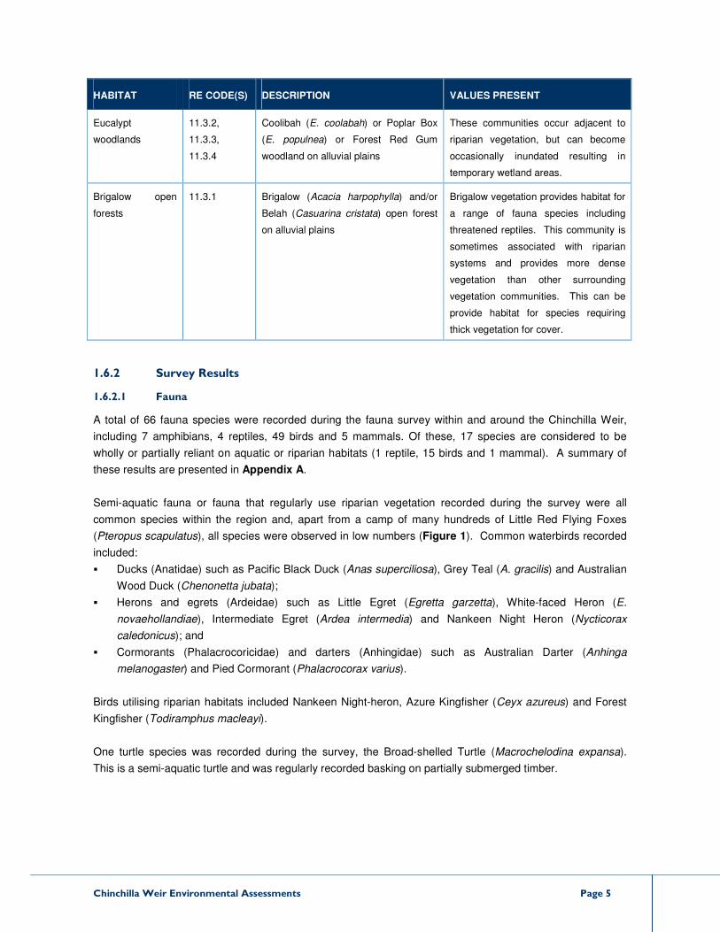
Chinchilla Weir Environmental Assessments Page 5
HABITAT RE CODE(S) DESCRIPTION VALUES PRESENT
Eucalypt
woodlands
11.3.2,
11.3.3,
11.3.4
Coolibah (E. coolabah) or Poplar Box
(E. populnea) or Forest Red Gum
woodland on alluvial plains
These communities occur adjacent to
riparian vegetation, but can become
occasionally inundated resulting in
temporary wetland areas.
Brigalow open
forests
11.3.1 Brigalow (Acacia harpophylla) and/or
Belah (Casuarina cristata) open forest
on alluvial plains
Brigalow vegetation provides habitat for
a range of fauna species including
threatened reptiles. This community is
sometimes associated with riparian
systems and provides more dense
vegetation than other surrounding
vegetation communities. This can be
provide habitat for species requiring
thick vegetation for cover.
1.6.2 Survey Results
1.6.2.1 Fauna
A total of 66 fauna species were recorded during the fauna survey within and around the Chinchilla Weir,
including 7 amphibians, 4 reptiles, 49 birds and 5 mammals. Of these, 17 species are considered to be
wholly or partially reliant on aquatic or riparian habitats (1 reptile, 15 birds and 1 mammal). A summary of
these results are presented in Appendix A.
Semi-aquatic fauna or fauna that regularly use riparian vegetation recorded during the survey were all
common species within the region and, apart from a camp of many hundreds of Little Red Flying Foxes
(Pteropus scapulatus), all species were observed in low numbers (Figure 1). Common waterbirds recorded
included:
� Ducks (Anatidae) such as Pacific Black Duck (Anas superciliosa), Grey Teal (A. gracilis) and Australian
Wood Duck (Chenonetta jubata);
� Herons and egrets (Ardeidae) such as Little Egret (Egretta garzetta), White-faced Heron (E.
novaehollandiae), Intermediate Egret (Ardea intermedia) and Nankeen Night Heron (Nycticorax
caledonicus); and
� Cormorants (Phalacrocoricidae) and darters (Anhingidae) such as Australian Darter (Anhinga
melanogaster) and Pied Cormorant (Phalacrocorax varius).
Birds utilising riparian habitats included Nankeen Night-heron, Azure Kingfisher (Ceyx azureus) and Forest
Kingfisher (Todiramphus macleayi).
One turtle species was recorded during the survey, the Broad-shelled Turtle (Macrochelodina expansa).
This is a semi-aquatic turtle and was regularly recorded basking on partially submerged timber.

11.3.25/11.3.4/11.3.3
11.4.12/11.3.2/11.3.1
11.3.25/11.3.4/11.3.3
11.4.12/11.3.4/11.3.1
11.4.12/11.3.2/11.3.111.4.12/11.3.4/11.3.1
11.4.12/11.3.4/11.3.1
11.3.2/11.4.12/11.3.1/11.3.4
11.4.12/11.3.2/11.3.1
11.4.12/11.3.4/11.3.1
11.3.2/11.4.12/11.3.1/11.3.4
11.3.2/11.4.12/11.3.1/11.3.4
11.3.2/11.4.12/11.3.1/11.3.4
Figure 1 - Vegetation Communities and Fauna HabitatsClient: Queensland Gas CompanyDate: Compiled by: Project Manager: Reference:DF PC19/11/2010
GDA 94, MGAz55
±
0 0.6 1.20.3Kilometers
1:50,000Scale@A4
Proposed Discharge PipelineRemnant Habitats
Eucalypt Woodland +/- BrigalowFringing Riparian Woodland
Regrowth HabitatsEucalypt Woodland +/- BrigalowFringing Riparian Woodland
PR103367-1Source: Spot-5 image ©Spot Image,
CHINCHILLA TA
RA ROADCHINCHILLA WEIR

Chinchilla Weir Environmental Assessments Page 1
As mentioned previously, a camp containing many hundreds of Little Red Flying Foxes was observed on an
island approximately 200m upstream of the weir. This species prefers camps within dense vegetation close
to water such as riparian vegetation and the weir provides such habitat. The use of this campsite by the
species is probably related to the presence of plant species in blossom (mainly eucalypts) surrounding the
weir or local area. Flying fox numbers may fluctuate widely depending upon the flowering of eucalypt
species.
1.6.2.2 Aquatic and semi-aquatic plants
Typical macrophytes within the weir include Persicaria spp. (smartweeds), Cyperus spp. (flatsedges),
Schoenoplectus spp (club rushes), Fimbristylis spp. (finger rushes), Carex spp. (sedges), Eleocharis spp.
(spike rushes) and Juncus spp. (rushes). Some of these species such as smartweeds and Phragmites
(Phragmites australis) have formed expansive beds within shallow areas particularly within the smaller
tributaries adjacent to the main river channel. Floating macrophytes were generally absent, possibly due to
the large flows within the Condamine River prior to the survey. It is considered, however, that such species
as waterlilies (Nymphaea sp.), aquatic ferns (eg. Azolla sp.), herbs (eg. Dichondra sp.), etc. would occur
within the weir.
1.6.2.3 Riparian Vegetation
Much of the vegetated areas surrounding the weir are mapped as fringing riparian woodlands (RE 11.3.25),
in association with other floodplain communities (i.e. RE 11.3.3 and 11.3.4) (Table 1). Based on the brief
field survey, the riparian vegetation broadly matches the description of the RE. Dominant species observed
were Forest / River Red Gum1 (Eucalyptus tereticornis / camaldulensis), River Oak (Casuarina
cunninghamiana), Black Tea-tree (Melaleuca bracteata), Weeping Bottlebrush (M. viminalis) and Shoestring
Acacia (Acacia stenophylla). The understorey varied from grassy to shrubby depending upon land uses and
disturbance history. Patches of Coolibah (E. coolabah) dominate in some areas where the topography is
flatter or gently sloping and Brigalow (A. harpophylla) also formed small patches interspersed within the
riparian woodlands.
1.6.3 Habitat Values
The inundation of the Condamine River after construction of the weir created several islands of vegetation
within the main river channel and also, through inundation death after filling, created large stands of dead
timber. Despite inundating riparian vegetation on the lower banks of the river, some of this vegetation type
remains on the higher banks of the river channel and advanced regrowth vegetation has progressively
colonised previously cleared areas. The main river channel is deep and holds permanent water even during
dry periods. When full, the weir impoundment has expansive shallow areas which encourage growth of
sedges and rushes forming large beds.
The habitat values within the weir for semi-aquatic fauna are as follows:
� A permanent source of water in dry periods – an aquatic ecological refuge;
1 Forest Red Gum and River Red Gum are very similar species and identification can only be made by
inspection of fruit and gumnuts. They fulfil a very similar ecological niche and therefore, for the purposes of
this report, are considered to be the same species.
Chinchilla Weir Environmental Assessments Page 2
� Fringing riparian vegetation provides foraging and nesting resource for a range of fauna species
(including wholly terrestrial species), it is an important dry season refuge and provides movement
opportunities upstream and downstream for wildlife;
� Stands of dead timber provide roosting and nesting resources for birds, including water birds and
terrestrial species, and habitat for turtles;
� Shallows and aquatic macrophyte beds (e.g. reeds, sedges and rushes) provide foraging and nesting
habitat for waders and other water birds.; and
� Vegetated islands create refuges for fauna from fire and exotic predators.
1.7 Potential Ecological Impacts
QGC are investigating the potential to discharge treated CSG water into the weir and at this stage the quality
or quantity of water discharged is unknown. Consequently, it is not possible to discuss potential aquatic
ecological impacts with certainty. Some general comments, however, can be made.
� In the absence of significant changes to water quality, potential effects for semi-aquatic and riparian
fauna and flora are likely to be minimal in the context of the Chinchilla Weir impoundment.
� Weir water levels are likely to maintained higher for longer (or perhaps permanently) with the addition of
discharged water increasing the utility of the weir impoundment as an aquatic ecological refuge in dry
times, and increasing the temporal availability of shallow water areas with macrophyte vegetation (a key
semi-aquatic faunal habitat in lacustrine environments).
� Water quality will be a primary issue for surveillance monitoring given the potential impacts to ionic
balance, turbidity, water temperature, pH and algal abundance.
1.8 Summary and Conclusion
The desktop assessment and brief field survey completed by RPS within the Chinchilla Weir identified a suite
of semi-aquatic species that are expected to regularly inhabit the weir and adjacent areas. QGC’s proposed
discharge of treated CSG water into the weir would not be expected to significantly impact on any species or
habitats within the weir and some species and habitats may even benefit due to the increased supply of
water into the weir during dry periods.
It is very important to understand that these conclusions may change depending on the final discharge
parameters proposed by QGC (water quality, water quantity and seasonal discharge timing). At the time of
preparing this survey report, final discharge conditions were not available.
Chinchilla Weir Environmental Assessments Page 3
Chapter 2 – Aquatic Ecosystem Values Assessment
1.1 Introduction
RPS has completed a desktop review of aquatic ecosystem values in Chinchilla Weir and nearby reaches of
the Condamine River catchment. Ecological values and ecological condition are closely related
environmental management concepts; however, they are not the same. It is important that the aquatic
ecological values of the Chinchilla Weir area are established as a baseline for further work and regulatory
negotiations associate with QGC water discharge proposals.
This document section reports the known aquatic ecological values for the study area (i.e. previously
assessed values).
1.2 Methods
The assessment of aquatic ecosystem values of the Chinchilla Weir has been completed by review of the
DERM Aquatic Conservation Assessment (ACA) for the Condamine River (DERM 2008). ACA’s are the
products of applying the Aquatic Biodiversity and Mapping Methodology (AquaBAMM) (Clayton et al 2006)
for a defined geographic area, which was developed to assess the conservation values of wetlands in
Queensland. The AquaBAMM uses a range of data sources including species records, vegetation and
wetland mapping and other geographic data as well as expert opinion to identify relative wetland
conservation/ecological values.
The ACAs, using AquaBAMM, provide a conservation assessment using criteria, indicators and measures.
The criteria in use are described below along with major criterion indicators:
1. Naturalness Aquatic – presence of exotic flora/fauna, aquatic communities/assemblages, habitat
features modification, hydrological modification and water quality;
2. Naturalness Catchment – presence of exotic flora/fauna, riparian disturbance, catchment disturbance,
flow modification;
3. Diversity and Richness – species, communities/assemblages, habitat, geomorphology;
4. Threatened Species and Ecosystems – species, communities/assemblages;
5. Priority Species and Ecosystems – species, communities;
6. Special Features – geomorphic, ecological processes, habitat, hydrological; and
7. Connectivity and Representativeness
a. Connectivity – significant species or populations, groundwater dependent ecosystems, floodplain
and wetland ecosystems; and
b. Representativeness – wetland protection, wetland uniqueness.
An ACA combines these criteria to produce an overall conservation value or ecological value for each spatial
unit. The results are calculated for a defined study area (usually a catchment) divided into smaller
geographic units or spatial units. A range of spatial unit values may result and they are interpreted relative to
each other but not to sites or geographic areas outside of the defined study area. That is, an ACA provides a
result referential within the defined study area.
The ACA for the Condamine River (DERM 2008) includes values results for spatial units at and nearby to
Chinchilla Weir. For the purposes of this document, the ACA results were supplemented by results of

Chinchilla Weir Environmental Assessments Page 4
desktop database and mapping searches to identify specific values within the catchment. These searches
include:
� Wildlife Online (DERM 2010a);
� EPBC Act Protected Matters search (Department of Sustainability, Environment, Water, Population
and Communities);
� Birds Australia BirData Atlas records;
� WetlandMaps (DERM 2010b); and
� Regional Ecosystem, remnant vegetation, essential habitat and high value regrowth vegetation
mapping (DERM 2010c,d,e).
The results of these searches were filtered to those that were relevant to aquatic values.
1.3 Results
1.3.1 Aquatic Conservation Assessment
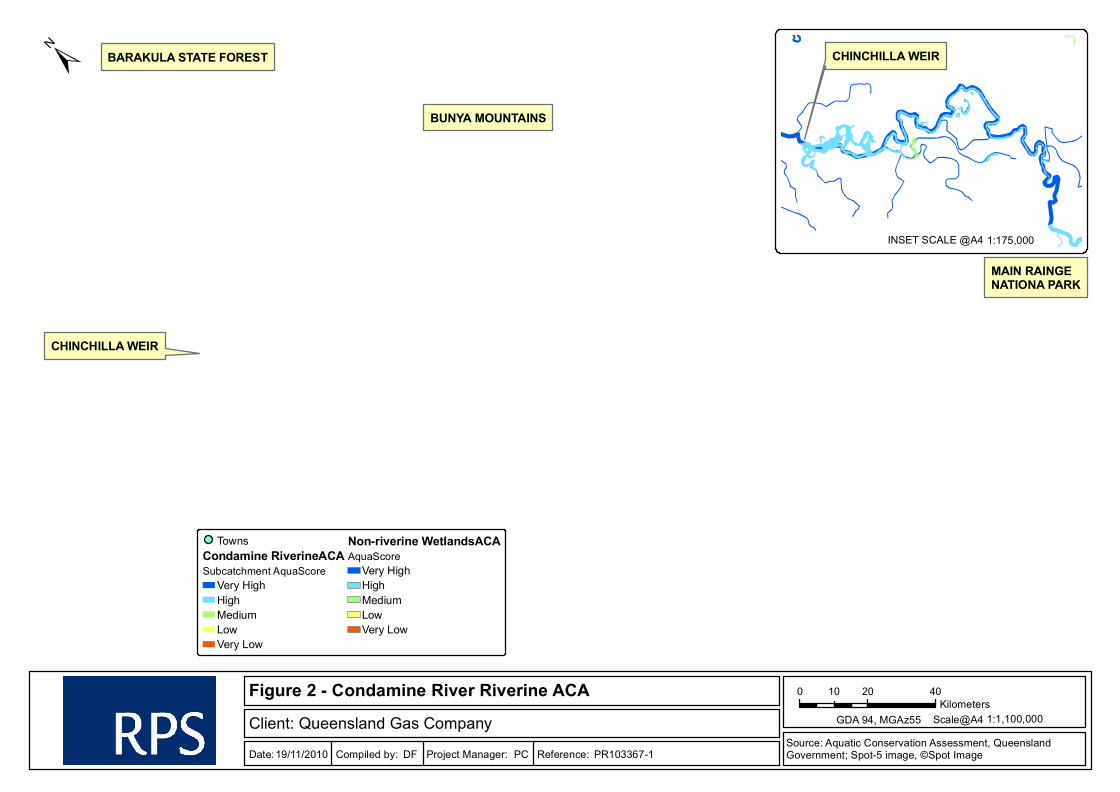
The results of the Condamine ACA for the Chinchilla Weir show that the portion of the Condamine River
inundated by the Weir and all downstream reaches of the river are given a “very high” score for riverine
wetlands. Upstream of the weir impoundment (i.e. upstream of the inundation area), the river is given a
“high” score (from the weir to south of Dalby). Spatial units encompassing tributary streams, rather than the
Condamine River itself) do not show “very high” scores except in higher altitude headwaters including the
Bunya Mountains, Barakula State Forest (Round Mountain) and the Main Range National Park. The
proposed discharge of production water into the Chinchilla Weir therefore has the potential to impact on a
large reach of the Condamine River.
Downstream of the Chinchilla Weir, all spatial units have been scored “very high” conservation value (or
ecological value) according to DERM 2008. This is the most significant element of this review with respect to
the proposed QGC water discharge and its downstream effects.
With respect to non-riverine wetlands, those mapped near the Chinchilla Weir were allocated “high” ACA
scores in most cases. However, the non-riverine aquatic ecosystem values are not considered further here
given that the primary focus is potential water discharge to the riverine environment.
Aquatic conservation values scores (ecological values scores) from the Condamine River ACA (DERM 2008)
are shown Figure 2.
1.3.2 Criterion Scores
ACAs provide more than one level of values scoring. The scores referred to above indicate the overall values
score for the spatial units discussed (i.e. the AquaScore (DERM 2006)). In the case of the Chinchilla Weir
reach of the Condamine River, the ACA shows a “very high” conservation value score as already discussed.
To examine this result further, the ACA should be interrogated to subordinate levels of data analysis and
scoring. In particularly, each AquaScore is the result of combination of a number of “criterion” level scores
that provide insight into the overall values result.
For the Chinchilla Weir area, DERM (2008) show the criterion level scores presented in Table 2.

Chinchilla Weir Environmental Assessments Page 5
TABLE 2 ACA CRITERIA SCORES FOR THE CHINCHILLA WEIR SPATIAL UNIT
CRITERIA RIVERINE WETLANDS CONSERVATION VALUE SCORE – CHINCHILLA WEIR
1. Naturalness Aquatic High
2. Naturalness Catchment High
3. Diversity and Richness Very High
4. Threatened Species and
Ecosystems
Medium
5. Priority Species and
Ecosystems
Very High
6. Special Features Very High
7. Connectivity and
Representativeness
Medium
AquaScore Very High
There are further levels of detail within each ACA; however, the results in Table 3 provide enough
discrimination to discuss the main contributors to the conservation (or ecological) values at the Chinchilla
Weir.
The fact that the weir represents an aquatic ecological connectivity barrier (or discontinuity) in the
Condamine River is recognised in the lower scores for the relevant criterion. Similarly, a weir is a modified
aquatic habitat so criteria that reflect ‘naturalness’ are also slightly depressed. In the case of the Chinchilla
Weir, the very high overall conservation score is clearly driven by the aquatic diversity and richness in the
local habitat, and by important species occurrences in the habitat (in this case, these species would primarily
migratory birds that use the weir and surrounding reaches).
The field survey, reported in Chapter 1 of this document, confirmed that aquatic diversity and richness is still
high in the Chinchilla Weir area. The comment was made that, unless water quality is significantly altered by
the QGC discharge proposal, the likely effects on these values would be minimal.
Downstream of the Chinchilla Weir, the DERM ACA (DERM 2008) reports that the aquatic conservation
values also score “very high”. Table 3 summarises the criterion level scores in the two immediately
downstream spatial units as defined by the ACA. For the purposes of this report and Table 3 the spatial units
are called SP1, immediately downstream of the Chinchilla Weir spatial unit, and SP2 further downstream
along the Condamine River. Together, these downstream spatial units extend the aquatic ecological values
assessment more than 50km downstream of the weir.

Chinchilla Weir Environmental Assessments Page 6
TABLE 3 ACA CRITERIA SCORES FOR DOWNSTREAM REACHES
CRITERIA VALUES SCORES – SP1 VALUES SCORES – SP2
1. Naturalness Aquatic Medium Medium
2. Naturalness Catchment High High
3. Diversity and Richness High Medium
4. Threatened Species and Ecosystems Very High Medium
5. Priority Species and Ecosystems High High
6. Special Features Very High Very High
7. Connectivity and Representativeness Low High
AquaScore Very High Very High
The criteria scores for the selected downstream reaches are mostly depressed compared with the scores for
the Chinchilla Weir, particularly for ‘naturalness aquatic’, ‘diversity and richness’ and ‘priority species and
ecosystems’. The overall AquaScore for both reaches scores very high, primarily driven by the presence of
special aquatic features, which may include significant wetland areas and/or significant aquatic habitat areas
as identified by the aquatic ecology expert panel. Despite the interruption of the weir on aquatic connectivity
and flows the downstream reaches provide significant habitat resources.
The proposed discharge of treated production water is unlikely to affect the downstream values identified by
the ACA because they are less related to the hydrological regime and more closely related to water quality
and habitat integrity. The altered hydrological regime downstream of the Chinchilla Weir, resulting from
management of this irrigation reach by Sunwater and the controlled Chinchilla Weir releases, is already
recognised by lower values assessments for ‘naturalness – aquatic’, etc. Provided that the proposed
discharge water quality is appropriate with respect to ambient Condamine River conditions, the aquatic
values identified for the downstream Condamine River reaches are unlikely to be changed significantly for
the discharge volumes proposed.
1.3.3 Threatened Species
Based on the results of the database searches, the study area contains records and/or provides habitat for
the following wetland dependent species listed as endangered, vulnerable or near threatened under the
Queensland Nature Conservation Act 1992 (NC Act) and/or the Commonwealth Environment Protection and
Biodiversity Conservation Act 1999 (EPBC Act):
� Black-necked Stork (Ephippiorhynchus asiaticus) – listed as near threatened under the NC Act;
� Glossy Ibis (Plegadis falcinellus) – listed as near threatened under the NC Act;
� Cotton Pygmy-goose (Nettapus coromandelianus) – listed as vulnerable under the EPBC Act and near
threatened under the NC Act;
� Australian Painted Snipe (Rostratula australis) – listed as vulnerable under the NC Act and EPBC Act;
and
Chinchilla Weir Environmental Assessments Page 7
� Fimbristylis vagans (a finger rush) – listed as near threatened under the NC Act.
In addition, the study area contains records and/or habitat for the following migratory wetland species listed
under the EPBC Act:
� Magpie Goose (Anseranas semipalmata);
� Eastern Great Egret (Ardea modesta);
� Latham's Snipe (Gallinago hardwickii);
� White-bellied Sea-eagle (Haliaeetus leucogaster); and
� Australian Reed-warbler (Acrocephalus australis).
It is likely, also, that the records for these species are primary drivers for high conservation values according
to DERMs ACA (DERM 2008) as reported in section 1.3.1.
1.3.4 Significant Vegetation Communities
The RE mapping shows that several patches of remnant and high value regrowth vegetation are mapped
within and surrounding the inundation (Figure 3). The area from the weir upstream to about the mid point of
the inundation of the river is largely devoid of remnant vegetation apart from small patches on the northern
bank. However, several large patches of high value regrowth vegetation are mapped on the northern and
southern banks of the weir. Areas further upstream are mapped as containing large tracts of riparian and
other floodplain communities. In addition, all patches are mapped as mixed polygons, meaning that several
different REs are not able to be delineated. The REs adjoining the Condamine River are RE 11.3.25 / 11.3.4
/ 11.3.3 and the REs on the higher floodplain are mapped as RE 11.4.12 / 11.3.2 / 11.3.1. Smaller patches
on the higher floodplain are mapped as RE 11.3.2 / 11.4.12 / 11.3.1 / 11.3.4.
These REs along with their vegetation management status (under the Vegetation Management Act 1999) as
per the Regional Ecosystem Description Database as provided in Table 4.
ESK
TARA
WARRA
KOGAN
OAKEY
DALBY
MILES
BOONAH
GATTON
IPSWICH
WARWICK
CLIFTON
LAIDLEY
MARBURG
HELIDONJANDOWAE
JONDARYAN
CONDAMINE
TOOWOOMBA
STANTHORPE
MILLMERRAN
PITTSWORTH
CROWS NEST
CHINCHILLA
KINGSTHORPE
CECIL PLAINS
Figure 2 - Condamine River Riverine ACAClient: Queensland Gas CompanyDate: Compiled by: Project Manager: Reference:DF PC19/11/2010
GDA 94, MGAz55
±
0 20 4010Kilometers
1:1,100,000Scale@A4
TownsCondamine RiverineACASubcatchment AquaScore
Very HighHighMediumLowVery Low
Non-riverine WetlandsACAAquaScore
Very HighHighMediumLowVery Low
PR103367-1Source: Aquatic Conservation Assessment, Queensland Government; Spot-5 image, ©Spot Image
CHINCHILLA WEIR
BUNYA MOUNTAINS
BARAKULA STATE FOREST
MAIN RAINGE NATIONA PARK
1:175,000INSET SCALE @A4
CHINCHILLA WEIR

Chinchilla Weir Environmental Assessments Page 9
TABLE 4 REGIONAL ECOSYSTEMS WITHIN AND SURROUNDING THE CHINCHILLA WEIR
RE CODE VM STATUS DESCRIPTION WETLANDS PRESENT
11.3.1 Endangered Acacia harpophylla and/or
Casuarina cristata open
forest on alluvial plains
Occasional flooding
11.3.2 Of concern Eucalyptus populnea
woodland on alluvial plains
Palustrine wetland
11.3.3 Of concern E. coolabah woodland on
alluvial plains
Floodplain
11.3.4 Of concern E. tereticornis and/or
Eucalyptus spp. tall
woodland on alluvial plains
Floodplain
11.3.25 Least concern E. tereticornis or E.
camaldulensis woodland
fringing drainage lines
Riverine wetland or fringing
wetland (i.e. riparian
vegetation)
11.4.12 Endangered E. populnea woodland on
Cainozoic clay plains
-
High Value Regrowth
Vegetation
Endangered Unknown Unknown
High Value Regrowth
Vegetation
Of concern Unknown Unknown
High Value Regrowth
Vegetation
Least concern Unknown Unknown
All of the REs listed above, apart from RE 11.3.25, are floodplain communities that are not relevant with
respect to the weir impoundment inundation and temporarily within-channel inundation after heavy rainfall
runoff. In contrast, RE 11.3.25 is a fringing riparian community that is directly connected to the inundation
area created by the weir.
No essential habitat for threatened species is mapped within the study area.
1.3.5 Wetland Ecosystems
The Queensland Wetland Map (DERM 2010a) for the study area shows the following wetland features:
� The area of inundation formed by the Chinchilla Weir is mapped as a lacustrine (e.g. lake) wetland;
� The headwaters of the weir are mapped as a riverine wetland (i.e. riparian communities);
� Palustrine wetlands (e.g. vegetated swamps) are mapped in lower lying areas surrounding the weir
inundation; and
Chinchilla Weir Environmental Assessments Page 10
� Remnant vegetation containing 1 – 50% of wetland Regional Ecosystems (RE) are mapped in the
north-eastern portion of the study area. This coincides with mapped patches of RE
11.4.12/11.3.2/11.3.1 (endangered dominant).
1.4 Summary
In summary, the review of aquatic ecosystem values shows that the Chinchilla Weir and adjacent tributaries
have been assessed with the following values:
� A “very high” conservation values score, according to the Condamine River ACA (DERM 2008), for the
Chinchilla Weir spatial unit and all spatial units downstream along the Condamine River;
� Known and potential habitat for threatened and migratory water birds and threatened plants; and
� Threatened remnant and high value regrowth riparian and wetland communities providing habitat for a
range of species.
QGC’s proposed discharge of treated CSG water into the weir would not be expected to significantly change
any of the assessed conservation values, unless significant changes in water quality or quantity (including
timing and shape of the river hydrograph) result in the loss or relocation of species, or the significant
modification of aquatic habitat in the longer term. It is very important to understand that these conclusions
may change depending on the final discharge parameters proposed by QGC (water quality, water quantity
and seasonal discharge timing). At the time of preparing this survey report, final discharge conditions were
not available.

non-rem
11.3.25/11.3.4/11.3.3
11.4.12/11.3.2/11.3.1
11.3.1/11.9.6
11.4.3
11.4.12/11.3.4/11.3.1
11.3.2/11.4.12/11.3.1/11.3.4
11.3.4
Figure 3 - Remnant and High Value Regrowth VegetationClient: Queensland Gas CompanyDate: Compiled by: Project Manager: Reference:DF PC19/11/2010
GDA 94, MGAz55
±
0 0.9 1.80.45Kilometers
1:50,000Scale@A4
Remnant VegetationEndangered - DominantEndangered - Sub-dominantOf Concern - Sub-dominantNon-remnant / regrowth
High Value Regrowth VegetationEndangered regional ecosystemsOf Concern regional ecosystemsLeast Concern regional ecosystem
PR103367-1Source: Aquatic Conservation Assessment, Queensland Government; Spot-5 image, ©Spot Image
CHINCHILLA WEIR

Chinchilla Weir Environmental Assessments Page 12
Chapter 3 – Data Document
This section of the report is unusual. With the growing levels of interest in works associated with Chinchilla
Weir and adjacent reaches of the Condamine River, previously conducted assessments and previously
created databases are important as a foundation for current and future investigations. In the case of the
proposed QGC water discharge, information and conclusions about local and regional aquatic ecology, water
quality and hydrology are particularly important.
To provide a first-stop document to assist in identifying previous and related surveys, assessments or
datasets, RPS has compiled Table 5 below. The table includes information such as literature, studies, and
spatial data and other mapping products, water quality data sets, survey information, hydrological
assessments that relate to the aquatic environment, ecology and values of the Chinchilla Weir.
To compile Table 5, a number of tasks were completed including reviews of publically accessible information
from a range of sources including species records databases, government water quality and stream flow
sampling regimes, and government and private sector aquatic values assessments
Critically, the information in Table 5 is current at the time of writing this report but there are many activities in
the Chinchilla Weir region underway that would alter its content. Also, many of these activities are
“commercial-in-confidence” and will be unavailable through regular search mechanisms. Table 5, therefore,
is an initial guide to data that might be available; however, the information will date very quickly and the
information is almost certainly incomplete given the likelihood of many undiscoverable activities, data sets
and reports.
This ‘data document’ is an initial attempt to provide a foundation for assessments and regulatory negotiations
associated with Chinchilla Weir.
Chinchilla Weir Environmental Assessments Page 13
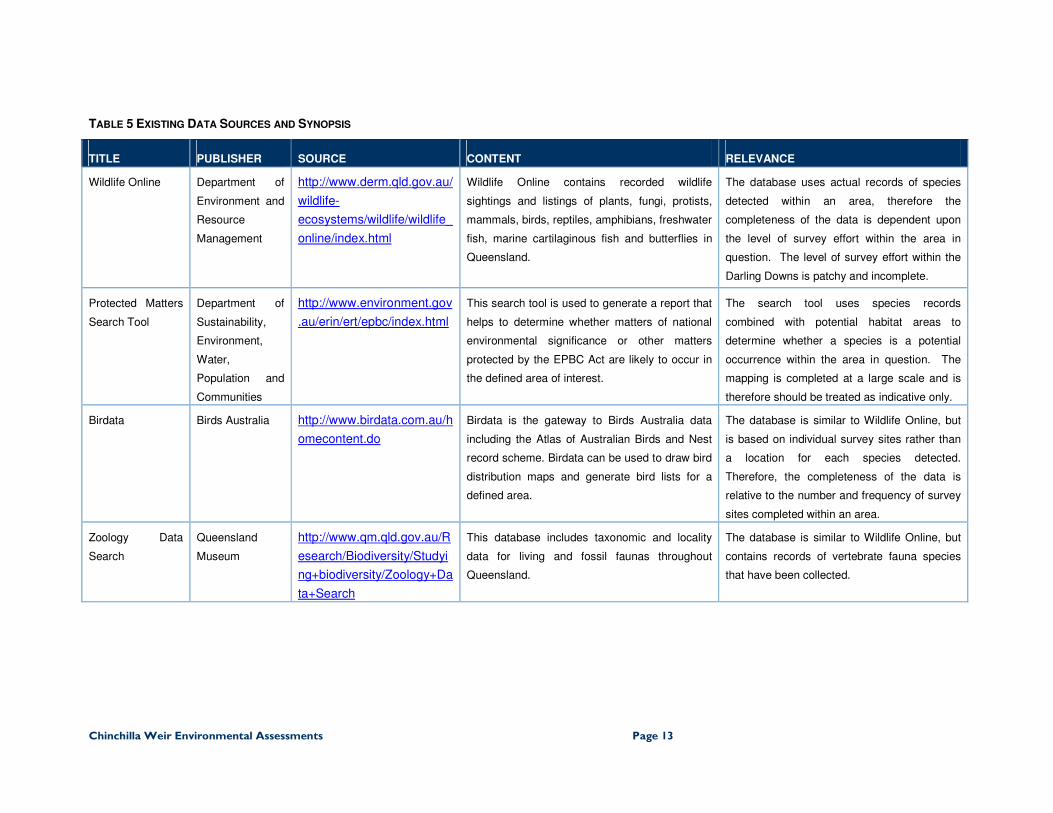
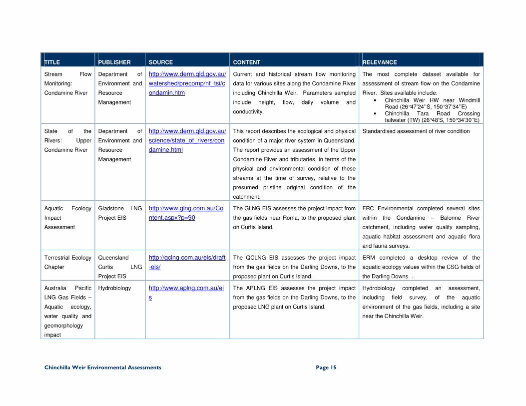
TABLE 5 EXISTING DATA SOURCES AND SYNOPSIS
TITLE PUBLISHER SOURCE CONTENT RELEVANCE
Wildlife Online Department of
Environment and
Resource
Management
http://www.derm.qld.gov.au/
wildlife-
ecosystems/wildlife/wildlife_
online/index.html
Wildlife Online contains recorded wildlife
sightings and listings of plants, fungi, protists,
mammals, birds, reptiles, amphibians, freshwater
fish, marine cartilaginous fish and butterflies in
Queensland.
The database uses actual records of species
detected within an area, therefore the
completeness of the data is dependent upon
the level of survey effort within the area in
question. The level of survey effort within the
Darling Downs is patchy and incomplete.
Protected Matters
Search Tool
Department of
Sustainability,
Environment,
Water,
Population and
Communities
http://www.environment.gov
.au/erin/ert/epbc/index.html
This search tool is used to generate a report that
helps to determine whether matters of national
environmental significance or other matters
protected by the EPBC Act are likely to occur in
the defined area of interest.
The search tool uses species records
combined with potential habitat areas to
determine whether a species is a potential
occurrence within the area in question. The
mapping is completed at a large scale and is
therefore should be treated as indicative only.
Birdata Birds Australia http://www.birdata.com.au/h
omecontent.do
Birdata is the gateway to Birds Australia data
including the Atlas of Australian Birds and Nest
record scheme. Birdata can be used to draw bird
distribution maps and generate bird lists for a
defined area.
The database is similar to Wildlife Online, but
is based on individual survey sites rather than
a location for each species detected.
Therefore, the completeness of the data is
relative to the number and frequency of survey
sites completed within an area.
Zoology Data
Search
Queensland
Museum
http://www.qm.qld.gov.au/R
esearch/Biodiversity/Studyi
ng+biodiversity/Zoology+Da
ta+Search
This database includes taxonomic and locality
data for living and fossil faunas throughout
Queensland.
The database is similar to Wildlife Online, but
contains records of vertebrate fauna species
that have been collected.
Chinchilla Weir Environmental Assessments Page 14
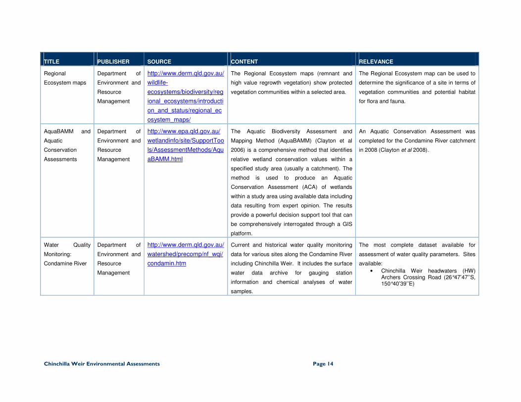
TITLE PUBLISHER SOURCE CONTENT RELEVANCE
Regional
Ecosystem maps
Department of
Environment and
Resource
Management
http://www.derm.qld.gov.au/
wildlife-
ecosystems/biodiversity/reg
ional_ecosystems/introducti
on_and_status/regional_ec
osystem_maps/
The Regional Ecosystem maps (remnant and
high value regrowth vegetation) show protected
vegetation communities within a selected area.
The Regional Ecosystem map can be used to
determine the significance of a site in terms of
vegetation communities and potential habitat
for flora and fauna.
AquaBAMM and
Aquatic
Conservation
Assessments
Department of
Environment and
Resource
Management
http://www.epa.qld.gov.au/
wetlandinfo/site/SupportToo
ls/AssessmentMethods/Aqu
aBAMM.html
The Aquatic Biodiversity Assessment and
Mapping Method (AquaBAMM) (Clayton et al
2006) is a comprehensive method that identifies
relative wetland conservation values within a
specified study area (usually a catchment). The
method is used to produce an Aquatic
Conservation Assessment (ACA) of wetlands
within a study area using available data including
data resulting from expert opinion. The results
provide a powerful decision support tool that can
be comprehensively interrogated through a GIS
platform.
An Aquatic Conservation Assessment was
completed for the Condamine River catchment
in 2008 (Clayton et al 2008).
Water Quality
Monitoring:
Condamine River
Department of
Environment and
Resource
Management
http://www.derm.qld.gov.au/
watershed/precomp/nf_wqi/
condamin.htm
Current and historical water quality monitoring
data for various sites along the Condamine River
including Chinchilla Weir. It includes the surface
water data archive for gauging station
information and chemical analyses of water
samples.
The most complete dataset available for
assessment of water quality parameters. Sites
available:
• Chinchilla Weir headwaters (HW) Archers Crossing Road (26°47’47’’S, 150°40’39’’E)
Chinchilla Weir Environmental Assessments Page 15
TITLE PUBLISHER SOURCE CONTENT RELEVANCE
Stream Flow
Monitoring:
Condamine River
Department of
Environment and
Resource
Management
http://www.derm.qld.gov.au/
watershed/precomp/nf_tsi/c
ondamin.htm
Current and historical stream flow monitoring
data for various sites along the Condamine River
including Chinchilla Weir. Parameters sampled
include height, flow, daily volume and
conductivity.
The most complete dataset available for
assessment of stream flow on the Condamine
River. Sites available include:
• Chinchilla Weir HW near Windmill Road (26°47’24’’S, 150°37’34’’E)
• Chinchilla Tara Road Crossing tailwater (TW) (26°48’S, 150°34’30’’E)
State of the
Rivers: Upper
Condamine River
Department of
Environment and
Resource
Management
http://www.derm.qld.gov.au/
science/state_of_rivers/con
damine.html
This report describes the ecological and physical
condition of a major river system in Queensland.
The report provides an assessment of the Upper
Condamine River and tributaries, in terms of the
physical and environmental condition of these
streams at the time of survey, relative to the
presumed pristine original condition of the
catchment.
Standardised assessment of river condition
Aquatic Ecology
Impact
Assessment
Gladstone LNG
Project EIS
http://www.glng.com.au/Co
ntent.aspx?p=90
The GLNG EIS assesses the project impact from
the gas fields near Roma, to the proposed plant
on Curtis Island.
FRC Environmental completed several sites
within the Condamine – Balonne River
catchment, including water quality sampling,
aquatic habitat assessment and aquatic flora
and fauna surveys.
Terrestrial Ecology
Chapter
Queensland
Curtis LNG
Project EIS
http://qclng.com.au/eis/draft
-eis/
The QCLNG EIS assesses the project impact
from the gas fields on the Darling Downs, to the
proposed plant on Curtis Island.
ERM completed a desktop review of the
aquatic ecology values within the CSG fields of
the Darling Downs. .
Australia Pacific
LNG Gas Fields –
Aquatic ecology,
water quality and
geomorphology
impact
Hydrobiology http://www.aplng.com.au/ei
s
The APLNG EIS assesses the project impact
from the gas fields on the Darling Downs, to the
proposed LNG plant on Curtis Island.
Hydrobiology completed an assessment,
including field survey, of the aquatic
environment of the gas fields, including a site
near the Chinchilla Weir.

Chinchilla Weir Environmental Assessments Page 16
TITLE PUBLISHER SOURCE CONTENT RELEVANCE
Various
hydrological,
ecological and
water quality
studies
Various private
companies
- Due to the level of development of resources and
infrastructure projects within the vicinity of the
Chinchilla Weir, it is likely that substantial aquatic
studies have been conducted. However, access
to these studies is problematic.
-
Sustainable Rivers
Audit
Murray Darling
Basin Authority
http://www.mdba.gov.au/sustai
nable-rivers-audit/
The Sustainable Rivers Audit aims to:
• determine the ecological condition and
health of river valleys in the Murray-
Darling Basin ;
• give a better insight into the variability of
river health indicators across the Basin
and over time;
• eventually help detect trends in river
health over time; and
• trigger changes to natural resource
management by providing a more
comprehensive picture of river health
than is currently available.
The first Murray Darling Basin river health
check 2004-2007 was released in 2008 and
provides a Basin-wide river health assessment
based on observations of fish,
macroinvertebrates and hydrology.
The health check provides an assessment of
the Condamine Valley, which is of relevance to
the Chinchilla Weir and environs, and is
provided in the Condamine Valley Report
Card.
Fisheries
Queensland
Freshwater fish
surveys
http://www.dpi.qld.gov.au/28_1
4567.htm
The freshwater fish from 10 Queensland river
systems was monitored by Fisheries Queensland
between 2000 to 2007. The program collected
species diversity, abundance and length
structure on key recreational and commercial
species along with the occurrence of exotic fish
species. It also collected information on water
quality and habitat conditions that may help to
correlate changes in fish community structure.
The freshwater fish surveys included sites
within the Balonne – Condamine system and
the data is available by request from Fisheries
Queensland.
Chinchilla Weir Environmental Assessments Page 17
References
Clayton, P.D., Fielder, D.P., Barratt, P.J. and Hill, C. (2008) Aquatic Conservation Assessments (ACA), using
AquaBAMM, for freshwater wetlands of the Condamine River catchment. Environmental Protection
Agency, Brisbane.
Clayton, P.D., Fielder, D.P., Howell, S. and Hill, C. (2006) Aquatic biodiversity assessment and mapping
method (AquaBAMM): a conservation values assessment tool for wetlands with trial application in
the Burnett River catchment. Environmental Protection Agency, Brisbane.
Department of Environment and Resource Management (DERM) (2010a). Wildlife Online Database, The
Department of Environment and Resource Management, Brisbane. URL:
http://www.epa.qld.gov.au/wetlandinfo/site/MappingFandD/WetlandMapsAndData/PDFMaps.html.
Accessed on November 2010.
Department of Environment and Resource Management (DERM) (2010b). Queensland Wetland Map, The
Department of Environment and Resource Management, Brisbane. URL:
http://www.derm.qld.gov.au/wildlife-ecosystems/wildlife/wildlife_online/. Accessed on November
2010.
Department of Environment and Resource Management (DERM) (2010c). Copies of the certified Regional
Ecosystem and Remnant Map—version 6 for the purpose of the Vegetation Management Act
1999. Online RE Maps, The Department of Environment and Resource Management, Brisbane.
URL: http://www.derm.qld.gov.au/REMAP. Accessed on November 2010.
Department of Environment and Resource Management (DERM) (2010d). Copies of the certified Essential
Habitat Map–version 3 for the purpose of the Vegetation Management Act 1999. Online RE Maps,
The Department of Environment and Resource Management, Brisbane. URL:
http://www.derm.qld.gov.au/REMAP. Accessed on November 2010.
Department of Environment and Resource Management (DERM) (2010e). Copies of the certified Regrowth
Vegetation Map—version 2 for the purpose of the Vegetation Management Act 1999. Online RE
Maps, The Department of Environment and Resource Management, Brisbane. URL:
http://www.derm.qld.gov.au/REMAP. Accessed on November 2010.

Chinchilla Weir Environmental Assessments Page A
APPENDIX A FLORA AND FAUNA SPECIES IDENTIFIED FROM RPS SURVEY AND/OR DATABASE
INTERROGATION

Chinchilla Weir Environmental Assessments Page B
SCIENTIFIC NAME COMMON NAME NC ACT
EPBC ACT
HABITAT ASSOCIATED WITH WEIR
RPS SURVEY
SOURCE
Amphibians
Cyclorana alboguttata Greenstripe Frog C X Wildnet
Cyclorana novaehollandiae New Holland Frog C X
Limnodynastes salmini Salmon-striped Frog C X
Litoria latopalmata Broad-palmed
Rocketfrog
C X
Litoria peronii Peron's Tree Frog C X Wildnet
Litoria rubella Red-backed Tree Frog C X
Rhinella marina Cane Toad Y X Wildnet
Birds
Acrocephalus australis Australian Reed-warbler C Reed beds X
Anas castanea Chestnut Teal C Aquatic macrophytes and shallows Wildnet
Anas gracilis Grey Teal C Aquatic macrophytes and shallows X Wildnet Birdata
Anas rhynchotis Australasian Shoveler C Open water Birdata
Anas superciliosa Pacific black duck C Varied aquatic habitats X Wildnet Birdata
Anhinga novaehollandiae Australasian Darter C Varied aquatic habitats X Wildnet Birdata
Anseranas semipalmata Magpie Goose C M Shallow water Wildnet EPBC Birdata
Ardea intermedia Intermediate Egret C Aquatic macrophytes and shallows X Wildnet Birdata
Ardea modesta Eastern Great Egret C M Shallow water Wildnet EPBC Birdata
Ardea pacifica White-necked Heron C Shallow water Wildnet Birdata

Chinchilla Weir Environmental Assessments Page C
SCIENTIFIC NAME COMMON NAME NC ACT
EPBC ACT
HABITAT ASSOCIATED WITH WEIR
RPS SURVEY
SOURCE
Artamus leucorynchus White-breasted
Woodswallow
C X
Aythya australis Hardhead C Aquatic macrophytes Wildnet Birdata
Biziura lobata Musk Duck C Reeds and open water Wildnet
Cacatua galerita Sulphur-crested
Cockatoo
C X
Ceyx azureus Azure Kingfisher C Riparian vegetation X Wildnet Birdata
Chenonetta jubata Australian Wood Duck C Varied aquatic habitats and adjacent
areas
X Wildnet Birdata
Coracina novaehollandiae Black-faced Cuckoo-
Shrike
C X
Corcorax melanorhamphos White-winged Chough C X
Corvus orru Torresian Crow C X
Cracticus nigrogularis Pied Butcherbird C X
Cracticus tibicen Magpie C X
Cygnus atratus Black Swan C Aquatic macrophytes and shallows Wildnet
Dacelo novaeguineae Kookaburra C X
Dendrocygna arcuata Wandering Whistling-
Duck
C Aquatic macrophytes and shallows Birdata
Dendrocygna eytoni Plumed Whistling-Duck C Aquatic macrophytes and shallows Birdata
Dicaeum hirundinaceum Mistletoebird C X
Egretta garzetta Little Egret C Shallow water X Wildnet Birdata

Chinchilla Weir Environmental Assessments Page D
SCIENTIFIC NAME COMMON NAME NC ACT
EPBC ACT
HABITAT ASSOCIATED WITH WEIR
RPS SURVEY
SOURCE
Egretta novaehollandiae White-faced Heron C Shallow water X Wildnet Birdata
Elseyornis melanops Black-fronted Dotterel C Shallow water Wildnet Birdata
Eolophus roseicapilla Galah C X
Ephippiorhynchus asiaticus Black-necked Stork NT Shallow water Wildnet Birdata
Eudynamys scolopacea Common Koel C X
Eurystomus orientalis Dollarbird C X
Fulica atra Eurasian Coot C Varied aquatic habitats Birdata
Gallinago hardwickii Latham's Snipe C M Reed beds EPBC Birdata
Gallinula tenebrosa Dusky Moorhen C Varied aquatic habitats X Birdata
Geopelia humeralis Peaceful Dove C X
Gerygone olivacea White-throated
Gerygone
C X
Grallina cyanoleuca Australian Magpie-lark C X
Grus rubicunda Brolga C Shallow water Birdata
Haliaeetus leucogaster White-bellied Sea-eagle C M Major rivers and permanent water Wildnet EPBC Birdata
Haliastur sphenurus Whistling Kite C X
Himantopus himantopus Black-winged Stilt C Shallow water Birdata
Hirundo neoxena Welcome Swallow C X
Irediparra gallinacea Comb-crested Jacana C Aquatic macrophytes and shallows Birdata
Ixobrychus flavicollis Black Bittern C Reed or dense macrophyte beds Wildnet
Lichmera indistincta Brown Honeyeater C X
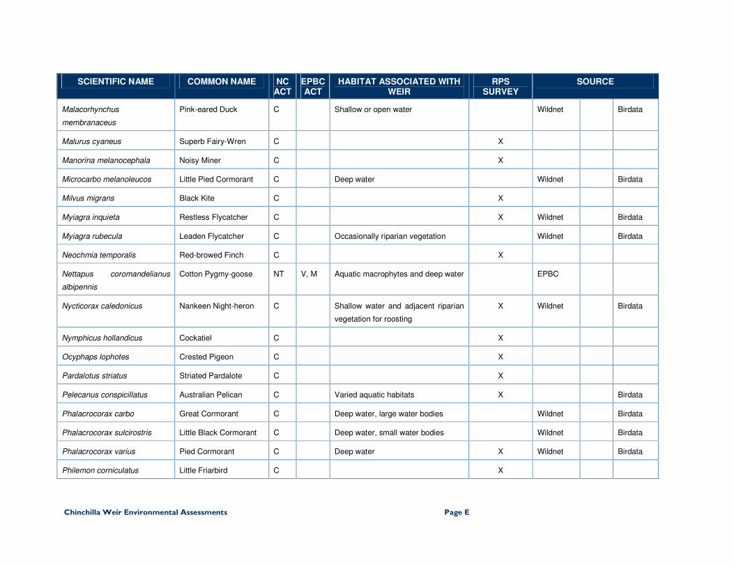
Chinchilla Weir Environmental Assessments Page E
SCIENTIFIC NAME COMMON NAME NC ACT
EPBC ACT
HABITAT ASSOCIATED WITH WEIR
RPS SURVEY
SOURCE
Malacorhynchus
membranaceus
Pink-eared Duck C Shallow or open water Wildnet Birdata
Malurus cyaneus Superb Fairy-Wren C X
Manorina melanocephala Noisy Miner C X
Microcarbo melanoleucos Little Pied Cormorant C Deep water Wildnet Birdata
Milvus migrans Black Kite C X
Myiagra inquieta Restless Flycatcher C X Wildnet Birdata
Myiagra rubecula Leaden Flycatcher C Occasionally riparian vegetation Wildnet Birdata
Neochmia temporalis Red-browed Finch C X
Nettapus coromandelianus
albipennis
Cotton Pygmy-goose NT V, M Aquatic macrophytes and deep water EPBC
Nycticorax caledonicus Nankeen Night-heron C Shallow water and adjacent riparian
vegetation for roosting
X Wildnet Birdata
Nymphicus hollandicus Cockatiel C X
Ocyphaps lophotes Crested Pigeon C X
Pardalotus striatus Striated Pardalote C X
Pelecanus conspicillatus Australian Pelican C Varied aquatic habitats X Birdata
Phalacrocorax carbo Great Cormorant C Deep water, large water bodies Wildnet Birdata
Phalacrocorax sulcirostris Little Black Cormorant C Deep water, small water bodies Wildnet Birdata
Phalacrocorax varius Pied Cormorant C Deep water X Wildnet Birdata
Philemon corniculatus Little Friarbird C X

Chinchilla Weir Environmental Assessments Page F
SCIENTIFIC NAME COMMON NAME NC ACT
EPBC ACT
HABITAT ASSOCIATED WITH WEIR
RPS SURVEY
SOURCE
Platalea flavipes Yellow-billed Spoonbill C Shallow water Wildnet Birdata
Platalea regia Royal Spoonbill C Shallow water Wildnet Birdata
Platycercus adscitus Pale-headed Rosella C X
Plectorhyncha lanceolata Striped Honeyeater C X
Plegadis falcinellus Glossy Ibis NT Shallow water Birdata
Podargus strigoides Tawny Frogmouth C X
Poliocephalus poliocephalus Hoary-headed Grebe C Open water Wildnet
Porphyrio porphyrio Purple Swamphen C Varied aquatic habitats Birdata
Rhipidura leucophrys Willy Wagtail C X
Rostratula australis Australian Painted
Snipe
V V, M Reed beds and other dense fringing
vegetation
EPBC
Struthidea cinerea Apostlebird C X
Tachybaptus novaehollandiae Australasian Grebe C Varied aquatic habitats Wildnet Birdata
Taeniopygia bichenovii Double-barred Finch C X
Threskiornis molucca Australian White Ibis C Shallow water and adjacent
vegetation
X Wildnet Birdata
Threskiornis spinicollis Straw-necked Ibis C Occasionally uses shallow water Wildnet Birdata
Todiramphus macleayii Forest Kingfisher C Occasionally uses riparian
vegetation
X
Anser anser Greylag Goose I Shallow water around human
habitation
X
Mammals

Chinchilla Weir Environmental Assessments Page G
SCIENTIFIC NAME COMMON NAME NC ACT
EPBC ACT
HABITAT ASSOCIATED WITH WEIR
RPS SURVEY
SOURCE
Felis catus Cat I X
Hydromys chrysogaster Water Rat C Varied aquatic habitats Wildnet
Macropus giganteus Eastern Grey Kangaroo C X
Petaurus brevipes Squirrel Glider C X
Pteropus scapulatus Little Red Flying Fox C Roosts in riparian vegetation X
Wallabia bicolor Swamp Wallaby C X
Reptiles
Gehyra dubia Dubious Dtella C X
Hemidactylus fraenatus Asian House Gecko I X
Macrochelodina expansa Broad-shelled Turtle C Open water X
Physignathus lesueurii Eastern Water Dragon C Riparian vegetation Wildnet
Varanus varius Lace Monitor C X
Plants
Rorippa palustris Marsh Cress I Semi-aquatic, floating Wildnet
Melaleuca species Bottlebrush C Fringing riparian species Wildnet
Eucalyptus tereticornis subsp. tereticornis
Forest Red Gum C Fringing riparian species Wildnet
Eucalyptus camaldulensis subsp. camaldulensis
River Red Gum C Fringing riparian species Wildnet
Melaleuca salicina Willow Bottlebrush C Fringing riparian species Wildnet
Persicaria attenuata a smartweed C Margins of shallows Wildnet
Persicaria lapathifolia Pale Knotweed C Margins of shallows Wildnet
Persicaria orientalis Princes Feathers C Margins of shallows Wildnet
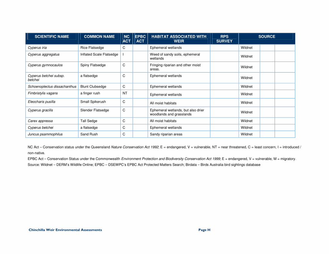
Chinchilla Weir Environmental Assessments Page H
SCIENTIFIC NAME COMMON NAME NC ACT
EPBC ACT
HABITAT ASSOCIATED WITH WEIR
RPS SURVEY
SOURCE
Cyperus iria Rice Flatsedge C Ephemeral wetlands Wildnet
Cyperus aggregatus Inflated Scale Flatsedge I Weed of sandy soils, ephemeral wetlands
Wildnet
Cyperus gymnocaulos Spiny Flatsedge C Fringing riparian and other moist areas.
Wildnet
Cyperus betchei subsp. betchei
a flatsedge C Ephemeral wetlands Wildnet
Schoenoplectus dissachanthus Blunt Clubsedge C Ephemeral wetlands Wildnet
Fimbristylis vagans a finger rush NT Ephemeral wetlands Wildnet
Eleocharis pusilla Small Spikerush C All moist habitats Wildnet
Cyperus gracilis Slender Flatsedge C Ephemeral wetlands, but also drier woodlands and grasslands
Wildnet
Carex appressa Tall Sedge C All moist habitats Wildnet
Cyperus betchei a flatsedge C Ephemeral wetlands Wildnet
Juncus psammophilus Sand Rush C Sandy riparian areas Wildnet
NC Act – Conservation status under the Queensland Nature Conservation Act 1992; E = endangered, V = vulnerable, NT = near threatened, C = least concern, I = introduced /
non-native.
EPBC Act – Conservation Status under the Commonwealth Environment Protection and Biodiversity Conservation Act 1999; E = endangered, V = vulnerable, M = migratory.
Source: Wildnet – DERM’s Wildlife Online; EPBC – DSEWPC’s EPBC Act Protected Matters Search; Birdata – Birds Australia bird sightings database


