17
Final Design Submittal T‐117_DesignReport20120820 Appendix L Archaeological Monitoring and Discovery Plan
Final Design Submittal
T‐117_DesignReport20120820
Appendix L Archaeological Monitoring and Discovery Plan
ARCHAEOLOGICAL MONITORING AND DISCOVERY PLAN PHASE 1: Sediment and Upland Cleanup
Lower Duwamish Waterway Superfund Site
Terminal 117 Early Action Area August 20, 2012
ARCHAEOLOGICAL MONITORING AND DISCOVERY PLAN PHASE 1: Sediment and Upland Cleanup
Lower Duwamish Waterway Superfund Site
Terminal 117 Early Action Area August 20, 2012
PREPARED BY:
AppL_Archaeological Monitoring and Discovery Plan_20120820.docx i
Table of Contents
1 Introduction .................................................................................................... 1‐1 1.1 Monitoring .......................................................................................... 1‐1
2 Archaeological Discovery Plan ....................................................................... 2‐1 2.1 Procedures for the Discovery of Cultural Resources ......................... 2‐1 2.2 Procedures for the Discovery of Human Remains ............................. 2‐4 2.3 Proceeding with Work ........................................................................ 2‐4
3 Contact Information ....................................................................................... 3‐1

Archaeological Monitoring and Discovery Plan
AppL_Archaeological Monitoring and Discovery Plan_20120820.docx ii
List of Figures
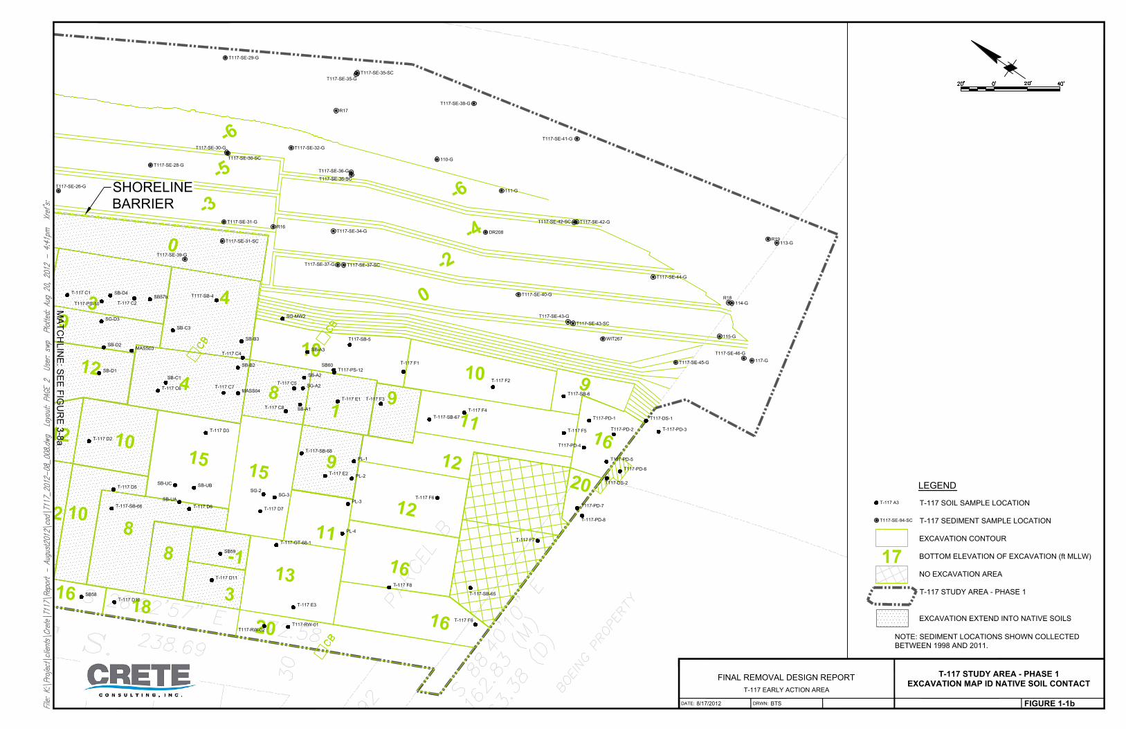
Figure 1‐1 T‐117 Study Area Phase 1 Excavation Map Identifying Native Soil Contact

Archaeological Monitoring and Discovery Plan
AppL_Archaeological Monitoring and Discovery Plan_20120820.docx iii
Acronyms and Abbreviations
APE area of potential effects CERCLA Comprehensive Environmental Response, Compensation, and Liability Act
(Superfund) CFR Code of Federal Regulations COC contaminant of concern CRC Cultural Resource Consultants CRETE Crete Consulting, Inc. EAA Early Action Area Engineer Port Resident Engineer EPA United States Environmental Protection Agency HAZWOPER Hazardous Waste Operations and Emergency Response LDW Lower Duwamish Waterway NHPA National Historic Preservation Act NRHP National Register of Historic Places OSHA Occupation Health and Safety Administration standards PCB polychlorinated biphenyl Phase 1 Sediment and Upland Areas Port Port of Seattle RCW Revised Code of Washington T‐117 Terminal 117 WHR Washington Heritage Register WA DAHP Washington State Department of Archaeology and Historic Preservation

Archaeological Monitoring and Discovery Plan
AppL_Archaeological Monitoring and Discovery Plan_20120820.docx 1‐1
1 Introduction
The Port of Seattle (Port) intends to conduct environmental cleanup at the Terminal 117 Early Action Area (T‐117 EAA) Upland and Sediment Removal Areas, in Seattle, King County, Washington. The T‐117 EAA Upland and Sediment Removal project involves removal of soil and sediment containing PCBs and other contaminants of concern (COCs) from the Lower Duwamish Waterway (LDW) shoreline and adjacent upland property (Tax Parcel No. 000160‐0044) (King County 2011) in the South Park neighborhood. The T‐117 EAA Upland and Sediment Removal project is being performed under the Comprehensive Environmental Response, Compensation, and Liability Act (CERCLA). The U.S. Environmental Protection Agency (EPA), Region 10, serves as the lead agency for this project, which is considered to be a federal undertaking subject to compliance with Section 106 of the National Historic Preservation Act (NHPA) of 1966, as amended, and implementing regulations (36 Code of Federal Regulations [CFR] 800). On behalf of the Port of Seattle, Crete Consulting, Inc., retained Cultural Resource Consultants, Inc. (CRC) to prepare a cultural resources assessment. CRC’s cultural resources investigations for the project have included background research, archaeological reconnaissance survey, and a historic resources survey to identify any recorded cultural resources within the project’s area of potential effects (APE), identify evidence of previously unrecorded cultural resources, and to assess the potential for as‐yet unknown archaeological resources to be present (Berger 2011). Limited archaeological monitoring occurred during geotechnical explorations and geotechnical data from the entire project area has been reviewed by a CRC archaeologist. Although evidence of archaeological resources has not yet been identified, the project retains the potential to contain precontact and historic‐period archaeological sites. CRC therefore recommended focused monitoring during removal of contaminated soil and sediment.
1.1 Monitoring Archaeological monitoring will include an orientation for the construction crew and machine operators prior to initiating soil and sediment removal. Project personnel would be made aware of the potentials of archaeology within the project area. They will be apprised of their responsibilities during archaeological monitoring, their obligations in the case of an inadvertent discovery and they will be made aware of the inadvertent discovery plan and protocol. Investigations would be performed either by a “professional archaeologist” who meets the Secretary of the Interior’s qualifications (36 CFR Part 61; RCW 27.53.030 (8)) or under the supervision of a professional archaeologist. Because the project location contains contaminated soils, the archaeologist shall be 40‐hour Hazardous Work Operations and Emergency Responses (HAZWOPER) certified in accordance with Occupation Health and
Archaeological Monitoring and Discovery Plan
AppL_Archaeological Monitoring and Discovery Plan_20120820.docx 1‐2
Safety Administration standards (OSHA 29 CFR, 1910.120). The Port Resident Engineer (Engineer) will brief the archaeologist on the project’s Health and Safety Plan. Archaeological monitoring would entail having an archaeologist present during ground‐disturbing activities that may intersect native soils to observe subsurface conditions and identify any buried archaeological materials that may be encountered. Native soils are delineated on Figure 1. The archaeologist would stand in close proximity to removal equipment in order to view subsurface deposits as they are exposed, and would be in close communication with equipment operators to ensure adequate opportunity for observation and documentation. Monitoring would seek to identify potential buried surfaces, anthropogenic sediments, and archaeological features such as shell middens, hearths, or artifact‐bearing strata. The archaeologist will inspect the removal locations and the recovered soil or sediment for indications of such archaeological resources. The archaeologist will be provided the opportunity to screen excavated soil or sediment and matrix samples when this is judged useful to the identification process. It is not expected that modern fill (e.g., imported culturally‐sterile construction fill) or glacial till sediments would be included in screening procedures. Excavated spoils may be examined in the course of excavation or dredging activities. If cultural materials are observed in spoils piles, it is expected that these would be removed for examination and that the opportunity to screen spoil soil or sediment would be available. Monitoring would proceed until it can be determined with a greater level of confidence that cultural resources will not be impacted by construction. The archaeologist will conduct monitoring until native and fill deposits can be confidently isolated and identified based on observed sedimentary exposures. If no evidence of buried native sediments is observed during initial monitoring, the archaeologist may recommend periodic “spot” monitoring. The underlying factors forming the basis for this recommendation would be documented. Continuation of subsequent monitoring may vary, and will depend on several factors, including, but not limited to, stratigraphy of deposits observed, spatial distribution of exposures across the project area, and representation of the exposures in context of the project. Upon completion of excavation observation, the archaeologist will prepare a report on the methods, changes in methodology (if any) and results of the work, illustrated with maps, drawings, and photographs as appropriate.

Archaeological Monitoring and Discovery Plan
AppL_Archaeological Monitoring and Discovery Plan_20120820.docx 2‐1
2 Archaeological Discovery Plan
In the event that archaeological materials or human remains are discovered, the following plan outlines procedures to follow, in accordance with state and federal laws. This plan will provide Port personnel and involved contractors with the appropriate protocols and procedures so they can:
Utilize as guidance for treatment, Chapter 27.44 Indian Graves and Records; Chapter 27.53 Archaeological Sites and Resources; and Chapter 68.60 Section 68.60.050 Protection of Historic Graves of the Revised Code of Washington (RCW)
Describe to regulatory and review agencies the procedures the EPA and its contractors will follow to prepare for and deal with inadvertent discoveries
Understand and follow the procedures and protocols established in this document should an inadvertent discovery occur.
2.1 Procedures for the Discovery of Cultural Resources
1. If any Port employee, contractor, or subcontractor suspects the inadvertent discovery of a cultural resource, all ground disturbing, construction or other activities around the immediate area of the discovery shall cease. A cultural resource may include an archaeological or historical resource. An archaeological resource is defined in RCW 27.53.040 as:
All sites, objects, structures, artifacts, implements, and locations of prehistorical or archaeological interest, whether previously recorded or still unrecognized, including, but not limited to, those pertaining to prehistoric and historic American Indian or aboriginal burials, campsites, dwellings, and habitation sites, including rock shelters and caves, their artifacts and implements of culture such as projectile points, arrowheads, skeletal remains, grave goods, basketry, pestles, mauls and grinding stones, knives, scrapers, rock carvings and paintings, and other implements and artifacts of any material that are located in, on, or under the surface of any lands or waters owned by or under the possession, custody, or control of the state of Washington or any county, City of Settle, or political subdivision of the state are hereby declared to be archaeological resources.
A historical resource is defined in RCW 27.53.030 (11):
. . . mean[ing] those properties which are listed in or eligible for listing in the Washington State Register of Historic Places (Washington Heritage Register

Archaeological Monitoring and Discovery Plan
AppL_Archaeological Monitoring and Discovery Plan_20120820.docx 2‐2
[WHR]) (RCW 27.34.220) or the National Register of Historic Places (NRHP) as defined in the National Historic Preservation Act of 1966 (Title 1, Sec. 101, Public Law 89‐665; 80 Stat. 915; 16 U.S.C. Sec. 470) as now or hereafter amended.
Cultural resources may qualify for the WHR and/or the NRHP listing if they are intact, aged at least 50 years old, and at least one of the following: A. Are associated with events that have made a significant contribution to
the broad patterns of our history; or B. Are associated with the lives of persons significant in our past; or C. Embody the distinctive characteristics of a type, period, or method of
construction or that represent the work of a master, or that possess high artistic values, or that represent a significant and distinguishable entity whose components may lack individual distinction; or
D. Have yielded, or may be likely to yield, information important in prehistory or history.
Examples of cultural resources that could be discovered in the APE include the following:
An accumulation of shell, burned rocks, or other food related materials;
Bones or small pieces of bone;
An area of charcoal or very dark stained soil with artifacts;
Stone tools or waste flakes (i.e. an arrowhead, or stone chips);
Clusters of tin cans or bottles, or agricultural equipment that appears to be older than 50 years; or
Buried marine rails, decking, or other industrial materials. Historic‐era materials would not be considered significant if recovered from previously disturbed sediments (i.e., fill).
When in doubt, proceed with caution and assume the material is a cultural resource. 2. Upon discovery of a potential cultural resource, the Engineer shall secure the area with a perimeter adequate to provide for the total security, protection, and integrity of the resource. The perimeter would be of a size and extent practicable to provide maximum protection to the resource while allowing for agency functions mandated by law, related to health, safety or environmental concerns. Vehicles, equipment, and unauthorized personnel will not be permitted to traverse the discovery site. Work in the immediate area will not resume until treatment of the discovery has been completed following provisions for treating cultural material as set forth in this plan. The Engineer may direct work away from cultural resources to work in other areas prior to contacting the concerned parties. 3. A 40‐hour HAZWOPER certified professional archaeologist, in coordination with the Washington State Department of Archaeology and Historic Preservation (WA DAHP), will

Archaeological Monitoring and Discovery Plan
AppL_Archaeological Monitoring and Discovery Plan_20120820.docx 2‐3
evaluate all inadvertently discovered potential cultural material to determine if it is archaeological. If the find is determined not archaeological, work may proceed without further delay. If it is determined to be archaeological, it will be recorded by a professional archaeologist on State of Washington inventory forms. Site overviews, features, and artifacts will be photographed; stratigraphic profiles and soil/sediment descriptions will be prepared for subsurface exposures. Discovery locations will be documented on scaled site plans and site location maps. If it is determined to be archaeological and potentially eligible for the National Register of Historic Places (NRHP), the archaeologist will notify the Engineer, who will in turn contact the Port Project Coordinator, the Port Permitting Coordinator, the lead agency Project Manager, the affected Tribes, WA DAHP, and other affected parties. If the discovery is considered eligible, then WA DAHP and the affected Tribe(s) will consult to determine appropriate treatment including, but not limited to, photography, mapping, and sampling. Cultural features, horizons and artifacts detected in buried sediments may require further evaluation using hand‐dug test units. Units may be dug in controlled fashion to expose features, collect samples from undisturbed contexts, or interpret complex stratigraphy. A test excavation unit or small trench might also be used to determine if an intact occupation surface is present. Test units would be implemented only when necessary to gather information on the nature, extent, and integrity of subsurface cultural deposits to evaluate the site’s significance. In the case of an isolated archaeological find, construction excavation will likely not halt for more than the several minutes that the archaeologist will require for photography and recording details of the location (e.g., depth below the ground surface, sedimentary context) and other pertinent information about the object. Construction excavation may resume in the area when the archaeologist has notified the Engineer that this work is complete. All precontact and historic artifacts collected from the surface, construction excavations, and/or archaeological testing will be analyzed, catalogued, and temporarily curated by the archaeologist. Ultimate disposition of cultural materials will be determined in consultation with the lead federal agency, WA DAHP, and the affected tribes. Any cultural material that has been in contact with contaminated soil or sediment must be appropriately decontaminated prior to removal from the site. Decontamination procedures will be developed on a case‐by‐case basis depending on the type of cultural material and extent of contamination. 4. EPA and Port will ensure that appropriate personnel and contractors follow procedures stipulated in this plan and treat all human remains, cultural items, and potential historic properties with respect.

Archaeological Monitoring and Discovery Plan
AppL_Archaeological Monitoring and Discovery Plan_20120820.docx 2‐4
2.2 Procedures for the Discovery of Human Remains Any human skeletal remains, regardless of ethnic origin, will at all times be treated with dignity and respect at all times. Remains will be covered with a tarp or other materials (not soil or rocks) for temporary protection in place and to shield them from being photographed. EPA and Port employees and contractors will not call 911 or speak with the media regarding such a discovery. The Port will comply with applicable state and federal laws and the following procedure:
A. Notify Law Enforcement Agency or Coroner’s Office: In addition to the actions described above, the Engineer will immediately notify the local law enforcement agency or coroner’s office. Law enforcement and the coroner will be required to enter the site to examine the remains. These persons will wear appropriate personal protective equipment (e.g., Tyvek suit, boot covers, and latex gloves) and will be escorted by an individual with 40‐hour HAZWOPER training. Law enforcement or the coroner may require remains to leave the site without decontamination. The coroner, with assistance of law enforcement personnel, will determine if the remains are human and whether the discovery is forensic (i.e., it constitutes a crime scene). If the coroner determines the remains are non‐forensic, they will report that finding to WA DAHP. B. Participate in Consultation: Per RCW 27.53.030, RCW 68.50, and RCW 68.60, WA DAHP will have jurisdiction over non‐forensic human remains. The State Physical Anthropologist at WA DAHP will make a determination of whether the remains are Indian or Non‐Indian and report that finding to any appropriate cemeteries and the affected tribes. WA DAHP will then handle all consultation with the affected parties as to the future preservation, excavation, and disposition of the remains.
2.3 Proceeding with Work Work outside the discovery location may continue while documentation and assessment of the cultural resources proceed. In consultation with WA DAHP and affected Tribe(s), the Engineer and consulting archaeologist will determine the appropriate level of documentation and treatment of the resource. The lead agency will make the final determinations about treatment and documentation. Construction may continue at the discovery location only after the process outlined in this plan is followed and compliance with state and federal laws is complete.
Archaeological Monitoring and Discovery Plan
AppL_Archaeological Monitoring and Discovery Plan_20120820.docx 3‐1
3 Contact Information
U.S. Environmental Protection Agency Piper Peterson, Project Manager 206‐553‐4951 [email protected]
Port of Seattle
Stacy Heilgeist, Resident Engineer 206‐387‐3251 [email protected] Roy Kuroiwa, Project Coordinator 206‐787‐3814 [email protected] Jon Sloan, Resource Agency Consultation Lead 206‐787‐3675 [email protected]
Suquamish Tribe
Dennis Lewarch, Cultural Resources 360‐394‐8529 [email protected]
Muckleshoot Tribe
Laura Murphy, Cultural Resources 253‐876‐3272 [email protected]
Duwamish Tribe
John Rasmussen, Cultural Resources [email protected] 206‐431‐1582
Archaeological Monitoring and Discovery Plan
AppL_Archaeological Monitoring and Discovery Plan_20120820.docx 3‐2
Washington State Department of Archaeology and Historic Preservation (WA DAHP) Rob Whitlam, Ph.D., State Archaeologist 360‐586‐3080 State Physical Anthropologist Guy Tasa, Ph.D. 360‐586‐3534
King County Medical Examiner’s Office
Richard Harruff, Medical Officer 206‐731‐3232 [email protected]
Local Law Enforcement
Seattle Police Department (SPD) 206‐625‐5011

Archaeological Monitoring and Discovery Plan
AppL_Archaeological Monitoring and Discovery Plan_20120820.docx
Figures
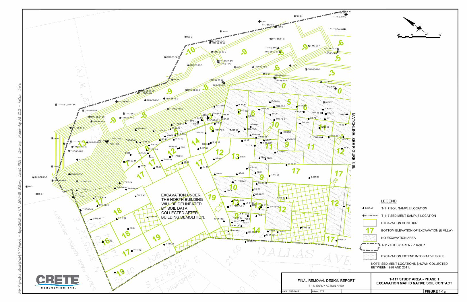
T-117 SOIL SAMPLE LOCATION
T-117 SEDIMENT SAMPLE LOCATION
EXCAVATION CONTOUR
BOTTOM ELEVATION OF EXCAVATION (ft MLLW)
NO EXCAVATION AREA
T-117 STUDY AREA - PHASE 1
EXCAVATION EXTEND INTO NATIVE SOILS
DRWN:DATE:
FINAL REMOVAL DESIGN REPORT
T-117 EARLY ACTION AREA
T-117 STUDY AREA - PHASE 1
EXCAVATION MAP ID NATIVE SOIL CONTACT
8/17/2012
FIGURE 1-1a
BTS
LEGEND
MA
TC
HL
IN
E: S
EE
F
IG
UR
E 3
-8
b
T-117 A3
T117-SE-94-SC
17
NOTE: SEDIMENT LOCATIONS SHOWN COLLECTED
BETWEEN 1998 AND 2011.
EXCAVATION UNDER
THE NORTH BUILDING
WILL BE DELINEATED
BY SOIL DATA
COLLECTED AFTER
BUILDING DEMOLITION.
MA
TC
HL
IN
E: S
EE
F
IG
UR
E 3
-8
a
T-117 SOIL SAMPLE LOCATION
T-117 SEDIMENT SAMPLE LOCATION
EXCAVATION CONTOUR
BOTTOM ELEVATION OF EXCAVATION (ft MLLW)
NO EXCAVATION AREA
T-117 STUDY AREA - PHASE 1
EXCAVATION EXTEND INTO NATIVE SOILS
DRWN:DATE:
FINAL REMOVAL DESIGN REPORT
T-117 EARLY ACTION AREA
T-117 STUDY AREA - PHASE 1
EXCAVATION MAP ID NATIVE SOIL CONTACT
8/17/2012
FIGURE 1-1b
BTS
LEGEND
T-117 A3
T117-SE-94-SC
17
NOTE: SEDIMENT LOCATIONS SHOWN COLLECTED
BETWEEN 1998 AND 2011.


