40
Appropriate Assessment July 2014 Updated Report (Habitats Regulations Assessment Report) Brighton & Hove Submission City Plan Part One Proposed Modifications July 2014

Appropriate AssessmentJuly 2014 Updated Report(Habitats Regulations Assessment Report)
Brighton & Hove SubmissionCity Plan Part One
Proposed Modifications
July 2014

Page 1 of 38
Brighton & Hove Submission City Plan Part 1 - Proposed Modifications
(July 2014)
Appropriate Assessment July 2014 Updated Report
(Habitats Regulations Assessment Report)

Page 2 of 38
Appropriate Assessment for the Brighton & Hove Submission City Plan Part 1 - Proposed Modifications (July 2014) Contents
1. Introduction 2. Screening 3. Discussion of Potential Effects 4. Summary and Conclusions
Appendices
Appendix A : Transcript of an email from Natural England dated 1 July 2014 (relating to the July 2014 updated report) Appendix B: Transcript of an emailed letter from Natural England dated 2 May 2012 (relating to the May 2012 updated
report undertaken for the Draft City Plan Part One) Appendix C: Statutory Consultee comments and response (including transcript of letter from Natural England, dated 24
February 2010, relating to the January 2010 updated report undertaken for the proposed Submission Core Strategy)
Appendix D: Transcript of a letter from Natural England dated 4th April 2008 (relating to the Appropriate Assessment undertaken for the Core Strategy - Refreshed Preferred Options 2008)
Appendix E: E-mail from Natural England dated 28th September 2007

Page 3 of 38
1. Introduction
1.1. Article 6 of Directive 92/43/EEC on the Conservation of Natural Habitats and of Wild Fauna and Flora (the Habitats Directive) requires an Appropriate Assessment, usually referred to in England as a ‘Habitats Regulations Assessment‘ (HRA) to be undertaken to assess the impacts of a plan or project against the conservation objectives of a European Site and to ascertain whether it would adversely affect the integrity of that site. Where significant negative effects are identified, alternative options should be examined to avoid any potential damaging effects, unless there are ‘imperative reasons of overriding interest’, in which case suitable compensatory measures are required.
1.2. Article 6(3) of the European Habitats Directive also states: “the competent national authorities shall agree to the plan or project only after having ascertained that it will not adversely affect the integrity of the site concerned and, if appropriate, after having obtained the opinion of the general public”.
1.3. European sites consist of Special Areas of Conservation (SACs), Special Protection Areas (SPAs) and European
offshore marine sites (EMS) are the marine equivalents of terrestrial SACs and SPAs. There are no EMS designated in the UK at present.
1.4. Under Regulation 102 of the Conservation of Habitats and Species Regulations 2010, land use plans must be subject
to HRA where a land use plan is likely to have a significant effect on a European site which is not directly connected with or necessary to the management of the site. HRA therefore applies to the City Plan Part 1 and related Planning Documents.
1.5. In August 2006 the Department for Communities and Local Government (DCLG) published draft guidance titled ‘Planning for the Protection of European Sites: Appropriate Assessment - Guidance For Regional Spatial Strategies and Local Development Documents’. The draft guidance was intended to be a step towards establishing a national methodology for applying HRA. In August 2007 the RSPB published ‘The Appropriate Assessment of Spatial Plans in England: a guide to why, when and how to do it.’ which is also a helpful clarification of procedure. This report takes full

Page 4 of 38
account of this guidance, of other relevant guidance1 and the reports of previously completed HRAs in the South East.
1.6. European and national guidance on HRA promotes a process of up to four stages:
1. Screening. An initial determination of whether the plan ‘in combination’ with other plans and projects, is likely to have a
significant effect on European sites.
2. The Appropriate Assessment. If significant effects cannot be ruled out at the screening stage, a more detailed determination of whether, in view of the site’s structure, function and conservation objectives, the plan in itself, or in combination with other plans or projects, could have an adverse effect on the site integrity.
3. Assessment of alternative solutions Where significant effects cannot be ruled out, alternatives are assessed.
4. Assessment where there are no alternative solutions and where adverse impacts remain Consideration of appropriate compensatory measures where it is considered the plan should proceed because of imperative reasons of overriding public interest.
1.7. This report describes Stage 1 of this process. It describes and assesses:
• The European sites that could be affected by the Brighton & Hove Submission City Plan Part 1 - Proposed Modifications, including the qualifying features of those sites, their conservation objectives and the key environmental conditions to support their integrity;
• An assessment of all possible impacts on the sites arising from the Brighton & Hove Submission City Plan Part 1 - Proposed Modifications;
1 See : Therivel, R. (2009) ‘Appropriate assessment of plans in England’, Environmental Impact Assessment Review 29(4), pp. 261-272. Scott Wilson et al. (September 2006) Appropriate Assessment of Plans. David Tyldesley Associates for Natural England, (2007) - Draft Guidance – The Assessment of Regional Spatial Strategies and Sub-regional strategies under the provisions of the Habitats Regulations.

Page 5 of 38
• An explanation of the impacts that can be screened out and why it has been concluded that it is not necessary to complete a full HRA.
1.8. An HRA was undertaken on the Refreshed Preferred Options of the Council’s Core Strategy in 2008 and the proposed Submission Brighton & Hove Core Strategy in 2010, which were subject to consultation with Natural England. Recommendations contained within Natural England’s response are attached for information (see Appendices C and D). In July 2011, the Council agreed to withdraw the Core Strategy from its examination to allow it to be updated and amended. This was agreed by the Secretary of State and the Core Strategy was formally withdrawn in September 2011. The need to amend the document arose from soundness issues raised at an Exploratory Meeting with the appointed Planning Inspector in May 2010. This concerned the housing delivery strategy in the submitted document and the government’s subsequent proposed removal of regional housing targets. The need to update the document also arose from the number of significant changes that occurred since the document was submitted to the Secretary of State in 2010. These included changes to national legislation and guidance (Localism Act and National Planning Policy Framework) reduced availability of government funding for capital projects and the completion of updated background studies. A draft City Plan Part 1 was published in May 2012 and an Appropriate Assessment undertaken in part to ensure the new Development Area of Toads Hole Valley (DA7) was assessed (see Appendix B).
1.9. The City Plan Part 1 was agreed at council on 31 January 2013 for formal publication prior to its submission to the Secretary of State for independent examination. The City Plan Part 1 and its accompanying documents were submitted in June 2013 to the Secretary of State for independent examination. As part of the examination, Public Hearings were held 22 October – 31 October 2013.
1.10. The Inspector indicated in her closing statement that further work and modifications would be required before the
Plan could be found sound. This was detailed in an Initial Conclusions Letter sent by the Inspector 13 December 2013. The Inspector considered the city’s objectively assessed housing need should be at the higher end of the objectively assessed range i.e 20,000 over the plan period2 and therefore the City Plan housing target of 11,300 represented a significant shortfall. She indicated the plan failed to meet the social dimension of sustainable development and the City Council should look again to rigorously assess all opportunities to meet housing need. Three sources of supply were indicated; firstly whether a further contribution through windfall provision could be
2 Housing Duty to Cooperate Study, Sussex Coast Housing Market Area, May 2013
Page 6 of 38
appropriate and secondly, to a more rigorous assessment of the city’s urban fringe sites and thirdly, employment sites3.
1.11. Consultants were commissioned by the council to undertake a robust assessment of the potential for housing within
the urban fringe. The Urban Fringe Assessment Study has informed the proposed modifications to the spatial strategy for accommodating growth in the city and CP1 Housing Delivery. It is proposed that the Urban Fringe is now identified as a broad source of potential for housing (1,200 units). An additional 650 units has also been added to the windfall allowance (now 1250) and added to the city’s housing target which is proposed to be increased to 13, 200.
1.12. The Inspector needs to be satisfied that the requirements for public consultation, SA and HRA are met with regard
to the proposed modifications before she can consider the proposed modifications and conclude the examination.
2. Screening European sites
2.1. Table 1 lists the European sites which have boundaries within 20 km of the administrative boundary of Brighton and Hove. The 20 km buffer zone is very comprehensive and greater than has been chosen by other HRAs in the South-East. Only Castle Hill SAC is within the administrative boundary of Brighton & Hove City Council.
3 Although the Inspector clarified in a subsequent letter to the Council that she was content at this stage to consider the matter of employment sites once representations on the Main Modifications drafted by the Council to CP3 were consulted upon.

Page 7 of 38
Table 1: European sites within 20 km of Brighton and Hove
Name
OS Grid Ref. Designation
Reason for designation
Closest distance (straight line) from Brighton and Hove
boundary (km)
Castle Hill TQ372066 SAC
Chalk grassland with a mosaic of calcareous semi-natural dry grassland communities. Important assemblage of rare and scarce species inc. early spider orchid (one of the largest colonies in the UK), early gentian and burnt orchid.
within boundary
Lewes Downs TQ441093 SAC Chalk grassland with CG2 Festuca ovina – Avenula pratensis and CG3 Bromus erectus calcareous grasslands. - important assemblage of rare and scarce orchids.
6
Ashdown Forest TQ451306 SAC & SPA
One of the largest single continuous blocks of lowland heath (both dry and wet heath) in South East England. Population of great crested newt (SAC). Nationally important breeding populations of nightjar and Dartford warbler (SPA).
19.5
Arun Valley TQ033142
SPA
Internationally important wintering population of tundra swan
20
Brighton & Hove Submission City Plan Part 1 - Proposed Modifications
2.2. The Brighton & Hove Submission City Plan Part 1 - Proposed Modifications cover the period 2010-2030. The plan includes 14 Development/Special Area policies and 22 citywide policies. The key aims of the document include the delivery of:

Page 8 of 38
• A local housing target of approximately13,200 net additional dwellings. • Net additional employment floorspace to address the identified shortfall of 96,100 sq m of B1a and B1b floorspace
2006-2026 through existing commitments and potential supply from major development sites and other strategic allocations (as indicated in the City Plan’s Employment Land policy CP3);
• Optimising development on brownfield sites throughout the existing built-up area of the city; • Directing significant development to broad areas of the city where identified capacity exists to accommodate further
development and where it is possible to make full use of public transport/ public transport interchanges or where public transport can be enhanced. These key broad areas are identified for place-shaping and development to bring about sustainable communities;
• Promotion of some major developments, including redevelopment of the Brighton Centre and delivery of the King Alfred development, of importance to the city and the region;
• The allocation of strategic sites and employment sites; • Improved coordination of policy and strategies across the city. The potential environmental impacts of each of these policies on European Sites are assessed in Table 2
Table 2: Submission City Plan Part 1 - Proposed Modifications : Policies and their potential environmental effects on European Sites (policies with potential for positive effects are highlighted) Policy Summary description Potential environmental impacts
of relevance to this HRA DA 1 – Brighton Centre and Churchill Square Area
New state of the art convention facility (25,000sqm), hotel and leisure facilities Extension of the Churchill Square shopping centre (a minimum of 20,000sqm). Approximately 20 residential units. Appropriate transport infrastructure improvements that provide and promote public and sustainable transport to support the redevelopment.
Increased resource use – water, hydrocarbons Increased traffic volumes Air pollution

Page 9 of 38
Policy Summary description Potential environmental impacts of relevance to this HRA
DA 2 - Brighton Marina, Gas Works and Black Rock Area
Development of Brighton Marina as a sustainable mixed use district of the city; enhanced transport infrastructure; improved pedestrian and cycle access; good mix of housing (an additional 1,940 residential units) which reflects housing needs. In addition to the additional housing the following amounts of additional development are detailed: 5,000sqm retail (A1-A5); 2,000sqm employment floorspace (B1); circa 10,500sqm leisure; a community building within the Marina; a health facility within or near the Marina; primary school or increase in school places within or near the Marina.
Increased resource use – water, hydrocarbons. Increased traffic volumes Air pollution Increased recreational pressure.
DA 3 - Lewes Road Area Sustainable redevelopment and expansion of the University campuses including accommodation for students; improved bus, cycle and pedestrian routes; open space improvements; an additional 850 residential units (inc 300 at Preston Barracks site); employment led development comprising 15,600 sqm employment floorspace (inc 5,000sqm at Woollards Field South and 10,600sqm at Preston Barracks site); 16,000sqm business school and 900 bed student accommodation (inc 750 at Preston Barracks site); community building at Bevendean.
Increased resource use – water, hydrocarbons. Increased traffic volumes Air pollution Increased recreational pressure.
DA4 - New England Quarter and London Road Area
Revitalise the London Road retail area and create a major new business quarter (20,000 sq m office floor space post 2016); create a green gateway to the city at Preston Road West; minimum of 1130 residential units, 300 bed student accommodation; improvements in vocational training and further education as an extension to the Academic Corridor.
Increased resource use – water, hydrocarbons. Increased traffic volumes Air pollution Increased recreational pressure.

Page 10 of 38
Policy Summary description Potential environmental impacts of relevance to this HRA
DA5 - Eastern Road and Edward Street Area
Improvements to the public realm and townscape; additional school places; up to 23,200sqm employment floorspace; a minimum of 515 residential units; enlargement of Royal Sussex County Hospital (additional 74,000sqm hospital floorspace); 400 bed student accommodation; 3,800sqm University floorspace; Dance Studio; multi practice GP’s surgery and community facilities/ buildings (eg for Queens Park and Craven Vale).
Increased resource use – water, hydrocarbons. Moderate increase in traffic volumes Air pollution Possible increase in recreational pressure.
DA6 - Hove Station Area
Employment-led mixed-use regeneration of under-used land and buildings, improving the public realm and the walking and cycling network in the area; an additional 525 residential units and 1,000sqm employment floorspace.
Increased resource use – water, hydrocarbons. Moderate increase in traffic volumes Air pollution
DA7 - Toads Hole Valley Modern, high quality and sustainable mixed use development that meets the future needs of the city including a minimum of 700 homes, 3.5-4.5 hectare site area with the aim of accommodating c. 25,000 sq m office/ high tech business space, a secondary school, multi-use community facility, ancillary supporting uses (eg shops and cafes), and open space and biodiversity enhancements.
Increased resource use – water, hydrocarbons. Increase in traffic volumes Air pollution Increase in recreational pressure.
DA8 - Shoreham Harbour Area
Long-term regeneration of Shoreham Port and immediately surrounding area to deliver a series of appropriately located high quality sustainable mixed use developments including new housing, employment space, leisure opportunities, improved public realm. Consolidation and enhancement of Shoreham Port. Within Brighton and Hove ; approximately 300 new residential units and 7,500 sq m of net additional employment floorspace.
Increased resource use – water, hydrocarbons. Increased traffic volumes Air pollution Increased recreational pressure
SA1 – The Seafront
On-going regeneration, in an integrated and coordinated manner, to support the retail, leisure, recreation and cultural role of the seafront, new leisure provision and a minimum of 400 residential units at King Alfred/RNR site (strategic allocation).
Possible improvements to water effluent; potential for increased traffic volumes and air pollution

Page 11 of 38
Policy Summary description Potential environmental impacts of relevance to this HRA
SA2 - Central Brighton
Reinforce central Brighton’s role as a vibrant, thriving regional centre for shopping, tourism, cultural and commercial facilities; significant new retail development; improved public realm and community safety. Identifies Central Brighton as the primary office area where existing office accommodation will be protected. Development is to take into account impact on local air quality and that improvements are/or mitigation are sought wherever possible.
Potential for increased traffic volumes and air pollution
SA3 – Valley Gardens Regenerate the Valley Gardens to reduce the adverse impact of vehicular traffic and create a continuous green boulevard.
Possible reduction in recreational pressure on downland sites
SA4 - Urban Fringe
Urban fringe is defined as ‘land between the built up area boundary and the intended South Downs National Park boundary’. The Submission City Plan Part 1 - Proposed Modifications reflect the findings of the Urban Fringe Assessment undertaken to address the issues raised by the Inspector following the Hearing in Public. Policy SA4 acknowledges the Urban Fringe Assessment which indicates a housing potential of 1,200 residential units to come from land within the urban fringe but does not allocate the sites – these will be defined in Part 2 of the City Plan. There is however an undertaking that no such potential housing land will be identified within 2km of a European Site. Where no potential for housing identified, the policy seeks the protection and enhancement of the urban fringe; promoting urban fringe as part of the city’s green network; improved access to the countryside.
Increased resource use – water, hydrocarbons. Increased traffic volumes Air pollution Increased recreational pressure
SA5 – The South Downs Maintain and protect the natural beauty of the South Downs, in the National Park boundary and its setting; enhancing access by sustainable transport.
Possible increase in recreational pressure to downland sites

Page 12 of 38
Policy Summary description Potential environmental impacts of relevance to this HRA
SA6 - Sustainable Neighbourhoods
Contribute to creating and maintaining sustainable neighbourhoods and reduce inequalities between neighbourhoods by: maintaining a good balance and mix of uses in local centres; improving quality of public services and range of learning and training facilities; improving sustainable transport access; improving community facility provision and choice of housing; improving environmental sustainability of new and existing buildings; supports sports, arts and cultural projects that enhance the environment and social cohesion; securing good quality employment and training opportunities; help to reduce health and learning inequalities and promote healthier lifestyles and in areas with environmental and community safety concerns support improvements to public realm, biodiversity and open space.
Possible reduction in recreational pressure on downland sites; potential for reduced resource use – water, hydrocarbons.
CP1 - Housing Delivery
New housing development delivered in a managed way in order to help provide sustainable communities. The proposed modifications increase the housing target to approximately 13,200 residential units (Submission City Plan indicated 11,350). The increase arises from an additional 650 windfall unit allowance and approximately 1200 from the urban fringe.
Increased resource use – water, hydrocarbons. Increased traffic volumes Air pollution Increased recreational pressure.
CP2 - Sustainable Economic Development
Overarching strategy regarding sustainable economic development: supporting the city’s key employment sectors, ICT infrastructure and Local Employment Scheme.
Increased resource use – water, hydrocarbons. Increased traffic volumes Air pollution.
CP3 - Employment Land Alongside proposals and allocations set out in DA1 – DA8 and SA2, this policy ensures sufficient employment sites and premises are safeguarded in order to meet the needs of the city to 2030; sets out the hierarchy of employment sites that will be protected for B1-B8 uses and those where mix use development (housing and employment) will be allowed. Secondary employment sites will continue to be protected.
None

Page 13 of 38
Policy Summary description Potential environmental impacts of relevance to this HRA
CP4 - Retail Provision
Current hierarchy of shopping centres will be maintained and enhanced, except the Brighton Marina District Centre which will be removed. Brighton Marina will be covered by a detailed retail policy in the City Plan Part 2.
None
CP5 - Culture and Tourism Maintain and enhance the historic environment and culture of the city to the benefit of residents and visitors.
None
CP6 - Visitor Accommodation
Management of proposals for new major hotel facilities.
Increased resource use – water, hydrocarbons. Increased traffic volumes Air pollution Increased recreational pressure.
CP7 - Infrastructure CIL and Developer Contributions
Planning and provision of social and physical infrastructure. None directly
CP8 – Sustainable Buildings
Promote the best possible standards of sustainable building design, construction, management and decommissioning in new and existing developments. The Inspector has requested modifications to this policy to address concerns with viability and to bring the policy in line with national standards.
Possible reduction in recreational pressure on downland sites; potential for reduced resource use – water, hydrocarbons.
CP9 - Sustainable Transport
Contribute to creating an integrated sustainable transport system that will accommodate new development, improve accessibility, promote walking, cycling and public transport use, and contribute to a safer, cleaner, quieter city. The policy is divided into two main parts – part A sets out the strategy for transport on a local and regional level and part B sets out the measures that will be undertaken. The main measures to intercept car journeys into the city are to better use existing car parks on the periphery of the city and to encourage transfers onto rail. Infrastructure will be put in place to enable the introduction of rapid/express bus services on key routes.
Increased resource use – hydrocarbons. Increased traffic volumes Air pollution Increased recreational pressure.

Page 14 of 38
Policy Summary description Potential environmental impacts of relevance to this HRA
CP10 - Biodiversity
Develop programmes and strategies which aim to conserve and enhance biodiversity including contributing to the delivery of biodiversity improvements within the South Downs Way Ahead Nature Improvement Area and protecting existing biodiversity from development.
Possible reduction in recreational pressure on downland sites.
CP11 - Flood Risk Reduce flood risk. None
CP12 – Urban Design Raise the standard of architecture and design in the city. None
CP13- Public Streets and Spaces
Quality, legibility and accessibility of the city’s public urban realm will be improved in a comprehensive manner.
None
CP14 - Housing Density
Higher housing densities permitted, where it meets defined criteria with a net density of at least 50 dwellings per hectare.
None directly
CP15 - Heritage Conserve and enhance the city’s historic environment, including buildings of historic importance and conservation areas. .
None
CP16 - Open Space Safeguard, enhance, and promote access to Brighton and Hove's green/open spaces.
Possible reduction in recreational pressure on downland sites.
CP17 - Sports Provision Safeguard, enhance and promote access to Brighton and Hove’s sports facilities helping to increase participation in sport and physical activity.
Possible reduction in recreational pressure on downland sites.
CP18- Healthy City Support and promote healthier lifestyles and reduce health inequalities.
None
CP19 - Housing Mix Ensure that an appropriate mix of housing in terms of housing type, size and tenure is achieved across the city.
None
CP20 - Affordable Housing
Require the provision of affordable housing on all sites of 5 or more dwellings (net) in line with the affordable housing targets set out in the policy.
Increased resource use – water, hydrocarbons. Increased traffic volumes Air pollution Increased recreational pressure.

Page 15 of 38
Policy Summary description Potential environmental impacts of relevance to this HRA
CP21 - Student Housing and Housing in Multiple Occupation (HMO)
New policy that sets a threshold for new HMO in identified areas alongside an Article 4 Direction. Identification of sites for new build student accommodation (Varley Halls, Preston Barracks site, Pelham Street, Circus Street and University of Sussex) and sets out criteria for assessment of purpose built student accommodation.
None
CP22 - Traveller Accommodation
Provision will be made to meet the city’s need for gypsy and traveller accommodation. The council will seek to deliver 18 permanent residential pitches to meet the assessed local need for the period to 2019. Although the precise locations for gypsy and traveller accommodation have not been defined, there is an undertaking that they will not have a significant adverse impact on a site of European Nature Conservation Importance.’
None
Likely Environmental Impacts
2.3. The possible environmental impacts of the Submission City Plan Part 1 - Proposed Modifications on European Sites can be summarised as being in the form of:
• Increased recreational pressure on green spaces and the countryside including the possibility of increased visits to
the European sites.
• Increased traffic, leading to increased air pollution, which could affect species that are sensitive to air quality.
• Increased resource use, including minerals, water and fuel. Increased water abstraction could affect water levels at the European sites.

Page 16 of 38
In Combination Effects
2.4. The HRA for the revoked South East Plan identifies a number of existing environmental trends at the regional scale. These need to be considered where relevant to the potential environmental impacts identified in 2.3 (above) on the European Sites listed in Table 1 because of their potential to have ‘in combination’ effects:
• Water supply: Most of the wetland sites in the South-East are affected by existing abstraction rates. The HRA to
the revoked South East Plan is unable to conclude that the Plan is unlikely to have a significant impact on the integrity of some European Sites, including Arun Valley, without a number of ‘strong measures’ being put in place to improve water efficiency and reduce demand. Increased demand associated with new housing and other development is likely to acerbate any water abstraction effects on European Sites.
• Worsening air quality due to traffic growth and increased fossil fuel consumption. Ashdown Forest,
Castle Hill and the Lewes Downs are listed in the HRA for the revoked South East Plan as being European Sites known to have depositions of air pollutants which exceed their critical load. Elevated levels of oxides of Nitrogen, Ammonia, Sulphur Dioxide and low-level Ozone are of particular concern. Motor vehicles are key contributors of these pollutants (see HRA to the revoked South East Plan, Table 8).
• More recreational pressure as a consequence of increased population. The HRA to the revoked South East
Plan lists a number of potential effects associated with recreation, including disturbance to wildlife, management difficulties and erosion. Ashdown Forest, Arun Valley and Lewes Downs are listed as being European Sites where it cannot be concluded that there will be no adverse effect due to increased recreational pressure associated with developments (see HRA to the revoked South East Plan, Table 10).
Screening Table
2.5. Table 3 summarises the screening of the potential direct and in combination effects of the Brighton & Hove City Plan Part 1 on the European Sites identified in Table 1.

Page 17 of 38
Table 3: Screening of the potential effects of the Brighton & Hove City Plan Part 1 on European Sites
Site
Qualifying features
Key environmental conditions to support
site integrity
Possible impacts
arising from City Plan Part
1
Is there a risk of a significant effect?
Possible ‘in combination’
impacts.
Risk of significant
‘in combination’
effects?
Arun Valley
Used by more than 1% of GB’s population of Annex I species Bewick’s swan (Cygnus columbianus bewickii). - Internationally important wintering population of 20,000+ waterfowl.
Sympathetic management of lowland wet grassland /grazing marsh (including water level management).
None – dependent on local factors
No None No

Page 18 of 38
Site
Qualifying features
Key environmental conditions to support
site integrity
Possible impacts
arising from City Plan Part
1
Is there a risk of a significant effect?
Possible ‘in combination’
impacts.
Risk of significant
‘in combination’
effects?
The neutral wet grassland ditches support rich aquatic flora and fauna. 7 Red Data Book threatened species, one of which is endangered; plus 4 rare and 4 nationally scarce plant species.
Maintenance of hydrological regime, including winter flooding
Development of 11,300 new homes in Brighton and Hove will increase demand for water. But Brighton and Hove is not in the Arun Valley water catchment.
No None – the Catchment Abstraction Management Strategy (CAMS) for The Arun and Western Streams does not address the Brighton and Hove area which is in a separate catchment
No
Page 19 of 38
Site
Qualifying features
Key environmental conditions to support
site integrity
Possible impacts
arising from City Plan Part
1
Is there a risk of a significant effect?
Possible ‘in combination’
impacts.
Risk of significant
‘in combination’
effects?
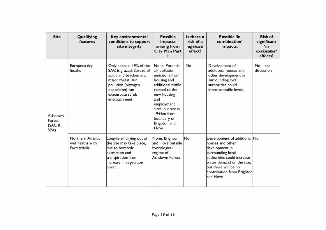
European dry heaths
Only approx. 19% of the SAC is grazed. Spread of scrub and bracken is a major threat. Air pollution (nitrogen deposition) can exacerbate scrub encroachment
None: Potential air pollution emissions from housing and additional traffic related to the new housing and employment sites, but site is 19+km from boundary of Brighton and Hove
No Development of additional houses and other development in surrounding local authorities could increase traffic levels.
No – see discussion
Ashdown Forest (SAC & SPA)
Northern Atlantic wet heaths with Erica tetralix
Long-term drying out of the site may take place, due to borehole extraction and transpiration from increase in vegetation cover.
None: Brighton and Hove outside hydrological regime of Ashdown Forest
No Development of additional houses and other development in surrounding local authorities could increase water demand on the site, but there will be no contribution from Brighton and Hove
No

Page 20 of 38
Site
Qualifying features
Key environmental conditions to support
site integrity
Possible impacts
arising from City Plan Part
1
Is there a risk of a significant effect?
Possible ‘in combination’
impacts.
Risk of significant
‘in combination’
effects?
Great Crested Newt
Suitable foraging and refuge habitat within 500m of the pond; unpolluted water; grazing management to prevent succession;
None No Local issues not significantly affected by development in Brighton and Hove
No
Ashdown Forest (SAC & SPA)
Nationally important breeding populations of nightjar and Dartford Warbler
Low recreational disturbance of birds
New housing in Brighton and Hove will not significantly effect traffic levels and recreational pressure on Ashdown Forest, some 19 km away (see discussion)
No Ashdown Forest has a wide recreational catchment area. The increased housing proposed for neighbouring local authorities could increase recreational pressure. However development in Brighton and Hove will have a negligible effect (see discussion)
No

Page 21 of 38
Site
Qualifying features
Key environmental conditions to support
site integrity
Possible impacts
arising from City Plan Part
1
Is there a risk of a significant effect?
Possible ‘in combination’
impacts.
Risk of significant
‘in combination’
effects?
Chalk grassland with CG2 Festuca ovina – Avenula pratensis and CG3 Bromus erectus calcareous grasslands. - important assemblage of rare and scarce orchids. The colony of burnt orchid is one of the largest in the UK
The grassland habitats depend upon grazing by sheep and cattle. Gradual scrub and coarse grass invasion can be indicative of nutrient (Nitrogen) enrichment or inadequate grazing.
Potential air pollution emissions from additional traffic related to new housing could increase Nitrogen deposition rates but the impact of Brighton and Hove development is not considered significant
No (see discussion)
Development of additional houses and other development in surrounding local authorities could increase deposition of Nitrogen and other pollutants but the contribution of Brighton and Hove is not thought to be significant (see discussion)
No Lewes Downs
Where arable land meets the SSSI boundary, leaching and spray-drift are potential threats.
Local management issue
No None No

Page 22 of 38
Site
Qualifying features
Key environmental conditions to support
site integrity
Possible impacts
arising from City Plan Part
1
Is there a risk of a significant effect?
Possible ‘in combination’
impacts.
Risk of significant
‘in combination’
effects?
Lewes Downs
Recreational pressure is not regarded by the JNCC as a threat to the site. Lewes Downs is managed as a national Nature Reserve and therefore increased recreation, if it did become an issue, could be managed accordingly
None No None No

Page 23 of 38
Site
Qualifying features
Key environmental conditions to support
site integrity
Possible impacts
arising from City Plan Part
1
Is there a risk of a significant effect?
Possible ‘in combination’
impacts.
Risk of significant
‘in combination’
effects?
This chalk grassland consists of a mosaic of calcareous semi-natural dry grasslands. Castle Hill’s important assemblage of rare and scarce species includes early spider-orchid Ophrys sphegodes and burnt orchid Orchis ustulata. The colony of early spider-orchid is one of the largest in the UK.
Continued conservation grazing by sheep and cattle. Encroachment by scrub is prevented by cutting and grazing animals. The issue of concern relates to gradual coarse grass invasion. This can be indicative of nutrient (Nitrogen) enrichment or inadequate grazing.
Potential air pollution emissions from housing and additional traffic related to new housing and employment could increase Nitrogen deposition rates but the impact of Brighton and Hove development is not considered significant
No Development of additional houses and other development in surrounding local authorities could increase deposition of Nitrogen and other pollutants but the contribution of Brighton and Hove is not significant (see discussion)
No
Castle Hill
Early gentian
Gentianella anglica
The site is surrounded by arable land, so leaching and spray-drift are potential threats.
Local management issue
No None No

Page 24 of 38
Site
Qualifying features
Key environmental conditions to support
site integrity
Possible impacts
arising from City Plan Part
1
Is there a risk of a significant effect?
Possible ‘in combination’
impacts.
Risk of significant
‘in combination’
effects?
Castle Hill See above Recreational pressure is not recorded as a threat to the site. Castle Hill is managed as a national Nature Reserve and therefore increased recreation, if it did become an issue, could be managed accordingly
None
No None No
3. Discussion of Potential Effects Air Pollution
3.1. Air pollution arising from policies in the City Plan Part 1 which result in increased road traffic and other sources is a potential impact at all the European sites listed in Table 1, except the Arun Valley. Air pollution can have a range of impacts:
• Sulphur, nitrates, nitrogen oxides and nitric acid can acidify soils. They are primarily caused by power stations,
industrial boilers, motor vehicles and domestic heating.
• Nitrogen oxides and ammonia promote nutrient enrichment. This promotes some competitive plant species over slower-growing, low nutrient demanding species, which tend to be the rarer species.
• Ground-level ozone, released from car engines, damages plants and can alter plant communities.

Page 25 of 38
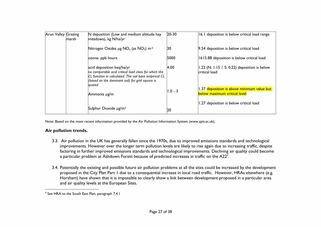
3.2. Table 4 summarises existing air quality problems at the European Sites under consideration. Ozone levels exceed
critical levels at all sites. Acid deposition at Ashdown Forest and the Arun Valley also exceeds critical levels.
Table 4: Air quality at selected European sites site habitat pollutant, measurement critical level /
range deposition
Ashdown Forest
lowland heathland
N deposition (dry heath), kg N/ha/yr ozone, ppb hours acid deposition, keq/ha/yr Ammonia µg/m
Sulphur Dioxide µg/m3 Nitrogen Oxides, µg NOx (as NO2) m-3
10-20 5000 CLmaxS: 0.32 CLminN: 0.64 CLmaxN: 0.96 1-3 20 30
14.84 deposition is within critical load range 1479.07 deposition is below critical load 1.16 (N: 1.06 | S: 0.25) deposition exceeds critical load range 0.74 deposition is below critical load 1.08 deposition is below critical load 9.5 deposition is below critical load

Page 26 of 38
Castle Hill Sub-atlantic semi-dry calcareous grassland:
N deposition (calcareous grassland), kg N/ha/yr Nitrogen Oxides µg NOx (as NO2) m-3
ozone, ppb hours acid deposition keq/ha/yr Ammonia µg m-3
Sulphur Dioxide µg/m3
15-25 30
5000 MaxCLmaxS: 3.95 CLminN: 0.85 CLmaxN: 4.81 1.0 - 3 20
15.54 deposition is within critical load range 12.76 deposition is below critical load 1660.92 deposition is below critical load 1.18 (N: 1.11 | S: 0.19) deposition is within critical load range (N only) 1.29 deposition is above minimum value but below maximum critical level 1.06 deposition is below critical load
Lewes Downs
Sub-atlantic semi-dry calcareous grassland:
N deposition (calcareous grassland), kg N/ha/yr Nitrogen Oxides µg NOx (as NO2) m-3
ozone, ppb hours acid deposition keq/ha/yr Ammonia µg/m
Sulphur Dioxide µg/m3
15-25 30 5000 CLmaxS: 3.94 CLminN: 0.85 CLmaxN: 4.8 1.0 - 3 20
17.78 deposition is above minimum value but below maximum critical level 11.98 deposition is below critical load 1573.13 deposition is below critical load 1.34 (N: 1.27 | S: 0.2) deposition is within critical load range (N only)
1.85 deposition is above minimum value but below maximum critical level 1.12 deposition is below critical load
Page 27 of 38
Arun Valley Grazing marsh
N deposition (Low and medium altitude hay meadows), kg N/ha/yr Nitrogen Oxides µg NOx (as NO2) m-3
ozone, ppb hours acid deposition keq/ha/yr no comparable acid critical load class for which the CL function in calculated. The soil base empirical CL (based on the dominant soil) for grid square is quoted
Ammonia µg/m
Sulphur Dioxide µg/m3
20-30 30 5000 4.00 1.0 - 3 20
16.1 deposition is below critical load range 9.54 deposition is below critical load 1615.88 deposition is below critical load 1.22 (N: 1.15 | S: 0.22) deposition is below critical load
1.37 deposition is above minimum value but below maximum critical level 1.27 deposition is below critical load
Note: Based on the most recent information provided by the Air Pollution Information System (www.apis.ac.uk).
Air pollution trends.
3.3. Air pollution in the UK has generally fallen since the 1970s, due to improved emissions standards and technological improvements. However over the longer term pollution levels are likely to rise again due to increasing traffic, despite factoring in further improved emissions standards and technological improvements. Declining air quality could become a particular problem at Ashdown Forest because of predicted increases in traffic on the A224.
3.4. Potentially the existing and possible future air pollution problems at all the sites could be increased by the development
proposed in the City Plan Part 1 due to a consequential increase in local road traffic. However, HRAs elsewhere (e.g. Horsham) have shown that it is impossible to clearly show a link between development proposed in a particular area and air quality levels at the European Sites.
4 See HRA to the South East Plan, paragraph 7.4.1

Page 28 of 38
3.5. The Highways Agency Design Manual for Roads and Bridges5 provides detailed guidance for the assessment of the
potential impact of road projects on local air quality, including sites designated under the Habitats Directive. The guidance states that ‘where appropriate, the advice may be applied to existing roads’. The Manual identifies plans or projects which lead to daily traffic flows changing by 1,000 annual average daily traffic (AADT) or more or Heavy Duty Vehicle flows changing by 200 AADT or more as being potentially significant. However the Manual states that ‘Only properties and Designated Sites within 200 m of roads affected by the project need be considered.’
3.6. Paragraph 7.5.6 of the HRA to the revoked SE Plan states:
“Low-level ozone is a particular problem in that it cannot be practically assessed or avoided at anything less than a national scale, due to the complex nature of its relationship to increases in traffic, housing, etc. and its trans-national character.”
3.7. In 2006 the then English Nature (now Natural England) wrote to Runnymede Borough Council, in response to their concern that any development in Runnymede could significantly affect European sites through air pollution6. English Nature’s response suggests that HRAs at the local level should focus on local air pollution impacts:
“The LDF-CS can only be concerned with locally emitted and short range locally acting pollutants. In terms of pollution from vehicular emissions the concentrations decline exponentially from the road edge. Though it varies with a range of factors and from pollutant to pollutant the concentrations of pollutants from roads can be said to have localised impacts up to 200m from the road side. Therefore for the LDF-CS effects of vehicular atmospheric emissions should be considered if the roads on which the vehicles travel are closer than 200m from the Natura 2000 site.”
3.8. Lewes Downs, Ashdown Forest and the Arun Valley are all several kilometres outside the boundary of Brighton and
Hove and any increase in localised air pollution caused to them by the City Plan Part 1 (from increased vehicular movements along roads within 200m of these sites) is considered to be trivial in comparison with existing background levels and the effects of proposed development much closer to these sites. Therefore, taking into account current
5 Highways Agency (2007): Design Manual for Roads and Bridges: Volume 11 Environmental Assessment, Section 3 Environmental Assessment Techniques, Part 1 Air Quality (HA207/07). 6 See HRA to South-east Plan, paragraph 7.5.1

Page 29 of 38
guidance, air pollution effects on these sites resulting from the City Plan Part 1 cannot be considered to be significant. Similarly, although Castle Hill is within the boundary of Brighton and Hove, the site is at least 400m from the nearest road and therefore beyond the range of localised impacts, even taking into account the potential for significant increases in road traffic as a consequence of the changes proposed to Policy CP1. It therefore seems reasonable to conclude, with the information available at this stage of the City Plan Part 1 development, that there is no significant effect of increased development in Brighton and Hove on air pollution within the European sites listed in Table 1.
3.9. ‘Urban fringe’ for residential development is defined in the City Plan Part 1 as ‘land between the built up area boundary
and the South Downs National Park boundary’. There is no such land in Brighton and Hove within 2km of a European Site. Therefore a similar conclusion can be drawn as stated in the previous paragraph about the potential air pollution impacts of such development on European sites.
Recreational Pressure
3.10. Castle Hill SAC is within the boundary of Brighton and Hove and therefore, of the European sites listed in Table 1, perhaps the most prone to increases in recreational pressure resulting from the Brighton & Hove City Plan Part 1. However Natural England consider that there is no evidence of an adverse effect on the interest features of the SAC due to recreational pressure7. According to Natural England, visitor numbers to Castle Hill have remained steady at around 3,500 per year since 1991, despite the introduction of open access legislation in 2000 and a policy of open access. The entire SAC is a National Nature Reserve, owned by the local authority, and therefore should recreational pressure become an issue in future, mechanisms could be put in place to manage visitor numbers.
3.11. Ashdown Forest SPA is vulnerable to recreational pressure because of the risk of reducing the breeding success of
Nightjar and Dartford Warbler, which are ground nesting birds and the qualifying features of the SPA. However Ashdown Forest is over 19 km from the boundary of Brighton and Hove and studies have shown an exponential drop in visitor numbers (by car) with distance from similar heathland sites. For example research by English Nature (now Natural England) found that half the people accessing a range of heathland sites across Dorset in 2006 lived within 3.7 km of the site8. Even when parking at the heathland site is provided, the report found that the typical distance people
7 E-mail from Natural England dated 28th September 2007. See Appendix D 8 Visitor Access Patterns on the Dorset Heathlands. English Nature Research Report No. 683

Page 30 of 38
drove to a Dorset heathland was about 4km and only 5% of people travelled further than 10km. Similarly, planning guidance designed to mitigate for the effects of recreational pressure on the Thames Basin Heaths SPA reports that 75% of visitors who regularly drive to heathland sites travel less than 5 kilometres. Consequently the planning guidance only requires mitigation for the potential effects of development within 5km of the SPA9.
3.12. Research from other heathland sites in the South East therefore suggests that a very small proportion of the visitors
to Ashdown Forest are from Brighton and Hove. However according to the HRA of the Horsham City Plan Part 1, Ashdown Forest has a larger visitor catchment area than the Thames Basin Heaths. A tourist survey of Ashdown Forest carried out in summer 200410 found that, of 218 visitors surveyed, 72% were day visitors from outside the forest area. However the number of these visitors that came from the Brighton and Hove area was still very small (single figures). The Horsham HRA concludes that any recreational effects on Ashdown Forest can be screened out, even though Horsham is closer than Brighton and Hove to the SPA. Similarly the HRA for the Mid Sussex District Plan, published in May 2013, states: ‘Following consultations with Natural England, a 7km zone of influence around Ashdown Forest was established. This is the area within which the majority (83%) of regular visitors to the Forest originate, and therefore where measures targeted at reducing pressure on the Forest would be most effective.’ This suggests that the new housing proposed by the Brighton & Hove Submission City Plan Part 1 – Proposed Modifications is also highly unlikely to have a significant impact on Ashdown Forest, and with the information available at this stage of City Plan Part 1 development, that it can therefore be screened out.
4. Summary and Conclusions
4.1. The Brighton & Hove Submission City Plan Part 1 – Proposed Modifications details areas with new housing and other development which could have an impact on European sites in the vicinity. Although some development is proposed on land between the built up area and South Downs National Park, there will be no encroachment onto land within 2km of a European Site.
9 THAMES BASIN HEATHS SPECIAL PROTECTION AREA: MITIGATION STANDARDS FOR RESIDENTIAL DEVELOPMENT (Draft). English Nature 26 May 2006. 10 Tourism South East Research Services. 2004. Ashdown Forest visitor monitoring survey 2004. Report commissioned by Wealden District Council and the Ashdown Forest Tourism Forum.

Page 31 of 38
4.2. The possible impacts of the City Plan Part 1 on European Sites amount to water abstraction, air pollution and recreational pressure. Of these:
� Water abstraction would not have a significant effect on any European site because there are no such sites which
are vulnerable to water abstraction within the water catchment area of Brighton and Hove.
� Despite policies which promote travel choice and minimise air pollution, it is still possible that air pollution may worsen as a result of the City Plan Part 1. However localised air pollution of this nature would not have a significant effect on any European site, according to Natural England advice.
� Recreational pressure on downland in the vicinity of Brighton and Hove may increase as a consequence of the
City Plan Part 1. However only one of the European sites assessed is vulnerable to recreational pressure (Ashdown Forest) and studies elsewhere have shown that this site is far enough away from Brighton and Hove to safely conclude that there would be no significant recreational impact on it as a result of the City Plan Part 1.
4.3. With the information available at this stage of City Plan Part 1 development, all the possible impacts of the Brighton &
Hove Submission City Plan Part 1 – Proposed Modifications on European sites have been discounted at the screening stage of this HRA. It is therefore concluded that no change to the City Plan Part 1 is required at this stage.
4.4. Brighton & Hove City Council includes the Castle Hill Special Area of Conservation, and a number of other European
or Ramsar wildlife sites are located in the wider area. The City Plan Part 1 has been assessed under the provisions of the Habitat Regulations to ensure that it will not have an adverse effect on any European or Ramsar wildlife site and this assessment has been recorded. The City Plan Part 1 does not support any project proposal where it cannot be demonstrated that the development would not have an adverse effect on the integrity of any European or Ramsar site. Any subsequent plan following this City Plan Part 1 will similarly adhere to the requirements of the Habitat Regulations.

Page 32 of 38
Appendix A Transcript of an emailed letter from Natural England dated 1 July 2014 (relating to the July 2014 updated report – provided above) From: Pearson, Rebecca (NE) To: Rebecca Fry Sent: 01 July 2014 17:59
Subject: Appropriate Assessment: Brighton and Hove City Plan, (June 2014).
Appropriate Assessment: Brighton and Hove City Plan (June 2014).
I can confirm that Natural England concurs with the conclusion of the document attached to your email of the 6TH June 2014 (Appropriate Assessment June 2014), that the Brighton & Hove City Plan Proposed Modifications will result in no likely significant effect on any European site.
Informative-Fringe sites and potential recreational Impacts
As you state within your correspondence Castle Hill is the closest International Site (SAC). We note however that should any fringe sites be put forward for development that locating these sites away from the SAC is key. We note that these will be located at least 2km away from the SAC. We advise that the sensitive location of such sites along with policies to provide open space for alternative recreation such as CP16 should be considered here. Should recreational pressure increase on Castle Hill impacts such as dog fouling, dog disturbance and visitor pressure must be considered.
Please do not hesitate to contact me should you wish to discuss this matter in more detail.
With best wishes Rebecca Pearson Lead Adviser Land Use Services Team Natural England

Page 33 of 38
Appendix B Transcript of an emailed letter from Natural England dated 2 May 2012 (relating to the May 2012 updated report undertaken for the Draft City Plan Part One May 2012.) Dear Mr Thomas,
Appropriate Assessment: Brighton and Hove City Plan, (May 2012).
I can confirm that Natural England concurs with the conclusion of the document attached to your to you email of the 1st May 2012 (Appropriate Assessment City Plan FINAL – for NE comment.doc), namely that the Brighton and Hove City Plan will result in no likely significant effect on any European site.
For any correspondence or queries relating to this consultation only, please contact Charles Routh on 07990 773630 or by email at [email protected]. For all other correspondence, please email [email protected], or if it is not possible to consult by email, please send to the above address.
Yours sincerely
Charles Routh
Lead Adviser, Winchester Land Use Operations Team, Natural England.

Page 34 of 38
Appendix C Statutory Consultee comments and response (including transcript of letter from Natural England, dated 24 February 2010, relating to the January 2010 Appropriate Assessment Updated Report undertaken for the proposed Submission Core Strategy) : The following table details how the comments from Natural England to the 2008 Appropriate Assessment were taken into account in the January 2010 updated report. After the table is a transcript of a letter from Natural England dated 24 February 2010 (relating to the January 2010 updated report).
Consultee
Summary of comment on draft AA report
How comment was taken on board in this report
Natural England 4th April 2008
The Core Strategy document is still developing - sites should not be screened out until the final record of the Habitats Regulations Assessment is produced at the submission stage.
Conclusions qualified to refer only to the current stage of the Core Strategy. Commitment to a review of the Habitats Regulations Assessment at the submission stage
Ashdown Forest Visitor Monitoring Survey should be clearly referenced in the document
Full reference included as footnote 7
Include in the appendix a summary of the relevant sections of the Ashdown Forest Visitor Monitoring Survey, and the information Natural England provided on access and recreation for Castle Hill SAC.
Information from Natural England on Castle Hill included in Appendix B
Include the following explanatory paragraph: The Brighton & Hove City Council includes the Castle Hill Special Area of Conservation, and a number of other European or Ramsar wildlife sites are located in the wider area. The Core Strategy has been assessed under the provisions of the Habitat Regulations to ensure that it will not have an adverse effect on any European or Ramsar wildlife site and this assessment has been recorded. The Core
Paragraph included at 4.4

Page 35 of 38
Strategy does not support any project proposal where it cannot be demonstrated that the development would not have an adverse effect on the integrity of any European or Ramsar site. Any subsequent plan following this Core Strategy will similarly adhere to the requirements of the Habitat Regulations.
Transcript of letter from Natural England dated 24th February 2010 (relating to the January 2010 updated report): Dear Matthew Brighton & Hove LDF – Core Strategy Appropriate Assessment Thank you for consulting Natural England on the above document. Natural England concurs with the conclusion of the report, that the Brighton & Hove Core Strategy is unlikely to have a significant effect on the Natura 2000 sites assessed. Please do not hesitate to contact me should you have any queries. Yours sincerely Jo Clarke Environmental Planning Adviser Government Team [email protected] Tel: 0300060 4060 Mob: 07901513218

Page 36 of 38
Appendix D Transcript of a letter from Natural England dated 4th April 2008 : Dear Matthew, Habitats Regulations Assessment of the Refreshed Preferred Options of the Council’s Core Strategy
Thank you for consulting Natural England on the above document.
Natural England concurs with the conclusion of the report, that the Brighton & Hove Core Strategy is unlikely to have a significant effect on the Natura 2000 sites assessed. The current Core Strategy document is still developing and in order to progress to a final assessment, Natural England advises that sites should not be screened out until the final record of the HRA is produced at the submission stage.
We confirm that the approach to the Assessment is satisfactory. However we would advise that the Ashdown Forest Visitor Monitoring Survey is clearly referenced in the document, as it is referred to in the text. It would also be advisable for clarity, to include in the appendix a summary of the relevant sections of the survey, and the information Natural England provided on access and recreation for Castle Hill SAC.
The assessment of plans under the provisions of the Habitats Regulations should ensure that the plan itself does not lead to any adverse effect on any European or international wildlife site, and also that any future plan or project that stems from the plan similarly does not have an adverse effect. It is therefore advised that, the submission draft of the Core Strategy should include an explanatory paragraph as follows:
The Brighton & Hove City Council includes the Castle Hill Special Area of Conservation, and a number of other European or Ramsar wildlife sites are located in the wider area. The Core Strategy has been assessed under the provisions of the Habitat Regulations to ensure that it will not have an adverse effect on any European or Ramsar wildlife site and this assessment as been recorded. The Core Strategy does not support any project proposal where it cannot be demonstrated that the development would not have an adverse effect on the integrity of any European or Ramsar site. Any subsequent plan following this Core Strategy will similarly adhere to the requirements of the Habitat Regulations.
With the addition of the above suggestions and amendments Natural England hopes to be able to agree to the final HRA and its conclusions, and that the final HRA will be able to demonstrate that any adverse effects on the integrity of neighbouring sites have been avoided, both alone and in-combination.

Page 37 of 38
I hope these comments are useful to you. Please do not hesitate to contact me if you wish to discuss any point in further detail or have any queries.
Yours sincerely
Jayne Field
Environmental Planning Advisor Direct Dial: 01273 407937 e-mail: [email protected]
Page 38 of 38
Appendix E Transcript of an e-mail from Natural England dated 28th September 2007
Matthew,
Please see attachments & below for info for AA of Castle Hill- this should give you some decent
baseline data. Malcolm says that he has not seen any significant increase in visitor numbers in the
last 5 years -just the nature of the visitors - ie- bike riders, and his assessment is that there is no
evidence of an adverse effect on the interest features
of the SAC.
Regards,
Jayne
From: Emery, Malcolm (NE)
Sent: 28 September 2007 11:26
To: Field, Jayne (NE)
Subject: RE: Appropriate Assessment: Brighton & Hove LDF Core Strategy
Visitor numbers are ~3,500 per annum; a very rough estimate. We have had no proper surveys of visitor
numbers, but I have not perceived any obvious changes since 1991, nor did the establishment of Open
Access show any obvious increases in foot traffic. There has however, been a steady increase in the
number of mountain bikes using the bridleways over this time. In case it is relevant, I have attached
a draft Access management plan for the Reserve. This was written by myself and the then Access
officer, Jenny Bowen, with elements of appropriate assessment principles in it, but its main
focus/flavour was on assessing what we needed to do to ensure we were not preventing access without
good justification. As far as I am aware, although it does not have the statutory status of, say, the
SSSI citation, it reflects Natural England's current position regarding access to the NNR CRoW access
land. We have also made the non - CRoW land on the Reserve open to access on foot. This will be so
until the next review of CRoW access areas. NNR leaflet also attached.
Cheers
Malcolm

Annexes
Implementation and Monitoring PlanInfrastructure Delivery PlanHousing Implementation Strategy
May 2012
Sustainability Appraisal
Sustainability Appraisal Report
May 2012May 2012
Supporting Documents
Statement of Consultation
May 2012
Supporting Documents
Schedule of Changes to theProposals Map
May 2012
Supporting Documents
Supporting Evidence Document
Sequential and ExceptionTests
May 2012May 2012 Updated Report
Appropriate Assessment(Habitats Regulations Assessment Report)
Brighton & Hove Housing Requirements StudyModelling of Housing Trajectory Scenario
May 2012
Implications of Demographic Change on Demand for Homes in Brighton & Hove
May 2012


![Habitat Regulations Assessment for the Carlton and Chellington … · 2019-06-11 · 1.1.1 The Conservation of Habitats and Species Regulations 2017 [the Habitats Regulations] require](https://static.documents.pub/doc/80x56/5e93cd95f98288519e1851ec/habitat-regulations-assessment-for-the-carlton-and-chellington-2019-06-11-111.jpg)


