31
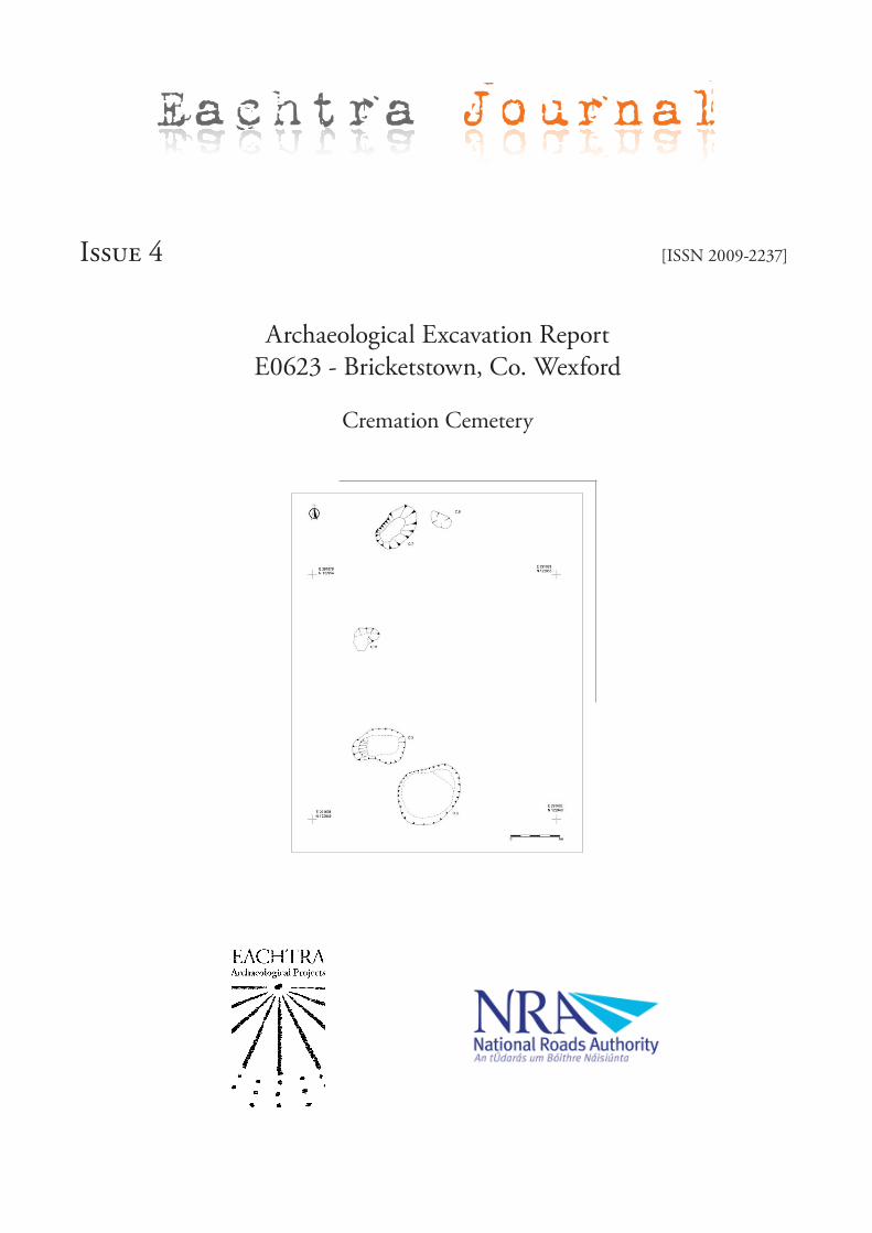
Issue 4 [ISSN 2009-2237] Archaeological Excavation Report E0623 - Bricketstown, Co. Wexford Cremation Cemetery Eachtra Journal
Issue 4 [ISSN 2009-2237]
Archaeological Excavation ReportE0623 - Bricketstown, Co. Wexford
Cremation Cemetery
Eachtra Journal
The Forge,Innishannon, Co. Cork.Tel.: 021 470 16 16Fax: 021 470 16 28E-mail: [email protected] Site: www.eachtra.ie
Contact details:
December 2009
Written by:
Client:
Archaeological Excavation Report,Bricketstown,N25 Harristown to Rathsillagh,Co. Wexford
Cremation Cemetery
Wexford County Councilc/o Tramore House Road Design OfficeTramoreCo. Wexford
00E0623
Stuart Elder
Stuart Elder and Penny Johnston
Licence No.:
Licensee:
iii
00E0623 Bricketstown, Co. Wexford ISSUE 4: Eachtra Journal - ISSN 2009-2237
Permalink: http://eachtra.ie/index.php/journal/e0623-bricketstown-co-wexford/
Copyright Notice: Please note that all original information contained within this report, including all original drawings, photographs, text and all other printed matter deemed to be the writer’s, remains the property of the writer and Eachtra Archaeological Projects and so may not be reproduced or used in any form without the written consent of the writer or Eachtra Archaeological Projects.
Table of Contents
i Acknowledgements ............................................................................................ iv
1. Summary ............................................................................................................1
2. Introduction .......................................................................................................1
3. Description of Development ...............................................................................1
4. Background to the excavation area ......................................................................1
5. Archaeological & Historical Background ............................................................2
6. Methodology ......................................................................................................5
7. Results ................................................................................................................5
8. Artefacts .............................................................................................................7
9. Environmental remains.......................................................................................7
10. Human remains .................................................................................................7
11. Discussion .........................................................................................................7
12. Conclusion ..........................................................................................................8
13. Bibliography ......................................................................................................9
14 Figures ............................................................................................................... 11
15 Plates ................................................................................................................. 18
16 Appendices ........................................................................................................ 19
iv
00E0623 Bricketstown, Co. Wexford ISSUE 4: Eachtra Journal - ISSN 2009-2237
Permalink: http://eachtra.ie/index.php/journal/e0623-bricketstown-co-wexford/
List of FiguresFigure 1: Extract of Ordnance Survey Discovery series No. 77 showing the route of the new road and the excavated sites ......................................................................................................................................11
Figure 2: Extract of Ordnance Survey First Edition showing the route of the new road and the excavated sites ..............................................................................................................................................12
Figure 3: Extract of Ordnance Survey RMP map sheet 36 showing the route of the new road and the excavated sites ......................................................................................................................................13
Figure 4: Route of the new road with the excavated site displayed .........................................................14
Figure 5: Post-excavation plan of all the archaeological features at Bricketstown (00E0623). ................15
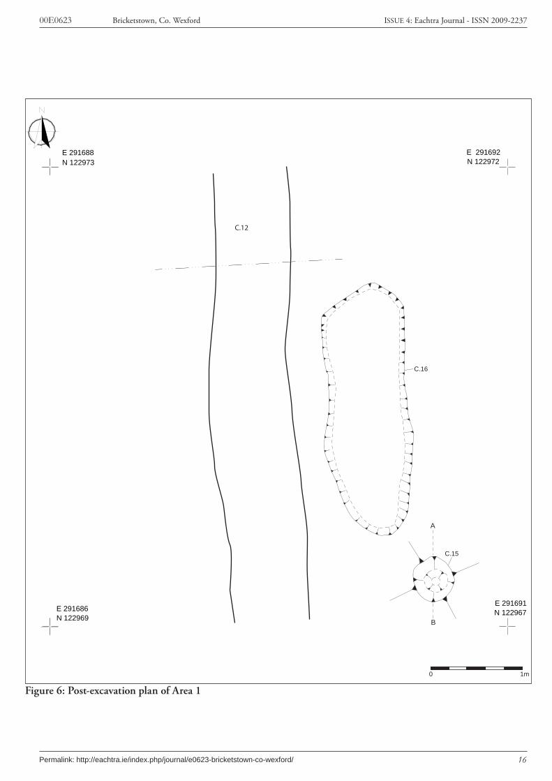
Figure 6: Post-excavation plan of Area 1 ...............................................................................................16
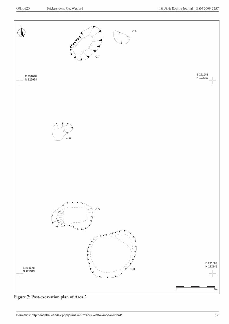
Figure 7: Post-excavation plan of Area 2 ................................................................................................17
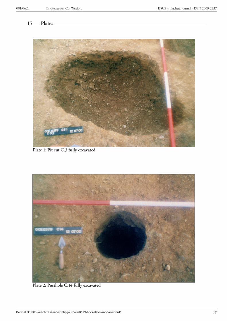
List of PlatesPlate 1: Pit cut C.3 fully excavated ........................................................................................................18
Plate 2: Posthole C.14 fully excavated ...................................................................................................18

v
00E0623 Bricketstown, Co. Wexford ISSUE 4: Eachtra Journal - ISSN 2009-2237
Permalink: http://eachtra.ie/index.php/journal/e0623-bricketstown-co-wexford/
i Acknowledgements
Project Manager: Michael TierneyLicensee: Stuart ElderField staff: Kieran Power, Cathy Fisher, Aaron Johnston, Karen Ward, Raquel LopezPhotography: Aaron JohnstonIllustrations: Stuart Elder, John Lehane, Bernice Kelly, Enda O’ Mahony.Text: Stuart Elder, Joanne O’Meadhra, Michael Tierney, Antonia Doolan, Penny Johnston
This project was entirely funded by Wexford County Council, under the National Development Plan.

1
00E0623 Bricketstown, Co. Wexford ISSUE 4: Eachtra Journal - ISSN 2009-2237
Permalink: http://eachtra.ie/index.php/journal/e0623-bricketstown-co-wexford/
1. Summary
County WexfordTownland BricketstownParish KilgarvanCivil Parish WhitechurchglynnBarony BantryNational Grid Co-ordinates 291684 123038Site type Cremation cemeteryExcavation Licence Number 00E0623
2. IntroductionArchaeological testing was conducted by Eachtra Archaeological Projects along the proposed route of the N25 realignment from Rathsillagh to Harristown, Co. Wexford. The proposed routeway was stripped by machine (under monitoring licence 00E0379) and a complex of features and spreads was revealed within the 50 m wide road take during topsoil stripping. The site was excavated under excava-tion licence number 00E0623 and it comprised a total of eight features, located in two areas approxi-mately 15 m apart but clearly relating to the same activity. One feature represented recent agricultural disturbance. Of the seven remaining features, five contained traces of burnt bone with charcoal, sug-gesting the presence of cremation deposits. A large spread of burnt material was also observed, lying in a shallow cut. This site lay approximately 240 m east of the Iron Age hearth site excavated under licence number 00E0624.
3. Description of DevelopmentThe N25 is the main southern east to west route, traversing the counties of Cork, Waterford, Kilkenny and Wexford. It links the port of Rosslare Harbour with Cork City, via New Ross, Waterford City, Dungarvan and Youghal. A section of the N25 route between the townlands of Rathsillagh and Har-ristown Little was selected for upgrading, as the old road comprised a single carriageway in either direction, with several ‘blind’ junctions, and in many cases only a hedge separating farmland from the road. The new route sought to straighten and level out the N25 and to provide a wider single car-riageway with hard shoulder in either direction, in keeping with the Barntown scheme completed in 1998.
4. Background to the excavation areaThe 8.5 km route of the new road crosses a series of low, undulating hills, to the south of the old N25 route, and is situated at a height of between 45 m and 80 m above sea level. The landscape here is characterised by small hills, interspersed with many small streams; these eventually flow into the River Corock to the southwest, into the Slaney to the northwest, as well as feeding into Ballyteige Bay to the south. From its western beginning in Rathsillagh townland the routeway climbs gently, running parallel and to the south of the old N25. It then continues through Assagart, Ballyvergin, Shanowle, Camaross, Carrowreagh, Dungeer, Bricketstown and through into Harristown Little, eventually exit-

2
00E0623 Bricketstown, Co. Wexford ISSUE 4: Eachtra Journal - ISSN 2009-2237
Permalink: http://eachtra.ie/index.php/journal/e0623-bricketstown-co-wexford/
ing in Harristown Big townland and tying into the Barntown improvement.The higher ground was lush pasture, well drained, and gave spectacular views all around. Sites on this part of the route included prehistoric settlement activity and a series of medieval/post-medieval kilns. Conversely, the lower ground in Camaross, Carrowreagh and Dungeer was quite marshy and prone to growth of gorse. Sites traditionally associated with low-lying ground were found in these townlands, for example a burnt mound at Dungeer and a moated site at Carrowreagh.
5. Archaeological & Historical BackgroundThere are thirteen recorded archaeological monument sites within 1 km either side of the development; one is a church and graveyard site, nine are listed as enclosure sites of between 30 m and 60 m in di-ameter and three are moated sites (two of which are destroyed). The ecclesiastical site apparently dates to the medieval period as there is a fragment of a medieval grave cover in the graveyard and the site was originally surrounded by a circular bank (Moore 1996, 129). The enclosures most likely represent the raths and ringforts of the early medieval period (Moore 1996, 28). Prior to these excavations, the known archaeological remains in the locality were all medieval and post-medieval but several prehis-toric sites were identified during the course of this programme of excavation along the N25 route-way, including Neolithic material at Harristown Big, Bronze Age sites at Dungeer, Ballyvergin and Har-ristown Big and Iron Age activity at two sites in Bricketstown.
5.1 Mesolithic 7000-4000 BCThe earliest known human occupation of Ireland dates to the Mesolithic period (c. 7000-4000 BC). Lithic scatters from the period have been found along the banks of the Barrow river in counties Wex-ford and Waterford (Green and Zvelebil 1990). Some diagnostic Mesolithic stone artefacts were also found in Camolin, in north Wexford, and along the eastern coastline between Carnsore and Kilm-ichael point (Stout 1987, 3). However, most activity is identified in resource-rich locations by riversides and coastlines and there is no known evidence for Mesolithic activity within the area affected by the roadtake.
5.2 Neolithic 4000-2500 BCThere is piecemeal evidence for Neolithic occupation in County Wexford. Stout’s (1987) distribution map of Neolithic remains includes evidence for one single burial site, fifteen find spots for flint and stone atefacts, two portal tombs and seven other possible megalithic tombs. Work on the Archaeologi-cal Survey of Ireland reduced the number of other possible megaliths from seven to five (Moore 1996). Subsequent excavation work has increased the extent of knowledge concerning Neolithic settlement in the county. Early Neolithic pottery was found by McLoughlin (2004) at Kerlogue (02E0606) and at a pit and a hearth excavated under licence 00E0630 at Courtlands East (Purcell 2002). Later Neolithic activity in the county is indicated by Sandhills ware, discovered during an excavation (02E0434) in a pit at St. Vogues (Purcell 2004). An undated excavation at MacMurroughs (1985:59) also uncovered a number of flints and a ground stone axe, associated with a hearth and pit may also be Neolithic in date (Cotter 1986). Some evidence for Neolithic activity was found as part of this project at Harristown Big (00E0424) where Neolithic pottery was discovered at a site where various pits and stakeholes were

3
00E0623 Bricketstown, Co. Wexford ISSUE 4: Eachtra Journal - ISSN 2009-2237
Permalink: http://eachtra.ie/index.php/journal/e0623-bricketstown-co-wexford/
excavated. Early Neolithic and possible Middle Neolithic wares were found.
5.3 Bronze Age 2500-500 BCSome of the earliest Bronze Age finds from Co. Wexford are three chance finds of Beaker gold discs (only one with a provenance). Other Bronze Age metal finds from the county include hoards of both Early and Late Bronze Age artefacts, e.g. at Cahore Point, a cave at Nash, Ballyvadden, Enniscorthy, Forth Commons and New Ross (Stout 1987, 9-10, 22). At Ballyvadden the Late Bronze Age metal ob-jects were found within a ceramic container, a unique feature in Irish hoards, but apparently common on the continent during the period (Stout 1987, 22). Burnt mounds are the most common Bronze Age site-types found in Ireland and sixty-three such sites were identified in the Archaeological Inventory for the county (Moore 1996) and since the survey work several have been excavated in the county; examples were found at Strandfield (McCarthy 2004) and along the routes of the N30 (Enniscorthy to Clonroche) and the N11 (Arklow to Gorey) roads (www.nra.ie/Archaeology/LeafletandPosterSeries). Only one burnt mound was excavated during works on the Rathsillagh-Harristown realignment of the N25; this was found at Dungeer 00E0474. Much of our evidence for Bronze Age activity in Wexford to date has come from burials. There is a recognised concentration of cist-type burials in Co. Wexford which are commonly thought to date to the Early Bronze Age. Stout (1987) identified more than thirty-seven but many were not well docu-mented and Moore (1996) could only pinpoint the locations of only twenty-five cist and pit burials in total. Several other burials with diagnostic Bronze Age pottery have since been found during excava-tion: there was a cordoned urn burial at Ballintubbrid, vase urn burials at Coolnaboy, Gorey Corpora-tion Lands and Kilmurry, a cist with a tripartite bowl at Knockbrack and a ring ditch with cremation burials at Ferns Lower (Bennett 2004-5). Another ring-ditch was found at Kerlogue Sites 4 and 5 and a large round house excavated at Kerlogue Site 2 was probably also of Bronze Age date (McLough-lin 2004). The excavations from the Rathsillagh-Harristown road scheme included one Early-Middle Bronze Age site at Ballyvergin where hot-stone technology was used in association with metalworking. Another metalworking site was found at Harristown Big (00E0425) where a series of Late Bronze Age metalworking pits and crucibles were found and a Late Bronze Age burnt mound site was excavated at Dungeer (00E0474).
5.4 Iron Age 500 BC-500 ADIn common with much of Ireland there is very little evidence for Iron Age activity in Co. Wexford. Hillforts and promontory forts have possible construction dates in the Late Bronze Age or Early Iron Age and there are two hillforts and five promontory forts in the county (Moore 1996). The artefactual evidence for this period in Wexford includes two pins that are of probable Iron Age date and two pos-sible Iron Age stone heads recovered from Duncormick (Stout 1987, 29-30). Two of the sites excavated along the route of the Rathsillagh-Harristown road produced Iron Age radiocarbon dates, both were from Bricketstown and one was a small cremation cemetery (00E0623), the second was a small hearth (00E0624).
5.5 Early Medieval 500 AD-1169 ADThe beginnings of Christianity are evident in the remains of seventeen early ecclesiastical sites in Co.
4
00E0623 Bricketstown, Co. Wexford ISSUE 4: Eachtra Journal - ISSN 2009-2237
Permalink: http://eachtra.ie/index.php/journal/e0623-bricketstown-co-wexford/
Wexford (Moore 1996). One of the earliest excavated examples from Co. Wexford was at St. Vogues, at Carnsore, where a wooden church preceded a stone building (O’Kelly 1975). One of the closest known early church sites to the roadtake is located approximately 3 km to the south at the church of Poulmarl/Taghmon, the monastery founded by St. Munna in the seventh century. The list of abbots from this site continues to the end of the tenth century and there is a record of a Viking raid in 917 AD (Moore 1996, 160). By this time the Norse town of Weisford, later to become Wexford, was already established, having been founded by the end of the ninth century (Colfer 1990-1991).Evidence for settlement in the county during the early medieval period comes from ringforts, typical monuments of the period. These were circular or subcircular enclosures made from earthen banks that surrounded areas roughly between 25 and 40 metres in diameter. Excavated examples have demon-strated that they generally surrounded single farmstead-type settlement sites. One hundred and fifty-three examples are known from the county (Moore 1996). Of these only two were located within close proximity to the area of the new Rathsillagh-Harristown road (at Haystown, c. 3 km to the north of the new road and at Cullenstown c. 2 km to the south). There are also numerous circular enclosure sites that probably represent ringforts; thirteen of them appear on the RMP Sheet 36 (covering the area of the new road-take) for Co. Wexford.
5.6 Later Medieval 1169 AD-1600 ADThe Anglo-Normans first landed in Ireland in Co. Wexford in 1169. The county was within their initial land-grab zone between AD 1169 and AD 1190 (Mitchell & Ryan 1997, 305) and was sub-infeudated in the early stages of Anglo-Norman activity in Ireland (Colfer 1987). Wexford county was one of the first twelve counties created by the English Kings in the 12th to 13th centuries, from the original Prov-inces and lesser Territories of the Irish Tuatha (Howarth 1911, 161). By the thirteenth century much of the area covered by the Rathsillagh-Harristown road-take was a frontier zone and the archaeologi-cal landscape of these areas is characterised by moated sites: there are ten known sites on RMP Sheet 36 for Co. Wexford, the area covered by the new road, and there are almost 130 moated sites known in the entire county (Moore 1996, 95). One moated site at Carrowreagh was found along the line of the new road. These sites were distributed at the peripheries of the colonial organisation centres and probably represent an attempt at secondary colonisation (O’Keeffe 2000, 73-75). However, by the end of the fourteenth century, much of the Anglo-Norman settlement in Co. Wexford had retreated to a southeastern stronghold in the baronies of Forth and Bargy, a pattern that Colfer (1987) suggests was reminiscent of the “Pale of county Wexford”. Excavations of medieval sites in the county include the remains of a medieval house were excavated at Ballyanne (Moran 2000), with pottery indicative of oc-cupation in the 12th to 14th centuries, and excavations at Ferns, Hook Head, Newtown, Tintern, Tagh-mon, New Ross and Wexford town all produced medieval archaeological remains (Bennett 2004-5). Along the route of the Rathsillagh-Harristown road the moated site at Carrowreagh (excavated under licence no. 00E0476) was the largest medieval site excavated. A spread of medieval occupation material was also excavated at Bricketwtown (00E0476) and this was rich in the remains of medieval pottery. It is also possible that the limekilns at Bricketstown (00E0476) and Harristown Little (00E0417) were in use at the very end of the medieval period.
5
00E0623 Bricketstown, Co. Wexford ISSUE 4: Eachtra Journal - ISSN 2009-2237
Permalink: http://eachtra.ie/index.php/journal/e0623-bricketstown-co-wexford/
5.7 Post-Medieval (after 1600 AD)A few excavations of post-medieval archaeological sites have been carried out in Wexford county, in-cluding Brideswell Big, Duncannon Fort, and excavations in Wexford and Ennisorthy town (Bennett 2004-5). Some of the excavations from the Rathsillagh to Harristown road scheme were probably used during this time, in particular the limekilns at Bricketstown (00E0476, 00E0626) and Harristown Little (00E0417). There is Jacobean house site in Dungeer, one of the townlands affected by the road-take. References to the house/castle date to the early seventeenth century (Moore 1996).
6. MethodologyThe sub-contractor stripped the sod and topsoil by mechanical excavator (and later by bulldozer), working along the line of the road. Natural subsoil appeared at c. 0.3 m below the sod. Removal of the subsequent spoil bank was also by mechanical excavator, loading into articulated 6-wheeled dumpers for stockpiling in designated areas off-site.All works were conducted using experienced archaeologists and co-ordinated by the licensee. The ar-chaeological deposits were investigated by cleaning the immediate and surrounding area with hoes and trowels in order to ascertain the nature and extent of the site.When the extent of the archaeological deposits was identified, the area was cordoned off using wooden fence poles and hazard tape, both to protect the site from intrusion and to comply with health and safety practices. A pre-excavation multi-context plan was made of the site, with pre-excavation photo-graphs of individual features followed by full excavation and preservation by record under licence, as per instruction from the DoEHLG (formerly Dúchas). Sediment samples taken during the course of the excavation were sieved to recover any environmental evidence.
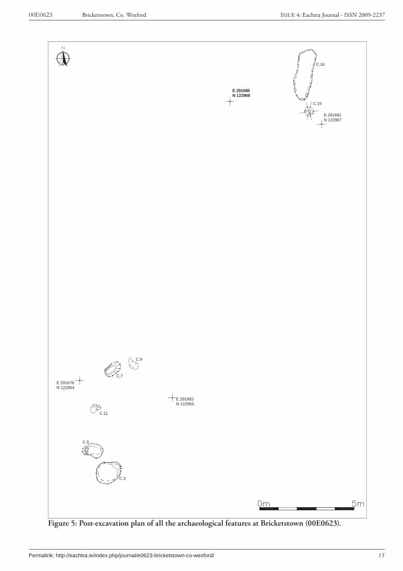
7. ResultsThe site comprised seven cut features, filled with burnt material, and situated in two distinct areas on the edges of the road-take (Figure 5). Area 1 contained a large posthole and a long, shallow, oval pit (Figure 6), and Area 2 contained five small to medium sized pits (Figure 7), four of which contained fragments of burnt bone. Some of the bone was identified as human and the site was interpreted as a small cemetery of token cremation deposits.
7.1 Area 1Area 1 consisted of a probable plough furrow (C.12), a posthole (C.15) and a shallow pit (C.16) (Figure 6).C.12 was aligned north-south and measured 4 m x 0.9 m x 0.35 m. It was filled by a soft silty clay containing moderate charcoal flecks and finds that included cattle bone and a 19/20th century copper alloy button. The modern nature of the finds recovered from this feature suggested that it was a plough furrow; it was similar in nature to several other features of the same type observed in the vicinity. All shared a common orientation, and were largely equidistant from one another.C.15 was a circular pit or posthole that was 0.4 m in diameter and 0.57 m deep. It was filled by C.13, a charcoal-rich soft silty clay containing occasional fragments of cremated bone throughout. Despite
6
00E0623 Bricketstown, Co. Wexford ISSUE 4: Eachtra Journal - ISSN 2009-2237
Permalink: http://eachtra.ie/index.php/journal/e0623-bricketstown-co-wexford/
the cremated bone, this feature resembled a substantial posthole (see Plate 1) rather than a cremation burial, and it is possible that the flecks of burnt bone are residual material associated with other activ-ity at the site.C.16 was a shallow cut of an elongated oval pit orientated north-south and measuring 2.72 m x 1 m x 0.15 m. It was filled by C.14, a deposit of dark silty clay with frequent charcoal flecks and some stone inclusions that showed evidence of heat fracturing. Charcoal from the sample was identified as oak (Appendix 4). The deposit did not contain any traces of burnt bone and there was no obvious oxidisa-tion of the sides to suggest an in situ fire.
7.2 Area 2There were five pits in this area of the site (C.3, C.5, C.7, C.9 and C.11) (Figure 7). Almost all of these contained cremated bone fragments in very small amounts. It has been possible to identify some of the cremated bone as human (Appendix 5) and therefore the site has been interpreted as a cremation cemetery, although these were token deposits rather than the burial of the entire cremated remains from one corpse.C.3 was a sub-rectangular pit orientated northeast-southwest with rounded corners on all sides apart from the northern and northwestern sides, which were square (Plate 2). It measured 1.5m x 1.2m x 0.5m deep. It contained two fills (C.1 and C.2). C.2 was the lowest fill; it was 1.1 m x 0.7 m x 0.35 m and it contained occasional charcoal pieces and fragments of cremated bone. It was overlain by C.1, the uppermost fill of the pit (1.2 m x 0.84 m x 0.15 m), which also contained occasional charcoal flecks. A significant proportion of the stone inclusions showed signs of having been subjected to heat and there small fragments of cremated bone were retrieved from this deposit during sample process-ing. Plant remains extracted from both fills of this pit included hazel nut shell fragments, sloe stones, a raspberry/blackberry pip and a wheat grain.A second pit (C.5) was sub-circular, orientated east-west and measured 1.1 m x 0.9 m x 0.26 m. It contained just one fill (C.4), a deposit with moderate charcoal flecks, a significant proportion of burnt stone, but no cremated bone.Pit (C.7) was a relatively large, shallow pit measuring 1.05 m x 0.65 m x 0.15 m and filled by a single deposit (C.6). This was a silty/pebbly sediment with moderate charcoal flecks, a small proportion of burnt bone and one indeterminate cereal grain. There was no evidence of oxidisation to suggest burn-ing in-situ. Some charcoal from this deposit was identified as oak (Appendix 4) and it returned an Iron Age radiocarbon date of cal AD 103-122 (see Appendix 3). Bone from this sample was identified as part of a human cranium, fragments of a phalanx from hand or foot and three portions of the ethmoid notch of the inner surface of the frontal bone (Appendix 5).A fourth pit (C.9) was aligned northwest-southeast and measured 0.55 m x 0.32 m x 0.07 m. It was filled by a deposit of silty sand (C.8) which contained moderate charcoal flecks, one hazel nut shell fragment and occasional burnt bone fragments and it was interpreted as a token cremation deposit. It was small and shallow which suggested that the feature was heavily truncated by recent activity. The fragments of cremated bone from this sample were not identifiable (Appendix 5).The final pit (C.11) was a shallow depression, heavily truncated either by modern agricultural activity, or by the striping of topsoil during the construction phase of the road development. It was roughly
7
00E0623 Bricketstown, Co. Wexford ISSUE 4: Eachtra Journal - ISSN 2009-2237
Permalink: http://eachtra.ie/index.php/journal/e0623-bricketstown-co-wexford/
circular and measured 0.55 m x 0.5 m x 0.07 m. The shallow depression was filled by a yellowish brown loose silty sand deposit (C.10) which contained moderate charcoal flecks (identified as oak, see Ap-pendix 4) and occasional fragments of cremated bone.
8. ArtefactsNo artefacts were retrieved during excavation at this site.
9. Environmental remainsFour bulk soil samples were taken from the site and were assess for their environmental content, focus-ing in particular on the recovery of charcoal and charred macroplant remains. This assessment was carried out by Penny Johnston (for details see Appendix 4). Charcoal was found in only three samples. Two samples contained oak charcoal and a third contained a diffuse-porous wood type that could not be identified to genus level. Some cereal grains, fruit stones and nut shell fragments were found in the deposits associated with small amounts of cremated bone. These included hazel nut shell fragments, sloe stones, blackberry/raspberry seeds and wheat grains. As only small amounts were found these were interpreted as stray inclusions.
10. Human remainsCremated bone was recovered in small quantities from several deposits and this was examined by Catryn Power (see Appendix 5). Twenty-seven minute fragments of bone were retrieved from C.6 and three minute fragments were found in C.8. In general these were too small to classify, but some of the bone from C.6 was identifiable as part of the cranium, a small long bone, the shaft of a phalanx from the hand or the foot. Three tiny portions of the ethmoid notch of the inner surface of the frontal bone was also identified. This work confirmed that the remains were of human origin and that the small deposits of cremated bone must have represented a token burial deposit.
11. DiscussionThe evidence for this site suggests that it represents a cemetery, as five of the seven archaeological fea-tures produced traces of burnt bone (C3, C.7, C.9 and C.11). Osteo-archaeological analysis has also confirmed that at least some of the small quantity of bone in these deposits is human (Appendix 5). It is widely accepted that cremation cemeteries are awkward to interpret, as individual cremations are often ‘token’ at best, sometimes with less than a handful of cremation material actually being interred. Moreover, where a cemetery clearly exists, wide variations occur in the size and depth of pits, and some may not contain cremated material at all. For example, excavations ahead of construction at the Lisheen Mine complex in Co. Tipperary revealed a large flat cremation cemetery with fifty-seven pits ranging in depth from 0.05 m – 0.37 m. Of these, only twenty-eight were identified as containing cremations (Stevens 1998, 174). The token nature of many of the cremated bone deposits excavated at this site is a frequent aspect of Iron Age cremations (Cooney and Grogan 1994), and the Iron Age radiocarbon date from one of the pits at Bricketstown demonstrates that the material from the site fits
8
00E0623 Bricketstown, Co. Wexford ISSUE 4: Eachtra Journal - ISSN 2009-2237
Permalink: http://eachtra.ie/index.php/journal/e0623-bricketstown-co-wexford/
quite well into this established pattern. The Bricketstown linear cut excavated at the (C.16) was initially suggested as a pyre site. Other sites interpreted as pyres include Cloghskelt, Co. Down, where a thick black deposit measuring 9 m x 6 m contained minute fragments of burnt bone (Waddell 1998, 156). This is much larger than the potential pyre at Bricketstown, which measured 2.72 m x 1 m x 0.15 m. In dimensions this was similar to linear cut features excavated at Ballyvelley, Tralee, Co. Kerry (Dunne 2000, 96-97). These features were identified as pyres due to the presence of intense in situ burning. However, there was no evidence for in situ burning at Bricketstown, Co. Wexford, despite the fact that the cremated bone indicated tem-peratures of up to 700˚ C (Appendix 5). While the dimensions of the feature make it entirely adequate for the role of a funeral pyre, one would expect localised oxidisation given the heat necessary to reduce a corpse to a cremated state. Therefore the feature at Bricketstown cannot be definitely identified as a cremation pyre.
12. ConclusionA series of pits were excavated at Bricketstown, Co. Wexford under licence no. 00E0623. Five of these contained the remains of cremated bone and in one deposit the bone was large enough to identify it as being of human origin. The site was therefore interpreted as a flat cremation cemetery.
9
00E0623 Bricketstown, Co. Wexford ISSUE 4: Eachtra Journal - ISSN 2009-2237
Permalink: http://eachtra.ie/index.php/journal/e0623-bricketstown-co-wexford/
13. BibliographyBennett, I. 2004-5. ‘Archaeological Excavations in Co. Wexford’, Journal of the Wexford Historical
Society 20, 184-196.
Colfer, B. 1987. ‘Anglo-Norman Settlement in County Wexford’, pp. 65-101 in Whelan, K. (ed.) Wexford History and Society. Interdisciplinary essays on the history of an Irish county. Dublin, Geography Publications.
Colfer, B. 1990-1991. ‘Medieval Wexford’, Journal of the Wexford Historical Society 13, 4-29.
Cotter, C. 1986. ‘MacMurroughs, Co. Wexford’, in Cotter, C. (ed.) Excavations 1985. Dublin, Irish Academic Publication for Organisation of Irish Archaeologists.
Cooney, G. and Grogan, E. 1994. Irish prehistory: a social perspective. Bray, Wordwell.
Dunne, L. 2000. ‘Ballyvelly, Tralee’ in Bennett, I. (ed.) Excavations 1998: Summary accounts of archaeological excavation in Ireland, Wordwell, Bray
Green, S. W. and Zvelebil, M. 1990. “The Mesolithic colonisation and agricultural transition of south-east Ireland”, Proceedings of the Prehistoric Society 56, 57-88.
Howarth, O.J.R. 1911. A Geography of Ireland. Oxford Geographies, London
McCarthy, M. 2004. ‘Strandfield, Co. Wexford’, pp. 520-521 in Bennett, I. (ed.) Excavations 2002. Bray, Wordwell.
McLoughlin, C. 2004. ‘Kerlogue’, pp.517-518 in Bennet, I. (ed.) Excavations 2002. Bray, Wordwell.
Mitchell, F. & Ryan, M. 1997. Reading the Irish Landscape, Town House, Dublin
Moore, M.J. 1996. Archaeological Inventory of County Wexford, Government Publications, Dublin.
Moran, J. 2000 ‘Ballyanne, Co. Wexford’. in Bennett, I. (ed.) Excavations 1998. Bray, Wordwell. Mullins, C. 2003 Rathaspick in Bennett, I. (ed.) Excavations 2001. Bray, Wordwell.
O’Keefe, T. 2000. Medieval Ireland, An Archaeology. Tempus Publishing, England.
O’Kelly, M.J. 1975. ‘Archaeological Survey and Excavation of St. Vogue’s Church, Enclosure and Other Monuments st Carnsore, Co. Wexford’. Unpublished excavation report for the Electricity Supply Board.
Purcell, J. 2004. ‘St. Vogue’s’, p.520 in Bennet, I. (ed.) Excavations 2002. Bray, Wordwell.
Purcell, A. 2002. ‘Courtlands East, Co. Wexford’, in Bennett, I. (ed.) Excavations 2000. Bray,
10
00E0623 Bricketstown, Co. Wexford ISSUE 4: Eachtra Journal - ISSN 2009-2237
Permalink: http://eachtra.ie/index.php/journal/e0623-bricketstown-co-wexford/
Wordwell.
Stevens, P. 1998. ‘Lisheen Mine, Killoran’, in Bennett, I. ed. Excavations 1997: Summary accounts of archaeological excavations in Ireland, Wordwell, Bray, 171-177
Stout, G. 1987. ‘Wexford in Prehistory 5000 B.C. to 300 A.D.’, pp.1-39 in Whelan, K. (ed.) Wexford History and Society. Interdisciplinary essays on the history of an Irish county. Dublin, Geography Publications.
Waddell, J. 1998. The Prehistoric Archaeology of Ireland, Galway University Press, NUI Galway.

Figu
re 1
: Disc
over
y m
ap sh
owin
g th
e ro
ute
of th
e N
25 R
aths
illag
h to
Har
risto
wn
road
11
00E0623 Bricketstown, Co. Wexford ISSUE 4: Eachtra Journal - ISSN 2009-2237
Permalink: http://eachtra.ie/index.php/journal/e0623-bricketstown-co-wexford/
14 Figures
Figu
re 1
: Ext
ract
of O
rdna
nce
Surv
ey D
isco
very
ser
ies
No.
77
show
ing
the
rout
e of
the
new
roa
d an
d th
e ex
cava
ted
site
s

02 k
mKe
y:
New
Road
Exist
ing N
25
New
Arch
aeolo
gical
Sites
00E0
473
00E0
471
00E0
474
00E0
475
00E0
625
00E0
626 00E0
62400E0
623 00
E047
6
00E0
424
00E0
42500
E041
7
12
00E0623 Bricketstown, Co. Wexford ISSUE 4: Eachtra Journal - ISSN 2009-2237
Permalink: http://eachtra.ie/index.php/journal/e0623-bricketstown-co-wexford/
Figu
re 2
: Ext
ract
of O
rdna
nce
Surv
ey F
irst
Edi
tion
sho
win
g th
e ro
ute
of t
he n
ew r
oad
and
the
exca
vate
d si
tes

02 k
mKe
y:Ne
w Ro
ad
Exist
ing N
25
New
Arch
aeolo
gical
Sites
00E0
473
00E0
471
00E0
474 00E0
475
00E0
625
00E0
626
00E0
62400
E062
3 00E0
476
00E0
424
00E0
42500
E041
7
3232
33
DELISTED
58
52
2425
23
64
1731
3120
1916
67
18
2115
31
14
13
DELI
STED
DELISTED
13
00E0623 Bricketstown, Co. Wexford ISSUE 4: Eachtra Journal - ISSN 2009-2237
Permalink: http://eachtra.ie/index.php/journal/e0623-bricketstown-co-wexford/
Figu
re 3
: Ext
ract
of O
rdna
nce
Surv
ey R
MP
map
she
et 3
6 sh
owin
g th
e ro
ute
of t
he n
ew r
oad
and
the
exca
vate
d si
tes

14
00E0623 Bricketstown, Co. Wexford ISSUE 4: Eachtra Journal - ISSN 2009-2237
Permalink: http://eachtra.ie/index.php/journal/e0623-bricketstown-co-wexford/
0m50
0m
Figu
re 4
: Rou
te o
f new
roa
d w
ith
all e
xcav
ated
site
s di
spla
yed
E 291686N 122969
E 291691N 122967
C.15
C.16
C.3
C.5
C.11
C.7
C.9
E 291686N 122969
E 291678N 122954
E 291683N 122953
15
00E0623 Bricketstown, Co. Wexford ISSUE 4: Eachtra Journal - ISSN 2009-2237
Permalink: http://eachtra.ie/index.php/journal/e0623-bricketstown-co-wexford/
Figure 5: Post-excavation plan of all the archaeological features at Bricketstown (00E0623).
C.12
C.16
C.15
A
B
E 291688 N 122973
E 291686 N 122969
E 291691N 122967
E 291692N 122972
m10
16
00E0623 Bricketstown, Co. Wexford ISSUE 4: Eachtra Journal - ISSN 2009-2237
Permalink: http://eachtra.ie/index.php/journal/e0623-bricketstown-co-wexford/
Figure 6: Post-excavation plan of Area 1
C.11
C.5
C.3
E 291683N 122953E 291678
N 122954
E 291678N 122949
E 291682N 122948
C.9
C.7
m10
17
00E0623 Bricketstown, Co. Wexford ISSUE 4: Eachtra Journal - ISSN 2009-2237
Permalink: http://eachtra.ie/index.php/journal/e0623-bricketstown-co-wexford/
Figure 7: Post-excavation plan of Area 2
18
00E0623 Bricketstown, Co. Wexford ISSUE 4: Eachtra Journal - ISSN 2009-2237
Permalink: http://eachtra.ie/index.php/journal/e0623-bricketstown-co-wexford/
Plate 1: Pit cut C.3 fully excavated
Plate 2: Posthole C.14 fully excavated
15 Plates
19
00E0623 Bricketstown, Co. Wexford ISSUE 4: Eachtra Journal - ISSN 2009-2237
Permalink: http://eachtra.ie/index.php/journal/e0623-bricketstown-co-wexford/
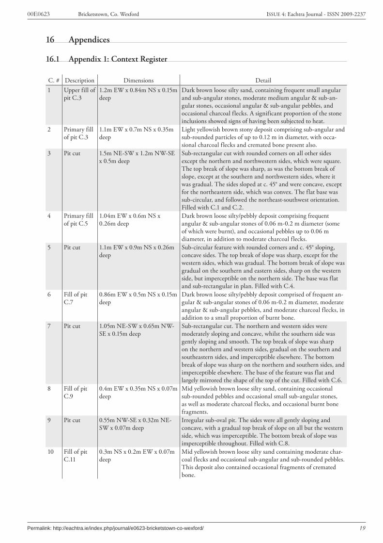
C. # Description Dimensions Detail1 Upper fill of
pit C.31.2m EW x 0.84m NS x 0.15m deep
Dark brown loose silty sand, containing frequent small angular and sub-angular stones, moderate medium angular & sub-an-gular stones, occasional angular & sub-angular pebbles, and occasional charcoal flecks. A significant proportion of the stone inclusions showed signs of having been subjected to heat.
2 Primary fill of pit C.3
1.1m EW x 0.7m NS x 0.35m deep
Light yellowish brown stony deposit comprising sub-angular and sub-rounded particles of up to 0.12 m in diameter, with occa-sional charcoal flecks and cremated bone present also.
3 Pit cut 1.5m NE-SW x 1.2m NW-SE x 0.5m deep
Sub-rectangular cut with rounded corners on all other sides except the northern and northwestern sides, which were square. The top break of slope was sharp, as was the bottom break of slope, except at the southern and northwestern sides, where it was gradual. The sides sloped at c. 45° and were concave, except for the northeastern side, which was convex. The flat base was sub-circular, and followed the northeast-southwest orientation. Filled with C.1 and C.2.
4 Primary fill of pit C.5
1.04m EW x 0.6m NS x 0.26m deep
Dark brown loose silty/pebbly deposit comprising frequent angular & sub-angular stones of 0.06 m-0.2 m diameter (some of which were burnt), and occasional pebbles up to 0.06 m diameter, in addition to moderate charcoal flecks.
5 Pit cut 1.1m EW x 0.9m NS x 0.26m deep
Sub-circular feature with rounded corners and c. 45° sloping, concave sides. The top break of slope was sharp, except for the western sides, which was gradual. The bottom break of slope was gradual on the southern and eastern sides, sharp on the western side, but imperceptible on the northern side. The base was flat and sub-rectangular in plan. Filled with C.4.
6 Fill of pit C.7
0.86m EW x 0.5m NS x 0.15m deep
Dark brown loose silty/pebbly deposit comprised of frequent an-gular & sub-angular stones of 0.06 m-0.2 m diameter, moderate angular & sub-angular pebbles, and moderate charcoal flecks, in addition to a small proportion of burnt bone.
7 Pit cut 1.05m NE-SW x 0.65m NW-SE x 0.15m deep
Sub-rectangular cut. The northern and western sides were moderately sloping and concave, whilst the southern side was gently sloping and smooth. The top break of slope was sharp on the northern and western sides, gradual on the southern and southeastern sides, and imperceptible elsewhere. The bottom break of slope was sharp on the northern and southern sides, and imperceptible elsewhere. The base of the feature was flat and largely mirrored the shape of the top of the cut. Filled with C.6.
8 Fill of pit C.9
0.4m EW x 0.35m NS x 0.07m deep
Mid yellowish brown loose silty sand, containing occasional sub-rounded pebbles and occasional small sub-angular stones, as well as moderate charcoal flecks, and occasional burnt bone fragments.
9 Pit cut 0.55m NW-SE x 0.32m NE-SW x 0.07m deep
Irregular sub-oval pit. The sides were all gently sloping and concave, with a gradual top break of slope on all but the western side, which was imperceptible. The bottom break of slope was imperceptible throughout. Filled with C.8.
10 Fill of pit C.11
0.3m NS x 0.2m EW x 0.07m deep
Mid yellowish brown loose silty sand containing moderate char-coal flecks and occasional sub-angular and sub-rounded pebbles. This deposit also contained occasional fragments of cremated bone.
16 Appendices
16.1 Appendix 1: Context Register
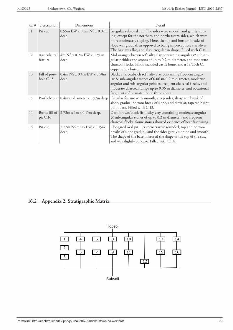
20
00E0623 Bricketstown, Co. Wexford ISSUE 4: Eachtra Journal - ISSN 2009-2237
Permalink: http://eachtra.ie/index.php/journal/e0623-bricketstown-co-wexford/
C. # Description Dimensions Detail11 Pit cut 0.55m EW x 0.5m NS x 0.07m
deepIrregular sub-oval cut. The sides were smooth and gently slop-ing, except for the northern and northeastern sides, which were more moderately sloping. Here, the top and bottom breaks of slope was gradual, as opposed to being imperceptible elsewhere. The base was flat, and also irregular in shape. Filled with C.10.
12 Agricultural feature
4m NS x 0.9m EW x 0.35 m deep
Mid orangey brown soft silty clay containing angular & sub-an-gular pebbles and stones of up to 0.2 m diameter, and moderate charcoal flecks. Finds included cattle bone, and a 19/20th C. copper alloy button.
13 Fill of post-hole C.15
0.4m NS x 0.4m EW x 0.58m deep
Black, charcoal-rich soft silty clay containing frequent angu-lar & sub-angular stones of 0.06 m-0.2 m diameter, moderate angular and sub-angular pebbles, frequent charcoal flecks, and moderate charcoal lumps up to 0.06 m diameter, and occasional fragments of cremated bone throughout.
15 Posthole cut 0.4m in diameter x 0.57m deep Circular feature with smooth, steep sides, sharp top break of slope, gradual bottom break of slope, and circular, tapered blunt point base. Filled with C.13.
14 Burnt fill of pit C.16
2.72m x 1m x 0.15m deep. Dark brown/black firm silty clay containing moderate angular & sub-angular stones of up to 0.2 m diameter, and frequent charcoal flecks. Some stones showed evidence of heat fracturing.
16 Pit cut 2.72m NS x 1m EW x 0.15m deep
Elongated oval pit. Its corners were rounded, top and bottom breaks of slope gradual, and the sides gently sloping and smooth. The shape of the base mirrored the shape of the top of the cut, and was slightly concave. Filled with C.14.
Topsoil
1 4 6 8 10 13 14
25 7 9 11 15 16
312
Subsoil
16.2 Appendix 2: Stratigraphic Matrix

21
00E0623 Bricketstown, Co. Wexford ISSUE 4: Eachtra Journal - ISSN 2009-2237
Permalink: http://eachtra.ie/index.php/journal/e0623-bricketstown-co-wexford/
16.3 Appendix 3: Radiocarbon Results from Bricketstown, Co. Wexford (00E0623)
Analysis by 14 Chrono Centre, Queen’s University Belfast
C.# S.# Charcoal Identification Lab code δ13C Radiocarbon Age 2 sigma calibration Period
6 4Diffuse-porous wood Hazel/Alder type (Alnus/Corylus)
UB 6955 -27.0 1963 +/- 34 BP cal AD 103-122 Iron Age
22
00E0623 Bricketstown, Co. Wexford ISSUE 4: Eachtra Journal - ISSN 2009-2237
Permalink: http://eachtra.ie/index.php/journal/e0623-bricketstown-co-wexford/
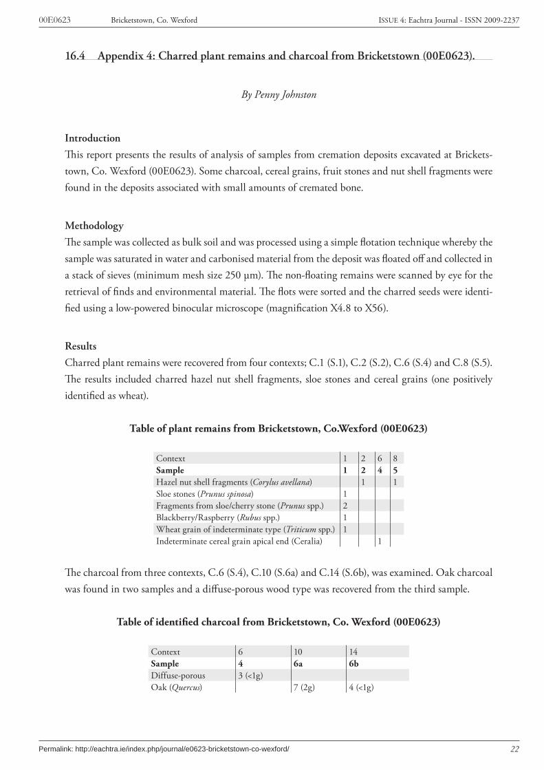
16.4 Appendix 4: Charred plant remains and charcoal from Bricketstown (00E0623).
By Penny Johnston
Introduction
This report presents the results of analysis of samples from cremation deposits excavated at Brickets-town, Co. Wexford (00E0623). Some charcoal, cereal grains, fruit stones and nut shell fragments were found in the deposits associated with small amounts of cremated bone.
Methodology
The sample was collected as bulk soil and was processed using a simple flotation technique whereby the sample was saturated in water and carbonised material from the deposit was floated off and collected in a stack of sieves (minimum mesh size 250 µm). The non-floating remains were scanned by eye for the retrieval of finds and environmental material. The flots were sorted and the charred seeds were identi-fied using a low-powered binocular microscope (magnification X4.8 to X56).
Results
Charred plant remains were recovered from four contexts; C.1 (S.1), C.2 (S.2), C.6 (S.4) and C.8 (S.5). The results included charred hazel nut shell fragments, sloe stones and cereal grains (one positively identified as wheat).
Table of plant remains from Bricketstown, Co.Wexford (00E0623)
Context 1 2 6 8Sample 1 2 4 5Hazel nut shell fragments (Corylus avellana) 1 1Sloe stones (Prunus spinosa) 1 Fragments from sloe/cherry stone (Prunus spp.) 2 Blackberry/Raspberry (Rubus spp.) 1 Wheat grain of indeterminate type (Triticum spp.) 1 Indeterminate cereal grain apical end (Ceralia) 1
The charcoal from three contexts, C.6 (S.4), C.10 (S.6a) and C.14 (S.6b), was examined. Oak charcoal was found in two samples and a diffuse-porous wood type was recovered from the third sample.
Table of identified charcoal from Bricketstown, Co. Wexford (00E0623)
Context 6 10 14Sample 4 6a 6bDiffuse-porous 3 (<1g)Oak (Quercus) 7 (2g) 4 (<1g)
23
00E0623 Bricketstown, Co. Wexford ISSUE 4: Eachtra Journal - ISSN 2009-2237
Permalink: http://eachtra.ie/index.php/journal/e0623-bricketstown-co-wexford/
The first sample (S.1) was taken from the uppermost fill (C.1) of a sub-rectangular pit which contained heat-shattered stone and small fragments of cremated bone. This was the richest assemblage of plant remains and it included a sloe stone, fragments from another sloe or cherry stone, a charred blackberry pip and one grain of wheat. Because the amounts of material present in the sample are so small it is likely that they were accidental inclusions in the samples. For example sloes could have been still at-tached to wood and twigs that were used to fuel the fire/cremation pyre. The second sample (S.2) was taken from the lower fill (C.2) of the same pit (C.3); the plant remains from this deposit consisted only of one fragment from a hazel nut shell. One sample (S.4) from the fill (C.6) of another pit (C.7) contained an unidentifiable cereal grain. It was taken from a deposit that contained moderate charcoal flecks and small amounts of cremated bone. The charcoal from this deposit was identified as a diffuse porous type wood.The final sample (S.5) containing charred plant remains was taken from the fill (C.8) of a pit (C.9) interpreted as a token cremation deposit. As well as a fragment of charred hazel nut shell the deposit also included charcoal and burnt bone fragments.Oak charcoal was identified in a sample from C.10 (S.6a), the fill of another pit that contained cre-mated bone. No charred seeds were recovered from this deposit.All of the above samples were taken from the cluster of pits excavated at the eastern part of the site and only one sample was examined from the features excavated in the western cluster. This was taken from C.14 (S.6b), a shallow pit which contained a charcoal flecked deposit and heat-shattered stones. There were no charred seeds in this deposit but the charcoal was identified as oak.
Discussion
There are now several comparative reports of plant remains studies on residues from Irish cremation burials: small amounts of plant remains were recovered by this author in deposits from (for example) Carmanhall, Co. Dublin (02E0076), Kilmainham, Co. Dublin (02E0067), Kilmurry North, Co. Wicklow (00E0509), Newcastle Middle, CO. Wicklow (01E0506) and Cherrywood, Co. Dublin (98E0526) and in some abundance in many sites excavated along the route of the Gas Pipeline to the West (Johnston, forthcoming). However, there are also many cremation deposits that are sampled but where plant remains are not found at all, e.g. samples from Raheen 2/18/1, E384:1 (Monk 1988). In cases of abundance these deposits may have been deliberate, however in instances where the plant re-mains are relatively sparse, such as in these deposits from Bricketstown, the recovery of small amounts of grain must be interpreted as accidental, stray inclusions.
Summary
This report details the results of plant remains and charcoal analysis carried out on samples from a small cremation cemetery at Bricketstown, Co. Wexford (00E0623). A small assemblage of plant remains indicated that fruit stones, nut shells and cereals were stray finds included in the cremation deposits accidentally.
24
00E0623 Bricketstown, Co. Wexford ISSUE 4: Eachtra Journal - ISSN 2009-2237
Permalink: http://eachtra.ie/index.php/journal/e0623-bricketstown-co-wexford/
References
Johnston, P. Forthcoming Charred plant remains, in Grogan, E. (ed.) The Gas Pipeline to the West-an integrated archaeological and environmental assessment.
Monk, M.1988 Appendix 3 Archaeobotanical study of samples from pipeline sites, pp. 185-191 in Gowen, M. Three Irish Gas Pipelines. Dublin: Wordwell.

25
00E0623 Bricketstown, Co. Wexford ISSUE 4: Eachtra Journal - ISSN 2009-2237
Permalink: http://eachtra.ie/index.php/journal/e0623-bricketstown-co-wexford/
16.5 Appendix 5: Cremated bone from Bricketstown, Co. Wexford (00E0623)
By Catryn Power
IntroductionThis report details the analysis of a small assemblage of cremated bone retrieved from deposits at Bricketstown, Co. Wexford (00E0623). Despite the fragmentary nature of the assemblage the results indicate that at least some of the bone retrieved is of human origin.
ResultsBone was retrieved from two contexts (C.6 and C.8), both fills of shallow pits that were interpreted as token cremation deposits.C.6 (Find Number 4)This small assemblage consists of twenty-seven minute fragments: the largest three of these are 1 cm in length and the remainder are less than 3 mm in length.One fragment is identifiable as part of the cranium, a parietal or frontal bone fragment; it is 1.9 cm in length. A second fragment of cremated bone belongs to a small long bone, the shaft of a phalanx from the hand or the foot. Three tiny portions of the ethmoid notch of the inner surface of the frontal bone can also be identified.C.8 (Find Number 2)Three minute fragments of cremated human bone are represented in this context; two of these are immeasurable specks while the third measures 6 mm in length. The fragments are too small to make identification into bone type possible.
DiscussionDuring prehistoric times religion was obviously an important part of daily life. Therefore, it is only logical that the people of the time treated death and burial very seriously. There can be no denying that religion instilled a belief in at least ‘something’ after death, perhaps that the ‘soul’ was immortal. Cremation is an ancient and widespread practice, second only to burial. It is the disposal of a corpse by fire. Some ancient cultures believed that fire was a purifying agent, and that cremation would light the way of the deceased to another world, or to prevent the return of the dead. Many of the great heroes of the Odyssey and Iliad were consumed in blazing funeral pyres. This may also have been true for many of the great men and women (ie. Chiefs, etc) of prehistoric Ireland. The lower classes of society may also have been cremated.The entire assemblage from Site 00E0623 weighs 2 g. A modern adult cremation produces between 1600-3600 g of bone depending on the size of the individual; hence a large amount of bone is absent. The colour and calcined appearance and size of the fragments have resulted from the process of crema-tion, which is one of dehydration, and oxidation of the organic components of the body. The intensity of the heat removes all the organic matter from the bone and dehydrates the calcium and phosphate salts to an acid insoluble form.
26
00E0623 Bricketstown, Co. Wexford ISSUE 4: Eachtra Journal - ISSN 2009-2237
Permalink: http://eachtra.ie/index.php/journal/e0623-bricketstown-co-wexford/
The size of the remains from the sample is minute and along with the absence of the remainder of the cremation indicates that some of the findings about the cremation process cannot be decisive. When incineration is nearly total then the remains will be very small. The small size a of the bone and the small quantity could also have resulted from one or both of the following factors: they may be the debris from the post burial disturbance of a cremation of the complete body of a corpse where gener-ally the burnt bone would consist of much larger fragments, as well as a greater quantity of bone; they may represent a token burial.During cremation the bones can shrink as much as twenty-five per cent. Changes in colour can accom-pany extensive shrinkage, first to black or grey and then to white. Hence the above-described sample, of cremated bones from Site 00E0623, are chalky white in colour and have shrunk by twenty-five per cent. The white coloration would also indicate that the temperature would have risen to 700˚ C, higher temperatures than that required to produce blue and grey coloration. The fragments from the assemblage from site 00E0623 are too small to determine typical fracture pat-terns formed during firing. Fracture patterns on cremated bones, indicate the presence or absence of flesh on the corpse during extreme combustion.
SummaryCremated human bone can be recognized in these two archaeological assemblages. Even though the amount (2 g) and size of the bone fragments represented is small, it can be established that the bones belong to at least one human. On average, cremations yield less information than inhumation burials; obviously, the former is due to the fragmentation of the remains during the firing process. Nevertheless cremations can provide useful and varied amounts of information. In this particular assemblage from Site 00E623 from the N25 the exact age or sex of the person cannot be assessed nor can the number of individuals from which these bones were obtained. However, it can be determined that these remains are from the cranium of a human; this person could have bee a juvenile or an adult. A postcranial fragment (phalanx fragment) suggests that the origin of these remains was from a complete individual, who was entirely cremated.


