Bulletin of Earth Sciences of Thailand 131 Do, Architecture and Depositional Environment of Fluvial Systems of Southern Songkhla Basin, Gulf of ailand. Vol. 6, No. 2, pp. 131-141 Architecture and Depositional Environment of Fluvial Systems of Southern Songkhla Basin, Gulf of ailand Toan Manh Do Petroleum Geoscience Program, Department of Geology, Faculty of Science, Chulalongkorn University, Bangkok 10330, ailand Corresponding author email: [email protected]Abstract Songkhla Basin lies at the southwestern part of the Gulf of ailand. is study reports depositional architecture and environment of Early Miocene to Pleistocene sequence of the southern part of the Songkhla Basin by integrating seismic geomor- phology, well log data and available biostratigraphic data. I applied RMS attribute, Inversion analysis and spectral decomposition analysis to improve the image of seismic horizon and time slices for mapping fluvial systems in the area. Seven hori- zon slices and twenty six computed strata slices in between horizons were analysed. Measurements have been made for key elements of fluvial systems. Early Miocene has large channel belts. e channel morphology is controlled by riſting of the basin. In Middle Miocene, narrow channels are observed. e change in style is due to low accommodation in late syn-riſt to post-riſt period. Broader channels are located from Top Middle Miocene to Pleistocene. In the absence of any tectonic activity other than slight subsidence, the channel morphology may be attributed to sea level drop at Top of the Middle Miocene. Biostratigraphic data reveals that Middle Miocene interval has marine influence and its intensity increases towards east. In shallow section at upper Middle Miocene and Pleistocene tidal creeks were observed on seismic images. is indicates marine influence in this time. Moreover, biostratigraphic data also support this. Early Mio- cene sequence in the southern part of the basin does not have any marine influence. Keywords: Seismic geomorphology, sand distribution, fluvial system, Songkhla Basindistributary channel 1. Introduction Seismic geomorphology has become key tool for the analysis of deposition- al settings of fluvial environments. 3D seismic data can help in detecting detailed geomorphic elements of fluvial depositional systems. e understand- ing of subsurface fluvial depositional system is important for hydrocarbon exploration. e 3D characterization of
Transcript
Bulletin of Earth Sciences of Thailand
131
Do, Architecture and Depositional Environment of Fluvial Systems of Southern Songkhla Basin, Gulf of Thailand. Vol. 6, No. 2, pp. 131-141
Architecture and Depositional Environment of Fluvial Systems of
Southern Songkhla Basin, Gulf of Thailand
Toan Manh Do
Petroleum Geoscience Program, Department of Geology, Faculty of Science, Chulalongkorn University, Bangkok 10330, ThailandCorresponding author email: [email protected]
Abstract
Songkhla Basin lies at the southwestern part of the Gulf of Thailand. This study reports depositional architecture and environment of Early Miocene to Pleistocene sequence of the southern part of the Songkhla Basin by integrating seismic geomor-phology, well log data and available biostratigraphic data. I applied RMS attribute, Inversion analysis and spectral decomposition analysis to improve the image of seismic horizon and time slices for mapping fluvial systems in the area. Seven hori-zon slices and twenty six computed strata slices in between horizons were analysed. Measurements have been made for key elements of fluvial systems.Early Miocene has large channel belts. The channel morphology is controlled by rifting of the basin. In Middle Miocene, narrow channels are observed. The change in style is due to low accommodation in late syn-rift to post-rift period. Broader channels are located from Top Middle Miocene to Pleistocene. In the absence of any tectonic activity other than slight subsidence, the channel morphology may be attributed to sea level drop at Top of the Middle Miocene. Biostratigraphic data reveals that Middle Miocene interval has marine influence and its intensity increases towards east. In shallow section at upper Middle Miocene and Pleistocene tidal creeks were observed on seismic images. This indicates marine influence in this time. Moreover, biostratigraphic data also support this. Early Mio-cene sequence in the southern part of the basin does not have any marine influence.
Seismic geomorphology has become key tool for the analysis of deposition-al settings of fluvial environments. 3D seismic data can help in detecting
detailed geomorphic elements of fluvial depositional systems. The understand-ing of subsurface fluvial depositional system is important for hydrocarbon exploration. The 3D characterization of
Bulletin of Earth Sciences of Thailand
132
Do, Architecture and Depositional Environment of Fluvial Systems of Southern Songkhla Basin, Gulf of Thailand. Vol. 6, No. 2, pp. 131-141
horizon and time slices allows differen-tiation of sand-prone point bar depos-its and mud-prone abandonment chan-nel facies.
I applied various seismic imaging techniques such as seismic inversion, RMS attribute and spectral decom-position to map fluvial systems of the southern part of the Songkhla basin. The specific objectives of the present research are to:
• Track fluvial systems from Early Miocene to Pleistocene by using different seismic attributes.
• Understand evolution of fluvial systems from Early Miocene to Pleistocene
• Determine the depositional envi-ronment by integrating log data, biostratigraphic data, and seismic morphological data.
2. Methodology
The rock physics analysis and seis-mic attributes are used for interpret-ing horizons and mapping sand distri-bution. Synthetic seismograms were generated for four wells to establish well
to seismic tie. Time structure maps and isochronal maps were prepared for key horizons to analyze the depocenter in different geological periods. I applied Root mean square (RMS), recursive inversion, spectral decomposition techniques to improve the resolution of seismic image to map the channel belts in the area.
RMS is a statistical measure of the magnitude of varying quantity. It is especially useful when variations are negative and positive like seismic data.
Recursive inversion was applied to compute acoustic impedance volumes. Inversion outputs generally improve the resolution, as they are free from wavelet effect.
Amplitude spectra was expected to define the thin channel that could not easy to observe on RMS ampli-tude attribute. Multiple frequency horizon slices were merged by using RGB blending technique. This shows different features detected by different frequencies.
Four key horizons (Top Oligocene, H40, Top Early Miocene and Top Middle Miocene) were interpreted for this mapping channel belts from Early Miocene to Pleistocene. Twenty-six strata slices were computed between these interpreted horizons for detailed mapping of the channel belts. Strata slices are proportional subdivisions of interval between two horizons incor-porating structural variations.
3. Results
3.1. Well log analysis and correlation
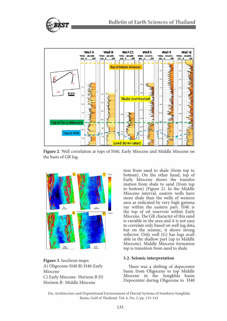
Four key horizons named Oligo-cene, H40, Early Miocene, and Middle Miocene are correlated among wells. Top of Oligocene is regional transi-
Do, Architecture and Depositional Environment of Fluvial Systems of Southern Songkhla Basin, Gulf of Thailand. Vol. 6, No. 2, pp. 131-141
tion from sand to shale (from top to bottom). On the other hand, top of Early Miocene shows the transfor-mation from shale to sand (from top to bottom) (Figure 2). In the Middle Miocene interval, eastern wells have more shale than the wells of western area as indicated by very high gamma ray within the eastern part. H40 is the top of oil reservoir within Early Miocene. The GR character of this sand is variable in the area and it is not easy to correlate only based on well log data, but on the seismic, it shows strong reflector. Only well (G) has logs avail-able in the shallow part (up to Middle Miocene). Middle Miocene formation top is transition from sand to shale.
3.2. Seismic interpretation
There was a shifting of depocenter basin from Oligocene to top Middle Miocene in the Songkhla basin. Depocenter during Oligocene to H40
Figure 2. Well correlation at tops of H40, Early Miocene and Middle Miocene on the basis of GR log.
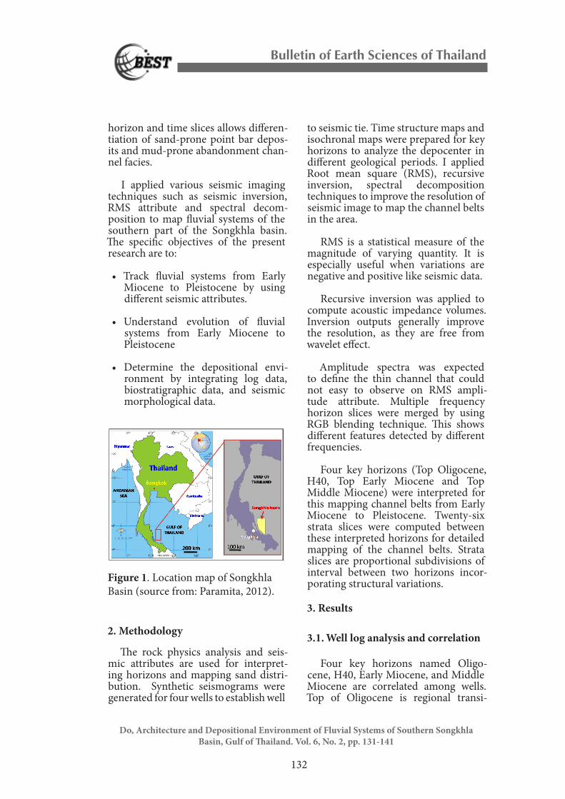
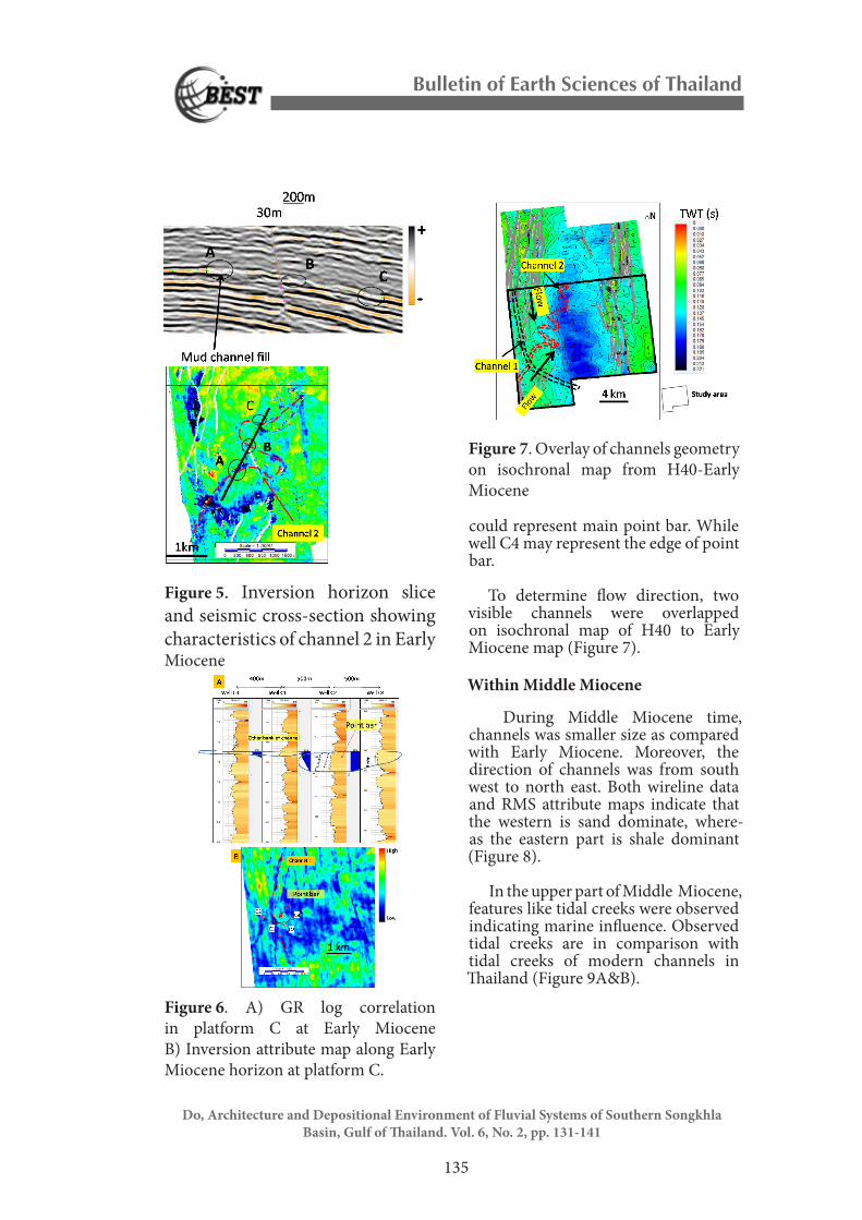
Figure 3. Isochron maps: A) Oligocene-H40 B) H40-Early Miocene C) Early Miocene- Horizon B D) Horizon B- Middle Miocene
Bulletin of Earth Sciences of Thailand
134
Do, Architecture and Depositional Environment of Fluvial Systems of Southern Songkhla Basin, Gulf of Thailand. Vol. 6, No. 2, pp. 131-141
located near the western part and could be influenced by western bound-ary faults (Figure 3A). Isochron map from H40 to Early Miocene revealed that maximum thickness is no more controlled by western boundary faults (Figure 3B). The maximum thickness of sediments from Early Miocene to B horizon (in Middle Miocene) interval shifted further eastward as compared with older sequences. In the Middle Miocene time period deepest part moved northeastward out of the study area and sediment deposition is no more controlled by faults (Figure 3D). This can be interpreted as ceasing of tectonic activity by this time and sedi-mentation is controlled by thermal subsidence.
3.3. Seismic geomorphology
Early Miocene
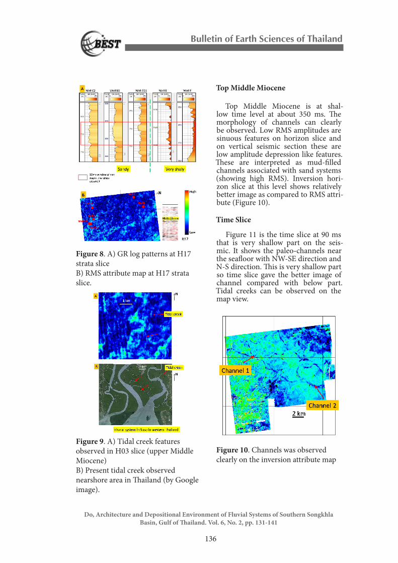
Only based on RMS horizon slice, it is not easy to map channels and fluvial meander belt systems on this horizon slice. However, seismic inversion hori-zon slice and spectral decomposition horizon slices at selected frequencies show better morphology of mender belt systems. Two main channels can be observed at this level. Direction of channel 1 is N-S (Figure 4A) on RMS horizon slice. Channel 2 is observed more clearly on inversion horizon slice and spectral decomposition (80 Hz) horizon slice (Figure 4B&C). Channel 2 has SW-NE direction. Vertical seis-mic section also supports this channel interpretation (Figure 5). Low ampli-tude mud-filled material is observed on vertical section surrounded by high amplitudes, which are interpreted as sands.
Cross section of wells of platform C along channel 1 indicates that GR log character is variable over the short distance. On the inner bank, well C2
has fining upward trend as compared with well C4 that has blocky sand (Figure 6A). While on the over bank, well C1&C3 are very thin sand layers. Well C2, which has fining upward trend
Do, Architecture and Depositional Environment of Fluvial Systems of Southern Songkhla Basin, Gulf of Thailand. Vol. 6, No. 2, pp. 131-141
could represent main point bar. While well C4 may represent the edge of point bar.
To determine flow direction, two visible channels were overlapped on isochronal map of H40 to Early Miocene map (Figure 7).
Within Middle Miocene
During Middle Miocene time, channels was smaller size as compared with Early Miocene. Moreover, the direction of channels was from south west to north east. Both wireline data and RMS attribute maps indicate that the western is sand dominate, where-as the eastern part is shale dominant (Figure 8).
In the upper part of Middle Miocene, features like tidal creeks were observed indicating marine influence. Observed tidal creeks are in comparison with tidal creeks of modern channels in Thailand (Figure 9A&B).
Figure 5. Inversion horizon slice and seismic cross-section showing characteristics of channel 2 in Early Miocene
Figure 6. A) GR log correlation in platform C at Early Miocene B) Inversion attribute map along Early Miocene horizon at platform C.
Figure 7. Overlay of channels geometry on isochronal map from H40-Early Miocene
Bulletin of Earth Sciences of Thailand
136
Do, Architecture and Depositional Environment of Fluvial Systems of Southern Songkhla Basin, Gulf of Thailand. Vol. 6, No. 2, pp. 131-141
Top Middle Miocene
Top Middle Miocene is at shal-low time level at about 350 ms. The morphology of channels can clearly be observed. Low RMS amplitudes are sinuous features on horizon slice and on vertical seismic section these are low amplitude depression like features. These are interpreted as mud-filled channels associated with sand systems (showing high RMS). Inversion hori-zon slice at this level shows relatively better image as compared to RMS attri-bute (Figure 10).
Time Slice
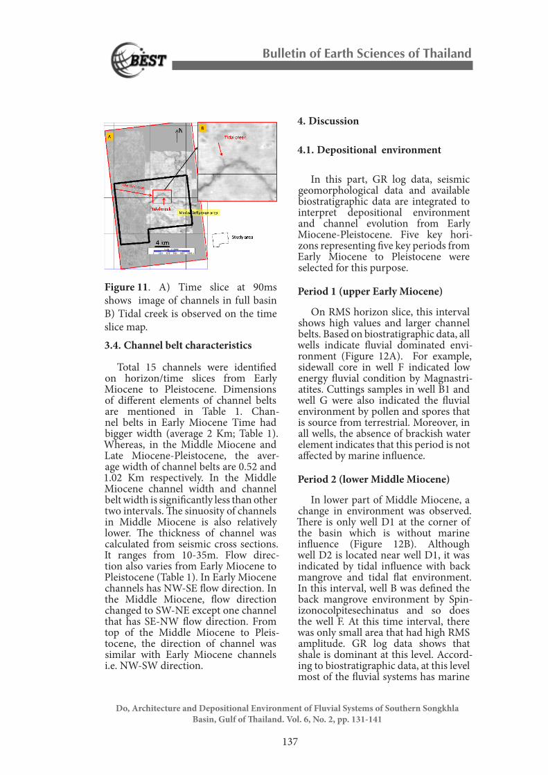
Figure 11 is the time slice at 90 ms that is very shallow part on the seis-mic. It shows the paleo-channels near the seafloor with NW-SE direction and N-S direction. This is very shallow part so time slice gave the better image of channel compared with below part. Tidal creeks can be observed on the map view.
Figure 8. A) GR log patterns at H17 strata slice B) RMS attribute map at H17 strata slice.
Figure 9. A) Tidal creek features observed in H03 slice (upper Middle Miocene) B) Present tidal creek observed nearshore area in Thailand (by Google image).
Figure 10. Channels was observed clearly on the inversion attribute map
Bulletin of Earth Sciences of Thailand
137
Do, Architecture and Depositional Environment of Fluvial Systems of Southern Songkhla Basin, Gulf of Thailand. Vol. 6, No. 2, pp. 131-141
3.4. Channel belt characteristics
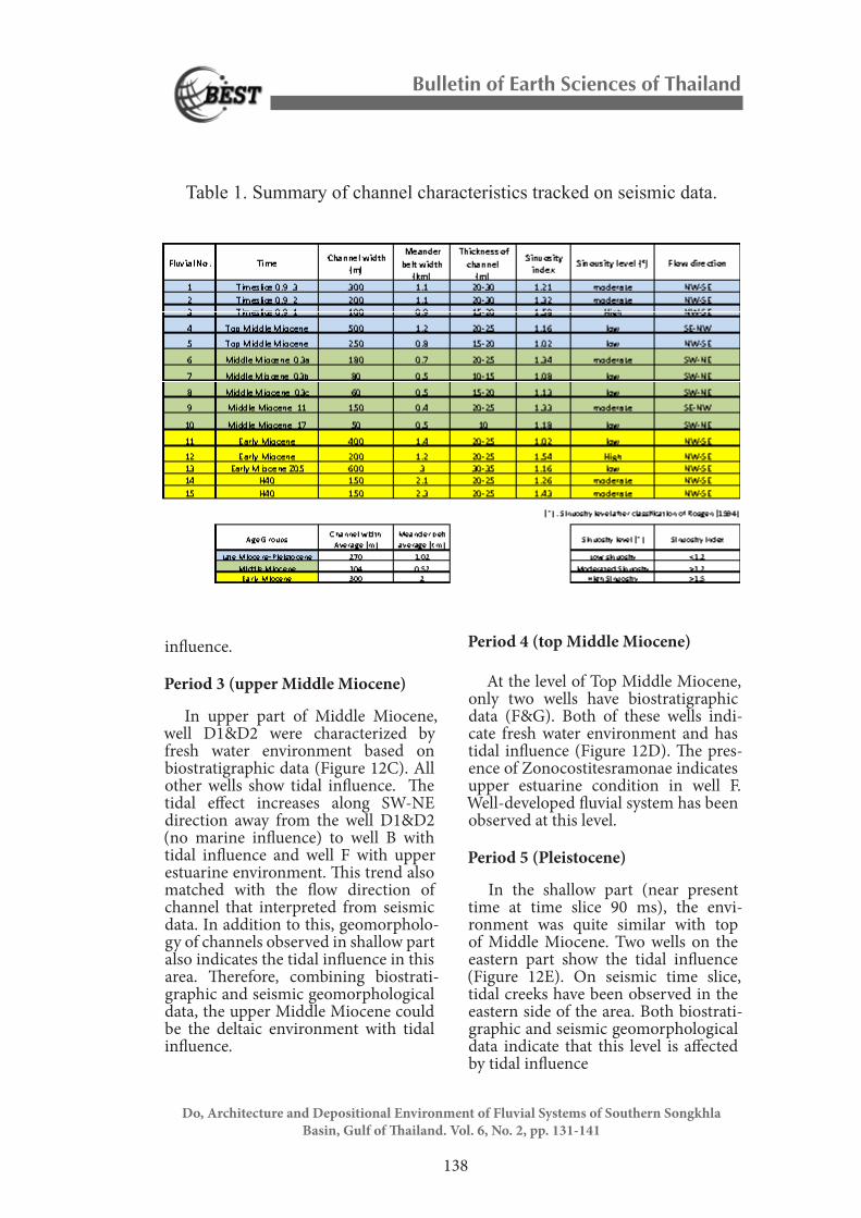
Total 15 channels were identified on horizon/time slices from Early Miocene to Pleistocene. Dimensions of different elements of channel belts are mentioned in Table 1. Chan-nel belts in Early Miocene Time had bigger width (average 2 Km; Table 1). Whereas, in the Middle Miocene and Late Miocene-Pleistocene, the aver-age width of channel belts are 0.52 and 1.02 Km respectively. In the Middle Miocene channel width and channel belt width is significantly less than other two intervals. The sinuosity of channels in Middle Miocene is also relatively lower. The thickness of channel was calculated from seismic cross sections. It ranges from 10-35m. Flow direc-tion also varies from Early Miocene to Pleistocene (Table 1). In Early Miocene channels has NW-SE flow direction. In the Middle Miocene, flow direction changed to SW-NE except one channel that has SE-NW flow direction. From top of the Middle Miocene to Pleis-tocene, the direction of channel was similar with Early Miocene channels i.e. NW-SW direction.
4. Discussion
4.1. Depositional environment
In this part, GR log data, seismic geomorphological data and available biostratigraphic data are integrated to interpret depositional environment and channel evolution from Early Miocene-Pleistocene. Five key hori-zons representing five key periods from Early Miocene to Pleistocene were selected for this purpose.
Period 1 (upper Early Miocene)
On RMS horizon slice, this interval shows high values and larger channel belts. Based on biostratigraphic data, all wells indicate fluvial dominated envi-ronment (Figure 12A). For example, sidewall core in well F indicated low energy fluvial condition by Magnastri-atites. Cuttings samples in well B1 and well G were also indicated the fluvial environment by pollen and spores that is source from terrestrial. Moreover, in all wells, the absence of brackish water element indicates that this period is not affected by marine influence.
Period 2 (lower Middle Miocene)
In lower part of Middle Miocene, a change in environment was observed. There is only well D1 at the corner of the basin which is without marine influence (Figure 12B). Although well D2 is located near well D1, it was indicated by tidal influence with back mangrove and tidal flat environment. In this interval, well B was defined the back mangrove environment by Spin-izonocolpitesechinatus and so does the well F. At this time interval, there was only small area that had high RMS amplitude. GR log data shows that shale is dominant at this level. Accord-ing to biostratigraphic data, at this level most of the fluvial systems has marine
Figure 11. A) Time slice at 90ms shows image of channels in full basin B) Tidal creek is observed on the time slice map.
Bulletin of Earth Sciences of Thailand
138
Do, Architecture and Depositional Environment of Fluvial Systems of Southern Songkhla Basin, Gulf of Thailand. Vol. 6, No. 2, pp. 131-141
influence.
Period 3 (upper Middle Miocene)
In upper part of Middle Miocene, well D1&D2 were characterized by fresh water environment based on biostratigraphic data (Figure 12C). All other wells show tidal influence. The tidal effect increases along SW-NE direction away from the well D1&D2 (no marine influence) to well B with tidal influence and well F with upper estuarine environment. This trend also matched with the flow direction of channel that interpreted from seismic data. In addition to this, geomorpholo-gy of channels observed in shallow part also indicates the tidal influence in this area. Therefore, combining biostrati-graphic and seismic geomorphological data, the upper Middle Miocene could be the deltaic environment with tidal influence.
Period 4 (top Middle Miocene)
At the level of Top Middle Miocene, only two wells have biostratigraphic data (F&G). Both of these wells indi-cate fresh water environment and has tidal influence (Figure 12D). The pres-ence of Zonocostitesramonae indicates upper estuarine condition in well F. Well-developed fluvial system has been observed at this level.
Period 5 (Pleistocene)
In the shallow part (near present time at time slice 90 ms), the envi-ronment was quite similar with top of Middle Miocene. Two wells on the eastern part show the tidal influence (Figure 12E). On seismic time slice, tidal creeks have been observed in the eastern side of the area. Both biostrati-graphic and seismic geomorphological data indicate that this level is affected by tidal influence
Table 1. Summary of channel characteristics tracked on seismic data.
Bulletin of Earth Sciences of Thailand
139
Do, Architecture and Depositional Environment of Fluvial Systems of Southern Songkhla Basin, Gulf of Thailand. Vol. 6, No. 2, pp. 131-141
Figure 13. Summary of channel evolution from Early Miocene to Pleistocene
Figure 12 and Figure 13 show the summary of fluvial channel evolution from Early Miocene until Pleistocene. Fluvial system was dominated in Early Miocene with no marine influence. The sizes of observed channels are large. The probable source of sediments is from the North. In the lower Middle Miocene time, tidal influenced broad-ly, span over the basin except a small corner area in the southeastern part. Flow direction also changed. At this interval, flow direction is from SW-NE. The sizes of the channels are also small within this interval. This type of chan-nel system continues until Late Middle Miocene. In the Middle Miocene, the source of sediments is from the south-western part of the area. In the Top Middle Miocene the flow, direction of channels is from the North-West to South-East (Figure 12D). Channels are relatively larger as compared to Middle
Miocene. From top middle Miocene to Pleistocene, channel direction remains, the same.
Figure 12. Summary of channel system evolution from Early Miocene to Pleistocene in study area.
Bulletin of Earth Sciences of Thailand
140
Do, Architecture and Depositional Environment of Fluvial Systems of Southern Songkhla Basin, Gulf of Thailand. Vol. 6, No. 2, pp. 131-141
In terms of lithology, in Middle Miocene time (Period 2 and 3) the shale is dominant in the eastern part as compared with the western part. Wells in the western part, which are located at the upper part of the chan-nel systems, are sandstone dominant in Middle Miocene. Contrary to this the wells on the eastern side of the basin are located at downstream of the fluvi-al system channels are shale dominant and has more marine influence.
4.2. Factors controlling channel mor-phology
In the study area, rifting was active at least until top of the Early Miocene. The rifting created a high gradient slope as well as high accommodation. In addition to this, the source from land could be rich to discharge sedi-ments to the fluvial systems in Early Miocene time. Therefore, fluvial system in Early Miocene has big size channel systems. In the western part, it is not easy to observe the channels due to the complex tectonics in the fault zone.
Whereas most of the tectonic activ-ity stopped in the Middle Miocene and sedimentation is controlled by thermal subsidence. It created the flat gradient slopes. Therefore, there was low accommodation space in Middle Miocene. This resulted in narrow chan-nel belts having relatively low sinuosity with no lateral migration. The marine influence inferred from biostratigraph-ic data within these non-marine rocks may indicates flooding episodes. On the top Middle Miocene horizon slice, large channels can be observed. Based on the global sea level data (Kenneth G. Miller et al., 2011 and Cramer et al. 2009), sea level in the Middle Miocene decreased gradually and till the top Middle Miocene there is significant drop in sea level. This drop in sea level may be the reason for the formation
of the large meander belts at top of the Middle Miocene. From top of the Middle Miocene to Pleistocene, no tectonic activity is observed, as there is no faults can be seen on the seismic data. Therefore, the fluvial channels are not attributed to accommodation related to tectonics. The well-devel-oped meander belts are related to sea level changes or change in sediment discharge due to climatic changes.
Fluvial system was controlled by basin boundary faults until the Early Miocene time in the western part of the basin. Close to the boundary faults, it is not easy to observe channel geome-try. This may be due to complex tecton-ic activity. However, the strong RMS amplitude distributed along syn-rift faults could indicate the presence of channel belts. The channel belts observed in the Early Miocene are in the center of the basin, where there is no tectonic deformation.
5. Conclusions
The main findings and conclusions of this study area are mentioned below:
1. Sedimentation in Songkhla basin was controlled by syn-rift faults from Oligocene to the Early Miocene as the depocenter is near the basin bound-ing faults at this time. In the Middle Miocene main phase of rifting ceased and depocenter shifted eastward away from the faults. Therefore, sedimen-tation is no more controlled by faults and this depocenter may controlled by thermal subsidence. From Top Middle Miocene to Pleistocene depocenter moved to NE part of the area.
2. In the Early Miocene, large mend-er belts are observed in the center of basin. Sand bodies have been identified within western basin bounding faults, but no channel belt can be observed. Large mender belts may be formed
Bulletin of Earth Sciences of Thailand
141
Do, Architecture and Depositional Environment of Fluvial Systems of Southern Songkhla Basin, Gulf of Thailand. Vol. 6, No. 2, pp. 131-141
due to greater accommodation space because of rifting in this period.
3. In the Middle Miocene, most of the channel belts are narrow with mini-mum lateral migration. This is due to low slope and low accommodation in deltaic condition. It is resulted from marine influence.
4. Biostratigraphic data indicates marine influence in Middle Miocene sequence. This influence is more on the eastern part of the area. Shallow seismic images within upper Middle Miocene and Pleistocene also indicate the presence of tidal creek. This marine influence in fluvial system is probably due to flooding episodes.
5. GR log patterns vary rapidly over small area in different components of fluvial systems. Therefore, it is not easy to correlate the wells without mapping fluvial systems on seismic data.
Acknowledgments
The author would like to thank theI wish to express my great appreciation to Dr. Mirza Naseer Ahmad for the final research project supervision. Land-mark, Kingdom and Schlumberger are acknowledged for providing academic licenses of software.
References
Cramer, B. S., J. R. Toggweiler, J. D. Wright, W. E. Katz, and K. G. Miller, 2009, Ocean overturning since the Late Cretaceous: Inferences from a new benthic foraminiferal isotope compilation: Paleoceanography, v. 24.
Kengkoom, S., 1992, Quaternary sea-level fluctuations in the coastal area of eastern Thailand: a synoptic view in relation to mineral resources
exploration: Southeast Asian Earth Sciences, v. 7, p. 39-51.
Miall, A. D., 2002, Architecture and se-quence stratigraphy of Pleistocene fluvial systems in the Malay basin, based on seismic time-slice analysis: AAPG Bulletin, v. 86, p. pp. 1201–1216.
Miller, Kenneth Mountain, Gregory Wright, James Browning, and James, 2011, A 180-Million-Year Record of Sea Level and Ice Volume Variations from Continental Margin and Deep-Sea Isotopic Records: Oceanography, v. 24, p. 40-53.
Morley, C. K., and A. Racey, 2011, Ter-tiary stratigraphy, The Geology of Thailand: London, Geological Soci-ety, p. 223-272.
Paramita, D., 2012, Structural evolution of the Songkhla basin, Gulf ofThai-land: A palinspastic restoration study, unpublished M.Sc thesis, The Department of Geology, Faculty of Science, Chulalongkorn University, Thailand.
Ridd, M. F., A. J. Barber, and M. J. Crow, 2011, The Geology of Thailand, Geo-logical Society Publishing House.
Rosgen, and D. L., 1994, A classifica-tion of natural rivers: CATENA, v. 22, p. 169-199.