St. Mary’s County Comprehensive Zoning Ordinance Article 4. OVERLAY AND FLOATING ZONES Page 40-1 ARTICLE 4. OVERLAY DISTRICTS AND FLOATING ZONES 1 CHAPTER 40 OVERLAY DISTRICTS, FLOATING ZONES: 2 PURPOSE, STANDARDS, PERMITTED USES 3 Sections: 4 40.1 Purpose of the Chesapeake Bay Critical Area Overlay. 5 40.2 Purpose of the Historic Landmarks and Districts Overlay. 6 40.3 Purpose of the Air Installations Compatible Use Zone and Airport Environs Overlay. 7 40.4 Purpose of the Planned Unit Development (PUD) Floating Zone. 8 40.5 Development Standards. 9 40.1. Purpose of the Chesapeake Bay Critical Area Overlay. 10 1. The Chesapeake Bay Critical Area Overlay implements Comprehensive Plan policies to protect 11 land and water resources in the Chesapeake Bay Critical Area. The developmental and land use 12 controls within the overlay will minimize adverse impacts on water quality from run off from 13 surrounding lands. It will conserve fish, wildlife, and plant habitat. Finally, this district 14 establishes land use regulations for development that accommodates growth and also addresses the 15 fact that, even if pollution is controlled, the number, movement, and activities of persons in that 16 area can create adverse environmental impacts. 17 2. Land use development standards and requirements established in Chapter 41 are intended to foster 18 more sensitive development activity for shoreline areas and to minimize the adverse impacts of 19 development and land use activities on water quality and natural habitats pursuant to the Natural 20 Resources Article, Subtitle 18 of the Annotated Code of Maryland and COMAR 27.01. 21 40.2. Purpose of the Historic Landmarks and Districts Overlay. 22 The Historic Landmarks and Districts Overlay implements Comprehensive Plan policies to recognize the 23 unique contribution of St. Mary’s County to state and national history, including recognition of the 24 County’s distinct rural historic landscape. This overlay promotes the conservation, preservation, 25 protection, and enhancement of historic resources, including sites, structures, and districts significant in 26 history, architecture, archaeology, or culture that serve as visible reminders of the County’s heritage. This 27 overlay district seeks to deter demolition, destruction, alteration, misuse, or neglect of historically, 28 architecturally, archaeologically, or culturally significant sites or structures. By conserving historic 29 resources, the district will preserve and enhance the quality of life and promote the economic prosperity 30 and welfare of the County. 31 40.3. Purpose of the Air Installations Compatible Use Zone and Airport Environs Overlay. 32 1. The Air Installations Compatible Use Zone (AICUZ) and Airport Environs (AE) Overlay is 33 established to ensure land use compatibility around federal and municipal airports in the County, 34 including, the Patuxent River Naval Air Station, Webster Field at St. Inigoes, St. Mary’s County 35 Regional Airport in Hollywood, and future similar airport, air field, or heliport operations 36 approved in the County. 37 2. Land use development standards and requirements established in Chapter 43 are intended to 38 minimize exposure to aircraft noise, minimize risks to public safety, and minimize hazards to 39 aviators and those employed or residing in proximity to public aviation facilities. Each overlay 40 establishes a hierarchy of sub-districts with restrictions dependent on the location of lands in 41 relation to airport operations. The most stringent restrictions apply to land located closest to the 42 airport, and the least stringent apply to lands located farther from the airport but within the 43 boundary of this Overlay district. 44 40.4. Purpose of the Planned Unit Development (PUD) Floating Zone. 45 1. The Planned Unit Development Floating Zone (PUD) is intended to provide flexibility in planning 46 for development of projects. 47 2. Land use development standards and requirements established in Chapter 44, Planned Unit 48 Development (PUD), are intended to: 49 a. Ensure orderly and thorough planning and review procedures that will result in quality 50 design; protection of open space, sensitive areas, and agricultural lands; and the creation 51
Transcript
St. Mary’s County Comprehensive Zoning Ordinance Article 4. OVERLAY AND FLOATING ZONES
Page 40-1
ARTICLE 4. OVERLAY DISTRICTS AND FLOATING ZONES 1
CHAPTER 40 OVERLAY DISTRICTS, FLOATING ZONES: 2
PURPOSE, STANDARDS, PERMITTED USES 3
Sections: 4
40.1 Purpose of the Chesapeake Bay Critical Area Overlay. 5
40.2 Purpose of the Historic Landmarks and Districts Overlay. 6
40.3 Purpose of the Air Installations Compatible Use Zone and Airport Environs Overlay. 7
40.4 Purpose of the Planned Unit Development (PUD) Floating Zone. 8
40.5 Development Standards. 9
40.1. Purpose of the Chesapeake Bay Critical Area Overlay. 10
1. The Chesapeake Bay Critical Area Overlay implements Comprehensive Plan policies to protect 11
land and water resources in the Chesapeake Bay Critical Area. The developmental and land use 12
controls within the overlay will minimize adverse impacts on water quality from run off from 13
surrounding lands. It will conserve fish, wildlife, and plant habitat. Finally, this district 14
establishes land use regulations for development that accommodates growth and also addresses the 15
fact that, even if pollution is controlled, the number, movement, and activities of persons in that 16
area can create adverse environmental impacts. 17
2. Land use development standards and requirements established in Chapter 41 are intended to foster 18
more sensitive development activity for shoreline areas and to minimize the adverse impacts of 19
development and land use activities on water quality and natural habitats pursuant to the Natural 20
Resources Article, Subtitle 18 of the Annotated Code of Maryland and COMAR 27.01. 21
40.2. Purpose of the Historic Landmarks and Districts Overlay. 22
The Historic Landmarks and Districts Overlay implements Comprehensive Plan policies to recognize the 23
unique contribution of St. Mary’s County to state and national history, including recognition of the 24
County’s distinct rural historic landscape. This overlay promotes the conservation, preservation, 25
protection, and enhancement of historic resources, including sites, structures, and districts significant in 26
history, architecture, archaeology, or culture that serve as visible reminders of the County’s heritage. This 27
overlay district seeks to deter demolition, destruction, alteration, misuse, or neglect of historically, 28
architecturally, archaeologically, or culturally significant sites or structures. By conserving historic 29
resources, the district will preserve and enhance the quality of life and promote the economic prosperity 30
and welfare of the County. 31
40.3. Purpose of the Air Installations Compatible Use Zone and Airport Environs Overlay. 32
1. The Air Installations Compatible Use Zone (AICUZ) and Airport Environs (AE) Overlay is 33
established to ensure land use compatibility around federal and municipal airports in the County, 34
including, the Patuxent River Naval Air Station, Webster Field at St. Inigoes, St. Mary’s County 35
Regional Airport in Hollywood, and future similar airport, air field, or heliport operations 36
approved in the County. 37
2. Land use development standards and requirements established in Chapter 43 are intended to 38
minimize exposure to aircraft noise, minimize risks to public safety, and minimize hazards to 39
aviators and those employed or residing in proximity to public aviation facilities. Each overlay 40
establishes a hierarchy of sub-districts with restrictions dependent on the location of lands in 41
relation to airport operations. The most stringent restrictions apply to land located closest to the 42
airport, and the least stringent apply to lands located farther from the airport but within the 43
boundary of this Overlay district. 44
40.4. Purpose of the Planned Unit Development (PUD) Floating Zone. 45
1. The Planned Unit Development Floating Zone (PUD) is intended to provide flexibility in planning 46
for development of projects. 47
2. Land use development standards and requirements established in Chapter 44, Planned Unit 48
Development (PUD), are intended to: 49
a. Ensure orderly and thorough planning and review procedures that will result in quality 50
design; protection of open space, sensitive areas, and agricultural lands; and the creation 51
St. Mary’s County Comprehensive Zoning Ordinance Article 4. OVERLAY AND FLOATING ZONES
Page 40-2
and improvement of common open space and coordination of vehicular, pedestrian, and 1
bicycle circulation. 2
b. Establish a procedure for the development of land under unified control in order to 3
achieve efficient land use patterns while permitting creative and innovative approaches to 4
the development of residential, commercial, and industrial uses in the designated zoning 5
districts. 6
c. Encourage mixed development patterns and avoid monotony in large developments by 7
allowing greater freedom in selecting the means to provide access, light, open space, and 8
amenities. 9
d. Allow a developer to take advantage of special site characteristics, locations, or land uses. 10
e. Provide for relief from the strict application of the land use standards, development 11
regulations, and performance standards found in the base zoning districts. 12
f. Decrease the burden created by new development on utilities and other infrastructure 13
systems by permitting mixed use development consistent with Smart Growth directives. 14
g. Provide a mechanism for increasing development in growth areas, where the 15
Comprehensive Plan directs additional development be accommodated, without 16
adversely affecting traffic circulation, infrastructure and public services and existing or 17
planned adjacent development. 18
h. The extent of uses allowed in a base zone shall be limited by action of the Board of 19
County Commissioners in order to maintain the essential character of the area in which 20
the PUD is placed. Therefore, the development of uses within a PUD that would not 21
otherwise be permitted in the base zone shall not adversely affect that zone. 22
40.5. Development Standards. 23
1. Overlay and Floating Standards 24
a. The development standards for the base zone (Schedules 32.1 and 32.2) shall govern, 25
unless explicitly modified through the approval of a PUD. 26
b. Additional proffers of amenities, public facilities or increased resource protection not 27
included in the table may be considered by the Board of County Commissioners for 28
PUDs. 29
c. Wherever more than one overlay applies the most restrictive criteria shall be used. 30
SCHEDULE 40.5 DEVELOPMENT STANDARDS W ITHIN OVERLAYS 31
Chesapeake Bay Critical Area (CBCA) Overlay
RCA LDA IDA
Residential Density
Base Density (units per acre) 1/20 --
Maximum. Density 1/20 -- --
Non-Residential Density
Base FAR 0.05 -- --
-- Not regulated, the base zone requirements apply. 32
2. Location Within Base Zoning Districts. Base zoning districts may host planned unit 33
developments upon finding by the Board of County Commissioners that the essential character of 34
the area in which the PUD is placed will be maintained.35
St. Mary’s County Comprehensive Zoning Ordinance Article 4. OVERLAY AND FLOATING ZONES
Page 41-1
CHAPTER 41 CHESAPEAKE BAY CRITICAL AREA (IDA, LDA, RCA) 1
Sections: 2
41.1 Applicability. 3
41.2 Lots of Record and Grandfathering. 4
41.3 Overlay Mapping and Zoning Designations. 5
41.4 Intensely Developed Area (IDA) Overlay District. 6
41.5 Limited Development Area (LDA) Overlay District. 7
41.6 Resource Conservation Area (RCA) Overlay District. 8
41.7 Buffer Management Overlay Designation. 9
41.8 Water Dependent Facilities Designation. 10
41.9 Growth Allocation Process. 11
41.1. Applicability. 12
1. This chapter applies to the St. Mary’s County Chesapeake Bay Critical Areas, the same being all 13
water of and lands under the Chesapeake Bay and its tributaries to the head of tide as indicated on 14
the State wetlands maps, and all State and private wetlands designated under Title 16 of the 15
Environment Article; and all land and water areas within 1,000 feet beyond the landward 16
boundaries of State or private wetlands and the heads of tide designated under Title 9 of the 17
Environment Article. 18
2. The St. Mary’s County Critical Area Overlay zones are superimposed on base zoning districts 19
within the St. Mary’s County Chesapeake Bay Critical Area and impose regulations that are in 20
addition to those established in the base zoning districts and any other applicable floating or 21
overlay zone. In the event of any inconsistency between the Critical Area provisions and the 22
provisions of the base zoning district or an applicable floating or overlay zone, the more restrictive 23
provision shall apply. 24
3. No person shall develop, alter, or use any land for residential, commercial, industrial, or 25
institutional uses, nor conduct agricultural, fishery, or forestry activities in the St. Mary’s County 26
Critical Area except in compliance with the applicable provisions of this Ordinance. 27
4. When the St. Mary’s County Critical Area overlay covers only a portion of a property, overlay 28
density shall apply on that portion of the property within the overlay and the underlying zone 29
density shall apply on that portion outside the overlay, provided that in no case shall the resulting 30
gross density for the parcel exceed that allowed in the underlying zone. 31
5. All local government development activities in the Chesapeake Bay Critical Area will be 32
implemented consistent with the requirements of COMAR 27.02.02 and 27.02.04. 33
41.2. Lots of Record and Grandfathering. 34
1. Any use or structure within the St. Mary’s County Critical Area existing or established before 35
March 27, 1990, that has not been abandoned for more than one year, regardless of any intention 36
to abandon or not, but which does not conform with the provisions of this chapter may continue. 37
Such use or structure, however, may not be reconstructed, intensified or expanded except in 38
accordance with this Ordinance. A nonconforming structure or a structure containing a 39
nonconforming use, which is destroyed by fire or other calamity, may be restored in accordance 40
with Section 52.5 of this Ordinance. 41
2. New uses within the St. Mary’s County Critical Area shall conform to the provisions of this 42
Ordinance. A single, undeveloped lot or parcel of land that was legally of record on the date of the 43
County’s Critical Area Program approval (March 27, 1990) may be improved with one single-44
family dwelling, notwithstanding that such development may be inconsistent with the density 45
provision of this chapter. 46
3. Development meeting the Resource Protection Standards set forth in the Zoning Ordinance may 47
occur on land that was: 48
a. Subdivided into recorded, legally buildable lots, where the subdivision received the 49
County’s final approval prior to June 1, 1984, provided that these lands are brought into 50
compliance with the requirements of this chapter insofar as possible, which shall include, 51
St. Mary’s County Comprehensive Zoning Ordinance Article 4. OVERLAY AND FLOATING ZONES
Page 41-2
but not be limited to, the consolidation or reconfiguration of adjacent lots in common 1
ownership to achieve a density more in keeping with the density and habitat protection 2
requirements of this chapter. Consolidation of lots in common ownership shall not be 3
required when impacts to steep slopes or Habitat Protection Areas would result or would 4
increase as a result of the consolidation proposal. 5
b. Subdivided into recorded, legally buildable lots, where the subdivision received the 6
County’s final approval after December 1, 1985, if the lots conform to the standards of 7
the St. Mary’s County Critical Area Overlay district, the lots receive growth allocation to 8
permit the proposed development, or a variance is properly approved. 9
c. Subdivided into recorded, legally buildable lots, where the subdivision received the 10
County’s final approval between June 1, 1984 and December 1, 1985, and the applicant 11
demonstrates that the lot meets all Critical Area criteria effective at the time of 12
subdivision approval. 13
d. Subdivided as part of a planned unit development that received final approval from the 14
County Commissioners prior to December 1, 1985, and which has met the requirements 15
of this Ordinance and any conditions of project approval. 16
4. The following subdivisions and planned unit developments in St. Mary’s County meet the 17
grandfathering criteria and do not require County growth allocation: 18
a. Esperanza Farms (Sections 10, 11, and 12) 19
b. Mulberry South 20
c. Rosebank Village 21
d. Breton Bay Garden Apartments (p/o Lansdale) 22
e. The Landings at Piney Point (originally known as Piney Point Landing PUD) 23
f. Cedar Cove PUD 24
g. Patuxent River Farms PUD (Myrtle Point Park) 25
h. Shannon Farms PUD except that this development is exempted from the provisions of 26
Section 41.2.3.d requiring compliance with conditions imposed at the time of rezoning if 27
the county determines that overall Critical Area Program requirements are exceeded, and 28
the Chesapeake Bay Critical Area Commission supports the County’s determination. 29
41.3. Overlay Mapping and Zoning Designations. 30
1. All land within the Chesapeake Bay Critical Area shall be assigned to one of the following overlay 31
districts corresponding to the land use classifications in the St. Mary’s County Critical Area 32
Program adopted on March 27, 1990. These districts shall be shown on official Critical Area 33
Overlay Zone Maps and on the Official Zoning Maps: 34
a. Intensely Developed Areas (IDA), and 35
b. Limited Development Areas (LDA), and 36
c. Resource Conservation Areas (RCA). 37
2. Land designated within the overlay zones may also be included in a “Buffer Management 38
Overlay.” This overlay provides relief from some regulations and standards for development that 39
necessarily occurs within the Critical Area Buffer. The Buffer Management Overlay shall be 40
shown on the Critical Area Overlay Zone Maps and on the Official Zoning Maps. 41
3. Changes to the Program. The following standards are established for amending the Critical Area 42
Overlay Zone Maps or program: 43
a. Program review and update. The County Commissioners may, on their own motion or 44
upon a recommendation from the Planning Commission, amend the Critical Area 45
provisions of this Ordinance and upon receiving a recommendation from the Planning 46
Commission, amend the Critical Area Overlay Zone Maps and the Official Zoning Maps 47
for Critical Area Overlay Zone designation. The Critical Area provisions of this 48
Ordinance and accompanying maps shall be reviewed at least every four years as part of 49
a comprehensive program review. 50
St. Mary’s County Comprehensive Zoning Ordinance Article 4. OVERLAY AND FLOATING ZONES
Page 41-3
b. The Critical Area Overlay Zone and the Official Zoning Maps (for Critical Area Overlay 1
Zone designation) may be amended as part of a review of this chapter, under the process 2
set forth below, or through the growth allocation process described in Section 41.9. 3
c. Mistake in Designation of Critical Area Overlay Districts. 4
(1) During the preparation of the Critical Area ordinances and the accompanying 5
maps, there may have existed some developed areas meeting the test for an LDA 6
or IDA classification that were not so classified due to an oversight. Proof of a 7
mistake in the existing Critical Area Overlay zoning or error in mapping may 8
only be demonstrated by the following: 9
(a) Evidence which shows that the assumptions or premises relied upon at 10
the time of the original mapping were invalid, or 11
(b) Evidence that the decision process failed to take into account physical 12
facts existing on December 15, 1985, or 13
(c) Evidence that the County failed to make any provision to accommodate 14
a project, trend, or need it recognized as existing on December 15, 15
1985. 16
(2) The following process is established for consideration of reclassification due to 17
mistake: 18
(a) Where evidence of a mistake is provided, application for 19
reclassification to LDA or IDA shall be made to the Planning 20
Commission, which shall forward a recommendation to the Board of 21
County Commissioners. 22
(b) The Board shall make a determination as to whether or not the property, 23
as it existed on December 15, 1985, met the test for an LDA or IDA 24
classification under the original rules as set forth in the St. Mary’s 25
County, Maryland Ordinance for the Chesapeake Bay Critical Area 26
Program, adopted March 27, 1990. 27
(c) If the Board finds that the property met the test and should have been 28
classified as LDA or IDA, then the Critical Area Overlay Zone Maps 29
and the Official Zoning Maps shall be amended to reflect these 30
findings. The amended maps shall be submitted to the Critical Area 31
Commission for approval. 32
d. Other map amendments. 33
(1) Buffer Management Areas shall be processed and mapped in accordance with 34
Section 41.7. 35
(2) Growth allocation shall be processed and mapped in accordance with Section 36
41.9. 37
(3) Critical Area boundary line changes shall be processed and mapped as 38
comprehensive map amendments. 39
(4) The Resource Area Maps, incorporated herein by reference, shall be routinely 40
updated in accordance with information from the State of Maryland. These 41
maps, which are available for inspection in the Department of Land Use and 42
Growth Management, were prepared for identifying the characteristics of the 43
Critical Area in need of protection from the impacts of human activity: 44
(a) Agricultural lands 45
(b) Wetlands 46
(c) Tributary streams 47
(d) Mineral resources 48
(e) Known threatened and endangered species and habitats of species in 49
need of conservation 50
(f) Watersheds of anadromous fish-spawning streams 51
St. Mary’s County Comprehensive Zoning Ordinance Article 4. OVERLAY AND FLOATING ZONES
Page 41-4
(g) Soils with development constraints 1
(h) Forest resources 2
(i) Wildlife habitat 3
(j) Steep slopes 4
e. State Approval. Amendments to the Critical Area program and maps shall be approved 5
by the Critical Area Commission before taking effect. 6
41.4. Intensely Developed Area (IDA) Overlay District. 7
1. Intent. Intensely developed areas are areas of at least 20 acres in size where residential, 8
commercial, institutional, and/or industrial developed land uses predominate and where relatively 9
little natural habitat occurs. The purpose of the Intensely Developed Area (IDA) Overlay District 10
is to: 11
1.a. Improve the quality of runoff from developed areas that enters the Chesapeake Bay or its 12
tributary streams; and 13
a.b. Accommodate additional development of the type and intensity designated by the County 14
Comprehensive Plan provided that water quality is not impaired; and 15
b.c. Minimize expansion of Intensely Developed Areas into portions of the Critical Area 16
designated as Habitat Protection Areas and Resource Conservation Areas; and 17
c.d. Conserve and enhance fish, wildlife, and plant habitats, to the extent possible; and 18
d.e. Encourage the use of retrofitting measures to address any existing stormwater 19
management problems; and 20
e.f. Protect aquifer recharge areas; and 21
f.g. In order to reduce the impacts on water quality that are generated by development, the 22
County will: 23
(1) Make an assessment of the impact to water quality and biological resources as 24
part of the Critical Area review. 25
(2) Implement best management practices. 26
(3) Use, where appropriate, urban forestry programs, such as street tree plantings, 27
gardens, landscaping, and open land buffer plantings. 28
g.h. Encourage development activities that minimize destruction of forest and woodland 29
vegetation and no net loss of forest. 30
2. Permitted Uses. 31
a. Uses permitted in the IDA District are shown in Schedule 50.4. 32
b. A dwelling unit or other non-water dependent structure on a pier located on State or 33
private wetlands may only obtain a building permit where the project is located in an IDA 34
overlay area, approved by the County and 35
(1) The state permit for the construction was issued on or before January 1, 1989 or 36
(2) It can be verified that: 37
(a) The pier was in existence on December 1, 1985 as verified by a 38
Department of Natural Resources aerial photograph dated 1985 and 39
accompanied by a map of the area. 40
(b) The project does not require an expansion of the pier greater than 25 41
percent of the area of piers or dry docks removed for the same property 42
plus and additional of 10 percent of the water coverage eliminated by 43
removal of piers from the same or other properties. The total expansion 44
may not exceed 35 percent of the original size of piers and dry docks 45
removed. 46
c. A permit for repair of existing dwelling or non-water dependent structure may be issued. 47
Expansion of such structure is only allowed in accordance with b. above. 48
St. Mary’s County Comprehensive Zoning Ordinance Article 4. OVERLAY AND FLOATING ZONES
Page 41-5
d. Except for permits issued under b (1) above, the applicant must demonstrate that the 1
construction of a dwelling unit or other non-water dependent facility on a pier located on 2
state or private wetlands within the Critical Area will have no long-term adverse effect on 3
water quality, demonstrate an improvement in water quality of stormwater runoff in 4
accordance with IDA standards for reduction of pollutants. 5
e. Uses that are not permitted are excluded because of their potential for adversely affecting 6
habitat and water quality. These uses may be considered for approval by the Board of 7
Appeals as conditional uses if no environmentally acceptable alternative exists outside 8
the Critical Area, or if the facility is needed to correct an existing water quality or waste 9
management problem. 10
3. Site Development Standards. The following standards apply to all development activities in the 11
IDA Overlay District: 12
a. Development and redevelopment shall be subject to the habitat protection criteria set 13
forth in COMAR at 27.01.09. 14
b. A variance shall be required to place new development including expansion of existing 15
development, in the Critical Area Buffer unless the site is also in a Buffer Management 16
Area. 17
c. Impervious surface trading in accordance with Section 41.5.3.i.(3) may be allowed within 18
the IDA. 19
d. The applicant shall develop and submit a strategy to reduce existing and potential water 20
quality impacts on the site of the proposed development activity. The applicant must 21
submit to the Planning Director documentation necessary to assess water quality and 22
impacts to biological resources prompted by proposals for new development or 23
redevelopment. The Planning Commission may impose conditions upon the proposed 24
development to reduce potential adverse impacts to water quality from the proposed 25
development. 26
e. For all proposed development and redevelopment activities, the applicant shall employ 27
technologies that minimize adverse impacts to water quality caused by stormwater runoff 28
from the proposed development. 29
f. The plans for new development and all projects that will disturb more than 250 sq. ft. 30
even those constructed on or traded for existing impervious areas, must provide water 31
quality benefits to provide a 10 percent reduction in pollutant loading from 32
predevelopment levels. Assessment of impact and compliance with this “10 percent rule” 33
in the Critical Area will be determined according to the process described in “Urban 34
Stormwater Quality Guidance for the Chesapeake Bay Critical Area in Intensely 35
Developed Areas,” as amended from time to time and subject to the following 36
amendments. 37
(1) Off-site water quality enhancements may be provided if the improvements 38
cannot be accomplished on-site, provided that water quality benefits are 39
equivalent, their benefits are obtained in the same watershed and their benefits 40
can be determined through uses of modeling, monitoring or other computation 41
of mitigation measures. 42
(2) Disturbances of less than 250 square feet on a single-family residential lot are 43
exempt from the 10 percent rule requirements; however, planting an area 44
equivalent to the area of new impervious surface on the lot shall be required. 45
(3) Disturbances of 250 square feet or more on a single-family lot shall not require 46
submission of a standard application and calculation worksheet, but shall select 47
a residential best management practice (BMP) appropriately suited to the site. 48
When site constraints prevent use of recommended residential BMPs, planting 49
of native trees and shrubs is recommended. Planting in lieu of installing a BMP 50
shall meet the following requirements: 51
(a) Plant three trees or nine shrubs for every 100 sq. ft. of new impervious 52
surface in the Buffer or in the Buffer Management Overlay. 53
St. Mary’s County Comprehensive Zoning Ordinance Article 4. OVERLAY AND FLOATING ZONES
Page 41-6
(b) Plant one tree or three shrubs per every 100 square feet of new 1
impervious surface outside Buffer areas. 2
(c) A combination of trees and shrubs is acceptable. 3
(d) This planting shall be in addition to any planting required as a result of 4
clearing on the lot. 5
(e) A planting agreement shall be required, and said agreement shall be 6
executed for all planting. 7
(f) If on-site planting and BMPs are impracticable due to site constraints, 8
the applicant may pay a fee-in-lieu calculated on the tree planting 9
requirements of this subsection. 10
g. Retention and/or creation of areas of public access to the shore, such as foot paths, scenic 11
drives, and other public recreational facilities shall be provided to the extent possible. 12
h. Cluster development shall be used to the extent possible as a means of reducing 13
impervious areas and of maximizing areas of natural vegetation. 14
i. Ports and industries that use water for transportation and derive economic benefits from 15
shore access shall be located near existing port facilities. 16
4. Maximum Density. The IDA Overlay District may not be developed at an overall residential 17
density or non-residential intensity exceeding that allowed by the underlying zone. State tidal 18
wetlands may not be used for density calculations. Private tidal wetlands may be used for density 19
calculations. 20
41.5. Limited Development Area (LDA) Overlay District. 21
1. Intent. Limited Development Areas are those areas developed in low or moderate intensity uses 22
that contain areas of natural plant and animal habitats and from which the quality of runoff has not 23
been substantially altered or impaired. The purpose of the Limited Development Area (LDA) 24
Overlay District is to: 25
a. Maintain or, if possible, improve the quality of runoff and groundwater entering the 26
Chesapeake Bay and its tributaries. 27
b. Maintain, to the extent practicable, existing areas of natural habitat. 28
c. Protect water quality, aquifer recharge areas, habitats, and the prevailing character of 29
areas when accommodating additional low or moderate intensity development. 30
d. Assure that the overall intensity of development in the LDA is not increased beyond the 31
level established in a particular area so as to change its prevailing character as identified 32
by density and land use currently established in the area. 33
2. Permitted Uses. 34
a. Uses permitted in the LDA District are shown in Schedule 50.4. 35
b. Uses shall not be located in Habitat Protection Areas unless no feasible alternative exists 36
and the Board of Appeals grants a variance meeting the standards of Chapter 24. 37
3. Site Development Standards. The following standards apply to all development activities in the 38
LDA Overlay District: 39
a. Development and redevelopment shall be subject to the habitat protection criteria set 40
forth in COMAR at 27.01.09. 41
b. The applicant shall identify and protect environmental and natural features in accordance 42
with Chapter 71 Resource Protection Standards. 43
c. The proposed activity must incorporate provisions to protect Habitat Protection Areas in 44
accordance with provisions of Section 71.8, Habitat Protection Standards. 45
d. Roads, bridges, or utilities will only be permitted in Habitat Protection Areas if the 46
applicant can demonstrate that no feasible alternatives exist. In these cases, roads, 47
bridges, or utilities may only be approved when they are located, designed, constructed, 48
and maintained to provide maximum erosion protection, to minimize negative impacts to 49
St. Mary’s County Comprehensive Zoning Ordinance Article 4. OVERLAY AND FLOATING ZONES
Page 41-7
wildlife, aquatic life, and their habitats; and to maintain hydrologic processes and water 1
quality. 2
e. All proposed activities that must cross or affect streams must be designed in accordance 3
with Section 71.4. 4
f. All development sites shall incorporate a wildlife corridor system that connects the 5
largest undeveloped or most vegetative tracts of land within and adjacent to the site in 6
order to provide continuity of existing wildlife and plant habitats with off-site habitats. 7
Wildlife corridors shall be maintained by the establishment of conservation easements, 8
restrictive covenants, or similar instruments through which the corridor is preserved by 9
public or private groups, including homeowners associations, nature trusts, and other 10
organizations. 11
g. Development in the St. Mary’s County Critical Area shall be in accordance with Chapter 12
72, Forest and Woodland Resources in the Critical Area. 13
h. Development on steep slopes shall be in accordance with Section 71.7. 14
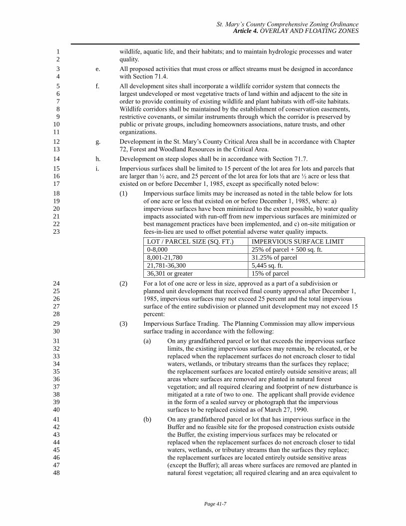
i. Impervious surfaces shall be limited to 15 percent of the lot area for lots and parcels that 15
are larger than ½ acre, and 25 percent of the lot area for lots that are ½ acre or less that 16
existed on or before December 1, 1985, except as specifically noted below: 17
(1) Impervious surface limits may be increased as noted in the table below for lots 18
of one acre or less that existed on or before December 1, 1985, where: a) 19
impervious surfaces have been minimized to the extent possible, b) water quality 20
impacts associated with run-off from new impervious surfaces are minimized or 21
best management practices have been implemented, and c) on-site mitigation or 22
fees-in-lieu are used to offset potential adverse water quality impacts. 23
LOT / PARCEL SIZE (SQ. FT.) IMPERVIOUS SURFACE LIMIT
0-8,000 25% of parcel + 500 sq. ft.
8,001-21,780 31.25% of parcel
21,781-36,300 5,445 sq. ft.
36,301 or greater 15% of parcel
(2) For a lot of one acre or less in size, approved as a part of a subdivision or 24
planned unit development that received final county approval after December 1, 25
1985, impervious surfaces may not exceed 25 percent and the total impervious 26
surface of the entire subdivision or planned unit development may not exceed 15 27
percent: 28
(3) Impervious Surface Trading. The Planning Commission may allow impervious 29
surface trading in accordance with the following: 30
(a) On any grandfathered parcel or lot that exceeds the impervious surface 31
limits, the existing impervious surfaces may remain, be relocated, or be 32
replaced when the replacement surfaces do not encroach closer to tidal 33
waters, wetlands, or tributary streams than the surfaces they replace; 34
the replacement surfaces are located entirely outside sensitive areas; all 35
areas where surfaces are removed are planted in natural forest 36
vegetation; and all required clearing and footprint of new disturbance is 37
mitigated at a rate of two to one. The applicant shall provide evidence 38
in the form of a sealed survey or photograph that the impervious 39
surfaces to be replaced existed as of March 27, 1990. 40
(b) On any grandfathered parcel or lot that has impervious surface in the 41
Buffer and no feasible site for the proposed construction exists outside 42
the Buffer, the existing impervious surfaces may be relocated or 43
replaced when the replacement surfaces do not encroach closer to tidal 44
waters, wetlands, or tributary streams than the surfaces they replace; 45
the replacement surfaces are located entirely outside sensitive areas 46
(except the Buffer); all areas where surfaces are removed are planted in 47
natural forest vegetation; all required clearing and an area equivalent to 48
St. Mary’s County Comprehensive Zoning Ordinance Article 4. OVERLAY AND FLOATING ZONES
Page 41-8
the footprint of new disturbance are mitigated at a rate of two to one; 1
and the total area of replacement impervious surface in the Buffer does 2
not exceed the lesser of the area removed or 1,000 square feet. The 3
applicant shall provide evidence in the form of a sealed survey or 4
photograph that the impervious surfaces to be replaced existed as of 5
March 27, 1990. 6
j. Modifications of road standards to reduce potential impacts to the site and Critical Area 7
resources will be permitted where the reduced standards do not impair the safety of the 8
road for its intended use. 9
k. The use of clustering to reduce the extent of impervious areas and maximize areas of 10
natural vegetation is encouraged. 11
l. A soil erosion and sedimentation control plan will be required for any proposed activities 12
in the Critical Area that involve clearing, grading, transporting or other form of 13
disturbance of land by the movement of earth. The required plan will be consistent with 14
the requirements of the Environment Article, Section 4-101 of the Annotated Code of 15
Maryland, and this Ordinance. Sediment control practices should be appropriately 16
designed to reduce adverse water quality impact and may include mitigation measures to 17
adequately address the identified constraints and avoid adverse impacts on water quality 18
or plant, fish, or wildlife habitat and to avoid erosion. 19
m. Proposed development activities within the Critical Area shall not cause downstream 20
property, watercourses, channels, or conduits to receive stormwater runoff at a higher 21
volume or rate than would result from a 10-year storm event were the land in its 22
predevelopment state. 23
n. All sediment control and stormwater management facilities must be designed with 24
sufficient capacity to achieve the water quality goals of the Critical Area program, and to 25
manage runoff caused by the development in excess of that which would have come from 26
the site if it were in its predevelopment state so that said excess runoff shall not leave the 27
site at a rate faster than it would have in its predevelopment state. 28
4. Maximum Density. The LDA Overlay District may not be developed at an overall residential 29
density or non-residential intensity exceeding that allowed by the underlying zone. State tidal 30
wetlands may not be used for density calculations. On-site private tidal wetlands and all nontidal 31
wetlands may be used for density calculations. 32
41.6. Resource Conservation Area (RCA) Overlay District. 33
1. Intent. Resource Conservation Areas are those areas characterized by nature-dominated 34
environments (that is, wetlands, forest, abandoned fields) and resource utilization activities (that 35
is, agriculture, forestry, fisheries activities, or aquaculture). The purpose of the RCA Resource 36
Conservation Area Overlay District is to: 37
a. Conserve, protect, and enhance the overall ecological values of the Critical Area, its 38
biological productivity and its diversity; 39
b. Provide adequate breeding, feeding, and wintering habitats for those wildlife populations 40
that require the Chesapeake Bay, its tributaries, or coastal habitats in order to sustain 41
populations of those species; 42
c. Conserve the land and water resource base that is necessary to maintain and support land 43
uses such as agriculture, forestry, fisheries activities, and aquaculture; and 44
d. Conserve the existing developed woodlands and forests for the water quality benefits that 45
they provide. 46
2. Permitted Uses. 47
a. Uses permitted in the RCA District are shown in Schedule 50.4. As set forth therein, new 48
industrial, commercial, and institutional uses are prohibited in the Resource Conservation 49
Area overlay. Such new uses must obtain approval for growth allocation and land must 50
be rezoned to either IDA or LDA as set forth in Section 41.9, Growth Allocation Process. 51
St. Mary’s County Comprehensive Zoning Ordinance Article 4. OVERLAY AND FLOATING ZONES
Page 41-9
b. New development and uses are not permitted to be located in Habitat Protection Areas 1
unless no feasible alternative exists and the uses are approved by the Board of Appeals as 2
a variance meeting the standards of Chapter 24. 3
3. Site Development Standards. Development activity within the RCA Overlay District shall 4
conform to the site development standards for the LDA Overlay District, established in Section 5
41.5. 6
4. Maximum Density. Except as otherwise provided in this chapter, properties within the RCA 7
Overlay District may not be developed at an overall residential density exceeding one dwelling 8
unit per 20 acres. State tidal wetlands may not be used for density calculations. Private tidal 9
wetlands and nontidal wetlands may be used for density calculations to the extent that the density 10
of development on the upland portion of the parcel may not exceed 1 dwelling unit per 8 acres, 11
and the area of private tidal wetlands shall be estimated on the basis of vegetative information as 12
designated on the Official State Tidal Wetland Maps. 13
a. Subdivisions of land that exceed the one dwelling unit per 20 acre density may be 14
allowed for bona fide intrafamily transfers 15
(1) Bona fide intrafamily transfers within the RCA Overlay District may be made 16
only from parcels of land that: 17
(a) Were of record on March 1, 1986, and 18
(b) Are at least 7 but less than 60 acres in size within the Critical Area. 19
(2) Bona fide intrafamily transfers within the RCA Overlay District are subject to 20
the County’s Subdivision Ordinance in addition to the following limitations: 21
(a) A parcel that is at least 7 acres and less than 12 acres may be 22
subdivided into two lots. 23
(b) A parcel that is at least 12 acres and less than 60 acres in size may be 24
subdivided into three lots. The lots may be created at different times. 25
(c) Any deed for a lot that is created for a bona fide intrafamily transfer 26
shall contain a covenant stating that the intra-family transfer lot is 27
created subject to the provisions of the Critical Area program. Such 28
covenant shall also be stated on the subdivision plat. 29
(3) Lots created under this section may not be conveyed subsequently to any person 30
other than a member of the owner’s immediate family, except upon the approval 31
of a request for exception filed in the Department of Land Use and Growth 32
Management that, at a minimum, includes the following assurances and 33
information: 34
(a) The lot was created as part of a bona fide intrafamily transfer and not 35
with the intent of subdividing the original parcel of land for purposes of 36
ultimate commercial sale, and 37
(b) A description of the change in circumstances that has occurred since the 38
bona fide intrafamily original transfer was made is not inconsistent 39
with the Critical Area program and warrants an exception. 40
(4) The request for an exception shall be submitted to the Planning Director for 41
referral to the TEC, which shall make a finding whether the exception is 42
warranted. Exceptions hereunder may be granted only by the Planning 43
Commission after consideration of the report of the TEC. To grant an exception 44
hereunder, the Planning Commission, must find that the lot was originally 45
created as part of a bona fide intrafamily transfer and that a legitimate change of 46
circumstance has occurred warranting the requested exception. 47
b. Accessory Apartment in the Resource Conservation Area: 48
(1) Within the Resource Conservation Area the County may permit one accessory 49
apartment per legally created lot or parcel as part of the primary dwelling unit 50
for the purpose of the density calculation under this subsection when the 51
accessory apartment meets the criteria of Section 51.3.105; 52
St. Mary’s County Comprehensive Zoning Ordinance Article 4. OVERLAY AND FLOATING ZONES
Page 41-10
(a) An accessory apartment permitted in accordance with Section 1
41.7.4.b(1) may not be subdivided or conveyed separately from the 2
primary dwelling unit. 3
(b) Any accessory apartment that does not meet the criteria of Section 4
51.3.105 shall be a dwelling unit subject to the density provisions of 5
41.7.4. 6
(2) The provisions of this section apply to density calculations only and may not be 7
construed to authorize the County to grant a variance to accommodate 8
construction of an accessory apartment, unless the variance is granted in 9
accordance with the requirements and standards in this ordinance for variances 10
in the critical area. 11
(a) Denial of a variance to construct an accessory apartment in the Critical 12
Area Buffer shall not constitute an unwarranted hardship under this 13
Ordinance. 14
(3) The County shall maintain records of all building permits issued under this 15
section for additional dwelling units considered part of a primary dwelling unit, 16
and shall provide this information on a quarterly basis to the Critical Area 17
Commission. 18
41.7. Buffer Management Overlay Designation. 19
1. Intent. The Buffer Management Overlay District is established to accommodate limited use of 20
shoreline areas where it has been demonstrated that the existing pattern of development in the 21
Critical Area prevents the Buffer from fulfilling the functions for water quality and habitat 22
protection setout in COMAR 27.01.09.01. 23
2. Mapping. The Buffer Management Overlay may be mapped only on lands that meet the following 24
criteria: 25
a. Lots recorded on or before December 1, 1985 whose configuration has not changed, and 26
that were also significantly impacted by development activities that existed as of 27
December 1, 1985 so as to prevent the Buffer from fulfilling its functions to: 28
(1) Provide for removal or reduction of sediments, nutrients and potentially harmful 29
or toxic substances in runoff entering the Chesapeake Bay or its tributaries; and 30
(2) Minimize the adverse effects of human activities on wetlands, shorelines, stream 31
banks, and aquatic resources; and 32
(3) Maintain an area of transitional habitat between aquatic and upland 33
communities; and 34
(4) Maintain the natural habitats of streams; and 35
(5) Protect riparian wildlife habitat. 36
OR 37
b. Waterfront parcels and lots less than 200 feet in depth that are within subdivisions of at 38
least nine lots, at least half of which are developed, and contain Buffer intrusion caused 39
by the existing principal structure. 40
OR 41
c. Zoned for commercial or industrial use and are less than five acres in size. 42
3. Permitted Uses. 43
Uses permitted shall be the same as for the applicable Critical Area Overlay (IDA, LDA or RCA) and the 44
underlying zoning. 45
4. Development Standards. 46
a. Development activities may not be approved in the Buffer unless the applicant can 47
demonstrate that there is no feasible alternative and the County finds that the applicant 48
has made efforts to minimize Buffer impacts based on the following guidelines: 49
St. Mary’s County Comprehensive Zoning Ordinance Article 4. OVERLAY AND FLOATING ZONES
Page 41-11
(1) Development activities shall be located as far as possible from mean high tide, 1
the landward edge of tidal wetlands, or the edge of tributary streams. 2
(2) Variances to other local setback requirements must be demonstrated to be 3
infeasible before intrusion into the Buffer. 4
(3) Convenience or expense shall not be factors considered when evaluating the 5
extent of allowable impacts to the Buffer, 6
(4) Principal or accessory structures in the Buffer may be replaced in the same 7
location. Any increase in impervious area is subject to the other provisions of 8
this section. 9
(5) Residential development and redevelopment shall not be closer to the water than 10
principal structures on an adjacent property, or the standard rear yard setback for 11
the underlying zone, or 25 feet, whichever is greater. 12
(6) Non-residential development and redevelopment, including both principal and 13
accessory structures, shall not be closer than 50 feet from mean high water or 14
the minimum standard rear yard setback, whichever is greater. 15
(7) New structures accessory to a residential use may be permitted in the Buffer in 16
accordance with the following requirements: 17
(a) They may be closer to the water or edge of tidal wetlands than the 18
principal structure on the property only if no other location exists for 19
their placement. Placement in a front or side yard subject to variance 20
approval shall be preferred over placement in the Buffer. 21
(b) In no case shall a new accessory structure be located within 25 feet of 22
mean high water or edge of state tidal wetlands. 23
(c) The area of impervious coverage for all accessory structures on the 24
property is 500 feet or less within 50 feet of the water and 1,000 square 25
feet in the entire Buffer on that property. 26
b. All development activities in the Buffer shall require mitigation in accordance with this 27
section. 28
c. No natural vegetation shall be removed in the Buffer except that required to perform the 29
proposed construction and install environmental protection measures. The remainder of 30
the Buffer shall be maintained in natural vegetation. 31
d. Development shall not impact any Habitat Protection Areas other than the 100-foot 32
Critical Area Buffer and may not occur in the 100-foot Buffer where other habitat 33
protection areas overlap with the 100-foot Buffer. Encroachment into steep slopes; 34
highly erodible soils; nontidal wetlands; and habitats of rare, threatened, and endangered 35
species is prohibited without a variance. 36
5. Mitigation requirements. 37
a. For any development in the Buffer Management Area, a planting agreement with 38
conditions to prevent future removal of vegetation shall be executed in accordance with 39
the provisions of the Forest and Woodland Protection Standards to provide mitigation and 40
enhancement or offsets as follows: 41
(1) An area of natural forest vegetation having twice the extent of the footprint of 42
the new impervious surface within the Buffer shall be planted on-site in the 43
Buffer. If it is not possible to carry out the on-site planting, an alternative 44
planting site within the same watershed as the development site may be 45
approved. 46
(2) Applicants who cannot comply with the planting requirements set forth above 47
may use offsets to meet mitigation requirements. Offsets may include removal 48
of an equivalent area of impervious surface in the Buffer, construction of a best 49
management practice (BMP) for stormwater, wetland creation or restoration, or 50
other measures that improve water quality or habitat. 51
St. Mary’s County Comprehensive Zoning Ordinance Article 4. OVERLAY AND FLOATING ZONES
Page 41-12
(3) Applicants who cannot comply with either planting or offset requirements are 1
required to pay into the County’s Critical Area fee-in-lieu program. The amount 2
of payment shall be based on the cost for the County to plant the area of 3
vegetation required under (1) above and shall be established by Resolution of 4
the Board of County Commissioners. 5
b. In addition to the above requirements, for non-residential development: 6
(1) Non-forested areas within the buffer on the site shall be planted with a minimum 7
of 5 canopy trees, 10 understory trees, 30 shrubs and 40 herbaceous plants per 8
100 linear feet of the buffer yard. Enhancement planting within forested areas 9
will also be required to provide a diverse forest structure with native species of 10
canopy, understory, shrub and herbaceous plants typically found in similar 11
Maryland riparian areas where such does not currently exist on-site. A Planting 12
Plan must be submitted to the Critical Area Commission for review with the site 13
plan in accordance with the provisions of COMAR 27.03.01.03. 14
(2) Unless the development attains Water Dependent Facility designation, a forested 15
or landscaped buffer yard, 25 feet wide, shall be required for the entire extent of 16
the shoreline between the water and all development on the site (both new and 17
existing). On redevelopment sites, if existing impervious surfaces or structures 18
are rebuilt on an existing footprint limit the area available for planting, then 19
modifications to the width of the planted buffer yard may be made on a case by 20
case basis, the promise being that the number of required plants shall not be 21
reduced, although their location may be revised. 22
41.8. Water Dependent Facilities Designation. 23
Intent. This section establishes policies and procedures for location, construction and operation of water-24
dependent activities that satisfy the requirements of Critical Area, state and federal law and support the 25
long-range development objectives of St. Mary’s County. 26
1. Water-dependent facilities in the Critical Area Buffer shall be limited to those that have minimal 27
individual or cumulative impact on water quality and fish, wildlife and plant habitat in the Critical 28
Area. 29
2. Permitted Uses. 30
a. Permitted water-dependent facilities include those structures or works associated with 31
industrial, maritime, recreational, educational, or fisheries activities that cannot exist 32
outside the Critical Area Buffer and are dependent on the water by reason of the intrinsic 33
nature of their operations. Water-dependent facilities include, but are not limited to: 34
charter fishing facilities, public docks, ramps and railways; boatyards; marinas; boatels; 35
commercial piers and ports and marine terminals; industrial and port-related facilities; 36
intake and outfall structures of power plants; water-use industries; public beaches and 37
public water-oriented recreation areas, and fisheries activities. Private piers installed or 38
maintained by individual riparian landowners, which are not part of a subdivision that 39
provides community piers, are excluded from regulation by this Section. 40
(1) Only those specific operations and structures that must occupy the Buffer in 41
order to serve their function may be located in the Buffer. New parking, roads, 42
and storage structures/areas; new eating and drinking establishments; retail sales 43
(other than fuel sales to watercraft); and other non-water dependent activities 44
and structures are prohibited from location in the 100 foot Buffer. 45
(2) Expansion of existing buildings in the Buffer requires a variance unless the 46
structure or facility was anticipated in an approved 5-to-10 year site plan 47
approved at the time of the designation of the site as a water-dependent facility, 48
the expansion is not waterward of the existing encroachment, and planting or 49
offsets are provided in the Buffer for two times the area of impervious surface 50
added. A five to ten year site plan indicates a five to ten year future for a given 51
site. The five to ten year site plan shall be submitted for review by the 52
St. Mary’s County Comprehensive Zoning Ordinance Article 4. OVERLAY AND FLOATING ZONES
Page 41-13
Department of Land Use and Growth Management as a Concept Plan in 1
accordance with Article 6 of this Ordinance. 2
b. Any activity structure of works permitted within the underlying zone, as set forth in 3
Schedule 50.4 and permitted in the Critical Area Overlay Zone may be approved as a 4
water-dependent facility if the applicant demonstrates that the activity, structure, or 5
works: 6
(1) Cannot exist outside the Critical Area Buffer; and 7
(2) Is dependent on the water by reason of the intrinsic nature of its operation. 8
c. Private, non-commercial piers having four or fewer slips, private non-commercial ramps 9
or railways, and structures for shore erosion control do not require a water-dependent 10
facility designation. Development of these waterfront facilities shall conform to County 11
requirements for shoreline structures and the County use regulations. 12
3. Requirements for the Selection/Approval of Areas and Sites. The following basic criteria and 13
requirements must be met for all new or expanded water-dependent facilities: 14
a. New or expanded development activities may not be allowed in those portions of the 15
Critical Area Buffer that fall in Resource Conservation Areas unless they are water-16
dependent facilities for: public beaches; other public, water-oriented recreation or 17
education; publicly-owned launching and docking facilities; fishing piers; research 18
facilities or activities; or fisheries and aquaculture facilities, and it can be shown that: 19
(1) Adequate sewage disposal facilities exist; and 20
(2) Non water-dependent facilities are located outside the Buffer to the extent 21
possible; and 22
(3) Permeable surfaces are used to the extent practicable; and 23
(4) Disturbance to natural vegetation is minimized; and 24
(5) Design and location criteria are such that the proposed activity will have 25
minimal individual and cumulative impact on water quality and fish, wildlife 26
and plant habitats in the Critical Area; and 27
(6) A fuel spill protection system will be installed. 28
b. Within the RCA overlay, any proposal seeking designation as a water-dependent facility 29
for a commercial, industrial, institutional or recreational use other than those permitted in 30
paragraph a, above, must concurrently seek and obtain growth allocation to reclassify the 31
property as LDA or IDA. 32
c. New or expanded water-dependent development activities may be permitted in the 33
Critical Area Buffer in Intensely Developed and Limited Development areas for industrial 34
and port-related facilities, marinas and commercial maritime facilities, community piers 35
and noncommercial boat docking and storage facilities, public beaches, or other public 36
water-oriented recreational or educational facilities, including publicly owned launching 37
and docking facilities and fishing piers, research facilities or activities, fisheries, and 38
aquaculture facilities provided that it can be shown that: 39
(1) That they are water-dependent; 40
(2) The project meets a recognized private right or public need; 41
(3) Adverse effects on water quality; tidal flow; and fish, plant, and wildlife habitat 42
are avoided or mitigated; 43
(4) Non-water dependent structures or operations associated with water-dependent 44
projects or activities are located outside the Critical Area Buffer; and 45
(5) The facilities are consistent with the Comprehensive Plan. 46
4. Site Development Standards for Specific Water-Dependent Facilities. 47
a. Development of water-dependent facilities shall conform to the criteria of Section 71.9 48
Standards for Shoreline Resources. 49
St. Mary’s County Comprehensive Zoning Ordinance Article 4. OVERLAY AND FLOATING ZONES
Page 41-14
b. Additional site development standards for specific water-dependent uses are hereby 1
incorporated by reference as set forth in Chapter 51. 2
c. If community piers, slips, or moorings are provided as part of a new development, private 3
piers in the development are not allowed. The number of slips, piers or mooring buoys 4
permitted at a community facility shall be the lesser of (1) or (2), below: 5
(1) One slip for each 50 feet of shore line in the subdivision in the Intensely 6
Developed Areas and Limited Development Areas and one slip for each 300 feet 7
of shoreline in the Resource Conservation Area according to the following 8
schedule: 9
(2) A density of slips, piers or mooring buoys to platted lots or dwellings within the 10
subdivision in the Critical Area according to the following schedule: 11
Platted Lots or Dwellings in the Critical Area Slips and Moorings
Up to 15 1 for each lot
16 – 40 15 or 75%, whichever is greater
41 – 100 30 or 50%, whichever is greater
101 – 300 50 or 25%, whichever is greater
Over 300 75 or 15%, whichever is greater
12
5. Permit Applications for Water-Dependent Facilities. The applicant shall prepare and submit 13
copies of an environmental water quality report with the appropriate application for site plan 14
approval. Copies of all necessary federal and state permits and approvals (which may be 15
identified before or during the site plan review) shall be submitted to the County before site plan 16
approval is granted. 17
6. Environmental Water Quality Report Requirements. 18
a. Qualitative factors must be evaluated by the Department of Land Use and Growth 19
Management in evaluating water-dependent development activities. The information 20
necessary for evaluating these factors, if not available locally, shall be obtained from 21
appropriate state and federal agencies. Based on materials submitted by the applicant, the 22
following findings must be made by the Planning Commission in approving the concept 23
plan for a water-dependent facility: 24
(1) The activities will not significantly alter existing water circulation patterns or 25
salinity regimes; 26
(2) The water body upon which these activities are proposed has adequate flushing 27
characteristics in the area; 28
(3) Disturbance to wetlands, submerged aquatic plant beds, or other areas of 29
important aquatic habitats will be minimized; 30
(4) Adverse impacts to water quality that may occur as a result of these activities, 31
such as non-point source runoff and sewage discharge from land activities, 32
vessels, or boat cleaning operations are minimized; 33
(5) Shellfish beds will not be disturbed or made subject to discharge that will render 34
them unsuitable for harvesting; 35
(6) Dredging shall be conducted in a manner and using a method that causes least 36
disturbance to water quality and aquatic and terrestrial habitats in the area 37
immediately surrounding the dredging operation or within the Critical Area 38
generally; 39
(7) Dredged spoil will not be placed within the Buffer or elsewhere in that portion 40
of the Critical Area that has been designated as a Habitat Protection Area except 41
as necessary for: 42
(a) Backfill for permitted shore erosion protection measures; 43
(b) Use in approved vegetated shore erosion projects; 44
St. Mary’s County Comprehensive Zoning Ordinance Article 4. OVERLAY AND FLOATING ZONES
Page 41-15
(c) Placement on previously approved channel maintenance spoil disposal 1
areas; and 2
(d) Authorized and approved beach nourishment; 3
AND 4
(8) Interference with the natural transport of sand will be minimized. 5
b. The materials submitted will be considered binding upon the applicant as an element of 6
the site development process. 7
7. Responsibilities for Impacts. The developer, owner, and/or operator of any water-dependent 8
facility shall be responsible for all impacts to the Buffer or water quality beyond those impacts 9
permitted under County, state or federal permits. 10
8. Identification of Future Area 11
a. Upon the direction of the Board of County Commissioners and with approval of a 12
program amendment or refinement by the Chesapeake Bay Critical Area Commission, the 13
Planning Commission may recommend the designation of additional areas of the IDA and 14
LDA using the criteria and process above and other relevant factors indicated in the 15
County’s Comprehensive Plan to satisfy expected future need for water-dependent 16
facility development. 17
b. The Planning Commission must hold public hearings in order to recommend the 18
designation of areas for future water dependent facility development. 19
c. Site plan approval for water-dependent activities may be granted in the pre-designated 20
areas when the plans meet the minimum criteria. 21
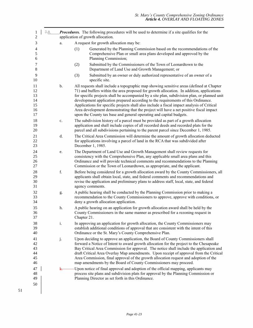
41.9. Growth Allocation Process. 22
1. Purpose and Intent. The purpose of the growth allocation process is to establish a method of 23
designating areas within the Critical Area where the County Commissioners may approve a 24
change in the current Critical Area overlay zone for specific sites or development projects to allow 25
for denser or more intensive development. The process provides for the designation of new IDAs 26
and LDAs within the Critical Area either by the conversion of LDA to IDA or the conversion of 27
RCA to LDA or IDA. No more than a total of 1,686 acres may be converted through the growth 28
allocation process. The County Commissioners may award growth allocation resulting from 29
Comprehensive Plan recommendations, small area plan recommendations, general or specific 30
requests from the Town of Leonardtown, or as the result of consideration of specific development 31
projects, site plans, subdivisions, or planned unit developments regulated under this Ordinance. 32
The County Commissioners must approve growth allocation prior to general approval of a specific 33
development project requiring growth allocation on the site, although review may occur 34
simultaneously with the growth allocation application. Growth allocation award is subject to the 35
approval of the Chesapeake Bay Critical Area Commission and may be contingent upon other 36
local, state, and federal approvals. 37
2. Location Criteria. The granting of growth allocation shall be consistent with the Comprehensive 38
Plan and the provisions of the St. Mary’s County Critical Area Program set forth in this chapter. 39
When approving a growth allocation, the County Commissioners shall use the following 40
guidelines to determine if the location of the proposed growth allocation classification is 41
consistent with the County Critical Area Program and Comprehensive Plan: 42
a. A new IDA should be located within an existing LDA or adjacent to an existing IDA. 43
b. A new IDA should be a minimum of 20 acres unless it is adjacent to an existing IDA or 44
LDA or is a grandfathered commercial, industrial, or institutional use that existed as of 45
the date of local Critical Area program approval. The amount of growth allocation 46
deducted shall be equivalent to the area of the entire parcel or parcels subject to the 47
growth allocation request. 48
c. Except as provided in §41.9.2.d, A new LDA shouldshall be located adjacent to an 49
existing LDA or IDA. 50
d. No more than one-half of the expansion allocated may be located in the Resource 51
Conservation Areas except that iIf the County is unable to utilize a portion of the growth 52
St. Mary’s County Comprehensive Zoning Ordinance Article 4. OVERLAY AND FLOATING ZONES
Page 41-16
allocated to the County within or adjacent to existing intensely developed or limited 1
development areas, as demonstrated by the local plan approved by the Critical Area 2
Commission, then that portion of the allocated expansion which cannot be so located may 3
be located in a Resource Conservation Area and the developers shall be required to 4
cluster any development in an area of expansion authorized under this exception. 5
(1) If the County demonstrates it is unable to utilize at least half A maximum of 844 6
acres of its growth allocation within the LDA, that portion of the allocated 7
expansion that cannot be located within the LDA may be located in the Resource 8
Conservation Area and no more than half of the growth allocation allotment for 9
conversion of RCA land (422 acres) may be used for residential projects. 10
(2) Minor Subdivision Plat submission and review by the Planning Commission and 11
decision by the Board of County Commisisoners regarding use of Growth 12
Allocation is established for the following residential development projects 13
requested within an area that does not meet the adjacency requirements for new 14
LDA or IDA project. 15
(1) , provided that development in an area authorized under this paragraph shall be 16
clustered. 17
(2) LDA or IDA necessary for the approval of new water-dependent 18
facilities may be located in the RCA. 19
(3)(a) LDA or IDA necessary for the approval of A a single lot subdivision 20
creating one new lot that is 1.5 acres in size or less in an area that does 21
not meet the adjacency requirements for new LDA or IDA may be 22
awarded growth allocation in Resource Conservation Areas provided: 23
1. The parent parcel The parent parcel is 20 acres or larger or, if 24
less than 20 acres, legally existed in its current configuration 25
as of December 1, 1985. 26
2. The parent parcel is of sufficient size to meet all criteria of the 27
zoning ordinance for both resulting lots. 28
3. Establishment of a 200-foot Buffer is required for any lot or 29
remainder parcel which is not managed under an approved 30
Soil Conservation and Water Quality Plan or approved Forest 31
Management Plan at the time of subdivision 32
(a) and is of sufficient size to meet the underlying zone density. 33
(b) The new lot is no more than 1.5 acres in size. 34
(c)4. If the acreage remaining in the parent parcel is less than 20 35
acres, the entire area of the parent parcel is shall be 36
mappedmapped and the entire acreage deducted from the 37
growth allocation allotment in accordance with Section 38
41.9.741.9.741.9.6. The acreage remaining in the parent 39
parcel that is less than 20 acres shall be prohibited from future 40
subdivision by a recorded deed restriction and a note on the 41
recorded subdivision plat. 42
(d)5. If the acreage remaining in the parent parcel is 20 acres or 43
more, and the balance of the parent parcel is to remain RCA, 44
only the new lot area shall be mapped and its be acreage 45
deducted from the growth allocation allotment. 46
(e) Any future subdivision of a parent parcel with remaining acres 47
less than 20 acres remaining isshall be prohibited from future 48
subdivision by a recorded deed restriction and a note on the 49
recorded subdivision plat. The acreage remaining in the parent 50
parcel that is less than 20 acres shall be prohibited from future 51
St. Mary’s County Comprehensive Zoning Ordinance Article 4. OVERLAY AND FLOATING ZONES
Page 41-17
subdivision by a recorded deed restriction and a note on the 1
recorded subdivision plat. 2
6. No more than half of the growth allocation allotment may be 3
used for residential projects. 4
(b) Upon identification of a parent parcel that exceeds allowed RCA 5
density due to a plat or subdivision approval granted after December 1, 6
1985, the County shall assure that no new dwelling permit is issued on 7
the identified parent parcel until and unless growth allocation is granted 8
under the provisons of this section. 9
1. The County Commisioners may request the Critical Area 10
Commission’s approval of a program refinement to change 11
land from RCA to LDA for a single development envelope 12
that encompasses eligible lots, outparcels, outlots and tracts 13
labeled as “Residue” that were created by recorded plat or by 14
deed after December 1, 1985 without approval of Growth 15
allocation and prior to [Date of introduction of this 16
amendment] when the resulting density on the parent parcel as 17
it existed on December 1, 1985 exceeds 20 units per acre. 18
2. Determining density on the parent parcel 19
a. Adjacent developed and undeveloped tracts (lots, 20
outlots, outparcels and tracts labeled as “Residue”) 21
on plats recorded after December 1, 1985 that were in 22
common ownership on [Date of introduction of this 23
amendment]) shall be combined and considered as a 24
single zoning lot. 25
b. Non-adjacent developed and undeveloped tracts shall 26
be considered as a single zoning lot. 27
c. The total density attributed to the parent parcel shall 28
be the sum of the number of existing dwellings 29
(excluding those meeting the definition as accessory 30
dwellings in the RCA) on the parent parcel AND the 31
number of vacant zoning lots with less than 20 acres 32
total area. 33
3. The following lands are not eligible to seek non-adjacent 34
growth allocation. 35
a. Land in any parcel created solely by deed after 36
February 1987. 37
b. Agricultural parcels 38
c. Undeveloped zoning lots determined according to 39
1.a. or 1.b. above that exceed 20 acres of total area. 40
d. Undeveloped zoning lots determined according to 41
1.a. or 1.b. above that cannot conform to all Critical 42
Area and zoning ordinance criteria currently in effect 43
without the need for a variance. 44
e. Land set aside to meet density requirments by a 45
recorded plat. 46
4. The County request must include all eligible developed or 47
undeveloped lots, outparcels, outlots or “residue” in the parent 48
parcel plus contiguous land in the parent parcel necessary to 49
define a compact single development envelope per Growth 50
Allocation criteria. 51
St. Mary’s County Comprehensive Zoning Ordinance Article 4. OVERLAY AND FLOATING ZONES
Page 41-18
a. Prepare an application meeting minimum criteria 1
established for a simplified growth allocation request 2
b. Follow procedures for a zoning map amendments, 3
with the County in the role of applicant to, to provide 4
notice to owners of tracts within and adjacent to the 5
parent parcel and posting. 6
c. Conduct a public hearing before the Planning 7
Commission for recommendation to the Board of 8
County Commissoners 9
d. Conduct a public hearing by the Board of County 10
Commissoners and transmit the request to the Critical 11
Area Commission for a program refinelment. 12
e. Upon approval of the program refinement by the 13
Critical Area Commission, a map amendment may be 14
adopted and the area of Growth allocation deducted 15
from the County allotment. 16
5. Within the area receiving growth allocation, no land may be 17
developed that has not been platted as a buildable lot through 18
the appropriate subdivision process. Development activities 19
on lots must conform to all Critical Area and zoning ordinance 20
criteria currently in effect without the need for a variance. 21
a. Establishment of a 200-foot Critical Area Buffer is 22
required for lots platted after February 8, 2010. 23
b. Establishment of the maximum possible Critical Area 24
Buffer on lots created prior to February 8, 2010 that 25
cannot provide a 200 foot buffer due to lot location 26
and configuration. 27
(3) Minor Siteplan Plat submission and review by the Planning Commission and 28
decision by the Board of County Commisisoners regarding use of Growth 29
Allocation is established for the following. 30
(a) LDA or IDA necessary for the approval of new water-dependent 31
facilities. 32
(b) Up to 100 acres of the County’s available growth allocation may be 33
used for non-adjacent LDA or IDA necessary for the approval of a 34
single development envelope on an RCA parcel to provide facilities for 35
a campground, day or boarding camp meeting the following criteria: 36
1. An area of proposed IDA growth allocation may be less than 37
20 acres; 38
2. If the acreage remaining outside the development envelope 39
leaves less than 20 acres of RCA land in the parcel or parcels 40
used for the campground, the entire area of the parcel shall be 41
mapped and deducted from the growth allocation allotment in 42
accordance with Section 41.9.6. 43
3. The use of land that is reclassified through the use of growth 44
allocation awarded in accordance with these provisions shall 45
be restricted to the specific uses approved as part of the 46
growth allocation request. Should the use be discontinued or 47
abandoned for a continuous period of one year or more, the 48
use shall not be reestablished. As appropriate, the Department 49
of Land Use and Growth Management can require that the 50
property be brought into full compliance with the RCA 51
St. Mary’s County Comprehensive Zoning Ordinance Article 4. OVERLAY AND FLOATING ZONES
Page 41-19
provisions in the County’s Zoning Ordinance and can revoke 1
the growth allocation used for the property. 2
4. The development envelope shall encompass the following 3
allowed commercial activities which are directly related or 4
incidental to the campground activities: 5
a. Access roads/driveways and parking areas 6
b. Campsites designated for use by a tent or by a 7
recreational vehicle that are improved with water 8
and/or electricity hookups. 9
c. Full extent of the Sewage reserve area 10
d. Camp administration functions including 11
caretaker/owner dwelling 12
e. Sale of fishing bait and tackle, toiletries, souvenirs, 13
and necessities to campers from a sales area 14
occupying no more than 1000 square feet; 15
f. Vending machines; 16
g. Canoe, kayak, boat rental; 17
h. Any recreational facility that would contribute lot 18
coverage including: swimming pool; tennis, 19
basketball, and volleyball courts, amphitheaters 20
i. Pump-out station for sewage and portable toilets 21
(requires health department approved disposal 22
facility). 23
5. The following campground activities and facilities may be 24
located in the RCA, outside of the “development envelope” 25
upon which the growth allocation acreage is based: 26
a. Primitive campsites which have defined fire pit but 27
provide no water or electrical hookups, have no new 28
impervious surfaces, have no clearing or grading 29
associated with their development, and which are 30
only accessed via a mulched hiking path. Primitive 31
campsites shall be located within 1,500 feet of toilet 32
facilities; 33
b. Hiking trails provided clearing is minimized and 34
mitigated. Trails may not exceed 3 feet in width and 35
shall not have paving, gravel or decked surfaces 36
except where necessary to traverse 25% or greater 37
slopes; 38
c. Boardwalks and observation platforms for nature 39
trails through tidal or nontidal wetlands when 40
properly permitted by the Maryland Department of 41
the Environment (MDE); 42
d. Recreational shoreline amenities (constructed in 43
accordance with §71.9) may be provided; 44
e. A single pier with no more than 1 slip per each 5 45
camp sites when properly permitted by MDE; 46
f. Up to three points of water access for launching of 47
canoes or kayaks or other non-motorized vehicles 48
which are hand carried via defined path through the 49
Critical Area Buffer; 50
St. Mary’s County Comprehensive Zoning Ordinance Article 4. OVERLAY AND FLOATING ZONES
Page 41-20
g. A recreational beach in areas with a naturally 1
occurring beach or a beach created with proper 2
permits from MDE; 3
h. Handicapped accessible path/ramps, roadways, and 4
parking as necessary for persons with disabilities to 5
access approved shoreline amenities. 6
6. Minimum standards for camp facilities and operations that 7
receive growth allocation: 8
a. Each campsite designated for use by a recreational 9
vehicle each of which shall have a single 15’ by 40’ 10
pervious pavement parking pad installed adjacent to 11
the approved access road/driveway. 12
b. No recreational vehicle may occupy any portion of 13
the campground for more than 24 hours unless 14
parked directly on one of the designated campsite 15
parking pads. Parking of any individual recreational 16
vehicle on any campsite parking pad within the 17
campground for more than 20 consecutive days in 18
any 30 consecutive day period is prohibited. The 19
campground management shall keep detailed records 20
documenting campground stays for each vehicle and 21
campsite. 22
c. No permanent or temporary structure of any kind 23
may be constructed at any campsite or erected on any 24
camp-site parking pad. 25
d. Tents and recreational vehicles shall not be occupied 26
for more than 14 consecutive days in any 30 27
consecutive day period or for more than 70 days in a 28
calendar year. 29
e. New Intensely Development Areas should shall be located where their impact is 30
minimized on the defined land uses of the Resource Conservation Area. 31
f. New IDA and LDA areas should shall be located in order to minimize impacts to Habitat 32
Protection Areas and in a manner that optimizes benefits to water quality. 33
3. For these uses the County, at its discretion, may use the Minor Site Plan review and approval 34
process as described in Chapter 60.6 of the St. Mary’s County Comprehensive Zoning Ordinance 35
as an alternative to the process specified in Chapter 41.9 of the Ordinance. Proposals using the 36
Minor Site Plan review and approval process shall demonstrate full compliance with the St. 37
Mary’s County Critical Area Program and the provisions of COMAR 27.01.02.05-1-2. 38
3.4. Design Criteria. Growth allocation applications shall comply with the following design criteria: 39
a. All Critical Area Habitat Protection Areas must be identified and protected according to 40
the requirements of this Ordinance. Projects shall conform to all resource protection 41
criteria of Chapter 71. 42
b. The design of development projects that request growth allocation awards must optimize 43
benefits to water quality through clustering, forest conservation, and use of best 44
management practices for storm water management and erosion and sediment control. 45
c. The designation of development projects that request growth allocation awards must 46
provide adequate protection for historic and archaeological resources listed on state or 47
local surveys or properties on or eligible for the National Register of Historic Places. 48
d. When growth allocation is permitted in the RCA, not adjacent to the IDA or LDA, the 49
applicant will be required to cluster the development and provide for resource 50
enhancement in the design of such development. 51
St. Mary’s County Comprehensive Zoning Ordinance Article 4. OVERLAY AND FLOATING ZONES
Page 41-21
e. Projects requesting to convert RCA land to either LDA or IDA shall provide a minimum 1
300-foot buffer from tidal waters and tidal wetlands and tributary streams in the Critical 2
Area. This restriction may be waived for water-dependent facilities that shall maintain a 3
minimum 100-foot buffer for all non-water dependent activities. 4
f. Project specific requests for growth allocation must demonstrate that the following design 5
standards will be met or exceeded in order to be approved. 6
(1) The development meets all applicable requirements of the St. Mary’s County 7
Critical Area Program and this Ordinance. 8
(2) The design of the development enhances the water quality and resource and 9
habitat values of the area. 10
(3) The development incorporates the comments and recommendations of the 11
County and the Department of Natural Resources in the project design. 12
(4) The applicant executes restrictive covenants or conservation easements that 13
guarantee maintenance of the required open space areas. 14
(5) The proposed project maximizes the use of a permanent conservation easement 15
and minimizes the use of the County’s growth allocation allotment. 16
4.5. Basis for Determining Maximum Permitted Density/Intensity. Maximum permitted densities or 17
non-residential intensities will be computed based on the total site area less the area occupied by 18
state wetlands. 19
a. The maximum residential density that will be permitted using growth allocation awards 20
shall be lesser of: 21
(1) The number of dwelling units permitted under all applicable zoning and non-22
Critical Area overlay districts; or 23
(2) The number of individual septic systems approved by the St. Mary’s County 24
Health Department under the regulations in effect at the time of application for 25
growth allocation or the number of units approved for connection to proposed 26
community facilities by the Maryland Department of the Environment; or 27
(3) The number of units available at the time of application for growth allocation 28
that may connect to an existing public sewerage system as determined by an 29
adequate facilities analysis. 30
b. The maximum non-residential intensity that will be permitted using growth allocation 31
awards shall be the lesser of: 32
(1) The square footage permitted under all applicable zoning and Critical Area 33
Overlay Districts, or 34
(2) The square footage approved for an individual septic system by the St. Mary’s 35
County Health Department under the regulations in effect at the time of 36
application for growth allocation; or 37
(3) The square footage approved for connection to proposed community facilities by 38
the Maryland Department of the Environment; or 39
(4) The square footage approved at the time of application for growth allocation 40
through an adequate facility analysis for projects proposing to connect to an 41
existing public sewerage system. 42
St. Mary’s County Comprehensive Zoning Ordinance Article 4. OVERLAY AND FLOATING ZONES
Page 41-22
5.6. Conditions of Approval. 1
a. Growth allocation awards shall remain in effect so long as progress is made toward 2
completion of approved development, such as recordation of a subdivision plat or 3
approval of a site plan. Should such progress not occur within three years of growth 4
allocation award, a hearing may be held by the Planning Commission and Board of 5
County Commissioners to withdraw the award and return the acreage to the County’s 6
growth allocation allotment. All procedures for a zoning map amendment shall be 7
followed with the County in the role of applicant for notice and posting. 8
b. A growth allocation award may be conditioned to be valid only for a specific project. 9
Any award that is so conditioned must be based on the concept approval of a site plan or 10
subdivision plan (including up to a six-year phasing plan). The growth allocation shall 11
remain valid as long as the project is completed within the allotted time or makes regular 12
and continued progress toward completion. If project approvals lapse, the growth 13
allocation shall be withdrawn at a public hearing to rezone the area to the overlay 14
designation in existence prior to the growth allocation award. An applicant for any 15
project for which approvals lapse, who desires to reinstate the growth allocation on the 16
site, is required to reapply. The project will be reviewed de novo and shall be subject to 17
the standards of the ordinance and regulations in effect at the time of reapplication. 18
c. Growth allocation that is not conditioned to be valid only for a specific project may 19
continue in effect even if the project for which the growth allocation was granted is 20
discontinued. Any new or substantially altered project located within an area that has 21
received such a Growth Allocation shall meet or exceed the resource and habitat 22
protection measures, water quality protection measures, and the growth allocation 23
standards of the originally approved project. 24
6.7. Computing the Use of the Growth Allocation. Growth Allocation acreage shall be computed as 25
follows: 26
a. Parcels of land that were recorded as of December 1, 1985, and classified as RCA or 27
LDA, where all or part of the parcel is identified by the County as a growth allocation 28
area, shall result in the acreage of the entire parcel not in state wetlands being deducted 29
from the St. Mary’s County growth allocation allotment, unless the development 30
envelope concept in (b) is used. 31
b. On an RCA parcel proposed for use of growth allocation, a single development envelope 32
may be specified, whereupon the acreage of the development envelope rather than the 33
entire parcel shall be deducted from the County’s growth allocation allotment if the 34
development meets the following criteria: 35
(1) The development envelope includes individually owned lots, required buffers 36
(including the 100-foot Critical Area Buffer, 25-foot nontidal wetlands buffers, 37
and any zoning buffers), impervious surfaces, roads, utilities, stormwater 38
management measures, on-site sewage disposal measures, any areas subject to 39
human use such as active recreation areas, and any additional acreage needed to 40
meet the development requirements of this Ordinance; and 41
(2) Only one development envelope is established per parcel of land; and 42
(3) If fewer than 20 acres remain outside the development envelope, the residue is 43
contiguous to a 20 acre or larger area of land with an RCA designation, and the 44
land is permanently protected (i.e. by easement). 45
c. For growth allocation areas proposed in the RCA, a 300-foot naturally vegetated buffer 46
provided on a growth allocation site is not required to be deducted from the County’s 47
allocated growth allocation, even if the buffer does not meet the 20-acre requirement. If 48
the 300-foot buffer area is not deducted, a deed restriction and easement identifying the 49
activities and management practices, if any, allowed in the buffer area must be approved 50
as a condition of growth allocation award by the County and recorded in the land records 51
and on the subdivision plat. 52
St. Mary’s County Comprehensive Zoning Ordinance Article 4. OVERLAY AND FLOATING ZONES
Page 41-23
7.8. Procedures. The following procedures will be used to determine if a site qualifies for the 1
application of growth allocation. 2
a. A request for growth allocation may be: 3
(1) Generated by the Planning Commission based on the recommendations of the 4
Comprehensive Plan or small area plans developed and approved by the 5
Planning Commission; 6
(2) Submitted by the Commissioners of the Town of Leonardtown to the 7
Department of Land Use and Growth Management; or 8
(3) Submitted by an owner or duly authorized representative of an owner of a 9
specific site. 10
b. All requests shall include a topographic map showing sensitive areas (defined at Chapter 11
71) and buffers within the area proposed for growth allocation. In addition, applications 12
for specific projects shall be accompanied by a site plan, subdivision plan, or planned unit 13
development application prepared according to the requirements of this Ordinance. 14
Applications for specific projects shall also include a fiscal impact analysis of Critical 15
Area development demonstrating that the project will have a net positive fiscal impact 16
upon the County tax base and general operating and capital budgets. 17
c. The subdivision history of a parcel must be provided as part of a growth allocation 18
application and shall include copies of all recorded deeds and recorded plats for the 19
parcel and all subdivisions pertaining to the parent parcel since December 1, 1985. 20
d. The Critical Area Commission will determine the amount of growth allocation deducted 21
for applications involving a parcel of land in the RCA that was subdivided after 22
December 1, 1985. 23
e. The Department of Land Use and Growth Management shall review requests for 24
consistency with the Comprehensive Plan, any applicable small area plans and this 25
Ordinance and will provide technical comments and recommendations to the Planning 26
Commission or the Town of Leonardtown, as appropriate, and the applicant. 27
f. Before being considered for a growth allocation award by the County Commissioners, all 28
applicants shall obtain local, state, and federal comments and recommendations and 29
revise the application and preliminary plans to address staff, local, state, and federal 30
agency comments. 31
g. A public hearing shall be conducted by the Planning Commission prior to making a 32
recommendation to the County Commissioners to approve, approve with conditions, or 33
deny a growth allocation application. 34
h. A public hearing on an application for growth allocation award shall be held by the 35
County Commissioners in the same manner as prescribed for a rezoning request in 36
Chapter 21. 37
i. In approving an application for growth allocation, the County Commissioners may 38
establish additional conditions of approval that are consistent with the intent of this 39
Ordinance or the St. Mary’s County Comprehensive Plan. 40
j. Upon deciding to approve an application, the Board of County Commissioners shall 41
forward a Notice of Intent to award growth allocation for the project to the Chesapeake 42
Bay Critical Area Commission for approval. The notice shall include the application and 43
draft Critical Area Overlay Map amendments. Upon receipt of approval from the Critical 44
Area Commission, final approval of the growth allocation request and adoption of the 45
map amendments by the Board of County Commissioners may proceed. 46
k. Upon notice of final approval and adoption of the official mapping, applicants may 47
process site plans and subdivision plats for approval by the Planning Commission or 48
Planning Director as set forth in this Ordinance.49
50
51
St. Mary’s County Comprehensive Zoning Ordinance Article 4. OVERLAY AND FLOATING ZONES
Page 42-1
CHAPTER 42 HISTORIC LANDMARKS AND DISTRICTS OVERLAY (H) 1
Sections: 2
42.1 Applicability. 3
42.2 Zoning Map Designators. 4
42.3 Initiation 5
42.4 Criteria for Designation. 6
42.5 Procedures for Designation. 7
42.6 Historic Resources Conservation Plan. 8
42.7 Review of Designation Applications. 9
42.8 Approval of Work. 10
42.9 Certificate of Appropriateness Review Standards. 11
42.10 Certificate of Appropriateness Review Procedures. 12
42.11 Amendments to County Design Guidelines or Historic Resources Conservation Plans. 13
42.12 Maintenance of Structures. 14
42.13 Prevention of Demolition by Neglect. 15
42.1. Applicability. 16
A historic landmark or historic district designation may be combined with any base district and applied to historic and 17
prehistoric resources, including sites, districts, structures, objects, buildings, or the remnants thereof. The land use 18
regulations, development regulations, and performance standards applicable to a building, structure or area subject to a 19
historic landmark or district designation shall be as prescribed for the base district with which it is combined, unless 20
modified by design guidelines or a historic resources conservation plan duly adopted by the Historic Preservation 21
Commission and approved by the Board of County Commissioners. When conflicts arise, the criteria and requirements 22
of the design guidelines or historic resources conservation plan shall govern. 23
42.2. Zoning Map Designators. 24
Each historic landmark or district shall be shown on the Zoning Maps by adding an “H” designator to the base district 25
designation, followed by the resolution number of the landmark or district. An H overlay designation may only be 26
adopted as an amendment to the Zoning Maps pursuant to the procedures and criteria of Chapter 21 and the criteria of 27
this chapter. 28
42.3. Initiation 29
Pursuant to Chapter 21, an application for amendment to the Zoning Maps for a historic landmark or historic district 30
zoning is to be initiated by the property owner or if a district application, by two-thirds of the property owners of the 31
proposed district. 32
42.4. Criteria for Designation. 33
In addition to the criteria for amendments to the Zoning Maps, the Board of County Commissioners shall consider the 34
following criteria of historical, cultural, architectural, and design significance in determining whether to approve a 35
historic landmark or district designation: 36
1. The area, structure or site seeking designation possesses value as a visible reminder of the cultural heritage of 37
the County, state or nation. 38
2. The area, structure, or site seeking designation as a historic landmark or district, is the location of a significant 39
local, state or national event. 40
3. The area, structure, or site seeking designation as a historic landmark or district, is identified with a person, 41
group, or event that contributed significantly to the cultural or historical development of the County, state or 42
nation. 43
4. Structures within an area seeking designation as a historic landmark or district exemplify a particular 44
architectural style or way of life important to the County. 45
5. Structures within an area seeking designation as a historic landmark or district are the best remaining examples 46
of an architectural style in a neighborhood. 47
St. Mary’s County Comprehensive Zoning Ordinance Article 4. OVERLAY AND FLOATING ZONES
Page 42-2
6. The area seeking designation as a historic landmark or district, or its structures, is identified as the work of a 1
person or group whose work has influenced the heritage of the County, the state, or the nation. 2
7. The area seeking designation as a historic landmark or district or its structures, embodies elements of 3
outstanding attention to architectural or landscape design, detail, materials, or craftsmanship. 4
8. The area seeking designation as a historic landmark or district is related to a designated historic or landmark 5
building or district in such a way that its preservation is essential to the integrity of the building or district. 6
9. Specific evidence exists that unique archaeological resources are present. 7
42.5. Procedures for Designation. 8
1. General. An application for an amendment to the Zoning Maps for a historic landmark or district designation 9
shall be processed pursuant to the procedures set forth above for amendment of the Zoning Maps, and the 10
additional requirements of this chapter. 11
2. Application Contents. An application for historic landmark or district designation shall include: 12
a. A map and description of the proposed historic landmark or district, which shall delineate boundaries 13
for landmarks or districts. 14
b. Photographs of the landmark or district proposed for designation. 15
c. An inventory of the age, setting, character and architectural, cultural or historical significance of the 16
landmark or sites within the district proposed for designation. 17
d. The proposed objectives to be achieved by the designation of the landmark or district. 18
e. If the application is for district designation, consent in writing of two-thirds majority of the property 19
owners in the district. (All affected property owners will be notified by certified mail.) 20
42.6. Historic Resources Conservation Plan. 21
An application for districts with 10 or more resources and/or properties shall include a Historic Resources Conservation 22
Plan. The plan shall be prepared by the applicant and shall contain architectural and design guidelines specific to the 23
proposed district and consistent with the Secretary of Interior’s Standards for Rehabilitation. These standards shall 24
govern renovation, new construction, infill, and maintenance work and shall specify such characteristics as materials, 25
colors, signage, landscaping, and other design-related considerations that will be permitted, encouraged, limited, or 26
excluded from the district. The Historic Resources Conservation Plan shall be incorporated in the adopting resolution 27
for district designation and, hence, be subject to the review and approval of the Board of County Commissioners. 28
42.7. Review of Designation Applications. 29
Applications for historic landmark and district designation shall be referred to the Historic Preservation Commission 30
(the HPC) for review prior to Planning Commission consideration. The HPC may call upon the County’s historic sites 31
surveyor/planner or other staff to analyze and report on the proposed designation. The resulting report may recommend 32
modification of proposed boundaries of historic landmarks or districts, as well as make recommendations for the 33
identification and designation of additional landmarks or districts to be included. The HPC shall make its 34
recommendations to the Planning Commission within 30 days of receiving the report. If no report is requested by the 35
HPC, the HPC shall make its recommendations to the Planning Commission within 30 days of receiving the application. 36
42.8. Approval of Work. 37
1. Certificates of Appropriateness. All development, exterior alteration, restoration, rehabilitation, or relocation 38
of any structure on or within a designated historic landmark or district requires a certificate of appropriateness 39
from the Historic Preservation Commission. Routine maintenance and the repair of any exterior architectural 40
feature that does not involve a change in design, material, or outward appearance is exempt from this 41
requirement. The Historic Preservation Commission shall notify the Planning Director of its approval, 42
modification, or rejection of all applications and plans submitted to it for review. 43
2. Historic Area Work Permit. If such work is approved and certified as appropriate by the HPC, a Historic Area 44
Work Permit shall be issued by the Planning Director pursuant to the provisions of Chapter 22, Administrative 45
Decisions. Work shall not commence on any such project until a permit has been issued. 46
3. Design Guidelines. 47
a. Within 12 months of the adoption of this Ordinance, the Historic Preservation Commission shall adopt 48
architectural and design guidelines subject to the review and approval of the Board of County 49
Commissioners. These guidelines shall address the County’s historic architecture and landscape and 50
be general in nature. These guidelines shall govern renovation, new construction, infill, and 51
St. Mary’s County Comprehensive Zoning Ordinance Article 4. OVERLAY AND FLOATING ZONES
Page 42-3
maintenance work and shall specify such characteristics as materials, colors, signage, landscaping, 1
and other design-related considerations that will be permitted, encouraged, limited, or excluded from 2
the historic landmark or districts. The architectural and design guidelines shall be consistent with the 3
Secretary of Interior’s Standards for Rehabilitation. 4
b. All work within designated historic landmark and districts shall conform to the guidelines adopted 5
pursuant to the paragraph above. 6
42.9. Certificate of Appropriateness Review Standards. 7
1. Certificate of Appropriateness. The Historic Preservation Commission shall issue a certificate of 8
appropriateness upon finding that: 9
a. The proposal is necessary in order to remedy unsafe conditions or health hazards; or 10
b. The proposal is necessary so the owner of the subject property will not be deprived of reasonable use 11
of the property or suffer unnecessary hardship; and 12
c. The proposal will not substantially alter the exterior features of the historic resource; and 13
d. The proposal is compatible in character and nature with the historical, archaeological, architectural, or 14
cultural features of the historic resource(s), as defined in the approved County design guidelines or 15
approved Historic Resources Conservation Plan; and 16
e. The proposal will enhance or aid in the protection, preservation, and public or private use of the 17
historic resource(s) in a manner compatible with its historical, archaeological, architectural, or cultural 18
value as defined in the adopted County design guidelines or approved Historic Resources 19
Conservation Plan; and 20
f. The general public welfare is served by issuance of the permit. 21
2. Other Review Considerations 22
a. The review process for a certificate of appropriateness requires submission and review of a site plan. 23
The extent of the site plan is determined by the Planning Director pursuant to the provisions of 24
Chapter 60, Site Plan Review. 25
b. The applicant for a certificate of appropriateness or historic area work permit shall have the 26
responsibility of providing sufficient information to support the application. If the property is subject 27
to an easement held by another historic preservation organization, the applicant shall submit proof of 28
approval of exterior architectural changes within the easement area from the organization holding the 29
easement. 30
c. Authorization by the HPC to issue a certificate of appropriateness or historic area work permit shall 31
not be construed to eliminate the need to obtain any other permit required by state or local law, 32
ordinance, or regulation, in conformance with all requirements applicable to such other permit. No 33
other permit shall be issued that would authorize work to be performed in violation of any conditions 34
imposed by a certificate of appropriateness or historic area work permit, or in the absence of such 35
certificate or permit. 36
d. The HPC shall not require structures of little historical or design significance within a historic district 37
to be preserved unless demolition would seriously impair the character of the historic district. 38
42.10. Certificate of Appropriateness Review Procedures. 39
1. Review Period. The Historic Preservation Commission shall review applications for certificates of 40
appropriateness and publish its findings, conclusions, and decision within 45 days after the filing of an 41
application, except as provided in this subsection below. 42
2. Effect of Denial. If, after reviewing a case, the HPC finds that denial of the certificate of appropriateness 43
would preclude all reasonable use of the property, or would impose unnecessary hardship on the owner, there 44
shall be a period of 120 days after such finding to allow for the development of an economically feasible plan 45
for the preservation of the structure. If, no plan has been produced at the end of such period, the HPC must 46
find that the proposal is the minimum relaxation of the approved County design guidelines or Historic 47
Resource Conservation Plan necessary for reasonable use and enjoyment of the property consistent with 48
Section 42.9.1, (c)-(f). 49
St. Mary’s County Comprehensive Zoning Ordinance Article 4. OVERLAY AND FLOATING ZONES
Page 42-4
3. Failure to Act. Failure of the Commission to act on an application within the stated time period shall be 1
considered as authorization by the Commission to issue the permit. The time period for Commission action 2
may be extended with the written consent of the applicant. 3
42.11. Amendments to County Design Guidelines or Historic Resources Conservation Plans. 4
Substantive amendments to a Historic Resources Conservation Plan shall require the approval of the Board of County 5
Commissioners, while minor amendments that are consistent with the intent of the original approval may be approved 6
by the Planning Director. 7
42.12. Maintenance of Structures. 8
1. General. All property owners in a designated historic district and property owners of a designated historic 9
landmark shall have the obligation of maintaining structures in good repair, and no owner shall permit the 10
property to fall into a state of disrepair. 11
2. Standards of Review. For this chapter, the standards of review for good repair and disrepair are as follows: 12
a. Good Repair. This is the level of maintenance that ensures the continued availability of the structure 13
and premises for a lawfully permitted use, and prevents deterioration, dilapidation, and decay of the 14
exterior portions of the structure and premises. 15
b. Disrepair. This includes but is not limited to deterioration of exterior walls, plaster, mortar or vertical 16
or horizontal supports; deterioration of roofs and exterior chimneys; ineffective waterproofing 17
(including broken windows or doors) or the deterioration of any other exterior feature that would 18
create a hazardous or unsafe condition. 19
42.13. Prevention of Demolition by Neglect. 20
1. Notice. 21
a. If a historic landmark or district property is deemed to be in a state of disrepair, the Historic 22
Preservation Commission shall instruct the Planning Director to notify, in writing, the owner(s) of 23
record of the designated historic landmark any person having any right, title, or interest in the 24
property; and the occupant or other person responsible for the maintenance of the landmark or 25
property, of the deterioration. The notice shall specify the minimum items of repair or maintenance 26
necessary to bring the landmark or property into good repair. 27
b. Such notice shall be sent by certified mail, return receipt requested, addressed to said owner or other 28
responsible person at the last known address or the address shown on the real property tax records. 29
Such notice, when so addressed and deposited with the Postal Service with proper postage prepaid, 30
shall be deemed complete and sufficient. In the event that such notice is returned by the postal 31
authorities, the Planning Director shall cause a copy of the notice to be personally served by an 32
authorized representative upon the owner(s) of record of the property; any person having any right, 33
title, or interest in the property; and the occupant or other person responsible for the maintenance of 34
the property or upon any agent of the owner(s) thereof. In the event that personal service cannot be 35
accomplished, as aforesaid, after reasonable efforts, notice shall be accomplished by posting a public 36
notice on the property. 37
c. The notice shall require that corrective action shall commence within 30 days or less of receipt or 38
posting of said notice, unless an extension is granted by the Commission, and shall be completed 39
within a reasonable period of time. The notice shall state that the owner(s) of record of the subject 40
property, or any person having any right, title, or interest therein, may, within 10 days, request a 41
hearing on the necessity of preventing demolition by neglect. If no request for hearing is received 42
within this time period, the notice shall become final. 43
2. Public Hearing. 44
a. In the event a public hearing is requested, it shall be held by the HPC upon 30 days written notice 45
mailed to the owner(s) of record; all persons having any right, title, or interest in the subject property; 46
the occupant or other person responsible for the maintenance of the property; and all citizens and 47
organizations the Commission reasonably finds may have an interest in the proceedings. 48
b. After the public hearing on the prevention of demolition by neglect, if the Commission still finds that 49
demolition should be prevented, it shall instruct the Planning Director to issue a final notice to be 50
mailed to the owner(s) of record; all persons having any right, title, or interest in the subject property; 51
St. Mary’s County Comprehensive Zoning Ordinance Article 4. OVERLAY AND FLOATING ZONES
Page 42-5
and the occupant or other person responsible for the maintenance of the property, stating the items of 1
repair and maintenance necessary to correct or prevent further deterioration. 2
c. The property owner(s) or other responsible person shall institute corrective action to comply with the 3
final notice within 30 days of receipt of the revised notice, unless an extension is granted by the HPC. 4
3. Economic Hardship. When a public hearing is requested, the HPC may consider economic hardship only if 5
the property owner(s) or owners of a historic landmark submit the following minimum information to the HPC, 6
at least 20 days prior to the public hearing. 7
a. For all landmarks and property: 8
(1) The amount paid for the landmark or the property the date of purchase and the party from 9
whom purchased, including a description of the relationship, if any, between the owner and 10
the person from whom the landmark or property was purchased; 11
(2) The assessed value of the landmark or the land and improvements thereon according to the 12
two most recent assessments; 13
(3) Real estate or other taxes paid for the previous two years; 14
(4) Annual debt service, if any, for the previous two years; 15
(5) All appraisals obtained within the previous two years by the property owner(s) in connection 16
with the property owner’s purchase, financing, or ownership of the landmark or the property; 17
(6) Any listing of the landmark or the property for sale or rent, price asked, and offers received; 18
if any; and 19
(7) Any consideration by the owner as to profitable adaptive uses for the landmark or the 20
property, and 21
b. For income-producing landmarks or property: 22
(1) The items in paragraph a above; and 23
(2) Annual gross income from the landmark or the property for the previous two years; 24
(3) Itemized operating and maintenance expenses from the landmark or the property for the 25
previous two years; and 26
(4) Annual cash flow from the landmark or the property, for the previous two years. 27
4. Additional Information. The HPC may require that the landmark or property owner(s) furnish such additional 28
information as the Commission believes is relevant to its determination of economic hardship. In the event 29
that any of the required information is not reasonably available to the landmark or property owner(s) and 30
cannot be obtained by the landmark or property owner(s), the landmark or property owner(s) shall file with the 31
other required information, a statement of the information that cannot be obtained and shall describe the 32
reasons why such information cannot be obtained. 33
5. Finding of Hardship. In the event that the HPC finds that, notwithstanding the necessity for preventing 34
demolition by neglect, the action provided for by Section 3 above would impose a substantial unnecessary 35
hardship on the owner(s) of record of the subject property, the Commission shall seek alternative methods for 36
preserving the historic resource. If none are confirmed within a reasonable time, the Planning Director shall 37
not issue final notice per Section 2 above. However, the Commission shall be permitted to make measured 38
drawings and photographs, or on-site documentation by some other method within a mutually agreeable period 39
of time. 40
6. Action Upon Non-compliance with Final Notice 41
a. Upon the failure, neglect, or refusal of the property owner or other responsible person, duly notified, 42
to take corrective action specified in the final notice, the Planning Director is hereby authorized and 43
empowered to institute, perform, and complete the necessary remedial work to prevent further 44
demolition by neglect, and to defray the costs thereof as hereinafter provided. 45
b. When the County has completed the necessary remedial work to prevent further demolition by 46
neglect, or has paid for its completion, the actual cost thereof, if not paid by the property owner(s) or 47
other responsible person prior thereto, shall be charged to the owner(s) of record of such property on 48
the next regular tax bill forwarded to such owner(s), and said charge shall be due and payable by said 49
owner(s) at the time of payment of tax bill. 50
St. Mary’s County Comprehensive Zoning Ordinance Article 4. OVERLAY AND FLOATING ZONES
Page 42-6
c. When the full amount due the County is not paid by the landlord or the property owner(s) when due, 1
the Planning Director shall cause to be recorded in the Office of the Treasurer of St. Mary’s County a 2
sworn statement showing the cost and expense incurred for the work, the date(s) upon which the work 3
was done, and the location of the property on which the work was done. Such notice shall result in a 4
tax lien being placed against the affected property, which shall be collected in the same manner as the 5
county taxes on such real property. 6
7. Demolition. In the event that any historic structure (50 years or older) is scheduled for demolition, the Historic 7
Preservation Commission may require that the demolition be delayed for a reasonable time, not to exceed 90 8
days, so that the structure may be documented.9
St. Mary’s County Comprehensive Zoning Ordinance Article 4. OVERLAY AND FLOATING ZONES
Page 43-1
1
CHAPTER 43 AIR INSTALLATIONS COMPATIBLE USE ZONE (AICUZ) AND AIRPORT 2
ENVIRONS (AE) OVERLAY 3
Sections: 4
43.1 Applicability and Zoning Map Designator. 5
43.2 Noise Level Contours. 6
43.3 Land Use and Development Regulations Generally. 7
43.4 Site Development Standards.Site Development Standards. 8
43.5 Airport Easements, Restrictions, and Covenants. 9
43.1. Applicability and Zoning Map Designator. 10
1. Applicability. All existing, new, or improved public airports, airfields, or heliports shall be located 11
within an AICUZ or AE Overlay Zone. 12
a. An AICUZ Overlay applies to certain lands immediately surrounding the Patuxent River 13
Naval Air Station and has been delineated on the Official Zoning Maps in accordance with all 14
state and federal aviation requirements. 15
b. An AE Overlay applies to certain lands surrounding the St. Mary’s County Regional Airport 16
and as been delineated on the Official Zoning Maps in accordance with the County’s airport 17
master plan. 18
c. If a portion of a lot, parcel, or tract lies within one of the AICUZ or AE subdistrict(s), the 19
restrictions upon uses and structures apply only to that portion of the lot, parcel, or tract 20
located within the AICUZ or AE subdistrict(s). 21
2. Zoning Map Sub-Districts and Purpose. 22
a. Within the AICUZ the following sub-districts shall be designated on the Official Zoning 23
Maps: 24
(1) Clear Zone (CZ). Within the CZ, aircraft can be expected to operate at an altitude 25
close to ground level, and therefore this area is the area of greatest aircraft accident 26
potential and threat to human life and real property improvements. 27
(2) Accident Potential Zone 1 (APZ 1). This is the glide zone, and area in which aircraft 28
are transitioning to commit to touchdown or takeoff with high power settings in a 29
descending or climbing attitude. It is an area of high concentration of air traffic and 30
noise and represents the second greatest accident and risk potential. 31
(3) Accident Potential Zone 2 (APZ 2). This is the rendezvous dispersion zone, the area 32
over which aircraft are normally in a vulnerable flight attitude with variable power 33
settings on landing and high power settings on takeoff and represents the least 34
potential for aircraft accidents and risks within the AICUZ. 35
b. Within the AE overlay the following sub-districts are designated on the Official Zoning Maps 36
but note that the vertical aspects of the sub-districts are described hereinin Figure 43.3.A: 37
(1) Approach Surface (AS). The inner edge of this surface coincides with the width of 38
the primary surface and is 500 feet wide. The approach surface expands outward 39
uniformly to a width of 3,500 feet at a horizontal distance of 10,000 feet from the 40
primary surface, centered on the extended runway centerline. This surface extends 41
upward at a slope of 34 feet horizontally for each foot vertically (34:1) beginning at 42
the end of and at the same elevation as the primary surface. 43
(2) Conical Surface (CS). This surface commences at the periphery of the horizontal 44
surface at a slope of twenty to one (20:1) and extends outward a horizontal distance 45
of 4,000 feet. 46
(3) Heliport Imaginary Surfaces. Heliport imaginary surfaces consist of the HPS, the 47
HAS and the HTS. The heliport primary surface (HPS) underlies a surface that 48
coincides with the size and shape of the designated takeoff and landing area of a 49
heliport. This surface is a horizontal plane at the elevation of the established heliport 50
elevation. The heliport approach surface (HAS) begins at each end of the Heliport 51
Primary Surface with the same width as the primary surface, and extends outward 52
St. Mary’s County Comprehensive Zoning Ordinance Article 4. OVERLAY AND FLOATING ZONES
Page 43-2
and upward for a horizontal distance of 4,000 feet where its width is 500 feet. The 1
slope of the approach surface is 8:1 for civil and 10:1 for military heliports. Heliport 2
transitional surfaces (HTS) extend outward from the lateral boundaries of the 3
heliport primary surface and from the approach surfaces at a slope of 2 feet 4
horizontal to 1 foot vertical for a distance of 250 feet measured horizontally from the 5
centerline of the primary and approach surfaces. 6
(4) Horizontal Surface (HS). This is as a horizontal plane one hundred and fifty (150) 7
feet above the established airport elevation, this surface is defined by arcs of ten 8
thousand (10,000) feet radii from the center of each end of the Primary Surface of 9
the runway, connected by tangent lines. The Horizontal Surface does not include the 10
Approach and Transitional Surfaces. 11
(5) Primary Surface (PS). This sub-district is a ground surface, 500 feet in width, 12
centered lengthwise on the runway and ending 200 feet beyond the end of the 13
runway. 14
(6) Transitional Surface (TS). This sub-district is established as a surface extending 15
outward at 90-degree angles to the runway centerline extended at a slope of seven 16
feet horizontally for each one foot vertically (7:1) from the sides of the primary and 17
approach surfaces to where they intersect the horizontal and conical surfaces. In 18
addition to the Site Development Standards contained herein, there are established 19
height limits sloping upward and outward seven feet horizontally for each foot 20
vertically (7:1) beginning at the sides of the same elevation as the approach surfaces, 21
and extending to where they intersect the conical surface. 22
(7) Runway Protection Zone (RPZ). This sub-district is a trapezoid shaped area located 23
off the end of each runway (part of Area 1). The RPZ expands outward uniformly to 24
a width of 700 feet at a horizontal distance of 1,000 feet from the primary surface, 25
centered on the extended runway centerline. This is an area where aircraft are 26
operating at a low altitude during approach or takeoff. 27
FIGURE 43.2.: NOISE CONTOURS
Source: Air Installations Compatible Use Zones Study for NAS Patuxent River, Patuxent River, Maryland, July 2009
St. Mary’s County Comprehensive Zoning Ordinance Article 4. OVERLAY AND FLOATING ZONES
Page 43-3
43.2. Noise Level Contours. 1
Noise from concentrated numbers of low-flying aircraft is expected to produce discomfort, annoyance or a 2
potentially unhealthy environment. Noise level contour lines based on anticipated day-night average sound 3
level (ldn) in decibels (db) may are shown in Figure 43.2 and will be applied to lands be shown shown on the 4
Official Zoning Maps, . 5
Applicants are responsible for seeking a determination by the the Planning Director of the noise level contours 6
applicable to their proposed application. and additional s 7
a. Sound deadening measures may be required, as shown on Figure 43.2.A, in new construction 8
or renovation to assure adequate construction requirements for sound level reduction to 9
produce an acceptable interior environment. 10
b. When a proposed structure or use lies within two noise contour areas the more restrictive 11
requirments shown on Figure 43.2.A will apply for the entire structure or use. 12
c. New development may be prohibited where indicated in Figure 43.2.A. 13
43.3. Land Use and Development Regulations Generally. 14
The restrictions upon use of land and structures listed in Figures 43.3.A and 43.3.B, apply to lands within the 15
AICUZ and the AE overlay respectively, and are in addition to any other applicable regulations. Where the 16
requirements conflict, the more stringent requirement shall apply. 17
1. Permitted Uses in the AICUZ. Uses identified in Figure 43.2.B are subject to the following: 18
a. Yes (Y): Exposure to accident potential is such that the activities associated with the land use 19
may be carried out with essentially no interference and no substantial loss of life and property. 20
The land use and related activities and structures are compatible without restrictions. 21
b. Yes with restrictions (YX): Exposure to accident potential is great enough to be of some 22
concern, but density of people and structures, when properly planned and approved, will 23
allow the accident potential environment to be acceptable. The land use and related structures 24
are generally compatible subject to restrictions indicated notes indicated by superscript and 25
use standards of Chapter 51.Site plan approval is required. 26
c. No with restrictions (NX): The exposure to accident potential is significantly more severe so 27
that more restrictive density and land use restrictions are necessary for safety of life and 28
property. . The land use and related structures are generally incompatible but might be 29
permitted subject to considerations in notes indicated by superscript, and use standards of 30
Chapter 51. 31
d. No (N): The exposure to accident potential at the site is so severe, due to potential loss of life 32
and property, that is the the land use and related activities and structures are not compatible 33
and should be prohibited. 34
e. Improvements and land uses that obstruct or interfere with the safe operation of aircraft or 35
cause a congregation of persons shall not be permitted in the Clear Zone (CZ). 36
2. Permitted Uses in the AE. Uses identified in the AICUZ or AE districts that are shown in Figure 37
43.3.A and 43.3.B are subject to the following: 38
a. Clearly Compatible (A): Exposure to accident potential is such that the activities associated 39
with the land use may be carried out with essentially no interference and no substantial loss of 40
life and property. 41
b. Normally Compatible(B): Exposure to accident potential is great enough to be of some 42
concern, but density of people and structures, when properly planned and approved, will 43
allow the accident potential environment to be acceptable. Site plan approval is required. 44
c. Normally Incompatible (C): The exposure to accident potential is significantly more severe so 45
that more restrictive density and land use restrictions are necessary for safety of life and 46
property. 47
d. Clearly Incompatible (-): (D): The exposure to accident potential at the site is so severe, due 48
to potential loss of life and property, that performance of the land use activity or development 49
is not permitted. Uses not specified in Figures 43.3.A and 43.3.B shall be deemed clearly 50
incompatible. 51
St. Mary’s County Comprehensive Zoning Ordinance Article 4. OVERLAY AND FLOATING ZONES
Page 43-4
e. Improvements and land uses that obstruct or interfere with the safe operation of aircraft or 1
cause a congregation of persons shall not be permitted in the Clear Zone (CZ). 2
2.3. AE Land Use Compatibility Guidelines. It is always best to take actions that will prevent 3
incompatible land use, as opposed to taking action to correct such activities after the fact. The first 4
step in implementing compatible land use for an airport is to adopt guidelines as part of a 5
comprehensive plan and the airport’s land use plan and map. Areas recommended for control as part of 6
the Land Use Compatibility Guidelines in the AE District are defined in the following sections. Figure 7
43.3.B A identifies land uses which are generally compatible or incompatible within airport safety 8
zones and Part 77 surfaces. There are specific types of development that are usually compatible within 9
airport safety zones. In general, these include agriculture, commercial, and industrial uses. Other 10
types of development, such as noise sensitive activities and places of public assembly are typically 11
considered to be incompatible within airport safety zones. The Land Use Compatibility Guidelines are 12
divided into the following four areas, which are graphically shown in Figure 44.3.C. 13
a. Area 1, as identified on the Official Zoning Maps, consists of the land beneath the Primary 14
Surface for each runway at the airport and the land beneath the Runway Protection Zone 15
(RPZ) which is further described in Section 43.1.2. The dimensions of this zone vary based 16
on the length and width of the runway and the existing or planned approach. The following 17
are permitted uses in Area 1, subject to the height requirements established by FAR Part 77: 18
(1) Runway and taxiway systems (widening, extending etc.). 19
(2) Frangible navigational aids (localizer, approach lighting etc.). 20
b. Area 2, as identified on the Official Zoning Maps, consists of the land beneath the Approach 21
Surface, as defined in Section 43.1.2 for each runway and extended 3,000 feet from the edge 22
of the Primary Surface, as defined in Section 43.1.2, except for land within Area 1. Area 2 23
expands outward uniformly from the Primary Surface to a width of 1,400 feet and includes 24
sufficient area for installation of an approach and runway indicator lighting systems. The 25
following are permitted uses in Area 2 and are subject to the height requirement established in 26
FAR Part 77. 27
(1) Agriculture. 28
(2) Passive Recreation (non-spectator). 29
(3) Cemeteries. 30
(4) Automobile Parking. 31
(5) Transportation Uses such as Roads, Railway and Street Rights-of-Way. 32
(6) Utilities (above and below ground). 33
c. Area 3, as identified on the Official Zoning Maps, consists of the land beneath the Transitional 34
Surface and the land beneath the Approach Surface, as defined in Section 43.1.2 and located 35
within 700 feet of the runway or runway centerline extended. The following are permitted 36
uses in Area 3, subject to the height requirements established in FAR Part 77: 37
(1) Agriculture, Forestry. 38
(2) Recreation (non-spectator) 39
(3) Resource extraction – Mining, General Manufacturing. 40
(4) Transportation Uses such as Rods, Railway and Street Right-of-Way. 41
(5) Automobile Parking. 42
(6) Utilities. 43
(7) Wholesale and Retail Trade such as building materials, hardware, and general 44
merchandise. 45
(8) Services, excluding hospitals, nursing homes, educational, other medical facilities, 46
and other noise sensitive uses. 47
(9) Airport and aircraft related services and fixed base operations (Tee-hangars, etc.). 48
It is important to note that these land use recommendations for the approach and transitional 49
surfaces are not based specifically on any established FAA criteria. 50
St. Mary’s County Comprehensive Zoning Ordinance Article 4. OVERLAY AND FLOATING ZONES
Page 43-5
d. Area 4, as identified on the Official Zoning Maps, consists of the land beneath the AE sub-1
districts not contained within Areas 1, 2 or 3, and is bound by the outer limit of the Conical 2
Surface. All land uses are permitted in Area 4, subject to the height requirements established 3
in FAR Part 77. 4
5
FIGURE 43.3.A: LAND USE COMPATIBILITY IN AIRCRAFT ACCIDENT POTENTIAL ZONES and NOISE LEVEL ZONES and CRITERIA Y (Yes) Land use and related structures compatible without restrictions.
N (No) Land use and related structures are not compatible and should be prohibited.
Yx
(Yes with restrictions)
Land use and related structures are generally compatible. However, see notes indicated by superscript.
Nx
(No with restrictions)
Land use and related structures are generally incompatible. However, see notes indicated by superscript.
SLUCM Standard Land Use Coding Manual.
NLR (Noise Level Reduction)
Noise Level Reduction (outdoor to indoor) to be achieved through incorporation of noise attenuation into the design and construction of the structure.
DNL Day-night average sound level.
NA Not Applicable (no data available for that category).
25, 30, or 35 Land use and related structures generally compatible; measures to achieve NLR of 25, 30 or 35 as noted must be incorporated into design and construction of structure.
Land Use Accident Potential Zones
1 Noise Levels
SLUCM No. Name APZ 1 APZ 2 65-70 DNL
70-75 DNL
75-80 DNL
80-85 DNL
10 Residential
11 Household units NA NA N26
N26 N N
11.11 Single units; detached N Y2
N26
N26 N N
11.12 Single units; semidetached N N N26
N26 N N
11.13 Single units; attached row N N N26
N26 N N
11.21 Two units; side-by-side N N N26
N26 N N
11.22 Two units; one above the other N N N26
N26 N N
11.31 Apartments; walk up N N N26
N26 N N
11.32 Apartments; elevator N N N26
N26 N N
12 Group quarters N N N26
N26 N N
13 Residential hotels N N N26
N26 N N
14 Mobile home parks or courts N N N N N N
15 Transient lodgings N N N26
N26
N26 N
16 Other residential N N N26
N26 N N
20 Manufacturing3
21 Food and kindred products; manufacturing N Y4 Y Y
27 Y
22 Y
29
22 Textile mill products; manufacturing N Y4 Y Y
27 Y
28 Y
29
23 Apparel and other finished products made from
fabrics, leather, and similar materials; manufacturing
N N Y Y27
Y28
Y29
St. Mary’s County Comprehensive Zoning Ordinance Article 4. OVERLAY AND FLOATING ZONES
Page 43-6
FIGURE 43.3.A: LAND USE COMPATIBILITY IN AIRCRAFT ACCIDENT POTENTIAL ZONES and NOISE LEVEL ZONES and CRITERIA Y (Yes) Land use and related structures compatible without restrictions.
N (No) Land use and related structures are not compatible and should be prohibited.
Yx
(Yes with restrictions)
Land use and related structures are generally compatible. However, see notes indicated by superscript.
Nx
(No with restrictions)
Land use and related structures are generally incompatible. However, see notes indicated by superscript.
SLUCM Standard Land Use Coding Manual.
NLR (Noise Level Reduction)
Noise Level Reduction (outdoor to indoor) to be achieved through incorporation of noise attenuation into the design and construction of the structure.
DNL Day-night average sound level.
NA Not Applicable (no data available for that category).
25, 30, or 35 Land use and related structures generally compatible; measures to achieve NLR of 25, 30 or 35 as noted must be incorporated into design and construction of structure.
Land Use Accident Potential Zones
1 Noise Levels
SLUCM No. Name APZ 1 APZ 2 65-70 DNL
70-75 DNL
75-80 DNL
80-85 DNL
24 Lumber and wood products (except furniture); manufacturing Y
5 Y
5 Y Y27
Y28
Y29
25 Furniture and fixtures; manufacturing Y5
Y5 Y Y
27 Y
28 Y
29
26 Paper and allied products; manufacturing Y5
Y5 Y Y
27 Y
28 Y
29
27 Printing, publishing, and allied industries Y5
Y5 Y Y
27 Y
28 Y
29
28 Chemicals and allied products; manufacturing N N Y Y27
Y28
Y29
29 Petroleum refining and related industries N N Y Y27
Y28
Y29
31 Rubber and misc. plastic products; manufacturing N N Y Y27
Y28
Y29
32 Stone, clay, and glass products; manufacturing N Y5 Y Y
27 Y
28 Y
29
33 Primary metal products; manufacturing N Y5 Y Y
27 Y
28 Y
29
34 Fabricated metal products; manufacturing N Y5 Y Y
27 Y
28 Y
29
35 Professional, scientific, and controlling
instruments; photographic and optical goods; watches and clocks; manufacturing
N N Y 25 30 N
39 Miscellaneous manufacturing Y6
Y6 Y Y
27 Y
28 Y
29
40 Transportation, communication and utilities3,6
41 Railroad, rapid rail transit, and street railway transportation Y
3,7 Y
3 Y Y27
Y28
Y29
42 Motor vehicle transportation Y 3,7
Y3 Y Y
27 Y
28 Y
29
43 Aircraft transportation Y 3,7
Y3 Y Y
27 Y
28 Y
29
44 Marine craft transportation Y 3,7
Y3 Y Y
27 Y
28 Y
29
45 Highway and street right-of-way Y 3,7
Y3 Y Y
27 Y
28 Y
29
46 Automobile parking Y 3,7
Y3 Y Y
27 Y
28 Y
29
47 Communication Y 3,7
Y3 Y 25,30 30,30 N
48 Utilities Y 3,7
Y3 Y Y
27 Y
28 Y
29
48.5 Solid waste disposal (landfills, incineration, etc.) N N NA NA NA NA
St. Mary’s County Comprehensive Zoning Ordinance Article 4. OVERLAY AND FLOATING ZONES
Page 43-7
FIGURE 43.3.A: LAND USE COMPATIBILITY IN AIRCRAFT ACCIDENT POTENTIAL ZONES and NOISE LEVEL ZONES and CRITERIA Y (Yes) Land use and related structures compatible without restrictions.
N (No) Land use and related structures are not compatible and should be prohibited.
Yx
(Yes with restrictions)
Land use and related structures are generally compatible. However, see notes indicated by superscript.
Nx
(No with restrictions)
Land use and related structures are generally incompatible. However, see notes indicated by superscript.
SLUCM Standard Land Use Coding Manual.
NLR (Noise Level Reduction)
Noise Level Reduction (outdoor to indoor) to be achieved through incorporation of noise attenuation into the design and construction of the structure.
DNL Day-night average sound level.
NA Not Applicable (no data available for that category).
25, 30, or 35 Land use and related structures generally compatible; measures to achieve NLR of 25, 30 or 35 as noted must be incorporated into design and construction of structure.
Land Use Accident Potential Zones
1 Noise Levels
SLUCM No. Name APZ 1 APZ 2 65-70 DNL
70-75 DNL
75-80 DNL
80-85 DNL
49 Other transportation, communication and utilities Y 3,7
Y3 Y 25,30 30,30 N
50 Trade
51 Wholesale trade Y5
Y5 Y Y
27 Y
28 Y
29
52 Retail trade – building materials, hardware and farm equipment Y
8 Y
8 Y Y27
Y28
Y29
53 Retail trade – shopping centers N9
Y9 Y 25 30 N
54 Retail trade – food N Y10 Y 25 30 N
55 Retail trade – automotive, marine craft, aircraft and accessories Y
8
Y8 Y 25 30 N
56 Retail trade – apparel and accessories N Y11
Y 25 30 N
57 Retail trade – furniture, home furnishings, and equipment N Y
11 Y 25 30 N
58 Retail trade – eating and drinking establishments N N Y 25 30 N
59 Other retail trade N Y9 Y 25 30 N
60 Services12
61 Finance, insurance, and real estate services N Y13
Y 25 30 N
62 Personal services N Y14
Y 25 30 N
62.4 Cemeteries Y15
Y
15 Y Y
27
Y28
Y
29,24
63 Business services N Y16
Y 25 30 N
63.7 Warehousing and storage Y17
Y
17 Y Y
27
Y28
Y
29
64 Repair services Y18
Y
18 Y Y
27
Y28
Y
29
65 Professional services N Y9 Y 25 30 N
65.1 Hospitals, other medical facilities N N 25 30 N N
65.16 Nursing homes N N N26
N
26 N N
66 Contract construction services Y18
Y
18 Y 25 30 N
67 Governmental services N Y10
Y
26 25 30 N
St. Mary’s County Comprehensive Zoning Ordinance Article 4. OVERLAY AND FLOATING ZONES
Page 43-8
FIGURE 43.3.A: LAND USE COMPATIBILITY IN AIRCRAFT ACCIDENT POTENTIAL ZONES and NOISE LEVEL ZONES and CRITERIA Y (Yes) Land use and related structures compatible without restrictions.
N (No) Land use and related structures are not compatible and should be prohibited.
Yx
(Yes with restrictions)
Land use and related structures are generally compatible. However, see notes indicated by superscript.
Nx
(No with restrictions)
Land use and related structures are generally incompatible. However, see notes indicated by superscript.
SLUCM Standard Land Use Coding Manual.
NLR (Noise Level Reduction)
Noise Level Reduction (outdoor to indoor) to be achieved through incorporation of noise attenuation into the design and construction of the structure.
DNL Day-night average sound level.
NA Not Applicable (no data available for that category).
25, 30, or 35 Land use and related structures generally compatible; measures to achieve NLR of 25, 30 or 35 as noted must be incorporated into design and construction of structure.
Land Use Accident Potential Zones
1 Noise Levels
SLUCM No. Name APZ 1 APZ 2 65-70 DNL
70-75 DNL
75-80 DNL
80-85 DNL
68 Educational services N N 25 30 N N
69 Miscellaneous services N Y9 Y 25 30 N
70 Cultural, entertainment and recreational
71 Cultural activities (including churches) N N 25 30 N N
71.2 Nature exhibits Y19
Y
19
Y26
N N N
72 Public assembly N N Y N N N
72.1 Auditoriums, concert halls N N 25 30 N N
72.11 Outdoor music shells, amphitheaters N N N N N N
72.2 Outdoor sports arenas, spectator sports N N Y31
74 Recreational activities (including golf courses, riding stables, water recreation) Y
18,19
Y18,19
Y
26
Y26
30 N
75 Resorts and group camps N N Y26
Y
26 N N
76 Parks Y18,19
Y
18,19
Y26
Y
26 N N
79 Other cultural, entertainment and recreation Y18,19
Y
18,19
Y26
Y
26 N N
80 Resource production and extraction
81 Agriculture (except livestock) Y20
Y
20
Y32
Y
33
Y34
Y
34,35
81.5 Livestock farming Y20,21
Y20,21
Y32
Y33
N N
81.7 and animal breeding Y
20,21
Y20,21
Y
32
Y33
N N
82 Agricultural related activities Y20,22
Y
20,22
Y32
Y
33
Y34
Y
34,35
83 Forestry activities and related services23 Y
22
Y22
Y
32
Y33
Y
34
Y34,35
84 Fishing activities and related services24 Y
22
Y22
Y Y Y Y
85 Mining activities and related services Y22
Y
22 Y Y Y Y
89 Other resource production and extraction Y22
Y
22 Y Y Y Y
St. Mary’s County Comprehensive Zoning Ordinance Article 4. OVERLAY AND FLOATING ZONES
Page 43-9
FIGURE 43.3.A: LAND USE COMPATIBILITY IN AIRCRAFT ACCIDENT POTENTIAL ZONES and NOISE LEVEL ZONES and CRITERIA Y (Yes) Land use and related structures compatible without restrictions.
N (No) Land use and related structures are not compatible and should be prohibited.
Yx
(Yes with restrictions)
Land use and related structures are generally compatible. However, see notes indicated by superscript.
Nx
(No with restrictions)
Land use and related structures are generally incompatible. However, see notes indicated by superscript.
SLUCM Standard Land Use Coding Manual.
NLR (Noise Level Reduction)
Noise Level Reduction (outdoor to indoor) to be achieved through incorporation of noise attenuation into the design and construction of the structure.
DNL Day-night average sound level.
NA Not Applicable (no data available for that category).
25, 30, or 35 Land use and related structures generally compatible; measures to achieve NLR of 25, 30 or 35 as noted must be incorporated into design and construction of structure.
Land Use Accident Potential Zones
1 Noise Levels
SLUCM No. Name APZ 1 APZ 2 65-70 DNL
70-75 DNL
75-80 DNL
80-85 DNL
90 Other
91 Undeveloped land Y Y NA NA NA NA
93 Water areas N25
N
25 NA NA NA NA
Source: U.S. Department of the Navy 2002
Notes for Figure 43.3.A: 1
1. A “Yes” or a “No” designation for compatible land use is to be used only for general comparison when standards are not 2 provided in Chapter 52. Uses exist where further evaluation by the Planning Director may be to make an official determination 3 on whether a use is clearly compatible, normally compatible, or not compatible due to the variation of densities of people and 4 structures. Floor/area ratios (FAR) are provided in OPNAVINST 11010.36B as a guide for intensity of development that limits 5 commercial, services, or industrial buildings or structure occupants to 25 per acre in APZ 1 and 50 per acre in APZ 2 which are 6 the occupancy levels considered to be low density. Outside events should be limited to assemblies of not more than 25 people 7 per acre in APZ 1, and maximum assemblies of 50 people per acre in APZ 2. 8
2. Where residential dwellings are allowed by zoning, assure that the amount of surface area covered by structures does not 9 exceed 20 percent of the total developed area and cluster development to retain largeretain large open areas. 10
3. Factors to be considered in determination of land use compatibility are: Labor intensity, structural coverage, explosive 11 characteristics, air pollution, electronic interference with aircraft, height of structures, and potential glare. 12
4. Maximum FAR of 0.56. 13 5. Maximum FAR of 0.28 in APZ-1 and 0.56 in APZ 2. 14 6. No structures (except airfield lighting), buildings or aboveground utility/communications lines should normally be located in clear 15
zone areas on or off the installation. The clear zone is subject to severe restrictions. See NAVFAC P-80.3 or Tri-Service 16 Manual AFM 32-1123(I); TM 5-803-7, NAVFAC P-971 “Airfield and Heliport Planning & Design” dated 1 May 99 for specific 17 design details. 18
7. No passenger terminals and no major aboveground transmission lines in APZ 1. 19 8. Maximum FAR of 0.14 in APZ 1 and 0.28 in APZ 2. 20 9. Maximum FAR of 0.22. 21 10. Maximum FAR of 0.24. 22 11. Maximum FAR of 0.28. 23 12. Low intensity office uses only. Accessory uses such as meeting places, auditoriums, etc. are not recommended. 24 13. Maximum FAR of 0.22 for “General Office/Office Park.” 25 14. Office uses only. Maximum FAR of 0.22. 26 15. No chapels are allowed within APZ 1 or APZ 2. 27 16. Maximum FAR of 0.22 in APZ 2. 28 17. Maximum FAR of 1.0 in APZ 1 and 2.0 in APZ 2. 29 18. Maximum FAR of 0.11 in APZ 1 and 0.22 in APZ 2. 30
St. Mary’s County Comprehensive Zoning Ordinance Article 4. OVERLAY AND FLOATING ZONES
Page 43-10
19. Facilities must be low intensity and provide no tot lots, etc. Facilities such as clubhouses, meeting places, auditoriums, large 1 classes, etc. are not recommended. 2
20. Includes livestock grazing but excludes feedlots and intensive animal husbandry. Activities that attract concentrations of birds 3 creating a hazard to aircraft operations should be excluded. 4
21. Includes feedlots and intensive animal husbandry. 5 22. Maximum FAR of 0.28 in APZ 1 and 0.56 in APZ 2. No activity that produces smoke or glare or involves explosives. 6 23. Lumber and timber products removed due to establishment, expansion, or maintenance of clear zones will be disposed of in 7
accordance with appropriate DoD Natural Resources Instructions. 8 24. Controlled hunting and fishing may be permitted for the purpose of wildlife management. 9 25. Naturally occurring water features (e.g., rivers, lakes, streams, wetlands) are compatible. 10 26. a. Where zoning allows residential uses, achieve outdoor to indoor noise level reduction (NLR) of at least 25 dB (DNL 65-69) 11
and 30 dB (DNL 70-74); for transient housing a NLR of at least 35 dB should be incorporated in DNL 75-79. 12 b. Normal permanent construction can be expected to provide an NLR of 20 dB; thus, the reduction requirements are stated 13
as 5, 10, or 15 dB over standard construction and assume mechanical ventilation, upgraded Sound Transmission Class 14 (STC) ratings in windows and doors and closed windows year round. Additional consideration should be given to modifying 15 NLR levels based on peak noise levels or vibrations. 16
c. NLR criteria will not eliminate outdoor noise problems. However, building location and site planning, design and use of 17 berms and barriers can help mitigate outdoor exposure, particularly from ground level sources. Measures that reduce noise 18 at a site should be used wherever practical in preference to measures which only protect interior spaces. 19
27. Incorporate measures to achieve an NLR of 25 into the design and construction of portions of these buildings where the 20 public is received, office areas, noise- sensitive areas or where the normal noise level is low. 21
28. Incorporate measures to achieve an NLR of 30 into the design and construction of portions of these buildings where the 22 public is received, office areas, noise- sensitive areas or where the normal noise level is low. 23
29. Incorporate measures to achieve an NLR of 35 be into the design and construction of portions of these buildings where the 24 public is received, office areas, noise- sensitive areas or where the normal noise level is low. 25
30. If the project or proposed development is noise sensitive, use is NLR; if not, land use is compatible without NLR. 26 31. Land use compatible provided special sound reinforcement systems are installed. 27 32. Residential buildings require an NLR of 25. 28 33. Residential buildings require an NLR of 30. 29 34. Residential buildings not permitted. 30 35. Land use not recommended, but if approved due to demonstrated need, personnel should wear hearing protection devices.. 31
St. Mary’s County Comprehensive Zoning Ordinance Article 4. OVERLAY AND FLOATING ZONES
Page 43-11
1
FIGURE 43.3. B: AE SUB-DISTRICTS AND LAND USE COMPATIBILITY GUIDELINES
St. Mary’s County Comprehensive Zoning Ordinance Article 4. OVERLAY AND FLOATING ZONES
Page 43-0
FIGURE 43.3.C: COMPATIBLE LAND USE RECOMMENDATIONS WITHIN THE AE SUB-DISTRICTS
Land Use Categoy Compatibility
RESIDENTIAL AREA 1 / 2* AREA 3 AREA 4
Residential-other than mobile home parks, transient lodgings D / D B B
Mobile home parks / mobile homes D / D B B
Transient lodgings, hotels, motels D / D B B
PUBLIC USE AND TRANSPORTATION
Places of public assembly (nursing homes, schools, hospitals, churches, auditoriums)
D / D B B
Government Buildings D / D B B
Transportation (parking, highways, bus and rail terminals, aviation terminals)
D / B B A
COMMERCIAL AND RETAIL TRADE
Offices-business and professional D / D B B
Wholesale/Retail-materials, food, hardware and farm equipment D / D B B
Retail trade-general, animal-related services (grooming etc) D / D B B
Source: Pennsylvania Land Use Compatibility Guidelines, Exhibit 9 Land Use Recommendations do not reflect an FAA standard or guideline; areas are based on FAR Part 77 and FAA Safety Zones.
KEY TO FIGURE 43.3.C 1
*
A conditional use approval is required in order to be located within or below designated AREA 2, subject to Land Use Compatibility Guidelines contained herein.
A: CLEARLY COMPATIBLE
Exposure to accident potential is such that the activities associated with the land use may be carried out with essentially no interference and no substantial loss of life and property.
B: NORMALLY COMPATIBLE
Exposure to accident potential is great enough to be of some concern, but density of people and structures, when property planned, will allow the accident potential environment to be acceptable.
C: NORMALLY INCOMPATIBLE
The exposure to accident potential is significantly more severe so that unusual density restrictions are necessary for safety of life and property.
D: CLEARLY INCOMPATIBLE
The exposure to accident potential at the site is so severe, due to potential loss of life and property, that performance of land use activities is not advisable.
St. Mary’s County Comprehensive Zoning Ordinance Article 4. OVERLAY AND FLOATING ZONES
Page 43-1
43.4. Site Development Standards. 1
1. General Requirements. Within the AICUZ, and AE, and Noise Contours, an application for 2
subdivision or site plan approval, conditional use approval, or variance, except for agricultural uses, 3
shall be subject to Site Plan Review pursuant to Chapter 60 of this Ordinance, and, shall not be 4
approved except upon receipt of evidence of filing of a “Notice of Proposed Construction or 5
Alteration” with the Federal Aviation Administration (FAA). Where required by 14 CFR Part 77, as 6
amended, development applications are required to document site elevations in relation to the AE 7
Overlay Subdistrict surfaces (43.1.2.b) and the AICUZ subdistricts (43.1.2.a). An area located in more 8
than one of the AE Overlay Subdistrict surfaces is considered to be only in the surface with the more 9
restrictive height limitation. Documentation of site elevations shall consist of a topographic map of the 10
site showing contours for every five feet of elevation change to illustrate the elevation above mean sea 11
level; the location and height of any proposed buildings or structures, as well as natural features that 12
impinge upon the AE Overlay Subdistrict surfaces; and the elevation of the aviation facility affecting 13
the applicant’s property. 14
a. Conditional Use Application. Within the AE surface restrictions described at Section 15
43.3043.3, any application for subdivision or site plan approval within or below AREA 2, 16
shall be subject to Conditional Use application in accordance with Chapter 25 of this 17
Ordinance. 18
b. Review by Airport Manager. Any application for subdivision approval, site plan approval, 19
conditional use approval, or variance within the AE overlay shall be referred to the director of 20
the department responsible for the Airport Master Plan for comment on the potential impact of 21
the proposal on aviation and/or airport operations or proposed expansions prior to the issuance 22
of any approval or building permit within the AE overlay. 23
2. Construction or Alteration Requiring Notice. Zoning approval for development required to file a 24
“Notice of Proposed Construction or Alteration” with the Federal Aviation Administration, (FAA) as 25
set forth below, shall be conditioned upon evidence of filing of a Notice of Proposed Construction or 26
Alteration with the FAA. A Notice of Proposed Construction or Alteration shall be completed by the 27
applicant and submitted to the director of the department responsible for the Airport Master Plan and to 28
the FAA for review and approvals for: 29
a. Any construction exceeding 100 feet in height above ground level at the site; 30
b. Any construction greater in height than an AE Overlay Subdistrict surface extending outward 31
and upward at one of the following slopes: 32
(1) 100 feet horizontal to 1 foot vertical for horizontal distance of 10,000 feet from the 33
nearest runway (end or side) of an airport with at least one runway more than 3,200 34
feet in length, excluding heliports. 35
(2) 50 feet horizontal to 1 foot vertical for a horizontal distance of 10,000 feet from the 36
nearest runway (end or side) of an airport with at least one runway no more than 37
3,200 feet in length, excluding heliports; 38
(3) 23 feet horizontal to 1 foot vertical for a horizontal distance of 5,000 feet from the 39
nearest point of the nearest landing and take off area of each heliport. 40
OR 41
c. Any transportation routes/structure (bridges, railways, highway, waterways) for which the 42
height of the tallest vehicle anticipated to traverse the route/structure will exceed the height of 43
an AE Overlay Subdistrict surface extending outward and upward as set forth at Section 44
43.4.2.b (1)-(3) above. 45
3. Performance Standards. The following performance standards shall apply to all uses within the 46
AICUZ or the AE overlay districts: 47
a. No proposed development or land use shall create electrical or electronic interference with 48
communications among aviators and/or ground control personnel. 49
b. No proposed development or land use shall make it difficult for aviators to distinguish 50
between airport lights and other lights or cause glare in the eyes of aviators using the airport 51
or airport facilities. 52
St. Mary’s County Comprehensive Zoning Ordinance Article 4. OVERLAY AND FLOATING ZONES
Page 43-2
c. No proposed development or land use may emit smoke, fly ash, dust, steam, vapor, gases or 1
other forms of air emissions that would impair visibility in the vicinity of the airport; 2
otherwise interfere with the safe operation of aircraft; or endanger the landing, take-off, or 3
maneuvering of aircraft at the airport or in the vicinity of the airport. 4
43.5. Airport Easements, Restrictions, and Covenants. 5
The following notes shall be included on all record plats of lands wholly or partly within the AE Overlay 6
District and subdivided after the adoption of this provision: 7
1. Within the area of the tract hereby created, no structure, erection, object, growth of trees, or vegetation 8
within the boundaries of the tract herein describes, nor any other objects placed within said tract, shall 9
penetrate the AE Overlay Subdistrict surfaces of an airport or heliport. Owner, his/her/their/its heirs, 10
successors and assigns shall be responsible for maintaining and pruning trees and vegetation so this 11
height restriction is not exceeded. 12
2. The land-owner expressly reserves for the use and benefit of itself and the public a right of flight for 13
the passage of aircraft in the airspace above the lands identified herein, together with the right to cause 14
above such tract all such noise, fumes, dust, vibration and fuel particles as may be inherent in the 15
operation of aircraft using said airspace for landing and taking off from the St. Mary’s County 16
Regional Airport and other regulated public landing strips. 17
18
St. Mary’s County Comprehensive Zoning Ordinance Article 4. OVERLAY AND FLOATING ZONES
Page 44-1
1
CHAPTER 44 PLANNED UNIT DEVELOPMENT (PUD) FLOATING ZONE 2
Sections: 3
44.1 Intent. 4
44.2 Conditions. 5
44.3 Application Procedures for Planned Unit Developments. 6
44.4 Review and approval of Development Plan. 7
44.5 Submission Requirements for a Development Plan. 8
44.6 Types of Planned Unit Developments. 9
44.7 General Regulations for Planned Unit Developments. 10
44.8 Detailed Site Plan and Subdivision Plat. 11
44.9 Regulations for PUD-R, Planned Unit Development – Residential. 12
44.10 Regulations of PUD-MHP, Planned Unit Development – Mobile Home Park. 13
44.11 Regulations of PUD-CP, Planned Unit Development – Commercial Park Districts. 14
44.12 Regulations for PUD-IP, Planned Unit Development – Industrial Park. 15
44.13 Regulations for PUD-CM, Planned Unit Development – Commercial Marine. 16
44.14 Regulations for PUD-X, Planned Unit Development – Mixed Use. 17
44.15 Common Open Space Document. 18
44.16 Guarantee Deposit 19
44.17 Delinquent Taxes 20
44.1. Intent. 21
Planned Unit Development (PUD) floating zones are designed to encourage innovative and creative design 22
of residential, commercial, and industrial development; facilitate use of the most advantageous construction 23
techniques; and maximize the conservation and efficient use of open space and natural features. These 24
floating zones are designed to further the purposes and provisions of the Comprehensive Plan and to 25
conserve public fiscal resources, efficiently utilize public facilities and courses, and provide a broad range 26
of housing and economic opportunities to present and future residents of the County. 27
44.2. Conditions. 28
Rezoning to Planned Unit Development will be permitted only in accordance with a development plan that 29
is reviewed by the Planning Commission with a recommendation to the Board of County Commissioners, 30
who hold approval authority, and may approve the same in accordance with the procedures and standards 31
contained within this Section and Article 2 32
44.3. Application Procedures for Planned Unit Developments. 33
1. Preapplication Conference: Prior to filing a formal application for approval of a planned 34
development, the applicant shall request a pre-application conference with the Planning Director, 35
or designee, and the Planning Commission. The purpose of such conference is to allow the 36
applicant to present a general concept of the proposed development prior to the preparation of 37
detailed plans. For this purpose, the presentation shall include, but not be limited to, the 38
following: 39
a. Written “letter of intent” from the applicant establishing his or her intentions as to 40
development of the land; and 41
b. Topographic survey and location map; and 42
c. Concept plans and ideas regarding land use, dwelling type and density, street and lot 43
arrangement, and tentative lot sizes; and 44
d. Tentative proposals regarding water supply, sewage disposal, surface drainage, and street 45
improvements. 46
2. The Planning Director, or designee, and the Planning Commission shall advise the applicant of the 47
zoning requirements and the County’s plans that might affect the proposed development, as well 48
as the procedural steps for approval. 49
St. Mary’s County Comprehensive Zoning Ordinance Article 4. OVERLAY AND FLOATING ZONES
Page 44-2
44.4. Review and approval of Development Plan. 1
Following the pre-application conference, a development plan conforming with Section 44.5 of this 2
Ordinance and an application shall be submitted to the Planning Director for circulation to the county 3
departments and agencies, the Planning Commission, and the Board of County Commissioners. Public 4
hearings on the proposal shall be conducted according to Chapter 21, including notice. The Board of 5
County Commissioners shall approve, approve with conditions, or disapprove the development plan and 6
application. In approving an application for a planned development, the Board of County Commissioners 7
may establish such conditions and require such modifications as necessary to assure compliance with all 8
applicable and adopted standards and regulations, to maintain the purposes and provisions of the 9
Comprehensive Plan, and to protect public facilities and utilities. An approved development plan, when 10
recommended by the Planning Commission and approved by the Board of County Commissioners, may 11
serve as an approved subdivision concept plat. 12
1. Review of Plan by the Planning Commission. 13
a. Review and Recommendation. In considering an application for the zone, the Planning 14
Commission shall consider whether the application and the accompanying development 15
plan fulfill the purposes and requirements of the zone. The Planning Commission shall 16
recommend approval, approval with recommended modifications or disapproval of the 17
development plan that accompanies the application. The Planning Commission shall 18
forward its written recommendations to the Board of County Commissioners and the 19
applicant, together with the technical staff report thereon. 20
b. Amendment of a Development Plan Prior to Approval. A development plan may be 21
amended by the applicant prior to review and recommendation by the Planning 22
Commission. In the event of any change or modification in a development plan 23
subsequent to the recommendation of the Planning Commission but prior to the report 24
and recommendation of the Planning Commission, such change or modification shall be 25
submitted by the Planning Director to the Planning Commission for its recommendations. 26
The Planning Commission shall submit the recommendation within 60 days of the 27
submission of the change or modification to the Board of County Commissioners, unless 28
the applicant shall have agreed in writing to an extension of such time limit. 29
2. Review of an Action on the Development Plan by the Board of County Commissioners. 30
1.a. Establishment of a PUD district by the Board of County Commissioners shall be deemed 31
to constitute approval of the development plan, which is a part of the application for 32
zoning reclassification. 33
a.b. Basis for Approval. Before approving an application for the zone, the Board of County 34
Commissioners shall consider whether the application and development plan fulfills the 35
purposes and requirements set forth in this section. The fact that an application complies 36
with all of the specific requirements and purposes set forth herein shall not be deemed to 37
create a presumption that the proposed development would carry out the purposes of this 38
section, nor that it would result in compatibility with surrounding development; nor shall 39
compliance by itself be sufficient to require the granting of the PUD district or the 40
approval of the development plan submitted. The Board of County Commissioners shall 41
make the following specific findings, in addition to any other findings that may be found 42
to be necessary and appropriate for the approval of the proposed reclassification: 43
(1) That the proposed development complies with the purposes of the PUD district 44
as set forth in this section and provides for the safety, convenience and amenity 45
of the residents of the development and the neighboring area; and 46
(2) That the proposed development complies with standards set forth in this section 47
and will otherwise be compatible with the surrounding neighborhood; and 48
(3) That the proposed vehicular and pedestrian transportation systems are adequate 49
and efficient; and 50
(4) That any proposals including restrictions, covenants agreements or other 51
documents, that show the ownership and method of assuring perpetual 52
St. Mary’s County Comprehensive Zoning Ordinance Article 4. OVERLAY AND FLOATING ZONES
Page 44-3
maintenance of those areas intended to be used for recreational or other common 1
or quasi-public purpose are adequate and sufficient; and 2
(5) That essential community facilities and services for the type of development 3
under consideration, such as schools, recreation areas, police and fire protection, 4
shall be reasonably accessible to the development or provisions made to assure 5
such facilities and services will be provided. 6
3. Approval of the Development Plan. 7
a. The planned development project shall be developed only according to the approved final 8
plan and all supporting data. The recitals and provisions of the ordinance under which 9
the development plan is adopted and, the development plan and all supporting data, 10
together with all amendments, shall be recorded in the land records and be binding on the 11
applicants, their successors, grantees, and assigns and shall limit and control the use of 12
premises (including the internal use of buildings and structures) and location of structures 13
in the planned development project as set forth therein. 14
b. Except as provided in the ordinance adopting the development plan or the exhibits and 15