Helliwell Provincial Park TEM Expanded Legend March 2001 1 Site Unit Symbol Site Unit Name Site Series Number AS Trembling aspen - Slough sedge 00 SITE DESCRIPTION This is a seral open wooded wetland community that occurs on six sites in Helliwell Park. It is relatively rare in the Strait of Georgia. Typical environmental conditions are medium-textured, poorly drained soils in depressional areas between the 30 and 80 metre contour intervals. Bedrock (cg) is the dominant underlying surficial material. Soils are gleysols that have developed where there is poor to imperfect drainage. Soils are saturated to the surface throughout the wet seasons and remain moist during the summer. The soil surface is usually covered with a shallow 20 cm Ah layer consisting of dark brown organic material that contributes to the soil‟s rich nutrient status. The rooting depth is limited by compacted cobbles, pebbles and bedrock below the 20 cm depth. The open wooded wetland (30-60% total cover) is comprised primarily of trembling aspen, with the occasional red alder and shore pine. Pacific crabapple is an important indicator species in the shrub-tree layer. Slough sedge, common rush and ferns typically dominate the early stages of development, as well as the herbaceous understorey of later stages. Assumed Site Modifiers: j, m SITE DESCRIPTION Elevation Range (m): 30 to 80 Slope Range (%): none Aspect (degrees): none Surficial Material: hRmjx-w, hRhx-w Moisture Regime: Subhygric to Hygric Nutrient Regime: Rich to Very Rich Trembling aspen – Slough sedge, Structural stage 3 Distribution of Map Units Containing AS Units
Transcript
Helliwell Provincial Park TEM Expanded Legend March 2001
1
Site Unit Symbol Site Unit Name Site Series Number
AS Trembling aspen - Slough sedge 00
SITE DESCRIPTION
This is a seral open wooded wetland community that occurs on six sites in Helliwell Park. It is relatively rare in the Strait of Georgia. Typical environmental conditions are medium-textured, poorly drained soils in depressional areas between the 30 and 80 metre contour intervals. Bedrock (cg) is the dominant underlying surficial material. Soils are gleysols that have developed where there is poor to imperfect drainage. Soils are saturated to the surface throughout the wet seasons
and remain moist during the summer. The soil surface is usually covered with a shallow 20 cm Ah layer consisting of dark brown organic material that contributes to the soil‟s rich nutrient status. The rooting depth is limited by compacted cobbles, pebbles and bedrock below the 20 cm depth. The open wooded wetland (30-60% total cover) is comprised primarily of trembling aspen, with the occasional red alder and shore pine. Pacific crabapple is an important indicator species in the shrub-tree layer. Slough sedge, common rush and ferns typically dominate the early stages of development, as well as the herbaceous understorey of later stages.
Additional notes: While relatively small in size, the six occurrences of this plant community in Helliwell Park are excellent examples that have not been fragmented or had their hydrological regimes altered. All are located away from the main trails and have long-term viability prospects.
Helliwell Provincial Park TEM Expanded Legend March 2001
3
Site Unit Symbol Site Unit Name Site Series Number
Beach BE N/A
SITE DESCRIPTION
Typically, an area with sorted sediments reworked in recent times by wave action. This unit also includes some rocky shore with gravels and/or sands. At Helliwell Park, the BE unit is only found next to salt water. On the north-eastern side of the park, the BE unit is associated with a midden site. While the north-eastern beaches have relatively easy access by land, the beaches on the shore of Tribune Bay are generally accesible only by water. The beaches of Flora Islet are all accessible by land and water and used as landing areas for casual boaters, kayakers and scuba divers. All are of excellent quality
Assumed Site Modifiers: c, j
SITE DESCRIPTION
Elevation Range (m): 0 to 5
Slope Range (%): 0 to 20
Aspect (degrees): all aspects
Surficial Material: spkWj
Moisture Regime: N/A
Nutrient Regime: N/A
Beach on eastern shore north of St. John‟s Point
Distribution of Map Units Containing BE Units
Helliwell Provincial Park TEM Expanded Legend March 2001
4
Site Unit Symbol Site Unit Name Site Series Number
CD Black cottonwood - Red osier dogwood 08
SITE DESCRIPTION
This unit typically occurs in several adjacent areas of the park in association with colluvial and fluvial surficial materials. Soils are deeper moist to wet gleysols with poor to imperfect drainage, developed in silty sandy colluvial deposits. Running water from ephemeral drainages provides moisture that saturates the soils and raises the water table throughout the wet seasons. The soil surface is usually covered with a humic enriched horizon (Ah) that contributes to the soil‟s rich nutrient status. The rooting depth is limited by cool, saturated soil at about 50cm depth. Sedges and ferns typically dominate the early stages of development as well as the herbaceous understory of later stages. The open forest is comprised primarily of maturing red alder, big-leaf maple and western redcedar. Black cottonwood is patchy, and some sites have very mature specimens. Grand-fir is less common on these sites in Helliwell Park than elsewhere in the CDF. Sitka spruce is rarely encountered, but small numbers of maturing specimens are found growing at one of the sites (see photo).
Assumed Site Modifiers: j, m
SITE DESCRIPTION
Elevation Range (m): 8 to 15
Slope Range (%): 0-10
Aspect (degrees): none
Surficial Material: spkCmb,p- im,p,mw
Moisture Regime: Subhygric to Hygric
Nutrient Regime: Rich to Very Rich
Black cottonwood – Red osier Dogwood, Structural stage 6
Distribution of Map Units Containing CD Units
Helliwell Provincial Park TEM Expanded Legend March 2001
5
Site Unit Symbol Site Unit Name BGC Site Series No.
Map Symbol (Structural Stage) CD5 (Young Forest) CD6 (Mature Forest)
Dominant Species
western redcedar slough sedge red alder black cottonwood
western redcedar grand fir Pacific crabapple black cottonwood slough sedge slender beaked moss
Indicator Species
grand fir Pacific crabapple deer fern blg-leaf maple lady fern sword fern sweet-scented bedstraw Menzies‟ tree moss slender beaked moss
deer fern lady fern sword fern sweet-scented bedstraw Menzies‟ tree moss
Associate Species
Pacific water-parsley trailing blackberry large leafy moss oceanspray common horsetail wall-lettuce
I
marsh violet common velvet-grass
I
Pacific water-parsley trailing blackberry bog St. John‟s wort large leafy moss common horsetail marsh violet wall-lettuce
I
common velvet-grass I
Plots: VKDH-36, 9619823 9804125 I Introduced species
Additional notes: Part of extensive wetland complex at northern end of park.
Helliwell Provincial Park TEM Expanded Legend March 2001
6
Site Unit Symbol Site Unit Name Site Series Number
CL Cliff N/A
SITE DESCRIPTION
A steep, vertical or overhanging rock face above the shoreline. These are sparsely vegetated units and may include soil pockets with vegetation similar to the FC and OR units. Cliffs occur in the south end of Helliwell Park overlooking Tribune Bay, and are important waterbird nesting sites. Because of the sedimentary nature of the bedrock geology (conglomerate), all cliffs are prone to erosion and vulnerable to recreational overuse. Some of the cliffs are important waterbird nesting sites.
Assumed Site Modifiers: w,z
SITE DESCRIPTION
Elevation Range (m): 0 to 50
Slope Range (%): > 30
Aspect (degrees): all aspects
Surficial Material: Rs (cg) Rm (cg)
Moisture Regime: N/A
Nutrient Regime: N/A
Cliff along Tribune Bay
Distribution of Map Units Containing CL Units
Helliwell Provincial Park TEM Expanded Legend March 2001
7
Site Unit Symbol Site Unit Name Site Series Number
CO Cultivated Orchard N/A
SITE DESCRIPTION
Typically, a cultivated agricultural area composed of single or multiple fruit tree varieties planted in rows. With annual pruning low, bushy trees are maintained. At Helliwell Park, the orchard has been abandoned and successional processes have allowed the forest (Douglas-fir & Douglas‟ maple) to advance and close canopy. Fruit (apple, plum) and nut (Juglans regia) trees still persist throughout the understorey in the area near the outhouse located at the northeastern corner of the park. Closer to the northern park boundary, the orchard remains partially open, and the understory vegetation has converted to “old field” and is dominated by non-native grasses and herbs. Rocky mountain juniper has invaded this site. The canopy has closed in around the outhouse and modified site conditions have allowed record-sized Douglas maples to become established.
Assumed Site Modifiers: j
SITE DESCRIPTION
Elevation Range (m): 2 to 16
Slope Range (%): 8 to 10
Aspect (degrees): NE
Surficial Material: spkCpmb-mw
Moisture Regime: Mesic
Nutrient Regime: Medium
Cultivated Orchard (abandoned)
Distribution of Map Units Containing CO Units
Helliwell Provincial Park TEM Expanded Legend March 2001
8
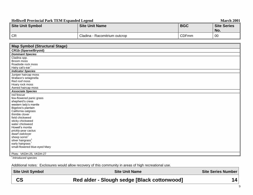
Site Unit Symbol Site Unit Name Site Series Number
CR Cladina - Racomitrium outcrop 00
SITE DESCRIPTION
This bryophyte community is sparsely interspersed (<5% total cover) within the extensive FC meadow community that dominates the south-western and eastern areas of the park, and has not been mapped as a separate unit. CR occurs on less-disturbed outcropping sandstone and conglomerate exposed bedrock patches within the FC meadow areas, and its distribution has been somehat reduced to a narrow margin along the extreme edges of outcropping cliffs where recreational trampling disturbance has not occurred. Soils are non-existent to very thin sandy veneers that are capable of supporting mat forming carpets of reindeer lichens (Cladina spp.), roadside rock moss (Racomitrium canescens) and broom moss (Dicranum scoparium). Unlike other sites where Cladina ecosystems are found, Wallace‟s selaginella (Selaginella wallacei) is rarely encountered. Further sampling is required throughout the CDF to describe the bryophyte communities in greater detail. All occurences of CR in Helliwell Park are structural stage 1b.
Helliwell Provincial Park TEM Expanded Legend March 2001
9
Site Unit Symbol Site Unit Name BGC Site Series
No.
CR Cladina - Racomitrium outcrop CDFmm 00
Map Symbol (Structural Stage) CR1b (Sparse/Bryoid) Dominant Species
Cladina spp. Broom moss Roadside rock moss Hairy cat's-ear
I
Indicator Species
Juniper haircap moss Wallace's selaginella Red roof moss Hoary rock moss Awned haircap moss
Associate Species
red fescue few-flowered panic grass shepherd‟s cress western lady‟s mantle Bigelow‟s plantain California oatgrass thimble clover field chickweed sticky chickweed water chickweed Howell‟s montia prickly-pear cactus dwarf owlclover sheep sorrel
I
silver hairgrass1
early hairgrass I
small-flowered blue-eyed Mary
Plots: VKDH-25, VKDH-27 I Introduced species
Additional notes: Exclosures would allow recovery of this community in areas of high recreational use.
Site Unit Symbol Site Unit Name Site Series Number
CS Red alder - Slough sedge [Black cottonwood] 14
Helliwell Provincial Park TEM Expanded Legend March 2001
10
SITE DESCRIPTION
This edaphic unit typically occurs in several depressional areas, with deeper, medium-textured, imperfectly to poorly drained soils. Soils are moist to wet gleysols with poor to imperfect drainage, developed in silty sandy colluvial deposits. The soils are saturated to the surface throughout the wet seasons and can remain wet with high water tables up to about 5 cm during the summer. The soil surface is usually covered with a humic enriched horizon (Ah) that contributes to the soil‟s rich nutrient status. The rooting depth is limited by cool, saturated soil at about 50cm depth. Sedges and ferns typically dominate the early stages of development as well as the herbaceous understory of later stages. The open forest (total cover 40-60%) is comprised primarily of red alder and western redcedar with some big-leaf maple and the occasional grand fir. Black cottonwood is patchy. Part of an extensive wetland complex.
Assumed Site Modifiers: d, j, m
SITE DESCRIPTION
Elevation Range (m): 8 to 15
Slope Range (%): none
Aspect (degrees): none
Surficial Material: spkCmb,p- im,p,mw
Moisture Regime: Subhygric to Hygric
Nutrient Regime: Rich to Very Rich
Red alder – Slough sedge [Black cottonwood]
Distribution of Map Units Containing CS Units
Helliwell Provincial Park TEM Expanded Legend March 2001
11
Site Unit Symbol Site Unit Name BGC Site Series No.
CS Red alder - Slough sedge [Black cottonwood] CDFmm 14
CSd deep soils CSf fine-textured soils CSm medium-textured soils
CSj gentle slope CSs shallow soils
Map Symbol (Structural Stage) CS2 (Herb) CS4 (Pole Sapling) CS5 (Young Forest) CS6 (Mature Forest) Dominant Species
slough sedge common rush creeping bentgrass
common velvet-grass I
red alder western redcedar slough sedge black cottonwood sitka spruce
slough sedge red alder black cottonwood western redcedar sitka spruce
western redcedar black cottonwood sitka spruce grand fir slough sedge slender beaked moss
Indicator Species
red alder trembling aspen black cottonwood western redcedar big-leaf maple shore pine deer fern lady fern sword fern Menzies‟ tree moss slender beaked moss sweet-scented bedstraw
grand fir Pacific crabapple bluejoint deer fern lady fern sword fern Menzies‟ tree moss slender beaked moss sweet-scented bedstraw
grand fir Pacific crabapple deer fern lady fern sword fern sweet-scented bedstraw Menzies‟ tree moss slender beaked moss
deer fern lady fern sword fern sweet-scented bedstraw Menzies‟ tree moss
Associate Species
Pacific water-parsley large leafy moss purple-leaved willowherb field mint
I
hairy cat's-ear I
common horsetail marsh violet bog St. John‟s-wort bracken fern bog haircap moss hair bentgrass
I
common speedwell self-heal wall-lettuce
I
Pacific water-parsley trailing blackberry large leafy moss red huckleberry field chickweed sheep sorrel
1
common horsetail bracken fern wall-lettuce
I
common velvet-grass I
Pacific water-parsley trailing blackberry large leafy moss common horsetail hairy honeysuckle baldhip rose bracken fern wall-lettuce
I
Pacific water-parsley trailing blackberry large leafy moss common horsetail baldhip rose wall-lettuce
I
English ivy I
hairy honeysuckle evergreen huckleberry
Plots: 9619691, 9804121 VKDH-9, 10, 9804123 VKDH-16, 98014124 VKDH-16, 9619690, 9619692 I Introduced species
Helliwell Provincial Park TEM Expanded Legend March 2001
12
Site Unit Symbol Site Unit Name Site Series Number
DA FdPl - Arbutus 02
SITE DESCRIPTION
The DA ecosystem typically occurs on upper slope to crest positions. The elevational range of this unit is from 40 metres to greater than 150m. Sampled sites included a wide range of slope gradients (0 - 30%) usually on warm south-facing aspects. Slope positions include shedding, dry, crest-like sites; the terrain consists mainly of moderately sloping (10 to 50%) bedrock. The soils are very lithic, shallow, rubbly Humo-Ferric Podzols, that are rapidly to well drained. This unit is characterized by an open forest of Douglas-fir and arbutus with the occasional shore pine and Garry oak scattered throughout the canopy. Total canopy closure in older forest stands is 50-70%. Early successional stages are often dominated by shrubs. Shore pine and arbutus form dense stands following disturbance such as fire, which has occurred near St. John‟s Point. Older forest stands provide evidence of the past fire history of this community type.
Assumed Site Modifiers: h, j, sw
SITE DESCRIPTION
Elevation Range (m): 40 to 140
Slope Range (%): level to >30
Aspect (degrees): all aspects, level
Surficial Material: hRhx-w, hRmjx-w
Moisture Regime: Xeric to Submesic
Nutrient Regime: Poor to Medium
Douglas fir - shore pine – Arbutus, Structural Stage 7
Distribution of Map Units Containing DA Units
Helliwell Provincial Park TEM Expanded Legend March 2001
13
Site Unit Symbol Site Unit Name BGC Site Series
No.
DA FdPl - Arbutus CDFmm 02
DAf fine-textured soils DAh hummocky
DAj gentle to moderate slope DAm medium-textured soils
DAr ridge or ridge crest DAsw shallow soils, warm aspect
Additional notes: This plant community occupies an extensive area of the park.
Helliwell Provincial Park TEM Expanded Legend March 2001
15
Site Unit Symbol Site Unit Name Site Series Number
DO Douglas-fir - oniongrass 03
SITE DESCRIPTION
This plant community occurs across a range of upper slope to mid-slope positions with an elevational range from 20 metres to greater than 100m. Sampled sites covered a range of slope gradients (0 - 20%), with most forming on gentle rises across all aspects. Surficial expressions are primarliy include dry, rolling topography. The terrain consists mainly of moderately sloping (10 to 50%) bedrock. The soils are thin veneers of dry, well-drained sandy loam. The presence of Garry oak in this community ensures that there is an LFH layer, generally about 2 cm in depth. This unit is characterized by an open forest of Douglas-fir and arbutus, with Garry oak persisting mainly in the canopy gaps. Canopy closure varies from 50 to 70%. Shore pine is scattered throughout the canopy. Early structural stages are dominated by a variety of grasses, meadow forbs and Garry oak. Older forest stands provide evidence of the past fire history of this community type, as does a thin black layer in the Ah soil horizon.
Assumed Site Modifiers: h, j, sw
SITE DESCRIPTION
Elevation Range (m): 20 to 100
Slope Range (%): level to >20
Aspect (degrees): all aspects, level
Surficial Material: hRmjx-w
Moisture Regime: Xeric to Submesic
Nutrient Regime: Medium to Very Rich
Douglas-fir - oniongrass, Structural Stage 7
Distribution of Map Units Containing DO Units
Helliwell Provincial Park TEM Expanded Legend March 2001
16
Site Unit Symbol Site Unit Name BGC Site Series
No.
DO Fd - Oniongrass CDFmm 03
DOh hummocky DOj gentle to moderate slope
DOm medium-textured soils DOsw shallow soils, warm aspect
Map Symbol (Structural Stage) DO2 (Sparse/Bryoid) DO3 (Shrub/Herb) DO4 (Pole Sapling) DO5 (Young Forest) DO7 (Old Forest) Dominant Species
early hairgrass I
common velvet-grass I
barren fescueI
wild strawberry red fescue Cladonia sp.
arbutus Douglas-fir western ryegrass wild strawberry
arbutus Douglas-fir Garry oak western ryegrass
Garry oak Douglas-fir arbutus western ryegrass
Douglas-fir arbutus western ryegrass
Indicator Species
hoary rock moss broom moss hairy honeysuckle Douglas-fir blue wildrye electrified cat‟s tail moss field wood-rush
Garry oak shore pine Cladonia sp. oceanspray hoary rock moss broom moss curly heron's-bill moss blue wildrye hairy honeysuckle barren fescue
I
early hairgrass I
Oregon beaked moss
dull Oregon grape shore pine oceanspray broom moss curly heron's-bill moss blue wildrye Pacific sanicle hairy honeysuckle early hairgrass
Plots: VKDH-26 VKDH-33 VKDH-34 9804117 VKDH-30, 9619699, 721 I Introduced species
Additional notes: This plant community occupies an extensive area of the forested park interior.
Helliwell Provincial Park TEM Expanded Legend March 2001
18
Site Unit Symbol Site Unit Name Site Series Number
DS Douglas-fir - Salal 01
SITE DESCRIPTION
Typically occurs on gently sloping, mid to upper slope position, with deep, medium-textured soils, at a wide elevational range from near shoreline slopes to over 100m on the upper hills. The surficial materials consist mainly rapidly drained, thin rubbly, sandy colluvium. Mature forests typically have a closed canopy (>60%) dominated by Douglas-fir with some western redcedar and grand fir. The understory is primarily dense salal (<2m). Dense salal also dominates early successional stages in association with swordfern, baldhip rose and Oregon-grape.
Assumed Site Modifiers: c, h,s
SITE DESCRIPTION
Elevation Range (m): 3 to 105
Slope Range (%): level to 48
Aspect (degrees): all aspects
Surficial Material: spkCpmb-mw
Moisture Regime: Mesic to Submesic
Nutrient Regime: Poor to Medium
Douglas fir – salal, Structural stage 5
Distribution of Map Units Containing DS Units
Helliwell Provincial Park TEM Expanded Legend March 2001
19
Site Unit Symbol Site Unit Name BGC Site Series No.
Helliwell Provincial Park TEM Expanded Legend March 2001
20
Site Unit Symbol Site Unit Name Site Series Number
FC Fescue - Camas 00
SITE DESCRIPTION
This herbaceous community is found along the level to gently sloping cliff tops, with very shallow, medium textured soils and warm aspects. FC units are typically mapped as Coastal Bluffs (CB) and Terrestrial Herbaceous (HT) Sensitive Ecosystem Inventory (SEI) sites. These units are often exposed to strong seasonal winds and occasional sea spray. The soils are often „blackish‟ in colour. Their texture is sandy loam and they rest on rolling conglomerate bedrock, which frequently outcrops to the surface. As such, the soils are very thin and droughty, with a rich nutrient regime derived from the cycling of annual grasses. This herbaceous meadow community is often dominated by introduced and native species such as common velvet-grass, red fescue, California oatgrass and meadow death-camus. Several Cladina species are also found in this community and when dominant, form small patches of the bryophyte community CR (see CR).
Assumed Site Modifiers: j, m, v
SITE DESCRIPTION
Elevation Range (m): 50 to 140
Slope Range (%): level to <30
Aspect (degrees): all aspects
Surficial Material: hRhx-w, Rks(cg)
Moisture Regime: Xeric to Submesic
Nutrient Regime: Rich to Very rich
Fescue – Camas – Structural Stage 2
Distribution of Map Units Containing FC Units
Helliwell Provincial Park TEM Expanded Legend March 2001
21
Site Unit Symbol Site Unit Name BGC Site Series No.
FC Fescue - Camas CDFmm 00
FCf fine-textured soils FCm medium-textured soils FCr ridge or ridge crest FCj gentle slopes FCv very shallow soils
Map Symbol (Structural Stage) FC2 (Herb)
Dominant Species
Cladina sp. red fescue California oatgrass bracken
Indicator Species
meadow death-camas common camas dark-throat shooting star Hooker‟s onion common sorrel English plantain
1
silver hairgrgass1
early hairgrassI
hairy cat's-earI
yarrow early hairgrass
1
rattail fescueI
Associate Species
blue wildrye Wallace's selaginella common camas small blue-eyed Mary ladies-tresses sea-blush sweet vernalgrass
western lady‟s mantle Menzies larkspur common monkey flower gumweed dandelion purple everlasting cudweed dwarf owlclover fine-leaf spring gold slender plantain few-flowered clover
field wood-rush fileree dove-foot geranium
1
least hop clover thimble clover lance clover common vetch windmill campion prickly- pear cactus
Plots: VKDH-1, VKDH-2, VKDH-18, VKDH-21, VKDH-24, VKDH-25, VKDH-33, 9619689, 9619698, 9804120, 9804122 I Introduced species
Additional notes: This unit usually has deeper soil pockets and a higher percentage of herbaceous cover than the CR unit. Exclosures would allow recovery of this community in areas of high recreational use.
Helliwell Provincial Park TEM Expanded Legend March 2001
22
Site Unit Symbol Site Unit Name Site Series Number
LM Dunegrass – Beach pea 00
SITE DESCRIPTION
This beach community occupies a narrow strip of land just above mean high water behind the strand. Typically this area is less active, and debris that has been tossed ashore accumulates and provides stability that allows the colonising species in this community to become established. These units are often exposed to strong seasonal winds, sea spray, and inundation during major storm events. The soils are azonal sands and gravels that are rapidly draining and very droughty, with a nutrient regime derived from the cycling of annual grasses and nitrogen input from the beach pea. This community is generally dominated by species such as dunegrass, beach pea, and gumweed.
Assumed Site Modifiers: j, m, v
SITE DESCRIPTION
Elevation Range (m): 2 to 5
Slope Range (%): level to <30
Aspect (degrees): all aspects
Surficial Material: hRhx-w, Rks (cg)
Moisture Regime: Xeric to Submesic
Nutrient Regime: Very poor to poor
Dunegrass – Beach pea
Distribution of Map Units Containing LM Units
Helliwell Provincial Park TEM Expanded Legend March 2001
23
Site Unit Symbol Site Unit Name BGC Site Series No.
LM Dunegrass – Beach pea CDFmm 00
LMc coarse-textured soils LMj gentle slopes LMm medium –textured soils LMv very shallow soils
Map Symbol (Structural Stage) LM Dominant Species
dunegrass beach pea Nootka rose Scouler‟s willow
Indicator Species
hairy cat's-earI
gumweed
Associate Species
yarrow shore pine bull thistle Canada thistle
Plots: VKDH-22, VKDH-35 I Introduced species
Additional notes: This plant community is represented by early successional (pioneer seral) stages at Helliwell Park. Disturbance regimes such as major storm events and summer moisture deficits may restrict its progression to later seral and forested structural stages.
Helliwell Provincial Park TEM Expanded Legend March 2001
24
Site Unit Symbol Site Unit Name Site Series Number
OR Oceanspray - Rose 00
SITE DESCRIPTION
Typically occurs on very steep cliff slopes (>35%), over shallow medium textured soils. Ephemeral seepages from higher elevations provide moisture during the winter months. Usually found in draws between two outcrop units. Advances to shrub stages when located near the toe of cliffs. Most commonly found on the south shore overlooking Tribune Bay. This dense shrub community typically includes Nootka rose, oceanspray, saskatoon, bitter cherry, and Scouler‟s willow.
Assumed Site Modifiers: m, s, w
SITE DESCRIPTION
Elevation Range (m): 2 to 50
Slope Range (%): >100
Aspect (degrees): all aspects
Surficial Material: Rs(cg), Rks(cg), Rm(cg)
Moisture Regime: Mesic to Subhygric
Nutrient Regime: Poor to Medium
Oceanspray – Rose Community, to right of image
Distribution of Map Units Containing OR Units
Helliwell Provincial Park TEM Expanded Legend March 2001
25
Site Unit Symbol Site Unit Name BGC Site Series No.
Additional notes: This community type occurs primarily in gullies or sloping seepage channels below cliff tops, where increased moisture availability supports dense shrub cover. Several shrub species tend to dominate the various sites. Tree species are wind pruned and form krummholz shapes.
Helliwell Provincial Park TEM Expanded Legend March 2001
26
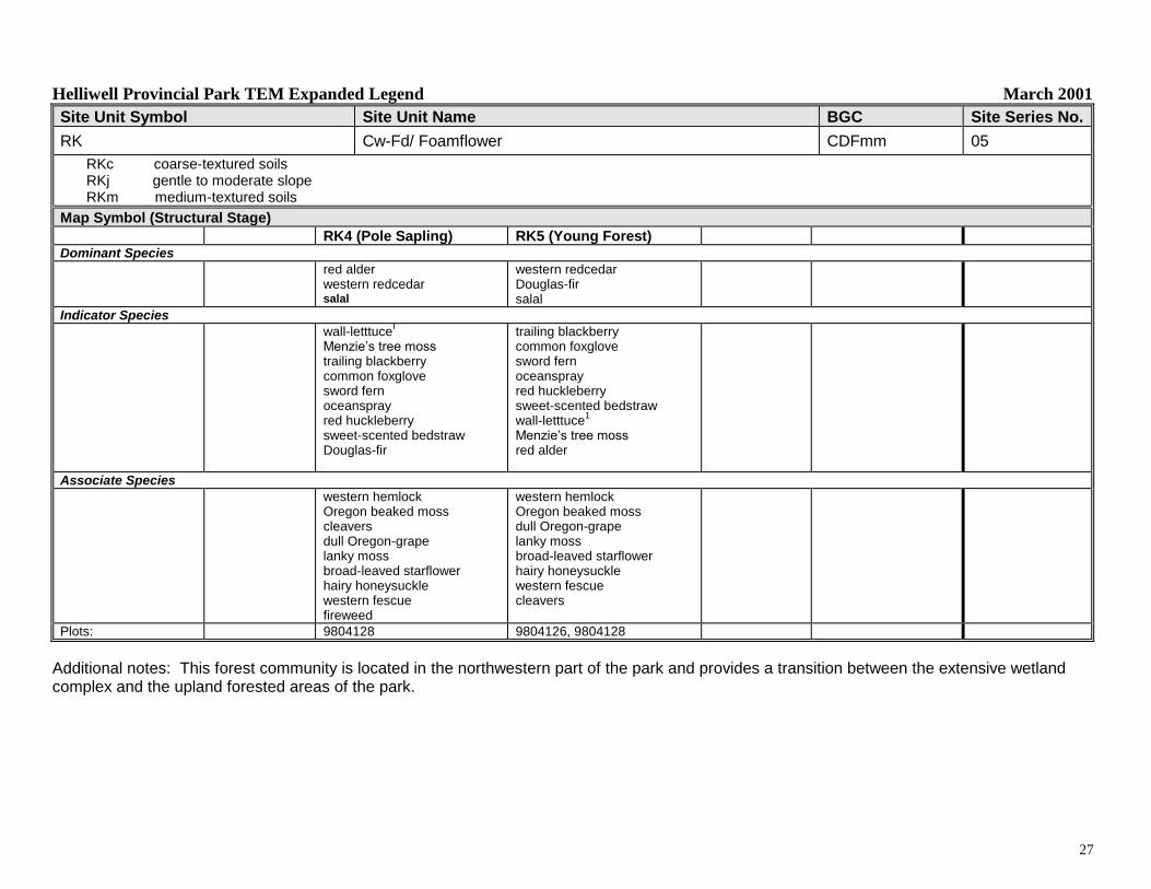
Site Unit Symbol Site Unit Name Site Series Number
RK Western redcedar-Douglas-fir/Oregon beaked moss 05
SITE DESCRIPTION
Typically occurs on gentle, lower slope, receiving positions, with deep medium-textured soils, mainly at lower elevations. The terrain consists of deep, colluvial deposits. The sandy loam soils are rich and have moderately well to imperfect drainage. Western redcedar commonly dominates this closed forest canopy, along with some grand fir, Douglas-fir and big-leaf maple. The lush understory is comprised primarily of swordfern. Early stages are typically dominated by herbs with more red alder present as the forest begins to develop.
Assumed Site Modifiers: j,m
SITE DESCRIPTION
Elevation Range (m): 6 to 43
Slope Range (%): level to 48
Aspect (degrees): all aspects
Surficial Material: spkCmb-im
Moisture Regime: Subhygric
Nutrient Regime: Rich to Very rich
Western redcedar–Douglas-fir – Oregon beaked moss
Distribution of Map Units Containing RK Units
Helliwell Provincial Park TEM Expanded Legend March 2001
27
Site Unit Symbol Site Unit Name BGC Site Series No.
Map Symbol (Structural Stage) RK4 (Pole Sapling) RK5 (Young Forest)
Dominant Species
red alder western redcedar salal
western redcedar Douglas-fir salal
Indicator Species
wall-letttuceI
Menzie‟s tree moss trailing blackberry common foxglove sword fern oceanspray red huckleberry sweet-scented bedstraw Douglas-fir
trailing blackberry common foxglove sword fern oceanspray red huckleberry sweet-scented bedstraw wall-letttuce
1
Menzie‟s tree moss red alder
Associate Species
western hemlock Oregon beaked moss cleavers dull Oregon-grape lanky moss broad-leaved starflower hairy honeysuckle western fescue fireweed
western hemlock Oregon beaked moss dull Oregon-grape lanky moss broad-leaved starflower hairy honeysuckle western fescue cleavers
Plots: 9804128 9804126, 9804128
Additional notes: This forest community is located in the northwestern part of the park and provides a transition between the extensive wetland complex and the upland forested areas of the park.
Helliwell Provincial Park TEM Expanded Legend March 2001
28
Site Unit Symbol Site Unit Name Site Series Number
RO Rock outcrop N/A
SITE DESCRIPTION
Typically consists of outcropping bedrock with gentle to steep slopes, little soil development and sparse vegetative cover. Very steep and overhanging slopes are classified as CL. The RO unit is found along the shoreline near sea level where rocks are washed by waves; just above this, rocks are subjected to sea spray. Flora Islet and several drying rocks located off St. John‟s Point are all classified as RO. Because of the exposure of these sites to harsh environmental conditions, terrestrial vegetation rarely survives within the sea spray zone. This unit is extremely droughty in summer and exposed to wind and rain during winter. The bedrock is either Gabriola Formation conglomerate (cg) or Gabriola Formation sandstone (ss). Weathering is an ongoing process and is the source of recent sediment for colluvial accumulations at the shoreline base of these slopes. Important marine mammal and shorebird habitat.
SITE DESCRIPTION
Elevation Range (m): 0 to 75
Slope Range (%): 0-30
Aspect (degrees): all aspects
Surficial Material: Rm (cg), Rm (ss)
Moisture Regime: N/A
Nutrient Regime: N/A
Rock outcrop on Flora Islet
Distribution of Map Units Containing RO Units
Helliwell Provincial Park TEM Expanded Legend March 2001
29
Site Unit Symbol Site Unit Name Site Series Number
RP Road Surface N/A
SITE DESCRIPTION
An area cleared and compacted for the purpose of transporting goods and services by vehicles. Also used to describe sites with hardened trail surfaces.
SITE DESCRIPTION
Elevation Range (m): 0 to 17
Slope Range (%): level to 15
Aspect (degrees): N/A
Surficial Material: N/A
Moisture Regime: N/A
Nutrient Regime: N/A
Parking Lot at Park Entrance
Distribution of Map Units Containing RP Units
Helliwell Provincial Park TEM Expanded Legend March 2001
30
Site Unit Symbol Site Unit Name Site Series Number
VP Vernal Pool N/A
SITE DESCRIPTION
Only one vernal pool was mapped within Helliwell Park, on Flora Islet. It has been disturbed in the past when the island supported several dwellings. The pool is located just west of the lighthouse in a shallow depressional area with imperfect drainage, and is currently being used during the wet seasons by otters. Vernal pools are ephemeral and fill with fresh water during the autumn rains. They remain inundated until the end of spring. During the summer moisture deficit period, waters evaporate from vernal pools and leave behind a shallow muddy depression. Vernal pools are critical breeding habitat for aquatic salamanders, frogs and toads; there is currently no evidence of these amphibians on Flora Islet.