FINAL REPORT for APN PROJECT Project Reference Number: ARCP2011-20NSY-McEvoy The following collaborators worked on this project: Project leader: Darryn McEvoy, RMIT University, Australia Iftekhar Ahmed & Alexei Trundle, RMIT University, Australia Le Thanh Sang, Nguyen Ngoc Diem, Lam Thi Thu Suu & Tran Ba Quoc, Huế case study, Vietnam Fuad Mallick, Rezaur Rahman, Aminur Rahman & Nandan Mukherjee, Satkhira case study, Bangladesh “Assessment of Climate Change Risks and Adaptation Options for Secondary Cities in Southwestern Bangladesh and Central VietNam”
Transcript
FINAL REPORT for APN PROJECT
Project Reference Number: ARCP2011-20NSY-McEvoy
The following collaborators worked on this project:
Project leader: Darryn McEvoy, RMIT University, Australia
Iftekhar Ahmed & Alexei Trundle, RMIT University, Australia
Le Thanh Sang, Nguyen Ngoc Diem, Lam Thi Thu Suu & Tran Ba Quoc, Huế case study, Vietnam
Analysis of climate change impacts has typically targeted rural areas in Asia to date, and when attention has focused on the urban environment it has been primarily in the context of the larger mega-cities. However, issues affecting rapidly urbanising secondary cities in Asia (which face a specific set of challenges vis-à-vis climate change, in combination with development dynamics) are less well researched and understood. Capacity to respond is also arguably lower in these regional cities, as evidenced by a lesser concentration of investment, resources, institutions and skills.
In response to this knowledge deficit, this project set out to develop a participatory toolkit that would enable local communities to assess the climate risks facing their cities in south-western
Bangladesh (Satkhira) and central Vietnam (Huế). Both regions already experience annual cycles of flooding and urban water-logging, with periodic extreme flood events, and these are projected to increase in frequency and intensity under a changing climate. The regions are also exposed to coastal cyclonic storms, as well as slower-onset events such as sea level rise and salinity intrusion.
The toolkit, comprising a portfolio of participatory assessment approaches, was tested in the respective local communities to ensure it was fit for purpose; with the intention of providing a platform for informing context-specific adaptation options.
Objectives
The main objectives of the project were:
1. Based on the latest international knowledge, to develop a climate risk assessment toolkit appropriate for use by local stakeholders in secondary cities in Bangladesh and Vietnam;
2. To pilot, and then refine with local teams, the toolkit in the two case study cities (Satkhira and Huế) to ensure that it was fit for local purpose;
3. To host joint workshops in each of the countries to reflect on lessons learnt, to compare findings (including the promotion of south-south exchange and learning), and to contribute to the strengthening of local adaptive capacity;
4. To distil key learnings to inform the refinement of an assessment toolkit that can be effectively applied in other Asia-Pacific secondary cities by policy-makers, practitioners and other key local stakeholders.
Amount received and number years supported The Grant awarded to this project was: US $43,000 for one year (2011/12).
Activity undertaken
In the first instance, project planning meetings were held. This initiation process involved the structuring of intended activities and the consolidation of the research teams from the three countries (Australia, Bangladesh and Vietnam).
Drawing from an international review of the latest scientific knowledge, a context specific risk assessment toolkit - refined from existing generic tools – was developed for application in the selected secondary cities (Satkhira, Bangladesh and Huế, Vietnam).
Comprising a portfolio of different assessment approaches (set out to address multiple urban scales and to encourage the involvement of different actors); the assessment toolkit was then piloted in each city of the two countries by the local teams. These arrangements were deliberately set up to involve both academics and NGOs, and to have active engagement with local communities and policymakers.
AR
CP
20
11
-20
NSY
-McE
voy-
FIN
AL
REP
OR
T
After conducting the ground survey activity, results were then analysed and incorporated into an interim report for each case study. These findings were then presented, discussed, and compared at a project workshop held in Huế, Vietnam, in April 2012. This event was attended by a broad spectrum of local stakeholders, including city and provincial policymakers; as well as representatives from all three project groups. Formal presentations were complemented by interactive group exercises to elicit the input of additional local knowledge and to actively facilitate regional cross-learning [this engagement process allowed achievements as well as barriers to be highlighted].
An end of project workshop was held in Satkhira, Bangladesh, in September 2012 to reflect on the achievements of the overall project, to discuss possible improvements to the risk assessment toolkit, and to consider the final report and guidelines which could effectively inform local adaptation options. Remaining gaps and potential avenues for future research also formed part of the discussions.
A final report for APN, ‘Assessment of climate change risks and adaptation options for secondary cities in south-western Bangladesh and central Vietnam’, was produced.
Results A toolkit specifically designed for use by local communities in rapidly growing cities was developed and tested in the two case studies. With constructive feedback about possible improvements, the participatory toolkit was well received by stakeholders, as it not only contributed to knowledge and capacity building about climate risks but also provided them the opportunity to input to the risk assessment process.
Relevance to the APN Goals, Science Agenda and to Policy Processes
APN goals were addressed by promoting regional cooperation between APN member countries facing a complex global environmental change issue - climate change - with regional implications for research, knowledge-sharing, collaboration and capacity building. New ways of working between scientific, policy and wider stakeholder communities were actively encouraged, as well as the development of local research capacity through engagement in multi-country and multi-disciplinary research processes.
The activity related to the APN Science Agenda through the furthering of solutions-orientated activity for better understanding of the physical and human dimensions of climate change, and how this can best contribute to informing adaptive policy and practice. The nexus of climate change adaptation / disaster risk reduction / sustainable development was also explicitly considered.
The APN institutional agenda was reflected in the inclusion of local partner institutions that have significant experience in global environmental change research and were willing to extend in-kind support to the project. Project findings are also to be disseminated through country-based networks in the local language(s) to best effect change on the ground, and will also be circulated through international channels such as the APN newsletter, AdaptNet and the Asia Pacific Adaptation Network.
Self evaluation The application of the toolkit in field settings uncovered some of the limitations of the toolkit e.g. even though it was deliberately designed to be used in the field by local communities some of the tools were still too complex to understand and apply. As a result some improvisation was needed. How best to communicate different ‘climate futures’ is one challenging question the research team have taken away from this research activity. Feedback from the fieldwork was taken on board as lessons to be learnt and to be considered in any updated version of the toolkit.
AR
CP
20
11
-20
NSY
-McE
voy-
FIN
AL
REP
OR
T
Stakeholder participation was central to the success of the project. However, experience from the case studies indicates that more time and effort is needed to contextualize the study area and to encourage even more widespread engagement. That said, the positive engagement and exchange between countries, cities, and the different actors involved in the assessment activity, was a major highlight of the year’s activity. It is hoped that long-lasting working networks will be maintained beyond this discrete project.
Potential for further work Several opportunities for follow-up research activity were identified through the APN-funded project. These either relate to a replication of a refined climate risk assessment toolkit with other neighbourhoods in rapidly growing cities (learning lessons from this preliminary study, and improving some of the processes and tools) leading to a linked network of interested secondary cities, or alternatively to focus further on some of the key issues that were identified in the two case studies. Examples of possible further work include:
Stakeholder and policy mapping exercises to better understand the multi-level institutional context for each of the case studies, and to determine the institutional barriers and opportunities (political and social limits) for adaptation responses (including the differing risk perceptions of stakeholders).
To develop alternative methods for communicating ‘climate futures’ in ways that connect with local community narratives in a more meaningful way.
To investigate in more depth, potential adaptation options for key issues that were identified by the assessment process (e.g. drainage, migration, the use of micro-credit etc). These could be used as case studies to inform the development of an adaptation manual.
Roll out the refined toolkit to other secondary cities and to evaluate effective mechanisms for enhancing adaptive capacity in local communities. The role of social networks could form part of this analysis.
To investigate risks and adaptation by the business sector, and how to promote effective public / NGO / private engagement in urban adaptation planning.
Publications
As this one year project has only recently been completed, both articles arising from the project (one conference paper and one peer reviewed journal paper) are still in progress. Both are intended for submission in 2012. The conference paper will also serve as the foundation for another journal paper submission in 2013.
1. Assessment of climate change risks, and adaptation options, for secondary cities in Southwestern Bangladesh and Central Vietnam Conference on Science and Technology: “Natural Resources and Environment towards Sustainable Development”, HCMC, Vietnam, 14th December 2012.
2. Participatory assessment of climate risks in secondary cities in Asia (in progress). Intended journal: Climate and Development
AR
CP
20
11
-20
NSY
-McE
voy-
FIN
AL
REP
OR
T
Acknowledgments This was a challenging project to be completed in a one year time frame and the collaborative inputs, assistance, and participation of all organisations and individuals involved with the project are fully acknowledged. The research team comprised members of the following organisations:
Bangladesh University of Engineering and Technology;
Southern Institute for Sustainable Development (SISD), Vietnam; and
Center for Social Research and Development (CSRD), Vietnam. The authors also wish to thank the many community members and leaders of Satkhira and Huế, whose input has been invaluable, and without whom this project would not have been possible. Particular thanks go to the resource personnel who co-ordinated workshops and community exercises in both cities. Special mention goes to the Satkhira Municipality Authority, including the Mayor and councillors. Additional thanks to Ms. Amina Bilkish and Mr Sharifullah Kaiser Sumon for their support in arranging the city level and community level workshops in Satkhira. Contact details: RMIT University
Darryn McEvoy, Professor and leader of the Climate Change Adaptation Program [email protected]
Preface The potential impacts of climate change on fast-growing secondary cities (and potential adaptation options) are under-researched in the Asian context. This document reports on the research carried out to develop and test a participatory risk assessment toolkit for the regional cities of Satkhira (Bangladesh) and Huế (Vietnam). Both urban centres are subject to a combination of drivers including rapid urban development and existing vulnerability to climate-related impacts, notably floods and storms. Both the assessment process and outcomes from each of the case studies are discussed.
Table of Contents 1.0 Introduction ………………………………………………………………………………………………………….. 9
1.1 Case Study Context: Satkhira, Bangladesh ………………………………………………. 9
1.2 Case Study Context: Huế, Vietnam ………………………………………………………….. 12
Bangladesh and Vietnam have been identified as countries that are amongst the most seriously threatened by the impacts of a changing climate. Flooding, water logging, and storms are of immediate primary concern, though other medium to longer term issues such as sea level rise and increasing salinity intrusion (impacting access to potable water) also needing to be explicitly planned for. At the same time, rapid urbanisation of secondary cities is taking place, adding further complexity to the goal of sustainable urban development under a changing climate.
Whilst many different agencies and organisations have developed their own assessment toolkits (see for example: ICLEI Oceania, 2008; UNDP, 2010) very few of these have been developed, or adapted, extensively for a participatory assessment of urban climate risks with a view towards developing adaptation options, particularly in the context of rapidly developing secondary cities in Asia.
As such, the development - and testing - of the risk assessment toolkit (as applied in the case study cities) was central to the project. A core early objective was therefore to make sense of the latest scientific knowledge, and the array of different assessment toolkits, in order to produce guidance and methodologies that were deliberately targeted to the local urban context and, importantly, were easy to use by those in the local communities; with the support of the local research teams. One notable example which should be mentioned as influencing the design of the project toolkit is the vulnerability and adaptation assessment carried out for Sorsogon City, Philippines (UN-Habitat, 2008; 2011).
In its final format (as delivered to the local teams), the project toolkit assembled a set of different tools, including guidance on the application of different assessment methodologies. It was underpinned by two discrete, though connected, assessment stages: firstly, context setting and local assessments; and secondly, future risk analysis and evaluation. These stages were embedded in a broader support framework that was devised to provide the necessary guidance for those carrying out the local assessment activity (see accompanying appendix for toolkit details). Introductory components of this were an initial explanation of the complexities involved when considering climate risks, a clarification of terminology and concepts to enhance common understandings between the two country teams, and an overview of the risk assessment process to be carried out.
The operational stages of the risk assessment toolkit were:
1. Pre-assessment (collecting secondary data, local introductions and briefings, finalising the key local stakeholders to be involved);
2. Local assessment (city-level risk analysis, community-level risk analysis);
3. Consolidation (compilation of findings into a draft report, with subsequent validation at stakeholder workshops);
4. Future climate change scenarios (integration of top-down expert approach with bottom-up vulnerability assessments for the case studies).
Early activity carried out by the country teams therefore involved setting the context for the two secondary cities under investigation through an analysis of secondary data. These details are briefly summarised in the case study sub-sections below.
1.1 Case study context: Satkhira, Bangladesh
Satkhira is a municipal town situated in the South West of Bangladesh. It is part of Satkhira District (Khulna division), which is bounded by Jessore district to the North, Khulna district to the East, Pargana district of West Bengal to the West, and in the South, the Bay of Bengal.
Satkhira Town consists of 9 wards and 31 mahallas (neighbourhood sub-divisions). The wards surveyed for the project cover an area of approximately 990 acres, with an average of 2,160 households and a total population of just over 95,000. The average population density for Satkhira Town is 3,282 people per km2.
AR
CP
20
11
-20
NSY
-McE
voy-
FIN
AL
REP
OR
T
Analysis indicates that around 51% of the population is involved with some form of livelihood activity; with one-third of Satkhira’s population not working. Average literacy is estimated at 63%, with males showing greater rates of literacy than female counterparts (67 – 57%). As is common throughout Bangladesh, most households use tubewells as their main source of water [Ward 4 being the exception, using tap water more].
Biophysical setting
Satkhira region is part of the High Ganges River Floodplain. Most areas have a complex relief of broad and narrow ridges and inter-ridge depressions. Whilst the upper parts of the high ridges stand above normal flood levels it is important to note that the lower parts, and the basin margins, are commonly shallow flooded on a seasonal basis. Under the Water Resources Planning Organisation (2005) categorisation, the area of Satkhira Sadar falls under the Shrimp (brackish water) zone. Cultivation of ‘bagda’ shrimp is becoming increasingly more intensive in suitable saline areas, either as the primary product or in conjunction with white fish and / or rotation with paddy fields. Fish processing centres and hatcheries are increasing in number (as evidenced by a site visit by the project team in September 2012).
There are many rivers that influence the surface water regime in Satkhira municipality, Ichamati and Kabodak being two of the most important (though they skirt the town itself). Satkhira Khal (or Pran Shayer Khal), which flows north to south through the centre of the municipality, plays a vital role in storm water drainage for local communities.
Climate profile
The climatic profile of the case study area is strongly influenced by its location – bordered by the Bay of Bengal in the south and the large tract of Gangetic land to the North and West (fertile plains fed by the Ganges River). These are sources of moisture and heat respectively. Unlike other areas in Bangladesh, this area is also located in the tropical monsoon region and as such its climate is characterised by high temperature, heavy rainfall, often excessive humidity, and fairly marked seasonal variations.
The most striking feature of the climate relates to the reversal of the wind circulation between summer and winter, with the hot, dry air emanating from the plains to feed the pre-monsoon hot period then displaced by moist southerly winds at the onset of the summer monsoon season. This reversal is an integral part of the circulation system of the South Asian subcontinent. Three distinct climatic seasons can be described: cool and dry (December to February), the pre-monsoon hot period (March to May), and the rainy monsoon (June to September). October to November is considered the autumn season.
The dominant climate variable for Satkhira is rainfall. The region is subject to pronounced seasonal patterns – the winter season (DJF) is very dry and accounts for only 2-3% of the total annual rainfall; the pre-monsoon hot season (MAM) sees around 15% caused by convective thunderstorms or nor’westers (called Kalbaishakhi locally); whilst three quarters of all annual rainfall occurs during the rainy season. During this period rainfall can vary between 452mm and 1733mm, with July typically the month of highest rainfall.
AR
CP
20
11
-20
NSY
-McE
voy-
FIN
AL
REP
OR
T
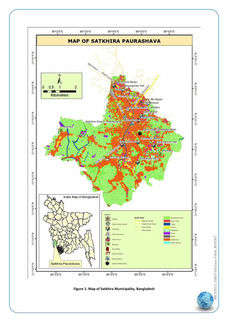
Figure 1: Map of Satkhira Municipality, Bangladesh
AR
CP
20
11
-20
NSY
-McE
voy-
FIN
AL
REP
OR
T
1.2 Case study context: Huế, Vietnam
Situated in central Vietnam, Huế is the largest city in Thua Thien Huế Province. It has considerable historic importance, having once been the national capital and is well known for the many monuments that remain from the times of the emperor e.g. Thanh Noi (the Imperial City). Its location is strategically important as it not only links northern and southern regions of the country (National Road 1 and the Trans-Asia Railway being two key transportation routes) but it is also defined as a key economic region as part of the East West economic corridor (Vietnam – Laos – Thailand – Myanmar).
The city of Huế has a population of 338,000 located in an area of 71km2. The population density, 4,763 per km2, is relatively high when compared to other provincial cities in Vietnam. Currently, there are 27 administrative divisions, including 27 urban wards. It is estimated that average GDP is approximately $1,500 USD/person/year, with 4.3% of the population living under the poverty line. Rapid urbanisation is evidenced by a rate of urban growth of 100% and an annual increase in population of 0.98%.
Figure 2: Map of Huế city, Vietnam
Biophysical setting
Huế is characterised by a tapestry of many different landscape types; including hills and mountains, areas of flat land, lakes and rivers. The average height of land is 3-4m above sea level, however some areas of the city are at minus 1m (source: Peoples Committee of Thua Thien-Huế Province). The hydrological system is also diverse evidenced by a high density of rivers, natural and artificial lakes, canals, ponds and sewers.
AR
CP
20
11
-20
NSY
-McE
voy-
FIN
AL
REP
OR
T
Climate profile
As with Satkhira, this area is also subject to tropical monsoon conditions though in this case characterised by two distinct seasons: hot-dry sunny season (May to September) and a cold-humid rainy season (October to March). The hottest time is around May and June when the temperature can reach 38 – 40°C. The cold season sees temperatures drop to an average of 20 – 22°C, with a humidity of around 85%.
Rainfall is also an important climate variable for Huế. The annual rainfall rate is 2,500mm, the majority of this falling between September and February. The peak month for rainfall is November which typically accounts for 30% of the yearly total. Resultant floods (1977-2010) have averaged 3.5/year, with 36% of these rated as serious or extremely serious. Experience indicates that the period of flood time can last from 5 days up to a week. It should be noted that there is strong correlation of droughts and floods with El Niño and La Niña patterns [droughts – El Niño-influenced years (e.g. 2003 and 2004), floods – La Nina (2009 and 2010)].
Typhoons and windstorms were also identified as important climate-related hazards for the region, usually occurring between August and October during the transitional period between the hot and cold seasons (influenced by the Southwest and Northeast monsoons).
Figure 3: Urban and Peri-urban landscapes in Huế (left) and Satkhira (right)
AR
CP
20
11
-20
NSY
-McE
voy-
FIN
AL
REP
OR
T
2.0 Methodology
As noted in the introduction, the methodology for the project activity was framed by the stages of the toolkit. A schematic representation of the local assessment process is shown in Figure 4.
1) PRE-ASSESSMENT
STAGECollecting secondary
information
Local introductions
and briefings
Selecting key local
stakeholders
2) ASSESSMENT
STAGE
Key informant interviews
Transects
Hazard mapping
Hazard ranking
City level risk
analysis
Community level
participatory risk
analysis
Hazard mapping
Hazard ranking
Transect walk
Long term trend
analysis
3) CONSOLIDATION
STAGECompilation of
findings/draft report
Validation at
stakeholders meeting
Key informant interviews
Scenarios analysis
Figure 4: Local assessment methodological framework
2.1 Pre-assessment
The pre-assessment stage was devised to set the local context for each case study and to promote preliminary engagement with key stakeholders before the risk assessment exercises were carried out. This involved three main activities: collecting secondary information (findings as summarised in the previous sub-section), local introductions and briefings, and the selection of key local stakeholders.
Local introductions and briefings / selection of local stakeholders Tool 1: Identifying key local stakeholders Tool 2: Matrix for stakeholder analysis This initial activity, supported by the first and second of the assessment ‘tools’, was intended to identify those agencies that had strong links to the communities and could play a key role in the assessment process, to engage with them at an early stage so that they understood the goals of the research, and ultimately to get their support for, and involvement in, the risk assessment process.
AR
CP
20
11
-20
NSY
-McE
voy-
FIN
AL
REP
OR
T
Framing questions included: Who should be included because of their relevant formal position? Who should be included because of their knowledge and experience? Who should be included because they have control over resources? Who has the power to promote, hinder or block the assessment process? Satkhira: Potential stakeholders were initially identified by the local team using tool 1. This involved a visit to the municipality and a series of meetings with different local actors. Key contacts were then invited to a half-day workshop which was used to introduce and elaborate on the risk assessment process and to finalise stakeholder participation (tool 2 – stakeholder analysis):
A list of potential NGOs were identified as being potential collaborators on the project (BRAC, Shushilan, Uttaran, Agragati, World Vision, LEDARS and Red Crescent). LEDARS agreed to provide the human resource to support the risk assessment process.
Many different groups from each of the nine wards – business people, agriculturalists, fishermen, teachers, health workers, labourers, transportation workers – agreed to participate.
Although the Municipality Authority has a key role to play in urban development and management, at this initial workshop representatives from other government agencies were absent.
Figure 5: Initial engagement with local stakeholders in Satkhira
Huế
As one of the project partners is an NGO based in the city of Huế, the process of identifying key stakeholders was done through their existing networks. These local networks were also used for introductions to other key stakeholders that were identified through a ‘snowball’ process. Following initial screening 26 organisations were invited to participate in a ‘kick-off’ meeting; with 20 people from 16 agencies attending the event on the day.
Recognising the time constraints faced by many of the local actors, and the need to make the most effective use of everyone’s time, this initial meeting was also used to trial the tools prepared for the city-level risk analysis (tools 3-7, see next section 2.2). Organisations were grouped according to being Government, NGO or affiliated to a research group. It is important to note that although engagement with business was recognised as highly desirable, the private sector was not represented at this initial meeting [this lack of engagement was considered a disappointing feature of the process in this case study].
AR
CP
20
11
-20
NSY
-McE
voy-
FIN
AL
REP
OR
T
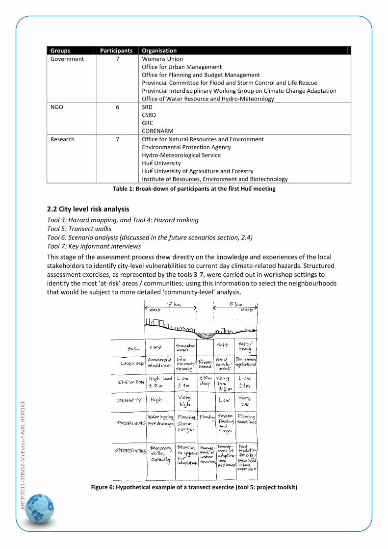
Groups Participants Organisation
Government 7 Womens Union Office for Urban Management Office for Planning and Budget Management Provincial Committee for Flood and Storm Control and Life Rescue Provincial Interdisciplinary Working Group on Climate Change Adaptation Office of Water Resource and Hydro-Meteorology
NGO 6 SRD CSRD GRC CORENARM
Research 7 Office for Natural Resources and Environment Environmental Protection Agency Hydro-Meteorological Service Huế University Huế University of Agriculture and Forestry Institute of Resources, Environment and Biotechnology
Table 1: Break-down of participants at the first Huế meeting
2.2 City level risk analysis
Tool 3: Hazard mapping, and Tool 4: Hazard ranking Tool 5: Transect walks Tool 6: Scenario analysis (discussed in the future scenarios section, 2.4) Tool 7: Key informant interviews
This stage of the assessment process drew directly on the knowledge and experiences of the local stakeholders to identify city-level vulnerabilities to current day climate-related hazards. Structured assessment exercises, as represented by the tools 3-7, were carried out in workshop settings to identify the most ‘at-risk’ areas / communities; using this information to select the neighbourhoods that would be subject to more detailed ‘community-level’ analysis.
Figure 6: Hypothetical example of a transect exercise (tool 5: project toolkit)
AR
CP
20
11
-20
NSY
-McE
voy-
FIN
AL
REP
OR
T
Satkhira: For the hazard mapping and ranking activities, participants were divided into nine groups according to their home ward. Each group was tasked with spatially mapping the hazards in their locality, and were then asked to rank each hazard according to its importance / impact. As part of this evaluation, ward 9 was identified as being the most exposed to multiple hazards, as well as being considered the most vulnerable both in terms of population and productive sectors.
Figure 7: Hazard mapping at the city level, Satkhira
The hazards were prioritised by the stakeholders as:
1. Water logging – 2011 was cited as particularly devastating. All wards identified it as a hazard, with 7 out of the 9 categorising waterlogging as a high risk, making this the number one city-wide concern.
2. Monsoon flooding – was considered the second most important hazard; again a recent event (2010) was described as being devastating. 3 wards rated this as a high risk, 5 as medium, whilst one regarded it as low risk.
3. Extreme heat – this is seen as an increasing problem, though only two wards ranked it as a high risk currently.
4. Rainfall variability – this was particularly marked in 2011, and 2 wards ranked this as a high risk.
5. Drought – this is considered to be closely linked with rainfall variability (above) and was ranked of similar importance. Participants also noted the linkages between rainfall, extreme heat, and the scarcity of water resources.
6. Salinity intrusion – although 3 wards highlighted this as a hazard, only one categorised it as a high risk (discussion linked this to an increasing imbalance in the fresh and brackish water flow regimes).
Unfortunately, due to the unavailability of willing participants the transect walk could not be carried out according to the prescribed methodology. To compensate for this the research team conducted this activity using alternative approaches - remote sensing imagery and digital elevation modelling.
The key informant interviews elicited valuable feedback on recent personal experiences of extreme events. Of particular note were:
Excessive rainfall in 2011 leading to waterlogging: people recalled the waterlogging lasting for more than three months. Local schools provided shelter but had to cancel teaching commitments to do so. NGOs also provided immediate relief (food and health provisions) and helped with housing reconstruction.
Extreme river flooding in 2000: the cause of this was attributed to human causes rather than rainfall, linked to the failure of water infrastructure in a neighbouring country.
AR
CP
20
11
-20
NSY
-McE
voy-
FIN
AL
REP
OR
T
Tornado in 1987, and cyclones in 2007 and 2009: whereas Satkhira was directly impacted by the tornado, the impact from the cyclones was felt indirectly through the significant in-migration of rural people affected by the extreme events.
Salinity intrusion: interestingly, and in contrast to the hazard ranking exercise, this emerging issue was cited as presenting a ‘deep crisis’ for potable water and for agricultural lands. Excessive extraction of groundwater was seen as a significant contributing factor.
Significant hail storm in 2011: this event devastated local agricultural crops.
Huế
As with Satkhira, participants were put into groups to map and rank the hazards though in this case study groupings were arranged according to governmental organisations, NGOs and researchers (this meant that in some instances some participants had more knowledge about local areas than others leading to a longer time period for discussions to reach agreement). Overall, the main hazards were identified and ranked with consensus, with flooding ranked the number one hazard and typhoons as the second most important. However, there was some level of discrepancy between the different groups when attempting to rank those hazards considered less important (drought, cold front, landslides, sea level rise, forest fires etc).
There was agreement between the groups when identifying the most affected communities. It was recognised that the higher land in the west of the city meant it was less exposed to flooding than the lower lying areas (the wards of An Dong, Xuan Phu, Thuy Bieu, Duc and Phu Hiep; as well as areas along the Houng River bank). These areas also tend to have the poorest infrastructure, creating ‘double exposure’ through enhanced vulnerability to storms.
The transect walk involving all three groups took place over half a day, starting in a flood prone area in the west of the city then going along the Huong River, through the Imperial area, until ending up in the lowest eastern part of the city. This activity was intended to improve understanding of the risks at the city-scale through observation, mapping, analysis and discussion. Findings highlighted the heightened exposure and vulnerability of the north bank area (lower in altitude, older/poorer infrastructure, and a greater density of population).
Figure 8: Huế assessment group on the transect walk, participant demonstrating previous flood levels
As with Satkhira, the key informant interviews elicited valuable information on the experience of recent extreme events (accessing local knowledge). Eight people from different backgrounds were interviewed, with some of the key messages summarised below:
AR
CP
20
11
-20
NSY
-McE
voy-
FIN
AL
REP
OR
T
The people of Huế are well used to having to cope with, and recover from, extreme weather events; the major flood of 2009 which caused significant damage (and fatalities) being one such illustration. However, climate change is a relatively new term for many in the community.
Poor infrastructure, old housing stock, an inadequate sewerage system, were all cited as important drivers of vulnerability, whilst lack of information and inaccurate forecasting of weather events were seen as compromising local adaptive capacity.
Previous experience of extreme events was said to have helped to inform improved responses and there was a feeling that the city is now better prepared than previously. Changes to institutional arrangements include: the restructuring of the Committee for Flood and Storm Control and Life Rescue at both provincial and community levels by the Provincial Peoples Committee after the 2009 flood. As part of this process, the roles and responsibilities for dealing with disasters were clarified. An upgrade of the city’s infrastructure was also carried out, with particular attention paid to the drainage system.
Huế city government is developing strategies to adapt to climate change. This has involved setting up expert committees, implementing projects, and calling for investment for climate change adaptation. Residents are also being encouraged to be better prepared through public initiatives such as ‘Living with Flood’.
Changes to the weather and seasons have been more noticeable in recent years. Changing seasonality has been particularly problematic – a late cold snap in late 2011 and early 2012 meant that rice farmers had to re-plant their crops many times.
2.3 Community level risk analysis
Tool 8: Community profiling
Tool 9: Community hazard mapping, and Tool 10: Hazard ranking
Tool 11: Transect walk
Tool 12: Long term trend analysis
Tool 13: Key informant interviews
Based on the city-scale analysis, the purpose of this second stage of assessment was to identify a community that had high exposure and vulnerability to climate-related impacts; and to carry out a ‘bottom up’, participatory, climate risk assessment. The toolkit provided structured guidance on how best to engage with communities, to ensure that venues were suitable for open discussions, and to actively encourage the participation of diverse members of the community; including women, children, the elderly etc. Similar techniques and tools were used for this community-based assessment as stage 2 though future climate scenarios were replaced with structured discussions about previous weather-related trends and their impacts, and to consider what changes may take place in the next 10-15 years (short time frame).
A key concern at this stage was to limit community expectations arising from the project; rather emphasising local contributions to capacity building concerning local climate-related impacts.
Satkhira
The area selected for the more in-depth analysis was Ward 9. This is mostly built-up environment with dispersed agricultural land and water bodies. Population is estimated at 30,000 - 40,000. When undertaking the hazard mapping and ranking exercises, participants were grouped according to: 1) farmers and fishermen; 2) teachers, service providers and business people; and 3) women and children.
AR
CP
20
11
-20
NSY
-McE
voy-
FIN
AL
REP
OR
T
Figure 9: Examples of hazard mapping (Ward 9)
Findings from the hazard ranking exercise can be summarised as:
Water-related issues dominated all groups’ priorities and rankings. Water logging, variability of seasons, and reduced river flow, were 1st to 3rd respectively. Interestingly, drought and erratic rainfall were ranked further down the list showing a disconnection (for some) between perceptions of climate and impacts on the ground [indeed, waterlogging is a good example of the complex interaction between nature and human interventions that can lead to adverse impacts – in this case waterlogging was recognised as being exacerbated by changes to local drainage systems].
The risks posed by extreme heat were perceived differently by all three groupings, clearly indicating differing perceptions of vulnerability across different community groups. For this hazard, women and children considered this to be a high risk, whilst at the other end of the scale farmers and fishermen considered this a low risk.
Only the grouping of teachers, service providers and business people rated storms and cyclones as high risk.
Although a GIS-based analysis had been carried out by the research team, it was recognised from field visits to Satkhira that it was also important to carry out a transect walk at the local community level (see Figure 10). These community levels transects were used to complement the previous work. However, in some cases it was difficult to explain the concept of a transect walk and simpler approaches had to be employed (translating to simpler picture formats, generic lists rather than a transect breakdown etc).
Limitations in understanding were also encountered when attempting to analyse long term trends. Therefore, to complete this activity, the local research team substituted a slightly different approach – defining 1990 as a base year, which provided a ‘living memory’ benchmark for the participants, and then setting targets of 2000, 2012, 2022 for people to consider possible changes and impacts in the future. Input was encouraged through the use of simple symbols. Recent, and perceived future changes to climate-related hazards, included:
AR
CP
20
11
-20
NSY
-McE
voy-
FIN
AL
REP
OR
T
Warming has been measured from 1990 through to 2012, and temperature is anticipated to continue rising.
Variability of rainfall has become increasingly noticeable in the last decade, and this is likely to continue.
Waterlogging was not a common occurrence in the 1990s, though was first considered a problem with the major flood of 2000. The most severe event occurred in 2011, though the impact is also strongly attributed to the clogging of natural drainage channels. Without improvement in drainage, waterlogging will continue to be a problem in future years.
Drought has not been a problem to date, though may become an issue in the future.
Figure 10: Image of canal taken during the group transect walk (Ward 9) & workshop transect diagram
Huế
The area selected for further analysis was Phu Hiep Ward (with particular attention paid to Cluster 6). Before implementing the activities the research team held a half-day workshop with the participants to clarify the project objectives and the purpose of the group activities. These included local authorities, local associations, and social groups; made up of five people representing the Ward and five representing the neighbourhood Cluster 6. The local assessment was then conducted over one full day, with evaluation in a workshop setting in the morning and then the groups taking part in a transect walk in the afternoon.
Figure 11: Hazard mapping and transect diagram for Huế
AR
CP
20
11
-20
NSY
-McE
voy-
FIN
AL
REP
OR
T
Four hazards were identified and ranked as high risk by the Cluster 6 group in the hazard mapping and ranking exercises. These included flood, storms, drought and acidity (cold front being seen as a medium risk). Cluster 6 is considered especially vulnerable to flooding, being low land as well as having poor infrastructure. Representatives of Phu Hiep Ward also noted changing seasonality as an issue. Floods and storms stand out as the major climate-related hazards for both groups. Of particular concern to the participants was the impact to livelihoods e.g. farmers, though indirect impacts such as the potential for pollution events were also highlighted in the discussions. The transect walk was carried out to complement the workshop activity. The route taken was through Cluster 6, an area identified as being especially vulnerable to climate change risks. The community stakeholders produced a transect diagram that depicted land use, altitude, residency density, environmental issues, and opportunities for improvement.
The final component of the local assessment was the long term trend analysis. As some of the participants were unaware of the climate change issue this meant that it was difficult for the stakeholders to extrapolate change into the future. That said, important local issues were highlighted and discussed. These included: longer lasting floods, the adverse impact on those living off the land (many residents in the area earn their living as farmers), and the planned local policy of relocation for those living in the most at-risk areas.
2.4 Future climate change scenarios
Tool 6: Scenarios analysis
Tool 16: Risk quadrant, and Tool 17: Vulnerability / capacity analysis of sectors
The interpretation of climate change information for the use of local adaptation planning took place at two different stages. Firstly, relevant scenario data was introduced for initial discussion by key stakeholders during the city-level analysis; this was then followed up by interactive discussions at the two project workshops in Huế and Satkhira. These activities sought to integrate a top-down expert led process with the information collated by the stakeholder-led vulnerability assessment. Of all the stages this integration proved the most challenging, and raised some important questions about the most relevant focus of climate risk assessment for secondary cities in Asia. The main issues arising from the analysis are discussed further in the results section (3.0).
Satkhira
For the Satkhira case study, the emphasis was to better understand the potential impacts of climate change on humans, the built environment, and on economic activity. The scenarios analysis was conducted according to individual climate-related hazards.
Hazard Impact
People Built environment Economy Comments Waterlogging Spread of diseases
Communication difficulties
Unliveable conditions
Food insecurity
Potable water scarcity
Spread of vector borne disease due to outspread of mosquitoes
Spread of water borne diseases like diarrhea
Threatened childhood
Inundation of roads, homesteads causes damage to physical infrastructure
Damage to educational infrastructure
Bio‐physical environmental degradation
Insecurities in livelihoods and lack of employment opportunities arising from difficulties in communication
Poor people are getting poorer
Creates temporary unemployment
People suffer financially
Climate change is altering the incidence of water logging
Re‐excavation of drainage canals, creation of retention ponds may help in improving the situation
Table 2: An example from the scenario analysis: waterlogging
AR
CP
20
11
-20
NSY
-McE
voy-
FIN
AL
REP
OR
T
Top-down future climate change scenarios for the Satkhira area have been developed through application of the PRECIS model in 2009, which was conducted in partnership between the Bangladesh Government Climate Change Cell, and the Hadley Centre (UK Met Office) (Climate Change Cell 2009), with the A2 ‘divided world’ emissions scenario used as input to produce rainfall and temperature projections for 2030, 2050 and 2070. Downscaling to the Upazila level is currently being undertaken in partnership with the Hadley Centre, however these data are not yet available.
Rainfall Change (mm/d) Jan Feb Mar Apr May Jun Jul Aug Sep Oct Nov Dec
Table 3: Projected rainfall change under an A2 scenario for the Satkhira region
As shown in Table 3, a significant increase in rainfall during monsoon and post-monsoon seasons is likely for Sakthira by 2030, with further increases by 2050 also projected. This is expected to increase flood frequency, while existing dry season drought conditions – a product of extensive existing rainfall variability – are likely to prevail, and potentially worsen. Although projections relating to tropical cyclone frequency and tracking are relatively uncertain, wind speeds and storm intensity are likely to increase with climate change. Exposure to storm-surge inundation and saline intrusion is also likely to increase through a combination of sea-level rise and enhanced storm-surge intensity, compounding potable water availability and quality issues.
Figure 12: Projected maximum temperature change under an A2 scenario for Bangladesh
A general warming trend is already evident across Bangladesh, with this trend likely to continue into the future. The south-west region is likely to continue to experience high average maximum and minimum temperatures than much of the rest of the country, as shown in Figure 12. However, A2-derived modelling shows uneven seasonal warming for the region to 2050, with slight reductions in maximum temperatures during post-monsoon and dry seasons, and only a slight increase to maximum and minimum average temperatures during the monsoon period (see Table 4).
2030 – South West Region
DJF MAM JJAS ON Annual
Maximum Temp. Change (⁰C)
-0.12 0.09 0.30 -0.90 -0.06
Minimum Temp. Change (⁰C)
0.01 0.40 0.62 0.33 0.36
2050 – South West Region
DJF MAM JJAS ON Annual
Maximum Temp. Change (⁰C)
-0.23 0.21 0.07 -0.95 -0.14
Minimum Temp. Change (⁰C)
-0.25 0.35 0.76 0.90 0.43
Table 4: Projected temperature change for Satkhira (A2)
AR
CP
20
11
-20
NSY
-McE
voy-
FIN
AL
REP
OR
T
Huế
Detailed assessment of three climate scenarios (A2, B2 and B1) have been conducted by the Vietnamese Government Ministry of Nature Resources and the Environment (MONRE), with the ministry advising local authorities to apply the B2 scenario for any planning processes and analysis. However, data for temperature and rainfall change for all three scenarios has been provided here in order to allow comparison with the application of A2 in Satkhira (MONRE 2009).
Mean annual temperatures for Huế are likely to increase by 1.4-1.5⁰C by 2050 under all three MONRE-applied scenarios, with the greatest seasonal increase likely to occur during the ‘hot’ season (March-May).
Average annual rainfall for the north-east area of Vietnam is also expected to increase, with a high emissions scenario (A2) likely to result in a 2.2% increase in annual rainfall by 2030, and a 2.8% increase in annual rainfall by 2050. MONRE modelling of a ‘B2’ medium emissions scenario projects a similar 2.1% increase by 2030, however a 3.8% increase by 2050 is likely – higher than A2 modelling. Seasonal rainfall patterns are expected to be enhanced under A1, B1 and B2 scenarios, with a drier dry season and more rainfall during the monsoon. With 78.4% of Huế’s rainfall currently falling between August and September, projected changes to the climate are therefore likely to enhance the risk of drought and water shortage during the rest of the year.
Sea level rise in central Vietnam is likely to be lower than in the North and South of the country, however it is nonetheless likely to have significant impacts on Huế relating to storm surges, inundation, waterlogging and salinity (see Table 6).
For their scenario activity, the Huế research team used a combination of IPCC and MONRE climate change data, basing their activity on the B2 ‘medium’ emissions scenario through to 2050. Findings highlighted the following impacts:
Human impacts: diseases and health problems (mental and physical).
Environmental impacts: pollution of water, widespread salinisation, drought, etc.
Infrastructure impacts: damage to roads, shorter life expectancy, renovation and construction issues (of concern the Thanh Noi - Imperial City - where there are many cultural heritages vulnerable to degradation).
Economy: the climate change will impact the production of all economic sectors e.g. reducing productivity and outputs in agriculture, increasing expenses for changing crops, unemployment in rural areas may increase and force labourers to move from rural areas to urban areas.
North Central Region – B1 DJF MAM JJA SON
2030 Mean Change (⁰C) 0.8 0.9 0.7 0.8
2050 Mean Change (⁰C) 1.4 1.6 1.3 1.3
North Central Region – B2 DJF MAM JJA SON
2030 Mean Change (⁰C) 0.8 0.9 0.7 0.8
2050 Mean Change (⁰C) 1.4 1.8 1.3 1.4
North Central Region – A2 DJF MAM JJA SON
2030 Mean Change (⁰C) 0.9 1.0 0.7 0.8
2050 Mean Change (⁰C) 1.6 1.9 1.3 1.4
Table 5: Projected temperature change for Huế
Scenario 2030 2050 2070 2100
High – A1FI 3.6 7.6 13.1 22.0
Medium – B2 3.9 7.1 10.7 15.9
Low – B1 3.7 6.8 10.0 13.6
Table 6: Projected sea level rise in central Vietnam (cm)
AR
CP
20
11
-20
NSY
-McE
voy-
FIN
AL
REP
OR
T
3.0 Results & Discussion
Discussion of the results has been distilled from the consolidation stage of the toolkit (tools 14 and 15) and the validation of case study findings at joint project workshops attended by members of each of the project teams (Huế – interim workshop; Satkhira – final workshop). These workshops were particularly useful for exchanges of experience and reflections on the findings and were much appreciated by the two country teams. Discussion points have been grouped under common headings for ease of reading:
Toolkit design and application:
Overall, the toolkit was received positively by both case studies. It proved to be a useful platform for local stakeholder input to be integrated with the expert knowledge of scientists; and the output from the different exercises provided valuable information for identifying and prioritising local exposure / vulnerability of urban communities to climate-related hazards. This resource provides a solid basis for the consideration of different adaptation options in each locality.
Specific feedback welcomed the opportunity to input local knowledge, acknowledging that involvement with the risk assessment process had also helped to raise local community awareness of climate change issues.
Although the assessment toolkit was deliberately designed to be both flexible and easy to use, some of the activities still had to be improvised by the teams when carrying out the ground surveys and analysis with local stakeholders. These ‘modifications’ further emphasised the need for flexibility in the design of assessment toolkits that are intended for use by non-experts. Also, as was evidenced from the experience of the two country teams, each applied the toolkit in slightly different ways e.g. conducting interview activity in group settings rather than one on one.
Some of the stakeholders found several of the tools difficult to understand and apply, in particular the transect walk and future climate change scenarios. Suggestions for improvements included more preparation time to enable the participants to better understand the activities – in essence, pre-toolkit training, though this would entail additional time and resource requirements. Alternatively, it was suggested that it may be useful to break down the exercises into smaller easier steps, perhaps with more emphasis on different forms of visualisation to enhance communication. This could potentially be through the greater involvement of stakeholders in interpreting climate scenarios, for instance, and the development of narratives that resonate with the local community more effectively (even though intentionally developed as a participatory toolkit, it was still perceived by some as a ‘top down’ initiative).
Field testing of the toolkit also gave some pointers as to how the toolkit could be improved. Two examples are: firstly, the focus on current day hazards led to the unintended consequence of people equating disaster risk reduction with climate change adaptation. This is not an easy issue to resolve but clarity of purpose clearly needs to be addressed when assessing climate risks in a local context. Secondly, constructive feedback from both case studies highlighted the need to consider reordering the different assessment tools to make most effective use of peoples’ input i.e. consideration of saving time and money (stakeholder engagement is discussed further in the next sub-section).
It is worth noting that there was also stakeholder interest in an assessment toolkit that was tailored for individual users, including some basic costings data for potential adaptation options.
The toolkit was only tested in detail in two neighbourhoods in each of the cities; however there was considerable interest by policymakers and other key stakeholders in up-
AR
CP
20
11
-20
NSY
-McE
voy-
FIN
AL
REP
OR
T
scaling the activity and replicating the participatory risk assessment in other vulnerable neighbourhoods and cities.
Engaging with stakeholders:
Effective engagement with stakeholders is vital to ensure the success, and validity, of the risk assessment process. Tools were explicitly integrated into the assessment toolkit to build in the importance of a truly participatory approach and to ensure that a diversity of perspectives in each case study was accounted for. This proved generally successful, though in hindsight some limitations to the engagement strategy in each of the case studies could still be improved.
In the case of Satkhira, the regional location of the case study (at some distance from Dhaka) meant that access by the scientific team members was intermittent and not as ‘embedded’ with the local community as might have been the case. As a consequence, engagement / meetings early in the project did not involve government authorities as fully as was initially hoped. As the project gained momentum, supported by the presence of BRAC University’s Vice Chancellor at the Satkhira stakeholder workshop, there was greater input from local policymakers (including the mayor of Satkhira).
Although the initial transect was conducted remotely for Satkhira, it became apparent to the case study team that this needed to be reinforced by community-based activity to enhance local input, inform discussions, and to promote a greater level of ‘ownership’ of the assessment process.
The Huế case study benefited from having a key partner present in the city, and hence could bring together some of the major stakeholders more easily, however getting ‘buy-in’ from business / industry proved problematic. Due to the governance arrangements in Vietnam it was felt that a more tailored approach that engaged with Government to actively promote the involvement of the private sector may have incentivised their participation. Experience from the toolkit exercises in this case study also highlighted the need to have broader representation from the vulnerable wards under investigation.
In both case studies, it was acknowledged that more time and effort was needed to prepare for the stakeholder engagement stages. This relates not only to comprehensive stakeholder mapping, and establishing contact with a range of different groups (engaging with the whole community), but also to the time and effort needed to explain and contextualise the tools and activities, and in some cases even to provide education on climate science.
More practical barriers were also raised. When dealing with vulnerable (often poor) communities it is important to consider financial compensation for participation (additional funds also need to be allocated for the servicing of meetings and other related sundries). As noted earlier, time commitment for the activities needs to be managed as effectively as possible – some key stakeholders would not stay for the whole day.
There was also a stated desire from many of those involved that the new networks that had been developed should be maintained beyond the duration of this discrete project.
Case study analysis and knowledge sharing:
Satkhira and Huế are both fast growing secondary cities subject to similar development pressures (e.g. informal settlements) and are already exposed to flooding and storm event impacts; which are projected to increase in frequency and intensity in the future. Both also face the additional, and increasing, problem of waterlogging (a problem highly visible in Satkhira). The workshops and site visits in each country contributed to a better
AR
CP
20
11
-20
NSY
-McE
voy-
FIN
AL
REP
OR
T
understanding of the common issues that are facing communities in the two cities (risks being manifest at the local scale).
It is not just future climate risks that need to be addressed - both cities face much more immediate development needs and the development of local adaptation responses will need to be cognisant of the broader sustainable development context.
Poverty is a core issue to be addressed in both case study locations. This was noted by the Huế case study team – ‘it is the poor that are at most at risk because they have little diversity in their income sources. They lack the resources and ability to absorb climate related risks, or to recover from the impact of extreme events’.
An important issue that was continually raised in project discussions was the difficulty in separating climate-related impacts from those compounded by human action and intervention; sometimes referred to as ‘pseudo natural’ hazards (UNDP, 2002). This can be challenging in practice as illustrated by the increasing impact of flooding and waterlogging which is undoubtedly being influenced by local human drivers (human activity arguably being the main cause). It is therefore important to ensure that differing perceptions of change are given the opportunity to be voiced and accounted for (importance of consensus building recognising that risk assessment is a value-laden process).
Also, whilst the climate-related impacts are similar for both case studies, the cities / countries differ quite markedly with regards social, political and cultural contexts; therefore adaptation responses will need to be nuanced for the different local conditions. Positive engagement with local policymakers is needed to ensure that assessment findings are formally taken into account; helping to promote evidence based decision-making.
The focus on secondary cities was greatly appreciated by the local stakeholders involved, with suggestions that similar assessment activity should be extended to other rapidly growing cities. Follow up studies that conduct more detailed assessment on the key issues identified in the case studies were also called for (moving beyond risk assessment to the implementation of adaptation options).
The exchange of knowledge and cross-fertilisation of expertise and ideas between countries; and the positive engagement between scientists, NGOs, policymakers, and local communities; proved to be one of the major highlights of the project. The international collaboration element was considered to be an extremely valuable catalyst for capacity building.
The intersection of climate adaptation, disaster risk reduction, and development needs:
This study set out to integrate a bottom up vulnerability assessment with a top-down expert-led climate risk approach; however for practical reasons the emphasis for the local assessment process relied heavily on the community’s personal experience of climate-related hazards and the identification of key vulnerabilities (changing seasonality was a major discussion point in both case studies for instance). This focus resonated more with the local stakeholders as they were able to make sense of climate variability and extreme events much more so than longer term climate change.
Given the socio-economic conditions currently experienced by the case study neighbourhoods, and the rapid changes to demographics and the built environment, it is obvious that more chronic day to day concerns will have greater immediacy for local communities than some point in the future. However, whilst immediate development needs provide a good starting platform for action, and should be at the centre of adaptation planning, attention to the short term must also be seen in light of medium and longer term change; with consideration of longer term resilience and avoiding responses that are to be ‘maladaptive’. Considerable challenges are likely to be faced e.g. whilst addressing
AR
CP
20
11
-20
NSY
-McE
voy-
FIN
AL
REP
OR
T
drainage issues may be a short term solution, in the medium to long term relocation from areas exposed to increased waterlogging / flooding may need to be considered.
Bearing in mind the findings represented by the first two bullet points, more climate science and higher resolution scenarios for future decades are not all that is required to move towards more climate resilient communities. In Satkhira and Huế, targeting existing vulnerabilities framed by shorter time periods would be an equally valuable approach.
In both case studies, local knowledge about climate science and the implications of future climate change scenarios were limited, indicating a need for awareness raising and educational activity about climate change. It was also clear that it would also be beneficial if climate change adaptation (CCA) could be better integrated with the concept of disaster risk reduction (DRR) as this was found to be more ‘accessible’ to local communities and has greater institutional ‘traction’ in the Asia context. However, greater clarity is needed about the important differences between DRR (responding to current day extreme events) and CCA [planning for future changes to the climate (including variability), dealing with uncertainty]. Here again, awareness raising and communication are important components.
A lack of climate information in formats useful for local interpretation was also brought up in the case studies. For the Huế case study, the climate scenario data were considered too generic when dealing with specific local issues and it was felt that there was a need to drill down in more detail to identify what climate data were needed for a more complete assessment. This suggests the need for new approaches that consider ‘climate futures’ in ways that are less technical and more suited to everyday community knowledge, practice, and values - perhaps in the form of local narratives.
Adapting to climate change is not only about engineering outcomes, it is important to recognise that adaptation can also be understood as a learning process. Learning by doing, and the sharing of knowledge and best practice, can be important contributors to the strengthening of local adaptive capacity.
Adaptation options:
For each of the case studies, an incremental approach which tackles existing climate risks in the first instance through ‘win-win’ and ‘no regrets’ adaptation responses will not only have the benefit of addressing more immediate development needs but can also help to build community resilience in the longer term. Furthermore, by focusing on existing problems it is likely to be easier to garner policy support than dealing with much longer time frames, which are made more complex by issues of uncertainty.
As water-related issues were to the fore in both case studies, it was suggested that a larger scale of analysis was needed when considering the risks and potential adaptation options (catchment level rather than just urban). Issues of analytical scale are also important for other issues such as rural-urban migration.
Inadequate infrastructure was identified as an issue in both cities, with engineering options identified as adaptation responses; however institutional barriers to change were also emphasised by stakeholders. Indeed, a strong statement from the Satkhira workshop was: ‘It is not that we don’t know the problems, or the solutions, rather the issue lies in the institutional issues’.
There was a general consensus that following the implementation of the toolkit there was a need to move beyond the assessment of climate-related risks towards a more detailed consideration of how to effectively implement adaptation measures. In this regard, a manual on climate resilient development, specifically targeted for use by local communities, was seen as a beneficial potential resource.
AR
CP
20
11
-20
NSY
-McE
voy-
FIN
AL
REP
OR
T
4.0 Conclusions
The overarching goal of this project was to develop and test an assessment toolkit that would enable communities in fast-growing secondary cities in Asia to identify local climate risks, and to begin the process of informing adaptation planning in the respective case study cities. A secondary, though equally important, goal was to actively promote participatory approaches that would ensure that a diversity of perspectives was considered in the assessment process.
The project has uncovered valuable lessons on the application of the toolkit both in terms of what worked well but also where improvements could be made. It was shown to act as an important mechanism for promoting inclusiveness; highlighting the value of effective stakeholder engagement and the considerable benefits that can arise from knowledge sharing and the cross-fertilisation of expertise and ideas.
Experience from the project has shown that the engagement of a wide range of project stakeholders in both cities has helped to raise awareness of the climate change issue as well as contributing to a strengthening of local adaptive capacity. Adapting to a changing climate is complex and we all have a role to play in moving towards more climate resilient, and sustainable, communities.
5.0 Future Directions Through this discrete research activity several avenues for further investigation were identified. These include (in no particular order):
Stakeholder and policy mapping exercises to better understand the multi-level institutional context for each of the case studies, and to determine the institutional barriers and opportunities (political and social limits) for adaptation responses (including the differing risk perceptions of stakeholders).
To develop alternative methods for communicating ‘climate futures’ in ways that connect with local community narratives in a more meaningful way.
To investigate in more depth, potential adaptation options for key issues that were identified by the assessment process (e.g. drainage, migration, the use of micro-credit etc). These could be used as case studies to inform the development of an adaptation manual.
Roll out the refined toolkit to other secondary cities and to evaluate effective mechanisms for capacity building in local communities. The role of social networks could form part of this analysis.
To investigate risks and adaptation by the business sector, and how to promote effective public / NGO / private engagement in urban adaptation planning.
References
Climate Change Cell (2009) Generation of PRECIS scenarios for Bangladesh: Validation and Parameterization Environment, Dhaka.
ICLEI (2008) Local Government Climate Change Adaptation toolkit.
MONRE (2009) Vietnam Climate Change Scenarios
UNDP (2002) A climate risk management approach to disaster reduction and adaptation to climate change UNDP Expert Group Meeting, Havana, July 2002.
UNDP (2010) Designing climate change adaptation initiatives: a UNDP toolkit for practitioners
UN-Habitat (2008) Sorsogon City climate change vulnerability and adaptation assessment UN-Habitat, Fukuoka (Japan).
UN-Habitat (2011) Planning for Climate Change: A Strategic Value-Based Approach for Urban Planners UN-Habitat, Nairobi (Kenya).