20
ATLAS OF ISOTOPE HYDROLOGY AFRICA
ATLAS OFISOTOPE HYDROLOGY
AFRICA
— AFRICA
ATLAS OF ISOTOPE HYDROLOGY

ATLAS OF ISOTOPE HYDROLOGY — AFRICA
ATLAS OF ISOTOPE HYDROLOGY — AFRICA
EDITORIAL NOTE
Although great care has been taken to maintain the accuracy of information contained in this publication, neither the IAEA nor its Member States assume any responsibility for consequences which may arise from its use.
The designations employed and the presentation of material on all maps in this Atlas do not imply the expression of any opinion whatsoever on the part of the Secretariats of the International Atomic Energy Agency and of the United Nations concerning the legal status of any country, territory, city or area or of its authorities, or concerning the delimitation of its frontiers or boundaries.
The mention of names of specifi c companies or products (whether or not indicated as registered) does not imply any intention to infringe proprietary rights, nor should it be construed as an endorsement or recommendation on the part of the IAEA.
For further information, please contact:
Isotope Hydrology SectionInternational Atomic Energy AgencyWagramer Strasse 5P.O. Box 100A-1400 ViennaAustriatel.: + 43 1 2600 21736fax.: +43 1 [email protected]://www.iaea.org/water
COPYRIGHT NOTICE
All IAEA scientifi c and technical publications are protected by the terms of the Universal Copyright Convention as adopted in 1952 (Berne) and as revised in 1972 (Paris). The copyright has since been extended by the World Intellectual Property Organization (Geneva) to include electronic and virtual intellectual property. Permission to use whole or parts of texts contained in IAEA publications in printed or electronic form must be obtained and is usually subject to royalty agreements. Proposals for non-commercial reproductions and translations are welcomed and will be considered on a case by case basis. Enquiries should be addressed by email to the Publishing Section, IAEA, at [email protected] or by post to:
Sales and Promotion Unit, Publishing SectionInternational Atomic Energy AgencyWagramer Strasse 5P.O. Box 100A-1400 ViennaAustriafax: +43 1 2600 29302tel.: +43 1 2600 22417http://www.iaea.org/books
© IAEA, 2007
Printed by the IAEA in AustriaAugust 2007
STI/PUB/1302
IAEA Library Cataloguing in Publication Data
Atlas of isotope hydrology — Africa. — Vienna: International Atomic Energy Agency, 2007. p. ; 24 cm. STI/PUB/1302 ISBN 978-92-0-107207-8 Includes bibliographical references.
1. Radioisotopes in hydrology — Africa — Maps. 2. Radioisotopes in hydrology — Africa — Statistics. Stable isotopes. 3. Hydrogeology — Africa. 4. Radioactive tracers in hydrogeology. I. International Atomic Energy Agency.
IAEA 07-00485
ATLAS OF ISOTOPE HYDROLOGY — AFRICA
AFGHANISTANALBANIAALGERIAANGOLAARGENTINAARMENIAAUSTRALIAAUSTRIAAZERBAIJANBANGLADESHBELARUSBELGIUMBELIZEBENINBOLIVIABOSNIA AND HERZEGOVINABOTSWANABRAZILBULGARIABURKINA FASOCAMEROONCANADACENTRAL AFRICAN REPUBLICCHADCHILECHINACOLOMBIACOSTA RICACÔTE D’IVOIRECROATIACUBACYPRUSCZECH REPUBLICDEMOCRATIC REPUBLIC OF THE CONGODENMARKDOMINICAN REPUBLICECUADOREGYPTEL SALVADORERITREAESTONIAETHIOPIAFINLANDFRANCEGABONGEORGIAGERMANYGHANAGREECE
GUATEMALAHAITIHOLY SEEHONDURASHUNGARYICELANDINDIAINDONESIAIRAN, ISLAMIC REPUBLIC OF IRAQIRELANDISRAELITALYJAMAICAJAPANJORDANKAZAKHSTANKENYAKOREA, REPUBLIC OFKUWAITKYRGYZSTANLATVIALEBANONLIBERIALIBYAN ARAB JAMAHIRIYALIECHTENSTEINLITHUANIALUXEMBOURGMADAGASCARMALAWIMALAYSIAMALIMALTAMARSHALL ISLANDSMAURITANIAMAURITIUSMEXICOMONACOMONGOLIAMONTENEGROMOROCCOMOZAMBIQUEMYANMARNAMIBIANETHERLANDSNEW ZEALANDNICARAGUANIGERNIGERIA
NORWAYPAKISTANPALAUPANAMAPARAGUAYPERUPHILIPPINESPOLANDPORTUGALQATARREPUBLIC OF MOLDOVAROMANIARUSSIAN FEDERATIONSAUDI ARABIASENEGALSERBIASEYCHELLESSIERRA LEONESINGAPORESLOVAKIASLOVENIASOUTH AFRICASPAINSRI LANKASUDANSWEDENSWITZERLANDSYRIAN ARAB REPUBLICTAJIKISTANTHAILANDTHE FORMER YUGOSLAV REPUBLIC
OF MACEDONIATUNISIATURKEYUGANDAUKRAINEUNITED ARAB EMIRATESUNITED KINGDOM OF GREAT BRITAIN
AND NORTHERN IRELANDUNITED REPUBLIC OF TANZANIAUNITED STATES OF AMERICAURUGUAYUZBEKISTANVENEZUELAVIETNAMYEMENZAMBIAZIMBABWE
The following States are Members of the International Atomic Energy Agency:
The Agency’s Statute was approved on 23 October 1956 by the Conference on the Statute of the IAEA held at United Nations Headquarters, New York; it entered into force on 29 July 1957. The Headquarters of the Agency are situated in Vienna. Its principal objective is “to accelerate and enlarge the contribution of atomic energy to peace, health and prosperity throughout the world”.
ATLAS OF ISOTOPE HYDROLOGY — AFRICA
CONTENTS
Foreword iPreface iiiStructure of the Atlas v
Description of plates vProject types and codes vStudy areas vElements of the country page viiiElements of the project page ix
Units of measurement xOxygen-18 and deuterium xTritium xCarbon-14 x
Stable isotopes in precipitation over Africa xReferences xiiiSelected further reading xiii
Plates:Algeria 1Benin 5Burkina Faso 7 Cameroon 11Cape Verde 15
Côte d´Ivoire 17Democratic Republic of the Congo 19Egypt 21Ethiopia 27Ghana 33Kenya 35Libyan Arab Jamahiriya 41Madagascar 43Mali 47Morocco 53Namibia 59Niger 63Nigeria 69Senegal 73South Africa 79Sudan 81Tunisia 89Uganda 95United Republic of Tanzania 101Zambia 109Zimbabwe 113
Index 117
ATLAS OF ISOTOPE HYDROLOGY — AFRICA
i
FOREWORD
At the core of all efforts for sustainable human development lies an adequate supply of freshwater. With increasing population numbers and economic growth, it is imperative that we reach a balance between demand and the availability of freshwater, protect available resources in rivers, lakes and aquifers, and prevent disputes over shared resources. Although a signifi cant portion of the Earth’s freshwater is renewed by the hydrological cycle, freshwater is still a fi nite resource and, unlike many other strategic resources, it has no substitute in most of its uses. Nearly half of all freshwater used for drinking and irrigation worldwide is groundwater, on which irrigation and the world’s food supply are dependent. Yet, the world’s groundwater resources are not well understood.
Water resources management and related policy development require widely acceptable scientifi c information on the hydrology of water bodies. Naturally occurring isotopes in water provide unique hydrological information and the associated techniques are highly cost effective. The applications of isotopes in hydrology have been part of the IAEA’s programmes related to the peaceful applications of nuclear energy from the very beginning. The focus of the IAEA’s work has been to develop appropriate methods for use in water resources management and to assist its Member States in using those methods.
The IAEA has helped create a large body of isotope data on the world’s rivers, lakes and aquifers that can be used for resource assessment and management on a local, regional and continental scale. I am pleased to see that a number of isotope hydrology atlases are now being produced using these data from nearly one hundred countries. By making the data easily available to scientists worldwide, I hope that we can facilitate the integration of isotope hydrology into the practice of water resources management.
Vienna, August 2007 Mohamed ElBaradei
Director General
International Atomic Energy Agency
ATLAS OF ISOTOPE HYDROLOGY — AFRICA
ATLAS OF ISOTOPE HYDROLOGY — AFRICA
ATLAS OF ISOTOPE HYDROLOGY — AFRICA
Although there are abundant water resources in Africa — about 17 large rivers and 160 lakes greater than 27 km2 — most of these resources are located in the humid and sub-humid regions around the equator. The surface runoff in Africa, on average, is much lower than average precipitation as a result of high evaporation and evapotranspiration, resulting in endemic drought in parts of the continent. Consequently, groundwater is a very important resource for Africa, providing nearly two-thirds of drinking water on the continent, and an even greater proportion in northern Africa.
Despite the importance of groundwater for many societies, there is a lack of corresponding public concern about its protection, perhaps because the extent and availability of groundwater are not easily measured. The impact of increasing degrees of temporal and spatial climatic variability on water resources is also an important consideration, and groundwater to some extent provides an opportunity to mitigate the impacts of climate change.
Applications of isotopes in hydrology are based on the general concept of “tracing”, in which naturally occurring or environmental isotopes (either radioactive or stable) are used to study hydrological processes on large temporal and spatial scales through their natural distribution in a hydrological system. Thus, environmental isotope methodologies are unique in regional studies of water resources to obtain integrated characteristics of groundwater systems. The most frequently used environmental isotopes include those of the water molecule, hydrogen (2H or D, also called deuterium, and 3H, also called tritium) and oxygen (18O), as well as of carbon (13C and 14C, also called radiocarbon or carbon-14) occurring in water as constituents of dissolved inorganic and organic carbon compounds. 2H, 13C and 18O are stable isotopes of the respective elements, whereas 3H and 14C are radioactive isotopes.
Among the most important areas where isotopes are useful in groundwater applications are aquifer recharge and discharge processes, flow and
interconnections between aquifers, and the sources, fate and transport of pollutants. In particular, under arid and semi-arid climatic conditions, isotope techniques constitute virtually the only approach for the identification and quantification of groundwater recharge. Pollution of shallow and deep aquifers, by anthropogenic contaminants is one of the central problems in the management of water resources. Environmental isotopes can be used to trace the pathways and predict the spatial distribution and temporal changes in pollution patterns for assessing pollution migration scenarios and in planning for aquifer remediation.
This first isotope hydrology atlas focuses on projects in the IAEA’s African Member States, where environmental isotopes were used to assess water resources in terms of quantity or quality. It presents location maps of study areas, summary statistics and relevant data plots. Nearly 10 500 isotope records from 79 projects between 1973 and 2007 in 26 African States are included. For each country, a digital elevation map is provided that shows major water bodies, locations of stations in the IAEA/WMO global Network of Isotopes in Precipitation (gNIP) and the project study areas. For each project, a higher resolution map of the study area is provided, together with data tables and plots for median and mean values of δ18O and δ2H, average annual precipitation and air temperature, tritium values, and radiocarbon.
The Isotope Hydrology Information System (ISOHIS), maintained by the the IAEA, has been the source of the hydrological and isotope information used in the compilation of this atlas. Data presented here, as well as additional hydrochemical and isotope data obtained in other studies conducted in Africa, are available through the on-line application WISER at http://www.iaea.org/water. A number of present and former IAEA staff contributed to ISOHIS.
The following IAEA staff were responsible for the preparation of the atlas: P.K. Aggarwal, L. Araguás-Araguás, S. Dogramaci, E. Izewski, K.M. Kulkarni and T. Kurttas.
PREFACE
iii
ATLAS OF ISOTOPE HYDROLOGY — AFRICA
STRUCTURE OF THE ATLAS
�
DESCRIPTION OF PLATES
The countries in this atlas are listed alphabetically. The projects are arranged chronologically: first national projects and then regional projects, with each country ha�ing a group of plates in the Atlas. The first plate in each group contains a physiographic map of the country showing the project area(s). This plate also includes a brief background of each project. The following plate(s) pro�ides a detailed map of each project area, a summary table of isotope data, and rele�ant isotope plots.
Physiographic maps for countries and study areas were taken from commercial GIS software [1]. Country boundaries ha�e been taken from the United Nations Geographical Information Working Group [2].
Project types and codes
Each IAEA technical cooperation project as well as research contract has a unique code number that appears on the plates of the Atlas. National projects include in�estigations at the national or local le�el, whereas regional projects comprise in�estigations in a group of Member States. Research contracts form a part of more focused coordinated research projects (CRPs) on selected research themes.
The codes for the three categories of projects mentioned abo�e are described below.
National projects: The code consists of a three-letter string for the country, followed by the number 8, which stands for the thematic field of the project (i.e. water resources and industrial applications). Finally, a three-digit sequential code is assigned (e.g. ALG8001, BEN8002,
etc.). These codes are used on the plates describing national projects. Multiple study areas in�estigated in a project are shown on different plates with details. In such cases, an arbitrary letter is placed after the project code, for example, ZAM8005K and ZAM8005L.
Regional projects: The code consists of a three-letter string RAF, followed by the thematic field area number (8) and a three-digit sequential code (e.g. RAF8012, RAF8029, etc.). A three-letter code identifying the participating country is added after this code. The regional project plates show a code such as, for example, RAF8012–SEN or RAF8022–SUD, etc. When multiple study areas are in�estigated in a gi�en country, they are shown on different plates with details. In such cases an arbitrary letter is placed after the project code, for example, RAF8022Q–EGY and RAF8022W–EGY.
Research contracts: The research contract code consists of a three-letter country code, followed by the assigned number of the contract (e.g. GHA–12954).
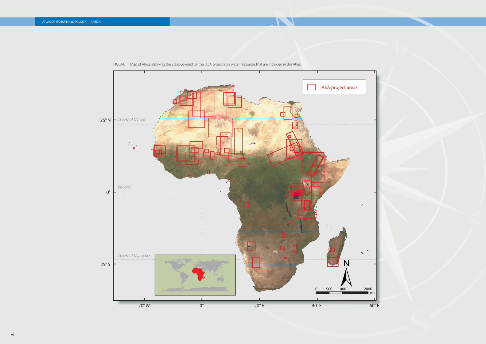
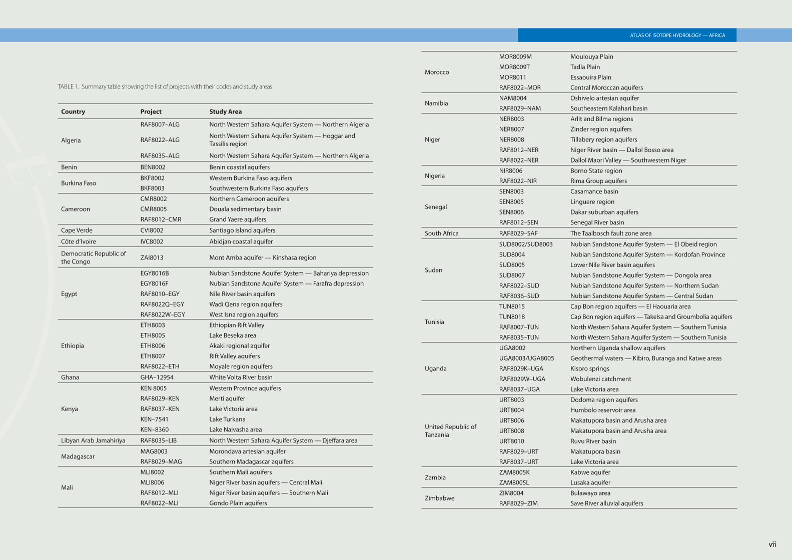
Study areas
The approximate spatial distribution of the study areas of all the projects is shown in Fig. 1. Project codes and study areas are listed in Table 1.
ATLAS OF ISOTOPE HYDROLOGY — AFRICA
vi
ATLAS OF ISOTOPE HYDROLOGY — AFRICAATLAS OF ISOTOPE HYDROLOGY — AFRICA
20° W 0° 20° E 40° E 60° E
25° S
0°
25° N
Equator
Tropic of Cancer
Tropic of Capricorn
±km
0 500 1000 2000
IAEA project areas
FIGURE 1. Map of Africa showing the areas covered by the IAEA projects on water resources that are included in the Atlas.
vii
ATLAS OF ISOTOPE HYDROLOGY — AFRICA
Country Project Study Area
Algeria
RAF8007–ALG North Western Sahara Aquifer System — Northern Algeria
RAF8022–ALG North Western Sahara Aquifer System — Hoggar and Tassilis region
RAF8035–ALG North Western Sahara Aquifer System — Northern Algeria
Benin BEN8002 Benin coastal aquifers
Burkina FasoBKF8002 Western Burkina Faso aquifers
BKF8003 Southwestern Burkina Faso aquifers
Cameroon
CMR8002 Northern Cameroon aquifers
CMR8005 Douala sedimentary basin
RAF8012–CMR Grand Yaere aquifers
Cape Verde CVI8002 Santiago island aquifers
Côte d’Ivoire IVC8002 Abidjan coastal aquifer
Democratic Republic of the Congo ZAI8013 Mont Amba aquifer — Kinshasa region
Egypt
EGY8016B Nubian Sandstone Aquifer System — Bahariya depression
EGY8016F Nubian Sandstone Aquifer System — Farafra depression
RAF8010–EGY Nile River basin aquifers
RAF8022Q–EGY Wadi Qena region aquifers
RAF8022W–EGY West Isna region aquifers
Ethiopia
ETH8003 Ethiopian Rift Valley
ETH8005 Lake Beseka area
ETH8006 Akaki regional aquifer
ETH8007 Rift Valley aquifers
RAF8022–ETH Moyale region aquifers
Ghana GHA–12954 White Volta River basin
Kenya
KEN 8005 Western Province aquifers
RAF8029–KEN Merti aquifer
RAF8037–KEN Lake Victoria area
KEN–7541 Lake Turkana
KEN–8360 Lake Naivasha area
Libyan Arab Jamahiriya RAF8035–LIB North Western Sahara Aquifer System — Dje� ara area
MadagascarMAG8003 Morondava artesian aquifer
RAF8029–MAG Southern Madagascar aquifers
Mali
MLI8002 Southern Mali aquifers
MLI8006 Niger River basin aquifers — Central Mali
RAF8012–MLI Niger River basin aquifers — Southern Mali
RAF8022–MLI Gondo Plain aquifers
Morocco
MOR8009M Moulouya Plain
MOR8009T Tadla Plain
MOR8011 Essaouira Plain
RAF8022–MOR Central Moroccan aquifers
NamibiaNAM8004 Oshivelo artesian aquifer
RAF8029–NAM Southeastern Kalahari basin
Niger
NER8003 Arlit and Bilma regions
NER8007 Zinder region aquifers
NER8008 Tillabery region aquifers
RAF8012–NER Niger River basin — Dallol Bosso area
RAF8022–NER Dallol Maori Valley — Southwestern Niger
NigeriaNIR8006 Borno State region
RAF8022–NIR Rima Group aquifers
Senegal
SEN8003 Casamance basin
SEN8005 Linguere region
SEN8006 Dakar suburban aquifers
RAF8012–SEN Senegal River basin
South Africa RAF8029–SAF The Taaibosch fault zone area
Sudan
SUD8002/SUD8003 Nubian Sandstone Aquifer System — El Obeid region
SUD8004 Nubian Sandstone Aquifer System — Kordofan Province
SUD8005 Lower Nile River basin aquifers
SUD8007 Nubian Sandstone Aquifer System — Dongola area
RAF8022–SUD Nubian Sandstone Aquifer System — Northern Sudan
RAF8036–SUD Nubian Sandstone Aquifer System — Central Sudan
Tunisia
TUN8015 Cap Bon region aquifers — El Haouaria area
TUN8018 Cap Bon region aquifers — Takelsa and Groumbolia aquifers
RAF8007–TUN North Western Sahara Aquifer System — Southern Tunisia
RAF8035–TUN North Western Sahara Aquifer System — Southern Tunisia
Uganda
UGA8002 Northern Uganda shallow aquifers
UGA8003/UGA8005 Geothermal waters — Kibiro, Buranga and Katwe areas
RAF8029K–UGA Kisoro springs
RAF8029W–UGA Wobulenzi catchment
RAF8037–UGA Lake Victoria area
United Republic of Tanzania
URT8003 Dodoma region aquifers
URT8004 Humbolo reservoir area
URT8006 Makatupora basin and Arusha area
URT8008 Makatupora basin and Arusha area
URT8010 Ruvu River basin
RAF8029–URT Makatupora basin
RAF8037–URT Lake Victoria area
ZambiaZAM8005K Kabwe aquifer
ZAM8005L Lusaka aquifer
ZimbabweZIM8004 Bulawayo area
RAF8029–ZIM Save River alluvial aquifers
TABLE 1. Summary table showing the list of projects with their codes and study areas
vii
viii
ATLAS OF ISOTOPE HYDROLOGY — AFRICA
Elements of the country page
Summary of the project including project code, start date, duration, study areas and background
Index map
Title bar with name of the country
Physiographic map of the country
Outline of the study area
City with a GNIP/WMO Station
City, town or settlement
International border of the country
Latitude
Scale of the map Page number
Map legend
Longitude
ix
ATLAS OF ISOTOPE HYDROLOGY — AFRICA
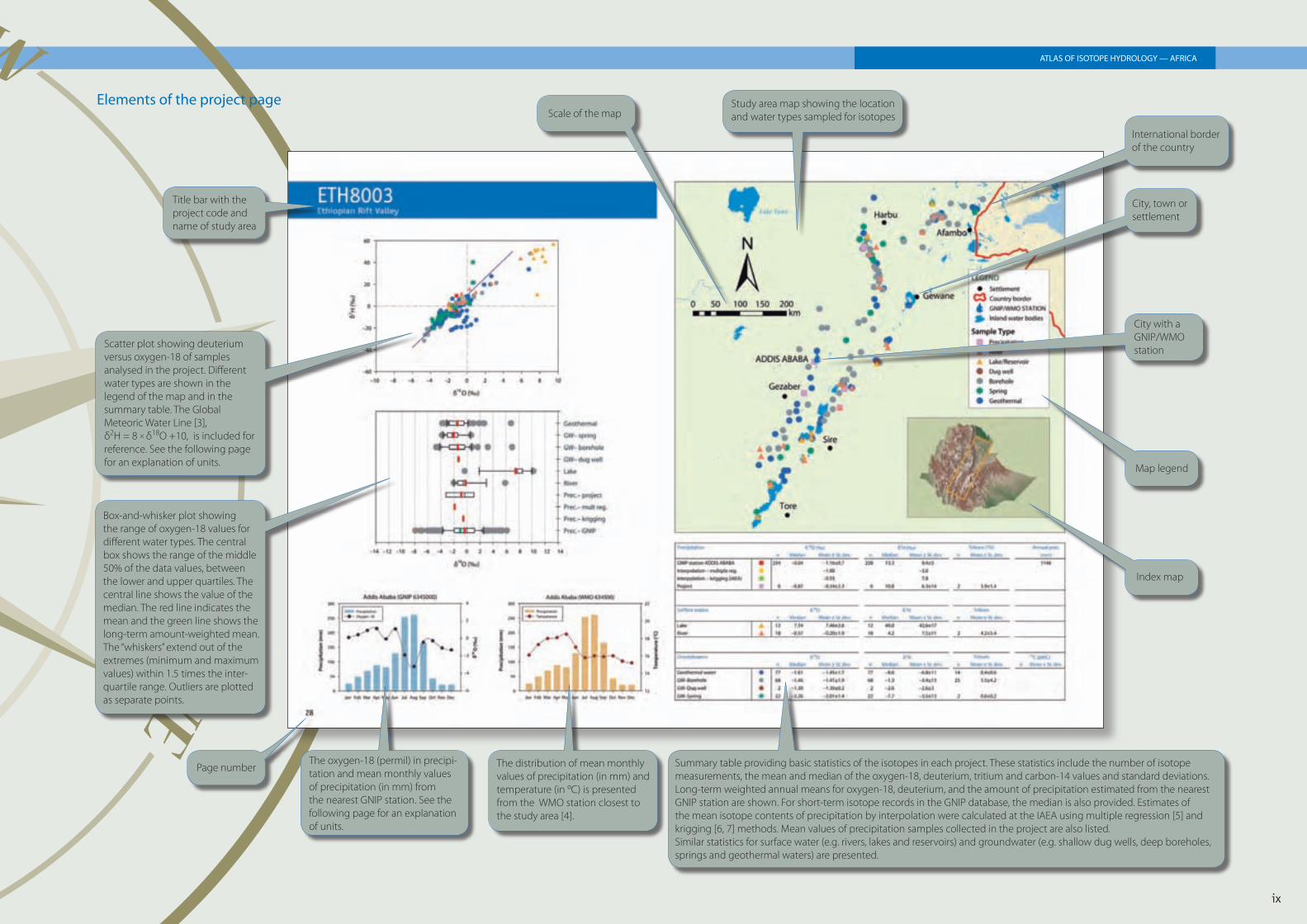
Elements of the project page
Summary table providing basic statistics of the isotopes in each project. These statistics include the number of isotope measurements, the mean and median of the oxygen-18, deuterium, tritium and carbon-14 values and standard deviations.Long-term weighted annual means for oxygen-18, deuterium, and the amount of precipitation estimated from the nearest GNIP station are shown. For short-term isotope records in the GNIP database, the median is also provided. Estimates of the mean isotope contents of precipitation by interpolation were calculated at the IAEA using multiple regression [5] and krigging [6, 7] methods. Mean values of precipitation samples collected in the project are also listed.Similar statistics for surface water (e.g. rivers, lakes and reservoirs) and groundwater (e.g. shallow dug wells, deep boreholes, springs and geothermal waters) are presented.
The oxygen-18 (permil) in precipi-tation and mean monthly values of precipitation (in mm) from the nearest GNIP station. See the following page for an explanation of units.
Page number
Box-and-whisker plot showing the range of oxygen-18 values for different water types. The central box shows the range of the middle 50% of the data values, between the lower and upper quartiles. The central line shows the value of the median. The red line indicates the mean and the green line shows the long-term amount-weighted mean. The “whiskers” extend out of the extremes (minimum and maximum values) within 1.5 times the inter-quartile range. Outliers are plotted as separate points.
Scatter plot showing deuterium versus oxygen-18 of samples analysed in the project. Different water types are shown in the legend of the map and in the summary table. The Global Meteoric Water Line [3], δ2H = 8 × δ18O +10, is included for reference. See the following page for an explanation of units.
Title bar with the project code and name of study area
Scale of the mapStudy area map showing the location and water types sampled for isotopes
International border of the country
City, town or settlement
City with a GNIP/WMO station
Map legend
Index map
The distribution of mean monthly values of precipitation (in mm) and temperature (in ºC) is presented from the WMO station closest to the study area [4].
UNITS OF MEASUREMENT
Oxygen-18 and Deuterium
Oxygen-18 and deuterium contents in water samples are expressed as δ values (δ18O, δ2H), which are permil deviations from an internationally accepted standard. The δ unit is defi ned as:
δ(‰) =Rsample – RVSMOV
RVSMOV× 103
where, R is the isotope ratio 2H/1H or 18O/16O.
In case of water, the internationally accepted standard is called Vienna Standard Mean Ocean Water (VSMOW) [3, 8]. The deuterium and oxygen-18 isotope ratios are determined by mass spectrometric methods. The measurements reported in this Atlas generally have a precision of about ± 0.1‰ for oxygen-18 and ± 1‰ for deuterium at one standard deviation level.
Tritium
Tritium concentration is expressed in tritium units (TU). One TU is defi ned as one atom of 3H per 1018 atoms of 1H, which is equivalent to an activity of 0.118 Bq or 3.193 pCi per litre of water. The half-life of tritium is 12.32 years (4500 days) [9]. Due to this relatively short half-life, tritium has been used in hydrogeology as an excellent environmental tracer to identify modern recharge in aquifer systems. Tritium content is measured by counting its radioactive decay, using liquid scintillation spectrometers. Due to very low levels of tritium in natural waters, electrolytic enrichment of tritium is done before counting the radioactive decay. The analytical uncertainty for tritium analysis is usually reported with each measurement. Current analytical methods involving electrolytic enrichment followed by
liquid scintillation counting provide uncertainty values in the order of ±0.3 TU for tritium levels lower than 5 TU.
Carbon-14
For hydrogeological applications, radiocarbon or carbon-14 activity is expressed as percentage of modern carbon (pMC). The activity of modern carbon is 95% of the specifi c activity of the carbon of NBS oxalic acid supplied by the US National Institute of Standards and Technology (NIST). One hundred per cent modern carbon corresponds to a carbon-14 specifi c activity of 13.56 ± 0.07 disintegrations per minute per gram of carbon. Measurement of carbon-14 activity is generally carried out by decay counting using liquid scintillation spectrometry or, more recently, by measurement of atoms using accelerator mass spectrometry (AMS) methods. Carbon-14 is a key dating tool for groundwaters between 5000 and 40 000 years before present (B.P.).
STABLE ISOTOPES IN PRECIPITATION OVER AFRICA
The analysis of temporal and spatial variations of isotope contents in the different components of the water cycle is required for the characterization of different sources of recharge for aquifers, springs, lakes, rivers, reservoirs, etc.
Ultimately, precipitation is the source of all recharge. Therefore, defi nition of the isotope signals (2H, 18O and 3H) in precipitation is required for proper assessment of location and mechanism of recharge. In other cases, isotopes in precipitation can aid in identifying fossil groundwater (complementary to the use of carbon-14 dating of groundwater) because of the isotopic contrast between modern and past precipitation.
GNIP is one of the main sources of information on isotope signals of precipitation worldwide. This global monitoring programme has been in operation since 1961 through a joint collaboration between the IAEA and the World Meteorological Organization (WMO).
The GNIP database, which is also accessible through WISER (http://www.iaea.org/water), provides basic isotope data for the application of isotopes in hydrological sciences.
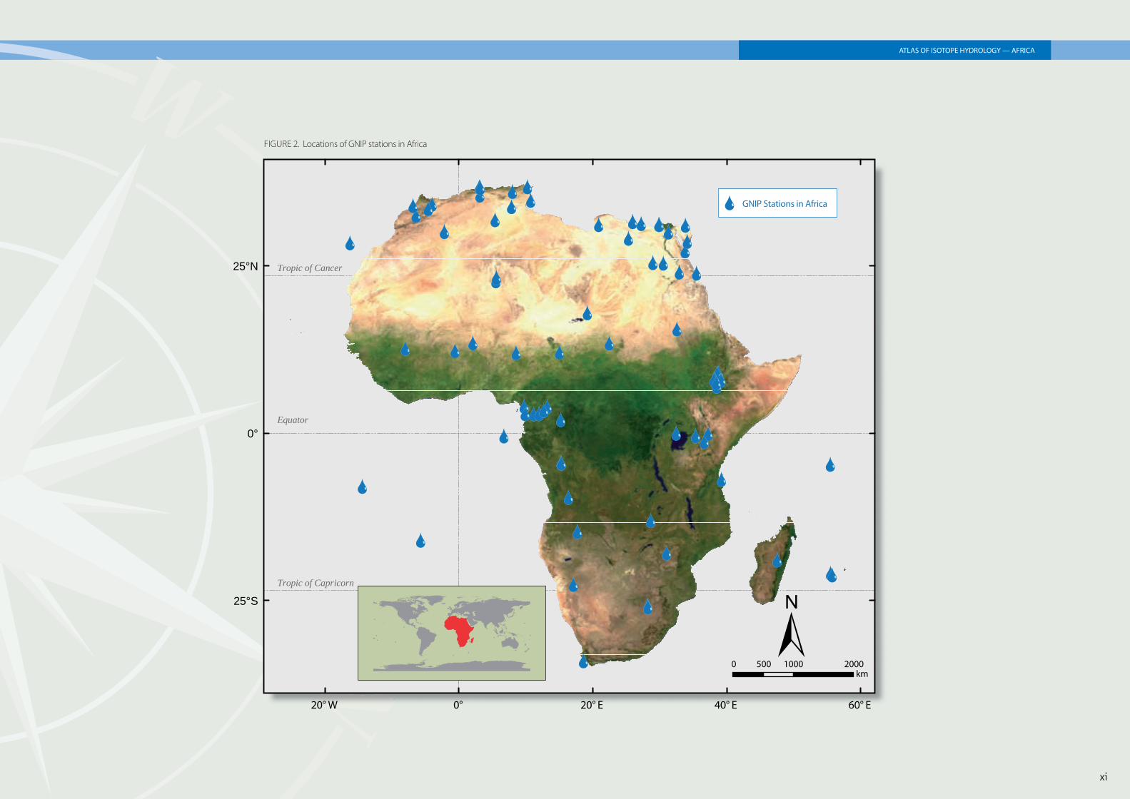
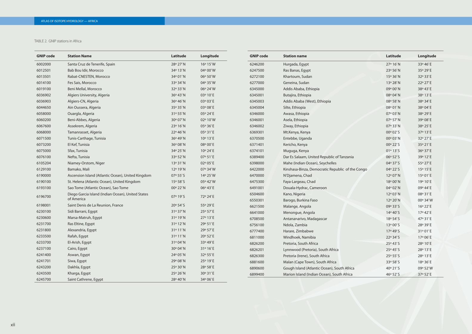
The isotope contents of precipitation over Africa have been monitored at more than 70 stations for the last 40 years. The raw isotope data, as well as the summary information (statistical treatment of meteorological and isotope data), are available at: http://www.iaea.org/water.
The locations of GNIP stations in Africa are shown in Fig. 2 and are listed in Table 2. The long term weighted mean δ18 O and δ2 H values of precipitation calculated for the nearest GNIP station for each study area have been included in the summary table for each project.
x
ATLAS OF ISOTOPE HYDROLOGY — AFRICA
xi
ATLAS OF ISOTOPE HYDROLOGY — AFRICA
FIGURE 2. Locations of GNIP stations in Africa
ÔÕÔÕ
ÔÕ
ÔÕ
ÔÕÔÕ
ÔÕ
ÔÕ
ÔÕ
ÔÕ ÔÕ
ÔÕ
ÔÕ
ÔÕ ÔÕ
ÔÕÔÕ
ÔÕ
ÔÕ
ÔÕ
ÔÕ
ÔÕ
ÔÕ
ÔÕ
ÔÕ
ÔÕ
ÔÕ
ÔÕ
ÔÕ
ÔÕ
ÔÕ
ÔÕ
ÔÕ
ÔÕ
ÔÕ
ÔÕ
ÔÕ
ÔÕ
ÔÕ
ÔÕ
ÔÕ
ÔÕÔÕ
ÔÕ
ÔÕ
ÔÕ
ÔÕ
ÔÕ
ÔÕÔÕ
ÔÕÔÕ
ÔÕ
ÔÕÔÕ
ÔÕ
ÔÕ
ÔÕ
ÔÕÔÕ
ÔÕ
ÔÕ
ÔÕ
ÔÕ
ÔÕ
ÔÕ
ÔÕ
ÔÕ
ÔÕ
ÔÕÔÕ
ÔÕ
ÔÕ
ÔÕ
ÔÕ
ÔÕ
ÔÕ ÔÕÔÕ
ÔÕ
ÔÕ
20° W 0° 20° E 40° E 60° E
25°S
0°
25°N
Ô
±0 500 1000 2000
km
Equator
Tropic of Cancer
Tropic of Capricorn
Õ GNIP Stations in Africa
xii
ATLAS OF ISOTOPE HYDROLOGY — AFRICA
GNIP code Station Name Latitude Longitude
6002000 Santa Cruz de Tenerife, Spain 28º 27’ N 16º 15’ W
6012501 Bab Bou Idir, Morocco 34º 13’ N 04º 00’ W
6013501 Rabat-CNESTEN, Morocco 34º 01’ N 06º 50’ W
6014100 Fes Sais, Morocco 33º 34’ N 04º 35’ W
6019100 Beni Mellal, Morocco 32º 33’ N 06º 24’ W
6036902 Algiers University, Algeria 36º 43’ N 03º 10’ E
6036903 Algiers-CN, Algeria 36º 46’ N 03º 03’ E
6044650 Ain Oussera, Algeria 35º 35’ N 03º 08’ E
6058000 Ouargla, Algeria 31º 55’ N 05º 24’ E
6060200 Beni-Abbes, Algeria 30º 07’ N 02º 10’ W
6067600 Assekrem, Algeria 23º 16’ N 05º 36’ E
6068000 Tamanrasset, Algeria 22º 46’ N 05º 31’ E
6071500 Tunis-Carthage, Tunisia 36º 49’ N 10º 13’ E
6073200 El Kef, Tunisia 36º 08’ N 08º 00’ E
6075000 Sfax, Tunisia 34º 25’ N 10º 24’ E
6076100 Nefta, Tunisia 33º 52’ N 07º 51’ E
6105204 Niamey-Orstom, Niger 13º 31’ N 02º 05’ E
6129100 Bamako, Mali 12º 19’ N 07º 34’ W
6190000 Ascension Island (Atlantic Ocean), United Kingdom 07º 55’ S 14º 25’ W
6190100 St. Helena (Atlantic Ocean), United Kingdom 15º 58’ S 05º 42’ W
6193100 Sao Tome (Atlantic Ocean), Sao Tome 00º 22’ N 06º 43’ E
6196700 Diego Garcia Island (Indian Ocean), United States of America 07º 19’ S 72º 24’ E
6198001 Saint Denis de La Reunion, France 20º 54’ S 55º 29’ E
6230100 Sidi Barrani, Egypt 31º 37’ N 25º 57’ E
6230600 Marsa-Matruh, Egypt 31º 19’ N 27º 13’ E
6231700 Ras Eltine, Egypt 31º 12’ N 29º 51’ E
6231800 Alexandria, Egypt 31º 11’ N 29º 57’ E
6233500 Rafah, Egypt 31º 11’ N 20º 52’ E
6233700 El-Arish, Egypt 31º 04’ N 33º 49’ E
6237100 Cairo, Egypt 30º 04’ N 31º 16’ E
6241400 Aswan, Egypt 24º 05’ N 32º 55’ E
6241701 Siwa, Egypt 29º 08’ N 25º 19’ E
6243200 Dakhla, Egypt 25º 30’ N 28º 58’ E
6243500 Kharga, Egypt 25º 26’ N 30º 31’ E
6245700 Saint Cathrene, Egypt 28º 40’ N 34º 06’ E
TABLE 2. GNIP stations in Africa
GNIP code Station name Latitude Longitude
6246200 Hurgada, Egypt 27º 16’ N 33º 46’ E
6247500 Ras Banas, Egypt 23º 56’ N 35º 29’ E
6272100 Khartoum, Sudan 15º 36’ N 32º 33’ E
6277000 Geneina, Sudan 13º 28’ N 22º 27’ E
6345000 Addis Ababa, Ethiopia 09º 00’ N 38º 43’ E
6345001 Butajira, Ethiopia 08º 04’ N 38º 13’ E
6345003 Addis Ababa (West), Ethiopia 08º 58’ N 38º 34’ E
6345004 Silte, Ethiopia 08º 01’ N 38º 04’ E
6346000 Awasa, Ethiopia 07º 03’ N 38º 29’ E
6346001 Asela, Ethiopia 07º 57’ N 39º 08’ E
6346002 Ziway, Ethiopia 07º 33’ N 38º 25’ E
6369301 Mt.Kenya, Kenya 00º 02’ S 37º 13’ E
6370500 Entebbe, Uganda 00º 03’ N 32º 27’ E
6371401 Kericho, Kenya 00º 22’ S 35º 21’ E
6374101 Muguga, Kenya 01º 13’ S 36º 37’ E
6389400 Dar Es Salaam, United Republic of Tanzania 06º 52’ S 39º 12’ E
6398000 Mahe (Indian Ocean), Seychelles 04º 37’ S 55º 27’ E
6422000 Kinshasa-Binza, Democratic Republic of the Congo 04º 22’ S 15º 15’ E
6470000 N’Djamena, Chad 12º 07’ N 15º 01’ E
6475300 Faya-Largeau, Chad 18º 00’ N 19º 10’ E
6491001 Douala-Hydrac, Cameroon 04º 02’ N 09º 44’ E
6504600 Kano, Nigeria 12º 03’ N 08º 31’ E
6550301 Barogo, Burkina Faso 12º 20’ N 00º 34’ W
6621500 Malange, Angola 09º 33’ S 16º 22’ E
6641000 Menongue, Angola 14º 40’ S 17º 42’ E
6708500 Antananarivo, Madagascar 18º 54’ S 47º 31’ E
6756100 Ndola, Zambia 13º 00’ S 28º 39’ E
6777400 Harare, Zimbabwe 17º 49’ S 31º 01’ E
6811000 Windhoek, Namibia 22º 34’ S 17º 06’ E
6826200 Pretoria, South Africa 25º 43’ S 28º 10’ E
6826201 Lynnwood (Pretoria), South Africa 25º 45’ S 28º 13’ E
6826300 Pretoria (Irene), South Africa 25º 55’ S 28º 13’ E
6881600 Malan (Cape Town), South Africa 33º 58’ S 18º 36’ E
6890600 Gough Island (Atlantic Ocean), South Africa 40º 21’ S 09º 52’ W
6899400 Marion Island (Indian Ocean), South Africa 46º 52’ S 37º 52’ E
REFERENCES
[1] HEARN, P., HARE, T., SCHRUBEN, P., SHERRILL, D., LAMAR, C., TSUSHIMA, P., Global GIS Global Coverage DVD, version 6.4.2 (Developed by U.S. Geological Survey), American Geological Institute, Alexandria, VA (ISBN 0-922152-67-5) (2003).
[2] UNITED NATIONS GEOGRAPHICAL INFORMATION WORKING GROUP, International and Administrative Boundaries, International Boundaries Task Group (2007) available at: http://www.ungiwg.org/inter.htm.
[3] CRAIG, H., Standard for reporting concentration of deuterium and oxygen-18 in natural waters, Science 113 (1961) 1833–34.
[4] WORLD METEOROLOGICAL ORGANIZATION, 1961–1990 Global Climate Normals, Version 1.0, National Climatic Data Center, Asheville (1998).
[5] BOWEN, G.J., REVENAUGH, J., Interpolating the isotope composition of modern meteoric precipitation, Water Resour. Res. 39 doi: 101029/2003WR002086 (2003).
[6] GANDIN, L.S., Objective analysis of meteorological fi elds: U.S. Dept. of Commerce and National Science Foundation, Washington, DC, (1965). (Original in Russian, obektivnyi analiz meterologicheskikh poleai, 1963.)
[7] HERZFELD, U.C., Inverse theory in the earth sciences — An introductory overview with emphasis on Gandin’s method of optimum interpolation, Math. Geol. 28 (1996).
[8] GONFIANTINI, R., Standard for stable isotope measurements in natural compounds, Nature (London) 271 (1978) 534–536.
[9] LUCAS, L.L., UNTERWEGER, M.P., Comprehensible review and critical evaluation of the half-life of tritium. J. Res. National Institute of Standards and Technology 105 (2000) 541–549.
SELECTED FURTHER READING
AGGARWAL, P.K., GAT, J.R., FROEHLICH, K.F.O. (Eds), Isotopes in the Water Cycle — Past, Present and Future of a Developing Science, Springer, Dordrecht (2005).
CLARK, I.D., FRITZ, P., Environmental Isotopes in Hydrogeology, Lewis Publishers, Boca Raton (1997).
COOK, P.G., HERCZEG, A.L. (Eds), Environmental Tracers in Subsurface Hydrology, Kluwer Academic Publishers, Boston (2000).
FRITZ, P., FONTES, J.-Ch. (Eds), Handbook of Environmental Isotope Geo chemistry, Vol. 1: The Terrestrial Environment, Elsevier, New York (1980).
FRITZ, P., FONTES, J.-Ch. (Eds), Handbook of Environmental Isotope Geochemistry, Vol. 2: The Terrestrial Environment, Elsevier, New York (1986).
FRITZ, P., FONTES, J.-Ch. (Eds), Handbook of Environmental Isotope Geochemistry, Vol. 3: The Marine Environment, Elsevier, New York (1989).
INTERNATIONAL ATOMIC ENERGY AGENCY, Stable Isotope Hydrology — Deuterium and Oxygen-18 in the Water Cycle, Technical Reports Series No. 210, IAEA, Vienna (1981).
INTERNATIONAL ATOMIC ENERGY AGENCY, Guidebook on Nuclear Techniques in Hydrology, Technical Reports Series No. 91, IAEA, Vienna (1983).
MAZOR, E., Chemical and Isotopic Groundwater Hydrology — The Applied Approach, Marcel Dekker, New York (1997).
MOOK, W.G., Introduction to Isotope Hydrology — Stable and Radio-active Isotopes of Hydrogen, Oxygen and Carbon, Taylor and Francis, London (2005).
UNESCO-IAEA, Environmental Isotopes in the Hydrological Cycle: Principles and Applications, IHP-V Technical Documents in Hydrology No. 39, Vols I – VI, UNESCO, Paris (2000).
xiii
ATLAS OF ISOTOPE HYDROLOGY — AFRICA


