B 2580 Creekview Road Moab, Utah 84532 Environmental Consultants 435/719-2018 435/719-2019Fax March 12, 2007 Fluid Minerals Group Bureau of Land Management 82 East Dogwood Moab, Utah 84532 RE: Application for Permit to Drill - Petro-Canada Resources (USA), Inc. Federal 42-5- 1,101' FSL & 1,931' FWL, SE/4 SWl4, Section 5, T13S, R15E, SLB&M, Carbon County, Utah Dear Fluid Minerals Group: On behalf of Petro-Canada Resources (USA), Inc. (Petro-Canada), Buys &Associates, Inc. respectfully submits the enclosed original and three copies of the Applicationfor Permit to Drill (APD) for the above referenced federal surface and mineral vertical well staked for the previous lease operator Cimarex Energy Co.. A request for exception to spacing (R649-3-2) is hereby requested based on topography since the well is located less than 460' of the drilling unit boundary. Petro-Canada is the only owner and operator within460' of the proposed well. Included with the APD is the following supplemental information: Exhibit "A" - Survey plats of the proposed well site; Exhibit "B" - Location layout and cross-sections of the proposed well site; Exhibit "C" -- Proposed location maps with access & pipeline corridor; Exhibit "D" - Drilling Plan; Exhibit "E" - Surface Use Plan; Exhibit "F" - Typical BOP and Choke Manifold diagram. Please accept this letter as Petro-Canada's, written request for confidential treatmentof all information contained in and pertaining to this application. Thank you very much for your timely consideration of this application. Please feel free to contact myself or Alan Vrooman of Petro-Canada at 303-350-1171 if you have any questions or need additional information. Sincerely, RECEIVED MAR 1 6 2007 Don Hamilton DIV.0FOIL, GAS&MINING Agent for Petro-Canada cc: Alan Vrooman, Petro-Canada Carla Konopka, Petro-Canada Don Stephens, BLM - Price Field Office Diana Mason, Division of Oil, Gas &
Fluid Minerals GroupBureau of Land Management82 East DogwoodMoab, Utah 84532
RE: Application for Permit to Drill - Petro-Canada Resources (USA), Inc.Federal 42-5- 1,101' FSL & 1,931' FWL, SE/4 SWl4,
Section 5, T13S, R15E, SLB&M, Carbon County, Utah
Dear Fluid Minerals Group:
On behalf of Petro-Canada Resources (USA), Inc. (Petro-Canada), Buys &Associates, Inc. respectfullysubmits the enclosed originaland three copies of the Applicationfor Permit to Drill(APD) for the abovereferenced federal surface and mineral verticalwell staked for the previous lease operator CimarexEnergy Co.. A request for exception to spacing (R649-3-2) is hereby requested based on topographysince the well is located less than 460' of the drilling unit boundary. Petro-Canada is the onlyowner andoperator within460' of the proposed well. Included with the APD is the following supplementalinformation:
Exhibit "A" - Survey plats of the proposed well site;
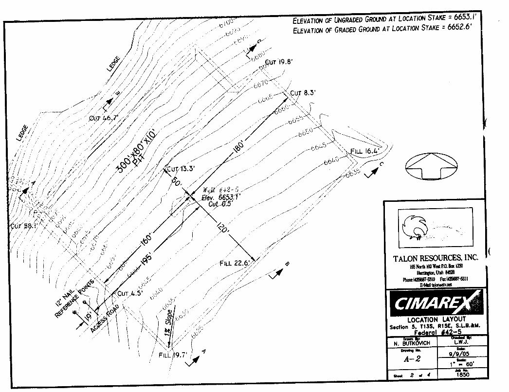
Exhibit "B" - Location layout and cross-sections of the proposed wellsite;
Exhibit "F" - Typical BOP and Choke Manifold diagram.
Please accept this letter as Petro-Canada's, written request for confidentialtreatmentof all informationcontained in and pertaining to thisapplication.
Thank you very much for your timelyconsideration of thisapplication. Please feel free to contact myselfor Alan Vrooman of Petro-Canada at 303-350-1171 ifyou have any questions or need additionalinformation.
Sincerely,RECEIVEDMAR1 6 2007
Don Hamilton DIV.0FOIL,GAS&MININGAgent for Petro-Canada
cc: Alan Vrooman, Petro-CanadaCarla Konopka, Petro-CanadaDon Stephens, BLM - Price Field OfficeDiana Mason, Division of Oil,Gas &
l& Distancefrom location* 19. ProposedDepib 20. BLM/BIABondNa on filetonealestwellappliedfor,on this None 9,700' UT 1215
21. Elevations(ShowwhetherDF,KDB,RT,GL,etc.) 22 Approximatedateworkwillstart* 21 Estimatedduration6,653' GR 06/01/2007 35 days drilling 40 days completion
24. AttachmentsThefollowing,completed inaccordancewith therequirements of OnshoreOilandGasOrderNo.1,must beattachedio thisform:
3. A SurfaceUse Plan (if the locationis on NationalForestSystemLands,the 5. OperatorcertificationSUPO must be filedwiththeappropriateForestServiceOffice). 6. Suchothersitespecificinformationand/orplansasmay berequired bythe
BLM.
25. Signature , Name(Printedn)ped) DatedrVL Don Hamilton 03/12/2007
Title 18U.S.C.Section1001andTitle43 U.S.C.Section1212,makeit a crimeforanypersonkno and willfully tomaketo any departmentor agency of the UnitedStatesanyfalse,fictitiousor fraudulentstatementsorrepresentationsastoanymatterwithm itsj cton.
*(Instructions on page 2)
MAR 6 200
ON OF OtL, GAS &MININGFederal Approval of t/alsActíon is Necessary
3ocanon
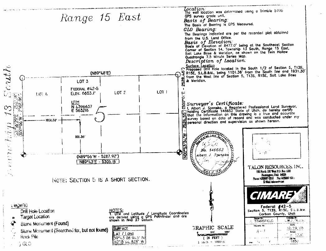
h 4- p The well location was determined using a Trimble 5700
,TL € i B G,S PS.•urv•v er 6•""it·Basts of Bearing:The Basis of Beoring is GPS Measured.GLO Bearing:The Beorings indicoted are per the recorded plot obtainedfrom the U.S. Land Office.Basis of Elevation:Basis of Elevation of 8477.0' being at the Southeast SectionCorner of Section 14, Township 13 South, Range 15 East.Salt Loke Base & Meridion, os shown on the Twin HollowQuadrongle 7.5 Minute Series Mop.Description of Location:Surface Location
(N89°48'E) Proposed Drill Hole located in the South 1/2 of Section 5, T13S,
OfNR15E, S.I.B.&M.. being i101.3ß' from the South line ond 1931.30"from the West Ilne of Section 5, T13S, R15E, Salt Lake Base
LOT 3 A& Meridion.
FEDERAL#42-5LOT & ELev. 6653.I' LOT 2 LOT I
UTM•o
N 4396637o Surveyor's Certificate:
E 5652l6 I, Albert J. S ensko, o Registered Professional Land Surveyor,holding Certif cote 146652 Stote of Utah, do hereby certifythot the information on this drawing is a true and occurote
- 1931.30' survey based on dota of record and was conducted under mypersonal direction and supervision as shown hereon.
1101.36'
No. 146862NB9°56'W
- 5287.92') Albert J spensko *
N89%3'E - 5305.18' ITALONRESOURCES,INC.
1951tatth100WatP,0.Boxtm
NOTE: SECTIONb IS A SHORT SECTION. «No maa
Ole LOCâ 04 ES:Federal #42-5
. M and Lotitude / Longitude Coordinates Section 5, T13S, R15E, SLB
ore derived usin o GPS Pathfinder and are Carbon County, Utah
StoneMonument(Found)shown in NAD2 Datum. A ŠRELD L
Name of Operator: Petro-Canada Resources (USA)Address: 1099 -
18thStreet, Suite 400
Denver, CO 80202Well Location: Fed 42-5
1,101' FSL & 1,931' FWL, SE SW
Section 5, T13S, Rl5ECarbon County, UT
L GEOLOGIC SURFACE FORMATION Green River
2 & 3.ESTIMATED DEPTHS OF IMPORTANT GEOLOGIC MARKERS AND FORMATIONS EXPECTED TO CONTAIN
WATER, OIL AND GAS OR MINERALS
Formation Depth
Green River SurfaceWasatch 1,700'*
Price River 5,200' *
Castlegate 7,200' *
Blackhawk 7,500' *
Starpoint 7,800' *
Mancos 8,200' *
TD 9,700'
* PROSPECTIVE PAY
4. PROPOSED CASING PROGRAM
All casing used to drill this well will be new casing.
Typ_t Size Weight Grade C Toß Bottom _Holg
Surface 9.625" 43.5 ppf L-80 STC O' 1,050' 12-1/4"
Production 5.5" 20.0 ppf P-110 LTC 0' 9,700'
DRILLING PLAN
APPROVAL OF OPERATIONS
5. OPERATOR'S MINIMUM SPECIFICATIONS FOR PRESSURE CONTROL
Surface hole: No BOPE will be utilized.
Production hole: Prior to drilling out the surface casing shoe, 5,000 psi BOP equipment will be installed. The pipe rams
will be operated at least once per day from surface casing depth to total depth. The blind rams will be tested once per day
from surface casing depth to total depth if operations permit.
A diagram of the planned BOP equipment for normal drilling operations in this area is attached. As denoted there will be
two valves and one check valve on the kill line, two valves on the choke line, and two adjustable chokes on the manifold
system. The BOP "stack" will consist of two BOP rams (1 pipe, I blind) and one annular type preventer, all rated to a
minimum of 5,000 psi working pressure.
The BOP equipment will be pressure tested prior to drilling below the surface casing shoe. All test pressures will be
maintained for fifteen (15) minutes without any significant pressure decrease. Clear water will be circulated into the BOP
stack and lines prior to pressure testing. The BLM and the state of Utah Division of Oil, Gas and Mining will be notified
24 hours in advance of all BOP pressure tests.
6. MUD SYSTEMSSufficient mud materials to maintain mud properties, control lost circulation and to contain "kick" will be available at the
well site.
Interval Mud Weight (poa) Viscosity Fluid Loss Remarks
0 - 40' 8.3 - 8.6 27-40 - Native Spud Mud
40' - 1,050' 8.3 - 8.6 27-40 15 cc or less Native/Gel/Lime
1,050' - TD 8.6 - 9.5 38-46 15 cc or less Potassium Formate
7. BLOOIE LINE• An automatic igniter will not be installed on blooie line. The blooie will have a constant ignition source.
• A "target tee" connection will be installed on blooie line for 90° change of directions for abrasion resistance.• "Target tee" connections will be a minimum of 50' from wellhead.• The blooie line discharge will be a minimum of 100' from the wellhead.
8. AUXILIARY EQUIPMENT TO BE USED• Upper Kelly cock; lower Kelly cock will be installed while drilling
• Inside BOP or stab-in valve (available on the rig floor)• Safety valve(s) and subs to fit all string connections in use
• Mud monitoring will be visually observed
9. TESTING. LOGGING AND CORING PROGRAMS TO BE FOLLOWEDCores None anticipated.Testing None anticipated.Sampling 30' samples; surface casing to TD
Preserve samples all show intervalsSurveys Run every 1,000' and on tripsLogging DIL-GR-SP, FDC-CNL-GR-Caliper-Pe-Microlog, Sonic-GR, ali TD to base of surface casing, GR through
surface casing.
10. ANTICIPATED ABNORMAL PRESSURES OR TEMPERATURES EXPECTED
• No abnormal temperature or pressures are anticipated, Bottom Hole Pressure is expected at 4200 psi.• The formations to be penetrated do not contain known H2S
DRILLING PLAN
APPROVAL OF OPERATIONS
11. WATER SUPPLY• No water pipelines will be laid for this well.• No water well will be drilled for this well.• Drilling water for this will be hauled on the road(s) shown in Exhibit B• Water to be used for drilling will be obtained through a direct purchase from Bill Barrett Corporation (BBC) utilizing
an existing water well located in Cottonwood Canyon on State Lands: Section 32-TI2S-Rl6E; BBC has
previously been granted authorization with SITLA Right of Entry #4534 and Water Right #90-1542.
12. CEMENT SYSTEMS
• Surface Casing: 189 sacks Premium Lite Plus + 0.05 lbs/sack Static Free + 2% bwoc Calcium Chloride + 0.25
Cement will be circulated to surface with 100% excess
• Production Casing: 725 sacks 50:50 Poz:Class G Cement +0.3% bwoc R-3 + 0.25 lbs/sack Cello Flake + 3 lbs/sack
Kol Seal + 1% bwoc FL-25 +2% bwoc Bentonite + 3% bwoc Potassium Chloride + 0.75% bwoc
EC-1 + 0.2% bwoc Sodium Metasilicate + 69.3% Fresh Water;Weight: 13.5 ppgYield: 1.49 cu.ft/sackCement will be placed in two stages through the use of a stage tool. Depth determined based on
potential pay sections, estimated at 4700 ft760 sacks Class G cement + 0.05% bwoc R-3 + 44.3% Fresh Water.
Weight: 15.8 ppgYield: 1.15 cu.ft/sack
Top of cement to be determined by log and sample evaluation; estimated TOC 1,000 ft.Volume is log caliper +10%
13. ANTICIPATED STARTING DATE AND DURATION OF THE OPERATIONS
Starting Date: June 1, 2007Duration: 30 days, drilling and 35 days
SURFACE USE PLAN
Attachment for Permit to Drill
Name of Operator: Petro-Canada Resources (USA)
Address: 1099 -
18* Street, Suite 400Denver, CO 80202
Well Location: Fed 42-5
1,101' FSL & 1,931' FWL, SE SWSection 5, T13S, R15ECarbon County, UT
The dirt contractor will be provided with an approved copy of the surface use plan of operationsbefore initiating construction.
The BLM onsite inspection for the referenced well is pending at this time.
1. Existing Roads:
a. The proposed well site is located approximately 13.3 miles northeast of Sunnyside, Utah.
b. The use of roads under State and County Road Department maintenance are necessary toaccess the Dry Canyon area. An encroachment permit is required to encroach the CarbonCounty maintained Dry Canyon road and upgrade the road as needed and will be applied foronce federal approval is received.
c. All existing roads will be maintained and kept in good repair during all phases of operation.
d. Vehicle operators will obey posted speed restrictions and observe safe speeds commensuratewith road and weather conditions.
2. Planned Access Roads:
a. From the existing Dry Canyon Carbon County maintained road a new road is proposedtrending north for 800' (0.15miles). The access consists of entirely new disturbance andcrosses no significant drainages.
b. A road design plan is not anticipated at this time.
c. The proposed access road will consist of a 22' travel surfàce within a 30' disturbed areaacross entirely BLM managed lands.
d. BLM approval to upgrade the existing road and construct the new access corridor isrequested with this application.
e. A maximum grade of 10% will be maintained throughout the project.
f. No turnouts are proposed.
g. No lowwater crossings and one 18' culvert at the spur road intersectionwith the DryCanyonroad is anticipated. Additional culverts and adequate drainagestructures will be incorporatedinto the remaining existing
h. No surfacing material will come from federal or Indian lands.
i. No gates or cattle guards are anticipated at this time.
j. Surface disturbance and vehicular travel will be limited to the approved locationaccess road.
k. All access roads and surface disturbing activities will conform to the standards outlined intheBureau of Land Management and Forest Service publication: Surface Operating Standardsfor Oil and Gas Exploration and Development, (1989).
1. The operator will be responsible for all maintenance of the access road including drainagestructures.
3. Location of Existing Wells:
a. No existing wells are located within a one mile radius of the proposed well.
4. Location of Production Facilities:
a. All permanent structures will be painted a flat, non-reflective Olive Black to match thestandard environmental colors. All facilities will be painted within six months of installation.Facilities required to comply with the Occupational Safety and Health Act (OSHA) may be
excluded.
b. Site security guidelines identified in 43 CFR 3163.7-5 and Onshore Oil and Gas Order No. 3
will be adhered to.
c. A gas meter run will be constructed and located on lease within 500 feet of the wellhead.
Meter runs will be housed and/or fenced. All gas production and measurement shall comply
with the provisions of 43 CFR 3162. 7-3, Onshore Oil and Gas Order No. 5, and American
Gas Association (AGA) Report No. 3.
d. A two-tank battery will be constructed on this lease, it will be surrounded by a dike of
sufficient capacity to contain the storage capacity of the largest tank. All loading lines andvalves will be placed inside the berm surrounding the tank battery. All liquid hydrocarbonsproduction and measurement shall conform to the provisions of 43 CFR 3162.7-3 and
Onshore Oil and Gas Order No. 4 and Onshore Oil and Gas Order No. 5 for natural gas
production and measurement.
e. Any necessary pits will be properly fenced to prevent any wildlife and livestock entry.
f. All access roads will be maintained as necessary to prevent erosion and accommodate year-
round traffic. The road will be maintained in a safe useable condition.
g. The site will require periodic maintenance to ensure that drainages are kept open and free of
debris, ice, and snow, and that surfaces are properly treated to reduce erosion, fugitive dust,and impacts to adjacent areas.
h. A gas pipeline is associated with this application and is being applied for at this time. The
proposed gas pipeline corridor will leave the southwest side ofthe well site and traverse 800'
to the Dry Canyon road. The pipeline will then continue along the Dry Canyon road 8.7
miles northeast to the existing Dry Canyon compressor facility operated by Bill Barrett
i. The new gas pipeline will be a 10" or less steel buried / surfàce pipeline within a 30' wide
utility corridor. The use of the proposed well sites and existing access roads will facilitatethestaging of the pipeline construction. A new pipeline length of approximately 8.7 miles isassociated with this well.
j. Petro-Canada intends on installing the pipeline on the surface by welding many jointsintolong lengths, dragging the long lengths into position and then completing a finalwelding pass
to join the long lengths together. Petro-Canada intends on connecting the pipeline togetherutilizing conventional welding technology.
k. The pipeline will be buried unless surface rock exists or conditions encountered duringconstruction prohibit the burial of the pipeline.
5. Location and Type of Water Supply:
a. The location and type of water supply has been addressed as number 11 within the previousdrilling plan information.
6. Source of Construction Material:
a. The use of materials will conform to 43 CFR 3610.2-3.
b. No construction materials will be removed from BLM lands.
c. If any gravel is used, it will be obtained from a state approved gravel pit.
7. Methods of Handling Waste Disposal:
a. All wastes associated with this application will be contained and disposed of utilizingapproved facilities.
b. Drill cuttings will be contained and buried on site.
c. The reserve pit will be located outboard of the location and along the northwest side of thepad.
d. The reserve pit will be constructed so as not to leak, break, or allow any discharge.
e. The reserve pit will be lined with 12 mil minimum thickness plastic nylon reinforced liner
material. The liner will overlay a felt liner pad only if rock is encountered duringexcavation.
The pit liner will overlap the pit walls and be covered with dirt and/or rocks to hold it inplace. No trash, scrap pipe, etc., that could puncture the liner will be disposed of in the pit.
Pit walls will be sloped no greater than 2:1. A minimum 2-foot freeboard will be maintained
in the pit at all times during the drilling and completion operation.
f. The reserve pit has been located in cut material. Three sides of the reserve pit will be fencedbefore drilling starts. The fourth side will be fenced as soon as drilling is completed, and
shall remain until the pit is dry. After the reserve pit has dried, all areas not needed forproduction will be rehabilitated.
g. No chemicals subject to reporting under SARA Title III (hazardous materials) in an amount
greater than 10,000 pounds will be used, produced, stored, transported, or disposed of
annually in association with the drilling, testing, or completion of the well. Furthermore, no
extremely hazardous substances, as defined in 40 CFR 355, in threshold planning
will be used, produced, stored, transported, or disposed of in association with the drilling,testing, or completion of the well.
h. Trash will be contained in a trash cage and hauled away to an approved disposal site asnecessary but no later than at the completion of drilling operations. The contents of the trashcontainer will be hauled off periodically to the approved UintahCountyLandfill near Vernal,Utah.
i. Produced fluids from the well other than water will be produced into a test tank until suchtime as construction of production facilities is completed. Any spills of oil, gas, salt water orother produced fluids will be cleaned up and removed.
j. After initial clean-up, a 400 bbl tank will be installed to contain produced waste water. Thiswater will be transported from the tank to an approved disposal well for disposal nearRoosevelt, Utah.
k. Any salts and/or chemicals, which are an integral part ofthe drilling system,will be disposedof in the same manner as the drilling fluid.
I. Sanitary facilities will be on site at all times during operations. Sewage will be placed in aportable chemical toilet and the toilet replaced periodically utilizing a licensed contractor totransport by truck the portable chemical toilet so that its contents can be delivered to theVernal Wastewater Treatment Facility in accordance with state and county regulations.
8. Ancillary Facilities:
a. A complete drilling crew camp is being proposed with this application and will be locatedcentral to the project area. A central crew camp will be analyzed in detail within theassociated Environmental Assessment.
9. Well Site Lavout: (See Exhibit B)
a. The well will be properly identified in accordance with 43 CFR 3162.6.
b. Access to the well pad will be from the southwest.
c. The pad and road designs are consistent with BLM specification
d. A pre-construction meeting with responsible company representative, contractors and theBLM will be conducted at the project site prior to commencement of surface-disturbingactivities. The pad and road will be construction-staked prior to this meeting.
e. The pad has been staked at its maximum size; however it will be constructed smaller ifpossible, depending upon rig availability. Should the layout change, this application will beamended and approved utilizing a sundry notice.
f. All surface disturbing activities, will be supervised by a qualified, responsible companyrepresentative who is aware of the terms and conditions of the APD and specifications in theapproved plans.
g. All cut and fill slopes will be such that stability can be maintained for the life of the activity.
h. Diversion ditches will be constructed as shown around the well site to prevent surface watersform entering the well site
i. The site surface will be graded to drain away from the pit to avoid pit spillage during largestorm events.
j. The stockpiled topsoil (first 6 inches or maximum available) will be stored in a windrow onthe uphill side of the location to prevent any possible contamination. All topsoil will bestockpiled for reclamation in such a way as to prevent soil loss and contamination.
k. Pits will remain fenced until site cleanup.
1. The blooie line will be located at least 100 feet from the well head.
m. Water injection may be implemented if necessary to minimize the amount of fugitive dust.
10. Plans for Restoration of the Surface (Interim Reclamation and Final Reclamation):
a. Site reclamation for a producing well will be accomplished for portions of the site notrequired for the continued operation of the well.
b. Upon well completion, any hydrocarbons in the pit shall be removed in accordance with 43CFR 3162.7-1.Once the reserve pit is dry, the plastic nylon reinforced liner shall be torn andperforated before backfilling of the reserve pit. The reserve pit and that portion of thelocation not needed for production facilities/operations will be re-contoured to theapproximate natural contours.
c. Following BLM published Best Management Practices the interim reclamation will becompleted within 90 days of completion of the well to reestablish vegetation, reduce dustanderosion and compliment the visual resources of the area.a. All equipment and debris will be removed from the area proposed for interim
reclamation and the pit area will be backfilled and re-contoured.
b. The area outside of the rig anchors and other disturbed areas not needed for theoperation of the well will be re-contoured to blend with the surrounding area andreseeded at 12 lbs /acre with the following native grass seeds:
c. Reclaimed areas receiving incidental disturbance during the life of the producing wellwill be re-contoured and reseeded as soon as practical.
d. The Operator will control noxious weeds along access road use authorizations, pipeline routeauthorizations, well sites, or other applicable facilitiesby spraying or mechanical removal. Alist of noxious weeds may be obtained from the BLM or the appropriate County ExtensionOffice. On BLM administered land, it is required that a Pesticide Use Proposal be submittedand approved prior to the application of herbicides, pesticides or possibly hazardouschemicals.
e. Prior to final abandonment of the site, all disturbed areas, including the access road, will bescarified and left with a rough surface. The site will then be seeded and/or planted asprescribed by the BLM. The BLM recommended seed mix will be detailed within theirapproval documents.
11. Surfàce and Mineral Ownership:
a. Surfàce Ownership - Federal under the management of the Bureau of Land Management - PriceField Office, 125 South 600 West, Price, Utah 84501;
b. Mineral Ownership - Federal under the management of the Bureau of Land Management - PriceField Office, 125 South 600 West, Price, Utah 84501; 435-636-3608.
12. Other Information:
a. Montgomery Archaeological Consultants will conduct a Class III archeological survey. Acopy of the pending report will be submitted under separate coverto the appropriate agenciesby Montgomery Archaeological Consultants.
b. A paleontological survey has not been required but a BLM approved paleontologist will bepresent and monitor construction activities during the excavation of bedrock.
c. Cuts and fills will be kept at the minimum possible to reduce impacts to visual resources.
13. Operator's Representative and Certification
Title Name Office PhoneCompany Representative (Denver) Alan Vrooman 1-303-350-1171
Agent Don Hamilton 1-435-719-2018
Certification:
I hereby certify that I, or persons under my direct supervision, have inspected the proposeddrill site and access route; that I am familiar with the conditions which currently exists; thatthe statements made in this APD package are, to the best of my knowledge, true and correct;and that the work associated with the operations proposed herein will be performed by Petro-
Canada Resources (USA), Inc. and its contractors and subcontractors in conformity with thisAPD package and the terms and conditions under which it is approved. I also certifyresponsibility for the operations conducted on that portion ofthe leased landsassociatedwiththis application, with bond coverage being provided under Petro-Canada's BLM bond. Thisstatement is subject to the provisions of 18 U.S.C. 1001 for the filing of a false statement.
NField Status Unit Status PLUGGED & ABANDONEDABANDONED EXPLORATORY y PRODUCING GASACTIVE GAS STORAGE o PRODUCING OILNF PP OIL -g- SHUT-IN GASCOMBINED NF SECONDARY
. SHUT-IN OIL W EINACTIVE NDINGp' TEMP. ABANDONEDPROPOSED OILo TEST WELL
ROMNGAETEDG THERML & WATER INJECTION S
PP OIL g WATER SUPPLY PREPARED BY: DIANA MASONSECONDARY WATER DISPOSAL DATE: 26-MARCH-2007TERMINATED
JON M. HUNTSMAN, JR.Governor
GARY R. HERBERT*sa Lieutenant Governor
State of Utah March 28, 2007
Department ofNatural Resources
MICHAEL R. STYLERExecutive Director Petro-Canada Resources
Division of 1099 18th St., Ste. 400Oil, Gas & Mining Denver, CO 80202
JOHN R. BAZADivision Director
Re: Federal 42-5 Well, 1101' FSL, 1931' FWL, SE SW, Sec. 5, T. 13 South,R. 15 East, Carbon County, Utah
Gentlemen:
Pursuant to the provisions and requirements of Utah Code Ann.§ 40-6-1 etseq., Utah Administrative Code R649-3-1 et seq., and the attached Conditions ofApproval, approval to drill the referenced well is granted.
Appropriate information has been submitted to DOGM and administrativeapproval of the requested exception location is hereby granted.
This approval shall expire one year from the above date unless substantial andcontinuous operation is underway, or a request for extension is made prior to theexpiration date. The API identification number assigned to this well is 43-007-31274.
Sincerely,
Gil HuntAssociate Director
pabEnclosures
cc: Carbon County AssessorBureau of Land Management, Moab District Office
1594 West North Temple, Suite 1210, PO Box 145801, Salt Lake City, UT 84114-5801
Compliance with the requirements of Utah Admin. R. 649-1 et seq., the Oil and GasConservation General Rules, and the applicable terms and provisions of the approvedApplication for permit to drill.
2. Notification RequirementsNotify the division within 24 hours of spudding the well.
• Contact Carol Daniels at (801) 538-5284.
Notify the Division prior to commencing operations to plug and abandon the well.• Contact Dustin Doucet at (801) 538-5281
3. Reporting RequirementsAll required reports, forms and submittals will be promptly filed with the Division,including but not limited to the Entity Action Form (Form 6), Report of WaterEncountered During Drilling (Form 7), Weekly Progress Reports for drilling andcompletion operations, and Sundry Notices and Reports on Wells requesting approval ofchange of plans or other operational actions.
4. State approval of this well does not supersede the required federal approval, which must beobtained prior to drilling.
5. This proposed well is located in an area for which drilling units (well spacing patterns) havenot been established through an order of the Board of Oil, Gas and Mining (the "Board").In order to avoid the possibility of waste or injury to correlative rights, the operator isrequested, once the well has been drilled, completed, and has produced, to analyzegeological and engineering data generated therefrom, as well as any similar data fromsurrounding areas if available. As soon as is practicable after completion of its analysis,and if the analysis suggests an area larger than the quarter-quarter section upon which thewell is located is being drained, the operator is requested to seek an appropriate orderfrom the Board establishing drilling and spacing units in conformance with such analysisby filing a Request for Agency Action with the
STATE OF UTAH FORM 9DEPARTMENT OF NATURALRESOURCES
DIVISIONOF OIL, GAS AND MINING 5. LEASEDESIGNATIONANDSERIALNUMBER:UTU-076713
SUNDRY NOTICES AND REPORTS ON WELLS 6. I/FINDIAN,ALLOTTEEORTRIBENAME:
7. UNIT or CA AGREEMENT NAME:Do not use this form for proposals to drillnewwells, significantly deepen existing wells below cuFrent bottom-hole depth, reenter plugged wells, or to Undesi nateddrill horizontal laterals. Use APPLICATION FOR PERMIT TO DRILLform for such proposals.
1. TYPE OF WELL 8. WELL NAMEand NUMBER:OIL WELL O GAS WELL OTHER Federal 42-5
2 NAMEOF OPERATOR: 9. API NUMBER:
Petro-Canada Resources (USA) Inc. 43007312743. ADDRESS OF OPERATOR: PHONE NUMBER: 10. FIELD AND POOL, OR WILDCAT:
999 18th St, Suite 600 ciTy Denver STATE CO ZlP80202-2499 (303) 297-2100 undesignated
Company Permit Issued to: Petro-Canada Resources (USA) Inc.Date Original Permit Issued: 3/28/2007
The undersigned as owner with legal rights to drill on the property as permittedabove, hereby verifies that the information as submitted in the previouslyapproved applicationto drill, remains valid and does not require revision.
Following is a checklist of some items related to the application, which should beverified.
If located on private land, has the ownership changed, if so, has the surfaceagreement been updated? Yes O No O
Have any wells been drilled in the vicinity of the proposed well which would affectthe spacing or siting requirements for this location? YesO Nom
Has there been any unit or other agreements put in place that could affect thepermitting or operation of thisproposed well? YesO NoO
Have there been any changes to the access route including ownership, or right-of-way, which could affect the proposed location? YesO No IZI
Has the approved source of water for drilling changed? YesO NoO
Have there been any physical changes to the surface location or access routewhich will require a change in plans from what was discussed at the onsiteevaluation? YesO NoO
Is bonding still in place, which covers thisproposed well? YesŒNoO
3/5/2008
Signature Date
Title: Agent
Representing: Petro-Canada Resources (USA) Inc.
RECEIVEDMAR1O2008
DIV.CFOlL,GAS&
STATE OF UTAH FORMS
O DEPARTMENTOF NATURALRESOURCEDIVISION OF OIL, GAS AND MINI 5. LEASEDESIGNATIONANDSERIALNUMBER:
UTU-0767136 IF INDIAN.ALLOTTEEOR TRIBE NAME:
SUNDRY NOTICES AND REPORTS ON WELLS N/A7 UNITorCAAGREEMENTNAME:
00 not use this formfor proposals todrìIlnew wells. Signillcantly deepen existingwellsbelow current bottom-floledepth, reenter plugged wells, ortodrillnortzontallaterals. Use APPLICATIONFOR PERMITTO DRILL form forsuch proposals.
1. TYPE OF WELL 8 WELLNAMEandNUMBER:OILWELL GAS WELL OTHER Federal 42-5
2. NAMEOF OPERATOR: 9 API NUMBER:Petro-Canada Resources (USA) Inc. 4300731274
3. ADDRESSOF OPERATOR: PHONE NUMBER: 10. FIELDANDPOOL, OR WILDCAT:
999 18th St, Suite 600 car Denver CO ,80202-2499 (303) 297-2100 undesignated4. LOCATION OF WELL
The undersigned as ownerwithlegal rights to drill on the property as permittedabove, hereby verifies that the information as submitted in the previouslyapproved applîcation todrill, remains validand does not require revision.
Following is a checklistof some items related to the application,which should beverified.
If located on private land, has the ownershipchanged, if so, has the surfaceagreement been updated? YesONol2l
Have any wells been drilled in the vicinityof the proposed wellwhich would affectthe spacing or siting requirements for this location? YesO No12\
Has there been any unitor other agreements put in place that could affect thepermitting or operation of this proposed well? YesO Nol21
Have there been any changes to the access route including ownership,or right-of-way,which could affect the proposed location? YesO No O
Has the approved source ofwater for drilling changed? YesO NoO
Have there been any physical changes to the surface location or access routewhichwillrequire a change in plans from what was discussed at the onsiteevaluation? YesONol2]
is bonding still in place, which covers this proposed well? YesŒNoO
2nsizoo9
Signature Date
Title: Agent
Representing: Petro-Canada Resources (USA)
API Well No: 43007312740000
STATE OF UTAHDEPARTMENT OF NATURAL RESOURCES
DIVISION OF OIL, GAS, AND MINING
FORM 9
5.LEASE DESIGNATION AND SERIAL NUMBER: UTU-076713
SUNDRY NOTICES AND REPORTS ON WELLSDo not use this form for proposals to drill new wells, significantly deepen existing wells below currentbottom-hole depth, reenter plugged wells, or to drill horizontal laterals. Use APPLICATION FOR PERMIT TODRILL form for such proposals.
6. IF INDIAN, ALLOTTEE OR TRIBE NAME:
7.UNIT or CA AGREEMENT NAME:
1. TYPE OF WELL Gas Well
8. WELL NAME and NUMBER: FEDERAL 42-5
2. NAME OF OPERATOR: PETRO-CANADA RESOURCES (USA), INC
4. LOCATION OF WELL FOOTAGES AT SURFACE: 1101 FSL 1931 FWL QTR/QTR, SECTION, TOWNSHIP, RANGE, MERIDIAN: Qtr/Qtr: SESW Section: 05 Township: 13.0S Range: 15.0E Meridian: S
COUNTY: CARBON
STATE: UTAH
11.
CHECK APPROPRIATE BOXES TO INDICATE NATURE OF NOTICE, REPORT, OR OTHER DATA
TYPE OF SUBMISSION TYPE OF ACTION
NOTICE OF INTENTApproximate date work will start:
9/20/2010
SUBSEQUENT REPORTDate of Work Completion:
SPUD REPORTDate of Spud:
DRILLING REPORTReport Date:
ACIDIZE ALTER CASING CASING REPAIR
CHANGE TO PREVIOUS PLANS CHANGE TUBING CHANGE WELL NAME
CHANGE WELL STATUS COMMINGLE PRODUCING FORMATIONS CONVERT WELL TYPE
DEEPEN FRACTURE TREAT NEW CONSTRUCTION
OPERATOR CHANGE PLUG AND ABANDON PLUG BACK
PRODUCTION START OR RESUME RECLAMATION OF WELL SITE RECOMPLETE DIFFERENT FORMATION
REPERFORATE CURRENT FORMATION SIDETRACK TO REPAIR WELL TEMPORARY ABANDON
TUBING REPAIR VENT OR FLARE WATER DISPOSAL
WATER SHUTOFF SI TA STATUS EXTENSION APD EXTENSION
WILDCAT WELL DETERMINATION OTHER OTHER:
12. DESCRIBE PROPOSED OR COMPLETED OPERATIONS. Clearly show all pertinent details including dates, depths, volumes, etc.
Petro-Canada Resources (USA), Inc. hereby requests a one year extension ofthe state permit for the referenced well. This is the third extension that has
been requested.
NAME (PLEASE PRINT) Don Hamilton
TITLE Permitting Agent (Buys & Associates, Inc)
SIGNATURE N/A
DATE 12/4/2009
PHONE NUMBER:303 297-2100 Ext
PHONE NUMBER435 719-2018
December 04, 2009
December 14, 2009
iPI Well No: 43007312740000
FORM 9
STATE OF UTAHDEPARTMENT OF NATURAL RESOURCES
DIVISION OF OIL, GAS, AND MINING LEAs0E76D7ESIGNATION AND SERIAL NUMBER:
SUNDRY NOTICES AND REPORTS ON WELLS 6. IF INDIAN, ALLOTTEE OR TRIBE NAME:
Do not use this form for proposals to drill new wells, significantly deepen existing wells below currentbottom-hole depth, reenter plugged wells, or to drill horizontal laterals. Use APPLICATION FOR PERMIT TO 7.UNIT or CA AGREEMENT NAME:
DRILL form for such proposals.
1. TYPE OF WELL 8. WELL NAME and NUMBER:Gas Well FEDERAL 42-5
2. NAME OF OPERATOR: 9. API NUMBER:PETRO-CANADA RESOURCES (USA), INC 43007312740000
3. ADDRESS OF OPERATOR: PHONE NUMBER: 9. FIELD and POOL or WILDCAT:999 18th Street, Sutie 600 , Denver, CO, 80202 303 297-2100 Ext UNDESIGNATED
4.LOCATIONOFWELL COUNTY:FOOTAGESATSURFACE: CARBON
1101 FSL 1931 FWLQTR/QTR, SECTION, TOWNSHIP, RANGE, MERIDIAN: STATE:
11.CHECK APPROPRIATE BOXES TO INDICATE NATURE OF NOTICE, REPORT, OR OTHER DATA
TYPE OF SUBMISSION TYPE OF ACTION
ACIDIZE ALTER CASING CASING REPAIR
/ NOTICE OF INTENTApproximate date work will start: CHANGE TO PREVIOUS PLANS CHANGE TUBING CHANGE WELL NAME
9/20/2010CHANGE WELL STATUS COMMINGLE PRODUCING FORMATIONS CONVERT WELL TYPE
SUBSEQUENT REPORT DEEPEN FRACTURE TREAT NEW CONSTRUCTIONDate of Work Completion:
OPERATOR CHANGE PLUG AND ABANDON PLUG BACK
PRODUCTION START OR RESUME RECLAMATION OF WELL SITE RECOMPLETE DIFFERENT FORMATION
SPUD REPORTDate of Spud: REPERFORATE CURRENT FORMATION SIDETRACK TO REPAIR WELL TEMPORARY ABANDON
TUBING REPAIR VENT OR FLARE WATER DISPOSAL
DRILLING REPORT WATER SHUTOFF SI TA STATUS EXTENSION APD EXTENSIONReport Date:
WILDCAT WELL DETERMINATION OTHER OTHER:
12. DESCRIBE PROPOSED OR CC MPLETED OPERATIONS. Clearly show all pertinent details including dates, depths, volumes, etc.Petro-Canada Resources (USA), Inc. hereby requests a one year extension ofthe state permit for the referenced well. This is the third extension that has Approved by the
been requested. Utah Division ofOil, Gas and Mining
Dat·e r 14, 2009
NAME (PLEASE PRINT) PHONE NUMBER TITLEDon Hamilton 435 719-2018 Permitting Agent (Buys & Associates, Inc)
SIGNATURE DATEN/A 12/4/2009
RECEIVED December 04,
The Utah Division of Oil, Gas, and Mining
- State of Utah- Department of Natural Resources
Electronic Permitting System - Sundry Notices
Request for Permit Extension Validation Well Number 43007312740000
The undersigned as owner with legal rights to drill on the property as permitted above, hereby verifies thatthe information as submitted in the previously approved application to drill, remains valid and does notrequire revision. Following is a checklist of some items related to the application, which should be verified.
If located on private land, has the ownership changed, if so, has the surface agreement beenupdated? Yes No
Have any wells been drilled in the vicinity of the proposed well which would affect the spacing orsiting requirements for this location? Yes No
Has there been any unit or other agreements put in place that could affect the permitting or operationof this proposed well? Yes No
Have there been any changes to the access route including ownership, or rightof- way, which couldaffect the proposed location? Yes No
Has the approved source of water for drilling changed? Yes No
Have there been any physical changes to the surface location or access route which will require achange in plans from what was discussed at the onsite evaluation? Yes No
Is bonding still in place, which covers this proposed well? Yes No
The undersigned as owner with legal rights to drill on the property as permitted above, hereby verifies thatthe information as submitted in the previously approved application to drill, remains valid and does notrequire revision. Following is a checklist of some items related to the application, which should be verified.
•If located on private_land, has the ownership changed, if so, has the surface agreement beenupdated? I___|I Yes I_Ð_I No
• Have any wells been drilled in the vicinity of the_proposed well which would affect the spacing orsiting requirements for this location? I:___) Yes _®_) No
• Has there been any unit or other agreements put in place that could affect the permitting or operationof this proposed well? I i Yes i i No
• Have there been any changes to the access route including ownership, or rightof- way, which couldaffect the proposed location? I___) Yes I _I No
• Has the approved source of water for drilling changed? I __I Yes i i No
• Have there been any physical changes to the surface location or access route which will require achange in plans from what was discussed at the onsite evaluation? I___I Yes I®I No
Approved by the•Is bonding still in place, which covers this proposed well? I§|I Yes i i No Utah Division of
Oil, Gas and MiningSignature: Don Hamilton Date: 12/4/2009
oovernor Division of Oil, Gas and MiningGREGORY S. BELL JOHN R. BAZALieutenant Governor Division Director
May 26, 2011
Petro-Canada Resources (USA) Inc.999 18thStreet, Suite 600Denver, CO 80202
Re: APD Rescinded - Federal 42-5, Sec. 5, T. 13S, R. 15ECarbon County, Utah API No. 43-007-31274
Ladies and Gentlemen:
The Application for Permit to Drill (APD) for the subject well wasapproved by the Division of Oil, Gas and Mining (Division) on March 28, 2007.On March 10, 2008, February 23, 2009 and December 14, 2009 the Divisiongranted a one-year APD extension. No drilling activity at this location has beenreported to the division. Therefore, approval to drill the well is hereby rescinded,effective May 26, 2011.
A new APD must be filed with this office for approval prior to thecommencement of any future work on the subject location.
If any previously unreported operations have been performed on this welllocation, it is imperative that you notify the Division immediately.
Sincerely,
Diana MasonEnvironmental Scientist
ec: Well FileBureau of Land Management, Price
UTAH
DNR
1594 West North Temple, Suite 1210, PO Box 145801, Salt Lake City, UT 84114 -5801