14
Barcelonnett e 10/2013 STAGE INSTRUMENTAIRE MASTER 2 3D SURFACE RECONSTRUCTION WITH MULTIVIEW-STEREO
| Date post: | 13-Jan-2016 |
| Category: |
Documents |
| Upload: | lesley-douglas |
| View: | 214 times |
| Download: | 1 times |

Barcelonnette10/2013
STAGE INSTRUMENTAIRE MASTER 2
3D SURFACE RECONSTRUCTION WITH MULTIVIEW-STEREO

WHAT?
2
Understand the basic principles of multi-view photogrammetry
Learn the steps involved in the processing workflow
Get to know and handle a wide range of software (Visual SFM, Meshlab,…)

WHY?
3
Estimation of mass-balances is crucial for the understanding of mass-wasting processes (landslides, erosion)
Distribution of surface fissures influences hydrological processes (infiltration and drainage) and signal underlying mechanical processes
Image-based methods are can be cost-efficient and fast complements to LiDAR acquisitions, traditional topographic surveys, and traditional mapping
Relatively new techniques that sill need development and long-term evaluation for geomorphological investigations
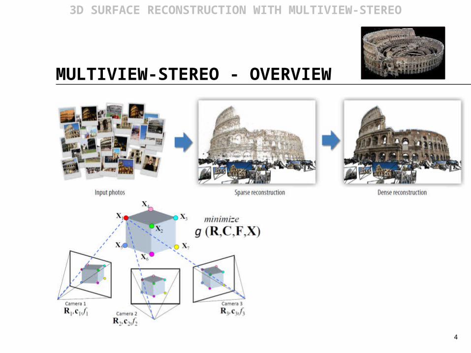
MULTIVIEW-STEREO - OVERVIEW
4
3D SURFACE RECONSTRUCTION WITH MULTIVIEW-STEREO

STEP 1 – IMAGE ACQUISITION
5
3D SURFACE RECONSTRUCTION WITH MULTIVIEW-STEREO

STEP 2 – FEATURE DETECTION
6
3D SURFACE RECONSTRUCTION WITH MULTIVIEW-STEREO

STEP 3 – FEATURE MATCHING
7
3D SURFACE RECONSTRUCTION WITH MULTIVIEW-STEREO
- From pairwise matches a network (graph) of image matches is obtained
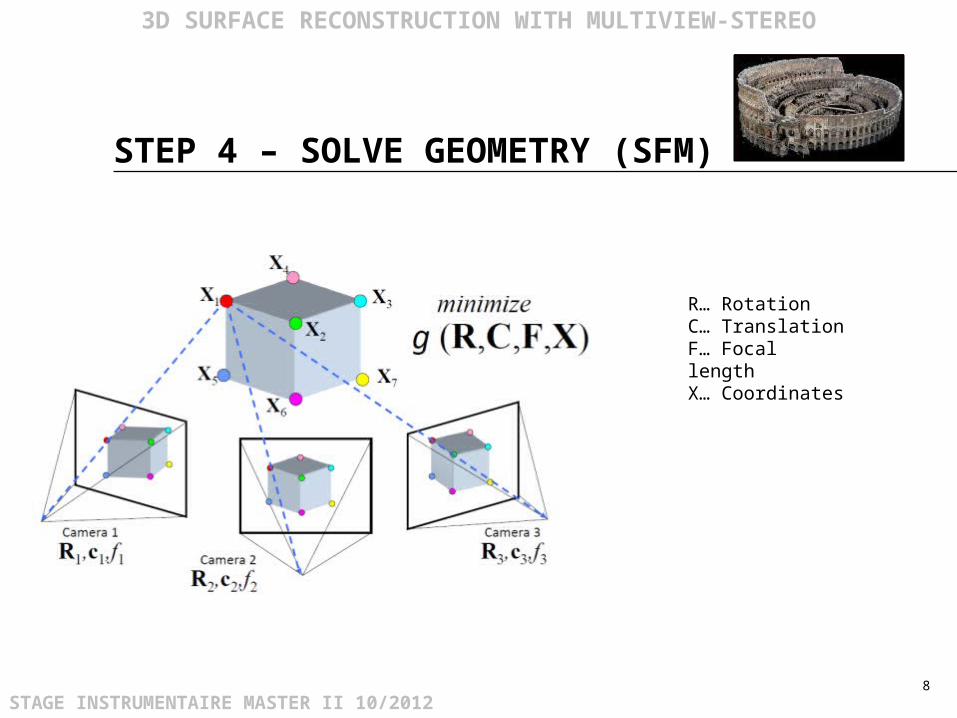
STEP 4 – SOLVE GEOMETRY (SFM)
8
3D SURFACE RECONSTRUCTION WITH MULTIVIEW-STEREO
STAGE INSTRUMENTAIRE MASTER II 10/2012
R… RotationC… TranslationF… Focal lengthX… Coordinates

STEP 4 – SOLVE GEOMETRY (SFM)
9
3D SURFACE RECONSTRUCTION WITH MULTIVIEW-STEREO
Sparse point cloud and camera views

STEP 4 – SOLVE GEOMETRY (SFM)
10
3D SURFACE RECONSTRUCTION WITH MULTIVIEW-STEREO

STEP 5 – DENSE MATCHING
11
3D SURFACE RECONSTRUCTION WITH MULTIVIEW-STEREO
Patch-wise iteration of 3D point generation (computational intensive!)

STEP 5 – DENSE MATCHING
12
3D SURFACE RECONSTRUCTION WITH MULTIVIEW-STEREO
Patch-wise iteration of 3D point generation (computational intensive!)
Point-cloud
Surface-mesh
Textured model

FURTHER STEPS
13
3D SURFACE RECONSTRUCTION WITH MULTIVIEW-STEREO
STAGE INSTRUMENTAIRE MASTER II 10/2012
Scaling and georeferencing
Comparison with LiDAR

THAT’S ALL FOLKS!
PRACTICALS?
Barcelonnette10/2012


![Multiview Photometric Stereo using Planar Mesh Parameterization · multiview stereo (MVS) [18], it is nowadays possible to re-construct 3D models for many challenging scenes. These](https://static.documents.pub/doc/80x56/60401a6a5c9293465463f3ca/multiview-photometric-stereo-using-planar-mesh-parameterization-multiview-stereo.jpg)


