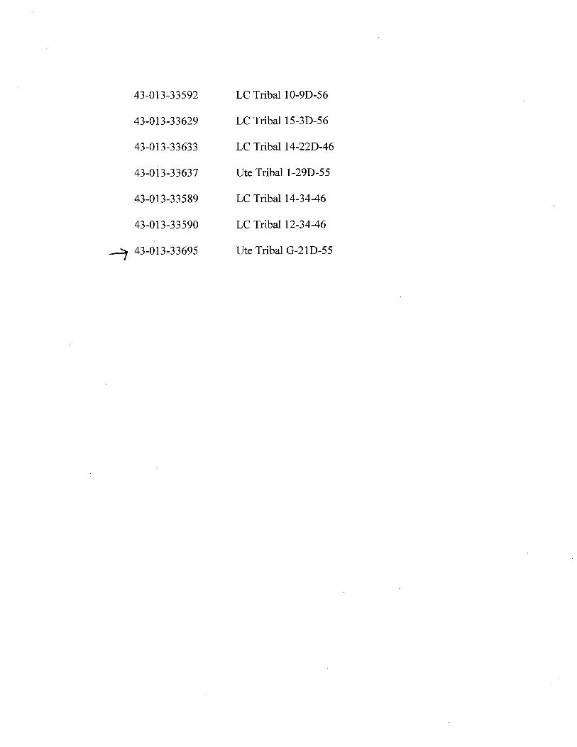
O O Berry Petroleum Company Brundage Canyon Field y , 2007 4000 South 4028 West Route 2 Box 7735 State of Utah Roosevelt, UT 84066 Department of Natural Resources Ph. (435) 722-1325 Division of Oil, Gas, and Mining Fax: (435) 722-1321 1594 West North Temple, Suite 1210 www.bry.com Box 145801 Salt Lake City, Utah 84114-5801 Re: Oil and Gas Conservation General Rules R649-3-3 Exception to Location and Siting of Wells. Ute Tribal No. G-21D-55 Gentlemen: Berry Petroleum Company is proposing to drill a development well based on a 20 acre development plan in the Brundage Canyon Field, Duchesne County, Utah. The well is located on lands within the Uintah and Ouray Ute Indian Reservation. A copy of the Federal Application for Permit to Drill (APD) is attached for your review. This APD has been submitted to the Bureau of Land Management (BLM) in Vernal and the Bureau of Indian Affairs (BIA) at Ft. Duchesne. As shown on the attached staking plat, the proposed location for the Ute Tribal No. G-21D-55 falls outside of the allowed standard well spacing (R649-3-2) which is currently 40 acres. Berry is requesting an exception to the spacing requirement per regulation R649-3-3 for the sole purpose of improving total hydrocarbon recovery through the improved reservoir efficiency that 20 acre well spacing will provide. The G-21D-55 well will share the surface location with the 4-21D-55 well. The chosen surface location is a function of topography and the proximity of neighboring facilities in an effort to severely reduce or totally eliminate surface disturbance. In accordance with R649-3-3, Berry is providing a copy of the staking plat showing the proposed location in relation to the allowed spacing "window" and all tracts contacted by a circle with a radius of 460'. A second plat is also attached showing the actual or recently proposed location for all direct or diagonal offsetting wells. As to the 460' radius circle, Berry is also the owner of all adjacent 1/4 1/4 sections surrounding the proposed well. Berry is requesting approval of this excepted location as proposed. If additional information is required, please contact Dan Anderson at (303) 825-3344. Sincerely, RECEIVED Shelley E. C zier JUN 1 5 2007 Regulatory & Permitting Specialist enclosures DIV.0FOIL, GAS&MINING Corporate Headquarters - 5201 Truxtun Ave., Ste. 300 • Bakersfield, CA 93309-0640 •
Transcript
O OBerry Petroleum Company
Brundage Canyon Field
y , 2007 4000 South 4028 WestRoute 2 Box 7735
State of UtahRoosevelt, UT 84066
Department of Natural Resources Ph. (435) 722-1325
Division of Oil, Gas, and Mining Fax: (435) 722-1321
1594 West North Temple, Suite 1210 www.bry.com
Box 145801Salt Lake City, Utah 84114-5801
Re: Oil and Gas Conservation General RulesR649-3-3 Exception to Location and Siting of Wells.Ute Tribal No. G-21D-55
Gentlemen:
Berry Petroleum Company is proposing to drill a development well based on a 20 acredevelopment plan in the Brundage Canyon Field, Duchesne County, Utah. The well is locatedon lands within the Uintah and Ouray Ute Indian Reservation. A copy of the FederalApplication for Permit to Drill (APD) is attached for your review. This APD has been submittedto the Bureau of Land Management (BLM) in Vernal and the Bureau of Indian Affairs (BIA) atFt. Duchesne.
As shown on the attached staking plat, the proposed location for the Ute Tribal No. G-21D-55falls outside of the allowed standard well spacing (R649-3-2) which is currently 40 acres. Berryis requesting an exception to the spacing requirement per regulation R649-3-3 for the solepurpose of improving total hydrocarbon recovery through the improved reservoirefficiency that 20 acre well spacing will provide. The G-21D-55 well will share the surfacelocation with the 4-21D-55 well. The chosen surface location is a function of topographyand the proximity of neighboring facilities in an effort to severely reduce or totallyeliminate surface disturbance.
In accordance with R649-3-3, Berry is providing a copy of the staking plat showing the proposedlocation in relation to the allowed spacing "window" and all tracts contacted by a circle with aradius of 460'. A second plat is also attached showing the actual or recently proposed locationfor all direct or diagonal offsetting wells. As to the 460' radius circle, Berry is also the ownerof all adjacent 1/4 1/4 sections surrounding the proposed well.
Berry is requesting approval of this excepted location as proposed. If additional information isrequired, please contact Dan Anderson at (303) 825-3344.
Sincerely,
RECEIVEDShelley E. C zier JUN1 52007Regulatory & Permitting Specialist
DEPARTMENT OF NATURALRESOURCESDIVISION OF OIL, GAS AND MINING AMENDED REPORT
(highlight changes)
APPLICATION FOR PERMIT TO DRILL "4N-E2ROA6E2AEN20 6. SURFANCE:lAN
7. IF INDIAN,ALLOTTEEOR TRIBE NAME:1A. TYPE OF WORK: DRILL REENTER Q DEEPEN UTE
8. UNIT or CA AGREEMENT NAME:B. TYPE OF WELL: OIL GAS OTHER SINGLE ZONE MULTIPLEZONE UTU-769652. NAMEOFOPERATOR: 9.WELLNAMEandNUMBER:
BERRY PETROLEUM COMPANY UTE TRIBAL G-21D-553. ADDRESS OF OPERATOR: PHONE NUMBER: 10. FIELD AND POOL, OR WILDCAT:
RT. 2 BOX 7735 CITY ROOSEVELT STATE UTAHZIP 84066 (435)722-1325 BRUNDAGE CANYON4. LOCATION OF WELL (FQO4A E
y -y q§ ý go-03(o§T 'l -//0. £/593/ Û " MERR/IQTRSECTION, TOWNSHIP, RANGE,
AT SURFACE: 995' FNL, 1133' FWL y NAD 27 (NWINW)64 VOÍ -//0/-/
40.036528 LAT SEC. 21, T.5S., R.5W.AT PROPOSED PRODUCING ZONE: (SEINW) 1416' FNL, 1373' FWL 110.456903 LONG U.S.B.&M.
14. DISTANCE IN MILES AND DIRECTION FROM NEAREST TOWN OR POST OFFICE: 12. COUNTY: 13. STATE:
29.1 MILES FROM MYTON, UTAH DUCHESNE | UTAH15. DISTANCE TO NEAREST PROPERTY OR LEASE LINE (FEET) 16. NUMBER OF ACRES IN LEASE: 17. NLMBER OF ACRES ASSIGNED TO THIS WELL:
995' 640 4018. DISTANCE TO NEAREST WELL (DRILLING,COMPLETED, OR 19. PROPOSED DEPTH: 20. BOND DESCRIPTION:
APPLIED FOR) ON THIS LEASE (FEET)1000' 6200' RLBOOO5651
21. ELEVATIONS (SHOW WHETHER DF, RT, GR, ETC.): 22. APPROXIMATE DATE WORK WILL START: 23. ESTIMATED DURATION:
7335' GR REFER TO BPC SOP PLAN REFER TO BPC SOP PLAN
24. PROPOSED CASING ANDCEMENTINGPROGRAMSIZE OF HOLE CASING SIZE, GRADE, AND WEIGHT PER FOOT SETTING DEPTH CEMENT TYPE, QUANTITY, YIELD,AND SLURRY WEIGHT
I I iI i ii i i
REFER TO BERRY PETROLEUM COMPANY SOP'S DRILLING PROGRAMICASING DESIGN
25. ATTACHMENTS
VERIFY THE FOLLOWING ARE ATTACHED IN ACCORDANCE WITH THE UTAH OIL AND GAS CONSERVATION GENERAL RULES:
WELL PLAT OR MAP PREPARED BY LICENSED SURVEYOR OR ENGINEER COMPLETE DRILLINGPLAN (BPC SOP ON FILE WITH STATE)
EVIDENCE OF DIVISION OF WATER RIGHTS APPROVAL FOR USE OF WATER FORM 5, IF OPERATOR IS PERSON OR COMPANY OTHER THAN THE LEASE OWNER
NAME (PLEASE PRINT) SHELLEY E. CROZIER TITLE REGULATORY & PERMITTING SPECIALIST
SIGNATURE .. DATE 06/13/07
(This space for State use only) Approved by the/ Utah Divisionof RECElVED
API NUMBER ASSIGNED: 'Oil, Ggud Mining
JUN152007(11/2001) (See Instructions
Dat Div.0FOIL,GAS&MINW
BERRY PETROLEUM COMPANY
Brundaege Canyon Project
////
u TOR gemenwt 1 ¢2 mi 45 in- 11fŸAMLyyyprBI AVirathm 4 i alf¾ ANYT%hl AMI
BERRY PETROLEUMCOMPANYsecuoncomer T5S, R5W, U.S.B.&M• Well location, UTE TRIBAL #G-21D--55, located
os shown in the NW 1/4 NW 1/4 of Section 21,, rrees NSP°51'29"W
- 52J4.82' (Meos.) s,r ston, T5S, RSW, U.S.B.&M., Duchesne County, Utoh.BASIS OF ELEVATION
10 BENCH MARK (M67) LOCATEDIN THE SW 1/4 OF SECTION\ Lot 7 9. T5S, R4W, U.S.B.&M., TAKEN FROM THE DUCHESNESE
QUADRANGLE,UTAH, DUCHESNE COUNTY, 7,5 MINUTEQUAD.(TOPOGRAPHIC MAP) PUBLISHED BY THE UNITEDSTATES
E 1RIBAL /G-21D-55 DEPARTMENT OF THE INTERIOR, GEOLOGICALSURVEY. SAID1133' Ele . Ungraded Ground = 7JJ7'Lot 2 ELEVATIONIS MARKED ON CAP AS BEING 6097 FEET.
BASIS OF BEARINGS1373' Sott m Lot 4 BASIS OF BEARINGS IS A G.P.S. OBSERVATION.
LINETABLE Lot 5 oLINE BEARING LENGTH Lot 6 o 9
L1 S30'00'42"E 486.89'
SCALECERTIFICATE
THISIS TO CERTIFY THATTHE ABC D FROMFIELDNOTESOF ACTUAL SURVEYS MYSUPERVISION AND THAT THESA E AND JO THEBEST OF MY KNOWLEDGEANDB 'in
Lot 7 .
12
IS RED D .pRYEY R
NB955'27"W - 322182' (Meas.) set Markeastone
UNTAH ENGINEERING & ND URVEYING
LEGEND. (NAD 83) 85 SOUTH 200 EAST - VERNAL, UTAH 84078' LATITUDE= 40'02'11.36" (40.036489) (435) 789-1017LONGITUDE= 110°27'27.41" (110.457614)=
Re-Estab/ished OS Shown in the NW 1/4 NW 1/4 of Section 21,,",ise searing NB9°51'29"W- 5234.82' (Meas.) set ston, T5S, R5W, U.S.B.&M., Duchesne County, Utah.
BASIS OF ELEVATIONBENCH MARK (M67) LOCATED IN THE SW 1/4 OF SECTION
\ 9, T5S, R4W, U.S.B.&M., TAKEN FROM THE DUCHESNE SEQUADRANGLE,UTAH, DUCHESNE COUNTY, 7.5 MINUTE QUAD.(TOPOGRAPHIC MAP) PUBLISHED BY THE UNITED STATESU7E 7R/BÆ /G-21D-55 - DEPARTMENTOF THE INTERIOR, GEOLOGICALSURVEY. SA1D
1133' Elev. Ungraded Ground =7JJ7'Lot 2 ELEVATIONIS MARKED ON CAP AS BEING 6097 FEET.
BASIS OF BEARINGS1373' Bottom BASIS OF BEARINGS IS A G.P.S. OBSERVATION.
Hole
Set MarkedStone
LINETABLE Lot 5LINE BEARING LENGTH Lot 6
L1 S30'00'42"E 486.89'
SCALECERTIFICATE
THIS IS TO CERTIFYTHAT THE ABOVE PLAT WAS PREPARED FROMFIELD NOTES OF ACTUALSURVEYS MA 99W ER MYSUPERVISIONAND THAT THE SAME T TO THEBEST OF MY KNOWLEDGEAND B
NB9 55'27"W - 5223.82' (Meas.) Set Markesstone
UINTAH ENGINEERING YING(NAD 83) 85 SOUTH 200 EAST - UTAH 84078LEGEND: LATITUDE= 40'02'11.36" (40.036489) (435) 789-1017LONGITUDE= 110°27'27.41" (110.457614)= 90 SYMBOL SCALE DATE SURVEYED: DATE DRAWN:(NAD 27) 1" = 1000' 04-12-07 05-11-07
= PROPOSED WELL HEAD. LATITUDE= 40'02'11.50" (40.036528)PARTY REFERENCESLONGITUDE=
A = SECTION CORNERSRE-ESTABLISHED.(Not Set On Ground) WEATHER FILEWARM BERRYPETROLEUM
O O
SELF-CERTIFICATION STATEMENT
The following self -certification statement is provided per federal requirements dated June 15, 1988.
Please be advised that Berry Petroleum Company is considered to be the operator of the following well.
Ute Tribal G-21D-55NW 1/4,NW 1/4, 995' FNL 1133' FWL, Section 21, T. 5 S., R. 5 W., U.S.B.& M.
BHL: SE ¼, NW ¼, 1416' FNL 1373' FWLLease BIA 14-20-H62-4825Duchesne, County, Utah
Berry Petroleum Company is responsible under the terms of the lease for the operations conducted upon thelease lands.
Shelley E. CrozierRegulatory & Permitting SpecialistBerry Petroleum Company4000 South 4028 WestRoute 2, Box 7735Roosevelt, Utah 84066
O O
BERRY PETROLEUM COMPANYUte Tribal G-21D-55
Surface location NW 1/4, NW 1/4, 995' FNL 1133' FWL, Section 21, T. 5 S., R. 5 W., U.S.B.& M.BHL: SE ¼, NW ¼, 1416' FNL 1373' FWL
Duchesne County, Utah
ONSHORE ORDER NO. 1
DRILLING PROGRAM
1,2 Estimated Tops of Geological Markers and Formations Expected to Contain Water, Oil andGas and Other Minerals
Formation Depth BHL Depth SHLUinta On Surface On SurfaceGreen River 1,572' 1,580'Green River Upper Marker 2,137' 2,150'Mahogany 2,748' 2,756'Tgr3 Marker 3,788' 3,797'Douglas Creek 4,550' 4,560'*Black Shale 5,202' 5,214'*Castle Peak 5,462' 5,476'Uteland Butte Ls. 5,866' 5,876'Wasatch 6,089' 6,099'TD 6,189' 6,200'
Base of Moderately Saline 7,348' 7,309'
*PROSPECTIVE PAY
Berry is locating the well at the surface location and directionally drillingfrom this location to minimize surface disturbance and Berry will be able toutilize the existing road and pipelines in the area.
Furthermore, Berry hereby certifies that it is the sole working interest ownerwith 460 feet of the entire directional well bore and the remainder of the UteTribal section.
3 Pressure Control Equipment
PLEASE REFER TO BERRY PETROLEUM COMPANY STANDARD OPERATINGPROCEDURE (SOP VERSION: SEPTEMBER 21, 2006).
4 Proposed Casing and Cementing Program
PLEASE REFER TO BERRY PETROLEUM COMPANY STANDARD OPERATINGPROCEDURE (SOP VERSION: SEPTEMBER 21,
O OBerry Petroleum CompanyDrilling ProgramUte Tribal G-21D-55Duchesne County, UtahPage Two
5 Drilling Fluids Program
PLEASE REFER TO BERRY PETROLEUM COMPANY STANDARD OPERATINGPROCEDURE (SOP VERSION: SEPTEMBER 21, 2006).
6 Evaluation Program
PLEASE REFER TO BERRY PETROLEUM COMPANY STANDARD OPERATINGPROCEDURE (SOP VERSION: SEPTEMBER 21, 2006).
7 Abnormal Conditions
PLEASE REFER TO BERRY PETROLEUM COMPANY STANDARD OPERATINGPROCEDURE (SOP VERSION: SEPTEMBER 21, 2006).
8 Anticipated Starting Dates and Notification of Operations
PLEASE REFER TO BERRY PETROLEUM COMPANY STANDARD OPERATINGPROCEDURE (SOP VERSION: SEPTEMBER 21, 2006).
9 Other information
PLEASE REFER TO BERRY PETROLEUM COMPANY STANDARD OPERATINGPROCEDURE (SOP VERSION: SEPTEMBER 21,
O O
BERRY PETROLEUM COMPANYUte Tribal G-21D-55
Surface location NW 1/4, NW 1/4, 995' FNL 1133' FWL, Section 21, T. 5 S., R. 5 W., U.S.B.& M.BHL: SE ¼, NW ¼, 1416' FNL 1373' FWL
Duchesne County, Utah
ONSHORE ORDER NO. l
MULTI POINT SURFACE USE & OPERATIONS PLAN
1 Existing Roads
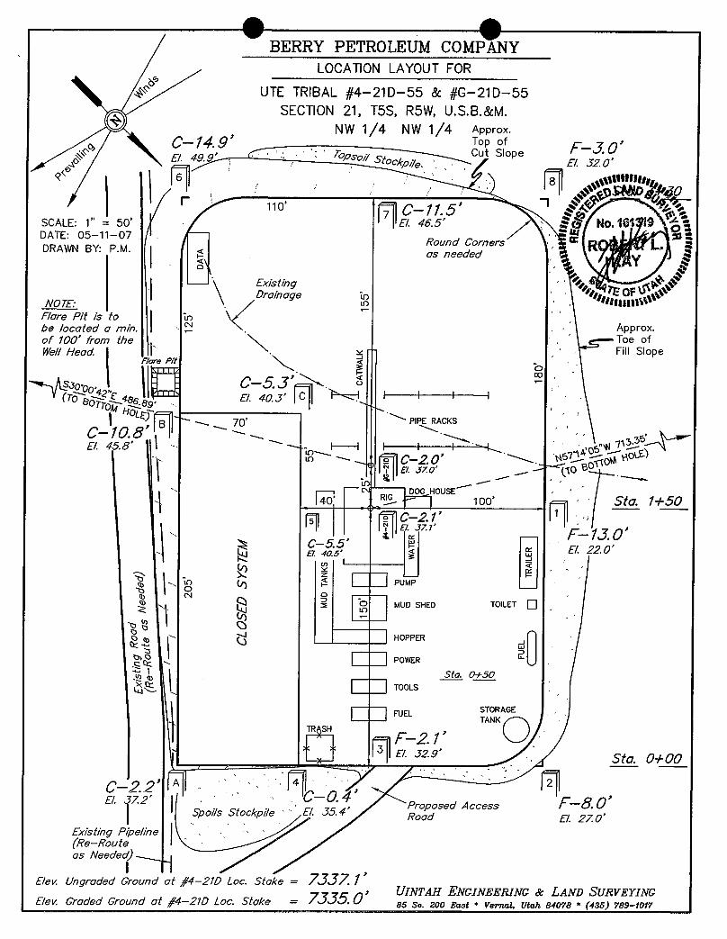
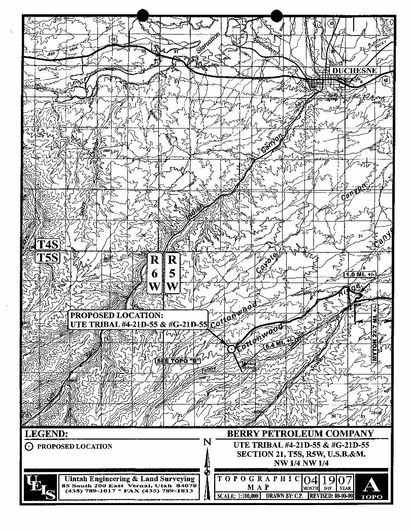
To reach the Berry Petroleum Company well, Ute Tribal G-21D-55 location, in Section 21-T5S-R5W:
Start in Myton, Utah. Proceed west on US Highway 40, 8.6 miles to the Antelope Creek/SowersCanyon Road at the Bridgeland turnoff. Turn south and proceed southwest 15.1 miles. Turn northand proceed north to the Cottowood Ridge Road and then west and south 5.4 miles to the UteTribal G-21D-55 access road. Turn east and proceed 180'+/- to the Ute Tribal G-21D-55 location.
The existing oilfield service road may need some surface material to prevent or repair holes in theroad due to heavy truck traffic during the drilling and completion operation. If repairs are made theoperator will secure material from private sources.
Please see the attached map for additional details.
2 Planned Access Road
See Topographic Map "B" for the location of the proposed access road.
3 Location of Existing Wells
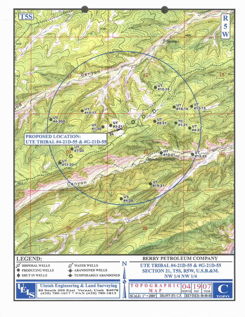
See Topographic Map "C" for the location of existing wells within a 1 mile radius.
4 Location of Tank Batteries, Production Facilities and Production Gathering and ServiceLines
PLEASE REFER TO BERRY PETROLEUM COMPANY STANDARD OPERATINGPROCEDURE (SOP VERSION: SEPTEMBER 21,
O O
Berry Petroleum CompanyMulti Point Surface Use & Operations PlanUte Tribal G-21D-55Duchesne County, UtahPage Two
5 Location and Type of Water Supply
Water for the drilling and completion will be pumped or trucked from the Berry source wellslocated in Sec. 23, T5S, R5W or Sec. 24, T5S, R5W, permit #43-11041, or from Duchesne CityCulinary Water Dock located in Sec. 1, T4S, R5W or from East Duchesne Water, Arcadia Feedlot,Sec. 28, T3S, R3W or Myton (Moon) Pit, SE/NE Sec. 27, T3S, R2W or from PetroglyphOperating Company 08-04 Waterplant, Sec. 8, T5S, R3W or from Kenneth V. & Barbara U.Richens source well located in Sec. 34, T3S, R2W, permit #43-1723 or Brundage Canyon Fieldproduced water or Leo Foy source well located in Sec. 34, T5S, R5W, permit # 43-11324. Awater use agreement is also in place with the Ute Tribe.
6 Source of Construction Materials
PLEASE REFER TO BERRY PETROLEUM COMPANY STANDARD OPERATINGPROCEDURE (SOP VERSION: SEPTEMBER 21, 2006).
7 Methods of Handling Waste Materials
PLEASE REFER TO BERRY PETROLEUM COMPANY STANDARD OPERATINGPROCEDURE (SOP VERSION: SEPTEMBER 21, 2006).
8 Ancillary Facilities
PLEASE REFER TO BERRY PETROLEUM COMPANY STANDARD OPERATINGPROCEDURE (SOP VERSION: SEPTEMBER 21, 2006).
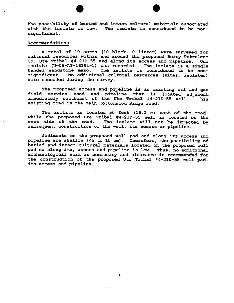
9 Wellsite Layout
The attached Location Layout diagram describes drill pad cross-sections, cuts and fills, andlocations of the mud tanks, reserve pit, pipe racks, trailer parking, spoil dirt stockpile(s) andsurface material stockpile(s)
10 Plans for Restoration of the Surface
PLEASE REFER TO BERRY PETROLEUM COMPANY STANDARD OPERATINGPROCEDURE (SOP VERSION: SEPTEMBER 21, 2006). If an Archaeological Study ispreformed, all seed mixture will match Archaeological recommendation.
11 Surface Ownership
Ute Indian Tribe
12 Other information
PLEASE REFER TO BERRY PETROLEUM COMPANY STANDARD OPERATINGPROCEDURE (SOP VERSION: SEPTEMBER 21,
O OBerry Petroleum CompanyMulti Point Surface Use & Operations PlanUte Tribal G-21D-55Duchesne County, UtahPage Three
All lease and/or unit operations will be conducted in such a manner that full compliance is madewith all applicable laws, regulations and onshore oil and gas orders. The operator is fullyresponsible for the actions of its subcontractors. A copy of these conditions will be furnished tothe field representative to ensure compliance.
The drilling permit will be valid for a period of one year from the date of approval. After permittermination, a new application will be filed for approval for any future operations.
B) Certification:
I hereby certify that I, or persons under my direct supervision, have inspected the proposed drillsiteand access route; that I am familiar with the conditions which presently exist; that the statementsmade in this plan are, to the best of my knowledge and belief, true and correct; and that the workassociated with the operations proposed herein will be performed by Berry Petroleum Companyand its contractors and subcontractors in conformity with this plan and the terms and conditionsunder which it is approved. This statement is subject to the provisions of 18 U.S.C. 1001 for thefiling of a false statement.
DA Shelley E. CrozierRegulatory & Permitting SpecialistBerry Petroleum
O O
APPLICATION FOR GRANT OF CORRIDOR RIGHT-OF-WAY
BERRY PETROLEUM COMPANY. having a resident or principal place of business at Route 2 Box 7735,
Roosevelt, Utah, 84066, hereby files an application with the Bureau of Indian Affairs, pursuant to the terms and
provisions of the Act of February 5, 1948 (62 Stat. 17; 25 U.S.C. 323), and to the regulations of the Departrnent of the
Interior contained in Title 25, Code of Federal Regulations, Part 169, for the grant of a Right-of-Way for the following
purposes and reasons:
To construct a Drill Site & Corridor Right-of-Way for the UTE TRIBAL #4-21D-55 & #G-21D-55
Across the following described Indian Lands N ½ NW 1/4 OF SECTION 21, TSS, R5W, U.S.B.&M.
Said Right-of-Way to be approximately 98.17 feet in length, 30 feet in width, and 0.068 Acres, and
more particularly described and shown on the map of definite location to be attached and made a part hereof.
The applicant understands and hereby expressly agrees to the following stipulations:
(a) To construct and maintain the Right-of-Way in a workmanlike manner.
(b) To pay promptly all damages and compensation, in addition to the deposit madepursuant to 169.4 determined by the Secretary to be due the landowners andauthorized users and occupants of the land on account of the survey, granting,construction and maintenance of the Right-of-Way.
(c) To indemnify the landowners and authorized users and occupants against anyliability for loss of life, personal injury and property damage arising from theconstruction, maintenance, occupancy or use of the lands by the applicant, hisemployees, contractors and their employees or subcontractors and their employees.
(d) To restore the lands as nearly as may be possible to their original condition uponthe completion of the construction to the extent compatible with the purpose forwhich the Right-of-Way was granted.
(e) To clear and keep clear the lands within the Right-of-Way to the extent compatiblewith the purpose of the Right-of-Way; and to dispose of all vegetative and othermaterial cut, uprooted, or otherwise accumulated during the construction andmaintenance of the project.
(f) To take soil and resource conservation and protection measures, including weedcontrol, on the land covered by the
g e(g) To do everything reasonable within its power to prevent and suppress fires on or
near the lands to be occupied under the Right-of-Way.
(h) To build and repair such roads, fences, and trails as may be destroyed or injured byconstruction work and to build and maintain necessary and suitable crossings for allroads and trails that intersect the works constructed, maintained, or operated underthe Right-of-Way.
(I) That upon revocation or termination of the Right-of-Way, the applicant shall, sofar as is reasonably possible, restore the land to its original condition.
(j) To at all times keep the Secretary informed of its address, and in case ofcorporations of the address of its principal officers.
(k) That the applicant will not interfere with the use of the lands by or under theauthority of the landowners for any purpose not inconsistent with the primarypurpose for which the Right-of-Way is granted.
IN WITNESS THEREOF, BERRY PETROLEUM COMPANY. has caused this instrument to
be executed this | Ú day of , 2007 .
/yVL4 BERRY PETROLEUM COMPANYWI ESS APPLICANT
WITNESS Ed Courtright/Production ForemanRoute 2 Box 7735Roosevelt, Utah 84066Phone:(435)722-1325
SUPPORTING DOCUMENTS:
( ) Written consent of the landowners.( ) Evidence of good faith and financial responsibility.(x) L_asper the terms of the Exploration and Development Agreement (14-20-H62-4728)( ) State certified copy of corporate charter or articles of corporation.( ) Certified copy of resolution or bylaws of the corporation authorizing the filing of the stipulation( ) State certification that the applicant is authorized to do business in the State where the land is
located.( ) Certified copy of the articles of partnership or association.(x) Map of definite location.( )
TOTAL CORRIDOR RIGHT-OF-WAY ON UTE TRIBAL LANDSTOTAL LENGTH OF RIGHT-OF-WAY IS 98.17' OR 0.019 MILES. WIDTHOF RIGHT-OF-WAY IS3D (15 PERPENDICULAR ON EACH SIDE OF THE CENTERLINE). CONTAINS 0.068 ACRESMORE OR LESS.
ENGINEER'S .AFFIDAVIT
STATE OF UTAH )SS
COUNTY OF UINTAH
ROBERT L KAY, BEING FIRST DULY SWORN DEPOSES AND STATES THAT HE IS THE REGISTERED LAND SURVEYOR,FOR BERRY PETROLEUM COMPANY, THAT THESE SURVEYS WEREMADE BY HIM (OR UNDERHIS SUPERVISION): THATHE HAS EXAMINEDTHE FIELD NOTES OF THE SURVEYS OF THE DAMAGEAREA AND CORRID pg -OF-WAY ASDESCRIBED AND SHOWN ON THIS MAP, THAT THIS MAP WAS PREPARED UNDER HIS DIRE - FIELDNOTES; AND THAT SAID RIGHT-OF-WAY, 0.019 MILES IN LENGTH BEGINNINGAND ENDI IS MAPIS ACCURATELYREPRESENTED.
li VR(ORIS ATI O. 1
S UTAH
TEOF
ACKNOWLEDGEMENT
SUBSCRIBED AND SWORN BEFORE ME THISSDAY OF , 7.
MY COMMISSIONEXPIRES ,44
NOTARY PUBLIC
TRACY0. HENUNE Î3379 East 5000 South |
Vemal, Utah 84078 i
APPLICANT'S CERTIFICATE "$°7,¾"åo*"iState of Utah a
I, ED COURTRIGHT,DO HEREBY CERTIFY THAT I AM THE AGENT FOR BERRY PETROLEUM COMPANY, HEREINAFTERDESIGNATEDTHE APPLICANT; THAT ROBERT L. KAY WHO SUBSCRIBED TO THE FOREGOING AFFIDAVIT, IS EMPLOYED BYTHE APPLICANT AS A LAND SURVEYOR AND THAT HE WAS DIRECTEDBY THE APPLICANT TO SURVEY THE LOCATIONOF THIS DAMAGEAREA AND CORRIDOR RIGHT-OF-WAY, 0.019 MILES IN LENGTH BEGINNINGAT STA. 0+00 AND ENDINGAT STA. 0+98.17, THAT SAID DAMAGE AREA AND CORRIDOR RIGHT-OF-WAY ARE ACCURATELYREPRESENTED ON THISMAP; THAT SUCH SURVEY AS REPRESENTED ON THIS MAP HAS BEEN ADOPTED BY THE APPLICANT AS THE DEFINITELOCATIONOF THE RIGHT-OF-WAY THEREBY SHOWN; AND THAT THE MAP HAS BEEN PREPARED TO BE FILED WITH THESECRETARY OF THE INTERIOR OR HIS DULY AUTHORIZEDREPRESENTATIVEAS PART OF THE APPLICATION FOR SAIDRIGHT-OF-WAY TO BE GRANTED THE APPLICANT, lTS SUCCESSORS AND ASSIGNS, WITH THE RIGHT TO CONSTRUCT,MAINTAIN,AND REPAIR IMPROVEMENTS,THEREON AND THEREOVER, FOR SUCH PURPOSES, AND WITH THE FURTHERRIGHT IN THE APPLICANT, ITS SUCCESSORS AND ASSIGNS TO TRANSFER THIS RIGHT-OF-WAY BY ASSIGNMENT, GRANT,OR OTHERWISE.
APPLICANT
PRODUCTION SUPERVISOR
e O O BERRY PE LEUM COMPANY. .
NB9°51'29"W- 52J4.82' (Meas.)
s..,,. c..,'°°"°" ""
LOCATIONDAMAGE AREA &"g,5°i.'4"".E CS
ne. 21 CORRIDOR RIGHT-OF- WAY
ON UTE TRIBAL LANDS(For UTE TRIBAL
Ute #4-21D-55 & #G-21D-55)Tribal LOCATEDIN
SECTION 21, T5S, R5W, U.S.B.&M.,DUCHESNE COUNTY, UTAH
END OF PROPOSED Utecosmoon monr-OF-WAY TribalSTA. 0+98.17(At Edge of Darnage Area)
L4 S46°03'51"W 380.00' 159.25' TO THE POINT OF BEGINNING. BASIS OF BEARINGS IS AL5 N43°56'09"W 260.00° CORRIDORRIGHT-OF-WAY DESCRIPTION G.P.S. OBSERVATION. CONTAINS 2.268 ACRES MORE OR LESS.L6 N46°03'51"E 380.00'L7 S43°56'09"E 159.25' A 30' WIDE RIGHT-OF-WAY 15' ON EACH SIDE OF THE
FOLLOWINGDESCRIBED CENTERLINE.
BEGINNING AT A POINT IN THE NE 1/4 NW 1/4 OF SECTION 21, CERTIFICATET5S, R5W, U.S.B.&M., WHICH BEARS N38°52'17"E 2200.74' FROM THIS IS TO CERT1FYTHAT THE ABO &&y EPARED FROMTHE WEST 1/4 CORNER OF SAID SECTION 21, THENCE FIELD NOTES OF ACTUAL SURVE |DER MY
RIGHT--OF-WAY LENGTHS N73'59'14"W 94.22'; THENCE N83'46'32"W 3.95' TO A POINT IN SUPERVISON AND THAT THE S CT TO THE
THE NW 1/4 NW 1/4 OF SAID SECTION 21, WHICHBEARS BEST OF MY KNOWLEDGEAN
PROPERTY OWNER FEET ACRES RODSN36°29'02"E 2163.89' FROM THE WEST 1/4 CORNER OF SAIDSECTION 21. THE SIDE LINES OF SAID DESCRIBED A = SECTION CORNERS LOCATEDUTE TRIBAL 98.17 0.068 5.95 RIGHT-OF-WAY BEING SHORTENED OR ELONGATEDTO MEET E Y
THE GRANTOR'S PROPERTY LINES. BASIS OF BEARINGS IS A A= SECTION CORNERS RE-ESTABLISHED. RE TRA . 161 19
G.P.S. OBSERVATION. CONTAINS 0.068 ACRES MORE OR LESS. (Not Set on Ground)TA OF
UmTAH ENGINEERING ti VEYlNGSet Marked Stme 1/4 Section Line
' Se c. 21 85 SOUTH - 200 EAST • (485) 789-1017
VERNAL, UTAH - 84078SCALE DATE
BASIS OF BEARINGS 1" = 300' 05-11-07
BASIS OF BEARINGS IS A G.P.S. OBSERVATION. PARTY REFERENCES
Vertical Section (ft) @ 150.32° Azm uTS L . OThe customer should only rely on this document after independently verifying all paths, targets, :oordinates, lease and hard lines
represented. Any decisions made or wells drilled utilizingthis or any other information supplied by MJIti-Shot, LLCare at the sole risk andresponsibility of the customer. Multi-Shot, LLCis not responsible for the accuracyof this schematic or the information contained
g g
Job Number: PO7-186 StatelCountry: Utah
Company: Berry Petroleum Declination:
Lease/Well: Ute Tribal G-21D-55 Grid: Referenced to True North
USm I H Location: Duchesne County File name: F:\WELLPL-1\2007\PO7180'S\PO7186\07186.SVY
Rig Name: Frontier 5 DatelTime: 16-Apr-07 I 14:51MSWWWWWWWWMMMEWRMBERES
BERRY PETROLEUMCOMPANYsecen corner TSS, RS W, U.S..B. &M Well locotion, UTE TRlBAL #G-21D-55, locatedgg*gg*" as shown in the NW 1/4 NW 1/4 of Section 21,rrees NSP°51'29"W
- 5234.82' (Meas.) s,« ston, T5S, R5W, U.S.B, &M., Duchesne County, Utah.BASIS OF ELEVATION
BENCH MARK (M87) LOCATEDIN THE SW 1/4 OF SECTIONLoi 1 9, T5S, R4W, U.S.B.&M., TAKEN FROM THE DUCHESNESE
QUADRANGLE.UTAH, DUCHESNECOUNTY, 7.5 MINUTEQUAD.(TOPOGRAPHIC MAP) PUBLISHEDBY THE UNITED STATESC/ 7R/BAL/G-21D-55 DEPARTMENT OF THE INTERIOR, GEOLOGICALSURVEY. SAID
113 'E/e . Ungraded Ground =
7337'Lot 2 ELEVATIONIS MARKED ON CAP AS BElNG 6097 FEET.
BASIS OF BEARINGSot m Lot 4 BASIS OF BEARINGSIS A G.P.S. OBSERVATION.
LINETABLE Lot 5LINE BEARING LENGTH Lot 6 ^o
L1 S30'00'42"E 486.89'
scALECERTIFICATE
7HIS IS TO CERTIFY THATTHE ABOVE D FROMFIELDNOTESOF ACTUAL SURVEYS MYSUPERVISION ANDTHATTHE SA AND 0 THEBEST OF MYKNOWLEDGEAND .a
Lot 7
NSP°55'27"W- 5223.82' (kleas.) set worked
stoneUINTAH ENGINEERING & 11RVEY1NG
(NAD 83) 85 SOUTH 200 EAST - VERNAL, UTAH 84078LEGENO: LATlTUDE= 40'02'11.36" (40.036489) (435) 789-1017LONGITUDE= 110°27'27.41" (110.457614)=
90° SYMBOL SCALE DATESURVEYED: DATEDRAWN:(NAD 27) 1" = 1000' 04-12-07 05-11-07= PROPOSED WELL HEAO. LATITUDE = 40°02'11.50" (40.036528)
Figure 2. View to north at the proposed Ute Tribal #G-21D-55 andUte Tribal #4-21D-55 well centerstakes and well padarea. - - - - - - - - - - - - - - - - - - - - - - - - 4
List of Appendices
Appendix A AIA Original Report - Berry Petroleum Company, UteTribal #4-21D-55: A Cultural Resource Inventory for awell pad, its access and pipeline, Uintah-Ouray UteReservation, Duchesne County, Utah. Utah Project NumberU-06-AY-1619(i), April 12, 2007. - - - - - - - - - - 9
Introduction
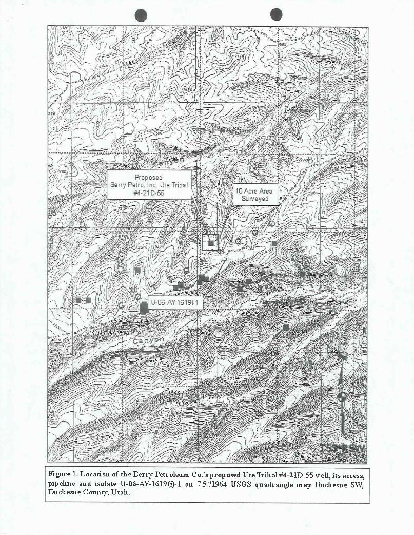
An Independent Archaeologist (AIA) was contacted by arepresentative of Berry Petroleum Co., to conduct a culturalresources investigation of the proposed Ute Tribal #G-21D-55 well,its access and pipeline. The location of the project area is inthe NW/NW 1/4 of Section 21, T5S, R5W, Duchesne County, Utah(Figure 1).
The proposed Ute Tribal #G-21D-55 well will be directionallydrilled from the existing Ute Tribal #4-21D-55 well pad. The UteTribal #4-21D-55 well was surveyed in April of 2007 by AIA(Truesdale 2007).
The proposed Ute Tribal #G-21D-55 well's centerstake(Alternate #2) footage is 995 ' FNL , 1133 ' FWL . The UniversalTransverse Mercator (UTM) centroid coordinate for the proposed UteTribal #G-21D-55 well centerstake is zone 12, North American Datum(180) 83, 5/46/309.4 mE 44/31/862.71 mN +5m.
The Ute Tribal #G-21D-55 well's proposed access and pipelineis the existing oil and gas field service road and pipeline thattrends north to south along the crest of Cottonwood ridge.
The land surface is administered by the United States, Bureauof Indian Affairs, Phoenix Area Office, Uintah-Ouray Agency, andthe Uintah-Ouray Ute tribe, Fort Duchesne, Utah. A total of 10acres (10 block, O linear) was surveyed. Fieldwork was authorizedthrough an access permit issued by the Energy and MineralsResource Division of the Uintah-Ouray Ute tribe. The fieldworkwas conducted on April 4, 2007 by AIA archaeologist JamesTruesdale and accompanied by Audie Appawoo (technician, Energy andMinerals Resource Division, Uintah-Ouray Ute tribe. All the fieldnotes and maps are located in the AIA office in Laramie, Wyoming.
File Search
A GIS file search was conducted at the Utah Division of StateHistory (UDSH), Antiquities Section, Records Division for theoriginal Ute Tribal #G-21D-55 well's Alternate #1 location wasconducted in November 14, 2006 and again on April 4, 2007. Inaddition, AIA's USGS quadrangle Duchesne SW base map was updatedfrom UDSH Records division Duchesne SW base map in November of2003 and again on February 2, 2004. The UDSH SHPO GIS file searchin November of 2006 and April of 2007 is identical. The Utah SHPOGIS files search reported six previous projects (U-02-AY-139, U-02-AY-614, U-04-1353, U-04-AY-1553, U-05-AY-1288, U-05-AY-1425)had been conducted in the general area (Section 21, T5S R5W).The files search also indicates that two sites (42DC1513,42DC2097) have been previously recorded in Section 21 of T5S R5W.Neither site is located near the present project area.
I
ProposedBerry Petro. Inc. Ute Tribal
#G-21D-55 10Acre Area_s y, Surveyecl
- - JA.
igure 1. Location of the Berry Petroleum Co.'s proposed Ute Tribal #G-21D.55 well, itsccess and pipeline on 7.591964 USGS quadran¢e map Duchesne SW, Duchesne County,
O OReview of AIA records and maps indicate that two additional
projects (U-06-AY-1619, U-06-AY-1622) had been conducted inSection 21 of T5S REW. One isolate was recorded during the surveyfor the Ute Tribal #4-21D-55 well pad (Truesdale 2007). Thismanuscript can be found in Appendix A.
Environment
Physiographically, the project is located in the Uinta Basin,approximately 25 miles southwest of Myton, Utah. The Uinta Basinis structurally the lowest part of the Colorado Plateaugeographical province (Thornbury 1965:425). The Uinta Basin is alarge, relatively flat, bowl shaped, east-west asymmetricalsyncline near the base of the Uinta Mountains (Stokes 1986:231).The topography is characteristic of sloping surfaces that inclinenorthward and are mainly dip slopes on the harder layers of GreenRiver and Uinta Formations. The terrain is characterized ashaving steep ridges and/or buttes of Uintah Formation sandstonesand clays dissected by seasonal drainages and washes with wideflat alluvial plains. The basin contains a thick section of morethan 9000 feet (2743.9 m) of early Tertiary rocks (Childs 1950).These rocks are mainly Paleocene and Eocene in age and consist ofsandstone, clay and shale lacustrine, fluviatile, and deltaiccontinental deposits, most famous of which are the lacustrineGreen River Beds.
The project area is located on Cottonwood Ridge. Portions ofthe desert hardpan and bedrock in the project area are coveredwith aeolian sand that may reach a depth of over 50 to 100centimeters in areas. Brundage Canyon drainage trends northeastapproximately 4 1/2 miles to Sowers Canyon, which trends northeast3 miles to Antelope Creek and then 10 miles north to the DuchesneRiver.
Vegetation in the project area is characteristic of aPinon/Juniper community. Species observed in the project areainclude; Pinyon pine (Pinus Edulis), juniper (JuniperusOsteosperma), curl-leaf mountain mahogany (Cercocarpusledifolius), shadscale (Atriplex confertifolia), sand sage,(Artemesia filifolia), saltbush (Atriplex nuttallii), rabbitbrush(Chrysothamnus viscidiflorus), winterfat (Eurotia lanata),greasewood (Sarcobatus baileyi), Indian ricegrass (Oryzopsishymenoides), desert needlegrass (Stipa speciosa), wild buckwheatEriogonum ovalifolium), silky lupine (Lupinus sericeus), desertglobemallow (Bromus tectorum), sky rocket (Gilia aggregata),Tansy leaved evening primrose (Oenothena tanacetifolia),Rydberg's Penstemon (Penstemon rydbergi), Stemless Hymenoxys(Hymenoxys acaulis), Sego Lily (Calochortus nuttallii),
The proposed Ute Tribal #G-21D-55 well will be directionallydrilled from the existing Ute Tribal #4-21D-55 well (Figure 2) .
The proposed Ute Tribal #G-21D-55 well centerstake (995' FNL,1133' FEL) is 17 feet (5.18 m) south and 18 feet (5.48 m) west ofthe existing Ute Tribal #4-21D-55 well centerstake (978' FNL,1151' FWL) .
The immediate Berry Petroleum Co .
' s proposed Ute Tribal #G-21D-55 well centerstake and the existing Ute Tribal #4-21D-55 wellis situated on the top (crest) and northwestern edge ofCottonwood Ridge (Figure 1) . Cottonwood Ridge is a largesouthwest to northeast trending ridge system that lies betweenCottonwood Canyon to the northwest and Tabby and Sowers Canyons tothe east. Vegetation is dominated by a low sagebrush community.
Figure 2 . View to north at the proposed Ute Tribal #G-21D-55 and UteTribal #4-21D-55 centerstakes and well pad area.
The vegetation consists of mountain mahogany, big sagebrush, budsage, buckwheat, yucca, prickly pear cactus and bunchgrasses
0 0(wheatgrass, Indian rice grass). A low sagebrush communityconsisting of sagebrush, saltbush, rabbitbrush, bunchgrasses andprickly pear cactus can be found in the open areas along the broadopen flats on top of the ridge. The undisturbed sedimentssurrounding the well pad are colluvial in nature. This colluviumconsists of shallow (< 5 to 10 an), poorly sorted, looselycompacted, tan to light brown sandy clay loam mixed with small tomedium sized flat angular pieces of sandstone. The elevation is7395.04 feet (2254.57 m) AMSL.
As mentioned ibove, the proposed Ute Tribal #G-21D-55 wellwill be directionally drilled from the existing Ute Tribal #4-21D-55 well pad. Therefore, the Ute Tribal #G-21D-55 well's proposedaccess and pipeline is the access (road) and pipeline associatedwith the Ute Tribal #4-21D-55 well pad. The Ute Tribal #4-21D-55well's access is an existing oil and gas field service road andpipeline that trends north to south through the eastern edge ofthe well pad. The access is the main Cottonwood Ridge accessroad.
The surrounding landscape exhibits exposures relatively thickledges of sandstone with thinner layers of clay and shale. Thesurrounding vegetation is dominated by a Pinion/juniper communitywith a understory of mountain mahogany, low sagebrush, yucca,bunchgrasses along the hill and ridge slopes, and low sagebrushcommunity in the ridge top flats and open parks.
Field Methods
A total of 10 acres was surveyed around the centerstake ofthe proposed Ute Tribal #G-21D-55 well location to allow forrelocation of the pad if necessary. The survey was accomplishedby walking transects spaced no more than 15 meters apart. Asmentioned earlier, the proposed Ute Tribal #G-21D-55 well will bedirectionally drilled from the existing Ute Tribal #4-21D-55 wellpad. The proposed access and pipeline is the existing access roadand pipeline located adjacent immediately southeast of the UteTribal #G-21D-55 and Ute Tribal #4-21D-55 well pad. Therefore, 0linear acres was surveyed.
Geologic landforms (rock shelters, alcoves, ridge tops andsaddles) and areas of subsurface exposure (ant hills, blowouts,rodent holes and burrow, eroding slopes and cut banks) wereexamined with special care in order to locate cultural resources(sites, isolates) and possibly help assess a site's sedimentaryintegrity and potential for the presence and/or absence of buriedintact cultural deposits. The entire surface area of ridge topswas covered. All exposures of sandstone cliff faces, alcoves orrockshelter, and talus slopes were surveyed.
When cultural materials are discovered, a more thorough
O Osurvey of the immediate vicinity is conducted in order to locateany associated artifacts and to determine the horizontal extent(surface area) of the site. If no other artifacts are locatedduring the search then the initial artifact was recorded as anisolated find. At times, isolated formal tools (typical endscrapers, projectile points) were drawn and measured. The isolatewas then described and its location plotted on a U.S.G.S.topographic map and UTM coordinates are recorded.
When sites are found an Intermountain Antiquities ComputerSystem (IMACS) form was used to record the site. At all sites,selected topographic features, site boundaries, stone tools andcultural features (hearths, foundations, trash dumps and trails)are mapped. Sites were mapped with a Brunton compass and pacingoff distances from a mapping station (datum). All debitage isinventoried using standard recording techniques (Truesdale et al1995:7) according to material type, basic flake type, and so on.Selected (mostly complete) stone tools and projectile points aredrawn and measured. All features (rock art panel(s), hearths,foundations, trash dumps and trails) are measured and described,while selected features are either drawn or photographed.
Site location data is recorded by a GARMIN Global PositioningSystem (GPS III Plus) and/or an E-Trex GPS. Site elevation andUniversal Transverse Mercator (UTM) grid data, its EstimatedPosition Error (EPE) and Dilution of Precision (DOP) wererecorded. Using the GPS data, the site location was then placedon a USGS 7.5' quadrangle map.
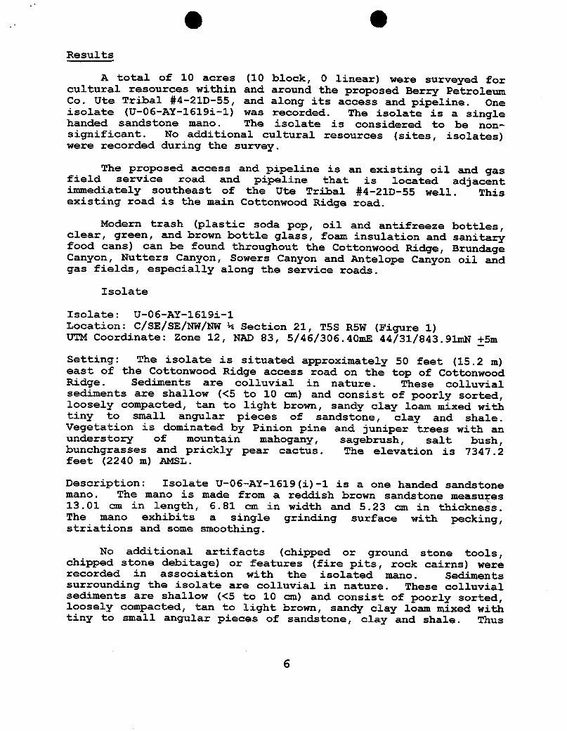
Results
A total of 10 acres (10 block, O linear) were surveyed forcultural resources within and around the proposed Berry PetroleumCo. Ute Tribal #G-21D-55, and along its access and pipeline. Theproposed Ute Tribal #G-21D-55 well will be directionally drilledfrom the existing Ute Tribal #4-21D-55 well pad. The proposedaccess and pipeline is an existing oil and gas field service roadand pipeline that is located adjacent immediately southeast of theUte Tribal #G-21D-55 and Ute Tribal #4-21D-55 well. This existingroad is the main Cottonwood Ridge road.
The Ute Tribal #4-21D-55 well was surveyed by AIA in April of2007 (Truesdale 2007). One isolate (U-06-AY-1619i-1) was recordedduring this past survey for the Ute Tribal #4-21D-55 well, itsaccess and pipeline (Truesdale 2007). The isolate is a singlehanded sandstone mano. The isolate is considered to be non-significant. A copy of this manuscript can be found in AppendixA.
No additional cultural resources (sites, isolates) wererecorded during the survey for the Ute Tribal #G-21D-55 well, or
O Oalong its access and pipeline.
Modern trash (plastic soda pop, oil and antifreeze bottles,clear, green, and brown bottle glass, foam insulation and sanitaryfood cans) can be found throughout the Cottonwood Ridge, BrundageCanyon, Nutters Canyon, Sowers Canyon and Antelope Canyon oil andgas fields, especially along the service roads.
Recommendations
A total of 10 acres (10 block, O linear) were surveyed forcultural resources within and around the proposed Berry PetroleumCo. Ute Tribal #G-21D-55, and along its access and pipeline. Theproposed Ute Tribal #G-21D-55 well will be directionally drilledfrom the existing Ute Tribal #4-21D-55 well pad. The proposedaccess and pipeline is an existing oil and gas field service roadand pipeline that is located adjacent immediately southeast of theUte Tribal #G-21D-55 and Ute Tribal #4-21D-55 well. This existingroad is the main Cottonwood Ridge road.
The Ute Tribal #4-21D-55 well was surveyed by AIA in April of2007 (Truesdale 2007). One isolate (U-06-AY-1619i-1) was recordedduring this past survey for the Ute Tribal #4-21D-55 well, itsaccess and pipeline (Truesdale 2007). The isolate is a singlehanded sandstone mano. The isolate is considered to be non-significant. A copy of this manuscript can be found in AppendixA.
The isolate is located 50 feet (15.2 m) east of the road,while the proposed Ute Tribal #4-21D-55 and Ute Tribal #G-21D-55well pad is located on the west side of the road. The isolatewill not be impacted by subsequent construction of the well, itsaccess or pipeline.
Sediments on the proposed well pad and along its access andpipeline are shallow (<5 to 10 cm). Therefore, the possibility ofburied and intact cultural materials located on the proposed wellpad or along its, access and pipeline is low. Thus, no additionalarchaeological work is necessary and clearance is recommended forthe construction of the proposed Ute Tribal #G-21D-55 well pad,its access and pipeline.
O O
REFERENCES CITED
Childs, 0.E.1950 Geologic history of the Uinta Basin, Utah Geological
and Mineralogical Survey. Guidebook to the Geology ofUtah, No. 5:49-59.
Stokes, William Lee1986 Geology of Utah. Contributions by Utah Museum of
Natural History, and the Utah Geological and MineralSurvey Department of Natural Resources. Utah Museum ofNatural History, Occasional Papers, Number 6.
Thornbury, William D.1965 Regional Geomorphology of the United States. John
Wiley & Sons, Inc.
Truesdale, James A.2007 Berry Petroleum Company, Ute Tribal #4-21D-55 well; A
Cultural Resource Inventory for a well pad, its accessand pipeline, Uintah-Ouray Ute Reservation, DuchesneCounty, Utah. Report prepared for Berry Petroleum Co.by AIA. Manuscript is on file at the AIA office inLaramie, Wyoming.
Truesdale, James A., Kathleen E. Hiatt, and Clifford Duncan1995 Cultural Resource Inventory of the Proposed Ouray
Gravel Pit Location, Uintah-Ouray Ute Reservation,Uintah County, Utah. Report prepared for U & WConstruction, Ft. Duchesne, Utah by AIA, Laramie,Wyoming.
O O
Appendix A
AIA Original ReportBerry Petroleum Company,
Ute Tribal #4-21D-55:A Cultural Resource Inventory for a well pad,
its access and pipeline,Uintah-Ouray Ute Reservation,
Duchesne County, Utah.
Utah Project Number U-06-AI-1619(i)-1April 12, 2007
Figure 1. Location of the Berry Petroleum Co.'s proposed UteTribal #4-21D-55 well, its access, pipeline and isolateU-0 6-AY-1619 (i) -1 on 7 . 5 ' /1964 USGS quadrangle mapDuchesne SW, Duchesne County, Utah. - - - - - - - - - 2
Figure 2 . View to north at the proposed Ute Tribal #4-21D-55 wellcenterstake and well pad area.- - - - - - - - - - - - 4
O OIntroduction
An Independent Archaeologist QAIA) was contacted by arepresentative of Berry Petroleum Co., to conduct a culturalresources investigation of the proposed Ute Tribal #4-21D-55 well,its access and pipeline. The location of the project area is inthe NW/NW 1/4 of Section 21, T5S, R5W, Duchesne County, Utah(Figure 1).
The proposed Ute Tribal #4-21D-55 well's centerstakeQAlternate #2) footage is 978' FNL, 1151' FEL. The Universal
Transverse Mercator (UTM) centroid coordinate for the proposed UteTribal #4-21D-55 well centerstake is Zone 12, North American DatumOR.ND) 83, 5/46/148.27 mE 44/31/855.79 mN +5m.
The Ute Tribal #4-21D-55 well's proposed access and pipelineis the existing oil and gas field service road and pipeline thattrends north to south along the crest of Cottonwood ridge.
The land surface is administered by the United States, Bureauof Indian Affairs, Phoenix Area Office, Uintah-Ouray Agency, andthe Uintah-Ouray Ute tribe, Fort Duchesne, Utah. A total of 10acres (10 block, O linear) was surveyed. Fieldwork was authorizedthrough an access permit issued by the Energy and MineralsResource Division of the Uintah-Ouray Ute tribe. The fieldworkwas conducted on April 3, 2007 by AIA archaeologist JamesTruesdale and accompanied by Audie Appawoo (technician, Energy andMinerals Resource Division, Uintah-Ouray Ute tribe. All the fieldnotes and maps are located in the AIA office in Laramie, Wyoming.
File Search
A GIS file search was conducted at the Utah Division of StateHistory (GDSH), Antiquities Section, Records Division for theoriginal Ute Tribal #4-21D-55 well's Alternate #1 location wasconducted in November 14, 2006. In addition, AIA's USGS quadrangleDuchesne SW base map was updated from UDSH Records divisionDuchesne SW base map in November of 2003 and again on February 2,2004. The UDSH SHPO GIS file search reported six previousprojects (U-02-AY-139, U-02-AY-614, U-04-1353, U-04-AY-1553, U-05-AY-1288, U-05-AY-1425) had been conducted in the general area(Section 21, T5S R5W). The files search also indicates that twosites (42DC1513, 42DC2097) have been previously recorded inSection 21 of T5S R5W. Neither site is located near the presentproject area.
Environment
Physiographically, the project is located in the Uinta Basin,approximately 25 miles southwest of Myton, Utah. The Uinta Basin
e e
Proposeclr o Dc5UteTri
e Area
U-06-AY-1619 I.
- Î -
- ,
i
Figure 1. Location of the Rerry Petroleum Co.'s proposed Ute Tribal #4-21D-55 well, its access,pipeline and isolate U-06-AY-1619(i)-1on 7.5'!1964 USGS quadrangle map Duchesne SW,Duchesne County,
Ois structurally the lowest part of the Colorado Plateaugeographical province (Thornbury 1965:425). The Uinta Basin is alarge, relatively flat, bowl shaped, east-west asymmetricalsyncline near the base of the Uinta Mountains (Stokes 1986:231).The topography is characteristic of sloping surfaces that inclinenorthward and are mainly dip slopes on the harder layers of GreenRiver and Uinta Formations. The terrain is characterized ashaving steep ridges and/or buttes of Uintah Formation sandstonesand clays dissected by seasonal drainages and washes with wideflat alluvial plains. The basin contains a thick section of morethan 9000 feet (2743.9 m) of early Tertiary rocks (Childs 1950).These rocks are mainly Paleocene and Eocene in age and consist ofsandstone, clay and shale lacustrine, fluviatile, and deltaiccontinental deposits, most famous of which are the lacustrineGreen River Beds.
The project area is located on Cottonwood Ridge. Portions ofthe desert hardpan and bedrock in the project area are coveredwith aeolian sand that may reach a depth of over 50 to 100centimeters in areas. Brundage Canyon drainage trends northeastapproximately 4 1/2 miles to Sowers Canyon, which trends northeast3 miles to Antelope Creek and then 10 miles north to the DuchesneRiver.
Vegetation in the project area is characteristic of aPinon/Juniper community. Species observed in the project areainclude; Pinyon pine (Pinus Edulis), juniper (JuniperusOsteosperma), curl-leaf mountain mahogany (Cercocarpusledifolius), shadscale (Atriplex confertifolia), sand sage,(Artemesia filifolia), saltbush (Atriplex nuttallii), rabbitbrush(Chrysothamnus viscidiflorus), winterfat (Eurotia lanata),
The immediate Berry Petroleum Co.'s proposed Ute Tribal #4-21D-55 well is situated on the top (crest) and northwestern edgeof Cottonwood Ridge (Figure 1) . Cottonwood Ridge is a largesouthwest to northeast trending ridge system that lies betweenCottonwood Canyon to the northwest and Tabby and Sowers Canyons tothe east. Vegetation is dominated by a low sagebrush community.The vegetation consists of mountain mahogany, big sagebrush, bud
O Osage, buckwheat, yucca, prickly pear cactus and bunchgrasses(wheatgrass, Indian rice grass). Alow sagebrush community
consisting of sagebrush, saltbush, rabbitbrush, bunchgrasses andprickly pear cactus can be found in the open areas along the broadopen flats on top of the ridge. The undisturbed sedimentssurrounding the well pad are colluvial in nature . This colluviumconsists of shallow (< 5 to 10 cm) , poorly sorted, looselycompacted, tan to light brown sandy clay loam mixed with small tomedium sized flat angular pieces of sandstone. The elevation is7395.04 feet (2254.57 m) AMSL.
Figure 2 . View to north at the proposed Ute Tribal #4-21D--55
centerstake and well pad area.
The Ute Tribal #4-21D--55 well' s access is an existing oil andgas field service road and pipeline that trends north to souththrough the eastern edge of the well pad. The access is the mainCottonwood Ridge access road.
The surrounding landscape exhibits exposures relatively thickledges of sandstone with thinner layers of clay and shale. Thesurrounding vegetation is dominated by a Pinion/ juniper communitywith a understory of mountain mahogany, low sagebrush, yucca,bunchgrasses along the hill and ridge slopes, and low sagebrushcommunity in the ridge top flats and open parks
O O
Field Methods
A total of 10 acres was surveyed around the centerstake ofthe proposed Ute Tribal #4-21D-55 well location to allow forrelocation of the pad if necessary. The survey was accomplishedby walking transects spaced no more than 15 meters apart. Theproposed access and pipeline is the existing access road andpipeline located adjacent immediately southeast of the Ute Tribal#4-21D-55 well. Therefore, 0 linear acres was surveyed.
Geologic landforms (rock shelters, alcoves, ridge tops andsaddles) and areas of subsurface exposure (ant hills, blowouts,rodent holes and burrow, eroding slopes and cut banks) wereexamined with special care in order to locate cultural resources(sites, isolates) and possibly help assess a site's sedimentaryintegrity and potential for the presence and/or absence of buriedintact cultural deposits. The entire surface area of ridge topswas covered. All exposures of sandstone cliff faces, alcoves orrockshelter, and talus slopes were surveyed.
When cultural materials are discovered, a more thoroughsurvey of the immediate vicinity is conducted in order to locateany associated artifacts and to determine the horizontal extent(surface area) of the site. If no other artifacts are locatedduring the search then the initial artifact was recorded as anisolated find. At times, isolated formal tools (typical endscrapers, projectile points) were drawn and measured. The isolatewas then described and its location plotted on a U.S.G.S.topographic map and UTM coordinates are recorded.
When sites are found an Intermountain Antiquities ComputerSystem (IMACS) form was used to record the site. At all sites,selected topographic features, site boundaries, stone tools andcultural features (hearths, foundations, trash dumps and trails)are mapped. Sites were mapped with a Brunton compass and pacingoff distances from a mapping station (datum) . All debitage isinventoried using standard recording techniques (Truesdale e_t al1995:7) according to material type, basic flake type, and so on.Selected (mostly complete) stone tools and projectile points aredrawn and measured. All features (rock art panel(s), hearths,foundations, trash dumps and trails) are measured and described,while selected features are either drawn or photographed.
Site location data is recorded by a GARMIN Global PositioningSystem (GPS III Plus) and/or an E-Trex GPS. Site elevation andUniversal Transverse Mercator (UTM) grid data, its EstimatedPosition Error (EPE) and Dilution of Precision (DOP) wererecorded. Using the GPS data, the site location was then placedon a USGS 7.5' quadrangle map.
O OResults
A total of 10 acres (10 block, 0 linear) were surveyed forcultural resources within and around the proposed Berry PetroleumCo. Ute Tribal #4-21D-55, and along its access and pipeline. Oneisolate (U-06-AY-1619i-1) was recorded. The isolate is a singlehanded sandstone mano. The isolate is considered to be non-significant. No additional cultural resources (sites, isolates)were recorded during the survey.
The proposed access and pipeline is an existing oil and gasfield service road and pipeline that is located adjacentimmediately southeast of the Ute Tribal #4-21D-55 well. Thisexisting road is the main Cottonwood Ridge road.
Modern trash (plastic soda pop, oil and antifreeze bottles,clear, green, and brown bottle glass, foam insulation and sanitaryfood cans) can be found throughout the Cottonwood Ridge, BrundageCanyon, Nutters Canyon, Sowers Canyon and Antelope Canyon oil andgas fields, especially along the service roads.
Isolate
Isolate: U-06-AY-1619i-1Location: C/SE/SE/NW/NW ¼ Section 21, T5S R5W (Figure 1)UTM Coordinate: zone 12, NAD 83, 5/46/306.40mE 44/31/843.91mR +_5m
Setting: The isolate is situated approximately 50 feet (15.2 m)east of the Cottonwood Ridge access road on the top of CottonwoodRidge. Sediments are colluvial in nature. These colluvialsediments are shallow (<5 to 10 cm) and consist of poorly sorted,loosely compacted, tan to light brown, sandy clay loam mixed withtiny to small angular pieces of sandstone, clay and shale.Vegetation is dominated by Pinion pine and juniper trees with anunderstory of mountain mahogany, sagebrush, salt bush,bunchgrasses and prickly pear cactus. The elevation is 7347.2feet (2240 m) AMSL.
Description: Isolate U-06-AY-1619(i)-1 is a one handed sandstonemano. The mano is made from a reddish brown sandstone measuyes13.01 am in length, 6.81 cm in width and 5.23 cm in thickness.The mano exhibits a single grinding surface with pecking,striations and some smoothing.
No additional artifacts (chipped or ground stone tools,chipped stone debitage) or features (fire pits, rock cairns) wererecorded in association with the isolated mano. Sedimentssurrounding the isolate are colluvial in nature. These colluvialsediments are shallow (<5 to 10 cm) and consist of poorly sorted,loosely compacted, tan to light brown, sandy clay loan mixed withtiny to small angular pieces of sandstone, clay and shale. Thus
O Othe possibility of buried and intact cultural materials associatedwith the isolate is low. The isolate is considered to be non-significant.
Recommendations
A total of 10 acres (10 block, 0 linear) were surveyed forcultural resources within and around the proposed Berry PetroleumCo. Ute Tribal #4-21D-55 and along its access and pipeline. Oneisolate (U-06-AY-1619i-1) was recorded. The isolate is a singlehanded sandstone mano. The isolate is considered to be non-significant. No additional cultural resources (sites, isolates)were recorded during the survey.
The proposed access and pipeline is an existing oil and gasfield service road and pipeline that is located adjacentimmediately southeast of the Ute Tribal #4-21D-55 well. Thisexisting road is the main Cottonwood Ridge road.
The isolate is located 50 feet (15.2 m) east of the road,while the proposed Ute Tribal #4-21D-55 well is located on thewest side of the road. The isolate will not be impacted bysubsequent construction of the well, its access or pipeline.
Sediments on the proposed well pad and along its access andpipeline are shallow (<5 to 10 en). Therefore, the possibility ofburied and intact cultural materials located on the proposed wellpad or along its, access and pipeline is low. Thus, no additionalarchaeological work is necessary and clearance is recommended forthe construction of the proposed Ute Tribal #4-21D-55 well pad,its access and pipeline.
O OBERRY PETROLEUM COMPANYUTE TRIBAL #4-21D-55 & #G-21D-55
LOCATED IN DUCHESNE COUNTY, UTAHSECTION 21, T5S, R5W, U.S.B.&M.
PHOTO: VIEW FROM CORNER #5 TO LOCATION STAKE CAMERA ANGLE: NORTHWESTERLY
PHOTO: VIEW FROM BEGINNING OF PROPOSED ACCESS CAMERA ANGLE: NORTHWESTERLY
Uintah Engineering & Land Surveying LOCATIONPHOTOS 04 19 07 PHOTO85 South 200 East Vemal. Utah 84078 10 DAY YEAR
sHUT [N WELLS # TEMPORARILY ABANDONED NW 1/4 NW 1/4E, Uintah Engineering & Land Surveying TOPOGR A PH I c 04 19 0785 South 200 East Vernal, Utah 84078 I A Ÿ MONTH DAY YEAR
Oil Shale 190-5 (B) or 190-3 or 190-13 Siting:460 From Qtr/Qtr & 920'Between Wells
// Water Permit \A R649-3-3. Exception
(No. 43-11041 )Drilling UnitLÁ RDCC Review (Y/N)
Board Cause No:(Date: ) Eff Date:
AUS Fee Surf Agreement (Y/N) Siting:
AÁ)9 Intent to Commingle (Y/N) R649-3-11. Directional Drill
COMMENTS:
STIPULATIONS:
TSS R5W
unnuna2-21 55 e TABBY
CANYON 1-28
+21D 55
K RUBR UK RUBR2oss • RUBR 21D 55 +22-55 e
TRIBM G-21D55
BHLG-2tDES
E2 2tD 55
UK BUBR25 10 21-55 e UIE
5-22D55
BRUNDAGE CANYON FIELD
UTE BUBAL15-22-55 e
28-55 eun:-2s
OPERATOR: BERRY PETRO CO (N2480)
SEC: 21 T.5S R. 5W
FIELD: BRUNDAGE CANYON (72)
COUNTY: DUCHESNE
SPACING:R649-3-11/DIRECTIONALDRILLING µ ECTIGOEN Utah 00 Gas and Maagx LOCATION ABANDONEDe NEW LOCATION
Field Status Unit Status e- PLUGGED & ABANDONEDABANDONED EXPLORATORY «_ PRODUCING GASACTIVE GAS STORAGE i PRODUCING OIL
NF PP OIL & SHUT-IN GASCOMBINED NFSECONDARY ÷ SHUT-INOIL W EINACTIVE N ING
)s( TEMP.ABANDONEDPROPOSED
5 o TEST WELL
r TR TED OTHERML & WATER INJECTION SPP OIL g WATER SUPPLY PREPARED BY: DIANA MASONSECONDARY WATER DISPOSAL DATE: 18-JUNE-2007TERMINATED
StategUtahDEPARTMENT OF NATURAL RESOURCES
MICHAEL R. STYLER. ExecutiveDirector
JON M. HUNTSMAN, JR.ÛÎVÎSion of Oil Gas and Mining
Governor JOHN R. BAZA, June 18, 2007
Division DirectorGARY R. HERBERTLieutenant Governor
Berry Petroleum CompanyRt. 2, Box 7735Roosevelt, UT 84066
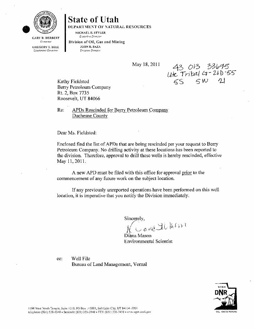
Re: Ute Tribal G-21D-55 Well, Surface Location 995' FNL, 1133' FWL, NW NW, Sec. 21,T. 5 South, R. 5 West, Bottom Location 1416' FNL, 1373' FWL, SE NW, Sec. 21,T. 5 South, R. 5 West, Duchesne County,Utah
Gentlemen:
Pursuant to the provisions and requirements of Utah Code Ann.§ 40-6-1 et seq., UtahAdministrative Code R649-3-1 et seq., and the attached Conditions of Approval, approval to drillthe referenced well is granted.
Appropriate information has been submitted to DOGM and administrative approval ofthe requested exception location is hereby granted.
This approval shall expire one year from the above date unless substantial and continuousoperation is underway, or a request for extension is made prior to the expiration date. The APIidentification number assigned to this well is 43-013-33695.
Sincerely,
Gil HuntAssociate Director
pabEnclosures
cc: Duchesne County AssessorBureau of Land Management, Vernal Office
Operator: Berry Petroleum CompanyWell Name & Number Ute Tribal G-21D-55
API Number: 43-013-33695Lease: 14-20-H62-4825
Surface Location: NW NW See. 21 T. 5 South R. 5 WestBottom Location: SE NW Sek. 21 T. 5 South IL 5 West
Conditions of Approval
1. GeneralCompliance with the requirements of Utah Admin. R. 649-1 et seq., the Oil and GasConservation General Rules, and the applicable terms and provisions of the approvedApplication for permit to drill.
2. Notification RequirementsNotify the Division within 24 hours of spudding the well.• Contact Carol Daniels at (801) 538-5284
Notify the Division prior to commencing operations to plug and abandon the well.• Contact Dustin Doucet at work (801) 538-5281 home (801) 733-0983
3. Reporting RequirementsAll required reports, forms and submittals will bë promptly filed with the Division,including but not limited to the Entity Action Form (Form 6), Report of WaterEncountered During Drilling (Form 7), Weekly Progress Reports for drilling andcompletion operations, and Sundry Notices and Reports on Wells requesting approval ofchange of plans or other operational actions.
4. State approval of this well does not supersede the required federal approval, which must beobtained prior to drilling.
5. In accordance with Utah Admin. R.649-3-11, Directional Drilling, the operator shall submita complete angular deviation and directional survey report to the Division within 30 daysfollowing completion of the well.
6. This proposed well is located in an area for which drilling units (well spacing patterns) havenot been established through an order of the Board of Oil,Gas and Mining (the "Board").In order to avoid the possibility of waste or injury to correlative rights, the operator isrequested, once the well has been drilled, completed, and has produced, to analyzegeological and engineering data generated therefrom,as well as any similar data fromsurrounding areas if available. As soon as is practicable after completion of its analysis,and if the analysis suggests an area larger than the quarter-quarter section upon which thewell is located iëbeing drained, the operator is requested to seek an appropriate orderfrom the Board establishing drilling and spagingunits in confo,pnance with such analysisby filing a Request for Agency Action with the
RECEIVED- JAN87 20U o
Form 3160-3 FORM APPROVED(April2004) DIV.0FOIL,GAS&MINING OMB No. 1004-0137
UNlTED STATES Expires March 31, 2007
DEPARTMENT OF THE INTERIOR 5 Lease Serial No.
BUREAU OF LAND MANAGEMENT U 14-20-H62-4825
APPLICATION FOR PERMIT TO DRILL OR R LANDN ibndian,Allotee or Tribe Name
UTE1a. TYPE OF WORK DRILL REENTER
7 Unit or CA Agreement, Name and No.
UTU-769658 Lease Name and Well No.
1b. Type of Well: Oil well Gas well Other Single zone Multiple zone UTE TRIBAL G-21D-552. Name of Operator 9 API Well No.
BERRY PETROLEUM COMPANY3a. Address 4000 SOUTH 4028 WEST 3b. Phone No. (include are code) 10. Field and Pool, or Exploratory
RT. 2 BOX 7735, ROOSEVELT, UT. 84066 (435) 722-1325 BRUNDAGE CANYON4. Location of Well (Report location clearlyandin accordance with any State requirements *) NAD 27 11. Sec., T. R. M. or BLK. and Survey or Area
Atsurface (NWINW) 995' FNL, 1133' FWL 40.036528 LAT SEC. 21, T.5S., R.5W.Atproposedprod. zone (SEINW) 1416' FNL, 1373' FWL 110.456903 LONG U.S.B.&M.
14. Distance in miles and dircetion from nearest townor post office' 12. County or Parrish 13. State
29.1 MILES FROM MYTON, UTAH DUCHESNE UTAH15. Distance from proposed* 16. No. of acres in lease 17 Spacing Unit dedicated to this well'p°rcapLonto nessare,To.,
a 995' 640 40(Also to neaset ang. Unit ime, it any)
18. Distance from proposed* 19. Proposed Depth 20 BLMIBIABond No. on file
21. Elevations (Show whether DF, KDB, RT, GR, etc.) 22. Approximate date work willstart* 23. Estimated duration
7335' GR REFER TO BPC SOP PLAN REFER TO BPC SOP PLAN
24. AttachmentsThe following, completed in accordance with the requirements of Onshore Oiland Gas Order No. 1, shall be attached to this form:
1. Well plat certifiedby a registered surveyor. 4. Bond to cover the operations unless covered by an existing bond on file (see2. A Drilling Plan. ' item 20 above.3. A Surface Use Plan (if the location is on National Forest System Lnads, the 5. Operator certification.
SUPO shall be filed with the appropriateForest Service Office). 6. Such other site specific information and/or plans as may be requiredby theauthorizedofficer.
2TtleSignature Name(PrinteSH14LEYE. CROZIER
Date
06/13/07
REGULATORY & PERMITTINGS ECIALISTApproved by ( natrue) Name {Printed/Typed) Date
Application approvaldo t r t a he a paCnholds legal or equitable titleto those rights in the subject lease which would entitlethe allicant to ,
conductoperations thereonConditions of approval, if any, are attached.
Title 1&U.SC. Section 1001 and Title 43 U.S.C. Section 1212. make it a crime for any person knowingly and willfully to make to any department or agency of the UnitedStates any false, fictitious or fraudulent statements or representations as to any matter within its jurisdiction.
Title Name Office Phone Number Cell Phone NumberPetroleum Engineer: Matt Baker (435) 781-4490 (435) 828-4470Petroleum Engineer: Michael Lee (435) 781-4432 (435) 828-7875Petroleum Engineer: James Ashley (435) 781-4470 (435) 828-7874Petroleum Engineer: Ryan Angus (435) 781-4430 (435) 828-7368Supervisory Petroleum Technician: Jamie Sparger (435) 781-4502 (435) 828-3913NRS/Enviro Scientist: Paul Buhler (435) 781-4475 (435) 828-4029NRS/Enviro Scientist: KarlWright (435) 781-4484 (435) 828-7381NRS/Enviro Scientist: HollyVilla (435) 781-4404NRS/Enviro Scientist: (435) 781-4476NRS/Enviro Scientist: Chuck MacDonald (435) 781-4441 (435) 828-7481NRS/Enviro Scientist: Jannice Cutler (435) 781-3400 (435) 828-3544NRS/Enviro Scientist: Michael Cutler (435) 781-3401 (435) 828-3546NRS/Enviro Scientist: Anna Figueroa (435) 781-3407 (435) 828-3548NRS/Enviro Scientist: Verlyn Pindell (435) 781-3402 (435) 828-3547NRS/Enviro Scientist: Darren Williams (435) 781-4447NRS/Enviro Scientist: Nathan Packer (435) 781-3405 (435) 828-3545
Fax: (435) 781-3420
A COPY OF THESE CONDITIONS SHALL BE FURNISHED TO YOURFIELD REPRESENTATIVE TO INSURE COMPLIANCE
All lease and/or unit operations are to be conducted in such a manner that full compliance is made with theapplicable laws, regulations (43 CFR Part 3160), and this approved Application for Permit to Drill includingSurface and Downhole Conditions of Approval. The operator is considered fully responsible for the actions ofhis subcontractors. A copy of the approved APD must be on location during construction, drilling, andcompletion operations. This permit is approved for a two (2) year period, or until lease expiration,whichever occurs first. An additional extension, up to two (2) years, may be applied for by sundrynotice prior to expiration.
NOTIFICATION REQUIREMENTS
Construction Activity - The Ute Tribe Energy & Minerals Dept. shall be notified inwriting48 hours in advance of any construction activity. TheUte Tribal office is open Monday throughThursday.
Construction Completion - Upon completion of the pertinent APDIROW construction,notify the Ute Tribe Energy & Minerals Dept. for a TribalTechnician to verify the Affidavit of Comgetion.
Spud Notice - Twenty-Four (24) hours prior to spudding the well.(Notify Petroleum Engineer)Casing String & Cementing - Twenty-Four (24) hours prior to running casing and cementing(Notify Supv. Petroleum Tech.) all casing strings.BOP & Related Equipment Tests - Twenty-Four (24) hours prior to initiating pressure tests.(Notify Supv. Petroleum TechFirst Production Notice - Within Five (5) business days after new well begins or(NotifyPetroleum Engineer) production resumes after well has been off production for more
than ninety (90)
Page 2 of 7Well: Ute Tribal G-21D-55
12/18/2007
SURFACE USE PROGRAMCONDITIONS OF APPROVAL (COAs)
General Surface COAs
• Ifthere is an active Gilsonite miningoperation within2 miles of the well location,operator shall notifythe Gilsonite operator at least 48 hours prior to any blasting duringconstruction.
• If paleontological materials are uncovered during construction, the operator is toimmediately stop work and contact the Authorized Officer AO. A report willbe preparedby a BLM permitted paleontologist and submitted to the AO at the completion of surfacedisturbing activities.
Specific Surface COAs
Additional Stipulations:
Paint tanks Desert Tan.
Keep pipeline away from trees.
General Conditions of Approval:
• A ifoot corridor right-of-way shall be approved. Upon completion of each pipeline incorridor, they shall be identified and filed with the Ute Tribe.
• A qualified Archaeologist accompanied by a Tribal Technician will monitor trenchingconstruction of pipeline.
• The Ute Tribe Energy & Minerals Department is to be notified, in writing48 hours prior toconstruction of pipeline.
• Construction Notice shall be given to the department on the Ute Tribe workdays, whichare Monday throughThursday. The Company understands that they may beresponsible for costs incurred by the Ute Tribe after hours.
• The Company shall inform contractors to maintain construction of pipelines withintheapproved ROWs.
• The Company shall assure the Ute Tribe that "ALLCONTRACTORS, INCLUDING SUB-CONTRACTORS, LEASING CONTRACTORS, AND ETC." have acquired a current andvalid Ute Tribal Business License and have "Access Permits" prior to construction, andwill have these permits in all vehicles at all times.
• You are hereby notifiedthat working under the "umbrella"of a company does not allowyou to be in the field, and can be subject to those fines of the Ute Tribe Severance Tax
Page 3 of 7Well: Ute Tribal G-21D-55
12/18/2007
• Any deviation of submitted APDs and ROW applications the Companies willnotifytheUte Tribe and BIA in writingand will receive written authorization of any such changewith appropriate authorization.
• The Company willimplement "Safety and Emergency Plan." The Company's safetydirector willensure its compliance.
• All Company employees and/orauthorized personnel (sub-contractors) in the field willhave approved applicable APDs and/or ROW permits/authorizations on theirperson(s)during all phases of construction.
• Allvehicular traffic,personnel movement, construction/restoration operations should beconfined to the area examined and approved, and to the existing roadways and/orevaluated access routes.
• All personnel should refrain from collectingartifacts, any paleontological fossils, andfrom disturbing any significant cultural resources in the area.
• The personnel from the_UteTribe Energy & Minerals Department should be notifiedshould cultural remains from subsurface deposits be exposed or identified duringconstruction. All construction willcease.
• All mitigativestipulations contained in the Bureau of Indian Affairs Site SpecificEnvironmental Assessment (EA) will be strictlyadhered.
• Upon completion of Application for Corridor Right-Way, the company will notifythe UteTribe Energy & Minerals Department, so that a Tribal Technician can verify Affidavit of
Page 4 of 7Well: Ute Tribal G-21D-55
12/18/2007
DOWNHOLE CONDITIONS OF APPROVAL
SITE SPECIFIC DOWNHOLE CONDITIONS OF APPROVAL
• Production casing cement shall be brought up and into the surface.
• All blow back fluids from completion operations shall be contained in such a manner thatno oil reaches the reserve pit.
AII provisions outlined in Onshore Oil & Gas Order #2 Drilling Operations shall be strictlyadhered to. The following items are emphasized:
DRILLINGICOMPLETIONIPRODUCING OPERATING STANDARDS
• The spud date and time shall be reported orally to Vernal Field Office within 24 hours ofspudding.
• NotifyVernal Field Office Supervisory Petroleum Engineerinq Technician at least 24 hours inadvance of casinq cementing operations and BOPE &casinq pressure tests.
• Blowout prevention equipment BOPE shall remain in use until the well is completed orabandoned. Closing unit controls shall remain unobstructed and readily accessible at alltimes. Choke manifolds shall be located outside of the rig substructure.
• AllBOPE components shall be inspected daily and those inspections shall be recorded in thedaily drilling report. Components shall be operated and tested as required by Onshore Oil&Gas Order No. 2 to insure good mechanical working order. AllBOPE pressure tests shall beperformed by a test pump with a chart recorder and NOT_by the rig pumps. Test shall bereported in the driller's log.
• BOP drills shall be initially conducted by each drillingcrew within 24 hours of drillingout fromunder the surface casing and weekly thereafter as specified in Onshore Oil &Gas Order No.2.
• Casing pressure tests are required before drillingout from under all casing strings set andcemented in place.
• No aggressivelfresh hard-banded drillpipe shall be used within casing.
• Cement baskets shall not be run on surface casing.
• The operator must report all shows of water or water-bearing sands to the BLM. Ifflowingwater is encountered it must be sampled, analyzed, and a copy of the analyses submitted tothe BLM Vernal Field Office.
• The operator must report encounters of all non oil &gas mineral resources such as Gilsonite,tar sands, oil shale, trona, etc. to the Vernal Field Office, in writing, within 5 working days ofeach encounter. Each report shall include the well namelnumber, well location, date anddepth from KB or GL of encounter, vertical footage of the encounter and, the name of theperson making the report along with a telephone number should the BLMneed to obtainadditional
Page 5 of 7. Well: Ute Tribal G-21D-55
12/18/2007
• A complete set of angular deviation and directional surveys of a directional well willbesubmitted to the Vernal BLMoffice engineer within 30 days of the completion of the well.
• Chronologic drillingprogress reports shall be filed directly with the BLM,Vernal Field Officeon a weekly basis in sundry, letter format or e-mail to the Petroleum Engineers until the wellis completed.
• A cement bond log CBLwillbe run from the production casing shoe to the top of cement andshall be utilized to determine the bond quality for the production casing. Submit a field copyof the CBL to this office.
• Please submit an electronic copy of all other logs run on this well in LAS format [email protected]. This submission will supersede the requirement forsubmittal of paper logs to the BLM.
• There shall be no deviation from the proposed drilling,completion, and/or workover programas approved. Safe drillingand operating practices must be observed. Any changes inoperation must have prior approval from the BLMVernal Field
Page 6 of 7Well: Ute Tribal G-21D-55
12/18/2007
OPERATING REQUIREMENT REMINDERS:
• Allwells, whether drilling, producing, suspended, or abandoned, shall be identified in accordancewith 43 CFR 3162.6. There shall be a sign or marker withthe name of the operator, lease serialnumber, well number, and surveyed description of the well.
• In accordance with43 CFR 3162.4-3, thiswell shall be reported on the "Monthly Report ofOperations" Oil and Gas Operations Report OGOR starting with the month in which operationscommence and continue each month until the well is physically plugged and abandoned. Thisreport shall be filed in duplicate, directly with the Minerals Management Service, P.O. Box 17110,Denver, Colorado 80217-0110, or call 1-800-525-7922 303 231-3650 for reporting information.
• Should the well be successfully completed for production, the BLMVernal Field office must benotified when it is placed in a producing status. Such notificationwill be by written communicationand must be received in thisofficeby not later than the fifth business day followingthe date onwhich the well is placed on production. The notificationshall provide, as a minimum, the followinginformational items:
o Operator name, address, and telephonenumber.
o Well name and number.
o Well location ¼¼, Sec., Twn, Rng, and P.M..
o Date well was placed in a producing status date of first production for which royalty willbe paid.
o The nature of the well's production, i.e., crude oil, or crude oil and casing head gas, ornatural gas and entrained liquid hydrocarbons.
o The Federal or Indian lease prefix and number on which the well is located; otherwise thenon-Federal or non-Indian land category, i.e., State or private.
o Unit agreement and/or participating area name and number, if applicable.
o Communitization agreement number, if applicable.
• Any venting or flaring of gas shall be done in accordance with Notice to Lessees NTL 4A andneeds prior approval from the BLMVernal Field Office.
• All undesirable events fires, accidents, blowouts, spills, discharges as specified in NTL 3A willbereported to the BLM,Vernal Field Office. Major events, as defined in NTL3A, shall be reportedverbally within24 hours, followed by a written report within 15 days. "Other than Major Events"will be reported in writing within 15 days. "Minor Events" will be reported on the Monthly Reportof Operations and Production.
• Whether the well is completed as a dry hole or as a producer, "Well Completion andRecompletion Report and Log" BLM Form 3160-4 shall be submitted not later than 30 days aftercompletion of the well or after completion of operations being performed, in accordance with 43CFR 3162.4-1. Two copies of all logs run, core descriptions, and all other surveys or dataobtained and compiled during the drilling, workover, and/or completion operations, shall be filedon BLM Form 3160-4. Submit with the well completion report a geologic report including, at aminimum, formation tops, and a summary and conclusions. Also include deviation surveys,sample descriptions, strip logs, core data, drill stem test data, and results of production tests ifperformed. Samples cuttings, fluid, and/or gas shall be submitted only when requested by
Page 7 of 7. Well: Ute Tribal G-21D-55
12/18/2007
BLM, Vernal Field Office.
• All off-lease storage, off-lease measurement, or comminglingon-lease or off-lease, shall haveprior written approval from the BLM Vernal Field Office.
• Oil and gas meters shall be calibrated in place prior to any deliveries. The BLMVernal FieldOffice Petroleum Engineers will be provided witha date and timefor the initial meter calibrationand all future meter proving schedules. A copy of the meter calibration reports shall be submittedto the BLMVernal Field Office. All measurement facilities will conform to the API standards forliquid hydrocarbons and the AGA standards for natural gas measurement. All measurementpoints shall be identified as the point of sale or allocation for royaltypurposes.
• A schematic facilities diagram as required by Onshore Oil & Gas Order No. 3 shall be submittedto the BLMVernal Field Office within 30 days of installation or first production, whichever occursfirst. AIIsite security regulations as specified in Onshore Oil & Gas Order No. 3 shall be adheredto. All product lines entering and leaving hydrocarbon storage tankswill be effectivelysealed inaccordance with Onshore Oil & Gas Order No. 3.
• Any additional construction, reconstruction, or alterations of facilities, including roads, gatheringlines, batteries, etc., which will result in the disturbance of new ground, shall require the filing of asuitable plan and need prior approval of the BLMVernal Field Office. Emergency approval maybe obtained orally, but such approval does not waive the written report requirement.
• No location shall be constructed or moved, no well shall be plugged, and no drilling or workoverequipment shall be removed from a well to be placed in a suspended status without priorapproval of the BLMVernal Field Office. If operations are to be suspended for more than 30days, prior approval of the BLMVernal Field Office shall be obtained and notification given beforeresumption of operations.
• Pursuant to Onshore Oil & Gas Order No. 7, this is authorization for pit disposal of waterproduced from thiswell for a period of 90 days from the date of initial production. A permanentdisposal method must be approved by thisoffice and in operation prior to the end of this90-dayperiod. In order to meet this deadline, an application for the proposed permanent disposalmethod shall be submitted along with any necessary water analyses, as soon as possible, but nolater than45 days after the date of first production. Any method of disposal which has not beenapproved prior to the end of the authorized 90-day period will be considered as an Incident ofNoncompliance and will be grounds for issuing a shut-in order until an acceptable manner fordisposing of said water is provided and approved by thisoffice.
• Unless the plugging is to take place immediately upon receipt of oral approval, the Field OfficePetroleum Engineers must be notified at least 24 hours in advance of the plugging of the well, inorder thata representative may witness plugging operations. Ifa well is suspended orabandoned, all pits must be fenced immediately until theyare backfilled. The "SubsequentReport of Abandonment" Form BLM3160-5 must be submitted within 30 days after the actualplugging of the well bore, showing location of plugs, amount of cement in each, and amount ofcasing left in hole, and the current status of the surface
FORM 9
STATE OF UTAHDIVISION OF OIL, GAS, AND MINING
5. Lease Designation and Serial Number:
14-20-H62-4825
SUNDRY NOTICES AND REPORTS ON WELLS 6.ITIndian,AllotteeorTribeName:
UTE TRIBEDo not use this form for proposals to drill new wells, deepen existing wells, or to re-enter plugged and abandoned wells, 7. Unit Agnement Name:
Use APPLICATION FOR PERMlT TO DRILLOR DEEPEN form for such proposals. UTU-769658. Well Name and Number:
L Type of Well: OIL GAS OTHER:
UTE TRIBAL G-21D-552. Name of Operator: 9. API Well Number:
BERRY PETROLEUM COMPANY 43-013-336953. Address and Telephone Number: 10. Field and Pool, or Wildcat:
4000 SOUTH 4028 WEST, RT. 2 BOX 7735 ROOSEVELT, UTAH 84066 (435) 722-1325 BRUNDAGE CANYON4. Location of Well:
QQ, Sec., T., R., M.: NWINW SEC. 21, T5S, R5W USB&M state: UTAH
CHECK APPROPRIATE BOXESTO INDICATE NATURE OF NOTICE, REPORT, OR OTHER DATA
NOTICE OF INTENT SUBSEQUENT REPORT
(Submit in Duplicate) (Submit Original Form Only)
Abandon New Construction Abandon New Construction
Repair Casing Pull or Alter Casing Repair Casing Pull or Alter Casing
Change of Plans Recomplete Change of Plans Reperforate
Convert to Injection Reperforate Convert to Injection Vent or Flare
Fracture Treat or Acidize Vent or Flare Fracture Treat or Acidize Water Shut-Off
Multiple Completion Water Shut-Off Other
Other ONE YEAR EXTENSIONDate of work completion
Approximate date work will start Report results of Multiple Completions and Recompletions to different reservoirs on WELLCOMPLETION OR RECOMLEPTION REPORT AND LOG form.
* Must be accompanied by a cement verification report.
12. DESCRIBE PROPOSED OR COMPLETED OPERATIONS (Clearly state all pertinent details, and give pertinent dates. If well is directionally drilled, give subsurface locations and measured and true
vertical depths for all markers and zones pertinent to this work.)
BERRY PETROEUM COMPANY RESPECTFULLY REQUESTS THAT THE APPROVED APPLICATION
TO DRILL FOR THE ABOVE SUBJECT WELL BE EXTENDED FOR A PERIOD OF ONE (1) YEAR.
Approved by the STATE BOND #RLBOOO5651Utah DMalon of
00, G Mining
Dele - - COPYSENTTOOPERATOR
BDate: Q*N'ginitials: 5
Name & Signature: SHELLEY E. CROZIER Title: REGULATORY& PERMITTINGSPECIALIST Date: 06/16/08
(This space for Federal or State office use)
RECEIVED
(4/94) (See instructionson reverse Side) JUN I 8 2008DIV.0FOIL,GAS&
Application for Permit to DrillRequest for Permit Extension
Validation(thisform should accompany the Sundry Notice requesting permit extension)
API: 43-013-33695Well Name: UTE TRIBAL G-21D-55Location: (NWINW) 995' FNL, 1133' FWL, SEC. 21-T5S-R5WCompany Permit Issued to: BERRY PETROLEUM COMPANYDate Original Permit Issued: 6/18/2007
The undersigned as owner with legal rights to drill on the property as permittedabove, hereby verifies thatthe information as submitted in the previouslyapproved application to drill, remains valid and does not require revision.
Following is a checklist of some items related to the application, which should beverified.
If located on private land, has the ownership changed, if so, has the surfaceagreement been updated? Yes O No O
Have any wells been drilled in thevicinityof the proposed well which would affectthe spacing or siting requirements for this location? YesO Nom
Has there been any unit or other agreements put in place that could affect thepermitting or operation of this proposed well? YesO NoU
Have there been any changes to the access route including ownership, or right-of-way, which could affect the proposed location? YesO No 2l
Has the approved source of water for drilling changed? YesO NoO
Have there been any physical changes to the surface location or access routewhich willrequire a change in plans from what was discussed at the onsiteevaluation? YesO No2
Is bonding still in place, which covers thisproposed well? YesŒNoO
6/16/2008
Signature U Date
Title: Regulatory & Permitting Specialist
Representing: Berry Petroleum Company
RECEIVEDJUN18
STATEOFUTAH FORM9
O DEPARTMENT OF NATURALRESOURCESDIVISION OF OIL, GAS AND MINING 5. LEASEDESIGNATIONANDSERIALNUMBER:
14-20-H62-4825
SUNDRY NOTICES AND REPORTS ON WELLS6 FINDIAN,ALLOTTEEORTRIBENAME:
7. UNITor CA AGREEMENT NAME:Do not use this form for proposals to drillnew wells, significantly deepen existing wells below current bottom-hole depth, reenter plugged wells, or to UTU-76965
drillhorizontal laterals. Use APPLICATIONFOR PERMITTO DRILLform for such proposals.
1. TYPE OF WELL 8. WELLNAMEand NUMBER:OILWELL GAS WELL OTHER UTE TRIBAL G-21D-55
2. NAMEOFOPERATOR: 9.APINUMBER:
BERRY PETROLEUM COMPANY 43013336953. ADDRESS OF OPERATOR: PHONE NUMBER: 10. FIELDAND POOL, OR WILDCAT:
4000 S. 4028 W c lyRoosevelt UT 84066 (435) 722-1325 BRUNDAGE CANYON
SUBSEQUENT REPORT CHANGE WELL NAME PLUG BACK WATER DISPOSAL(Submit Original Form Only)
CHANGE WELLSTATUS PRODUCTlON (START/RESUME) WATER SHUT-OFFDate of work completion:
COMMINGLEPRODUCING FORMATIONS RECLAMATION OF WELL S1TE OTHER: 1 YEAR EXTENSIONCONVERT WELL TYPE RECOMPLETE - DIFFERENT FORMATION
12 DESCRIBE PROPOSED OR COMPLETED OPERATIONS. Clearly show all pertinent details including dates, depths, volumes, etc
BERRY PETROLEUM COMPANYRESPECTFULLY REQUESTS THAT THE APPROVED APPLICATION TODRILL FOR THE ABOVE SUBJECT WELL BE EXTENDED FO g (1) YEAR.
Utah DivisionofOil, Gas and Mining
STATE BOND # RLBOOO5651
NAME(PLEASEPRINT) SHELLEY E. CROZIER< TITLE REGULATORY & PERMITTING SPECIALIST
SIGNATURE / DATE 6/16/2009
(This space for State use only)
RECElVED(5/2000) (See Instructions on Reverse Side)
DIV.OFOIL,GAS&
Application for Permit to DrillRequest for Permit Extension
Validation(thisform should accompany the Sundry Notice requesting permit extension)
API: 43-013-33695Well Name: UTE TRIBAL G-21D-55
Location: (NW/NW) 995' FNL, 1133' FWL, SEC. 21-TSS-R5W
Company Permit Issued to: BERRY PETROLEUM COMPANYDate Original Permit Issued: 6/18/2007
The undersigned as owner with legal rights to drill on the property as permittedabove, hereby verifies that the information as submitted in the previouslyapproved application to drill, remains valid and does not require revision.
Followinq is a checklist of some items related to the application, which should beverified.
If located on private land, has the ownership changed, if so, has the surfaceagreement been updated? YesONolZI
Have any wells been drilled in the vicinityof the proposed well which would affectthe spacing or siting requirements for this location? YesO NolZI
Has there been any unit or other agreements put in place that could affect thepermitting or operation of thisproposed well? YesO No1Zl
Have therebeen any changes to the access route including ownership,or right-of-way, which could affect the proposed location? YesO No IZI
Has the approved source of water for drilling changed? YesO No1Zl
Have there been any physical changes to the surface location or access routewhich willrequire a change in plans from what was discussed at the onsiteevaluation? YesONolZl
Is bonding still in place, which covers this proposed well? YeslZINoO
6/16/2009
Signature U Date
Title: Regulatory & Permitting Specialist
Representing: Berry Petroleum Company
RECEIVEDJUN2 2 2009
DIV.0F OIL,GAS&
EAonn31 o UNITED STATESoo Ro D7
ugu DEPARTMENT OF THE INTERIOR Expires: July 31, 2010
BUREAU OF LAND MANAGEMENT 5. Lease Seria1No.14-20-H62-4825
SUNDRY NOTICES AND REPORTS ON WELLS 6. If Indian, Allottee or Tribe Name
Do not use this form for proposals to drill or to re-enter anabandoned well. Use Form 3160-3 (APD) for such proposals. UTE
SUBMIT IN TRIPLICATE - Other instructions on page 2. 7. If Unit of CA/Agreement, Name and/or No.UTU 76965
1. Type of Well
Oil Well Gas Well OthergWEel NamAeLa-2N1Ó-55
2. Name of Overator 9. API Well No.BERRY PETROLEUM COMPANY 4301333695
3a. Address 3b. Phone No. (include area code) 10. Field and Pool or Exploratory Area4000 SOUTH 4028 WEST, RT. 2, BOX 7735 BRUNDAGE CANYONROOSEVELT, UTAH 84066 (435) 722-1325
4 Location of Well (Footage, Sec., T,R.,M., or Survey Description) 11. Country or Parish, State
995' FNL, 1133' FWL BHL: 1416' FNL, 1373' FWL (NWNW) SEC. 21-T5S-R5W DUCHESNE COUNTY, UTAH
12. CHECK THE APPROPRIATE BOX(ES) TO INDICATENATURE OF NOTICE, REPORT OR OTHER DATA
TYPE OF SUBMISSION TYPE OF ACTION
Notice of Intent Acidize Deepen Production (Start/Resume) Water Shut-Off
Alter Casing Fracture Treat Reclamation Well Integrity
Subsequent Report Casing Repair New Construction Recomplete Other
Change Plans Plug and Abandon Temporarily Abandon 1 YR. EXTENSION
Final Abandonment Notice Convert to Injection Plug Back Water Disposal
13. Describe Proposed or Completed Operation: Clearly state all pertinent details, including estimated starting date of any proposed work and approximate duration thereof Ifthe proposal is to deepen directionally or recomplete horizontally, give subsurface locations and measured and true vertical depths of all pertinent markers and zones.Attach the Bond under which the work will be performed or provide the Bond No. on file with BLM/BIA. Required subsequent reports must be filed within 30 daysfollowing completion of the involved operations. If the operation results in a multiple completion or recompletion in a new interval, a Form 3160-4 must be filed oncetesting has been completed. Final Abandonment Notices must be filed only after all requirements, including reclamation, have been completed and the operator hasdetermined that the site is ready for final inspection.)
BERRY PETROLEUM COMPANY RESPECTFULLY REQUESTS THAT THE APPROVED APPLICATION TO DRILLFOR THE ABOVE SUBJECT WELL BE EXTENDED FOR A PERIOD OF ONE (1) YEAR.
RECEIVEDDEC3 1 2009
DIV.0FOIL,GAS&MINING
14. I hereby certify that the foregoing is true and correct. Name (Printed/Typed)
SHELLEY E. CROZIER Title REGULATORY & PERMITTING SPECIALIST
Signature Date 12/01/2009
THIS SPACE FOR FEDERAL OR STATE OFFICE USEApproved by
PSUOlOUm Engineer os,. DEC1 7 2009Conditions of al, if an attached. Approval of this notice does not warrant or certifythat the applican olds legal or equitable title to those rights in the subject lease which would Officeentitle the applicant to conduct operations thereon.
Title 18 U.S.C. Section 1001 and Title 43 U.S.C. Section 1212, make it a crime for any person knowingly and willfully to make to any department or agency of the United States any false,eentstatements or representations as to any matter within its
API Well No: 43013336950000
STATE OF UTAHDEPARTMENT OF NATURAL RESOURCES
DIVISION OF OIL, GAS, AND MINING
FORM 9
5.LEASE DESIGNATION AND SERIAL NUMBER: 14-20-H62-4825
SUNDRY NOTICES AND REPORTS ON WELLSDo not use this form for proposals to drill new wells, significantly deepen existing wells below currentbottom-hole depth, reenter plugged wells, or to drill horizontal laterals. Use APPLICATION FOR PERMIT TODRILL form for such proposals.
6. IF INDIAN, ALLOTTEE OR TRIBE NAME: UTE
7.UNIT or CA AGREEMENT NAME:
1. TYPE OF WELL Oil Well
8. WELL NAME and NUMBER: UTE TRIBAL G-21D-55
2. NAME OF OPERATOR: BERRY PETROLEUM COMPANY
9. API NUMBER: 43013336950000
3. ADDRESS OF OPERATOR: 4000 South 4028 West Rt 2 Box 7735 , Roosevelt, UT, 84066
9. FIELD and POOL or WILDCAT: BRUNDAGE CANYON
4. LOCATION OF WELL FOOTAGES AT SURFACE: 0995 FNL 1133 FWL QTR/QTR, SECTION, TOWNSHIP, RANGE, MERIDIAN: Qtr/Qtr: NWNW Section: 21 Township: 05.0S Range: 05.0W Meridian: U
COUNTY: DUCHESNE
STATE: UTAH
11.
CHECK APPROPRIATE BOXES TO INDICATE NATURE OF NOTICE, REPORT, OR OTHER DATA
TYPE OF SUBMISSION TYPE OF ACTION
NOTICE OF INTENTApproximate date work will start:
6/18/2011
SUBSEQUENT REPORTDate of Work Completion:
SPUD REPORTDate of Spud:
DRILLING REPORTReport Date:
ACIDIZE ALTER CASING CASING REPAIR
CHANGE TO PREVIOUS PLANS CHANGE TUBING CHANGE WELL NAME
CHANGE WELL STATUS COMMINGLE PRODUCING FORMATIONS CONVERT WELL TYPE
DEEPEN FRACTURE TREAT NEW CONSTRUCTION
OPERATOR CHANGE PLUG AND ABANDON PLUG BACK
PRODUCTION START OR RESUME RECLAMATION OF WELL SITE RECOMPLETE DIFFERENT FORMATION
REPERFORATE CURRENT FORMATION SIDETRACK TO REPAIR WELL TEMPORARY ABANDON
TUBING REPAIR VENT OR FLARE WATER DISPOSAL
WATER SHUTOFF SI TA STATUS EXTENSION APD EXTENSION
WILDCAT WELL DETERMINATION OTHER OTHER:
12. DESCRIBE PROPOSED OR COMPLETED OPERATIONS. Clearly show all pertinent details including dates, depths, volumes, etc.
BERRY PETROLEUM RESPECTFULLY REQUESTS THAT THE APPROVEDAPPLICATION TO DRILL FOR THE ABOVE SUBJECT WELL BE EXTENDED FOR
THE PERIOD OF ONE (1) YEAR.
NAME (PLEASE PRINT) Kathy K. Fieldsted
TITLE Sr. Regulatory & Permitting Tech.
SIGNATURE N/A
DATE 5/24/2010
PHONE NUMBER:303 999-4044 Ext
PHONE NUMBER435 722-1325
May 24, 2010
May 25, 2010
iPI Well No: 43013336950000
FORM 9
STATE OF UTAHDEPARTMENT OF NATURAL RESOURCES
DIVISION OF OIL, GAS, AND MINING 4E DESI48N2A5TION AND SERIAL NUMBER:
SUNDRY NOTICES AND REPORTS ON WELLS FEINDIAN,ALLOTTEEORTRIBENAME:
Do not use this form for proposals to drill new wells, significantly deepen e×isting wells below currentbottom-hole depth, reenter plugged wells, or to drill horizontal laterals. Use APPLICATION FOR PERMIT TO 7.UNIT or CA AGREEMENT NAME:
DRILL form for such proposals.
1. TYPE OF WELL 8. WELL NAME and NUMBER:Oil Well UTE TRIBAL G-21D-55
2. NAME OF OPERATOR: 9. API NUMBER:BERRY PETROLEUM COMPANY 43013336950000
3. ADDRESS OF OPERATOR: PHONE NUMBER: 9. FIELD and POOL or WILDCAT:4000 South 4028 West Rt 2 Bo× 7735 , Roosevelt, UT, 84066 303 999-4044 Ext BRUNDAGE CANYON
4.LOCATIONOFWELL COUNTY:FOOTAGES AT SURFACE: DUCHESNE
0995 FNL 1133 FWLQTR/QTR, SECTION, TOWNSHIP, RANGE, MERIDIAN: STATE:
11.CHECK APPROPRIATE BOXES TO INDICATE NATURE OF NOTICE, REPORT, OR OTHER DATA
TYPE OF SUBMISSION TYPE OF ACTION
ACIDIZE ALTER CASING CASING REPAIR
/ NOTICE OF INTENTApproximate date work will start: CHANGE TO PREVIOUS PLANS CHANGE TUBING CHANGE WELL NAME
6/18/2011CHANGE WELL STATUS COMMINGLE PRODUCING FORMATIONS CONVERT WELL TYPE
SUBSEQUENT REPORT DEEPEN FRACTURE TREAT NEW CONSTRUCTIONDate of Work Completion:
OPERATOR CHANGE PLUG AND ABANDON PLUG BACK
PRODUCTION START OR RESUME RECLAMATION OF WELL SITE RECOMPLETE DIFFERENT FORMATION
SPUD REPORTDate of Spud: REPERFORATE CURRENT FORMATION SIDETRACK TO REPAIR WELL TEMPORARY ABANDON
TUBING REPAIR VENT OR FLARE WATER DISPOSAL
DRILLING REPORT WATER SHUTOFF SI TA STATUS EXTENSION APD EXTENSIONReport Date:
WILDCAT WELL DETERMINATION OTHER OTHER:
12. DESCRIBE PROPOSED OR CC MPLETED OPERATIONS. Clearly show all pertinent details including dates, depths, volumes, etc.
BERRY PETROLEUM RESPECTFULLY REQUESTS THAT THE APPROVEDAPPLICATION TO DRILL FOR THE ABOVE SUBJECT WELL BE EXTENDED FOR Approved by the
THE PERIOD OF ONE (1) YEAR. Utah Division ofOil, Gas and Mining
Dat·e 2010
NAME (PLEASE PRINT) PHONE NUMBER TITLEKathy K. Fieldsted 435 722-1325 Sr. Regulatory & Permitting Tech.
SIGNATURE DATEN/A 5/24/2010
RECEIVED May 24,
The Utah Division of Oil, Gas, and Mining
- State of Utah- Department of Natural Resources
Electronic Permitting System - Sundry Notices
Request for Permit Extension Validation Well Number 43013336950000
API: 43013336950000Well Name: UTE TRIBAL G-21D-55
Location: 0995 FNL 1133 FWL QTR NWNW SEC 21 TWNP 050S RNG 050W MER UCompany Permit Issued to: BERRY PETROLEUM COMPANY
Date Original Permit Issued: 6/18/2007
The undersigned as owner with legal rights to drill on the property as permitted above, hereby verifies thatthe information as submitted in the previously approved application to drill, remains valid and does notrequire revision. Following is a checklist of some items related to the application, which should be verified.
If located on private land, has the ownership changed, if so, has the surface agreement beenupdated? Yes No
Have any wells been drilled in the vicinity of the proposed well which would affect the spacing orsiting requirements for this location? Yes No
Has there been any unit or other agreements put in place that could affect the permitting or operationof this proposed well? Yes No
Have there been any changes to the access route including ownership, or rightof- way, which couldaffect the proposed location? Yes No
Has the approved source of water for drilling changed? Yes No
Have there been any physical changes to the surface location or access route which will require achange in plans from what was discussed at the onsite evaluation? Yes No
Is bonding still in place, which covers this proposed well? Yes No
Signature: Kathy K. Fieldsted Date: 5/24/2010
Title: Sr. Regulatory & Permitting Tech. Representing: BERRY PETROLEUM COMPANY
May 24, 2010
May 25, 2010
UTAH
DNR The Utah Division of Oil, Gas, and Mining'
- State of Utah- Department of Natural ResourcesElectronic Permitting System - Sundry Notices
OTI BAS Br MlNTNG
Request for Permit Extension Validation Well Number 43013336950000
API: 43013336950000Well Name: UTE TRIBAL G-21D-55
Location: 0995 FNL 1133 FWL QTR NWNW SEC 21 TWNP 0505 RNG 050W MER UCompany Permit Issued to: BERRY PETROLEUM COMPANY
Date Original Permit Issued: 6/18/2007
The undersigned as owner with legal rights to drill on the property as permitted above, hereby verifies thatthe information as submitted in the previously approved application to drill, remains valid and does notrequire revision. Following is a checklist of some items related to the application, which should be verified.
•If located on private_land, has the ownership changed, if so, has the surface agreement beenupdated? I___|I Yes I_Ð_I No
• Have any wells been drilled in the vicinity of the_proposed well which would affect the spacing orsiting requirements for this location? I:___) Yes _®_) No
• Has there been any unit or other agreements put in place that could affect the permitting or operationof this proposed well? I i Yes i i No
• Have there been any changes to the access route including ownership, or rightof- way, which couldaffect the proposed location? I___) Yes I _I No
• Has the approved source of water for drilling changed? I __I Yes i i No
• Have there been any physical changes to the surface location or access route which will require achange in plans from what was discussed at the onsite evaluation? I___I Yes I®I No
Approved by the•Is bonding still in place, which covers this proposed well? I§|I Yes i i No Utah Division of
Oil, Gas and MiningSignature: Kathy K. Fieldsted Date: 5/24/2010
Re: APDs Rescinded for Berry Petroleum CompanyDuchesne County
Dear Ms. Fieldsted:
Enclosed find the list of APDs that are being rescinded per your request to BerryPetroleum Company. No drilling activity at these locations has been reported tothe division. Therefore, approval to drill these wells is hereby rescinded, effectiveMay 11, 2011.
A new APD must be filed with this office for approval prior to thecommencement of any future work on the subject location.
If any previously unreported operations have been performed on this welllocation, it is imperative that you notify the Division immediately.
Sincerely,
DiËnaMasonEnvironmental Scientist
ec: Well FileBureau of Land Management, Vernal
UTAH
DNR
1594 West North Temple, Suite 1210, PO Box 145801, Salt Lake City, UT 84114 -5801