98
Cornwall & Scilly Urban Survey Historic characterisation for regeneration BODMIN HISTORIC ENVIRONMENT SERVICE Objective One is part-funded by the European Union
Cornwall & Scilly Urban Survey
Historic characterisation for regeneration
BODMIN
HISTORIC ENVIRONMENT
SERVICE
Objective One is part-funded by the European Union
Cornwall and Scilly Urban Survey
Historic characterisation for regeneration
BODMIN
HES REPORT NO. 2005R064
Graeme Kirkham
September 2005
HISTORIC ENVIRONMENT SERVICE Planning Transportation and Estates, Cornwall County Council
Kennall Building, Old County Hall, Station Road, Truro, Cornwall, TR1 3AY Tel (01872) 323603 fax (01872) 323811 E-mail [email protected]
Acknowledgements This report was produced by the Cornwall & Scilly Urban Survey project (CSUS), funded by English Heritage, the Objective One Partnership for Cornwall and the Isles of Scilly (European Regional Development Fund) and the South West of England Regional Development Agency. Peter Beacham (Head of Designation), Graham Fairclough (Head of Characterisation), Roger M Thomas (Head of Urban Archaeology), Ian Morrison (Ancient Monuments Inspector for Devon, Cornwall and Isles of Scilly) and Jill Guthrie (Designation Team Leader, South West) liaised with the project team for English Heritage and provided valuable advice, guidance and support. Nick Cahill (The Cahill Partnership) acted as Conservation Advisor to the project, providing vital support with the characterisation methodology and advice on the interpretation of individual settlements. Georgina McLaren (Cornwall Enterprise) performed a key advisory role on all aspects of economic regeneration. The Urban Survey Team, within Cornwall County Council Historic Environment Service, is Kate Newell (Urban Survey Officer), Dr Steve Mills (Archaeological GIS Mapper; to July 2003) and Graeme Kirkham (Project Manager to Spring 2004). Bryn Perry-Tapper is the CSUS GIS supervisor and has played an important role in developing the GIS, HER and internet components of CSUS. Jeanette Ratcliffe was the initial Project Co-ordinator, succeeded by Peter Herring from Spring 2003 and Peter Rose from Spring 2005. Air photographs are from the Cornwall County Council Historic Environment Record. Other photographs are by the report author and Nick Cahill. Thanks are due for comments on the consultation draft of this report to Bodmin Town Council, Bodmin and Surrounding Area Forum, North Cornwall District Council, Ann Kerridge CC, Steve Rogerson CC, Nick Cahill (The Cahill Partnership) and Georgina McLaren (Cornwall Enterprise). Maps The maps are based on Ordnance Survey material with the permission of the Ordnance Survey on behalf of the Controller of Her Majesty's Stationery Office (c) Crown copyright. Unauthorised reproduction infringes Crown copyright and may lead to prosecution and/or civil proceedings. The map data, derived from Ordnance Survey mapping, included within this publication is provided by Cornwall County Council under licence from the Ordnance Survey in order to fulfil its public function to publicise local public services. Cornwall County Council Licence No. 10019590. Cover illustration The centre of Bodmin from the south west, August 2003 (CCC Historic Environment Service, ACS 6052) © Cornwall County Council 2005 No part of this document may be reproduced, stored in a retrieval system, or transmitted in any form or by any means without the prior permission of the publisher.
Contents Summary 1 1 Introduction 5
Regeneration and the historic towns of Cornwall and Scilly 5 Characterisation and regeneration 5 Cornwall and Scilly Urban Survey 6 CSUS reports 6 Extent of the study area 7
2 Bodmin: the context 8 Landscape and setting 8 The regeneration context 9 Historic environment designations 12
3 Historic and topographic development 13 Before Bodmin – the prehistoric period 13 Early medieval Bodmin 13 The medieval period 15 ‘From west to east along in one street’: Bodmin’s medieval topography 19 Without priory or friary: Bodmin in the post-medieval period 24 ‘Poor old Bodmin’ 27 ‘The capital town of the Principality’ 29 Bodmin up to date 40
4 Archaeological potential 43 Indicators of archaeological potential 44
5 Bodmin: statement of significance 45 6 Present settlement character 46
Physical topography and settlement form 46 Survival of standing historic fabric 47 Architecture, materials and detail 48 Views and streetscapes 51 Identifying Character Areas 52
7 Regeneration and management 54 Character-based principles for regeneration 54 The historic environment and regeneration: key themes for Bodmin 54
8 The Character Areas 60 1 Down Town: Fore Street, Honey Street and Mount Folly 60 2 Church Square, Turf Street, St Nicholas Street and Priory grounds 68 3 Top Town: Lower and Higher Bore Street and St Leonard’s 72 4 Dennison Road - Berrycombe Road 77 5 The Berry area: Church Lane, Castle Street and environs 81 6 The county institutions: St Lawrence’s, Bodmin gaol, Bodmin barracks 84
Appendix 1: archaeological interventions 89 Sources 90
Figures Bound at the back of the report
1. Location and topography 2. Ordnance Survey 2nd edition 1:2500 map (c 1907) 3. Historic development 4. Historic settlement topography 5. Surviving historic components 6. Archaeological potential 7. Character areas Character area summary sheets 1 – 6 (A3 fold-outs) Abbreviations
CCC Cornwall County Council
CSUS Cornwall & Scilly Urban Survey
DCMS Department for Culture, Media and Sport
DTLR Department for Transport, Local Government and the Regions
EH English Heritage
GIS Geographical Information Systems
NCDC North Cornwall District Council
South West RDA South West of England Regional Development Agency
TPO Tree Preservation Order
Cornwall & Scilly Urban Survey Bodmin
Summary
Cornwall & Scilly Urban Survey
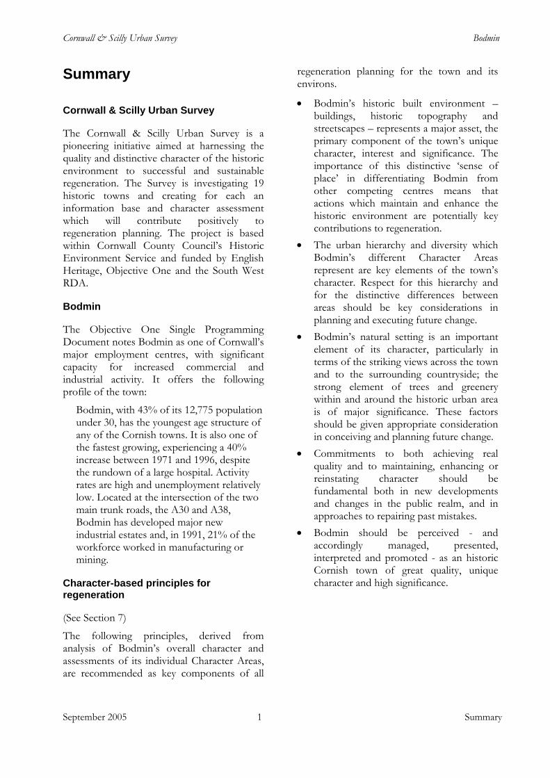
The Cornwall & Scilly Urban Survey is a pioneering initiative aimed at harnessing the quality and distinctive character of the historic environment to successful and sustainable regeneration. The Survey is investigating 19 historic towns and creating for each an information base and character assessment which will contribute positively to regeneration planning. The project is based within Cornwall County Council’s Historic Environment Service and funded by English Heritage, Objective One and the South West RDA.
Bodmin
The Objective One Single Programming Document notes Bodmin as one of Cornwall’s major employment centres, with significant capacity for increased commercial and industrial activity. It offers the following profile of the town:
Bodmin, with 43% of its 12,775 population under 30, has the youngest age structure of any of the Cornish towns. It is also one of the fastest growing, experiencing a 40% increase between 1971 and 1996, despite the rundown of a large hospital. Activity rates are high and unemployment relatively low. Located at the intersection of the two main trunk roads, the A30 and A38, Bodmin has developed major new industrial estates and, in 1991, 21% of the workforce worked in manufacturing or mining.
Character-based principles for regeneration
(See Section 7)
The following principles, derived from analysis of Bodmin’s overall character and assessments of its individual Character Areas, are recommended as key components of all
regeneration planning for the town and its environs.
• Bodmin’s historic built environment – buildings, historic topography and streetscapes – represents a major asset, the primary component of the town’s unique character, interest and significance. The importance of this distinctive ‘sense of place’ in differentiating Bodmin from other competing centres means that actions which maintain and enhance the historic environment are potentially key contributions to regeneration.
• The urban hierarchy and diversity which Bodmin’s different Character Areas represent are key elements of the town’s character. Respect for this hierarchy and for the distinctive differences between areas should be key considerations in planning and executing future change.
• Bodmin’s natural setting is an important element of its character, particularly in terms of the striking views across the town and to the surrounding countryside; the strong element of trees and greenery within and around the historic urban area is of major significance. These factors should be given appropriate consideration in conceiving and planning future change.
• Commitments to both achieving real quality and to maintaining, enhancing or reinstating character should be fundamental both in new developments and changes in the public realm, and in approaches to repairing past mistakes.
• Bodmin should be perceived - and accordingly managed, presented, interpreted and promoted - as an historic Cornish town of great quality, unique character and high significance.
September 2005 1 Summary
Cornwall & Scilly Urban Survey Bodmin
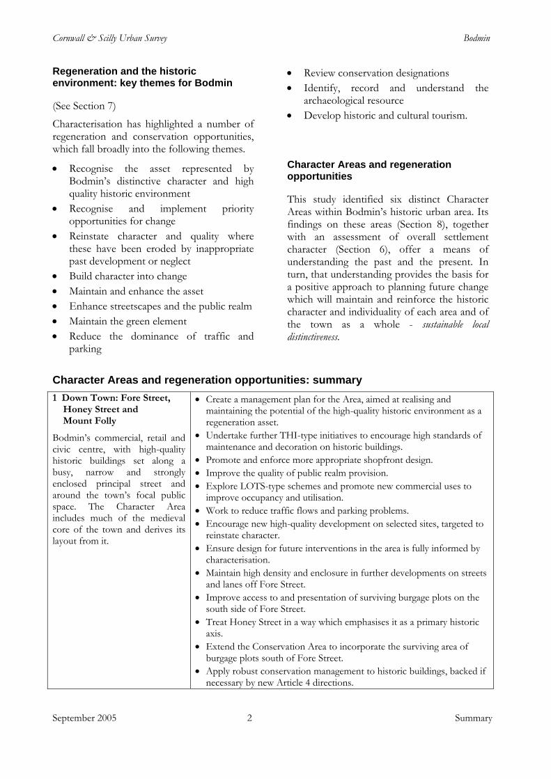
Regeneration and the historic environment: key themes for Bodmin
• Review conservation designations • Identify, record and understand the
archaeological resource (See Section 7) • Develop historic and cultural tourism.
Characterisation has highlighted a number of regeneration and conservation opportunities, which fall broadly into the following themes.
Character Areas and regeneration opportunities
• Recognise the asset represented by Bodmin’s distinctive character and high quality historic environment This study identified six distinct Character
Areas within Bodmin’s historic urban area. Its findings on these areas (Section 8), together with an assessment of overall settlement character (Section 6), offer a means of understanding the past and the present. In turn, that understanding provides the basis for a positive approach to planning future change which will maintain and reinforce the historic character and individuality of each area and of the town as a whole - sustainable local distinctiveness.
• Recognise and implement priority opportunities for change
• Reinstate character and quality where these have been eroded by inappropriate past development or neglect
• Build character into change • Maintain and enhance the asset • Enhance streetscapes and the public realm • Maintain the green element • Reduce the dominance of traffic and
parking Character Areas and regeneration opportunities: summary 1 Down Town: Fore Street,
Honey Street and Mount Folly
Bodmin’s commercial, retail and civic centre, with high-quality historic buildings set along a busy, narrow and strongly enclosed principal street and around the town’s focal public space. The Character Area includes much of the medieval core of the town and derives its layout from it.
• Create a management plan for the Area, aimed at realising and maintaining the potential of the high-quality historic environment as a regeneration asset.
• Undertake further THI-type initiatives to encourage high standards of maintenance and decoration on historic buildings.
• Promote and enforce more appropriate shopfront design. • Improve the quality of public realm provision. • Explore LOTS-type schemes and promote new commercial uses to
improve occupancy and utilisation. • Work to reduce traffic flows and parking problems. • Encourage new high-quality development on selected sites, targeted to
reinstate character. • Ensure design for future interventions in the area is fully informed by
characterisation. • Maintain high density and enclosure in further developments on streets
and lanes off Fore Street. • Improve access to and presentation of surviving burgage plots on the
south side of Fore Street. • Treat Honey Street in a way which emphasises it as a primary historic
axis. • Extend the Conservation Area to incorporate the surviving area of
burgage plots south of Fore Street. • Apply robust conservation management to historic buildings, backed if
necessary by new Article 4 directions.
September 2005 2 Summary
Cornwall & Scilly Urban Survey Bodmin
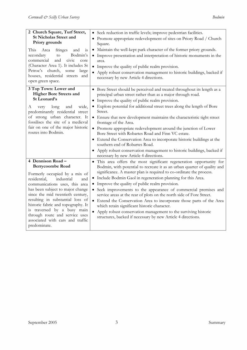
2 Church Square, Turf Street, St Nicholas Street and Priory grounds
This Area fringes and is secondary to Bodmin’s commercial and civic core (Character Area 1). It includes St Petroc’s church, some large houses, residential streets and open green space.
• Seek reduction in traffic levels; improve pedestrian facilities. • Promote appropriate redevelopment of sites on Priory Road / Church
Square. • Maintain the well-kept park character of the former priory grounds. • Improve presentation and interpretation of historic monuments in the
area. • Improve the quality of public realm provision. • Apply robust conservation management to historic buildings, backed if
necessary by new Article 4 directions.
3 Top Town: Lower and Higher Bore Streets and St Leonard’s
A very long and wide, predominantly residential street of strong urban character. It fossilises the site of a medieval fair on one of the major historic routes into Bodmin.
• Bore Street should be perceived and treated throughout its length as a principal urban street rather than as a major through road.
• Improve the quality of public realm provision. • Explore potential for additional street trees along the length of Bore
Street. • Ensure that new development maintains the characteristic tight street
frontage of the Area. • Promote appropriate redevelopment around the junction of Lower
Bore Street with Robartes Road and Finn VC estate. • Extend the Conservation Area to incorporate historic buildings at the
southern end of Robartes Road. • Apply robust conservation management to historic buildings, backed if
necessary by new Article 4 directions. 4 Dennison Road –
Berrycoombe Road
Formerly occupied by a mix of residential, industrial and communications uses, this area has been subject to major change since the mid twentieth century, resulting in substantial loss of historic fabric and topography. It is traversed by a busy main through route and service uses associated with cars and traffic predominate.
• This area offers the most significant regeneration opportunity for Bodmin, with potential to recreate it as an urban quarter of quality and significance. A master plan is required to co-ordinate the process.
• Include Bodmin Gaol in regeneration planning for this Area. • Improve the quality of public realm provision. • Seek improvements to the appearance of commercial premises and
service areas at the rear of plots on the north side of Fore Street. • Extend the Conservation Area to incorporate those parts of the Area
which retain significant historic character. • Apply robust conservation management to the surviving historic
structures, backed if necessary by new Article 4 directions.
September 2005 3 Summary
Cornwall & Scilly Urban Survey Bodmin
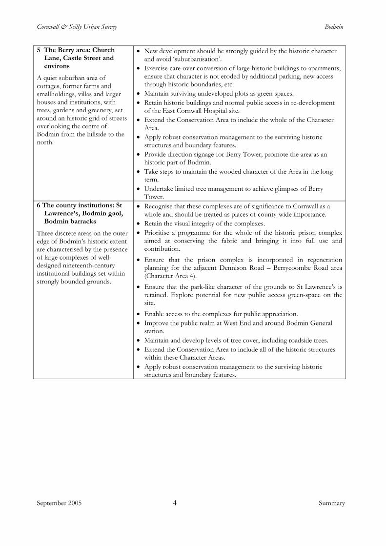
5 The Berry area: Church Lane, Castle Street and environs
A quiet suburban area of cottages, former farms and smallholdings, villas and larger houses and institutions, with trees, gardens and greenery, set around an historic grid of streets overlooking the centre of Bodmin from the hillside to the north.
• New development should be strongly guided by the historic character and avoid ‘suburbanisation’.
• Exercise care over conversion of large historic buildings to apartments; ensure that character is not eroded by additional parking, new access through historic boundaries, etc.
• Maintain surviving undeveloped plots as green spaces. • Retain historic buildings and normal public access in re-development
of the East Cornwall Hospital site. • Extend the Conservation Area to include the whole of the Character
Area. • Apply robust conservation management to the surviving historic
structures and boundary features. • Provide direction signage for Berry Tower; promote the area as an
historic part of Bodmin. • Take steps to maintain the wooded character of the Area in the long
term. • Undertake limited tree management to achieve glimpses of Berry
Tower. 6 The county institutions: St
Lawrence’s, Bodmin gaol, Bodmin barracks
Three discrete areas on the outer edge of Bodmin’s historic extent are characterised by the presence of large complexes of well-designed nineteenth-century institutional buildings set within strongly bounded grounds.
• Recognise that these complexes are of significance to Cornwall as a whole and should be treated as places of county-wide importance.
• Retain the visual integrity of the complexes. • Prioritise a programme for the whole of the historic prison complex
aimed at conserving the fabric and bringing it into full use and contribution.
• Ensure that the prison complex is incorporated in regeneration planning for the adjacent Dennison Road – Berrycoombe Road area (Character Area 4).
• Ensure that the park-like character of the grounds to St Lawrence’s is retained. Explore potential for new public access green-space on the site.
• Enable access to the complexes for public appreciation. • Improve the public realm at West End and around Bodmin General
station. • Maintain and develop levels of tree cover, including roadside trees. • Extend the Conservation Area to include all of the historic structures
within these Character Areas. • Apply robust conservation management to the surviving historic
structures and boundary features.
September 2005 4 Summary
Cornwall & Scilly Urban Survey Bodmin
September 2005 5 Introduction
1 Introduction
Regeneration and the historic towns of Cornwall and Scilly
In July 1999 Cornwall and the Isles of Scilly were designated as an Objective One area, bringing potential investment from European funds of more than £300m over the nine-year spending period. Economic regeneration schemes and development projects within the region’s towns are likely to form a major element of the Objective One Programme.
Regeneration on this scale offers an unparalleled opportunity for contemporary contributions in urban design and architecture to the built environment of Cornwall and Scilly’s towns. At the same time, the Objective One programme emphasises environmental sustainability (including the historic environment) and regional distinctiveness as key considerations in regeneration planning. The process of change launched by current regeneration initiatives could, if not carefully managed, have a negative impact on the historic environment and the unique character and sense of place of each of these settlements. The pressure to achieve rapid change could in itself result in severe erosion and dilution of their individuality and particular distinctiveness and, at worst, their transformation into ‘anywhere’ towns.
It is clear from recent research that a high-quality historic urban environment and the distinctiveness and sense of place integral to it are themselves primary assets in promoting regeneration. The effect may be direct, through heritage tourism, for example, but there is a more powerful and decisive impact from such distinctiveness in prompting a strong sense of identity and pride of place which in turn creates a positive and confident climate for investment and growth.
This synergy between the historic environment and economic regeneration was recognised and strongly advocated in the Power of Place review of policies on the historic
environment carried out by English Heritage in 2000, and its value clearly highlighted in the government’s response, The Historic Environment: A Force for the Future (2001). The tool by which the two may be linked to create a framework for sustainable development in historic settlements is characterisation.
Characterisation and regeneration
‘The government . . . wants to see more regeneration projects, large and small, going forward on the basis of a clear understanding of the existing historic environment, how this has developed over time and how it can be used creatively to meet contemporary needs.’ (DCMS / DTLR 2001, The Historic Environment: A Force for the Future, 5.2)
‘Characterisation’ provides a means of understanding the diverse range of factors which combine to create ‘distinctiveness’ and ‘sense of place’. It involves the creation of a comprehensive knowledge base on the historic environment. This includes what is known of a settlement’s historic development and urban topography (that is, the basic components which have contributed to the physical shaping of the historic settlement, such as market places, church enclosures, turnpike roads, railways, etc), together with an overview of the surviving historic fabric, distinctive architectural forms, materials and treatments and the significant elements of town and streetscapes. Characterisation may also provide the basis for assessing the potential for buried and standing archaeological remains and their likely significance, reducing uncertainty for regeneration interests by providing an indication of potential constraints.
Characterisation is also a means whereby the historic environment can itself provide an inspirational matrix for regeneration. It emphasises the historic continuum which provides the context for current change and into which the regeneration measures of the present must fit if the distinctive and special qualities of each historic town are to be
Cornwall & Scilly Urban Survey Bodmin
maintained and enhanced. It both highlights the ‘tears in the urban fabric’ wrought by a lack of care in the past and offers an indication of appropriate approaches to their repair.
Characterisation is not intended to encourage or to provide a basis for imitation or pastiche; rather, it offers a sound basis on which the twenty-first century can make its own distinct and high-quality contribution to places of abiding value.
Cornwall and Scilly Urban Survey
The Cornwall & Scilly Urban Survey (CSUS) was set up – funded by both English Heritage and the Objective One Partnership for Cornwall and Scilly (European Regional Development Fund) – as a key contributor to regeneration in the region. Additional funding has been provided by the South West of England Regional Development Agency. The project is investigating 19 historic towns and creating for each the information base and character assessment which will provide a framework for sustainable action within these historic settlements.
These towns have been identified, in consultation with planning, conservation and economic regeneration officers within the seven district, borough and unitary authorities in the region, as those which are likely to be the focus for regeneration. The project’s ‘target’ settlements are:
Penzance Newlyn St Ives Hayle Helston Camborne Redruth Falmouth Penryn Truro Newquay St Austell Bodmin Camelford Launceston Liskeard Saltash Torpoint Hugh Town
CSUS is a pioneering initiative aimed directly at cutting across the boundary that traditionally divides conservation and economic development. Nationally, it is the first such project carrying out a characterisation-based assessment of the historic urban environment specifically to inform and support a regional economic regeneration programme. Future regeneration initiatives in other historic settlements, in Cornwall and Scilly and further afield, will benefit from the new approach developed by the project.
CSUS reports
CSUS reports present the major findings and recommendations arising from the project’s work on each town. They are complemented by computer-based digital mapping and data recorded using ArcView Geographical Information System (GIS) software, and together the two sources provide comprehensive information on historic development, urban topography, significant components of the historic environment, archaeological potential and historic character.
Importantly, the reports also identify opportunities for heritage-led regeneration and positive management of the historic environment. However, they are not intended to be prescriptive design guides, but should rather be used by architects, town planners and regeneration officers to inform future development and planning strategies.
The reports and associated digital resources are shared with the appropriate local authorities; economic regeneration, planning and conservation officers therefore have immediate access to the detailed information generated by the project. Additional information is held in the Cornwall and Scilly Historic Environment Record, maintained by the Historic Environment Service of Cornwall County Council.
Public access to the report and to the associated mapping is available via the
September 2005 6 Introduction
Cornwall & Scilly Urban Survey Bodmin
project’s website - www.historic-cornwall.org.uk - or by appointment at the offices of Cornwall County Council’s Historic Environment Service, Old County Hall, Truro.
Extent of the study area
The history and historic development of each town are investigated and mapped for the whole of the area defined for the settlement
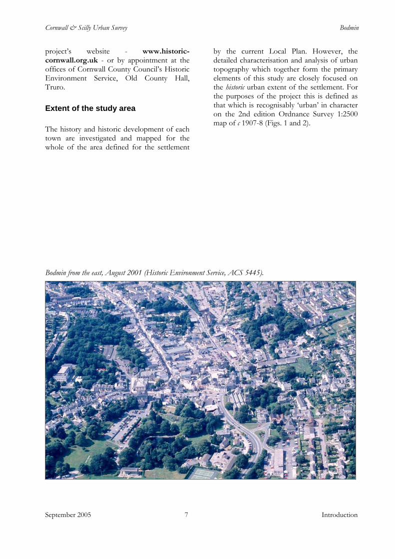
by the current Local Plan. However, the detailed characterisation and analysis of urban topography which together form the primary elements of this study are closely focused on the historic urban extent of the settlement. For the purposes of the project this is defined as that which is recognisably ‘urban’ in character on the 2nd edition Ordnance Survey 1:2500 map of c 1907-8 (Figs. 1 and 2).
Bodmin from the east, August 2001 (Historic Environment Service, ACS 5445).
September 2005 7 Introduction
Cornwall & Scilly Urban Survey Bodmin
September 2005 Bodmin: the context
2 Bodmin: the context
Landscape and setting
Bodmin lies at the centre of Cornwall, both geographically (the precise centre being just two miles to the west at Lanivet) and in terms of the communications network. Cornwall’s spinal trunk road, the A30, is joined here by the main road from Plymouth and Liskeard, the A38, and the busy A389 links the town with the A39 ‘Atlantic Highway’ running up the north coast. The main rail line passes a short distance to the south of the town with a station at Bodmin Parkway, 5km from the town centre.
The town lies on an ancient, possibly prehistoric, east-west route through Cornwall, perpetuated by the A30 and before that by the Bodmin-Launceston turnpike. It is also sometimes noted as being located on an
‘historic’ north-south route – recently titled the ‘Saint’s Way’ – between Padstow and Fowey. Such a route is not in fact well attested historically, but some element in the development of the settlement in the early medieval period and later may be attributable to its position mid-way between the highest navigable points on the Camel and Fowey rivers, then probably only about 10 km apart. John Leland referred in about 1540 to Bodmyn Pill (south of Golant) on the Fowey as a ‘having [i.e., haven or harbour] for wares then to be carried to Bodmin’. This was presumably a later medieval replacement for Lostwithiel as a transhipment point, after navigation of the upper part of the Fowey became difficult because of silting resulting from streamworking for tin upstream on Bodmin Moor; the upper reaches of the Camel were also subject to silting but prior to the medieval period may have been navigable as far upstream as Nanstallon.
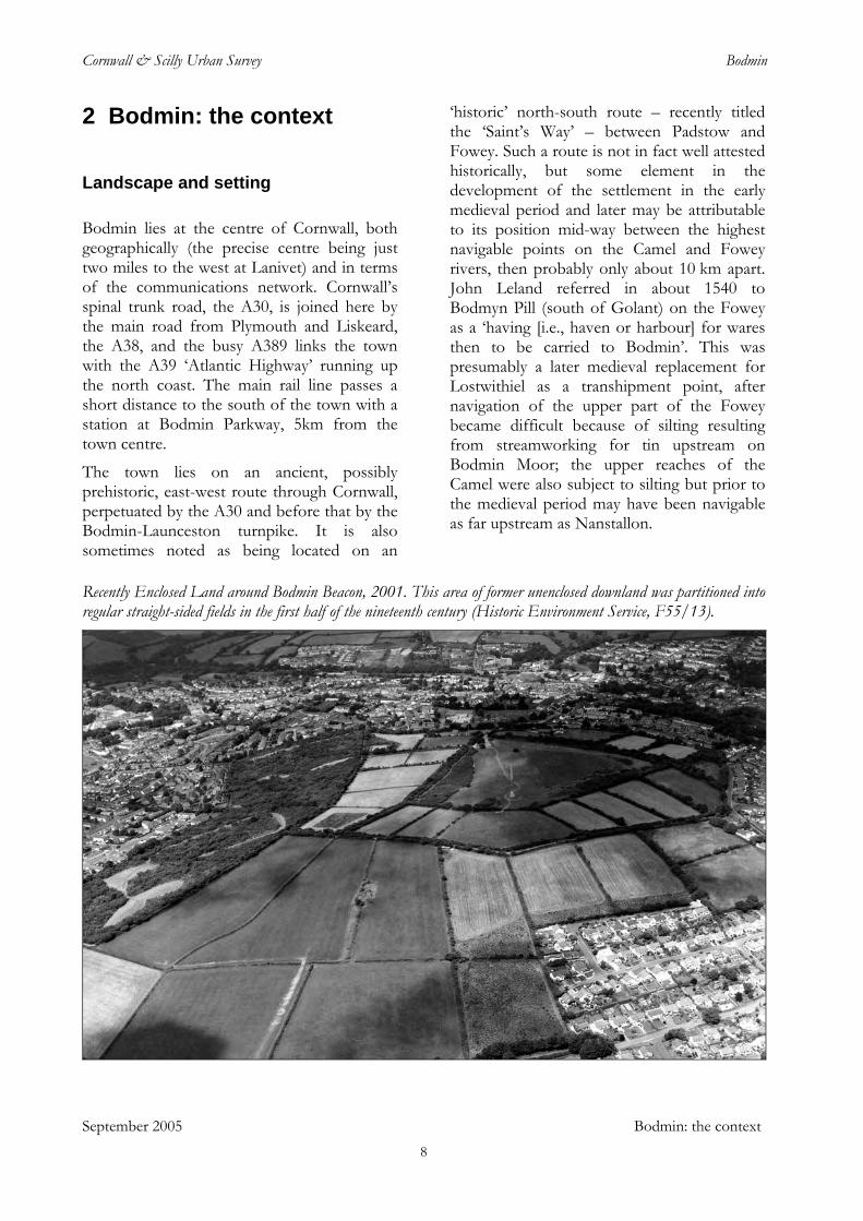
Recently Enclosed Land around Bodmin Beacon, 2001. This area of former unenclosed downland was partitioned into regular straight-sided fields in the first half of the nineteenth century (Historic Environment Service, F55/13).
8
Cornwall & Scilly Urban Survey Bodmin
The Camel curves past Bodmin in the deep wooded valley of Dunmere, 2 km west of the church. Dunmere Bridge carries the A389, the historic road to Wadebridge and beyond to Padstow. The Camelford road, an old ridgeway, but now the B3266, branches off a mile to the north. To the south east the Fowey River comes closest at Respryn, 3.5 kilometres from the church, and the late medieval bridge here took the old road to Liskeard, Saltash and the world beyond the Tamar. The grounds of Lanhydrock house (and parish) provide an ornamental buffer between Bodmin and the wooded valleys of the Fowey and its tributaries the Cardinham and Maudlin Waters. Lostwithiel, the nearest urban neighbour, 9 km to the south, is reached by another old ridgeway (now the B3268). This ran through the divide between Bodmin’s two great southern hills, the Beacon (162m) and Castle Canyke (166m), the latter crowned with a great prehistoric enclosure. Bodmin General station was later built in this divide, the nearest the difficult topography would allow the railway to get to Bodmin town; the looping lines running east and west to Bodmin Road and Boscarne stations pick out the hills’ contours nicely. At Halgavor the Lostwithiel road crosses by a bridge (previously a ford) the stream (possibly once called St Lawrence Water?) whose gently sloping valley wraps around the south side of the Beacon.
September 2005 Bodmin: the context
Until the early modern period Bodmin was a town almost encircled by open downs, heaths and moors. Carew wrote of Halgaver c 1600 that ‘the name signifieth the Goat’s Moor, and such a place it is, lying a little without the town, and full of quagmires.’ Leland in the 1530s found the road from St Laurence’s to Mitchell, ‘hilly and moory ground’. This setting is reflected in the 1994 Historic Landscape Characterisation of Cornwall, which identifies much of the area to the east, west and south of the town as Recently Enclosed Land, typified by the straight-sided early nineteenth century fields which now subdivide the Beacon; prior to enclosure these areas would have been open rough ground, primarily used for extensive grazing and as a source of domestic fuel. Much of Bodmin’s
later twentieth century expansion has taken place over such Recently Enclosed Land. Anciently Enclosed Land, in the form of enclosed parcels of former strip fields associated with farming hamlets such as Bodiniel, Penbugle and Lancarffe, lies close to the town on the northern side, with a swathe of similar terrain, intermixed with ancient woodland, extending north towards Helland and Pencarrow. Even here, however, the tops of many of the hills in Helland parish, and to the east around Cardinham, have been enclosed and improved for agriculture only in the last two hundred years.
The regeneration context
Georgina McLaren, Cornwall Enterprise Bodmin is located near the geographical centre of Cornwall, south west of Bodmin Moor. The two main roads into and through Cornwall, the A30 and the A38, converge on the outskirts of the town, giving it an important strategic position for employment and tourism. Bodmin is the largest town in North Cornwall and has experienced significant growth since 1965. In the 1960s and 1970s substantial areas of new public sector housing were developed in association with the Greater London Council overspill scheme. The population was recorded as 12,881 at the 2001 census. In-migration and the building of the A30 bypass have been key factors in the growth of new light industrial activity on the eastern edge of the town, close to the A30. Tourism is also important to the local economy and Bodmin hosts a number of attractions including the Bodmin and Wenford Railway and the Camel Trail.
Bodmin acts as a district service centre and currently has a full range of social and community facilities relating to education, health, shopping, leisure, recreation and public transport. There are regular bus services to nearby towns including Wadebridge, Padstow, St Austell, Camelford and Truro, and to the nearby Bodmin Parkway Station, which is on the main London to Penzance railway line.
9
Cornwall & Scilly Urban Survey Bodmin
An important and unique feature in the regeneration context is Bodmin’s legacy from its period as the county town. As such, the town has a significant number of substantial nineteenth-century government properties. Some have been adapted or developed relatively recently, whilst others still present significant future opportunities. These buildings and sites include Bodmin Barracks (now employment land, home of the Environment Agency, the DCLI regimental museum and new and converted housing), the former Assize Courts (now the Shire Hall living courts museum and visitor centre), the Judges’ Lodgings (Bodmin Town Council offices) and the County Lunatic Asylum (St Lawrence’s Hospital), the latter now being developed for private housing and as a flagship Business Park (Beacon Technology Park) by SWRDA. Walker Lines, a legacy of World War II, is now an industrial estate. One remaining important building in private ownership that still awaits major regeneration plans is Bodmin Gaol.
Socio-economic profile
Population profile There are two wards in Bodmin, St Mary’s and St Petroc’s, with populations at the 2001 census of 6,806 and 6,075 respectively. Both wards show the proportion of population of working age is considerably higher than those aged under 15 and over 65. From 1999 to 2001 the 20-44 years population age group decreased whereas population age group 45+ years increased. This is possibly a result of the younger working population being forced out of the housing market and moving away to find better paid, higher quality jobs. It is also reflective of the influx of people in the early 1970s.
Indices of deprivation The Indices of Multiple Deprivation 2004 breaks Bodmin down into nine Super Output Areas (SOAs). Five of these SOAs are in the ten ranked most deprived in North Cornwall and three are in the top 20% most deprived in the whole county. Five of the SOAs are ranked in the top 20% for income deprivation
in Cornwall and six SOAs in the top 10 ranked for employment deprivation.
Levels of car ownership are generally lower than the county standard, although the percentage of ownership of one car per household is slightly higher than the Cornwall average of 48.7% (50.6% in St Mary’s and 50% in St Petroc’s). St Mary’s ward has, at 27%, a higher than national average percentage of households with no cars. The county average is 20.5%.
Employment, business and industry The predominant employment sectors in Bodmin are wholesale and retail trade, light manufacturing, health and social work, construction and real estate, and renting for tourism. A large proportion of businesses in Bodmin are micro-businesses, employing five or fewer people (Bodmin Parish Profile 2005). From 1991-2001 employment levels in Bodmin rose from 34.3% to 36.9%, whilst unemployment fell from 6.2% to 3.9%. During the same period the number of part-time employees and students has increased and the number of self-employed people has decreased slightly.
September 2005 Bodmin: the context
A town centre Health Check was carried out in 2000 by consultants to provide baseline information concerning the economic and environmental health of the town. Key findings included that around 1,000 people were employed in the town centre and that there were 175 retail units in Bodmin Town, mainly concentrated around Fore Street. The Health Check concluded that retail space in the town centre had fallen by 11% from 116,290 sq ft in 1987 to 103,820 sq ft in 2000. Comparison goods shopping (defined as non-perishable goods which stocked in a wide range of sizes, styles, colours and qualities, such as furniture, carpets, televisions, etc) has become relatively more dominant, while services and vacant space have remained broadly the same; convenience goods shopping (relatively inexpensive frequently purchased consumer goods) has fallen. One of the key findings from the Health Check was that there was a need for more ‘multiple stores’, particularly in clothing, as this would
10
Cornwall & Scilly Urban Survey Bodmin
improve the attraction of the town as a shopping destination.
Recent and current initiatives
A programme of town centre enhancements was carried out between 1998 and 2002, including conversion of the Assize Courts, landscaping of Mount Folly, new car parking provision, streetscape improvements and traffic calming in Fore Street. This built upon earlier works carried out in Honey Street. A Townscape Heritage Initiative led to successful refurbishment of a number of privately owned derelict and dilapidated buildings in the town centre.
Bodmin ‘Pride and Place’ is a three-year initiative aiming to strengthen the town’s unique landscape and cultural identity and to use creativity to heighten its sense of place. Starting in April 2004, the project has begun to assist local communities within and round Bodmin to recognise the unique character of the area and to record and celebrate its diversity and richness. Activities include making tree sculptures, working with local schools and the Cornwall Audio Visual Archive and running community workshops and local exhibitions.
In August 2003 a new East Cornwall Materials and Recycling Facility was set up in Bodmin by North Cornwall District Council and Caradon District Council in partnership with Cornwall Paper Company. The facility has a visitor centre so that local schools and community groups can find out more about recycling and watch the whole process from the viewing gallery.
The Walk to Work project in Bodmin is being led by the Coast and Countryside Service of NCDC to encourage walking and cycling to work and school for leisure and health. The project involves creating new safe off-road routes across the town and an extension of the Camel Trail to bring this closer to the town centre.
The North Cornwall Tourism Strategy 2001-2005 sets out a range of strategic objectives
aimed at improving, refining and expanding the tourism product and market in the district. Bodmin is a town that offers further potential in this area.
As the result of the regeneration initiatives in 1998-2002 and the subsequent Bodmin Market and Coastal Towns Initiative, a local representative forum - Bodmin Futures - has evolved. In March 2005 Bodmin Futures published its 2020 vision for Bodmin and the six surrounding parishes of Helland, Lanhydrock, Lanivet, Withiel, Blisland and Cardinham. The vision covers all aspects of community life and is built on core values of quality and partnership; it focuses on the creation of a twenty-first century economy.
Specific projects envisaged under the Futures vision include undertaking an urban design study to create a development and marketing framework for the town centre and Conservation Area, encouraging preservation of the historic built environment and promotion of an ‘open building programme’ for greater public access to important buildings. There are also proposals for improved interpretation, including walking tours and measures to promote and increase understanding of ancient monuments and archaeological sites.
Future planning approaches
North Cornwall Local Plan The Local Plan was adopted in 1999 and will be succeeded by a new Local Development Framework in 2007. The Local Plan Annual Monitoring Report 2003/2004 indicated that most of the local plan policies were operating successfully and were progressing to meet the relevant Local Plan objectives.
The Local Plan’s overall aim was ‘to develop Bodmin’s role as the main centre for job opportunities, services and facilities in mid-east Cornwall’. This approach recognised that Bodmin has the strategic location, development opportunities and infrastructure to accommodate development without undue detriment to the environment. The growth of
September 2005 Bodmin: the context 11
Cornwall & Scilly Urban Survey Bodmin
the town would also help to sustain and enhance services for the rural hinterland.
Housing: Between 1991-2 and 2000-1, there were 477 house completions in Bodmin; a further 124 completions took place in 2001-2. Permissions have been implemented at St Lawrence’s Hospital site, Scarlett’s Well Park, Respryn Road and Green Lane to meet housing requirements, in addition to developments at various infill sites within the built-up area of the town.
Industry and employment: Industrial development in Bodmin has concentrated on the east side of the town where there is good access to both the A30 and the A38. The Local Plan highlighted that in addition to the conventional industrial estates, Bodmin’s strategic location would be suitable for a business park development that could cater for the special needs of high technology, research and development and high profile business establishments. There was also an opportunity for mixed development with possibilities of housing where appropriate to introduce the concept of Live-Work that is currently being explored in other parts of the county.
Town centre and retail development: Bodmin provides a reasonable range of facilities although there are many opportunities for these to be improved in order to attract more residents and visitors to choose Bodmin as a destination for shopping and entertainment. The Local Plan stated that the future success of the town centre would depend upon consolidating and increasing town centre activity in a well defined area and creating an attractive town centre environment with plenty of convenient car-parking. A number of traffic management and environmental schemes in the public realm have since taken place to address this issue.
Cornwall Structure Plan The general planning approach described in the Cornwall Structure Plan 2004 is that
development should consolidate the current employment and retail function of the town, maintaining the balance of homes and jobs. The Structure Plan also designates Bodmin as a Strategic Urban Centre, the only one in North Cornwall, and recognises the town as the largest population centre in the district.
Local Development Framework North Cornwall District Council published key results on the Local Development Framework Issues and Options Report consultation in November 2004. Issues to be addressed in assessing the capacity of Bodmin to accommodate further growth include: environmental impact, infrastructure, social and community facilities, employment opportunities, availability of previously developed land and availability of greenfield sites. Three areas have been identified in the undeveloped corridor to the east between the eastern residential suburbs and the A30, where allocations for future development for housing and employment are likely to be made. Issues were raised in relation to the provision of adequate infrastructure and social and community facilities in Bodmin.
Historic environment designations
Current historic environment designations for Bodmin include two Scheduled Monuments (Berrycoombe Cross and the chapel of Thomas à Becket) and more than 100 Listed Buildings. The latter include St Petroc’s church (Grade I) and several Grade II* structures: St Lawrence’s Hospital, Shire Hall, Shire House, St Guron’s well and the chapel of Thomas à Becket (both within St Petroc’s churchyard), and several crosses. Much of the historic extent of the town has Conservation Area status, with the most recent major amendment dating from c 1999. There is potential for some significant amendments to its extent (see Section 7).
September 2005 Bodmin: the context 12
Cornwall & Scilly Urban Survey Bodmin
September 2005 Historic and topographic development
3 Historic and topographic development
Figures 3 and 4 give an overview of Bodmin’s historic development and historic topography
Before Bodmin – the prehistoric period
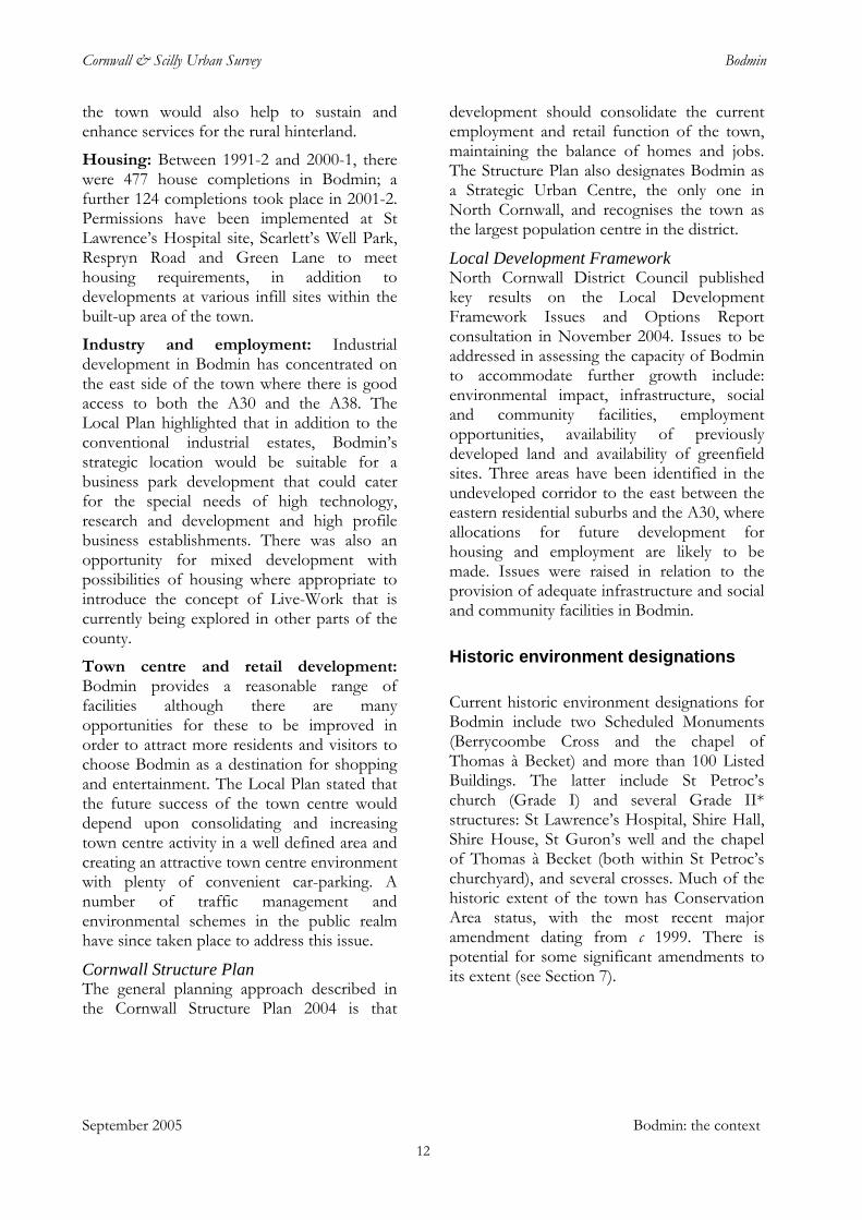
The earliest known evidence for human activity in the Bodmin area is a scatter of worked flint of probable Mesolithic date (c 8,000-4,000 BC) from Castle Canyke, south east of the town. The sites of Bronze Age barrows, dating from approximately 2,500-1200 BC, are known or suspected on Bodmin Beacon, the former Bodmin Down south of Barn Lane (with a stone cist nearby) and within the barracks; there are barrow groups to the west of the town at Boscarne and Tregear and on Penaligon and New Downs.
Castle Canyke, Cornwall’s largest Iron Age hillfort, surrounded by the remains of a substantial ditch and rampart; these have been much reduced by ploughing on the eastern side. The interior was subdivided and enclosed in the post-medieval period (Historic Environment Service, ACS 714). Activity in later prehistory is represented by Castle Canyke, the largest Iron Age hillfort in Cornwall, south east of the town, and another very substantial enclosure of this period in Dunmere Wood, to the north west. A number of rounds or defended farmsteads of the Iron Age – Romano-British period are known in the wider area of the town, including sites at
Penhargard, north of Bodmin, Colesloggett, Tawnamoor and Kingswood to the east, St Ingunger to the south and Lamorick, in Lanivet parish, to the south west. The ‘Berry’ and ‘Castle’ names which occur on the northern valley side above the town may record the presence of another enclosed site of this period (see below).
At Nanstallon, the remains of a Roman fort –the only one firmly identified in Cornwall to date – have been excavated and shown to have been occupied for only 20-30 years in the second half of the first century AD. The proximity of this site to what was probably then the highest navigable point on the Camel may indicate that it was sited to defend, or to function as, a shipment point for maritime trade. Evidence was found there of metalworking in silver and possible iron smelting. Roman coins have occasionally been found in the vicinity of Bodmin, including examples from St Petroc’s.
Early medieval Bodmin
The eleventh and twelfth century Lives of St Petroc attributed the origins of a settlement at Bodmin to the saint having gone into a ‘remote wilderness’ inland from his earlier foundations at Padstow and Little Petherick and there taking over the dwelling of a hermit, St Uuron. Petroc’s followers joined him, according to these sources, eventually necessitating the construction of a second monastic house on the hill above an earlier foundation in a valley. There is currently no archaeological or documentary evidence to support an early religious settlement in or near Bodmin, however, and it is worth noting that such medieval legends were often constructed long after the events they purported to describe to explain and provide a history and pedigree for foundations existing at the time they were written. The available evidence rather suggests that a monastic or clerical settlement associated with the cult of St Petroc, established earlier at Padstow, was founded at Bodmin at some point in the later centuries of the early medieval period. This
13
Cornwall & Scilly Urban Survey Bodmin
may have been around AD 800: it has been suggested that Bodmin was the site of a monastery or church named as Dinuurrin in a documentary source dated between AD 833 and AD 870. At this time the monastery was the seat of a bishop named Kenstec, the document recording his pledge of allegiance to the Anglo Saxon church centred on Canterbury. This part of Cornwall appears to have already come under Saxon control by this period: much of the land formerly held by the earlier monastic foundation dedicated to St Petroc at Padstow had been granted away by King Ecgberht in the wake of his military actions in Cornwall in the early ninth century; removal from Padstow to Bodmin may have occurred because the latter was a more convenient base from which to manage the remaining monastic estates.
By the later tenth century Bodmin had become the primary centre of the monastic foundation dedicated to St Petroc, perhaps encouraged by Viking raids in the Camel estuary in AD 981. The manumissions - that is, formal grants of freedom to slaves - recorded in the tenth-century Bodmin Gospels demonstrate that the Bodmin foundation was at this time closely integrated with the wider Anglo-Saxon political and religious orbit: slaves are noted as having been freed for the benefit of the souls of several later tenth century Saxon kings (Edmund, Eadred, Eadwig), bishops, nobles and others. There are also hints of an organised urban or proto-urban settlement with its own officials. One of the manumission entries records an individual purchasing a female slave and her son ‘at the church door in Bodmin’, paying a toll to ‘Aeilsige the portreeve’ (broadly equivalent to a mayor or chief magistrate) and another official, and then freeing the two individuals ‘on St Petroc’s altar’.
The location of the early elements of the monastic foundation and developing settlement has been the subject of some debate. The early ninth century monastery named Dinuurrin may have been on the hill north of the centre of Bodmin. There are a number of place-names which include the
element ‘berry’ in this area, with documentary evidence to date this association to at least the fourteenth century. The word perhaps derives from the Old English burh, meaning a defended site, and therefore suggesting a link with the Cornish element din, a fort, which occurs in Dinuurrin. No archaeological evidence for such a feature has been identified to date but there are local accounts of a possible site at Castlehill; the physical topography would suggest a possible location on the ridge east of the house of that name on the upper part of Castle Street. It has also been argued that the late fifteenth century church of the Holy Rood, surviving now as the Berry Tower, was constructed on an early ecclesiastical site.
If such a monastic settlement on the northern valley side did exist, the settlement which grew up around the site of the present St Petroc’s church could represent a later phase, perhaps associated with the founding of a second monastic establishment. The place-name Bodmin is itself likely to derive from the Cornish elements, bod + meneghi, with the probable meaning ‘dwelling by church-land’.
Early medieval activity in the area of the present town is attested by finds of distinctive ‘grass-marked’ pottery from the western end of the site of the former Priory (Priory House) and from the area of the car park constructed on the steep slope behind Mount Folly, south of the east end of Fore Street. Such pottery typically dates from between the seventh and eleventh century and its presence, probably resulting from the manuring of agricultural land with household waste, provides an indication of settlement in the near vicinity.
September 2005 Historic and topographic development
One factor in the development of a settlement at Bodmin at this period is likely to have been the presence nearby of the tin industry. Evidence for this comes from finds made at Boscarne in the early nineteenth century. These included a tin ingot and an early tin smelting site, together with the remains of oak shovels; the latter have been radiocarbon dated to the period AD 635-1045 and were almost certainly associated with streamworking.
14
Cornwall & Scilly Urban Survey Bodmin
The medieval period
Domesday book noted Bodmine as held in 1086 by St Petroc’s church, recording also that ‘St Petroc’s has 68 houses and a market’. By this point, therefore, Bodmin was already a small town, one of only three in Cornwall at this period (the others were Liskeard and St Stephen-by-Launceston). Bodmin’s market was again recorded in 1201 and a fair, known as the Longfair and said to be held in the king’s highway, was documented in 1274. The market and additional fairs were noted again in 1302.
The monastery of St Petroc was re-established as a foundation of Augustinian canons in the 1120s or 1130s, one of a number of such changes in the south west at this period whereby former monastic settlements of ‘secular canons’ were converted to priories. Bishop Warlewast of Exeter appears to have promoted similar moves at Launceston, with the founding of the priory at St Thomas, and at Plympton. At Bodmin a new priory complex was developed on a site a short distance south east of the earlier monastic site (now St Petroc’s church). This may not have occurred immediately: excavations in the mid 1980s uncovered the north-west corner of the aisled priory church and dated it to the late twelfth or early thirteenth century.
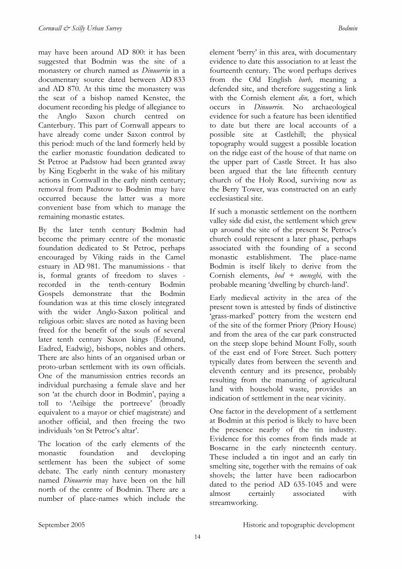
The new priory church would have been an impressive structure. ‘One of the finest buildings in Cornwall’ of the time, suggested Charles Henderson, and the architectural historian E H Sedding was confident from the surviving fragments of worked stone that the ‘Norman architecture in Bodmin Priory must have been equal to any specimens of their work in Great Britain’. The church was part of a substantial group of buildings which included a cloister, dormitory, chapter house, refectory and prior’s lodgings; a graveyard also developed around the priory – human remains have been found on several occasions over the past century – and the complex was bounded by extensive walled and gated grounds.
Ornately carved stonework revealed during archaeological excavations on the priory site in 1985. The priory had substantial estates for its support, including the town of Bodmin and large areas around Lanhydrock, Withiel, Rialton and Padstow. There are also indications that it possessed two or three deer parks in the vicinity of Bodmin: a document of 1389 referred to a ‘park by St Leonard’, ‘Borhull park’ and ‘Scu’s park . . . with meadows therein’. The locations and boundaries of these parks are not known but that referred to as ‘by St Leonard’ was presumably to the west of the town, beyond the chapel of St Leonard at the west end of Bore Street; the tithe apportionment recorded a block of fields named ‘Deer Parks’ to the north of the junction of Boundary Road and Boskear Lane and the name ‘Eastpark Cottages’, shown on the south side of Westheath Avenue on the 1st edition Ordnance Survey 1:2500 map of c 1880 may also be relevant. ‘Borhull’, if it incorporates the same ‘bore’ element which appears in Bore Street, may indicate a further park to the west of the town.
The shrine of St Petroc which had previously been kept in the monastery was removed to the priory, representing a considerable asset, in terms of both the popular legitimacy it conferred on the new institution and the offerings it attracted from visitors. The saint’s relics are said to have been stolen from the priory within a few decades of its foundation and taken by a monk to his home monastery
September 2005 Historic and topographic development 15
Cornwall & Scilly Urban Survey Bodmin
at St Méen in Brittany; they were restored in 1177, housed in an ivory reliquary (now in St Petroc’s church). This story now forms part of the rich store of legends which has built up around Bodmin’s religious history, but it is not clear whether it should be taken at face value or perhaps conceals the association of the priory, if only briefly, with a religious house in continental Europe as was the case for other foundations in Cornwall at this period
It is likely that the former monastic church, on or close to the site of the present St Petroc’s, was retained initially as the parish church; the Norman work which survives at the base of the tower of St Petroc’s may represent the remains of the north transept of the Norman church or a detached campanile (bell tower) which formed part of the monastic suite of buildings. (The majority of the present church fabric is late fifteenth century in date.)
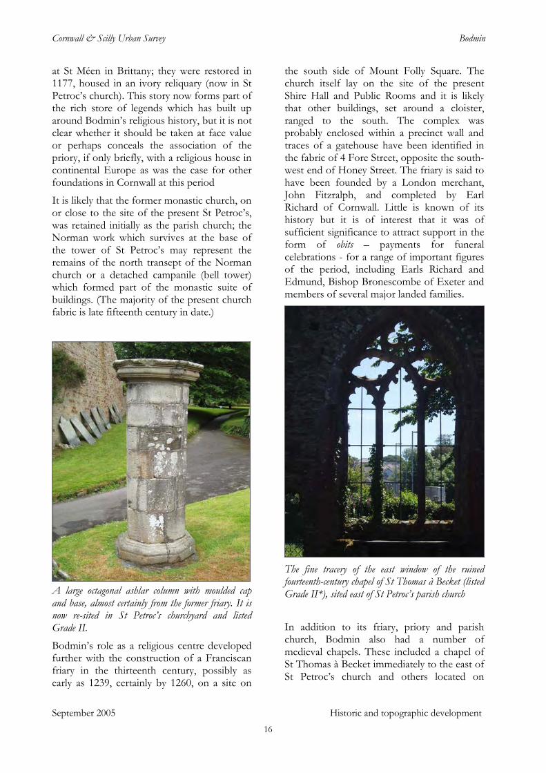
A large octagonal ashlar column with moulded cap and base, almost certainly from the former friary. It is now re-sited in St Petroc’s churchyard and listed Grade II.
September 2005 Historic and topographic development
Bodmin’s role as a religious centre developed further with the construction of a Franciscan friary in the thirteenth century, possibly as early as 1239, certainly by 1260, on a site on
the south side of Mount Folly Square. The church itself lay on the site of the present Shire Hall and Public Rooms and it is likely that other buildings, set around a cloister, ranged to the south. The complex was probably enclosed within a precinct wall and traces of a gatehouse have been identified in the fabric of 4 Fore Street, opposite the south-west end of Honey Street. The friary is said to have been founded by a London merchant, John Fitzralph, and completed by Earl Richard of Cornwall. Little is known of its history but it is of interest that it was of sufficient significance to attract support in the form of obits – payments for funeral celebrations - for a range of important figures of the period, including Earls Richard and Edmund, Bishop Bronescombe of Exeter and members of several major landed families.
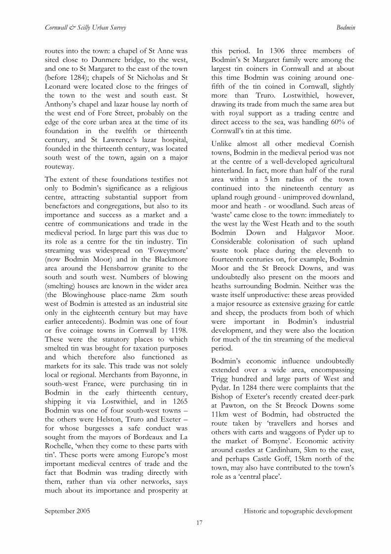
The fine tracery of the east window of the ruined fourteenth-century chapel of St Thomas à Becket (listed Grade II*), sited east of St Petroc’s parish church
In addition to its friary, priory and parish church, Bodmin also had a number of medieval chapels. These included a chapel of St Thomas à Becket immediately to the east of St Petroc’s church and others located on
16
Cornwall & Scilly Urban Survey Bodmin
routes into the town: a chapel of St Anne was sited close to Dunmere bridge, to the west, and one to St Margaret to the east of the town (before 1284); chapels of St Nicholas and St Leonard were located close to the fringes of the town to the west and south east. St Anthony’s chapel and lazar house lay north of the west end of Fore Street, probably on the edge of the core urban area at the time of its foundation in the twelfth or thirteenth century, and St Lawrence’s lazar hospital, founded in the thirteenth century, was located south west of the town, again on a major routeway.
September 2005 Historic and topographic development
The extent of these foundations testifies not only to Bodmin’s significance as a religious centre, attracting substantial support from benefactors and congregations, but also to its importance and success as a market and a centre of communications and trade in the medieval period. In large part this was due to its role as a centre for the tin industry. Tin streaming was widespread on ‘Foweymore’ (now Bodmin Moor) and in the Blackmore area around the Hensbarrow granite to the south and south west. Numbers of blowing (smelting) houses are known in the wider area (the Blowinghouse place-name 2km south west of Bodmin is attested as an industrial site only in the eighteenth century but may have earlier antecedents). Bodmin was one of four or five coinage towns in Cornwall by 1198. These were the statutory places to which smelted tin was brought for taxation purposes and which therefore also functioned as markets for its sale. This trade was not solely local or regional. Merchants from Bayonne, in south-west France, were purchasing tin in Bodmin in the early thirteenth century, shipping it via Lostwithiel, and in 1265 Bodmin was one of four south-west towns – the others were Helston, Truro and Exeter – for whose burgesses a safe conduct was sought from the mayors of Bordeaux and La Rochelle, ‘when they come to these parts with tin’. These ports were among Europe’s most important medieval centres of trade and the fact that Bodmin was trading directly with them, rather than via other networks, says much about its importance and prosperity at
this period. In 1306 three members of Bodmin’s St Margaret family were among the largest tin coiners in Cornwall and at about this time Bodmin was coining around one-fifth of the tin coined in Cornwall, slightly more than Truro. Lostwithiel, however, drawing its trade from much the same area but with royal support as a trading centre and direct access to the sea, was handling 60% of Cornwall’s tin at this time.
Unlike almost all other medieval Cornish towns, Bodmin in the medieval period was not at the centre of a well-developed agricultural hinterland. In fact, more than half of the rural area within a 5 km radius of the town continued into the nineteenth century as upland rough ground - unimproved downland, moor and heath - or woodland. Such areas of ‘waste’ came close to the town: immediately to the west lay the West Heath and to the south Bodmin Down and Halgavor Moor. Considerable colonisation of such upland waste took place during the eleventh to fourteenth centuries on, for example, Bodmin Moor and the St Breock Downs, and was undoubtedly also present on the moors and heaths surrounding Bodmin. Neither was the waste itself unproductive: these areas provided a major resource as extensive grazing for cattle and sheep, the products from both of which were important in Bodmin’s industrial development, and they were also the location for much of the tin streaming of the medieval period.
Bodmin’s economic influence undoubtedly extended over a wide area, encompassing Trigg hundred and large parts of West and Pydar. In 1284 there were complaints that the Bishop of Exeter’s recently created deer-park at Pawton, on the St Breock Downs some 11km west of Bodmin, had obstructed the route taken by ‘travellers and horses and others with carts and waggons of Pyder up to the market of Bomyne’. Economic activity around castles at Cardinham, 5km to the east, and perhaps Castle Goff, 15km north of the town, may also have contributed to the town’s role as a ‘central place’.
17
Cornwall & Scilly Urban Survey Bodmin
Other aspects of the town’s economic life included provision for a wealthy elite: five wine sellers were recorded there in 1201, increasing to nine, selling a total of 142 ‘doles’ (casks), a century later. One or two goldworkers were recorded in the town in the late thirteenth - early fourteenth century (there were others in Truro and Lostwithiel) and there are several references to ‘shops’ in Bodmin at about this time; two selds, or private bazaars, were recorded in Bodmin in 1307-8. The existence of gilds of skinners and glovers and of cordwainers indicates an involvement in tanning and leatherworking at this stage, certainly a significant element in the town’s economy in the post medieval era.
Bodmin may also have had a judicial and administrative function for a time during the thirteenth century. Earl Richard, with his attention perhaps focused on the town by his involvement with the friary, is said to have moved some of the county courts - previously held in Launceston - to Bodmin; the courts were subsequently removed to Lostwithiel by Earl Edmund.
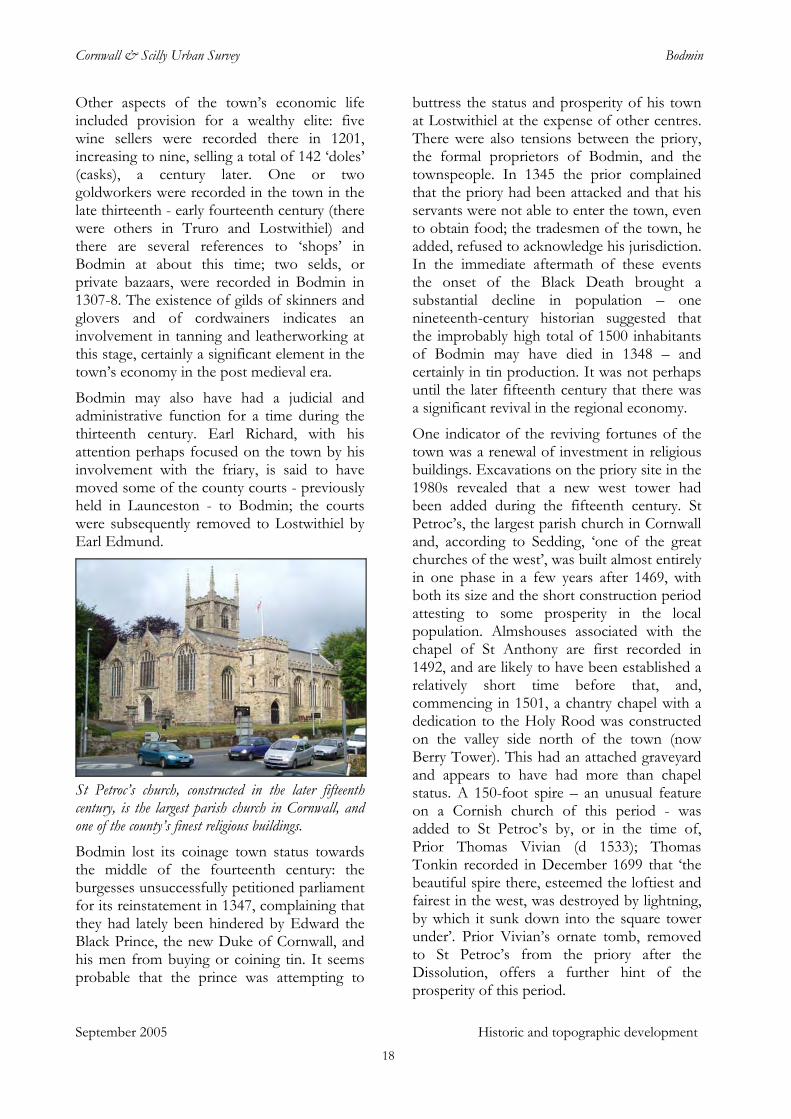
St Petroc’s church, constructed in the later fifteenth century, is the largest parish church in Cornwall, and one of the county’s finest religious buildings. Bodmin lost its coinage town status towards the middle of the fourteenth century: the burgesses unsuccessfully petitioned parliament for its reinstatement in 1347, complaining that they had lately been hindered by Edward the Black Prince, the new Duke of Cornwall, and his men from buying or coining tin. It seems probable that the prince was attempting to
buttress the status and prosperity of his town at Lostwithiel at the expense of other centres. There were also tensions between the priory, the formal proprietors of Bodmin, and the townspeople. In 1345 the prior complained that the priory had been attacked and that his servants were not able to enter the town, even to obtain food; the tradesmen of the town, he added, refused to acknowledge his jurisdiction. In the immediate aftermath of these events the onset of the Black Death brought a substantial decline in population – one nineteenth-century historian suggested that the improbably high total of 1500 inhabitants of Bodmin may have died in 1348 – and certainly in tin production. It was not perhaps until the later fifteenth century that there was a significant revival in the regional economy.
September 2005 Historic and topographic development
One indicator of the reviving fortunes of the town was a renewal of investment in religious buildings. Excavations on the priory site in the 1980s revealed that a new west tower had been added during the fifteenth century. St Petroc’s, the largest parish church in Cornwall and, according to Sedding, ‘one of the great churches of the west’, was built almost entirely in one phase in a few years after 1469, with both its size and the short construction period attesting to some prosperity in the local population. Almshouses associated with the chapel of St Anthony are first recorded in 1492, and are likely to have been established a relatively short time before that, and, commencing in 1501, a chantry chapel with a dedication to the Holy Rood was constructed on the valley side north of the town (now Berry Tower). This had an attached graveyard and appears to have had more than chapel status. A 150-foot spire – an unusual feature on a Cornish church of this period - was added to St Petroc’s by, or in the time of, Prior Thomas Vivian (d 1533); Thomas Tonkin recorded in December 1699 that ‘the beautiful spire there, esteemed the loftiest and fairest in the west, was destroyed by lightning, by which it sunk down into the square tower under’. Prior Vivian’s ornate tomb, removed to St Petroc’s from the priory after the Dissolution, offers a further hint of the prosperity of this period.
18
Cornwall & Scilly Urban Survey Bodmin
Little is known of secular activity at this time but it is apparent from fifteenth-century documentary references to a number of streets in the town (see below) that Bodmin had already achieved most of its post-medieval extent. It was also well populated: according to Maclean, the burgesses claimed in the earlier sixteenth century that the town accommodated 1,800 ‘houselying people’. The town also appears to have become the acknowledged ‘central place’ for Cornwall by this period. This may in part have been due to its convenient location in the county, partly its size and economic importance and partly its prominence before the Reformation as a religious centre and place of pilgrimage. It is notable that it was a primary place of assembly during the Cornish rebellions of both 1497 and 1549, during both of which local men were prominent as leaders; Perkin Warbeck chose Bodmin as the place at which to proclaim himself king in 1497.
‘From west to east along in one street’: Bodmin’s medieval topography
St Petroc’s church is located alongside a spring named after St Guron, close to the bottom of the valley. It lies within a substantial sub-oval area defined by the present Priory Road and Church Lane and this may well mark the approximate extent of the former monastic precinct. It is clear that this site was an early element in the layout of the town: Castle Street, running uphill from the north side of the church, was the principal route into Bodmin from the east and north east until the early nineteenth century; Priory Road represents an historic route from the east and south east, and St Nicholas Street, also aligned on the church, from the south.
One intriguing aspect of Bodmin’s urban topography is the grid of streets which extends north up the hillside from the area of the church: Pound Lane, Castle Street, Rhind Street and perhaps Berry Lane, with Cross Lane and Pool Street. The streets rising up the slope could simply represent a fan of historic
routes linking the early core of Bodmin with its hinterland to the north: Berry Lane becomes Helland Road and Rhind Street (via Roseland Road) and Castle Street both connect with routes to settlements on the west side of Bodmin Moor. At the same time, however, historic maps show the area enclosed by these streets to have itself been subdivided into regular plots. This gridded area coincides with that highlighted by ‘berry’ place-names and is clearly a relatively early component of the town: Castel Street was first recorded in 1313, Reynestrete in 1400 (perhaps from the Cornish dialect word reen, a slope), Berry Lane and Pool Street in 1468.
The name Castle Street is itself intriguing: there is no evidence for Bodmin having had a medieval castle and the name may have referred to the same earthwork feature which was otherwise denoted in place-names by din and burh. The location of this feature is unknown, although a site somewhere near the upper part of Castle Street or close to that now occupied by Berry Tower seems possible. As well as holding the meaning of an enclosure, the Old English place-name element burh is associated with a number of late Anglo-Saxon urban settlements in Wessex and south-west England, notably those listed in the document known as the Burghal Hidage; south-western examples include Lydford and Exeter. Key elements of these places include a gridded street plan and, in some instances, a defensive earthwork circuit. Exeter offers a particularly notable example, with a grid laid out probably during the later ninth century within the area defined by the Roman town walls. There is no evidence of a defensive circuit at Bodmin but the combination of an apparently early street grid immediately adjacent to - and with its main axis (Castle Street) aligned on - the probable location of St Petroc’s monastery, together with the burh place-name element, raises the possibility that this area of Bodmin represents the earliest element of the urban settlement, planned and laid out as a town as part of the incorporation of this area of Cornwall into the wider Saxon sphere. This area of Bodmin
September 2005 Historic and topographic development 19
Cornwall & Scilly Urban Survey Bodmin
offers a striking topographical similarity to part of Marlborough, Wiltshire, where an undefended grid of streets, probably laid out in the tenth century, extends up the northern slope of the Kennet valley from the parish church; part of this area was known as Kingsbury, a name which also occurs in Bodmin’s ‘Berry grid’.
These comparisons raise the possibility that the ‘Berry’ area of Bodmin represents the earliest urban settlement in the area, the town of the ‘portreeve’ referred to in the manumissions and of the 68 burgesses recorded in Domesday. A scatter of Old English place-names around the town – Holton, Norton, Whitley, Weatherly, Clerkenwater, Newton, Woodley – suggests that the burh could itself have been the focus for some Saxon colonisation at this period; the names incorporating -ley perhaps indicate some clearance of woodland around the town for new farm settlements.
At the time that Bodmin’s tithe map and apportionment were compiled, c 1840, relatively few of the plots within the ‘Berry grid’ were occupied by dwellings, particularly higher on the slope away from the town. Many of the small enclosures were then held as meadows or gardens by individuals who dwelt elsewhere in the town. Does this represent the final remnants of a shrunken early medieval town, as suggested above? Or, if the ‘grid’ did not originate in that way, could it represent a planned extension of the town at some later time? The early occurrences of the street names suggest not. Could it simply represent speculative partitioning at a later period to provide additional building and garden plots in close proximity to the town, the underlying layout deriving simply from the multiple early routes ascending the hillside? These questions could perhaps be resolved through further documentary research and fieldwork as well as by investigations which arise through the Development Control process.
A new town?
When the priory was established in the first half of the twelfth century it took on the estates of the former monastic foundation, including the land on which Bodmin itself was located; the prior was, in effect, the proprietor of Bodmin. Elsewhere in Cornwall during the medieval period, a number of noble proprietors attempted to develop their estates by ‘planting’ towns on them: examples include Truro, Helston, Tregony and Boscastle. Ecclesiastical proprietors could act similarly, as at Penryn and St Thomas, Launceston; in the latter instance the new settlement of Newport was laid out in near proximity to the new priory site. The urban historian Maurice Beresford has proposed that Bodmin is an example of a town of ‘organic growth’ – that is, without substantial planned elements. However, Bodmin’s historic topography strongly suggests that a similar entrepreneurial approach was taken to expanding or re-establishing the earlier town. In particular, Fore Street appears to represent a planned new element to the town, made up of a block of burgage plots extending west from approximately the present Crockwell Street and the corresponding point on the south side. The date of this development is not clear: the rear boundary of the burgage plots on the south side of Fore Street is set some distance up the slope beyond that of the friary precinct, suggesting that the burgage plots were laid out after the friary was established in the middle decades of the thirteenth century. However, three of the burgage plot boundaries on the south side of Fore Street were subject to archaeological investigation in advance of works to lay out the present car park. A range of pottery was recovered from these, including some later early medieval ‘grass-marked’ wares and fifteenth- or sixteenth-century forms. Based on material recovered from the primary bank of stony clay underlying each boundary, however, the excavator concluded that the boundaries probably dated to the twelfth century. Further investigation of sites in the area and / or re-assessment of the pottery
September 2005 Historic and topographic development 20
Cornwall & Scilly Urban Survey Bodmin
finds could clarify the chronology and sequence.
From historic maps it appears that the early block of burgage plots may have extended to a point approximately 25m west of Market Street, with the possible later addition of a few further strips extending to somewhere in the vicinity of Chapel Street. The former presence immediately west of Chapel Street of the medieval chapel and lazar house of St Anthony, dating from the thirteenth or fourteenth century, suggests strongly that when it was established this was the western extent of the town.
A speculative reconstruction of the medieval townscape would also include a large triangular market space defined by Honey Street, Turf Street and Mount Folly. St Petroc’s would have overlooked this space from the north, with the priory boundary and gate forming the eastern side and the friary wall and gate the southern side. Honey Street,
representing development along the direct ‘desire line’ between the east end of Fore Street and St Petroc’s, was first recorded in 1566.
Turf Street was first recorded in 1470, and may indicate that the space was becoming infilled by that date. This street-name was unknown in the late eighteenth century, however, when it was known as Back Lane. It was renamed Turf Street in the 1830-40s but it is not entirely certain that the fifteenth-century reference is to the same street. Historic maps show Turf Street / Back Lane running north from Mount Folly but making a sharp angle at its northern end to run west into Honey Street; the main route for traffic descending St Nicholas Street to the church was via Mount Folly and Honey Street, and remained so until some time in the twentieth century; the present direct route through to Church Square was first recorded on a map in the early 1960s.
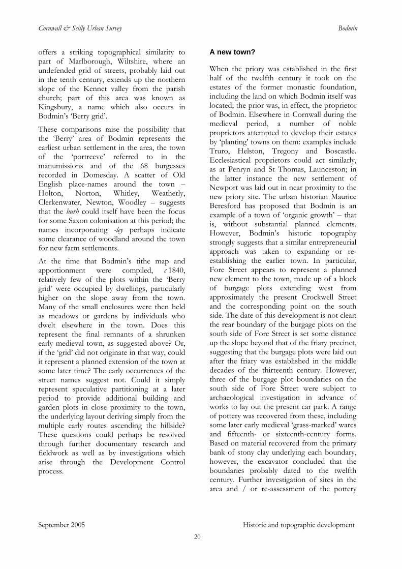
Bodmin’s burgage plots laid out north and south from Fore Street, shown on the 1st edition Ordnance Survey 1:2500 map of c 1880. (Based on the Ordnance Survey and Landmark 1880 OS 1:2500 historic mapping with the permission of the Controller Her Majesty's Stationery Office © Crown copyright and Landmark Information Group. Unauthorised reproduction infringes Crown copyright and may lead to Prosecution or civil proceedings. CCC licence No 100019590. All material copyright © Cornwall County Council 2005.)
September 2005 Historic and topographic development
21
Cornwall & Scilly Urban Survey Bodmin
Fore Street runs west from the south-west angle of the probable market area, taking an easy line as it rises up the southern valley side, with its burgage plots running more-or-less up and down the slope. It is not clear whether it was laid out de novo on a greenfield site, with the burgage plots perhaps following the orientation of former strip fields, or whether it was laid out from an existing route: the latter is suggested by the extension of the axis of Fore Street into Bore Street which can be plausibly identified as the site of an annual fair known as the ‘Longfair’, recorded in 1274 and said to be held on the ‘king’s highway’.
Bore Street – the present Higher and Lower Bore Streets – was undoubtedly an early element in Bodmin’s topography. It is named in various fifteenth century documents and there are references to several pre-Reformation gilds having been located there; gilds of St Margaret, St Anne, St David, All Saints and St Matthew were recorded ‘at the Bore’, with another recorded as that of the ‘Virgins of Bore-street’. That it was an early component of Bodmin’s topography is also evident in the way that routes approaching the town from the western quadrant converge on the western end of Bore Street: were this area a late development (as has been suggested in some accounts of Bodmin’s development) these routes would more probably have been aligned more directly on the west end of Fore Street.
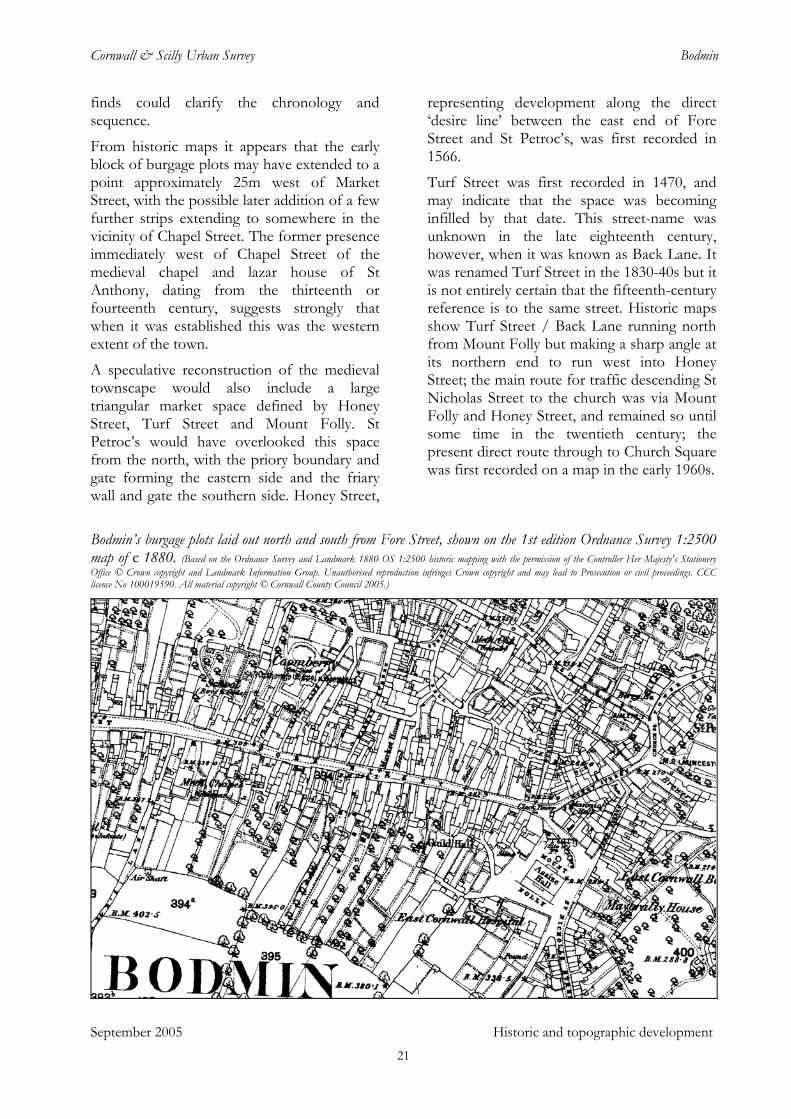
The elongated cigar shape of Bore Street is characteristic of a settlement based around a street fair or market site. However, it is probable that the ‘Bore’ street-name derives from a ‘bar’ or town gate: a document of 1283 refers to the street ‘of the Barre’ and another of about the same period records ‘magno vico versus La Bare’, the great street towards the bar. It has been suggested that the bar or gate was located slightly to the east of the present Town Wall. In this position, however, it would have effectively divided the supposed fair site in two, which seems inherently unlikely. An alternative site for a medieval bar
marking the western bounds of Bodmin’s medieval core would be the upper end of the present Fore Street, perhaps between Chapel Lane and Beacon Hill.
Bore Street also shows evidence of burgage plots, but it is not clear whether these were formally set out as a planned expansion to the main settlement to the east or simply represent development of urban holdings over earlier strip fields. The former presence of such fields is particularly clear on the north side of Bore Street in the area now occupied by Hillside Park, where the strips shown on historic maps have a particularly characteristic ‘reversed J’ form. On the south side of Bore Street a continuous rear boundary to the block of strips extended from a short distance west of Beacon Hill, at the west end of Fore Street, as far as the west end of Higher Bore Street. This may represent formally established burgage plots but could also have been simply the uphill boundary of a block of strips; however, the medieval St Leonard’s chapel lay approximately 30m outside the western boundary of this block, again suggesting a chapel located on the outer edge of a defined settlement.
A late thirteenth century account mentions ‘Aldermen of the Barre’ with jurisdiction to pursue malefactors. This implies a separate civic authority from that of Bodmin but, as with most of Bodmin’s early history, further research is required to confirm this. Settlements made up of paired boroughs are known elsewhere in Cornwall in the medieval period – Lostwithiel and its adjoining medieval ‘twin’ borough of Penknight provides a near and contemporary example – but in this instance it is perhaps less likely in that the land occupied by the two areas was all under the control of a single proprietor. It is perhaps more probable that the fairs required a distinct administrative establishment - the ‘Aldermen’ - but that Bore Street was effectively a large suburb to the medieval core of Bodmin.
September 2005 Historic and topographic development 22
Cornwall & Scilly Urban Survey Bodmin
Burgage plots laid off from Bore Street. The elongated ‘cigar-shape’ typical of a fair site is very clear. A block of former strip fields is evident on the north side of Higher Bore Street, west of the present Cardell Road, previously Bore Lane. (Based on the Ordnance Survey and Landmark 1880 OS 1:2500 historic mapping with the permission of the Controller Her Majesty's Stationery Office © Crown copyright and Landmark Information Group. Unauthorised reproduction infringes Crown copyright and may lead to Prosecution or civil proceedings. CCC licence No 100019590. All material copyright © Cornwall County Council 2005.)
Early descriptions of Bodmin emphasise its ‘one-street’ layout. Leland, c 1540, wrote that the ‘showe and the principale of the Toun is from west to est along in one streate. There is a Chapel at the west ende of the toun. The paroch chirch standith at the est end of the town, and is a fair large thing . . .’ Norden, towards the end of the sixteenth century, also noted the long main axis, commenting also on the town’s ‘ragged lanes’ and ‘decayed houses’. Carew, c 1600, was critical of both the location and cleanliness of Bodmin, which, he suggested, ‘a man might, not unaptly, turn into Badham.’ Of all the towns in Cornwall, he said, he found none more healthily situated than his own neighbouring town of Saltash, ‘or more contagiously than this’.
September 2005 Historic and topographic development
It consisteth wholly (in a manner) of one street leading east and west wellnear [sic]
the space of an eastern mile, whose south side is hidden from the sun by an high hill so nearly coasting it in most places, as neither can light have entrance to their stairs nor open air to their other rooms. Their back houses, of more necessary than cleanly service, as kitchens, stables, etc, are climbed up unto by steps, and their filth by every great shower washed down through their houses into the streets.
The other side is also overlooked by a great hill, though somewhat farther distant, and for a corollarium their conduit water runneth through the churchyard, the ordinary place of burial for town and parish. It breedeth therefore little cause for marvel that every general infection is first here admitted and last excluded.
23
Cornwall & Scilly Urban Survey Bodmin
Other elements of medieval Bodmin included at least two watermills, one sited on the western side of the priory grounds and another in the vicinity of Mill Street, together with their associated mill pools and leats; Pool Street was first noted in 1468 and another of the medieval gilds was based there. The mills were served by the stream which follows the valley, rising to the east close to Prior’s Barn and running west via the Priory fishponds now in the Priory Grounds park and along Berrycoombe to join the Camel at Dunmere. William Worcestre, writing after 1450, noted this as the ‘Carn water’, attributing the name to a man named Carn ‘who built the bridge in Bodmin town’. This bridge was probably somewhere in the vicinity of the north end of Honey Street and Church Square. Leland, c 1540, noted the ‘little broke’ which ‘servith the milles and rennith by the est ende of the town of Bodmyn’. The stream has been almost entirely culverted over time – the only part which is now easily visible within the town core is a short length in the yard of the Hole in the Wall pub. Assessment of the leat’s archaeology in advance of a flood prevention scheme identified lengths of the conduit with unmortared barrel-vaulting which may date from the medieval period.
September 2005 Historic and topographic development
Viewed as a whole, Bodmin’s historic topography is intriguingly lopsided: with the exception of the grid of streets north of the church, itself perhaps of some antiquity, all development from the medieval period until relatively recent times appears to have taken place to the west of the early core, leaving the church on the eastern fringe of the built-up area. At the time of the 1st edition of the Ordnance Survey 1:2500 map, c 1880, the only buildings to the east of the churchyard and Turf Street were Priory House and the vicarage, both dating to the later eighteenth century, and the county police station of the 1860s. The probable explanation is that the presence of the priory and its extensive grounds over much of the east side of the town barred secular development in the area until the Dissolution, by which time Bodmin’s urban layout was fully established. These lands remained undivided until 1812 but even after
this date substantial private grounds remained attached to Priory House. Only in the later twentieth century did development pressures produce expansion in this area. This distinctive topography, the legacy of Bodmin’s medieval history, constitutes a significant element in Bodmin’s character to the present day.
Without priory or friary: Bodmin in the post-medieval period
The coming of the Reformation in the 1530s could have had a major impact on Bodmin, ending as it did several hundred years during which the life and prospects of the town had been substantially shaped by its religious foundations. During 1538-9 the friary and priory were surrendered to the crown and their populations of religious dispersed. The priory, its lands and other assets were valued at the then considerable sum of £289 per annum. The buildings were turned to secular uses. Seventeenth- and eighteenth-century sources record malthouses and a tanyard within the priory precinct and during the earlier eighteenth century the former priory church was used for metalworking, including bell-founding. Other parts of the priory complex continued as domestic accommodation: a building referred to as the ‘Great House’ in the mid eighteenth century was demolished for the construction of Priory House in the 1760-70s. The friary church was acquired by the corporation of Bodmin (see below). Both sites provided a ready ad hoc quarry for the town and architectural fragments from both the friary and priory are widely distributed in Bodmin; fragments of finely-worked stone, possibly an arch, found during archaeological investigations at 27-31 Fore Street, for example, are likely to have been brought to the site as building stone. The town’s chapels appear mostly to have been turned to secular purposes or allowed to decay, although the leper hospitals continued to function.
Despite the major change which the Dissolution brought there is little to indicate
24
Cornwall & Scilly Urban Survey Bodmin
any short- or medium-term negative impact on Bodmin. John Leland, visiting the town in the immediate aftermath of the closure of the priory and friary, was the first of a number of commentators over the next two centuries or more to note the continuing success of Bodmin as a market centre. He called it ‘that busy place’ and ‘the most famous market in the whole of Cornwall’, adding that ‘Bodmyn hath a Market on every Saturday lyke a Fair for the Confluence of People.’ In 1563, the Arundell family’s manor of Domellick, at St Dennis, was described as being ‘within 8 miles of Bodman, the chiefest market town of Cornwall’.
The 1545 datestone on the water shute in Church Square suggests some level of civic initiative in the years immediately following the Dissolution. Formal creation of a corporation to administer the town only took place in 1563, however, when a charter was obtained from Elizabeth I establishing a body made up of a mayor and 36 burgesses. This gained possession of the former friary site at Mount Folly, including the large friary church; part of the building was used initially as a ‘house of correction’ for the idle and vagrant but, according to Hals, writing c 1730, the townsmen . . . soon after converted or profaned it further to a common market house, for selling corn, wool and other commodities weekly’. A stone corn measure said to have been used in the market is now in the town museum. In addition to the weekly market the charter confirmed two fairs annually.
Carew, c 1600, noted Bodmin’s weekly market as the ‘greatest in Cornwall’ but, in addition to his unfavourable observations on the town’s location and sanitation (see above), he also commented that the ‘many decayed houses prove the town to have been once very populous’. Whether the implied decline was recent or based on a longer perspective is not clear; similar comments were made at intervals until at least the late eighteenth century. The decline in population which Carew implied, however, may in part have been a consequence of a series of epidemics which
took place in the later sixteenth century. Maclean notes that there were episodes of ‘pestilence’ in 1563, 1575, 1581 and 1590; during the second of these outbreaks 350 people died during a four-month period.
Carew also described Bodmin as the ‘convenientest and usual place of assembly for the whole county’: Bodmin and Truro shared the role of venue for the county quarter sessions at this period and the town was also the location for regimental musters and a variety of administrative meetings; county meetings were held there during the disturbed political climate of the 1640s and the gentlemen of Cornwall petitioned in 1664 for the county assizes to be moved to Bodmin from Launceston, because of the former’s more convenient situation. The overall population of the town and surrounding parish in the early 1640s was in the region of 1600, and it was then probably the largest urban settlement in Cornwall.
Bodmin was in Royalist hands for most of the Civil War, although in November 1642 it was attacked by what the historian of Bodmin Maclean described as ‘500 or 600 fishermen, with their wives, armed with spits, clubs, and stones, in a violent and rustic manner’, the horde plundering the inhabitants of ‘all their plate and pewter’. There was also some skirmishing in the vicinity during 1643 and a reference to ‘trenches’ in the mayoral accounts for the year suggests that some temporary defences may have been constructed. The town was taken briefly by Parliamentary forces in 1644 but quickly retaken for the king, falling finally to Fairfax and Cromwell’s army in the spring of 1646 shortly before the end of hostilities.
September 2005 Historic and topographic development
Figures presented by Whetter show a significant decline in the number of baptisms in the later decades of the century when compared with levels in the period 1600-40, although burial numbers remained roughly similar across the two periods. This may indicate a temporary decline in the number of younger households, perhaps through migration. Charles II is reputed to have remarked that Bodmin was the ‘politest town
25
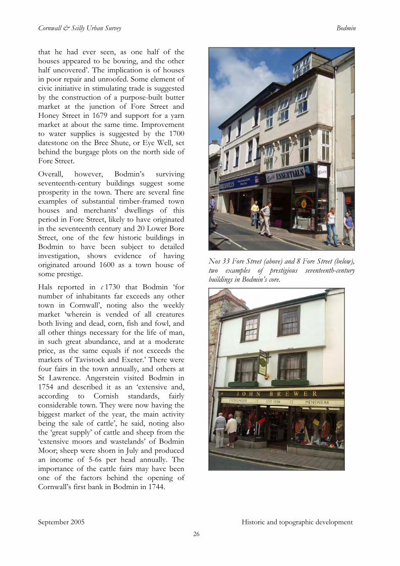
Cornwall & Scilly Urban Survey Bodmin
that he had ever seen, as one half of the houses appeared to be bowing, and the other half uncovered’. The implication is of houses in poor repair and unroofed. Some element of civic initiative in stimulating trade is suggested by the construction of a purpose-built butter market at the junction of Fore Street and Honey Street in 1679 and support for a yarn market at about the same time. Improvement to water supplies is suggested by the 1700 datestone on the Bree Shute, or Eye Well, set behind the burgage plots on the north side of Fore Street.
Overall, however, Bodmin’s surviving seventeenth-century buildings suggest some prosperity in the town. There are several fine examples of substantial timber-framed town houses and merchants’ dwellings of this period in Fore Street, likely to have originated in the seventeenth century and 20 Lower Bore Street, one of the few historic buildings in Bodmin to have been subject to detailed investigation, shows evidence of having originated around 1600 as a town house of some prestige.
Hals reported in c 1730 that Bodmin ‘for number of inhabitants far exceeds any other town in Cornwall’, noting also the weekly market ‘wherein is vended of all creatures both living and dead, corn, fish and fowl, and all other things necessary for the life of man, in such great abundance, and at a moderate price, as the same equals if not exceeds the markets of Tavistock and Exeter.’ There were four fairs in the town annually, and others at St Lawrence. Angerstein visited Bodmin in 1754 and described it as an ‘extensive and, according to Cornish standards, fairly considerable town. They were now having the biggest market of the year, the main activity being the sale of cattle’, he said, noting also the ‘great supply’ of cattle and sheep from the ‘extensive moors and wastelands’ of Bodmin Moor; sheep were shorn in July and produced an income of 5-6s per head annually. The importance of the cattle fairs may have been one of the factors behind the opening of Cornwall’s first bank in Bodmin in 1744.
Nos 33 Fore Street (above) and 8 Fore Street (below), two examples of prestigious seventeenth-century buildings in Bodmin’s core.
September 2005 Historic and topographic development 26
Cornwall & Scilly Urban Survey Bodmin
There was a considerable woollen industry in Bodmin in the post medieval period and perhaps earlier. A fuller and a dyer were recorded there in the early seventeenth century and the town corporation gave financial support to a yarn market in the later 1670s. Theophilus Botanista noted in 1757 that the town was ‘once the only staple [principal market] of the county for the yarn manufacture, but that is since greatly decayed.’ The Reverend Maton, visiting in 1785, observed that the town ‘must formerly have been a very flourishing, extensive place, and was famous for its manufactories . . . A manufactory of yarn too continues, but is said to be much on the decline.’ Of the 17 Bodmin traders listed in Bailey’s Western and Midland Directory, published in 1783, two were noted as yarn merchants and four as yarn jobbers; several others were recorded as mercers and drapers. William Clift (born 1775), recalled in later life that during his boyhood his mother and sisters ‘occupied themselves in carding and spinning wool, which was the staple employment of most of the poor people during the winter months’. In the 1790s his sister Elizabeth prepared warps for Joseph Eyre, listed with his brother Thomas as yarn merchants in 1783, who put out wool for spinning and may also have employed weavers. Eyre built a tucking mill at Margate, east of the town, in 1792, replacing one he had previously operated in the Priory precinct. A woollen blanket manufactory was noted at Clerkenwater, to the north, in 1794.
September 2005 Historic and topographic development
Tanning, another industry deriving its raw materials from Bodmin’s wide pastoral hinterland, was also important. The town’s 1563 charter provided that tanners and curriers from outside the borough should not purchase ‘new hides’, effectively restricting the supply of raw materials for the important tanning and leather trade to the town’s own entrepreneurs. Lime pits associated with the tanning trade were recorded in Berrycoombe during the sixteenth century and in 1662 Bodmin was said to have a ‘great many tanners’. Boot and shoe making also became important. Elizabeth Clift noted a strike by journeymen shoemakers in 1796: ‘all the
Masters have entered into an article . . . not to give any more wages . . . there is but three journeymen at work in town, four are gone off today to get work and several more are going tomorrow’. This and other small-scale craft trades would have operated from small workshops in or close to domestic premises.
‘Poor Bodmin’ (John Wesley, 1774)
From 1716 Bodmin became Cornwall’s second assize town (discontinued between 1727 and 1736), despite the reported protests of the judges of the circuit, who were credited with the comment ‘Out of the world into Bodmin’. The Summer Assizes were held there annually, the winter court being held at Launceston. The impact on the town of its new status was not immediate. Bishop Pococke, visiting in 1750, noted Bodmin as ‘a long town but seems to be very poor’, noting also that the former friary church, with a fine east window, had been converted to serve as a courthouse. Nonetheless, the Assizes brought substantial numbers of people to Bodmin, partly for the legal proceedings but also for an associated round of social events, attracting substantial representation from Cornwall’s nobility and gentry. Bodmin Races, in particular, attracted considerable attendance. The races were held during the week after the assizes on a course ‘considered one of the finest in England’. (Racecourse Downs lay about 3km north east of the centre of Bodmin, immediately outside the municipal boundary.) The provision of accommodation and other services for these visitors over a period each summer must have had significant implications for the town’s economy. The construction of numbers of good-quality town houses and the refurbishment of others in the mid and later eighteenth century – there are surviving examples in Castle Street, Church Square, Honey Street, Fore Street and Lower and Higher Bore Streets – is likely to have been in some part a response to demand for lodgings during the Assize season and for improved accommodation for some prospering residents. These houses, together
27
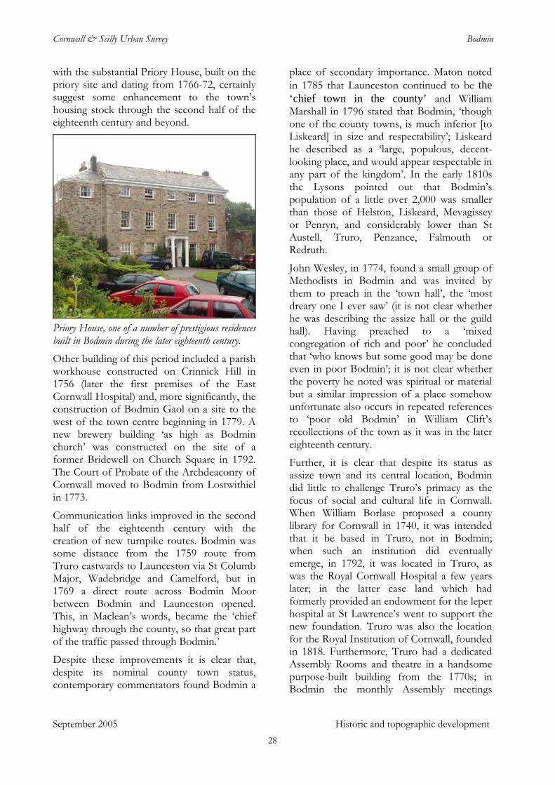
Cornwall & Scilly Urban Survey Bodmin
with the substantial Priory House, built on the priory site and dating from 1766-72, certainly suggest some enhancement to the town’s housing stock through the second half of the eighteenth century and beyond.
Priory House, one of a number of prestigious residences built in Bodmin during the later eighteenth century. Other building of this period included a parish workhouse constructed on Crinnick Hill in 1756 (later the first premises of the East Cornwall Hospital) and, more significantly, the construction of Bodmin Gaol on a site to the west of the town centre beginning in 1779. A new brewery building ‘as high as Bodmin church’ was constructed on the site of a former Bridewell on Church Square in 1792. The Court of Probate of the Archdeaconry of Cornwall moved to Bodmin from Lostwithiel in 1773.
Communication links improved in the second half of the eighteenth century with the creation of new turnpike routes. Bodmin was some distance from the 1759 route from Truro eastwards to Launceston via St Columb Major, Wadebridge and Camelford, but in 1769 a direct route across Bodmin Moor between Bodmin and Launceston opened. This, in Maclean’s words, became the ‘chief highway through the county, so that great part of the traffic passed through Bodmin.’
Despite these improvements it is clear that, despite its nominal county town status, contemporary commentators found Bodmin a
place of secondary importance. Maton noted in 1785 that Launceston continued to be the ‘chief town in the county’ and William Marshall in 1796 stated that Bodmin, ‘though one of the county towns, is much inferior [to Liskeard] in size and respectability’; Liskeard he described as a ‘large, populous, decent-looking place, and would appear respectable in any part of the kingdom’. In the early 1810s the Lysons pointed out that Bodmin’s population of a little over 2,000 was smaller than those of Helston, Liskeard, Mevagissey or Penryn, and considerably lower than St Austell, Truro, Penzance, Falmouth or Redruth.
John Wesley, in 1774, found a small group of Methodists in Bodmin and was invited by them to preach in the ‘town hall’, the ‘most dreary one I ever saw’ (it is not clear whether he was describing the assize hall or the guild hall). Having preached to a ‘mixed congregation of rich and poor’ he concluded that ‘who knows but some good may be done even in poor Bodmin’; it is not clear whether the poverty he noted was spiritual or material but a similar impression of a place somehow unfortunate also occurs in repeated references to ‘poor old Bodmin’ in William Clift’s recollections of the town as it was in the later eighteenth century.
Further, it is clear that despite its status as assize town and its central location, Bodmin did little to challenge Truro’s primacy as the focus of social and cultural life in Cornwall. When William Borlase proposed a county library for Cornwall in 1740, it was intended that it be based in Truro, not in Bodmin; when such an institution did eventually emerge, in 1792, it was located in Truro, as was the Royal Cornwall Hospital a few years later; in the latter case land which had formerly provided an endowment for the leper hospital at St Lawrence’s went to support the new foundation. Truro was also the location for the Royal Institution of Cornwall, founded in 1818. Furthermore, Truro had a dedicated Assembly Rooms and theatre in a handsome purpose-built building from the 1770s; in Bodmin the monthly Assembly meetings
September 2005 Historic and topographic development 28
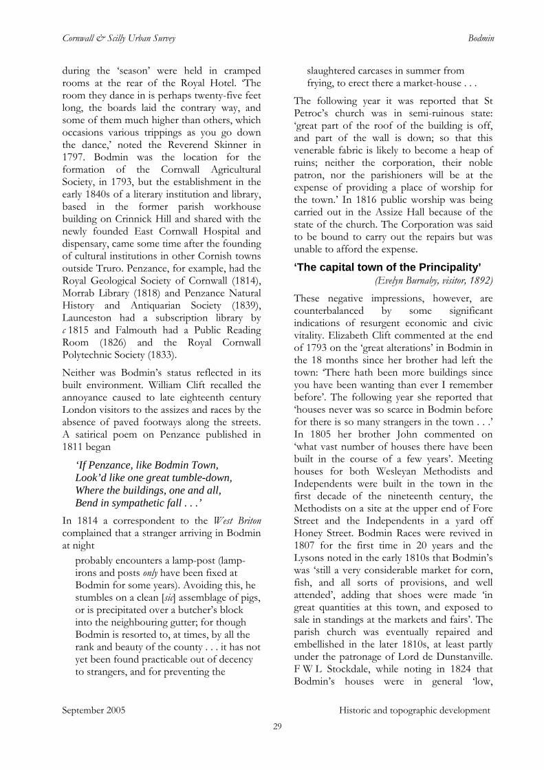
Cornwall & Scilly Urban Survey Bodmin
during the ‘season’ were held in cramped rooms at the rear of the Royal Hotel. ‘The room they dance in is perhaps twenty-five feet long, the boards laid the contrary way, and some of them much higher than others, which occasions various trippings as you go down the dance,’ noted the Reverend Skinner in 1797. Bodmin was the location for the formation of the Cornwall Agricultural Society, in 1793, but the establishment in the early 1840s of a literary institution and library, based in the former parish workhouse building on Crinnick Hill and shared with the newly founded East Cornwall Hospital and dispensary, came some time after the founding of cultural institutions in other Cornish towns outside Truro. Penzance, for example, had the Royal Geological Society of Cornwall (1814), Morrab Library (1818) and Penzance Natural History and Antiquarian Society (1839), Launceston had a subscription library by c 1815 and Falmouth had a Public Reading Room (1826) and the Royal Cornwall Polytechnic Society (1833).
Neither was Bodmin’s status reflected in its built environment. William Clift recalled the annoyance caused to late eighteenth century London visitors to the assizes and races by the absence of paved footways along the streets. A satirical poem on Penzance published in 1811 began
‘If Penzance, like Bodmin Town, Look’d like one great tumble-down, Where the buildings, one and all, Bend in sympathetic fall . . .’
In 1814 a correspondent to the West Briton complained that a stranger arriving in Bodmin at night
probably encounters a lamp-post (lamp-irons and posts only have been fixed at Bodmin for some years). Avoiding this, he stumbles on a clean [sic] assemblage of pigs, or is precipitated over a butcher’s block into the neighbouring gutter; for though Bodmin is resorted to, at times, by all the rank and beauty of the county . . . it has not yet been found practicable out of decency to strangers, and for preventing the
slaughtered carcases in summer from frying, to erect there a market-house . . .
The following year it was reported that St Petroc’s church was in semi-ruinous state: ‘great part of the roof of the building is off, and part of the wall is down; so that this venerable fabric is likely to become a heap of ruins; neither the corporation, their noble patron, nor the parishioners will be at the expense of providing a place of worship for the town.’ In 1816 public worship was being carried out in the Assize Hall because of the state of the church. The Corporation was said to be bound to carry out the repairs but was unable to afford the expense.
‘The capital town of the Principality’ (Evelyn Burnaby, visitor, 1892)
September 2005 Historic and topographic development
These negative impressions, however, are counterbalanced by some significant indications of resurgent economic and civic vitality. Elizabeth Clift commented at the end of 1793 on the ‘great alterations’ in Bodmin in the 18 months since her brother had left the town: ‘There hath been more buildings since you have been wanting than ever I remember before’. The following year she reported that ‘houses never was so scarce in Bodmin before for there is so many strangers in the town . . .’ In 1805 her brother John commented on ‘what vast number of houses there have been built in the course of a few years’. Meeting houses for both Wesleyan Methodists and Independents were built in the town in the first decade of the nineteenth century, the Methodists on a site at the upper end of Fore Street and the Independents in a yard off Honey Street. Bodmin Races were revived in 1807 for the first time in 20 years and the Lysons noted in the early 1810s that Bodmin’s was ‘still a very considerable market for corn, fish, and all sorts of provisions, and well attended’, adding that shoes were made ‘in great quantities at this town, and exposed to sale in standings at the markets and fairs’. The parish church was eventually repaired and embellished in the later 1810s, at least partly under the patronage of Lord de Dunstanville. F W L Stockdale, while noting in 1824 that Bodmin’s houses were in general ‘low,
29
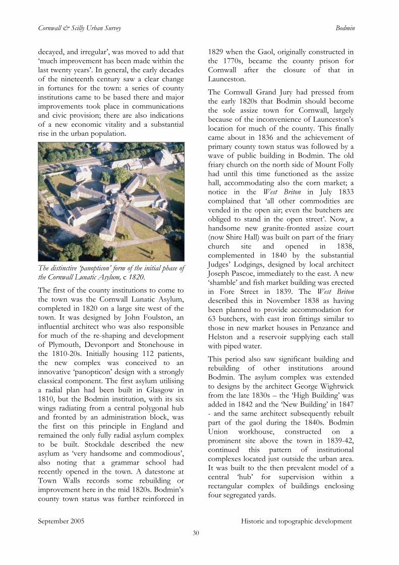
Cornwall & Scilly Urban Survey Bodmin
decayed, and irregular’, was moved to add that ‘much improvement has been made within the last twenty years’. In general, the early decades of the nineteenth century saw a clear change in fortunes for the town: a series of county institutions came to be based there and major improvements took place in communications and civic provision; there are also indications of a new economic vitality and a substantial rise in the urban population.
The distinctive ‘panopticon’ form of the initial phase of the Cornwall Lunatic Asylum, c 1820. The first of the county institutions to come to the town was the Cornwall Lunatic Asylum, completed in 1820 on a large site west of the town. It was designed by John Foulston, an influential architect who was also responsible for much of the re-shaping and development of Plymouth, Devonport and Stonehouse in the 1810-20s. Initially housing 112 patients, the new complex was conceived to an innovative ‘panopticon’ design with a strongly classical component. The first asylum utilising a radial plan had been built in Glasgow in 1810, but the Bodmin institution, with its six wings radiating from a central polygonal hub and fronted by an administration block, was the first on this principle in England and remained the only fully radial asylum complex to be built. Stockdale described the new asylum as ‘very handsome and commodious’, also noting that a grammar school had recently opened in the town. A datestone at Town Walls records some rebuilding or improvement here in the mid 1820s. Bodmin’s county town status was further reinforced in
1829 when the Gaol, originally constructed in the 1770s, became the county prison for Cornwall after the closure of that in Launceston.
The Cornwall Grand Jury had pressed from the early 1820s that Bodmin should become the sole assize town for Cornwall, largely because of the inconvenience of Launceston’s location for much of the county. This finally came about in 1836 and the achievement of primary county town status was followed by a wave of public building in Bodmin. The old friary church on the north side of Mount Folly had until this time functioned as the assize hall, accommodating also the corn market; a notice in the West Briton in July 1833 complained that ‘all other commodities are vended in the open air; even the butchers are obliged to stand in the open street’. Now, a handsome new granite-fronted assize court (now Shire Hall) was built on part of the friary church site and opened in 1838, complemented in 1840 by the substantial Judges’ Lodgings, designed by local architect Joseph Pascoe, immediately to the east. A new ‘shamble’ and fish market building was erected in Fore Street in 1839. The West Briton described this in November 1838 as having been planned to provide accommodation for 63 butchers, with cast iron fittings similar to those in new market houses in Penzance and Helston and a reservoir supplying each stall with piped water.
This period also saw significant building and rebuilding of other institutions around Bodmin. The asylum complex was extended to designs by the architect George Wightwick from the late 1830s – the ‘High Building’ was added in 1842 and the ‘New Building’ in 1847 - and the same architect subsequently rebuilt part of the gaol during the 1840s. Bodmin Union workhouse, constructed on a prominent site above the town in 1839-42, continued this pattern of institutional complexes located just outside the urban area. It was built to the then prevalent model of a central ‘hub’ for supervision within a rectangular complex of buildings enclosing four segregated yards.
September 2005 Historic and topographic development 30
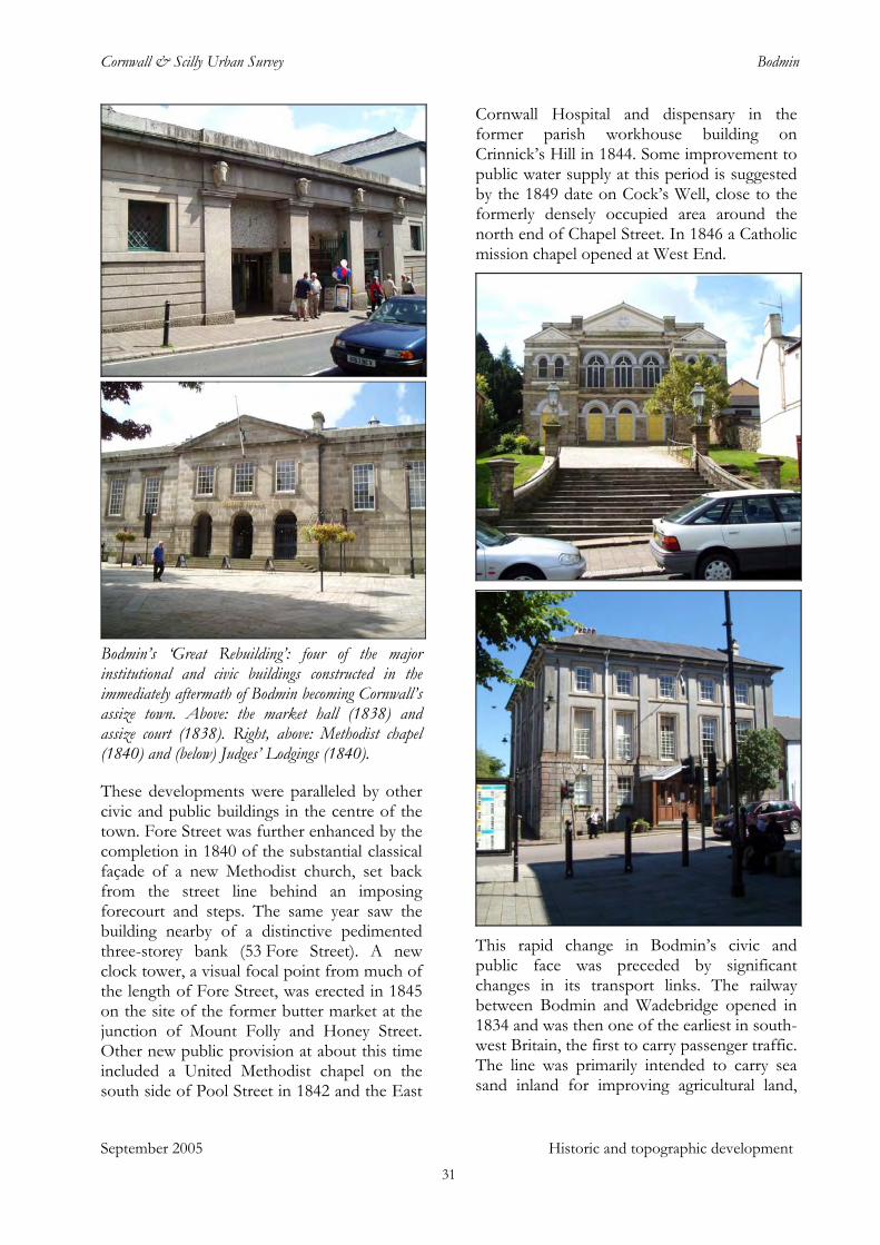
Cornwall & Scilly Urban Survey Bodmin
Bodmin’s ‘Great Rebuilding’: four of the major institutional and civic buildings constructed in the immediately aftermath of Bodmin becoming Cornwall’s assize town. Above: the market hall (1838) and assize court (1838). Right, above: Methodist chapel (1840) and (below) Judges’ Lodgings (1840).
These developments were paralleled by other civic and public buildings in the centre of the town. Fore Street was further enhanced by the completion in 1840 of the substantial classical façade of a new Methodist church, set back from the street line behind an imposing forecourt and steps. The same year saw the building nearby of a distinctive pedimented three-storey bank (53 Fore Street). A new clock tower, a visual focal point from much of the length of Fore Street, was erected in 1845 on the site of the former butter market at the junction of Mount Folly and Honey Street. Other new public provision at about this time included a United Methodist chapel on the south side of Pool Street in 1842 and the East
Cornwall Hospital and dispensary in the former parish workhouse building on Crinnick’s Hill in 1844. Some improvement to public water supply at this period is suggested by the 1849 date on Cock’s Well, close to the formerly densely occupied area around the north end of Chapel Street. In 1846 a Catholic mission chapel opened at West End.
This rapid change in Bodmin’s civic and public face was preceded by significant changes in its transport links. The railway between Bodmin and Wadebridge opened in 1834 and was then one of the earliest in south-west Britain, the first to carry passenger traffic. The line was primarily intended to carry sea sand inland for improving agricultural land,
September 2005 Historic and topographic development 31
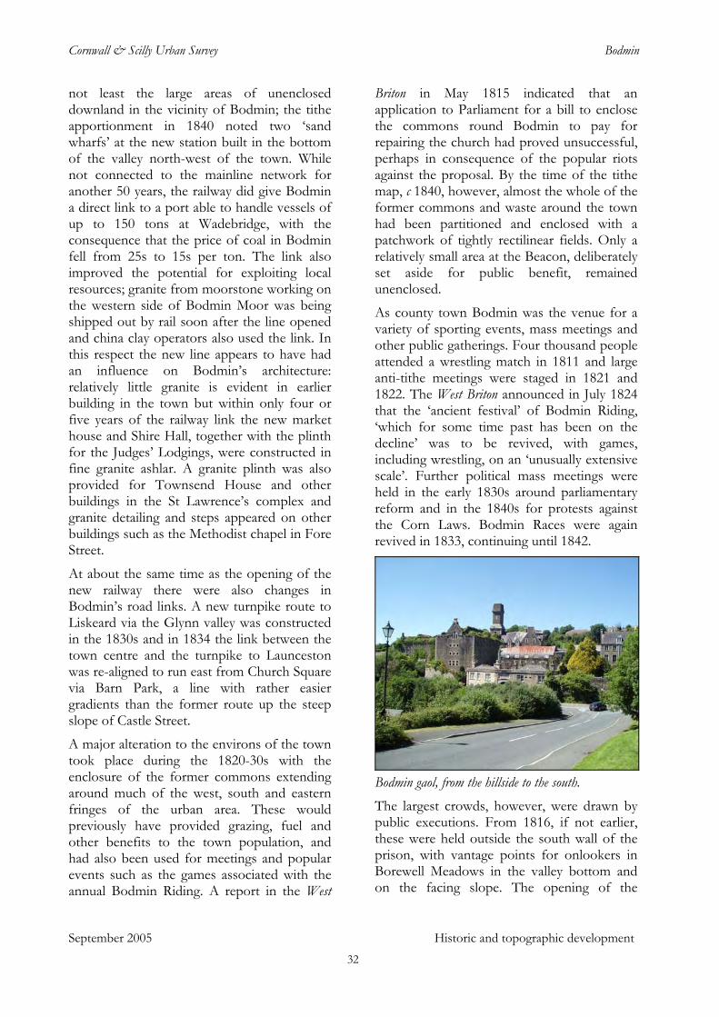
Cornwall & Scilly Urban Survey Bodmin
not least the large areas of unenclosed downland in the vicinity of Bodmin; the tithe apportionment in 1840 noted two ‘sand wharfs’ at the new station built in the bottom of the valley north-west of the town. While not connected to the mainline network for another 50 years, the railway did give Bodmin a direct link to a port able to handle vessels of up to 150 tons at Wadebridge, with the consequence that the price of coal in Bodmin fell from 25s to 15s per ton. The link also improved the potential for exploiting local resources; granite from moorstone working on the western side of Bodmin Moor was being shipped out by rail soon after the line opened and china clay operators also used the link. In this respect the new line appears to have had an influence on Bodmin’s architecture: relatively little granite is evident in earlier building in the town but within only four or five years of the railway link the new market house and Shire Hall, together with the plinth for the Judges’ Lodgings, were constructed in fine granite ashlar. A granite plinth was also provided for Townsend House and other buildings in the St Lawrence’s complex and granite detailing and steps appeared on other buildings such as the Methodist chapel in Fore Street.
At about the same time as the opening of the new railway there were also changes in Bodmin’s road links. A new turnpike route to Liskeard via the Glynn valley was constructed in the 1830s and in 1834 the link between the town centre and the turnpike to Launceston was re-aligned to run east from Church Square via Barn Park, a line with rather easier gradients than the former route up the steep slope of Castle Street.
A major alteration to the environs of the town took place during the 1820-30s with the enclosure of the former commons extending around much of the west, south and eastern fringes of the urban area. These would previously have provided grazing, fuel and other benefits to the town population, and had also been used for meetings and popular events such as the games associated with the annual Bodmin Riding. A report in the West
Briton in May 1815 indicated that an application to Parliament for a bill to enclose the commons round Bodmin to pay for repairing the church had proved unsuccessful, perhaps in consequence of the popular riots against the proposal. By the time of the tithe map, c 1840, however, almost the whole of the former commons and waste around the town had been partitioned and enclosed with a patchwork of tightly rectilinear fields. Only a relatively small area at the Beacon, deliberately set aside for public benefit, remained unenclosed.
As county town Bodmin was the venue for a variety of sporting events, mass meetings and other public gatherings. Four thousand people attended a wrestling match in 1811 and large anti-tithe meetings were staged in 1821 and 1822. The West Briton announced in July 1824 that the ‘ancient festival’ of Bodmin Riding, ‘which for some time past has been on the decline’ was to be revived, with games, including wrestling, on an ‘unusually extensive scale’. Further political mass meetings were held in the early 1830s around parliamentary reform and in the 1840s for protests against the Corn Laws. Bodmin Races were again revived in 1833, continuing until 1842.
Bodmin gaol, from the hillside to the south. The largest crowds, however, were drawn by public executions. From 1816, if not earlier, these were held outside the south wall of the prison, with vantage points for onlookers in Borewell Meadows in the valley bottom and on the facing slope. The opening of the
September 2005 Historic and topographic development 32
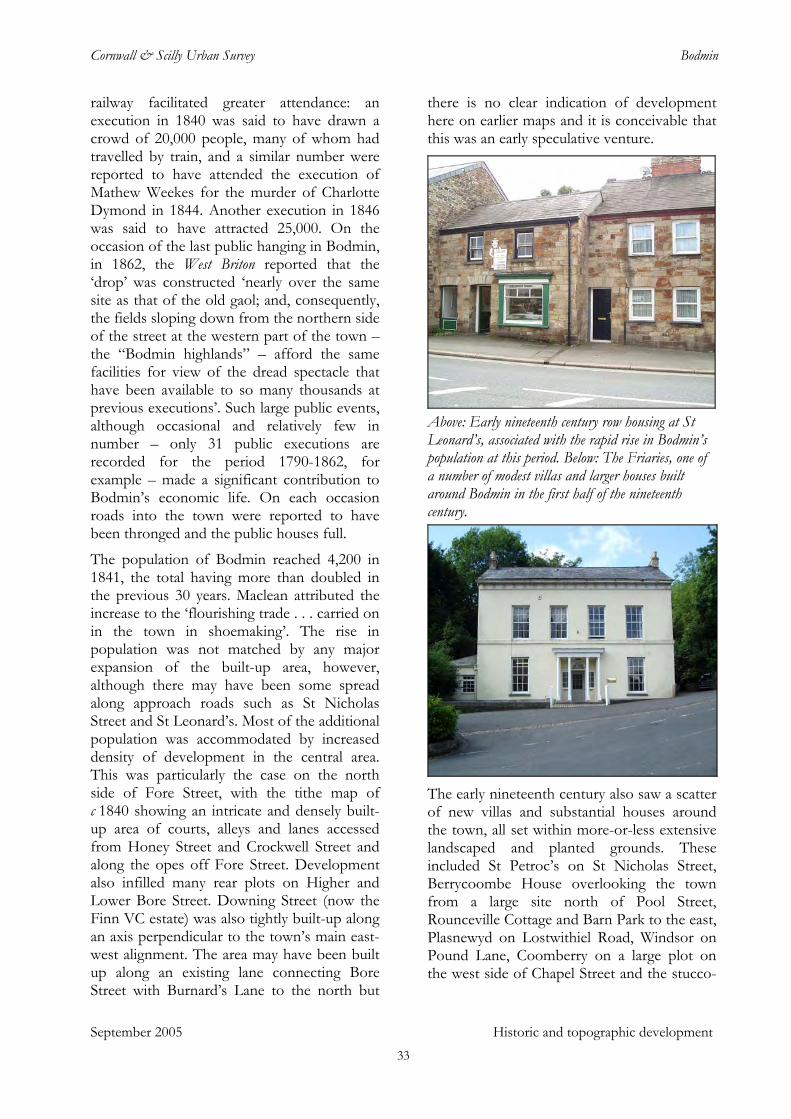
Cornwall & Scilly Urban Survey Bodmin
railway facilitated greater attendance: an execution in 1840 was said to have drawn a crowd of 20,000 people, many of whom had travelled by train, and a similar number were reported to have attended the execution of Mathew Weekes for the murder of Charlotte Dymond in 1844. Another execution in 1846 was said to have attracted 25,000. On the occasion of the last public hanging in Bodmin, in 1862, the West Briton reported that the ‘drop’ was constructed ‘nearly over the same site as that of the old gaol; and, consequently, the fields sloping down from the northern side of the street at the western part of the town – the “Bodmin highlands” – afford the same facilities for view of the dread spectacle that have been available to so many thousands at previous executions’. Such large public events, although occasional and relatively few in number – only 31 public executions are recorded for the period 1790-1862, for example – made a significant contribution to Bodmin’s economic life. On each occasion roads into the town were reported to have been thronged and the public houses full.
September 2005 Historic and topographic development
The population of Bodmin reached 4,200 in 1841, the total having more than doubled in the previous 30 years. Maclean attributed the increase to the ‘flourishing trade . . . carried on in the town in shoemaking’. The rise in population was not matched by any major expansion of the built-up area, however, although there may have been some spread along approach roads such as St Nicholas Street and St Leonard’s. Most of the additional population was accommodated by increased density of development in the central area. This was particularly the case on the north side of Fore Street, with the tithe map of c 1840 showing an intricate and densely built-up area of courts, alleys and lanes accessed from Honey Street and Crockwell Street and along the opes off Fore Street. Development also infilled many rear plots on Higher and Lower Bore Street. Downing Street (now the Finn VC estate) was also tightly built-up along an axis perpendicular to the town’s main east-west alignment. The area may have been built up along an existing lane connecting Bore Street with Burnard’s Lane to the north but
there is no clear indication of development here on earlier maps and it is conceivable that this was an early speculative venture.
Above: Early nineteenth century row housing at St Leonard’s, associated with the rapid rise in Bodmin’s population at this period. Below: The Friaries, one of a number of modest villas and larger houses built around Bodmin in the first half of the nineteenth century.
The early nineteenth century also saw a scatter of new villas and substantial houses around the town, all set within more-or-less extensive landscaped and planted grounds. These included St Petroc’s on St Nicholas Street, Berrycoombe House overlooking the town from a large site north of Pool Street, Rounceville Cottage and Barn Park to the east, Plasnewyd on Lostwithiel Road, Windsor on Pound Lane, Coomberry on a large plot on the west side of Chapel Street and the stucco-
33
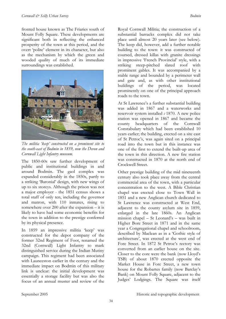
Cornwall & Scilly Urban Survey Bodmin
fronted house known as The Friaries south of Mount Folly Square. These developments are significant both in reflecting the enhanced prosperity of the town at this period, and the overt ‘polite’ element in its character, but also as the mechanism by which the green and wooded quality of much of its immediate surroundings was established.
The militia ‘keep’ constructed on a prominent site to the south-east of Bodmin in 1859, now the Devon and Cornwall Light Infantry museum. The 1850-60s saw further development of public and institutional buildings in and around Bodmin. The gaol complex was expanded considerably in the 1850s, partly to a striking ‘Baronial’ design, with new wings of up to six storeys. Although the prison was not a major employer - the 1851 census shows a total staff of only ten, including the governor and matron, with 110 inmates, rising to somewhere over 200 after the expansion – it is likely to have had some economic benefits for the town in addition to the prestige conferred by its physical presence.
In 1859 an impressive militia ‘keep’ was constructed for the depot company of the former 32nd Regiment of Foot, renamed the 32nd (Cornwall) Light Infantry to mark distinguished service during the Indian Mutiny campaign. This regiment had been associated with Launceston earlier in the century and the immediate impact on Bodmin of this military link is unclear: the initial development was essentially a storage facility but was also the focus of an annual muster and review of the
Royal Cornwall Militia; the construction of a substantial barracks complex did not take place until almost 20 years later (see below). The keep did, however, add a further notable building to the town: it was constructed of coursed, dressed killas with granite dressings in impressive ‘French Provincial’ style, with a striking steep-pitched slated roof with prominent gables. It was accompanied by a stable range and bounded by a perimeter wall and gate and, as with other institutional buildings of the period, was located prominently on one of the principal approach roads to the town.
At St Lawrence’s a further substantial building was added in 1867 and a waterworks and reservoir system installed c 1870. A new police station was opened in 1867 and became the county headquarters of the Cornwall Constabulary which had been established 10 years earlier; the building, erected on a site east of St Petroc’s, was again sited on a principal road into the town but in this instance was one of the first to extend the built-up area of the town in this direction. A new fire station was constructed in 1870 at the north end of Crockwell Street.
Other prestige building of the mid nineteenth century also took place away from the central commercial area of the town, with a particular concentration to the west. A Bible Christian chapel was erected close to Town Wall in 1851 and a new Anglican church dedicated to St Lawrence was constructed at West End, adjacent to the county asylum site in 1859, enlarged in the late 1860s. An Anglican mission chapel – St Leonard’s – was built in Higher Bore Street in 1871 and in the same year a Congregational chapel and schoolroom, described by Maclean as in a ‘Gothic style of architecture’, was erected at the west end of Fore Street. In 1872 St Petroc’s rectory was converted from an earlier house on the site. Closer to the core were the bank (now Lloyd’s TSB) of about 1870 erected opposite the Market House in Fore Street, a new town house for the Robartes family (now Barclay’s Bank) on Mount Folly Square, adjacent to the Judges’ Lodgings. The Square was itself
September 2005 Historic and topographic development 34
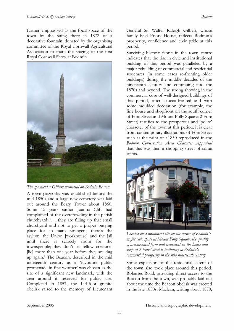
Cornwall & Scilly Urban Survey Bodmin
further emphasised as the focal space of the town by the siting there in 1872 of a decorative fountain, donated by the organising committee of the Royal Cornwall Agricultural Association to mark the staging of the first Royal Cornwall Show at Bodmin.
The spectacular Gilbert memorial on Bodmin Beacon. A town gasworks was established before the mid 1850s and a large new cemetery was laid out around the Berry Tower about 1860. Some 15 years earlier Joanna Clift had complained of the overcrowding in the parish churchyard: ‘. . . they are filling up that small churchyard and not to get a proper burying place for so many strangers; there’s the asylum, the Union [workhouse] and the jail until there is scarcely room for the townspeople; they don’t let fellow creatures [lie] more than one year before they are dug up again.’ The Beacon, described in the mid nineteenth century as a ‘favourite public promenade in fine weather’ was chosen as the site of a significant new landmark, with the area around it reserved for public use. Completed in 1857, the 144-foot granite obelisk raised to the memory of Lieutenant
General Sir Walter Raleigh Gilbert, whose family held Priory House, reflects Bodmin’s prosperity, confidence and civic pride at this period. Surviving historic fabric in the town centre indicates that the rise in civic and institutional building of this period was paralleled by a major rebuilding of commercial and residential structures (in some cases re-fronting older buildings) during the middle decades of the nineteenth century and continuing into the 1870s and beyond. The strong showing in the commercial core of well-designed buildings of this period, often stucco-fronted and with some moulded decoration (for example, the fine house and shopfront on the south corner of Fore Street and Mount Folly Square: 2 Fore Street) testifies to the prosperous and ‘polite’ character of the town at this period; it is clear from contemporary illustrations of Fore Street such as the print of c 1850 reproduced in the Bodmin Conservation Area Character Appraisal that this was then a shopping street of some status.
Located on a prominent site on the corner of Bodmin’s major civic space at Mount Folly Square, the quality of architectural form and treatment on the house and shop at 2 Fore Street is testimony to Bodmin’s commercial prosperity in the mid nineteenth century. Some expansion of the residential extent of the town also took place around this period. Robartes Road, providing direct access to the Beacon from the town, was probably laid out about the time the Beacon obelisk was erected in the late 1850s; Maclean, writing about 1870,
September 2005 Historic and topographic development 35
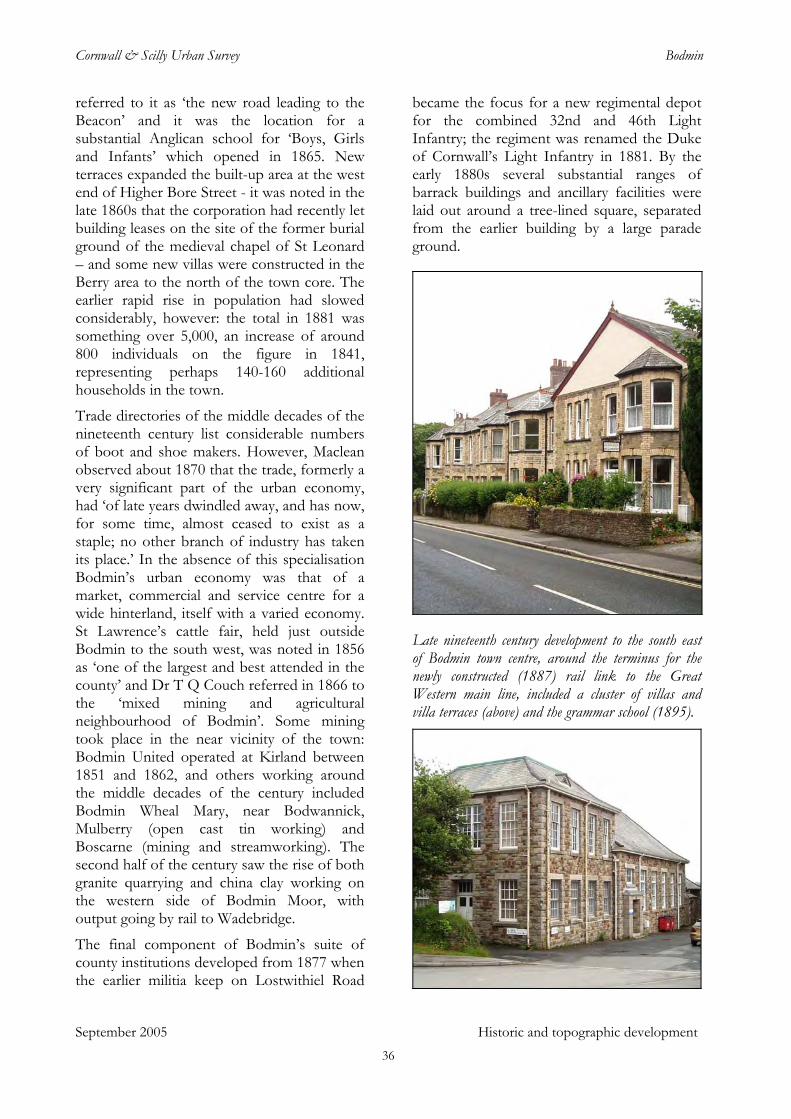
Cornwall & Scilly Urban Survey Bodmin
referred to it as ‘the new road leading to the Beacon’ and it was the location for a substantial Anglican school for ‘Boys, Girls and Infants’ which opened in 1865. New terraces expanded the built-up area at the west end of Higher Bore Street - it was noted in the late 1860s that the corporation had recently let building leases on the site of the former burial ground of the medieval chapel of St Leonard – and some new villas were constructed in the Berry area to the north of the town core. The earlier rapid rise in population had slowed considerably, however: the total in 1881 was something over 5,000, an increase of around 800 individuals on the figure in 1841, representing perhaps 140-160 additional households in the town.
Trade directories of the middle decades of the nineteenth century list considerable numbers of boot and shoe makers. However, Maclean observed about 1870 that the trade, formerly a very significant part of the urban economy, had ‘of late years dwindled away, and has now, for some time, almost ceased to exist as a staple; no other branch of industry has taken its place.’ In the absence of this specialisation Bodmin’s urban economy was that of a market, commercial and service centre for a wide hinterland, itself with a varied economy. St Lawrence’s cattle fair, held just outside Bodmin to the south west, was noted in 1856 as ‘one of the largest and best attended in the county’ and Dr T Q Couch referred in 1866 to the ‘mixed mining and agricultural neighbourhood of Bodmin’. Some mining took place in the near vicinity of the town: Bodmin United operated at Kirland between 1851 and 1862, and others working around the middle decades of the century included Bodmin Wheal Mary, near Bodwannick, Mulberry (open cast tin working) and Boscarne (mining and streamworking). The second half of the century saw the rise of both granite quarrying and china clay working on the western side of Bodmin Moor, with output going by rail to Wadebridge.
The final component of Bodmin’s suite of county institutions developed from 1877 when the earlier militia keep on Lostwithiel Road
became the focus for a new regimental depot for the combined 32nd and 46th Light Infantry; the regiment was renamed the Duke of Cornwall’s Light Infantry in 1881. By the early 1880s several substantial ranges of barrack buildings and ancillary facilities were laid out around a tree-lined square, separated from the earlier building by a large parade ground.
Late nineteenth century development to the south east of Bodmin town centre, around the terminus for the newly constructed (1887) rail link to the Great Western main line, included a cluster of villas and villa terraces (above) and the grammar school (1895).
September 2005 Historic and topographic development 36
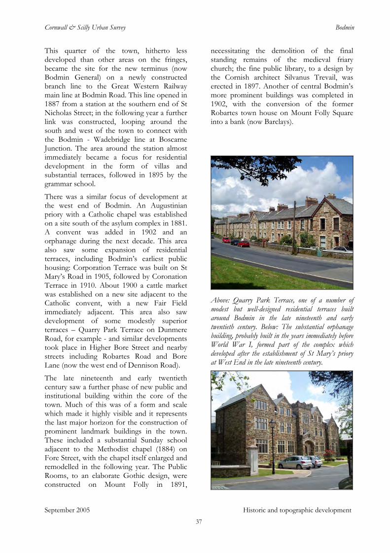
Cornwall & Scilly Urban Survey Bodmin
This quarter of the town, hitherto less developed than other areas on the fringes, became the site for the new terminus (now Bodmin General) on a newly constructed branch line to the Great Western Railway main line at Bodmin Road. This line opened in 1887 from a station at the southern end of St Nicholas Street; in the following year a further link was constructed, looping around the south and west of the town to connect with the Bodmin - Wadebridge line at Boscarne Junction. The area around the station almost immediately became a focus for residential development in the form of villas and substantial terraces, followed in 1895 by the grammar school.
There was a similar focus of development at the west end of Bodmin. An Augustinian priory with a Catholic chapel was established on a site south of the asylum complex in 1881. A convent was added in 1902 and an orphanage during the next decade. This area also saw some expansion of residential terraces, including Bodmin’s earliest public housing: Corporation Terrace was built on St Mary’s Road in 1905, followed by Coronation Terrace in 1910. About 1900 a cattle market was established on a new site adjacent to the Catholic convent, with a new Fair Field immediately adjacent. This area also saw development of some modestly superior terraces – Quarry Park Terrace on Dunmere Road, for example - and similar developments took place in Higher Bore Street and nearby streets including Robartes Road and Bore Lane (now the west end of Dennison Road).
The late nineteenth and early twentieth century saw a further phase of new public and institutional building within the core of the town. Much of this was of a form and scale which made it highly visible and it represents the last major horizon for the construction of prominent landmark buildings in the town. These included a substantial Sunday school adjacent to the Methodist chapel (1884) on Fore Street, with the chapel itself enlarged and remodelled in the following year. The Public Rooms, to an elaborate Gothic design, were constructed on Mount Folly in 1891,
necessitating the demolition of the final standing remains of the medieval friary church; the fine public library, to a design by the Cornish architect Silvanus Trevail, was erected in 1897. Another of central Bodmin’s more prominent buildings was completed in 1902, with the conversion of the former Robartes town house on Mount Folly Square into a bank (now Barclays).
Above: Quarry Park Terrace, one of a number of modest but well-designed residential terraces built around Bodmin in the late nineteenth and early twentieth century. Below: The substantial orphanage building, probably built in the years immediately before World War I, formed part of the complex which developed after the establishment of St Mary’s priory at West End in the late nineteenth century.
September 2005 Historic and topographic development 37
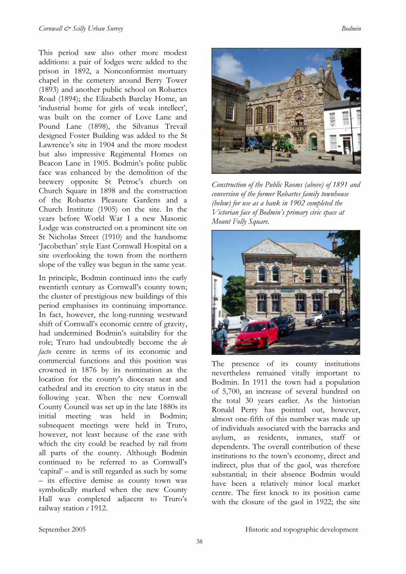
Cornwall & Scilly Urban Survey Bodmin
This period saw also other more modest additions: a pair of lodges were added to the prison in 1892, a Nonconformist mortuary chapel in the cemetery around Berry Tower (1893) and another public school on Robartes Road (1894); the Elizabeth Barclay Home, an ‘industrial home for girls of weak intellect’, was built on the corner of Love Lane and Pound Lane (1898), the Silvanus Trevail designed Foster Building was added to the St Lawrence’s site in 1904 and the more modest but also impressive Regimental Homes on Beacon Lane in 1905. Bodmin’s polite public face was enhanced by the demolition of the brewery opposite St Petroc’s church on Church Square in 1898 and the construction of the Robartes Pleasure Gardens and a Church Institute (1905) on the site. In the years before World War I a new Masonic Lodge was constructed on a prominent site on St Nicholas Street (1910) and the handsome ‘Jacobethan’ style East Cornwall Hospital on a site overlooking the town from the northern slope of the valley was begun in the same year.
September 2005 Historic and topographic development
In principle, Bodmin continued into the early twentieth century as Cornwall’s county town; the cluster of prestigious new buildings of this period emphasises its continuing importance. In fact, however, the long-running westward shift of Cornwall’s economic centre of gravity, had undermined Bodmin’s suitability for the role; Truro had undoubtedly become the de facto centre in terms of its economic and commercial functions and this position was crowned in 1876 by its nomination as the location for the county’s diocesan seat and cathedral and its erection to city status in the following year. When the new Cornwall County Council was set up in the late 1880s its initial meeting was held in Bodmin; subsequent meetings were held in Truro, however, not least because of the ease with which the city could be reached by rail from all parts of the county. Although Bodmin continued to be referred to as Cornwall’s ‘capital’ – and is still regarded as such by some – its effective demise as county town was symbolically marked when the new County Hall was completed adjacent to Truro’s railway station c 1912.
Construction of the Public Rooms (above) of 1891 and conversion of the former Robartes family townhouse (below) for use as a bank in 1902 completed the Victorian face of Bodmin’s primary civic space at Mount Folly Square.
The presence of its county institutions nevertheless remained vitally important to Bodmin. In 1911 the town had a population of 5,700, an increase of several hundred on the total 30 years earlier. As the historian Ronald Perry has pointed out, however, almost one-fifth of this number was made up of individuals associated with the barracks and asylum, as residents, inmates, staff or dependents. The overall contribution of these institutions to the town’s economy, direct and indirect, plus that of the gaol, was therefore substantial; in their absence Bodmin would have been a relatively minor local market centre. The first knock to its position came with the closure of the gaol in 1922; the site
38
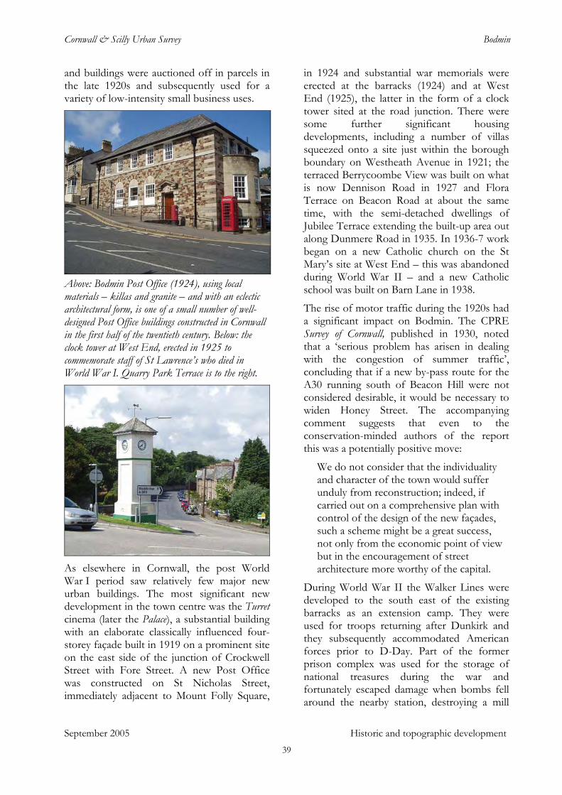
Cornwall & Scilly Urban Survey Bodmin
and buildings were auctioned off in parcels in the late 1920s and subsequently used for a variety of low-intensity small business uses.
Above: Bodmin Post Office (1924), using local materials – killas and granite – and with an eclectic architectural form, is one of a small number of well-designed Post Office buildings constructed in Cornwall in the first half of the twentieth century. Below: the clock tower at West End, erected in 1925 to commemorate staff of St Lawrence’s who died in World War I. Quarry Park Terrace is to the right.
As elsewhere in Cornwall, the post World War I period saw relatively few major new urban buildings. The most significant new development in the town centre was the Turret cinema (later the Palace), a substantial building with an elaborate classically influenced four-storey façade built in 1919 on a prominent site on the east side of the junction of Crockwell Street with Fore Street. A new Post Office was constructed on St Nicholas Street, immediately adjacent to Mount Folly Square,
in 1924 and substantial war memorials were erected at the barracks (1924) and at West End (1925), the latter in the form of a clock tower sited at the road junction. There were some further significant housing developments, including a number of villas squeezed onto a site just within the borough boundary on Westheath Avenue in 1921; the terraced Berrycoombe View was built on what is now Dennison Road in 1927 and Flora Terrace on Beacon Road at about the same time, with the semi-detached dwellings of Jubilee Terrace extending the built-up area out along Dunmere Road in 1935. In 1936-7 work began on a new Catholic church on the St Mary’s site at West End – this was abandoned during World War II – and a new Catholic school was built on Barn Lane in 1938.
The rise of motor traffic during the 1920s had a significant impact on Bodmin. The CPRE Survey of Cornwall, published in 1930, noted that a ‘serious problem has arisen in dealing with the congestion of summer traffic’, concluding that if a new by-pass route for the A30 running south of Beacon Hill were not considered desirable, it would be necessary to widen Honey Street. The accompanying comment suggests that even to the conservation-minded authors of the report this was a potentially positive move:
We do not consider that the individuality and character of the town would suffer unduly from reconstruction; indeed, if carried out on a comprehensive plan with control of the design of the new façades, such a scheme might be a great success, not only from the economic point of view but in the encouragement of street architecture more worthy of the capital.
September 2005 Historic and topographic development
During World War II the Walker Lines were developed to the south east of the existing barracks as an extension camp. They were used for troops returning after Dunkirk and they subsequently accommodated American forces prior to D-Day. Part of the former prison complex was used for the storage of national treasures during the war and fortunately escaped damage when bombs fell around the nearby station, destroying a mill
39
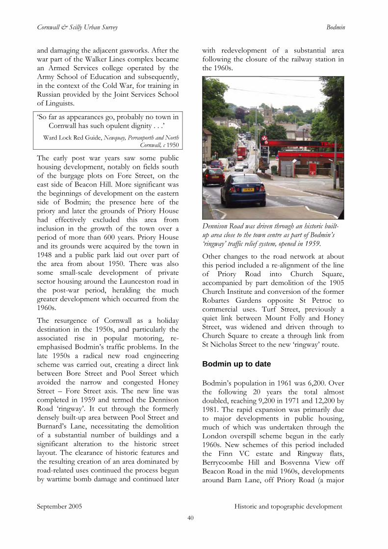
Cornwall & Scilly Urban Survey Bodmin
and damaging the adjacent gasworks. After the war part of the Walker Lines complex became an Armed Services college operated by the Army School of Education and subsequently, in the context of the Cold War, for training in Russian provided by the Joint Services School of Linguists.
‘So far as appearances go, probably no town in Cornwall has such opulent dignity . . .’
September 2005 Historic and topographic development
Ward Lock Red Guide, Newquay, Perranporth and North Cornwall, c 1950
The early post war years saw some public housing development, notably on fields south of the burgage plots on Fore Street, on the east side of Beacon Hill. More significant was the beginnings of development on the eastern side of Bodmin; the presence here of the priory and later the grounds of Priory House had effectively excluded this area from inclusion in the growth of the town over a period of more than 600 years. Priory House and its grounds were acquired by the town in 1948 and a public park laid out over part of the area from about 1950. There was also some small-scale development of private sector housing around the Launceston road in the post-war period, heralding the much greater development which occurred from the 1960s.
The resurgence of Cornwall as a holiday destination in the 1950s, and particularly the associated rise in popular motoring, re-emphasised Bodmin’s traffic problems. In the late 1950s a radical new road engineering scheme was carried out, creating a direct link between Bore Street and Pool Street which avoided the narrow and congested Honey Street – Fore Street axis. The new line was completed in 1959 and termed the Dennison Road ‘ringway’. It cut through the formerly densely built-up area between Pool Street and Burnard’s Lane, necessitating the demolition of a substantial number of buildings and a significant alteration to the historic street layout. The clearance of historic features and the resulting creation of an area dominated by road-related uses continued the process begun by wartime bomb damage and continued later
with redevelopment of a substantial area following the closure of the railway station in the 1960s.
Dennison Road was driven through an historic built-up area close to the town centre as part of Bodmin’s ‘ringway’ traffic relief system, opened in 1959. Other changes to the road network at about this period included a re-alignment of the line of Priory Road into Church Square, accompanied by part demolition of the 1905 Church Institute and conversion of the former Robartes Gardens opposite St Petroc to commercial uses. Turf Street, previously a quiet link between Mount Folly and Honey Street, was widened and driven through to Church Square to create a through link from St Nicholas Street to the new ‘ringway’ route.
Bodmin up to date
Bodmin’s population in 1961 was 6,200. Over the following 20 years the total almost doubled, reaching 9,200 in 1971 and 12,200 by 1981. The rapid expansion was primarily due to major developments in public housing, much of which was undertaken through the London overspill scheme begun in the early 1960s. New schemes of this period included the Finn VC estate and Ringway flats, Berrycoombe Hill and Bosvenna View off Beacon Road in the mid 1960s, developments around Barn Lane, off Priory Road (a major
40
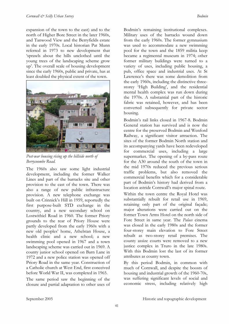
Cornwall & Scilly Urban Survey Bodmin
expansion of the town to the east) and to the north of Higher Bore Street in the later 1960s, and Tanwood View and the Berryfields estate in the early 1970s. Local historian Pat Munn referred in 1973 to new development that ‘sprawls about the hills unclothed until the young trees of the landscaping scheme grow up’. The overall scale of housing development since the early 1960s, public and private, has at least doubled the physical extent of the town.
Post-war housing rising up the hillside north of Berrycoombe Road. The 1960s also saw some light industrial development, including the former Walker Lines and part of the barracks site and other provision to the east of the town. There was also a range of new public infrastructure provision. A new telephone exchange was built on Crinnick’s Hill in 1959, reportedly the first purpose-built STD exchange in the country, and a new secondary school on Lostwithiel Road in 1960. The former Priory grounds to the rear of Priory House were partly developed from the early 1960s with a new old peoples’ home, Athelstan House, a health clinic and a new school; a new swimming pool opened in 1967 and a town landscaping scheme was carried out in 1969. A county junior school opened on Barn Lane in 1972 and a new police station was opened off Priory Road in the same year. Construction of a Catholic church at West End, first conceived before World War II, was completed in 1965. The same period saw the beginning of the closure and partial adaptation to other uses of
Bodmin’s remaining institutional complexes. Military uses of the barracks wound down from the early 1960s. The former gymnasium was used to accommodate a new swimming pool for the town and the 1859 militia keep became a regimental museum in 1974; other former military buildings were turned to a variety of uses, including public housing, a pub, office space and industrial uses. At St Lawrence’s there was some demolition from the early 1960s, including the distinctive three-storey ‘High Building’, and the residential mental health complex was run down during the 1970s. A substantial part of the historic fabric was retained, however, and has been converted subsequently for private sector housing. Bodmin’s rail links closed in 1967-8. Bodmin General station has survived and is now the centre for the preserved Bodmin and Wenford Railway, a significant visitor attraction. The sites of the former Bodmin North station and its accompanying yards have been redeveloped for commercial uses, including a large supermarket. The opening of a by-pass route for the A30 around the south of the town in the mid 1970s reduced the previous serious traffic problems, but also removed the commercial benefits which for a considerable part of Bodmin’s history had derived from a location astride Cornwall’s major spinal route. Within the town centre the Royal Hotel was substantially rebuilt for retail use in 1969, retaining only part of the original façade; major alterations were carried out on the former Town Arms Hotel on the north side of Fore Street in same year. The Palace cinema was closed in the early 1980s and the former four-storey main elevation to Fore Street rebuilt as two-storey retail premises. The county assize courts were removed to a new justice complex in Truro in the late 1980s. With this Bodmin lost the last of its former attributes as county town. By this period Bodmin, in common with much of Cornwall, and despite the boosts of housing and industrial growth of the 1960-70s, was suffering significant levels of social and economic stress, including relatively high
September 2005 Historic and topographic development 41
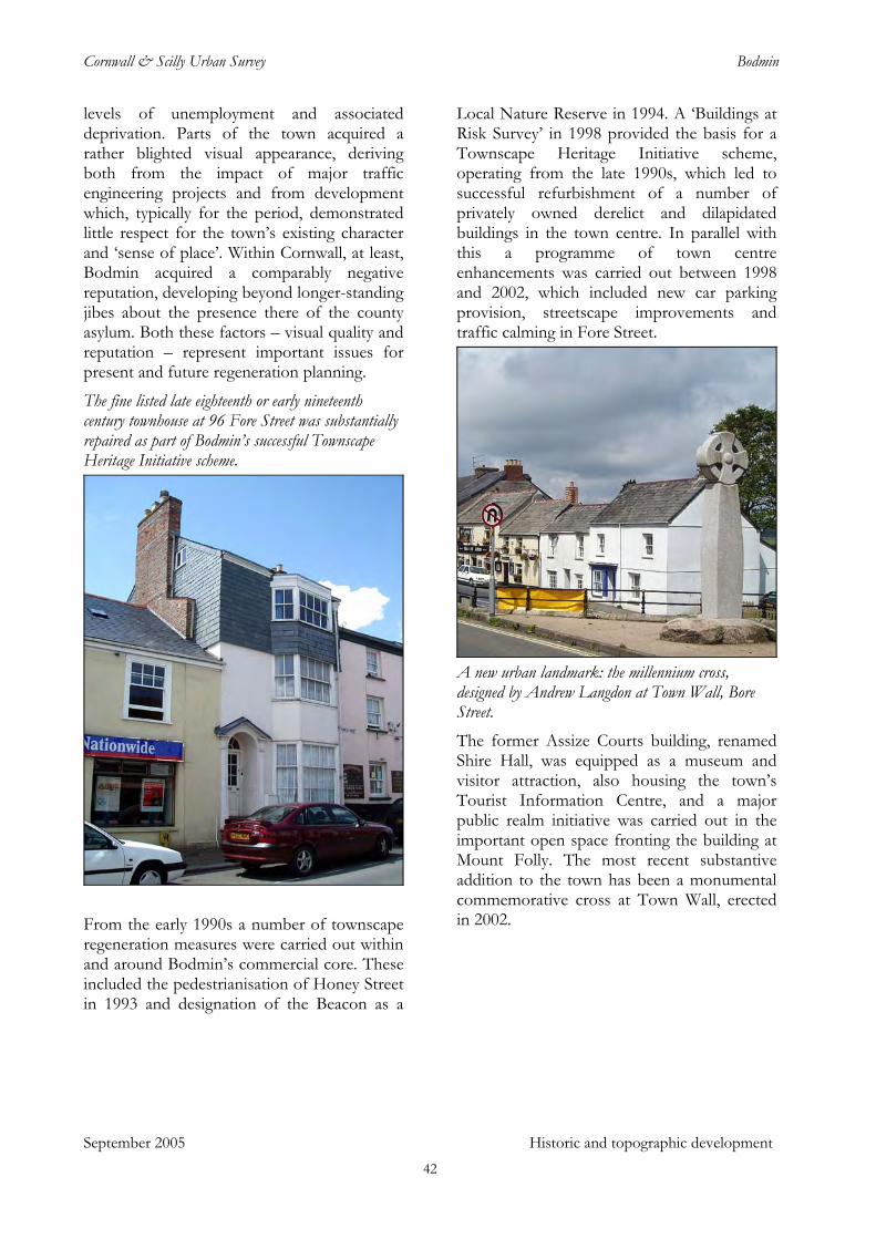
Cornwall & Scilly Urban Survey Bodmin
levels of unemployment and associated deprivation. Parts of the town acquired a rather blighted visual appearance, deriving both from the impact of major traffic engineering projects and from development which, typically for the period, demonstrated little respect for the town’s existing character and ‘sense of place’. Within Cornwall, at least, Bodmin acquired a comparably negative reputation, developing beyond longer-standing jibes about the presence there of the county asylum. Both these factors – visual quality and reputation – represent important issues for present and future regeneration planning.
The fine listed late eighteenth or early nineteenth century townhouse at 96 Fore Street was substantially repaired as part of Bodmin’s successful Townscape Heritage Initiative scheme.
From the early 1990s a number of townscape regeneration measures were carried out within and around Bodmin’s commercial core. These included the pedestrianisation of Honey Street in 1993 and designation of the Beacon as a
Local Nature Reserve in 1994. A ‘Buildings at Risk Survey’ in 1998 provided the basis for a Townscape Heritage Initiative scheme, operating from the late 1990s, which led to successful refurbishment of a number of privately owned derelict and dilapidated buildings in the town centre. In parallel with this a programme of town centre enhancements was carried out between 1998 and 2002, which included new car parking provision, streetscape improvements and traffic calming in Fore Street.
A new urban landmark: the millennium cross, designed by Andrew Langdon at Town Wall, Bore Street. The former Assize Courts building, renamed Shire Hall, was equipped as a museum and visitor attraction, also housing the town’s Tourist Information Centre, and a major public realm initiative was carried out in the important open space fronting the building at Mount Folly. The most recent substantive addition to the town has been a monumental commemorative cross at Town Wall, erected in 2002.
September 2005 Historic and topographic development 42
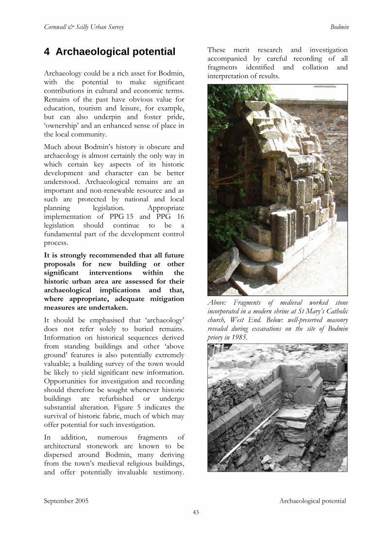
Cornwall & Scilly Urban Survey Bodmin
September 2005 Archaeological potential
4 Archaeological potential
Archaeology could be a rich asset for Bodmin, with the potential to make significant contributions in cultural and economic terms. Remains of the past have obvious value for education, tourism and leisure, for example, but can also underpin and foster pride, ‘ownership’ and an enhanced sense of place in the local community.
Much about Bodmin’s history is obscure and archaeology is almost certainly the only way in which certain key aspects of its historic development and character can be better understood. Archaeological remains are an important and non-renewable resource and as such are protected by national and local planning legislation. Appropriate implementation of PPG 15 and PPG 16 legislation should continue to be a fundamental part of the development control process.
It is strongly recommended that all future proposals for new building or other significant interventions within the historic urban area are assessed for their archaeological implications and that, where appropriate, adequate mitigation measures are undertaken.
It should be emphasised that ‘archaeology’ does not refer solely to buried remains. Information on historical sequences derived from standing buildings and other ‘above ground’ features is also potentially extremely valuable; a building survey of the town would be likely to yield significant new information. Opportunities for investigation and recording should therefore be sought whenever historic buildings are refurbished or undergo substantial alteration. Figure 5 indicates the survival of historic fabric, much of which may offer potential for such investigation.
In addition, numerous fragments of architectural stonework are known to be dispersed around Bodmin, many deriving from the town’s medieval religious buildings, and offer potentially invaluable testimony.
These merit research and investigation accompanied by careful recording of all fragments identified and collation and interpretation of results.
Above: Fragments of medieval worked stone incorporated in a modern shrine at St Mary’s Catholic church, West End. Below: well-preserved masonry revealed during excavations on the site of Bodmin priory in 1985.
43
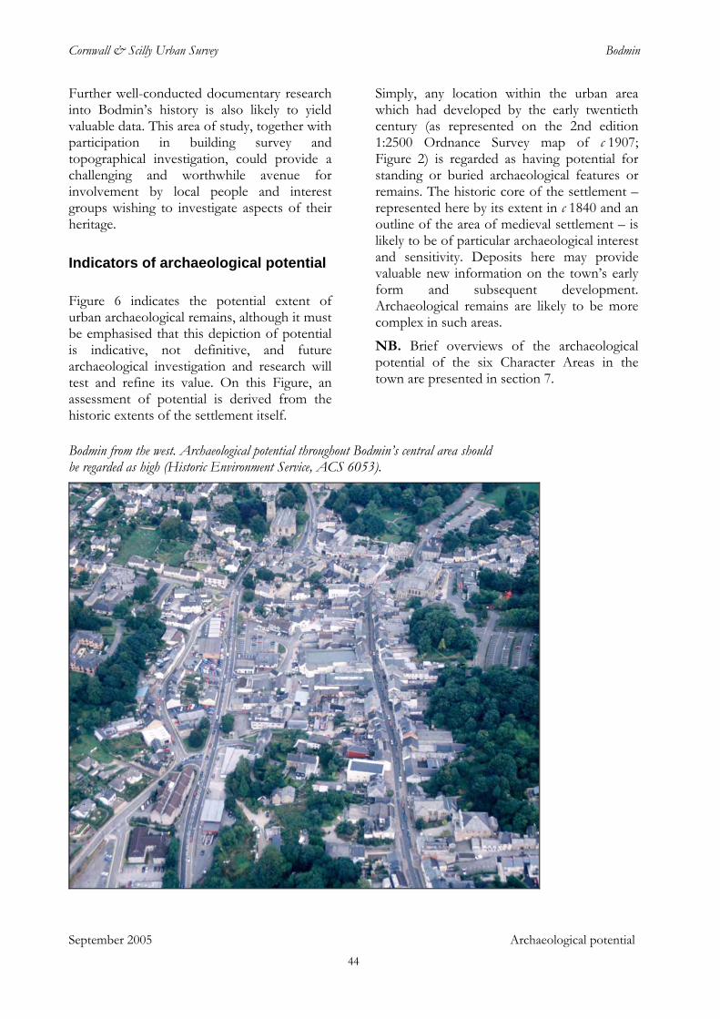
Cornwall & Scilly Urban Survey Bodmin
Further well-conducted documentary research into Bodmin’s history is also likely to yield valuable data. This area of study, together with participation in building survey and topographical investigation, could provide a challenging and worthwhile avenue for involvement by local people and interest groups wishing to investigate aspects of their heritage.
Indicators of archaeological potential
Figure 6 indicates the potential extent of urban archaeological remains, although it must be emphasised that this depiction of potential is indicative, not definitive, and future archaeological investigation and research will test and refine its value. On this Figure, an assessment of potential is derived from the historic extents of the settlement itself.
Simply, any location within the urban area which had developed by the early twentieth century (as represented on the 2nd edition 1:2500 Ordnance Survey map of c 1907; Figure 2) is regarded as having potential for standing or buried archaeological features or remains. The historic core of the settlement – represented here by its extent in c 1840 and an outline of the area of medieval settlement – is likely to be of particular archaeological interest and sensitivity. Deposits here may provide valuable new information on the town’s early form and subsequent development. Archaeological remains are likely to be more complex in such areas.
NB. Brief overviews of the archaeological potential of the six Character Areas in the town are presented in section 7.
Bodmin from the west. Archaeological potential throughout Bodmin’s central area should be regarded as high (Historic Environment Service, ACS 6053).
September 2005 Archaeological potential
44
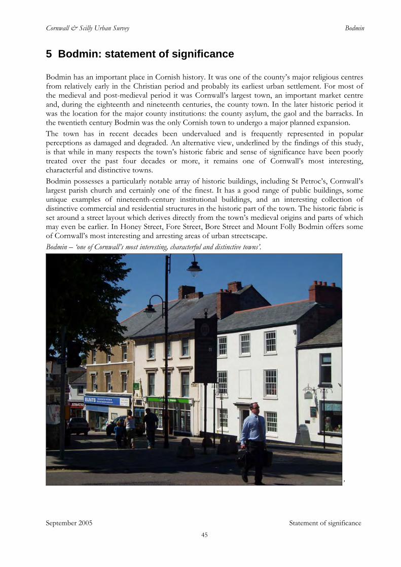
Cornwall & Scilly Urban Survey Bodmin
September 2005 Statement of significance
5 Bodmin: statement of significance
Bodmin has an important place in Cornish history. It was one of the county’s major religious centres from relatively early in the Christian period and probably its earliest urban settlement. For most of the medieval and post-medieval period it was Cornwall’s largest town, an important market centre and, during the eighteenth and nineteenth centuries, the county town. In the later historic period it was the location for the major county institutions: the county asylum, the gaol and the barracks. In the twentieth century Bodmin was the only Cornish town to undergo a major planned expansion. The town has in recent decades been undervalued and is frequently represented in popular perceptions as damaged and degraded. An alternative view, underlined by the findings of this study, is that while in many respects the town’s historic fabric and sense of significance have been poorly treated over the past four decades or more, it remains one of Cornwall’s most interesting, characterful and distinctive towns. Bodmin possesses a particularly notable array of historic buildings, including St Petroc’s, Cornwall’s largest parish church and certainly one of the finest. It has a good range of public buildings, some unique examples of nineteenth-century institutional buildings, and an interesting collection of distinctive commercial and residential structures in the historic part of the town. The historic fabric is set around a street layout which derives directly from the town’s medieval origins and parts of which may even be earlier. In Honey Street, Fore Street, Bore Street and Mount Folly Bodmin offers some of Cornwall’s most interesting and arresting areas of urban streetscape. Bodmin – ‘one of Cornwall’s most interesting, characterful and distinctive towns’.
’
45
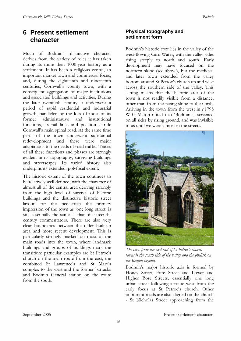
Cornwall & Scilly Urban Survey Bodmin
September 2005 Present settlement character
6 Present settlement character
Much of Bodmin’s distinctive character derives from the variety of roles it has taken during its more than 1000-year history as a settlement. It has been a religious centre, an important market town and commercial focus, and, during the eighteenth and nineteenth centuries, Cornwall’s county town, with a consequent aggregation of major institutions and associated buildings and activities. During the later twentieth century it underwent a period of rapid residential and industrial growth, paralleled by the loss of most of its former administrative and institutional functions, its rail links and position astride Cornwall’s main spinal road. At the same time parts of the town underwent substantial redevelopment and there were major adaptations to the needs of road traffic. Traces of all these functions and phases are strongly evident in its topography, surviving buildings and streetscapes. Its varied history also underpins its extended, polyfocal extent.
The historic extent of the town continues to be relatively well defined, with the character of almost all of the central area deriving strongly from the high level of survival of historic buildings and the distinctive historic street layout: for the pedestrian the primary impression of the town as ‘one long street’ is still essentially the same as that of sixteenth-century commentators. There are also very clear boundaries between the older built-up area and more recent development. This is particularly strongly marked on most of the main roads into the town, where landmark buildings and groups of buildings mark the transition: particular examples are St Petroc’s church on the main route from the east, the combined St Lawrence’s and St Mary’s complex to the west and the former barracks and Bodmin General station on the route from the south.
Physical topography and settlement form
Bodmin’s historic core lies in the valley of the west-flowing Carn Water, with the valley sides rising steeply to north and south. Early development may have focused on the northern slope (see above), but the medieval and later town extended from the valley bottom around St Petroc’s church up and west across the southern side of the valley. This setting means that the historic area of the town is not readily visible from a distance, other than from the facing slope to the north. Arriving in the town from the west in c 1795 W G Maton noted that ‘Bodmin is screened on all sides by rising ground, and was invisible to us until we were almost in the streets.’
The view from the east end of St Petroc’s church towards the south side of the valley and the obelisk on the Beacon beyond. Bodmin’s major historic axis is formed by Honey Street, Fore Street and Lower and Higher Bore Streets, essentially one long urban street following a route west from the early focus at St Petroc’s church. Other important roads are also aligned on the church - St Nicholas Street approaching from the
46
Cornwall & Scilly Urban Survey Bodmin
south, Priory Road combining routes from the north east and south east and Castle Street representing an earlier road from the north east. With the exception of the latter, there is little evidence for development along any of these routes until relatively late in the historic period. From the late eighteenth century a series of institutions – prison, asylum, workhouse, barracks – were sited around the periphery of Bodmin, on or close to these routes; there was some suburban infilling in the same areas. While Bodmin’s overall extent expanded substantially, however, its essential ‘one-street’ form persisted.
The very substantial physical expansion of Bodmin since the 1960s, extending well beyond its original confines around the slopes of the valley and beyond, means that the settlement now has a considerably greater visible presence in the wider landscape. The character of recent developments, however, has been essentially suburban or ‘out-of-town’ and the primacy of Bodmin’s historic core persists: Bodmin’s distinctiveness is still based on the street layout and settlement form which derive from its medieval history.
Survival of standing historic fabric
Within the historic extent of the town the character of the built environment is primarily derived from the high level of survival of historic buildings. There has been some loss and replacement but, with the exception of the Dennison Road area (Character Area 4), the visual impression in most areas is of streetscapes in which a large majority of buildings date from before 1900 (Fig 5).
As in most Cornish towns, the earliest surviving structures are religious buildings: the fourteenth-century chapel of Thomas à Becket and fifteenth-century fabric of the parish church and Berry Tower. There is a significant scatter of seventeenth-century structures, including several prominent timber-framed houses in Fore Street, one with a sixteenth-century wing to the rear. The interesting Tower Hill farmhouse incorporates a 1614 datestone. It is likely that many other buildings
in the town incorporate some early fabric: detailed analysis of what appeared to be an eighteenth or nineteenth century building at 20 Lower Bore Street found evidence for it having originated around 1600 as a town house of some social significance. There are a number of good eighteenth-century structures, including Priory House, St Leonard’s House on Higher Bore Street and a number of town houses in Fore Street, Honey Street, Higher and Lower Bore Street and elsewhere.
Much the largest component of Bodmin’s historic fabric dates from the nineteenth and early twentieth century, with a notable and varied range of fine civic and institutional buildings, numerous commercial structures (particularly in Honey Street and Fore Street), villas and a quantity of terraced ‘industrial’ housing. There is a small interwar twentieth century component, including the Post Office (1924) on St Nicholas Street, the 1920s clock tower at West End, Jubilee Terrace on Dunmere Road (1935) and other terraces at the east end of Beacon Road.
There have been some significant individual losses within the town in the relatively recent past; examples include the former Royal Hotel in Fore Street, of which part of the façade is all that survives, the early nineteenth century (or earlier) townhouse named Chestnuts at the upper end of Fore Street, the Turret cinema (later the Palace) of 1919 adjacent to Mount Folly, and a number of nonconformist chapels. Important elements within the former St Lawrence’s site such as the ‘High Building’ have also gone, and the setting and context for important parts of this complex and of the gaol, workhouse and barracks building groups have been compromised in recent years by inappropriate development.
September 2005 Present settlement character
The most extensive area of loss of historic fabric is around the central portion of the present Dennison Road – Pool Street link road, extending to the former station and gasworks sites south of Berrycoombe Road. The historic street layout in this area has also been radically remodelled. Areas such as the former Downing Street (Finn VC estate), its junction with Lower Bore Street and the west
47
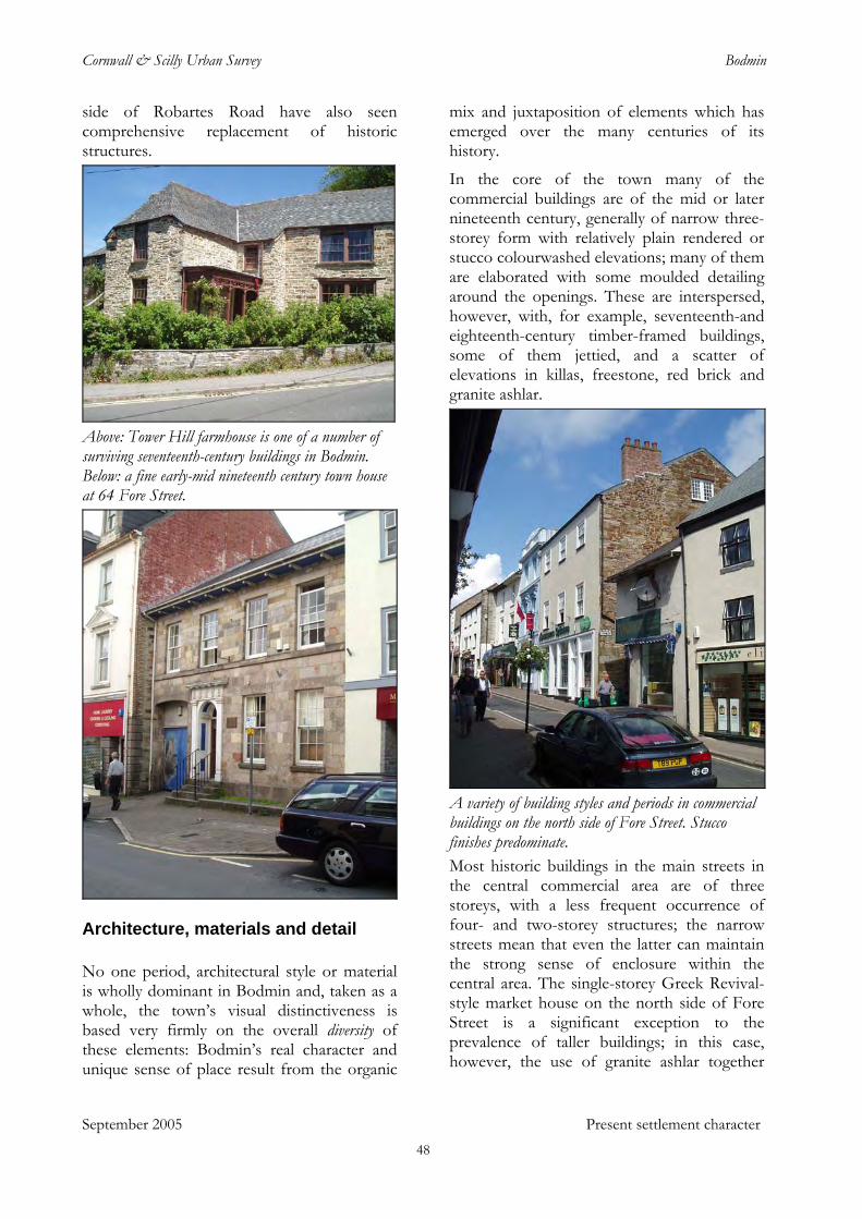
Cornwall & Scilly Urban Survey Bodmin
side of Robartes Road have also seen comprehensive replacement of historic structures.
Above: Tower Hill farmhouse is one of a number of surviving seventeenth-century buildings in Bodmin. Below: a fine early-mid nineteenth century town house at 64 Fore Street.
Architecture, materials and detail
No one period, architectural style or material is wholly dominant in Bodmin and, taken as a whole, the town’s visual distinctiveness is based very firmly on the overall diversity of these elements: Bodmin’s real character and unique sense of place result from the organic
mix and juxtaposition of elements which has emerged over the many centuries of its history.
In the core of the town many of the commercial buildings are of the mid or later nineteenth century, generally of narrow three-storey form with relatively plain rendered or stucco colourwashed elevations; many of them are elaborated with some moulded detailing around the openings. These are interspersed, however, with, for example, seventeenth-and eighteenth-century timber-framed buildings, some of them jettied, and a scatter of elevations in killas, freestone, red brick and granite ashlar.
A variety of building styles and periods in commercial buildings on the north side of Fore Street. Stucco finishes predominate. Most historic buildings in the main streets in the central commercial area are of three storeys, with a less frequent occurrence of four- and two-storey structures; the narrow streets mean that even the latter can maintain the strong sense of enclosure within the central area. The single-storey Greek Revival-style market house on the north side of Fore Street is a significant exception to the prevalence of taller buildings; in this case, however, the use of granite ashlar together
September 2005 Present settlement character 48
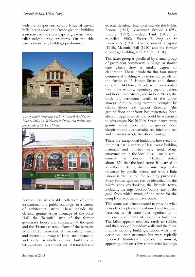
Cornwall & Scilly Urban Survey Bodmin
with the parapet cornice and frieze of carved bulls’ heads above the façade give the building a presence in the streetscape as great as that of taller neighbouring structures. On the side streets two-storey buildings predominate.
Use of ornate terracotta work on (above) the Masonic Hall (1910), on St Nicholas Street, and (below) the fine façade of 26 Fore Street.
Bodmin has an enviable collection of other institutional and public buildings, in a variety of architectural styles. These include the classical granite ashlar frontage of the Shire Hall, the ‘Baronial’ style of the former governor’s house and chaplaincy at the gaol, and the ‘French chateau’ form of the barracks keep (DCLI museum). A particularly varied and interesting group of large late nineteenth and early twentieth century buildings is distinguished by a robust use of materials and
eclectic detailing. Examples include the Public Rooms (1891), Grammar School (1895), Library (1897), Barclays Bank (1875, re-modelled 1902), Foster Building at St Lawrence’s (1904), East Cornwall Hospital (1910), Masonic Hall (1910) and the former orphanage building at St Mary’s (c 1910).
This latter group is paralleled by a small group of prominent commercial buildings of similar date which show a similar degree of elaboration. These include the fine four-storey commercial building with terracotta panels on the façade at 15 Honey Street and, almost opposite, 14 Honey Street, with pedimented first floor window openings, granite quoins and brick upper storey, and, in Fore Street, the brick and terracotta details of the upper storeys of the building currently occupied by Clarks Shoes and Cancer Research (the ground-floor shopfront has regrettably been altered inappropriately and could be reinstated to advantage). No 26 Fore Street incorporates granite ashlar piers on the ground floor shopfront and a remarkable red brick and red and cream terracotta first-floor frontage.
These are exceptional buildings, however. For the most part a variety of less exotic building materials and finishes were used. Many structures are in the local killas, usually semi-coursed or coursed. Maclean noted about 1870 that the local stone ‘if quarried to a sufficient depth, divides into large slabs traversed by parallel joints, and with a little labour is well suited for building purposes’. Many former quarries can be identified on the valley sides overlooking the historic town, including the large Cuckoo Quarry, east of the gaol, from which much of the stone for the complex is reputed to have come. This stone was often squared to provide what is in effect a pleasantly coloured and textured freestone which contributes significantly to the quality of many of Bodmin’s buildings. The killas appears relatively rarely as rubble, and then only on boundary walls and the more humble working buildings; rubble walls may occur on other structures but were typically rendered. Non-local freestone is unusual, appearing only on a few commercial buildings
September 2005 Present settlement character 49
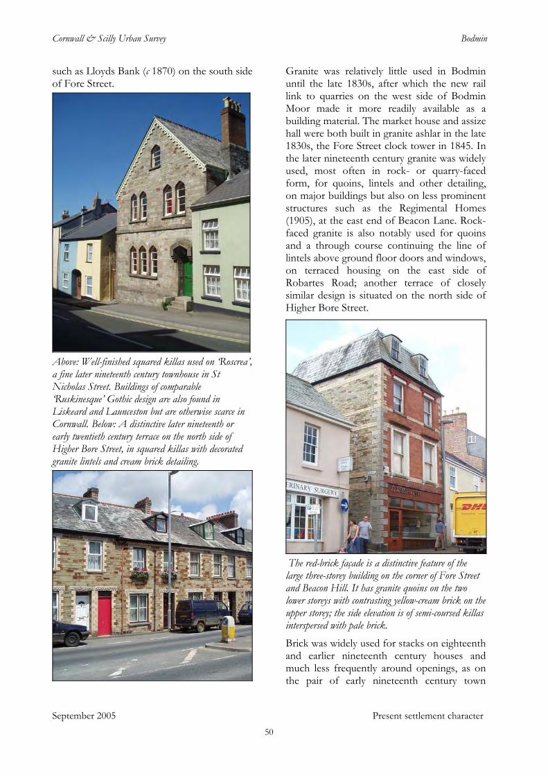
Cornwall & Scilly Urban Survey Bodmin
such as Lloyds Bank (c 1870) on the south side of Fore Street.
Above: Well-finished squared killas used on ‘Roscrea’, a fine later nineteenth century townhouse in St Nicholas Street. Buildings of comparable ‘Ruskinesque’ Gothic design are also found in Liskeard and Launceston but are otherwise scarce in Cornwall. Below: A distinctive later nineteenth or early twentieth century terrace on the north side of Higher Bore Street, in squared killas with decorated granite lintels and cream brick detailing.
Granite was relatively little used in Bodmin until the late 1830s, after which the new rail link to quarries on the west side of Bodmin Moor made it more readily available as a building material. The market house and assize hall were both built in granite ashlar in the late 1830s, the Fore Street clock tower in 1845. In the later nineteenth century granite was widely used, most often in rock- or quarry-faced form, for quoins, lintels and other detailing, on major buildings but also on less prominent structures such as the Regimental Homes (1905), at the east end of Beacon Lane. Rock-faced granite is also notably used for quoins and a through course continuing the line of lintels above ground floor doors and windows, on terraced housing on the east side of Robartes Road; another terrace of closely similar design is situated on the north side of Higher Bore Street.
The red-brick façade is a distinctive feature of the large three-storey building on the corner of Fore Street and Beacon Hill. It has granite quoins on the two lower storeys with contrasting yellow-cream brick on the upper storey; the side elevation is of semi-coursed killas interspersed with pale brick. Brick was widely used for stacks on eighteenth and earlier nineteenth century houses and much less frequently around openings, as on the pair of early nineteenth century town
September 2005 Present settlement character 50
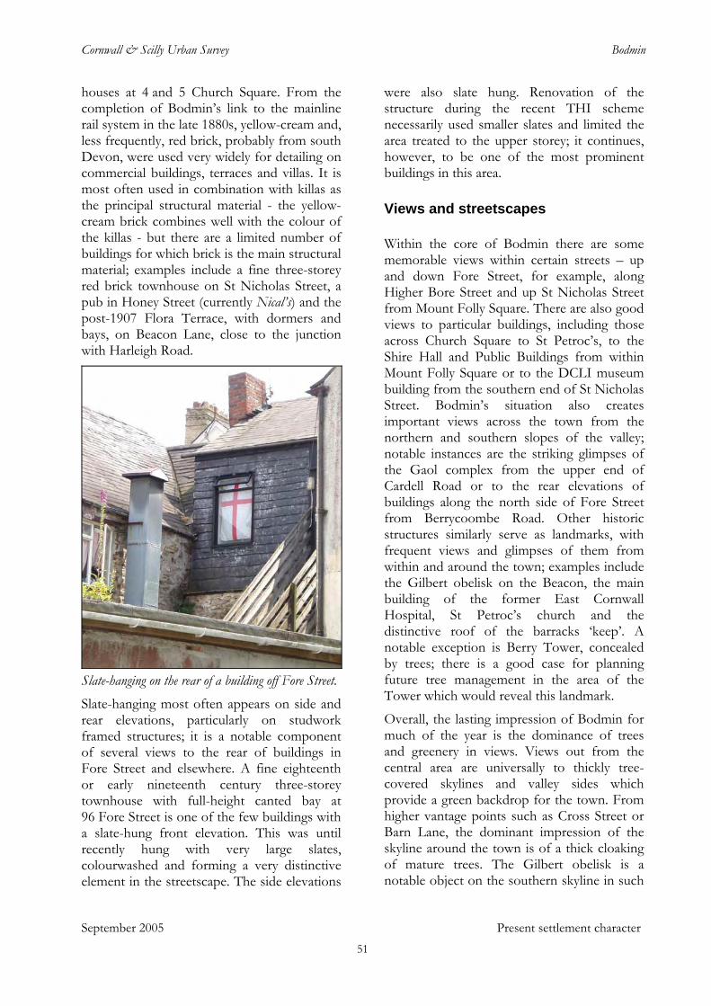
Cornwall & Scilly Urban Survey Bodmin
houses at 4 and 5 Church Square. From the completion of Bodmin’s link to the mainline rail system in the late 1880s, yellow-cream and, less frequently, red brick, probably from south Devon, were used very widely for detailing on commercial buildings, terraces and villas. It is most often used in combination with killas as the principal structural material - the yellow-cream brick combines well with the colour of the killas - but there are a limited number of buildings for which brick is the main structural material; examples include a fine three-storey red brick townhouse on St Nicholas Street, a pub in Honey Street (currently Nical’s) and the post-1907 Flora Terrace, with dormers and bays, on Beacon Lane, close to the junction with Harleigh Road.
Slate-hanging on the rear of a building off Fore Street. Slate-hanging most often appears on side and rear elevations, particularly on studwork framed structures; it is a notable component of several views to the rear of buildings in Fore Street and elsewhere. A fine eighteenth or early nineteenth century three-storey townhouse with full-height canted bay at 96 Fore Street is one of the few buildings with a slate-hung front elevation. This was until recently hung with very large slates, colourwashed and forming a very distinctive element in the streetscape. The side elevations
were also slate hung. Renovation of the structure during the recent THI scheme necessarily used smaller slates and limited the area treated to the upper storey; it continues, however, to be one of the most prominent buildings in this area.
Views and streetscapes
Within the core of Bodmin there are some memorable views within certain streets – up and down Fore Street, for example, along Higher Bore Street and up St Nicholas Street from Mount Folly Square. There are also good views to particular buildings, including those across Church Square to St Petroc’s, to the Shire Hall and Public Buildings from within Mount Folly Square or to the DCLI museum building from the southern end of St Nicholas Street. Bodmin’s situation also creates important views across the town from the northern and southern slopes of the valley; notable instances are the striking glimpses of the Gaol complex from the upper end of Cardell Road or to the rear elevations of buildings along the north side of Fore Street from Berrycoombe Road. Other historic structures similarly serve as landmarks, with frequent views and glimpses of them from within and around the town; examples include the Gilbert obelisk on the Beacon, the main building of the former East Cornwall Hospital, St Petroc’s church and the distinctive roof of the barracks ‘keep’. A notable exception is Berry Tower, concealed by trees; there is a good case for planning future tree management in the area of the Tower which would reveal this landmark.
Overall, the lasting impression of Bodmin for much of the year is the dominance of trees and greenery in views. Views out from the central area are universally to thickly tree-covered skylines and valley sides which provide a green backdrop for the town. From higher vantage points such as Cross Street or Barn Lane, the dominant impression of the skyline around the town is of a thick cloaking of mature trees. The Gilbert obelisk is a notable object on the southern skyline in such
September 2005 Present settlement character 51
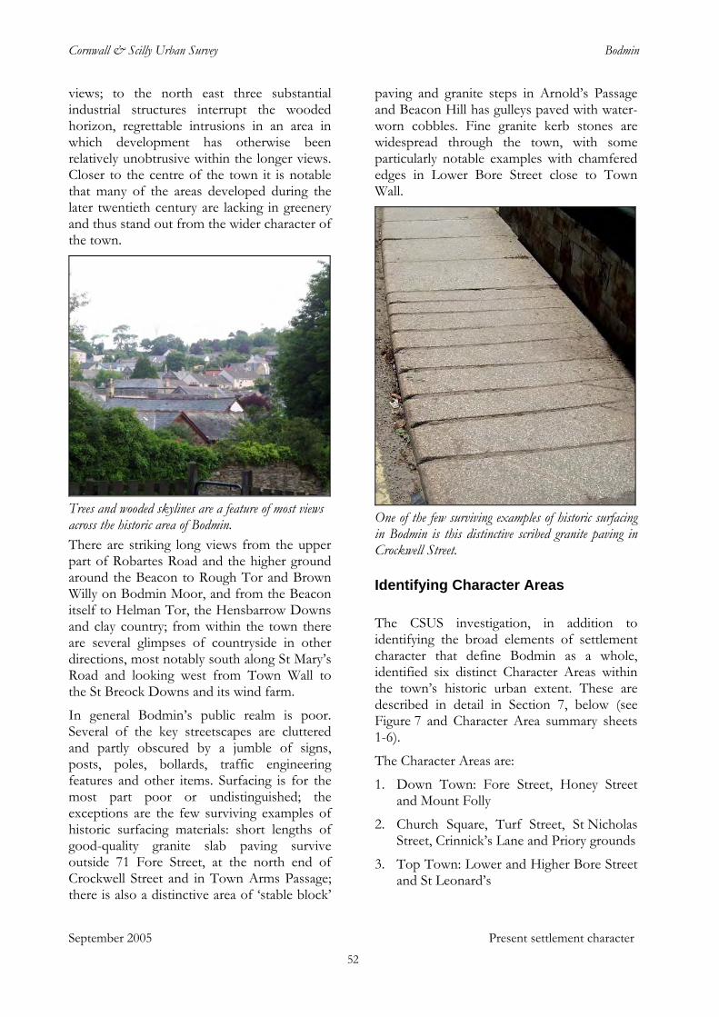
Cornwall & Scilly Urban Survey Bodmin
views; to the north east three substantial industrial structures interrupt the wooded horizon, regrettable intrusions in an area in which development has otherwise been relatively unobtrusive within the longer views. Closer to the centre of the town it is notable that many of the areas developed during the later twentieth century are lacking in greenery and thus stand out from the wider character of the town.
Trees and wooded skylines are a feature of most views across the historic area of Bodmin. There are striking long views from the upper part of Robartes Road and the higher ground around the Beacon to Rough Tor and Brown Willy on Bodmin Moor, and from the Beacon itself to Helman Tor, the Hensbarrow Downs and clay country; from within the town there are several glimpses of countryside in other directions, most notably south along St Mary’s Road and looking west from Town Wall to the St Breock Downs and its wind farm.
In general Bodmin’s public realm is poor. Several of the key streetscapes are cluttered and partly obscured by a jumble of signs, posts, poles, bollards, traffic engineering features and other items. Surfacing is for the most part poor or undistinguished; the exceptions are the few surviving examples of historic surfacing materials: short lengths of good-quality granite slab paving survive outside 71 Fore Street, at the north end of Crockwell Street and in Town Arms Passage; there is also a distinctive area of ‘stable block’
paving and granite steps in Arnold’s Passage and Beacon Hill has gulleys paved with water-worn cobbles. Fine granite kerb stones are widespread through the town, with some particularly notable examples with chamfered edges in Lower Bore Street close to Town Wall.
One of the few surviving examples of historic surfacing in Bodmin is this distinctive scribed granite paving in Crockwell Street.
Identifying Character Areas
The CSUS investigation, in addition to identifying the broad elements of settlement character that define Bodmin as a whole, identified six distinct Character Areas within the town’s historic urban extent. These are described in detail in Section 7, below (see Figure 7 and Character Area summary sheets 1-6).
The Character Areas are:
1. Down Town: Fore Street, Honey Street and Mount Folly
2. Church Square, Turf Street, St Nicholas Street, Crinnick’s Lane and Priory grounds
3. Top Town: Lower and Higher Bore Street and St Leonard’s
September 2005 Present settlement character 52
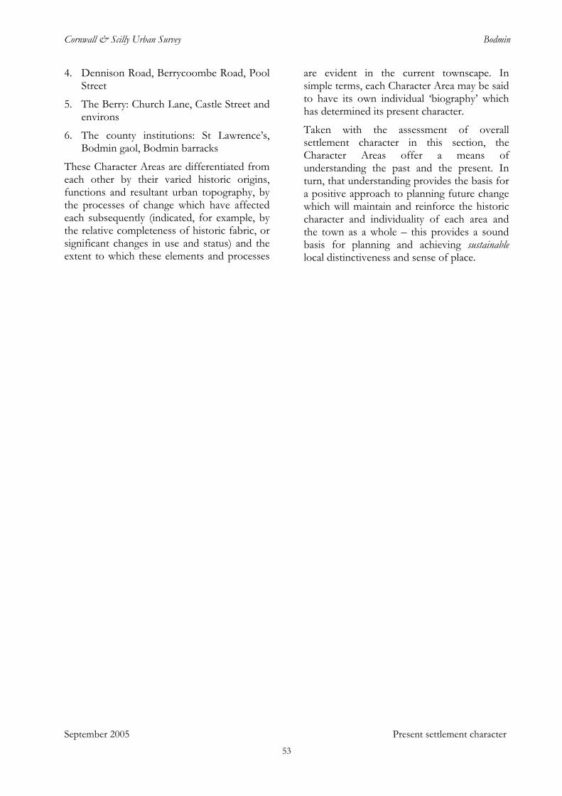
Cornwall & Scilly Urban Survey Bodmin
4. Dennison Road, Berrycoombe Road, Pool Street
5. The Berry: Church Lane, Castle Street and environs
6. The county institutions: St Lawrence’s, Bodmin gaol, Bodmin barracks
These Character Areas are differentiated from each other by their varied historic origins, functions and resultant urban topography, by the processes of change which have affected each subsequently (indicated, for example, by the relative completeness of historic fabric, or significant changes in use and status) and the extent to which these elements and processes
are evident in the current townscape. In simple terms, each Character Area may be said to have its own individual ‘biography’ which has determined its present character.
Taken with the assessment of overall settlement character in this section, the Character Areas offer a means of understanding the past and the present. In turn, that understanding provides the basis for a positive approach to planning future change which will maintain and reinforce the historic character and individuality of each area and the town as a whole – this provides a sound basis for planning and achieving sustainable local distinctiveness and sense of place.
September 2005 Present settlement character 53
Cornwall & Scilly Urban Survey Bodmin
September 2005 Regeneration and management
7 Regeneration and management
Characterisation of the historic environment of Bodmin has revealed the essential dynamic factors underpinning the town’s character. Regeneration planning which is informed and inspired by these elements can take a sure-footed and proactive approach to creating beneficial change, reinforcing and enhancing existing character and ensuring that new developments are closely integrated into the existing urban framework. Change can be focused on enhancing Bodmin’s distinctiveness and strong ‘sense of place’ and therefore ultimately more successful.
The characterisation process has also produced a valuable dataset on the historic fabric, archaeological potential and townscape character of the historic town. This information can be used as a conventional conservation and planning tool to define constraints, as a yardstick against which to measure new development and policy proposals, and as the basis of well-founded conservation management, restoration and enhancement schemes and policies.
Character-based principles for regeneration
The following principles have been derived from the analysis of Bodmin’s overall character and assessments of its Character Areas. These principles should underpin all regeneration planning.
• Bodmin’s historic built environment –buildings, historic topography and streetscapes – represents a major asset, the primary component of the town’s unique character, charm and significance. The importance of this distinctive ‘sense of place’ in differentiating Bodmin from other potentially competing centres means that actions which maintain and enhance the historic environment are potentially key contributions to regeneration.
• Bodmin’s location is a key element of its character. The valley with its steeply sloping sides and vista opening to the west is a distinctive topographical feature in itself, not least in that it means that trees and greenery form the skyline for much of the town. The physical topography is also important in the degree to which it renders most parts of the historic settlement visible from a wide circuit of potential viewing points: many buildings and areas in the town are easily visible (and therefore require care in their presentation) from almost all sides.
• The urban hierarchy and pattern of diversity which Bodmin’s different Character Areas represent are key elements of the town’s unique character. Respect for this hierarchy and for the distinctive differences between areas should be key considerations in planning and executing future change.
• A commitment to achieving quality and to maintaining, enhancing or reinstating character should be fundamental both in new developments in the urban area and in promoting a positive and proactive approach to repairing past mistakes.
• Bodmin should be perceived - and accordingly managed, presented, interpreted and promoted - as an historic Cornish town of quality, character and significance.
The historic environment and regeneration: key themes for Bodmin
Characterisation has highlighted regeneration and conservation opportunities both for Bodmin’s historic extent as a whole and for specific areas and sites. These opportunities fall into the following themes.
Recognise the asset
Future economic and community regeneration planning should be guided by a perspective which fully recognises and values the assets provided by Bodmin’s distinctive character
54
Cornwall & Scilly Urban Survey Bodmin
and high quality historic environment. Fundamental to this is perceiving the degree to which the town’s character and sense of place provides a positive and uniquely different ‘brand image’, differentiating Bodmin from other competing centres in Cornwall and beyond.
Recognise priority opportunities for change
Bodmin’s clearest opportunity for significant new-build regeneration activity within the historic area of the town is the wider zone focusing on Dennison Road (Character Area 4). This offers potential for considerable new build of mixed residential and small business premises on brownfield sites in immediate proximity to the historic core of the town. The area is currently underused and much of it is of extremely poor townscape quality; this could be radically improved and brought into full contribution. The former historic topography of the area, a network of streets, lanes opes and more extensive industrial spaces, provides a model for reinstating living and working zones of significance and character. There are surviving examples of distinctive historic housing which provide a broad model for appropriate forms. Such an initiative could be undertaken in phased stages, as land can be acquired, but fundamentally requires a masterplan to ensure that development follows appropriate forms.
A second high priority for substantive change must be the area facing St Petroc’s on Church Square / Priory Road. Redevelopment of this site should create high-quality townscape appropriate to its situation opposite one of Cornwall’s finest churches and in a key location within the historic core of the town.
Reduce the dominance of traffic and parking
September 2005 Regeneration and management
It is arguable that traffic levels in Bodmin have a greater negative impact on the ambience and sense of character and significance of its core historic area than in any other town in Cornwall. Enjoyment of places such as Church Square, Mount Folly, Fore Street and
Lower and Higher Bore Streets, in other respects potentially comparable with the finest urban environments in the county, is frequently greatly reduced or made impossible by extremes of noise and air pollution, unceasing vehicle movement, the difficulties of crossing roads and the overall sense of risk to the pedestrian. Reducing perceived vehicle-pedestrian conflict and the overall dominance of traffic, parking and traffic engineering in the historic built-up area of the town is therefore a key requirement for harnessing Bodmin’s distinctive historic built environment to regeneration.
Some steps in this direction have been taken - for example, the pedestrianisation of Honey Street and a degree of traffic calming at Mount Folly and Fore Street – but there is a need for more general improvement. Church Square is a particular priority. Mount Folly and Fore Street also continue to see relatively high volumes of through traffic, much of it apparently utilising the route solely as a short-cut to the west side of the town rather than for access to shops and businesses. Beneficial measures here could include restrictions on delivery times for goods vehicles, reductions in vehicle speeds and an emphasis in engineering these spaces on presenting them as shared by vehicles and pedestrians. A number of individual parts of Bodmin have been re-shaped to facilitate traffic movement, or to separate vehicles and pedestrians, with little regard for the impact of these interventions on the character and quality of the historic townscape. Examples include Church Square, West End, Bore Street and both ends of Honey Street. These spaces merit an urgent re-assessment of traffic engineering measures, with the aim of mitigating or reversing past errors. Future traffic management interventions should be planned and carried out with a full understanding of character and a primary aim to maintain and enhance it.
On-street parking levels in many areas are high, frequently masking and degrading the quality of historic spaces. Part of the aim of any future redevelopment in the wider
55
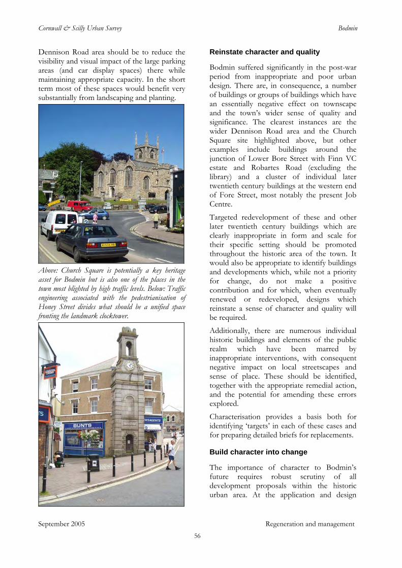
Cornwall & Scilly Urban Survey Bodmin
Dennison Road area should be to reduce the visibility and visual impact of the large parking areas (and car display spaces) there while maintaining appropriate capacity. In the short term most of these spaces would benefit very substantially from landscaping and planting.
Above: Church Square is potentially a key heritage asset for Bodmin but is also one of the places in the town most blighted by high traffic levels. Below: Traffic engineering associated with the pedestrianisation of Honey Street divides what should be a unified space fronting the landmark clocktower.
September 2005 Regeneration and management
Reinstate character and quality
Bodmin suffered significantly in the post-war period from inappropriate and poor urban design. There are, in consequence, a number of buildings or groups of buildings which have an essentially negative effect on townscape and the town’s wider sense of quality and significance. The clearest instances are the wider Dennison Road area and the Church Square site highlighted above, but other examples include buildings around the junction of Lower Bore Street with Finn VC estate and Robartes Road (excluding the library) and a cluster of individual later twentieth century buildings at the western end of Fore Street, most notably the present Job Centre.
Targeted redevelopment of these and other later twentieth century buildings which are clearly inappropriate in form and scale for their specific setting should be promoted throughout the historic area of the town. It would also be appropriate to identify buildings and developments which, while not a priority for change, do not make a positive contribution and for which, when eventually renewed or redeveloped, designs which reinstate a sense of character and quality will be required.
Additionally, there are numerous individual historic buildings and elements of the public realm which have been marred by inappropriate interventions, with consequent negative impact on local streetscapes and sense of place. These should be identified, together with the appropriate remedial action, and the potential for amending these errors explored.
Characterisation provides a basis both for identifying ‘targets’ in each of these cases and for preparing detailed briefs for replacements.
Build character into change
The importance of character to Bodmin’s future requires robust scrutiny of all development proposals within the historic urban area. At the application and design
56
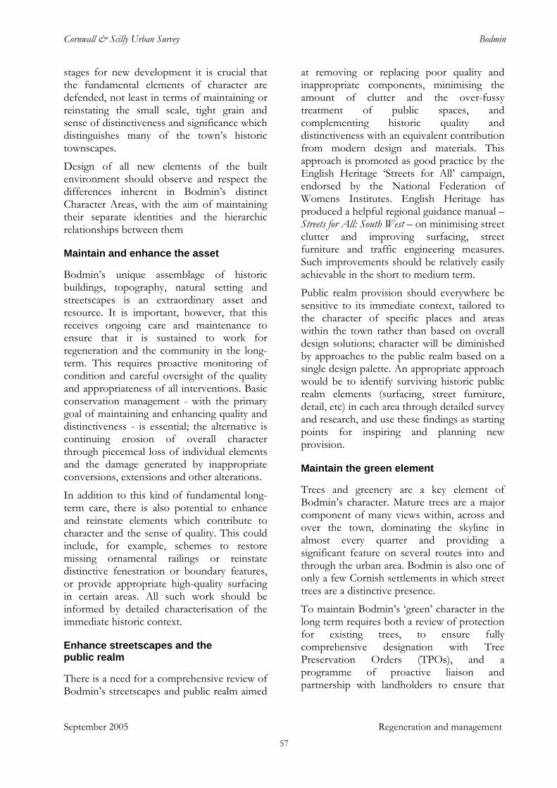
Cornwall & Scilly Urban Survey Bodmin
stages for new development it is crucial that the fundamental elements of character are defended, not least in terms of maintaining or reinstating the small scale, tight grain and sense of distinctiveness and significance which distinguishes many of the town’s historic townscapes.
Design of all new elements of the built environment should observe and respect the differences inherent in Bodmin’s distinct Character Areas, with the aim of maintaining their separate identities and the hierarchic relationships between them
Maintain and enhance the asset
Bodmin’s unique assemblage of historic buildings, topography, natural setting and streetscapes is an extraordinary asset and resource. It is important, however, that this receives ongoing care and maintenance to ensure that it is sustained to work for regeneration and the community in the long-term. This requires proactive monitoring of condition and careful oversight of the quality and appropriateness of all interventions. Basic conservation management - with the primary goal of maintaining and enhancing quality and distinctiveness - is essential; the alternative is continuing erosion of overall character through piecemeal loss of individual elements and the damage generated by inappropriate conversions, extensions and other alterations.
In addition to this kind of fundamental long-term care, there is also potential to enhance and reinstate elements which contribute to character and the sense of quality. This could include, for example, schemes to restore missing ornamental railings or reinstate distinctive fenestration or boundary features, or provide appropriate high-quality surfacing in certain areas. All such work should be informed by detailed characterisation of the immediate historic context.
Enhance streetscapes and the public realm
There is a need for a comprehensive review of Bodmin’s streetscapes and public realm aimed
at removing or replacing poor quality and inappropriate components, minimising the amount of clutter and the over-fussy treatment of public spaces, and complementing historic quality and distinctiveness with an equivalent contribution from modern design and materials. This approach is promoted as good practice by the English Heritage ‘Streets for All’ campaign, endorsed by the National Federation of Womens Institutes. English Heritage has produced a helpful regional guidance manual – Streets for All: South West – on minimising street clutter and improving surfacing, street furniture and traffic engineering measures. Such improvements should be relatively easily achievable in the short to medium term.
Public realm provision should everywhere be sensitive to its immediate context, tailored to the character of specific places and areas within the town rather than based on overall design solutions; character will be diminished by approaches to the public realm based on a single design palette. An appropriate approach would be to identify surviving historic public realm elements (surfacing, street furniture, detail, etc) in each area through detailed survey and research, and use these findings as starting points for inspiring and planning new provision.
Maintain the green element
Trees and greenery are a key element of Bodmin’s character. Mature trees are a major component of many views within, across and over the town, dominating the skyline in almost every quarter and providing a significant feature on several routes into and through the urban area. Bodmin is also one of only a few Cornish settlements in which street trees are a distinctive presence.
To maintain Bodmin’s ‘green’ character in the long term requires both a review of protection for existing trees, to ensure fully comprehensive designation with Tree Preservation Orders (TPOs), and a programme of proactive liaison and partnership with landholders to ensure that
September 2005 Regeneration and management 57
Cornwall & Scilly Urban Survey Bodmin
adequate and appropriate replacement planting is carried out. Where new development takes place it is important that existing levels of tree cover on sites are maintained and enhanced through new planting.
There is substantial potential for additional planting of street trees in a number of areas (see section 7).
Review conservation designations
Bodmin currently has more than 100 Listed Buildings, but there are others which are arguably of equivalent special architectural or historic interest and should be considered for the additional protection and aid which listing confers. There is certainly potential for a ‘local list’ to acknowledge the significance of locally important historic structures. The ‘other historic buildings’ identified on Figure 5 and in CSUS digital mapping offer an initial baseline for such a list. In this context it should be noted that many historic buildings of quality and interest have been omitted from those indicated as of Local Importance in the mapping included in the Bodmin Town Conservation Area Character Appraisal (2000). There is potential for some revision of the criteria for this attribution.
The present Conservation Area boundary could be beneficially extended to incorporate some historic buildings and areas of significant character which are currently excluded (see Section 7).
The priory site is of demonstrated archaeological potential and significance but currently has no statutory protection. It should be considered as a matter of some priority for Scheduled Monument status.
Identify, record and understand the archaeological resource
A number of past archaeological investigations and building recording projects in Bodmin have revealed important information about the history of the town and its people (Appendix 1). This knowledge offers a
valuable resource for education at a variety of levels, for academic study, for community interest and pride and to enhance visitor information, as well as aiding in developing appropriate conservation and management strategies. Much remains obscure, however, and it is important that future development and alterations to historic structures in the town continue to be subject to appropriate archaeological assessment.
There are additional measures which should be undertaken, however, to advance the present state of knowledge. One of these is the full analysis of the archaeological investigations undertaken in the 1980s during North Cornwall District Council works on the site of Bodmin Priory. These rescue excavations recovered important information on the early priory church, associated burials and the fifteenth-century tower, together with evidence of the later use of the complex for industrial activities and hints of early medieval occupation. It would be of very significant benefit in furthering understanding of Bodmin’s history if this material could be appropriately assessed and published.
A further opportunity is presented by the large number of fragments of architectural stonework which are distributed around Bodmin. These are likely to derive from the former friary and priory buildings and perhaps also from some of the town’s many medieval chapels. They represent a key resource for improved understanding of Bodmin’s religious and architectural heritage. A project to identify, record and analyse all surviving stonework around the town would be valuable in itself, but could also offer opportunities for significant community involvement; with the associated educational and visitor information benefits and the potential for using advanced modern technologies to record and present the information gained, such a project might attract significant external funding from sources such as the Local Heritage Initiative or Heritage Lottery Fund.
September 2005 Regeneration and management
This report has highlighted the possibility that the pre-Conquest town lay within the grid of streets running up the hillside to the north of
58
Cornwall & Scilly Urban Survey Bodmin
St Petroc’s church. A project aimed at proactive archaeological evaluation of the area, accompanied by assessment of documentary resources, would serve to clarify the origins and character of the area and provide a better indication of its archaeological and historical significance.
Further develop historic and cultural tourism
There is potential for further promotion and interpretation aimed at encouraging tourism based on Bodmin’s rich historic environment and distinctive historic and cultural assets. At the simplest level this could be supported by better identification and signposting of historic elements throughout the town; casual visitors currently find nothing to direct them to Bodmin Beacon, for example. Similarly, there is potential to ‘add value’ with additional well-informed interpretation of popular features such as the Camel Trail (when opened in 1834 this was Cornwall’s first railway to be locomotive hauled and the first to carry passengers) or the very fine Tudor fireplace exhibited in the Edinburgh Wool Shop in Fore Street. In addition to the current themes of justice and punishment (Shire Hall and Gaol), military heritage and railway history, there is potential for other strands, including:
Religious history In addition to placing further emphasis on the significance of St Petroc’s church (listed Grade I and sometimes referred to as ‘Cornwall’s cathedral’) and the interesting suite
of associated elements (chapel of Thomas à Becket, holy well, architectural fragments, etc), a ‘package’ of other elements associated with the town’s long religious history could be developed, bringing in the possible early monastic site(s), Berry Tower, the priory remains, friary and former chapel sites, wells (including the former pilgrim’s well known as Scarlett’s Well), nonconformist chapels, St Mary’s, etc.
Architecture and development history Bodmin’s unique range of historic buildings and the intriguing development of its historic topography merit appropriate interpretation and promotion.
Literary associations Bodmin is known as the birthplace of Sir Arthur Quiller Couch (the town appears as ‘Tregarrick’ in some of his works) and had longer connections with the Quiller Couch family; H C McNeile, who as ‘Sapper’ was the author of the 1920-30s Bulldog Drummond stories, was born in the governor’s house of Bodmin Gaol. The town was also the home of Emma Gifford, first wife of Thomas Hardy. Other places in the surrounding area – not least Bodmin Moor – also have significant literary connections. Together, these associations could be made the basis of a package closely linked to Bodmin’s historic fabric.
September 2005 Regeneration and management 59
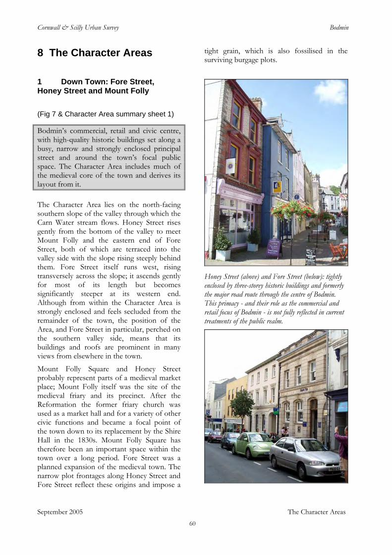
Cornwall & Scilly Urban Survey Bodmin
September 2005 The Character Areas
8 The Character Areas
1 Down Town: Fore Street, Honey Street and Mount Folly
(Fig 7 & Character Area summary sheet 1)
Bodmin’s commercial, retail and civic centre, with high-quality historic buildings set along a busy, narrow and strongly enclosed principal street and around the town’s focal public space. The Character Area includes much of the medieval core of the town and derives its layout from it. The Character Area lies on the north-facing southern slope of the valley through which the Carn Water stream flows. Honey Street rises gently from the bottom of the valley to meet Mount Folly and the eastern end of Fore Street, both of which are terraced into the valley side with the slope rising steeply behind them. Fore Street itself runs west, rising transversely across the slope; it ascends gently for most of its length but becomes significantly steeper at its western end. Although from within the Character Area is strongly enclosed and feels secluded from the remainder of the town, the position of the Area, and Fore Street in particular, perched on the southern valley side, means that its buildings and roofs are prominent in many views from elsewhere in the town.
Mount Folly Square and Honey Street probably represent parts of a medieval market place; Mount Folly itself was the site of the medieval friary and its precinct. After the Reformation the former friary church was used as a market hall and for a variety of other civic functions and became a focal point of the town down to its replacement by the Shire Hall in the 1830s. Mount Folly Square has therefore been an important space within the town over a long period. Fore Street was a planned expansion of the medieval town. The narrow plot frontages along Honey Street and Fore Street reflect these origins and impose a
tight grain, which is also fossilised in the surviving burgage plots.
Honey Street (above) and Fore Street (below): tightly enclosed by three-storey historic buildings and formerly the major road route through the centre of Bodmin. This primacy - and their role as the commercial and retail focus of Bodmin - is not fully reflected in current treatments of the public realm.
60
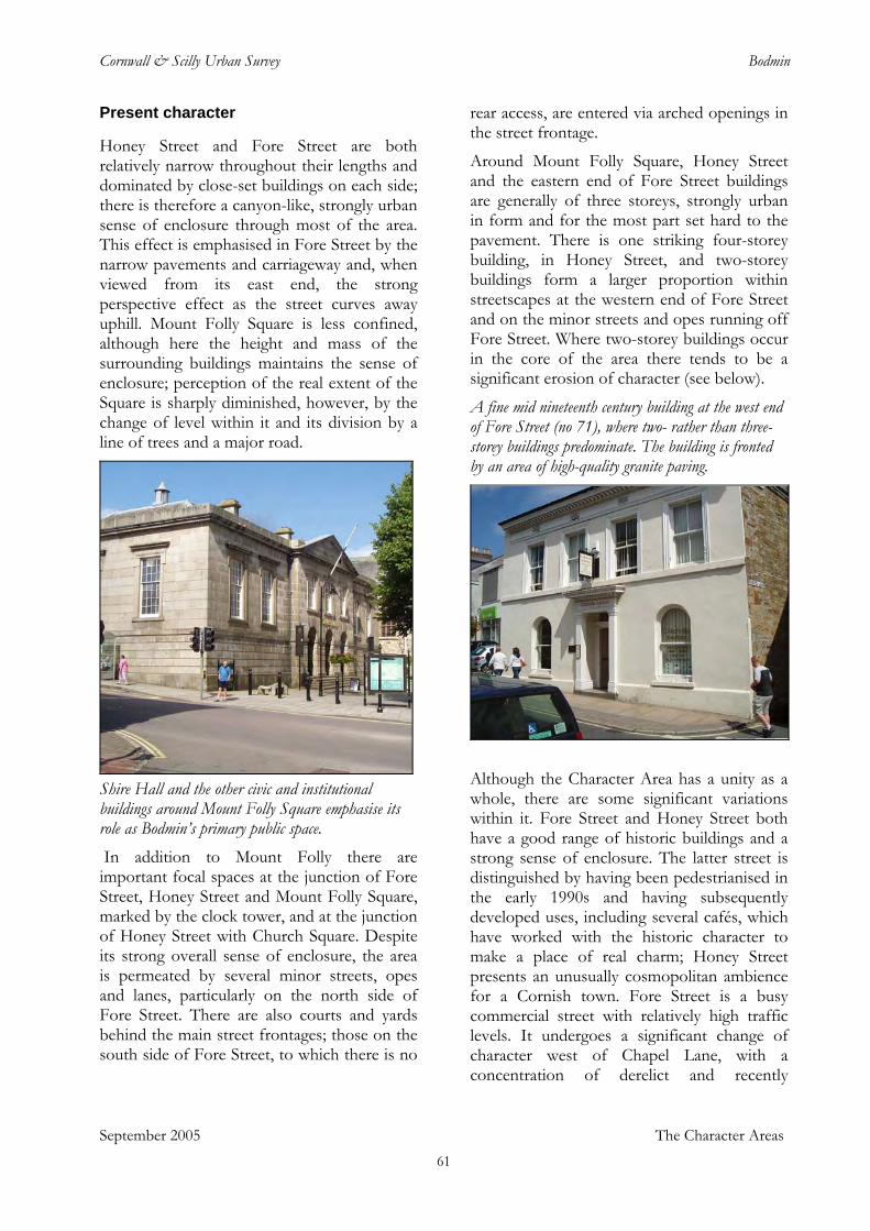
Cornwall & Scilly Urban Survey Bodmin
Present character
Honey Street and Fore Street are both relatively narrow throughout their lengths and dominated by close-set buildings on each side; there is therefore a canyon-like, strongly urban sense of enclosure through most of the area. This effect is emphasised in Fore Street by the narrow pavements and carriageway and, when viewed from its east end, the strong perspective effect as the street curves away uphill. Mount Folly Square is less confined, although here the height and mass of the surrounding buildings maintains the sense of enclosure; perception of the real extent of the Square is sharply diminished, however, by the change of level within it and its division by a line of trees and a major road.
Shire Hall and the other civic and institutional buildings around Mount Folly Square emphasise its role as Bodmin’s primary public space. In addition to Mount Folly there are important focal spaces at the junction of Fore Street, Honey Street and Mount Folly Square, marked by the clock tower, and at the junction of Honey Street with Church Square. Despite its strong overall sense of enclosure, the area is permeated by several minor streets, opes and lanes, particularly on the north side of Fore Street. There are also courts and yards behind the main street frontages; those on the south side of Fore Street, to which there is no
rear access, are entered via arched openings in the street frontage.
Around Mount Folly Square, Honey Street and the eastern end of Fore Street buildings are generally of three storeys, strongly urban in form and for the most part set hard to the pavement. There is one striking four-storey building, in Honey Street, and two-storey buildings form a larger proportion within streetscapes at the western end of Fore Street and on the minor streets and opes running off Fore Street. Where two-storey buildings occur in the core of the area there tends to be a significant erosion of character (see below).
A fine mid nineteenth century building at the west end of Fore Street (no 71), where two- rather than three-storey buildings predominate. The building is fronted by an area of high-quality granite paving.
Although the Character Area has a unity as a whole, there are some significant variations within it. Fore Street and Honey Street both have a good range of historic buildings and a strong sense of enclosure. The latter street is distinguished by having been pedestrianised in the early 1990s and having subsequently developed uses, including several cafés, which have worked with the historic character to make a place of real charm; Honey Street presents an unusually cosmopolitan ambience for a Cornish town. Fore Street is a busy commercial street with relatively high traffic levels. It undergoes a significant change of character west of Chapel Lane, with a concentration of derelict and recently
September 2005 The Character Areas 61
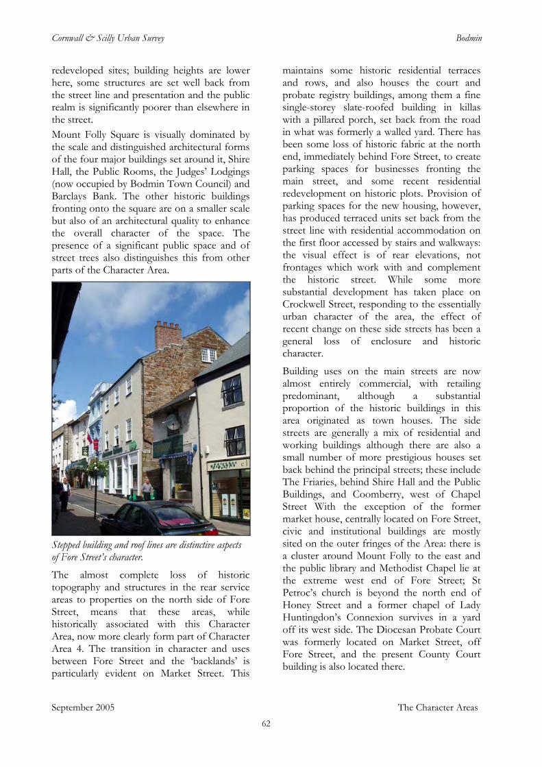
Cornwall & Scilly Urban Survey Bodmin
redeveloped sites; building heights are lower here, some structures are set well back from the street line and presentation and the public realm is significantly poorer than elsewhere in the street. Mount Folly Square is visually dominated by the scale and distinguished architectural forms of the four major buildings set around it, Shire Hall, the Public Rooms, the Judges’ Lodgings (now occupied by Bodmin Town Council) and Barclays Bank. The other historic buildings fronting onto the square are on a smaller scale but also of an architectural quality to enhance the overall character of the space. The presence of a significant public space and of street trees also distinguishes this from other parts of the Character Area.
Stepped building and roof lines are distinctive aspects of Fore Street’s character. The almost complete loss of historic topography and structures in the rear service areas to properties on the north side of Fore Street, means that these areas, while historically associated with this Character Area, now more clearly form part of Character Area 4. The transition in character and uses between Fore Street and the ‘backlands’ is particularly evident on Market Street. This
maintains some historic residential terraces and rows, and also houses the court and probate registry buildings, among them a fine single-storey slate-roofed building in killas with a pillared porch, set back from the road in what was formerly a walled yard. There has been some loss of historic fabric at the north end, immediately behind Fore Street, to create parking spaces for businesses fronting the main street, and some recent residential redevelopment on historic plots. Provision of parking spaces for the new housing, however, has produced terraced units set back from the street line with residential accommodation on the first floor accessed by stairs and walkways: the visual effect is of rear elevations, not frontages which work with and complement the historic street. While some more substantial development has taken place on Crockwell Street, responding to the essentially urban character of the area, the effect of recent change on these side streets has been a general loss of enclosure and historic character.
Building uses on the main streets are now almost entirely commercial, with retailing predominant, although a substantial proportion of the historic buildings in this area originated as town houses. The side streets are generally a mix of residential and working buildings although there are also a small number of more prestigious houses set back behind the principal streets; these include The Friaries, behind Shire Hall and the Public Buildings, and Coomberry, west of Chapel Street With the exception of the former market house, centrally located on Fore Street, civic and institutional buildings are mostly sited on the outer fringes of the Area: there is a cluster around Mount Folly to the east and the public library and Methodist Chapel lie at the extreme west end of Fore Street; St Petroc’s church is beyond the north end of Honey Street and a former chapel of Lady Huntingdon’s Connexion survives in a yard off its west side. The Diocesan Probate Court was formerly located on Market Street, off Fore Street, and the present County Court building is also located there.
September 2005 The Character Areas 62
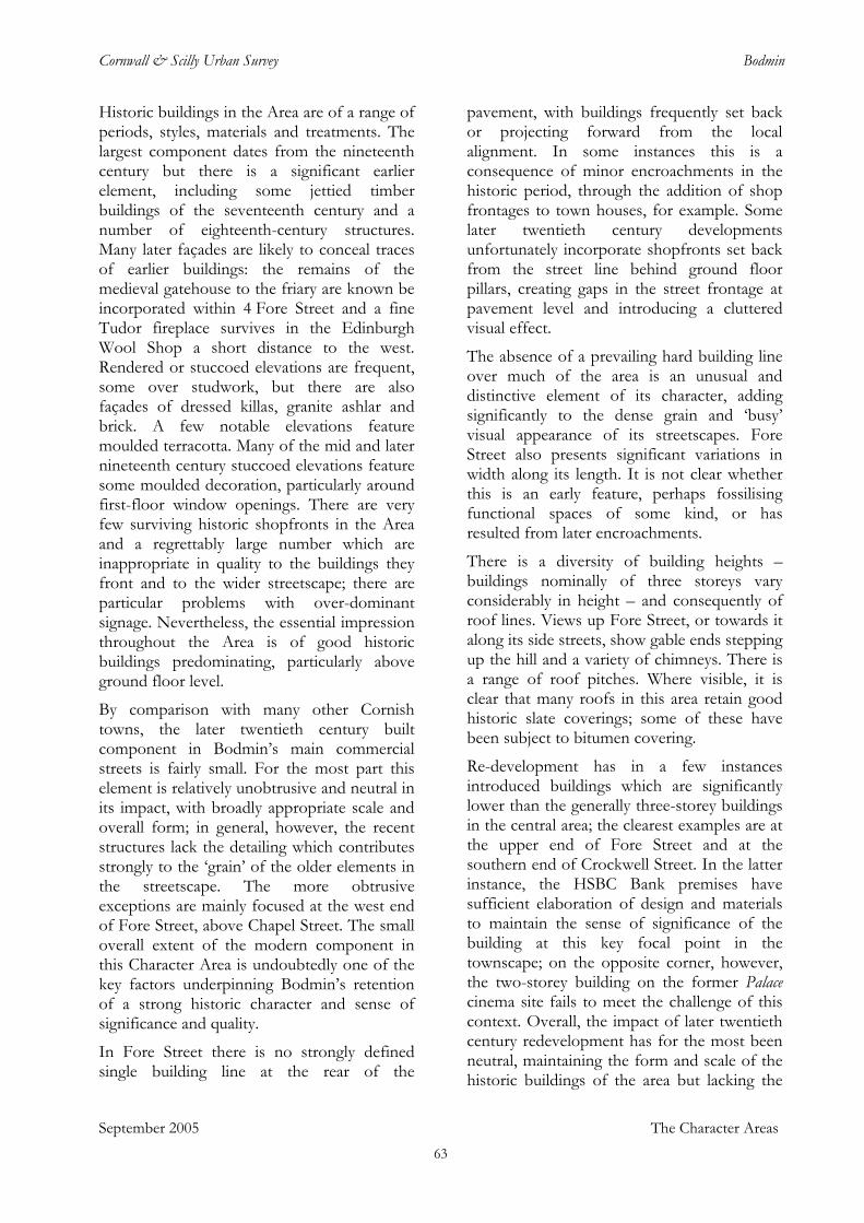
Cornwall & Scilly Urban Survey Bodmin
Historic buildings in the Area are of a range of periods, styles, materials and treatments. The largest component dates from the nineteenth century but there is a significant earlier element, including some jettied timber buildings of the seventeenth century and a number of eighteenth-century structures. Many later façades are likely to conceal traces of earlier buildings: the remains of the medieval gatehouse to the friary are known be incorporated within 4 Fore Street and a fine Tudor fireplace survives in the Edinburgh Wool Shop a short distance to the west. Rendered or stuccoed elevations are frequent, some over studwork, but there are also façades of dressed killas, granite ashlar and brick. A few notable elevations feature moulded terracotta. Many of the mid and later nineteenth century stuccoed elevations feature some moulded decoration, particularly around first-floor window openings. There are very few surviving historic shopfronts in the Area and a regrettably large number which are inappropriate in quality to the buildings they front and to the wider streetscape; there are particular problems with over-dominant signage. Nevertheless, the essential impression throughout the Area is of good historic buildings predominating, particularly above ground floor level.
By comparison with many other Cornish towns, the later twentieth century built component in Bodmin’s main commercial streets is fairly small. For the most part this element is relatively unobtrusive and neutral in its impact, with broadly appropriate scale and overall form; in general, however, the recent structures lack the detailing which contributes strongly to the ‘grain’ of the older elements in the streetscape. The more obtrusive exceptions are mainly focused at the west end of Fore Street, above Chapel Street. The small overall extent of the modern component in this Character Area is undoubtedly one of the key factors underpinning Bodmin’s retention of a strong historic character and sense of significance and quality.
In Fore Street there is no strongly defined single building line at the rear of the
pavement, with buildings frequently set back or projecting forward from the local alignment. In some instances this is a consequence of minor encroachments in the historic period, through the addition of shop frontages to town houses, for example. Some later twentieth century developments unfortunately incorporate shopfronts set back from the street line behind ground floor pillars, creating gaps in the street frontage at pavement level and introducing a cluttered visual effect.
The absence of a prevailing hard building line over much of the area is an unusual and distinctive element of its character, adding significantly to the dense grain and ‘busy’ visual appearance of its streetscapes. Fore Street also presents significant variations in width along its length. It is not clear whether this is an early feature, perhaps fossilising functional spaces of some kind, or has resulted from later encroachments.
There is a diversity of building heights – buildings nominally of three storeys vary considerably in height – and consequently of roof lines. Views up Fore Street, or towards it along its side streets, show gable ends stepping up the hill and a variety of chimneys. There is a range of roof pitches. Where visible, it is clear that many roofs in this area retain good historic slate coverings; some of these have been subject to bitumen covering.
September 2005 The Character Areas
Re-development has in a few instances introduced buildings which are significantly lower than the generally three-storey buildings in the central area; the clearest examples are at the upper end of Fore Street and at the southern end of Crockwell Street. In the latter instance, the HSBC Bank premises have sufficient elaboration of design and materials to maintain the sense of significance of the building at this key focal point in the townscape; on the opposite corner, however, the two-storey building on the former Palace cinema site fails to meet the challenge of this context. Overall, the impact of later twentieth century redevelopment has for the most been neutral, maintaining the form and scale of the historic buildings of the area but lacking the
63

Cornwall & Scilly Urban Survey Bodmin
detailing or use of quality materials which would have enabled them to contribute substantially to its built character. The most visible negative element is a former supermarket, now Bodmin’s Job Centre, at the head of Fore Street.
The quality of many otherwise well-preserved historic façades in Bodmin’s commercial core has been eroded by the insertion of inappropriate shopfronts and over-prominent signage. Little historic surfacing survives in the Area, the major exceptions being a short length of fine granite slab paving outside 71 Fore Street and short lengths at the north end of Crockwell Street (west side) and in Town Arms Passage. Good quality granite kerbing is widespread, however, with some notable wide, scribed, examples sited outside the Methodist church at the west end of Fore Street. There are also some unusual chamfered granite kerbs in Town Arms Passage. The modern granite surfacing fronting the Shire Hall is a considerable improvement on what preceded it, but other surfacing in the Area is generally poor: most pavements are recent, many of them formed of small concrete paviors now
patched, stained and pierced by a haphazard set of utility and service covers.
Other public realm provision in the Area is extremely cluttered, with excessive quantities of poles, signs, planters, seats, bollards and other street furniture. This is particularly marked in the immediate vicinity of the Shire Hall, an important visual focal point in the Area, where it is difficult to find a view to the historic buildings around the space which is not intruded on by one or more of these elements. In Honey Street the tables and chairs, signs, etc, put out by cafés and other businesses create an appropriate ambience in a pleasant pedestrianised space, but the sense of the street as an important historic through-route and a principal street of the town is eroded by the clutter of poles, benches and other objects along its main axis and the near blocking of the visual link to St Petroc’s at its northern end.
Archaeological potential
This area represents an important part of the medieval extent of Bodmin and archaeological potential should be regarded as high throughout. Street frontages are likely to have seen sequences of development over a long period and rear plots may contain evidence of both early urban uses (refuse and cess pits, or small-scale industrial activity, for example) and later high-density functions such as residential courts. The friary site at Mount Folly is of major interest and has revealed human remains at various times; there are also graveyards within the area associated with the Methodist church at the head of Fore Street and the former chapel of Lady Huntingdon’s Connexion off Honey Street. Previous archaeological work has recovered important dating evidence from the boundaries dividing the burgage plots south of Fore Street. Several historic structures in the area have been demonstrated to incorporate fabric from earlier phases - the survival of a high-status sixteenth-century fireplace in the Edinburgh Wool Shop offers an easily accessible example - and it is likely that many others conceal important historic remains.
September 2005 The Character Areas 64
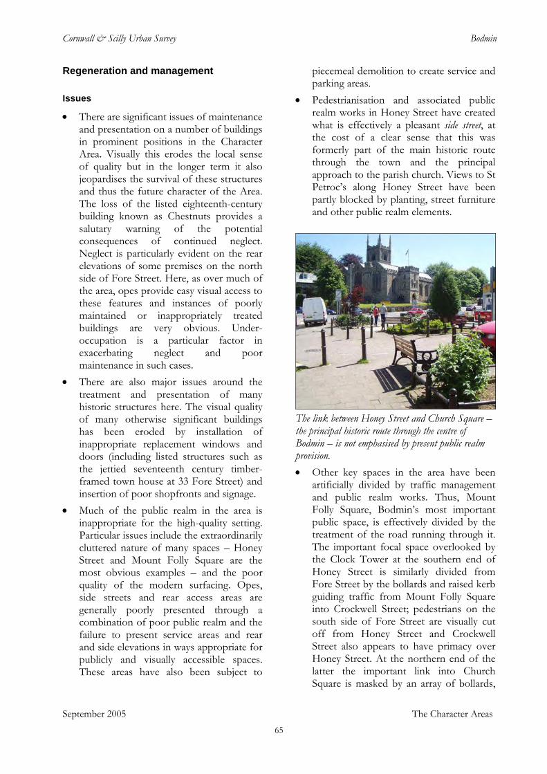
Cornwall & Scilly Urban Survey Bodmin
Regeneration and management
Issues • There are significant issues of maintenance
and presentation on a number of buildings in prominent positions in the Character Area. Visually this erodes the local sense of quality but in the longer term it also jeopardises the survival of these structures and thus the future character of the Area. The loss of the listed eighteenth-century building known as Chestnuts provides a salutary warning of the potential consequences of continued neglect. Neglect is particularly evident on the rear elevations of some premises on the north side of Fore Street. Here, as over much of the area, opes provide easy visual access to these features and instances of poorly maintained or inappropriately treated buildings are very obvious. Under-occupation is a particular factor in exacerbating neglect and poor maintenance in such cases.
• There are also major issues around the treatment and presentation of many historic structures here. The visual quality of many otherwise significant buildings has been eroded by installation of inappropriate replacement windows and doors (including listed structures such as the jettied seventeenth century timber-framed town house at 33 Fore Street) and insertion of poor shopfronts and signage.
• Much of the public realm in the area is inappropriate for the high-quality setting. Particular issues include the extraordinarily cluttered nature of many spaces – Honey Street and Mount Folly Square are the most obvious examples – and the poor quality of the modern surfacing. Opes, side streets and rear access areas are generally poorly presented through a combination of poor public realm and the failure to present service areas and rear and side elevations in ways appropriate for publicly and visually accessible spaces. These areas have also been subject to
piecemeal demolition to create service and parking areas.
• Pedestrianisation and associated public realm works in Honey Street have created what is effectively a pleasant side street, at the cost of a clear sense that this was formerly part of the main historic route through the town and the principal approach to the parish church. Views to St Petroc’s along Honey Street have been partly blocked by planting, street furniture and other public realm elements.
The link between Honey Street and Church Square – the principal historic route through the centre of Bodmin – is not emphasised by present public realm provision.
September 2005 The Character Areas
• Other key spaces in the area have been artificially divided by traffic management and public realm works. Thus, Mount Folly Square, Bodmin’s most important public space, is effectively divided by the treatment of the road running through it. The important focal space overlooked by the Clock Tower at the southern end of Honey Street is similarly divided from Fore Street by the bollards and raised kerb guiding traffic from Mount Folly Square into Crockwell Street; pedestrians on the south side of Fore Street are visually cut off from Honey Street and Crockwell Street also appears to have primacy over Honey Street. At the northern end of the latter the important link into Church Square is masked by an array of bollards,
65
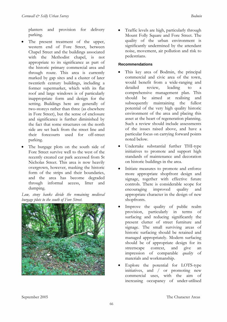
Cornwall & Scilly Urban Survey Bodmin
planters and provision for delivery parking.
• The present treatment of the upper, western end of Fore Street, between Chapel Street and the buildings associated with the Methodist chapel, is not appropriate to its significance as part of the historic primary commercial area and through route. This area is currently marked by gap sites and a cluster of later twentieth century buildings, including a former supermarket, which with its flat roof and large windows is of particularly inappropriate form and design for the setting. Buildings here are generally of two-storeys rather than three (as elsewhere in Fore Street), but the sense of enclosure and significance is further diminished by the fact that some structures on the north side are set back from the street line and their forecourts used for off-street parking.
• The burgage plots on the south side of Fore Street survive well to the west of the recently created car park accessed from St Nicholas Street. This area is now heavily overgrown, however, masking the historic form of the strips and their boundaries, and the area has become degraded through informal access, litter and dumping.
Low, stony banks divide the remaining medieval burgage plots to the south of Fore Street.
• Traffic levels are high, particularly through Mount Folly Square and Fore Street. The quality of the urban environment is significantly undermined by the attendant noise, movement, air pollution and risk to pedestrians.
Recommendations • This key area of Bodmin, the principal
commercial and civic area of the town, would benefit from a wide-ranging and detailed review, leading to a comprehensive management plan. This should be aimed at realising and subsequently maintaining the fullest potential of the very high quality historic environment of the area and placing this asset at the heart of regeneration planning. Such a review should include assessments of the issues raised above, and have a particular focus on carrying forward points noted below.
• Undertake substantial further THI-type initiatives to promote and support high standards of maintenance and decoration on historic buildings in the area.
• Initiate measures to promote and enforce more appropriate shopfront design and signage, together with effective future controls. There is considerable scope for encouraging improved quality and appropriate character in the design of new shopfronts.
• Improve the quality of public realm provision, particularly in terms of surfacing and reducing significantly the present clutter of street furniture and signage. The small surviving areas of historic surfacing should be retained and managed appropriately. Modern surfacing should be of appropriate design for its streetscape context, and give an impression of comparable quality of materials and workmanship.
• Explore the potential for LOTS-type initiatives, and / or promoting new commercial uses, with the aim of increasing occupancy of under-utilised
September 2005 The Character Areas 66
Cornwall & Scilly Urban Survey Bodmin
historic buildings and thereby underpinning their long-term maintenance and retention. There is a particular priority to identify a beneficial use or uses for the former Methodist Sunday School building at the upper end of Fore Street; while there is a lack of parking in this area, refurbishment of this building and an associated increase in activity could serve as a catalyst for more general redevelopment and improvement in what is otherwise an area of degraded townscape character.
• Work to remedy traffic and parking problems: a key objective should be to reduce traffic flows through Mount Folly Square and Fore Street, creating an area of increased pedestrian priority. The absence of rear access to commercial premises, particularly on the south side of Fore Street, will necessitate continuing movement of delivery and other service vehicles in the area; however, there is potential to reduce conflict with pedestrian use through some degree of restrictions on delivery times.
• Encourage new high-quality development on selected sites, targeted to reinstate character where it has been eroded and to reverse past mistakes. Examples of priorities would include the gap sites and inappropriate structures at the west end of Fore Street and the two-storey building (currently occupied by Stratton Creber) on the former cinema site at the south end of Crockwell Street; the latter is a prominent site in the heart of the town and merits a building of appropriate scale and form.
• Ensure that design for all future interventions in the area, both buildings and public realm, is shaped by a detailed understanding of the immediate context as well as by the area’s overall character. Although the Character Area has a number of clear unifying characteristics there is very considerable variation within it which should be acknowledged, maintained and enhanced.
• Ensure that further redevelopment along the streets and lanes running off Fore Street maintains the historic high density and strong enclosure of these spaces. Most importantly, provision for parking should not dominate street elevations on new developments.
• Explore opportunities for creation of more formal public access to, and uses of, the surviving burgage plots on the south side of Fore Street. This important historic feature of the town requires improved management, not least to reduce dumping, but also has potential for presentation as a key element of Bodmin’s historic topography. These are probably the most extensive set of surviving undeveloped burgage plots in a major Cornish town and could form a significant additional feature in presenting Bodmin’s history, particularly its medieval origins, to the public.
• Honey Street should be more clearly emphasised as a primary historic axis of the town. This could be achieved through improvements to the public realm, particularly minimising the present clutter of street furniture, improving surfacing and reducing the blocking effect at the northern end which diminishes the visual association of Honey Street with Church Square and St Petroc’s.
• Extend the Conservation Area to incorporate the surviving area of burgage plots to the south of Fore Street. These plots with their associated boundaries constitute a significant element of the historic character of the area and merit protection.
• Apply robust conservation management to historic buildings in the Area, probably through enhanced provision of appropriate Article 4 Directions, in order to retain historic character and quality.
September 2005 The Character Areas 67
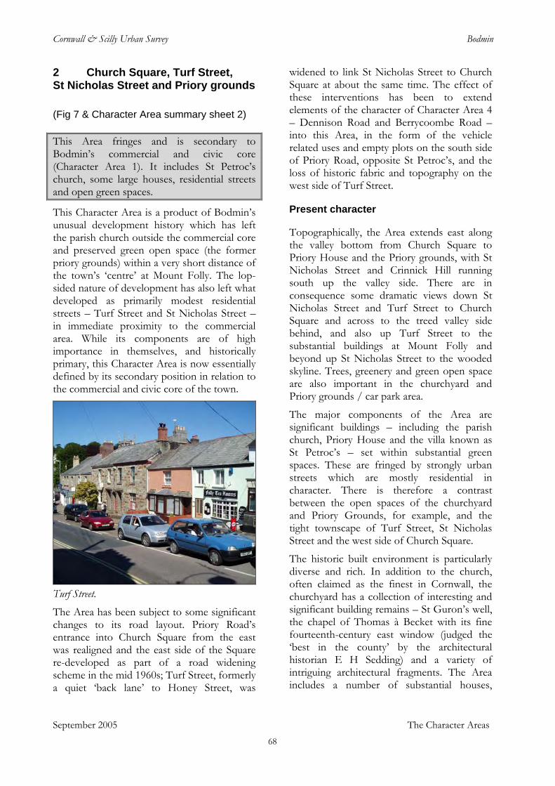
Cornwall & Scilly Urban Survey Bodmin
2 Church Square, Turf Street, St Nicholas Street and Priory grounds
(Fig 7 & Character Area summary sheet 2) This Area fringes and is secondary to Bodmin’s commercial and civic core (Character Area 1). It includes St Petroc’s church, some large houses, residential streets and open green spaces.
This Character Area is a product of Bodmin’s unusual development history which has left the parish church outside the commercial core and preserved green open space (the former priory grounds) within a very short distance of the town’s ‘centre’ at Mount Folly. The lop-sided nature of development has also left what developed as primarily modest residential streets – Turf Street and St Nicholas Street – in immediate proximity to the commercial area. While its components are of high importance in themselves, and historically primary, this Character Area is now essentially defined by its secondary position in relation to the commercial and civic core of the town.
Turf Street. The Area has been subject to some significant changes to its road layout. Priory Road’s entrance into Church Square from the east was realigned and the east side of the Square re-developed as part of a road widening scheme in the mid 1960s; Turf Street, formerly a quiet ‘back lane’ to Honey Street, was
widened to link St Nicholas Street to Church Square at about the same time. The effect of these interventions has been to extend elements of the character of Character Area 4 – Dennison Road and Berrycoombe Road – into this Area, in the form of the vehicle related uses and empty plots on the south side of Priory Road, opposite St Petroc’s, and the loss of historic fabric and topography on the west side of Turf Street.
Present character
Topographically, the Area extends east along the valley bottom from Church Square to Priory House and the Priory grounds, with St Nicholas Street and Crinnick Hill running south up the valley side. There are in consequence some dramatic views down St Nicholas Street and Turf Street to Church Square and across to the treed valley side behind, and also up Turf Street to the substantial buildings at Mount Folly and beyond up St Nicholas Street to the wooded skyline. Trees, greenery and green open space are also important in the churchyard and Priory grounds / car park area.
The major components of the Area are significant buildings – including the parish church, Priory House and the villa known as St Petroc’s – set within substantial green spaces. These are fringed by strongly urban streets which are mostly residential in character. There is therefore a contrast between the open spaces of the churchyard and Priory Grounds, for example, and the tight townscape of Turf Street, St Nicholas Street and the west side of Church Square.
The historic built environment is particularly diverse and rich. In addition to the church, often claimed as the finest in Cornwall, the churchyard has a collection of interesting and significant building remains – St Guron’s well, the chapel of Thomas à Becket with its fine fourteenth-century east window (judged the ‘best in the county’ by the architectural historian E H Sedding) and a variety of intriguing architectural fragments. The Area includes a number of substantial houses,
September 2005 The Character Areas 68
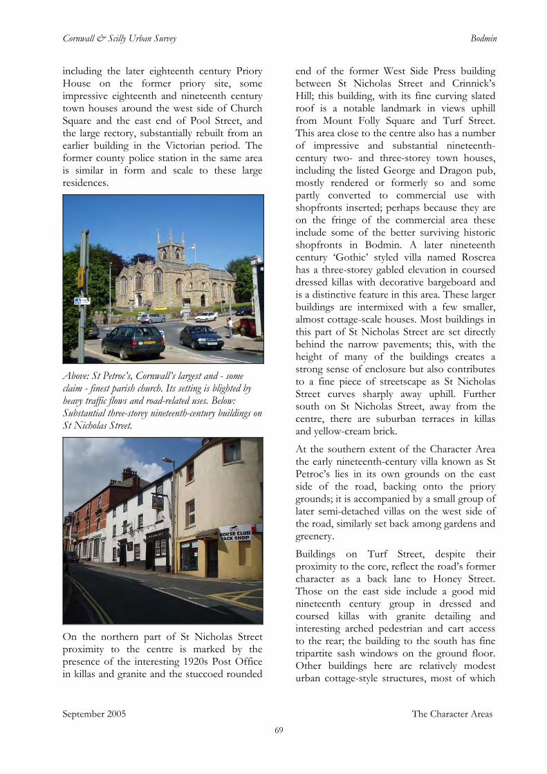
Cornwall & Scilly Urban Survey Bodmin
including the later eighteenth century Priory House on the former priory site, some impressive eighteenth and nineteenth century town houses around the west side of Church Square and the east end of Pool Street, and the large rectory, substantially rebuilt from an earlier building in the Victorian period. The former county police station in the same area is similar in form and scale to these large residences.
Above: St Petroc’s, Cornwall’s largest and - some claim - finest parish church. Its setting is blighted by heavy traffic flows and road-related uses. Below: Substantial three-storey nineteenth-century buildings on St Nicholas Street.
On the northern part of St Nicholas Street proximity to the centre is marked by the presence of the interesting 1920s Post Office in killas and granite and the stuccoed rounded
end of the former West Side Press building between St Nicholas Street and Crinnick’s Hill; this building, with its fine curving slated roof is a notable landmark in views uphill from Mount Folly Square and Turf Street. This area close to the centre also has a number of impressive and substantial nineteenth-century two- and three-storey town houses, including the listed George and Dragon pub, mostly rendered or formerly so and some partly converted to commercial use with shopfronts inserted; perhaps because they are on the fringe of the commercial area these include some of the better surviving historic shopfronts in Bodmin. A later nineteenth century ‘Gothic’ styled villa named Roscrea has a three-storey gabled elevation in coursed dressed killas with decorative bargeboard and is a distinctive feature in this area. These larger buildings are intermixed with a few smaller, almost cottage-scale houses. Most buildings in this part of St Nicholas Street are set directly behind the narrow pavements; this, with the height of many of the buildings creates a strong sense of enclosure but also contributes to a fine piece of streetscape as St Nicholas Street curves sharply away uphill. Further south on St Nicholas Street, away from the centre, there are suburban terraces in killas and yellow-cream brick.
At the southern extent of the Character Area the early nineteenth-century villa known as St Petroc’s lies in its own grounds on the east side of the road, backing onto the priory grounds; it is accompanied by a small group of later semi-detached villas on the west side of the road, similarly set back among gardens and greenery.
Buildings on Turf Street, despite their proximity to the core, reflect the road’s former character as a back lane to Honey Street. Those on the east side include a good mid nineteenth century group in dressed and coursed killas with granite detailing and interesting arched pedestrian and cart access to the rear; the building to the south has fine tripartite sash windows on the ground floor. Other buildings here are relatively modest urban cottage-style structures, most of which
September 2005 The Character Areas 69
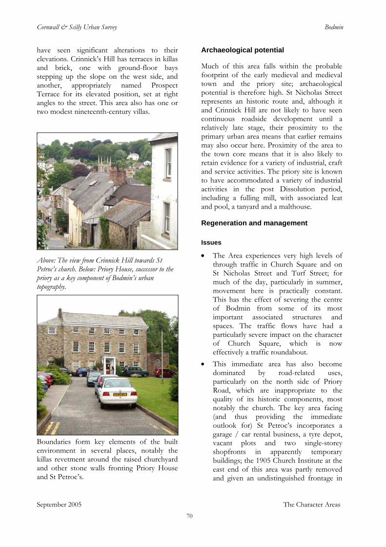
Cornwall & Scilly Urban Survey Bodmin
have seen significant alterations to their elevations. Crinnick’s Hill has terraces in killas and brick, one with ground-floor bays stepping up the slope on the west side, and another, appropriately named Prospect Terrace for its elevated position, set at right angles to the street. This area also has one or two modest nineteenth-century villas.
Above: The view from Crinnick Hill towards St Petroc’s church. Below: Priory House, successor to the priory as a key component of Bodmin’s urban topography.
Boundaries form key elements of the built environment in several places, notably the killas revetment around the raised churchyard and other stone walls fronting Priory House and St Petroc’s.
Archaeological potential
Much of this area falls within the probable footprint of the early medieval and medieval town and the priory site; archaeological potential is therefore high. St Nicholas Street represents an historic route and, although it and Crinnick Hill are not likely to have seen continuous roadside development until a relatively late stage, their proximity to the primary urban area means that earlier remains may also occur here. Proximity of the area to the town core means that it is also likely to retain evidence for a variety of industrial, craft and service activities. The priory site is known to have accommodated a variety of industrial activities in the post Dissolution period, including a fulling mill, with associated leat and pool, a tanyard and a malthouse.
Regeneration and management
Issues • The Area experiences very high levels of
through traffic in Church Square and on St Nicholas Street and Turf Street; for much of the day, particularly in summer, movement here is practically constant. This has the effect of severing the centre of Bodmin from some of its most important associated structures and spaces. The traffic flows have had a particularly severe impact on the character of Church Square, which is now effectively a traffic roundabout.
• This immediate area has also become dominated by road-related uses, particularly on the north side of Priory Road, which are inappropriate to the quality of its historic components, most notably the church. The key area facing (and thus providing the immediate outlook for) St Petroc’s incorporates a garage / car rental business, a tyre depot, vacant plots and two single-storey shopfronts in apparently temporary buildings; the 1905 Church Institute at the east end of this area was partly removed and given an undistinguished frontage in
September 2005 The Character Areas 70
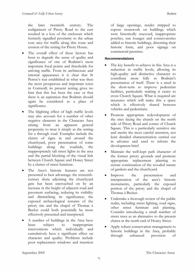
Cornwall & Scilly Urban Survey Bodmin
the later twentieth century. The realignment of Priory Road to the east resulted in a loss of the enclosure which formerly signalled proximity to the urban core area for traffic along this route and erosion of the setting for Priory House.
• The overall effect of these factors has been to degrade the sense of quality and significance of one of Bodmin’s most important focal points and thresholds for arriving traffic. From its architecture and internal appearance it is clear that St Petroc’s was established in what was then the most prosperous and important town in Cornwall; its present setting gives no hint that this has been the case or that there is an aspiration that Bodmin should again be considered as a place of significance.
• The blighting effect of high traffic levels may also account for a number of other negative elements in the Character Area arising from an apparent general propensity to treat it simply as the setting for a through road. Examples include the clutter of signs in and around the churchyard, poor presentation of some buildings along the roadside, the inappropriately tall street lights in the area and the partial blocking of the visual link between Church Square and Honey Street by a clutter of street furniture.
• The Area’s historic features are not presented to best advantage: the sixteenth-century shute adjoining the churchyard gate has been encroached on by an increase in the height of adjacent road and pavement surfacing, reducing its visibility and diminishing its significance; the exposed archaeological remains of the priory site and the chapel of Thomas à Becket could both potentially be more effectively presented and interpreted.
September 2005 The Character Areas
• A number of buildings in the Area have been subject to inappropriate interventions which individually and cumulatively have a significant effect on character and quality. Problems include poor replacement windows and insertion
of large openings, render stripped to expose stonework on buildings which were historically stuccoed, inappropriate porches, sun lounges and conservatories added to historic buildings, distorting their historic form, and poor signage on commercial premises.
Recommendations • The key benefit to achieve in this Area is a
reduction in traffic levels, allowing its high-quality and distinctive character to contribute more fully to Bodmin’s presentation of itself. There is a need in the short-term to improve pedestrian facilities, particularly making it easier to cross Church Square. What is required are measures which will make this a space which is effectively shared between vehicles and pedestrians.
• Promote appropriate redevelopment of the sites facing the church on the north side of Priory Road and corner of Church Square. This is a particularly sensitive site and merits the most careful attention, not least detailed characterisation carried out in advance and used to inform the development brief.
• Maintain the well-kept park character of the former priory grounds and promote appropriate replacement planting to ensure continuation of the wooded nature of gardens and the churchyard.
• Improve the presentation and interpretation of the area’s historic monuments, particularly the exposed portion of the priory and the chapel of Thomas à Becket.
• Undertake a thorough review of the public realm, including street lighting, road signs, other street furniture and planting. Consider introducing a small number of street trees as an alternative to the present clutter at the north end of Honey Street.
• Apply robust conservation management to historic buildings in the Area, probably through enhanced provision of
71
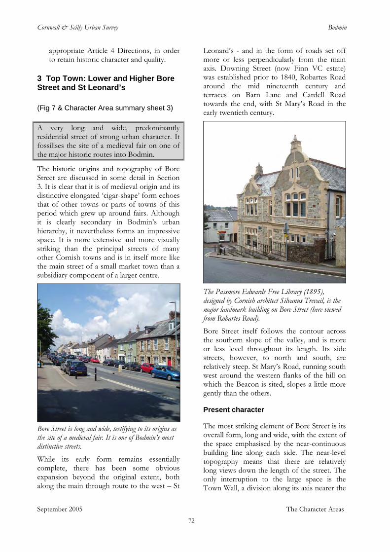
Cornwall & Scilly Urban Survey Bodmin
appropriate Article 4 Directions, in order to retain historic character and quality.
3 Top Town: Lower and Higher Bore Street and St Leonard’s
(Fig 7 & Character Area summary sheet 3)
September 2005 The Character Areas
A very long and wide, predominantly residential street of strong urban character. It fossilises the site of a medieval fair on one of the major historic routes into Bodmin.
The historic origins and topography of Bore Street are discussed in some detail in Section 3. It is clear that it is of medieval origin and its distinctive elongated ‘cigar-shape’ form echoes that of other towns or parts of towns of this period which grew up around fairs. Although it is clearly secondary in Bodmin’s urban hierarchy, it nevertheless forms an impressive space. It is more extensive and more visually striking than the principal streets of many other Cornish towns and is in itself more like the main street of a small market town than a subsidiary component of a larger centre.
Bore Street is long and wide, testifying to its origins as the site of a medieval fair. It is one of Bodmin’s most distinctive streets. While its early form remains essentially complete, there has been some obvious expansion beyond the original extent, both along the main through route to the west – St
Leonard’s - and in the form of roads set off more or less perpendicularly from the main axis. Downing Street (now Finn VC estate) was established prior to 1840, Robartes Road around the mid nineteenth century and terraces on Barn Lane and Cardell Road towards the end, with St Mary’s Road in the early twentieth century.
The Passmore Edwards Free Library (1895), designed by Cornish architect Silvanus Trevail, is the major landmark building on Bore Street (here viewed from Robartes Road). Bore Street itself follows the contour across the southern slope of the valley, and is more or less level throughout its length. Its side streets, however, to north and south, are relatively steep. St Mary’s Road, running south west around the western flanks of the hill on which the Beacon is sited, slopes a little more gently than the others.
Present character
The most striking element of Bore Street is its overall form, long and wide, with the extent of the space emphasised by the near-continuous building line along each side. The near-level topography means that there are relatively long views down the length of the street. The only interruption to the large space is the Town Wall, a division along its axis nearer the
72
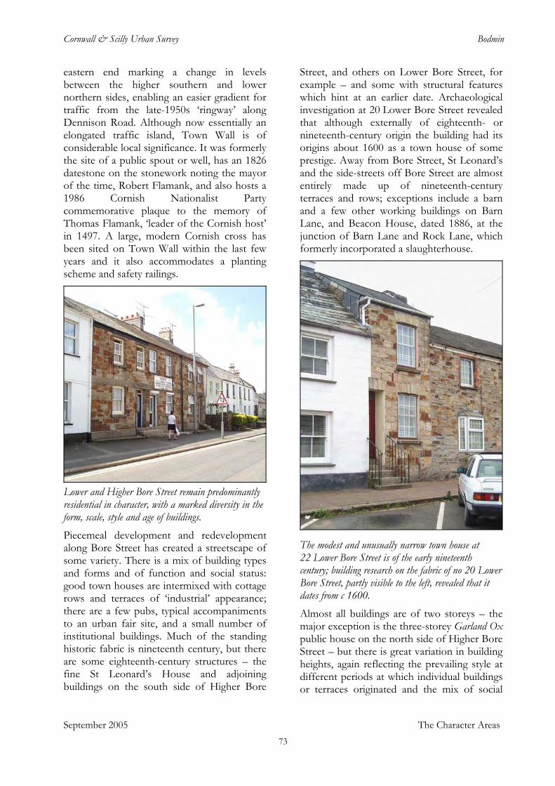
Cornwall & Scilly Urban Survey Bodmin
eastern end marking a change in levels between the higher southern and lower northern sides, enabling an easier gradient for traffic from the late-1950s ‘ringway’ along Dennison Road. Although now essentially an elongated traffic island, Town Wall is of considerable local significance. It was formerly the site of a public spout or well, has an 1826 datestone on the stonework noting the mayor of the time, Robert Flamank, and also hosts a 1986 Cornish Nationalist Party commemorative plaque to the memory of Thomas Flamank, ‘leader of the Cornish host’ in 1497. A large, modern Cornish cross has been sited on Town Wall within the last few years and it also accommodates a planting scheme and safety railings.
Lower and Higher Bore Street remain predominantly residential in character, with a marked diversity in the form, scale, style and age of buildings. Piecemeal development and redevelopment along Bore Street has created a streetscape of some variety. There is a mix of building types and forms and of function and social status: good town houses are intermixed with cottage rows and terraces of ‘industrial’ appearance; there are a few pubs, typical accompaniments to an urban fair site, and a small number of institutional buildings. Much of the standing historic fabric is nineteenth century, but there are some eighteenth-century structures – the fine St Leonard’s House and adjoining buildings on the south side of Higher Bore
Street, and others on Lower Bore Street, for example – and some with structural features which hint at an earlier date. Archaeological investigation at 20 Lower Bore Street revealed that although externally of eighteenth- or nineteenth-century origin the building had its origins about 1600 as a town house of some prestige. Away from Bore Street, St Leonard’s and the side-streets off Bore Street are almost entirely made up of nineteenth-century terraces and rows; exceptions include a barn and a few other working buildings on Barn Lane, and Beacon House, dated 1886, at the junction of Barn Lane and Rock Lane, which formerly incorporated a slaughterhouse.
The modest and unusually narrow town house at 22 Lower Bore Street is of the early nineteenth century; building research on the fabric of no 20 Lower Bore Street, partly visible to the left, revealed that it dates from c 1600. Almost all buildings are of two storeys – the major exception is the three-storey Garland Ox public house on the north side of Higher Bore Street – but there is great variation in building heights, again reflecting the prevailing style at different periods at which individual buildings or terraces originated and the mix of social
September 2005 The Character Areas 73
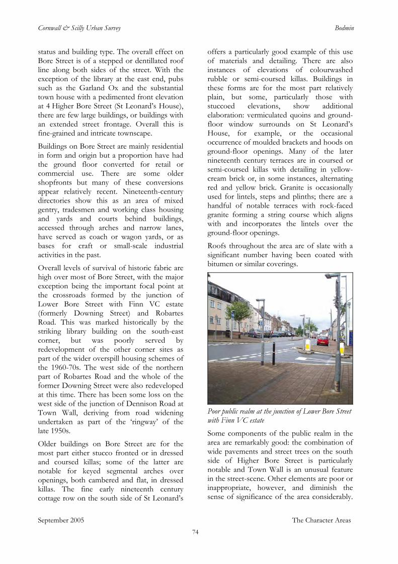
Cornwall & Scilly Urban Survey Bodmin
status and building type. The overall effect on Bore Street is of a stepped or dentillated roof line along both sides of the street. With the exception of the library at the east end, pubs such as the Garland Ox and the substantial town house with a pedimented front elevation at 4 Higher Bore Street (St Leonard’s House), there are few large buildings, or buildings with an extended street frontage. Overall this is fine-grained and intricate townscape.
Buildings on Bore Street are mainly residential in form and origin but a proportion have had the ground floor converted for retail or commercial use. There are some older shopfronts but many of these conversions appear relatively recent. Nineteenth-century directories show this as an area of mixed gentry, tradesmen and working class housing and yards and courts behind buildings, accessed through arches and narrow lanes, have served as coach or wagon yards, or as bases for craft or small-scale industrial activities in the past.
Overall levels of survival of historic fabric are high over most of Bore Street, with the major exception being the important focal point at the crossroads formed by the junction of Lower Bore Street with Finn VC estate (formerly Downing Street) and Robartes Road. This was marked historically by the striking library building on the south-east corner, but was poorly served by redevelopment of the other corner sites as part of the wider overspill housing schemes of the 1960-70s. The west side of the northern part of Robartes Road and the whole of the former Downing Street were also redeveloped at this time. There has been some loss on the west side of the junction of Dennison Road at Town Wall, deriving from road widening undertaken as part of the ‘ringway’ of the late 1950s.
September 2005 The Character Areas
Older buildings on Bore Street are for the most part either stucco fronted or in dressed and coursed killas; some of the latter are notable for keyed segmental arches over openings, both cambered and flat, in dressed killas. The fine early nineteenth century cottage row on the south side of St Leonard’s
offers a particularly good example of this use of materials and detailing. There are also instances of elevations of colourwashed rubble or semi-coursed killas. Buildings in these forms are for the most part relatively plain, but some, particularly those with stuccoed elevations, show additional elaboration: vermiculated quoins and ground-floor window surrounds on St Leonard’s House, for example, or the occasional occurrence of moulded brackets and hoods on ground-floor openings. Many of the later nineteenth century terraces are in coursed or semi-coursed killas with detailing in yellow-cream brick or, in some instances, alternating red and yellow brick. Granite is occasionally used for lintels, steps and plinths; there are a handful of notable terraces with rock-faced granite forming a string course which aligns with and incorporates the lintels over the ground-floor openings.
Roofs throughout the area are of slate with a significant number having been coated with bitumen or similar coverings.
Poor public realm at the junction of Lower Bore Street with Finn VC estate Some components of the public realm in the area are remarkably good: the combination of wide pavements and street trees on the south side of Higher Bore Street is particularly notable and Town Wall is an unusual feature in the street-scene. Other elements are poor or inappropriate, however, and diminish the sense of significance of the area considerably.
74
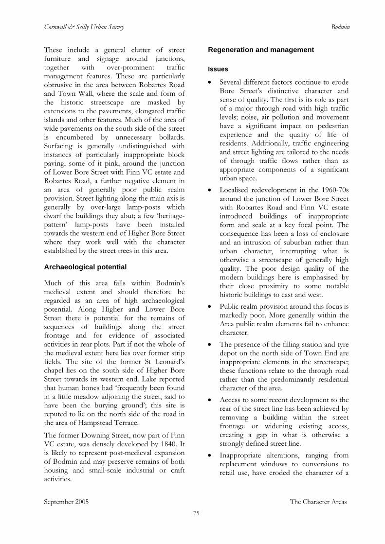
Cornwall & Scilly Urban Survey Bodmin
These include a general clutter of street furniture and signage around junctions, together with over-prominent traffic management features. These are particularly obtrusive in the area between Robartes Road and Town Wall, where the scale and form of the historic streetscape are masked by extensions to the pavements, elongated traffic islands and other features. Much of the area of wide pavements on the south side of the street is encumbered by unnecessary bollards. Surfacing is generally undistinguished with instances of particularly inappropriate block paving, some of it pink, around the junction of Lower Bore Street with Finn VC estate and Robartes Road, a further negative element in an area of generally poor public realm provision. Street lighting along the main axis is generally by over-large lamp-posts which dwarf the buildings they abut; a few ‘heritage-pattern’ lamp-posts have been installed towards the western end of Higher Bore Street where they work well with the character established by the street trees in this area.
Archaeological potential
Much of this area falls within Bodmin’s medieval extent and should therefore be regarded as an area of high archaeological potential. Along Higher and Lower Bore Street there is potential for the remains of sequences of buildings along the street frontage and for evidence of associated activities in rear plots. Part if not the whole of the medieval extent here lies over former strip fields. The site of the former St Leonard’s chapel lies on the south side of Higher Bore Street towards its western end. Lake reported that human bones had ‘frequently been found in a little meadow adjoining the street, said to have been the burying ground’; this site is reputed to lie on the north side of the road in the area of Hampstead Terrace.
The former Downing Street, now part of Finn VC estate, was densely developed by 1840. It is likely to represent post-medieval expansion of Bodmin and may preserve remains of both housing and small-scale industrial or craft activities.
Regeneration and management
Issues
• Several different factors continue to erode Bore Street’s distinctive character and sense of quality. The first is its role as part of a major through road with high traffic levels; noise, air pollution and movement have a significant impact on pedestrian experience and the quality of life of residents. Additionally, traffic engineering and street lighting are tailored to the needs of through traffic flows rather than as appropriate components of a significant urban space.
• Localised redevelopment in the 1960-70s around the junction of Lower Bore Street with Robartes Road and Finn VC estate introduced buildings of inappropriate form and scale at a key focal point. The consequence has been a loss of enclosure and an intrusion of suburban rather than urban character, interrupting what is otherwise a streetscape of generally high quality. The poor design quality of the modern buildings here is emphasised by their close proximity to some notable historic buildings to east and west.
• Public realm provision around this focus is markedly poor. More generally within the Area public realm elements fail to enhance character.
• The presence of the filling station and tyre depot on the north side of Town End are inappropriate elements in the streetscape; these functions relate to the through road rather than the predominantly residential character of the area.
• Access to some recent development to the rear of the street line has been achieved by removing a building within the street frontage or widening existing access, creating a gap in what is otherwise a strongly defined street line.
• Inappropriate alterations, ranging from replacement windows to conversions to retail use, have eroded the character of a
September 2005 The Character Areas 75
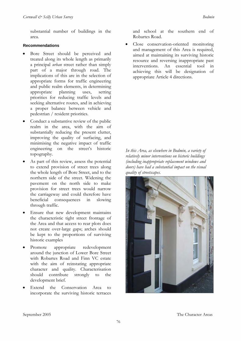
Cornwall & Scilly Urban Survey Bodmin
substantial number of buildings in the area.
Recommendations • Bore Street should be perceived and
treated along its whole length as primarily a principal urban street rather than simply part of a major through road. The implications of this are in the selection of appropriate forms for traffic engineering and public realm elements, in determining appropriate planning uses, setting priorities for reducing traffic levels and seeking alternative routes, and in achieving a proper balance between vehicle and pedestrian / resident priorities.
• Conduct a substantive review of the public realm in the area, with the aim of substantially reducing the present clutter, improving the quality of surfacing, and minimising the negative impact of traffic engineering on the street’s historic topography.
• As part of this review, assess the potential to extend provision of street trees along the whole length of Bore Street, and to the northern side of the street. Widening the pavement on the north side to make provision for street trees would narrow the carriageway and could therefore have beneficial consequences in slowing through traffic.
• Ensure that new development maintains the characteristic tight street frontage of the Area and that access to rear plots does not create over-large gaps; arches should be kept to the proportions of surviving historic examples
• Promote appropriate redevelopment around the junction of Lower Bore Street with Robartes Road and Finn VC estate with the aim of reinstating appropriate character and quality. Characterisation should contribute strongly to the development brief.
• Extend the Conservation Area to incorporate the surviving historic terraces
and school at the southern end of Robartes Road.
• Close conservation-oriented monitoring and management of this Area is required, aimed at maintaining its surviving historic resource and reversing inappropriate past interventions. An essential tool in achieving this will be designation of appropriate Article 4 directions.
In this Area, as elsewhere in Bodmin, a variety of relatively minor interventions on historic buildings (including inappropriate replacement windows and doors) have had a substantial impact on the visual quality of streetscapes.
September 2005 The Character Areas 76
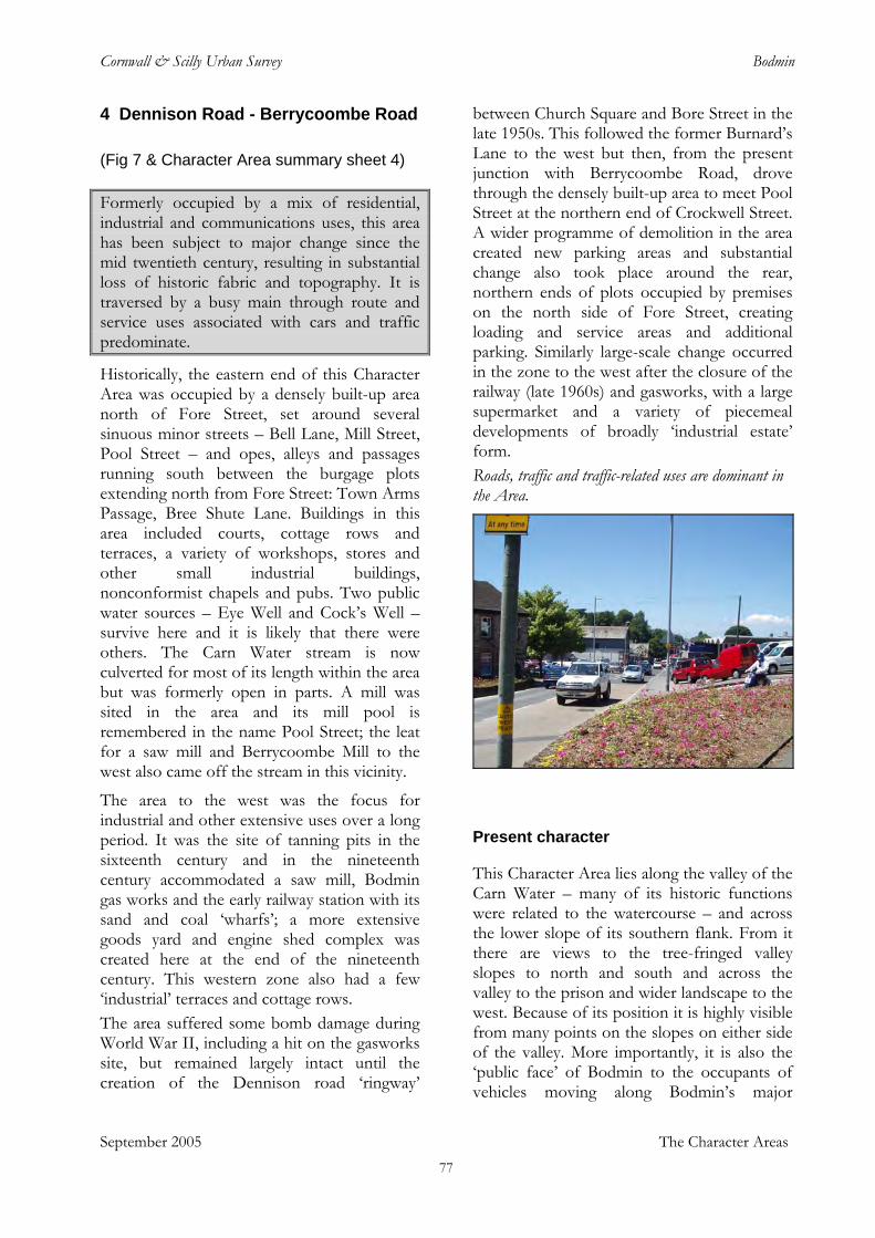
Cornwall & Scilly Urban Survey Bodmin
4 Dennison Road - Berrycoombe Road
(Fig 7 & Character Area summary sheet 4) Formerly occupied by a mix of residential, industrial and communications uses, this area has been subject to major change since the mid twentieth century, resulting in substantial loss of historic fabric and topography. It is traversed by a busy main through route and service uses associated with cars and traffic predominate.
Historically, the eastern end of this Character Area was occupied by a densely built-up area north of Fore Street, set around several sinuous minor streets – Bell Lane, Mill Street, Pool Street – and opes, alleys and passages running south between the burgage plots extending north from Fore Street: Town Arms Passage, Bree Shute Lane. Buildings in this area included courts, cottage rows and terraces, a variety of workshops, stores and other small industrial buildings, nonconformist chapels and pubs. Two public water sources – Eye Well and Cock’s Well – survive here and it is likely that there were others. The Carn Water stream is now culverted for most of its length within the area but was formerly open in parts. A mill was sited in the area and its mill pool is remembered in the name Pool Street; the leat for a saw mill and Berrycoombe Mill to the west also came off the stream in this vicinity.
The area to the west was the focus for industrial and other extensive uses over a long period. It was the site of tanning pits in the sixteenth century and in the nineteenth century accommodated a saw mill, Bodmin gas works and the early railway station with its sand and coal ‘wharfs’; a more extensive goods yard and engine shed complex was created here at the end of the nineteenth century. This western zone also had a few ‘industrial’ terraces and cottage rows. The area suffered some bomb damage during World War II, including a hit on the gasworks site, but remained largely intact until the creation of the Dennison road ‘ringway’
between Church Square and Bore Street in the late 1950s. This followed the former Burnard’s Lane to the west but then, from the present junction with Berrycoombe Road, drove through the densely built-up area to meet Pool Street at the northern end of Crockwell Street. A wider programme of demolition in the area created new parking areas and substantial change also took place around the rear, northern ends of plots occupied by premises on the north side of Fore Street, creating loading and service areas and additional parking. Similarly large-scale change occurred in the zone to the west after the closure of the railway (late 1960s) and gasworks, with a large supermarket and a variety of piecemeal developments of broadly ‘industrial estate’ form. Roads, traffic and traffic-related uses are dominant in the Area.
Present character
This Character Area lies along the valley of the Carn Water – many of its historic functions were related to the watercourse – and across the lower slope of its southern flank. From it there are views to the tree-fringed valley slopes to north and south and across the valley to the prison and wider landscape to the west. Because of its position it is highly visible from many points on the slopes on either side of the valley. More importantly, it is also the ‘public face’ of Bodmin to the occupants of vehicles moving along Bodmin’s major
September 2005 The Character Areas 77
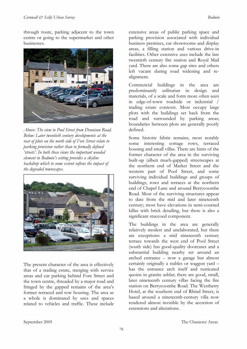
Cornwall & Scilly Urban Survey Bodmin
through route, parking adjacent to the town centre or going to the supermarket and other businesses.
Above: The view to Pool Street from Dennison Road. Below: Later twentieth century developments at the rear of plots on the north side of Fore Street relate to parking provision rather than to formally defined ‘streets’. In both these views the important wooded element in Bodmin’s setting provides a skyline backdrop which to some extent softens the impact of the degraded townscapes.
The present character of the area is effectively that of a trading estate, merging with service areas and car parking behind Fore Street and the town centre, threaded by a major road and fringed by the gapped remains of the area’s former terraced and row housing. The area as a whole is dominated by uses and spaces related to vehicles and traffic. These include
extensive areas of public parking space and parking provision associated with individual business premises, car showrooms and display areas, a filling station and various drive-in facilities. Other extensive uses include the late twentieth century fire station and Royal Mail yard. There are also some gap sites and others left vacant during road widening and re-alignment.
Commercial buildings in the area are predominantly utilitarian in design and materials, of a scale and form more often seen in edge-of-town roadside or industrial / trading estate contexts. Most occupy large plots with the buildings set back from the road and surrounded by parking areas; boundaries between plots are generally poorly defined.
Some historic fabric remains, most notably some interesting cottage rows, terraced housing and small villas. There are hints of the former character of the area in the surviving built-up (albeit much-gapped) streetscapes at the northern end of Market Street and the western part of Pool Street, and some surviving individual buildings and groups of buildings, rows and terraces at the northern end of Chapel Lane and around Berrycoombe Road. Most of the surviving structures appear to date from the mid and later nineteenth century; most have elevations in semi-coursed killas with brick detailing, but there is also a significant stuccoed component.
September 2005 The Character Areas
The buildings in the area are generally relatively modest and unelaborated, but there are exceptions: a mid nineteenth century terrace towards the west end of Pool Street (south side) has good-quality doorcases and a substantial building nearby set around an arched entrance – now a garage but almost certainly originally a stables or waggon yard – has the entrance arch itself and rusticated quoins in granite ashlar; there are good, small, later nineteenth century villas facing the fire station on Berrycoombe Road. The Westberry Hotel, at the southern end of Rhind Street, is based around a nineteenth-century villa now rendered almost invisible by the accretion of extensions and alterations.
78
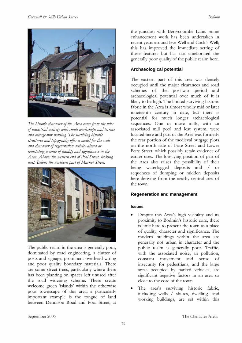
Cornwall & Scilly Urban Survey Bodmin
The historic character of the Area came from the mix of industrial activity with small workshops and terrace and cottage-row housing. The surviving historic structures and topography offer a model for the scale and character of regeneration activity aimed at reinstating a sense of quality and significance in the Area. Above: the western end of Pool Street, looking west. Below: the northern part of Market Street.
The public realm in the area is generally poor, dominated by road engineering, a clutter of posts and signage, prominent overhead wiring and poor quality boundary materials. There are some street trees, particularly where there has been planting on spaces left unused after the road widening scheme. These create welcome green ‘islands’ within the otherwise poor townscape of this area; a particularly important example is the tongue of land between Dennison Road and Pool Street, at
the junction with Berrycoombe Lane. Some enhancement work has been undertaken in recent years around Eye Well and Cock’s Well; this has improved the immediate setting of these features but has not ameliorated the generally poor quality of the public realm here.
Archaeological potential
The eastern part of this area was densely occupied until the major clearances and road schemes of the post-war period and archaeological potential over much of it is likely to be high. The limited surviving historic fabric in the Area is almost wholly mid or later nineteenth century in date, but there is potential for much longer archaeological sequences. One or more mills, with an associated mill pool and leat system, were located here and part of the Area was formerly the rear portion of the medieval burgage plots on the north side of Fore Street and Lower Bore Street, which possibly retain evidence of earlier uses. The low-lying position of part of the Area also raises the possibility of their being waterlogged deposits and / or sequences of dumping or midden deposits here deriving from the nearby central area of the town.
Regeneration and management
Issues • Despite this Area’s high visibility and its
proximity to Bodmin’s historic core, there is little here to present the town as a place of quality, character and significance. The modern buildings within the area are generally not urban in character and the public realm is generally poor. Traffic, with the associated noise, air pollution, constant movement and sense of insecurity for pedestrians, and the large areas occupied by parked vehicles, are significant negative factors in an area so close to the core of the town.
• The area’s surviving historic fabric, including wells / shutes, dwellings and working buildings, are set within this
September 2005 The Character Areas 79
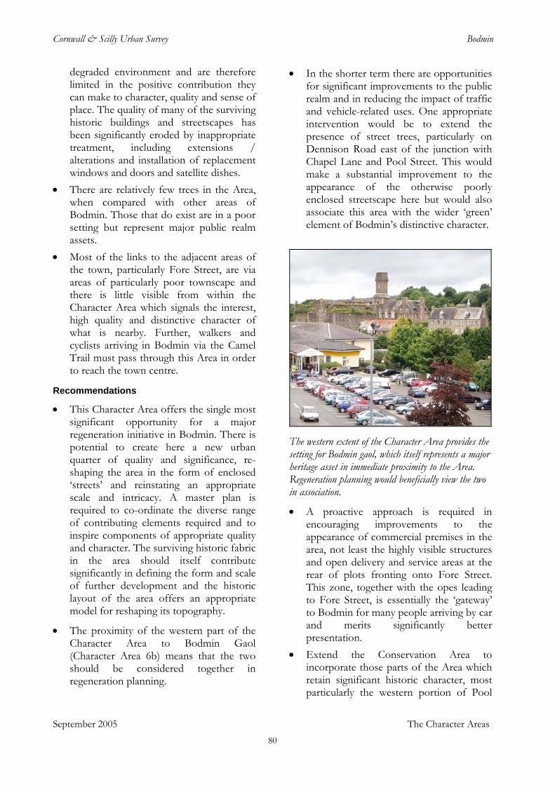
Cornwall & Scilly Urban Survey Bodmin
degraded environment and are therefore limited in the positive contribution they can make to character, quality and sense of place. The quality of many of the surviving historic buildings and streetscapes has been significantly eroded by inappropriate treatment, including extensions / alterations and installation of replacement windows and doors and satellite dishes.
• There are relatively few trees in the Area, when compared with other areas of Bodmin. Those that do exist are in a poor setting but represent major public realm assets.
• Most of the links to the adjacent areas of the town, particularly Fore Street, are via areas of particularly poor townscape and there is little visible from within the Character Area which signals the interest, high quality and distinctive character of what is nearby. Further, walkers and cyclists arriving in Bodmin via the Camel Trail must pass through this Area in order to reach the town centre.
Recommendations • This Character Area offers the single most
significant opportunity for a major regeneration initiative in Bodmin. There is potential to create here a new urban quarter of quality and significance, re-shaping the area in the form of enclosed ‘streets’ and reinstating an appropriate scale and intricacy. A master plan is required to co-ordinate the diverse range of contributing elements required and to inspire components of appropriate quality and character. The surviving historic fabric in the area should itself contribute significantly in defining the form and scale of further development and the historic layout of the area offers an appropriate model for reshaping its topography.
• The proximity of the western part of the Character Area to Bodmin Gaol (Character Area 6b) means that the two should be considered together in regeneration planning.
• In the shorter term there are opportunities for significant improvements to the public realm and in reducing the impact of traffic and vehicle-related uses. One appropriate intervention would be to extend the presence of street trees, particularly on Dennison Road east of the junction with Chapel Lane and Pool Street. This would make a substantial improvement to the appearance of the otherwise poorly enclosed streetscape here but would also associate this area with the wider ‘green’ element of Bodmin’s distinctive character.
The western extent of the Character Area provides the setting for Bodmin gaol, which itself represents a major heritage asset in immediate proximity to the Area. Regeneration planning would beneficially view the two in association.
• A proactive approach is required in encouraging improvements to the appearance of commercial premises in the area, not least the highly visible structures and open delivery and service areas at the rear of plots fronting onto Fore Street. This zone, together with the opes leading to Fore Street, is essentially the ‘gateway’ to Bodmin for many people arriving by car and merits significantly better presentation.
• Extend the Conservation Area to incorporate those parts of the Area which retain significant historic character, most particularly the western portion of Pool
September 2005 The Character Areas 80
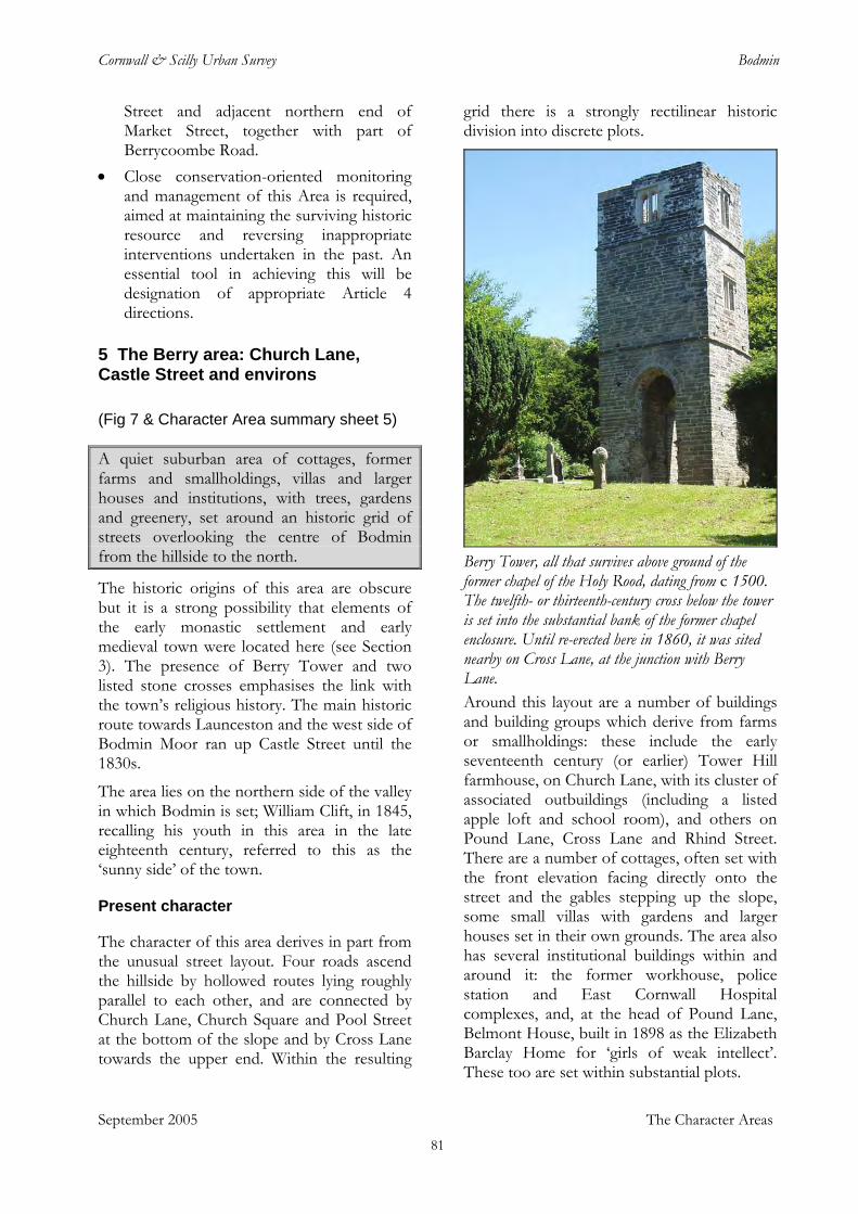
Cornwall & Scilly Urban Survey Bodmin
Street and adjacent northern end of Market Street, together with part of Berrycoombe Road.
• Close conservation-oriented monitoring and management of this Area is required, aimed at maintaining the surviving historic resource and reversing inappropriate interventions undertaken in the past. An essential tool in achieving this will be designation of appropriate Article 4 directions.
5 The Berry area: Church Lane, Castle Street and environs
(Fig 7 & Character Area summary sheet 5)
September 2005 The Character Areas
A quiet suburban area of cottages, former farms and smallholdings, villas and larger houses and institutions, with trees, gardens and greenery, set around an historic grid of streets overlooking the centre of Bodmin from the hillside to the north.
The historic origins of this area are obscure but it is a strong possibility that elements of the early monastic settlement and early medieval town were located here (see Section 3). The presence of Berry Tower and two listed stone crosses emphasises the link with the town’s religious history. The main historic route towards Launceston and the west side of Bodmin Moor ran up Castle Street until the 1830s.
The area lies on the northern side of the valley in which Bodmin is set; William Clift, in 1845, recalling his youth in this area in the late eighteenth century, referred to this as the ‘sunny side’ of the town.
Present character
The character of this area derives in part from the unusual street layout. Four roads ascend the hillside by hollowed routes lying roughly parallel to each other, and are connected by Church Lane, Church Square and Pool Street at the bottom of the slope and by Cross Lane towards the upper end. Within the resulting
grid there is a strongly rectilinear historic division into discrete plots.
Berry Tower, all that survives above ground of the former chapel of the Holy Rood, dating from c 1500. The twelfth- or thirteenth-century cross below the tower is set into the substantial bank of the former chapel enclosure. Until re-erected here in 1860, it was sited nearby on Cross Lane, at the junction with Berry Lane. Around this layout are a number of buildings and building groups which derive from farms or smallholdings: these include the early seventeenth century (or earlier) Tower Hill farmhouse, on Church Lane, with its cluster of associated outbuildings (including a listed apple loft and school room), and others on Pound Lane, Cross Lane and Rhind Street. There are a number of cottages, often set with the front elevation facing directly onto the street and the gables stepping up the slope, some small villas with gardens and larger houses set in their own grounds. The area also has several institutional buildings within and around it: the former workhouse, police station and East Cornwall Hospital complexes, and, at the head of Pound Lane, Belmont House, built in 1898 as the Elizabeth Barclay Home for ‘girls of weak intellect’. These too are set within substantial plots.
81
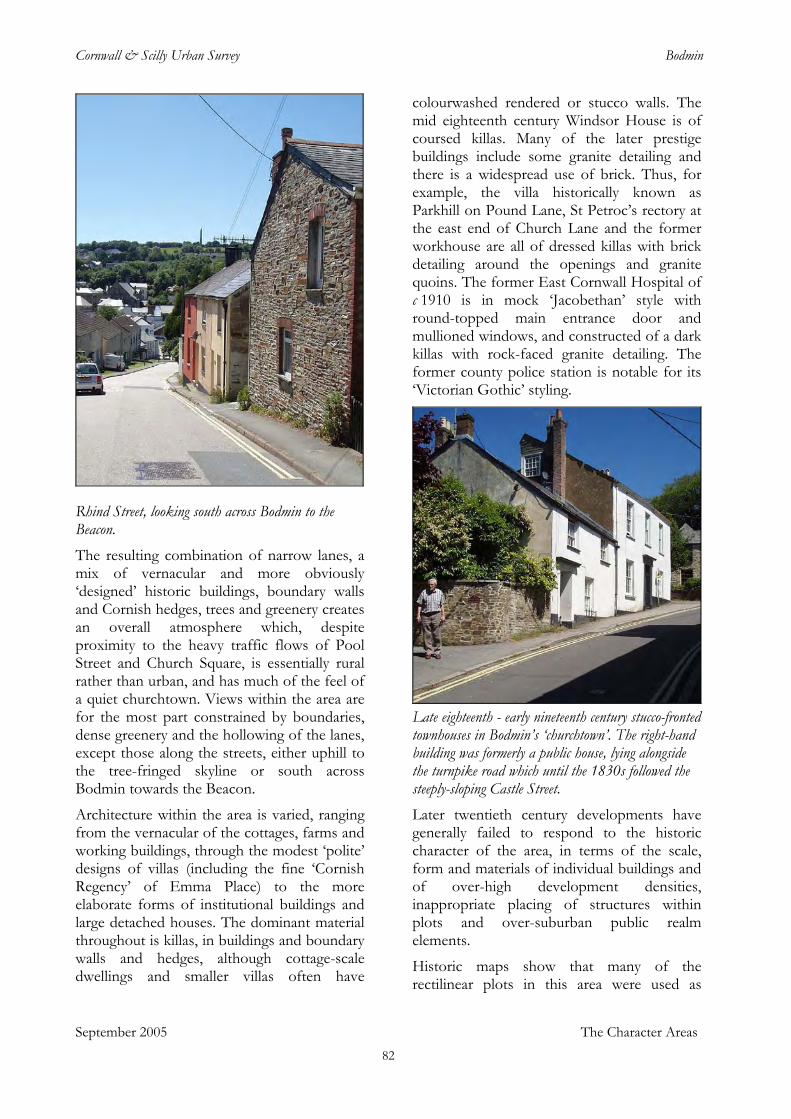
Cornwall & Scilly Urban Survey Bodmin
Rhind Street, looking south across Bodmin to the Beacon. The resulting combination of narrow lanes, a mix of vernacular and more obviously ‘designed’ historic buildings, boundary walls and Cornish hedges, trees and greenery creates an overall atmosphere which, despite proximity to the heavy traffic flows of Pool Street and Church Square, is essentially rural rather than urban, and has much of the feel of a quiet churchtown. Views within the area are for the most part constrained by boundaries, dense greenery and the hollowing of the lanes, except those along the streets, either uphill to the tree-fringed skyline or south across Bodmin towards the Beacon.
Architecture within the area is varied, ranging from the vernacular of the cottages, farms and working buildings, through the modest ‘polite’ designs of villas (including the fine ‘Cornish Regency’ of Emma Place) to the more elaborate forms of institutional buildings and large detached houses. The dominant material throughout is killas, in buildings and boundary walls and hedges, although cottage-scale dwellings and smaller villas often have
colourwashed rendered or stucco walls. The mid eighteenth century Windsor House is of coursed killas. Many of the later prestige buildings include some granite detailing and there is a widespread use of brick. Thus, for example, the villa historically known as Parkhill on Pound Lane, St Petroc’s rectory at the east end of Church Lane and the former workhouse are all of dressed killas with brick detailing around the openings and granite quoins. The former East Cornwall Hospital of c 1910 is in mock ‘Jacobethan’ style with round-topped main entrance door and mullioned windows, and constructed of a dark killas with rock-faced granite detailing. The former county police station is notable for its ‘Victorian Gothic’ styling.
Late eighteenth - early nineteenth century stucco-fronted townhouses in Bodmin’s ‘churchtown’. The right-hand building was formerly a public house, lying alongside the turnpike road which until the 1830s followed the steeply-sloping Castle Street. Later twentieth century developments have generally failed to respond to the historic character of the area, in terms of the scale, form and materials of individual buildings and of over-high development densities, inappropriate placing of structures within plots and over-suburban public realm elements.
Historic maps show that many of the rectilinear plots in this area were used as
September 2005 The Character Areas 82
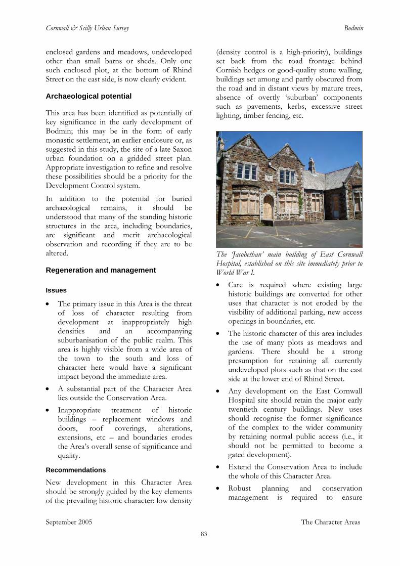
Cornwall & Scilly Urban Survey Bodmin
enclosed gardens and meadows, undeveloped other than small barns or sheds. Only one such enclosed plot, at the bottom of Rhind Street on the east side, is now clearly evident.
Archaeological potential
This area has been identified as potentially of key significance in the early development of Bodmin; this may be in the form of early monastic settlement, an earlier enclosure or, as suggested in this study, the site of a late Saxon urban foundation on a gridded street plan. Appropriate investigation to refine and resolve these possibilities should be a priority for the Development Control system.
In addition to the potential for buried archaeological remains, it should be understood that many of the standing historic structures in the area, including boundaries, are significant and merit archaeological observation and recording if they are to be altered.
Regeneration and management
Issues • The primary issue in this Area is the threat
of loss of character resulting from development at inappropriately high densities and an accompanying suburbanisation of the public realm. This area is highly visible from a wide area of the town to the south and loss of character here would have a significant impact beyond the immediate area.
• A substantial part of the Character Area lies outside the Conservation Area.
• Inappropriate treatment of historic buildings – replacement windows and doors, roof coverings, alterations, extensions, etc – and boundaries erodes the Area’s overall sense of significance and quality.
Recommendations
September 2005 The Character Areas
New development in this Character Area should be strongly guided by the key elements of the prevailing historic character: low density
(density control is a high-priority), buildings set back from the road frontage behind Cornish hedges or good-quality stone walling, buildings set among and partly obscured from the road and in distant views by mature trees, absence of overtly ‘suburban’ components such as pavements, kerbs, excessive street lighting, timber fencing, etc.
The ‘Jacobethan’ main building of East Cornwall Hospital, established on this site immediately prior to World War I. • Care is required where existing large
historic buildings are converted for other uses that character is not eroded by the visibility of additional parking, new access openings in boundaries, etc.
• The historic character of this area includes the use of many plots as meadows and gardens. There should be a strong presumption for retaining all currently undeveloped plots such as that on the east side at the lower end of Rhind Street.
• Any development on the East Cornwall Hospital site should retain the major early twentieth century buildings. New uses should recognise the former significance of the complex to the wider community by retaining normal public access (i.e., it should not be permitted to become a gated development).
• Extend the Conservation Area to include the whole of this Character Area.
• Robust planning and conservation management is required to ensure
83
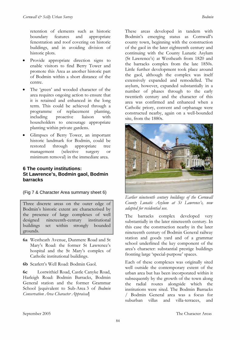
Cornwall & Scilly Urban Survey Bodmin
retention of elements such as historic boundary features and appropriate fenestration and roof covering on historic buildings, and in avoiding division of historic plots.
• Provide appropriate direction signs to enable visitors to find Berry Tower and promote this Area as another historic part of Bodmin within a short distance of the centre.
• The ‘green’ and wooded character of the area requires ongoing action to ensure that it is retained and enhanced in the long term. This could be achieved through a programme of replacement planting, including proactive liaison with householders to encourage appropriate planting within private gardens.
• Glimpses of Berry Tower, an important historic landmark for Bodmin, could be restored through appropriate tree management (selective surgery or minimum removal) in the immediate area.
6 The county institutions: St Lawrence’s, Bodmin gaol, Bodmin barracks
(Fig 7 & Character Area summary sheet 6)
September 2005 The Character Areas
Three discrete areas on the outer edge of Bodmin’s historic extent are characterised by the presence of large complexes of well designed nineteenth-century institutional buildings set within strongly bounded grounds.
6a Westheath Avenue, Dunmere Road and St Mary’s Road: the former St Lawrence’s hospital and the St Mary’s complex of Catholic institutional buildings.
6b Scarlett’s Well Road: Bodmin Gaol.
6c Lostwithiel Road, Castle Canyke Road, Harleigh Road: Bodmin Barracks, Bodmin General station and the former Grammar School [equivalent to Sub-Area 3 of Bodmin Conservation Area Character Appraisal]
These areas developed in tandem with Bodmin’s emerging status as Cornwall’s county town, beginning with the construction of the gaol in the later eighteenth century and continuing with the County Lunatic Asylum (St Lawrence’s) at Westheath from 1820 and the barracks complex from the late 1850s. Little further development took place around the gaol, although the complex was itself extensively expanded and remodelled. The asylum, however, expanded substantially in a number of phases through to the early twentieth century and the character of this area was confirmed and enhanced when a Catholic priory, convent and orphanage were constructed nearby, again on a well-bounded site, from the 1880s.
Earlier nineteenth century buildings of the Cornwall County Lunatic Asylum at St Lawrence’s, now adapted for residential use. The barracks complex developed very substantially in the later nineteenth century. In this case the construction nearby in the later nineteenth century of Bodmin General railway station and goods yard and of a grammar school underlined the key component of the area’s character: substantial prestige buildings fronting large ‘special-purpose’ spaces.
Each of these complexes was originally sited well outside the contemporary extent of the urban area but has been incorporated within it subsequently by the growth of the town along the radial routes alongside which the institutions were sited. The Bodmin Barracks / Bodmin General area was a focus for suburban villas and villa-terraces, and
84
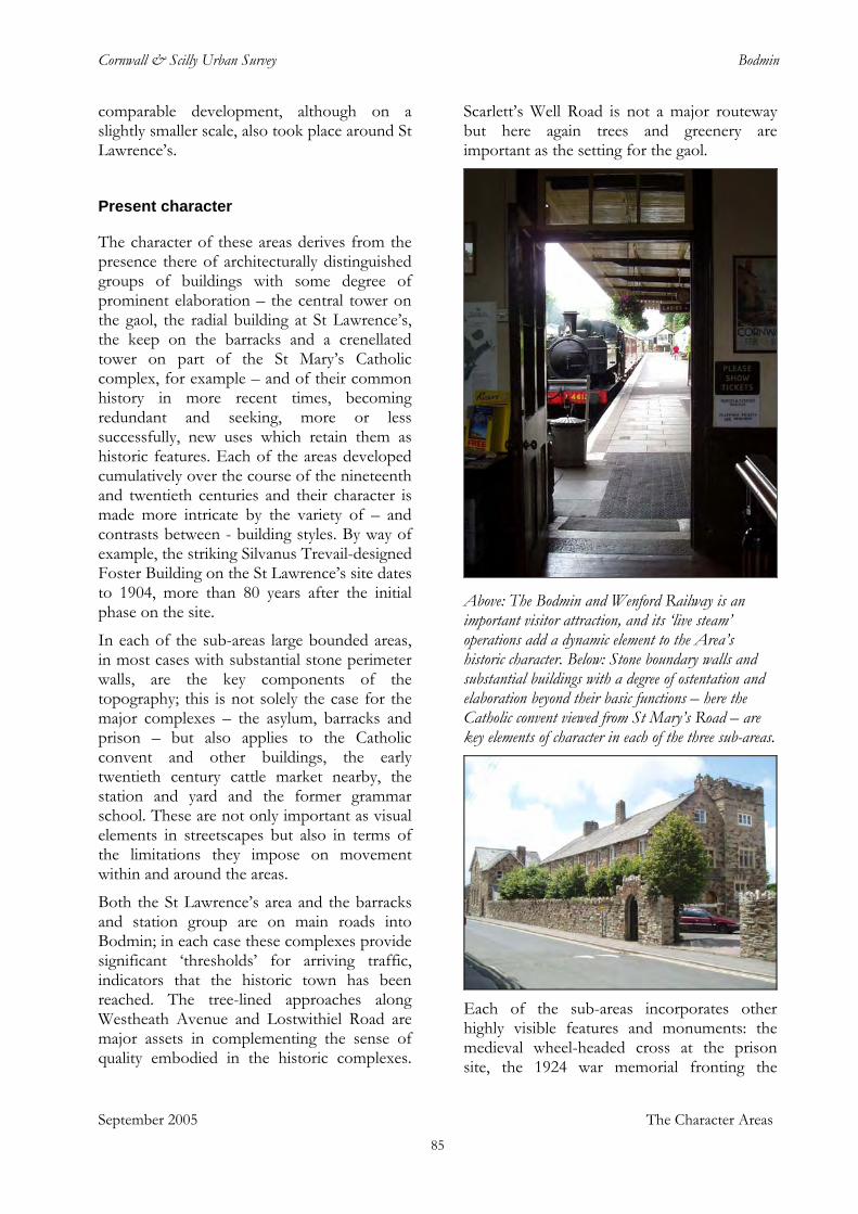
Cornwall & Scilly Urban Survey Bodmin
comparable development, although on a slightly smaller scale, also took place around St Lawrence’s.
Present character
The character of these areas derives from the presence there of architecturally distinguished groups of buildings with some degree of prominent elaboration – the central tower on the gaol, the radial building at St Lawrence’s, the keep on the barracks and a crenellated tower on part of the St Mary’s Catholic complex, for example – and of their common history in more recent times, becoming redundant and seeking, more or less successfully, new uses which retain them as historic features. Each of the areas developed cumulatively over the course of the nineteenth and twentieth centuries and their character is made more intricate by the variety of – and contrasts between - building styles. By way of example, the striking Silvanus Trevail-designed Foster Building on the St Lawrence’s site dates to 1904, more than 80 years after the initial phase on the site.
In each of the sub-areas large bounded areas, in most cases with substantial stone perimeter walls, are the key components of the topography; this is not solely the case for the major complexes – the asylum, barracks and prison – but also applies to the Catholic convent and other buildings, the early twentieth century cattle market nearby, the station and yard and the former grammar school. These are not only important as visual elements in streetscapes but also in terms of the limitations they impose on movement within and around the areas.
Both the St Lawrence’s area and the barracks and station group are on main roads into Bodmin; in each case these complexes provide significant ‘thresholds’ for arriving traffic, indicators that the historic town has been reached. The tree-lined approaches along Westheath Avenue and Lostwithiel Road are major assets in complementing the sense of quality embodied in the historic complexes.
Scarlett’s Well Road is not a major routeway but here again trees and greenery are important as the setting for the gaol.
Above: The Bodmin and Wenford Railway is an important visitor attraction, and its ‘live steam’ operations add a dynamic element to the Area’s historic character. Below: Stone boundary walls and substantial buildings with a degree of ostentation and elaboration beyond their basic functions – here the Catholic convent viewed from St Mary’s Road – are key elements of character in each of the three sub-areas.
Each of the sub-areas incorporates other highly visible features and monuments: the medieval wheel-headed cross at the prison site, the 1924 war memorial fronting the
September 2005 The Character Areas 85
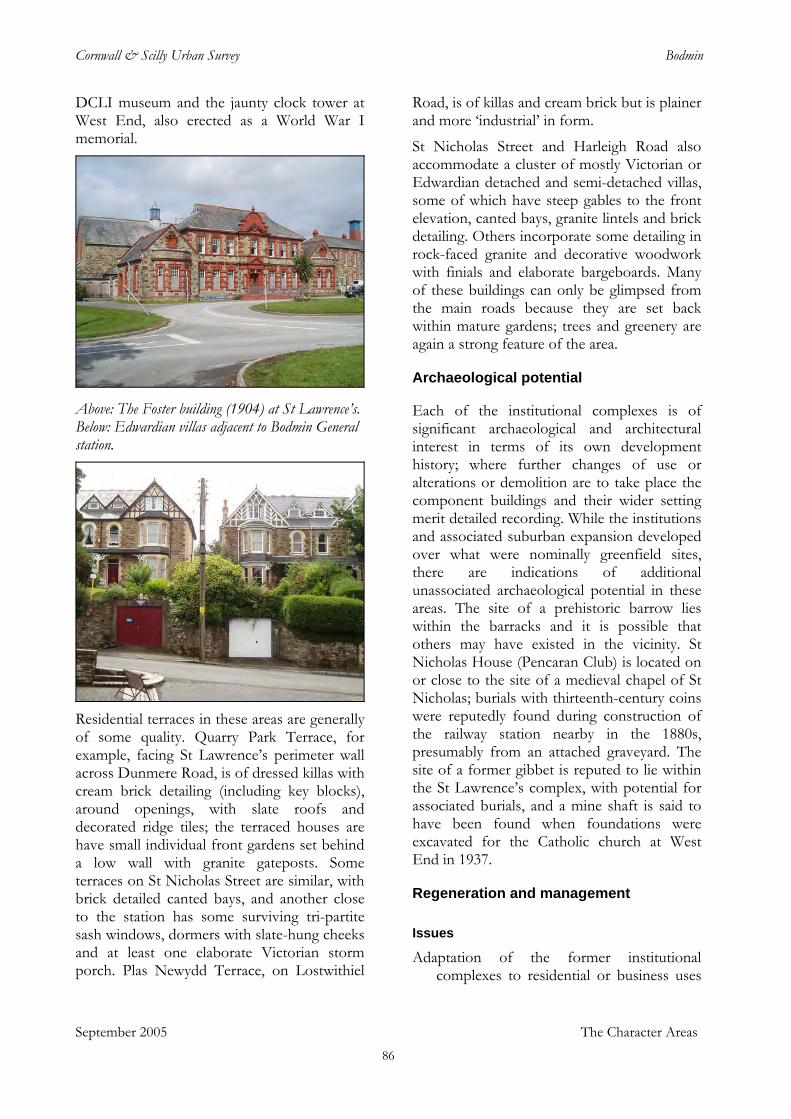
Cornwall & Scilly Urban Survey Bodmin
DCLI museum and the jaunty clock tower at West End, also erected as a World War I memorial.
Above: The Foster building (1904) at St Lawrence’s. Below: Edwardian villas adjacent to Bodmin General station.
Residential terraces in these areas are generally of some quality. Quarry Park Terrace, for example, facing St Lawrence’s perimeter wall across Dunmere Road, is of dressed killas with cream brick detailing (including key blocks), around openings, with slate roofs and decorated ridge tiles; the terraced houses are have small individual front gardens set behind a low wall with granite gateposts. Some terraces on St Nicholas Street are similar, with brick detailed canted bays, and another close to the station has some surviving tri-partite sash windows, dormers with slate-hung cheeks and at least one elaborate Victorian storm porch. Plas Newydd Terrace, on Lostwithiel
Road, is of killas and cream brick but is plainer and more ‘industrial’ in form.
St Nicholas Street and Harleigh Road also accommodate a cluster of mostly Victorian or Edwardian detached and semi-detached villas, some of which have steep gables to the front elevation, canted bays, granite lintels and brick detailing. Others incorporate some detailing in rock-faced granite and decorative woodwork with finials and elaborate bargeboards. Many of these buildings can only be glimpsed from the main roads because they are set back within mature gardens; trees and greenery are again a strong feature of the area.
Archaeological potential
Each of the institutional complexes is of significant archaeological and architectural interest in terms of its own development history; where further changes of use or alterations or demolition are to take place the component buildings and their wider setting merit detailed recording. While the institutions and associated suburban expansion developed over what were nominally greenfield sites, there are indications of additional unassociated archaeological potential in these areas. The site of a prehistoric barrow lies within the barracks and it is possible that others may have existed in the vicinity. St Nicholas House (Pencaran Club) is located on or close to the site of a medieval chapel of St Nicholas; burials with thirteenth-century coins were reputedly found during construction of the railway station nearby in the 1880s, presumably from an attached graveyard. The site of a former gibbet is reputed to lie within the St Lawrence’s complex, with potential for associated burials, and a mine shaft is said to have been found when foundations were excavated for the Catholic church at West End in 1937.
Regeneration and management
Issues Adaptation of the former institutional
complexes to residential or business uses
September 2005 The Character Areas 86
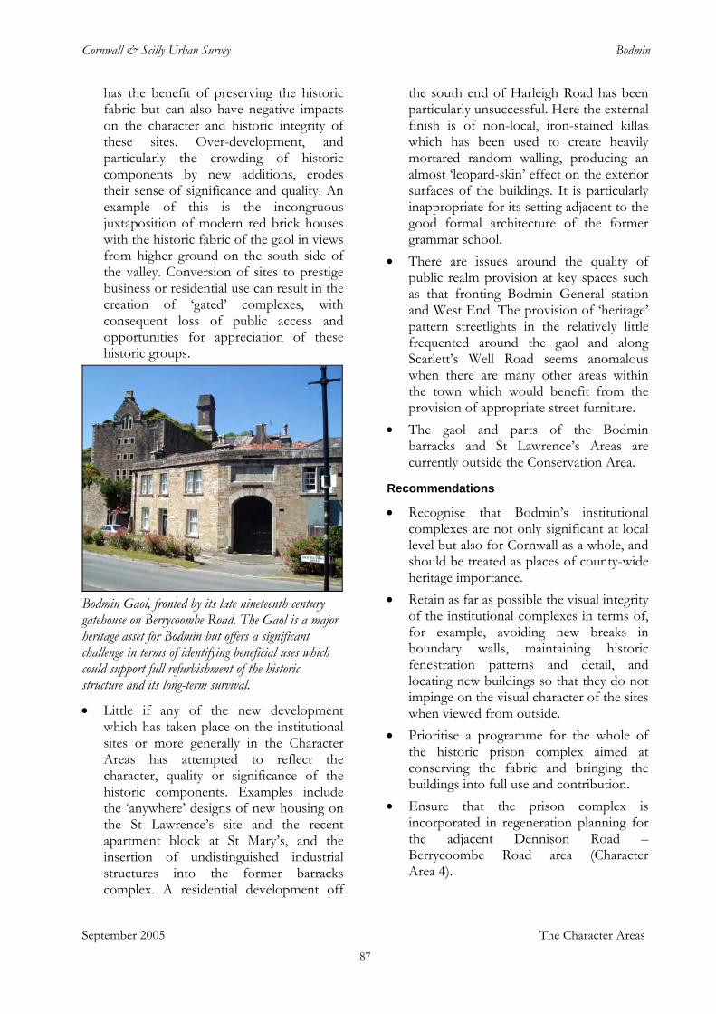
Cornwall & Scilly Urban Survey Bodmin
has the benefit of preserving the historic fabric but can also have negative impacts on the character and historic integrity of these sites. Over-development, and particularly the crowding of historic components by new additions, erodes their sense of significance and quality. An example of this is the incongruous juxtaposition of modern red brick houses with the historic fabric of the gaol in views from higher ground on the south side of the valley. Conversion of sites to prestige business or residential use can result in the creation of ‘gated’ complexes, with consequent loss of public access and opportunities for appreciation of these historic groups.
Bodmin Gaol, fronted by its late nineteenth century gatehouse on Berrycoombe Road. The Gaol is a major heritage asset for Bodmin but offers a significant challenge in terms of identifying beneficial uses which could support full refurbishment of the historic structure and its long-term survival.
• Little if any of the new development which has taken place on the institutional sites or more generally in the Character Areas has attempted to reflect the character, quality or significance of the historic components. Examples include the ‘anywhere’ designs of new housing on the St Lawrence’s site and the recent apartment block at St Mary’s, and the insertion of undistinguished industrial structures into the former barracks complex. A residential development off
the south end of Harleigh Road has been particularly unsuccessful. Here the external finish is of non-local, iron-stained killas which has been used to create heavily mortared random walling, producing an almost ‘leopard-skin’ effect on the exterior surfaces of the buildings. It is particularly inappropriate for its setting adjacent to the good formal architecture of the former grammar school.
• There are issues around the quality of public realm provision at key spaces such as that fronting Bodmin General station and West End. The provision of ‘heritage’ pattern streetlights in the relatively little frequented around the gaol and along Scarlett’s Well Road seems anomalous when there are many other areas within the town which would benefit from the provision of appropriate street furniture.
• The gaol and parts of the Bodmin barracks and St Lawrence’s Areas are currently outside the Conservation Area.
Recommendations • Recognise that Bodmin’s institutional
complexes are not only significant at local level but also for Cornwall as a whole, and should be treated as places of county-wide heritage importance.
• Retain as far as possible the visual integrity of the institutional complexes in terms of, for example, avoiding new breaks in boundary walls, maintaining historic fenestration patterns and detail, and locating new buildings so that they do not impinge on the visual character of the sites when viewed from outside.
• Prioritise a programme for the whole of the historic prison complex aimed at conserving the fabric and bringing the buildings into full use and contribution.
• Ensure that the prison complex is incorporated in regeneration planning for the adjacent Dennison Road – Berrycoombe Road area (Character Area 4).
September 2005 The Character Areas 87
Cornwall & Scilly Urban Survey Bodmin
• Ensure that the park-like character of the grounds to St Lawrence’s is retained. Explore potential for new public access green-space on the site.
• Enable access to the institutional complexes for public appreciation of the historic structures and settings wherever possible.
• Undertake public realm enhancements at West End and around Bodmin General station.
• Maintain and develop levels of tree cover within the sub-areas, including roadside trees.
• Extend the Conservation Area to incorporate all the surviving historic structures and associated plots within these Character Areas.
• Apply robust planning and conservation management to ensure retention of elements such as historic boundary features and landscapes, and of detail on historic buildings, and avoiding division of historic plots.
September 2005 The Character Areas 88
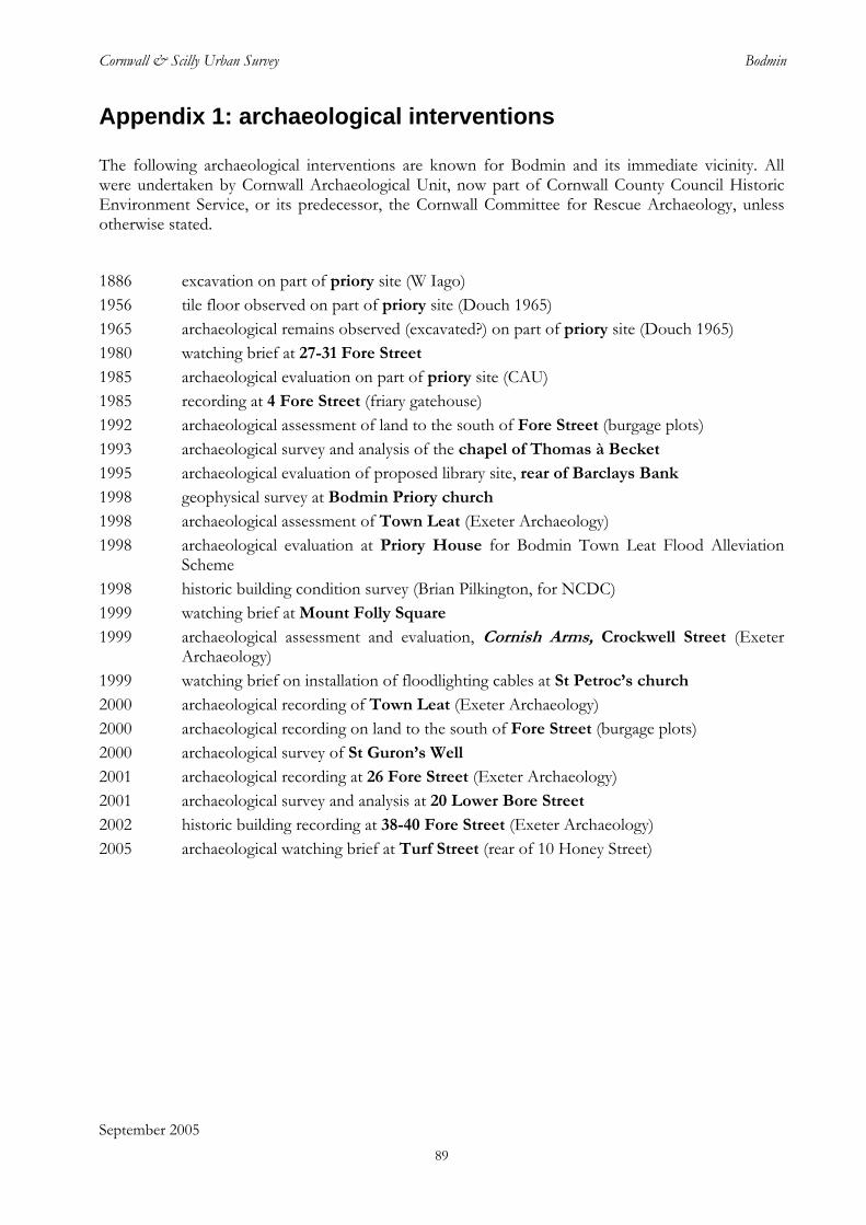
Cornwall & Scilly Urban Survey Bodmin
Appendix 1: archaeological interventions
The following archaeological interventions are known for Bodmin and its immediate vicinity. All were undertaken by Cornwall Archaeological Unit, now part of Cornwall County Council Historic Environment Service, or its predecessor, the Cornwall Committee for Rescue Archaeology, unless otherwise stated.
1886 excavation on part of priory site (W Iago) 1956 tile floor observed on part of priory site (Douch 1965) 1965 archaeological remains observed (excavated?) on part of priory site (Douch 1965) 1980 watching brief at 27-31 Fore Street 1985 archaeological evaluation on part of priory site (CAU) 1985 recording at 4 Fore Street (friary gatehouse) 1992 archaeological assessment of land to the south of Fore Street (burgage plots) 1993 archaeological survey and analysis of the chapel of Thomas à Becket 1995 archaeological evaluation of proposed library site, rear of Barclays Bank 1998 geophysical survey at Bodmin Priory church 1998 archaeological assessment of Town Leat (Exeter Archaeology) 1998 archaeological evaluation at Priory House for Bodmin Town Leat Flood Alleviation
Scheme 1998 historic building condition survey (Brian Pilkington, for NCDC) 1999 watching brief at Mount Folly Square 1999 archaeological assessment and evaluation, Cornish Arms, Crockwell Street (Exeter
Archaeology) 1999 watching brief on installation of floodlighting cables at St Petroc’s church 2000 archaeological recording of Town Leat (Exeter Archaeology) 2000 archaeological recording on land to the south of Fore Street (burgage plots) 2000 archaeological survey of St Guron’s Well 2001 archaeological recording at 26 Fore Street (Exeter Archaeology) 2001 archaeological survey and analysis at 20 Lower Bore Street
2002 historic building recording at 38-40 Fore Street (Exeter Archaeology) 2005 archaeological watching brief at Turf Street (rear of 10 Honey Street)
September 2005 89
Cornwall & Scilly Urban Survey Bodmin
Sources
Published sources Angerstein, R R, 2001. R R Angerstein’s illustrated travel diary, 1753-1755: industry in England and Wales
from a Swedish perspective, London
Anon, 1859. A handbook for travellers in Devon and Cornwall, London (John Murray); 4th edition
Austin, F, ed, 1991. The Clift family correspondence, 1792-1846, Sheffield
Bailey’s Western and Midland Directory, 1783, Birmingham
Barton, R M, 1970. Life in Cornwall in the early nineteenth century, Truro; 1997 reprint
Barton, R M, 1971. Life in Cornwall in the mid nineteenth century, Truro
Barton, R M, 1972. Life in Cornwall in the late nineteenth century, Truro
Barton, R M, 1974. Life in Cornwall at the end of the nineteenth century, Truro
Botanista, T, 1757. Rural beauties, or the natural history of the four following western counties, viz Cornwall, Devonshire, Dorsetshire and Somersetshire, London
Brunton, A, 1992. Bodmin Gaol, Cornwall, Newton Abbot
Carew, R, 1602. The survey of Cornwall; reprinted Redruth, 2000
Chandler, J, 1996. John Leland in the West Country, in Topographical writers in south-west England (M Brayshay, ed), Exeter
Chope P, 1967. Early tours in Devon and Cornwall, Newton Abbot
Daniell, J J, 1854. A compendium of the geography and history of Cornwall, Truro (revised 4th edn, T Peter 1906)
Duffin, A, 1996. Faction and faith: politics and religion of the Cornish gentry before the Civil War, Exeter
Elliott-Binns, L E, 1955. Medieval Cornwall, London
Fox, H S A, and Padel, O J, 2000. The Cornish lands of the Arundells of Lanherne, fourteenth to sixteenth centuries, Exeter
Gerrard, S, 2000. The early British tin industry, Stroud
Goldsmith, R F K, 1970. The Duke of Cornwall’s Light Infantry, London
Gray, T, 2000. Cornwall: The travellers’ tales, I, Exeter
Hamilton Jenkin, A K, 1945. Cornwall and its people, London (reprinted Newton Abbot, 1970)
Harris, J, ed, 1964. The Prideaux collection of topographical drawings, Architectural History, 7
Haslam, J, 1984. The towns of Wiltshire, in Anglo-Saxon towns in southern England (J Haslam, ed), Chichester, 87-148
Henderson, C, 1963, Essays in Cornish history, ed A L Rowse and M I Henderson, Truro (first printed Oxford, 1935)
Hull, P L, 1971, The caption of seizin of the duchy of Cornwall, Exeter
Jankulak, K, 2000. The medieval cult of St Petroc, Woodbridge
September 2005 90
Cornwall & Scilly Urban Survey Bodmin
Lewis, H, nd. Bodmin’s well trail: an historic trail of discovery through the ancient town of Bodmin, Bodmin
Maclean, J, 1870. The parochial and family history of the parish and borough of Bodmin, London
Morrison, K, 1999. The workhouse: a study of Poor-Law buildings in England, Swindon
Munn, P, 1973. Introducing Bodmin, the Cornish capital, Bodmin
O’ Hara, P, 1985. Excavation news, 1985: Bodmin Priory, Conish Archaeology, 24, 212
Padel, O J, 1985. Cornish place-name elements, Nottingham
Padel O J, 1988. A popular dictionary of Cornish place-names, Newmill [Penzance]
Perry, R, 2001. Cornwall’s mining collapse revisited: an empirical survey of economic re-adjustment in late-Victorian and Edwardian Cornwall, in Cornish History [online journal: www.marjon.ac.uk/cornish-history]
Pevsner N, 1951. The buildings of England: Cornwall, Harmondsworth
Pocock, S J, 1998. Behind bars: a chronicle of Bodmin Gaol, Truro
Pool, P A S, 1974. The history of the town and borough of Penzance, Penzance
Pool, P A S, 1986. William Borlase, Truro
Richardson, H, ed, 1998. English hospitals 1660-1948: a survey of their architecture and design, Swindon
St John Thomas, D, 1988. A regional history of the railways of Great Britain. Vol. 1: The West Country, Newton Abbot
Sedding, E H, 1909. Norman architecture in Cornwall, London
Sheppard, P, 1980. The historic towns of Cornwall: an archaeological survey, Truro, Cornwall Committee for Rescue Archaeology
Stanier,P, 1999. South west granite: a history of the granite industry in Cornwall and Devon, St Austell
Stockdale F W L, 1824. Excursions in the county of Cornwall, London
Thorn, C, and Thorn, F, 1979. Domesday Book: Cornwall, Chichester
Whetter, J, 2000. Cornish people in the 18th century, Gorran
Willmott, J, 1977. The book of Bodmin: a portrait of the town, Chesham
Strategic, policy and programme documents Bodmin Town Health Check, Colliers Erdman Lewis Research and Consultancy, January 2000
Bodmin Town Conservation Area Character Appraisal, North Cornwall District Council 2000
English Heritage 2005, Streets for All: South West, London
North Cornwall Local Plan 1999-2006
North Cornwall Local Development Framework - Report on the Consultation on the Issues and Options Report November 2004
Cornwall Structure Plan, 2004
Bodmin Parish Profile North Cornwall District Council
North Cornwall Tourism Strategy 2001-2005
Indices of Deprivation 2004 - North Cornwall
September 2005 91
Cornwall & Scilly Urban Survey Bodmin
Bodmin Townscape Heritage Initiative Final Report, Cornwall Enterprise, 2002
Bodmin Futures 2020 Vision
Objective 1 Partnership for Cornwall and Scilly. Single Programming Document
Archaeological reports Barker, P P, 1998. A report for Cornwall Archaeological Unit on a geophysical survey carried out at Bodmin
Priory, Bodmin, Cornwall, June 1998, Upton-on-Severn, Stratascan
Berry, E, Mattingly, J, and Thomas, N, 2001. 20 Lower Bore Street, Bodmin, Cornwall: archaeological survey and historical analysis, Truro, Cornwall Archaeological Unit
Brookes, C F, 1999. A reappraisal of the ground probing radar survey carried out for Cornwall Archaeological Unit at Bodmin Priory, Bodmin, Cornwall, in June 1998, Upton-on-Severn, Stratascan
Cole, R, 1998. Bodmin town leat flood alleviation scheme: Priory House archaeological evaluation, Truro, Cornwall Archaeological Unit
Exeter Archaeology 1998. Archaeological assessment of Bodmin town leat improvement scheme, Exeter Archaeology Report 98.10
Exeter Archaeology 2000. Interim summary report of archaeological recording: Bodmin town leat improvement scheme, Exeter Archaeology Report (draft)
Johns, C, 1992. Burgage plots at Bodmin: an archaeological assessment of land to the south of Fore Street, Bodmin, Truro, Cornwall Archaeological Unit
Johns, C, 2000. Land to the south of Fore Street, Bodmin, Cornwall: archaeological recording, Truro, Cornwall Archaeological Unit
Johns, C, and Thomas, N, 1995. An archaeological evaluation of the proposed new library site, Bodmin, Cornwall, Truro, Cornwall Archaeological Unit
Pilkington, B, 1998. Bodmin: buildings at risk survey, Bodmin, NCDC
Preston-Jones, A, and Mattingly, J, 2000. St Guron’s Well, Bodmin parish churchyard, Cornwall, Truro, Cornwall Archaeological Unit
Stead, P M, 1999. Archaeological assessment and evaluation at the Cornish Arms, Crockwell Street, Bodmin, Exeter Archaeology Report 99.41
Thomas, N, 1993. The chapel of Thomas à Becket, Bodmin, Cornwall, Truro, Cornwall Archaeological Unit
Thomas, N, 1999. St Petroc’s Church, Bodmin: installation of floodlight cables, Truro, Cornwall Archaeological Unit
Thorpe, C, 2000. Mount Folly Square, Bodmin, Cornwall: archaeological watching brief, Truro, Cornwall Archaeological Unit
Whitton, C J M, 2001. Archaeological recording at no 26 Fore Street, Bodmin, Cornwall, Exeter Archaeology Report Report 01.45
Historic maps Joel Gascoyne’s map of Cornwall, 1699 (facsimile reprint, Devon and Cornwall Record Society,
Exeter, 1991)
Thomas Martyn’s map of Cornwall, 1748 (photocopy at HES)
September 2005 92
Cornwall & Scilly Urban Survey Bodmin
Ordnance Surveyors’ Drawings (c 1809)
Ordnance Survey 1st edn (c 1814)
Tithe maps and apportionment (c 1840)
Ordnance Survey 1st edn 1:2500 (c 1880)
Ordnance Survey 2nd edn 1:2500 (c 1907)
Ordnance Survey 1:10,000 map (c 1963) (reproduced in Bodmin Town Conservation Area Character Appraisal, NCDC 2000)
Ordnance Survey Landline digital mapping (current)
Websites Cornwall County Council
Cornish History [online journal]: <http://www.marjon.ac.uk/cornish-history/index.htm>
English Heritage, Images of England English Heritage, Streets for All <http://www.english-heritage.org.uk/server/show/nav.8682>
North Cornwall District Council
Objective One Partnership for Cornwall and Scilly
Samantha Letters, Online Gazetteer of Markets and Fairs in England Wales to 1516 <http://www.history.ac.uk/cmh/gaz/gazweb2.html>.
South West RDA
Victoria County History Cornwall; draft texts: <http:// www.cornwallpast.net>
West Country cinema gazetteer: <http://www.albanyward.com/Bodmin
Cornwall County Council Historic Environment Record Sites, Monuments and Buildings Record
Aerial photographs
September 2005 93


