28
BOOKLET PROJECTS
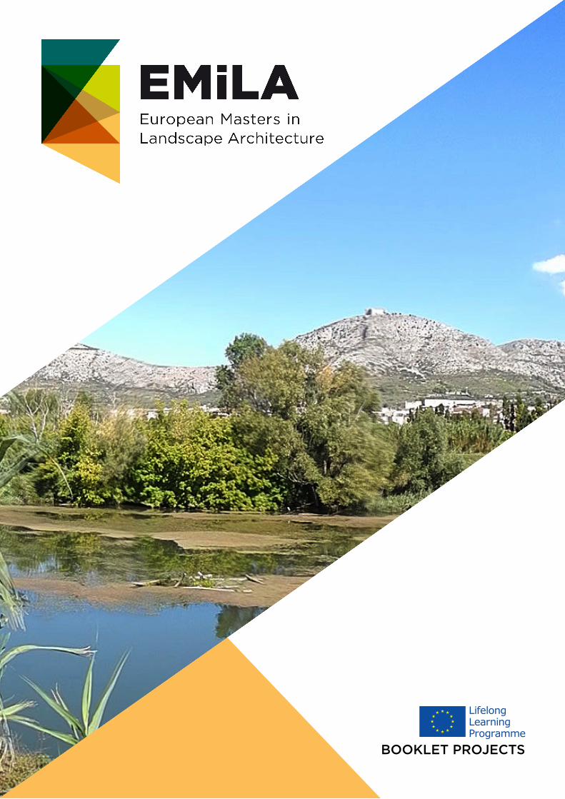
BOOKLET PROJECTS

This project has been funded with support from the European Commission. This publication [communication] reflects the views only of the author, and the Commission cannot be held responsible for any use which may be made of the information contained therein.
Working in international teams has an increasing relevance
for Landscape Architects. Many competitions are announced
Europe-wide. Transnational developments influence the
everyday work of Landscape Architects which increases the
demand for teaching and research on a European scale. From
September 2013 onwards, the European Masters in Landscape
Architecture (EMiLA) will provide students with a programme
of study specifically developed to address these issues..
www.emila.eu
This project has been funded with support from the European Commission. This publication [communication] reflects the views only of the author, and the Commission cannot be held responsible for any use which may be made of the information contained therein.
UNIVERSITY WORKS ANNEX
Amsterdamse Hogeschool voor de Kunsten (AHK)
-P5 design studio Ghana. 3rd year.
-Master/Diploma: Graduation project
-P3b design studio Public Garden
-P4b design studio Countryside
Universitat Politècnica de Catalunya (UPC). Escola Tècnica Superior d’Arquitectura
-LA Studio I, Renewal for a School patio in Alella.
-LA Studio II, Restoration of a quarry in Garraf.
-LA Studio III, Urban Park in River Ter, Ripoll.
-LA Final Studio, Interventions at Valleé de l’Agly, Perpignan.
Edinburgh School of Architecture and Landscape Architecture (ESALA). Edinburgh College of
Art (ESALA ECA). The University of Edinburgh.
-Art, space, nature; Tempelhof Airfield
-Design, strategy, intervention.
-Glenforsa.
Leibniz Universität Hannover (LUH). Fakultät für Architektur und Landschaft
-1st Semester Studio Project, M.Sc. Landschaftsarchitektur
-Final thesis M.Sc. Landschaftsarchitektur
-3rd Semester Studio Project, M.Sc. Landschaftsarchitektur
École Nationale Supérieure de Paysage. Versailles/Marseille (ENSP)
-Urban blue: transforming the harbour of Rouen
-Rungis city expansion
-Urban water

This project has been funded with support from the European Commission. This publication [communication] reflects the views only of the author, and the Commission cannot be held responsible for any use which may be made of the information contained therein.
Vormstudies
This project has been funded with support from the European Commission. This publication [communication] reflects the views only of the author, and the Commission cannot be held responsible for any use which may be made of the information contained therein.
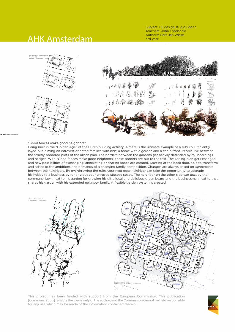
Subject: P5 design studio Ghana. Teachers: John LondsdaleAuthors: Gert-Jan Wisse3rd yearAHK Amsterdam
GOOD FENCES MAKE GOOD NEIGHBOURS. Gert-Jan Wisse. Academy of Architecture Amsterdam
year 1 year 4
Using the flexible forces of nature, ever so resilient borders can be created that grow, set, mature, change shape, get moved, get shaped, get cut and move by them selves over time. By reinventing ancient hedging typologies, the hedge can once more create the physical appearance of our landscape.
the vegetal
Craetegus monogyna
0 0 1 ½ 2 ½ 3 ½ 4 ½ 5 ½ 6 ½ 7 ½ 8 ½ 9
Rosa canina
Cornus mas
Lonicera japonica
Carpinus betulus
Salix alba
Acer campestre
Juglans regia
Salix matsudana
Craetegus monogyna
Rosa caninaRosa canina
growing
expanding
tangling
climbing
cutting
weaving
merging
shaping
walking
0 0 year
Carpinus betulus
Lonicera japonica
Cornus masCornus masCornus masCornus mas
#6
0 0 1 ½ 2 ½ 3 ½ 4 ½ 5 ½ 6 ½ 7 ½ 8 ½ 90 0 year
GOOD FENCES MAKE GOOD NEIGHBOURS. Gert-Jan Wisse. Academy of Architecture Amsterdam
GOOD FENCES MAKE GOOD NEIGHBOURS
Academy of Architecture AmsterdamGOOD FENCES MAKE GOOD NEIGHBOURS. Gert-Jan Wisse. Academy of Architecture Amsterdam
“Good fences make good neighbours” puts the neighborhood of “Kruidenwijk” in Almere in the perspective of the changing society of today and tomorrow.
Being built in the “Golden Age” of the Dutch building activity makes Almere the ultimate example of a suburb. Efficiently layed-out, aiming on introvert oriented families with kids; a home with a garden and a car in front. This clearly shows in the way people live between the strictly bordered plots of the urban set-up. The border between the garden and the neighbors’ garden gets heavily defended by tall boardings and hedges. Once these borders start to decay, the DIY spirit of the suburban resident shows, and the boardings and fences get repaired, often in highly inventive ways. With “Good fences make good neighbors” these borders are put to the test by overthrowing the rules they are based upon. The zoning-plan gets changed, building permits are a thing of the past and new possibilities of exchanging, annexating or sharing space are created. Always based on agreements among the neighbors.In this way a flexible landscape is created which starts at the backdoor, and which is able to change
and adept to the ambitions and demands of a changing family composition.The nextdoor neighbor takes the opportunity to upgrade his hobby to a business by renting out your un-used storage space. The neighbor on the other side occupies the communal lawn next to his garden for growing his ultra local and delicious green beans. The women down the street splits her property and rents half out to a young family in the attic, and the businessman next to that shares his garden with the extended family next door.
The composition of the neighborhood changes continiously and with that the needs and demands of its residents. By binding the force of nature in fast growing hedgerows, an ultra flexible division tool is created wich is able to move with the perception of space of the people on both sides. A green maze of hedges, gardens and thriving entrepeneurship provides a new focus on locality in times of economic uncertainty. The division between people becomes the subject of negotiation and the garden becomes the facade of a new local society.
the political landscape of Almere Kruidenwijkborders of ownership
the physical landscape of Almere Kruidenwijkfences - boardings - hedges
Almere Kruidenwijka new mental landscape
GOOD FENCES MAKE GOOD NEIGHBOURS. Gert-Jan Wisse. Academy of Architecture Amsterdam
GOOD FENCES MAKE GOOD NEIGHBOURS
Academy of Architecture Amsterdam
Tuinkruidenhof 2020exploration of shifting boundaries
plot expanding contracting
1 expantion 2 expantion and annexing
3 contraction / shed occupation
4 building and annexing
5 enclosing / merging
6 detaching and shifting
“Good fences make good neighbors”Being built in the “Golden Age” of the Dutch building activity, Almere is the ultimate example of a suburb. Efficiently layed-out, aiming on introvert oriented families with kids; a home with a garden and a car in front. People live between the strictly bordered plots of the urban plan. The borders between the gardens get heavily defended by tall boardings and hedges. With “Good fences make good neighbors” these borders are put to the test. The zoning-plan gets changed and new possibilities of exchanging, annexating or sharing space are created. Starting at the back door, able to transform and adapt to the ambitions and demands of a changing family composition. Changes are always based on agreements between the neighbors. By overthrowing the rules your next door neighbor can take the opportunity to upgrade his hobby to a business by renting out your un-used storage space. The neighbor on the other side can occupy the communal lawn next to his garden for growing his ultra local and delicious green beans and the businessman next to that shares his garden with his extended neighbor family. A flexible garden system is created.
This project has been funded with support from the European Commission. This publication [communication] reflects the views only of the author, and the Commission cannot be held responsible for any use which may be made of the information contained therein.
glacial mount (current situation)glacial hidden treasures under surface (boulders) very rare in the Netherlands
(after 5 years) eroding glacial mount, arise of coastal cliffs, hidden treasures on surface
(after 100 years) cliffs became relict
Jorryt Braaksma - Academy of Architecture Amsterdam
Rising Land03
Cliffs of Finsterwolde after 5 years
Cliffs of Finsterwolde after 25 years
Cliffs of Finsterwolde after 50 years
Cliffs of Finsterwolde after 75 years
new Cliffs of Finsterwoldelocation of the glacial mound, current situation location of the glacial mound, after 25 years
huidig
nieuw
nieuw
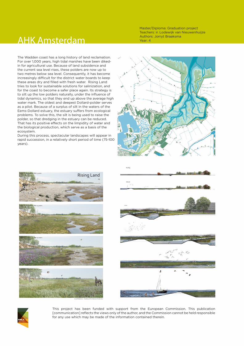
Master/Diploma: Graduation project Teachers: ir. Lodewijk van NieuwenhuijzeAuthors: Jorryt BraaksmaYear: 4Plankaart
beeld na 25 jaar
normale vloed
AHK Amsterdam
The Wadden coast has a long history of land reclamation. For over 1,000 years, high tidal marshes have been diked-in for agricultural use. Because of land subsidence and the current sea level rises, these polders are now up to two metres below sea level. Consequently, it has become increasingly difficult for the district water boards to keep these areas dry and filled with fresh water. Rising Land tries to look for sustainable solutions for salinization, and for the coast to become a safer place again. Its strategy is to silt up the low polders naturally, under the influence of tidal dynamics, so that they end up above the average high water mark. The oldest and deepest Dollard-polder serves as a pilot. Because of a surplus of silt in the waters of the Eems-Dollard estuary, the estuary suffers from ecological problems. To solve this, the silt is being used to raise the polder, so that dredging in the estuary can be reduced. That has its positive effects on the limpidity of water and the biological production, which serve as a basis of the ecosystem. During this process, spectacular landscapes will appear in rapid succession, in a relatively short period of time (75-100 years).
This project has been funded with support from the European Commission. This publication [communication] reflects the views only of the author, and the Commission cannot be held responsible for any use which may be made of the information contained therein.
Routing
Water
0 20 40 100 meter60 80
PLANTDETAIL
GARDEN DESIGN ALONAKI
Plantings
0 2 4 10 meter6 8
Va
leria
na
d
iosc
ord
is
Sta
ch
ys
sylv
atic
a
Me
nth
ap
ipe
rita
Ca
len
du
la
arv
en
sis
gu
tte
r
pa
th
wa
ll
Ole
a
eu
rop
ae
a
PLANTDETAIL
RUNWATER DETAILS
indication of the slope of the Alonaki siteAlonaki site suffering from drought rainwater runs down the hill lines consisting of rows of stones paralell to the height-lines create a terrace effect
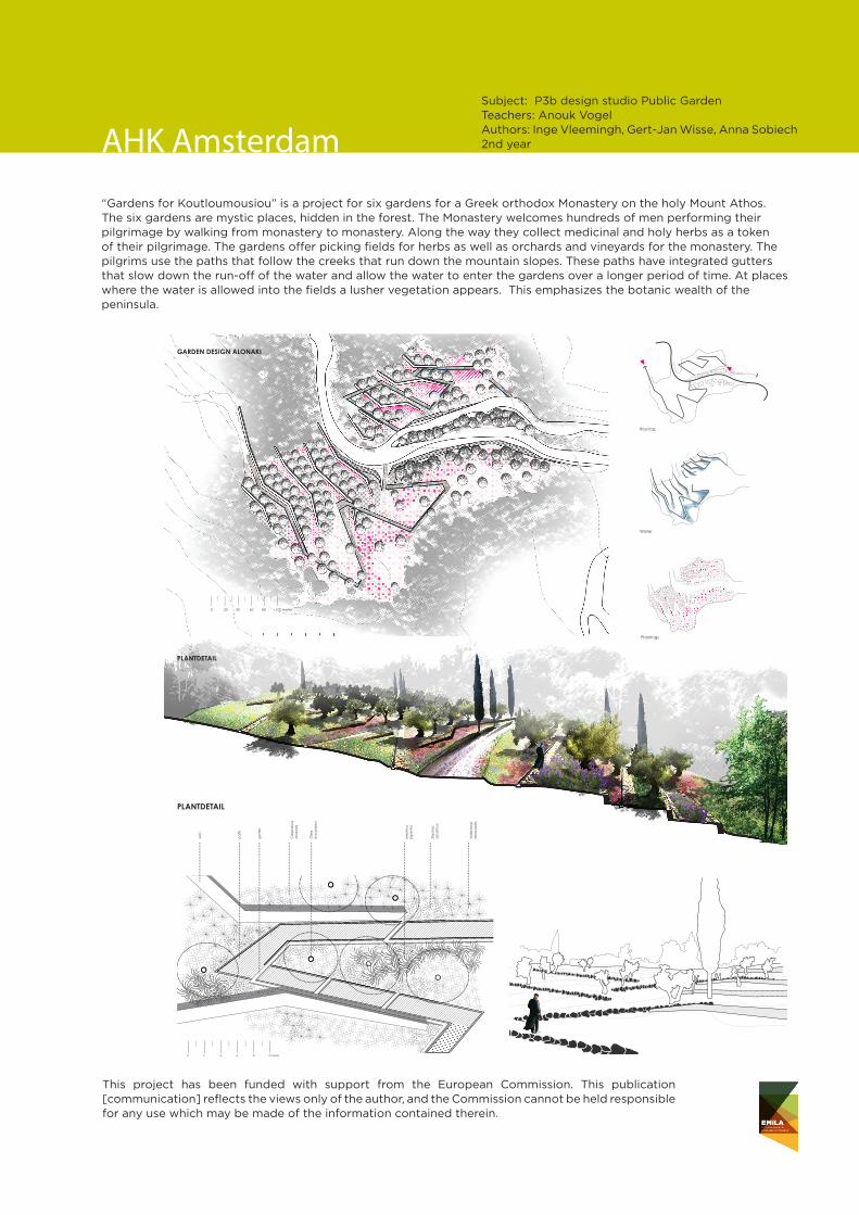
AHK AmsterdamSubject: P3b design studio Public Garden Teachers: Anouk Vogel Authors: Inge Vleemingh, Gert-Jan Wisse, Anna Sobiech 2nd year
“Gardens for Koutloumousiou” is a project for six gardens for a Greek orthodox Monastery on the holy Mount Athos. The six gardens are mystic places, hidden in the forest. The Monastery welcomes hundreds of men performing their pilgrimage by walking from monastery to monastery. Along the way they collect medicinal and holy herbs as a token of their pilgrimage. The gardens offer picking fields for herbs as well as orchards and vineyards for the monastery. The pilgrims use the paths that follow the creeks that run down the mountain slopes. These paths have integrated gutters that slow down the run-off of the water and allow the water to enter the gardens over a longer period of time. At places where the water is allowed into the fields a lusher vegetation appears. This emphasizes the botanic wealth of the peninsula.
This project has been funded with support from the European Commission. This publication [communication] reflects the views only of the author, and the Commission cannot be held responsible for any use which may be made of the information contained therein.
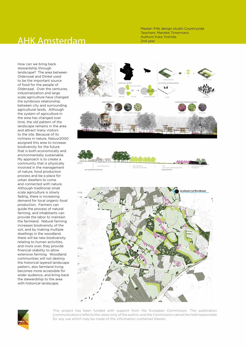
How can we bring back stewardship through landscape? The area between Oldenzaal and Dinkel used to be the important source of food for the people of Oldenzaal. Over the centuries, industrialization and large scale agriculture have changed the symbiosis relationship between city and surrounding agricultural lands. Although the system of agriculture in the area has changed over time, the old pattern of the landscape remains in the area and attract many visitors to the site. Because of its richness in nature, Natuur2000 assigned this area to increase biodiversity for the future that is both economically and environmentally sustainable. My approach is to create a community that is physically involved in the management of nature, food production process and be a place for urban dwellers to come and connected with nature. Although traditional small scale agriculture is slowly fading, there is increasing demand for local organic food production. Farmers can guide the process of natural farming, and inhabitants can provide the labor to maintain the farmland. Natural farming increases biodiversity of the soil, and by making multiple dwellings in the woodland, there will be new biodiversity relating to human activities, and more over, they provide financial stability to allow extensive farming. Woodland communities will not destroy the historical layered landscape pattern, also farmland living becomes more accessible for wider audience, and bring back the stewardship to the area with historical landscape.
Legend
existing woodland
new woodland
new orchard
new woodland dwellings
natural farming site
natuur monumenten
Woodland Urban Living
Planscale 1:=10,000
Master: P4b design studio CountrysideTeachers: Marieke TimermansAuthors:Yuka Yoshida 2nd year
existing condition
step I
step II
Prunus AlnusQuercusLupinus organic grassland cover cropsorchard for CSA
natural farmingnew woodland biodiversity
maintenance and CSA management
new woodland living plant wild owers under the new woodland
CSA (community supported agriculture)
private woodland farmerintensive farming
place the prefab wood houses made from the logs from the site
plant understory owers
plant wild owers under the new woodland
2 years to convert to natural farming and plant orchard
farmer
Woodland Urban Living
=+-
clearing and adding
Analysis and Concept
Woodland Urban Living
promoting stewardship
privateOldenzaal De Lutte
natuurmonumenten
new zone of buff er semi-public
existing landscape new landscape
study area
economical sustainability + biodiversity =human + nature
growing cities
creating a buff er
bat sparrow roooftop garden rough surface CampanulaMelandrium Lupinus
ornamental understory plantingurban biodiversity
1900
2000
1700
20001900
built area
Yuka YoshidaP4b / Master of Landscape ArchitectureAcademie van BouwkunstAmsterdamse Hogeschool voor de Kunsten
private semi public
AHK Amsterdam

This project has been funded with support from the European Commission. This publication [communication] reflects the views only of the author, and the Commission cannot be held responsible for any use which may be made of the information contained therein.

This project has been funded with support from the European Commission. This publication [communication] reflects the views only of the author, and the Commission cannot be held responsible for any use which may be made of the information contained therein.
This project has been funded with support from the European Commission. This publication [communication] reflects the views only of the author, and the Commission cannot be held responsible for any use which may be made of the information contained therein.
SUBJECT: LA Studio I TEACHERS: Jordi Bellmunt, Agata BuscemiAUTHORS: Duna BellmuntETSAB UPC Barcelona
Kindergarden renewal

This project has been funded with support from the European Commission. This publication [communication] reflects the views only of the author, and the Commission cannot be held responsible for any use which may be made of the information contained therein.
SUBJECT: LA Studio II TEACHERS: Enric Batlle, Xavier Ramoneda, Javier ZaldívarAUTHORS: Ana Quintana, Elisenda Lurbes, Sergi RomeroETSAB UPC Barcelona
Quarry restoration

This project has been funded with support from the European Commission. This publication [communication] reflects the views only of the author, and the Commission cannot be held responsible for any use which may be made of the information contained therein.
SUBJECT: LA Studio II TEACHERS: Enric Batlle, Xavier Ramoneda, Javier ZaldívarAUTHORS: Ana Quintana, Elisenda Lurbes, Sergi Romero
Urban river interventions
SUBJECT: LA Studio III TEACHERS: Víctor TénezAUTHORS: Joan Fañè, Kihan KimETSAB UPC Barcelona

This project has been funded with support from the European Commission. This publication [communication] reflects the views only of the author, and the Commission cannot be held responsible for any use which may be made of the information contained therein.
SUBJECT: LA Final StudioTEACHERS: Maria Goula, Pepa Morán, Martí Franch, Anna ZahoneroAUTHORS: Maria Duran, Joan Fañé, Anna MolasETSAB UPC Barcelona
Agriculture and Heritage

This project has been funded with support from the European Commission. This publication [communication] reflects the views only of the author, and the Commission cannot be held responsible for any use which may be made of the information contained therein.
SUBJECT: LA Final StudioTEACHERS: Maria Goula, Pepa Morán, Martí Franch, Anna ZahoneroAUTHORS: Maria Duran, Joan Fañé, Anna Molas

This project has been funded with support from the European Commission. This publication [communication] reflects the views only of the author, and the Commission cannot be held responsible for any use which may be made of the information contained therein.
This project has been funded with support from the European Commission. This publication [communication] reflects the views only of the author, and the Commission cannot be held responsible for any use which may be made of the information contained therein.
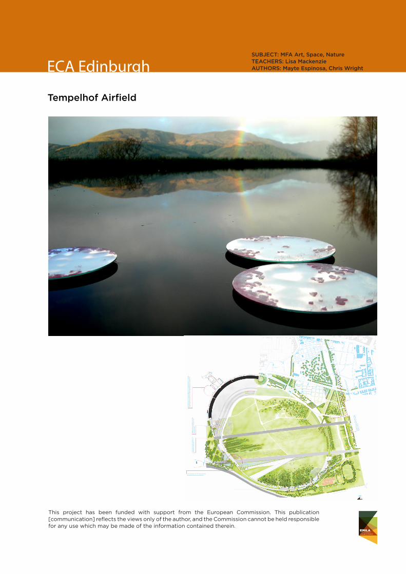
ECA EdinburghSUBJECT: MFA Art, Space, Nature TEACHERS: Lisa MackenzieAUTHORS: Mayte Espinosa, Chris Wright
Tempelhof Airfield
This project has been funded with support from the European Commission. This publication [communication] reflects the views only of the author, and the Commission cannot be held responsible for any use which may be made of the information contained therein.
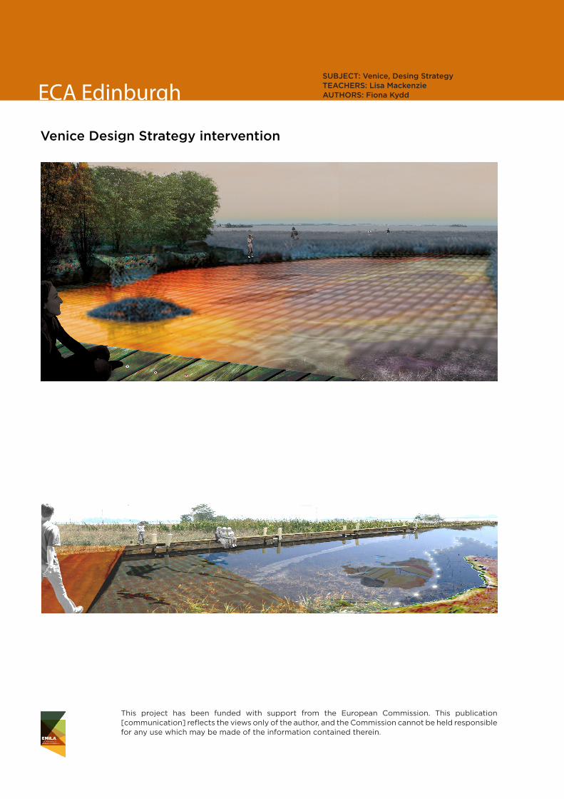
ECA EdinburghSUBJECT: Venice, Desing StrategyTEACHERS: Lisa MackenzieAUTHORS: Fiona Kydd
Venice Design Strategy intervention
This project has been funded with support from the European Commission. This publication [communication] reflects the views only of the author, and the Commission cannot be held responsible for any use which may be made of the information contained therein.
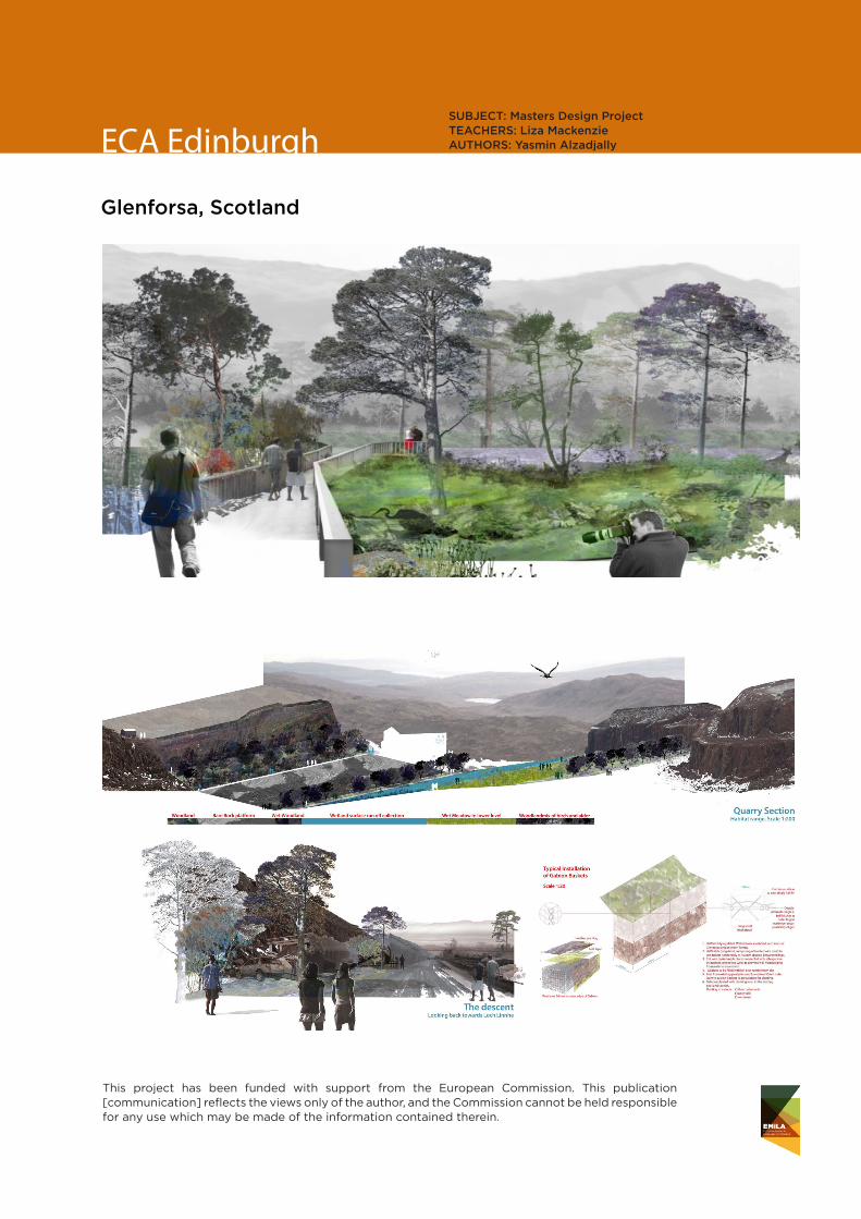
ECA EdinburghSUBJECT: Masters Design ProjectTEACHERS: Liza MackenzieAUTHORS: Yasmin Alzadjally
Glenforsa, Scotland

This project has been funded with support from the European Commission. This publication [communication] reflects the views only of the author, and the Commission cannot be held responsible for any use which may be made of the information contained therein.

This project has been funded with support from the European Commission. This publication [communication] reflects the views only of the author, and the Commission cannot be held responsible for any use which may be made of the information contained therein.
LUH Hannover
Lagoon Park Weser.Minden
The LAGOON PARK WESER creates a new landscape along the River Weser in Minden, Germany. For years, people have been afraid of the dangerous consequences of flooding along the Weser. Engineered flood barriers were built and all new districts were planned far from the river. Consequently, Minden is now disconnected from the Weser as an archipelago of separated districts or “islands”. The concept of “Lagoon Park Weser.Minden” understands the Weser as the linking surface between existing and future islands. The river is transformed from an archipelago into a lagoon. New “ecologically oriented islands”, and “leisure dedicated islands” are integrated in the city of Minden. Flood protection, nature conservation, and leisure activities interact with the dynamic river.
SUBJECT: 1st Semester Studio Project, M.Sc. Landschaftsarchitektur TEACHERS: Dipl.-Ing. Anna Schwinge, Dipl.-Ing. Susanne ZellerAUTHORS: Florian Depenbrock, Flavio Venturelli

This project has been funded with support from the European Commission. This publication [communication] reflects the views only of the author, and the Commission cannot be held responsible for any use which may be made of the information contained therein.
LUH Hannover
They are gargantuan and extremely deep, with a majestic white color, accented by a shimmering turquoise blue or a fluffy green. These quarries at Lägerdorf were created for chalk extraction to be used in cement production. The chalk layers are the result of millions of years of sedimentary process, but after only a few decades of mining the resource will be quickly exhausted. The extraction of natural resources is generally only a temporary land use. Once the extraction is done, what could be the next step within the transformation process of these impressive landscapes?This thesis explores various future development scenarios for the quarrying landscape. It aims at identifying possible combinations, synergies and multifunctional aspects. The productive Chalk-sea represents one possible future for this breathtaking chalk-pit landscape.
SUBJECT: Final thesis M.Sc. Landschaftsarchitektur TEACHERS: Martin Prominski, Verena Butt AUTHOR: Marcella Hartmann
Chalk Pit Land
This project has been funded with support from the European Commission. This publication [communication] reflects the views only of the author, and the Commission cannot be held responsible for any use which may be made of the information contained therein.
LUH Hannover
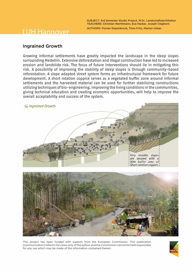
Ingrained Growth
Growing informal settlements have greatly impacted the landscape in the steep slopes surrounding Medellín. Extensive deforestation and illegal construction have led to increased erosion and landslide risk. The focus of future interventions should lie in mitigating this risk. A possibility of improving the stability of steep slopes is through community-based reforestation. A slope adapted street system forms an infrastructural framework for future development. A short rotation coppice serves as a vegetated buffer zone around informal settlements and the harvested material can be used for further stabilizing constructions utilizing techniques of bio-engineering. Improving the living conditions in the communities, giving technical education and creating economic opportunities, will help to improve the overall acceptability and success of the system.
SUBJECT: 3rd Semester Studio Project, M.Sc. Landschaftsarchitektur TEACHERS: Christian Werthmann, Eva Hacker, Joseph Claghorn
AUTHORS: Florian Depenbrock, Timo Fritz, Marten Urban

This project has been funded with support from the European Commission. This publication [communication] reflects the views only of the author, and the Commission cannot be held responsible for any use which may be made of the information contained therein.
This project has been funded with support from the European Commission. This publication [communication] reflects the views only of the author, and the Commission cannot be held responsible for any use which may be made of the information contained therein.
ENSP Versailles
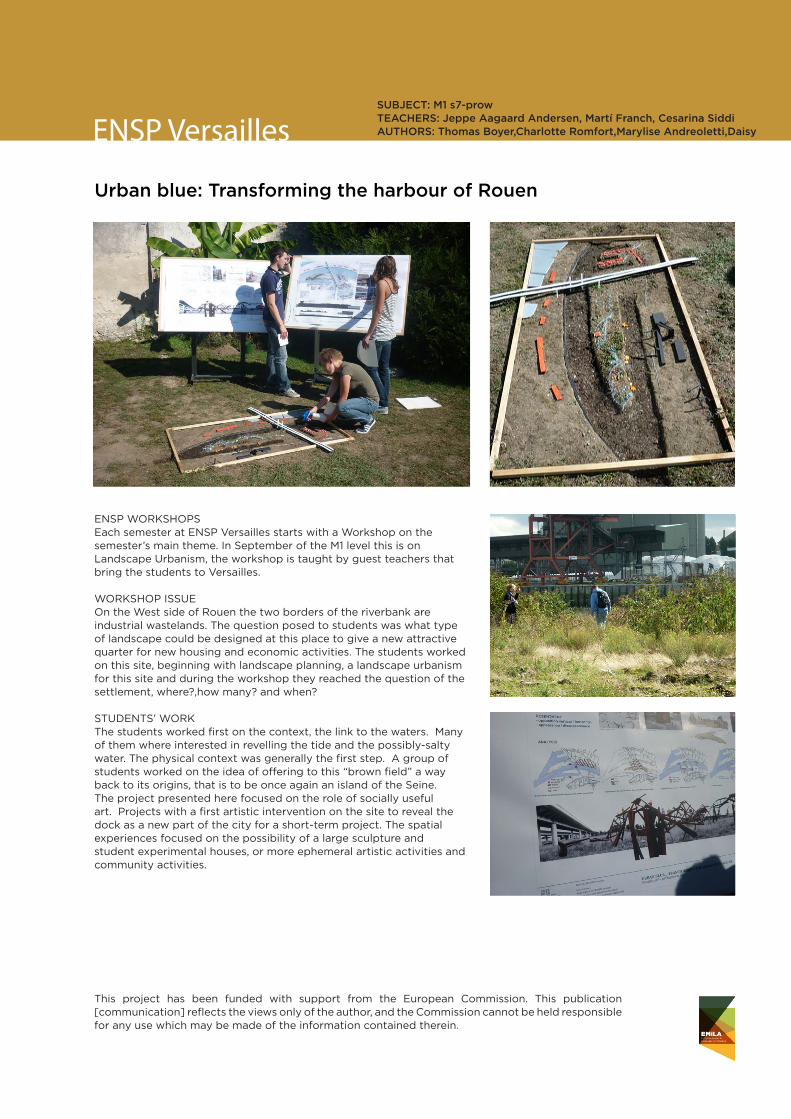
Urban blue: Transforming the harbour of Rouen
ENSP WORKSHOPS Each semester at ENSP Versailles starts with a Workshop on the semester’s main theme. In September of the M1 level this is on Landscape Urbanism, the workshop is taught by guest teachers that bring the students to Versailles.
WORKSHOP ISSUE On the West side of Rouen the two borders of the riverbank are industrial wastelands. The question posed to students was what type of landscape could be designed at this place to give a new attractive quarter for new housing and economic activities. The students worked on this site, beginning with landscape planning, a landscape urbanism for this site and during the workshop they reached the question of the settlement, where?,how many? and when?
STUDENTS’ WORK The students worked first on the context, the link to the waters. Many of them where interested in revelling the tide and the possibly-salty water. The physical context was generally the first step. A group of students worked on the idea of offering to this “brown field” a way back to its origins, that is to be once again an island of the Seine. The project presented here focused on the role of socially useful art. Projects with a first artistic intervention on the site to reveal the dock as a new part of the city for a short-term project. The spatial experiences focused on the possibility of a large sculpture and student experimental houses, or more ephemeral artistic activities and community activities.
SUBJECT: M1 s7-prow TEACHERS: Jeppe Aagaard Andersen, Martí Franch, Cesarina SiddiAUTHORS: Thomas Boyer,Charlotte Romfort,Marylise Andreoletti,Daisy

This project has been funded with support from the European Commission. This publication [communication] reflects the views only of the author, and the Commission cannot be held responsible for any use which may be made of the information contained therein.
ENSP VersaillesSUBJECT: CESP Diploma in Landscape UrbanismTEACHERS: Karin HelmsAUTHORS: Junmin C Paolillo
Rungis city expansion
STUDENTS’ WORK On a 30 ha rural land on the edge of the South of Rungish that is economically disadvantaged, with a plant nursery belonging to the Parisian city centre, and is underused due to more ecological ways of greening the city centre, the students choose to develop a new housing area to represent the future of this land. The project proposed by CHU was to remodel the geography and rediscover the hydrology bonds that have been disturbed by the contemporary constructions as the highway, the canalisation of rivers and urban expansions. The project underlines the topographical lines and curves as fundament of the future housing area, plus creates a scene to view the horizons in for of a large terrace. The terrace creates an edge between two housing zones a transition between two landscape entities.
Historical map 1774, South of Paris and todays spatial occupation of the site South of Rungis
ENSP STUDIO At Master 1 level, three main studios and a large regional analyses form the main topics of the year. The first Studio is on urban expansion through the notion of Landscape Urbanism. The Studio is held in English with invited guest academics. One of the studio sites (city of Rungis at the south edge of greater city of Paris) is used for diploma work of a guest student from China CHU.

This project has been funded with support from the European Commission. This publication [communication] reflects the views only of the author, and the Commission cannot be held responsible for any use which may be made of the information contained therein.
ENSP Versailles
Urban water
ENSP STUDIO At Master 2 level there are two main studios. The studio held by Prof. Gilles Vexlard covers a very large urban and suburban landscape. The main topic is to redefine geographical logics on a territory and organise landscape sequences for a better understanding of a site, as well as to anticipate future developments.
WORKSHOP ISSUE Within the framework of this workshop on urban creativity, the theme proposed in 2011 was “urban water”. Water plays a definite and materially unavoidable role in the design of urban and other landscapes The notion of “associated water” to be applicable at a territorial level, must be an integral part of the geographical situations and future sites of projects. The terrain is a research tool, a prerequisite to the development of landscaping approaches that annex “the space under the sky” embodied by forests, wetlands, cultivated lands, meadows, infrastructures, and constructions. Each student developed a topic for the future of this site and its concrete capacity to accept new inhabitants. The students worked out different thematics such as: -Water associated with the distance required between urban areas -Water associated with the development of forests -Water associated with the public space -Water associated with living things and agriculture -Water associated with the cleansing and regeneration of the landscape -Water associated with the cultural forms of the landscape, “the parks”
STUDENTS’ WORK -Water associated with the cultural forms of the landscape, “the parks”, “The metropolitan groves” A large scale Parisian grove that links the the city centre of Paris to the rural area through the suburban city. A project that anticipates climate change by proposing large green corridors for leisure, for ecological and water trails, plus a way to bring into to the city fresh air from the West coast.
SUBJECT: M2 s9-proTEACHERS: Gilles Vexlard Landscape architect, lecturer Luc Léotoing, Charles Dard AUTHORS: Benjamin Menegale,Johanes Montagne, Hélène Pépin,Guilain Roussel,Tanguy Auffret Paolillo
Credits
Technical coordination
Marina Cervera
Graphic design
Sergi Romero
Images and documentation
By EMiLA consortium partners


![[AIESEC] Projects in Panama Booklet](https://static.documents.pub/doc/80x56/568cadaa1a28ab186dac9f86/aiesec-projects-in-panama-booklet.jpg)


