20
BoRit Asbestos Superfund Site Remedial Overview of USACE Reservoir Report January 15, 2014 Jill Lowe, EPA Travis Fatzinger, USACE

BoRit Asbestos Superfund SiteRemedial Overview of USACE Reservoir Report
January 15, 2014
Jill Lowe, EPA Travis Fatzinger, USACE
BoRit Asbestos Superfund SiteOverview
USACE Report on BoRit ReservoirReservoir HydrologyBerm StabilityOptions Reviewed
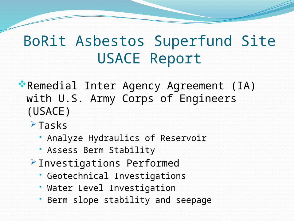
BoRit Asbestos Superfund SiteUSACE Report
Remedial Inter Agency Agreement (IA) with U.S. Army Corps of Engineers (USACE)Tasks
Analyze Hydraulics of Reservoir Assess Berm Stability
Investigations Performed Geotechnical Investigations Water Level Investigation Berm slope stability and seepage
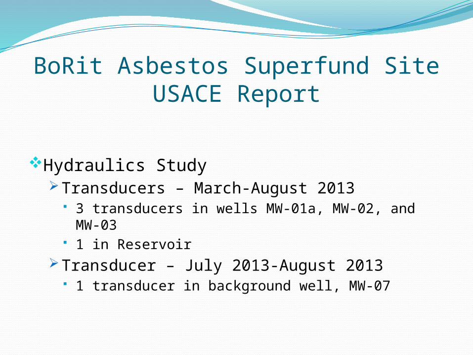
BoRit Asbestos Superfund SiteUSACE Report
Hydraulics StudyTransducers – March-August 2013
3 transducers in wells MW-01a, MW-02, and MW-03 1 in Reservoir
Transducer – July 2013-August 2013 1 transducer in background well, MW-07
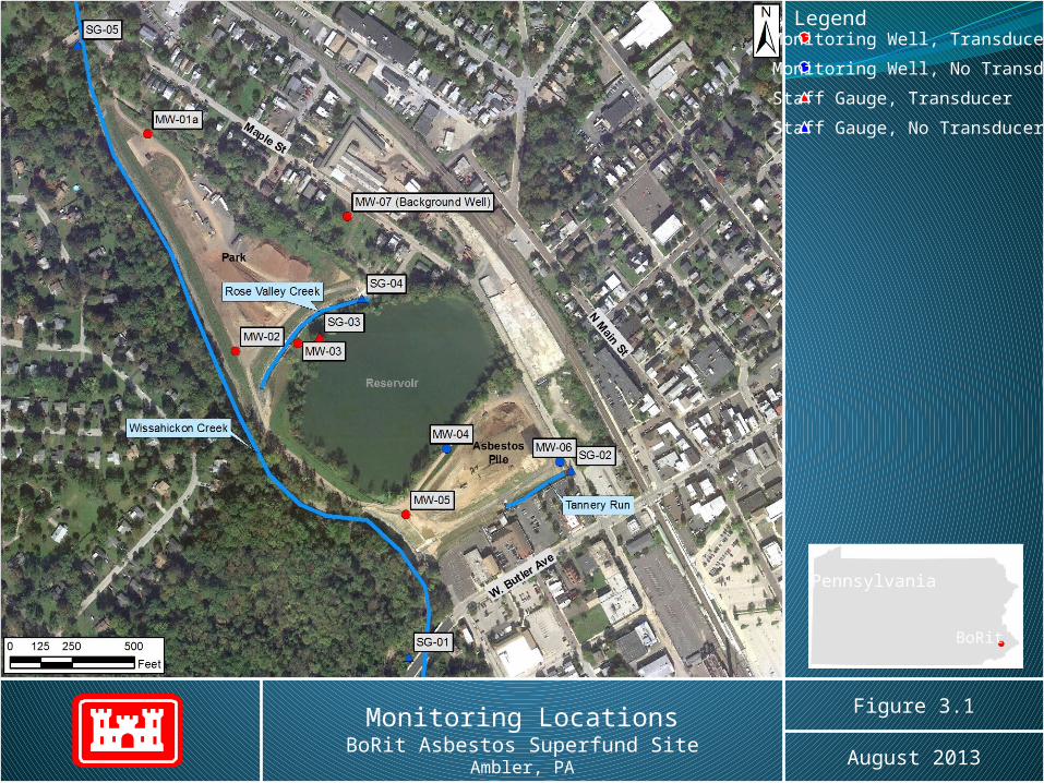
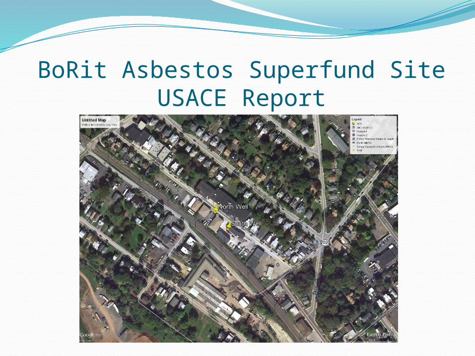
Monitoring LocationsBoRit Asbestos Superfund Site
Ambler, PA
Figure 3.1
August 2013
LegendMonitoring Well, TransducerMonitoring Well, No TransducerStaff Gauge, TransducerStaff Gauge, No Transducer
Pennsylvania
BoRit

BoRit Asbestos Superfund SiteUSACE Report
Hydraulics Study ConclusionsReservoir
No direct correlation between groundwater and Reservoir
Water levels correlate to rainfall and evaporation Known seep is not significant
Groundwater Significant drawdown Monday through Friday
o Identified 2-Non-potable production wells
BoRit Asbestos Superfund SiteUSACE Report

Geophysical Investigation
Multi-channel analysis of surface waves (MASW)Characterize Soil
Self-potential (SP)Water flow
EM61 Metal DetectorGround Penetrating Radar (GPR)Probable pipe locations targeted based upon
drawings from Whitpain Township and removal workKnown pipes likely filled in with sedimentation
8
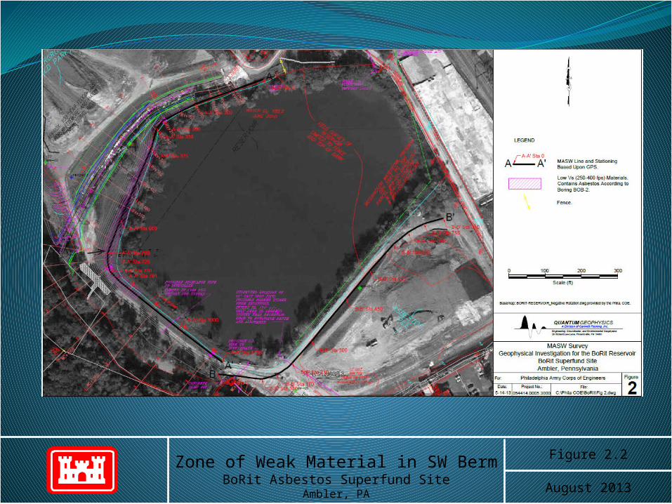
Zone of Weak Material in SW BermBoRit Asbestos Superfund Site
Ambler, PA
Figure 2.2
August 2013

Geotechnical Investigation
Boring locations based on survey cross-sections, geophysical results, and seepage locations
Three BoringsContinuous Split Spoon SamplingAdvanced until bedrock refusal
Lab testing on SamplesIncluded sieve analyses, triaxial consolidated-
undrained, unconfined compression
10
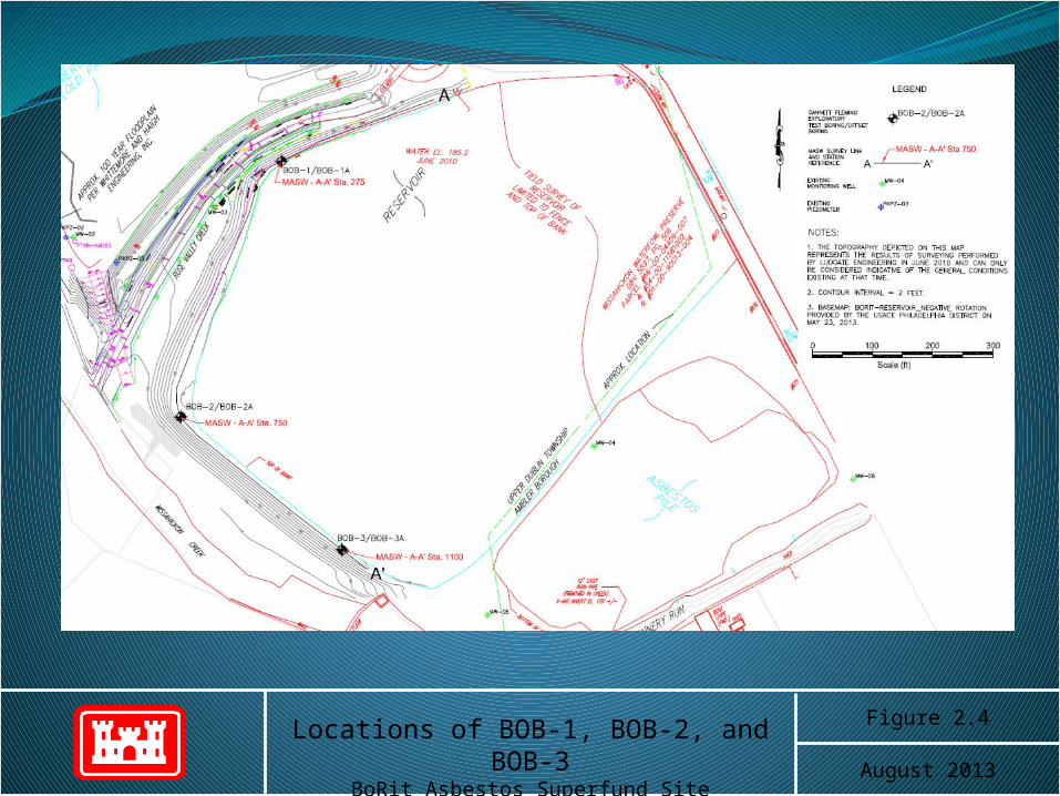
Locations of BOB-1, BOB-2, and BOB-3BoRit Asbestos Superfund Site
Ambler, PA
Figure 2.4
August 2013

Slope Stability Model
GeoStudio 2012Seep /WSlope /W
Survey ProfilesSoil ProfilesLab Results
12
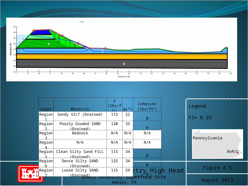
BOB-2 Current Geometry High HeadBoRit Asbestos Superfund Site
Ambler, PA
Figure 4.5
August 2013
Legend
FS= 0.93
Pennsylvania
BoRit
Layer Material γ (lbs/ft3) φ(°) Cohesion (lbs/ft2)Region 1 Sandy SILT (Drained) 115 22 0Region 2 Poorly Graded SAND (Drained) 120 33 0Region 3 Bedrock N/A N/A N/ARegion 4 N/A N/A N/A N/ARegion 5 Clean Silty Sand FILL (Drained) 115 34 0Region 6 Dense Silty SAND (Drained) 125 34 0Region 7 Loose Silty SAND (Drained) 115 29 0

Current ConditionSlope Stability Results
Current Geometry
Boring Factor of Safety1
Normal Water Level
Factor of SafetyHigh Head
Level
BOB-1 3.28 2.70
BOB-2 1.12 0.93
BOB-3 1.46 1.261 Factor of Safety = material strength/design load. USACE target is 1.4
14
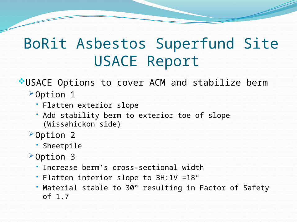
BoRit Asbestos Superfund SiteUSACE Report
USACE Options to cover ACM and stabilize bermOption 1
Flatten exterior slope Add stability berm to exterior toe of slope (Wissahickon
side)Option 2
SheetpileOption 3
Increase berm’s cross-sectional width Flatten interior slope to 3H:1V =18° Material stable to 30° resulting in Factor of Safety of 1.7
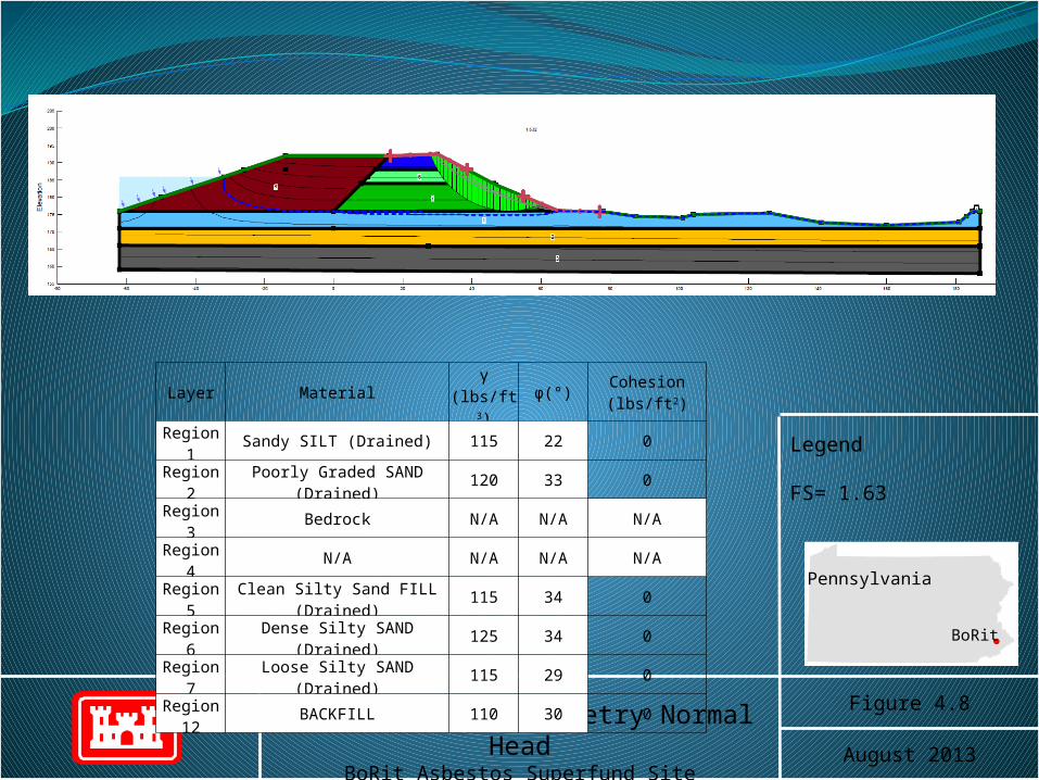
BOB-2 Proposed Geometry Normal HeadBoRit Asbestos Superfund Site
Ambler, PA
Figure 4.8
August 2013
Legend
FS= 1.63
Pennsylvania
BoRit
Layer Material γ (lbs/ft3) φ(°) Cohesion (lbs/ft2)Region 1 Sandy SILT (Drained) 115 22 0Region 2 Poorly Graded SAND (Drained) 120 33 0Region 3 Bedrock N/A N/A N/ARegion 4 N/A N/A N/A N/ARegion 5 Clean Silty Sand FILL (Drained) 115 34 0Region 6 Dense Silty SAND (Drained) 125 34 0Region 7 Loose Silty SAND (Drained) 115 29 0
Region 12 BACKFILL 110 30 0
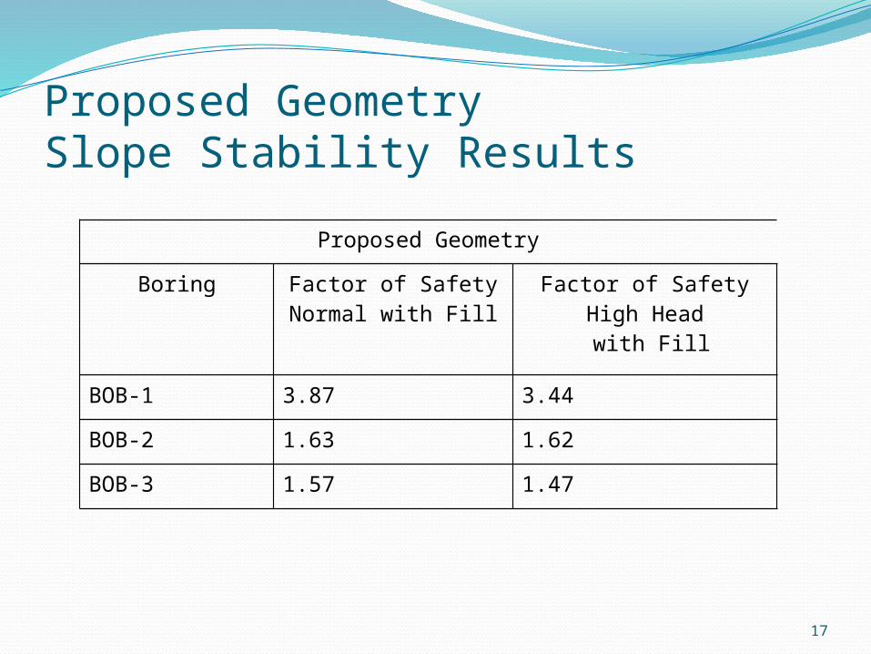
Proposed GeometrySlope Stability Results
17
Proposed Geometry
Boring Factor of SafetyNormal with Fill
Factor of SafetyHigh Head with Fill
BOB-1 3.87 3.44
BOB-2 1.63 1.62
BOB-3 1.57 1.47

Option 3 with GCLSupplement clay fill with Geosynthetic Clay Liner (GCL)GCL consists of bentonite between layers
of Geotextile“Self Healing” PropertiesBenefits
Reduced berm widthHomogenous, uniform installationLess fill and haul trucks required
Sand and Clay fill geotechnical properties testing complete
GCL FS for Bob-2 Normal head conditions 1.50, High head 1.41

GCL/ Backfill placementBackfill material Sandy Lean ClayClay material placed on inside slope
compacted in lifts to 90% standard ProctorGCL placed on top- then covered by 2-3 ft
additional compacted clayExisting berm will be dry and compacted
from additional weight
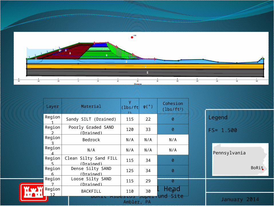
BOB-2 GCL Normal HeadBoRit Asbestos Superfund Site
Ambler, PA January 2014
Legend
FS= 1.500
Pennsylvania
BoRit
Layer Material γ (lbs/ft3) φ(°) Cohesion (lbs/ft2)Region 1 Sandy SILT (Drained) 115 22 0Region 2 Poorly Graded SAND (Drained) 120 33 0Region 3 Bedrock N/A N/A N/ARegion 4 N/A N/A N/A N/ARegion 5 Clean Silty Sand FILL (Drained) 115 34 0Region 6 Dense Silty SAND (Drained) 125 34 0Region 7 Loose Silty SAND (Drained) 115 29 0
Region 12 BACKFILL 110 30 0


