BRY PLACER GROUP Assessment Report 2012 Gravel,silt sampling and panning on Claims: 523068, 522278, 589718 Located on map sheet 093A 062 5~2°57'3/A/ / 31° Hi' 9¥" )Aj Cariboo D/viS''on Owner-operator Egil Livgard Writer: Egil Livgard September 7 th 2012 GEOLOGICAL SURVEY BRANCH ASSESSMENT REPORT
Transcript
BRY PLACER GROUP
Assessment Report 2012
Gravel,silt sampling and panning on
Claims: 523068, 522278, 589718
Located on map sheet 093A 062 5 ~ 2 ° 5 7 ' 3 / A / / 3 1 ° Hi' 9 ¥ " )Aj
Cariboo D/viS''on
Owner-operator Egil Livgard
Writer: Egil Livgard September 7 t h 2012 GEOLOGICAL SURVEY BRANCH
ASSESSMENT REPORT
ldegroot
Text Box
BC Geological Survey Assessment Report 33265
INDEX
Summary page 3
Recommendations
Introduction 4
Property
Location and access
History 5
Geology
Property testing 6
Cost of work 7
Maps:
Location map 8
Claim map 9
Sample locations 3 10,11,12
Historic soil survey 13
Historic geology 14
Likley area 15
References 16
Appendix 2 sheets
Summary 3
The property consists of three placer claims that total 117.68 Hectars
That covers about 1.4 Kilometers of the south bank of Quesnel River
starting about 3 kilometers below Quesnel Forks and extends west
about 1.4 kilometers. The Quesnel River is staked for placer
continuously for 90 kilometers below the claims all the way to Quesnel
City. Access to the claims is either by boat from the Forks or by dirt
road from Morehead road and east along the river to the west border
of the claims. The ground immediately above the river bank has been
staked for hardrock and explored for copper gold. A broad intrusive
carries gold values as does some of the adjoining rocks. A coincident
chargability and magnetic geophysical anomaly has been outlined.
These rocks have been continuously eroding into the river and have left
some of their gold on the river bank. Six gravel and silt sample were
collected and three of these consisting of a large pan full weighing 5kg
were panned down to about 200g. 'colours' were noted in two pans -
one was almost one mm long. The samples were submitted to G&L
Lab. In Kamloops for analysis. The results were very good.
Recommendations
The road should be fixed to and extended onto the property. Two creek
wash outs require culverts. A proper testing using a small sluice box and
hand work is recommended.
Estimated cost: Road work $4000
Sluice testing $3000
Introduction 4
An examination of part of the claim ground and some gravel and silt sampling and panning was carried out on the 26 t h of May and parts of June 1 s t 2012.
This assessment report describes that work.
Property
The property consists of three claims: # 523068 that covers 58.84 hectars, # 522278 that covers 19.61 hectars and # 589718 that covers 39.23 hectares. The total size of the property thus covers 117.68 hectars. The property starts about 300 meters downstream from the Quesnel Forks (the junction of the Cariboo and the Quesnel Rivers) and takes in 1.7 kilometers downstream of the south shore of the Quesnel River. The writer is the owner of the property
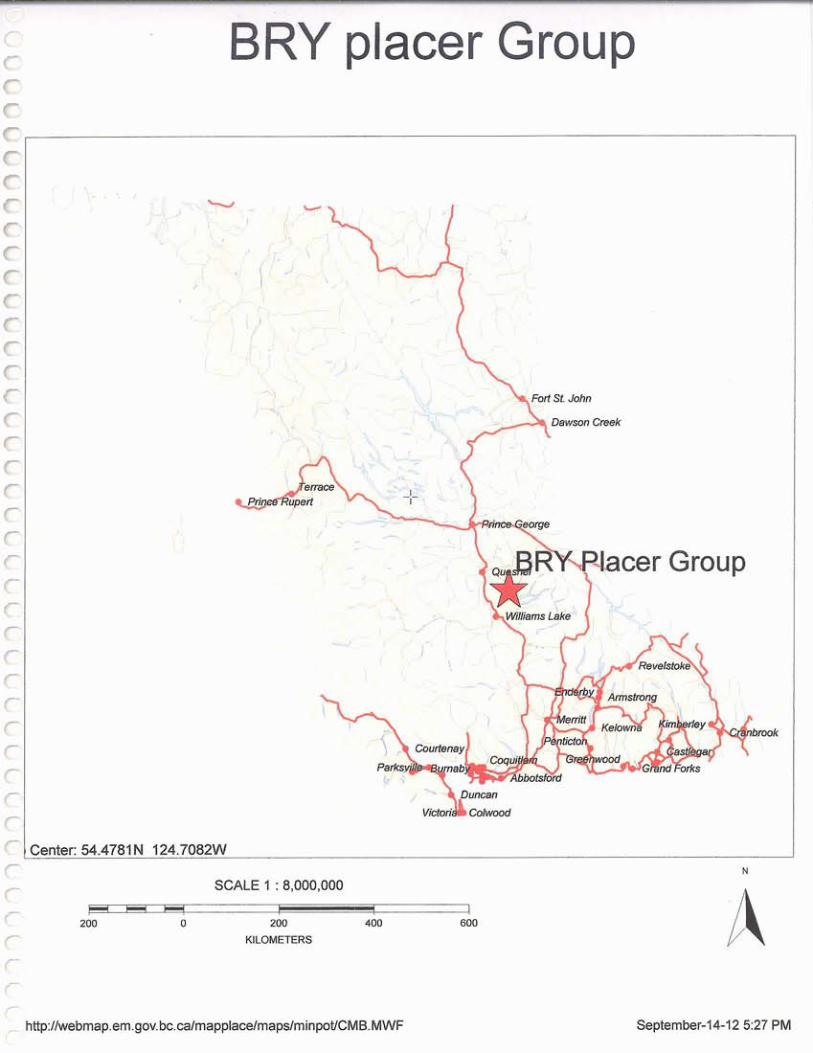
Location and access
The property is found on map sheet # 093A 062 about 0.5 to 2.0 Kilometers west of Quesnel Forks which is about 10 kilometers NW of Likley B.C
The property can best be accessed by driving down Morehead creek road to the Quesnel River and there turn on a road along the river to the east. This old road extends to the western boundary of the claims. The road is washed out in three places. To get drivable road access two small creek wash outs need fixing and one large slide into the river has to be bypassed by about 200 meters of new road.
History 5
Gold was discovered in the Barkerville-Wells area inl858. Historic production totaled 3.7 million troy ounces of gold of which 1.9 million ounces came from placer mining and 1.8 million ounces from 2.7 million short tons of underground ore. The Bullion pit near Likley produced 175,700 ounces of gold from 200 million tons of gravel. Numerous other smaller placer operations have operated around in the area and some are still active. The Quesnel Forks area is one of the better known. Gold has been carried down by both the Quesnel and the Cariboo rivers and onto and downstream from the Bry property placer claims. Placer claims cover the river banks continuously for over 90 kilometers all the way to the city of Quesnel. Minor placer testing was carried out on the property in 2008. No other placer activity is documented on the property. Partly the same area is covered by hardrock claims and some exploration activity has continued intermittently for several decades. A soil survey (2005) along the foot of the cliffs gave values in gold up to as much as 34 grams per tonne.
Geology
The property is located in a structural and depositional feature known as the Quesnel Trough. The feature is a 30 kilometers wide, northwesterly trending volcanic-sedimentary belt. This belt has been intruded by numerous alkaline stocks which frequently carry anomalous values in copper and gold. Two mines have been established on or at such intrusions - each is associated with a number of mineral deposits. The QR mine, which is no longer active, lies about six kilometers west of the property on the north side of the river. The mineral deposits at this mine, containing mainly gold, are found in volcanics altered by intrusive bodies. The Polly Mine is located about 10 kilometers south of the property. The mineral deposits at this mine, containing copper/gold, are found in intrusives and in the intruded rocks.
The geology at and in the immediate vicinity of the property has many features similar to that at the above mines although no mineable deposits have yet been located. The intrusive is about 500m wide. It carries anomalous values in
6
copper/gold and has intruded similar volcanics and in part calcareous sediments. The intruded rocks also in places show anomalous gold values. These rock types are being eroded by the river and the gold they carry is in part being deposited in the gravel of the river.
Property testing
Test work in 2008 using a sluice box found 'colours' in the gravel. In the writers opinion the test location was not the best, being upstream from any locally derived gold. Accessing the placer ground from the higher ground above is difficult due to the very steep slope and partly dense growth. Previous test work reached the placers by boat from the Forks. Relatively moderate roadwork, connecting to the Morehead Creek road 6-7 kilometer downstream to the west, will give easier access. The work this year consisted of silt sampling and panning of silt and gravel. Two pans had visible gold - one flake was close to one mm long. The samples were shipped to G&T Metallurgical services in Kamloops for analysis. Each pan sample was a full pan weighing 5 Kg. It was panned down to about 200g. The grades of each sample were thus 1/25 of reported grade.
Pan 1. 12.8/25 0.512g/T gold in the gravel
Pan 2. 21.7/25 0.868g/T gold in the gravel
Pan 3. 016/25 .0064g/T gold in the gravel
The silt samples (not panned) gave IB. 0.3, 2B. 0.03, 28-1.0.05 g/tonne
It was noted that the ground just south of the property had good room for a settling dam in low ground away from the river up against the steep bank.
Cost of work
Travel two days: Terrace to Likley- 825 kilometers and return
Vehicle and gas : 825 x $0.45/Km -$371.25 return $742.50
Wages $400 x2 $800.00
Accommodations $100.79+85.11 $185.90
Meals $90.00 x2 $ 180.00
$1908.40
Morehead Lake cabins $110.00 x6 $660 + tax $739.20
B.C.G. Bull 97 Geology and Mineral Deposits of the Quesnel River -
Horsefly area.
- Mapplace
- Minfile 093A 041 Bullion Lode
Dome Exploration (Canada) Ltd. Feb. 1986
ARS 3048 by Bryan Livgard Jan.8 2009 Placer Assessment Report
27961 By Egil Livgard Nov 13 t h 2005 Dome claims Geology
The writer is a retired professional Engineer with 45 years
experience x x X ^ ^ x "
201 Cariboo - More Likley
008 Mt. Polly Mine
121 QR Mine
Egil Livgard Terrace BC
Sept. 7 t h 2012
APPENDIX
Analysis - 1 sheet
G & T METALLURGICAL m e t a l l u r q L | SERVICES
Certificate of Analysis
Client - KM3486
Date: June 22, 2012
Sample Elements
Sample A u
Pan 1 Pan IB Pan 2 Pan 2B Pan 3 Pan 28-1
12.8 0.30 21.7 0.03 0.16 0.05
B C Certified Assayer
A D D R E S S 2957 Bowers Place, Kamloops, BC V1S1W5 i P H O N E + 1 250 828 61 57 ! i A X + 1 250 828 6159 A L S C A N A D A i T D Part of the ALS Group A Campbell Brothers Limited Company
ALS Canada Ltd. (BN 100938885)
www.alsglobal.com ISO 9001:2008 Certificate No fS631TO