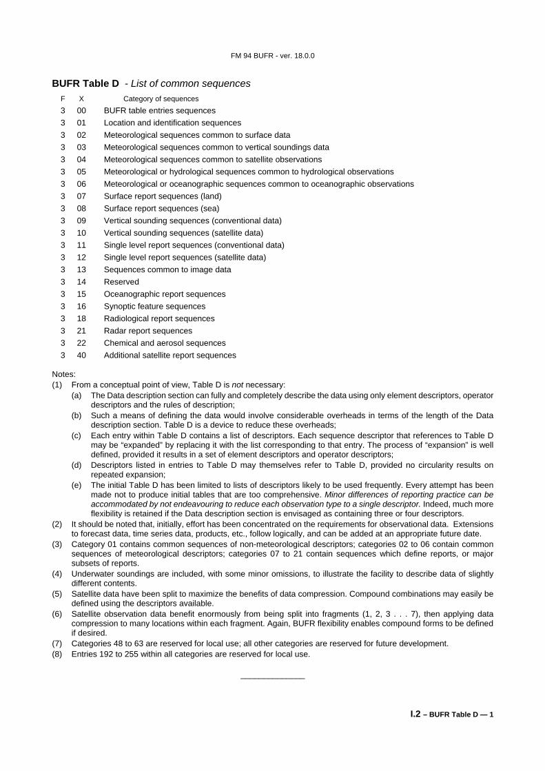
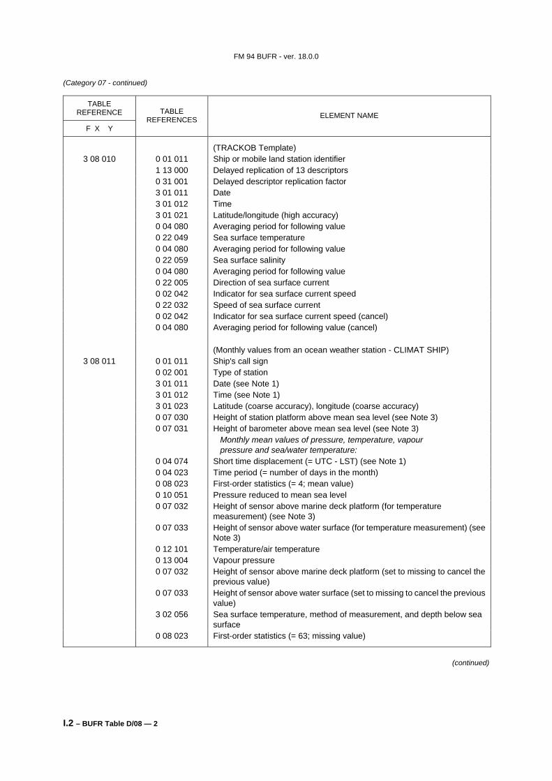
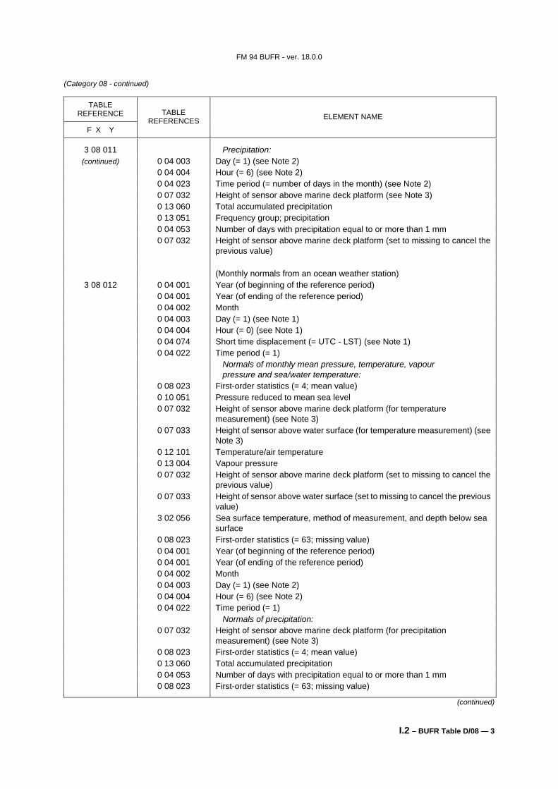
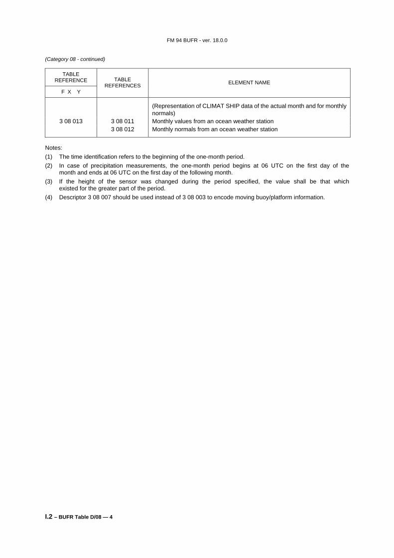
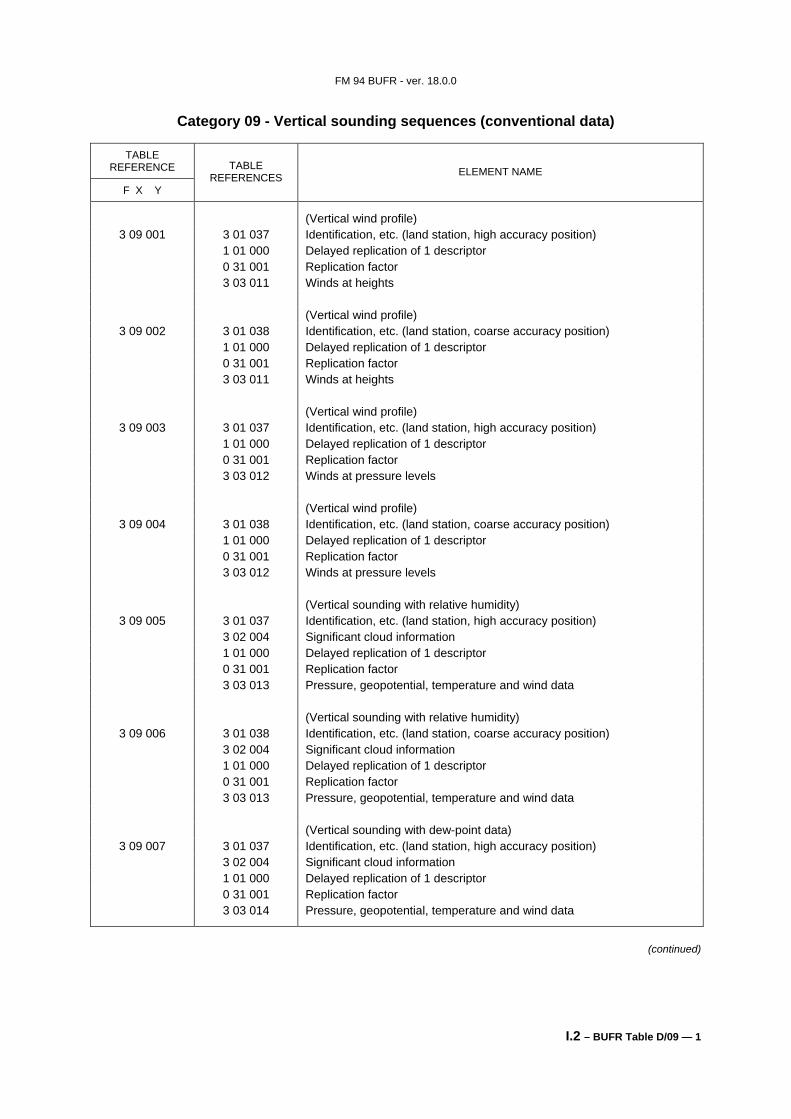
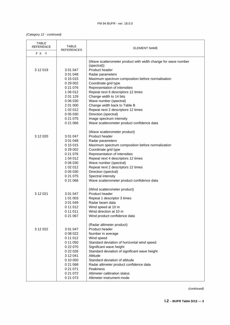
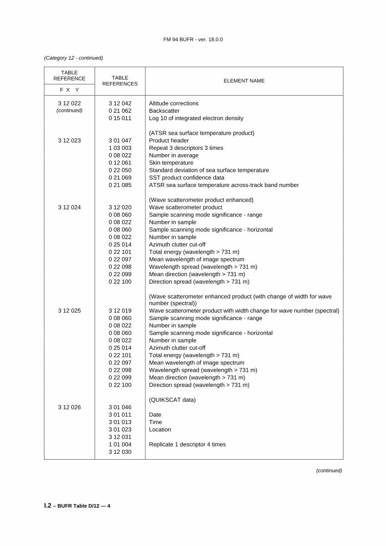
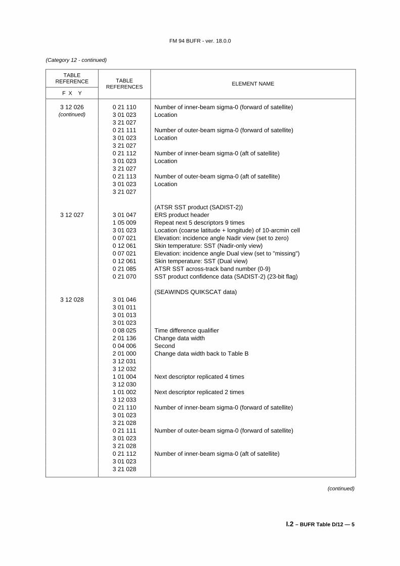
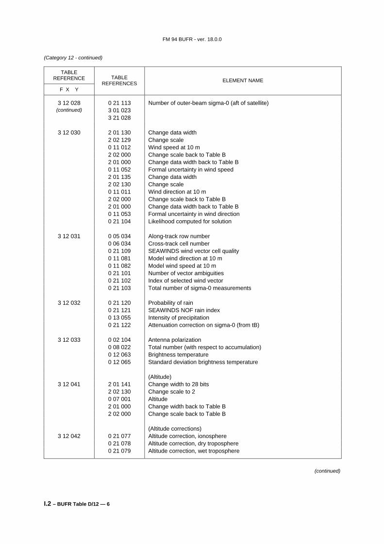
FM 94 BUFR - ver. 18.0.0 I.2 – BUFR Table D — 1 BUFR Table D - List of common sequences F X Category of sequences 3 00 BUFR table entries sequences 3 01 Location and identification sequences 3 02 Meteorological sequences common to surface data 3 03 Meteorological sequences common to vertical soundings data 3 04 Meteorological sequences common to satellite observations 3 05 Meteorological or hydrological sequences common to hydrological observations 3 06 Meteorological or oceanographic sequences common to oceanographic observations 3 07 Surface report sequences (land) 3 08 Surface report sequences (sea) 3 09 Vertical sounding sequences (conventional data) 3 10 Vertical sounding sequences (satellite data) 3 11 Single level report sequences (conventional data) 3 12 Single level report sequences (satellite data) 3 13 Sequences common to image data 3 14 Reserved 3 15 Oceanographic report sequences 3 16 Synoptic feature sequences 3 18 Radiological report sequences 3 21 Radar report sequences 3 22 Chemical and aerosol sequences 3 40 Additional satellite report sequences Notes: (1) From a conceptual point of view, Table D is not necessary: (a) The Data description section can fully and completely describe the data using only element descriptors, operator descriptors and the rules of description; (b) Such a means of defining the data would involve considerable overheads in terms of the length of the Data description section. Table D is a device to reduce these overheads; (c) Each entry within Table D contains a list of descriptors. Each sequence descriptor that references to Table D may be “expanded” by replacing it with the list corresponding to that entry. The process of “expansion” is well defined, provided it results in a set of element descriptors and operator descriptors; (d) Descriptors listed in entries to Table D may themselves refer to Table D, provided no circularity results on repeated expansion; (e) The initial Table D has been limited to lists of descriptors likely to be used frequently. Every attempt has been made not to produce initial tables that are too comprehensive. Minor differences of reporting practice can be accommodated by not endeavouring to reduce each observation type to a single descriptor. Indeed, much more flexibility is retained if the Data description section is envisaged as containing three or four descriptors. (2) It should be noted that, initially, effort has been concentrated on the requirements for observational data. Extensions to forecast data, time series data, products, etc., follow logically, and can be added at an appropriate future date. (3) Category 01 contains common sequences of non-meteorological descriptors; categories 02 to 06 contain common sequences of meteorological descriptors; categories 07 to 21 contain sequences which define reports, or major subsets of reports. (4) Underwater soundings are included, with some minor omissions, to illustrate the facility to describe data of slightly different contents. (5) Satellite data have been split to maximize the benefits of data compression. Compound combinations may easily be defined using the descriptors available. (6) Satellite observation data benefit enormously from being split into fragments (1, 2, 3 . . . 7), then applying data compression to many locations within each fragment. Again, BUFR flexibility enables compound forms to be defined if desired. (7) Categories 48 to 63 are reserved for local use; all other categories are reserved for future development. (8) Entries 192 to 255 within all categories are reserved for local use. ______________
Transcript
FM 94 BUFR - ver. 18.0.0
I.2 – BUFR Table D — 1
BUFR Table D - List of common sequences F X Category of sequences 3 00 BUFR table entries sequences 3 01 Location and identification sequences 3 02 Meteorological sequences common to surface data 3 03 Meteorological sequences common to vertical soundings data 3 04 Meteorological sequences common to satellite observations 3 05 Meteorological or hydrological sequences common to hydrological observations 3 06 Meteorological or oceanographic sequences common to oceanographic observations 3 07 Surface report sequences (land) 3 08 Surface report sequences (sea) 3 09 Vertical sounding sequences (conventional data) 3 10 Vertical sounding sequences (satellite data) 3 11 Single level report sequences (conventional data) 3 12 Single level report sequences (satellite data) 3 13 Sequences common to image data 3 14 Reserved 3 15 Oceanographic report sequences 3 16 Synoptic feature sequences 3 18 Radiological report sequences 3 21 Radar report sequences 3 22 Chemical and aerosol sequences 3 40 Additional satellite report sequences Notes: (1) From a conceptual point of view, Table D is not necessary:
(a) The Data description section can fully and completely describe the data using only element descriptors, operator descriptors and the rules of description;
(b) Such a means of defining the data would involve considerable overheads in terms of the length of the Data description section. Table D is a device to reduce these overheads;
(c) Each entry within Table D contains a list of descriptors. Each sequence descriptor that references to Table D may be “expanded” by replacing it with the list corresponding to that entry. The process of “expansion” is well defined, provided it results in a set of element descriptors and operator descriptors;
(d) Descriptors listed in entries to Table D may themselves refer to Table D, provided no circularity results on repeated expansion;
(e) The initial Table D has been limited to lists of descriptors likely to be used frequently. Every attempt has been made not to produce initial tables that are too comprehensive. Minor differences of reporting practice can be accommodated by not endeavouring to reduce each observation type to a single descriptor. Indeed, much more flexibility is retained if the Data description section is envisaged as containing three or four descriptors.
(2) It should be noted that, initially, effort has been concentrated on the requirements for observational data. Extensions to forecast data, time series data, products, etc., follow logically, and can be added at an appropriate future date.
(3) Category 01 contains common sequences of non-meteorological descriptors; categories 02 to 06 contain common sequences of meteorological descriptors; categories 07 to 21 contain sequences which define reports, or major subsets of reports.
(4) Underwater soundings are included, with some minor omissions, to illustrate the facility to describe data of slightly different contents.
(5) Satellite data have been split to maximize the benefits of data compression. Compound combinations may easily be defined using the descriptors available.
(6) Satellite observation data benefit enormously from being split into fragments (1, 2, 3 . . . 7), then applying data compression to many locations within each fragment. Again, BUFR flexibility enables compound forms to be defined if desired.
(7) Categories 48 to 63 are reserved for local use; all other categories are reserved for future development. (8) Entries 192 to 255 within all categories are reserved for local use.
______________
FM 94 BUFR - ver. 18.0.0
I.2 – BUFR Table D/00 — 1
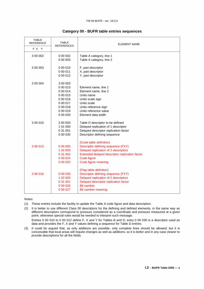
Category 00 - BUFR table entries sequences
TABLE REFERENCE
F X Y
TABLE REFERENCES ELEMENT NAME
3 00 002 0 00 002 Table A category, line 1 0 00 003 Table A category, line 2
3 00 003 0 00 010 F, part descriptor 0 00 011 X, part descriptor 0 00 012 Y, part descriptor
3 00 004 3 00 003 0 00 013 Element name, line 1 0 00 014 Element name, line 2 0 00 015 Units name 0 00 016 Units scale sign 0 00 017 Units scale 0 00 018 Units reference sign 0 00 019 Units reference value 0 00 020 Element data width
3 00 010 3 00 003 Table D descriptor to be defined 1 01 000 Delayed replication of 1 descriptor 0 31 001 Delayed descriptor replication factor 0 00 030 Descriptor defining sequence (Code table definition)
3 00 016 0 00 030 Descriptor defining sequence (FXY) 1 02 000 Delayed replication of 2 descriptors 0 31 001 Delayed descriptor replication factor 0 00 026 Bit number 0 00 027 Bit number meaning
Notes: (1) These entries include the facility to update the Table A code figure and data description. (2) It is better to use different Class 00 descriptors for the defining and defined elements, in the same way as
different descriptors correspond to pressure considered as a coordinate and pressure measured at a given point; otherwise special rules would be needed to interpret such message.
Entries 0 00 010 to 0 00 012 define F, X and Y for Tables B and D; entry 0 00 030 is a descriptor used as data and provides the F, X and Y values defining a sequence for Table D entries.
(3) It could be argued that, as only additions are possible, only complete lines should be allowed; but it is conceivable that local areas will require changes as well as additions, so it is better and in any case clearer to provide descriptions for all the fields.
FM 94 BUFR - ver. 18.0.0
I.2 – BUFR Table D/01 — 1
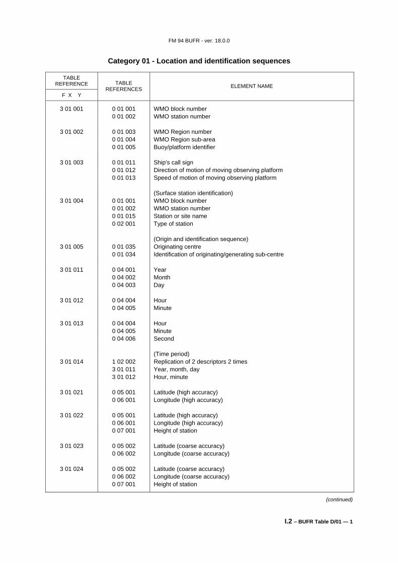
Category 01 - Location and identification sequences
TABLE REFERENCE
F X Y
TABLE REFERENCES ELEMENT NAME
3 01 001 0 01 001 WMO block number 0 01 002 WMO station number
3 01 002 0 01 003 WMO Region number 0 01 004 WMO Region sub-area 0 01 005 Buoy/platform identifier
3 01 003 0 01 011 Ship's call sign 0 01 012 Direction of motion of moving observing platform 0 01 013 Speed of motion of moving observing platform (Surface station identification)
3 01 004 0 01 001 WMO block number 0 01 002 WMO station number 0 01 015 Station or site name 0 02 001 Type of station (Origin and identification sequence)
3 01 005 0 01 035 Originating centre 0 01 034 Identification of originating/generating sub-centre
3 01 011 0 04 001 Year 0 04 002 Month 0 04 003 Day
0 33 042 Type of limit represented by following (flight level) value 0 07 010 Flight level 1 01 000 Delayed replication of 1 descriptor 0 31 002 Extended replication factor (see Note 6) 3 01 023 Location 0 19 007 Radius of feature (see Note 7) 0 08 040 Flight level significance, Missing = Cancel
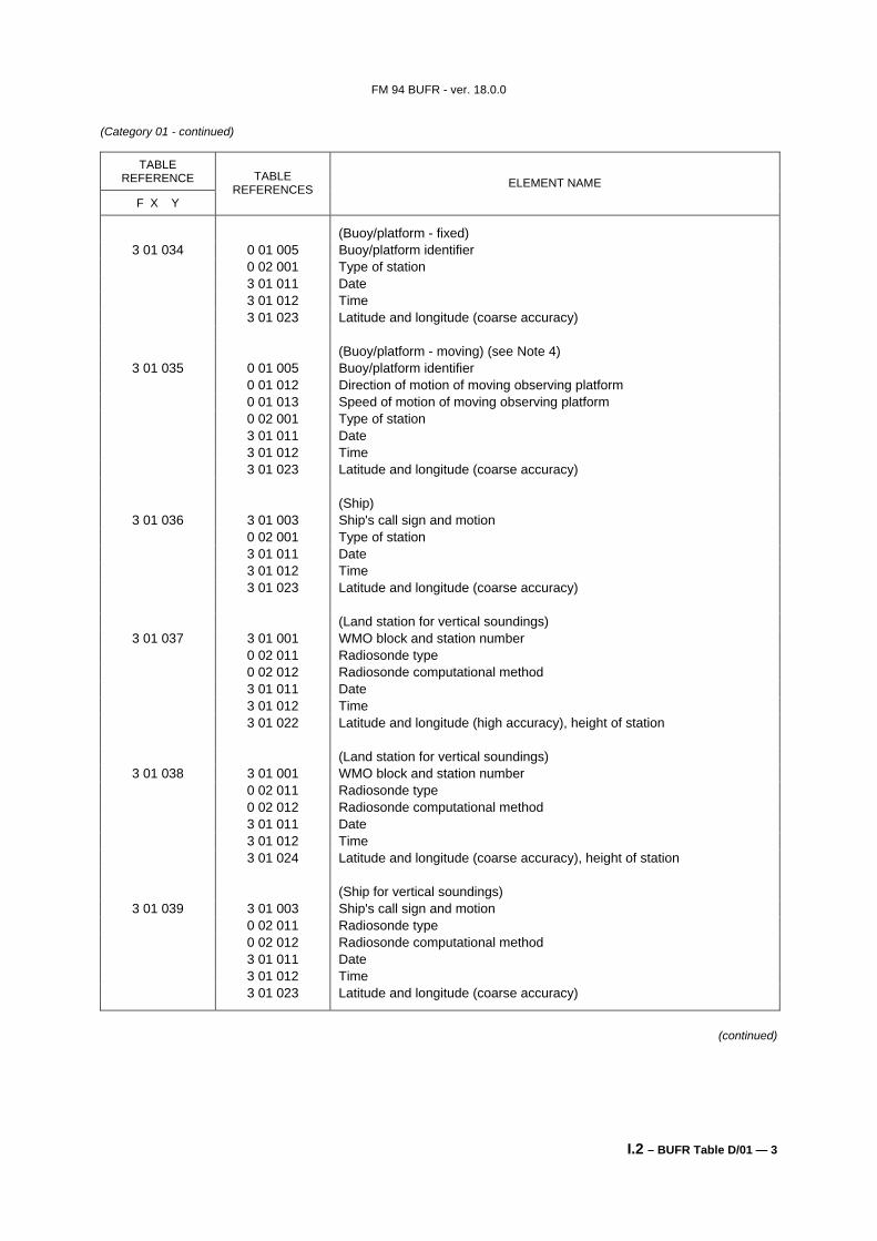
3 01 031 3 01 001 WMO block and station number 0 02 001 Type of station 3 01 011 Date 3 01 012 Time 3 01 022 Latitude and longitude (high accuracy), height of station
3 01 032 3 01 001 WMO block and station number 0 02 001 Type of station 3 01 011 Date 3 01 012 Time 3 01 024 Latitude and longitude (coarse accuracy), height of station (Buoy/platform - fixed)
3 01 033 0 01 005 Buoy/platform identifier 0 02 001 Type of station 3 01 011 Date 3 01 012 Time 3 01 021 Latitude and longitude (high accuracy)
0 02 001 Type of station 3 01 011 Date 3 01 012 Time 3 01 023 Latitude and longitude (coarse accuracy) (Buoy/platform - moving) (see Note 4)
3 01 035 0 01 005 Buoy/platform identifier 0 01 012 Direction of motion of moving observing platform 0 01 013 Speed of motion of moving observing platform 0 02 001 Type of station 3 01 011 Date 3 01 012 Time 3 01 023 Latitude and longitude (coarse accuracy) (Ship)
3 01 036 3 01 003 Ship's call sign and motion 0 02 001 Type of station 3 01 011 Date 3 01 012 Time 3 01 023 Latitude and longitude (coarse accuracy) (Land station for vertical soundings)
3 01 037 3 01 001 WMO block and station number 0 02 011 Radiosonde type 0 02 012 Radiosonde computational method 3 01 011 Date 3 01 012 Time 3 01 022 Latitude and longitude (high accuracy), height of station (Land station for vertical soundings)
3 01 038 3 01 001 WMO block and station number 0 02 011 Radiosonde type 0 02 012 Radiosonde computational method 3 01 011 Date 3 01 012 Time 3 01 024 Latitude and longitude (coarse accuracy), height of station (Ship for vertical soundings)
3 01 039 3 01 003 Ship's call sign and motion 0 02 011 Radiosonde type 0 02 012 Radiosonde computational method 3 01 011 Date 3 01 012 Time 3 01 023 Latitude and longitude (coarse accuracy)
(continued)
FM 94 BUFR - ver. 18.0.0
I.2 – BUFR Table D/01 — 4
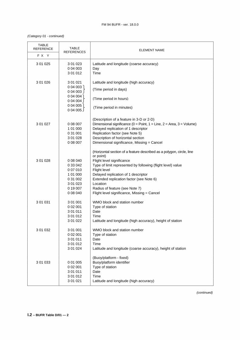
(Category 01 - continued)
TABLE REFERENCE
F X Y
TABLE REFERENCES ELEMENT NAME
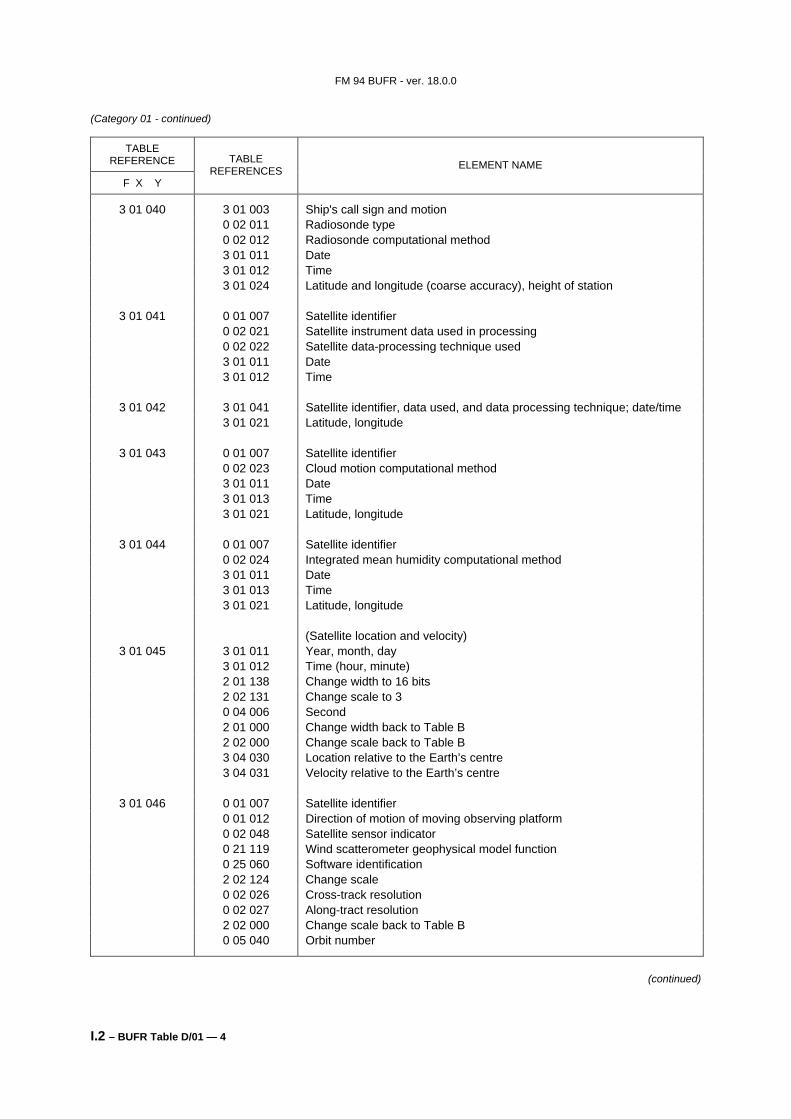
3 01 040 3 01 003 Ship's call sign and motion 0 02 011 Radiosonde type 0 02 012 Radiosonde computational method 3 01 011 Date 3 01 012 Time 3 01 024 Latitude and longitude (coarse accuracy), height of station
3 01 041 0 01 007 Satellite identifier 0 02 021 Satellite instrument data used in processing 0 02 022 Satellite data-processing technique used 3 01 011 Date 3 01 012 Time
3 01 042 3 01 041 Satellite identifier, data used, and data processing technique; date/time 3 01 021 Latitude, longitude
3 01 044 0 01 007 Satellite identifier 0 02 024 Integrated mean humidity computational method 3 01 011 Date 3 01 013 Time 3 01 021 Latitude, longitude (Satellite location and velocity)
3 01 045 3 01 011 Year, month, day 3 01 012 Time (hour, minute) 2 01 138 Change width to 16 bits 2 02 131 Change scale to 3 0 04 006 Second 2 01 000 Change width back to Table B 2 02 000 Change scale back to Table B 3 04 030 Location relative to the Earth’s centre 3 04 031 Velocity relative to the Earth’s centre
3 01 046 0 01 007 Satellite identifier 0 01 012 Direction of motion of moving observing platform 0 02 048 Satellite sensor indicator 0 21 119 Wind scatterometer geophysical model function 0 25 060 Software identification 2 02 124 Change scale 0 02 026 Cross-track resolution 0 02 027 Along-tract resolution 2 02 000 Change scale back to Table B 0 05 040 Orbit number
0 25 060 Software identification 0 01 033 Originating/generating centre 0 01 034 Originating/generating sub-centre 0 01 012 Direction of motion of moving observation platform 3 01 045 Satellite location and velocity 0 02 021 Satellite instrument data used in processing 3 01 011 Date (year, month, day) 3 01 012 Time (hour, minute) 2 01 138 Change bit width to 16 bits 2 02 131 Change scale to 3 0 04 006 Second 2 01 000 Change width back to Table B 2 02 000 Change scale back to Table B 3 01 023 Location (latitude, longitude) (Radar parameters)
3 01 051 0 01 006 Aircraft flight number 0 02 061 Navigational system 3 01 011 Date 3 01 012 Time 3 01 021 Latitude, longitude 0 08 004 Phase of aircraft flight
(continued)
FM 94 BUFR - ver. 18.0.0
I.2 – BUFR Table D/01 — 6
(Category 01 - continued)
TABLE REFERENCE
F X Y
TABLE REFERENCES ELEMENT NAME
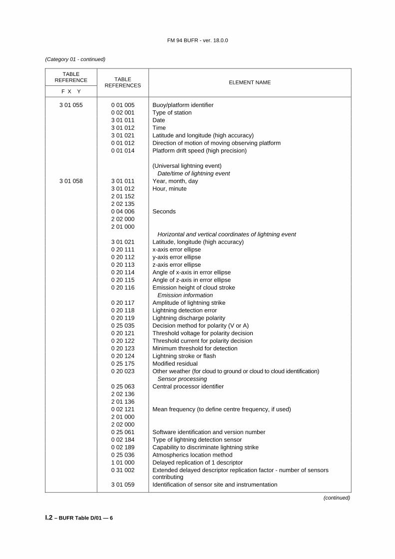
3 01 055 0 01 005 Buoy/platform identifier 0 02 001 Type of station 3 01 011 Date 3 01 012 Time 3 01 021 Latitude and longitude (high accuracy) 0 01 012 Direction of motion of moving observing platform 0 01 014 Platform drift speed (high precision) (Universal lightning event) Date/time of lightning event
3 01 058 3 01 011 Year, month, day 3 01 012 Hour, minute 2 01 152 2 02 135 0 04 006 Seconds 2 02 000 2 01 000 Horizontal and vertical coordinates of lightning event 3 01 021 Latitude, longitude (high accuracy) 0 20 111 x-axis error ellipse 0 20 112 y-axis error ellipse 0 20 113 z-axis error ellipse 0 20 114 Angle of x-axis in error ellipse 0 20 115 Angle of z-axis in error ellipse 0 20 116 Emission height of cloud stroke Emission information 0 20 117 Amplitude of lightning strike 0 20 118 Lightning detection error 0 20 119 Lightning discharge polarity 0 25 035 Decision method for polarity (V or A) 0 20 121 Threshold voltage for polarity decision 0 20 122 Threshold current for polarity decision 0 20 123 Minimum threshold for detection 0 20 124 Lightning stroke or flash 0 25 175 Modified residual 0 20 023 Other weather (for cloud to ground or cloud to cloud identification) Sensor processing 0 25 063 Central processor identifier 2 02 136 2 01 136 0 02 121 Mean frequency (to define centre frequency, if used) 2 01 000 2 02 000 0 25 061 Software identification and version number 0 02 184 Type of lightning detection sensor 0 02 189 Capability to discriminate lightning strike 0 25 036 Atmospherics location method 1 01 000 Delayed replication of 1 descriptor 0 31 002 Extended delayed descriptor replication factor - number of sensors
contributing 3 01 059 Identification of sensor site and instrumentation
(continued)
FM 94 BUFR - ver. 18.0.0
I.2 – BUFR Table D/01 — 7
(Category 01 - continued)
TABLE REFERENCE
F X Y
TABLE REFERENCES ELEMENT NAME
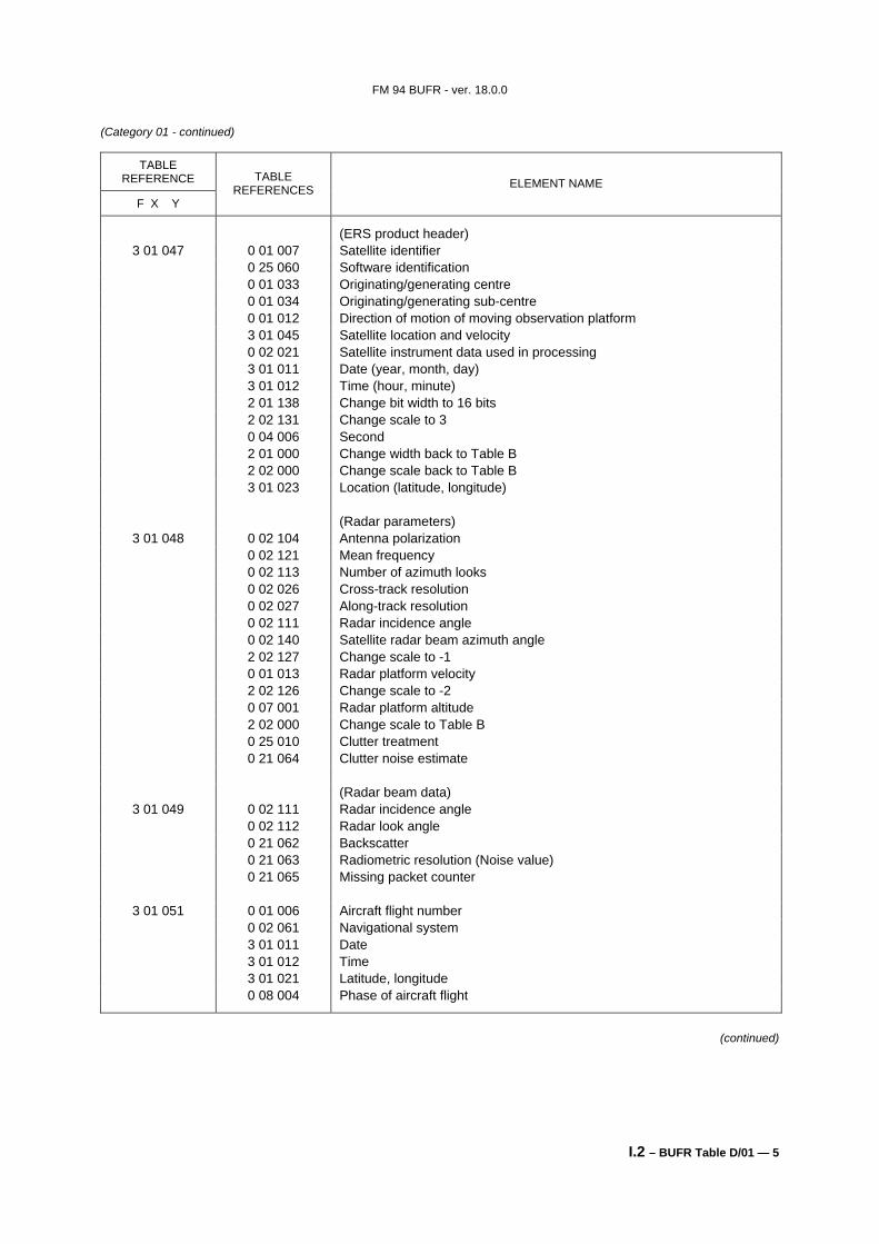
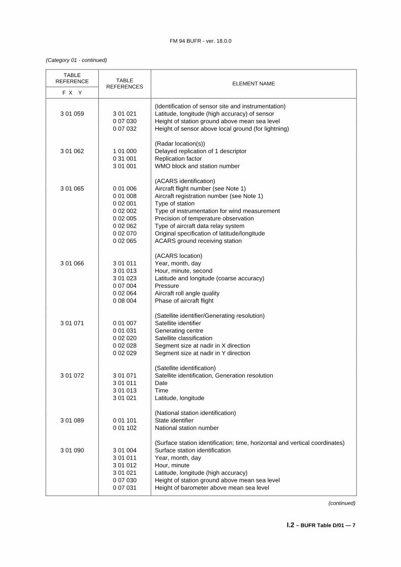
(Identification of sensor site and instrumentation) 3 01 059 3 01 021 Latitude, longitude (high accuracy) of sensor
0 07 030 Height of station ground above mean sea level 0 07 032 Height of sensor above local ground (for lightning) (Radar location(s))
3 01 062 1 01 000 Delayed replication of 1 descriptor 0 31 001 Replication factor 3 01 001 WMO block and station number (ACARS identification)
3 01 065 0 01 006 Aircraft flight number (see Note 1) 0 01 008 Aircraft registration number (see Note 1) 0 02 001 Type of station 0 02 002 Type of instrumentation for wind measurement 0 02 005 Precision of temperature observation 0 02 062 Type of aircraft data relay system 0 02 070 Original specification of latitude/longitude 0 02 065 ACARS ground receiving station (ACARS location)
3 01 066 3 01 011 Year, month, day 3 01 013 Hour, minute, second 3 01 023 Latitude and longitude (coarse accuracy) 0 07 004 Pressure 0 02 064 Aircraft roll angle quality 0 08 004 Phase of aircraft flight (Satellite identifier/Generating resolution)
3 01 071 0 01 007 Satellite identifier 0 01 031 Generating centre 0 02 020 Satellite classification 0 02 028 Segment size at nadir in X direction 0 02 029 Segment size at nadir in Y direction (Satellite identification)
3 01 072 3 01 071 Satellite identification, Generation resolution 3 01 011 Date 3 01 013 Time 3 01 021 Latitude, longitude (National station identification)
3 01 089 0 01 101 State identifier 0 01 102 National station number (Surface station identification; time, horizontal and vertical coordinates)
3 01 090 3 01 004 Surface station identification 3 01 011 Year, month, day 3 01 012 Hour, minute 3 01 021 Latitude, longitude (high accuracy) 0 07 030 Height of station ground above mean sea level 0 07 031 Height of barometer above mean sea level
(continued)
FM 94 BUFR - ver. 18.0.0
I.2 – BUFR Table D/01 — 8
(Category 01 - continued)
TABLE REFERENCE
F X Y
TABLE REFERENCES ELEMENT NAME
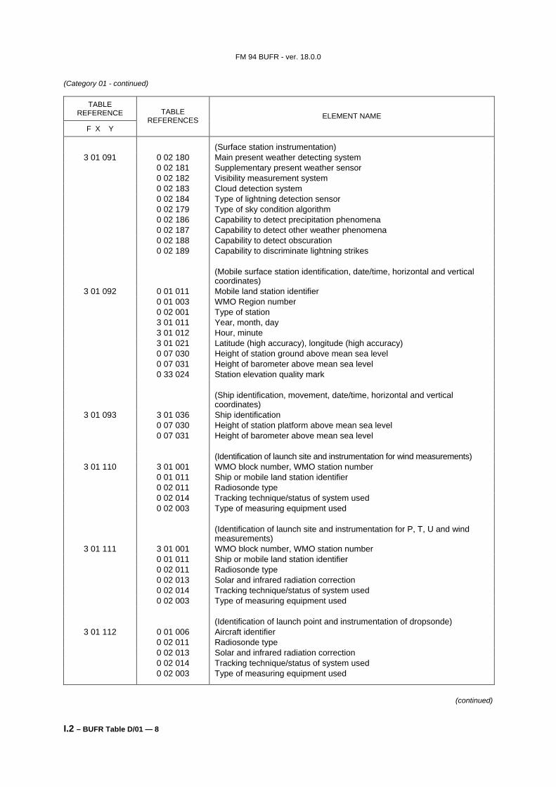
(Surface station instrumentation) 3 01 091 0 02 180 Main present weather detecting system
0 02 181 Supplementary present weather sensor 0 02 182 Visibility measurement system 0 02 183 Cloud detection system 0 02 184 Type of lightning detection sensor 0 02 179 Type of sky condition algorithm 0 02 186 Capability to detect precipitation phenomena 0 02 187 Capability to detect other weather phenomena 0 02 188 Capability to detect obscuration 0 02 189 Capability to discriminate lightning strikes (Mobile surface station identification, date/time, horizontal and vertical
coordinates) 3 01 092 0 01 011 Mobile land station identifier
0 01 003 WMO Region number 0 02 001 Type of station 3 01 011 Year, month, day 3 01 012 Hour, minute 3 01 021 Latitude (high accuracy), longitude (high accuracy) 0 07 030 Height of station ground above mean sea level 0 07 031 Height of barometer above mean sea level 0 33 024 Station elevation quality mark (Ship identification, movement, date/time, horizontal and vertical
0 07 030 Height of station platform above mean sea level 0 07 031 Height of barometer above mean sea level (Identification of launch site and instrumentation for wind measurements)
3 01 110 3 01 001 WMO block number, WMO station number 0 01 011 Ship or mobile land station identifier 0 02 011 Radiosonde type 0 02 014 Tracking technique/status of system used 0 02 003 Type of measuring equipment used (Identification of launch site and instrumentation for P, T, U and wind
measurements) 3 01 111 3 01 001 WMO block number, WMO station number
0 01 011 Ship or mobile land station identifier 0 02 011 Radiosonde type 0 02 013 Solar and infrared radiation correction 0 02 014 Tracking technique/status of system used 0 02 003 Type of measuring equipment used (Identification of launch point and instrumentation of dropsonde)
3 01 112 0 01 006 Aircraft identifier 0 02 011 Radiosonde type 0 02 013 Solar and infrared radiation correction 0 02 014 Tracking technique/status of system used 0 02 003 Type of measuring equipment used
(continued)
FM 94 BUFR - ver. 18.0.0
I.2 – BUFR Table D/01 — 9
(Category 01 - continued)
TABLE REFERENCE
F X Y
TABLE REFERENCES ELEMENT NAME
(Date/time of launch) (see Note 3) 3 01 113 0 08 021 Time significance (= 18 (launch time))
3 01 011 Year, month, day of launch 3 01 013 Hour, minute, second of launch (Horizontal and vertical coordinates of launch site)
3 01 114 3 01 021 Latitude (high accuracy), longitude (high accuracy) 0 07 030 Height of station ground above mean sea level 0 07 031 Height of barometer above mean sea level 0 07 007 Height of release of sonde above mean sea level 0 33 024 Station elevation quality mark (for mobile stations) (Radiosonde abbreviated header and launch information)
3 01 120 3 01 001 WMO block and station number 0 01 094 WBAN number 0 02 011 Radiosonde type 3 01 121 Radiosonde launch point location (Radiosonde launch point location)
3 01 121 0 08 041 Data significance (3 = Balloon launch point) 3 01 122 Date/time (to hundredths of second) 3 01 021 Latitude and longitude (high accuracy) 0 07 031 Height of barometer above MSL 0 07 007 Height (of radiosonde release above MSL) (Date/time (to hundredths of second)) (see Note 3)
3 01 122 3 01 011 Date 3 01 012 Time 2 01 135 Change data width 2 02 130 Change scale 0 04 006 Second 2 02 000 Cancel change scale 2 01 000 Cancel change data width (Radiosonde full header information)
3 01 123 1 02 002 Replicate 2 descriptors 2 times 0 08 041 Data significance (0 = Parent site, 1 = Observation site) 0 01 062 Short ICAO location identifier 3 01 001 WMO block and station number 0 01 094 WBAN number 0 02 011 Radiosonde type 0 01 018 Short station or site name 0 01 095 Observer identification 0 25 061 Software identification 0 25 068 Number of archive recomputes 0 01 082 Radiosonde ascension number 0 01 083 Radiosonde release number 0 01 081 Radiosonde serial number 0 02 067 Radiosonde operating frequency 0 02 066 Radiosonde ground receiving system 0 02 014 Tracking technique/status of system used 0 25 067 Release point pressure correction
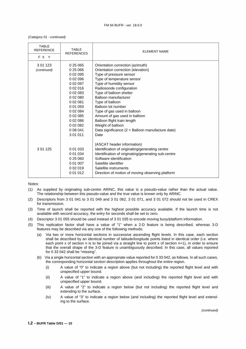
0 02 095 Type of pressure sensor 0 02 096 Type of temperature sensor 0 02 097 Type of humidity sensor 0 02 016 Radiosonde configuration 0 02 083 Type of balloon shelter 0 02 080 Balloon manufacturer 0 02 081 Type of balloon 0 01 093 Balloon lot number 0 02 084 Type of gas used in balloon 0 02 085 Amount of gas used in balloon 0 02 086 Balloon flight train length 0 02 082 Weight of balloon 0 08 041 Data significance (2 = Balloon manufacture date) 3 01 011 Date (ASCAT header information)
3 01 125 0 01 033 Identification of originating/generating centre 0 01 034 Identification of originating/generating sub-centre 0 25 060 Software identification 0 01 007 Satellite identifier 0 02 019 Satellite instruments 0 01 012 Direction of motion of moving observing platform
Notes: (1) As supplied by originating sub-centre ARINC, this value is a pseudo-value rather than the actual value.
The relationship between this pseudo-value and the true value is known only by ARINC. (2) Descriptors from 3 01 041 to 3 01 049 and 3 01 062, 3 01 071, and 3 01 072 should not be used in CREX
for transmission. (3) Time of launch shall be reported with the highest possible accuracy available. If the launch time is not
available with second accuracy, the entry for seconds shall be set to zero. (4) Descriptor 3 01 055 should be used instead of 3 01 035 to encode moving buoy/platform information. (5) This replication factor shall have a value of “1” when a 2-D feature is being described, whereas 3-D
features may be described via any one of the following methods: (a) Via two or more horizontal sections in successive ascending flight levels. In this case, each section
shall be described by an identical number of latitude/longitude points listed in identical order (i.e. where each point x of section n is to be joined via a straight line to point x of section n+1), in order to ensure that the overall shape of the 3-D feature is unambiguously described. In this case, all values reported for 0 33 042 shall be “missing”.
(b) Via a single horizontal section with an appropriate value reported for 0 33 042, as follows. In all such cases, the corresponding horizontal section description applies throughout the entire region. (i) A value of “0” to indicate a region above (but not including) the reported flight level and with
unspecified upper bound. (ii) A value of “1” to indicate a region above (and including) the reported flight level and with
unspecified upper bound. (iii) A value of “2” to indicate a region below (but not including) the reported flight level and
extending to the surface. (iv) A value of “3” to indicate a region below (and including) the reported flight level and extend-
ing to the surface.
(continued)
FM 94 BUFR - ver. 18.0.0
I.2 – BUFR Table D/01 — 11
(Category 01 - continued)
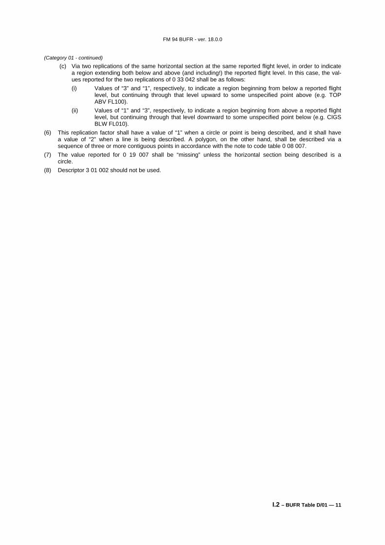
(c) Via two replications of the same horizontal section at the same reported flight level, in order to indicate a region extending both below and above (and including!) the reported flight level. In this case, the val- ues reported for the two replications of 0 33 042 shall be as follows: (i) Values of “3” and “1”, respectively, to indicate a region beginning from below a reported flight
level, but continuing through that level upward to some unspecified point above (e.g. TOP ABV FL100).
(ii) Values of “1” and “3”, respectively, to indicate a region beginning from above a reported flight level, but continuing through that level downward to some unspecified point below (e.g. CIGS BLW FL010).
(6) This replication factor shall have a value of “1” when a circle or point is being described, and it shall have a value of “2” when a line is being described. A polygon, on the other hand, shall be described via a sequence of three or more contiguous points in accordance with the note to code table 0 08 007.
(7) The value reported for 0 19 007 shall be “missing” unless the horizontal section being described is a circle.
(8) Descriptor 3 01 002 should not be used.
FM 94 BUFR - ver. 18.0.0
I.2 – BUFR Table D/02 — 1
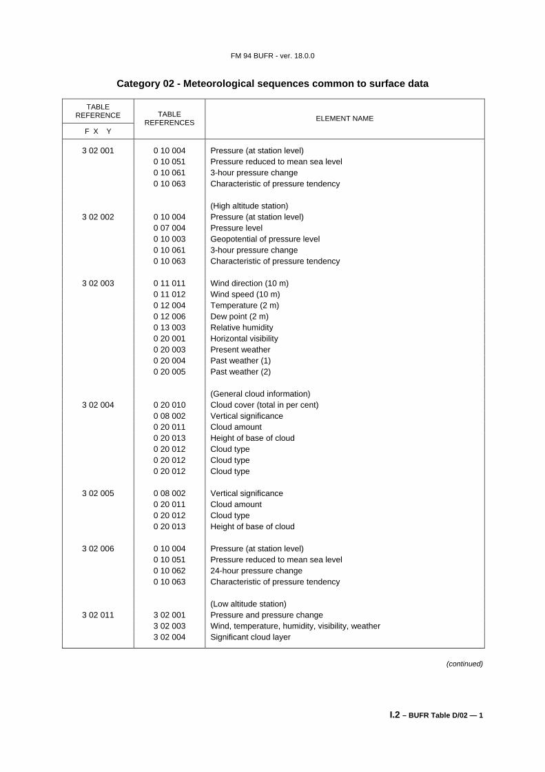
Category 02 - Meteorological sequences common to surface data
TABLE REFERENCE
F X Y
TABLE REFERENCES ELEMENT NAME
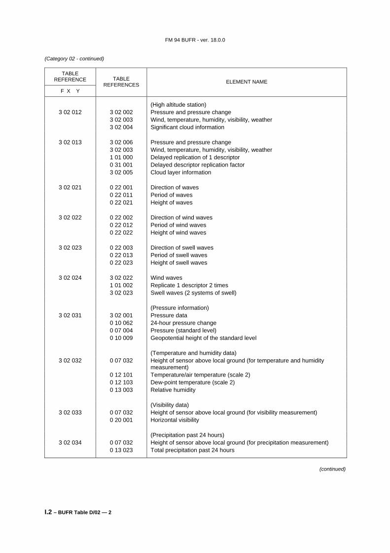
3 02 001 0 10 004 Pressure (at station level) 0 10 051 Pressure reduced to mean sea level 0 10 061 3-hour pressure change 0 10 063 Characteristic of pressure tendency (High altitude station)
3 02 033 0 07 032 Height of sensor above local ground (for visibility measurement) 0 20 001 Horizontal visibility (Precipitation past 24 hours)
3 02 034 0 07 032 Height of sensor above local ground (for precipitation measurement) 0 13 023 Total precipitation past 24 hours
(continued)
FM 94 BUFR - ver. 18.0.0
I.2 – BUFR Table D/02 — 3
(Category 02 - continued)
TABLE REFERENCE
F X Y
TABLE REFERENCES ELEMENT NAME
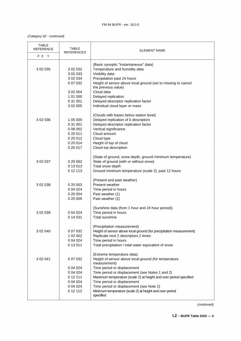
(Basic synoptic "instantaneous" data) 3 02 035 3 02 032 Temperature and humidity data
3 02 033 Visibility data 3 02 034 Precipitation past 24 hours 0 07 032 Height of sensor above local ground (set to missing to cancel
the previous value) 3 02 004 Cloud data 1 01 000 Delayed replication 0 31 001 Delayed descriptor replication factor 3 02 005 Individual cloud layer or mass (Clouds with bases below station level)
3 02 036 1 05 000 Delayed replication of 5 descriptors 0 31 001 Delayed descriptor replication factor 0 08 002 Vertical significance 0 20 011 Cloud amount 0 20 012 Cloud type 0 20 014 Height of top of cloud 0 20 017 Cloud top description (State of ground, snow depth, ground minimum temperature)
3 02 037 0 20 062 State of ground (with or without snow) 0 13 013 Total snow depth 0 12 113 Ground minimum temperature (scale 2), past 12 hours (Present and past weather)
3 02 038 0 20 003 Present weather 0 04 024 Time period in hours 0 20 004 Past weather (1) 0 20 005 Past weather (2) (Sunshine data (from 1 hour and 24 hour period))
3 02 039 0 04 024 Time period in hours 0 14 031 Total sunshine (Precipitation measurement)
3 02 040 0 07 032 Height of sensor above local ground (for precipitation measurement) 1 02 002 Replicate next 2 descriptors 2 times 0 04 024 Time period in hours 0 13 011 Total precipitation / total water equivalent of snow (Extreme temperature data)
3 02 041 0 07 032 Height of sensor above local ground (for temperature measurement)
0 04 024 Time period or displacement 0 04 024 Time period or displacement (see Notes 1 and 2) 0 12 111 Maximum temperature (scale 2) at height and over period specified 0 04 024 Time period or displacement 0 04 024 Time period or displacement (see Note 2) 0 12 112 Minimum temperature (scale 2) at height and over period
specified
(continued)
FM 94 BUFR - ver. 18.0.0
I.2 – BUFR Table D/02 — 4
(Category 02 - continued)
TABLE REFERENCE
F X Y
TABLE REFERENCES ELEMENT NAME
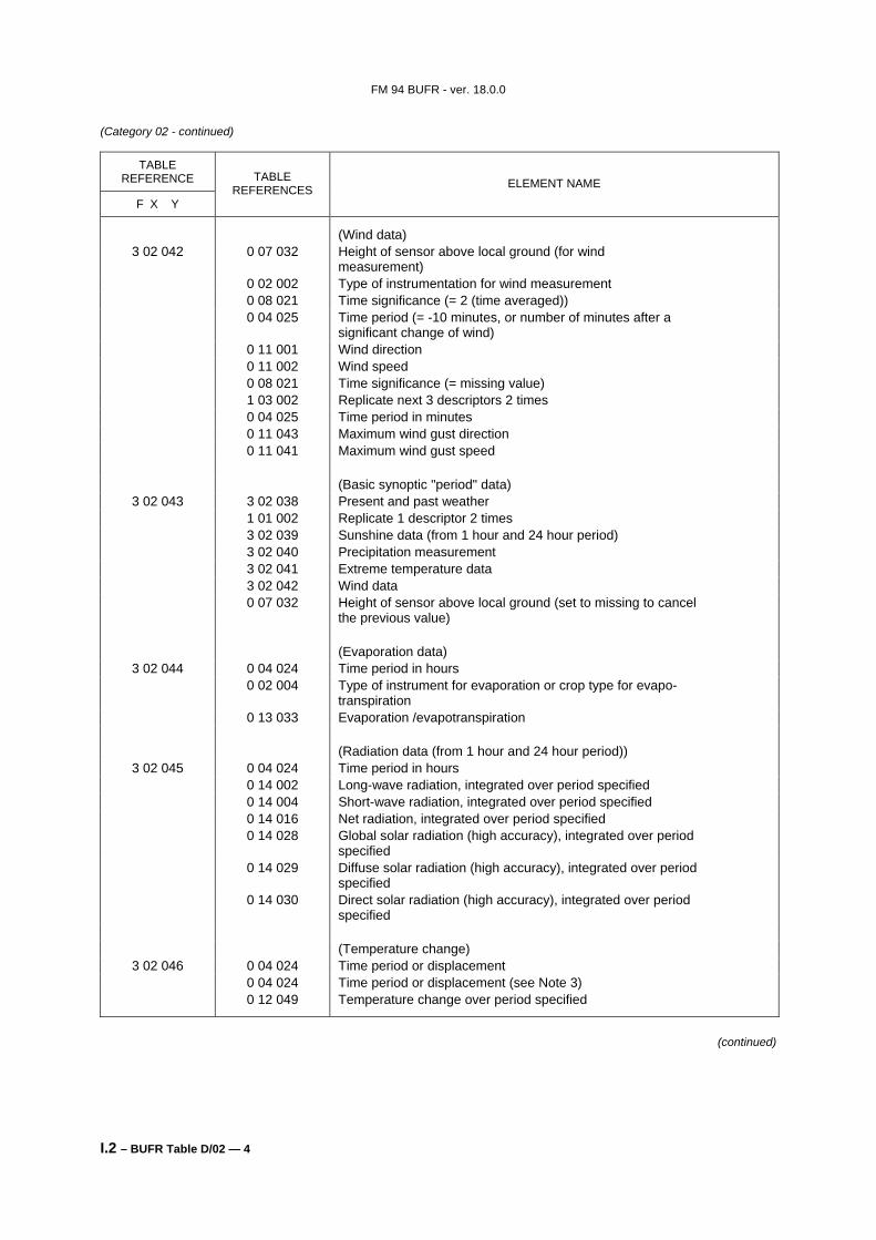
(Wind data) 3 02 042 0 07 032 Height of sensor above local ground (for wind
measurement) 0 02 002 Type of instrumentation for wind measurement 0 08 021 Time significance (= 2 (time averaged)) 0 04 025 Time period (= -10 minutes, or number of minutes after a
significant change of wind) 0 11 001 Wind direction 0 11 002 Wind speed 0 08 021 Time significance (= missing value) 1 03 002 Replicate next 3 descriptors 2 times 0 04 025 Time period in minutes 0 11 043 Maximum wind gust direction 0 11 041 Maximum wind gust speed (Basic synoptic "period" data)
3 02 043 3 02 038 Present and past weather 1 01 002 Replicate 1 descriptor 2 times 3 02 039 Sunshine data (from 1 hour and 24 hour period) 3 02 040 Precipitation measurement 3 02 041 Extreme temperature data 3 02 042 Wind data 0 07 032 Height of sensor above local ground (set to missing to cancel
the previous value) (Evaporation data)
3 02 044 0 04 024 Time period in hours 0 02 004 Type of instrument for evaporation or crop type for evapo-
transpiration 0 13 033 Evaporation /evapotranspiration (Radiation data (from 1 hour and 24 hour period))
3 02 045 0 04 024 Time period in hours 0 14 002 Long-wave radiation, integrated over period specified 0 14 004 Short-wave radiation, integrated over period specified 0 14 016 Net radiation, integrated over period specified 0 14 028 Global solar radiation (high accuracy), integrated over period
specified 0 14 029 Diffuse solar radiation (high accuracy), integrated over period
specified 0 14 030 Direct solar radiation (high accuracy), integrated over period
specified (Temperature change)
3 02 046 0 04 024 Time period or displacement 0 04 024 Time period or displacement (see Note 3) 0 12 049 Temperature change over period specified
(continued)
FM 94 BUFR - ver. 18.0.0
I.2 – BUFR Table D/02 — 5
(Category 02 - continued)
TABLE REFERENCE
F X Y
TABLE REFERENCES ELEMENT NAME
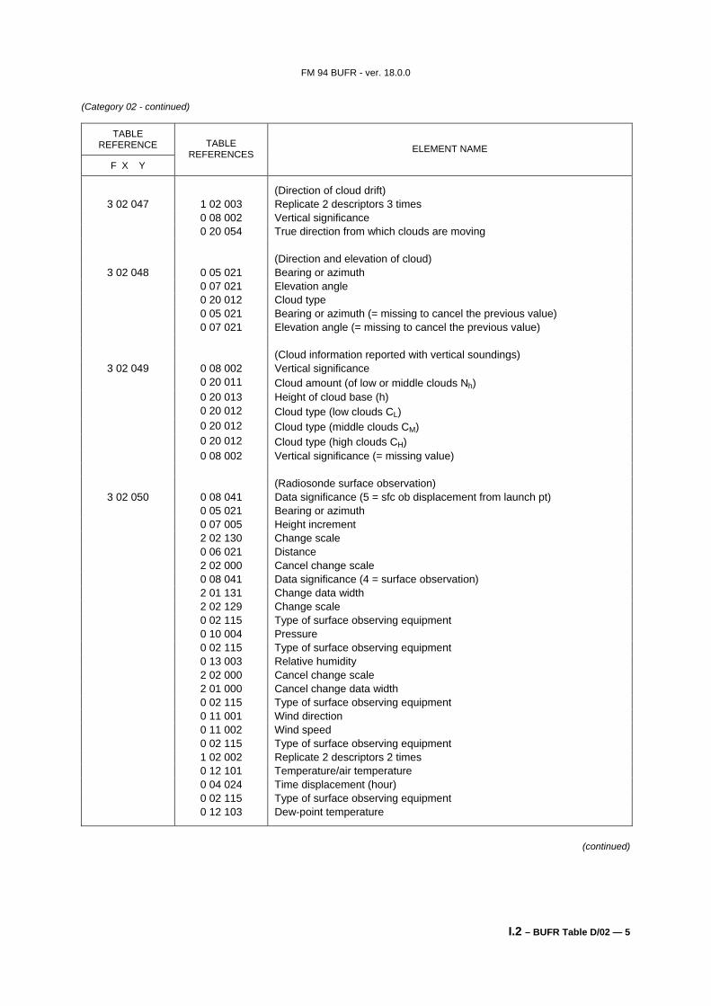
(Direction of cloud drift) 3 02 047 1 02 003 Replicate 2 descriptors 3 times
0 08 002 Vertical significance 0 20 054 True direction from which clouds are moving (Direction and elevation of cloud)
3 02 048 0 05 021 Bearing or azimuth 0 07 021 Elevation angle 0 20 012 Cloud type 0 05 021 Bearing or azimuth (= missing to cancel the previous value) 0 07 021 Elevation angle (= missing to cancel the previous value) (Cloud information reported with vertical soundings)
3 02 050 0 08 041 Data significance (5 = sfc ob displacement from launch pt) 0 05 021 Bearing or azimuth 0 07 005 Height increment 2 02 130 Change scale 0 06 021 Distance 2 02 000 Cancel change scale 0 08 041 Data significance (4 = surface observation) 2 01 131 Change data width 2 02 129 Change scale 0 02 115 Type of surface observing equipment 0 10 004 Pressure 0 02 115 Type of surface observing equipment 0 13 003 Relative humidity 2 02 000 Cancel change scale 2 01 000 Cancel change data width 0 02 115 Type of surface observing equipment 0 11 001 Wind direction 0 11 002 Wind speed 0 02 115 Type of surface observing equipment 1 02 002 Replicate 2 descriptors 2 times 0 12 101 Temperature/air temperature 0 04 024 Time displacement (hour) 0 02 115 Type of surface observing equipment 0 12 103 Dew-point temperature
(continued)
FM 94 BUFR - ver. 18.0.0
I.2 – BUFR Table D/02 — 6
(Category 02 - continued)
TABLE REFERENCE
F X Y
TABLE REFERENCES ELEMENT NAME
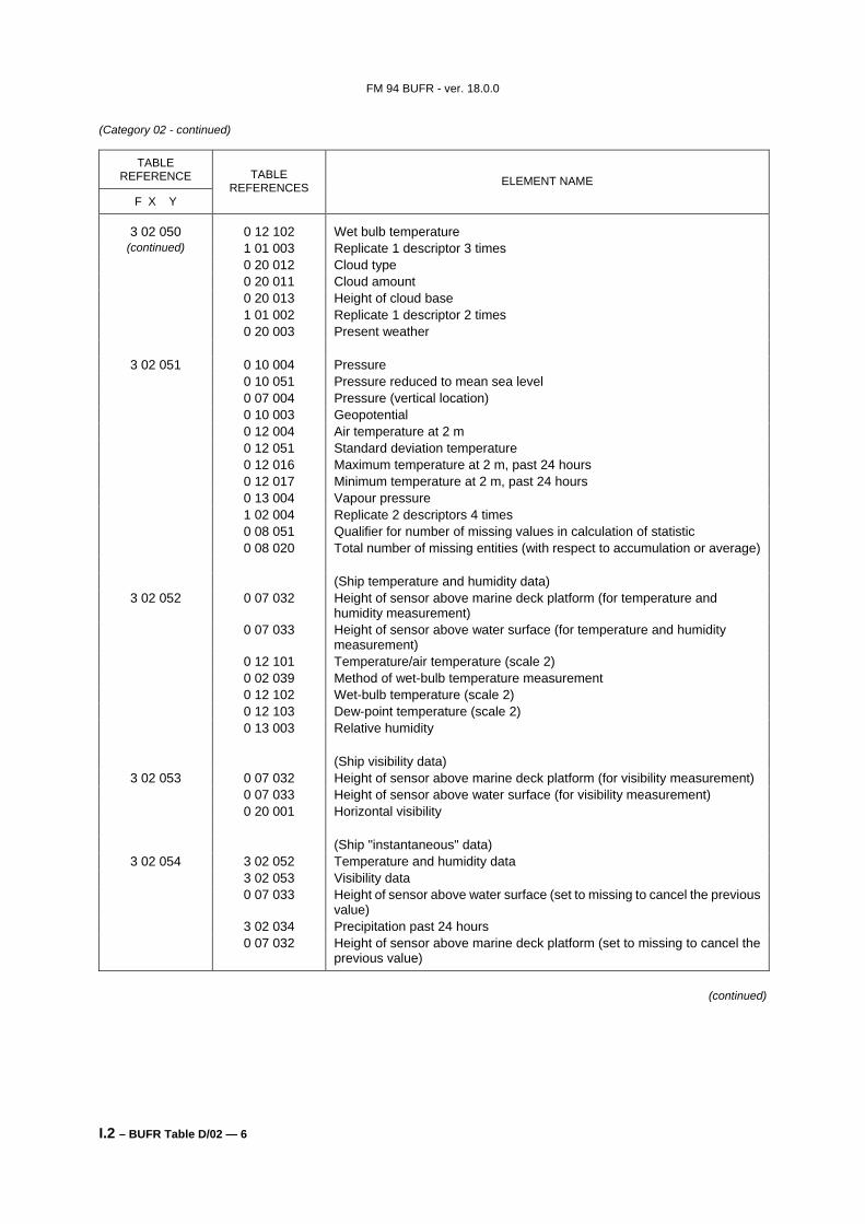
3 02 050 0 12 102 Wet bulb temperature (continued) 1 01 003 Replicate 1 descriptor 3 times
0 20 012 Cloud type 0 20 011 Cloud amount 0 20 013 Height of cloud base 1 01 002 Replicate 1 descriptor 2 times 0 20 003 Present weather
3 02 051 0 10 004 Pressure 0 10 051 Pressure reduced to mean sea level 0 07 004 Pressure (vertical location) 0 10 003 Geopotential 0 12 004 Air temperature at 2 m 0 12 051 Standard deviation temperature 0 12 016 Maximum temperature at 2 m, past 24 hours 0 12 017 Minimum temperature at 2 m, past 24 hours 0 13 004 Vapour pressure 1 02 004 Replicate 2 descriptors 4 times 0 08 051 Qualifier for number of missing values in calculation of statistic 0 08 020 Total number of missing entities (with respect to accumulation or average) (Ship temperature and humidity data)
3 02 052 0 07 032 Height of sensor above marine deck platform (for temperature and humidity measurement)
0 07 033 Height of sensor above water surface (for temperature and humidity measurement)
0 12 101 Temperature/air temperature (scale 2) 0 02 039 Method of wet-bulb temperature measurement 0 12 102 Wet-bulb temperature (scale 2) 0 12 103 Dew-point temperature (scale 2) 0 13 003 Relative humidity (Ship visibility data)
3 02 054 3 02 052 Temperature and humidity data 3 02 053 Visibility data 0 07 033 Height of sensor above water surface (set to missing to cancel the previous
value) 3 02 034 Precipitation past 24 hours 0 07 032 Height of sensor above marine deck platform (set to missing to cancel the
previous value)
(continued)
FM 94 BUFR - ver. 18.0.0
I.2 – BUFR Table D/02 — 7
(Category 02 - continued)
TABLE REFERENCE
F X Y
TABLE REFERENCES ELEMENT NAME
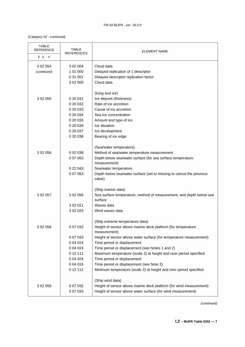
3 02 054 3 02 004 Cloud data (continued) 1 01 000 Delayed replication of 1 descriptor
0 31 001 Delayed descriptor replication factor 3 02 005 Cloud data (Icing and ice)
3 02 055 0 20 031 Ice deposit (thickness) 0 20 032 Rate of ice accretion 0 20 033 Cause of ice accretion 0 20 034 Sea ice concentration 0 20 035 Amount and type of ice 0 20 036 Ice situation 0 20 037 Ice development 0 20 038 Bearing of ice edge (Sea/water temperature)
3 02 056 0 02 038 Method of sea/water temperature measurement 0 07 063 Depth below sea/water surface (for sea surface temperature
measurement) 0 22 043 Sea/water temperature 0 07 063 Depth below sea/water surface (set to missing to cancel the previous
value) (Ship marine data)
3 02 057 3 02 056 Sea surface temperature, method of measurement, and depth below sea surface
3 02 021 Waves data 3 02 024 Wind waves data (Ship extreme temperature data)
3 02 058 0 07 032 Height of sensor above marine deck platform (for temperature measurement)
0 07 033 Height of sensor above water surface (for temperature measurement) 0 04 024 Time period or displacement 0 04 024 Time period or displacement (see Notes 1 and 2) 0 12 111 Maximum temperature (scale 2) at height and over period specified 0 04 024 Time period or displacement 0 04 024 Time period or displacement (see Note 2) 0 12 112 Minimum temperature (scale 2) at height and over period specified (Ship wind data)
3 02 059 0 07 032 Height of sensor above marine deck platform (for wind measurement) 0 07 033 Height of sensor above water surface (for wind measurement)
(continued)
FM 94 BUFR - ver. 18.0.0
I.2 – BUFR Table D/02 — 8
(Category 02 - continued)
TABLE REFERENCE
F X Y
TABLE REFERENCES ELEMENT NAME
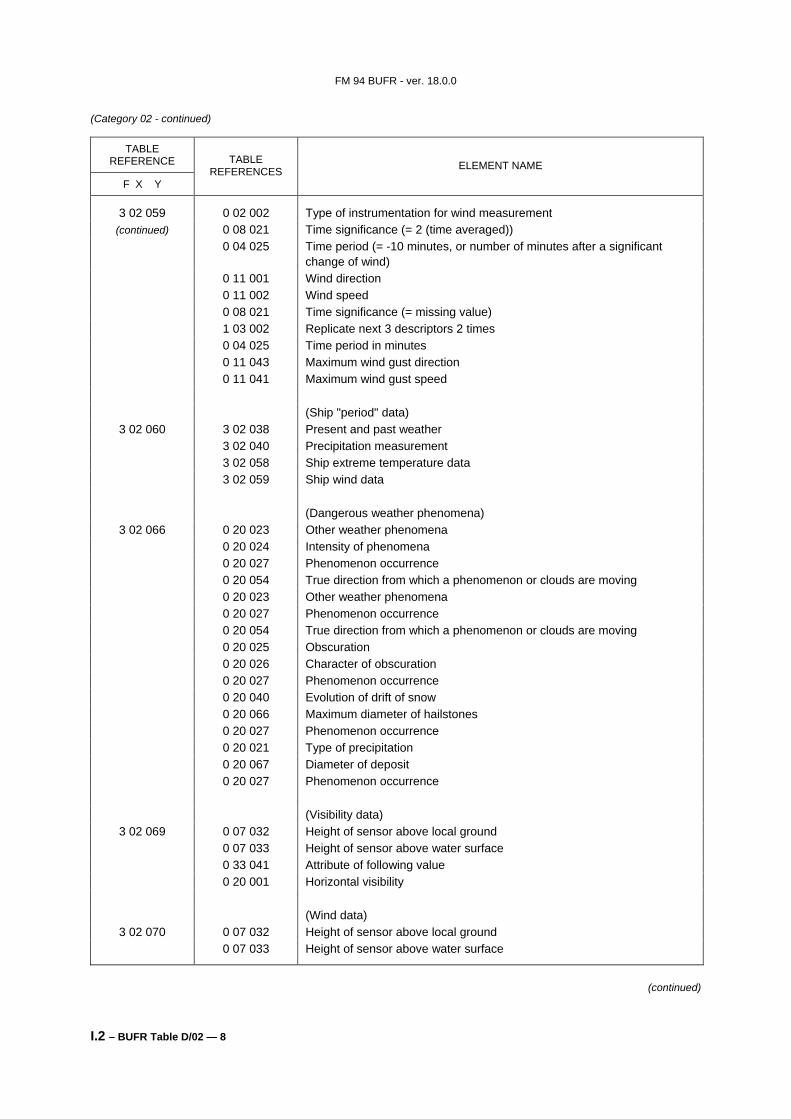
3 02 059 0 02 002 Type of instrumentation for wind measurement (continued) 0 08 021 Time significance (= 2 (time averaged))
0 04 025 Time period (= -10 minutes, or number of minutes after a significant change of wind)
0 11 001 Wind direction 0 11 002 Wind speed 0 08 021 Time significance (= missing value) 1 03 002 Replicate next 3 descriptors 2 times 0 04 025 Time period in minutes 0 11 043 Maximum wind gust direction 0 11 041 Maximum wind gust speed (Ship "period" data)
3 02 060 3 02 038 Present and past weather 3 02 040 Precipitation measurement 3 02 058 Ship extreme temperature data 3 02 059 Ship wind data (Dangerous weather phenomena)
3 02 066 0 20 023 Other weather phenomena 0 20 024 Intensity of phenomena 0 20 027 Phenomenon occurrence 0 20 054 True direction from which a phenomenon or clouds are moving 0 20 023 Other weather phenomena 0 20 027 Phenomenon occurrence 0 20 054 True direction from which a phenomenon or clouds are moving 0 20 025 Obscuration 0 20 026 Character of obscuration 0 20 027 Phenomenon occurrence 0 20 040 Evolution of drift of snow 0 20 066 Maximum diameter of hailstones 0 20 027 Phenomenon occurrence 0 20 021 Type of precipitation 0 20 067 Diameter of deposit 0 20 027 Phenomenon occurrence (Visibility data)
3 02 069 0 07 032 Height of sensor above local ground 0 07 033 Height of sensor above water surface 0 33 041 Attribute of following value 0 20 001 Horizontal visibility (Wind data)
3 02 070 0 07 032 Height of sensor above local ground 0 07 033 Height of sensor above water surface
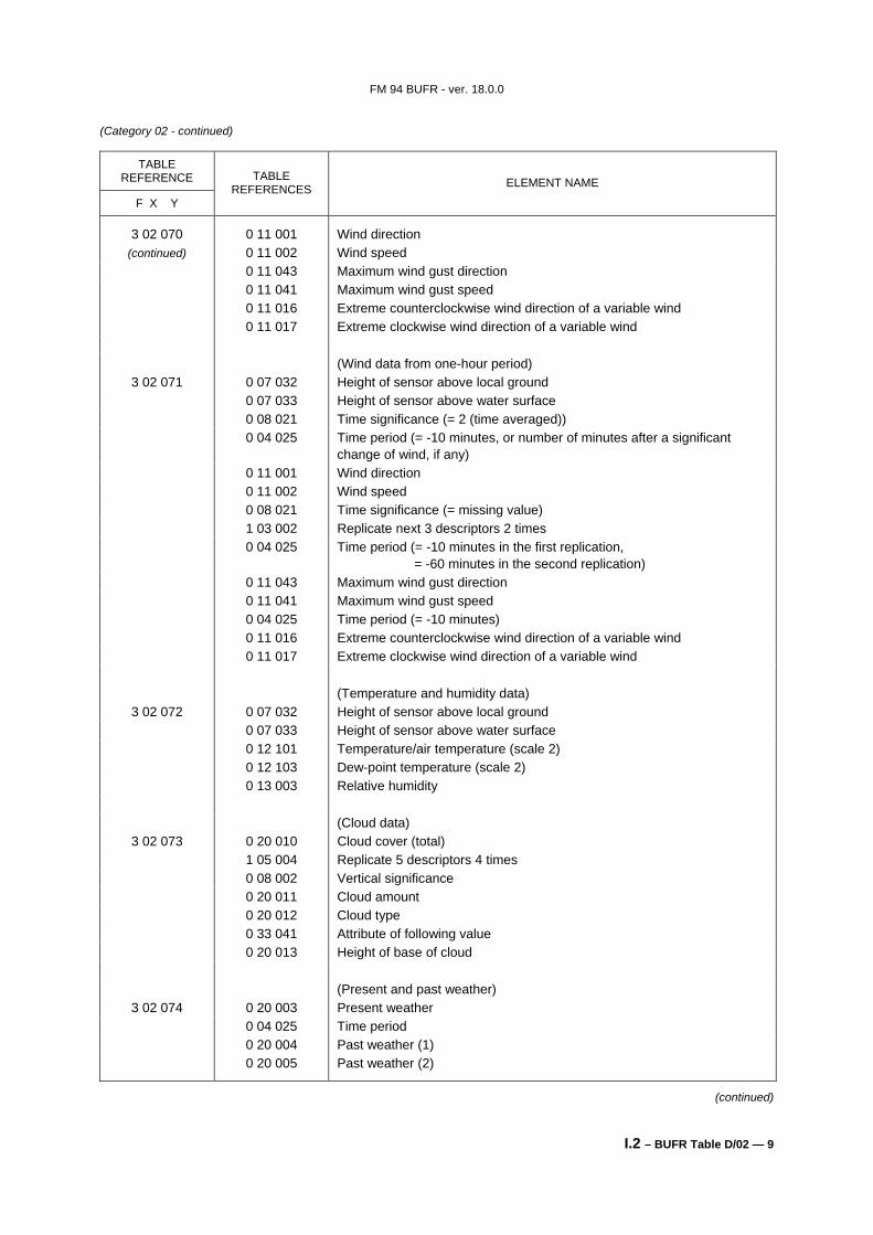
0 11 043 Maximum wind gust direction 0 11 041 Maximum wind gust speed 0 11 016 Extreme counterclockwise wind direction of a variable wind 0 11 017 Extreme clockwise wind direction of a variable wind (Wind data from one-hour period)
3 02 071 0 07 032 Height of sensor above local ground 0 07 033 Height of sensor above water surface 0 08 021 Time significance (= 2 (time averaged)) 0 04 025 Time period (= -10 minutes, or number of minutes after a significant
change of wind, if any) 0 11 001 Wind direction 0 11 002 Wind speed 0 08 021 Time significance (= missing value) 1 03 002 Replicate next 3 descriptors 2 times 0 04 025 Time period (= -10 minutes in the first replication,
= -60 minutes in the second replication) 0 11 043 Maximum wind gust direction 0 11 041 Maximum wind gust speed 0 04 025 Time period (= -10 minutes) 0 11 016 Extreme counterclockwise wind direction of a variable wind 0 11 017 Extreme clockwise wind direction of a variable wind (Temperature and humidity data)
3 02 072 0 07 032 Height of sensor above local ground 0 07 033 Height of sensor above water surface 0 12 101 Temperature/air temperature (scale 2) 0 12 103 Dew-point temperature (scale 2) 0 13 003 Relative humidity (Cloud data)
3 02 073 0 20 010 Cloud cover (total) 1 05 004 Replicate 5 descriptors 4 times 0 08 002 Vertical significance 0 20 011 Cloud amount 0 20 012 Cloud type 0 33 041 Attribute of following value 0 20 013 Height of base of cloud (Present and past weather)
3 02 074 0 20 003 Present weather 0 04 025 Time period 0 20 004 Past weather (1) 0 20 005 Past weather (2)
(continued)
FM 94 BUFR - ver. 18.0.0
I.2 – BUFR Table D/02 — 10
(Category 02 - continued)
TABLE REFERENCE
F X Y
TABLE REFERENCES ELEMENT NAME
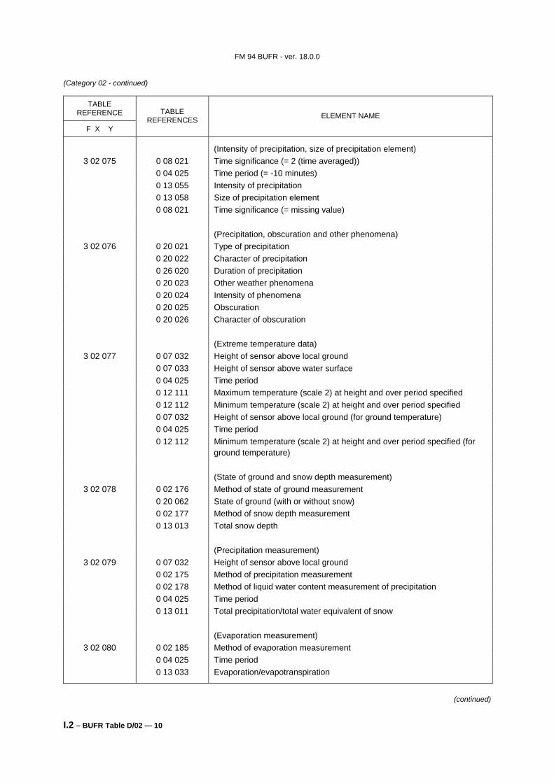
(Intensity of precipitation, size of precipitation element) 3 02 075 0 08 021 Time significance (= 2 (time averaged))
0 04 025 Time period (= -10 minutes) 0 13 055 Intensity of precipitation 0 13 058 Size of precipitation element 0 08 021 Time significance (= missing value) (Precipitation, obscuration and other phenomena)
3 02 076 0 20 021 Type of precipitation 0 20 022 Character of precipitation 0 26 020 Duration of precipitation 0 20 023 Other weather phenomena 0 20 024 Intensity of phenomena 0 20 025 Obscuration 0 20 026 Character of obscuration (Extreme temperature data)
3 02 077 0 07 032 Height of sensor above local ground 0 07 033 Height of sensor above water surface 0 04 025 Time period 0 12 111 Maximum temperature (scale 2) at height and over period specified 0 12 112 Minimum temperature (scale 2) at height and over period specified 0 07 032 Height of sensor above local ground (for ground temperature) 0 04 025 Time period 0 12 112 Minimum temperature (scale 2) at height and over period specified (for
ground temperature) (State of ground and snow depth measurement)
3 02 078 0 02 176 Method of state of ground measurement 0 20 062 State of ground (with or without snow) 0 02 177 Method of snow depth measurement 0 13 013 Total snow depth (Precipitation measurement)
3 02 079 0 07 032 Height of sensor above local ground 0 02 175 Method of precipitation measurement 0 02 178 Method of liquid water content measurement of precipitation 0 04 025 Time period 0 13 011 Total precipitation/total water equivalent of snow (Evaporation measurement)
3 02 080 0 02 185 Method of evaporation measurement 0 04 025 Time period 0 13 033 Evaporation/evapotranspiration
(continued)
FM 94 BUFR - ver. 18.0.0
I.2 – BUFR Table D/02 — 11
(Category 02 - continued)
TABLE REFERENCE
F X Y
TABLE REFERENCES ELEMENT NAME
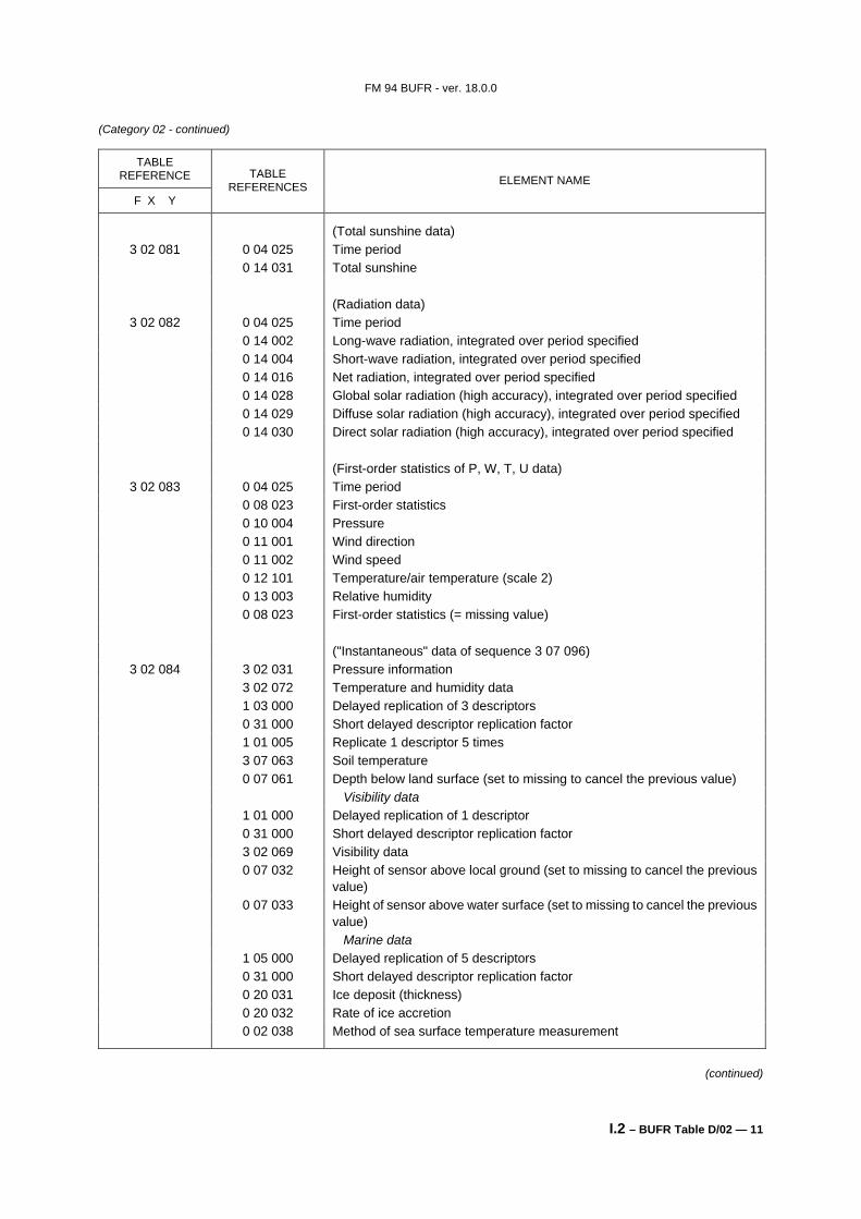
(Total sunshine data) 3 02 081 0 04 025 Time period
0 14 031 Total sunshine (Radiation data)
3 02 082 0 04 025 Time period 0 14 002 Long-wave radiation, integrated over period specified 0 14 004 Short-wave radiation, integrated over period specified 0 14 016 Net radiation, integrated over period specified 0 14 028 Global solar radiation (high accuracy), integrated over period specified 0 14 029 Diffuse solar radiation (high accuracy), integrated over period specified 0 14 030 Direct solar radiation (high accuracy), integrated over period specified (First-order statistics of P, W, T, U data)
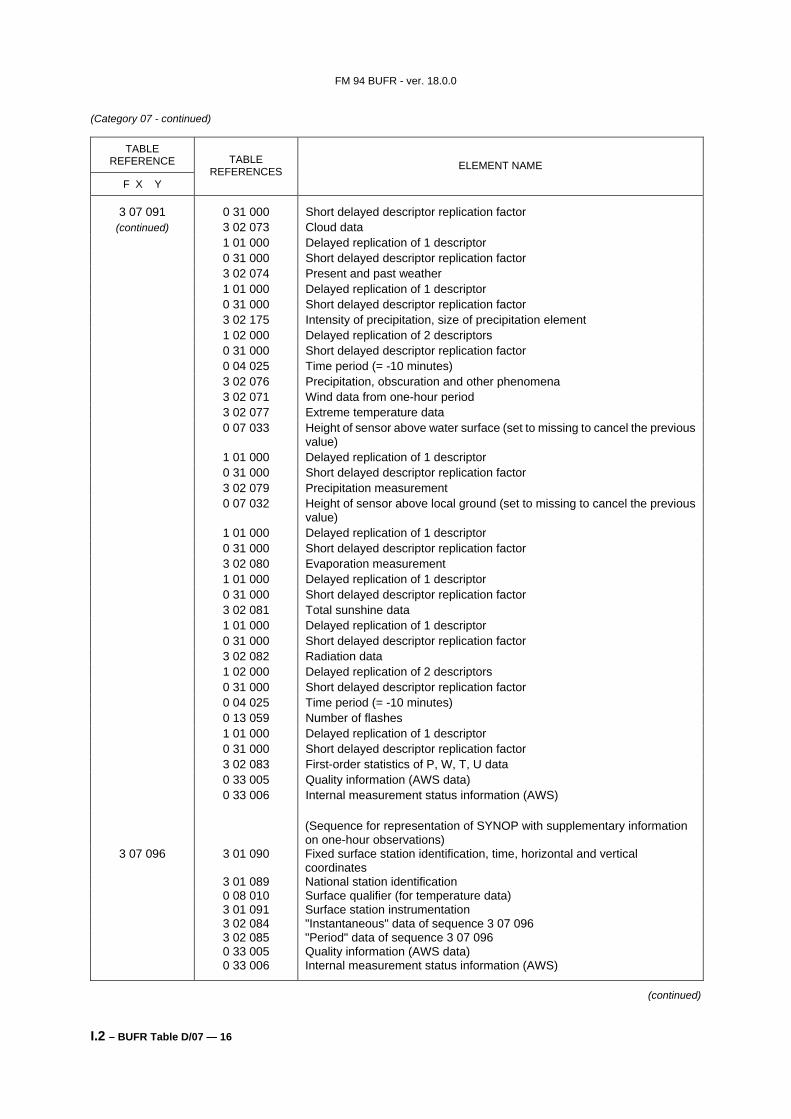
3 02 083 0 04 025 Time period 0 08 023 First-order statistics 0 10 004 Pressure 0 11 001 Wind direction 0 11 002 Wind speed 0 12 101 Temperature/air temperature (scale 2) 0 13 003 Relative humidity 0 08 023 First-order statistics (= missing value) ("Instantaneous" data of sequence 3 07 096)
3 02 084 3 02 031 Pressure information 3 02 072 Temperature and humidity data 1 03 000 Delayed replication of 3 descriptors 0 31 000 Short delayed descriptor replication factor 1 01 005 Replicate 1 descriptor 5 times 3 07 063 Soil temperature 0 07 061 Depth below land surface (set to missing to cancel the previous value) Visibility data 1 01 000 Delayed replication of 1 descriptor 0 31 000 Short delayed descriptor replication factor 3 02 069 Visibility data
0 07 032 Height of sensor above local ground (set to missing to cancel the previous value)
0 07 033 Height of sensor above water surface (set to missing to cancel the previous value)
Marine data 1 05 000 Delayed replication of 5 descriptors 0 31 000 Short delayed descriptor replication factor 0 20 031 Ice deposit (thickness) 0 20 032 Rate of ice accretion 0 02 038 Method of sea surface temperature measurement
(continued)
FM 94 BUFR - ver. 18.0.0
I.2 – BUFR Table D/02 — 12
(Category 02 - continued)
TABLE REFERENCE
F X Y
TABLE REFERENCES ELEMENT NAME
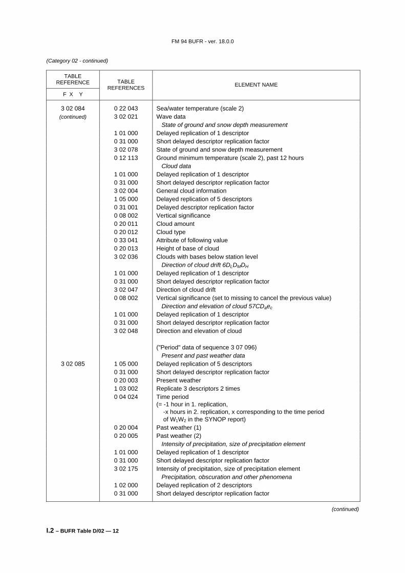
3 02 084 0 22 043 Sea/water temperature (scale 2) (continued) 3 02 021 Wave data
State of ground and snow depth measurement 1 01 000 Delayed replication of 1 descriptor 0 31 000 Short delayed descriptor replication factor 3 02 078 State of ground and snow depth measurement 0 12 113 Ground minimum temperature (scale 2), past 12 hours Cloud data 1 01 000 Delayed replication of 1 descriptor 0 31 000 Short delayed descriptor replication factor 3 02 004 General cloud information 1 05 000 Delayed replication of 5 descriptors 0 31 001 Delayed descriptor replication factor 0 08 002 Vertical significance 0 20 011 Cloud amount 0 20 012 Cloud type 0 33 041 Attribute of following value 0 20 013 Height of base of cloud 3 02 036 Clouds with bases below station level Direction of cloud drift 6DLDMDH 1 01 000 Delayed replication of 1 descriptor 0 31 000 Short delayed descriptor replication factor 3 02 047 Direction of cloud drift 0 08 002 Vertical significance (set to missing to cancel the previous value) Direction and elevation of cloud 57CDaec 1 01 000 Delayed replication of 1 descriptor 0 31 000 Short delayed descriptor replication factor 3 02 048 Direction and elevation of cloud ("Period" data of sequence 3 07 096) Present and past weather data
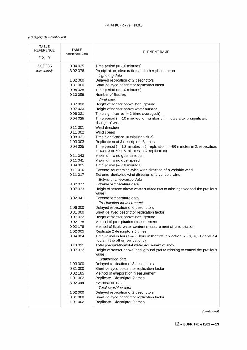
3 02 085 1 05 000 Delayed replication of 5 descriptors 0 31 000 Short delayed descriptor replication factor 0 20 003 Present weather 1 03 002 Replicate 3 descriptors 2 times 0 04 024 Time period
(= -1 hour in 1. replication, -x hours in 2. replication, x corresponding to the time period of W1W2 in the SYNOP report)
0 20 004 Past weather (1) 0 20 005 Past weather (2) Intensity of precipitation, size of precipitation element 1 01 000 Delayed replication of 1 descriptor 0 31 000 Short delayed descriptor replication factor 3 02 175 Intensity of precipitation, size of precipitation element Precipitation, obscuration and other phenomena 1 02 000 Delayed replication of 2 descriptors 0 31 000 Short delayed descriptor replication factor
(continued)
FM 94 BUFR - ver. 18.0.0
I.2 – BUFR Table D/02 — 13
(Category 02 - continued)
TABLE REFERENCE
F X Y
TABLE REFERENCES ELEMENT NAME
3 02 085 0 04 025 Time period (= -10 minutes) (continued) 3 02 076 Precipitation, obscuration and other phenomena
Lightning data 1 02 000 Delayed replication of 2 descriptors 0 31 000 Short delayed descriptor replication factor 0 04 025 Time period (= -10 minutes) 0 13 059 Number of flashes Wind data 0 07 032 Height of sensor above local ground 0 07 033 Height of sensor above water surface 0 08 021 Time significance (= 2 (time averaged)) 0 04 025 Time period (= -10 minutes, or number of minutes after a significant
change of wind) 0 11 001 Wind direction 0 11 002 Wind speed 0 08 021 Time significance (= missing value) 1 03 003 Replicate next 3 descriptors 3 times 0 04 025 Time period (= -10 minutes in 1. replication, = -60 minutes in 2. replication,
= -60 x 3 or 60 x 6 minutes in 3. replication) 0 11 043 Maximum wind gust direction 0 11 041 Maximum wind gust speed 0 04 025 Time period (= -10 minutes) 0 11 016 Extreme counterclockwise wind direction of a variable wind 0 11 017 Extreme clockwise wind direction of a variable wind Extreme temperature data 3 02 077 Extreme temperature data 0 07 033 Height of sensor above water surface (set to missing to cancel the previous
value) 3 02 041 Extreme temperature data Precipitation measurement 1 06 000 Delayed replication of 6 descriptors 0 31 000 Short delayed descriptor replication factor 0 07 032 Height of sensor above local ground 0 02 175 Method of precipitation measurement 0 02 178 Method of liquid water content measurement of precipitation 1 02 005 Replicate 2 descriptors 5 times 0 04 024 Time period in hours (= -1 hour in the first replication, = - 3, -6, -12 and -24
hours in the other replications) 0 13 011 Total precipitation/total water equivalent of snow 0 07 032 Height of sensor above local ground (set to missing to cancel the previous
value) Evaporation data 1 03 000 Delayed replication of 3 descriptors 0 31 000 Short delayed descriptor replication factor 0 02 185 Method of evaporation measurement 1 01 002 Replicate 1 descriptor 2 times 3 02 044 Evaporation data Total sunshine data 1 02 000 Delayed replication of 2 descriptors 0 31 000 Short delayed descriptor replication factor 1 01 002 Replicate 1 descriptor 2 times
(continued)
FM 94 BUFR - ver. 18.0.0
I.2 – BUFR Table D/02 — 14
(Category 02 - continued)
TABLE REFERENCE
F X Y
TABLE REFERENCES ELEMENT NAME
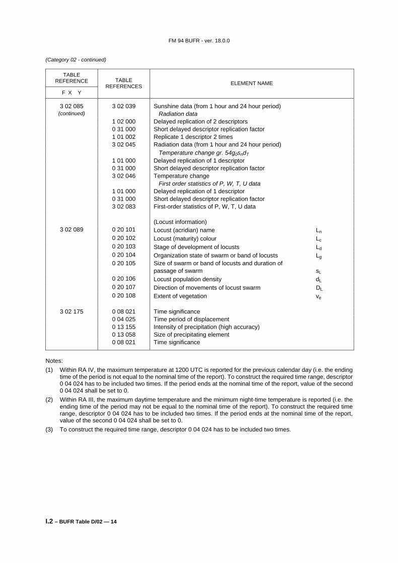
3 02 085 3 02 039 Sunshine data (from 1 hour and 24 hour period) (continued) Radiation data
1 02 000 Delayed replication of 2 descriptors 0 31 000 Short delayed descriptor replication factor 1 01 002 Replicate 1 descriptor 2 times 3 02 045 Radiation data (from 1 hour and 24 hour period) Temperature change gr. 54g0sndT 1 01 000 Delayed replication of 1 descriptor 0 31 000 Short delayed descriptor replication factor 3 02 046 Temperature change First order statistics of P, W, T, U data 1 01 000 Delayed replication of 1 descriptor 0 31 000 Short delayed descriptor replication factor 3 02 083 First-order statistics of P, W, T, U data (Locust information)
3 02 089 0 20 101 Locust (acridian) name Ln 0 20 102 Locust (maturity) colour Lc 0 20 103 Stage of development of locusts Ld 0 20 104 Organization state of swarm or band of locusts Lg 0 20 105 Size of swarm or band of locusts and duration of
passage of swarm sL 0 20 106 Locust population density dL 0 20 107 Direction of movements of locust swarm DL 0 20 108 Extent of vegetation ve
3 02 175 0 08 021 Time significance 0 04 025 Time period of displacement 0 13 155 Intensity of precipitation (high accuracy) 0 13 058 Size of precipitating element 0 08 021 Time significance
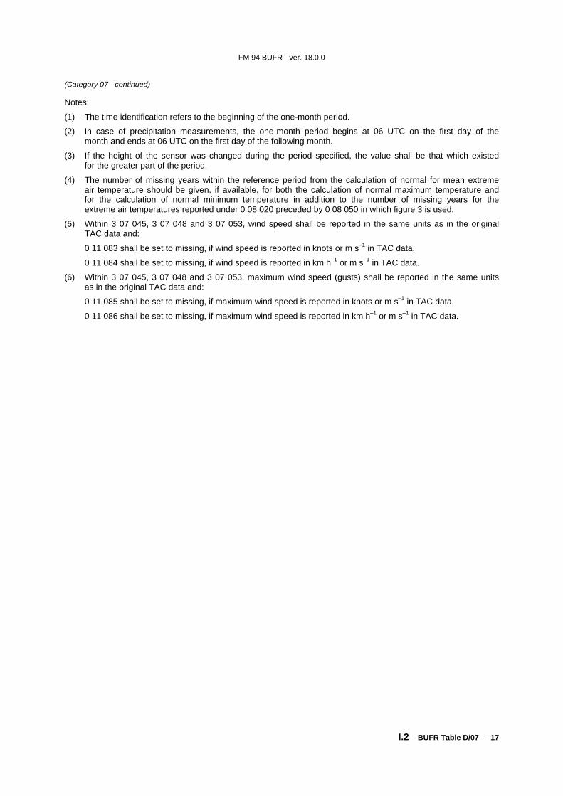
Notes: (1) Within RA IV, the maximum temperature at 1200 UTC is reported for the previous calendar day (i.e. the ending
time of the period is not equal to the nominal time of the report). To construct the required time range, descriptor 0 04 024 has to be included two times. If the period ends at the nominal time of the report, value of the second 0 04 024 shall be set to 0.
(2) Within RA III, the maximum daytime temperature and the minimum night-time temperature is reported (i.e. the ending time of the period may not be equal to the nominal time of the report). To construct the required time range, descriptor 0 04 024 has to be included two times. If the period ends at the nominal time of the report, value of the second 0 04 024 shall be set to 0.
(3) To construct the required time range, descriptor 0 04 024 has to be included two times.
FM 94 BUFR - ver. 18.0.0
I.2 – BUFR Table D/03 — 1
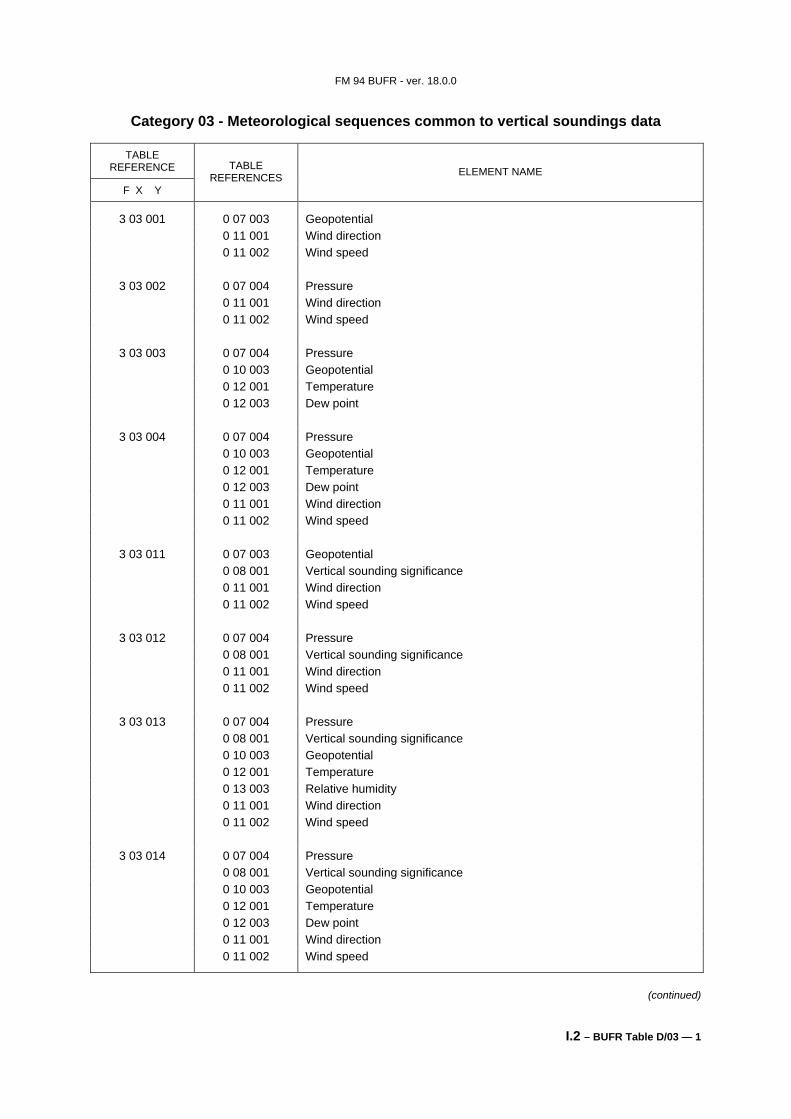
Category 03 - Meteorological sequences common to vertical soundings data
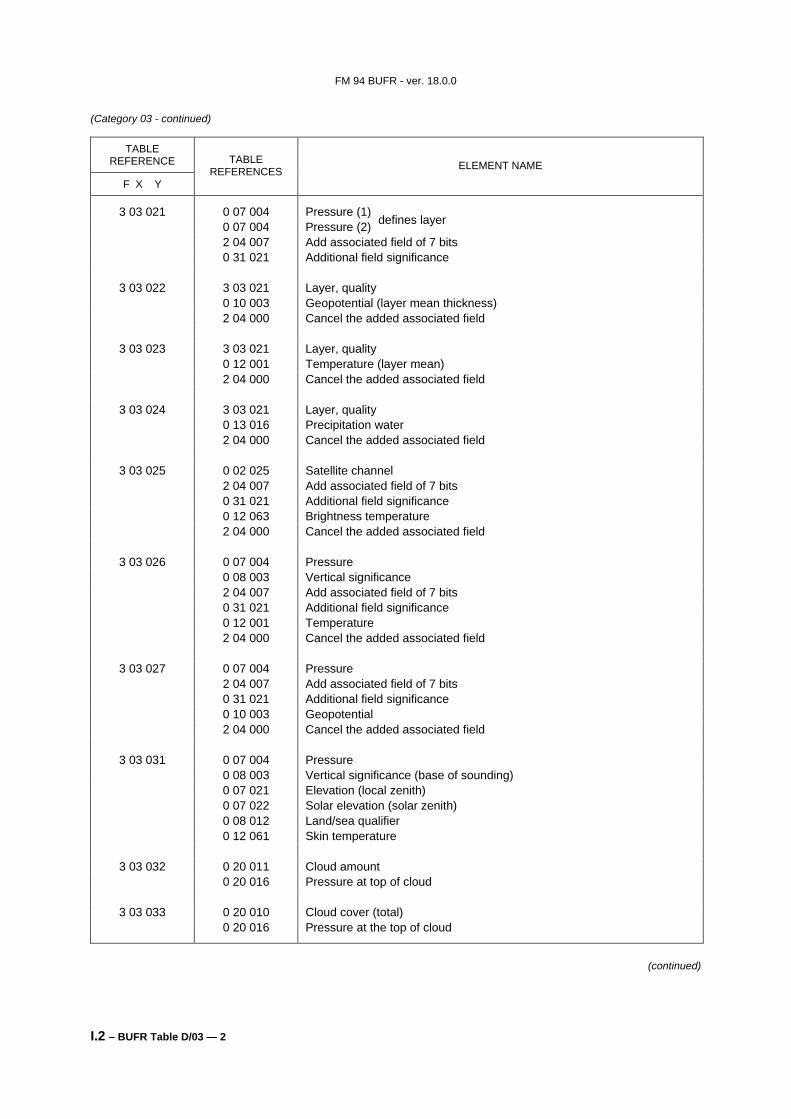
3 03 032 0 20 011 Cloud amount 0 20 016 Pressure at top of cloud
3 03 033 0 20 010 Cloud cover (total) 0 20 016 Pressure at the top of cloud
(continued)
defines layer
FM 94 BUFR - ver. 18.0.0
I.2 – BUFR Table D/03 — 3
(Category 03 - continued)
TABLE REFERENCE
F X Y
TABLE REFERENCES ELEMENT NAME
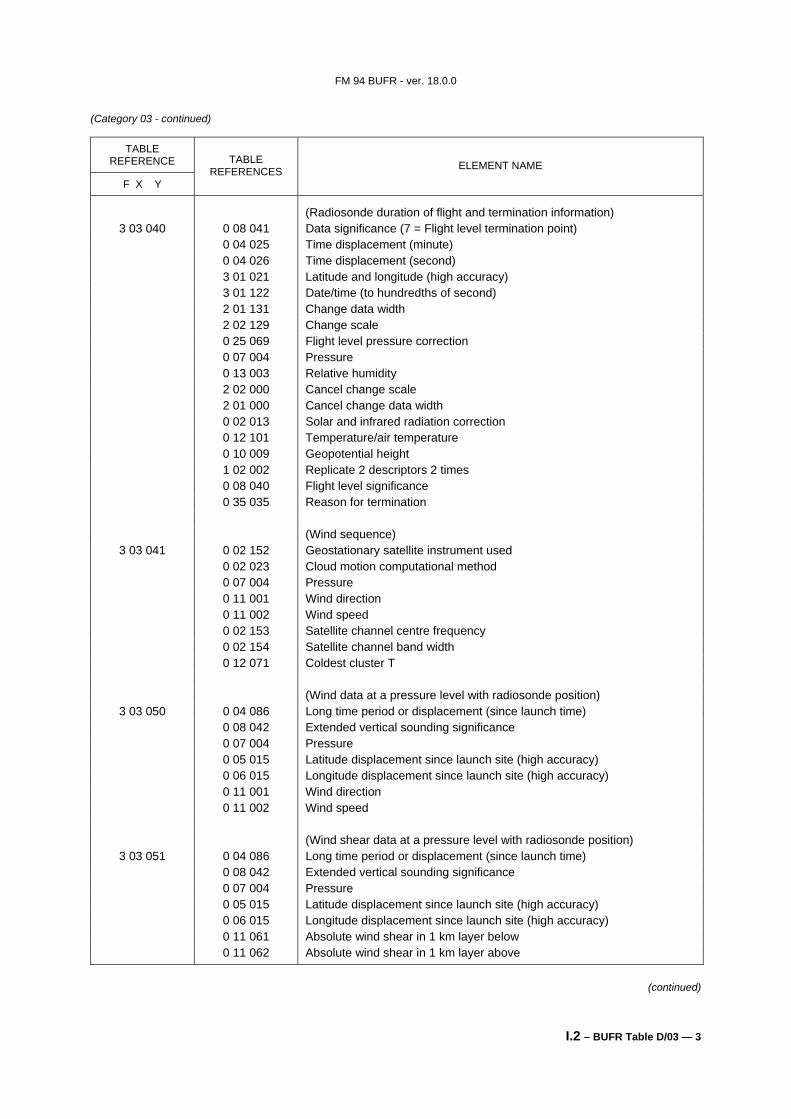
(Radiosonde duration of flight and termination information) 3 03 040 0 08 041 Data significance (7 = Flight level termination point)
0 04 025 Time displacement (minute) 0 04 026 Time displacement (second) 3 01 021 Latitude and longitude (high accuracy) 3 01 122 Date/time (to hundredths of second) 2 01 131 Change data width 2 02 129 Change scale 0 25 069 Flight level pressure correction 0 07 004 Pressure 0 13 003 Relative humidity 2 02 000 Cancel change scale 2 01 000 Cancel change data width 0 02 013 Solar and infrared radiation correction 0 12 101 Temperature/air temperature 0 10 009 Geopotential height 1 02 002 Replicate 2 descriptors 2 times 0 08 040 Flight level significance 0 35 035 Reason for termination (Wind sequence)
3 03 041 0 02 152 Geostationary satellite instrument used 0 02 023 Cloud motion computational method 0 07 004 Pressure 0 11 001 Wind direction 0 11 002 Wind speed 0 02 153 Satellite channel centre frequency 0 02 154 Satellite channel band width 0 12 071 Coldest cluster T (Wind data at a pressure level with radiosonde position)
3 03 050 0 04 086 Long time period or displacement (since launch time) 0 08 042 Extended vertical sounding significance 0 07 004 Pressure 0 05 015 Latitude displacement since launch site (high accuracy) 0 06 015 Longitude displacement since launch site (high accuracy) 0 11 001 Wind direction 0 11 002 Wind speed (Wind shear data at a pressure level with radiosonde position)
3 03 051 0 04 086 Long time period or displacement (since launch time) 0 08 042 Extended vertical sounding significance 0 07 004 Pressure 0 05 015 Latitude displacement since launch site (high accuracy) 0 06 015 Longitude displacement since launch site (high accuracy) 0 11 061 Absolute wind shear in 1 km layer below 0 11 062 Absolute wind shear in 1 km layer above
(continued)
FM 94 BUFR - ver. 18.0.0
I.2 – BUFR Table D/03 — 4
(Category 03 - continued)
TABLE REFERENCE
F X Y
TABLE REFERENCES ELEMENT NAME
(Wind data at a height level with radiosonde position) 3 03 052 0 04 086 Long time period or displacement (since launch time)
0 08 042 Extended vertical sounding significance 0 07 009 Geopotential height 0 05 015 Latitude displacement since launch site (high accuracy) 0 06 015 Longitude displacement since launch site (high accuracy) 0 11 001 Wind direction 0 11 002 Wind speed (Wind shear data at a height level with radiosonde position)
3 03 053 0 04 086 Long time period or displacement (since launch time) 0 08 042 Extended vertical sounding significance 0 07 009 Geopotential height 0 05 015 Latitude displacement since launch site (high accuracy) 0 06 015 Longitude displacement since launch site (high accuracy) 0 11 061 Absolute wind shear in 1 km layer below 0 11 062 Absolute wind shear in 1 km layer above (Temperature, dew-point and wind data at a pressure level with radiosonde
position) 3 03 054 0 04 086 Long time period or displacement (since launch time)
0 08 042 Extended vertical sounding significance 0 07 004 Pressure 0 10 009 Geopotential height 0 05 015 Latitude displacement since launch site (high accuracy) 0 06 015 Longitude displacement since launch site (high accuracy) 0 12 101 Temperature/air temperature (scale 2) 0 12 103 Dew-point temperature (scale 2) 0 11 001 Wind direction 0 11 002 Wind speed (Temperature, dew-point, relative humidity and wind data at height
levels with radiosonde position) 3 03 055 0 04 086 Long time period or displacement (since launch time)
0 08 042 Extended vertical sounding significance 0 07 009 Geopotential height 0 05 015 Latitude displacement since launch site (high accuracy) 0 06 015 Longitude displacement since launch site (high accuracy) 0 12 101 Temperature/air temperature (scale 2) 0 13 009 Relative humidity 0 12 103 Dew-point temperature (scale 2) 0 11 001 Wind direction 0 11 002 Wind speed
Notes: (1) Descriptors 3 03 021 to 3 03 027 are not available in CREX. (2) Long time displacement 0 04 086 represents the time offset from the launch time 3 01 013 (in seconds). (3) Latitude displacement 0 05 015 represents the latitude offset from the latitude of the launch site. Longitude
displacement 0 06 015 represents the longitude offset from the longitude of the launch site.
FM 94 BUFR - ver. 18.0.0
I.2 – BUFR Table D/04 — 1
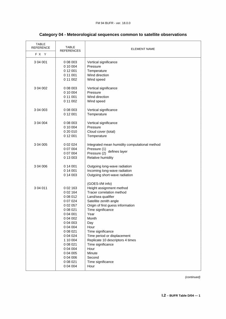
Category 04 - Meteorological sequences common to satellite observations
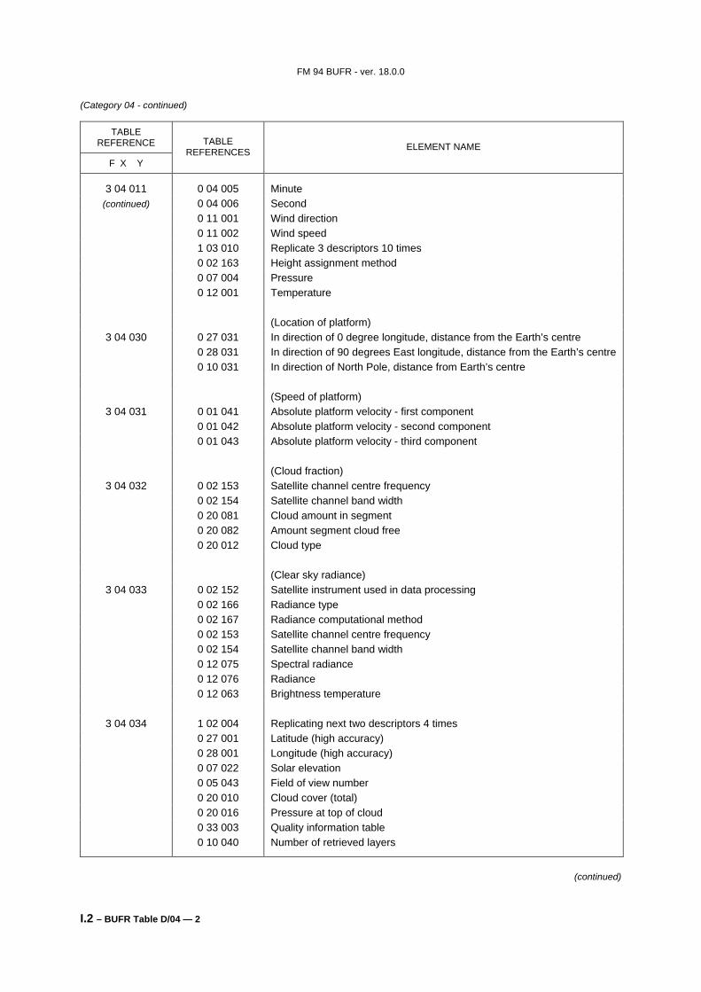
0 11 001 Wind direction 0 11 002 Wind speed 1 03 010 Replicate 3 descriptors 10 times 0 02 163 Height assignment method 0 07 004 Pressure 0 12 001 Temperature (Location of platform)
3 04 030 0 27 031 In direction of 0 degree longitude, distance from the Earth’s centre 0 28 031 In direction of 90 degrees East longitude, distance from the Earth’s centre 0 10 031 In direction of North Pole, distance from Earth’s centre (Speed of platform)
3 04 032 0 02 153 Satellite channel centre frequency 0 02 154 Satellite channel band width 0 20 081 Cloud amount in segment 0 20 082 Amount segment cloud free 0 20 012 Cloud type (Clear sky radiance)
3 04 033 0 02 152 Satellite instrument used in data processing 0 02 166 Radiance type 0 02 167 Radiance computational method 0 02 153 Satellite channel centre frequency 0 02 154 Satellite channel band width 0 12 075 Spectral radiance 0 12 076 Radiance 0 12 063 Brightness temperature
3 04 034 1 02 004 Replicating next two descriptors 4 times 0 27 001 Latitude (high accuracy) 0 28 001 Longitude (high accuracy) 0 07 022 Solar elevation 0 05 043 Field of view number 0 20 010 Cloud cover (total) 0 20 016 Pressure at top of cloud 0 33 003 Quality information table 0 10 040 Number of retrieved layers
(continued)
FM 94 BUFR - ver. 18.0.0
I.2 – BUFR Table D/04 — 3
(Category 04 - continued)
TABLE REFERENCE
F X Y
TABLE REFERENCES ELEMENT NAME
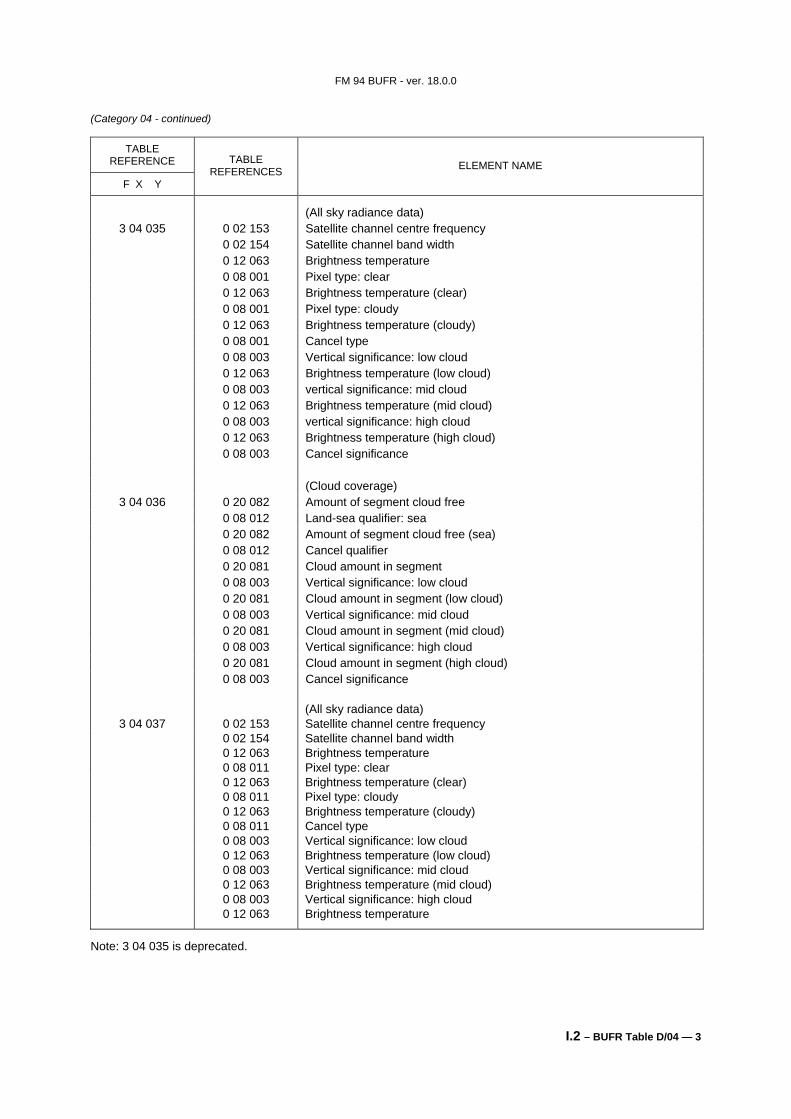
(All sky radiance data) 3 04 035 0 02 153 Satellite channel centre frequency
0 02 154 Satellite channel band width 0 12 063 Brightness temperature 0 08 001 Pixel type: clear 0 12 063 Brightness temperature (clear) 0 08 001 Pixel type: cloudy 0 12 063 Brightness temperature (cloudy) 0 08 001 Cancel type 0 08 003 Vertical significance: low cloud 0 12 063 Brightness temperature (low cloud) 0 08 003 vertical significance: mid cloud 0 12 063 Brightness temperature (mid cloud) 0 08 003 vertical significance: high cloud 0 12 063 Brightness temperature (high cloud) 0 08 003 Cancel significance (Cloud coverage)
3 04 037 0 02 153 Satellite channel centre frequency 0 02 154 Satellite channel band width 0 12 063 Brightness temperature 0 08 011 Pixel type: clear 0 12 063 Brightness temperature (clear) 0 08 011 Pixel type: cloudy 0 12 063 Brightness temperature (cloudy) 0 08 011 Cancel type 0 08 003 Vertical significance: low cloud 0 12 063 Brightness temperature (low cloud) 0 08 003 Vertical significance: mid cloud 0 12 063 Brightness temperature (mid cloud) 0 08 003 Vertical significance: high cloud 0 12 063 Brightness temperature
Note: 3 04 035 is deprecated.
FM 94 BUFR - ver. 18.0.0
I.2 – BUFR Table D/05 — 1
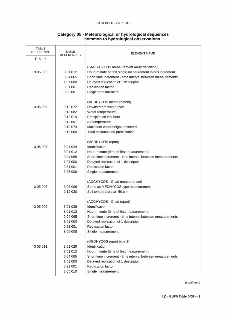
Category 05 - Meteorological or hydrological sequences common to hydrological observations
TABLE
REFERENCE
F X Y
TABLE REFERENCES ELEMENT NAME
(SADC-HYCOS measurement array definition) 3 05 003 3 01 012 Hour, minute of first single measurement minus increment
0 04 065 Short time increment - time interval between measurements 1 01 000 Delayed replication of 1 descriptor 0 31 001 Replication factor 3 05 001 Single measurement (MEDHYCOS measurement)
3 05 006 0 13 072 Downstream water level 0 13 082 Water temperature 0 13 019 Precipitation last hour 0 12 001 Air temperature 0 13 073 Maximum water height observed 0 13 060 Total accumulated precipitation (MEDHYCOS report)
3 05 007 3 01 029 Identification 3 01 012 Hour, minute (time of first measurement) 0 04 065 Short time increment - time interval between measurements 1 01 000 Delayed replication of 1 descriptor 0 31 001 Replication factor 3 05 006 Single measurement (AOCHYCOS - Chad measurement)
3 05 008 3 05 006 Same as MEDHYCOS type measurement 0 12 030 Soil temperature at -50 cm (AOCHYCOS - Chad report)
3 05 009 3 01 029 Identification 3 01 012 Hour, minute (time of first measurement) 0 04 065 Short time increment - time interval between measurements 1 01 000 Delayed replication of 1 descriptor 0 31 001 Replication factor 3 05 008 Single measurement (MEDHYCOS report type 2)
3 05 011 3 01 029 Identification 3 01 012 Hour, minute (time of first measurement) 0 04 065 Short time increment - time interval between measurements 1 01 000 Delayed replication of 1 descriptor 0 31 001 Replication factor 3 05 010 Single measurement
(continued)
FM 94 BUFR - ver. 18.0.0
I.2 – BUFR Table D/05 — 2
(Category 05 - continued)
TABLE REFERENCE
F X Y
TABLE REFERENCES ELEMENT NAME
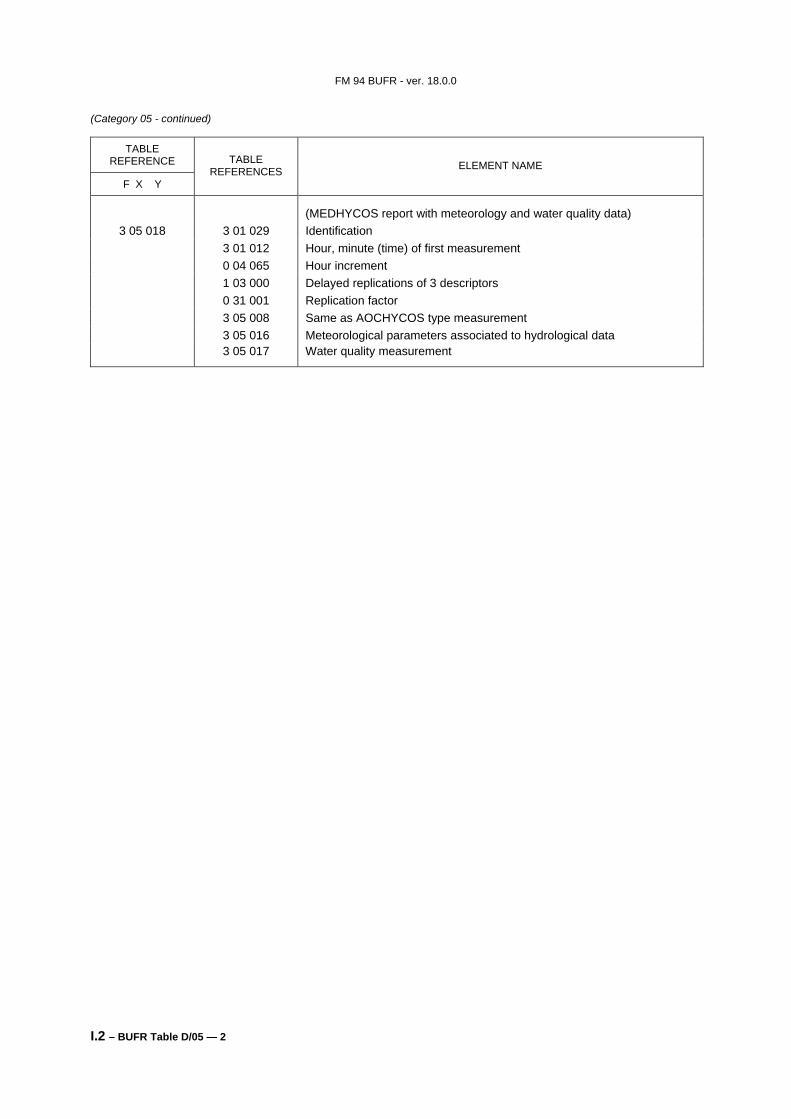
(MEDHYCOS report with meteorology and water quality data) 3 05 018 3 01 029 Identification
3 01 012 Hour, minute (time) of first measurement 0 04 065 Hour increment 1 03 000 Delayed replications of 3 descriptors 0 31 001 Replication factor 3 05 008 Same as AOCHYCOS type measurement 3 05 016 Meteorological parameters associated to hydrological data 3 05 017 Water quality measurement
FM 94 BUFR - ver. 18.0.0
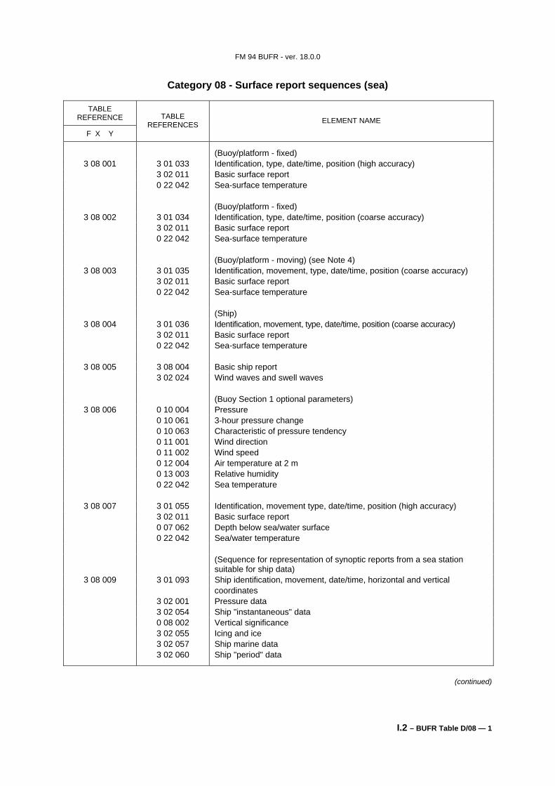
I.2 – BUFR Table D/06 — 1
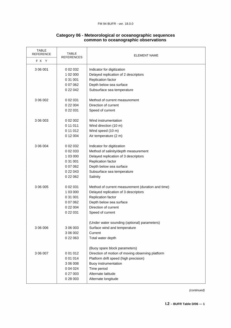
Category 06 - Meteorological or oceanographic sequences common to oceanographic observations
3 06 005 0 02 031 Method of current measurement (duration and time) 1 03 000 Delayed replication of 3 descriptors 0 31 001 Replication factor 0 07 062 Depth below sea surface 0 22 004 Direction of current 0 22 031 Speed of current (Under water sounding (optional) parameters)
3 06 006 3 06 003 Surface wind and temperature 3 06 002 Current 0 22 063 Total water depth (Buoy spare block parameters)
3 06 007 0 01 012 Direction of motion of moving observing platform 0 01 014 Platform drift speed (high precision) 3 06 008 Buoy instrumentation 0 04 024 Time period 0 27 003 Alternate latitude 0 28 003 Alternate longitude
(Tide report identification, water level checks, time increments)
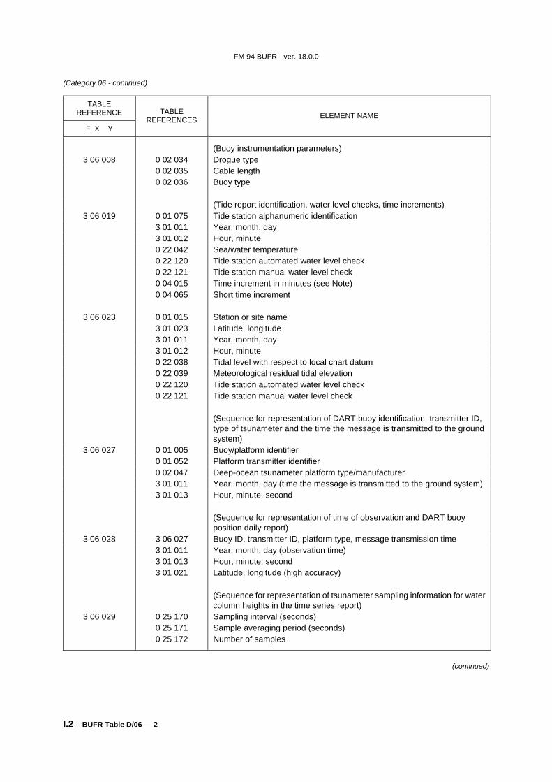
3 06 019 0 01 075 Tide station alphanumeric identification 3 01 011 Year, month, day 3 01 012 Hour, minute 0 22 042 Sea/water temperature 0 22 120 Tide station automated water level check 0 22 121 Tide station manual water level check 0 04 015 Time increment in minutes (see Note) 0 04 065 Short time increment
3 06 023 0 01 015 Station or site name 3 01 023 Latitude, longitude 3 01 011 Year, month, day 3 01 012 Hour, minute 0 22 038 Tidal level with respect to local chart datum 0 22 039 Meteorological residual tidal elevation 0 22 120 Tide station automated water level check 0 22 121 Tide station manual water level check (Sequence for representation of DART buoy identification, transmitter ID,
type of tsunameter and the time the message is transmitted to the ground system)
3 06 027 0 01 005 Buoy/platform identifier 0 01 052 Platform transmitter identifier 0 02 047 Deep-ocean tsunameter platform type/manufacturer 3 01 011 Year, month, day (time the message is transmitted to the ground system) 3 01 013 Hour, minute, second (Sequence for representation of time of observation and DART buoy
position daily report) 3 06 028 3 06 027 Buoy ID, transmitter ID, platform type, message transmission time
3 01 011 Year, month, day (observation time) 3 01 013 Hour, minute, second 3 01 021 Latitude, longitude (high accuracy) (Sequence for representation of tsunameter sampling information for water
column heights in the time series report) 3 06 029 0 25 170 Sampling interval (seconds)
0 25 171 Sample averaging period (seconds) 0 25 172 Number of samples
(continued)
FM 94 BUFR - ver. 18.0.0
I.2 – BUFR Table D/06 — 3
(Category 06 - continued)
TABLE REFERENCE
F X Y
TABLE REFERENCES ELEMENT NAME
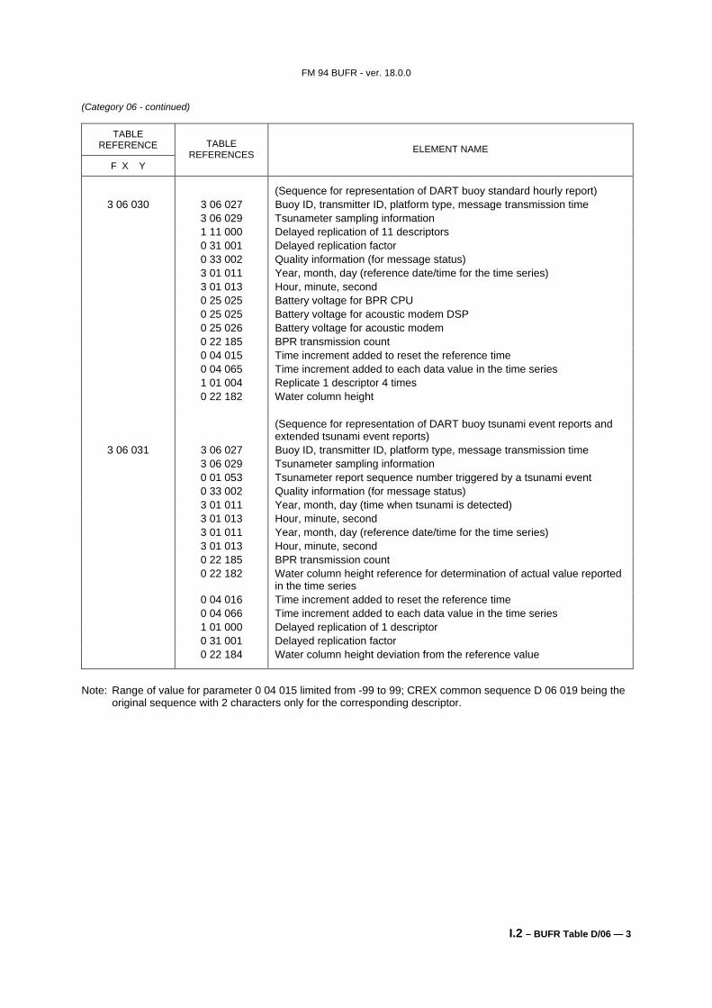
(Sequence for representation of DART buoy standard hourly report) 3 06 030 3 06 027 Buoy ID, transmitter ID, platform type, message transmission time
3 06 029 Tsunameter sampling information 1 11 000 Delayed replication of 11 descriptors 0 31 001 Delayed replication factor 0 33 002 Quality information (for message status) 3 01 011 Year, month, day (reference date/time for the time series) 3 01 013 Hour, minute, second 0 25 025 Battery voltage for BPR CPU 0 25 025 Battery voltage for acoustic modem DSP 0 25 026 Battery voltage for acoustic modem 0 22 185 BPR transmission count 0 04 015 Time increment added to reset the reference time 0 04 065 Time increment added to each data value in the time series 1 01 004 Replicate 1 descriptor 4 times 0 22 182 Water column height (Sequence for representation of DART buoy tsunami event reports and
3 06 029 Tsunameter sampling information 0 01 053 Tsunameter report sequence number triggered by a tsunami event 0 33 002 Quality information (for message status) 3 01 011 Year, month, day (time when tsunami is detected) 3 01 013 Hour, minute, second 3 01 011 Year, month, day (reference date/time for the time series) 3 01 013 Hour, minute, second 0 22 185 BPR transmission count 0 22 182 Water column height reference for determination of actual value reported
in the time series 0 04 016 Time increment added to reset the reference time 0 04 066 Time increment added to each data value in the time series 1 01 000 Delayed replication of 1 descriptor 0 31 001 Delayed replication factor 0 22 184 Water column height deviation from the reference value
Note: Range of value for parameter 0 04 015 limited from -99 to 99; CREX common sequence D 06 019 being the
original sequence with 2 characters only for the corresponding descriptor.
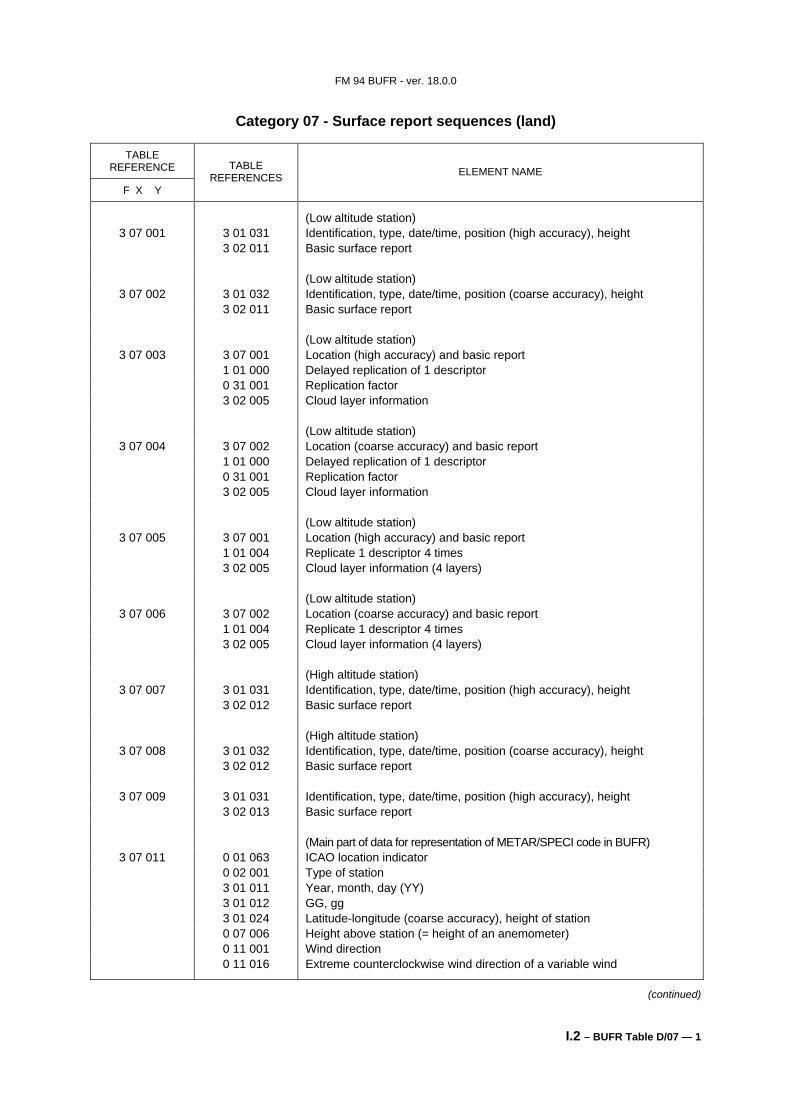
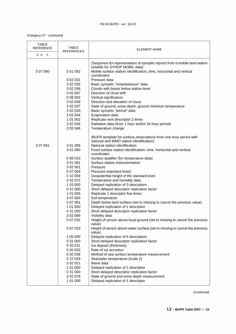
3 07 009 3 01 031 Identification, type, date/time, position (high accuracy), height 3 02 013 Basic surface report (Main part of data for representation of METAR/SPECI code in BUFR)
3 07 011 0 01 063 ICAO location indicator 0 02 001 Type of station 3 01 011 Year, month, day (YY) 3 01 012 GG, gg 3 01 024 Latitude-longitude (coarse accuracy), height of station 0 07 006 Height above station (= height of an anemometer) 0 11 001 Wind direction 0 11 016 Extreme counterclockwise wind direction of a variable wind
(continued)
FM 94 BUFR - ver. 18.0.0
I.2 – BUFR Table D/07 — 2
(Category 07 - continued)
TABLE REFERENCE
F X Y
TABLE REFERENCES ELEMENT NAME
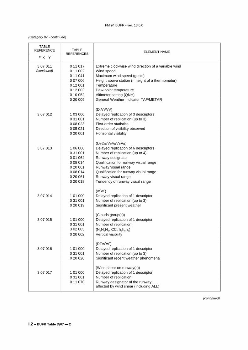
3 07 011 0 11 017 Extreme clockwise wind direction of a variable wind (continued) 0 11 002 Wind speed
0 11 041 Maximum wind speed (gusts) 0 07 006 Height above station (= height of a thermometer) 0 12 001 Temperature 0 12 003 Dew-point temperature 0 10 052 Altimeter setting (QNH) 0 20 009 General Weather Indicator TAF/METAR (DvVVVV)
3 07 012 1 03 000 Delayed replication of 3 descriptors 0 31 001 Number of replication (up to 3) 0 08 023 First-order statistics 0 05 021 Direction of visibility observed 0 20 001 Horizontal visibility (DRDR/VRVRVRVR)
3 07 013 1 06 000 Delayed replication of 6 descriptors 0 31 001 Number of replication (up to 4) 0 01 064 Runway designator 0 08 014 Qualification for runway visual range 0 20 061 Runway visual range 0 08 014 Qualification for runway visual range 0 20 061 Runway visual range 0 20 018 Tendency of runway visual range (w´w´)
3 07 014 1 01 000 Delayed replication of 1 descriptor 0 31 001 Number of replication (up to 3) 0 20 019 Significant present weather (Clouds group(s))
3 07 015 1 01 000 Delayed replication of 1 descriptor 0 31 001 Number of replication 3 02 005 (NsNsNs, CC, hshshs) 0 20 002 Vertical visibility (REw´w´)
3 07 016 1 01 000 Delayed replication of 1 descriptor 0 31 001 Number of replication (up to 3) 0 20 020 Significant recent weather phenomena (Wind shear on runway(s))
3 07 017 1 01 000 Delayed replication of 1 descriptor 0 31 001 Number of replication 0 11 070 Runway designator of the runway
affected by wind shear (including ALL)
(continued)
FM 94 BUFR - ver. 18.0.0
I.2 – BUFR Table D/07 — 3
(Category 07 - continued)
TABLE REFERENCE
F X Y
TABLE REFERENCES ELEMENT NAME
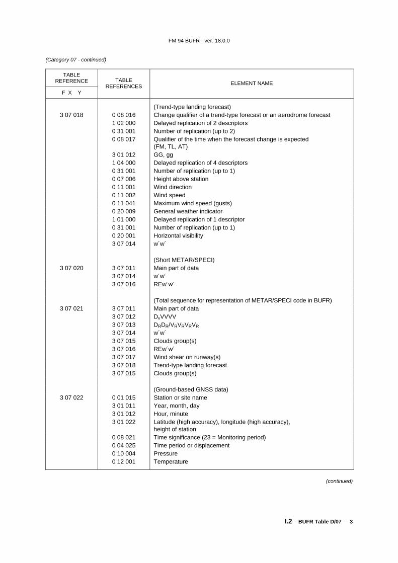
(Trend-type landing forecast) 3 07 018 0 08 016 Change qualifier of a trend-type forecast or an aerodrome forecast
1 02 000 Delayed replication of 2 descriptors 0 31 001 Number of replication (up to 2) 0 08 017 Qualifier of the time when the forecast change is expected
(FM, TL, AT) 3 01 012 GG, gg 1 04 000 Delayed replication of 4 descriptors 0 31 001 Number of replication (up to 1) 0 07 006 Height above station 0 11 001 Wind direction 0 11 002 Wind speed 0 11 041 Maximum wind speed (gusts) 0 20 009 General weather indicator 1 01 000 Delayed replication of 1 descriptor 0 31 001 Number of replication (up to 1) 0 20 001 Horizontal visibility 3 07 014 w´w´ (Short METAR/SPECI)
3 07 020 3 07 011 Main part of data 3 07 014 w´w´ 3 07 016 REw´w´ (Total sequence for representation of METAR/SPECI code in BUFR)
3 07 022 0 01 015 Station or site name 3 01 011 Year, month, day 3 01 012 Hour, minute 3 01 022 Latitude (high accuracy), longitude (high accuracy),
height of station 0 08 021 Time significance (23 = Monitoring period) 0 04 025 Time period or displacement 0 10 004 Pressure 0 12 001 Temperature
(continued)
FM 94 BUFR - ver. 18.0.0
I.2 – BUFR Table D/07 — 4
(Category 07 - continued)
TABLE REFERENCE
F X Y
TABLE REFERENCES ELEMENT NAME
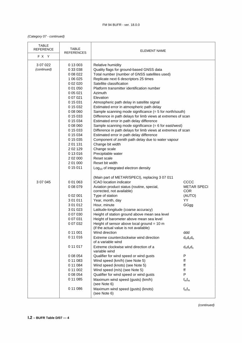
3 07 022 0 13 003 Relative humidity (continued) 0 33 038 Quality flags for ground-based GNSS data
0 08 022 Total number (number of GNSS satellites used) 1 06 025 Replicate next 6 descriptors 25 times 0 02 020 Satellite classification 0 01 050 Platform transmitter identification number 0 05 021 Azimuth 0 07 021 Elevation 0 15 031 Atmospheric path delay in satellite signal 0 15 032 Estimated error in atmospheric path delay 0 08 060 Sample scanning mode significance (= 5 for north/south) 0 15 033 Difference in path delays for limb views at extremes of scan 0 15 034 Estimated error in path delay difference 0 08 060 Sample scanning mode significance (= 6 for east/west) 0 15 033 Difference in path delays for limb views at extremes of scan 0 15 034 Estimated error in path delay difference 0 15 035 Component of zenith path delay due to water vapour 2 01 131 Change bit width 2 02 129 Change scale 0 13 016 Precipitable water 2 02 000 Reset scale 2 01 000 Reset bit width 0 15 011 Log10 of integrated electron density (Main part of METAR/SPECI), replacing 3 07 011
3 07 045 0 01 063 ICAO location indicator CCCC 0 08 079 Aviation product status (routine, special, METAR SPECI
corrected, not available) COR 0 02 001 Type of station (AUTO) 3 01 011 Year, month, day YY 3 01 012 Hour, minute GGgg 3 01 023 Latitude-longitude (coarse accuracy) 0 07 030 Height of station ground above mean sea level 0 07 031 Height of barometer above mean sea level 0 07 032 Height of sensor above local ground = 10 m
(if the actual value is not available) 0 11 001 Wind direction ddd 0 11 016 Extreme counterclockwise wind direction dndndn
of a variable wind 0 11 017 Extreme clockwise wind direction of a dxdxdx
variable wind 0 08 054 Qualifier for wind speed or wind gusts P 0 11 083 Wind speed (km/h) (see Note 5) ff 0 11 084 Wind speed (knots) (see Note 5) ff 0 11 002 Wind speed (m/s) (see Note 5) ff 0 08 054 Qualifier for wind speed or wind gusts P 0 11 085 Maximum wind speed (gusts) (km/h) fmfm
(see Note 6) 0 11 086 Maximum wind speed (gusts) (knots) fmfm
(see Note 6)
(continued)
FM 94 BUFR - ver. 18.0.0
I.2 – BUFR Table D/07 — 5
(Category 07 - continued)
TABLE REFERENCE
F X Y
TABLE REFERENCES ELEMENT NAME
3 07 045 (continued)
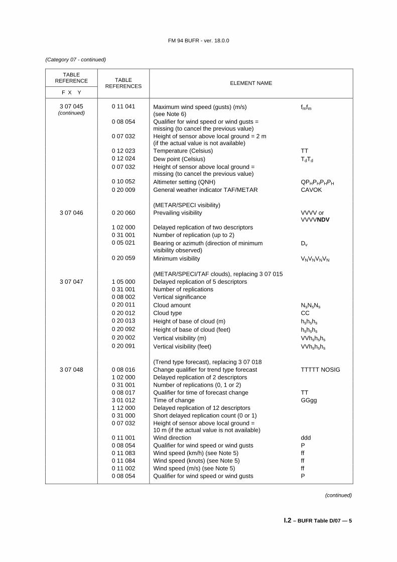
0 11 041 Maximum wind speed (gusts) (m/s) fmfm (see Note 6)
0 08 054 Qualifier for wind speed or wind gusts = missing (to cancel the previous value)
0 07 032 Height of sensor above local ground = 2 m (if the actual value is not available)
0 12 023 Temperature (Celsius) TT 0 12 024 Dew point (Celsius) TdTd 0 07 032 Height of sensor above local ground =
3 07 047 1 05 000 Delayed replication of 5 descriptors 0 31 001 Number of replications 0 08 002 Vertical significance 0 20 011 Cloud amount NsNsNs 0 20 012 Cloud type CC 0 20 013 Height of base of cloud (m) hshshs 0 20 092 Height of base of cloud (feet) hshshs 0 20 002 Vertical visibility (m) VVhshshs 0 20 091 Vertical visibility (feet) VVhshshs (Trend type forecast), replacing 3 07 018
3 07 048 0 08 016 Change qualifier for trend type forecast TTTTT NOSIG 1 02 000 Delayed replication of 2 descriptors 0 31 001 Number of replications (0, 1 or 2) 0 08 017 Qualifier for time of forecast change TT 3 01 012 Time of change GGgg 1 12 000 Delayed replication of 12 descriptors 0 31 000 Short delayed replication count (0 or 1) 0 07 032 Height of sensor above local ground =
10 m (if the actual value is not available) 0 11 001 Wind direction ddd 0 08 054 Qualifier for wind speed or wind gusts P 0 11 083 Wind speed (km/h) (see Note 5) ff 0 11 084 Wind speed (knots) (see Note 5) ff 0 11 002 Wind speed (m/s) (see Note 5) ff 0 08 054 Qualifier for wind speed or wind gusts P
(continued)
FM 94 BUFR - ver. 18.0.0
I.2 – BUFR Table D/07 — 6
(Category 07 - continued)
TABLE REFERENCE
F X Y
TABLE REFERENCES ELEMENT NAME
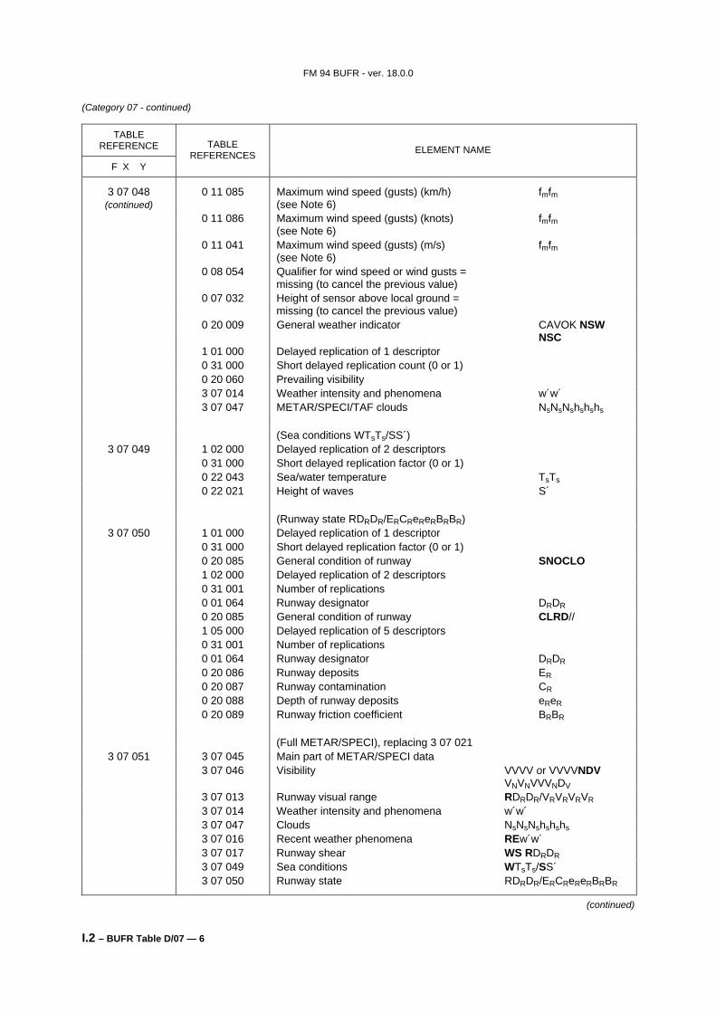
3 07 048 (continued)
0 11 085 Maximum wind speed (gusts) (km/h) fmfm (see Note 6)
0 11 086 Maximum wind speed (gusts) (knots) fmfm (see Note 6)
0 11 041 Maximum wind speed (gusts) (m/s) fmfm (see Note 6)
0 08 054 Qualifier for wind speed or wind gusts = missing (to cancel the previous value)
0 07 032 Height of sensor above local ground = missing (to cancel the previous value)
0 20 009 General weather indicator CAVOK NSW NSC
1 01 000 Delayed replication of 1 descriptor 0 31 000 Short delayed replication count (0 or 1) 0 20 060 Prevailing visibility 3 07 014 Weather intensity and phenomena w´w´ 3 07 047 METAR/SPECI/TAF clouds NsNsNshshshs (Sea conditions WTsTs/SS´)
3 07 049 1 02 000 Delayed replication of 2 descriptors 0 31 000 Short delayed replication factor (0 or 1) 0 22 043 Sea/water temperature TsTs 0 22 021 Height of waves S´ (Runway state RDRDR/ERCReReRBRBR)
3 07 050 1 01 000 Delayed replication of 1 descriptor 0 31 000 Short delayed replication factor (0 or 1) 0 20 085 General condition of runway SNOCLO 1 02 000 Delayed replication of 2 descriptors 0 31 001 Number of replications 0 01 064 Runway designator DRDR 0 20 085 General condition of runway CLRD// 1 05 000 Delayed replication of 5 descriptors 0 31 001 Number of replications 0 01 064 Runway designator DRDR 0 20 086 Runway deposits ER 0 20 087 Runway contamination CR 0 20 088 Depth of runway deposits eReR 0 20 089 Runway friction coefficient BRBR (Full METAR/SPECI), replacing 3 07 021
3 07 051 3 07 045 Main part of METAR/SPECI data 3 07 046 Visibility VVVV or VVVVNDV
3 07 048 Trend type forecast (Aerodrome forecast identification and time interval)
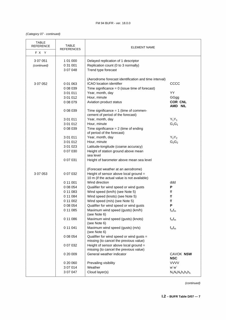
3 07 052 0 01 063 ICAO location identifier CCCC 0 08 039 Time significance = 0 (issue time of forecast) 3 01 011 Year, month, day YY 3 01 012 Hour, minute GGgg 0 08 079 Aviation product status COR CNL
AMD NIL 0 08 039 Time significance = 1 (time of commen-
cement of period of the forecast) 3 01 011 Year, month, day Y1Y1 3 01 012 Hour, minute G1G1 0 08 039 Time significance = 2 (time of ending
of period of the forecast) 3 01 011 Year, month, day Y2Y2 3 01 012 Hour, minute G2G2 3 01 023 Latitude-longitude (coarse accuracy) 0 07 030 Height of station ground above mean
sea level 0 07 031 Height of barometer above mean sea level (Forecast weather at an aerodrome)
3 07 053 0 07 032 Height of sensor above local ground = 10 m (if the actual value is not available)
0 11 001 Wind direction ddd 0 08 054 Qualifier for wind speed or wind gusts P 0 11 083 Wind speed (km/h) (see Note 5) ff 0 11 084 Wind speed (knots) (see Note 5) ff 0 11 002 Wind speed (m/s) (see Note 5) ff 0 08 054 Qualifier for wind speed or wind gusts P 0 11 085 Maximum wind speed (gusts) (km/h) fmfm
(see Note 6) 0 11 086 Maximum wind speed (gusts) (knots) fmfm
(see Note 6) 0 11 041 Maximum wind speed (gusts) (m/s) fmfm
(see Note 6) 0 08 054 Qualifier for wind speed or wind gusts =
missing (to cancel the previous value) 0 07 032 Height of sensor above local ground =
missing (to cancel the previous value) 0 20 009 General weather indicator CAVOK NSW
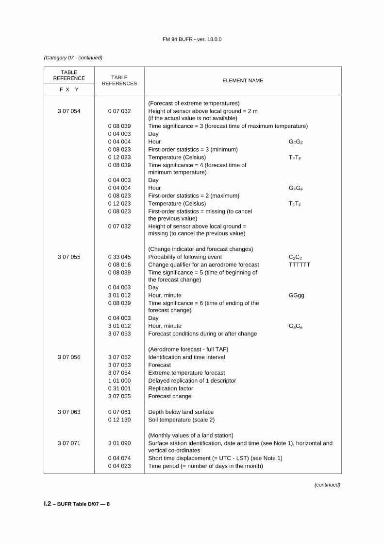
(Forecast of extreme temperatures) 3 07 054 0 07 032 Height of sensor above local ground = 2 m
(if the actual value is not available) 0 08 039 Time significance = 3 (forecast time of maximum temperature) 0 04 003 Day 0 04 004 Hour GFGF 0 08 023 First-order statistics = 3 (minimum) 0 12 023 Temperature (Celsius) TFTF 0 08 039 Time significance = 4 (forecast time of
the previous value) 0 07 032 Height of sensor above local ground =
missing (to cancel the previous value) (Change indicator and forecast changes)
3 07 055 0 33 045 Probability of following event C2C2 0 08 016 Change qualifier for an aerodrome forecast TTTTTT 0 08 039 Time significance = 5 (time of beginning of
the forecast change) 0 04 003 Day 3 01 012 Hour, minute GGgg 0 08 039 Time significance = 6 (time of ending of the
forecast change) 0 04 003 Day 3 01 012 Hour, minute GeGe 3 07 053 Forecast conditions during or after change (Aerodrome forecast - full TAF)
3 07 056 3 07 052 Identification and time interval 3 07 053 Forecast 3 07 054 Extreme temperature forecast 1 01 000 Delayed replication of 1 descriptor 0 31 001 Replication factor 3 07 055 Forecast change
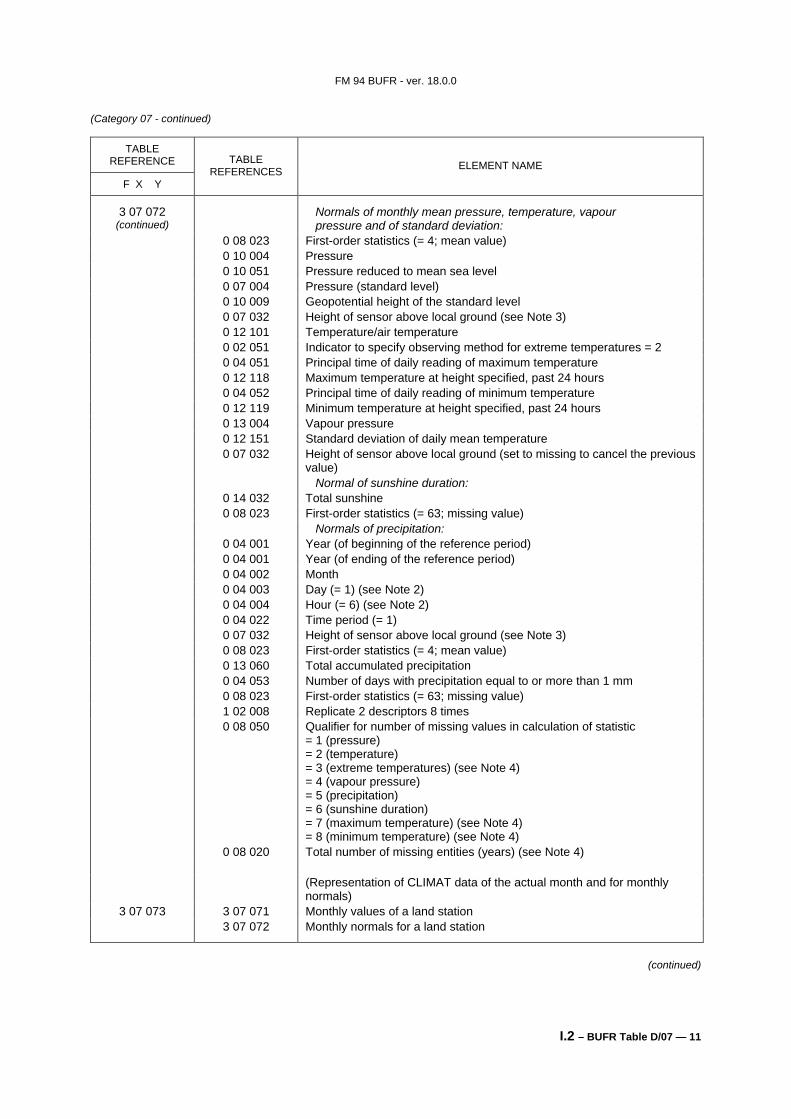
3 07 063 0 07 061 Depth below land surface 0 12 130 Soil temperature (scale 2) (Monthly values of a land station)
3 07 071 3 01 090 Surface station identification, date and time (see Note 1), horizontal and vertical co-ordinates
0 04 074 Short time displacement (= UTC - LST) (see Note 1) 0 04 023 Time period (= number of days in the month)
(continued)
FM 94 BUFR - ver. 18.0.0
I.2 – BUFR Table D/07 — 9
(Category 07 - continued)
TABLE REFERENCE
F X Y
TABLE REFERENCES ELEMENT NAME
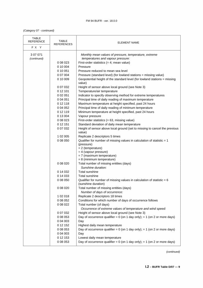
3 07 071 (continued)
Monthly mean values of pressure, temperature, extreme temperatures and vapour pressure:
0 08 023 First-order statistics (= 4; mean value) 0 10 004 Pressure 0 10 051 Pressure reduced to mean sea level 0 07 004 Pressure (standard level) (for lowland stations = missing value) 0 10 009 Geopotential height of the standard level (for lowland stations = missing
value) 0 07 032 Height of sensor above local ground (see Note 3) 0 12 101 Temperature/air temperature 0 02 051 Indicator to specify observing method for extreme temperatures 0 04 051 Principal time of daily reading of maximum temperature 0 12 118 Maximum temperature at height specified, past 24 hours 0 04 052 Principal time of daily reading of minimum temperature 0 12 119 Minimum temperature at height specified, past 24 hours 0 13 004 Vapour pressure 0 08 023 First-order statistics (= 63, missing value) 0 12 151 Standard deviation of daily mean temperature 0 07 032 Height of sensor above local ground (set to missing to cancel the previous
value) 1 02 005 Replicate 2 descriptors 5 times 0 08 050 Qualifier for number of missing values in calculation of statistic = 1
0 08 020 Total number of missing entities (days) Sunshine duration: 0 14 032 Total sunshine 0 14 033 Total sunshine 0 08 050 Qualifier for number of missing values in calculation of statistic = 6
(sunshine duration) 0 08 020 Total number of missing entities (days) Number of days of occurrence: 1 02 018 Replicate 2 descriptors 18 times 0 08 052 Conditions for which number of days of occurrence follows 0 08 022 Total number (of days) Occurrence of extreme values of temperature and wind speed: 0 07 032 Height of sensor above local ground (see Note 3) 0 08 053 Day of occurrence qualifier = 0 (on 1 day only); = 1 (on 2 or more days) 0 04 003 Day 0 12 152 Highest daily mean temperature 0 08 053 Day of occurrence qualifier = 0 (on 1 day only); = 1 (on 2 or more days) 0 04 003 Day 0 12 153 Lowest daily mean temperature 0 08 053 Day of occurrence qualifier = 0 (on 1 day only); = 1 (on 2 or more days)
(continued)
FM 94 BUFR - ver. 18.0.0
I.2 – BUFR Table D/07 — 10
(Category 07 - continued)
TABLE REFERENCE
F X Y
TABLE REFERENCES ELEMENT NAME
3 07 071 0 04 003 Day (continued) 0 08 023 First-order statistics (= 2; maximum value)
0 12 101 Temperature/air temperature 0 08 053 Day of occurrence qualifier = 0 (on 1 day only); = 1 (on 2 or more days) 0 04 003 Day 0 08 023 First-order statistics (= 3; minimum value) 0 12 101 Temperature/air temperature 0 08 023 First-order statistics (= 63; missing value) 0 07 032 Height of sensor above local ground (see Note 3) 0 02 002 Type of instrumentation for wind measurement 0 08 053 Day of occurrence qualifier = 0 (on 1 day only); = 1 (on 2 or more days) 0 04 003 Day 0 11 046 Maximum instantaneous wind speed 0 08 053 Day of occurrence qualifier (set to missing = 3 to cancel the previous value) Precipitation: 0 04 003 Day (= 1) (see Note 2) 0 04 004 Hour (= 6) (see Note 2) 0 04 023 Time period (= number of days in the month) (see Note 2) 0 07 032 Height of sensor above local ground (see Note 3) 0 13 060 Total accumulated precipitation 0 13 051 Frequency group; precipitation 0 04 053 Number of days with precipitation equal to or more than 1 mm 0 08 050 Qualifier for number of missing values in calculation of statistic = 5
(precipitation) 0 08 020 Total number of missing entities (days) Numbers of days of occurrence: 1 02 006 Replicate 2 descriptors 6 times 0 08 052 Conditions for which number of days of occurrence follows 0 08 022 Total number (of days) Occurrence of extreme precipitation: 0 08 053 Day of occurrence qualifier = 0 (on 1 day only); = 1 (on 2 or more days) 0 04 003 Day 0 13 052 Highest daily amount of precipitation 0 07 032 Height of sensor above local ground (set to missing to cancel the previous
value) (Monthly normals for a land station)
3 07 072 0 04 001 Year (of beginning of the reference period) 0 04 001 Year (of ending of the reference period) 0 04 002 Month 0 04 003 Day (= 1) (see Note 1) 0 04 004 Hour (= 0) (see Note 1) 0 04 074 Short time displacement (= UTC - LST) (see Note 1) 0 04 022 Time period (= 1)
(continued)
FM 94 BUFR - ver. 18.0.0
I.2 – BUFR Table D/07 — 11
(Category 07 - continued)
TABLE REFERENCE
F X Y
TABLE REFERENCES ELEMENT NAME
3 07 072 (continued)
Normals of monthly mean pressure, temperature, vapour pressure and of standard deviation:
0 08 023 First-order statistics (= 4; mean value) 0 10 004 Pressure 0 10 051 Pressure reduced to mean sea level 0 07 004 Pressure (standard level) 0 10 009 Geopotential height of the standard level 0 07 032 Height of sensor above local ground (see Note 3) 0 12 101 Temperature/air temperature 0 02 051 Indicator to specify observing method for extreme temperatures = 2 0 04 051 Principal time of daily reading of maximum temperature 0 12 118 Maximum temperature at height specified, past 24 hours 0 04 052 Principal time of daily reading of minimum temperature 0 12 119 Minimum temperature at height specified, past 24 hours 0 13 004 Vapour pressure 0 12 151 Standard deviation of daily mean temperature 0 07 032 Height of sensor above local ground (set to missing to cancel the previous
value) Normal of sunshine duration: 0 14 032 Total sunshine 0 08 023 First-order statistics (= 63; missing value) Normals of precipitation: 0 04 001 Year (of beginning of the reference period) 0 04 001 Year (of ending of the reference period) 0 04 002 Month 0 04 003 Day (= 1) (see Note 2) 0 04 004 Hour (= 6) (see Note 2) 0 04 022 Time period (= 1) 0 07 032 Height of sensor above local ground (see Note 3) 0 08 023 First-order statistics (= 4; mean value) 0 13 060 Total accumulated precipitation 0 04 053 Number of days with precipitation equal to or more than 1 mm 0 08 023 First-order statistics (= 63; missing value) 1 02 008 Replicate 2 descriptors 8 times 0 08 050 Qualifier for number of missing values in calculation of statistic
0 08 020 Total number of missing entities (years) (see Note 4) (Representation of CLIMAT data of the actual month and for monthly
normals) 3 07 073 3 07 071 Monthly values of a land station
3 07 072 Monthly normals for a land station
(continued)
FM 94 BUFR - ver. 18.0.0
I.2 – BUFR Table D/07 — 12
(Category 07 - continued)
TABLE REFERENCE
F X Y
TABLE REFERENCES ELEMENT NAME
(Sequence for representation of synoptic reports from fixed land stations suitable for SYNOP data and for maritime data from coastal stations)
3 07 079 3 01 090 Fixed surface station identification, time, horizontal and vertical coordinates
3 02 031 Pressure data 3 02 035 Basic synoptic "instantaneous" data 3 02 036 Clouds with bases below station level 1 01 000 Delayed replication of 1 descriptor 0 31 000 Short delayed descriptor replication factor 3 02 047 Direction of cloud drift 0 08 002 Vertical significance 1 01 000 Delayed replication of 1 descriptor 0 31 000 Short delayed descriptor replication factor 3 02 048 Direction and elevation of cloud 3 02 037 State of ground, snow depth, ground minimum temperature 1 02 000 Delayed replication of 2 descriptors 0 31 000 Short delayed descriptor replication factor 0 22 061 State of the sea 0 20 058 Visibility seawards from a coastal station 1 01 000 Delayed replication of 1 descriptor 0 31 000 Short delayed descriptor replication factor 3 02 056 Sea/water surface temperature, method of measurement, depth below
water surface 1 01 000 Delayed replication of 1 descriptor 0 31 000 Short delayed descriptor replication factor 3 02 055 Icing and ice 3 02 043 Basic synoptic "period" data 3 02 044 Evaporation data 1 01 000 Delayed replication of 1 descriptor 0 31 001 Delayed descriptor replication factor 3 02 045 Radiation data 1 01 000 Delayed replication of 1 descriptor 0 31 000 Short delayed descriptor replication factor 3 02 046 Temperature change (Sequence for representation of synoptic reports from a fixed land station
suitable for SYNOP data) 3 07 080 3 01 090 Fixed surface station identification, time, horizontal and vertical
coordinates 3 02 031 Pressure data 3 02 035 Basic synoptic "instantaneous" data 3 02 036 Clouds with bases below station level 3 02 047 Direction of cloud drift 0 08 002 Vertical significance 3 02 048 Direction and elevation of cloud 3 02 037 State of ground, snow depth, ground minimum temperature 3 02 043 Basic synoptic "period" data 3 02 044 Evaporation data 1 01 002 Replicate next descriptor 2 times 3 02 045 Radiation data (from 1 hour and/or 24 hour period) 3 02 046 Temperature change
(continued)
FM 94 BUFR - ver. 18.0.0
I.2 – BUFR Table D/07 — 13
(Category 07 - continued)
TABLE REFERENCE
F X Y
TABLE REFERENCES ELEMENT NAME
(Sequence for representation of synoptic reports from a fixed land station suitable for SYNOP data in compliance with reporting practices in RA I)
3 07 081 3 01 090 Fixed surface station identification, time, horizontal and vertical coordinates
3 02 031 Pressure data 3 02 035 Basic synoptic "instantaneous" data 3 02 036 Clouds with bases below station level 3 02 047 Direction of cloud drift 0 08 002 Vertical significance (= missing to cancel the previous value) 3 02 048 Direction and elevation of cloud 3 02 037 State of ground, snow depth, ground minimum temperature 0 12 122 Ground minimum temperature of the preceding night 0 13 056 Character and intensity of precipitation 0 13 057 Time of beginning or end of precipitation 0 20 101 Locust (acridian) name 0 20 102 Locust (maturity) colour 0 20 103 Stage of development of locusts 0 20 104 Organization state of swarm or band of locusts 0 20 105 Size of swarm or band of locusts and duration of passage of swarm 0 20 106 Locust population density 0 20 107 Direction of movements of locust swarm 0 20 108 Extent of vegetation 3 02 043 Basic synoptic "period" data 3 02 044 Evaporation data 1 01 002 Replicate next descriptor 2 times 3 02 045 Radiation data (from 1 hour and/or 24 hour period) 3 02 046 Temperature change (Sequence for representation of synoptic reports from a fixed land station
suitable for SYNOP data in compliance with reporting practices in RA II) 3 07 082 3 01 090 Fixed surface station identification, time, horizontal and vertical
coordinates 3 02 031 Pressure data 3 02 035 Basic synoptic "instantaneous" data 3 02 036 Clouds with bases below station level 3 02 047 Direction of cloud drift 0 08 002 Vertical significance (= missing to cancel the previous value) 3 02 048 Direction and elevation of cloud 3 02 037 State of ground, snow depth, ground minimum temperature 0 12 121 Ground minimum temperature (at the time of observation) 0 12 122 Ground minimum temperature of the preceding night 3 02 043 Basic synoptic "period" data 3 02 044 Evaporation data 1 01 002 Replicate next descriptor 2 times 3 02 045 Radiation data (from 1 hour and/or 24 hour period) 3 02 046 Temperature change
(continued)
FM 94 BUFR - ver. 18.0.0
I.2 – BUFR Table D/07 — 14
(Category 07 - continued)
TABLE REFERENCE
F X Y
TABLE REFERENCES ELEMENT NAME
(Sequence for representation of synoptic reports from a fixed land station suitable for SYNOP data in compliance with reporting practices in RA III)
3 07 083 3 01 090 Fixed surface station identification, time, horizontal and vertical coordinates
3 02 031 Pressure data 3 02 035 Basic synoptic "instantaneous" data 3 02 036 Clouds with bases below station level 3 02 047 Direction of cloud drift 0 08 002 Vertical significance (= missing to cancel the previous value) 3 02 048 Direction and elevation of cloud 3 02 037 State of ground, snow depth, ground minimum temperature 0 12 122 Ground minimum temperature of the preceding night 3 02 043 Basic synoptic "period" data 3 02 044 Evaporation data 1 01 002 Replicate next descriptor 2 times 3 02 045 Radiation data (from 1 hour and/or 24 hour period) 3 02 046 Temperature change (Sequence for representation of synoptic reports from a fixed land station
suitable for SYNOP data in compliance with reporting practices in RA IV) 3 07 084 3 01 090 Fixed surface station identification, time, horizontal and vertical
coordinates 3 02 031 Pressure data 3 02 035 Basic synoptic "instantaneous" data 3 02 036 Clouds with bases below station level 3 02 047 Direction of cloud drift 0 08 002 Vertical significance (= missing to cancel the previous value) 3 02 048 Direction and elevation of cloud 3 02 037 State of ground, snow depth, ground minimum temperature 0 20 055 State of sky in tropics 1 01 000 Delayed replication of 1 descriptor 0 31 001 Delayed descriptor replication factor 2 05 001 Character field of 1 character 3 02 043 Basic synoptic "period" data 3 02 044 Evaporation data 1 01 002 Replicate next descriptor 2 times 3 02 045 Radiation data (from 1 hour and/or 24 hour period) 3 02 046 Temperature change (Sequence for representation of synoptic reports from a fixed land station
suitable for SYNOP data in compliance with reporting practices in RA VI) 3 07 086 3 01 090 Fixed surface station identification, time, horizontal and vertical
coordinates 3 02 031 Pressure data 3 02 035 Basic synoptic "instantaneous" data 3 02 036 Clouds with bases below station level 0 08 002 Vertical significance (= missing to cancel the previous value) 3 02 037 State of ground, snow depth, ground minimum temperature 3 02 066 Dangerous weather phenomena 3 02 043 Basic synoptic "period" data 3 02 044 Evaporation data 1 01 002 Replicate next descriptor 2 times 3 02 045 Radiation data (from 1 hour and/or 24 hour period)
(continued)
FM 94 BUFR - ver. 18.0.0
I.2 – BUFR Table D/07 — 15
(Category 07 - continued)
TABLE REFERENCE
F X Y
TABLE REFERENCES ELEMENT NAME
(Sequence for representation of synoptic reports from a mobile land station suitable for SYNOP MOBIL data)
3 07 090 3 01 092 Mobile surface station identification, time, horizontal and vertical coordinates
3 02 031 Pressure data 3 02 035 Basic synoptic "instantaneous" data 3 02 036 Clouds with bases below station level 3 02 047 Direction of cloud drift 0 08 002 Vertical significance 3 02 048 Direction and elevation of cloud 3 02 037 State of ground, snow depth, ground minimum temperature 3 02 043 Basic synoptic "period" data 3 02 044 Evaporation data 1 01 002 Replicate next descriptor 2 times 3 02 045 Radiation data (from 1 hour and/or 24 hour period) 3 02 046 Temperature change (BUFR template for surface observations from one-hour period with
national and WMO station identification) 3 07 091 3 01 089 National station identification
3 01 090 Fixed surface station identification; time, horizontal and vertical coordinates
0 08 010 Surface qualifier (for temperature data) 3 01 091 Surface station instrumentation 3 02 001 Pressure 0 07 004 Pressure (standard level) 0 10 009 Geopotential height of the standard level 3 02 072 Temperature and humidity data 1 03 000 Delayed replication of 3 descriptors 0 31 000 Short delayed descriptor replication factor 1 01 005 Replicate 1 descriptor five times 3 07 063 Soil temperature 0 07 061 Depth below land surface (set to missing to cancel the previous value) 1 01 000 Delayed replication of 1 descriptor 0 31 000 Short delayed descriptor replication factor 3 02 069 Visibility data 0 07 032 Height of sensor above local ground (set to missing to cancel the previous
value) 0 07 033 Height of sensor above water surface (set to missing to cancel the previous
value) 1 05 000 Delayed replication of 5 descriptors 0 31 000 Short delayed descriptor replication factor 0 20 031 Ice deposit (thickness) 0 20 032 Rate of ice accretion 0 02 038 Method of sea surface temperature measurement 0 22 043 Sea/water temperature (scale 2) 3 02 021 Wave data 1 01 000 Delayed replication of 1 descriptor 0 31 000 Short delayed descriptor replication factor 3 02 078 State of ground and snow depth measurement 1 01 000 Delayed replication of 1 descriptor
(continued)
FM 94 BUFR - ver. 18.0.0
I.2 – BUFR Table D/07 — 16
(Category 07 - continued)
TABLE REFERENCE
F X Y
TABLE REFERENCES ELEMENT NAME
3 07 091 0 31 000 Short delayed descriptor replication factor (continued) 3 02 073 Cloud data
1 01 000 Delayed replication of 1 descriptor 0 31 000 Short delayed descriptor replication factor 3 02 074 Present and past weather 1 01 000 Delayed replication of 1 descriptor 0 31 000 Short delayed descriptor replication factor 3 02 175 Intensity of precipitation, size of precipitation element 1 02 000 Delayed replication of 2 descriptors 0 31 000 Short delayed descriptor replication factor 0 04 025 Time period (= -10 minutes) 3 02 076 Precipitation, obscuration and other phenomena 3 02 071 Wind data from one-hour period 3 02 077 Extreme temperature data 0 07 033 Height of sensor above water surface (set to missing to cancel the previous
value) 1 01 000 Delayed replication of 1 descriptor 0 31 000 Short delayed descriptor replication factor 3 02 079 Precipitation measurement 0 07 032 Height of sensor above local ground (set to missing to cancel the previous
value) 1 01 000 Delayed replication of 1 descriptor 0 31 000 Short delayed descriptor replication factor 3 02 080 Evaporation measurement 1 01 000 Delayed replication of 1 descriptor 0 31 000 Short delayed descriptor replication factor 3 02 081 Total sunshine data 1 01 000 Delayed replication of 1 descriptor 0 31 000 Short delayed descriptor replication factor 3 02 082 Radiation data 1 02 000 Delayed replication of 2 descriptors 0 31 000 Short delayed descriptor replication factor 0 04 025 Time period (= -10 minutes) 0 13 059 Number of flashes 1 01 000 Delayed replication of 1 descriptor 0 31 000 Short delayed descriptor replication factor 3 02 083 First-order statistics of P, W, T, U data 0 33 005 Quality information (AWS data) 0 33 006 Internal measurement status information (AWS)
(Sequence for representation of SYNOP with supplementary information on one-hour observations)
3 07 096 3 01 090 Fixed surface station identification, time, horizontal and vertical coordinates
3 01 089 National station identification 0 08 010 Surface qualifier (for temperature data) 3 01 091 Surface station instrumentation 3 02 084 "Instantaneous" data of sequence 3 07 096 3 02 085 "Period" data of sequence 3 07 096 0 33 005 Quality information (AWS data) 0 33 006 Internal measurement status information (AWS)
(continued)
FM 94 BUFR - ver. 18.0.0
I.2 – BUFR Table D/07 — 17
(Category 07 - continued) Notes:
(1) The time identification refers to the beginning of the one-month period.
(2) In case of precipitation measurements, the one-month period begins at 06 UTC on the first day of the month and ends at 06 UTC on the first day of the following month.
(3) If the height of the sensor was changed during the period specified, the value shall be that which existed for the greater part of the period.
(4) The number of missing years within the reference period from the calculation of normal for mean extreme air temperature should be given, if available, for both the calculation of normal maximum temperature and for the calculation of normal minimum temperature in addition to the number of missing years for the extreme air temperatures reported under 0 08 020 preceded by 0 08 050 in which figure 3 is used.
(5) Within 3 07 045, 3 07 048 and 3 07 053, wind speed shall be reported in the same units as in the original TAC data and:
0 11 083 shall be set to missing, if wind speed is reported in knots or m s–1 in TAC data,
0 11 084 shall be set to missing, if wind speed is reported in km h–1 or m s–1 in TAC data.
(6) Within 3 07 045, 3 07 048 and 3 07 053, maximum wind speed (gusts) shall be reported in the same units as in the original TAC data and:
0 11 085 shall be set to missing, if maximum wind speed is reported in knots or m s–1 in TAC data,
0 11 086 shall be set to missing, if maximum wind speed is reported in km h–1 or m s–1 in TAC data.
3 08 006 0 10 004 Pressure 0 10 061 3-hour pressure change 0 10 063 Characteristic of pressure tendency 0 11 001 Wind direction 0 11 002 Wind speed 0 12 004 Air temperature at 2 m 0 13 003 Relative humidity 0 22 042 Sea temperature
3 08 007 3 01 055 Identification, movement type, date/time, position (high accuracy) 3 02 011 Basic surface report 0 07 062 Depth below sea/water surface 0 22 042 Sea/water temperature (Sequence for representation of synoptic reports from a sea station
suitable for ship data) 3 08 009 3 01 093 Ship identification, movement, date/time, horizontal and vertical
coordinates 3 02 001 Pressure data 3 02 054 Ship "instantaneous" data 0 08 002 Vertical significance 3 02 055 Icing and ice 3 02 057 Ship marine data 3 02 060 Ship "period" data
(continued)
FM 94 BUFR - ver. 18.0.0
I.2 – BUFR Table D/08 — 2
(Category 07 - continued)
TABLE REFERENCE
F X Y
TABLE REFERENCES ELEMENT NAME
(TRACKOB Template) 3 08 010 0 01 011 Ship or mobile land station identifier
1 13 000 Delayed replication of 13 descriptors 0 31 001 Delayed descriptor replication factor 3 01 011 Date 3 01 012 Time 3 01 021 Latitude/longitude (high accuracy) 0 04 080 Averaging period for following value 0 22 049 Sea surface temperature 0 04 080 Averaging period for following value 0 22 059 Sea surface salinity 0 04 080 Averaging period for following value 0 22 005 Direction of sea surface current 0 02 042 Indicator for sea surface current speed 0 22 032 Speed of sea surface current 0 02 042 Indicator for sea surface current speed (cancel) 0 04 080 Averaging period for following value (cancel) (Monthly values from an ocean weather station - CLIMAT SHIP)
3 08 011 0 01 011 Ship's call sign 0 02 001 Type of station 3 01 011 Date (see Note 1) 3 01 012 Time (see Note 1) 3 01 023 Latitude (coarse accuracy), longitude (coarse accuracy) 0 07 030 Height of station platform above mean sea level (see Note 3) 0 07 031 Height of barometer above mean sea level (see Note 3) Monthly mean values of pressure, temperature, vapour
pressure and sea/water temperature: 0 04 074 Short time displacement (= UTC - LST) (see Note 1) 0 04 023 Time period (= number of days in the month) 0 08 023 First-order statistics (= 4; mean value) 0 10 051 Pressure reduced to mean sea level 0 07 032 Height of sensor above marine deck platform (for temperature
measurement) (see Note 3) 0 07 033 Height of sensor above water surface (for temperature measurement) (see
Note 3) 0 12 101 Temperature/air temperature 0 13 004 Vapour pressure 0 07 032 Height of sensor above marine deck platform (set to missing to cancel the
previous value) 0 07 033 Height of sensor above water surface (set to missing to cancel the previous
value) 3 02 056 Sea surface temperature, method of measurement, and depth below sea
3 08 011 Precipitation: (continued) 0 04 003 Day (= 1) (see Note 2)
0 04 004 Hour (= 6) (see Note 2) 0 04 023 Time period (= number of days in the month) (see Note 2) 0 07 032 Height of sensor above marine deck platform (see Note 3) 0 13 060 Total accumulated precipitation 0 13 051 Frequency group; precipitation 0 04 053 Number of days with precipitation equal to or more than 1 mm 0 07 032 Height of sensor above marine deck platform (set to missing to cancel the
previous value) (Monthly normals from an ocean weather station)
3 08 012 0 04 001 Year (of beginning of the reference period) 0 04 001 Year (of ending of the reference period) 0 04 002 Month 0 04 003 Day (= 1) (see Note 1) 0 04 004 Hour (= 0) (see Note 1) 0 04 074 Short time displacement (= UTC - LST) (see Note 1) 0 04 022 Time period (= 1) Normals of monthly mean pressure, temperature, vapour
pressure and sea/water temperature: 0 08 023 First-order statistics (= 4; mean value) 0 10 051 Pressure reduced to mean sea level 0 07 032 Height of sensor above marine deck platform (for temperature
measurement) (see Note 3) 0 07 033 Height of sensor above water surface (for temperature measurement) (see
Note 3) 0 12 101 Temperature/air temperature 0 13 004 Vapour pressure 0 07 032 Height of sensor above marine deck platform (set to missing to cancel the
previous value) 0 07 033 Height of sensor above water surface (set to missing to cancel the previous
value) 3 02 056 Sea surface temperature, method of measurement, and depth below sea
surface 0 08 023 First-order statistics (= 63; missing value) 0 04 001 Year (of beginning of the reference period) 0 04 001 Year (of ending of the reference period) 0 04 002 Month 0 04 003 Day (= 1) (see Note 2) 0 04 004 Hour (= 6) (see Note 2) 0 04 022 Time period (= 1) Normals of precipitation: 0 07 032 Height of sensor above marine deck platform (for precipitation
measurement) (see Note 3) 0 08 023 First-order statistics (= 4; mean value) 0 13 060 Total accumulated precipitation 0 04 053 Number of days with precipitation equal to or more than 1 mm 0 08 023 First-order statistics (= 63; missing value)
(continued)
FM 94 BUFR - ver. 18.0.0
I.2 – BUFR Table D/08 — 4
(Category 08 - continued)
TABLE REFERENCE
F X Y
TABLE REFERENCES ELEMENT NAME
(Representation of CLIMAT SHIP data of the actual month and for monthly normals)
3 08 013 3 08 011 Monthly values from an ocean weather station 3 08 012 Monthly normals from an ocean weather station
Notes: (1) The time identification refers to the beginning of the one-month period. (2) In case of precipitation measurements, the one-month period begins at 06 UTC on the first day of the
month and ends at 06 UTC on the first day of the following month. (3) If the height of the sensor was changed during the period specified, the value shall be that which
existed for the greater part of the period. (4) Descriptor 3 08 007 should be used instead of 3 08 003 to encode moving buoy/platform information.
0 07 004 Pressure 0 15 003 Measured ozone partial pressure (Sequence for representation of PILOT, PILOT SHIP and PILOT MOBIL
observation type data with pressure as the vertical coordinate) 3 09 050 3 01 110 Identification of launch site and instrumentation for wind measurements
3 01 113 Date/time of launch 3 01 114 Horizontal and vertical coordinates of launch site 1 01 000 Delayed replication of 1 descriptor 0 31 002 Extended delayed descriptor replication factor 3 03 050 Wind data at a pressure level 1 01 000 Delayed replication of 1 descriptor 0 31 001 Delayed descriptor replication factor 3 03 051 Wind shear data at a pressure level (Sequence for representation of PILOT, PILOT SHIP and PILOT MOBIL
observation type data with height as the vertical coordinate) 3 09 051 3 01 110 Identification of launch site and instrumentation for wind mea-
surements 3 01 113 Date/time of launch 3 01 114 Horizontal and vertical coordinates of launch site 1 01 000 Delayed replication of 1 descriptor 0 31 002 Extended delayed descriptor replication factor 3 03 052 Wind data at a height level 1 01 000 Delayed replication of 1 descriptor 0 31 001 Delayed descriptor replication factor 3 03 053 Wind shear data at a height level (Sequence for representation of TEMP, TEMP SHIP and TEMP MOBIL
observation type data) 3 09 052 3 01 111 Identification of launch site and instrumentation for P, T, U and wind
measurements 3 01 113 Date/time of launch 3 01 114 Horizontal and vertical coordinates of launch site 3 02 049 Cloud information reported with vertical soundings 0 22 043 Sea water temperature 1 01 000 Delayed replication of 1 descriptor 0 31 002 Extended delayed descriptor replication factor 3 03 054 Temperature, dew-point and wind data at a pressure level 1 01 000 Delayed replication of 1 descriptor 0 31 001 Delayed descriptor replication factor 3 03 051 Wind shear data at a pressure level
(continued)
FM 94 BUFR - ver. 18.0.0
I.2 – BUFR Table D/09 — 5
(Category 09 - continued)
TABLE REFERENCE
F X Y
TABLE REFERENCES ELEMENT NAME
(Sequence for representation of TEMP DROP observation type data) 3 09 053 3 01 112 Identification of launch point and instrumentation of dropsonde
3 01 113 Date/time of launch 3 01 114 Horizontal and vertical coordinates of launch site 1 01 000 Delayed replication of 1 descriptor 0 31 002 Extended delayed descriptor replication factor 3 03 054 Temperature, dew-point and wind data at a pressure level 1 01 000 Delayed replication of 1 descriptor 0 31 001 Delayed descriptor replication factor 3 03 051 Wind shear data at a pressure level (Sequence for representation of CLIMAT TEMP and CLIMAT TEMP SHIP
data) 3 09 054 3 01 001 Identification of launch site
0 01 011 Ship's call sign 3 01 011 Date 3 01 012 Time 3 01 021 Horizontal and vertical coordinates 0 07 030 Height of station ground above mean sea level 0 07 031 Height of barometer above mean sea level 0 07 007 Height release of sonde above mean sea level Monthly mean data: 0 04 023 Time period (= number of days in the month) 0 04 059 Times of observations used to compute the reported mean values 1 15 000 Delayed replication of 15 descriptors 0 31 001 Delayed descriptor replication factor 0 08 001 Vertical sounding significance 0 08 023 First-order statistics (= 4; mean value) 0 07 004 Pressure 0 10 009 Geopotential height 0 12 101 Temperature/air temperature 0 12 103 Dew-point temperature 0 08 023 First-order statistics (= 32; vector mean) 0 11 001 Wind direction 0 11 002 Wind speed 0 08 023 First-order statistics (= 63; missing value) 0 11 019 Steadiness of wind 0 08 050 Qualifier for number of missing values in calculation of statistic (= 2;
temperature) 0 08 020 Total number of missing entities (days) 0 08 050 Qualifier for number of missing values in calculation of statistic (= 9; wind) 0 08 020 Total number of missing entities (days)
(continued)
FM 94 BUFR - ver. 18.0.0
I.2 – BUFR Table D/09 — 6
(Category 09 - continued)
TABLE REFERENCE
F X Y
TABLE REFERENCES ELEMENT NAME
(Radiosonde complete registration and surface observation) 3 09 060 3 01 123 Radiosonde full header information
3 01 121 Radiosonde launch point location 3 02 050 Radiosonde surface observation 3 03 040 Radiosonde duration of flight and termination information (Raw PTU)
3 09 061 3 01 120 Radiosonde abbreviated header and launch information 0 08 041 Data significance (6 = flight level observation) 3 01 122 Date/time (to hundredths of second) 2 01 131 Change data width 2 02 129 Change scale 0 25 069 Flight level pressure correction 0 07 004 Pressure 2 02 000 Cancel change scale 2 01 000 Cancel change data width 0 33 007 Per cent confidence (for pressure) 0 33 035 Manual/automatic quality control (for pressure) 0 33 015 Data quality-check indicator (for pressure) 0 13 009 Relative humidity 0 33 007 Per cent confidence (for relative humidity) 0 33 035 Manual/automatic quality control (for relative humidity) 0 33 015 Data quality-check indicator (for relative humidity) 0 02 013 Solar and infrared radiation correction 0 12 101 Temperature/air temperature 0 33 007 Per cent confidence (for temperature) 0 33 035 Manual/automatic quality control (for temperature) 0 33 015 Data quality-check indicator (for temperature) (Raw GPS unsmoothed wind)
3 09 062 3 01 120 Radiosonde abbreviated header and launch information 0 08 041 Data significance (6 = flight level observation) 3 01 122 Date/time (to hundredths of second) 0 05 001 Latitude (high accuracy) 0 33 035 Manual/automatic quality control (for latitude) 0 33 015 Data quality-check indicator (for latitude) 0 06 001 Longitude (high accuracy) 0 33 035 Manual/automatic quality control (for longitude) 0 33 015 Data quality-check indicator (for longitude) 0 07 007 Height 0 33 035 Manual/automatic quality control (for height) 0 33 015 Data quality-check indicator (for height) 0 11 003 u-component 0 33 035 Manual/automatic quality control (for u-component) 0 33 015 Data quality-check indicator (for u-component) 0 11 004 v-component 0 33 035 Manual/automatic quality control (for v-component) 0 33 015 Data quality-check indicator (for v-component) 0 33 007 Per cent confidence (for raw GPS unsmoothed wind)
(continued)
FM 94 BUFR - ver. 18.0.0
I.2 – BUFR Table D/09 — 7
(Category 09 - continued)
TABLE REFERENCE
F X Y
TABLE REFERENCES ELEMENT NAME
(Raw GPS smoothed wind) 3 09 063 3 01 120 Radiosonde abbreviated header and launch information
0 08 041 Data significance (6 = flight level observation) 3 01 122 Date/time (to hundredths of second) sequence 0 05 001 Latitude (high accuracy) 0 33 035 Manual/automatic quality control (for latitude) 0 33 015 Data quality-check indicator (for latitude) 0 06 001 Longitude (high accuracy) 0 33 035 Manual/automatic quality control (for longitude) 0 33 015 Data quality-check indicator (for longitude) 0 07 007 Height 0 33 035 Manual/automatic quality control (for height) 0 33 015 Data quality-check indicator (for height) 0 11 003 u-component 0 33 035 Manual/automatic quality control (for u-component) 0 33 015 Data quality-check indicator (for u-component) 0 11 004 v-component 0 33 035 Manual/automatic quality control (for v-component) 0 33 015 Data quality-check indicator (for v-component) 0 33 007 Per cent confidence (for raw GPS smoothed wind) (Processed PTU)
3 09 064 3 01 120 Radiosonde abbreviated header and launch information 0 08 041 Data significance (6 = flight level observation) 3 01 122 Date/time (to hundredths of second) 2 01 131 Change data width 2 02 129 Change scale 1 04 002 Replicate 4 descriptors 2 times 0 25 069 Flight level pressure correction 0 07 004 Pressure 0 33 035 Manual/automatic quality control (for pressure) 0 33 015 Data quality-check indicator (for pressure) 0 13 003 Relative humidity 0 33 035 Manual/automatic quality control (for relative humidity) 0 33 015 Data quality-check indicator (for relative humidity) 2 02 000 Cancel change scale 2 01 000 Cancel change data width 1 04 002 Replicate 4 descriptors 2 times 0 02 013 Solar and infrared radiation correction 0 12 101 Temperature/air temperature 0 33 035 Manual/automatic quality control (for temperature) 0 33 015 Data quality-check indicator (for temperature) 0 12 103 Dew-point temperature 0 33 035 Manual/automatic quality control (for dew-point temperature) 0 33 015 Data quality-check indicator (for dew-point temperature) 0 10 009 Geopotential height 0 33 035 Manual/automatic quality control (for geopotential height) 0 33 015 Data quality-check indicator (for geopotential height)
(continued)
FM 94 BUFR - ver. 18.0.0
I.2 – BUFR Table D/09 — 8
(Category 09 - continued)
TABLE REFERENCE
F X Y
TABLE REFERENCES ELEMENT NAME
(Processed GPS) 3 09 065 3 01 120 Radiosonde abbreviated header and launch information
0 08 041 Data significance (6 = flight level observation) 3 01 122 Date/time (to hundredths of second) 0 05 001 Latitude (high accuracy) 0 33 035 Manual/automatic quality control (for latitude) 0 33 015 Data quality-check indicator (for latitude) 0 06 001 Longitude (high accuracy) 0 33 035 Manual/automatic quality control (for longitude) 0 33 015 Data quality-check indicator (for longitude) 0 07 007 Height 0 33 035 Manual/automatic quality control (for height) 0 33 015 Data quality-check indicator (for height) 0 11 003 u-component 0 33 035 Manual/automatic quality control (for u-component) 0 33 015 Data quality-check indicator (for u-component) 0 11 004 v-component 0 33 035 Manual/automatic quality control (for v-component) 0 33 015 Data quality-check indicator (for v-component) (Standard and significant levels)
(Vertical profile for numerical weather prediction data) Identification
3 09 070 0 01 035 Originating centre 0 01 032 Originating process 0 01 015 Station name 0 01 063 ICAO location indicator 3 01 001 block # stn # 3 01 011 yy mm dd 3 01 012 hh mm 3 01 021 lat long 2 07 001 Increase scale factor by 1; reference value and data width are recalculated
in accordance with the Table C specification of operator 2 07 YYY 0 10 001 Station elevation (non coordinate) 2 07 000 Cancel increase scale factor operator 0 08 086 Vertical significance for NWP 0 07 030 Height of station above mean sea level 0 25 031 NWP-generated vertical profile thinning method 0 08 021 Time significance 0 04 014 Time increment in hours 0 10 004 Pressure 0 10 051 Pressure reduced to MSL 0 10 009 Geopotential height 0 20 010 Cloud cover (total) 0 13 095 Total column water vapour 1 28 000 0 31 002 1 13 000 0 31 000 0 08 086 Vertical significance for NWP 0 07 004 Pressure 0 11 001 Wind direction (degrees true) 0 11 002 Wind speed (m/s) 0 12 101 Temperature 0 12 102 Wet-bulb temperature 0 12 103 Dew-point temperature 0 10 009 Geopotential height 1 03 000 0 31 000 0 11 021 Relative vorticity 0 11 022 Divergence 0 11 005 Vertical motion 1 04 000 0 31 000 0 08 086 Vertical significance for NWP
(continued)
FM 94 BUFR - ver. 18.0.0
I.2 – BUFR Table D/09 — 10
(Category 09 - continued)
TABLE REFERENCE
F X Y
TABLE REFERENCES ELEMENT NAME
3 09 070 0 07 006 Height above station (continued) 0 11 001 Wind direction (degrees true)
0 11 002 Wind speed (m/s) 1 05 000 0 31 000 0 08 086 Vertical significance for NWP 0 07 006 Height above station 0 12 101 Temperature 0 12 102 Wet-bulb temperature 0 12 103 Dew-point temperature
Note: Sequence 3 09 030 is deprecated because of incorrect usage of descriptor 0 04 015; sequence 3 09 031 should
3 10 018 0 01 007 Satellite identifier 0 05 040 Orbit number 0 04 001 Year 0 04 043 Day of year 0 04 004 Hour 0 04 005 Minute 0 04 006 Second 2 07 002 Increase scale, reference value and data width 0 26 030 Measurement integration time 2 07 000 Cancel increase scale, reference value and data width 0 05 002 Latitude 0 06 002 Longitude 0 33 072 Ozone error 0 07 025 Solar zenith angle 0 05 022 Solar azimuth angle 2 07 002 Increase scale, reference value and data width 0 15 001 Total ozone 2 07 000 Cancel increase scale, reference value and data width 0 08 003 Vertical significance (0 = Surface)
(continued)
FM 94 BUFR - ver. 18.0.0
I.2 – BUFR Table D/10 — 6
(Category 10 - continued)
TABLE REFERENCE
F X Y
TABLE REFERENCES ELEMENT NAME
3 10 018 2 07 001 Increase scale, reference value and data width (continued) 0 10 004 Pressure (terrain)
2 07 000 Cancel increase scale, reference value and data width 0 08 003 Vertical significance (Missing = Cancel) 0 08 003 Vertical significance (2 = Cloud top) 0 33 042 Type of limit represented by following value
(0 = Exclusive lower limit) 2 07 001 Increase scale, reference value and data width 0 07 004 Pressure 2 07 000 Cancel increase scale, reference value and data width 2 07 002 Increase scale, reference value and data width 0 15 001 Total ozone (below cloud top pressure) 2 07 000 Cancel increase scale, reference value and data width 0 08 003 Vertical significance (Missing = Cancel) 2 07 002 Increase scale, reference value and data width 0 20 081 Cloud amount in segment (cloud fraction) 2 07 000 Cancel increase scale, reference value and data width 0 20 065 Snow cover 0 08 029 Surface type 2 07 004 Increase scale, reference value and data width 0 15 030 Aerosol contamination index 2 07 000 Cancel increase scale, reference value and data width 0 08 075 Ascending/descending orbit qualifier (Ozone data)
3 10 019 0 01 007 Satellite identifier 0 02 019 Satellite instruments (624 = SBUV/2) 3 01 011 Date 3 01 013 Time 3 01 023 Latitude/longitude 0 07 025 Solar zenith angle 0 08 021 Time significance (28 = Start of scan) 0 07 025 Solar zenith angle 0 08 021 Time significance (29 = End of scan) 0 07 025 Solar zenith angle 0 08 021 Time significance (Missing = Cancel) 0 08 029 Surface type 0 05 040 Orbit number 0 08 075 Ascending/descending orbit qualifier 0 08 003 Vertical significance (0 = Surface) 0 10 004 Pressure (terrain) 0 08 003 Vertical significance (Missing = Cancel) 2 07 002 Increase scale, reference value and data width 0 15 001 Total ozone 2 07 000 Cancel increase scale, reference value and data width 0 33 070 Total ozone quality 0 15 030 Aerosol contamination index 2 07 002 Increase scale, reference value and data width 0 20 081 Cloud amount in segment (cloud fraction) 2 07 000 Cancel increase scale, reference value and data width 0 08 003 Vertical significance (2 = Cloud top)
(continued)
FM 94 BUFR - ver. 18.0.0
I.2 – BUFR Table D/10 — 7
(Category 10 - continued)
TABLE REFERENCE
F X Y
TABLE REFERENCES ELEMENT NAME
3 10 019 (continued)
0 33 042 Type of limit represented by following value (0 = Exclusive lower limit)
0 07 004 Pressure 2 07 002 Increase scale, reference value and data width 0 15 001 Total ozone (below cloud top pressure) 2 07 000 Cancel increase scale, reference value and data width 0 08 003 Vertical significance (Missing = Cancel) 1 13 021 Repeat next 13 descriptors 21 times 0 07 004 Pressure (at bottom of layer) 0 07 004 Pressure (at top of layer) 2 07 002 Increase scale, reference value and data width 0 08 021 Time significance (27 = First guess) 0 15 005 Ozone p 0 08 021 Time significance (Missing = Cancel) 0 15 005 Ozone p 0 33 007 % confidence 2 07 000 Cancel increase scale, reference value and data width 0 08 026 Matrix significance (0 = Row of averaging kernel matrix) 1 01 020 Repeat next descriptor 20 times 0 25 143 Linear coefficient 0 08 026 Matrix significance (Missing = Cancel) 0 08 043 Atmospheric chemical type (0 = Ozone) 1 09 015 Repeat next 9 descriptors 15 times 0 07 004 Pressure 0 08 090 Decimal scale of following Table B values 2 07 006 Increase scale, reference value and data width 0 15 008 Scaled mixing ratio (volumetric) 2 07 000 Cancel increase scale, reference value and data width 0 08 090 Decimal scale of following Table B values (Missing = Cancel) 2 07 002 Increase scale, reference value and data width 0 33 007 % confidence 2 07 000 Cancel increase scale, reference value and data width 0 08 043 Atmospheric chemical type (Missing = Cancel) 0 33 071 Profile ozone quality 1 08 008 Repeat next 8 descriptors 8 times 2 02 124 Change scale 2 01 107 Change data width 0 02 071 Spectrographic wavelength 2 01 000 Cancel change data width 2 02 000 Cancel change scale 2 07 002 Increase scale, reference value and data width 0 20 081 Cloud amount in segment (cloud fraction) 2 07 000 Cancel increase scale, reference value and data width (Retrieved ozone data)
0 04 005 Minute 0 05 040 Orbit number 1 01 003 Replicate 3 times 0 12 070 Warm load temperature 0 25 054 SSMIS subframe identification number 1 01 004 Replicate 4 times 0 25 055 Multiplexer housekeeping values 0 08 007 Dimensional significance (line) 1 04 028 Replicate next 4 descriptors 28 times 0 05 002 Latitude 0 06 002 Longitude 0 02 111 Earth angle 0 05 021 Azimuth (Satellite radio occultation data)
3 10 026 3 10 022 Satellite, instrument and product 0 25 060 Software identification 0 08 021 Time significance (17 = Start of phenomenon) 3 01 011 Year, month, day 3 01 012 Hour, minute 2 01 138 Change width to 16 bits 2 02 131 Change scale to 3 0 04 006 Second 2 02 000 Change scale back to Table B 2 01 000 Change width back to Table B 0 33 039 Quality flags for radio occultation data 0 33 007 Per cent confidence (for whole message) 3 04 030 Location of platform 3 04 031 Speed of platform 0 02 020 Satellite classification 0 01 050 Platform transmitter identification number 2 02 127 Change scale to 1 3 04 030 Location of platform 2 02 000 Change scale back to Table B 3 04 031 Speed of platform 2 01 133 Change width to 18 bits 2 02 131 Change scale to 3 0 04 016 Time increment 2 02 000 Change scale back to Table B 2 01 000 Change width back to Table B 3 01 021 Latitude, longitude (high accuracy) 3 04 030 Location of point 0 10 035 Earth’s local radius of curvature 0 05 021 Bearing or azimuth 0 10 036 Geoid undulation 1 13 000 Delayed replication of 13 descriptors 0 31 002 Replication factor (16 bits) 3 01 021 Latitude, longitude (high accuracy)
(continued)
FM 94 BUFR - ver. 18.0.0
I.2 – BUFR Table D/10 — 11
(Category 10 - continued)
TABLE REFERENCE
F X Y
TABLE REFERENCES ELEMENT NAME
3 10 026 0 05 021 Bearing or azimuth (continued) 1 08 000 Delayed replication of 8 descriptors
0 31 001 Replication factor 0 02 121 Mean frequency 0 07 040 Impact parameter 0 15 037 Bending angle 0 08 023 First-order statistics (13 = Root-mean-square) 2 01 125 Change width to 20 bits 0 15 037 Bending angle 2 01 000 Change width back to Table B 0 08 023 First-order statistics (63 = Missing) 0 33 007 Per cent confidence (all data for current replication) 1 08 000 Delayed replication of 8 descriptors 0 31 002 Replication factor (16 bits) 0 07 007 Height 0 15 036 Atmospheric refractivity 0 08 023 First-order statistics (13 = Root-mean-square) 2 01 123 Change width to 14 bits 0 15 036 Atmospheric refractivity 2 01 000 Change width back to Table B 0 08 023 First-order statistics (63 = Missing) 0 33 007 Per cent confidence (all data for current height) 1 16 000 Delayed replication of 16 descriptors 0 31 002 Replication factor (16 bits) 0 07 009 Geopotential height 0 10 004 Pressure 0 12 001 Temperature 0 13 001 Specific humidity 0 08 023 First-order statistics (13 = Root-mean-square) 2 01 120 Change width to 6 bits 0 10 004 Pressure 2 01 000 Change width back to Table B 2 01 122 Change width to 6 bits 0 12 001 Temperature 2 01 000 Change width back to Table B 2 01 123 Change width to 9 bits 0 13 001 Specific humidity 2 01 000 Change width back to Table B 0 08 023 First-order statistics (63 = Missing) 0 33 007 Per cent confidence (all data for current height) 0 08 003 Vertical significance (0 = surface) 0 07 009 Geopotential height 0 10 004 Pressure 0 08 023 First-order statistics (13 = Root-mean-square) 2 01 120 Change width to 6 bits 0 10 004 Pressure 2 01 000 Change width back to Table B 0 08 023 First-order statistics (63 = Missing) 0 33 007 Per cent confidence (for surface data)
(continued)
FM 94 BUFR - ver. 18.0.0
I.2 – BUFR Table D/10 — 12
(Category 10 - continued)
TABLE REFERENCE
F X Y
TABLE REFERENCES ELEMENT NAME
(All sky radiance product main sequence) 3 10 027 3 01 071 Product information
3 01 011 Date 3 01 013 Time 3 01 021 Latitude / longitude 0 30 021 Number of pixels per row 0 30 022 Number of pixels per column 0 10 002 Orbit height 3 04 036 All sky radiance cloud coverage 0 02 152 Satellite instrument used 0 02 167 Radiance computational method 1 01 011 Replication operator 3 04 035 All sky radiance data (All sky radiance product main sequence)
3 10 028 3 01 071 Product information 3 01 011 Date 3 01 013 Time 3 01 021 Latitude / longitude 0 30 021 Number of pixels per row 0 30 022 Number of pixels per column 0 10 002 Orbit height 3 04 036 All sky radiance cloud coverage 0 02 152 Satellite instrument used 0 02 167 Radiance computational method 1 01 011 Replication operator 3 04 037 All sky radiance data (Layer, ozone, height, temperature and water vapour)
3 10 030 3 10 022 Satellite identification, product type 3 01 011 Date 3 01 013 Time 3 01 021 Latitude/longitude 3 04 034 Latitude/longitude, solar elevation, number of layers 3 10 029 Layer, ozone, height, temperature and water vapour
(continued)
FM 94 BUFR - ver. 18.0.0
I.2 – BUFR Table D/10 — 13
(Category 10 - continued)
TABLE REFERENCE
F X Y
TABLE REFERENCES ELEMENT NAME
(Satellite collocated 1C reports with 3 instruments) 3 10 050 3 10 051 Satellite position and instrument temperatures
3 10 052 Satellite instrument type and position (AIRS) 1 01 000 Delayed replication of 1 descriptor 0 31 002 Extended delayed descriptor replication factor 3 10 053 Satellite channels and brightness temperatures with expanded channel set
(AIRS) 1 01 004 Replicate 1 descriptor 4 times 3 10 054 Satellite visible channels and albedos with expanded channel set 0 20 010 Cloud cover (total) 3 10 052 Satellite instrument type and position (AMSU-A) 1 01 015 Replicate 1 descriptor 15 times 3 10 053 Satellite channels and brightness temperatures with expanded channel set
(AMSU-A) 3 10 052 Satellite instrument type and position (HSB) 1 01 005 Replicate 1 descriptor 5 times 3 10 053 Satellite channels and brightness temperatures with expanded channel set
(HSB) (Satellite position and instrument temperatures)
3 10 051 0 01 007 Satellite identifier 0 05 040 Orbit number 2 01 133 Change data width 0 05 041 Scan line number 2 01 000 Cancel change data width 2 01 132 Change data width 0 25 070 Major frame count 2 01 000 Cancel change data width 2 02 126 Change scale 0 07 001 Height of station 2 02 000 Cancel change scale 0 07 025 Solar zenith angle 0 05 022 Solar azimuth 1 02 009 Replicate 2 descriptors 9 times 0 02 151 Radiometer identifier 0 12 064 Instrument temperature (Satellite instrument type and position)
3 10 052 0 02 019 Satellite instruments 3 01 011 Year, month, day 3 01 012 Hour, minute 2 02 131 Change scale 2 01 138 Change data width 0 04 006 Second 2 01 000 Cancel change data width 2 02 000 Cancel change scale 3 01 021 Latitude and longitude (high accuracy) 0 07 024 Satellite zenith angle 0 05 021 Bearing or azimuth 0 05 043 Field of view number
(continued)
FM 94 BUFR - ver. 18.0.0
I.2 – BUFR Table D/10 — 14
(Category 10 - continued)
TABLE REFERENCE
F X Y
TABLE REFERENCES ELEMENT NAME
(Satellite channels and brightness temperatures with expanded channel set)
3 10 053 2 01 134 Change data width 0 05 042 Channel number 2 01 000 Cancel change data width 0 25 076 Log-10 of temperature-radiance central wave number for ATOVS 0 33 032 Channel quality flags for ATOVS 0 12 163 Brightness temperature (scale 2) (Satellite visible channels and albedos with expanded channel set)
3 10 054 2 01 134 Change data width 0 05 042 Channel number 2 01 000 Cancel change data width 0 25 076 Log-10 of temperature-radiance central wave number for ATOVS 0 33 032 Channel quality flags for ATOVS 2 01 131 Change data width 2 02 129 Change scale 1 02 002 Replicate 2 descriptors 2 times 0 08 023 First-order statistics 0 14 027 Albedo 0 08 023 First-order statistics 2 02 000 Cancel change scale 2 01 000 Cancel change data width (Satellite radiance/channel principle components)
3 10 055 3 10 051 Satellite position and instrument temperatures 3 10 052 Satellite instrument type and position (AIRS) 1 02 020 Replicate 2 descriptors 20 times 0 25 076 Log-10 of temperature-radiance central wave number for ATOVS 0 25 052 Log-10 of principal components normalized fit to data 1 01 000 Delayed replication of 1 descriptor 0 31 002 Extended delayed descriptor replication factor 0 25 050 Principal components of satellite radiance (CrIS (Cross-Track Infrared Sounder) radiance data)
3 10 060 0 01 007 Satellite identifier 0 01 033 Identification of originating/generating centre 0 02 019 Satellite instruments 0 02 020 Satellite classification 3 01 011 Year, month, day 3 01 012 Hour, minute 2 07 003 Increase scale and bit width 0 04 006 Second 2 07 000 Cancel increase scale and bit width 3 04 030 Location of satellite platform 3 01 021 Latitude, longitude (high accuracy) 0 07 024 Satellite zenith angle 0 05 021 Bearing or azimuth 0 07 025 Solar zenith angle 0 05 022 Solar azimuth
3 11 005 0 01 008 Aircraft identification 0 01 023 Sequence number 3 01 021 Latitude and longitude
(continued)
FM 94 BUFR - ver. 18.0.0
I.2 – BUFR Table D/11 — 2
(Category 11 - continued)
TABLE REFERENCE
F X Y
TABLE REFERENCES ELEMENT NAME
3 11 005 3 01 011 Year, month, day (continued) 3 01 013 Hour, minute, second
0 07 010 Flight level 0 08 009 Detailed phase of flight 0 11 001 Wind direction 0 11 002 Wind speed 0 11 031 Degree of turbulence 0 11 036 Derived equivalent vertical gust speed 0 12 101 Temperature/air temperature 0 33 025 ACARS interpolated values indicator (AMDAR data or aircraft data for one level without latitude/longitude)
3 11 006 0 07 010 Flight level 0 11 001 Wind direction 0 11 002 Wind speed 0 02 064 Aircraft roll angle quality 0 12 101 Temperature/air temperature 0 12 103 Dew-point temperature (Aircraft data for one level with latitude/longitude indicated)
3 11 007 0 07 010 Flight level 3 01 021 Latitude, longitude 0 11 001 Wind direction 0 11 002 Wind speed 0 02 064 Aircraft roll angle quality 0 12 101 Temperature/air temperature 0 12 103 Dew-point temperature (Aircraft ascent/descent profile without latitude/longitude indicated at each
level) 3 11 008 0 01 008 Aircraft identification
3 01 011 Year, month, day 3 01 013 Hour, minute, second 3 01 021 Latitude, longitude 0 08 004 Phase of flight 1 01 000 Delayed replication of 1 descriptor 0 31 001 Delayed descriptor replication factor 3 11 006 Aircraft data for one level without latitude/longitude (Aircraft ascent/descent profile with latitude/longitude given for each level)
3 11 009 0 01 008 Aircraft identification 3 01 011 Year, month, day 3 01 013 Hour, minute, second 3 01 021 Latitude, longitude 0 08 004 Phase of flight 1 01 000 Delayed replication of 1 descriptor 0 31 001 Delayed descriptor replication factor 3 11 007 Aircraft data for one level with latitude/longitude indicated
(continued)
FM 94 BUFR - ver. 18.0.0
I.2 – BUFR Table D/11 — 3
(Category 11 - continued)
TABLE REFERENCE
F X Y
TABLE REFERENCES ELEMENT NAME
(BUFR template for AMDAR, 3 11 010, version 7) 3 11 010 0 01 008 Aircraft identification
0 01 023 Sequence number 0 01 006 Flight number 0 01 110 Aircraft tail number 0 01 111 Origination airport 0 01 112 Destination airport 2 04 002 Add associated field (of 2 bits) 0 31 021 Associated field significance (= 8 Two bits quality information) 3 01 011 Year, month and day 3 01 013 Hour, minute and second 3 01 021 Latitude and longitude (high accuracy) 0 07 010 Pressure altitude (flight level) 0 10 053 GNSS altitude 0 08 009 Detailed phase of flight 0 11 001 Wind direction 0 11 002 Wind speed 0 02 064 Aircraft roll angle quality 0 11 100 Aircraft true airspeed 0 11 101 Aircraft ground speed (u-component) 0 11 102 Aircraft ground speed (v-component) 0 11 103 Aircraft ground speed (w-component) 0 11 104 Aircraft true heading 0 12 101 Temperature/air temperature 0 02 170 Aircraft humidity sensors 2 01 144 Change data width 2 02 133 Change scale 0 13 002 Mixing ratio 2 02 000 Cancel change scale 2 01 000 Cancel change data width 2 01 135 Change data width 2 02 130 Change scale 0 13 003 Relative humidity 2 02 000 Cancel change scale 2 01 000 Cancel change data width 1 01 000 Delayed replication of 1 descriptor 0 31 000 Short delayed descriptor replication factor 0 12 103 Dew-point temperature 0 33 026 Moisture quality 1 01 000 Delayed replication of 1 descriptor 0 31 000 Short delayed descriptor replication factor 0 20 042 Airframe icing 1 03 000 Delayed replication of 3 descriptors 0 31 000 Short delayed descriptor replication factor
(continued)
FM 94 BUFR - ver. 18.0.0
I.2 – BUFR Table D/11 — 4
(Category 11 - continued)
TABLE REFERENCE
F X Y
TABLE REFERENCES ELEMENT NAME
3 11 010 0 20 043 Peak liquid water content (continued) 0 20 044 Average liquid water content
0 20 045 Supercooled large droplet (SLD) conditions 1 01 000 Delayed replication of 1 descriptor 0 31 000 Short delayed descriptor replication factor 0 33 025 ACARS interpolated values indicator 1 03 000 Delayed replication of 3 descriptors 0 31 001 Delayed descriptor replication factor 0 11 075 Mean turbulence intensity (EDR) 0 11 076 Peak turbulence intensity (EDR) 0 11 039 Extended time of occurrence of peak EDR 1 02 000 Delayed replication of 2 descriptors 0 31 000 Short delayed descriptor replication factor 0 11 037 Turbulence index (EDR) 0 11 077 Reporting interval or averaging time for EDR 1 03 000 Delayed replication of 3 descriptors 0 31 000 Short delayed descriptor replication factor 0 11 034 Vertical gust velocity 0 11 035 Vertical gust acceleration 0 11 036 Maximum derived equivalent vertical gust speed 2 04 000 Cancel add associated field 1 19 000 Delayed replication of 19 descriptors 0 31 001 Delayed descriptor replication factor 3 01 011 Year, month and day 3 01 013 Hour, minute and second 3 01 021 Latitude and longitude (high accuracy) 0 07 007 Height 0 11 105 EDR algorithm version 2 04 007 Add associated field (of 7 bits) 0 31 021 Associated field significance (= 7 Percentage confidence) 0 11 076 Peak turbulence intensity (EDR) 0 11 075 Mean turbulence intensity (EDR) 2 04 000 Cancel add associated field 0 11 106 Running minimum confidence 0 11 107 Maximum number bad inputs 0 11 108 Peak location 0 11 109 Number of good EDR 0 12 101 Temperature/air temperature 0 11 001 Wind direction 2 01 130 Change data width 0 11 084 Wind speed 2 01 000 Cancel change data width
(continued)
FM 94 BUFR - ver. 18.0.0
I.2 – BUFR Table D/11 — 5
(Category 11 - continued)
TABLE REFERENCE
F X Y
TABLE REFERENCES ELEMENT NAME
(IAGOS template for a single observation), version 2 3 11 011 0 01 023 Observation sequence number
0 08 004 Phase of aircraft flight 3 01 011 Year/month/day 3 01 013 Hour/minute/second 0 05 002 Latitude (coarse accuracy) 0 06 002 Longitude (coarse accuracy) 0 07 004 Pressure 0 11 001 Wind direction 0 11 002 Wind speed 0 12 101 Temperature/air temperature 1 06 000 Delayed replication of 6 descriptors 0 31 001 Delayed descriptor replication factor 0 08 046 Atmospheric chemical or physical constituent type 2 01 139 Increase data width from 9 to 20 2 02 126 Decrease scale from 9 to 7 0 15 026 Concentration of pollutant 2 02 000 Cancel change scale 2 01 000 Cancel change data width 1 06 000 Delayed replication of 6 descriptors 0 31 001 Delayed descriptor replication factor 0 08 046 Atmospheric chemical or physical constituent type 2 01 138 Increase data width from 9 to 19 2 02 130 Increase scale from 9 to 11 0 15 026 Concentration of pollutant 2 02 000 Cancel change scale 2 01 000 Cancel change data width 0 15 052 Log_10 of Number density of aerosol particles with diameter greater than 5
nm 0 15 053 Log_10 of Number density of aerosol particles with diameter greater than
14 nm 0 15 054 Log_10 of Number density of aerosol particles with diameter between 0.25
and 2.5 µm 0 15 055 Non volatile aerosol ratio 0 07 004 Pressure 0 07 004 Pressure 0 13 099 Log_10 of integrated cloud particle density 0 13 100 Log_10 of integrated cloud particle area 0 13 101 Log_10 of integrated cloud particle volume
FM 94 BUFR - ver. 18.0.0
I.2 – BUFR Table D/12 — 1
Category 12 - Single level report sequences (satellite data)
3 12 010 0 01 007 Satellite identifier 0 05 040 Orbit number 0 02 021 Satellite instrumentation 0 05 041 Scan line number 0 04 001 Year 0 04 043 Day of year (Orbital information, Part II)
3 12 011 2 02 131 Change scale 2 01 149 Change width 0 04 006 Second 2 01 000 Change width 2 02 126 Change scale 0 10 002 Height 2 02 000 Change scale 0 05 043 Field of view number 0 05 053 Field of view number increment (HIRS brightness temperatures - channels 1-19)
0 15 011 Log 10 of integrated electron density (ATSR sea surface temperature product)
3 12 023 3 01 047 Product header 1 03 003 Repeat 3 descriptors 3 times 0 08 022 Number in average 0 12 061 Skin temperature 0 22 050 Standard deviation of sea surface temperature 0 21 069 SST product confidence data 0 21 085 ATSR sea surface temperature across-track band number (Wave scatterometer product enhanced)
3 12 024 3 12 020 Wave scatterometer product 0 08 060 Sample scanning mode significance - range 0 08 022 Number in sample 0 08 060 Sample scanning mode significance - horizontal 0 08 022 Number in sample 0 25 014 Azimuth clutter cut-off 0 22 101 Total energy (wavelength > 731 m) 0 22 097 Mean wavelength of image spectrum 0 22 098 Wavelength spread (wavelength > 731 m) 0 22 099 Mean direction (wavelength > 731 m) 0 22 100 Direction spread (wavelength > 731 m) (Wave scatterometer enhanced product (with change of width for wave
number (spectral)) 3 12 025 3 12 019 Wave scatterometer product with width change for wave number (spectral)
0 08 060 Sample scanning mode significance - range 0 08 022 Number in sample 0 08 060 Sample scanning mode significance - horizontal 0 08 022 Number in sample 0 25 014 Azimuth clutter cut-off 0 22 101 Total energy (wavelength > 731 m) 0 22 097 Mean wavelength of image spectrum 0 22 098 Wavelength spread (wavelength > 731 m) 0 22 099 Mean direction (wavelength > 731 m) 0 22 100 Direction spread (wavelength > 731 m) (QUIKSCAT data)
3 12 026 0 21 110 Number of inner-beam sigma-0 (forward of satellite) (continued) 3 01 023 Location
3 21 027 0 21 111 Number of outer-beam sigma-0 (forward of satellite) 3 01 023 Location 3 21 027 0 21 112 Number of inner-beam sigma-0 (aft of satellite) 3 01 023 Location 3 21 027 0 21 113 Number of outer-beam sigma-0 (aft of satellite) 3 01 023 Location 3 21 027 (ATSR SST product (SADIST-2))
3 12 027 3 01 047 ERS product header 1 05 009 Repeat next 5 descriptors 9 times 3 01 023 Location (coarse latitude + longitude) of 10-arcmin cell 0 07 021 Elevation: incidence angle Nadir view (set to zero) 0 12 061 Skin temperature: SST (Nadir-only view) 0 07 021 Elevation: incidence angle Dual view (set to "missing") 0 12 061 Skin temperature: SST (Dual view) 0 21 085 ATSR SST across-track band number (0-9) 0 21 070 SST product confidence data (SADIST-2) (23-bit flag) (SEAWINDS QUIKSCAT data)
3 12 028 3 01 046 3 01 011 3 01 013 3 01 023 0 08 025 Time difference qualifier 2 01 136 Change data width 0 04 006 Second 2 01 000 Change data width back to Table B 3 12 031 3 12 032 1 01 004 Next descriptor replicated 4 times 3 12 030 1 01 002 Next descriptor replicated 2 times 3 12 033 0 21 110 Number of inner-beam sigma-0 (forward of satellite) 3 01 023 3 21 028 0 21 111 Number of outer-beam sigma-0 (forward of satellite) 3 01 023 3 21 028 0 21 112 Number of inner-beam sigma-0 (aft of satellite) 3 01 023 3 21 028
(continued)
FM 94 BUFR - ver. 18.0.0
I.2 – BUFR Table D/12 — 6
(Category 12 - continued)
TABLE REFERENCE
F X Y
TABLE REFERENCES ELEMENT NAME
3 12 028 0 21 113 Number of outer-beam sigma-0 (aft of satellite) (continued) 3 01 023
3 21 028
3 12 030 2 01 130 Change data width 2 02 129 Change scale 0 11 012 Wind speed at 10 m 2 02 000 Change scale back to Table B 2 01 000 Change data width back to Table B 0 11 052 Formal uncertainty in wind speed 2 01 135 Change data width 2 02 130 Change scale 0 11 011 Wind direction at 10 m 2 02 000 Change scale back to Table B 2 01 000 Change data width back to Table B 0 11 053 Formal uncertainty in wind direction 0 21 104 Likelihood computed for solution
3 12 031 0 05 034 Along-track row number 0 06 034 Cross-track cell number 0 21 109 SEAWINDS wind vector cell quality 0 11 081 Model wind direction at 10 m 0 11 082 Model wind speed at 10 m 0 21 101 Number of vector ambiguities 0 21 102 Index of selected wind vector 0 21 103 Total number of sigma-0 measurements
3 12 032 0 21 120 Probability of rain 0 21 121 SEAWINDS NOF rain index 0 13 055 Intensity of precipitation 0 21 122 Attenuation correction on sigma-0 (from tB)
3 12 033 0 02 104 Antenna polarization 0 08 022 Total number (with respect to accumulation) 0 12 063 Brightness temperature 0 12 065 Standard deviation brightness temperature (Altitude)
3 12 041 2 01 141 Change width to 28 bits 2 02 130 Change scale to 2 0 07 001 Altitude 2 01 000 Change width back to Table B 2 02 000 Change scale back to Table B (Altitude corrections)
0 21 082 Open loop automatic gain control calibration correction (AATSR sea surface temperatures)
3 12 045 0 01 007 Satellite identifier 0 02 019 Satellite instruments 0 01 096 Station acquisition 0 25 061 Software identification and version number 0 05 040 Orbit number 3 01 011 Date 3 01 013 Time 3 01 021 Latitude/longitude 0 07 002 Height or altitude 0 12 180 Average 12 micron BT for all clear pixels at nadir 0 12 181 Average 11 micron BT for all clear pixels at nadir 0 12 182 Average 3.7 micron BT for all clear pixels at nadir 0 12 183 Average 12 micron BT for all clear pixels, forward view 0 12 184 Average 11 micron BT for all clear pixels, forward view 0 12 185 Average 3.7 micron BT for all clear pixels, forward view 0 02 174 Mean across-track pixel number 0 21 086 Number of pixels in nadir only, average 0 12 186 Mean nadir sea-surface temperature 0 21 087 Number of pixels in dual view, average 0 12 187 Mean dual view sea-surface temperature 0 33 043 ATS confidence (MERIS instrument reporting)
2 01 000 Cancel operator 0 13 095 Total column water vapour (Ocean cross spectra - WVS)
3 12 051 0 01 007 Satellite identifier 0 02 019 Satellite instrument type 0 01 096 Station acquisition 0 25 061 Software identification 0 05 040 Orbit number 0 08 075 Ascending/descending orbit qualifier 3 01 011 Date 3 01 013 Time 3 01 021 Latitude/longitude 0 01 012 Direction of motion of moving observing platform 2 01 131 Change data width 0 01 013 Speed of motion of moving observing platform 2 01 000 Cancel operator 0 10 032 Satellite distance to Earth centre 0 10 033 Altitude (platform to ellipsoid) 0 10 034 Earth radius 0 07 002 Height 0 08 012 Land/sea qualifier 0 25 110 Image processing summary 0 25 111 Number of input data gaps 0 25 102 Number of missing lines excluding data gaps 0 02 104 Antenna polarization 0 25 103 Number of directional bins 0 25 104 Number of wavelength bins 0 25 105 First directional bin 0 25 106 Directional bin step 0 25 107 First wavelength bin 0 25 108 Last wavelength bin 0 02 111 Radar incidence angle 0 02 121 Mean frequency 0 02 026 Cross-track resolution 0 02 027 Along-track resolution 0 21 130 Spectrum total energy 0 21 131 Spectrum maximum energy 0 21 132 Direction of spectrum max on higher resolution grid 0 21 133 Wavelength of spectrum max on higher resolution grid 0 21 064 Clutter noise estimate 0 25 014 Azimuth clutter cut-off 0 21 134 Range resolution of cross covariance spectrum 1 07 018 Replicate next 7 descriptors 18 times 0 05 030 Direction (spectral) 1 05 024 Replicate 5 descriptors 24 times
(continued)
FM 94 BUFR - ver. 18.0.0
I.2 – BUFR Table D/12 — 9
(Category 12 - continued)
TABLE REFERENCE
F X Y
TABLE REFERENCES ELEMENT NAME
3 12 051 2 01 130 Change data width (continued) 0 06 030 Wave number (spectral)
2 01 000 Cancel operator 0 21 135 Real part of cross spectra 0 21 136 Imaginary part of cross spectra 0 33 044 ASAR quality (RA2 - radar altimeter-2)
3 12 052 0 01 007 Satellite identifier 0 02 019 Satellite instrument type 0 01 096 Station acquisition 0 25 061 Software identification 0 05 040 Orbit number 0 25 120 RA2 L2 processing flag 0 25 121 RA2 L2 processing quality 0 25 124 MWR L2 processing flag 0 25 125 MWR L2 processing quality 0 25 122 Hardware configuration for RF 0 25 123 Hardware configuration for HPA 3 01 011 Date 3 01 013 Time 3 01 021 Latitude/longitude 0 07 002 Height or altitude 0 02 119 Instrument operations 0 33 047 Measurement confidence data 0 10 081 Altitude of COG above reference ellipsoid 0 10 082 Instantaneous altitude rate 0 10 083 Off nadir angle of the satellite from platform data 0 10 084 Off nadir angle of the satellite from waveform data 0 02 116 Percentage of 320 MHz band processed 0 02 117 Percentage of 80 MHz band processed 0 02 118 Percentage of 20 MHz band processed 0 02 156 Percentage of valid Ku ocean retracker measurements 0 02 157 Percentage of valid S ocean retracker measurements 0 14 055 Solar activity index 0 22 150 Number of 18 Hz valid points for Ku band 0 22 151 Ku band ocean range 0 22 152 STD of 18 Hz Ku band ocean range 0 22 153 Number of 18 Hz valid points for S band 0 22 154 S band ocean range 0 22 155 STD of 18 Hz S band ocean range 0 22 156 Ku band significant wave height 0 22 157 STD of 18 Hz Ku band significant wave height 0 22 158 S band significant wave height 0 22 159 STD 18 Hz S band significant wave height 0 21 137 Ku band corrected ocean backscatter coefficient 0 21 138 STD Ku band corrected ocean backscatter coefficient 0 21 139 Ku band net instrumental correction for AGC
(continued)
FM 94 BUFR - ver. 18.0.0
I.2 – BUFR Table D/12 — 10
(Category 12 - continued)
TABLE REFERENCE
F X Y
TABLE REFERENCES ELEMENT NAME
3 12 052 0 21 140 S band corrected ocean backscatter coefficient (continued) 0 21 141 STD S band corrected ocean backscatter coefficient
0 21 142 S band net instrumental correction for AGC 0 10 085 Mean sea-surface height 0 10 086 Geoid height 0 10 087 Ocean depth/land elevation 0 10 088 Total geocentric ocean tide height solution 1 0 10 089 Total geocentric ocean tide height solution 2 0 10 090 Long period tide height 0 10 091 Tidal loading height 0 10 092 Solid earth tide height 0 10 093 Geocentric pole tide height 0 11 002 Wind speed 0 25 126 Model dry tropospheric correction 0 25 127 Inverted barometer correction 0 25 128 Model wet tropospheric correction 0 25 129 MWR derived wet tropospheric correction 0 25 130 RA2 ionospheric correction on Ku band 0 25 131 Ionospheric correction from Doris on Ku band 0 25 132 Ionospheric correction from model on Ku band 0 25 133 Sea state bias correction on Ku band 0 25 134 RA2 ionospheric correction on S band 0 25 135 Ionospheric correction from Doris on S band 0 25 136 Ionospheric correction from model on S band 0 25 137 Sea state bias correction on S band 0 13 096 MWR water vapour content 0 13 097 MWR liquid water content 0 11 095 u-component of model wind vector 0 11 096 v-component of model wind vector 0 12 188 Interpolated 23.8 GHz brightness temperature from MWR 0 12 189 Interpolated 36.5 GHz brightness temperature from MWR 0 02 158 RA2 instrument 0 02 159 MWR instrument 0 33 052 S band ocean retracking quality 0 33 053 Ku band ocean retracking quality 0 21 143 Ku band rain attenuation 0 21 144 Altimeter rain flag (Ocean wave spectra)
3 12 053 0 01 007 Satellite identifier 0 02 019 Satellite instrument type 0 01 096 Station acquisition 0 25 061 Software identification and version number 0 05 040 Orbit number 0 08 075 Ascending/descending orbit qualifier 3 01 011 Date 3 01 013 Time 3 01 021 Latitude/longitude
(continued)
FM 94 BUFR - ver. 18.0.0
I.2 – BUFR Table D/12 — 11
(Category 12 - continued)
TABLE REFERENCE
F X Y
TABLE REFERENCES ELEMENT NAME
3 12 053 0 01 012 Direction of motion of moving observing platform (continued) 2 01 131 Change data width
0 01 013 Speed of motion of moving observing platform 2 01 000 Cancel operator 0 10 032 Satellite distance to Earth centre 0 10 033 Altitude (platform to ellipsoid) 0 10 034 Earth radius 0 07 002 Height or altitude 0 08 012 Land/sea qualifier 0 25 110 Image processing summary 0 25 111 Number of input data gaps 0 25 102 Number of missing lines excluding data gaps 0 02 104 Antenna polarization 0 25 103 Number of directional bins 0 25 104 Number of wavelength bins 0 25 105 First directional bin 0 25 106 Directional bin step 0 25 107 First wavelength bin 0 25 108 Last wavelength bin 0 11 001 Wind direction 0 11 002 Wind speed 0 22 160 Normalized inverse wave age 0 25 138 Average signal-to-noise ratio 2 01 130 Change data width 2 02 129 Change scale 0 22 021 Height of waves 2 02 000 Cancel operator 2 01 000 Cancel operator 0 33 048 Confidence measure for SAR inversion 0 33 049 Confidence measure for wind retrieval 0 02 026 Cross-track resolution 0 02 027 Along-track resolution 0 21 130 Spectrum total energy 0 21 131 Spectrum max energy 0 21 132 Direction of spectrum max 0 21 133 Wavelength of spectrum max 0 25 014 Azimuth clutter cut-off 1 06 036 Replicate 6 descriptors 36 times 0 05 030 Direction (spectral) 1 04 024 Replicate 4 descriptors 24 times 2 01 130 Change data width 0 06 030 Wave number (spectral) 2 01 000 Cancel operator 0 22 161 Wave spectra 0 33 044 ASAR quality (ASCAT level 1b cell information)
3 12 055 0 05 033 Pixel size on horizontal-1 0 05 040 Orbit number
(continued)
FM 94 BUFR - ver. 18.0.0
I.2 – BUFR Table D/12 — 12
(Category 12 - continued)
TABLE REFERENCE
F X Y
TABLE REFERENCES ELEMENT NAME
3 12 055 0 06 034 Cross track cell number (continued) 0 10 095 Height of atmosphere used
0 21 157 Loss per unit length of atmosphere used (Scatterometer wind cell information)
3 12 056 0 25 060 Software identification 0 01 032 Generating application 0 11 082 Model wind speed at 10 m 0 11 081 Model wind direction at 10 m 0 20 095 Ice probability 0 20 096 Ice age (a-parameter) 0 21 155 Wind vector cell quality 2 01 133 Increase data width by 5 bits 0 21 101 Number of vector ambiguities 0 21 102 Index of selected wind vector 2 01 000 Cancel change data width (Ambiguous wind data)
3 12 057 2 01 130 Increase data width by 2 bits 2 02 129 Increase scaling by 101 0 11 012 Wind speed at 10 m 2 02 000 Cancel change scaling 2 01 000 Cancel change data width 2 01 131 Increase data width by 3 bits 2 02 129 Increase scaling by 101 0 11 011 Wind direction at 10 m 2 02 000 Cancel change scaling 2 01 000 Cancel change data width 0 21 156 Backscatter distance 0 21 104 Likelihood computed for solution (ASCAT level 1b data)
3 12 058 3 01 125 ASCAT header information 3 01 011 Date information 3 01 013 Time information 3 01 021 Position information 3 12 055 ASCAT level 1b cell information 0 21 150 Beam co-location 1 01 003 Repeat next 1 descriptor 3 times 3 21 030 ASCAT sigma-0 information (Scatterometer wind data)
3 12 059 3 12 056 Scatterometer wind cell information 1 01 000 Delayed replication of next 1 descriptor 0 31 001 Delayed replication factor 3 12 057 Ambiguous wind data
0 25 083 Faraday rotational angle 0 25 084 Geometric rotational angle 0 12 080 Brightness temperature real part 0 12 081 Brightness temperature imaginary part 0 12 082 Pixel radiometric accuracy 0 25 174 SMOS information flag 0 33 028 Snapshot overall quality
Notes: (1) Separation of single level satellite data into sets of BUFR messages helps compression and results in
efficient data transmission and storage. (2) Each BUFR message may contain data for a number of locations; the BUFR compression technique
involves negligible overheads for data items that are invariant. (3) Compound BUFR messages may be described within the data description section, if required (e.g.
3 13 031 0 06 002 First longitude location minus one increment 0 06 012 Longitude increment 1 01 000 Delayed replication of 1 descriptor 0 31 002 Extended replication factor 0 30 001 Pixel value (4 bits) (Non run-length encoded picture data for Pixel value (4 bits))
3 13 032 0 05 002 First latitude location minus one increment 0 05 012 Latitude increment (signed value so cannot cross pole) 1 01 000 Delayed replication of 1 descriptor 0 31 002 Extended replication factor 3 13 031 Non run-length encoded row (Run-length encoded row for Pixel value (4 bits))
3 13 041 0 06 002 First longitude location minus one increment 1 10 000 Delayed replication of 10 descriptors 0 31 001 Replication factor 1 04 000 Delayed replication of 4 descriptors 0 31 001 Replication factor 0 06 012 Longitude increment 1 01 000 Delayed replication of 1 descriptor 0 31 012 Repetition factor 0 30 001 Pixel value (4 bits) 0 06 012 Longitude increment 1 01 000 Delayed replication of 1 descriptor 0 31 001 Replication factor 0 30 001 Pixel value (4 bits) (Run-length encoded picture data for Pixel value (4 bits))
3 13 042 0 05 002 First latitude location minus one increment 0 05 012 Latitude increment (signed value so cannot cross pole) 1 01 000 Delayed replication of 1 descriptor 0 31 002 Extended replication factor 3 13 041 Run-length encoded row
(continued)
FM 94 BUFR - ver. 18.0.0
I.2 – BUFR Table D/13 — 2
(Category 13 - continued)
TABLE REFERENCE
F X Y
TABLE REFERENCES ELEMENT NAME
(Run-length encoded picture data for pixel value (4 bits), regular grid) 3 13 043 0 06 002 First longitude location minus one increment
0 05 002 First latitude location minus one increment 0 05 012 Latitude increment 1 12 000 Delayed replication of 12 descriptors 0 31 001 Replication factor 1 10 000 Delayed replication of 10 descriptors 0 31 001 Replication factor 1 04 000 Delayed replication of 4 descriptors 0 31 001 Replication factor 0 06 012 Longitude increment 1 01 000 Delayed replication of 1 descriptor 0 31 011 Repetition factor 0 30 001 Pixel value (4 bits) 0 06 012 Longitude increment 1 01 000 Delayed replication of 1 descriptor 0 31 001 Replication factor 0 30 001 Pixel value (4 bits)
3 01 011 Date 3 01 012 Time 3 01 023 Latitude and longitude (coarse accuracy) 3 06 001 Depth, temperature (Typically reported underwater sounding without optional fields)
3 15 002 0 01 011 Ship's call sign 3 01 011 Date 3 01 012 Time 3 01 023 Latitude and longitude (coarse accuracy) 3 06 004 Depth, temperature, salinity (Temperature and salinity profile observed by profile floats)
3 15 003 0 01 087 WMO Marine observing platform extended identifier 0 01 085 Observing platform manufacturers model 0 01 086 Observing platform manufacturers serial number 0 02 036 Buoy type 0 02 148 Data collection and/or location system 0 02 149 Type of data buoy 0 22 055 Float cycle number 0 22 056 Direction of profile 0 22 067 Instrument type for water temperature profile measurement 3 01 011 Date 3 01 012 Time 3 01 021 Latitude and longitude (high accuracy) 0 08 080 Qualifier for quality class 0 33 050 GTSPP quality class 1 09 000 Delayed replication of 9 descriptors 0 31 002 Extended delayed descriptor replication factor 0 07 065 Water pressure 0 08 080 Qualifier for quality class 0 33 050 GTSPP quality class 0 22 045 Subsurface sea temperature 0 08 080 Qualifier for quality class 0 33 050 GTSPP quality class 0 22 064 Salinity 0 08 080 Qualifier for quality class 0 33 050 GTSPP quality class
FM 94 BUFR - ver. 18.0.0
I.2 – BUFR Table D/16 — 1
Category 16 - Synoptic feature sequences
TABLE REFERENCE
F X Y
TABLE REFERENCES ELEMENT NAME
3 16 001 3 01 011 Year, month, day 0 04 004 Hour 3 01 023 Latitude and longitude (coarse accuracy) 0 01 021 Synoptic feature identifier 0 02 041 Method for estimating reports related to synoptic features 0 19 001 Type of synoptic feature 0 10 051 Pressure reduced to mean sea level 0 19 002 Effective radius of feature 0 19 003 Wind speed threshold (15 m s–1 typically) 0 19 004 Effective radius with respect to wind speeds above threshold (Header)
3 16 002 0 08 021 Data time (analysis) 0 04 001 Year 0 04 002 Month 0 04 003 Day 0 04 004 Hour 0 04 005 Minute 0 01 033 Originating/generating centre 0 08 021 Validity time (forecast) 0 04 001 Year 0 04 002 Month 0 04 003 Day 0 04 004 Hour 0 04 005 Minute 0 07 002 Flight level (altitude) (base of chart layer) 0 07 002 Flight level (altitude) (top of chart layer) (Jet stream)
3 16 011 1 17 000 Delayed replication 0 31 001 Replication 0 08 011 Meteorological feature (value for special clouds) 0 01 022 Name of feature (volcano name) 0 08 007 Dimensional significance (value for point) 1 02 000 Delayed replication 0 31 001 Replication 0 05 002 Latitude (coarse) 0 06 002 Longitude (coarse) 0 08 021 Time significance (eruption starting time) 0 04 001 Year
(continued)
FM 94 BUFR - ver. 18.0.0
I.2 – BUFR Table D/16 — 4
(Category 16 - continued)
TABLE REFERENCE
F X Y
TABLE REFERENCES ELEMENT NAME
3 16 011 0 04 002 Month (continued) 0 04 003 Day
0 04 004 Hour 0 04 005 Minute 0 20 090 Special clouds (clouds from volcanic eruptions) 0 08 021 Time significance (cancel) 0 08 007 Dimensional significance (cancel) 0 08 011 Meteorological feature (cancel/end of object) (Forecast data)
3 16 022 0 01 032 Generating application (NWP model name, etc. code table defined by originating/generating centre)
0 02 041 Method for estimating reports related to synoptic feature 0 19 001 Type of synoptic feature 0 19 010 Method for tracing of the centre of synoptic feature 1 18 000 Delayed replication of 18 descriptors 0 31 001 Replication factor 0 08 021 Time significance (forecast) 0 04 014 Time increment (hour) 0 08 005 Surface synoptic feature significance 3 01 023 Latitude (coarse accuracy), longitude (coarse accuracy) 0 19 005 Direction of motion of feature 0 19 006 Speed of motion of feature 0 10 004 Pressure 0 11 041 Maximum wind speed (gust: e.g. used in the United States) 0 08 021 Time significance (forecast time averaged) 0 04 075 Time period (minutes) 0 11 040 Maximum wind speed (mean wind) 0 19 008 Vertical extent of feature 1 05 004 Replicate 5 descriptors 4 times 0 05 021 Starting bearing or azimuth 0 05 021 Ending bearing or azimuth 1 02 002 Replicate 2 descriptors 2 times 0 19 003 Wind speed threshold 0 19 004 Effective radius with respect to wind speed above threshold (SIGMET header)
3 16 030 3 01 014 Time period (for which SIGMET is valid) 0 01 037 SIGMET sequence identifier 0 10 064 SIGMET cruising level 0 08 019 Qualifier for location identifier, 1 = ATS unit serving FIR 0 01 062 Short ICAO location identifier 0 08 019 Qualifier for location identifier, 2 = FIR, 3 = UIR, 4 = CTA 0 01 065 ICAO region identifier 0 08 019 Qualifier for location identifier, 6 = MWO 0 01 062 Short ICAO location identifier 0 08 019 Qualifier for location identifier, Missing = Cancel (SIGMET, Observed or forecast location and motion)
3 16 031 0 08 021 Time significance, 16 = Analysis, 4 = Forecast 3 01 011 Year, month, day
3 16 040 3 01 014 Time period (of the SIGMET to be cancelled) (continued) 0 01 037 SIGMET sequence identifier (of the SIGMET to be cancelled)
0 10 064 SIGMET cruising level (of the SIGMET to be cancelled) 0 08 079 Product status, Missing = Cancel
(RADOB template - Part A: Information on tropical cyclone) 3 16 050 3 01 001 WMO block and station number
3 01 011 Date 3 01 012 Time 0 02 160 Wave length of the radar 0 08 005 Meteorological attribute significance (= 1) 0 05 002 Latitude (coarse accuracy) 0 06 002 Longitude (coarse accuracy) 0 08 005 Cancel meteorological attribute significance 0 19 100 Time interval to calculate the movement of the tropical cyclone 0 19 005 Direction of motion of feature 0 19 006 Speed of motion of feature 0 19 101 Accuracy of the position of the centre of the tropical cyclone 0 19 102 Shape and definition of the eye of the tropical cyclone 0 19 103 Diameter of major axis of the eye of the tropical cyclone 0 19 104 Change in character of the eye during the 30 minutes 0 19 105 Distance between the end of spiral band and the centre (SAREP template - Part A: Information on tropical cyclone)
3 16 052 3 01 005 Originating centre/sub-centre 3 01 011 Date 3 01 012 Time 0 01 007 Satellite identifier 0 25 150 Method of tropical cyclone intensity analysis using satellite data 1 22 000 Delayed replication of 22 descriptors 0 31 001 Delayed descriptor replication factor 0 01 027 WMO long storm name 0 19 150 Typhoon International Common Number (Typhoon Committee) 0 19 106 Identification number of tropical cyclone 0 08 005 Meteorological attribute significance (= 1) 0 05 002 Latitude (coarse accuracy) 0 06 002 Longitude (coarse accuracy) 0 08 005 Cancel meteorological attribute significance 0 19 107 Time interval of the tropical cyclone analysis 0 19 005 Direction of motion of feature 0 19 006 Speed of motion of feature 0 19 108 Accuracy of geographical position of the tropical cyclone 0 19 109 Mean diameter of the overcast cloud of the tropical cyclone 0 19 110 Apparent 24-hour change in intensity of the tropical cyclone 0 19 111 Current Intensity (CI) number of the tropical cyclone 0 19 112 Data Tropical (DT) number of the tropical cyclone 0 19 113 Cloud pattern type of the DT-number 0 19 114 Model Expected Tropical (MET) number of the tropical cyclone 0 19 115 Trend of the past 24-hour change (+: Developed, -: Weakened) 0 19 116 Pattern Tropical (PT) number of the tropical cyclone
(continued)
FM 94 BUFR - ver. 18.0.0
I.2 – BUFR Table D/16 — 8
(Category 16 - continued)
TABLE REFERENCE
F X Y
TABLE REFERENCES ELEMENT NAME
3 16 052 0 19 117 Cloud picture type of the PT-number (continued) 0 19 118 Final Tropical (T) number of the tropical cyclone
0 19 119 Type of the final T-number (Graphical AIRMET Sierra)
3 16 071 3 01 014 Time period (for which AIRMET is valid) 1 01 000 Delayed replication 0 31 002 Replication factor 3 16 075 GFA IFR ceiling and visibility 1 01 000 Delayed replication 0 31 002 Replication factor 3 16 076 GFA mountain obscuration (Graphical AIRMET Tango)
Notes: (1) For MOD OCNL SEV code as 12 (extreme in clear air) or 13 (extreme in cloud). (2) Code table values: FRQ = code figure 8 (8 oktas) OCNL EMBD = code figure 6 (6 oktas) ISOL = code figure 2 (2 oktas) when the cloud = Cb. (3) Front direction (towards which the front is moving) must always be given as it is needed for plotting
purposes. A front direction with a front speed of zero would indicate a slow front. A value in the code table exists to represent a quasi-stationary front.
(4) The statistic is to determine whether the following tropopause levels are minimum, maximum or spot values (missing code value).
(5) Decibel (dB) is a logarithmic measure of the relative power, or of the relative values of two flux densities, especially of sound intensities and radio and radar power densities. In radar meteorology, the logarithmic scale (dBZ) is used for measuring radar reflectivity factor (obtained from the American Meteorological Society Glossary of Meteorology).
FM 94 BUFR - ver. 18.0.0
I.2 – BUFR Table D/18 — 1
Category 18 - Radiological report sequences
TABLE REFERENCE
F X Y
TABLE REFERENCES ELEMENT NAME
3 18 001 3 01 025 Latitude and longitude (coarse accuracy), day and time 0 24 011 Dose
3 18 003 3 01 026 Latitude and longitude (high accuracy), time periods in days, hours and minutes
0 24 005 Isotope mass 0 24 004 Element name 0 24 021 Air concentration
3 18 004 3 01 025 Latitude and longitude (coarse accuracy), day and time 0 04 023 Time period or displacement 0 13 011 Total precipitation/total water equivalent 0 24 005 Isotope mass 0 24 004 Element name 0 24 022 Concentration in precipitation
FM 94 BUFR - ver. 18.0.0
I.2 – BUFR Table D/21 — 1
Category 21 - Radar report sequences
TABLE REFERENCE
F X Y
TABLE REFERENCES ELEMENT NAME
(Wind profiler - antenna characteristics) 3 21 001 0 02 101 Type of antenna
0 02 114 Antenna effective surface area 0 02 105 Maximum antenna gain 0 02 106 3-dB beamwidth 0 02 107 Sidelobe suppression 0 02 121 Mean frequency (Wind profiler - moment data)
3 21 003 0 21 051 Signal power above 1 mW 0 21 014 Doppler mean velocity (radial) 0 21 017 Doppler velocity spectral width 0 21 030 Signal to noise ratio (Wind profiler - moment data sounding)
3 21 004 3 01 031 Identification, type, date/time, position (high accuracy), height 0 02 003 Type of measuring equipment used 1 01 000 Delayed replication of 1 descriptor 0 31 001 Replication factor 3 21 003 Wind profiler - moment data (Transmitter-receiver characteristics)
3 21 005 0 25 004 Echo processing 0 02 121 Mean frequency 0 02 122 Frequency agility range 0 02 123 Peak power 0 02 124 Average power 0 02 125 Pulse repetition frequency 0 02 126 Pulse width 0 02 127 Receiver intermediate frequency 0 02 128 Intermediate frequency bandwidth 0 02 129 Minimum detectable signal 0 02 130 Dynamic range 0 02 131 Sensitivity time control (Integration characteristics)
3 21 006 0 25 001 Range-gate length 0 25 002 Number of gates averaged 0 25 003 Number of integrated pulses 0 25 005 Echo integration (Corrections)
(Z to R conversion) 3 21 008 0 25 006 Z to R conversion
0 25 007 Z to R conversion factor 0 25 008 Z to R conversion exponent (A to Z law)
3 21 009 0 25 018 A to Z law for attenuation factor 0 25 019 A to Z law for attenuation exponent (Antenna characteristics)
3 21 010 0 02 101 Type of antenna 0 07 002 Altitude of the tower base 0 02 102 Antenna height above tower base 0 02 103 Radome 0 02 104 Antenna polarization 0 02 105 Maximum antenna gain 0 02 106 3-dB beamwidth 0 02 107 Sidelobe suppression 0 02 108 Crosspol discrimination (on axis) 0 02 109 Antenna speed (azimuth) 0 02 110 Antenna speed (elevation) 0 02 132 Azimuth pointing accuracy 0 02 133 Elevation pointing accuracy (General characteristics)
3 21 011 0 30 031 Picture type 0 30 032 Combination with other data 0 29 002 Coordinate grid type (Antenna elevations)
3 21 012 1 01 000 Delayed replication of 1 descriptor 0 31 001 Replication factor 0 02 135 Antenna elevation (Basic information (system/site header) on wind profiler/RASS)
3 21 021 0 02 003 Type of measuring equipment used 0 02 101 Type of antenna 2 01 130 Change width to 8 bits 0 02 106 3-dB beamwidth 2 01 000 Change width back to table B 2 01 132 Change width to 11 bits 2 02 130 Change scale to -6 0 02 121 Mean frequency 2 02 000 Change scale back to table B 2 01 000 Change width back to table B 2 01 133 Change width to 11 bits 2 02 129 Change scale to 0 0 25 001 Range-gate length 2 02 000 Change scale back to table B 2 01 000 Change width back to table B
2 04 001 Add associated field of 1 bit in length 0 31 021 Associated field significance 0 11 001 Wind direction 2 04 000 Cancel add associated field 0 11 002 Wind speed 2 04 001 Add associated field of 1 bit in length 0 31 021 Associated field significance 0 11 006 w-component 2 04 000 Cancel add associated field 0 21 030 Signal to noise ratio (Wind profiler: raw-data winds)
3 21 023 0 07 007 Height 0 21 091 Radar signal Doppler spectrum 0th moment 0 21 030 Signal to noise ratio 2 02 129 Change scale to 2 0 21 014 Doppler mean velocity (radial) 2 01 129 Change width to 9 bits 0 21 017 Doppler velocity spectral width 2 02 000 Change scale back to table B 2 01 000 Change width back to table B (RASS-mode: processed-data RASS)
3 21 024 0 07 007 Height 2 04 001 Add associated field of 1 bit in length 0 31 021 Associated field significance 0 12 007 Virtual temperature 0 11 006 w-component 2 04 000 Cancel add associated field 0 21 030 Signal to noise ratio (RASS-mode: raw-data RASS)
3 21 025 0 07 007 Height 0 21 091 Radar signal Doppler spectrum 0th moment 0 21 030 Signal to noise ratio 2 02 129 Change scale to 2 0 21 014 Doppler mean velocity (radial) 2 01 129 Change width to 9 bits 0 21 017 Doppler velocity spectral width 2 02 000 Change scale back to table B 2 01 000 Change width back to table B 0 21 092 RASS signal Doppler spectrum 0th moment,
referring to RASS signal 0 21 030 Signal to noise ratio, referring to RASS signal 0 25 092 Acoustic propagation velocity 2 01 129 Change width to 9 bits 2 02 129 Change scale to 2 0 21 017 Doppler velocity spectral width, referring to RASS signal 2 02 000 Change scale back to table B 2 01 000 Change width back to table B
(continued)
FM 94 BUFR - ver. 18.0.0
I.2 – BUFR Table D/21 — 4
(Category 21 - continued)
TABLE REFERENCE
F X Y
TABLE REFERENCES ELEMENT NAME
(RASS data - fluxes) 3 21 026 0 07 007 Height
2 04 001 Add associated field of 1 bit in length 0 31 021 Associated field significance 0 12 007 Virtual temperature 0 25 091 Structure constant of the refraction index (Cn
3 40 003 1 04 100 Repeat next 4 descriptors 100 times 2 01 136 Add 8 to width 0 05 042 Channel number 2 01 000 Reset width 0 14 046 Scaled IASI radiance (IASI Level 1c AVHRR single scene)
3 40 004 0 05 060 Y angular position from centre of gravity 0 05 061 Z angular position from centre of gravity 0 25 085 Fraction of clear pixels in HIRS FOV 1 05 006 Repeat next 5 descriptor 6 times 0 05 042 Channel number 0 25 142 Channel scale factor 0 14 047 Scaled mean AVHRR radiance 0 25 142 Channel scale factor 0 14 048 Scaled std dev AVHRR radiance (JASON2 OGDR data)
3 40 005 0 01 007 Satellite identifier 0 02 019 Satellite instruments 0 01 096 Acquisition station identifier 0 25 061 Software identification 0 05 044 Satellite cycle number 0 05 040 Orbit number 0 01 030 Numerical model identifier Datation 0 04 001 Year 0 04 002 Month 0 04 003 Day 0 04 004 Hour 0 04 005 Minute 0 04 007 Seconds within a minute Location and surface type 0 05 001 Latitude (high accuracy) 0 06 001 Longitude (high accuracy) 0 08 029 Surface type 0 08 074 Altimeter echo type 0 08 077 Radiometer sensed surface type Flags 0 40 011 Interpolation flag 0 25 097 Three-dimensional error estimate of the navigator orbit
(continued)
FM 94 BUFR - ver. 18.0.0
I.2 – BUFR Table D/40 — 3
(Category 40 - continued)
TABLE REFERENCE
F X Y
TABLE REFERENCES ELEMENT NAME
3 40 005 0 25 095 Altimeter state flag (continued) 0 25 098 Altimeter data quality flag
0 25 099 Altimeter correction quality flag 0 21 144 Altimeter rain flag 0 25 096 Radiometer state flag 0 40 012 Radiometer data quality flag 0 40 013 Radiometer brightness temperature interpretation flag 0 21 169 Ice presence indicator Altimeter: Ku band 0 22 151 Ku band ocean range 0 22 162 RMS of 20 Hz Ku band ocean range 0 22 163 Number of 20 Hz valid points for Ku band 0 25 160 Ku band net instrumental correction 0 25 133 Sea state bias correction on Ku band 0 22 156 Ku band significant wave height 0 22 164 RMS 20 Hz Ku band significant wave height 0 22 165 Number of 20 Hz valid points for Ku band significant wave height 0 22 166 Ku band net instrumental correction for significant wave height 0 21 137 Ku band corrected ocean backscatter coefficient 0 21 138 STD Ku band corrected ocean backscatter coefficient 0 22 167 Number of valid points for Ku band backscatter 0 21 139 Ku band net instrumental correction for AGC 0 21 118 Attenuation correction on sigma-0 0 21 145 Ku band automatic gain control 0 21 146 RMS Ku band automatic gain control 0 21 147 Number of valid points for Ku band automatic gain control Altimeter: C band 0 22 168 C band ocean range 0 22 169 RMS of C band ocean range 0 22 170 Number of 20 Hz valid points for C band 0 25 161 C band net instrumental correction 0 25 162 Sea state bias correction on C band 0 22 171 C band significant wave height 0 22 172 RMS 20 Hz C band significant wave height 0 22 173 Number of 20 Hz valid points for C band significant wave height 0 22 174 C band net instrumental correction for significant wave height 0 21 170 C band corrected ocean backscatter coefficient 0 21 171 RMS C band corrected ocean backscatter coefficient 0 22 175 Number of valid points for C band backscatter 0 21 172 C band net instrumental correction for AGC 0 21 118 Attenuation correction on sigma-0 0 21 173 C band automatic gain control 0 21 174 RMS C band automatic gain control 0 21 175 Number of valid points for C band automatic gain control Radiometer 0 02 153 Satellite channel centre frequency
(continued)
FM 94 BUFR - ver. 18.0.0
I.2 – BUFR Table D/40 — 4
(Category 40 - continued)
TABLE REFERENCE
F X Y
TABLE REFERENCES ELEMENT NAME
3 40 005 0 12 063 Brightness temperature (continued) 0 02 153 Satellite channel centre frequency
0 12 063 Brightness temperature 0 02 153 Satellite channel centre frequency 0 12 063 Brightness temperature 0 13 090 Radiometer water vapour content 0 13 091 Radiometer liquid content Wind 0 07 002 Height or altitude 0 11 097 Wind speed from altimeter 0 11 098 Wind speed from radiometer 0 07 002 Height or altitude 0 11 095 u-component of the model wind vector 0 11 096 v-component of the model wind vector Dynamic topography 0 10 096 Mean dynamic topography 0 10 081 Altitude of COG above reference ellipsoid 0 10 082 Instantaneous altitude rate 0 10 083 Off nadir angle of the satellite from platform data 0 10 101 Squared off nadir angle of the satellite from waveform data 0 25 132 Ionospheric correction from model on Ku band 0 25 163 Altimeter ionospheric correction on Ku band 0 25 126 Model dry tropospheric correction 0 25 128 Model wet tropospheric correction 0 25 164 Radiometer wet tropospheric correction 0 10 085 Mean sea surface height 0 10 097 Mean sea surface height from altimeter only 0 10 086 Geoid's height 0 10 087 Ocean depth/land elevation 0 10 092 Solid earth tide height 0 10 088 Geocentric ocean tide height solution 1 0 10 089 Geocentric ocean tide height solution 2 0 10 098 Loading tide height geocentric ocean tide solution 1 0 10 099 Loading tide height geocentric ocean tide solution 2 0 10 090 Long period tide height 0 10 100 Non-equilibrium long period tide height 0 10 093 Geocentric pole tide height 0 25 127 Sea surface height correction due to pressure loading 0 40 014 High frequency fluctuations of the sea surface topography
0 01 031 Identification of originating/generating centre 0 02 019 Satellite instruments 0 02 020 Satellite classification 0 04 001 Year 0 04 002 Month 0 04 003 Day 0 04 004 Hour 0 04 005 Minute 2 02 131 Add 3 to scale 2 01 138 Add 10 to width 0 04 006 Second 2 01 000 Reset width 2 02 000 Reset scale 0 05 001 Latitude (high accuracy) 0 06 001 Longitude (high accuracy) 0 07 024 Satellite zenith angle 0 05 021 Bearing or azimuth 0 07 025 Solar zenith angle 0 05 022 Solar azimuth 0 05 043 Field of view number 0 05 040 Orbit number 2 01 133 Add 5 to width 0 05 041 Scan line number 2 01 000 Reset width 2 01 132 Add 4 to width 0 25 070 Major frame count 2 01 000 Reset width 2 02 126 Subtract 2 from scale 0 07 001 Height of station 2 02 000 Reset scale 1 03 003 Repeat next 3 descriptors 3 times 0 25 140 Start channel 0 25 141 End channel 0 33 060 GqisFlagQual 0 33 061 GqisQualIndex 0 33 062 GqisQualIndexLoc 0 33 063 GqisQualIndexRad 0 33 064 GqisQualIndexSpect 0 33 065 GqisSysTecSondQual 0 40 020 GqisFlagQualDetailed - quality flag for the system 1 01 010 Repeat next 1 descriptor 10 times 3 40 002 IASI Level 1c band description 1 01 087 Repeat next 1 descriptor 87 times 3 40 003 IASI Level 1c 100 channel sequence 0 02 019 Satellite instruments 0 25 051 AVHRR channel combination 1 01 007 Repeat next 1 descriptor 7 times
(continued)
FM 94 BUFR - ver. 18.0.0
I.2 – BUFR Table D/40 — 6
(Category 40 - continued)
TABLE REFERENCE
F X Y
TABLE REFERENCES ELEMENT NAME
3 40 007 3 40 004 IASI Level 1c AVHRR single scene sequence (continued) 0 20 081 Cloud amount in segment
0 08 029 Surface type 0 20 083 Amount of segment covered by scene 0 08 029 Surface type 0 40 018 GIacAvgImagIIS -average of imager measurements 0 40 019 GIacVarImagIIS -variance of imager measurements 0 40 021 Fraction of weighted AVHRR pixel in IASI FOV covered with snow/ice 0 40 022 Number of missing, bad or failed AVHRR pixels (IASI sequence combining PC scores, channel selection and enhanced
data) Satellite processing information
3 40 008 0 01 007 Satellite identifier 0 01 031 Identification of originating/generating centre 0 02 019 Satellite instruments 0 02 020 Satellite classification Date and time 0 04 001 Year 0 04 002 Month 0 04 003 Day 0 04 004 Hour 0 04 005 Minute 2 02 131 Add 3 to scale 2 01 138 Add 10 to width 0 04 006 Second 2 01 000 Reset width 2 02 000 Reset scale Location information 0 05 001 Latitude (high accuracy) 0 06 001 Longitude (high accuracy) 0 07 024 Satellite zenith angle 0 05 021 Bearing or azimuth 0 07 025 Solar zenith angle 0 05 022 Solar azimuth 0 05 043 Field of view number 0 05 040 Orbit number 2 01 133 Add 5 to width 0 05 041 Scan line number 2 01 000 Reset width 2 01 132 Add 4 to width 0 25 070 Major frame count 2 01 000 Reset width 2 02 126 Subtract 2 from scale 0 07 001 Height of station 2 02 000 Reset scale Quality information 1 03 003 Repeat next 3 descriptors 3 times 0 25 140 Start channel 0 25 141 End channel
0 01 031 Generating centre 0 02 019 Satellite instrument 0 02 020 Satellite classification 3 01 011 Date 3 01 013 Time 0 05 040 Orbit number 2 01 136 Add 8 bits to width of next descriptor 0 05 041 Scan line number 2 01 000 Reset descriptor width 0 25 071 Frame count 0 05 001 Latitude (high accuracy) 0 05 001 Latitude (high accuracy) 0 06 001 Longitude (high accuracy) 0 06 001 Longitude (high accuracy) 1 07 064 Repeat next 7 descriptors 64 times 1 06 032 Repeat next 6 descriptors 32 times 0 08 012 Land/sea qualifier 0 08 013 Day/night qualifier 0 08 065 Sun-glint indicator 0 08 072 Pixel(s) type 0 13 039 Terrain type (ice/snow) 0 40 015 Normalized differential vegetation index (NDVI) (JASON-2 OGDR data) Satellite
3 40 010 0 01 007 Satellite identifier 0 02 019 Satellite instruments 0 01 096 Acquisition station identifier 0 25 061 Software identification 0 05 044 Satellite cycle number 0 05 040 Orbit number 0 01 030 Numerical model identifier Datation 0 04 001 Year 0 04 002 Month 0 04 003 Day 0 04 004 Hour 0 04 005 Minute 0 04 007 Seconds within a minute Location and surface type 0 05 001 Latitude (high accuracy) 0 06 001 Longitude (high accuracy) 0 08 029 Surface type 0 08 074 Altimeter echo type 0 08 077 Radiometer sensed surface type Flags 0 40 011 Interpolation flag 0 25 097 Three dimensional error estimate of the navigator orbit
(continued)
FM 94 BUFR - ver. 18.0.0
I.2 – BUFR Table D/40 — 9
(Category 40 - continued)
TABLE REFERENCE
F X Y
TABLE REFERENCES ELEMENT NAME
3 40 010 0 25 095 Altimeter state flag (continued) 0 25 098 Altimeter data quality flag
0 25 099 Altimeter correction quality flag 0 21 144 Altimeter rain flag 0 25 096 Radiometer state flag 0 40 012 Radiometer data quality flag 0 40 013 Radiometer brightness temperature interpretation flag 0 21 169 Ice presence indicator 0 40 023 Auxiliary altimeter state flags 0 40 024 Meteorological map availability 0 40 025 Interpolation flag for mean diurnal tide Altimeter: Ku band 0 22 151 Ku band ocean range 0 22 162 RMS of 20 Hz Ku band ocean range 0 22 163 Number of 20 Hz valid points for Ku band 0 25 160 Ku band net instrumental correction 0 25 133 Sea state bias correction on Ku band 0 22 156 Ku band significant wave height 0 22 164 RMS 20 Hz Ku band significant wave height 0 22 165 Number of 20 Hz valid points for Ku band significant wave height 0 22 166 Ku band net instrumental correction for significant wave height 0 21 137 Ku band corrected ocean backscatter coefficient 0 21 138 Std Ku band corrected ocean backscatter coefficient 0 22 167 Number of valid points for Ku band backscatter 0 21 139 Ku band net instrumental correction for AGC 0 21 118 Attenuation correction on sigma-0 0 21 145 Ku band automatic gain control 0 21 146 RMS Ku band automatic gain control 0 21 147 Number of valid points for Ku band automatic gain control Altimeter: C band 0 22 168 C band ocean range 0 22 169 RMS of C band ocean range 0 22 170 Number of 20 Hz valid points for C band 0 25 161 C band net instrumental correction 0 25 162 Sea state bias correction on C band 0 22 171 C band significant wave height 0 22 172 RMS 20 Hz C band significant wave height 0 22 173 Number of 20 Hz valid points for C band significant wave height 0 22 174 C band net instrumental correction for significant wave height 0 21 170 C band corrected ocean backscatter coefficient 0 21 171 RMS C band corrected ocean backscatter coefficient 0 22 175 Number of valid points for C band backscatter 0 21 172 C band net instrumental correction for AGC 0 21 118 Attenuation correction on sigma-0 0 21 173 C band automatic gain control 0 21 174 RMS C band automatic gain control 0 21 175 Number of valid points for C band automatic gain control Radiometer 0 02 153 Satellite channel centre frequency
(continued)
FM 94 BUFR - ver. 18.0.0
I.2 – BUFR Table D/40 — 10
(Category 40 - continued)
TABLE REFERENCE
F X Y
TABLE REFERENCES ELEMENT NAME
3 40 010 0 12 063 Brightness temperature (continued) 0 02 153 Satellite channel centre frequency
0 12 063 Brightness temperature 0 02 153 Satellite channel centre frequency 0 12 063 Brightness temperature 0 13 090 Radiometer water vapour content 0 13 091 Radiometer liquid content Wind 0 07 002 Height or altitude 0 11 097 Wind speed from altimeter 0 11 098 Wind speed from radiometer 0 07 002 Height or altitude 0 11 095 u-component of the model wind vector 0 11 096 v-component of the model wind vector Dynamic topography 0 10 096 Mean dynamic topography 0 10 081 Altitude of cog above reference ellipsoid 0 10 082 Instantaneous altitude rate 0 10 083 Off nadir angle of the satellite from platform data 0 10 101 Squared off nadir angle of the satellite from waveform data 0 25 132 Ionospheric correction from model on Ku band 0 25 163 Altimeter ionospheric correction on Ku band 0 25 126 Model dry tropospheric correction 0 25 128 Model wet tropospheric correction 0 25 164 Radiometer wet tropospheric correction 0 10 085 Mean sea surface height 0 10 097 Mean sea surface height from altimeter only 0 10 086 Geoid's height 0 10 087 Ocean depth/land elevation 0 10 092 Solid earth tide height 0 10 088 Geocentric ocean tide height solution 1 0 10 089 Geocentric ocean tide height solution 2 0 10 098 Loading tide height geocentric ocean tide solution 1 0 10 099 Loading tide height geocentric ocean tide solution 2 0 10 090 Long period tide height 0 10 100 Non-equilibrium long period tide height 0 10 093 Geocentric pole tide height 0 25 127 Sea surface height correction due to pressure loading 0 40 014 High frequency fluctuations of the sea surface topography correction 0 10 102 Sea surface height anomaly
Notes: Descriptor 3 40 010 should be used in preference to 3 40 005.