JULY 2017 BART TO LIVERMORE EXTENSION PROJECT EIR CHAPTER 3 ENVIRONMENTAL ANALYSIS C. LAND USE AND AGRICULTURAL RESOURCES 461 C. LAND USE AND AGRICULTURAL RESOURCES 1. Introduction This section describes the setting and existing conditions with regard to land uses, land use planning, and agricultural resources as they relate to the BART to Livermore Extension Project, discusses the regulations relevant to land use, and assesses the potential impacts to land use from construction and operation of the Proposed Project and Alternatives. The study area for the land use and agricultural resource analysis encompasses the area within approximately 0.25 mile of the collective footprint—the combined footprints of the Proposed Project, DMU Alternative, and Express Bus/BRT Alternative —and within approximately 0.5 mile of the Dublin/Pleasanton Station and proposed Isabel Station. In addition, the bus routes and bus infrastructure improvements for the Enhanced Bus Alternative, as well as for the feeder buses for the Proposed Project and other Build Alternatives, which are anticipated to extend along existing streets and within the street rights-of-way (ROW), are addressed programmatically in this analysis, as described in Chapter 2, Project Description. This section describes land uses within the geographic subareas along the project corridor. The subareas are described in Section 3.A, Introduction to Environmental Analysis. Consistent with the BART policy of coordinating system expansion with local land use planning, this section includes a brief discussion of applicable local land use policies, plans, and zoning to document the consistency of the Proposed Project and Build Alternatives with those plans and policies, as well as identify any potential inconsistencies. However, under California Government Code Sections 53090 and 53091, rapid transit districts such as BART are exempt from complying with local land use plans, policies, and zoning ordinances; thus, any potential land use or policy inconsistencies are presented for informational purposes only and are not considered significant impacts under CEQA. Comments pertaining to land use were received in response to the Notice of Preparation for this EIR or during the scoping meeting held for the EIR. These comments cover the following topics: consistency with the BART System Expansion Policy; housing in the proposed Isabel Station area; and potential impacts to agricultural land. See Section 3.A, Introduction to Environmental Analysis and Section 3.D, Population and Housing for information related to housing and the Isabel Neighborhood Plan (INP). See Chapter 5, Project Merits for information related to the System Expansion Policy.
Transcript
JULY 2017 BART TO LIVERMORE EXTENSION PROJECT EIR CHAPTER 3 ENVIRONMENTAL ANALYSIS
C. LAND USE AND AGRICULTURAL RESOURCES
461
C. LAND USE AND AGRICULTURAL RESOURCES
1. Introduction
This section describes the setting and existing conditions with regard to land uses, land use planning, and agricultural resources as they relate to the BART to Livermore Extension Project, discusses the regulations relevant to land use, and assesses the potential impacts to land use from construction and operation of the Proposed Project and Alternatives.
The study area for the land use and agricultural resource analysis encompasses the area within approximately 0.25 mile of the collective footprint—the combined footprints of the Proposed Project, DMU Alternative, and Express Bus/BRT Alternative —and within approximately 0.5 mile of the Dublin/Pleasanton Station and proposed Isabel Station. In addition, the bus routes and bus infrastructure improvements for the Enhanced Bus Alternative, as well as for the feeder buses for the Proposed Project and other Build Alternatives, which are anticipated to extend along existing streets and within the street rights-of-way (ROW), are addressed programmatically in this analysis, as described in Chapter 2, Project Description. This section describes land uses within the geographic subareas along the project corridor. The subareas are described in Section 3.A, Introduction to Environmental Analysis.
Consistent with the BART policy of coordinating system expansion with local land use planning, this section includes a brief discussion of applicable local land use policies, plans, and zoning to document the consistency of the Proposed Project and Build Alternatives with those plans and policies, as well as identify any potential inconsistencies. However, under California Government Code Sections 53090 and 53091, rapid transit districts such as BART are exempt from complying with local land use plans, policies, and zoning ordinances; thus, any potential land use or policy inconsistencies are presented for informational purposes only and are not considered significant impacts under CEQA.
Comments pertaining to land use were received in response to the Notice of Preparation for this EIR or during the scoping meeting held for the EIR. These comments cover the following topics: consistency with the BART System Expansion Policy; housing in the proposed Isabel Station area; and potential impacts to agricultural land. See Section 3.A, Introduction to Environmental Analysis and Section 3.D, Population and Housing for information related to housing and the Isabel Neighborhood Plan (INP). See Chapter 5, Project Merits for information related to the System Expansion Policy.
BART TO LIVERMORE EXTENSION PROJECT EIR JULY 2017 CHAPTER 3 ENVIRONMENTAL ANALYSIS C. LAND USE AND AGRICULTURAL RESOURCES
462
2. Existing Conditions
This subsection provides a regional overview of the study area and describes the local setting, including land uses and agricultural resources, in the study area.
a. Regional Overview
The urban pattern in Alameda County is characterized by higher population densities in the western cities (particularly Oakland, Berkeley, and Alameda), and by lower population densities to the east (e.g., Dublin, Pleasanton, and Livermore) and south (e.g., Hayward and Fremont). Large undeveloped, unincorporated areas remain in the center of the county, primarily consisting of East Bay Regional Park District land. Between 2010 and 2016, Dublin had the highest residential growth in the county (25 percent), while Livermore and Pleasanton had residential growth rates of 9 percent and 7 percent, respectively, similar to that of the county as a whole (8 percent).1 As described in Section 3.D, Population and Housing, Table 3.D-2, the population of Alameda County is expected to increase by approximately 27 percent, to a total of 1.99 million by 2040.2, 3
b. Local Setting
This subsection describes existing land uses and general plan and zoning designations for each geographic subarea along the project corridor.
(1) Overview Existing Land Uses
The land uses described below for each geographic subarea are identified in Figures 3.C-1a and 3.C-1b.
(a) Dublin/Pleasanton Station Area
The Dublin/Pleasanton Station Area, which includes the existing BART station, extends from west of the Dougherty Road/Hopyard Road interchange to the Hacienda Drive/ Interstate Highway (I-) 580 interchange. The city of Dublin is north of I-580, while the city of Pleasanton is south of I-580. Land uses in the area are generally commercial, and building heights generally range from one to seven stories. Representative photos of the Dublin/Pleasanton Station Area are shown in Figure 3.C-2.
1 California Department of Finance (DOF), 2016. E-4 Population Estimates for Cities, Counties,
and the State, 2011-2016, with 2010 Census Benchmark. May. 2 United States Census Bureau, 2014. 2010-2014 American Community Survey. Available at:
https://factfinder.census.gov/, accessed March 1, 2017. 3 Association of Bay Area Governments (ABAG), 2013. Plan Bay Area Projections 2013.
Stoneridge ChryslerJeep Dodge San Francisco Premium
Outlets in Livermore
Tri-ValleyGolf Center
Las PositasGolf Course
Fallon Rd/El Charro RdInterchange
CrosswindsChurch
Segment 1
1
Dublin/Pleasanton BART Station
DublinVolkswagen
AvalonDublin StationDublin
Hyundai
Mercedes-Benzof Pleasanton Oracle
Hacienda Crossings/Regal
DublinToyota
DublinChevrolet
Acura ofPleasanton
East BayBMW
Lexus ofPleasanton
Dougherty Rd/Hopyard RdInterchange
Hacienda Dr Interchange
Tassajara Rd/Santa Rita RdInterchange
Overview
Segment 1 Segment 2Segment 3 Segment 4
580
680
Not to Scale
680
580
Legend
Existing
Proposed Collective FootprintBART Project and Alternatives
BART Service
Construction Staging Area
Figure 3.C 1aLand Use and Agricultural Resources
Existing Land Uses
Source: Arup, 2017; Google Earth, 2016.
Note: Conventional BART and DMU Alternative include component 2 and Express Bus/BRT Alternative includes component 1.
N0 2,0001,000 Feet
BART to Livermore Extension Project EIR
Overview
Segment 1 Segment 2Segment 3 Segment 4
580
680
Not to Scale
680
5808
Segment 4
Las PositasCollege
Shea Homes-Sage Project
Livermore Municipal Airport
G&M Farms
Boomers!Livermore
CayetanoPark
Airway BlvdInterchange
Isabel AveInterchange
ProposedIsabel Station
3
4
5
6
7
Livermore Municipal Airport
Figure 3.C 1bLand Use and Agricultural Resources
Existing Land Uses
Source: Arup, 2017; Google Earth, 2016.
Note: Conventional BART includes components 3, 4, 5, and 7; DMU Alternative includes component 3, 4, 5, and 6; and Express Bus/BRT Alternative includes component 8.
0 2,0001,000 Feet
N
BART to Livermore Extension Project EIR
LegendProposed BART Project and AlternativesConstruction Staging Area
Segment 3
Oracle o�ce complex along Owens Drive. Chabot Canal immediately to the south of the Dublin/Pleasanton Station.
Dublin/Pleasanton Station parking lot south of I-580 inPleasanton.
North of I-580 in Dublin, Dublin/Pleasanton Station entrance (right) and Avalon residential complex (left).
Source: Urban Planning Partners, 2016, 2017. Figure 3.C 2Land Use and Agricultural Resources
Dublin/Pleasanton Station Area Photos
Dublin/Pleasanton Station Area
BART to Livermore Extension Project EIR
BART TO LIVERMORE EXTENSION PROJECT EIR JULY 2017 CHAPTER 3 ENVIRONMENTAL ANALYSIS C. LAND USE AND AGRICULTURAL RESOURCES
466
Existing uses within the collective footprint include the Dublin/Pleasanton Station and surface parking lots—the location of the proposed diesel multiple unit (DMU) transfer platform and additional BART car storage (under the DMU Alternative) and the location of the proposed bus transfer platforms and replacement parking (under the Express Bus/Bus Rapid Transit [BRT] Alternative). The station consists of two levels, as follows: (1) concourse (lower level), which houses the passenger entry and ticket area; and (2) upper level within the I-580 median, which consists of the BART platform with tracks on both sides.
Land uses in the study area north of the Dublin/Pleasanton Station and I-580 include the following: residential apartment buildings, such as the Avalon Dublin Station residential complex; BART surface parking lots and parking structure; and two automobile dealerships (Dublin Volkswagen and Dublin Hyundai). A large parcel to the west of Hacienda Drive remains undeveloped. Land uses in the study area to the south of I-580 include the following: office buildings, such as the Oracle business complex; an automobile dealership (Mercedes-Benz of Pleasanton); and the primary Dublin/Pleasanton Station parking lot along Owens Drive. Land uses farther south include office, hotel, and mixed-use residential.
(b) I-580 Corridor Area
The I-580 Corridor Area extends along I-580 from the Hacienda Drive/I-580 interchange to the Portola Avenue/I-580 overcrossing. North of I-580, the area extends through the city of Dublin, unincorporated Alameda County, and the city of Livermore. South of I-580, the area is within the cities of Pleasanton and Livermore.
The collective footprint includes the freeway and immediately adjacent areas north and south of the freeway. The area within the proposed median widening would be the location of the proposed rail extension (under the Proposed Project and DMU Alternative) and portion of the corridor would be the location of the proposed additional BART car storage (under the Express Bus/BRT Alternative).
The study area is characterized by commercial development, including shopping malls and automobile dealerships, as well as business parks, residential, industrial, recreational uses, and some undeveloped parcels. Representative photos of the I-580 Corridor Area are shown in Figure 3.C-3. There are three residential developments: one at the western end of the project corridor directly east of Tassajara Road/Santa Rita Road, and two at the eastern end just west of the Portola Avenue overcrossing, one north and one south of I-580. One of the residential areas at the eastern end, the Shea Homes – Sage Project (under construction), is north of I-580, and the other is south of I-580.
Regal Cinemas from the Hacienda Drive/I-580 interchange.
Looking north of I-580 at undeveloped landwith a residential subdivision beyond.
Looking west at Las Positas Golf Course fromAirway Boulevard.
Source: Urban Planning Partners, 2016, 2017. Figure 3.C 3Land Use and Agricultural Resources
I-580 Corridor Area and Isabel North Area Photos
Looking west from Isabel Avenue at undeveloped landand commercial uses beyond (behind the trees).
Looking south from Portola Avenue, view of Isabel North Area (center) with Shea Homes-Sage Project under construction (left).
I-580 Corridor Area
Isabel North Area
BART to Livermore Extension Project EIR
BART TO LIVERMORE EXTENSION PROJECT EIR JULY 2017 CHAPTER 3 ENVIRONMENTAL ANALYSIS C. LAND USE AND AGRICULTURAL RESOURCES
468
Land uses north of I-580, from west to east, are as follows:
From Hacienda Drive to Tassajara Road/Santa Rita Road, land uses comprise commercial developments, business parks, and automobile dealerships. This segment has the Hacienda Crossings shopping complex, including the Regal Cinemas movie theater; several automobile dealerships, including Dublin Toyota and Dublin Chevrolet; and office buildings. Building heights in this area generally range from one to two stories.
From Tassajara Road/Santa Rita Road to Fallon Road/El Charro Road, land uses are largely residential, commercial, and undeveloped, with several large parcels of undeveloped land interspersed with two shopping centers—Grafton Station and Fallon Gateway.
East of Fallon Road/El Charro Road to Airway Boulevard, existing land uses generally consist of agricultural, grazing, and undeveloped land in unincorporated Alameda County.
East of Airway Boulevard to Portola Avenue, existing land uses are generally residential and commercial with areas of undeveloped parcels. Limited agricultural uses are also along this segment of the I-580 Corridor Area.
Land uses south of I-580, from west to east, are as follows:
From Hacienda Drive to Tassajara Road/Santa Rita Road, land uses consist of retail and shopping complexes; business parks, which generally have large parking lots fronting I-580, are substantially set back from I-580, and largely screened from view by trees; and automobile dealerships, including East Bay BMW, Acura of Pleasanton, and Lexus of Pleasanton. Building heights in this area generally range from one to two stories.
From Tassajara Road/Santa Rita Road to Fallon Road/El Charro Road, land uses are largely residential, commercial, and undeveloped, with a large single-family housing development and the Stoneridge Chrysler Jeep Dodge dealership.
East of Fallon Road/El Charro Road to Airway Boulevard, the San Francisco Premium Outlets in Livermore are just east of El Charro Road, and the Tri-Valley Golf Center, Crosswinds Church, and Las Positas Golf Course are farther east. Livermore Municipal Airport is slightly over 0.25 mile south of I-580 and just outside of the study area.
East of Airway Boulevard to Portola Avenue, existing land uses are generally residential and commercial with areas of undeveloped parcels. A large single-family housing development is south of I-580 between Isabel Avenue and Portola Avenue. Limited agricultural uses are also along this segment of the I-580 Corridor Area.
JULY 2017 BART TO LIVERMORE EXTENSION PROJECT EIR CHAPTER 3 ENVIRONMENTAL ANALYSIS
C. LAND USE AND AGRICULTURAL RESOURCES
469
(c) Isabel North Area
The Isabel North Area is north of I-580 at the Isabel Avenue/I-580 interchange in the city of Livermore. The collective footprint currently consists of undeveloped land immediately north of I-580 and east of Isabel Avenue—the location of the proposed Isabel Station pedestrian touchdown structure and bus transfer facility (under the Proposed Project and DMU Alternative). The Shea Homes – Sage Project, a residential development, is under construction farther east of Isabel Avenue. Immediately west of Isabel Avenue, there currently is undeveloped land. Commercial uses are farther west of Isabel Avenue along I-580 and a residential subdivision is located to the northwest of the intersection of Isabel Avenue and Portola Avenue. Cayetano Park is northeast of the intersection. Representative photos of the Isabel North Area are shown in Figure 3.C-3.
(d) Isabel South Area
The Isabel South Area is located in the city of Livermore, south of I-580, on both the east and west side of Isabel Avenue. The area is characterized by commercial uses, undeveloped land, and agricultural uses. Arroyo las Positas creek flows under I-580 and runs east to west though the Isabel South Area, and then crosses underneath Isabel Avenue. Representative photos of the Isabel South Area are shown in Figure 3.C-4.
Existing uses within the collective footprint north of East Airway Boulevard include agricultural uses and BART’s park-and-ride lot, which is the location of the proposed Isabel Station parking facility (under the Proposed Project and DMU Alternative). Riparian vegetation lines both sides of Arroyo las Positas, with numerous trees, including eucalyptus and oaks. The collective footprint at Isabel Avenue/Kitty Hawk Road—the location of the proposed wayside facility under the Proposed Project and DMU Alternative—consists of undeveloped land.
Commercial office and warehouse buildings are south of Kitty Hawk Road and south of East Airway Boulevard along both sides of Isabel Avenue. West of Isabel Avenue and farther west along Kitty Hawk Road is Boomers! Livermore (an amusement park). East of Isabel Avenue and south of East Airway Boulevard is an area of unincorporated county land used for farming operations (G&M Farms) (see Section 3.F, Cultural Resources for a discussion of G&M Farms, referred to therein as the Gandolfo Ranch Historic District). Farther south and east along East Airway Boulevard are single-family residences and a residential trailer park.
Source: Urban Planning Partners, 2016, 2017. Figure 3.C 4Land Use and Agricultural Resources
Isabel South Area Photos
Agricultural uses south of East Airway Boulevard (G&M Farms).
Location of proposed wayside facility at Isabel Avenue/Kitty Hawk Road, consisting of undeveloped land, with commercial uses beyond. (Proposed Project and DMU Alternative)
Location of proposed parking garage along East Airway Boulevard with existing agricultural uses. (Proposed Project and DMU Alternative)
Location of proposed parking garage along East Airway Boulevard with the BART park-and-ride lot. (Proposed Project and DMU Alternative)
Commercial uses south of East Airway Boulevard.
Isabel South Area
BART to Livermore Extension Project EIR
JULY 2017 BART TO LIVERMORE EXTENSION PROJECT EIR CHAPTER 3 ENVIRONMENTAL ANALYSIS
C. LAND USE AND AGRICULTURAL RESOURCES
471
(e) Cayetano Creek Area
The Cayetano Creek Area is north of I-580, beginning just west of the Portola Avenue/I-580 overcrossing and extending north along the Livermore city boundary into unincorporated county land. The collective footprint and the surrounding area consist of undeveloped agricultural land. Cayetano Creek runs generally north-south through this area. Farther to the west are Las Positas College and a residential subdivision, generally west and north of Campus Hill Drive. The Cayetano Creek Area would be the location of the proposed storage and maintenance facility (under the Proposed Project and DMU Alternative). Representative photos of the Cayetano Creek Area are shown in Figure 3.C-5.
(f) Laughlin Road Area
The Laughlin Road Area is north of I-580 in the city of Livermore, bounded by Northfront Road to the south and Laughlin Road to the east. The area is generally characterized by agricultural and undeveloped land, with residential development farther to the north and west. Existing uses within the collective footprint include a go-cart race track, viewing stands, and associated parking lot—the location of the proposed surface parking lot (under the Express Bus/BRT Alternative). Storage and light industrial uses are immediately to the east, across Laughlin Road. Farther to the east of Laughlin Road, the area generally is undeveloped grazing land and rural agricultural uses on unincorporated county land. To the west of Laughlin Road, undeveloped land lies just north and west of the collective footprint with a large residential subdivision farther north along Laughlin Road. Office/commercial uses lie to the south, across I-580. Representative photos of the Laughlin Road Area are shown in Figure 3.C-6.
(2) Land Uses Affected
Table 3.C-1 shows land uses within the collective footprint classified by the type of land use. A large proportion of the collective footprint is composed of existing transportation uses, primarily California Department of Transportation (Caltrans) ROW along I-580, and BART-owned parcels, as shown in Table 2-1 in Chapter 2, Project Description. Table 3.C-1 shows only the land uses in the remainder of the footprint, which would need to be acquired by BART, as further discussed in Section 3.D, Population and Housing, and does not include property already owned by BART. However, it is noted that agricultural land is identified within the collective footprint on BART-owned parcels in the Isabel South Area. This land is discussed below in the Important Farmland subsection and shown in Figure 3.C-9.
A detailed representation of the footprints of the Proposed Project, DMU Alternative, and Express Bus/BRT Alternative is shown in Appendix B. In addition, a detailed list of the affected parcels within the footprints of the Proposed Project, DMU Alternative, and Express Bus/BRT Alternative and their respective land uses is presented in Appendix C of this EIR.
Looking east from Las Positas College towards the proposed storage and maintenance facility location. (Proposed Project and DMU Alternative)
Looking west from North Livermore Avenue towards the proposed storage and maintenance facility location in the background.
Source: Urban Planning Partners, 2016, 2017. Figure 3.C 5Land Use and Agricultural Resources
Cayetano Creek Area Photos
Cayetano Creek Area
BART to Livermore Extension Project EIR
Source: Urban Planning Partners, 2016, 2017. Figure 3.C 6Land Use and Agricultural Resources
Laughlin Road Area Photos
Go-Kart race track at Laughlin Road, location of proposed Laughlin parking lot. (Express Bus/BRT Alternative)
Looking south on Laughlin Road towards the proposed Laughlin parking lot. (Express Bus/BRT Alternative)
Laughlin Road Area and adjacent industrial uses.
Looking northwest towards the proposed Laughlin parking lot from Northfront Road and Laughlin Road. (Express Bus/BRT Alterantive)
Laughlin Road Area
BART to Livermore Extension Project EIR
BART TO LIVERMORE EXTENSION PROJECT EIR JULY 2017 CHAPTER 3 ENVIRONMENTAL ANALYSIS C. LAND USE AND AGRICULTURAL RESOURCES
474
TABLE 3.C-1 AFFECTED LAND USES WITHIN THE COLLECTIVE FOOTPRINT (NON-BART OWNED PARCELS)
Land Use Category
Conventional BART Project DMU Alternative (with EMU Option) Express Bus/BRT Alternative
Total 117 147 100.0% 137 102 100.0% 34 10 100.0% Notes: - = Not applicable; Other = Includes uses such as motels, parking lots, golf courses, and warehouses. This table does not include parcels owned by BART, nor parcels that are currently occupied by existing transportation uses (i.e., within the Caltrans ROW or roadways). Land use categories are based on Alameda County Assessor’s property ownership information and do not always correspond to the underlying zoning. The Enhanced Bus Alternative, as well as the bus infrastructure improvements under the Proposed Project, DMU Alternative, and Express Bus/BRT Alternative, would be constructed in the street ROW and no parcels are listed in the table for these improvements. Sources: Alameda County Assessor’s Office, 2017.
JULY 2017 BART TO LIVERMORE EXTENSION PROJECT EIR CHAPTER 3 ENVIRONMENTAL ANALYSIS
C. LAND USE AND AGRICULTURAL RESOURCES
475
The majority of the 147 acres that would be affected under the Proposed Project would consist of agricultural uses, representing approximately 69 percent of the non-BART-owned parcels (approximately 101 acres). The other uses listed in Table 3.C-1 each account for approximately 1 to 10 percent. For the DMU Alternative, approximately 54 percent of the 102 acres that would be affected consist of agricultural uses (approximately 55 acres), 10 percent consist of government/public property, and the remainder of the uses each account for approximately 1 to 18 percent. Under the Express Bus/BRT Alternative, 10 acres would be affected; 56 percent are government/public property and 42 percent are commercial and office.
(3) General Plan Land Use Designations
General plan land use designations represent a community’s intention for future development in terms of land use and density. The land use designations in the study area encompass a variety of uses. Most land within the cities is designated for residential, commercial, industrial uses, and open space, while areas within unincorporated Alameda County are primarily designated for resource management or large-parcel agricultural uses. The generalized land use designations for the study area are presented in Figure 3.C–7 and listed in Table 3.C-2.
General plan land use designations within the study area are as follows:
Dublin/Pleasanton Station Area. Primarily mixed-use, commercial, and community facility uses, with a small area designated for residential directly north of the Dublin/Pleasanton Station and open space west of the station along I-580.
I-580 Corridor Area. Varies from west to east along the corridor. Within the city of Dublin and north of I-580, designations are generally commercial with some mixed-use. Within the city of Pleasanton and south of I-580, land uses include medium- to high-density residential as well as some commercial and mixed-use. Farther east in unincorporated Alameda County, north of I-580 between the Dublin and Livermore city limits (Doolan Canyon), are resource management and public land. General Plan designations within the city of Livermore, along both sides of I-580, are generally commercial, medium-density residential, and medium-high-/high-density residential, with some open space. Some land at the eastern end of the corridor is also agricultural.
Isabel North Area. Mainly commercial use and medium-high-/high-density residential, with a few areas of open space.
Isabel South Area. Light industrial and medium-density residential. There are also a few designations for community facilities, agricultural, open space, and commercial.
Las PositasCollege
Airway Blvd Portola Ave
Croa
k Rd
W Jack London B lvd
ProposedIsabel Station
580
Isab
el A
veIs
abel
Ave
N Canyons Pkwy
N Canyons Pkwy
7
6
4
3
2
LIVERMORE
DUBLIN
UNINCORPORATEDALAMEDA COUNTY
Livermore MunicipalAirport
LIVERMORE
Fallon Rd
Doo
lan
Rd
Cam
pus
Hill
D
r
Cam
pus
Hill
D
r
Hartman Rd
2
355
4
7
6
Segment 2
!
Dou
gher
ty R
d
Hac
iend
a D
r
Dublin Blvd
Tass
ajar
a R
d
Owens Dr
San
ta R
ita R
d
Stoneridge DrDublin/Pleasanton BART Station
680
Fallon Rd
580
DUBLIN
PLEASANTON
11
Segment 1
Laug
hlin
Rd
N V
asco
Rd
Laug
hlin
Rd
580
8
LIVERMORE
UNINCORPORATEDALAMEDA COUNTY
8
Segment 3
BART Project and AlternativesStudy Area
BART ServiceMunicipal Boundaries
LegendProposed
Existing
General Plan Land Use Designations
Medium-Density ResidentialMedium-High/High-Density ResidentialMixed-UseCommercialSpeci�c Plan AreasLight IndustrialPublic/Quasi-Public and InstitutionalOpen SpaceAgriculturalResource Management and WaterAirport
Segment 1 Segment 2
Segment 3
580
680
Segment 1 Segment 2
Segment 3580
680 84
DUBLIN
PLEASANTON LIVERMORE
Overview
Figure 3.C 7Land Use and Agricultural Resources
General Plan Designations in the Study Area
N
Source: Arup, 2017; Alameda County, 2016; City of Dublin, 2016; City of Livermore, 2016; City of Pleasanton, 2016.
Notes: Study area is approximately 0.25-mile around project footprint and 0.5-mile around stations and storage yard/maintenance facility
Conventional BART includes components 2, 3, 4, 5, and 7; DMU Alternative includes components 2, 3, 4, 5, and 6; and Express Bus/BRT AlternativeIncludes components 1 and 8.
General Plan land use designations have been combined into similar categories based on the underlying use type.
Not to scale
Not to scaleNot to Scale
BART to Livermore Extension Project EIR
JULY 2017 BART TO LIVERMORE EXTENSION PROJECT EIR CHAPTER 3 ENVIRONMENTAL ANALYSIS
C. LAND USE AND AGRICULTURAL RESOURCES
477
TABLE 3.C-2 GENERAL PLAN LAND USE DESIGNATIONS
Site General Plan Land Use Designation
Dublin/Pleasanton Station Area
Dublin: Public/Quasi-Public and Institutional Open Space Mixed-Use Commercial Light Industrial Medium-High-/High-Density Residential Specific Plan Areas
Pleasanton: Commercial Public/Quasi-Public and Institutional Mixed-Use
I-580 Corridor Area Dublin: Commercial Public/Quasi-Public and Institutional Mixed-Use Open Space Light Industrial Pleasanton: Mixed-Use Open Space Commercial Medium-Density Residential Medium-High-/High-Density Residential Public/Quasi-Public and Institutional Light Industrial
Livermore: Commercial Open Space Light Industrial Unincorporated Alameda County: Resource Management and Water
Isabel North Area Livermore: Commercial Open Space
Isabel South Area Livermore: Medium-Density Residential Commercial Light Industrial Open Space Airport
Unincorporated Alameda County: Agricultural
Cayetano Creek Area
Livermore: Medium-High-/High-Density Residential Commercial Public/Quasi-Public and Institutional Open Space
Unincorporated Alameda County: Agricultural Resource Management and Water
Laughlin Road Area Livermore: Medium-Density Residential Medium-High-/High-Density Residential Commercial Light Industrial Public/Quasi-Public and Institutional
Unincorporated Alameda County: Public/Quasi-Public and Institutional Resource Management and Water Mixed-Use
Note: General Plan land use designations have been generalized into broader categories based on the specific use designation of the jurisdiction to provide comparison across jurisdictions. Sources: County of Alameda, 2016; City of Dublin, 2016; City of Pleasanton, 2016; City of Livermore, 2016.
BART TO LIVERMORE EXTENSION PROJECT EIR JULY 2017 CHAPTER 3 ENVIRONMENTAL ANALYSIS C. LAND USE AND AGRICULTURAL RESOURCES
478
Cayetano Creek Area. Primarily agricultural. A few areas are also designated for open space, resource management, and community facilities.
Laughlin Road Area. Medium-density residential, light industrial, public/quasi-public and institutional, and commercial.
(4) Zoning Designations
While there are many different zoning designations throughout the study area, planned development is the main designation along the I-580 corridor. Other common zoning designations include commercial, industrial, and residential. The designations for the cities of Dublin, Pleasanton, and Livermore, and for Alameda County, are shown in Figure 3.C–8.
Zoning designations within the study area are as follows:
Dublin/Pleasanton Station Area
o Dublin: Industrial, planned development, and Dublin Crossing Zoning District
o Pleasanton: Industrial, mixed-use, and agricultural
I-580 Corridor Area
o Dublin: Predominantly planned development
o Pleasanton: Planned development; commercial; low-density and single-family residential; medium, high, and multi-family residential; public/quasi-public and institutional
o Livermore: Planned development; commercial; medium-/high-density and multi-family residential; public/quasi-public and institutional; parks and open space; and airport designations
o Unincorporated Alameda County: Agricultural and vineyard
Isabel North Area
o Livermore: Planned development (allowing business park, commercial, residential and junior college uses)
Isabel South Area
o Livermore: Planned development and residential, with some industrial, parks and open space, and airport
o Unincorporated Alameda County: Planned development
!
Las PositasCollege
Airway Blvd Portola Ave
Croa
k Rd
W Jack London B lvd
ProposedIsabel Station
580
Isab
el A
veIs
abel
Ave
N Canyons Pkwy
N Canyons Pkwy
7
6
5
4
3
2
LIVERMORE
DUBLIN
UNINCORPORATEDALAMEDA COUNTY
Livermore MunicipalAirport
LIVERMORE
Fallon Rd
Doo
lan
Rd
Hartman Rd
Cam
pus
Hill
D
r
Cam
pus
Hill
D
r
2
35
4
7
6
Segment 2
!
Dou
gher
ty R
d
Hac
iend
a D
r
Dublin Blvd
Tass
ajar
a R
d
Owens Dr
San
ta R
ita R
d
Stoneridge DrDublin/Pleasanton BART Station
680
Fallon Rd
580 1
DUBLIN
PLEASANTON
1
Segment 1
Laug
hlin
Rd
N V
asco
Rd
Laug
hlin
Rd
580
8
LIVERMORE
UNINCORPORATEDALAMEDA COUNTY
8
Segment 3
BART Project and AlternativesStudy Area
BART ServiceMunicipal Boundaries
LegendProposed
Existing
Zoning Designations
Low-Density and Single-Family ResidentialMedium, High, and Multi-Family ResidentialMixed-UseCommercialPlanned Development/PUDDublin Crossing Zoning DistrictIndustrialPublic/Quasi-Public and InstitutionalParks and Open SpaceAgricultural and VineyardAirport
Segment 1 Segment 2
Segment 3
580
680
Segment 1 Segment 2
Segment 3580
680 84
DUBLIN
PLEASANTON LIVERMORE
Overview
Figure 3.C 8Land Use and Agricultural Resources
Zoning Designations in the Study Area
Source: Arup, 2017; Alameda County, 2016; City of Dublin, 2016; City of Livermore, 2016; City of Pleasanton, 2016.
Notes: Study area is approximately 0.25-mile around project footprint and 0.5-mile around stations and storage yard/maintenance facility
Conventional BART includes components 2, 3, 4, 5, and 7; DMU Alternative includes components 2, 3, 4, 5, and 6; and Express Bus/BRT Alternative includes components 1 and 8.
Zoning designations have been combined into similar categories based on the underlying use type.
Not to scale
Not to scale
N
Not to Scale
BART to Livermore Extension Project EIR
BART TO LIVERMORE EXTENSION PROJECT EIR JULY 2017 CHAPTER 3 ENVIRONMENTAL ANALYSIS C. LAND USE AND AGRICULTURAL RESOURCES
480
Cayetano Creek Area
o Livermore: Public/quasi-public and institutional
o Unincorporated Alameda County: Agricultural and vineyard
Laughlin Road Area
o Livermore: Commercial, residential, industrial, and planned development
o Unincorporated Alameda County: Agricultural and vineyard
c. Agricultural Resources
According to the Alameda County Farm Bureau, the total value of agricultural production in the county for 2016 was approximately $40 million. The five leading agricultural commodities were as follows (ordered by descending value): wine grapes, woody ornamentals, cattle and calves, range, and hay.4 Most of the agricultural lands in the study area are in the East County Planning Area in unincorporated Alameda County, outside the Urban Growth Boundary (UGB) of the East County Planning Area.
Agricultural resources considered in this EIR include Important Farmland, designated by the California Department of Conservation’s Division of Land Resource Protection, and land under California Land Conservation Act contract (commonly known as the Williamson Act), as described below.
(1) Important Farmland
The California Department of Conservation’s Division of Land Resource Protection maintains the Farmland Mapping and Monitoring Program (FMMP), which rates land throughout California based on soil quality, irrigation status, and potential for productivity. Land of the highest agricultural quality is called Prime Farmland. Prime Farmland—along with Farmland of Statewide Importance, Unique Farmland, and Farmland of Local Importance—is generally described here as “Important Farmland.” The FMMP categories are defined in Table 3.C–3.
According to the most recent California Department of Conservation survey, Alameda County contained 247,970 acres of agricultural land in 2014.5 Of that total, 241,169 acres (97 percent) was devoted to grazing. In 2014, the county contained 6,801 acres of Important Farmland, which consisted of 3,433 acres of Prime Farmland, 1,109 acres of
4 California Farm Bureau Federation, 2016. Alameda County Farm Bureau. Available at:
http://www.cfbf.com/alameda-fb, accessed September 13, 2016. 5 California Department of Conservation, 2016a. Alameda County 2012-2014 Land Use
Conversion, Table A-1. Available at: http://www.conservation.ca.gov/dlrp/fmmp/Pages/Alameda.aspx, accessed April 25, 2017.
JULY 2017 BART TO LIVERMORE EXTENSION PROJECT EIR CHAPTER 3 ENVIRONMENTAL ANALYSIS
C. LAND USE AND AGRICULTURAL RESOURCES
481
Farmland of Statewide Importance, and 2,259 acres of Unique Farmland; as of 2014, there was no Farmland of Local Importance in Alameda County.6
TABLE 3.C-3 FMMP FARMLAND CLASSIFICATIONS
Land Classification Definition
Prime Farmland
Land with the best combination of physical and chemical features able to sustain long-term agricultural production. This land has the soil quality, growing season, and moisture supply needed to produce sustained high yields. Land must have been used for irrigated agricultural production at some time during the 4 years prior to the mapping date.
Farmland of Statewide Importance
Land similar to Prime Farmland but with minor shortcomings, such as greater slopes or lesser ability to store soil moisture. Land must have been used for irrigated agricultural production at some time during the 4 years prior to the mapping date.
Unique Farmland
Land with lower-quality soils used for the production of the state’s leading agricultural crops. This land is usually irrigated, but may include non-irrigated orchards or vineyards as found in some climatic zones in California. Land must have been cropped at some time during the 4 years prior to the mapping date.
Farmland of Local Importance
Land of local importance to the local agricultural economy as determined by each county’s board of supervisors and a local advisory committee.
Grazing Land Land on which the existing vegetation is suited to the grazing of livestock. This category was developed in cooperation with the California Cattlemen’s Association, University of California Cooperative Extension, and other groups interested in the extent of grazing activities.
Urban and Built-up Land
Land occupied by structures with a building density of at least one unit to 1.5 acres, or approximately six structures to a 10-acre parcel. Common examples include residential, industrial, commercial, institutional facilities, cemeteries, airports, golf courses, sanitary landfills, sewage treatment, and water control structures.
Water Perennial water bodies with an extent of at least 40 acres. Other Land Land not included in any other mapping category. Common examples include
low-density rural developments, vegetative and riparian areas not suitable for livestock grazing, confined animal agriculture facilities, strip mines, borrow pits, and water bodies smaller than 40 acres. Vacant and nonagricultural land surrounded on all sides by urban development and greater than 40 acres is mapped as Other Land.
Note: FMMP = Farmland Mapping and Monitoring Program. Source: California Department of Conservation, 2015.
6 Ibid.
BART TO LIVERMORE EXTENSION PROJECT EIR JULY 2017 CHAPTER 3 ENVIRONMENTAL ANALYSIS C. LAND USE AND AGRICULTURAL RESOURCES
482
Within the collective footprint, approximately 6.3 acres of Prime Farmland and approximately 5.5 acres of Unique Farmland are located in the Isabel South Area on BART-owned property, as shown in Figure 3.C-9. In addition, the relocation to the south of a portion of East Airway Boulevard would encroach into G&M Farms, a 20-acre parcel of Prime Farmland in the Isabel South Area. Only a small portion of G&M Farms (approximately 0.2 acre) would be within the collective footprint and this portion is used as a parking lot. No other land designated by the FMMP as Important Farmland is within the collective footprint.
In addition, two areas of Important Farmland are within the broader study area but outside the collective footprint. Of these two, the area nearest to the collective footprint is the remaining portion of G&M Farms, which is used for agriculture. An area of Farmland of Statewide Importance and Unique Farmland is located in the study area near North Canyons Parkway, approximately 1,000 feet from the proposed roadway relocation and rail alignment under the Proposed Project and DMU Alternative.
(2) Williamson Act Contracts
As established in the California Land Conservation Act of 1965 (commonly known as the Williamson Act), local governments may enter into contracts with private landowners to restrict parcels of land to agricultural use. This voluntary agricultural land conservation program provides lower property taxes to agricultural landowners in exchange for their commitment to maintain agricultural or open space uses of their land for at least 10 years. These contracts automatically renew each year. Tax assessment of contracted lands is based on farming and open space uses rather than full market value.7
The Williamson Act distinguishes between Prime and Non-Prime Farmland. Its definition of Prime Farmland, codified in Government Code Section 51201(c), is unrelated to Prime Farmland as defined by the FMMP. Non-Prime Farmland may include but is not limited to land used for grazing or dry farming. In addition, Williamson Act land can be in non-renewal, a process initiated either by the landowner or the county through which a Williamson Act contract stops self-renewing each year, but all terms and conditions of the contract/Act remain in effect for the remainder of the term (California Government Code Section 51246).
7 California Department of Conservation, 2016b. Williamson Act: Questions and Answers.
Available at: http://www.conservation.ca.gov/dlrp/lca/Documents/WA%20fact%20sheet%2006.pdf, accessed September 14, 2016.
I-580 and Roadway RelocationI-580 Interchange Reconfiguration
Collective footprint includes the Proposed Project and Alternatives.
Altamont Corridor Express (ACE)/UPRR Tracks
BART Service
Conventional BART includes components 2, 3, 4, 5 and 7; DMU Alternative includes components 2, 3, 4, 5, and 6; and Express Bus/BRT nents 1 and 8.
3 5
6
7
8
24
UNINCORPORATEDALAMEDA COUNTY
UNINCORPORATEDALAMEDA COUNTY
Dublin/PleasantonBART Station
580
Figure 3.C 9Land Use and Agricultural Resources
Agricultural Resources
---
!
35
4
Construction Staging Areas
Alameda County Williamson Act
Farmland Mapping and Monitoring Program Designations
Prime FarmlandFarmland of Statewide Importance
Unique Farmland
Prime Farmland
Non-Prime Farmland in Non-RenewalNon-Prime Farmland
Note: Study area is approximately 0.25-mile around project footprint and 0.5-mile around stations.
Study Area
Inset - Isabel Station Area
BART to Livermore Extension Project EIR
Livermore Urban Growth Boundary
Not to Scale
Arup, 2017; BART, 2010; Department of Conservation, 2015.Alternative includes compo
BART TO LIVERMORE EXTENSION PROJECT EIR JULY 2017 CHAPTER 3 ENVIRONMENTAL ANALYSIS C. LAND USE AND AGRICULTURAL RESOURCES
484
Approximately 16 million acres of farm and ranch land in California is protected under this legislation.8 In 2014, approximately 135,647 acres of land in Alameda County were enrolled in Williamson Act contracts.9 As shown in Figure 3.C-9, there is no land enrolled in Williamson Act contracts within the collective footprint. However, there is land under Williamson Act contract in the study area, along the northwest portion of the Cayetano Creek Area.
3. Regulatory Framework
As described in the Introduction subsection above, BART is not required to comply with local land use plans, policies, and zoning ordinances, pursuant to California Government Code Sections 53090 and 53091. However, for informational purposes—and consistent with BART’s policy of coordinating system expansion with local land use planning—this section includes a discussion of relevant county and local land use policies and regulations. In addition, this subsection describes the relationship of Plan Bay Area 2013 (Plan Bay Area) to the BART to Livermore Extension Project, as it is not exempt from Plan Bay Area, which was adopted pursuant to State law (Senate Bill 375). The locations and boundaries of the specific plans, area plans, and other special planning areas and regulations discussed below are shown in Figure 3.C–10.
(1) Plan Bay Area
Plan Bay Area was jointly adopted by the Metropolitan Transportation Commission and the Association of Bay Area Governments Executive Board in July 2013. Plan Bay Area responds to the requirements of Senate Bill 375, which sets goals to decrease greenhouse gas emissions from vehicles and accommodate increased density of housing growth. See Section 3.L, Greenhouse Gas Emissions for additional information regarding Senate Bill 375.
As the nine–county San Francisco Bay Area’s Regional Transportation Plan (RTP) and Sustainable Communities Strategy, Plan Bay Area represents the regional framework for coordinating local and regional land use and transportation planning. It specifically supports continued investment in public transit operations and capital projects. The BART to Livermore Extension Project is listed in both Plan Bay Area and the (final) draft of its update, Plan Bay Area 2040, which was published in July 2017. Because BART has not yet adopted the Proposed Project or one of the alternatives, the BART to Livermore Extension Project was not included in the Plan Bay Area 2040 project performance assessment or transportation conformity modeling. Should the BART Board of Directors adopt either the Proposed Project, the DMU Alternative/EMU Option, or the Express Bus/BRT Alternative and desire discretionary
8 Ibid. 9 California Department of Conservation, 2014. The California Land Conservation Act 2014
Status Report, p.34.
680
1
2
3
4
5
6
7
8
Livermore MunicipalAirport
Stoneridge Mall
Las PositasCollege
LawrenceLivermoreNational
Laboratory
SandiaNational
Laboratory
ACEPleasanton
ACELivermore
ACE Vasco Road
ALAMEDACONTRA COSTA
LIVERMORE
DUBLIN
84
Dublin/Pleasanton BART Station
ProposedIsabel Station
PLEASANTON
580
680
580580
UNINCORPORATEDALAMEDA COUNTY
UNINCORPORATEDALAMEDA COUNTY
East Side PDA
Downtown PDA
Isabel Avenue/BART Station PDA*
Stanley Blvd
Foothill Rd
Dou
gher
ty R
d
Hac
iend
a D
r
Las Positas Blvd
Hopyard Rd
Suno
l Blv
d
Vineyard Ave
Santa Rita R
d
Tass
ajar
a R
d
Fallon Rd Cro
ak R
d
El Charro Rd
Isab
el A
ve
First S
t
Las Positas Rd
Portola Ave
N L
iver
mor
e Av
e
S Livermore Ave
East Ave
Mines Rd
S V
asco
Rd
N V
asco
Rd
Stonerid
ge Dr
Arn
old
Rd
W Jack L ondon B lvd
Mur
rieta
Blv
d
Laug
hlin
Rd
Doo
lan
Rd
Collier C
anyon Rd
N Cany ons Pkwy
Airway Blvd
Owens Dr
Gleason Dr
Dublin Blvd
BART Project and Alternatives I-580 and Roadway RelocationI-580 Interchange Recon�guration
Conventional BART includes components 2, 3, 4, 5, and 7; DMU Alternative includes components 2, 3, 4, 5, and 6; and Express Bus/BRT Alternative includes components 1 and 8.
N0 1 20 5 Miles.
Figure 3.C 10Land Use and Agricultural Resources
Regulatory Boundaries and Special Planning Areas
Source: Alameda County Airport Land Use Commission, 2012; Arup, 2017; BART, 2010.
Notes: Isabel Avenue/BART Station PDA is the location of proposed Isabel Neighborhood Plan
BART to Livermore Extension Project EIR
BART TO LIVERMORE EXTENSION PROJECT EIR JULY 2017 CHAPTER 3 ENVIRONMENTAL ANALYSIS C. LAND USE AND AGRICULTURAL RESOURCES
486
regional funding to design and construct it, the adopted project would be subject to MTC’s project performance assessment process, assuming MTC continues to use this process to prioritize discretionary regional funding in future updates to Plan Bay Area. See Chapter 1, Introduction for additional information regarding MTC’s project performance assessment process.
Plan Bay Area identifies Priority Development Areas (PDAs) as the implementing framework for housing and job development and anticipates that 78 percent of new housing and 62 percent of new jobs would be developed in PDAs.10 Within the study area, there are seven PDAs as follows: three in Dublin, one in Pleasanton, and three in Livermore. Due to the nature of the Proposed Project, which would extend BART service 5.5 miles to the east of the Dublin/Pleasanton Station to a new terminus station at Isabel Avenue, this discussion focuses on the PDAs in the city of Livermore. The PDAs, which are shown in Figure 3.C-10, are as follows: (1) Livermore Downtown PDA; (2) Livermore East Side PDA; and (3) Livermore Isabel Avenue BART Station PDA, located at the proposed Isabel Station and the location of the proposed INP. See Section 3.D, Population and Housing for a discussion of growth projections associated with these PDAs.
The Livermore Isabel Avenue BART Station PDA is a 1,131-acre Potential PDA envisioned as a transit-oriented neighborhood with a mix of housing types close to transit and trail connections, an expanding employment center, and Las Positas College. This PDA encompasses the proposed Isabel Station, as well as portions of the project corridor just to the west and east. Bus transit would provide local and regional transit connections for residents, commuters, college students, and faculty. This area would serve commuters, new residential development, and the college.
The Livermore East Side PDA is a 785-acre Potential PDA next to two major employment centers in the city, the Lawrence Livermore and Sandia National Laboratories, and includes the Altamont Corridor Express (ACE) rail station (an existing regional transit connection). This PDA extends south of I-580 and west of Greenville Road to Vasco Road. The overall vision for the area integrates a revitalized research and technology center with affordable housing of varied types and commercial services.
The Livermore Downtown PDA is a 252-acre Planned PDA envisioned as a mixed-use district that includes affordable infill housing, streetscape and pathway enhancements, improved bicycle and pedestrian connections to transit (including an ACE Station and a Livermore-Amador Valley Transit Authority [LAVTA] transit center), significant live-work opportunities, employment, shopping, and a variety of cultural and entertainment venues. The Downtown PDA is approximately 1.3 miles south of the collective footprint.
10 Association of Bay Area Governments (ABAG), 2013. Plan Bay Area Projections 2013.
JULY 2017 BART TO LIVERMORE EXTENSION PROJECT EIR CHAPTER 3 ENVIRONMENTAL ANALYSIS
C. LAND USE AND AGRICULTURAL RESOURCES
487
(2) Alameda County General Plan
The Alameda County General Plan consists of several documents. Three area plans (Eden Area, Castro Valley Area, and East County) contain land use and circulation elements for their respective geographic areas, as well as area specific goals, policies, and actions for circulation, open space, conservation, safety, and noise. The East County Area Plan, adopted by the Alameda County Board of Supervisors in May 1994 and amended in May 2002, describes the County’s plan for long-range development and resource conservation within the unincorporated 418-square-mile plan area, which includes the study area.11 In addition, the countywide housing, conservation, open space, noise, seismic and safety, and scenic route elements contain goals, policies, and actions that apply to the entire unincorporated county. Relevant goals, policies, and programs are summarized below.
(a) Alameda County Open Space Element
The Alameda County Open Space Element presents policy proposals for the protection and preservation of major open areas with Alameda County. 12
Designate Agricultural Open Space. As a means of limiting urban growth and preserving agricultural lands and other natural resources, all areas shown as cultivated and uncultivated agriculture on the County General Plan should be designated as permanent agricultural open space on the Open Space Plan.
Limit Development in Agricultural Areas. Agricultural areas should be free of urban type development with dwellings permitted only for those persons involved in agricultural production.
(b) East County Area Plan
The East County Area Plan discusses issues that directly address physical development, as well as social, environmental, and economic issues related to land use considerations.13
Land Use Policy 1. The County shall identify and maintain a County Urban Growth Boundary that divides areas inside the Boundary, next to existing cities, generally suitable for urban development from areas outside suitable for long-term protection of natural resources, agriculture, public health and safety, and buffers between communities (see Figure 3.C-10).
11 County of Alameda, 1994. East County Area Plan. Adopted May. Amended November 2000. 12 County of Alameda, 1973. Alameda County General Plan, Open Space Element. Adopted May
30. Amended May 5, 1994. 13 County of Alameda, 1994. East County Area Plan. Adopted May. Amended November 2000.
BART TO LIVERMORE EXTENSION PROJECT EIR JULY 2017 CHAPTER 3 ENVIRONMENTAL ANALYSIS C. LAND USE AND AGRICULTURAL RESOURCES
488
Land Use Policy 17. The County shall support the eventual city annexation or incorporation of all existing and proposed urban development within the Urban Growth Boundary consistent with the East County Area Plan.
Land Use Policy 51. The County shall work with East County cities to preserve a continuous open space system outside the Urban Growth Boundary with priority given to the permanent protection of the Resource Management area between Dublin and North Livermore and the area north of the Urban Growth Boundary in North Livermore […].
Land Use Policy 54. The County shall approve only open space, park, recreational, agricultural, limited infrastructure, public facilities (e.g., limited infrastructure, hospitals, research facilities, landfill sites, jails, etc.) and other similar and compatible uses outside the Urban Growth Boundary.
Land Use Policy 71. The County shall conserve prime soils (Class I and Class II, as defined by the USDA Soil Conservation Service Land Capability Classification) and Farmland of Statewide Importance and Unique Farmland (as defined by the California Department of Conservation Farmland Mapping and Monitoring Program) outside the Urban Growth Boundary.
Land Use Policy 73. The County shall require buffers between those areas designated for agricultural use and new non-agricultural uses within agricultural areas or abutting parcels. The size, configuration and design of buffers shall be determined based on the characteristics of the project site and the intensity of the adjacent agricultural uses, and if applicable, the anticipated timing of future urbanization of adjacent agricultural land where such agricultural land is included in a phased growth plan. The buffer shall be located on the parcel for which a permit is sought and shall provide for the protection of the maximum amount of arable, pasture, and grazing land feasible.
Land Use Policy 86. The County shall not approve cancellation of Williamson Act contracts within or outside the County Urban Growth Boundary except where findings can be made in accordance with state law, and the cancellation is consistent with the Initiative. In no case shall contracts outside the UGB be canceled for purposes inconsistent with agricultural or public facility uses. Prior to canceling any contract inside the County Urban Growth Boundary, the Board of Supervisors shall specifically find that there is insufficient non-contract land available within the Boundary to satisfy state-mandated housing requirements. In making this finding, the County shall consider land that can be made available through reuse and rezoning of non-contract land.
Land Use Policy 88. The County shall encourage the cities in East County to adopt policies and programs (such as mitigation fees for the conversion of agricultural lands within city boundaries and on lands to be annexed to a city) to fund the Alameda
JULY 2017 BART TO LIVERMORE EXTENSION PROJECT EIR CHAPTER 3 ENVIRONMENTAL ANALYSIS
C. LAND USE AND AGRICULTURAL RESOURCES
489
County Open Space Land Trust for protection of resources and the preservation of a continuous open space system outside the Urban Growth Boundary.
Land Use Policy 89. The county shall retain rangeland in large, contiguous blocks of sufficient size to enable commercially viable grazing.
Land Use Policy 95. Outside the Urban Growth Boundary, the County may approve divisions of parcels only to the extent […] consistent with the Initiative, and, if applicable, the criteria set forward in Table 5 Standards for Subdivision and Site Development Review for Agricultural Parcels.
Land Use Program 29. The County shall develop guidelines for establishing buffers between existing agricultural uses and potentially incompatible uses. Buffers may take the form of precluding incompatible uses within a certain distance of agricultural operations, erecting physical barriers to nuisances such as berms or foliage, or mitigation of impacts to non-agricultural uses (e.g., noise insulation). Buffers may consist of a topographic feature, a substantial tree stand, watercourse, or similar feature.
Transportation Policy 203. The County shall support construction of a light rail or other transit system along either the I-680 corridor or the former Southern Pacific San Ramon branch line, or a combination of each, from Pleasanton to Walnut Creek, and, if feasible, along the County’s Transportation Corridors and remaining Southern Pacific rail line from Tracy to Fremont, and rail extension of the BART system along the I-580 corridor.
Transportation Policy 205. The County shall encourage BART to locate new BART stations in areas that can be developed at high densities and intensities to maximize transit patronage.
Transportation Policy 206. The County shall encourage BART to extend service to the Livermore area by 2010. This could be facilitated by including a portion of the costs of the rail extension to the planned Livermore stations using funds to be collected from the proposed sub-regional transportation fee being developed by the Tri-Valley Transportation Council.
(c) East County Urban Growth Boundary
The East County Area Plan includes a UGB that limits the encroachment of urban development onto open spaces and agricultural lands (see Land Use Policy 1, above). Urban development is defined as development with a density of one residential unit per acre or higher, or equivalent industrial or commercial densities. The goal of the UGB is to focus urban development in or near existing cities where it will be efficiently served by existing facilities. Policy 54 of the East County Area Plan provides that “The County shall approve only open space, park, recreational, agricultural, limited infrastructure, public
BART TO LIVERMORE EXTENSION PROJECT EIR JULY 2017 CHAPTER 3 ENVIRONMENTAL ANALYSIS C. LAND USE AND AGRICULTURAL RESOURCES
490
facilities (e.g., limited infrastructure, hospitals, research facilities, landfill sites, jails, etc.) and other similar and compatible uses outside the Urban Growth Boundary.” 14
In November 2000, Alameda County voters approved the Save Agriculture and Open Space Lands Initiative (Measure D), which redrew the UGB and established it in its current form. The initiative’s intent was to further preserve agricultural lands, maintain the natural environment, and protect local wildlife and habitat areas outside of the UGB. Included in the initiative were amendments to portions of the existing East County Area Plan.
(3) Local Land Use Plans
Land use patterns within the study area are determined largely by the general plans and specific plans of the cities of Dublin, Pleasanton, and Livermore, in addition to the countywide plans described above. Various special planning areas and regulatory boundaries are also in place in each city to achieve targeted development goals in specific areas.
(a) City of Livermore General Plan
The Livermore General Plan, adopted in 2004, is the City’s overarching land use and growth-related policy document, intended to guide development and conservation in Livermore through 2025. The Land Use Element includes a number of goals, policies, and objectives pertinent to the evaluation of the BART corridor extension and associated sites. The Community Character, Circulation and Open Space and Conservation Elements also contain relevant goals, policies, and objectives, as summarized below: 15, 16, 17
Objective LU-1.1. Locate new development so as to create a consolidated pattern of urbanization, maximizing the use of existing public services and facilities.
Objective LU-3.1. Create neighborhoods near transit that include a mix of uses and a range of housing types to meet the needs of all residents.
Objective LU-4.4. Protect the Municipal Airport from encroachment by incompatible uses.
o Policy 2. Development in the Airport Influence Area […] shall be in conformance with the Livermore Airport Land Use Compatibility Plan (ALUCP), dated August 2012. Land uses shall be consistent with this General Plan, the Livermore
14 Ibid. 15 City of Livermore, 2013a. City of Livermore General Plan: 2003-2025, Land Use Element.
Adopted 2004, amended 2013. 16 City of Livermore, 2014. City of Livermore General Plan: 2003-2025, Circulation Element.
Adopted 2004, amended 2014. 17 City of Livermore, 2004. City of Livermore General Plan: 2003-2025, Open Space and
Conservation Element.
JULY 2017 BART TO LIVERMORE EXTENSION PROJECT EIR CHAPTER 3 ENVIRONMENTAL ANALYSIS
C. LAND USE AND AGRICULTURAL RESOURCES
491
Development Code, and the Land Use and Safety Compatibility Criteria contained in Table 2-3 and Table 3-2 of the ALUCP. Existing Land Uses, as defined in Section 2.4 of the ALUCP, are not subject to the policies of the Airport Land Use Commission (ALUC). ALUCP Section 2.7.5.7 lists other special conditions where ALUC authority may be limited (see Figure 3.C-10).
o Policy 5. New residential land use designations or the intensification of existing residential land use designations shall be prohibited within the Airport Protection Area (APA).18 The APA includes the area located within 7,100 feet west of the western end of runway 7L-25R, 5,000 feet north of the northern edge of runway 7L-25R, 5,000 feet east of the eastern end of runway 7L-25R, and 5,000 feet south of the southern end of runway 7L-25R (see Figure 3.C-10).
Objective LU-5.1. Maintain an UGB to protect open space and agricultural uses in North Livermore.
Objective LU-5.2. Carefully regulate land uses in North Livermore.
o Policy 4. Only the following uses, and their normal and appropriate accessory uses and structures, (as well as uses preemptively authorized by Federal and State law) may be permitted in North Livermore, provided that they comply with all the provisions of this plan:
(1) One single-family residence per parcel, additional dwelling units to the extent that clustering is permitted on a single parcel under Objective LU-5.3, secondary units required by State law, and farm labor housing necessary for bona fide farm workers employed full-time […];
(2) agriculture, including horticulture and grazing of ruminants, but not including large or medium size commercial feed lots and pig farms;
(3) packaging, processing, storage or sale of agricultural produce or plants, a substantial portion of which were grown in the Livermore area, but not canneries and freezing facilities;
(4) rearing, custodianship, training, rental or care of animals, other than ruminants which are not subject to this subsection but are agriculture covered by LU-5.2.P4(2), provided that the use does not cause appreciable environmental harm;
(5) additional commercial uses, limited to the following:
(i) outdoor recreation and pastimes predominantly for active participants, not spectators;
18 The ALUCP does make an exception for possible TOD around Isabel Avenue, as described
below in the Livermore Municipal Airport Land Use Compatibility Plan subsection.
BART TO LIVERMORE EXTENSION PROJECT EIR JULY 2017 CHAPTER 3 ENVIRONMENTAL ANALYSIS C. LAND USE AND AGRICULTURAL RESOURCES
492
(ii) nature observation, study or enjoyment
(iii) home occupations and offices;
(iv) rental of rooms to lodgers;
(v) uses in historic structures;
(vi) physical and mental convalescence and rehabilitation;
(vii) veterinary offices or facilities, and repair shops primarily for agriculture;
(viii) cemeteries, not to exceed twenty acres;
(ix) accommodations for short term visitor occupancy and for provision of food and drink that accord with a rural, agricultural environment;
(6) institutional and other non-profit uses that primarily serve North Livermore residents […];
(7) City and other government facilities and infrastructure, and public utilities, that are limited to meeting the needs created by permitted uses in North Livermore […]
Objective CIR-2.1. Provide viable alternatives to single-occupant vehicle travel.
o Action 4. Preserve ROW adjacent to I-580 to allow widening for high-occupancy vehicle lanes, auxiliary lanes, and BART.
o Action 7. Advocate for a first-stage extension of BART along the I-580 freeway to a station at Isabel Avenue/I-580 with an eventual extension to a station at Greenville Road/I-580 as the City’s preference.
Objective OSC-3.1. Preserve agricultural land, a vital part of Livermore’s open space network and an irreplaceable natural resource.
o Policy 1. Undeveloped lands that are State-designated as Prime Farmland, Farmland of Statewide Importance, and Unique Farmland shall be preserved, to the greatest extent feasible, for open space or agricultural use.
o Policy 2. The City shall encourage the County to preserve agricultural activities outside the Urban Growth Boundary.
o Policy 5. The City shall encourage agricultural landowners to enter the agricultural preserve program established under the Land Conservation Act, particularly in areas adjacent to patterns of urbanization encouraged by the General Plan.
Objective OSC-6.1. Minimize air pollution emissions.
o Policy 7. The City shall support programs to encourage the development and maximum use of regional and local mass transit systems. To this end, the City shall actively support:
JULY 2017 BART TO LIVERMORE EXTENSION PROJECT EIR CHAPTER 3 ENVIRONMENTAL ANALYSIS
C. LAND USE AND AGRICULTURAL RESOURCES
493
(a) the funding and construction of a BART or light/commuter rail extension to Livermore […];
(b) Livermore Urban Growth Boundary
The provisions of the UGB contained in the East County Area Plan protect land outside of the UGB from urban development. However, the East County Area Plan no longer protects these areas if they are annexed to Livermore. Therefore, the City of Livermore has adopted its own UGB limits—one for north Livermore and one for south Livermore. The north Livermore UGB connects to the existing south Livermore UGB to form a continuous UGB around the entire city (see Figure 3.C-10). The UGBs for these areas were approved by Livermore voters as initiatives in 2002 and 2000, respectively. The boundary provides a clear demarcation beyond which urban uses would not be permitted and city water and sewer services would not be extended. The initiatives were expressions of the community’s intent to preserve its surrounding agricultural and open space resources and protect against urban sprawl. Modifications to the boundaries shall only be permitted with voter approval.
Even if lands outside the north Livermore UGB were annexed to the City of Livermore, they would remain subject to the East County Area Plan development regulations. These regulations prescribe minimum parcel sizes and restrict permitted uses to single-family dwelling units, agricultural uses, very limited commercial uses, institutional and non-profit uses, and “[c]ity and other government facilities and infrastructure, and public utilities, that are limited to meeting the needs created by permitted uses in North Livermore, except if the City Council reasonably finds more extensive public need that cannot be met outside North Livermore [….]”(North Livermore Urban Growth Boundary Initiative, Section 12(7)).19
(c) City of Livermore – El Charro Specific Plan
The El Charro Specific Plan, adopted in 2007, is intended to guide the development of a regional retail destination at the western gateway to the city of Livermore. The approximately 250-acre plan area is bordered by I-580 to the north and is thereby roughly contiguous with the I-580 corridor. It is also bordered by El Charro Road to the west, Livermore Municipal Airport and Municipal Golf Course to the east, and mining quarries to the south. The specific plan is a land use framework that includes 152 acres of regional serving retail and 97 acres of open space.20 The northwest portion of the plan area is developed with the 57-acre San Francisco Premium Outlets in Livermore. The Crosswinds
19 City of Livermore, 2013b. City of Livermore General Plan: 2003-2025, Land Use Element.
Appendix A, North Livermore Urban Growth Boundary Initiative. December. Adopted 2004, amended 2013.
20 City of Livermore, 2007. El Charro Specific Plan. July.
BART TO LIVERMORE EXTENSION PROJECT EIR JULY 2017 CHAPTER 3 ENVIRONMENTAL ANALYSIS C. LAND USE AND AGRICULTURAL RESOURCES
494
Church and Tri-Valley Golf Center are located to the east, and two commercial centers are approved but not yet constructed to the east and south, respectively, of the San Francisco Premium Outlets.
(d) Livermore Municipal Airport Land Use Compatibility Plan
The Livermore Municipal Airport is approximately 0.25 mile south of I-580 along the project corridor. The Livermore Municipal ALUCP identifies a number of different zones around the Livermore Municipal Airport that are defined to ensure that surrounding land uses are compatible with airport activities. These zones include the Airport Influence Area (AIA), which is under the jurisdiction of the ALUC, and the APA, which is under the jurisdiction of the City of Livermore.
The AIA is the area in which current or future airport-related noise, overflight, safety, and/or airspace protection factors may significantly affect land uses or necessitate restrictions on those uses. This is the area within which the ALUC is authorized to review local land use actions affecting the area, including adoption or amendments of general plans, specific plans, zoning ordinances, and building regulations. The AIA includes the I-580 corridor from Tassajara Road/Santa Rita Road through North Livermore Avenue, and includes a large portion of the collective footprint (the majority of the I-580 Corridor Area, Isabel North Area, Isabel South Area, and much of the Cayetano Creek Area), as shown in Figure 3.N-3 in Section 3.N, Public Health and Safety. The Dublin/Pleasanton Station Area and the Laughlin Road Area are not located within any airport zones.
The APA was established by the City of Livermore in 1991. The APA extends 5,000 feet beyond the runways to the north, south, and east, and 7,000 feet to the west (typically the takeoff direction). The APA includes the I-580 corridor from just west of Fallon Road/El Charro Road to east of Isabel Avenue, which includes portions of the collective footprint (a portion of I-580 Corridor Area, Isabel North Area, and Isabel South Area), as shown in Figure 3.N-3. The Livermore Municipal ALUCP generally prohibits new residential uses within the APA; however, the APA may be modified by the City of Livermore to allow transit-oriented residential development around the proposed Isabel Station.21 See Section 3.N, Public Health and Safety for further analysis related to airport safety.
(e) City of Pleasanton General Plan
The City of Pleasanton General Plan, adopted in July 2009, guides land use and development in Pleasanton through 2025. The project corridor extends approximately 1.5
21 Alameda County Airport Land Use Commission, 2012. Livermore Executive Airport Land Use
Compatibility Plan, p. 3-10. August.
JULY 2017 BART TO LIVERMORE EXTENSION PROJECT EIR CHAPTER 3 ENVIRONMENTAL ANALYSIS
C. LAND USE AND AGRICULTURAL RESOURCES
495
miles along the city boundaries, from just west of the Dublin/Pleasanton Station to just west of the El Charro Road interchange at Las Positas Boulevard.
The following goals, objectives, policies and actions from the City of Pleasanton General Plan are relevant to the land use evaluation:22
Land Use Policy 18. Establish a well-planned mixture of land uses around the BART Stations.
Circulation Policy 15. Reduce the total number of average daily traffic trips throughout the city.
o Program 15.3. Maximize transportation opportunities, enabling more people to live close to their places of work, such as with transit-oriented development (TOD).
Circulation Policy 18. Encourage the extension of BART from Pleasanton to Livermore and beyond.
o Program 18.3. Encourage a more direct and convenient connection of BART with Altamont Commuter Express rail service.
(f) City of Pleasanton – Stoneridge Drive Specific Plan Amendment/Staples Ranch
The Stoneridge Drive Specific Plan was originally adopted in October 1989.23 The 293-acre plan area is located in the northeast corner of the city of Pleasanton, bounded by I-580 to the north and El Charro Road to the east. The 124-acre Staples Ranch property lies in the northeast portion of this area. Although the entire plan area is within Pleasanton’s sphere of influence, 196 acres are within unincorporated Alameda County. In August 2010, the Stoneridge Drive Specific Plan was amended to address the future development on the Staples Ranch property.
The Stoneridge Drive Specific Plan proposed the following uses for the plan area: an automobile mall, retail commercial, a continuing care community, a neighborhood park, and a community park. The specific plan acknowledges BART’s planned extension along the I-580 ROW; however, no specific policies reference the extension. As of 2016, the plan area has been largely built out with primarily residential uses as well as an automobile dealership in the northeast corner of the Staples Ranch property.
(g) City of Dublin General Plan
The City of Dublin General Plan, the City’s overarching land use policy document, was adopted in 1985 (as amended 2015) and is effective through 2025. The project corridor
22 City of Pleasanton, 2015. Pleasanton General Plan 2005-2025. 23 City of Pleasanton, 1989. Stoneridge Drive Specific Plan. October 3.
BART TO LIVERMORE EXTENSION PROJECT EIR JULY 2017 CHAPTER 3 ENVIRONMENTAL ANALYSIS C. LAND USE AND AGRICULTURAL RESOURCES
496
extends over 3 miles along the city boundaries, from just east of the Dublin/Pleasanton Station to east of Fallon Road. As a result, the following policies for Dublin’s Eastern Extended Planning Area are relevant to the land use evaluation:24
Circulation Policy 5.3.1.A.1. Support improved local transit as essential to a quality urban environment, particularly for residents who do not drive.
Circulation Policy 5.3.1.A.2. Support the development of a community that facilitates and encourages the use of local and regional transit systems.
Circulation Policy 5.3.1.B.1. Urge BART cooperation in maintaining standards for review of public and private improvements in the vicinity of BART stations that take account of both future traffic needs and development opportunities.
Circulation Policy 5.3.1.B.4. Capitalize on opportunities to connect into and enhance ridership on regional transit systems, including BART, LAVTA, and any future light rail systems.
Circulation Policy 5.5.1.A.3. Enhance the multi-modal circulation network to better accommodate alternative transportation choices, including BART, bus, bicycle, and pedestrian transportation.
(h) City of Dublin—Eastern Dublin Specific Plan
The Eastern Dublin Specific Plan area, on the eastern edge of the city of Dublin, is bordered by I-580 to the south and the Alameda/Contra Costa County line to the north, as shown in Figure 3.C-10. Although the specific plan was approved in 1993, subsequent amendments, such as the addition of the Dublin Transit Center and portions of Fallon Village, have increased the size of the plan area. The specific plan designates significant portions of the area for employment-generating uses, which are generally adjacent to freeways and transit facilities. Large-scale projects at freeway interchanges are designated as gateways into the plan area.25
4. Impacts and Mitigation Measures
This subsection lists the standards of significance used to assess impacts, discusses the methodology used in the analysis, summarizes the impacts, and provides an in-depth analysis of the impacts with mitigation measures identified as appropriate.
24 City of Dublin, 2015. City of Dublin General Plan. 25 City of Dublin, 1994. Eastern Dublin Specific Plan. Available at:
JULY 2017 BART TO LIVERMORE EXTENSION PROJECT EIR CHAPTER 3 ENVIRONMENTAL ANALYSIS
C. LAND USE AND AGRICULTURAL RESOURCES
497
a. Standards of Significance
For the purposes of this EIR, impacts related to land use and agricultural resources are considered significant if the Proposed Project or one of the Alternatives would result in any of the following:
Physically divide an established community
Conflict with existing zoning for or cause rezoning of forest land (as defined in Public Resources Code section 12220(g)), timberland (as defined by Public Resources Code section 4526), or timberland zoned Timberland Production (as defined by Government Code section 51104(g))
Result in the loss of forest land or conversion of forest land to non-forest use
Convert Prime Farmland, Unique Farmland, or Farmland of Statewide Importance (collectively referred to herein as Farmland), as shown on the maps prepared pursuant to the FMMP of the California Resources Agency, to non-agricultural use
Conflict with a Williamson Act contract
Conflict with existing zoning for agricultural use
Involve other changes in the existing environment that, due to their location or nature, could result in conversion of Prime Farmland, Unique Farmland, or Farmland of Statewide Importance to non-agricultural use or conversion of forest land to non-forest use
CEQA Guidelines Appendix G directs lead agencies to evaluate whether a proposed project could conflict with applicable land use plans, policies and regulations, including zoning ordinances. BART is exempt under State law from compliance with local land use ordinances—including local zoning—as described in the Introduction subsection above. Furthermore, CEQA grants lead agencies broad discretion to develop their own standards of significance. 26 Therefore, BART would typically not consider conflicts with existing zoning for agricultural use a significant impact under CEQA. In this case, however, BART acknowledges that the Proposed Project and DMU Alternative would result in a conversion
of a substantial amount of agriculturally zoned land, as described under Impact AG-3 below. Under these unusual circumstances, BART has elected in this instance to utilize zoning for agricultural use as a standard of significance.
In addition, an evaluation of consistency with applicable local land use plans, policies, or regulations is provided at the end of the section; this analysis is provided for informational purposes only as BART is exempt from local land use regulations as
26 Save Cuyama Valley v County of Santa Barbara (2013) 213 Cal. 4th 1059, 1068.
BART TO LIVERMORE EXTENSION PROJECT EIR JULY 2017 CHAPTER 3 ENVIRONMENTAL ANALYSIS C. LAND USE AND AGRICULTURAL RESOURCES
498
described above. See Chapter 5, Project Merits for an evaluation of the Proposed Project’s and each alternative’s potential to satisfy objectives of Plan Bay Area.
See Section 3.I, Biological Resources for an analysis of consistency with conservation plans and natural community conservation plans.
b. Impact Methodology
The methodology used to evaluate the significance of land use impacts is described below under each respective impact analysis. The Electric Multiple Unit (EMU) Option would result in the same impacts as the DMU Alternative; therefore, the analysis and conclusions for the DMU Alternative also apply to the EMU Option.
The analysis of the Enhanced Bus Alternative, which addresses the potential impacts of construction of the bus infrastructure improvements and operation of the bus routes at a programmatic level, would also apply to the bus improvements and feeder bus service for the Proposed Project and other Build Alternatives. Therefore, the analyses and conclusions for the Enhanced Bus Alternative also apply to the Proposed Project, DMU Alternative, and Express Bus/BRT Alternative, and are not repeated in the analysis of the Proposed Project and other Build Alternatives.
c. Summary of Impacts
Table 3.C-4 summarizes the impacts of the Proposed Project and Alternatives described in the analysis below.
TABLE 3.C-4 SUMMARY OF LAND USE IMPACTS
Impacts
Significance Determinationsa
No Project Alternative
Conventional BART Projectb
DMU Alternative (with EMU Option)b
Express Bus/BRT
Alternativeb
Enhanced Bus
Alternative
Construction
Project Analysis
Impact LU-1: Result in conversion of forest land to non-forest use during construction
NI NI NI NI NI
Impact LU-2: Physically divide an established community
NI LS LS LS NI
JULY 2017 BART TO LIVERMORE EXTENSION PROJECT EIR CHAPTER 3 ENVIRONMENTAL ANALYSIS
C. LAND USE AND AGRICULTURAL RESOURCES
499
TABLE 3.C-4 SUMMARY OF LAND USE IMPACTS
Impacts
Significance Determinationsa
No Project Alternative
Conventional BART Projectb
DMU Alternative (with EMU Option)b
Express Bus/BRT
Alternativeb
Enhanced Bus
Alternative
Impact AG-1: Directly convert Farmland during construction
NI SU SU NI NI
Impact AG-2: Conflict with a Williamson Act contract during construction
NI NI NI NI NI
Impact AG-3: Conflict with zoning for agricultural use during construction
NI SU SU NI NI
Cumulative Analysis
Impact LU-3(CU): Physically divide an established community under Cumulative conditions
NI LS LS LS NI
No cumulative impacts related to forest land or Williamson Act contract. (NI) Cumulative impacts related to Farmland and land zoned for agricultural use are discussed in Impact
AG-5(CU).
Operation
Project Analysis
Impact AG-4: Indirectly result in conversion of Farmland or Williamson Act lands
NI LS LS NI NI
Cumulative Analysis
Impact AG-5(CU): Convert or result in conversion of Farmland
NI SU SU NI NI
Notes: NI=No impact; LS=Less-than-Significant impact, no mitigation required; LSM=Less-than-Significant impact with mitigation; SU=Significant and unavoidable, even with mitigation or no feasible mitigation available. a All significance determinations listed in the table assume incorporation of applicable mitigation measures. b The analysis of the Enhanced Bus Alternative also applies to the feeder bus service and bus improvements under the Proposed Project, DMU Alternative, and Express Bus/BRT Alternative, as described in the Impact Methodology subsection above.
BART TO LIVERMORE EXTENSION PROJECT EIR JULY 2017 CHAPTER 3 ENVIRONMENTAL ANALYSIS C. LAND USE AND AGRICULTURAL RESOURCES
500
d. Environmental Analysis
Impacts related to construction are described below, followed by operations-related impacts.
(1) Construction Impacts
Potential impacts related to project construction are described below, followed by cumulative construction impacts.
Impacts related to direct conversion of forest land, Farmland, or Williamson Act land, conflicts with zoning for agricultural use, or physical division of an existing community would be the same during construction and operation of the Proposed Project or Build Alternatives. These impacts would commence during construction and continue during operation. Therefore, these construction-related impacts described below are considered to be permanent (rather than temporary).
(a) Construction – Project Analysis
Impact LU-1: Conflict with existing zoning for or cause rezoning of forest land,
timberland, or timberland zoned Timberland Production; result in the loss of forest
land or conversion of forest land to non-forest use; or involve other changes in the existing environment that, due to their location or nature, could result in conversion
of forest land to non-forest use, during construction.
Express Bus/BRT Alternative: NI; Enhanced Bus Alternative: NI)
No Project Alternative. Under the No Project Alternative, the BART to Livermore Extension Project would not be implemented and there would be no physical changes in the environment associated with construction of the Proposed Project or any of the Build Alternatives. However, planned and programmed transportation improvements for segments of I-580, local roadways and intersections, and core transit service improvements for BART, ACE, and the LAVTA would be constructed. In addition, population and employment increases throughout Alameda County would result in continued land use development, including construction of both residential and commercial uses. Similar to the Proposed Project and Build Alternatives, there are no forest lands within or in the vicinity of the study area. Therefore, the No Project
Alternative would not result in new impacts related to forest land. (NI)
JULY 2017 BART TO LIVERMORE EXTENSION PROJECT EIR CHAPTER 3 ENVIRONMENTAL ANALYSIS
C. LAND USE AND AGRICULTURAL RESOURCES
501
Conventional BART Project and Build Alternatives. According to land cover maps prepared by the California Department of Forestry and Fire Protection, there are no forest lands within or in the vicinity of the study area.27 Furthermore, as shown in Figure 3.C-8, no land in the vicinity of the study area is zoned forest land or timberland. The Proposed Project and Build Alternatives would not result in the loss or conversion of forest land or involve other changes that could result in conversion of forest land to non-forest use. Therefore, the Proposed Project, DMU Alternative, Express Bus/BRT Alternative, and
Enhanced Bus Alternative would have no impacts related to forest land or timberland. (NI)
Mitigation Measures. As described above, the Proposed Project and Alternatives would not result in significant impacts related to forest land, timberland, or timberland zoned Timberland Production, and no mitigation measures are required.
Impact LU-2: Physically divide an established community.
Express Bus/BRT Alternative: LS; Enhanced Bus Alternative: NI)
Physical division of established communities refers to the potential of a project to physically sever or interrupt the connections between parts of a community. A potential impact on a community or neighborhood could occur if a project serves as a physical barrier that would effectively isolate one part of an established community from another, thus potentially disrupting community cohesion. Types of projects that can physically divide a community include new highways through existing communities.
No Project Alternative. Under the No Project Alternative, the BART to Livermore Extension Project would not be implemented; the relocation of I-580 would not occur, the mainline track would not be extended to a new station at Isabel Avenue, and the storage and maintenance facility would not be constructed. However, construction of the planned and programmed transportation improvements and continued land use development, including construction of residential and commercial uses would occur. While these projects associated with the No Project Alternative could physically divide existing communities, these effects have been or will be addressed in environmental documents prepared for these projects before they are implemented. The No Project Alternative would not result in new impacts as a consequence of the BART Board of Directors’ decision not to adopt a project. Therefore, the No Project Alternative is considered to have
no impact related to the physical division of communities. (NI)
27 California Department of Forestry and Fire Protection (CAL FIRE), 2006. Fire and Resource
Assessment Program, Land Cover. Available at: http://frap.fire.ca.gov/data/frapgismaps/pdfs/fvegwhr13b_map.pdf.
BART TO LIVERMORE EXTENSION PROJECT EIR JULY 2017 CHAPTER 3 ENVIRONMENTAL ANALYSIS C. LAND USE AND AGRICULTURAL RESOURCES
502
Conventional BART Project. The majority of the Proposed Project’s components would be located in the I-580 median or along the existing I- 580 corridor, adjacent to and surrounded by existing transportation infrastructure. The location of the Proposed Project generally within the I-580 corridor, which already serves as a physical barrier, would not result in further separation of the communities along the corridor in Dublin, Pleasanton, or Livermore. The Proposed Project would relocate the lanes of I-580 to the north and south of the existing freeway location, as described in Chapter 2, Project Description. In addition, some surface frontage roads and structures adjacent to I-580 would also be relocated outward. Access to properties would be maintained. The location of the mainline BART tracks and proposed Isabel Station within the I-580 median would be consistent with the location of existing BART facilities to the west, and would not result in divisions to existing communities.
Several components of the Proposed Project would not be located in the I-580 median or immediately along the transportation corridor, as described below. The proposed facilities at Isabel Station at would be north of I-580 include the pedestrian touchdown structure, a new access loop road from Isabel Avenue, and the bus transfer facility. Facilities south of I-580 include the pedestrian touchdown structure and the BART parking structure and surface parking lots. All of these structures would be located on undeveloped land or land currently developed with a surface parking lot. The structures would primarily consist of discrete buildings, overhead structures, and uncovered areas; therefore, they would not constitute physical barriers to existing communities. The tail tracks, storage and maintenance facility, and access road from Campus Hill Drive would also be located outside of the I-580 median and transportation corridor. These project components would be on currently undeveloped land, outside of residential areas, and would not divide an existing community or create physical barriers for existing communities. In addition, the Proposed Project would include new and modified bus routes as well as bus infrastructure, including bus shelters, bus bulbs, and signage. The bus infrastructure would be constructed within the existing street ROW, and no physical barriers to established communities would be erected.
For these reasons, the Proposed Project would not result in the physical division of existing communities. Therefore, the Proposed Project would have less-than-significant impacts pertaining to physical division of an established community, and no mitigation
measures are required. (LS)
DMU Alternative. Similar to the Proposed Project, the majority of the DMU Alternative would be located in the existing I-580 transportation corridor and would not result in further separation of the communities along the corridor. The components under this alternative include the improvements at the Dublin/Pleasanton Station Area, including the DMU transfer platform, which would be constructed in the I-580 median adjacent to the existing BART platform and associated I-580 and surface road relocation. Similar to the
JULY 2017 BART TO LIVERMORE EXTENSION PROJECT EIR CHAPTER 3 ENVIRONMENTAL ANALYSIS
C. LAND USE AND AGRICULTURAL RESOURCES
503
Proposed Project, access to properties would be maintained. Other components under the DMU Alternative would be as described for the Proposed Project above. These facilities would be located on undeveloped land and would not create physical barriers for existing communities.
Therefore, similar to the Proposed Project, the impact related to physical division of an established community under the DMU Alternative would be less than significant, and no
mitigation measures are required. (LS)
Express Bus/BRT Alternative. Similar to the Proposed Project, the majority of the components under the Express Bus/BRT Alternative would be located in the existing I-580 transportation corridor and would not result in further separation of the communities along the corridor. The major components of this alternative would involve improvements at the Dublin/Pleasanton Station Area, including the bus transfer platform, new bus ramps from the I-580 express lanes (which would be constructed in the I-580 median adjacent to the existing BART platform), associated I-580 and surface road relocation, and replacement parking at the Dublin/Pleasanton Station. Similar to the Proposed Project, access to properties would be maintained. In addition, a new surface parking lot would be constructed at Laughlin Road, which is surrounded primarily by undeveloped and agricultural land. The new parking lot would increase the footprint of the currently developed area. This parking lot would not constitute a physical barrier that could divide an established community. In addition, the Express Bus/BRT Alternative would include new and modified bus routes as well as minor bus infrastructure improvements, which would be constructed within the existing street ROW and would not serve as physical barriers to established communities.
Therefore, the impact pertaining to physical division of an established community under the Express Bus/BRT Alternative would be less than significant, and no mitigation measures are required. (LS)
Enhanced Bus Alternative. Under the Enhanced Bus Alternative, bus service improvements would be constructed within the existing street ROW, and no physical barriers to established communities would be erected. In contrast to the Proposed Project and the other two Build Alternatives, for which this impact was determined to be less than significant, the Enhanced Bus involves no construction of new physical infrastructure outside existing streets. Therefore, the Enhanced Bus Alternative would have no potential for impacts pertaining to physical division of an established community, and no mitigation measures are required. (NI)
Mitigation Measures. As described above, the Proposed Project and Alternatives would not result in significant impacts related to physical division of an established community, and no mitigation measures are required.
BART TO LIVERMORE EXTENSION PROJECT EIR JULY 2017 CHAPTER 3 ENVIRONMENTAL ANALYSIS C. LAND USE AND AGRICULTURAL RESOURCES
504
Impact AG-1: Directly convert Prime Farmland, Unique Farmland, or Farmland of
Statewide Importance, as shown on the maps prepared pursuant to the FMMP of the
California Resources Agency, to non-agricultural use, during construction.
Express Bus/BRT Alternative: NI; Enhanced Bus Alternative: NI)
Impacts to Prime Farmland, Unique Farmland, or Farmland of Statewide Importance (collectively referred to herein as Farmland) may be either direct or indirect. A direct impact would result from the siting of a facility on Farmland and would occur with the commencement of construction upon a parcel of Farmland; therefore, direct impacts are examined in here. Indirect impacts could result from the siting of a facility near Farmland, which could create effects heightening the possibility of the conversion of adjacent agricultural land. Indirect impacts could only occur during operation and are therefore examined in Impact AG-3 below.
The western half of the study area is located in urbanized areas within the cities of Dublin and Pleasanton. In these areas, the Proposed Project and Build Alternatives would not impact Farmland. However, a portion of the Proposed Project and Build Alternatives footprint in the Isabel South Area is located within Farmland, as described below.
No Project Alternative. Under the No Project Alternative, the BART to Livermore Extension Project would not be implemented and there would be no physical changes in the environment associated with construction of the Proposed Project or any of the Build Alternatives. However, construction of the planned and programmed transportation improvements and continued land use development, including construction of residential and commercial uses, would occur. The effects of the projects associated with the No Project Alternative have been or will be addressed in environmental documents prepared for those projects before they are implemented, and the No Project Alternative would not result in new impacts as a consequence of the BART Board of Directors’ decision not to adopt a project. Therefore, the No Project Alternative is considered to have no impact
related to conversion of Farmland. (NI)
Conventional BART Project and DMU Alternative. Approximately 6.3 acres of Prime Farmland and approximately 5.5 acres of Unique Farmland are located in the footprints of the Proposed Project and DMU Alternative at the Isabel South Area, as shown in Figure 3.C-9. This area would serve as the parking facility for the proposed Isabel Station. Therefore, in total, construction of the Proposed Project or DMU Alternative would permanently remove approximately 11.8 acres of Farmland from agricultural use.
These parcels were acquired by BART in 1987-1988 for a station site for the future extension of BART. As an interim use, BART constructed a park-and-ride lot with feeder bus service to the Dublin/Pleasanton BART Station provided by LAVTA. Other portions of
JULY 2017 BART TO LIVERMORE EXTENSION PROJECT EIR CHAPTER 3 ENVIRONMENTAL ANALYSIS
C. LAND USE AND AGRICULTURAL RESOURCES
505
the site have been leased for agricultural use. These parcels were mapped as Other Land by the FMMP as of 2012. However, in 2014, they were re-mapped as Prime Farmland and Unique Farmland because they had been used for irrigated agricultural production.28, 29 These parcels are within the city of Livermore and are surrounded by urban and transportation uses; I-580 is immediately to the north of the parcels and East Airway Boulevard and office buildings are to the south. With the exception of G&M Farms, a 20-acre parcel of Prime Farmland to the east along East Airway Boulevard, the area is generally urban and surrounded by urban uses.
In addition, under the Proposed Project and DMU Alternative, the relocation of a segment of East Airway Boulevard would encroach into an approximately 0.2-acre portion of G&M Farms. The 0.2-acre portion of G&M Farms that would be affected by the relocation is designated as Prime Farmland; however, it is used as a parking lot and no direct conversion of agricultural land would occur.
The loss of approximately 12 acres of Farmland in the Isabel South Area (which conservatively includes the portion of G&M Farms that is used as a parking lot) would be a
significant impact. This impact would be reduced with the implementation of Mitigation
Measure AG-1, which requires preservation of Farmland at a 1-to-1 ratio and would protect Farmland in perpetuity through agricultural easements or other permanent protection. However, because the Proposed Project and DMU Alternative would nevertheless result in a decrease in the total amount of Farmland in the study area, this impact is conservatively assumed to remain significant and unavoidable. (SU)
Express Bus/BRT Alternative. There is no Farmland within the footprint for the Express Bus/BRT Alternative, including in the Laughlin Road Area. Therefore, there would be no impact related to conversion of Farmland to non-agricultural use, and no mitigation
measures are required. (NI)
Enhanced Bus Alternative. The Enhanced Bus Alternative would be constructed within the existing street ROW. It would not convert Prime Farmland, Unique Farmland, or Farmland of Statewide Importance to non-agricultural use. Therefore, there would be no impacts
under the Enhanced Bus Alternative, and no mitigation measures are required. (NI)
Mitigation Measures. As described above, the Proposed Project and DMU Alternative would have potentially significant direct impacts related to conversion of Farmland. This
28 California Department of Conservation, Division of Land Resource Protection, 2014.
Alameda County Important Farmland 2012. April. Available at: ftp://ftp.consrv.ca.gov/pub/dlrp/FMMP/pdf/2012/ala12.pdf.
29 California Department of Conservation, Division of Land Resource Protection, 2016. Alameda County Important Farmland 2014. December. Available at: ftp://ftp.consrv.ca.gov/pub/dlrp/FMMP/pdf/2014/ala14.pdf.
BART TO LIVERMORE EXTENSION PROJECT EIR JULY 2017 CHAPTER 3 ENVIRONMENTAL ANALYSIS C. LAND USE AND AGRICULTURAL RESOURCES
506
impact would be reduced with the implementation of Mitigation Measure AG-1, which requires preservation of Farmland at a 1-to-1 ratio for Farmland removed from agricultural use and would protect Farmland in perpetuity through agricultural easements or other permanent protection. However, this impact is conservatively assumed to remain significant and unavoidable because the Proposed Project and DMU Alternative would nevertheless result in a decrease in the total amount of Farmland in the study area.
As described above, the Express Bus/BRT Alternative and Enhanced Bus Alternative would not have significant impacts; therefore, no mitigation measures are required for these alternatives.
Mitigation Measure AG-1: Provide Compensatory Farmland under Permanent
Protection (Conventional BART Project and DMU Alternative/EMU Option).
BART shall mitigate the loss of agricultural land, including Prime Farmland, Unique Farmland, and land zoned for agricultural use by providing for permanent agricultural use at an off-site location at a 1-to-1 ratio. The land shall have similar agricultural value to the acreage lost. The preferred location for the mitigation property shall be in Eastern Alameda County, although other locations are possible. The protection will be in perpetuity through agricultural land easements or other permanent protection.
Impact AG-2: Conflict with a Williamson Act contract during construction.
Express Bus/BRT Alternative: NI; Enhanced Bus Alternative: NI)
No Project Alternative. Under the No Project Alternative, the BART to Livermore Extension Project would not be implemented and there would be no physical changes in the environment associated with construction of the Proposed Project or any of the Build Alternatives. However, construction of the planned and programmed transportation improvements and continued land use development, including construction of residential and commercial uses would occur. The effects of the projects associated with the No Project Alternative have been or will be addressed in environmental documents prepared for those projects before they are implemented, while the No Project Alternative would not result in new impacts as a consequence of the BART Board of Directors’ decision not to adopt a project. Therefore, the No Project Alternative is considered to have no impact
related to conflicts with a Williamson Act contract. (NI)
Conventional BART Project and Build Alternatives. As shown in Figure 3.C-9, there are no lands under a Williamson Act contract within the collective footprint. Furthermore, the bus routes and bus infrastructure improvements for the Enhanced Bus Alternative, as well as for the Proposed Project and other Build Alternatives, are anticipated to extend along existing street ROWs and would not affect Williamson Act contract lands. Therefore, there
JULY 2017 BART TO LIVERMORE EXTENSION PROJECT EIR CHAPTER 3 ENVIRONMENTAL ANALYSIS
C. LAND USE AND AGRICULTURAL RESOURCES
507
would be no construction impacts under the Proposed Project or Build Alternatives, and
no mitigation measures are required. (NI)
Mitigation Measures. As described above, the Proposed Project and Alternatives would not result in significant impacts related to conflicts with a Williamson Act contract, and no mitigation measures are required.
Impact AG-3: Conflict with existing zoning for agricultural use during construction.
(No Project Alternative: NI; Conventional BART Project: SU; DMU Alternative: SU; Express Bus/BRT Alternative: NI; Enhanced Bus Alternative: NI)
As shown in Figure 3.C-8, there are four areas with agricultural zoning in the study area: (1) at the western end of the project alignment, south of I-580 and west of Hopyard Road; (2) north of I-580 just west of Doolan Road and the western Livermore city limit; (3) north of I-580 on unincorporated county land west of North Livermore Avenue; (4) and north of I-580 east of Laughlin Road. The collective footprint would encroach into agriculturally zoned land north of I-580 east of the eastern Livermore city limit, in the Cayetano Creek Area.
No Project Alternative. Under the No Project Alternative, the BART to Livermore Extension Project would not be implemented and there would be no physical changes to the environment associated with construction of the Proposed Project or any of the Build Alternatives. However, planned and programmed transportation improvements for segments of I-580, local roadways and intersections, and core transit service improvements for BART, ACE, and the LAVTA would be constructed. In addition, population and employment increases throughout Alameda County would result in continued land use development, including both residential and commercial. These improvements and development projects could result in potential conflicts with agricultural zoning. However, the effects of the other projects associated with the No Project Alternative have been or will be addressed in environmental documents prepared for those projects before they are implemented, while the No Project Alternative would not result in new impacts as a consequence of the BART Board of Directors’ decision not to adopt a project. Therefore, the No Project Alternative is considered to have no impact
related to conflicts with existing zoning for agricultural use during construction. (NI)
Conventional BART Project. A substantial portion of the Proposed Project footprint, including the new mainline track and the proposed Isabel Station, would be located in the I-580 ROW. Proposed components associated with the Isabel Station, such as the wayside facility northeast of Kitty Hawk Road, the bus transfer facility in the Isabel North Area, and the parking facility in the Isabel South Area, would be located on land zoned for planned development and open space. However, the proposed tail tracks and storage and maintenance facility would be located on unincorporated county land zoned for
BART TO LIVERMORE EXTENSION PROJECT EIR JULY 2017 CHAPTER 3 ENVIRONMENTAL ANALYSIS C. LAND USE AND AGRICULTURAL RESOURCES
508
agricultural uses (Agricultural [A] district). This land consists of open grasslands with intermittent cattle grazing, with some agricultural production uses.
While the tail tracks and storage and maintenance facility would be consistent with the types of uses conditionally allowed in the Agricultural district zoning designation as described in the Consistency with Applicable Local Plans and Land Use Policy subsection below, the tail tracks and storage and maintenance facility would cover approximately 104 acres of agriculturally zoned land.30 Within this area, the Proposed Project footprint would only cover a portion of some of the agriculturally zoned parcels. However, in some cases BART may need to acquire the entire parcel, as described in Section 3.D, Population and Housing. Therefore, if BART is unable to acquire only the needed portions of the parcels, and instead acquires the entire parcels, a larger area could be removed from grazing use. As described in the Standards of Significance subsection above, BART has elected to find these effects on agriculturally zoned land a significant impact, although BART is not subject to local land use regulations. This impact would be reduced with the
implementation of Mitigation Measure AG-1, which requires preservation of agricultural land at a 1-to-1 ratio for land removed from agricultural use and would protect agricultural land in perpetuity through agricultural easements or other permanent protection. Even with implementation of this mitigation measure, the conversion of agriculturally zoned land to non-agricultural uses is conservatively considered to remain a
significant and unavoidable impact. (SU)
DMU Alternative. Similar to the Proposed Project, a substantial portion of the Proposed Project footprint would be located in the I-580 ROW. This land consists mostly of open grasslands with intermittent cattle grazing, with some agricultural production uses. However, similar to the Proposed Project, the tail tracks and storage and maintenance facility would be constructed on land currently zoned for agriculture. Approximately 56 acres of agriculturally-zoned land would be permanently converted to other uses, resulting in a significant impact.31 Within this area, the DMU Alternative footprint would only cover a portion of some of the agriculturally zoned parcels. However, in some cases BART may need to acquire the entire parcel, as described in Section 3.D, Population and Housing. Therefore, if BART is unable to acquire only the needed portions of the parcels, and instead acquires the entire parcels, a larger area could be removed from grazing use. This impact would be reduced with the implementation of Mitigation Measure AG-1, which requires preservation of agricultural land at a 1-to-1 ratio for land removed from agricultural use and would protect agricultural land in perpetuity through agricultural easements or other permanent protection. Even with implementation of this mitigation
30 This amount conservatively includes the entire footprint of the Proposed Project within the
agricultural zoning district; however, other uses such as residential may exist in this district. 31 This amount conservatively includes the entire footprint of the DMU Alternative within the
agricultural zoning district; however, other uses such as residential may exist in this district.
JULY 2017 BART TO LIVERMORE EXTENSION PROJECT EIR CHAPTER 3 ENVIRONMENTAL ANALYSIS
C. LAND USE AND AGRICULTURAL RESOURCES
509
measure, the conversion of agriculturally zoned land to non-agricultural uses is
conservatively considered to remain a significant and unavoidable impact. (SU)
Express Bus/BRT Alternative. The Express Bus/BRT Alternative would not encroach onto agriculturally zoned land. Improvements under the Express Bus/BRT Alternative would be limited to the I-580 ROW, industrially zoned land south of I-580 in the Dublin/Pleasanton Station area, and commercially zoned land west of Laughlin Road in the Laughlin Road area. Therefore, the Express Bus/BRT Alternative would not conflict with land zoned for agricultural uses. There would be no impacts under the Express Bus/BRT Alternative, and
no mitigation measures are required. (NI)
Enhanced Bus Alternative. The Enhanced Bus Alternative would be constructed within the existing street ROW and it would not conflict with land zoned for agricultural uses. Therefore, there would be no impacts under the Enhanced Bus Alternative, and no
mitigation measures are required. (NI)
Mitigation Measures. As described above, the Proposed Project and DMU Alternative would have significant direct impacts related to conflicts with zoning for agricultural use.
This impact would be reduced with the implementation of Mitigation Measure AG-1 (listed above under Impact AG-1), which requires preservation of agricultural land at a 1-to-1 ratio for land removed from agricultural use and would protect agricultural land in perpetuity through agricultural easements or other permanent protection. However, this impact is conservatively assumed to remain significant and unavoidable because the Proposed Project and DMU Alternative would result in a decrease in the overall amount of agricultural land in the study area.
As described above, the Express Bus/BRT Alternative and Enhanced Bus Alternative would not have significant impacts; therefore, no mitigation measures are required for these alternatives.
(b) Construction – Cumulative Analysis
As described in Impact LU-1 above, the Proposed Project and Alternatives would have no impacts related to conversion of forest land to non-forest uses. In addition, as described
in Impact AG-2 above, the Proposed Project and Alternatives would have no impacts related to conflicts with Williamson Act contracts. Therefore, the Proposed Project and Alternatives would not contribute to cumulative forest land or Williamson Act contract impacts.
Cumulative impacts pertaining to direct conversion of Farmland during construction (addressed in Impact AG-1) and conflicts with agricultural zoning during construction
(addressed in Impact AG-3) are analyzed together with indirect operations-related impacts in Impact AG-5(CU) below, because both direct and indirect conversion of any type of
BART TO LIVERMORE EXTENSION PROJECT EIR JULY 2017 CHAPTER 3 ENVIRONMENTAL ANALYSIS C. LAND USE AND AGRICULTURAL RESOURCES
510
agricultural land can contribute to a broader cumulative impact related to loss of farmland.
The geographic study area for cumulative impacts related to division of existing communities is the same as that identified in the Introduction subsection above.
Impact LU-3(CU): Physically divide an established community under cumulative
conditions.
(No Project Alternative: NI; Conventional BART Project: LS; DMU Alternative: LS; Express Bus/BRT Alternative: LS; Enhanced Bus Alternative: NI)
No Project Alternative. As described in Impact LU-2 above, the No Project Alternative would have no impacts related to physically dividing an established community.
Therefore, the No Project Alternative would not contribute to cumulative impacts. (NI)
Conventional BART Project, DMU Alternative, and Express Bus/BRT Alternative. The Proposed Project, DMU Alternative, and Express Bus/BRT Alternative would not contribute
to divisions of existing communities, as described in Impact LU-2 above. Furthermore, it is not expected that the probable future projects combined with the Proposed Project or these alternatives would result in physical division of an established community. Strategies in the planning documents for the study area address the installation of infrastructure and roadways required to serve the probable future development. The various housing developments that are planned, approved, or under construction in the cities of Dublin, Pleasanton, and Livermore would develop undeveloped or underutilized infill parcels, thereby connecting existing gaps in the urban environment, creating connections between communities, and fostering greater community cohesion. During the approval process for the cumulative projects/plans, the potential for those projects/plans to result in the division of local communities has or will be considered and addressed.
Therefore, cumulative impacts related to the physical division of established communities from the Proposed Project, DMU Alternative, and Express Bus/BRT Alternative combined with past, present, or probable future projects would be less than significant, and no
mitigation measures are required. (LS)
Enhanced Bus Alternative. The Enhanced Bus Alternative would have no project impacts related to physical division of existing communities, as described in Impact LU-2, and
would not contribute to cumulative impacts. (NI)
Mitigation Measures. As described above, the Proposed Project and Alternatives, in combination with past, present, and probable future projects, would not result in significant cumulative impacts related to physical division of an existing community, and no mitigation measures are required.
JULY 2017 BART TO LIVERMORE EXTENSION PROJECT EIR CHAPTER 3 ENVIRONMENTAL ANALYSIS
C. LAND USE AND AGRICULTURAL RESOURCES
511
(2) Operational Impacts
Potential impacts pertaining to project operations are described below, followed by cumulative operations impacts.
(a) Operations – Project Analysis
Impact AG-4: Indirectly involve other changes in the existing environment that, due to
their location or nature, could result in conversion of Farmland or Williamson Act
Express Bus/BRT Alternative: NI; Enhanced Bus Alternative: NI)
As discussed in Impact AG-1 above, impacts to Farmland or Williamson Act land may be either direct or indirect. Direct impacts are analyzed in Impact AG-1 above. Indirect impacts, analyzed here, could result from the siting of a facility near a parcel of Farmland or Williamson Act land, which could increase the possibility of the conversion of adjacent agricultural land. Indirect conversion of agricultural land generally occurs when incompatible uses, such as residential and commercial uses, encroach upon agriculture and generate pressure to develop the non-urban land in their proximity. This can occur when new residents or business owners complain about noise, odors, or other aspects of agricultural activities, or if the incompatible uses affect adjacent lands in ways that substantially reduce their utility for agriculture, such as by interfering with water supplies.
No Project Alternative. Under the No Project Alternative, the relocation of I-580 would not occur, the rail track would not be extended to a new station at Isabel Avenue, and the storage and maintenance facility would not be constructed. There would be no extension of BART, and thus no new TOD at Isabel Station under the No Project Alternative. However, substantial growth is forecast for Livermore and indirect impacts to farmland within the UGB could occur. These effects have been or will be addressed in environmental documents prepared for those projects before they are implemented, while the No Project Alternative would not result in new impacts as a consequence of the BART Board of Directors’ decision not to adopt a project. Therefore, the No Project Alternative is considered to have no impact pertaining to changes in the existing environment that, due to their location or nature, could result in conversion of Farmland or Williamson Act land
to non-agricultural use. (NI)
Conventional BART Project and DMU Alternative. As shown in Figure 3.C-9, four areas of farmland/Williamson Act contract lands are located within or near the study area. Although they would not be directly affected by the Proposed Project or DMU Alternative, these areas could be indirectly affected if there is pressure for them to be developed with non-agricultural uses as described below.
BART TO LIVERMORE EXTENSION PROJECT EIR JULY 2017 CHAPTER 3 ENVIRONMENTAL ANALYSIS C. LAND USE AND AGRICULTURAL RESOURCES
512
G&M Farms. The Farmland closest to the footprint of the Proposed Project and DMU Alternative is G&M Farms, a 20-acre area of Prime Farmland within the Isabel South Area study area, across East Airway Boulevard from the proposed Isabel Station parking facility. The Proposed Project or DMU Alternative is intended to promote TOD, and thus could accelerate the conversion of the parcel. However, this parcel is located near I-580, surrounded by land that is developed with residential and light industrial uses. While this parcel is within unincorporated Alameda County, it is located within Livermore’s UGB. Livermore’s General Plan designates it as Limited Agriculture; however, it has been pre-zoned as Planned Development by the City of Livermore (see Figure 3.C-8). This zoning designation is “applied to areas of the City appropriate for residential, commercial, and industrial planned development projects that require more flexible design standards.”32
Doolan Road and Collier Canyon Road. Two additional areas of Farmland and/or Williamson Act land are within the UGB, north of North Canyons Parkway; one is along Doolan Road and the other is along Collier Canyon Road. The Farmland along Doolan Road includes Unique Farmland and Farmland of Statewide Importance as designated by the FMMP, as well as Prime Farmland as designated by the Williamson Act. The area designated as Farmland of Statewide Importance is just inside the study area. The Farmland along Collier Canyon Road, entirely outside of the study area, is partially designated as Unique Farmland by the FMMP, and the entire area (including the Unique Farmland) is designated as Prime Farmland by the Williamson Act. These areas are zoned Planned Development Industrial, and thus are not constrained by zoning to agricultural uses. However, it would be unlikely that the Proposed Project or DMU Alternative would indirectly result in the conversion of these areas to non-agricultural use given their location almost entirely outside of the study area and the length of the distance to the proposed Isabel Station (approximately 1.25 miles and 0.9 mile, respectively).
Hartman Road. An area of Williamson Act land, classified as Non-Prime Farmland, is near the proposed storage and maintenance facility in the Cayetano Creek Area. This land is located outside of the UGB. Agricultural land located outside of the UGB would be protected from the possibility of urban development, as described in the East County Urban Growth Boundary subsection above. Therefore, there would be no indirect impacts to this land from the Proposed Project or DMU Alternative. Furthermore, the storage and maintenance facility would be an industrial/public facility use with operations limited to the storage and maintenance of BART cars or DMU vehicles. The facility would not indirectly lead to the conversion of adjacent agricultural lands, because it would not put pressure on adjacent uses to remove agriculture, unlike residential and commercial uses, which can have this effect.
32 City of Livermore, 2010. Livermore Development Code, §3.04.030
JULY 2017 BART TO LIVERMORE EXTENSION PROJECT EIR CHAPTER 3 ENVIRONMENTAL ANALYSIS
C. LAND USE AND AGRICULTURAL RESOURCES
513
For the above reasons, the Proposed Project and DMU Alternative would have less-than-significant impacts pertaining to changes in the existing environment that, due to their location or nature, could result in conversion of farmland or Williamson Act land to non-agricultural use, and no mitigation measures are required. (LS)
Express Bus/BRT Alternative. With the exception of the Laughlin Road parking lot, the footprint of the Express Bus Alternative would be confined to Dublin and Pleasanton, which are entirely urbanized and have no agricultural land nearby. The agricultural land closest to Laughlin Parking Lot includes an area of Non-Prime Williamson Act land approximately 0.8 mile to the east and area of Non-Prime Williamson Act land approximately 1 mile to the north. The sole purpose of the Laughlin Road parking lot is to allow westbound commuters to park there and then take a bus to the Dublin/Pleasanton Station. This type of use is not likely to generate any pressure to indirectly convert the Williamson Act land, which is a considerable distance from the proposed parking lot. Therefore, the Express Bus/BRT Alternative would have no impacts pertaining to changes in the existing environment that could result in conversion of Farmland or Williamson Act
land to non-agricultural use. (NI)
Enhanced Bus Alternative. The Enhanced Bus Alternative would be constructed within the existing street ROW. It would involve minimal, low-cost infrastructure that would have no potential for indirectly converting Farmland or Williamson Act land. Therefore, there would be no impacts under the Enhanced Bus Alternative, and no mitigation measures are required. (NI)
Mitigation Measures. As described above, the Proposed Project and Alternatives would not result in significant impacts related to changes in the existing environment that, due to their location or nature, could result in conversion of farmland or Williamson Act land to non-agricultural use, and no mitigation measures are required.
(b) Operations – Cumulative Analysis
The geographic study area for cumulative impacts to agricultural resources, including Important Farmland, Williamson Act land, and agriculturally zoned land, encompasses Alameda County because the loss of agricultural land is a countywide concern.
The probable future projects described in both Section 3.A, Introduction to Environmental Analysis and Appendix E—including the INP, Dublin/Pleasanton BART Parking Expansion, Kaiser Dublin Medical Center, Grafton Plaza Mixed-Use Development, IKEA Retail Center/Project Clover, Fallon Gateway, and Crosswinds Site—would result in future development in the study area. In particular, the INP would provide for denser development around the proposed Isabel Station area than is currently permitted by the City of Livermore General Plan. For the purpose of this EIR, it is assumed the INP would be implemented under the Proposed Project or DMU Alternative, but not under the Express
BART TO LIVERMORE EXTENSION PROJECT EIR JULY 2017 CHAPTER 3 ENVIRONMENTAL ANALYSIS C. LAND USE AND AGRICULTURAL RESOURCES
514
Bus/BRT Alternative or Enhanced Bus Alternative. The INP is projected to be fully built out by 2040 and would entail new development consisting of 4,095 residential housing units, 1,656,000 square feet of office space, 241,000 square feet of business park, 324,000 square feet of neighborhood commercial space, 296,000 square feet of general commercial space, and 9,148 jobs.
Impact AG-5(CU): Convert Prime Farmland, Unique Farmland, or Farmland of
Statewide Importance, as shown on the maps prepared pursuant to the FMMP of the California Resources Agency, to non-agricultural use, conflict with a Williamson Act
contract, or conflict with land zoned for agricultural use under cumulative
Express Bus/BRT Alternative: NI; Enhanced Bus Alternative: NI)
No Project Alternative. As described in Impacts AG-1, AG-2, AG-3, and AG-4, the No Project Alternative would have no direct or indirect impacts related to conversion of farmland, conflicts with Williamson Act contracts, or conflicts with agricultural land.
Therefore, the No Project Alternative would not contribute to cumulative impacts. (NI)
Conventional BART Project and DMU Alternative. Over the past three decades, Alameda County has experienced, and continues to experience, the conversion of agricultural land to urban uses.33 According to the California Department of Conservation, Alameda County lost 22,137 acres of agricultural land from 1984 through 2014, including 6,068 acres of Important Farmland.34, 35 From 2012 to 2014 alone, 251 acres of Important Farmland were converted to non-agricultural uses.36 As described in Section 3.D, Population and Housing, Alameda County’s population is projected to grow by 27 percent between 2014 and 2040, while Livermore’s population is forecasted to grow by 24 percent between 2014 and 2040.37, 38 Therefore, substantial growth in the future is anticipated to occur and it is likely that land currently designated as agricultural will experience further development pressures. Depending on policy decisions made by the local jurisdictions, this growth
33 California Department of Conservation, 2016c. Alameda County 1984-2014 Land Use
Summary. Available at: http://www.conservation.ca.gov/dlrp/fmmp/Pages/Alameda.aspx, accessed April 25, 2017.
34 Ibid. 35 Under the “Important Farmland” designation, the California Department of Conservation
includes Prime Farmland, Farmland of Statewide Importance, Unique Farmland, and Farmland of Local Importance.
36 California Department of Conservation, 2016a. Alameda County 2012-2014 Land Use Conversion, Table A-1. Available at: http://www.conservation.ca.gov/dlrp/fmmp/Pages/Alameda.aspx, accessed April 25, 2017.
37 United States Census Bureau, 2014. 2010-2014 American Community Survey. Available at: https://factfinder.census.gov/, accessed March 1, 2017.
38 Association of Bay Area Governments (ABAG), 2013. Plan Bay Area Projections 2013.
JULY 2017 BART TO LIVERMORE EXTENSION PROJECT EIR CHAPTER 3 ENVIRONMENTAL ANALYSIS
C. LAND USE AND AGRICULTURAL RESOURCES
515
could either occur in dense land use patterns around transit nodes or take the form of sprawl, causing the impacts to be more widely distributed.
Given the prior loss of agricultural land and Important Farmland in the county and continuing development pressure, there has been and may continue to be a substantial decline in Important Farmland or land under a Williamson Act contract. Therefore, cumulative impacts on agricultural resources could be significant. However, the probable future projects would generally not contribute to this ongoing loss, as their footprints do not overlap with land designated as Farmland or Williamson Act land. The only exception
is G&M Farms, which is discussed in Impact AG-4 and could be converted to non-agricultural uses under the INP.
As explained in Impact AG-1 above, the Proposed Project and DMU Alternative would directly convert approximately 6.3 acres of Prime Farmland and approximately 5.5 acres of Unique Farmland currently in agricultural uses, and approximately 0.2 acre of Prime
Farmland currently not in agricultural use in the Isabel South Area. As explained in Impact
AG-3 above, the Proposed Project would entail the placement of the tail tracks and storage and maintenance facility on 104 acres of agriculturally zoned land in the Cayetano Creek Area, and the DMU Alternative would entail the placement of the tail tracks and storage and maintenance facility on 56 acres of agriculturally zoned land in the Cayetano Creek Area. In addition, the Proposed Project and DMU Alternative could indirectly accelerate the conversion of G&M Farms, a 20-acre parcel of Prime Farmland, to non-agricultural uses as the proposed INP designates this parcel for residential uses and proposes new roadways through the parcel, further increasing the likelihood that this parcel would be converted. The Proposed Project and DMU Alternative would be required to mitigate for the loss of Farmland in the Isabel South Area and the loss of grazing land in an agricultural zoning
district in the Cayetano Creek Area at a ratio of 1-to-1 (see Mitigation Measure AG-1 above). Similarly, if any proposed project resulted in the conversion of G&M Farms, it would likely be required to mitigate the loss of that Farmland.
Any potential impacts to Farmland under the Proposed Project and DMU Alternative would occur in the vicinity of the proposed Isabel Station, and inside the UGB. One of the main project objectives of the BART to Livermore Extension Project is to create opportunities for TOD in the Livermore Isabel Avenue BART Station PDA. Similarly, the proposed INP would create a TOD plan for the area around the proposed Isabel Station, allowing for denser development than currently permitted by the City of Livermore. Therefore, the Proposed Project or DMU Alternative and INP would work in tandem to create a more dense land use pattern in the Livermore Isabel Avenue BART Station PDA. The development of dense residential and mixed-use districts in close proximity to transit represents an environmental benefit compared to less dense patterns of growth. Furthermore, by concentrating more of the projected growth in a smaller infill area within the UGB, such growth would be consistent with the UGB’s directive to reserve areas outside the UGB for
BART TO LIVERMORE EXTENSION PROJECT EIR JULY 2017 CHAPTER 3 ENVIRONMENTAL ANALYSIS C. LAND USE AND AGRICULTURAL RESOURCES
516
long-term protection of natural resources, agriculture, public health and safety, and buffers between communities.
However, overall, the Proposed Project and DMU Alternative could combine with past, present, and probable future projects to result in a cumulative loss of farmland, which is a finite resource, including Important Farmland and land in agricultural use within an agricultural zoning district. This would be a significant cumulative impact. There are no feasible mitigation measures to reduce this impact. The Proposed Project and DMU Alternative would have a cumulatively considerable contribution to this impact, even after
project-level mitigation identified in Impacts AG-1 and AG-3. Therefore, impacts would remain significant and avoidable. (SU)
Express Bus/BRT Alternative and Enhanced Bus Alternative. The Express Bus/BRT Alternative and Enhanced Bus Alternative would have no project-level impacts related to converting or involving other changes that could result in conversion, as described in
Impacts AG-1, AG-2, AG-3, and AG-4 above, and thus would not contribute to cumulative impacts. (NI)
Mitigation Measures. As described above, even after the implementation of project-level mitigation measures, the Proposed Project and DMU Alternative would contribute to a potentially significant cumulative impact on agricultural resources. No additional feasible mitigation measures are available, and the Proposed Project and DMU Alternative would have a cumulatively considerable contribution (significant and unavoidable).
As described above, the Express Bus/BRT Alternative and Enhanced Bus Alternative would not contribute to cumulative impacts, and no mitigation measures are required for these alternatives.
Consistency with Applicable Local Plans and Land Use Policy
As noted earlier in this section, California Government Code Sections 53090 and 53091 exempt BART from complying with local land use plans, policies, and ordinances. Nevertheless, for informational purposes and consistent with BART’s policy goal of coordinating system expansion with local land use planning, consistency and any potential conflicts with applicable plans are discussed in this section.
The following analysis includes a discussion of the consistency of the Proposed Project and Alternatives with local general plans, the UGB, and zoning. See the Regulatory Framework subsection above, for the full text of these policies and regulations. Consistency with other regulations is reviewed in the pertinent sections. For example, Livermore General Plan policies intended to protect scenic views, resources, and corridors are discussed in Section 3.E, Visual Quality; regulations of the Livermore Municipal Airport
JULY 2017 BART TO LIVERMORE EXTENSION PROJECT EIR CHAPTER 3 ENVIRONMENTAL ANALYSIS
C. LAND USE AND AGRICULTURAL RESOURCES
517
are reviewed in Section 3.N, Public Health and Safety; and consistency with Plan Bay Area is reviewed in Chapter 5, Project Merits.
As described below, the Proposed Project and Alternatives would primarily be consistent with applicable land use plans and policies and would fulfill or support the policies related to TOD, extension of BART, and agricultural land to varying degrees. However, the Proposed Project and DMU Alternative could conflict with East County Area Plan Land Use Policy 89 pertaining to rangeland, and Livermore General Plan Objective OSC-3.1, Policy 1, pertaining to farmland designated by the FMMP, as noted below.
No Project Alternative. The No Project Alternative would not be expected to induce development beyond that reflected in the General Plans and other planning documents of the County and cities. The long-term projections for development within the project corridor would not change significantly under the No Project Alternative. However, the No Project Alternative would not be effective in encouraging transit-oriented development and higher density infill development patterns within the project corridor or in the INP area. Specifically, the No Project Alternative would not promote Transportation Policies 203-206 of the East County Area Plan, which support a BART extension along the I-580 corridor to Livermore, and Livermore General Plan’s Objective CIR-2.1, which calls for the provision of viable alternatives to single-occupant vehicle travel through actions such as supporting a BART extension along the I-580 freeway to a station at Isabel Avenue.
Conventional BART Project. Applicable general plan policies, UGB policies, and zoning are described below.
General Plan Policies. The East County Area Plan and the general plans of the cities of Dublin, Pleasanton, and Livermore contain goals, policies and/or programs related to transit and TOD—to increase investment in and use of public transit; create balanced, multi-modal transport systems; decrease traffic via public transit options; and/or encourage TOD. In particular, the East County Area Plan contains specific policies in support of a BART extension along the I-580 corridor to Livermore (Transportation Policies 203–206) and the Livermore General Plan encourages a BART extension into the city, including Actions 4 and 7 of Objective CIR-2.1 and Policy 7 of Objective OSC-6.1. Similarly, the Pleasanton General Plan Circulation Policy 18 encourages the extension of BART to Livermore and beyond. The proposed Isabel Station, including its main components north and south of I-580—the bus transfer facilities and parking lot—would be consistent with Action 7 of Objective CIR-2.1, which advocates for an extension of BART to a station at Isabel Avenue/I-580 interchange.
Additionally, the East County Area Plan, Livermore General Plan, Dublin General Plan, Pleasanton General Plan, and Alameda County Open Space Element contain policies intended to protect agricultural resources, including Important Farmland and parcels
BART TO LIVERMORE EXTENSION PROJECT EIR JULY 2017 CHAPTER 3 ENVIRONMENTAL ANALYSIS C. LAND USE AND AGRICULTURAL RESOURCES
518
under Williamson Act contracts. Specifically, the East County Area Plan contains the following policies:
o Land Use Policy 52, which directs the County to preserve open space areas for the protection of public health and safety, provision of recreational opportunities, production of natural resources (e.g., agriculture, windpower, and mineral extraction), protection of sensitive viewsheds, preservation of biological resources, and the physical separation between neighboring communities
o Land Use Policy 54, which permits only open space, park, recreational, agriculture, limited infrastructure, public facilities and other similar and compatible uses outside the UGB
o Land Use Policy 71, which targets the conservation of Prime Farmland, Farmland of Statewide Importance, and Unique Farmland outside the UGB
o Land Use Policy 73 and Land Use Program 29, which require buffers between those areas designated for agricultural uses and new non-agricultural uses within agricultural areas or abutting parcels
o Land Use Policy 86, which prohibits the cancellation of Williamson Act contracts outside the UGB
o Land Use Policy 87, which encourages the establishment and permanent protection of existing and new cultivated agriculture through the use of homesite clustering, agricultural easements, density bonuses, or other means
o Land Use Policy 88, which pertains to policies, including mitigation fees for the conversion of agricultural lands within city boundaries, to fund the Alameda County Open Space Land Trust
o Land Use Policy 89, which requires the County to retain rangeland in blocks of sufficient size to enable commercially viable grazing.
Furthermore, the Livermore General Plan open space and conservation goal (OSC-3.1) targets the general protection of open space in the city of Livermore.
As explained below under Zoning, the proposed tail tracks and storage and maintenance facility would be a use similar to a public utility; therefore, the Proposed Project would generally be consistent with Land Use Policies 52 and 54. The Proposed Project would not affect any Prime Farmland, Farmland of Statewide Importance, or Unique Farmland outside the UGB, and therefore would be generally consistent with Land Use Policy 71. Land use buffers are designed to both reduce agricultural impacts to non-residential uses (dust, odors, hazardous materials, such as pesticides) and preserve the “right to farm” for producers who may find their operations being constrained by new development in what was previously a solely agricultural area. As an industrial facility, the operation of the storage yard and maintenance facility would
JULY 2017 BART TO LIVERMORE EXTENSION PROJECT EIR CHAPTER 3 ENVIRONMENTAL ANALYSIS
C. LAND USE AND AGRICULTURAL RESOURCES
519
not be hampered by adjacent agricultural activities. No buffer would be necessary. The Proposed Project would generally be consistent with Land Use Policy 73 and Land Use Program 29. No Williamson Act land would be affected by the Proposed Project. While there is Williamson Act land just to the northwest of the storage and maintenance facility, the facility would be a stand-alone facility with impacts largely limited to its footprint. Therefore, the Proposed Project would generally not conflict with Land Use Policy 86.
The Proposed Project could conflict with the Livermore General Plan Objective OSC-3.1, Policy 1, which states “undeveloped lands that are State-designated as Prime Farmland, Farmland of Statewide Importance, and Unique Farmland shall be preserved, to the greatest extent feasible, for open space or agricultural use.” The Proposed Project would directly convert Prime Farmland and Unique Farmland in the Isabel South area (at the proposed Isabel Station parking facility). However, the Proposed Project would be consistent with Land Use Policy 87 and 88 by mitigating this direct loss of Prime Farmland and Unique Farmland in the Proposed Project footprint at a 1-to-1 ratio and protecting farmland in perpetuity through agricultural easements or other permanent protection.
The Proposed Project could conflict with Land Use Policy 89 pertaining to rangeland. The tail tracks and storage and maintenance facility would require the either partial or full acquisition of several agricultural parcels, as further discussed in Section 3.D, Population and Housing. In some cases, partial acquisition of a parcel could result in the division of the parcel into two unconnected halves or otherwise decrease the economic viability of the parcel.
Therefore, as described above, the Proposed Project would generally be consistent with the East County Area Plan and the general plans of Dublin, Pleasanton, and Livermore, with the exception of East County Area Plan Land Use Policy 89 pertaining to rangeland, and Livermore General Plan Objective OSC-3.1, Policy 1.
Urban Growth Boundary. Both the City of Livermore General Plan and the East County Area Plan include UGBs intended to restrict urban development to certain desired areas and limit such development beyond those specified areas. As shown in Figure 3.C-10, components of the Proposed Project within the Cayetano Creek Area—including the tail tracks, storage and maintenance facility, and access road—would be located outside the north Livermore UGB, which is generally similar to the East County Area Plan UGB in this location. The regulations of the East County Area Plan pertaining to the UGB apply. The tail tracks and storage and maintenance facility would be a public facility, which is one of the types of uses permitted outside the UGB by the East County Area Plan’s Policy 54.
Zoning. The majority of the Proposed Project would be constructed in the existing I-580 ROW, which is owned by a state entity (Caltrans) and thus has no applicable zoning. The proposed bus transfer facility and parking facility at Isabel Station would
BART TO LIVERMORE EXTENSION PROJECT EIR JULY 2017 CHAPTER 3 ENVIRONMENTAL ANALYSIS C. LAND USE AND AGRICULTURAL RESOURCES
520
be located on land zoned by Livermore as Planned Development or Planned Unit Development, a designation assigned to areas of the City appropriate for residential, commercial, and industrial planned development projects that require more flexible design standards—in particular, in areas near a freeway or freeway interchange. The proposed bus transfer facility and parking facility would be consistent with the broad development standards prescribed by this zoning designation.
As shown in Figure 3.C-8, the proposed tail tracks and storage and maintenance facility would be located on unincorporated county land zoned for agricultural uses (Agricultural [A] district). This land consists of open grasslands with intermittent cattle grazing. Uses permitted in an agricultural district include agriculture, trails, and agricultural caretaker dwellings.39 Conditional uses include air strips, cemeteries, oil and gas drilling, public utility buildings, and radio and television transmission facilities.
While the proposed tail tracks and storage and maintenance facility are not standard uses described in most zoning regulations, they are part of the transportation infrastructure, and would be considered a public use similar to a public utility. The tail tracks and storage and maintenance facility would be consistent with the types of uses conditionally allowed in the Agricultural district zoning designation. Therefore, the Proposed Project would not conflict with the existing agricultural zoning.
DMU Alternative. The DMU Alternative would extend transit services and support implementation of TOD policies in a similar manner to the Proposed Project. The DMU Alternative would be generally consistent with East County Area Plan Land Use Policies 54, 71, 73, 86, 88, 89, and Land Use Program 29; East County Area Plan Transportation Policies 203-206; Livermore General Plan’s Objective CIR-2.1 (Actions 4 and 7) and Objective OSC-6.1 (Action 7); and Pleasanton General Plan Circulation Policy 18. However, it could conflict with East County Area Plan Land Use Policy 89 pertaining to rangeland, and Livermore General Plan Objective OSC-3.1, Policy 1 pertaining to farmland designated by the FMMP, for the same reasons described for the Proposed Project above.
Similar to the Proposed Project, the DMU Alternative would be consistent with the zoning of the respective municipalities. As shown in Figure 3.C-8, the proposed tail tracks and storage and maintenance facility would be located on unincorporated county land zoned for agricultural uses (Agricultural [A] district). This land mostly consists of open grasslands with intermittent cattle grazing. The only agricultural uses within the collective footprint are located at the far northwestern corner, in the construction staging area for the storage and maintenance facility. The tail tracks and storage and maintenance facility would be consistent with the types of uses conditionally allowed in the Agricultural district zoning designation.
39 Alameda County Code of Ordinances, Title 17, Chapter 17.06.
JULY 2017 BART TO LIVERMORE EXTENSION PROJECT EIR CHAPTER 3 ENVIRONMENTAL ANALYSIS
C. LAND USE AND AGRICULTURAL RESOURCES
521
Express Bus/BRT Alternative. Similar to the Proposed Project, the Express Bus/BRT Alternative would extend transit services and support implementation of TOD policies outlined in the East County Area Plan and the general plans of the cities along the project corridor. Specifically, it would connect regional transit systems (BART, LAVTA, and ACE) and enhance the multi-modal circulation network, supporting the circulation policies listed in the Dublin General Plan. Under this alternative, the proposed Isabel Station would not be constructed, and the City of Livermore would not adopt the INP. Because it would not extend BART into the city of Livermore, it would only partially achieve the goals enumerated in the East County Area Plan and the general plans of the cities along the project corridor.
The Express Bus/BRT Alternative footprint is not located in agricultural land; therefore, it would not present any conflicts with the policies in the East County Area Plan and Livermore General Plan intended to protect agricultural resources. Unlike the Proposed Project, the Express Bus/BRT Alternative would not construct any project components outside of the Livermore UGB.
The replacement Dublin/Pleasanton parking lot or parking garage under the Express Bus/BRT Alternative would generally be located in the same area as the existing Dublin/Pleasanton parking lot, an area zoned Planned Unit Development – Mixed Use by Pleasanton and marked ‘BART parking lots’ on the Pleasanton zoning map. Therefore, the proposed replacement parking lot or parking garage would remain consistent with the zoning designation. The Laughlin parking lot would be constructed in an area of Livermore zoned Commercial Service. A parking lot would not conflict with the permitted uses or development standards of this zoning district. Therefore, the Express Bus/BRT Alternative generally would not conflict with applicable land use policies.
Enhanced Bus Alternative. Similar to the Express Bus/BRT Alternative, the Enhanced Bus Alternative would not extend BART into the city of Livermore nor would it construct a new station. Therefore, similar to the Express Bus/BRT Alternative, the Enhanced Bus Alternative would not conflict with applicable land use policies, but it would only partially achieve the goals enumerated in the East County Area Plan and the general plans of the cities along the project corridor related to TOD, extension of transit service to Livermore, minimizing air pollution and providing viable alternatives to single-occupant vehicle travel.
BART TO LIVERMORE EXTENSION PROJECT EIR JULY 2017 CHAPTER 3 ENVIRONMENTAL ANALYSIS C. LAND USE AND AGRICULTURAL RESOURCES


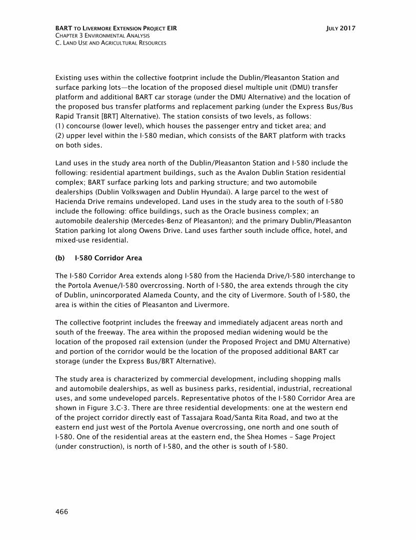


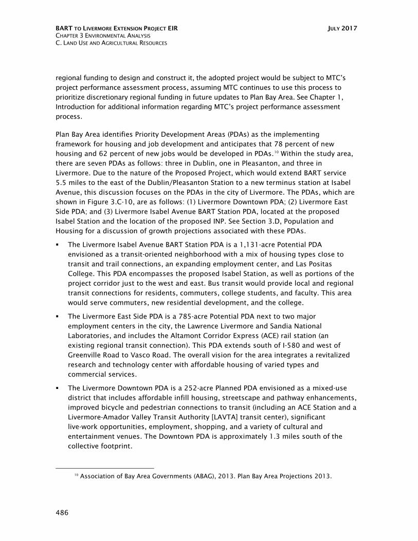


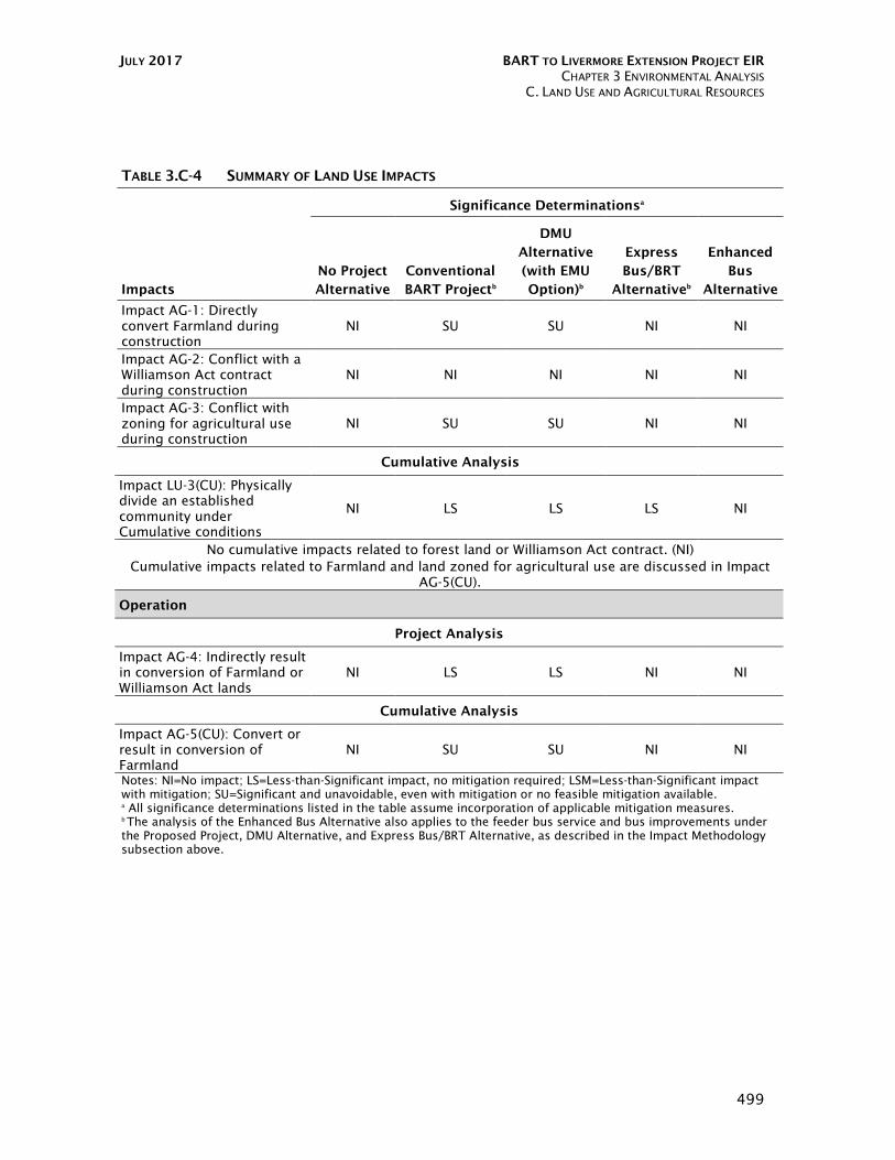


![Thurston County Agricultural Land Pocket Gopher Evaluation · [THURSTON COUNTY AGRICULTURAL LAND POCKET GOPHER EVALUATION] March 30, 2014 3 Thurston County Agricultural Land Pocket](https://static.documents.pub/doc/80x56/5b00b2377f8b9a256b90627a/thurston-county-agricultural-land-pocket-gopher-evaluation-thurston-county-agricultural.jpg)


