138
CADASTRE SURVEY PRACTICE (SGHU 4323) WEEK 8-STRATA TITLES-6 SR DR. TAN LIAT CHOON 07-5530844 016-4975551 1

CADASTRE SURVEY PRACTICE (SGHU 4323)
WEEK 8-STRATA TITLES-6
SR DR. TAN LIAT CHOON07-5530844
016-4975551
1
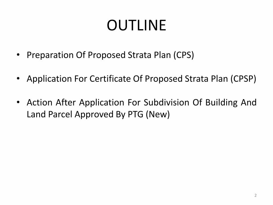
OUTLINE
• Preparation Of Proposed Strata Plan (CPS)
• Application For Certificate Of Proposed Strata Plan (CPSP)
• Action After Application For Subdivision Of Building AndLand Parcel Approved By PTG (New)
2
PREPARATION OF PROPOSED STRATA PLAN (CPS)
3

Proposed Strata Plan
A Licensed Land Surveyor conducting a survey ofsubdivision of building or land is responsible for ensuringthat there is no inconsistency between the proposed strataplan provided with the approved building plan, schedule ofparcel and the plan contained in the sale and purchaseagreement between the developer or the vendor with thebuyer or owner.
4
Information On Proposed Strata Plan
5
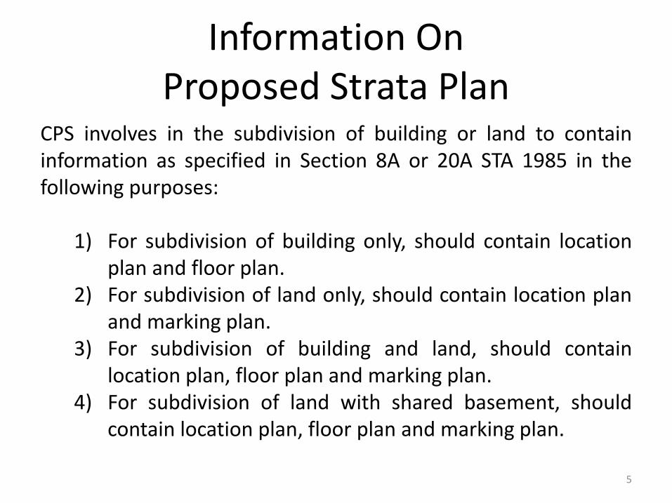
CPS involves in the subdivision of building or land to containinformation as specified in Section 8A or 20A STA 1985 in thefollowing purposes:
1) For subdivision of building only, should contain locationplan and floor plan.
2) For subdivision of land only, should contain location planand marking plan.
3) For subdivision of building and land, should containlocation plan, floor plan and marking plan.
4) For subdivision of land with shared basement, shouldcontain location plan, floor plan and marking plan.

Information On Proposed Strata Plan
6
Other information in the CPS includes:
1) Strata table for each subdivided building or land.
2) Summary of strata table for the whole strata scheme.
3) Number with the “CPS” must be used for each scheduleof parcels folio.
Information On Proposed Strata Plan
7
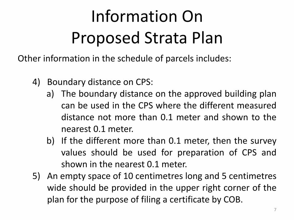
Other information in the schedule of parcels includes:
4) Boundary distance on CPS:a) The boundary distance on the approved building plan
can be used in the CPS where the different measureddistance not more than 0.1 meter and shown to thenearest 0.1 meter.
b) If the different more than 0.1 meter, then the surveyvalues should be used for preparation of CPS andshown in the nearest 0.1 meter.
5) An empty space of 10 centimetres long and 5 centimetreswide should be provided in the upper right corner of theplan for the purpose of filing a certificate by COB.
Information On Proposed Strata Plan
8
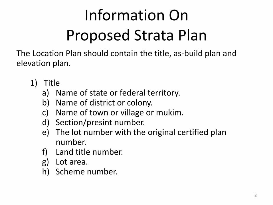
The Location Plan should contain the title, as-build plan and elevation plan.
1) Titlea) Name of state or federal territory.b) Name of district or colony.c) Name of town or village or mukim.d) Section/presint number.e) The lot number with the original certified plan
number.f) Land title number.g) Lot area.h) Scheme number.

Information On Proposed Strata Plan
9
2) The site plan should be drawn to scale and shall indicateinformation :
a) Boundary marks and lot boundary without bearing anddistance.
b) Adjacent lots boundary, abuttal, adjacent lot numbers andstreets name.
c) Scale and north point.d) Horizontal dimension for each building with numbers, either
above or below the surface of the earth with thick black line.e) Horizontal dimension for each tower with black line with the
identification alphabet in the correct order in the case of abuilding containing more than one tower.

Information On Proposed Strata Plan
10
f) Determination of provisional block
i. Horizontal dimension for each provisional block withnumbers, either above or below the surface of the earthwith thick black dashed line.
ii. The perimeter line of the provisional block on the surface ofthe earth with a constant black line and if the horizontal endof the provisional block meets the perimeter of the site,then the perimeter of the site should not be shown.
iii. The symbol of the pipe or spike for boundary without beingdesignated for the corner of the provisional blockconstruction site.

Information On Proposed Strata Plan
11
g) Any eaves, awnings and balcony that are not part ofany proposed parcel that projected to a roadreserve are shown with dashed black lines withoutscale.
h) Boundary and land parcel number.

Information On Proposed Strata Plan
12
3) Elevation plan of building and provisional block
Elevation, usually taken from the front view of each building andevery provisional block based on the approved building plan orbuilding plan under paragraph 8A(1)(c) STA 1985, shall be drawnon a suitable scale in the constant black line except in the case ofprovisional block should be drawn in dashed black line andindicate:
a) Titles include building number, provisional block number andscale.
b) Floor and ceiling of each floor and floor number.c) Height of each floor to the nearest 0.1 meter.d) Any other necessary information.

Information On Proposed Strata Plan
13
Floor plan should be provided for each floor of the subdividedbuilding and contain:
a) Title includes building number, tower number, floor number,parcel number, accessory parcel number and scale.
b) North point.
c) Colour indications for parcel (red line), accessory parcels(blue line) and common property (yellow colour with blacklines), provisional block (black dashed line) and electricsubstation (PE abbreviation).

Information On Proposed Strata Plan
14
Floor plans are drawn to scale and should indicate:
a) Each parcel boundary with a constant red line.b) Each accessory parcel boundary with a constant blue line.c) All common properties are in yellow.d) Any balcony that is not part of the parcel with dashed line
with the statement of 'balcony' (bay-window case).e) Each parcel number.f) Each accessory parcel number and relation relate it to a
parcel number in brackets.g) Each floor area of parcel and accessory parcel are shown to
the nearest square meter.h) Each floor area for each floor for multi-storey parcels and
multi-floor accessory parcels should be shown in bracketstogether with its overall area.

Information On Proposed Strata Plan
15
i) Common property shall be indicated where its use is statedin detail. Examples include electric substation, swimmingpool, visitor car/motor parking and disabled people parking(OKU), guard house, play ground, garbage centre, clubhouse,gymnasium, laundry, retail, surau, multipurpose hall etc. aswell as common property such as staircase, elevators andother.
j) Limitations on footpaths and spaces below any staircase thatform part of the parcel or accessory parcel, are indicated bydashed lines.

Information On Proposed Strata Plan
16
k) Abuttals and abuttal parcel number, together with CPS folionumbers if all the floors not be displayed in a CPS folio.
l) Accessory parcel outside building should be drawn to scaleand indicate:(i) The accessory parcel number and relation with the parcel
number in brackets.(ii) Each area of the accessory parcel is shown to the nearest
square meter.(iii) Each boundary of accessories parcel with a constant blue
line.(iv) Sufficient connections in dashed black line with bearings
and distance connect the accessory parcel with building.m) Any other information (if necessary).

Information On Proposed Strata Plan
17
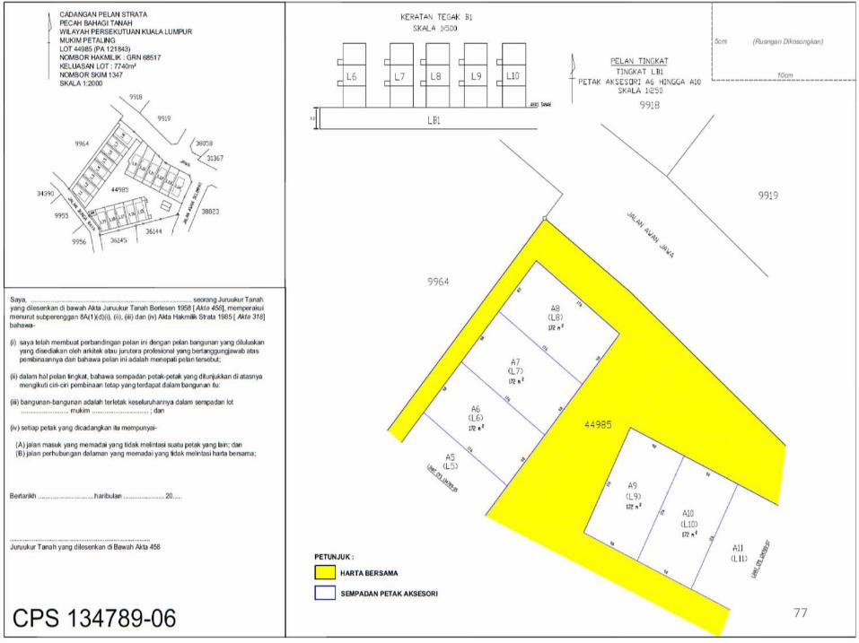
Marking PlanMarking plan for land parcels should be drawn to scale and showinformation:
a) Title, scale and north point.
b) Boundary of land parcel with bearing and distance.
c) Sufficient connection with bearing and distance from lotboundary to land parcel.
d) Land parcel number.
e) Perimeter line of building site for each land parcel.

Information On Proposed Strata Plan
18
f) The land parcel area and accessories parcel should bedetermined based on the value of the measurements andshown to the nearest square meter.
g) For land parcel with basement, floor plans should be paintedfor each basement by showing all accessory parcels andcommon properties.
h) The elevation to indicate the height of the shared basementshould be shown taking into account the front view of thehousing scheme, if relevant.

Information On Proposed Strata Plan
19
i) For temporary blocks in respect of the proposed land plot:
1) Boundary should be shown with dashed black line withbearing and distance.
2) Have enough connection with bearing and distance fromlot boundary to provisional block of land parcel.
3) At least two (2) provisional land parcels are combined intoa provisional block.
4) Provisional block number applicable to land parcels.

Information On Proposed Strata Plan
20
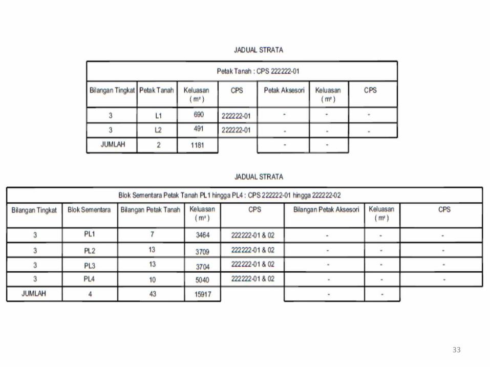
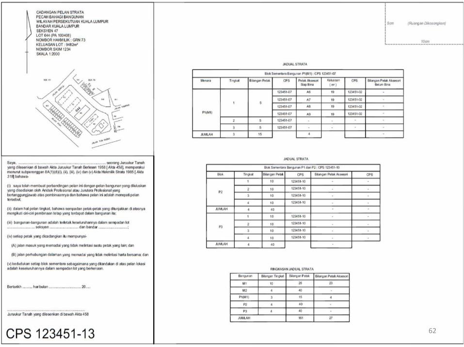
The strata table for each building should indicate:
a) Tower information (if applicable).b) Floor location.c) Parcels number.d) Parcels area.e) CPS folio for parcels.f) Accessory parcels numberg) Accessory parcels area.

Information On Proposed Strata Plan
21
The strata table for each building should indicate:
h) CPS folio for accessory parcels.i) Relation of each accessory parcels with parcel.j) Total number of floors of the subdivided building.k) Total number of parcels.l) Total number of parcels area.m) Total number of accessory parcels.n) Total number of accessory parcels area.o) If the space on plan cannot fit the entire table, it can be
shown in other folio.

22

23

24

Information On Proposed Strata Plan
25
The strata table for each provisional block should indicate:
a) Provisional block number.b) Floor location.c) Number of parcels.d) CPS folio for provisional block.e) Number of accessory parcels.f) CPS folio for accessory parcels.g) Total number of floors.i) Total number of parcels.j) Total number of accessory parcels.k) If the space on plan cannot fit the entire table, it can be
shown in other folio.

26

Information On Proposed Strata Plan
27
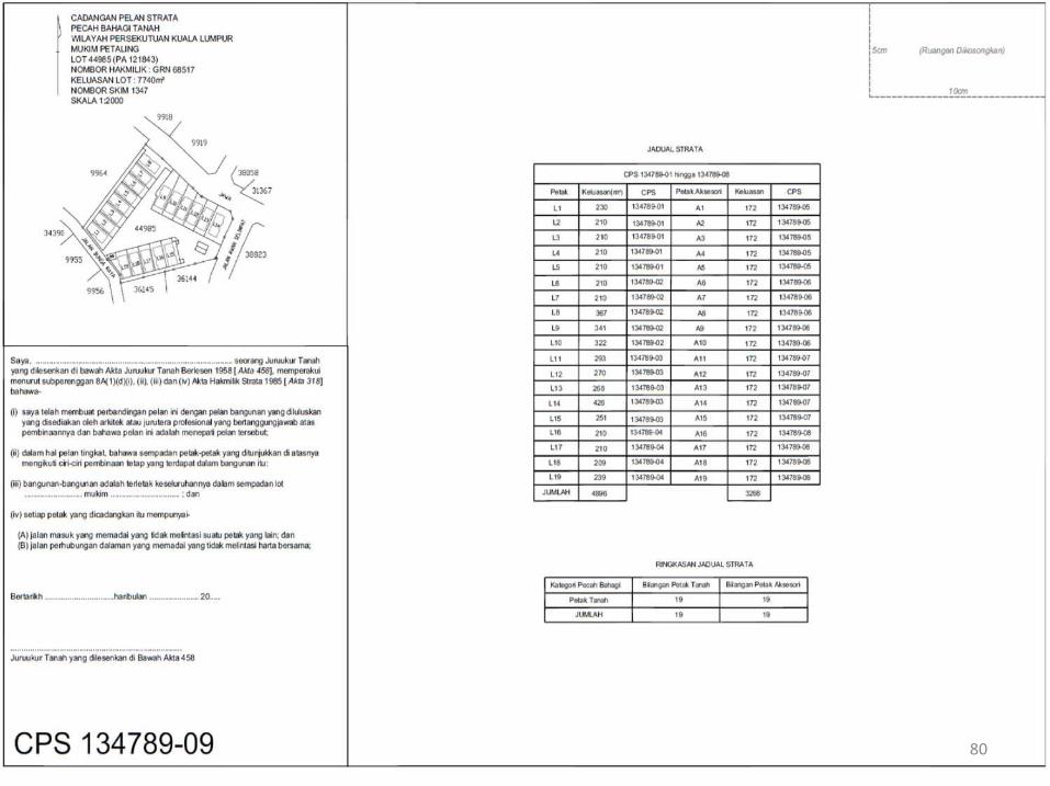
The strata table for subdivision of land should indicate:
a) Number of floor of each land parcel.b) Land parcel number.c) Land parcel area.d) JP folio for each land parcel.e) Accessory parcel area.f) Accessory parcel usage.g) JP folio for each accessory parcel.

Information On Proposed Strata Plan
28
The strata table for subdivision of land should indicate:
i) Relation of each accessory parcels with parcel.j) Total number of number of land parcels.k) Total number of land parcels area.l) Total number of number of accessory parcels.m) Total number of accessory parcels area.n) If the space on plan cannot fit the entire table, it can be
shown in other folio.

29

30

Information On Proposed Strata Plan
31
The strata table for provisional block for land parcel shouldindicate:
a) Number of floor.b) Provisional block number.c) Number of land parcel.d) Provisional block area.e) JP folio for provisional block.f) Number of accessory parcel.g) Accessory parcel area.h) JP folio for each accessory parcel.

Information On Proposed Strata Plan
32
The strata table for provisional block for land parcel shouldindicate:
i) Total number of provisional blocks.j) Total number of land parcels.k) Total number of land parcels area.l) Total number of accessory parcels.m) If the space on plan cannot fit the entire table, it can be
shown in other folio.
33

Information On Proposed Strata Plan
34
The summary of strata table for subdivision of building shouldindicate:
a) Building information.b) Number of floor for each building or provisional block.c) Number of parcel in each building or provisional block.d) Number of accessory parcel related to each building.e) Total number of parcels in the scheme.f) Total number of accessory parcels in the scheme.

35
Information On Proposed Strata Plan
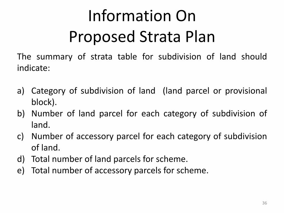
36
The summary of strata table for subdivision of land shouldindicate:
a) Category of subdivision of land (land parcel or provisionalblock).
b) Number of land parcel for each category of subdivision ofland.
c) Number of accessory parcel for each category of subdivisionof land.
d) Total number of land parcels for scheme.e) Total number of accessory parcels for scheme.

37

Proposed Strata Plan
Index plan for floor plan or marking plan
If there is any floor that results in the preparation of a floorplan exceeding 1 folio, LLS should provide an Index Plan toshow the entire floor of the relevant floor or marking plan.
All parcels, accessory parcels and common properties shall beshown in the Index Plan. In order to avoid confusion, it mustcomplied with the compliance of strata numbering methods.
38

Certification By Licensed Land Surveyor On Proposed Strata Plan
The certification by LLS covers the following matters:
(i) Total parcels, land parcels, accessory parcels and provisionalblock/blocks and common properties are in line with approvedbuilding plan and Schedule of Parcel.(ii) The number of floors in the building for each parcel and theshared basement for the parcel is correct.(iii) Each building is in a land parcel and not exceeding four (4)storey.(iv) In the event that there is a eaves, awning and balconyconstructed out to a reserve, air space permit (Section 75A, NLC1965), to be obtained first.
39

Certification By LLS On CPS For Subdivision Of Building Without Air Space Permit
40
Saya ___________________seorang Juruukur Tanah Yang Dilesenkan di bawah Akta Juruukur TanahBerlesen 1958 [Akta 458], memperakui menurut subperenggan 8A(1)(d)(i), (ii), (iii), (iv), dan (v) AktaHakmilik Strata 1985 [Akta 318] bahawa-
(i) saya telah membuat perbandingan pelan ini dengan pelan bangunan yang diluluskan yangdisediakan oleh Arkitek Profesional atau Jurutera Profesional yang bertanggungjawab ataspembinaannya dan bahawa pelan ini adalah menepati pelan tersebut;(ii) dalam hal pelan tingkat, bahawa sempadan petak-petak yang ditunjukkan di atasnya mengikuticiri-ciri pembinaan tetap yang terdapat dalam bangunan itu;(iii) bangunan/bangunan-bangunan adalah terletak keseluruhannya dalam sempadan lot...................... Bandar/pekan/mukim ...................... Seksyen .........................dan daerah .......................................;(iv) setiap petak yang dicadangkan itu mempunyai-
(A) jalan masuk yang memadai yang tidak melintasi suatu petak yang lain; dan(B) jalan perhubungan dalaman yang memadai yang tidak melintasi harta bersama.
Bertarikh _________ haribulan ________ 20 ___
_________________________________________Juruukur Tanah yang dilesenkan di bawah Akta 458
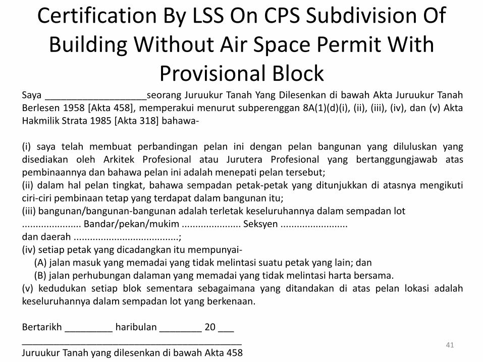
Certification By LSS On CPS Subdivision Of Building Without Air Space Permit With
Provisional Block
41
Saya ___________________seorang Juruukur Tanah Yang Dilesenkan di bawah Akta Juruukur TanahBerlesen 1958 [Akta 458], memperakui menurut subperenggan 8A(1)(d)(i), (ii), (iii), (iv), dan (v) AktaHakmilik Strata 1985 [Akta 318] bahawa-
(i) saya telah membuat perbandingan pelan ini dengan pelan bangunan yang diluluskan yangdisediakan oleh Arkitek Profesional atau Jurutera Profesional yang bertanggungjawab ataspembinaannya dan bahawa pelan ini adalah menepati pelan tersebut;(ii) dalam hal pelan tingkat, bahawa sempadan petak-petak yang ditunjukkan di atasnya mengikuticiri-ciri pembinaan tetap yang terdapat dalam bangunan itu;(iii) bangunan/bangunan-bangunan adalah terletak keseluruhannya dalam sempadan lot...................... Bandar/pekan/mukim ...................... Seksyen .........................dan daerah .......................................;(iv) setiap petak yang dicadangkan itu mempunyai-
(A) jalan masuk yang memadai yang tidak melintasi suatu petak yang lain; dan(B) jalan perhubungan dalaman yang memadai yang tidak melintasi harta bersama.
(v) kedudukan setiap blok sementara sebagaimana yang ditandakan di atas pelan lokasi adalahkeseluruhannya dalam sempadan lot yang berkenaan.
Bertarikh _________ haribulan ________ 20 ____________________________________________Juruukur Tanah yang dilesenkan di bawah Akta 458
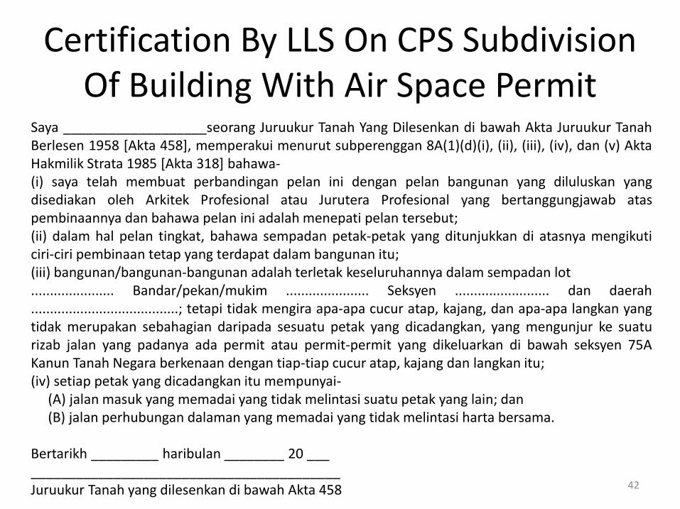
Certification By LLS On CPS Subdivision Of Building With Air Space Permit
42
Saya ___________________seorang Juruukur Tanah Yang Dilesenkan di bawah Akta Juruukur TanahBerlesen 1958 [Akta 458], memperakui menurut subperenggan 8A(1)(d)(i), (ii), (iii), (iv), dan (v) AktaHakmilik Strata 1985 [Akta 318] bahawa-(i) saya telah membuat perbandingan pelan ini dengan pelan bangunan yang diluluskan yangdisediakan oleh Arkitek Profesional atau Jurutera Profesional yang bertanggungjawab ataspembinaannya dan bahawa pelan ini adalah menepati pelan tersebut;(ii) dalam hal pelan tingkat, bahawa sempadan petak-petak yang ditunjukkan di atasnya mengikuticiri-ciri pembinaan tetap yang terdapat dalam bangunan itu;(iii) bangunan/bangunan-bangunan adalah terletak keseluruhannya dalam sempadan lot...................... Bandar/pekan/mukim ...................... Seksyen ......................... dan daerah.......................................; tetapi tidak mengira apa-apa cucur atap, kajang, dan apa-apa langkan yangtidak merupakan sebahagian daripada sesuatu petak yang dicadangkan, yang mengunjur ke suaturizab jalan yang padanya ada permit atau permit-permit yang dikeluarkan di bawah seksyen 75AKanun Tanah Negara berkenaan dengan tiap-tiap cucur atap, kajang dan langkan itu;(iv) setiap petak yang dicadangkan itu mempunyai-
(A) jalan masuk yang memadai yang tidak melintasi suatu petak yang lain; dan(B) jalan perhubungan dalaman yang memadai yang tidak melintasi harta bersama.
Bertarikh _________ haribulan ________ 20 ____________________________________________Juruukur Tanah yang dilesenkan di bawah Akta 458

Certification By LLS On CPS Subdivision Of Building With Air Space Permit And Provisional Block
43
Saya ___________________seorang Juruukur Tanah Yang Dilesenkan di bawah Akta Juruukur TanahBerlesen 1958 [Akta 458], memperakui menurut subperenggan 8A(1)(d)(i), (ii), (iii), (iv), dan (v) AktaHakmilik Strata 1985 [Akta 318] bahawa-(i) saya telah membuat perbandingan pelan ini dengan pelan bangunan yang diluluskan yangdisediakan oleh Arkitek Profesional atau Jurutera Profesional yang bertanggungjawab ataspembinaannya dan bahawa pelan ini adalah menepati pelan tersebut;(ii) dalam hal pelan tingkat, bahawa sempadan petak-petak yang ditunjukkan di atasnya mengikuticiri-ciri pembinaan tetap yang terdapat dalam bangunan itu;(iii) bangunan/bangunan-bangunan adalah terletak keseluruhannya dalam sempadan lot...................... Bandar/pekan/mukim ...................... Seksyen ......................... dan daerah.......................................; tetapi tidak mengira apa-apa cucur atap, kajang, dan apa-apa langkan yangtidak merupakan sebahagian daripada sesuatu petak yang dicadangkan, yang mengunjur ke suaturizab jalan yang padanya ada permit atau permit-permit yang dikeluarkan di bawah seksyen 75AKanun Tanah Negara berkenaan dengan tiap-tiap cucur atap, kajang dan langkan itu;(iv) setiap petak yang dicadangkan itu mempunyai-
(A) jalan masuk yang memadai yang tidak melintasi suatu petak yang lain; dan(B) jalan perhubungan dalaman yang memadai yang tidak melintasi harta bersama.
(v) kedudukan setiap blok sementara sebagaimana yang ditandakan di atas pelan lokasi adalah keseluruhannya dalam sempadan lot yang berkenaan.Bertarikh _________ haribulan ________ 20 ____________________________________________Juruukur Tanah yang dilesenkan di bawah Akta 458

Certification By LLS On Proposed Strata Plan For Subdivision Of Land
44
Saya ___________________seorang Juruukur Tanah Yang Dilesenkan di bawah Akta Juruukur TanahBerlesen 1958 [Akta 458], memperakui menurut subperenggan 8A(1)(d)(i), (ii), (iii), (iv), dan (v) AktaHakmilik Strata 1985 [Akta 318] bahawa-
(i) saya telah membuat perbandingan pelan ini dengan pelan bangunan yang diluluskan yangdisediakan oleh Arkitek Profesional atau Jurutera Profesional yang bertanggungjawab ataspembinaannya dan bahawa pelan ini adalah menepati pelan tersebut;(ii) (tidak berkenaan);(iii) bangunan/bangunan-bangunan adalah terletak keseluruhannya dalam sempadan lot...................... Bandar/pekan/mukim .........................., seksyen .................. Dan daerah ........................(iv) setiap petak yang dicadangkan itu mempunyai-
(A) jalan masuk yang memadai yang tidak melintasi suatu petak yang lain; dan(B) jalan perhubungan dalaman yang memadai yang tidak melintasi harta bersama.
Bertarikh _________ haribulan ________ 20 ___
_________________________________________Juruukur Tanah yang dilesenkan di bawah Akta 458

Certification By LLS On Proposed Strata Plan For Subdivision Of Building & Provisional Block
45
Saya ___________________seorang Juruukur Tanah Yang Dilesen di bawah Akta Juruukur TanahBerlesen 1958 [Akta 458], memperakui menurut subperenggan 8A(1)(d)(i), (ii), (iii), (iv), dan (v) AktaHakmilik Strata 1985 [Akta 318] bahawa-
(i) saya telah membuat perbandingan pelan ini dengan pelan bangunan yang diluluskan yangdisediakan oleh Arkitek Profesional atau Jurutera Profesional yang bertanggungjawab ataspembinaannya dan bahawa pelan ini adalah menepati pelan tersebut;(ii) (tidak berkenaan);(iii) bangunan/bangunan-bangunan adalah terletak keseluruhannya dalam sempadan lot...................... Bandar/pekan/mukim .........................., seksyen .................. Dan daerah ........................(iv) setiap petak yang dicadangkan itu mempunyai-
(A) jalan masuk yang memadai yang tidak melintasi suatu petak yang lain; dan(B) jalan perhubungan dalaman yang memadai yang tidak melintasi harta bersama.
(v) kedudukan setiap blok sementara sebagaimana yang ditandakan di atas pelan lokasi adalah keseluruhannya dalam sempadan lot yang berkenaan.
Bertarikh _________ haribulan ________ 20 ___
_________________________________________Juruukur Tanah yang dilesenkan di bawah Akta 458

Certification By LLS On Proposed Strata Plan For Subdivision Of Land (Shared Basement)
46
Saya ___________________seorang Juruukur Tanah Yang Dilesen di bawah Akta Juruukur TanahBerlesen 1958 [Akta 458], memperakui menurut subperenggan 8A(1)(d)(i), (ii), (iii), (iv), dan (v) AktaHakmilik Strata 1985 [Akta 318] bahawa-
(i) saya telah membuat perbandingan pelan ini dengan pelan bangunan yang diluluskan yangdisediakan oleh Arkitek Profesional atau Jurutera Profesional yang bertanggungjawab ataspembinaannya dan bahawa pelan ini adalah menepati pelan tersebut;(ii) dalam hal pelan tingkat, bahawa sempadan petak-petak yang ditunjukkan di atasnya mengikuticiri-ciri pembinaan tetap yang terdapat dalam bangunan itu;(iii) bangunan/bangunan-bangunan adalah terletak keseluruhannya dalam sempadan lot...................... Bandar/pekan/mukim .........................., seksyen .................. Dan daerah ........................(iv) setiap petak yang dicadangkan itu mempunyai-
(A) jalan masuk yang memadai yang tidak melintasi suatu petak yang lain; dan(B) jalan perhubungan dalaman yang memadai yang tidak melintasi harta bersama.
Bertarikh _________ haribulan ________ 20 ___
_________________________________________Juruukur Tanah yang dilesenkan di bawah Akta 458

Certification By LLS On Proposed Strata Plan For Subdivision Of Land (Shared
Basement) And Provisional Block
47
Saya ___________________seorang Juruukur Tanah Yang Dilesen di bawah Akta Juruukur TanahBerlesen 1958 [Akta 458], memperakui menurut subperenggan 8A(1)(d)(i), (ii), (iii), (iv), dan (v) AktaHakmilik Strata 1985 [Akta 318] bahawa-
(i) saya telah membuat perbandingan pelan ini dengan pelan bangunan yang diluluskan yangdisediakan oleh Arkitek Profesional atau Jurutera Profesional yang bertanggungjawab ataspembinaannya dan bahawa pelan ini adalah menepati pelan tersebut;(ii) dalam hal pelan tingkat, bahawa sempadan petak-petak yang ditunjukkan di atasnya mengikuticiri-ciri pembinaan tetap yang terdapat dalam bangunan itu;(iii) bangunan/bangunan-bangunan adalah terletak keseluruhannya dalam sempadan lot...................... Bandar/pekan/mukim .........................., seksyen .................. Dan daerah ........................(iv) setiap petak yang dicadangkan itu mempunyai-
(A) jalan masuk yang memadai yang tidak melintasi suatu petak yang lain; dan(B) jalan perhubungan dalaman yang memadai yang tidak melintasi harta bersama.
(v) kedudukan setiap blok sementara sebagaimana yang ditandakan di atas pelan lokasi adalahkeseluruhannya dalam sempadan lot yang berkenaan.
Bertarikh _________ haribulan ________ 20 ___
_________________________________________Juruukur Tanah yang dilesenkan di bawah Akta 458

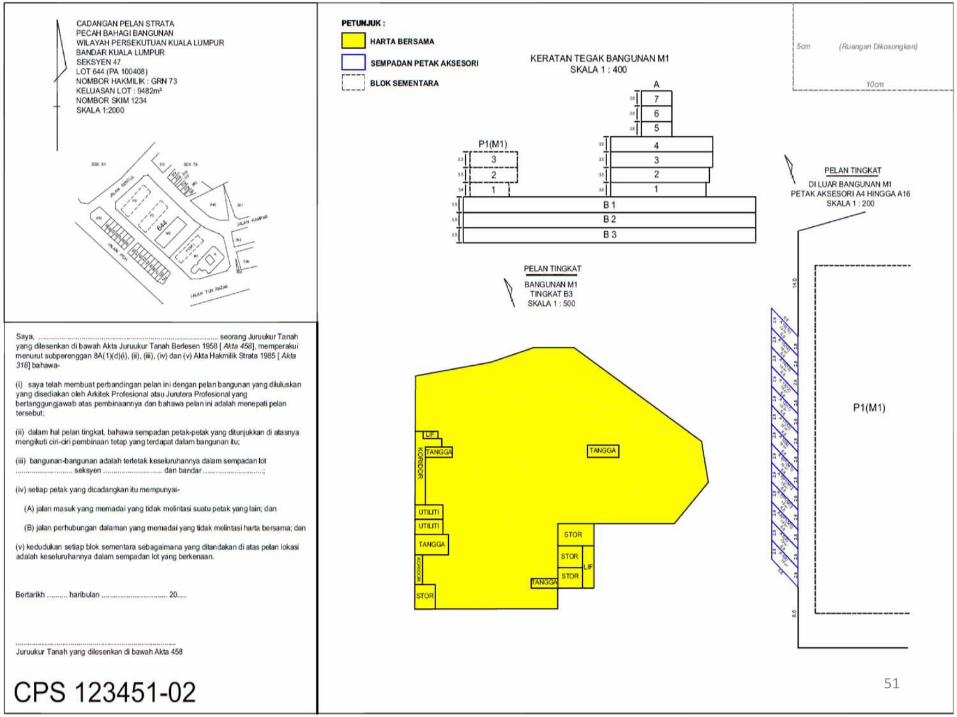
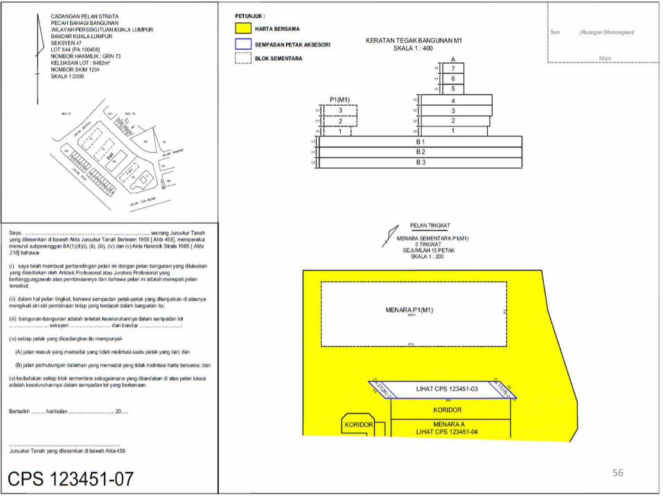
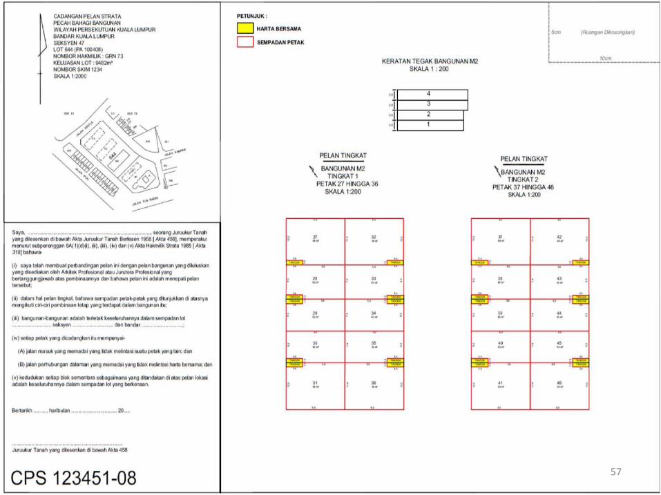
Proposed Strata Plan
48

Proposed Strata Plan For Subdivision Of Building And
Provisional Block
49

50
51

52

53

54

55
56
57

58

59

60

61
62

Proposed Strata Plan For Subdivision Of Land
63

64

65

66

Proposed Strata Plan For Subdivision Of Land And
Provisional Block
67

68

69

70

Proposed Strata Plan For Subdivision Of Land With Shared
Basement
71

72

73

74

75

76
77

78

79
80

Proposed Strata Plan For Completed Provisional Block
81

82

83

84

APPLICATION FOR CERTIFICATE OF PROPOSED STRATA PLAN
(CPSP)
85

Application For Certificate Of Proposed Strata Plan (CPSP)
86
Planning Approval
Building Plan Approved
Sale & Purchase Agreement (SPA) –
(Schedule H of Housing Developer
Act)
Construction–Super Structure
Stage
Application for Certified Propose Strata Plan (CPSP)
- JUPEM
Application for subdivision- PTG
Certified Strata Plan approved & Preparation of
Strata Title Plan (B4)
Vacant Possession &
Strata Title Issue
APPROVED
IN ORDER

Application For Certificate Of Proposed Strata Plan (CPSP)
Application for Certificate of Proposed Strata Plan (CPSP)3 months after confirmation of Architect that building insuper structure stage.
Super structure stage means completion of buildingworks up to the stage of completion of walls or delineationsthat are necessary for the measurement of all parcelsincluding any accessory parcels and common propertyneeded to be shown on the strata plan (G12).
87

Comments On Proposed Strata Plan By JUPEM
1. State Director of Survey and Mapping shall commentwithin 30 days and issue the Certificate of ProposedStrata Plan if in order.
2. In the case of applications not in order, should benotified to applicants, District Land Office/Lands andMines Office and Land Surveyors Board.
3. The proposed Strata Plan cannot be revised after theCertificate of Proposed Strata Plan issued.
88

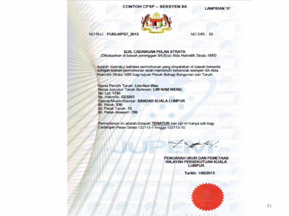
Certificate Of Proposed Strata Plan (CPSP)
89
1. CPSP is a certificate of work in order issued by the Director ofSurvey after checking the proposed strata plan (CPS) and issatisfied that the plan is in order.
2. CPSP is a document that needs to be obtained first by LLSbefore submitting a subdivision of building or land to PTG/PTDfor the issue of strata title.
3. JTB on behalf of the developer is responsible for theapplication of the CPSP within three (3) months from thecompletion date of the super structure stage or three (3)months from the date of issuance of CCC or three (3) monthsfrom the effective date of the Act, according to whicheverrelated section 8(2) AHS 1985].

Certificate Of Proposed Strata Plan (CPSP)
4. Prior to submitting a subdivision of building or land, it is theresponsibility of the developer through the appointed LLS toensure there is no inconsistency between the proposed strataplan prepared with the approved building plan by the LocalAuthority (PBT), the schedule of parcel filed to COB as well asthe plans contained in the sale and purchase agreementbetween the developer or the vendor with the buyer orowner.
5. In addition, land related matters should also be settled inadvance including obtaining final title and ensuringdevelopment is in line with the express conditions beforesubmitting an application for the CPSP to the Director ofSurvey.
90
91

92

93

Application To Obtain CPSP
JTB on behalf of the developer shall submit the applicationof CPSP to the Director of Survey using Form 10(P.U.(A)105) [section 8A STA 1985] together with thefollowing:
1. CPSP application fee to JUPEM using Form 10.
2. Original copy of approved the building plan by the LocalAuthority or original copy of the approved site plan bythe Local Authority, whichever related [paragraph8A(1)(b) or (c) STA 1985].
94

Application To Obtain CPSP
The National Land Code (Survey Fees) (Amendment) Order 2015is effective 1st June 2015. [P.U.(A) 99]
Application for Certificate of Proposed Strata Plan
It covers the measurement of the application of subdivision ofbuildings, building and land or land for the issuance of thecertificate of proposed strata plan. The fees charged are asfollows:
(a) Low cost strata scheme Fi = 5P + 2.5A + RM300.00(b) Not low cost strata scheme Fi = 10P + 5A + RM600.00
Where: P = number of parcelA = number of accessory parcels
95

Application To Obtain CPSP
Low-cost strata scheme
Total number of parcels = 500Total number of accessory prcels = 750Fee = 5P + 2.5A + RM300
= 5*500 + 2.5*750 + RM300= 2,500 + 1,875 + RM300= RM4,675-00
96

Application To Obtain CPSP
Non low-cost strata scheme
Total number of parcels = 500Total number of accessory prcels = 750Fee = 10P + 5A + RM600
= 10*500 + 5*750 + RM600= 5,000 + 3,775 + RM600= RM9,350-00
97

Application To Obtain CPSP
3) CPS should be in the form of:a) Softcopy copies (in * .tiff format) certified according to the
8A(1)(d) STA 1985 with a digital signature by LLS using the LLSOffice Signer module with a resolution of 300 dpi and LZWcompression.
b) Hardcopy of four (4) copies certified by JTB according to clause8A (1) (d) of AHS 1985.
4) A certified true copy of the final title of the lot (official search).
5) Certification by Professional Architect or Engineer that thebuilding has been constructed in accordance with the approvedplan and specification [paragraph 8A(1)(e) STA 1985].
98

Application To Obtain CPSP
6) Certified true copy of approved air space permits[section 75A NLC 1965], (if applicable).
7) Certified true copy of the document that regulates toSuper Structure Stage for the circumstances underparagraph 8(2)(a) STA 1985.
8) Certified true copy of the CCC or CFO, as the case maybe, except in the case under paragraph 8(2)(a) of the STA1985.
9) Certified true copy of schedule of parcel filed to COB.99

Application To Obtain CPSP
10) Certified true copy of SiFUS.
11) Original field book for the subdivision of the building orland.
12) Field work data in digitized according to JUPEM ASCIIformat for re-survey of lot and land parcels (ifapplicable) for verification purposes.
13) Certified true copy of the sale and purchase agreementfor each usage of different parcel.
100

Application To Obtain CPSP
14)Certified true copy of the Letter of Development Order.
15)Strata table and summary of strata table (softcopy ExcelSpreadsheets).
16)XML strata.
101

CPSP Application For Completed Provisional Block
JTB on behalf of the developer is responsible for the application of theCPSP within three (3) months from the completion date of the superstructure stage or three (3) months from the date of issuance of CCCor three (3) months from the effective date of the Act, section 20 (2)AHS 1985].
When submitting CPSP application to the Director of Survey, JTB onbehalf of the developer shall file an application using Form 10 (P.U.(A)105) [section 20A STA 1985] together with the following:
1) CPSP application fee.
2) Original copy of approved the building plan by the Local Authorityor original copy of the approved site plan by the Local Authority,whichever related [paragraph 20A(1)(b) or (c) STA 1985]. 102

CPSP Application For Completed Provisional Block
3) CPS should be in the form of:a) Softcopy copies (in * .tiff format) certified according to the
20A(1)(d) STA 1985 with a digital signature by LLS using theLLS Office Signer module with a resolution of 300 dpi and LZWcompression.
b) Hardcopy of four (4) copies certified by JTB according toclause 20A(1)(d) of AHS 1985.
4) Certification by Professional Architect or Engineer that thebuilding has been constructed in accordance with theapproved plan and specification [paragraph 820(1)(e) STA1985].
5) Salinan diperakui sah kelulusan permit ruang udara [seksyen75A KTN 1965], (jike berkenaan).
103

CPSP Application For Completed Provisional Block
6) Certified true copy of the document that regulates toSuper Structure Stage for the circumstances underparagraph 20(2)(a) STA 1985.
7) Certified true copy of the CCC or CFO, as the case maybe, except in the case under paragraph 20(2)(a) of theSTA 1985.
8) Certified true copy of schedule of parcel filed to COB.
104

CPSP Application For Completed Provisional Block
9) Certified true copy of SiFUS.
10) Original field book for the subdivision of the building orland.
11) Field work data in digitized according to JUPEM ASCIIformat for re-survey of lot and land parcels (ifapplicable) for verification purposes.
12) Certified true copy of the sale and purchase agreementfor each usage of different parcel.
105

CPSP Application For Completed Provisional Block
13) Certified true copy of the Letter of Development Order.
14) Strata table and summary of strata table (softcopy ExcelSpreadsheets).
15) Certified true copy of the issue document of strata title inrespect of related provisional block or blocks [Form 4A].
16) XML strata.
17) Form LJT700 and copy of the official receipt/ LJT DeclarationCertificate as proof of the fee payment was deposited if thenew LLS was appointed.
106

ACTION AFTER APPLICATION FOR SUBDIVISION OF BUILDING AND LAND PARCEL APPROVED BY PTG
(NEW)
107

Application For Subdivision
108
LULUS
TERATUR
Planning Approval
Building Plan Approved
Sale & Purchase Agreement (SPA) –
(Schedule H of Housing Developer
Act)
Construction–Super Structure
Stage
Application for Certified Propose Strata Plan (CPSP)
- JUPEM
Application for subdivision-
PTG
Certified Strata Plan approved & Preparation of
Strata Title Plan
Upon Vacant Possession &
Strata Title Issue

Application For Subdivision Of Building And Land Or Land
Application to District Land Office / Land and MineOffice:
≤ 1 month after Certificate of Proposed Strata Plan The share unit is equal to the schedule of parcel and
the Sale and Purchase Agreement Certified true Copy of Schedule of Parcel Issue Document of Title Payable fees CCC in case of sale and purchase agreement before
effective109

Action By JUPEM After Received CPSP Application
Upon receipt of the complete CPSP application along withthe application fee, the Director of Survey shall:
1) Open a file.
2) CPS to be checked and conduct survey work.
Only one department reference file number should beused for each strata scheme but in the case of thesubdivision of any parcel or amalgamation of two or moreadjacent parcels, the new reference file number can beused.
Application fee will not be refunded after the file isopened.
110
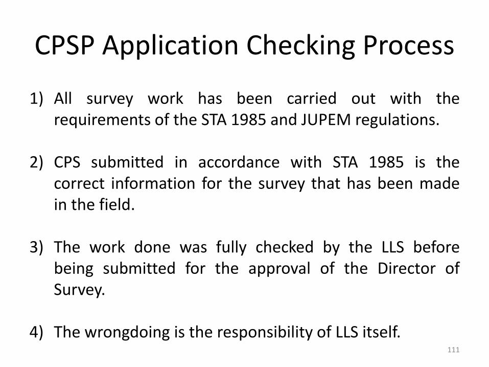
CPSP Application Checking Process
1) All survey work has been carried out with therequirements of the STA 1985 and JUPEM regulations.
2) CPS submitted in accordance with STA 1985 is thecorrect information for the survey that has been madein the field.
3) The work done was fully checked by the LLS beforebeing submitted for the approval of the Director ofSurvey.
4) The wrongdoing is the responsibility of LLS itself.111

CPSP Application Checking Process
Checking of Application Document
1) Checking of documents must be made to ensure that some ofthe important requirements are met before the checking ofbuilding. Items such as in the attachment shall be checkedwithin seven (7) days from the date of receipt of thedocument.
2) If any a mistake found, the application documents will bereturned to LLS and shall be corrected and resubmit within aperiod not exceeding fourteen (14) days from the date of theinquiry. Failure to return a query within a prescribed periodmay result in the application being rejected.
112

113
Checklist Of CPSP Application Checking

114

115

116

CPSP Application Checking Process
3) Requirements in the Development or PlanningPermission Orders need to be reviewed in order to be inline with the breakdown of the building or land,including:
a) Building conditions (e.g. the need for the disabled).b) Restriction in Interest (if any).c) Number of main parcel.d) Number of accessory parcel.e) List of common property (e.g. visitor car park).f) Total number of allocated parking.
117

CPSP Application Checking Process
4) CPS needs to be compared with approved building planas well as schedule of parcel.
5) The CPSP application will be rejected if there is anamendment involving changes to:
a) Number or shape of parcel.
b) Number or shape of accessory parcel.
c) Common property
118

CPSP Application Checking Process
6) For any application that uses a symmetrical plan or buildingplan used for more than one (1) development scheme at thesame or different location, the building plan shall be approvedand obtain a certificate of approval from the Local Authoritythat the plan may be used for development projects in otherarea. In the absence of a certificate, the Director of Surveyreserves the right to refuse the application.
7) For land parcel, the survey datum size can only based on themain lot boundary mark.
8) In the event of non-compliance under Section 8A/20A STA1985, the application will be rejected.
119

CPSP Application Checking Process
Field Checking
1) For main parcel without wall, there must be a marking onthe main parcel.
2) The number of parking for accessory parcel must besufficient as the approval of development order and thedetermination is sufficiently made by ensuring that thedimensions of the parking space are adequate in thefield.
120
CPSP Application Checking Process
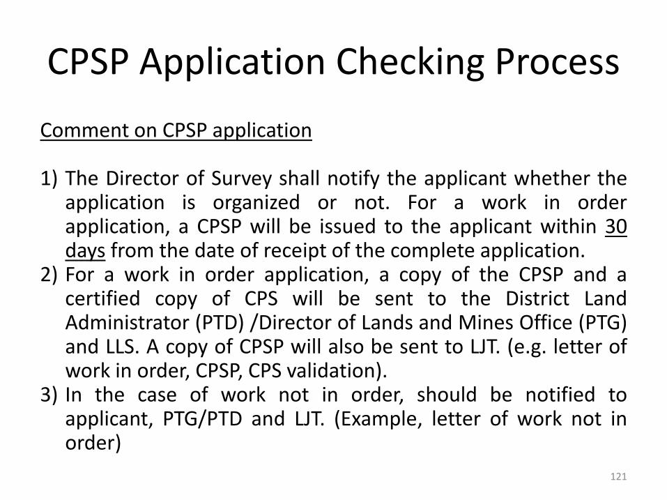
Comment on CPSP application
1) The Director of Survey shall notify the applicant whether theapplication is organized or not. For a work in orderapplication, a CPSP will be issued to the applicant within 30days from the date of receipt of the complete application.
2) For a work in order application, a copy of the CPSP and acertified copy of CPS will be sent to the District LandAdministrator (PTD) /Director of Lands and Mines Office (PTG)and LLS. A copy of CPSP will also be sent to LJT. (e.g. letter ofwork in order, CPSP, CPS validation).
3) In the case of work not in order, should be notified toapplicant, PTG/PTD and LJT. (Example, letter of work not inorder)
121

122

123

124
125

126

CPSP Application Checking Process
Checking period
CPSP application checking period should be within 30 daysfrom the date of receipt of complete applicationdocuments. The CPSP application process flow chart is asbelow.
127

128
CPSP Application Flow Chart
DEVELOPER
LLS
DIRECTOR OF SURVEY
CHECKING
LLSPTG
CPSP copy
Not in order
Director of Survey issue the CPSP
State JUEPM checking application comply to Section 8A/20A STA 1985
Building reach Super Structure Stage (G12)
LLS sent application together with schedule of parcel, proposed strata plan and Strata XML to State JUPEM
Query / request for additional documents
Within3 months
Within 30 days
In order

CPSP Application Checking Process
CPSP delivery method
CPSP and official letter from the Director of Survey shall besubmitted to the applicant by registered post, by hand. Aletter of representation by JTB should be submittedtogether if the JTB representative wishes to take thisdocument at the State Survey Office. If the CPSP and theofficial letter from the Director of Survey are generatedthrough the system and signed digitally, electronicallydelivery is permitted.
129

Action By LLS After Received CPSP From JUPEM
1) After receipt of CPSP from the Director of Survey, the applicationfor subdivision of building or land must be submitted to thePTG/PTD for the purpose of obtaining the approval of theapplication for the subdivision of the building or land.
2) PA(B) provided in TIFF format.
JTB shall comply with PA(B) resolution and compression in TIFFformat as follows:
a) Resolution: 300 dpi.
b) Compression: LZW Compression.
3) The numbers provided with the prefix "PA(B)" must be used foreach certified strata plan folio.
130

Action By LLS After Received CPSP From JUPEM
4) PA(B) digitally signed using the LLS Office Signer module.
5) Submit PA(B) which has been digitally signed to theDirector of Survey within 14 days.
The digitally signed PA(B) will generate 3 files in the ZIPfolder ie data.txt, PA (B) XXX.xcs, and PA (B) XXX.sig.PA(B) XXX.zip shall be sent to the Director of Surveywithin 14 days from the date of issuance of CPSP forpreliminary checking before the approval of PTG isobtained. The PA(B) delivery form should be used as inthe attachment.
131

132

Action By LLS After Received CPSP From JUPEM
6) The checking of PA(B) will be conducted by the Director
of Survey using the checklist as in the annex. However,
the approval of PA(B) will only be made after the
application of subdivision approved by PTG.
133
After PTG Approval
134
AAPPROVED
IN ORDER
Planning Approval
Building Plan Approved
Sale & Purchase Agreement (SPA) –
(Schedule H of Housing Developer
Act)
Construction–Super Structure
Stage
Application for Certified Propose Strata Plan (CPSP)
- JUPEM
Application for subdivision-
PTG
Certified Strata Plan approved & Preparation of
Strata Title Plan
Upon Vacant Possession &
Strata Title Issue

Action By JUPEM After Subdivision Of Building Or Land Approved By PTG
1) Once the application is approved by PTG, the Director ofSurvey shall approve PA(B).
2) Once PA(B) is approved, the Director of Survey shall:
a) Update information into relevant lists.b) Provide a copy of PA(B) that has been approved for the
Registrar.c) Provide an additional copy of PA(B) for each relevant parcel
which has been approved to Registrar and to attached on theissue document of title.
3) The flow chart after approval of the strata application untilthe issue of the Certified Strata Plan is as in the attachment.
135
136
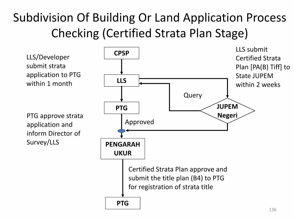
Subdivision Of Building Or Land Application Process Checking (Certified Strata Plan Stage)
CPSP
LLS
PENGARAHUKUR
PTG
Certified Strata Plan approve and submit the title plan (B4) to PTG for registration of strata title
LLS submit Certified Strata Plan [PA(B) Tiff] to State JUPEM within 2 weeks
LLS/Developer submit strata application to PTG within 1 month
Approved
PTG JUPEMNegeri
Query
PTG approve strata application and inform Director of Survey/LLS

Action After Application for Strata Subdivision Of Building Approved By PTG For Provisional
Block/Blocks
1) Upon receipt of an approved application from PTG, theDirector of Survey shall approve PA(B).
2) Upon approval of PA(B) the Director of Survey shall:a) Update information into relevant lists.b) Update PA(B) information on existing/old PA(B) in red.c) Provide a copy of PA(B) that has been approved for the
Registrar.d) Provide an additional copy of PA(B) for each relevant
parcel which has been approved to Registrar and toattached on the issue document of title.
137

T H A N K YO U
138


