23
Captina Creek Watershed Action Plan Belmont County Soil and Water Conservation District 101 N. Market St. Suite D St. Clairsville, Ohio 43950

Captina Creek Watershed Action Plan
Belmont County Soil and Water Conservation District
101 N. Market St. Suite D
St. Clairsville, Ohio 43950

Table of Contents
Part I. Introduction A. Watershed Size and Administrative Boundaries
B. Demographics
C. Geographic Locators
D. General Watershed Information
Part II. Watershed Plan Development
A. Watershed Partners
B. Mission Statement
C. Organization and Administration of Watershed Group
D. General Plan Contents
Part III. Watershed Inventory
A. Description of watershed
Geology
Topography
Geological Features
Soils
Glacial History
Biological Features
Rare, Threatened and Endangered Species
Invasive Species
Water Resources
Climate
Surface Water and Wetlands
Ground Water
Land Usage and Cover
Urban and Impervious Surfaces
Home Sewage Treatment Systems
Forest
Agriculture
Water
Non-Forested Wetlands
Barren
Protected Lands
Status and Trends
B. Cultural Resources
C. Previous and Complementary Efforts
D. Physical Attributes that Support Habitat, Recreation and Water Quality
E. Water Resource Quality
Locationally Referenced Use Attainment
Miles in Full Attainment
Threatened Miles
Miles in Partial Attainment
Miles in Non-Attainment
Number of Streams Designated but not Monitored
Quality of Lakes
Quality of Wetlands
Quality of Groundwater
Causes and Sources of Impairment
Point Sources
Spills and Illicit Discharges
Nonpoint Sources
Status and Trends
Part IV. Watershed Impairments TMDL and Pollutant Loading
Habitat Conditions
Cause and Source of Impairments and Estimated Load
Part V. Watershed Restoration Project Goals Measurable Indicators of Success
Objectives to Accomplish Each Goal
Part VI. Implementation
Prioritized Objectives
Education/Information Strategies
Funding Strategy
Part VII. Evaluation
Criteria for Progress/Load Reduction
Monitoring of Plan Progress

Part I. Introduction
Defining the Watershed
A watershed is an area of land over which water drains into a specific location (stream, lake,
river, or ocean). Water resources in Ohio are protected and maintained through groups that work
at the local watershed level to restore water quality to state and national standards. In order to
restore and maintain water quality, a watershed action plan is developed to outline the necessary
steps to achieve water quality attainment. Because each watershed is different each watershed
action plan is written with local support distinctive to the area. Support from local members of
the watershed help ensure that the watershed goals will be met, and will help impaired streams
meet designated standards.
The Captina Creek watershed is unique for a watershed management plan because it meets
water quality standards and grades exceptional water quality both on its mainstem and several of
its tributaries. While most watershed action plans are drafted to repair and restore damaged
habitat, Captina Creek's action plan focuses more on preserving the relatively undisturbed
landscape that gives the creek its exceptional standing. Many streams within the watershed
contain rare and diverse species of fish, macroinvertebrates and amphibians and show little signs
of chemical, physical, and biological stress. Sparsely populated areas surrounding the
watershed's tributaries allow for growth of extensive riparian corridors around nearly unaltered
streambeds. The OEPA has deemed the mainstem of Captina Creek an Outstanding State Water
(OSW) from River Mile (RM) 25.42 to River Mile (RM) 0.8 and the USEPA has designated the
creek an Aquatic Resource of National Importance (ARNI) based its biodiversity and water
quality values (USEPA, 2010).
Nearly the entire length of Captina Creek is classified by the OEPA to be exceptional
warmwater habitat (EWH), meaning it is capable of supporting and maintaining an exceptional
or unusual community of warmwater aquatic organisms having a species composition, diversity
and functional organization comparable to the seventy-fifth percentile of the identified reference
sites on a statewide basis (USEPA, 2010). Several of the headwater tributaries feeding into the
creek have attained cold water habitat (CWH) status based on the diversity of sampled
salamanders and macroinvertebrates. The mainstem of Captina Creek scored the highest Index
of Biotic Integrity (IBI) average in the state (55.1 out of a possible 60 points) with a diversity of
fifty-six fish species sampled, many of which are pollution intolerant. Moreover, Invertebrate
Community Index (ICI) score averages place Captina Creek in the top ten among watersheds in
the state (OEPA, 2010). Adding to its unique diversity, Captina Creek is home to the largest
eastern hellbender (Cryptobranchus alleganiensis) population in the state of Ohio and the only
reproductive population. Sightings of the state endangered bobcat (Felis rufus) have also
increased in the forested habitat of the watershed over the last 10 years.
Qualitative Habitat Evaluation Index (QHEI) scores are used by the EPA to measure stream
physical habitat in terms of substrate type, imbeddedness within streams and channel shape
characteristics. The average QHEI scores recorded by OEPA for all of Captina Creek was 72.2
consistent with very good overall habitat quality (OEPA, 2010). Headwater Habitat Evaluation

Indexes (HHEI) have been conducted on numerous streams in the watershed by the OEPA
including Casey Run, Reeves Hollow, Berrys Run and Mikes Run. HHEI metrics evaluate the
quality of headwater stream habitat (< 1 square mile of drainage area) based on the presence of
diverse populations of macroinvertebrates and salamanders, substrate content, stream depth and
channel width. A score of 70 classifies a headwater stream as Class III - Primary Headwater
Habitat (PHWH) indicating a stream of the highest quality able to support cold water biota year-
round. All four of these headwater streams scored above 70 with Casey Run registering an 84 at
RM 0.75 (USEPA, 2010).
Although Captina Creek scores high on OEPA and USEPA water quality and habitat
assessments, significant impacts to the biological integrity of the watershed exist with land use
being one of the primary concerns. Sedimentation pollutes headwater and tributary streams
during times of heavy rainfall due to naturally erosive processes. Logging, construction, gravel
excavation and recreational ATV traffic are prevalent in portions of the watershed and
significantly add to the sediment load of specific tributaries. Agriculturally speaking, concerns
exist with livestock having unregulated access to portions of the creek, trampling stream banks
and increasing nutrient loading and sedimentation. Developmentally speaking, increasing
amounts of sewage effluent are entering the creek via faulty waste water treatment facilities and
dysfunctional or absent private leach fields that drain directly into the creek.
Two coal mines owned by Murray Energy, Ohio Valley Coal Company (OVCC) and
American Energy Corporation (AEC), reside on the banks of the middle section of the mainstem
of Captina Creek and have had multiple slurry spills into the creek over the course of their
operations with the most recent occurring October 1st, 2010. Coal slurry is a waste material
generated by washing impurities from coal once it is retrieved from the ground. Slurry spills are
very damaging to watershed habitat and have mortal effects on the creek's biotic fauna especially
near their discharge points. Not only is the slurry choking and poisonous to creek inhabitants,
the cleanup and removal of the waste is damaging to the environment as well. Roads have to be
cut through riparian corridors and the creek bed is trampled and sucked dry in places by vacuum
trucks. Interestingly, the creek has had a unique ability to rebound somewhat quickly from
slurry spill contamination which is attributed to a layer of limestone bedrock lining the creek
bed. In addition to contamination from sporadic slurry spills, local residents complain about
subsidence impacts on home drinking wells.
Slurry contamination also poses a threat to state endangered eastern hellbender populations
in Captina Creek. During the most recent cleanup process, three hellbenders were found alive in
the slurry spill zone that stretched over three-fourths of a mile in length between Wayne and
Washington Townships. Workers contracted to remove the slurry discovered the hellbenders in
the couple of days following the spill but did not know how to care for them or what steps to take
to ensure their survival. Subsequently the animals were released with good intention into areas
outside the spill zone that were unfavorable habitat without any documentation of whether they
had been previously pit-tagged or whether they were healthy enough for release. In the future,
having a proper implementation plan in place for hellbender rescue and care and educating
cleanup crews on the handling and caging of hellbenders during slurry spill cleanups may reduce
the impact on hellbender populations.

The purpose of this management plan is to provide a guiding framework for watershed
stakeholders and key individuals at the community level that can be implemented to protect the
biological, chemical and physical integrity of the Captina Creek watershed region. Protecting
streams, lakes and wetlands in full attainment status and restoring acceptable water quality
standards to impaired streams ensures that Captina Creek and its tributaries will remain premier
freshwater bodies in the state of Ohio. In order to achieve these goals, data collection, public and
private outreach, education, land management, community involvement and best management
practices will need to be implemented to protect the waters of the region.
Figure 1.

Watershed Boundaries
The Captina Creek watershed drains approximately 180 square miles of surface area in
Belmont and Monroe Counties in southeastern Ohio. Of that, 167.8 square miles (93.2%) are
located in Belmont County and 12.2 square miles (6.8%) are in Monroe County. The watershed
is part of the EPA designated Central Ohio River Tributaries from below McMahon Creek to
above Fish Creek West Virginia.
Within the Captina Creek watershed there are six incorporated villages: Barnesville,
Beallsville (northern portion), Bethesda, Jerusalem (northern portion), Powhatan Point and
Wilson (northern portion). There are also fifteen unincorporated hamlets in the watershed region
some of which are difficult to identify within the landscape (e.g. Captina and Clover Ridge)
because of limited or absent structural features. The unincorporated areas are: Alledonia,
Armstrongs Mills, Bingham, Boston, Captina, Centerville, Clover Ridge, Cool Hill, Crabapple,
Hunter, Jacobsburg, New Castle, Somerton, Speidel and Steinersville.
Figure 2.

Special Districts Within the Watershed
Parks – Within the Captina Creek watershed there are several parks for public
recreational activities. Village parks include Somerton Park in Somerton and Epworth Park in
Bethesda. Centerville and Powhatan Point also have recreational ball fields and community
areas which are not designated city parks. Powhatan Point has a community marina for
launching watercraft into the Ohio River as well. Also three golf courses are located within the
watershed are which are Clair-Mar in Steinersville, Horseshoe Bend in Armstrongs Mills and
Switzerland Lake in Wilson. No national or state parks reside in the watershed, however there
are private fisheries located near the unincorporated hamlet of Captina (Lake Shawn) and at
Switzerland Lake.
The Ohio Riverfront Development Committee (ORDC) and Rails to Trails have
expressed interest in extending recreational biking and horseback trails from Powhatan Point
westward along the mainstem of Captina Creek. If constructed near the creek a walking/biking
trail could be beneficial in preserving riparian corridors and green space, and providing residents
an alternative to ATV recreation.
Regional Planning Agencies – Government agencies in the watershed are the Belmont
and Monroe Soil and Water Conservation Districts, the Natural Resource Conservation District,
Ohio Department of Transportation (Highway Garages), OSU Extension Service of Belmont
County and the Farm Bureau.
Conservation – Within the watershed there are two current land conservation areas,
Dysart Woods and Raven Rocks, and several conservation easements held by Murray Energy.
Dysart Woods is an old growth forest preserve of approximately 55 acres owned and operated by
Ohio University. It is located in the west-central portion of Smith township in the Bend Fork
subwatershed area and is used primarily for academic research although its nature trails are open
to the public year-round. Raven Rocks Inc. is a private organization that owns land for
conservation practices. The group has acquired approximately 1200 acres of land in southeastern
Wayne Township within South Fork subwatershed to protect against mining and is currently
working with the Captina Conservancy on placing a portion of the property into a land trust.
Murray Energy, owners of Ohio Valley Coal Company Powhatan #6 and American
Energy Corporation Century coal mines, holds several conservation easements on private
property in Wayne and Washington townships. Easements in Wayne Township are located on
different parcels between six streams in Section 3 including Long Run and Piney Creek.
Combined the easements along these tributaries totals 11,110 linear feet at a width of 50 feet.
Also in the same township section, a 2.66 acre easement exists next to Township Road 87 where
a patch of wetlands has been reclaimed as a mitigation project. Other conservation easements
held by Murray Energy are located near the mouth of Bend Fork in Sections 23, 24 and 30 of
Washington Township along Township Road 101 and on Millers Run in Section 30 of
Washington Township. The easements at the mouth of Bend Fork cover 831.7 linear feet of
stream with a width of 250 feet while those in Millers Run cover 844 linear feet of stream at a
width of 100 feet (Wood-Pugh email communication, February, 2011).

Schools – Public school districts in the watershed region include a portion of Switzerland
of Ohio Local School District (including Beallsville Schools), all of Shadyside Local School
District, portions of Union Local Schools, Bellaire Schools and Barnesville Exempted Village
School District as illustrated in Figure 3. Additionally Olney Friends school is a private
secondary school located in Barnesville.
Figure 3.
Special Designations
The mainstem of Captina Creek (from RM 25.2 to S.R. 7 at RM 0.8) and its South Fork
Captina Creek tributary have been designated Outstanding State Waters (OSW) by OEPA based
on exceptional ecological values. An additional two of Captina Creek's tributaries, North Fork
Captina Creek (from RM 6.64 to the mouth) and Pea Vine Creek, have been declared Superior
High Quality Waters by OEPA as well (OEPA, 2010). The creek has also garnered recognition
as an Aquatic Resource of National Importance (ARNI) by USEPA. It is not designated as
national or state wild and scenic river but may be considered in the future.

Phase Two Storm Water Communities
The National Pollution Discharge Elimination System (NPDES), established from the Clean
Water Act, provides governing rules for stormwater runoff. NPDES regulations are divided in
two phases. Phase one deals with the most severe stormwater pollution and Phase two deals with
less severe stormwater pollution usually by smaller municipalities that were exempt from earlier
regulations. There are no Phase 1 or Phase 2 storm water communities present within the
Captina Creek watershed boundary
Watershed Demographics
Population and Age
The estimated population residing in the Captina Creek watershed is approximately 11,138
persons with nearly one third of the population living in unincorporated areas. Population
estimates are based on 2010 GIS address data provided by Belmont and Monroe Counties' 911
Services and was calculated by adding the total number of houses and trailers within the
watershed boundary then multiplying that number by the county averages of 2.37 persons per
household in Belmont and 2.5 persons per household in Monroe respectively (US Census Data,
2009). A map of the watershed population distribution by township is given in Figure 4.

Figure 4. Belmont county townships are outlined in blue while Monroe county townships are in red.
Each dot in Figure 4 represents either a structural building or trailer within the Captina
watershed. As one would expect, the majority of dots are situated in or near the incorporated
villages. Using calculations described for estimating population numbers in the watershed, the
population of individuals living in Monroe County was 828 and those living in Belmont was
10,310.
Based on 2009 census estimates the population of Belmont County was 68,066 persons
while Monroe County was 14,058 persons. Both counties in the watershed have experienced
decreases in population over the last ten years. According to year 2000 census data the
population of Belmont County was 70,226 while Monroe County was 15,180. Current Ohio
census data indicates population changes of -3.1% and -7.4% for Belmont and Monroe Counties
respectively from the period April 1, 2000 to July 1, 2009. Figures 5a and 5b represent a
breakdown of the age groups by percentage in each county (census.gov).
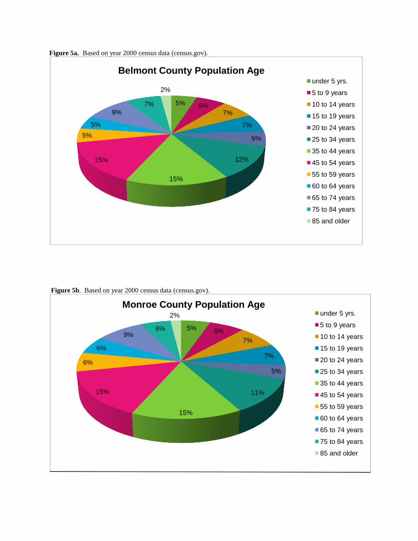
Figure 5a. Based on year 2000 census data (census.gov).
Figure 5b. Based on year 2000 census data (census.gov).
5% 6%7%
7%
5%
12%
15%
15%
5%
5%
9%
7%
2%
under 5 yrs.
5 to 9 years
10 to 14 years
15 to 19 years
20 to 24 years
25 to 34 years
35 to 44 years
45 to 54 years
55 to 59 years
60 to 64 years
65 to 74 years
75 to 84 years
85 and older
Belmont County Population Age
5% 6%
7%
7%
5%
11%
15%
15%
6%
6%
9%6%
2% under 5 yrs.
5 to 9 years
10 to 14 years
15 to 19 years
20 to 24 years
25 to 34 years
35 to 44 years
45 to 54 years
55 to 59 years
60 to 64 years
65 to 74 years
75 to 84 years
85 and older
Monroe County Population Age

Education Levels
Education statistics for both counties are similar in that roughly twenty percent of
individuals have no high school diploma which is consistent with state (17%) and national
averages (19.6%) from year 2009. Of those individuals who attend post-secondary institutions
only 11% go on to earn bachelor degrees in Belmont County and 9 % in Monroe County. This
statistic along with the struggling local economy may be the largest force driving people and
businesses away from the area. Figures 6a and 6b depict the education status of both counties in
the watershed.
Figure 6a. (census.gov, 2009) Figure 6b. (census.gov, 2009)
Income Levels
Median household income for year 2008 per household was $37,941 in Belmont County and
$40,089 for Monroe County compared to a statewide median of $48,011 and a national median
of $52, 029 per household. Only 24% of residents in Belmont County earn median incomes at or
above the national average compared to 23% in Monroe County. Figures 7a and 7b depict
yearly income statistics for residents of each county (US Census Data, 2009).
19%
47%17%
6%7% 4%
Belmont County Education
No High School Diploma
High School Graduate
Some College, No Degree
Associate Degree
Bachelor Degree
Master Degree or Higher
21%
50%
15%
5% 6% 3%
Monroe County Education
No High School Diploma
High School Graduate
Some College, No Degree
Associate Degree
Bachelor Degree
Master Degree or Higher

Figure 7a. From US Census Data, 2009.
Figure 7b. From US Census Data, 2009.
Locations of Growth/Economic Patterns
For each county the workforce has decreased while unemployment has remained the same
for years 2003-2007. The number of new businesses have dropped 34% from 2003-2007 and the
number of active businesses in the area have dropped 14% within the same years (US census
data, 2008).
14%
20%
17%14%
10%
8%
8%6%
2% 0%1%
Belmont County Household Income
Less than $10,000
$10,000 to $19,999
$20,000 to $29,999
$30,000 to $39,999
$40,000 to $49,999
$50,000 to $59,999
$60,000 to $74,999
$75,000 to $99,999
$100,000 to $149,999
$150,000 to $199,999
$200,000 or more
14%
17%
18%15%
12%
9%
9%4%
1% 0%1%
Monroe County Household Income
Less than $10,000
$10,000 to $19,999
$20,000 to $29,999
$30,000 to $39,999
$40,000 to $49,999
$50,000 to $59,999
$60,000 to $74,999
$75,000 to $99,999
$100,000 to $149,999
$150,000 to $199,999
$200,000 or more

According to US census projections, populations within Belmont and Monroe Counties are
expected continue to decrease over the next ten years primarily due to a sluggish local economy
and the fact that more youth leaves the area than stays. Belmont County Community
Improvement Corporation (CIC) indicates that urban growth and development in the Captina
Creek watershed is not forecast to be significant in the foreseeable future. CIC associate director
Susan Douglass stated that Murray Energy has been the only corporation in the watershed that
has worked with the CIC in the past. Douglass also indicated she had been approached by
private interests seeking to establish recreational ventures along the mainstem of the creek none
of which have yet to materialize. The newest business development slated in Belmont County is
a commercial park located behind valley plaza in St. Clairsville near Interstate 70 well north of
the Captina watershed area (Douglass, 2010). Also, the Switzerland of Ohio School District is
planning to construct a new elementary school near Captina Creek west of Powhatan Point
within the next two years (Workman, 2010) .
Economic forecasts are similar in Monroe County in terms of slow commercial development
with the Black Walnut Center in Woodsfield and the State Route 7 corridor along the Ohio River
likely locations for growth if it were to occur. The Switzerland of Ohio School District is also
constructing a school facility at the extreme southern edge of the watershed area in Monroe
County. This facility will serve as the new Beallsville Schools campus and is located along SR
556 on the southern fringe of the Piney Creek subwatershed (Workman, 2010). Figures 8a and
8b represent projected census trends over the next few decades for Belmont and Monroe
Counties (US Census Data, 2000).
Figure 8a. From US Census Data, 2000
0
10,000
20,000
30,000
40,000
50,000
60,000
70,000
80,000
90,000
100,000
1800 1850 1900 1950 2000 2050
Belmont County Population Trend
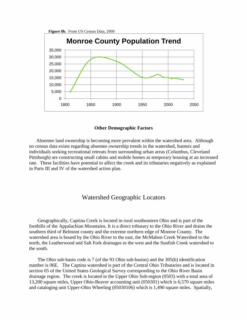
Figure 8b. From US Census Data, 2000
Other Demographic Factors
Absentee land ownership is becoming more prevalent within the watershed area. Although
no census data exists regarding absentee ownership trends in the watershed, hunters and
individuals seeking recreational retreats from surrounding urban areas (Columbus, Cleveland
Pittsburgh) are constructing small cabins and mobile homes as temporary housing at an increased
rate. These facilities have potential to affect the creek and its tributaries negatively as explained
in Parts III and IV of the watershed action plan.
Watershed Geographic Locators
Geographically, Captina Creek is located in rural southeastern Ohio and is part of the
foothills of the Appalachian Mountains. It is a direct tributary to the Ohio River and drains the
southern third of Belmont county and the extreme northern edge of Monroe County. The
watershed area is bound by the Ohio River to the east, the McMahon Creek Watershed to the
north, the Leatherwood and Salt Fork drainages to the west and the Sunfish Creek watershed to
the south.
The Ohio sub-basin code is 7 (of the 93 Ohio sub-basins) and the 305(b) identification
number is 06E. The Captina watershed is part of the Central Ohio Tributaries and is located in
section 05 of the United States Geological Survey corresponding to the Ohio River Basin
drainage region. The creek is located in the Upper Ohio Sub-region (0503) with a total area of
13,200 square miles, Upper Ohio-Beaver accounting unit (050301) which is 6,570 square miles
and cataloging unit Upper-Ohio Wheeling (05030106) which is 1,490 square miles. Spatially,
0
5,000
10,000
15,000
20,000
25,000
30,000
35,000
1800 1850 1900 1950 2000 2050
Monroe County Population Trend

the watershed area lies between longitude coordinates 81o13'12"W and 80
o44'18"W and,
between latitude coordinates 40o1'36"N and 39
o49'35"N.
Figure 9a. From Ohio River Basin Consotorium. Figure 9b. Upper Ohio Wheeling Watershed (OEPA)
The Captina Creek watershed area consists of six subwatershed tributary regions that drain
directly into the mainstem of Captina Creek. They are named North Fork Captina Creek, South
Fork Captina Creek, Bend Fork, Piney Creek, Pea Vine Creek and Cat Run from west to east
respectively.
Hydrologic Unit Codes were developed by the USGS in the mid 1970's as a means to
standardize the watershed classification system in the U.S. Hydrologic units are watershed
boundaries organized hierarchically by surface area. They range from regions of 8 digit to 14
digit codes with the lesser number representing a larger surface drainage and the greater number
representing a very specific watershed drainage within a region (USGS Water Data Online,
2010). ODNR currently recognizes twelve digit HUC coding (illustrated in Figure 10) for
classifying watershed areas. The Captina watershed region also has an eight digit HUC
05030106 and the eleven digit HUC 05030106110 (NRCS, 2010).

Figure 10. The Captina Creek mainstem is fed by six subwatershed areas.
Table 1. Subwatershed areas by acreage (derived from Ohio Geological Survey Data).
Subwatershed Twelve-Digit HUC Surface Area (acres) Total Stream Miles*
Pea Vine Creek 050301060905 24,332 220.5
South Fork 050301060902 23,036 191.3
North Fork 050301060901 20,942 172.3
Piney Creek 050301060904 18,608 163.4
Bend Fork 050301060903 17,290 140.1
Cat Run 050301060906 10,980 64.3
*Stream miles were calculated using all tributary drainages in each subwatershed area including those that are semi-permanent.
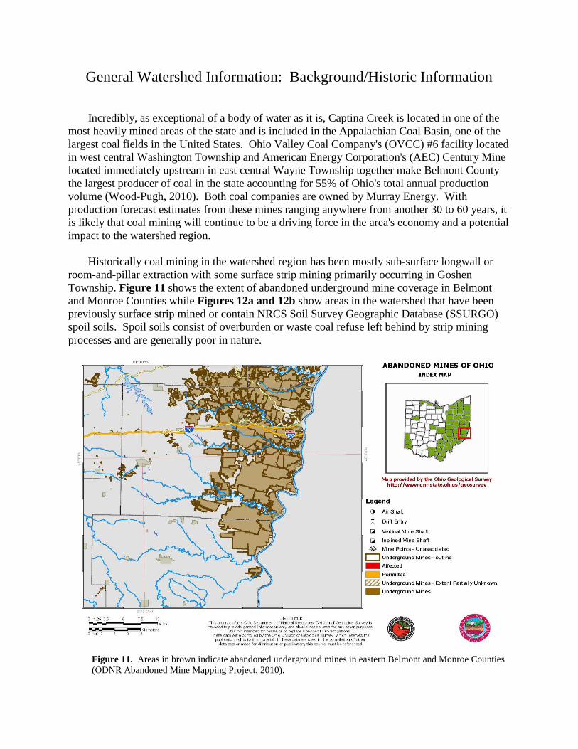
General Watershed Information: Background/Historic Information
Incredibly, as exceptional of a body of water as it is, Captina Creek is located in one of the
most heavily mined areas of the state and is included in the Appalachian Coal Basin, one of the
largest coal fields in the United States. Ohio Valley Coal Company's (OVCC) #6 facility located
in west central Washington Township and American Energy Corporation's (AEC) Century Mine
located immediately upstream in east central Wayne Township together make Belmont County
the largest producer of coal in the state accounting for 55% of Ohio's total annual production
volume (Wood-Pugh, 2010). Both coal companies are owned by Murray Energy. With
production forecast estimates from these mines ranging anywhere from another 30 to 60 years, it
is likely that coal mining will continue to be a driving force in the area's economy and a potential
impact to the watershed region.
Historically coal mining in the watershed region has been mostly sub-surface longwall or
room-and-pillar extraction with some surface strip mining primarily occurring in Goshen
Township. Figure 11 shows the extent of abandoned underground mine coverage in Belmont
and Monroe Counties while Figures 12a and 12b show areas in the watershed that have been
previously surface strip mined or contain NRCS Soil Survey Geographic Database (SSURGO)
spoil soils. Spoil soils consist of overburden or waste coal refuse left behind by strip mining
processes and are generally poor in nature.
Figure 11. Areas in brown indicate abandoned underground mines in eastern Belmont and Monroe Counties
(ODNR Abandoned Mine Mapping Project, 2010).

Figure 12a. Location of strip mined grounds in the western portion of the Captina Creek watershed area (source: Belmont
County GIS).
ALLEDONIAALLEDONIAALLEDONIAALLEDONIAALLEDONIA
ARMSTRONGS MILARMSTRONGS MILARMSTRONGS MILARMSTRONGS MILARMSTRONGS MIL
BADGERSBURGBADGERSBURGBADGERSBURGBADGERSBURGBADGERSBURG
BARKCAMP PARKBARKCAMP PARKBARKCAMP PARKBARKCAMP PARKBARKCAMP PARK
BARNESVILLEBARNESVILLEBARNESVILLEBARNESVILLEBARNESVILLE
BELMONTBELMONTBELMONTBELMONTBELMONT
BETHESDABETHESDABETHESDABETHESDABETHESDA
BOSTONBOSTONBOSTONBOSTONBOSTON
CENTERVILLECENTERVILLECENTERVILLECENTERVILLECENTERVILLE
CHAPEL HILLCHAPEL HILLCHAPEL HILLCHAPEL HILLCHAPEL HILL
CLOVER RIDGECLOVER RIDGECLOVER RIDGECLOVER RIDGECLOVER RIDGE
COOL HILLCOOL HILLCOOL HILLCOOL HILLCOOL HILL JACOBSBURGJACOBSBURGJACOBSBURGJACOBSBURGJACOBSBURG
LAMIRALAMIRALAMIRALAMIRALAMIRA
LOOMISLOOMISLOOMISLOOMISLOOMIS
MT OLIVETTMT OLIVETTMT OLIVETTMT OLIVETTMT OLIVETT
NEW CASTLENEW CASTLENEW CASTLENEW CASTLENEW CASTLE
SOMERTONSOMERTONSOMERTONSOMERTONSOMERTON
SPEIDELSPEIDELSPEIDELSPEIDELSPEIDELTACOMATACOMATACOMATACOMATACOMA
WARNOCKWARNOCKWARNOCKWARNOCKWARNOCK
WHITNEYWHITNEYWHITNEYWHITNEYWHITNEY
WILSONWILSONWILSONWILSONWILSON
Map Legend
Creeks Strip Mine Ground SSURGO Spoil Soils

Figure 12b. Location of strip mined grounds in the eastern portion of the Captina Creek watershed area (source: Belmont
County GIS).
Captina Creek has had one historic restoration and cleanup effort of note. The campaign
was headed by the watershed organization ‘Citizens for a Clean Captina’ that formed in the late
1970’s - a time when water quality was so bad that large sections of the mainstem of Captina
Creek were declared dead because of mining activities along its banks. The group was headed
by Captina Creek resident Dennis Bigler and had the goal of restoring water quality standards
within the watershed at a time when there was little influence by the EPA on coal mining
discharge and acid mine drainage. Contributing to water quality problems were waste coal gob
piles deposited directly on creek banks, unregulated slurry seepage into the creek, and acid mine
drainage (AMD) from un-reclaimed strip mine grounds and pumping out underground mines.
The Citizens group had 70 stakeholders of which 40 attended regular meetings.
During this time the group organized un-reclaimed strip mine funds to launch studies of acid
mine drainage treatment and abatement (AMDAT) along Captina Creek. The Citizens group
disbanded in 1982 after successful cleanup efforts of the Oglebay-Norton gob pile at the former
Cravat site near the confluence of Pea Vine and Captina Creeks. In a personal interview
conducted in September of 2010, Dennis Bigler stated that he could not believe how fast the
ALLEDONIAALLEDONIAALLEDONIAALLEDONIAALLEDONIA
ARMSTRONGS MILARMSTRONGS MILARMSTRONGS MILARMSTRONGS MILARMSTRONGS MIL
AVONDALEAVONDALEAVONDALEAVONDALEAVONDALE
BUSINESSBURGBUSINESSBURGBUSINESSBURGBUSINESSBURGBUSINESSBURG
CAPTINACAPTINACAPTINACAPTINACAPTINA
CENTERVILLECENTERVILLECENTERVILLECENTERVILLECENTERVILLE
CHAPEL HILLCHAPEL HILLCHAPEL HILLCHAPEL HILLCHAPEL HILL
CLOVER RIDGECLOVER RIDGECLOVER RIDGECLOVER RIDGECLOVER RIDGE
COOL HILLCOOL HILLCOOL HILLCOOL HILLCOOL HILL
DILLES BOTTOMDILLES BOTTOMDILLES BOTTOMDILLES BOTTOMDILLES BOTTOM
GLENCOEGLENCOEGLENCOEGLENCOEGLENCOE
JACOBSBURGJACOBSBURGJACOBSBURGJACOBSBURGJACOBSBURG
KEYKEYKEYKEYKEY
POWHATAN POINTPOWHATAN POINTPOWHATAN POINTPOWHATAN POINTPOWHATAN POINT
SHADYSIDESHADYSIDESHADYSIDESHADYSIDESHADYSIDE
STEINERSVILLESTEINERSVILLESTEINERSVILLESTEINERSVILLESTEINERSVILLE
STEWARTSVILLESTEWARTSVILLESTEWARTSVILLESTEWARTSVILLESTEWARTSVILLE
VADISVADISVADISVADISVADIS
VALLONIAVALLONIAVALLONIAVALLONIAVALLONIA
WEBBWEBBWEBBWEBBWEBB
WEGEEWEGEEWEGEEWEGEEWEGEE
WHITNEYWHITNEYWHITNEYWHITNEYWHITNEY
Map Legend
Creeks Strip Mine Ground SSURGO Spoil Soils

creek's habitat rebounded once the gob pile was removed. "In a matter of a few years the habitat
went from seemingly dead to thriving," commented Bigler. See Appendix B for copies of
newspaper articles related to the Citizens for a Clean Captina accomplishments.
Cravat Coal Company received recognition for its reclamation of 55 acres of strip mined
grounds in the 1980's located in section 33 of York Township across SR 148 from Lake Shawn.
The restoration project eliminated an existing high wall in the reclamation area, constructed two
settling ponds lined with limestone slag to neutralize acid mine drainage (AMD) and buried an
existing gob pile at the site. Further improvements were made to this site from 1990 to 2000
with the assistance of Abandoned Mine Lands (AML) Appalachian Clean Streams (ACS)
initiative. Included in these improvements were the installment of two additional settling ponds
at the site and an alkaline slag bed to treat water escaping the toe of the buried gob pile. Cravat
has also been credited for the reclamation of surface mined grounds in the late 1970's just west of
Armstrongs Mills in Washington township sections 10 and 16, and a reclamation of the Linn
Tipple facility by installing settling ponds for AMD prior to 1986.
Two abandoned subsurface coal mines have also been reclaimed by Ohio Division of
Mineral Resources along the banks of Captina Creek. One area is located west of Powhatan
Point along Cove Rd. and the other is just east of York Township Rd. 810 near the intersection
with SR 148. Both sites employ the use of alkaline dosing silos to treat acidic water pumped
from underground mine shafts before entering the creek. The Cove Rd. silo is at the former
Bellaire Corporation Powhatan No. 2 mine which was abandoned in 1954 and the York
Township Rd. 810 silo is at the former Bellaire Corporation Powhatan No. 5 mine abandoned in
the early 1980's.
In 2006 crews working for Murray Energy were able to remove a portion of the abandoned
Oklahoma Coal Company Linn Tipple gob pile located in Section 4 of Washington Township.
The reclaimed area is specifically located between SR 148 and the railroad tracks. A sizable gob
pile still exists on the hillside above the railroad tracks at this location and has been documented
releasing AMD into a culvert along SR 148. Mike Mozena, head of Ohio Department of Mineral
Resources Abandoned Mine Lands reclamation program, states the remnants of the Linn Tipple
gob pile along Captina Creek in eastern Washington Township remains a priority project for his
department. Two other partially reclaimed piles are located along Captina Creek downstream of
Linn Tipple, their locations are given in Table 2.
Table 2. Existing gob pile locations in the Captina Creek watershed region.
Township Subwatershed Description Coordinates 12 Digit HUC
Washington - Sec. 4 Pea Vine Creek
Oklahoma Coal
Company Linn
Tipple Facility
80o 54' 18.4" W
39o 54' 5.1" N
050301060905
York - Sec. 21 Pea Vine Creek
Bellaire Corporation
Powhatan #5 Mine
site
80o 51' 15.7" W
39o 53' 17.5" N
050301060905
York - Sec. 33 Pea Vine Creek Reclaimed Cravat
gob pile
80o 53' 35.8" W
39o 53' 39.8" N
050301060905
Additionally, in spring of 2007 biologists from Murray Energy reclaimed a wetland parcel
near the Century Mine in Section 3 of Wayne Township along Township Road 87. The location
was recently inspected and approved by the Army Corps of Engineers. Officials at Murray
Energy have been open to ideas for mitigation projects like wetlands habitat restoration that will
improve water quality in the Captina Creek area.
In 2002, the Natural Resources Conservation Service (NRCS) targeted the Captina
watershed for the Environmental Quality Incentive Program (EQIP). This cost-sharing program
protects soil and water by using best management practices (BMPs) for agriculture and ranching.
The program has provided Belmont County more than one million dollars over the last 6 years
for conservation practices designed protect water quality through the use of riparian buffer
corridors, animal waste and nutrient management facilities, proper silviculture, and outreach and
educational activities. In fall of 2010 specifications were made to the EQUIP application
guidelines by Belmont SWCD and NRCS Local Work Group giving extra points to farmers
applying for EQUIP funding who live in the Cat Run and South Fork subwatershed areas. These
areas were targeted based on TMDL results from OEPA assessment of stream quality indicating
higher than normal nutrient loading due to agricultural practices.


