116
Gothic, CO (GTH161) 2017 CASTNET Annual Network Plan Clean Air Markets Division Office of Atmospheric Programs US Environmental Protection Agency June 21, 2017

Gothic, CO (GTH161)
2017 CASTNET Annual Network Plan
Clean Air Markets Division
Office of Atmospheric Programs
US Environmental Protection Agency
June 21, 2017

2
Table of Contents Table of Contents ...........................................................................................................................................................................2
1. Network Overview .................................................................................................................................................................3
2. Ozone and Trace Gas Data .....................................................................................................................................................5
3. Exceptional Events .................................................................................................................................................................6
4. Network Audit Requirements ................................................................................................................................................6
5. Quality Control Checks ...........................................................................................................................................................6
6. Performance Evaluations (PE) ................................................................................................................................................7
7. Field Systems Audit (FSA) .....................................................................................................................................................10
8. National Performance Audit Program (NPAP) .....................................................................................................................10
9. Technical Systems Audit (TSA) .............................................................................................................................................11
10. Annual Monitoring Network Plans and Network Assessment .............................................................................................11
11. Network Modification ..........................................................................................................................................................11
12. Data Reporting and Certification..........................................................................................................................................12
Appendix A. Detailed Site Information ..........................................................................................................................................13
Appendix B. Quality Assurance Validation Template ....................................................................................................................94
Appendix C. Ozone Season by State ........................................................................................................................................... 106
Appendix D. CASTNET QAPP Ozone Certification Flowchart ...................................................................................................... 107
Appendix E. EPA Regional Office Contacts Information ............................................................................................................. 108
Appendix F. Outline for TSA Report ........................................................................................................................................... 109
Appendix G. Current list of 40 CFR Part 58 Compliant CASTNET Ozone and Trace Gas Monitors ............................................. 110
Appendix H. CBSA Code and Title for CASTNET Sites ................................................................................................................. 113
Appendix I. Summary of Current CASTNET Ozone and Trace Gas Monitors .............................................................................. 116
List of Tables
Table 1 Quality Control Checks………………………………………………………………………….………………………………..…………………………………….6
Table 2 Audit Levels for Performance Evaluations (PE)………………………………………………………………………..…………………………………….7
Table 3 Proposed PE and FSA Schedule……………………………………….……………………………………………………….……………………….…………..8
Table 4 Annual Network Plan Schedule….…………………………………………………………………………………………….………………………………….11
List of Figures
Figure 1 CASTNET Project Organization…………………………………………………………………..…………………………………………………………………3
Figure 2 Active and planned CASTNET sites in 2017………………………………………….....……………………………………………………………………4
3
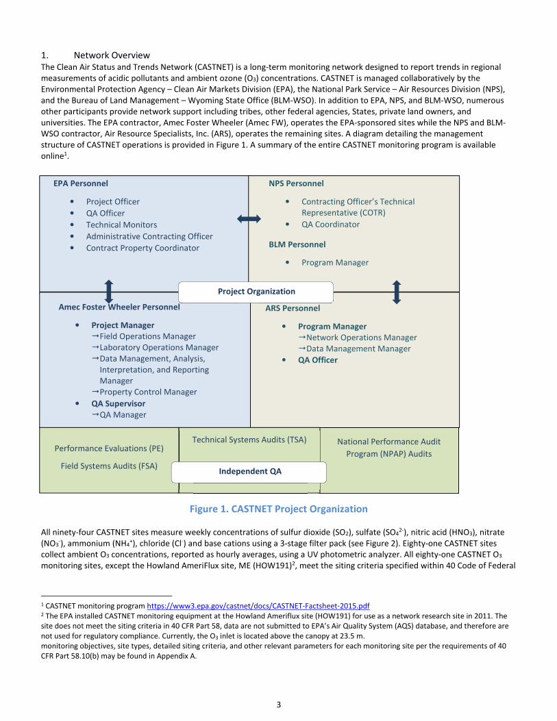
1. Network Overview
The Clean Air Status and Trends Network (CASTNET) is a long-term monitoring network designed to report trends in regional
measurements of acidic pollutants and ambient ozone (O3) concentrations. CASTNET is managed collaboratively by the
Environmental Protection Agency – Clean Air Markets Division (EPA), the National Park Service – Air Resources Division (NPS),
and the Bureau of Land Management – Wyoming State Office (BLM-WSO). In addition to EPA, NPS, and BLM-WSO, numerous
other participants provide network support including tribes, other federal agencies, States, private land owners, and
universities. The EPA contractor, Amec Foster Wheeler (Amec FW), operates the EPA-sponsored sites while the NPS and BLM-
WSO contractor, Air Resource Specialists, Inc. (ARS), operates the remaining sites. A diagram detailing the management
structure of CASTNET operations is provided in Figure 1. A summary of the entire CASTNET monitoring program is available
online1.
Figure 1. CASTNET Project Organization
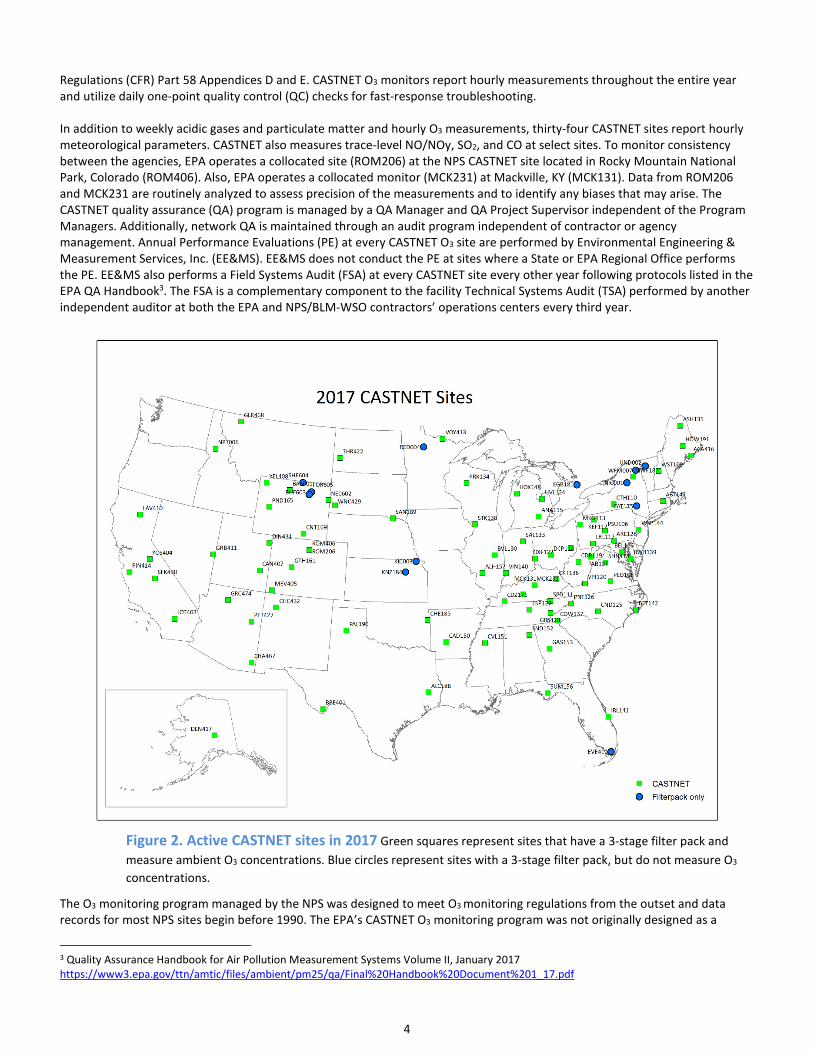
All ninety-four CASTNET sites measure weekly concentrations of sulfur dioxide (SO2), sulfate (SO42-), nitric acid (HNO3), nitrate
(NO3-), ammonium (NH4
+), chloride (Cl-) and base cations using a 3-stage filter pack (see Figure 2). Eighty-one CASTNET sites
collect ambient O3 concentrations, reported as hourly averages, using a UV photometric analyzer. All eighty-one CASTNET O3
monitoring sites, except the Howland AmeriFlux site, ME (HOW191)2, meet the siting criteria specified within 40 Code of Federal
1 CASTNET monitoring program https://www3.epa.gov/castnet/docs/CASTNET-Factsheet-2015.pdf 2 The EPA installed CASTNET monitoring equipment at the Howland Ameriflux site (HOW191) for use as a network research site in 2011. The
site does not meet the siting criteria in 40 CFR Part 58, data are not submitted to EPA’s Air Quality System (AQS) database, and therefore are
not used for regulatory compliance. Currently, the O3 inlet is located above the canopy at 23.5 m.
monitoring objectives, site types, detailed siting criteria, and other relevant parameters for each monitoring site per the requirements of 40
CFR Part 58.10(b) may be found in Appendix A.
National Performance Audit
Program (NPAP) Audits
EPA Personnel
• Project Officer
• QA Officer
• Technical Monitors
• Administrative Contracting Officer
• Contract Property Coordinator
NPS Personnel
• Contracting Officer’s Technical
Representative (COTR)
• QA Coordinator
BLM Personnel
• Program Manager
ARS Personnel
• Program Manager
�Network Operations Manager
�Data Management Manager
• QA Officer
Amec Foster Wheeler Personnel
• Project Manager
�Field Operations Manager
�Laboratory Operations Manager
�Data Management, Analysis,
Interpretation, and Reporting
Manager
�Property Control Manager
• QA Supervisor
�QA Manager
Project Organization
Performance Evaluations (PE)
Field Systems Audits (FSA)
Technical Systems Audits (TSA)
Independent QA
4
Regulations (CFR) Part 58 Appendices D and E. CASTNET O3 monitors report hourly measurements throughout the entire year
and utilize daily one-point quality control (QC) checks for fast-response troubleshooting.
In addition to weekly acidic gases and particulate matter and hourly O3 measurements, thirty-four CASTNET sites report hourly
meteorological parameters. CASTNET also measures trace-level NO/NOy, SO2, and CO at select sites. To monitor consistency
between the agencies, EPA operates a collocated site (ROM206) at the NPS CASTNET site located in Rocky Mountain National
Park, Colorado (ROM406). Also, EPA operates a collocated monitor (MCK231) at Mackville, KY (MCK131). Data from ROM206
and MCK231 are routinely analyzed to assess precision of the measurements and to identify any biases that may arise. The
CASTNET quality assurance (QA) program is managed by a QA Manager and QA Project Supervisor independent of the Program
Managers. Additionally, network QA is maintained through an audit program independent of contractor or agency
management. Annual Performance Evaluations (PE) at every CASTNET O3 site are performed by Environmental Engineering &
Measurement Services, Inc. (EE&MS). EE&MS does not conduct the PE at sites where a State or EPA Regional Office performs
the PE. EE&MS also performs a Field Systems Audit (FSA) at every CASTNET site every other year following protocols listed in the
EPA QA Handbook3. The FSA is a complementary component to the facility Technical Systems Audit (TSA) performed by another
independent auditor at both the EPA and NPS/BLM-WSO contractors’ operations centers every third year.
Figure 2. Active CASTNET sites in 2017 Green squares represent sites that have a 3-stage filter pack and
measure ambient O3 concentrations. Blue circles represent sites with a 3-stage filter pack, but do not measure O3
concentrations.
The O3 monitoring program managed by the NPS was designed to meet O3 monitoring regulations from the outset and data
records for most NPS sites begin before 1990. The EPA’s CASTNET O3 monitoring program was not originally designed as a
3 Quality Assurance Handbook for Air Pollution Measurement Systems Volume II, January 2017
https://www3.epa.gov/ttn/amtic/files/ambient/pm25/qa/Final%20Handbook%20Document%201_17.pdf
5
regulatory network, but was upgraded in 2010 and 2011 to comply with the requirements in 40 CFR Part 58. EPA replaced the
existing O3 analyzers with a pair of Thermo Scientific™ Model 49i monitors where one has onboard O3-generators for use as an
on-site transfer standard, and updated the QA/QC procedures to comply with these requirements. The upgrade at the EPA-
sponsored sites improved the overall quality of data, the reliability of the analyzers, and the comparability of the data with
other regulatory monitoring networks (e.g., State and Local Air Monitoring Sites (SLAMS), NCore).
The EPA uses CASTNET O3 data to calculate design values for all sites where data completeness requirements are met. The
CASTNET program follows QA/QC procedures and schedules to meet the regulatory requirements detailed in Appendix B. This
document includes an overview of the CASTNET regulatory O3 monitoring program, a description of the internal and external QA
programs, any planned changes to the network, and a description of each monitoring site (Appendix A). The procedures in this
Network Plan originate from the requirements placed on States for SLAMS per guidance in 40 CFR Part 58.10, but have been
adapted to a federally-operated national monitoring network.
2. Ozone and Trace Gas Data
CASTNET monitors measure ambient O3 concentrations for the entire year, which extends beyond the required O3 season for
many States (Appendix C). CASTNET submits ambient concentrations in near real time to AIRNow Tech4 and reports data to the
CASTNET website2 daily. NPS also displays O3 and meteorological data on the Gaseous Pollutant and Meteorological Data
website5 and the BLM-WSO distributes O3 data through their WARMS website6. Amec FW and ARS submit the hourly O3
concentrations to EPA’s Air Quality System (AQS) database on a monthly basis and daily 1-point precision results on a quarterly
basis. EPA submits O3 data from two collocated monitors (ROM206 and MCK231) to AQS, but the data are identified as ‘NAAQS
Excluded’ as these data are solely used for QA purposes and are not used to calculate design values.
CASTNET also measures ambient trace gas concentrations including SO2 and CO at Bondville, IL as required by the NCore
program for the entire year. The CASTNET SO2 monitor used is a Teledyne API T100U and the CO monitor used is a Teledyne API
T300U. CASTNET submits ambient trace-gas concentrations in near real time to AIRNow Tech4 and reports data to the CASTNET
website7 daily. Amec FW and ARS submit the hourly and 5-minute (SO2 only) trace gas concentrations to EPA’s Air Quality
System (AQS) database on a monthly basis and daily 1-point precision check results on a quarterly basis.
CASTNET uses the measurement quality objectives and validation templates described in the EPA QA Handbook Validation
Template8 (reproduced in Appendix B of this document) to ensure that the highest quality data are being submitted to AQS.
These validation templates describe operational and systematic criteria for O3 and trace gas measurements, including
requirements for frequency of measurements or audits, calibration schedules, and acceptance criteria for QC checks.
In addition to the QC checks required for meeting the measurement quality objectives and validation templates, semi-annual
(O3) and quarterly (SO2 and CO) system checks are performed at each CASTNET site. Using National Institute of Standards and
Technology (NIST) terminology we define levels as degrees of separation from a NIST standard reference photometer (Level 1).
During these checks, a field operations technician challenges the on-site analyzer and re-verifies the on-site transfer standard,
calibrates the on-site analyzer to the traveling transfer standard (Level 2) as needed, and verifies the data logger and the shelter
temperature probe using NIST traceable standards. All on-site O3 transfer standards at CASTNET sites are NIST-traceable at Level
3. A flow chart diagram of the data certification process is illustrated in Appendix D.
Following guidance in 40 CFR Part 58.15, CASTNET federal managers from EPA, NPS and BLM-WSO submit their annual data
certification letter, including the AQS Data Certification Report (AMP600) to the EPA Office of Air Quality Planning and
Standards (OAQPS) and applicable EPA Regional Offices by May 1 of each year. Consistent with the March 28, 2016 revision to
40 CFR Part 58.10 (a)(1), all of the monitors included in Appendix G of this document meet the siting and operational criteria
required in appendices A, C, D, and E of 40 CFR Part 58 as identified for each year.
4 AIRNow Tech https://www.airnowtech.org/ 5 NPS Gaseous Pollutant and Meteorological Data website http://ard-request.air-resource.com/ 6 BLM-WSO WARMS website http://www.blmwarms.net/ 7 CASTNET website https://java.epa.gov/castnet/clearsession.do 8 EPA QA Handbook Appendix D Validation Templates, March 2017
https://www3.epa.gov/ttn/amtic/files/ambient/pm25/qa/APP_D%20validation%20template%20version%2003_2017_for%20AMTIC%20Rev_
1.pdf
6
3. Exceptional Events
Exceptional events are unusual or naturally occurring events that can affect air quality but are not reasonably controllable using
techniques that State, local, or tribal (S/L/T) air agencies may implement in order to attain and maintain the National Ambient
Air Quality Standards. Exceptional events include wildfires, stratospheric ozone intrusions, and volcanic and seismic activities.
Following guidance in 40 CFR Part 50.14(a)(1), a State may request that EPA exclude data that exceed the NAAQS and have been
impacted by an exceptional event. As noted in the preamble to the 2016 Exceptional Events Rule (81 FR 68216, 10/3/2016)9,
“as the single actor responsible for administering air quality planning and management activities within its jurisdictional
boundaries, the state, exclusive of tribal lands, is ultimately responsible for submitting exceptional event demonstrations for
exceedances that occur at all regulatory monitoring sites within the boundary of the state.” CASTNET federal partners will
continue to work with S/L/T air agencies to flag ambient data potentially influenced by an exceptional event as requested by a
S/L/T air agency that has jurisdiction over the area where a CASTNET site is located and assist in preparing a demonstration (i.e.,
providing relevant information) if requested by a S/L/T agency. This initial flag is denoted as informational-use only and these
data will continue to be used for NAAQS attainment purposes until the State agency receives approval from the EPA Regional
Administrator to exclude these data based on the Exceptional Event Demonstration. State agencies will continue to be
responsible for working with the EPA region to submit exceptional event demonstrations, which may include data from
CASTNET sites. CASTNET managers do not have the authorization to determine the sufficiency of an Exceptional Event
Demonstration or whether or not CASTNET monitoring data should be excluded from the NAAQS calculation. S/L/T agencies
should follow the regulations described in the revision to 40 CFR Parts 50 and 51, Treatment of Data Influenced by Exceptional
Events (81 FR 68216, 10/3/2016) to prepare and submit exceptional event demonstrations.
To request that CASTNET managers apply initial data flags to CASTNET O3 data potentially impacted by an exceptional event, a
State agency should email the following information to Timothy Sharac ([email protected]):
o date/time range of incident,
o type of exceptional event, and
o CASTNET site(s)
Initial data flags will be applied in AQS within 30 days after CASTNET managers receive a request from a State or local agency.
Exceptional event types and their associated AQS qualifier codes are listed on the AQS Code List webpage10.
4. Network Audit Requirements
The network audit requirements for 40 CFR Part 58 compliance are summarized in Appendix B. CASTNET managers include the
PE and FSA schedules with each Annual Network Plan to ensure EPA Regional Offices have the opportunity to make travel
arrangements if they choose to attend the audit. The EPA Regional Office contacts are listed in Appendix E.
5. Quality Control Checks
Automated zero/precision/span (ZPS) scans are performed nightly while three additional QC checks are verified during weekly
(on Sundays) multi-point checks at EPA-sponsored sites as shown in Table 1. Additional checks may be run manually to
troubleshoot potential issues that may arise. The criteria for the automated ZPS scans are included in Appendix B. QC results are
posted to the CASTNET website daily for EPA-sponsored CASTNET sites.
Table 1 Quality Control Checks
Frequency O3 (ppb) SO2 (ppb) CO (ppm)
Zero Daily 0 0 0
Precision Daily 60 25 250
Span Daily 225* 90 1800
Additional point #1 Weekly 40** 5** 80**
Additional point #2 Weekly 90** 40** 300**
Additional point #3 Weekly 150** 60** 800**
*NPS and BLM-WSO perform O3 span checks at 200 ppb **EPA-sponsored CASTNET sites
All CASTNET O3 monitors are designed for NAAQS decisions and are the only regulatory O3 monitors for 17 distinct CBSAs,
therefore the single point precision check was set to 60 ppb because this is the average fourth highest 8-hour daily maximum
9 Federal Register Volume 81, No. 191 October 3, 2016
https://www.epa.gov/sites/production/files/2016-09/documents/exceptional_events_rule_revisions_2060-as02_final.pdf 10 AQS Code List webpage https://www.epa.gov/aqs/aqs-code-list

7
value for CASTNET O3 monitors. As required by 40 CFR Part 58 Appendix A, results from the single point precision checks are
reported to AQS quarterly. In 2016 all sites met the precision criterion, the upper 90 percent confidence limit for the coefficient
of variation less than or equal to 7 percent, established in 40 CFR Part 58 Appendix A.
6. Performance Evaluations (PE)
An independent auditor performs an annual PE (in accordance with EPA’s QA Handbook11 and the recently revised 40 CFR Parts
53 and Parts 5812) and submits these results to AQS on a quarterly basis. Verification of the O3 and trace gas analyzers during
the PE requires that the zero/span be within ±2% of the full scale of the best fit linear line. The auditor selects target
concentration values among the ten audit levels, as described in guidance from Appendix A to Part 5813. The evaluation is made
by challenging the monitor with audit gas standards of known concentration from at least three audit levels. A minimum of
three audit levels that represent routine concentrations at the monitoring site are required (see Table 2 for acceptable audit
ranges). Audit levels 1 and 2 must be within ±1.5 ppb or within ±15%, whichever is greater, to meet the acceptance criteria for
O3, SO2, and NO2, while levels 1 and 2 must be within ±0.03 ppm or within ±15%, whichever is greater, to meet the acceptance
criteria for CO. Levels 3-10 must be within ±15% to meet the acceptance criteria.
Table 2 Audit Levels for Performance Evaluations (PE)1
Audit
Level
O3
Concentration
Range, ppm
SO2
Concentration
Range, ppm
NO2
Concentration
Range, ppm
O3, SO2, and NO2
Acceptance
Criteria
CO Concentration
Range, ppm
CO Acceptance
Criteria
1 0.004 – 0.0059 0.003 – 0.0029 0.003 – 0.0029 ±1.5 ppb or ±15%,
whichever is
greater
0.020 – 0.059 ±0.03 ppm or
±15%, whichever is
greater
2 0.006 – 0.019 0.0030 – 0.0049 0.0030 – 0.0049 ±1.5 ppb or ±15%,
whichever is
greater
0.060 – 0.199 ±0.03 ppm or
±15%, whichever is
greater
3 0.020 – 0.039 0.0050 – 0.0079 0.0050 – 0.0079 ±15% 0.200 – 0.899 ±15%
4 0.040 – 0.069 0.0080 – 0.0199 0.0080 – 0.0199 ±15% 0.900 – 2.999 ±15%
5 0.070 – 0.089 0.0200 – 0.0499 0.0200 – 0.0499 ±15% 3.000 – 7.999 ±15%
6 0.090 – 0.119 0.0500 – 0.0999 0.0500 – 0.0999 ±15% 8.000 – 15.999 ±15%
7 0.120 – 0.139 0.1000 – 0.1499 0.1000 – 0.2999 ±15% 16.000 – 30.999 ±15%
8 0.140 – 0.169 0.1500 – 0.2599 0.3000 – 0.4999 ±15% 31.000 – 39.999 ±15%
9 0.170 – 0.189 0.2600 – 0.7999 0.5000 – 0.7999 ±15% 40.000 – 49.999 ±15%
10 0.190 - 0.259 0.8000 – 1.000 0.8000 – 1.000 ±15% 50.000 – 60.000 ±15%
Appendix A to Part 58 – Quality Assurance Requirements for Monitors used in Evaluations of National Ambient Air
Quality Standards11. The target audit levels used for PE audits for CASTNET O3, SO2, and CO measurements are
highlighted in bold font
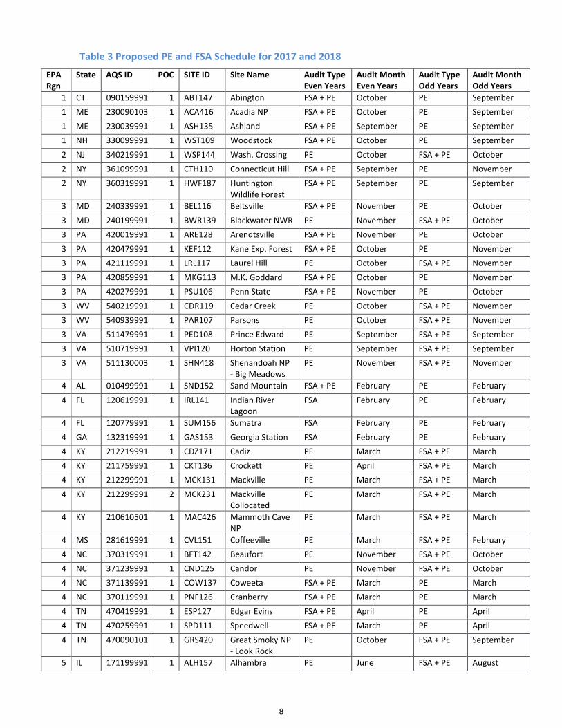
The proposed PE and FSA audit schedule for CASTNET sites is shown in Table 3 below. The independent auditor uses equipment
that is NIST-certified (verified twice per year) to audit CASTNET monitoring equipment. The independent auditor performs a PE
at each site annually and performs a FSA which includes audit of flow, meteorological sensors, and related parameters every
other year. States may perform a PE if they coordinate with the sponsoring agency, site supervisor, and independent auditor as
explained in the third-party CASTNET audit document14.
11 Quality Assurance Handbook for Air Pollution Measurement Systems Volume II, January 2017
https://www3.epa.gov/ttn/amtic/files/ambient/pm25/qa/Final%20Handbook%20Document%201_17.pdf 12 40 CFR Parts 53 and Parts 58
https://www.ecfr.gov/cgi-bin/text-idx?SID=81db12ed36c99ad4e260a58d3b874658&mc=true&tpl=/ecfrbrowse/Title40/40cfrv6_02.tpl#0
13 App A to Part 58 – Quality Assurance Requirements for Monitors used in Evaluations of National Ambient Air Quality Standards.
http://www.ecfr.gov/cgi-bin/text-idx?SID=43a82c5c9a954280524a1abf6a3328ca&mc=true&node=ap40.6.58_161.a&rgn=div9
14 CASTNET third-party audit document https://www.epa.gov/sites/production/files/2015-07/documents/third_party_audits.pdf
8
Table 3 Proposed PE and FSA Schedule for 2017 and 2018
EPA
Rgn
State AQS ID POC SITE ID Site Name Audit Type
Even Years
Audit Month
Even Years
Audit Type
Odd Years
Audit Month
Odd Years
1 CT 090159991 1 ABT147 Abington FSA + PE October PE September
1 ME 230090103 1 ACA416 Acadia NP FSA + PE October PE September
1 ME 230039991 1 ASH135 Ashland FSA + PE September PE September
1 NH 330099991 1 WST109 Woodstock FSA + PE October PE September
2 NJ 340219991 1 WSP144 Wash. Crossing PE October FSA + PE October
2 NY 361099991 1 CTH110 Connecticut Hill FSA + PE September PE November
2 NY 360319991 1 HWF187 Huntington
Wildlife Forest
FSA + PE September PE September
3 MD 240339991 1 BEL116 Beltsville FSA + PE November PE October
3 MD 240199991 1 BWR139 Blackwater NWR PE November FSA + PE October
3 PA 420019991 1 ARE128 Arendtsville FSA + PE November PE October
3 PA 420479991 1 KEF112 Kane Exp. Forest FSA + PE October PE November
3 PA 421119991 1 LRL117 Laurel Hill PE October FSA + PE November
3 PA 420859991 1 MKG113 M.K. Goddard FSA + PE October PE November
3 PA 420279991 1 PSU106 Penn State FSA + PE November PE October
3 WV 540219991 1 CDR119 Cedar Creek PE October FSA + PE November
3 WV 540939991 1 PAR107 Parsons PE October FSA + PE November
3 VA 511479991 1 PED108 Prince Edward PE September FSA + PE September
3 VA 510719991 1 VPI120 Horton Station PE September FSA + PE September
3 VA 511130003 1 SHN418 Shenandoah NP
- Big Meadows
PE November FSA + PE November
4 AL 010499991 1 SND152 Sand Mountain FSA + PE February PE February
4 FL 120619991 1 IRL141 Indian River
Lagoon
FSA February PE February
4 FL 120779991 1 SUM156 Sumatra FSA February PE February
4 GA 132319991 1 GAS153 Georgia Station FSA February PE February
4 KY 212219991 1 CDZ171 Cadiz PE March FSA + PE March
4 KY 211759991 1 CKT136 Crockett PE April FSA + PE March
4 KY 212299991 1 MCK131 Mackville PE March FSA + PE March
4 KY 212299991 2 MCK231 Mackville
Collocated
PE March FSA + PE March
4 KY 210610501 1 MAC426 Mammoth Cave
NP
PE March FSA + PE March
4 MS 281619991 1 CVL151 Coffeeville PE March FSA + PE February
4 NC 370319991 1 BFT142 Beaufort PE November FSA + PE October
4 NC 371239991 1 CND125 Candor PE November FSA + PE October
4 NC 371139991 1 COW137 Coweeta FSA + PE March PE March
4 NC 370119991 1 PNF126 Cranberry FSA + PE March PE March
4 TN 470419991 1 ESP127 Edgar Evins FSA + PE April PE April
4 TN 470259991 1 SPD111 Speedwell FSA + PE March PE April
4 TN 470090101 1 GRS420 Great Smoky NP
- Look Rock
PE October FSA + PE September
5 IL 171199991 1 ALH157 Alhambra PE June FSA + PE August

9
Table 3 Proposed PE and FSA Schedule for 2017 and 2018
EPA
Rgn
State AQS ID POC SITE ID Site Name Audit Type
Even Years
Audit Month
Even Years
Audit Type
Odd Years
Audit Month
Odd Years
5 IL 170191001 1 BVL130 Bondville PE August FSA + PE August
5 IL 170859991 1 STK138 Stockton PE June FSA + PE August
5 IN 181699991 1 SAL133 Salamonie
Reservoir
FSA + PE August PE August
5 IN 180839991 1 VIN140 Vincennes PE June FSA + PE August
5 MI 261619991 1 ANA115 Ann Arbor FSA + PE August PE August
5 MI 261659991 1 HOX148 Hoxeyville FSA + PE August PE August
5 MI 261579991 1 UVL124 Unionville FSA + PE August PE August
5 MN 271370034 1 VOY413 Voyageurs NP PE August FSA + PE August
5 OH 390479991 1 DCP114 Deer Creek PE April FSA + PE April
5 OH 390179991 1 OXF122 Oxford PE April FSA + PE April
5 OH 391219991 1 QAK172 Quaker City PE April FSA + PE April
5 WI 551199991 1 PRK134 Perkinstown PE August FSA + PE August
6 AR 050199991 1 CAD150 Caddo Valley PE February FSA + PE February
6 OK 400019009 1 CHE185 Cherokee Nation PE February FSA + PE March
6 NM 350450020 1 CHC432 Chaco NM PE April FSA + PE April
6 TX 483739991 1 ALC188 Alabama-
Coushatta
PE March FSA + PE February
6 TX 480430101 1 BBE401 Big Bend NP PE March FSA + PE March
6 TX 483819991 1 PAL190 Palo Duro PE February FSA + PE March
7 NE 311079991 1 SAN189 Santee Sioux PE July FSA + PE June
8 CO 080519991 1 GTH161 Gothic PE June FSA + PE June
8 CO 080830101 1 MEV405 Mesa Verde NP FSA + PE April PE April
8 CO 080699991 1 ROM206 Rocky Mtn NP
QA Collocated
PE June FSA + PE June
8 CO 080690007 1 ROM406 Rocky Mtn NP
Primary
PE June FSA + PE June
8 MT 300298001 1 GLR468 Glacier NP FSA + PE June PE June
8 ND 380070002 1 THR422 Theodore
Roosevelt NP
PE September FSA + PE July
8 SD 460330132 3 WNC429 Wind Cave NP PE September FSA + PE July
8 UT 490370101 1 CAN407 Canyonlands NP FSA + PE April PE April
8 UT 490471002 1 DIN431 Dinosaur NM FSA + PE July PE July
8 WY 560030002 1 BAS601 Basin PE June FSA + PE June
8 WY 560019991 1 CNT169 Centennial PE June FSA + PE June
8 WY 560450003 1 NEC602 Newcastle PE June FSA + PE June
8 WY 560359991 1 PND165 Pinedale PE August FSA + PE June
8 WY 560391011 1 YEL408 Yellowstone NP PE June FSA + PE May
9 AZ 040038001 1 CHA467 Chiricahua NM FSA + PE April PE April
9 AZ 040058001 1 GRC474 Grand Canyon
NP
FSA + PE April PE April
9 AZ 040170119 1 PET427 Petrified Forest FSA + PE April PE April
9 CA 060719002 1 JOT403 Joshua Tree NP FSA + PE May PE April

10
Table 3 Proposed PE and FSA Schedule for 2017 and 2018
EPA
Rgn
State AQS ID POC SITE ID Site Name Audit Type
Even Years
Audit Month
Even Years
Audit Type
Odd Years
Audit Month
Odd Years
9 CA 060893003 1 LAV410 Lassen Volcanic
NP
PE May FSA + PE May
9 CA 060690003 1 PIN414 Pinnacles NM PE May FSA + PE April
9 CA 061070009 1 SEK430 Sequoia NP - Ash
Mountain
PE May FSA + PE May
9 CA 060430003 1 YOS404 Yosemite NP -
Turtleback
Dome
PE May FSA + PE May
9 NV 320330101 1 GRB411 Great Basin NP FSA + PE May PE April
10 AK 020680003 1 DEN417 Denali NP FSA + PE July PE June
10 ID 160499991 1 NPT006 Nez Perce FSA + PE Oct PE Oct
Note: See Appendix H for CBSA Codes for CASTNET sites as available
7. Field Systems Audit (FSA)
An independent auditor performs a FSA every other year at each CASTNET site to complement the requirements of the TSA
(required every three years) to ensure network-wide consistency among all sites within CASTNET. The purpose of these audits is
to provide an independent assessment of the site, the performance of site equipment, and the proficiency of the site operator.
The auditor verifies that filter pack flow, the O3 analyzer, and the meteorological sensors meet the criteria listed in Appendix B
and the CASTNET QAPP15. The auditor also completes a PE for O3 in addition to the FSA. The auditor performs a through-the-
probe (TTP) audit to verify there are no line losses within the system and documents whether any obstructions or emissions
sources violate the CASTNET siting criteria found in the QAPP15. During the FSA, the auditor discusses any issues related to
equipment, siting criteria, or operator handling with the operator and/or site supervisor. The independent auditor submits audit
results to the site supervisor, site operator, site funding agency, and CASTNET contractor following the audit. A summary of
audit results are available in a quarterly report and posted to the CASTNET’s Independent Audit Program webpage16.
The independent auditor sends FSA announcement letters to the agency contractor, site operator, and site sponsor describing
the purpose of the site visit 2-4 weeks prior to the FSA to ensure all parties involved are prepared. The proposed schedule for
2017 and 2018 is shown in Table 3.
8. National Performance Audit Program (NPAP)
The purpose of the NPAP is to assess the proficiency of the monitoring organization. As the primary sponsor for CASTNET, EPA’s
Clean Air Markets Division coordinates with OAQPS, EPA Regional Offices (listed in Appendix E), and the Environmental Services
Assistance Team (ESAT) to fulfill the NPAP requirements for all CASTNET sites. Each monitoring organization’s network is
required to complete NPAP audits, with a goal of 20% of the sites each year or 100% within 6 years. OAQPS is responsible for
selecting the sites to audit and special priority is given to those sites with design values near the O3 NAAQS. The NPAP auditor is
responsible for submitting the audit results to AQS. Through-the-probe audits are also performed during an NPAP audit using a
zero air generator to supply the carrier gas to an O3 generator. Audit O3 concentrations are delivered to the through-the-probe
dual glass manifold connected to the monitor’s inlet probe while venting excess flow to the atmosphere. The O3 generator is
referenced back to a Level 2 O3 standard which is in turn referenced to a Level 1 standard reference photometer. The auditor
selects 3 or 4 known target concentrations to determine the accuracy of the on-site O3 analyzer. The acceptable ranges are the
same as those used for the annual performance evaluations in Table 2.
15 CASTNET Documents webpage https://java.epa.gov/castnet/documents.do 16 CASTNET’s Independent Audit Program webpage https://www.epa.gov/castnet/independent-audit-program

11
9. Technical Systems Audit (TSA)
CASTNET uses an independent auditor to conduct the facilities portion of the TSA at the contractor’s O3 laboratory once every
three years. CASTNET staff may also attend the facility audit when travel funds are available. CASTNET staff provide the date of
the scheduled audit to the EPA Regional Offices at least six months prior to the visit. The purpose of the facility TSA is to provide
a qualitative appraisal of the total measurement system. Site planning, organization, documentation and operation are
evaluated to ensure that good QA/QC practices are being applied throughout the monitoring program. An outline of the facility
TSA is available in Appendix F. RTI International last performed facility TSAs at Amec FW, Inc. in Newberry, FL in 2012 and 2015
and at ARS, Inc. in Fort Collins, CO in 2013 and 2017. The facility TSA consists of an assessment of the staff, facilities, data and
document control, and the quality control programs. Results, findings, and the responses to the findings can be found on the
CASTNET documents webpage17 under “Technical Systems Audit”.
10. Annual Monitoring Network Plans and Network Assessment
CASTNET staff prepare an annual CASTNET Network Plan for public review. The Network Plan focuses on the CASTNET O3 and
trace gas monitoring program and addresses the monitoring requirements of 40 CFR 58.10(b). EPA, NPS, and BLM-WSO consult
with OAQPS and applicable EPA Regional Offices ahead of adding or discontinuing O3 monitors in accordance with 40 CFR 58.14
and any changes are included in this Network Plan. CASTNET staff collect additional comments by sending draft copies to the
National Association of Clean Air Agencies (NACAA) and the Association of Air Pollution Control Agencies (AAPCA). A draft copy
is also distributed through OAQPS’ monitoring list-serve. CASTNET staff contact States directly if these States use a CASTNET
monitor in place of a State-operated O3 monitor (e.g., SLAMS) to ensure their participation in the planning process. CASTNET
staff submit a final version of the Network Plan and responses to any comments received on the draft Network Plan to the EPA
CASTNET O3 webpage18 and OAQPS’ Ambient Monitoring Technology Information Center (AMTIC) Network Plans webpage19.
The schedule for these activities is outlined in Table 5. The Division Director or a designee at the EPA’s Clean Air Markets
Division approves this plan with input from the public by July 1. OAQPS provides comments within 120 days on any plans
proposing changes to the O3 network.
Table 4 Annual Network Plan Schedule
Date Network Plan Steps
March 1 Submit Network Plan to NPS/BLM-WSO for review
May 1 Distribute Network Plan to OAQPS, OAQPS list-serve, EPA Regional Offices, NACAA,
AAPCA and post for public review on the CASTNET webpage
June 1 Deadline for public comments to Network Plan
June 25 CASTNET staff complete response to public comments
July 1 CASTNET staff distribute final version of Network Plan
October 31 OAQPS/Lead EPA Regional Office review Network Plan and provide approval
EPA completes a network assessment every 5 years in accordance with 40 CFR 58.10(d). CASTNET staff submit the network
assessment to the EPA CASTNET O3 webpage18 and OAQPS’ AMTIC Network Plan webpage19. There is no public comment review
and response of this document. The next assessment is due July 1, 2020, and every 5 years thereafter.
Some States include CASTNET sites in their Network Plan to fulfill their requirement for monitoring sites within a population
area. These States should notify the CASTNET agency sponsor that they will be using the CASTNET site in their plan so that the
State may be included in any discussions related to changes at the site.
11. Network Modification
As of June 2017, the following network modifications have occurred:
17 CASTNET Documents webpage https://java.epa.gov/castnet/documents.do 18 CASTNET O3 webpage https://www.epa.gov/castnet/ozone 19 OAQPS’ AMTIC Network Plans webpage https://www3.epa.gov/ttn/amtic/plans.html
12
• EPA-CAMD is attempting to change the AQS site ID for the EPA-sponsored Rocky Mountain National Park from 08-068-
9991-44201-1 to 08-069-0007-44201-2 because this monitor is a secondary QA monitor and is collocated with the
primary NPS-sponsored Rocky Mountain National Park monitor, 08-069-0007-44201-1.
• NPS added an additional CASTNET O3 site at Chaco Culture National Historical Park in New Mexico, 35-045-0020,
44201-1.
• SO2 hourly and 5-minute concentration measurements were discontinued at Beltsville, MD in March, 2017 because the
calibration equipment was required for a special study.
12. Data Reporting and Certification
CASTNET staff submit applicable ambient and quality assurance data to AQS within 90 days after the end of each quarterly
reporting period. CASTNET complies with the annual air monitoring certification requirements in accordance with 40 CFR 58.15-
16. EPA, NPS, and BLM-WSO certify CASTNET ambient O3, SO2, and CO data and quality assurance results by May 1 for the prior
calendar year for their respective CASTNET sites and submit the data to OAQPS for review.

13
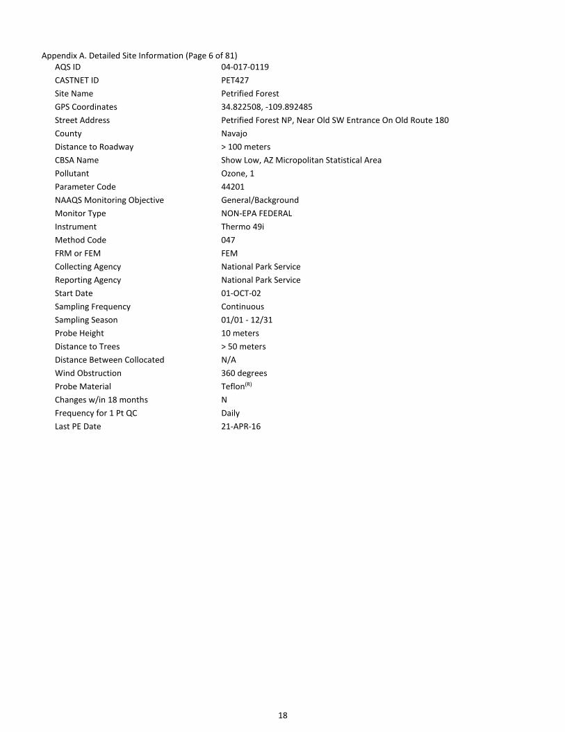
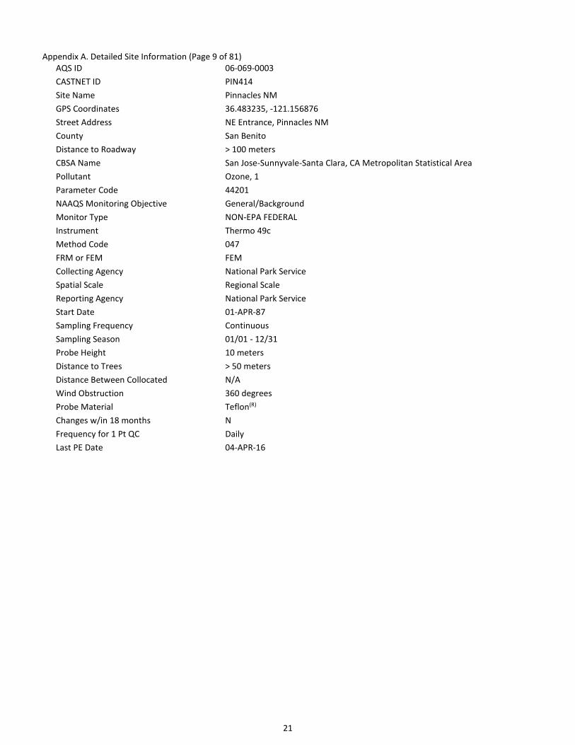
Appendix A. Detailed Site Information (Page 1 of 81)
CASTNET O3 monitors meet the siting criteria as specified within 40 CFR Part 58 Appendices D and E. Following guidance from 40
CFR Part 58.10b, the following detailed information required for each CASTNET monitor is listed in the following pages.
The following parameters are the same at all CASTNET sites:
- Current sampling frequency is continuous
- Sampling season is 01/01 – 12/31
- Frequency of one-point QC check is daily
Parameters required by Part 58.10b, but not available include:
- Traffic count (AADT)

14
Appendix A. Detailed Site Information (Page 2 of 81)
AQS ID 01-049-9991
CASTNET ID SND152
Site Name Sand Mountain
GPS Coordinates 34.289001, -85.970065
Street Address Sand Mountain Alabama Agricultural Experiment Station, Crossville, AL 35962
County DeKalb
Distance to Roadway > 100 meters
CBSA Name Fort Payne, AL Micropolitan Statistical Area
Pollutant Ozone, 1
Parameter Code 44201
NAAQS Monitoring Objective Highest Concentration
Monitor Type EPA
Instrument Thermo 49i
Method Code 047
FRM or FEM FEM
Collecting Agency EPA/CAMD
Spatial Scale Regional Scale
Reporting Agency EPA/CAMD
Start Date 01-JAN-11
Sampling Frequency Continuous
Sampling Season 01/01 - 12/31
Probe Height 10 meters
Distance to Trees > 50 meters
Distance Between Collocated N/A
Wind Obstruction 360 degrees
Probe Material Teflon(R)
Changes w/in 18 months N
Frequency for 1 Pt QC Daily
Last PE Date 09-MAR-16

15
Appendix A. Detailed Site Information (Page 3 of 81)
AQS ID 02-068-0003
CASTNET ID DEN417
Site Name Denali NP
GPS Coordinates 63.7232, -148.9676
Street Address Denali National Park
County Denali
Distance to Roadway > 100 meters
Pollutant Ozone, 1
Parameter Code 44201
NAAQS Monitoring Objective General/Background
Monitor Type NON-EPA FEDERAL
Instrument Thermo 49c
Method Code 047
FRM or FEM FEM
Collecting Agency National Park Service
Spatial Scale Regional Scale
Reporting Agency National Park Service
Start Date 01-JUN-87
Sampling Frequency Continuous
Sampling Season 01/01 - 12/31
Probe Height 10 meters
Distance to Trees > 50 meters
Distance Between Collocated N/A
Wind Obstruction 360 degrees
Probe Material Teflon(R)
Changes w/in 18 months N
Frequency for 1 Pt QC Daily
Last PE Date 07-JUL-16

16
Appendix A. Detailed Site Information (Page 4 of 81)
AQS ID 04-003-8001
CASTNET ID CHA467
Site Name Chiricahua NM
GPS Coordinates 32.009405, -109.389058
Street Address Chiricahua National Monument
County Cochise
Distance to Roadway > 100 meters
CBSA Name Sierra Vista-Douglas, AZ Micropolitan Statistical Area
Pollutant Ozone, 1
Parameter Code 44201
NAAQS Monitoring Objective General/Background
Monitor Type NON-EPA FEDERAL
Instrument Thermo 49i
Method Code 047
FRM or FEM FEM
Collecting Agency National Park Service
Reporting Agency National Park Service
Start Date 01-JUL-89
Sampling Frequency Continuous
Sampling Season 01/01 - 12/31
Probe Height 10 meters
Distance to Trees > 50 meters
Distance Between Collocated N/A
Wind Obstruction 360 degrees
Probe Material Teflon(R)
Changes w/in 18 months N
Frequency for 1 Pt QC Daily
Last PE Date 19-APR-16

17
Appendix A. Detailed Site Information (Page 5 of 81)
AQS ID 04-005-8001
CASTNET ID GRC474
Site Name Grand Canyon NP
GPS Coordinates 36.058642, -112.183575
Street Address Grand Canyon National Park, W Rim Drive
County Coconino
Distance to Roadway > 100 meters
CBSA Name Flagstaff, AZ Metropolitan Statistical Area
Pollutant Ozone, 1
Parameter Code 44201
NAAQS Monitoring Objective General/Background
Monitor Type NON-EPA FEDERAL
Instrument Thermo 49i
Method Code 047
FRM or FEM FEM
Collecting Agency National Park Service
Reporting Agency National Park Service
Start Date 01-JUL-89
Sampling Frequency Continuous
Sampling Season 01/01 - 12/31
Probe Height 10 meters
Distance to Trees > 50 meters
Distance Between Collocated N/A
Wind Obstruction 360 degrees
Probe Material Teflon(R)
Changes w/in 18 months N
Frequency for 1 Pt QC Daily
Last PE Date 20-APR-16
18
Appendix A. Detailed Site Information (Page 6 of 81)
AQS ID 04-017-0119
CASTNET ID PET427
Site Name Petrified Forest
GPS Coordinates 34.822508, -109.892485
Street Address Petrified Forest NP, Near Old SW Entrance On Old Route 180
County Navajo
Distance to Roadway > 100 meters
CBSA Name Show Low, AZ Micropolitan Statistical Area
Pollutant Ozone, 1
Parameter Code 44201
NAAQS Monitoring Objective General/Background
Monitor Type NON-EPA FEDERAL
Instrument Thermo 49i
Method Code 047
FRM or FEM FEM
Collecting Agency National Park Service
Reporting Agency National Park Service
Start Date 01-OCT-02
Sampling Frequency Continuous
Sampling Season 01/01 - 12/31
Probe Height 10 meters
Distance to Trees > 50 meters
Distance Between Collocated N/A
Wind Obstruction 360 degrees
Probe Material Teflon(R)
Changes w/in 18 months N
Frequency for 1 Pt QC Daily
Last PE Date 21-APR-16

19
Appendix A. Detailed Site Information (Page 7 of 81)
AQS ID 05-019-9991
CASTNET ID CAD150
Site Name Caddo Valley
GPS Coordinates 34.179278, -93.098755
Street Address Lower Lake Recreation Area, Caddo Valley, AR 71923
County Clark
Distance to Roadway > 100 meters
CBSA Name Arkadelphia, AR Micropolitan Statistical Area
Pollutant Ozone, 1
Parameter Code 44201
NAAQS Monitoring Objective Highest Concentration
Monitor Type EPA
Instrument Thermo 49i
Method Code 047
FRM or FEM FEM
Collecting Agency EPA/CAMD
Spatial Scale Regional Scale
Reporting Agency EPA/CAMD
Start Date 01-JAN-11
Sampling Frequency Continuous
Sampling Season 01/01 - 12/31
Probe Height 10 meters
Distance to Trees > 50 meters
Distance Between Collocated N/A
Wind Obstruction 360 degrees
Probe Material Teflon(R)
Changes w/in 18 months N
Frequency for 1 Pt QC Daily
Last PE Date 19-FEB-16

20
Appendix A. Detailed Site Information (Page 8 of 81)
AQS ID 06-043-0003
CASTNET ID YOS404
Site Name Yosemite NP - Turtleback Dome
GPS Coordinates 37.713251, -119.706196
Street Address Turtleback Dome, Yosemite National Park
County Mariposa
Distance to Roadway > 100 meters
Pollutant Ozone, 1
Parameter Code 44201
NAAQS Monitoring Objective General/Background
Monitor Type NON-EPA FEDERAL
Instrument Thermo 49c
Method Code 047
FRM or FEM FEM
Collecting Agency National Park Service
Reporting Agency National Park Service
Start Date 01-SEP-90
Sampling Frequency Continuous
Sampling Season 01/01 - 12/31
Probe Height 10 meters
Distance to Trees > 50 meters
Distance Between Collocated N/A
Wind Obstruction 360 degrees
Probe Material Teflon(R)
Changes w/in 18 months N
Frequency for 1 Pt QC Daily
Last PE Date 11-OCT-16
21
Appendix A. Detailed Site Information (Page 9 of 81)
AQS ID 06-069-0003
CASTNET ID PIN414
Site Name Pinnacles NM
GPS Coordinates 36.483235, -121.156876
Street Address NE Entrance, Pinnacles NM
County San Benito
Distance to Roadway > 100 meters
CBSA Name San Jose-Sunnyvale-Santa Clara, CA Metropolitan Statistical Area
Pollutant Ozone, 1
Parameter Code 44201
NAAQS Monitoring Objective General/Background
Monitor Type NON-EPA FEDERAL
Instrument Thermo 49c
Method Code 047
FRM or FEM FEM
Collecting Agency National Park Service
Spatial Scale Regional Scale
Reporting Agency National Park Service
Start Date 01-APR-87
Sampling Frequency Continuous
Sampling Season 01/01 - 12/31
Probe Height 10 meters
Distance to Trees > 50 meters
Distance Between Collocated N/A
Wind Obstruction 360 degrees
Probe Material Teflon(R)
Changes w/in 18 months N
Frequency for 1 Pt QC Daily
Last PE Date 04-APR-16
22
Appendix A. Detailed Site Information (Page 10 of 81)
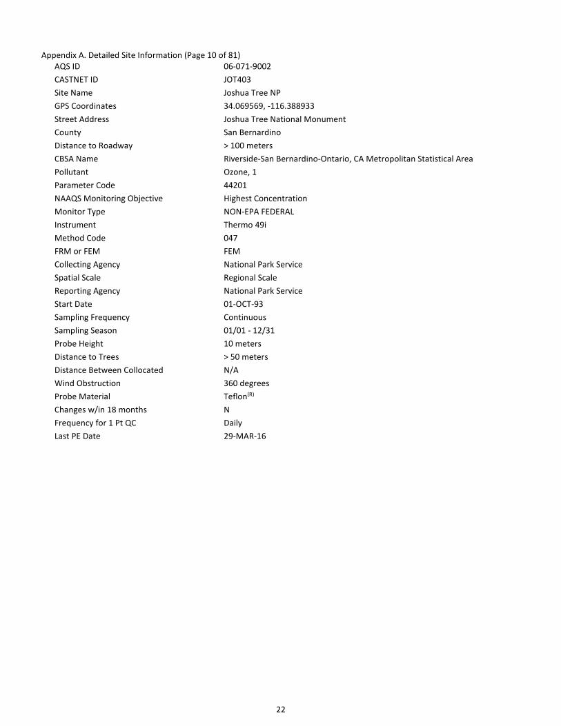
AQS ID 06-071-9002
CASTNET ID JOT403
Site Name Joshua Tree NP
GPS Coordinates 34.069569, -116.388933
Street Address Joshua Tree National Monument
County San Bernardino
Distance to Roadway > 100 meters
CBSA Name Riverside-San Bernardino-Ontario, CA Metropolitan Statistical Area
Pollutant Ozone, 1
Parameter Code 44201
NAAQS Monitoring Objective Highest Concentration
Monitor Type NON-EPA FEDERAL
Instrument Thermo 49i
Method Code 047
FRM or FEM FEM
Collecting Agency National Park Service
Spatial Scale Regional Scale
Reporting Agency National Park Service
Start Date 01-OCT-93
Sampling Frequency Continuous
Sampling Season 01/01 - 12/31
Probe Height 10 meters
Distance to Trees > 50 meters
Distance Between Collocated N/A
Wind Obstruction 360 degrees
Probe Material Teflon(R)
Changes w/in 18 months N
Frequency for 1 Pt QC Daily
Last PE Date 29-MAR-16

23
Appendix A. Detailed Site Information (Page 11 of 81)
AQS ID 06-089-3003
CASTNET ID LAV410
Site Name Lassen Volcanic NP
GPS Coordinates 40.539991, -121.576462
Street Address Manzanita Lake, Lassen Volcanic NP
County Shasta
Distance to Roadway 25 meters
CBSA Name Redding, CA Metropolitan Statistical Area
Pollutant Ozone, 1
Parameter Code 44201
NAAQS Monitoring Objective General/Background
Monitor Type NON-EPA FEDERAL
Instrument Thermo 49c
Method Code 047
FRM or FEM FEM
Collecting Agency National Park Service
Spatial Scale Regional Scale
Reporting Agency National Park Service
Start Date 01-NOV-87
Sampling Frequency Continuous
Sampling Season 01/01 - 12/31
Probe Height 10 meters
Distance to Trees 10 meters
Distance Between Collocated N/A
Wind Obstruction 360 degrees
Probe Material Teflon(R)
Changes w/in 18 months N
Frequency for 1 Pt QC Daily
Last PE Date 14-MAR-16
24
Appendix A. Detailed Site Information (Page 12 of 81)
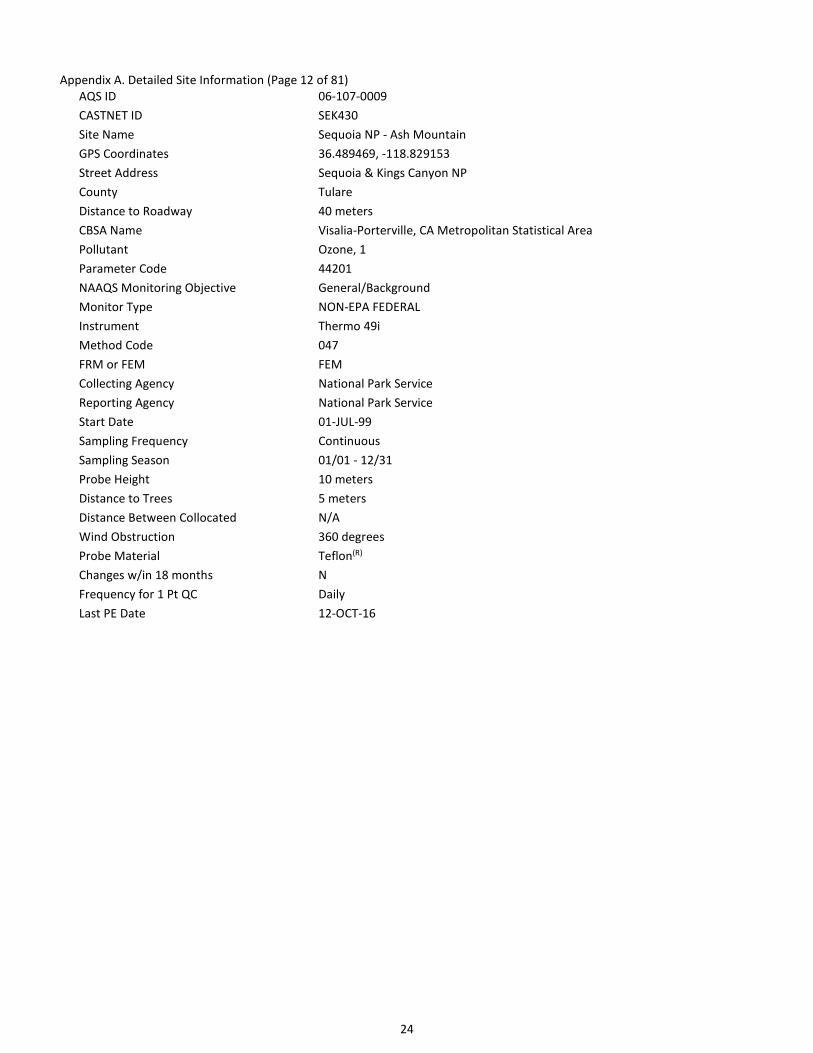
AQS ID 06-107-0009
CASTNET ID SEK430
Site Name Sequoia NP - Ash Mountain
GPS Coordinates 36.489469, -118.829153
Street Address Sequoia & Kings Canyon NP
County Tulare
Distance to Roadway 40 meters
CBSA Name Visalia-Porterville, CA Metropolitan Statistical Area
Pollutant Ozone, 1
Parameter Code 44201
NAAQS Monitoring Objective General/Background
Monitor Type NON-EPA FEDERAL
Instrument Thermo 49i
Method Code 047
FRM or FEM FEM
Collecting Agency National Park Service
Reporting Agency National Park Service
Start Date 01-JUL-99
Sampling Frequency Continuous
Sampling Season 01/01 - 12/31
Probe Height 10 meters
Distance to Trees 5 meters
Distance Between Collocated N/A
Wind Obstruction 360 degrees
Probe Material Teflon(R)
Changes w/in 18 months N
Frequency for 1 Pt QC Daily
Last PE Date 12-OCT-16

25
Appendix A. Detailed Site Information (Page 13 of 81)
AQS ID 08-051-9991
CASTNET ID GTH161
Site Name Gothic
GPS Coordinates 38.95627, -106.98587
Street Address Gunnison National Forest, Crested Butte, CO 81224
County Gunnison
Distance to Roadway > 100 meters
Pollutant Ozone, 1
Parameter Code 44201
NAAQS Monitoring Objective Highest Concentration
Monitor Type EPA
Instrument Thermo 49i
Method Code 047
FRM or FEM FEM
Collecting Agency EPA/CAMD
Spatial Scale Regional Scale
Reporting Agency EPA/CAMD
Start Date 01-JUN-11
Sampling Frequency Continuous
Sampling Season 01/01 - 12/31
Probe Height 10 meters
Distance to Trees > 50 meters
Distance Between Collocated N/A
Wind Obstruction 360 degrees
Probe Material Teflon(R)
Changes w/in 18 months N
Frequency for 1 Pt QC Daily
Last PE Date 30-SEP-16

26
Appendix A. Detailed Site Information (Page 14 of 81)
AQS ID 08-069-0007
CASTNET ID ROM406
Site Name Rocky Mtn NP
GPS Coordinates 40.278129, -105.545635
Street Address Rocky Mountain National Park, Estes Park, CO 80517
County Larimer
Distance to Roadway > 100 meters
CBSA Name Fort Collins-Loveland, CO Metropolitan Statistical Area
Pollutant Ozone, 1
Parameter Code 44201
NAAQS Monitoring Objective General/Background
Monitor Type NON-EPA FEDERAL
Instrument Thermo 49i
Method Code 047
FRM or FEM FEM
Collecting Agency National Park Service
Spatial Scale Regional Scale
Reporting Agency National Park Service
Start Date 01-AUG-87
Sampling Frequency Continuous
Sampling Season 01/01 - 12/31
Probe Height 10 meters
Distance to Trees > 50 meters
Distance Between Collocated 7.5 m
Wind Obstruction 360 degrees
Probe Material Teflon(R)
Changes w/in 18 months N
Frequency for 1 Pt QC Daily
Last PE Date 06-JUL-16

27
Appendix A. Detailed Site Information (Page 15 of 81)
AQS ID 08-069-9991
CASTNET ID ROM206
Site Name Rocky Mtn NP Collocated
GPS Coordinates 40.278129, -105.545635
Street Address Rocky Mountain National Park, Estes Park, CO 80517
County Larimer
Distance to Roadway > 100 meters
CBSA Name Fort Collins-Loveland, CO Metropolitan Statistical Area
Pollutant Ozone, 1
Parameter Code 44201
NAAQS Monitoring Objective Quality Assurance
Monitor Type EPA, NON-REGULATORY
Instrument Thermo 49i
Method Code 047
FRM or FEM FEM
Collecting Agency EPA/CAMD
Spatial Scale Regional Scale
Reporting Agency EPA/CAMD
Start Date 01-JAN-11
Sampling Frequency Continuous
Sampling Season 01/01 - 12/31
Probe Height 10 meters
Distance to Trees > 50 meters
Distance Between Collocated 7.5 m
Wind Obstruction 360 degrees
Probe Material Teflon(R)
Changes w/in 18 months N
Frequency for 1 Pt QC Daily
Last PE Date 06-JUL-16

28
Appendix A. Detailed Site Information (Page 16 of 81)
AQS ID 08-083-0101
CASTNET ID MEV405
Site Name Mesa Verde NP
GPS Coordinates 37.198398, -108.490462
Street Address Mesa Verde National Park, Colorado
County Montezuma
Distance to Roadway > 100 meters
Pollutant Ozone, 1
Parameter Code 44201
NAAQS Monitoring Objective Highest Concentration
Monitor Type NON-EPA FEDERAL
Instrument Thermo 49c
Method Code 047
FRM or FEM FEM
Collecting Agency National Park Service
Spatial Scale Regional Scale
Reporting Agency National Park Service
Start Date 01-MAY-93
Sampling Frequency Continuous
Sampling Season 01/01 - 12/31
Probe Height 10 meters
Distance to Trees > 50 meters
Distance Between Collocated N/A
Wind Obstruction 360 degrees
Probe Material Teflon(R)
Changes w/in 18 months N
Frequency for 1 Pt QC Daily
Last PE Date 31-MAY-16

29
Appendix A. Detailed Site Information (Page 17 of 81)
AQS ID 09-015-9991
CASTNET ID ABT147
Site Name Abington
GPS Coordinates 41.84046, -72.010368
Street Address 80 Ayers Rd, Abington, CT 06230
County Windham
Distance to Roadway > 100 meters
CBSA Name Willimantic, CT Micropolitan Statistical Area
Pollutant Ozone, 1
Parameter Code 44201
NAAQS Monitoring Objective Highest Concentration
Monitor Type EPA
Instrument Thermo 49i
Method Code 047
FRM or FEM FEM
Collecting Agency EPA/CAMD
Spatial Scale Regional Scale
Reporting Agency EPA/CAMD
Start Date 01-JUN-11
Sampling Frequency Continuous
Sampling Season 01/01 - 12/31
Probe Height 10 meters
Distance to Trees > 50 meters
Distance Between Collocated N/A
Wind Obstruction 360 degrees
Probe Material Teflon(R)
Changes w/in 18 months N
Frequency for 1 Pt QC Daily
Last PE Date 17-SEP-16

30
Appendix A. Detailed Site Information (Page 18 of 81)
AQS ID 12-061-9991
CASTNET ID IRL141
Site Name Indian River Lagoon
GPS Coordinates 27.849215, -80.455595
Street Address Sebastian Inlet State Recreation Area, Vero Beach, FL 32963
County Indian River
Distance to Roadway > 100 meters
CBSA Name Sebastian-Vero Beach, FL Metropolitan Statistical Area
Pollutant Ozone, 1
Parameter Code 44201
NAAQS Monitoring Objective Highest Concentration
Monitor Type EPA
Instrument Thermo 49i
Method Code 047
FRM or FEM FEM
Collecting Agency EPA/CAMD
Spatial Scale Regional Scale
Reporting Agency EPA/CAMD
Start Date 01-JAN-11
Sampling Frequency Continuous
Sampling Season 01/01 - 12/31
Probe Height 10 meters
Distance to Trees > 50 meters
Distance Between Collocated N/A
Wind Obstruction 360 degrees
Probe Material Teflon(R)
Changes w/in 18 months N
Frequency for 1 Pt QC Daily
Last PE Date 15-FEB-16

31
Appendix A. Detailed Site Information (Page 19 of 81)
AQS ID 12-077-9991
CASTNET ID SUM156
Site Name Sumatra
GPS Coordinates 30.110226, -84.99038
Street Address Apalachicola National Forest, Bristol, FL 32321
County Liberty
Distance to Roadway > 100 meters
Pollutant Ozone, 1
Parameter Code 44201
NAAQS Monitoring Objective Highest Concentration
Monitor Type EPA
Instrument Thermo 49i
Method Code 047
FRM or FEM FEM
Collecting Agency EPA/CAMD
Spatial Scale Regional Scale
Reporting Agency EPA/CAMD
Start Date 01-JAN-11
Sampling Frequency Continuous
Sampling Season 01/01 - 12/31
Probe Height 10 meters
Distance to Trees > 50 meters
Distance Between Collocated N/A
Wind Obstruction 360 degrees
Probe Material Teflon(R)
Changes w/in 18 months N
Frequency for 1 Pt QC Daily
Last PE Date 01-MAR-16

32
Appendix A. Detailed Site Information (Page 20 of 81)
AQS ID 13-231-9991
CASTNET ID GAS153
Site Name Georgia Station
GPS Coordinates 33.181173, -84.410054
Street Address Georgia Station Georgia Agricultural Experiment Station, Williamson, GA 30292
County Pike
Distance to Roadway > 100 meters
CBSA Name Atlanta-Sandy Springs-Marietta, GA Metropolitan Statistical Area
Pollutant Ozone, 1
Parameter Code 44201
NAAQS Monitoring Objective Highest Concentration
Monitor Type EPA
Instrument Thermo 49i
Method Code 047
FRM or FEM FEM
Collecting Agency EPA/CAMD
Spatial Scale Regional Scale
Reporting Agency EPA/CAMD
Start Date 01-JAN-11
Sampling Frequency Continuous
Sampling Season 01/01 - 12/31
Probe Height 10 meters
Distance to Trees > 50 meters
Distance Between Collocated N/A
Wind Obstruction 360 degrees
Probe Material Teflon(R)
Changes w/in 18 months N
Frequency for 1 Pt QC Daily
Last PE Date 08-MAR-16

33
Appendix A. Detailed Site Information (Page 21 of 81)
AQS ID 17-019-1001
CASTNET ID BVL130
Site Name Bondville
GPS Coordinates 40.051981, -88.372495
Street Address Twp Rd 500 E., Champaign, IL
County Champaign
Distance to Roadway > 100 meters
CBSA Name Champaign-Urbana, IL Metropolitan Statistical Area
Pollutants Ozone; hourly SO2; 5-min SO2; CO
Parameter Codes, POC 44201, 1; 42401, 2; 42401, 3; 42101, 1
NAAQS Monitoring Objective Highest Concentration
Monitor Type EPA
Instruments Thermo 49i; TAPI T100U; TAPI T100U; TAPI T300U
Method Code 047; 600; 600; 593
FRM or FEM FEM; FEM; FEM; FRM
Collecting Agency EPA/CAMD
Spatial Scale Regional Scale
Reporting Agency EPA/CAMD
Start Date 01-APR-11; 01-SEP-12; 01-SEP-12; 01-SEP-12
Sampling Frequency Continuous
Sampling Season 01/01 - 12/31
Probe Height 10 meters
Distance to Trees > 50 meters
Distance Between Collocated N/A
Wind Obstruction 360 degrees
Probe Material Teflon(R)
Changes w/in 18 months N
Frequency for 1 Pt QC Daily
Last PE Date 24-SEP-16
34
Appendix A. Detailed Site Information (Page 22 of 81)
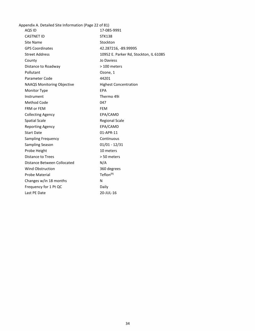
AQS ID 17-085-9991
CASTNET ID STK138
Site Name Stockton
GPS Coordinates 42.287216, -89.99995
Street Address 10952 E. Parker Rd, Stockton, IL 61085
County Jo Daviess
Distance to Roadway > 100 meters
Pollutant Ozone, 1
Parameter Code 44201
NAAQS Monitoring Objective Highest Concentration
Monitor Type EPA
Instrument Thermo 49i
Method Code 047
FRM or FEM FEM
Collecting Agency EPA/CAMD
Spatial Scale Regional Scale
Reporting Agency EPA/CAMD
Start Date 01-APR-11
Sampling Frequency Continuous
Sampling Season 01/01 - 12/31
Probe Height 10 meters
Distance to Trees > 50 meters
Distance Between Collocated N/A
Wind Obstruction 360 degrees
Probe Material Teflon(R)
Changes w/in 18 months N
Frequency for 1 Pt QC Daily
Last PE Date 20-JUL-16

35
Appendix A. Detailed Site Information (Page 23 of 81)
AQS ID 17-119-9991
CASTNET ID ALH157
Site Name Alhambra
GPS Coordinates 38.869001, -89.622815
Street Address 5403 State Road 160, Highland, IL 62249
County Madison
Distance to Roadway > 100 meters
CBSA Name St. Louis, MO-IL Metropolitan Statistical Area
Pollutant Ozone, 1
Parameter Code 44201
NAAQS Monitoring Objective Highest Concentration
Monitor Type EPA
Instrument Thermo 49i
Method Code 047
FRM or FEM FEM
Collecting Agency EPA/CAMD
Spatial Scale Regional Scale
Reporting Agency EPA/CAMD
Start Date 01-APR-11
Sampling Frequency Continuous
Sampling Season 01/01 - 12/31
Probe Height 10 meters
Distance to Trees > 50 meters
Distance Between Collocated N/A
Wind Obstruction 360 degrees
Probe Material Teflon(R)
Changes w/in 18 months N
Frequency for 1 Pt QC Daily
Last PE Date 21-JUL-16

36
Appendix A. Detailed Site Information (Page 24 of 81)
AQS ID 18-083-9991
CASTNET ID VIN140
Site Name Vincennes
GPS Coordinates 38.740792, -87.484923
Street Address Southwest Purdue Agricultural Center, Vincennes, IN 47591
County Knox
Distance to Roadway > 100 meters
CBSA Name Vincennes, IN Micropolitan Statistical Area
Pollutant Ozone, 1
Parameter Code 44201
NAAQS Monitoring Objective Highest Concentration
Monitor Type EPA
Instrument Thermo 49i
Method Code 047
FRM or FEM FEM
Collecting Agency EPA/CAMD
Spatial Scale Regional Scale
Reporting Agency EPA/CAMD
Start Date 01-APR-11
Sampling Frequency Continuous
Sampling Season 01/01 - 12/31
Probe Height 10 meters
Distance to Trees > 50 meters
Distance Between Collocated N/A
Wind Obstruction 360 degrees
Probe Material Teflon(R)
Changes w/in 18 months N
Frequency for 1 Pt QC Daily
Last PE Date 22-JUL-16

37
Appendix A. Detailed Site Information (Page 25 of 81)
AQS ID 18-169-9991
CASTNET ID SAL133
Site Name Salamonie Reservoir
GPS Coordinates 40.816038, -85.661407
Street Address Hamilton Rd, Lagro, IN 46941
County Wabash
Distance to Roadway > 100 meters
CBSA Name Wabash, IN Micropolitan Statistical Area
Pollutant Ozone, 1
Parameter Code 44201
NAAQS Monitoring Objective Highest Concentration
Monitor Type EPA
Instrument Thermo 49i
Method Code 047
FRM or FEM FEM
Collecting Agency EPA/CAMD
Spatial Scale Regional Scale
Reporting Agency EPA/CAMD
Start Date 01-JUN-11
Sampling Frequency Continuous
Sampling Season 01/01 - 12/31
Probe Height 10 meters
Distance to Trees > 50 meters
Distance Between Collocated N/A
Wind Obstruction 360 degrees
Probe Material Teflon(R)
Changes w/in 18 months N
Frequency for 1 Pt QC Daily
Last PE Date 19-JUL-16

38
Appendix A. Detailed Site Information (Page 26 of 81)
AQS ID 21-061-0501
CASTNET ID MAC426
Site Name Mammoth Cave NP
GPS Coordinates 37.131794, -86.142953
Street Address Mammoth Cave NP - Alfred Cook Road
County Edmonson
Distance to Roadway > 100 meters
CBSA Name Bowling Green, KY Metropolitan Statistical Area
Pollutant Ozone, 1
Parameter Code 44201
NAAQS Monitoring Objective General/Background & Maximum Ozone Concentration
Monitor Type NON-EPA FEDERAL
Instrument Thermo 49i
Method Code 047
FRM or FEM FEM
Collecting Agency National Park Service
Reporting Agency National Park Service
Start Date 01-AUG-97
Sampling Frequency Continuous
Sampling Season 01/01 - 12/31
Probe Height 10 meters
Distance to Trees > 50 meters
Distance Between Collocated N/A
Wind Obstruction 360 degrees
Probe Material Teflon(R)
Changes w/in 18 months N
Frequency for 1 Pt QC Daily
Last PE Date 30-MAR-16

39
Appendix A. Detailed Site Information (Page 27 of 81)
AQS ID 21-175-9991
CASTNET ID CKT136
Site Name Crockett
GPS Coordinates 37.92146, -83.066295
Street Address State Highway 437, West Liberty, KY 41472
County Morgan
Distance to Roadway > 100 meters
Pollutant Ozone, 1
Parameter Code 44201
NAAQS Monitoring Objective Highest Concentration
Monitor Type EPA
Instrument Thermo 49i
Method Code 047
FRM or FEM FEM
Collecting Agency EPA/CAMD
Spatial Scale Regional Scale
Reporting Agency EPA/CAMD
Start Date 01-APR-11
Sampling Frequency Continuous
Sampling Season 01/01 - 12/31
Probe Height 10 meters
Distance to Trees > 50 meters
Distance Between Collocated N/A
Wind Obstruction 360 degrees
Probe Material Teflon(R)
Changes w/in 18 months N
Frequency for 1 Pt QC Daily
Last PE Date 29-MAR-16

40
Appendix A. Detailed Site Information (Page 28 of 81)
AQS ID 21-221-9991
CASTNET ID CDZ171
Site Name Cadiz
GPS Coordinates 36.784053, -87.85015
Street Address 5720 Old Dover Rd, Cadiz, KY 42211
County Trigg
Distance to Roadway > 100 meters
CBSA Name Clarksville, TN-KY Metropolitan Statistical Area
Pollutant Ozone, 1
Parameter Code 44201
NAAQS Monitoring Objective Highest Concentration & Maximum Ozone Concentration
Monitor Type EPA
Instrument Thermo 49i
Method Code 047
FRM or FEM FEM
Collecting Agency EPA/CAMD
Spatial Scale Regional Scale
Reporting Agency EPA/CAMD
Start Date 01-MAR-11
Sampling Frequency Continuous
Sampling Season 01/01 - 12/31
Probe Height 10 meters
Distance to Trees > 50 meters
Distance Between Collocated N/A
Wind Obstruction 360 degrees
Probe Material Teflon(R)
Changes w/in 18 months N
Frequency for 1 Pt QC Daily
Last PE Date 30-MAR-16

41
Appendix A. Detailed Site Information (Page 29 of 81)
AQS ID 21-229-9991
CASTNET ID MCK131/231
Site Name Mackville
GPS Coordinates 37.704678, -85.048706
Street Address 542 Wesley-Miller Rd, Harrodsburg, KY 40330
County Washington
Distance to Roadway > 100 meters
Pollutant Ozone, 1/2
Parameter Code 44201
NAAQS Monitoring Objective Highest Concentration/Quality Assurance
Monitor Type EPA
Instrument Thermo 49i
Method Code 047
FRM or FEM FEM
Collecting Agency EPA/CAMD
Spatial Scale Regional Scale
Reporting Agency EPA/CAMD
Start Date 01-MAR-11
Sampling Frequency Continuous
Sampling Season 01/01 - 12/31
Probe Height 10 meters
Distance to Trees > 50 meters
Distance Between Collocated 0 m
Wind Obstruction 360 degrees
Probe Material Teflon(R)
Changes w/in 18 months N/Y
Frequency for 1 Pt QC Daily
Last PE Date 11-MAR-16/ 11-MAR-16

42
Appendix A. Detailed Site Information (Page 30 of 81)
AQS ID 23-003-9991
CASTNET ID ASH135
Site Name Ashland
GPS Coordinates 46.603832, -68.413227
Street Address 45 Radar Rd, Ashland, ME 04732
County Aroostook
Distance to Roadway > 100 meters
Pollutant Ozone, 1
Parameter Code 44201
NAAQS Monitoring Objective Highest Concentration
Monitor Type EPA
Instrument Thermo 49i
Method Code 047
FRM or FEM FEM
Collecting Agency EPA/CAMD
Spatial Scale Regional Scale
Reporting Agency EPA/CAMD
Start Date 01-JUN-11
Sampling Frequency Continuous
Sampling Season 01/01 - 12/31
Probe Height 10 meters
Distance to Trees 20 meters
Distance Between Collocated N/A
Wind Obstruction 360 degrees
Probe Material Teflon(R)
Changes w/in 18 months N
Frequency for 1 Pt QC Daily
Last PE Date 11-OCT-16

43
Appendix A. Detailed Site Information (Page 31 of 81)
AQS ID 23-009-0103
CASTNET ID ACA416
Site Name Acadia NP
GPS Coordinates 44.377086, -68.2608
Street Address Mcfarland Hill-Air Pollutant Research Site
County Hancock
Distance to Roadway > 100 meters
Pollutant Ozone, 1
Parameter Code 44201
NAAQS Monitoring Objective Regional Transport & Upwind Background
Monitor Type SLAMS & NON-EPA FEDERAL
Instrument Thermo 49c
Method Code 047
FRM or FEM FEM
Collecting Agency Maine - Dept of Environmental Protection
Spatial Scale Regional Scale
Reporting Agency Maine - Dept of Environmental Protection
Start Date 09-FEB-98
Sampling Frequency Continuous
Sampling Season 01/01 - 12/31
Probe Height 10 meters
Distance to Trees 25 meters
Distance Between Collocated N/A
Wind Obstruction 360 degrees
Probe Material Teflon(R)
Changes w/in 18 months N
Frequency for 1 Pt QC Daily
Last PE Date 5-OCT-16

44
Appendix A. Detailed Site Information (Page 32 of 81)
AQS ID 24-019-9991
CASTNET ID BWR139
Site Name Blackwater NWR
GPS Coordinates 38.444971, -76.111274
Street Address Blackwater National Wildlife Refuge, Cambridge, MD 21613
County Dorchester
Distance to Roadway > 100 meters
CBSA Name Cambridge, MD Micropolitan Statistical Area
Pollutant Ozone, 1
Parameter Code 44201
NAAQS Monitoring Objective Highest Concentration
Monitor Type EPA
Instrument Thermo 49i
Method Code 047
FRM or FEM FEM
Collecting Agency EPA/CAMD
Spatial Scale Regional Scale
Reporting Agency EPA/CAMD
Start Date 01-JAN-11
Sampling Frequency Continuous
Sampling Season 01/01 - 12/31
Probe Height 10 meters
Distance to Trees > 50 meters
Distance Between Collocated N/A
Wind Obstruction 360 degrees
Probe Material Teflon(R)
Changes w/in 18 months N
Frequency for 1 Pt QC Daily
Last PE Date 8-NOV-16

45
Appendix A. Detailed Site Information (Page 33 of 81)
AQS ID 24-033-9991
CASTNET ID BEL116
Site Name Beltsville
GPS Coordinates 39.028177, -76.817127
Street Address Powder Mill Rd, Laurel, MD 20708
County Prince George's
Distance to Roadway > 100 meters
CBSA Name Washington-Arlington-Alexandria, DC-VA-MD-WV Metropolitan Statistical Area
Pollutants Ozone; SO2 hourly; SO2 5-minute
Parameter Code, POC 44201, 1;
NAAQS Monitoring Objective Highest Concentration
Monitor Type EPA
Instrument Thermo 49i
Method Code 047
FRM or FEM FEM
Collecting Agency EPA/CAMD
Spatial Scale Regional Scale
Reporting Agency EPA/CAMD
Start Date 01-APR-11;
Sampling Frequency Continuous
Sampling Season 01/01 - 12/31
Probe Height 10 meters
Distance to Trees > 50 meters
Distance Between Collocated N/A
Wind Obstruction 360 degrees
Probe Material Teflon(R)
Changes w/in 18 months N
Frequency for 1 Pt QC Daily
Last PE Date 14-NOV-16
46
Appendix A. Detailed Site Information (Page 34 of 81)
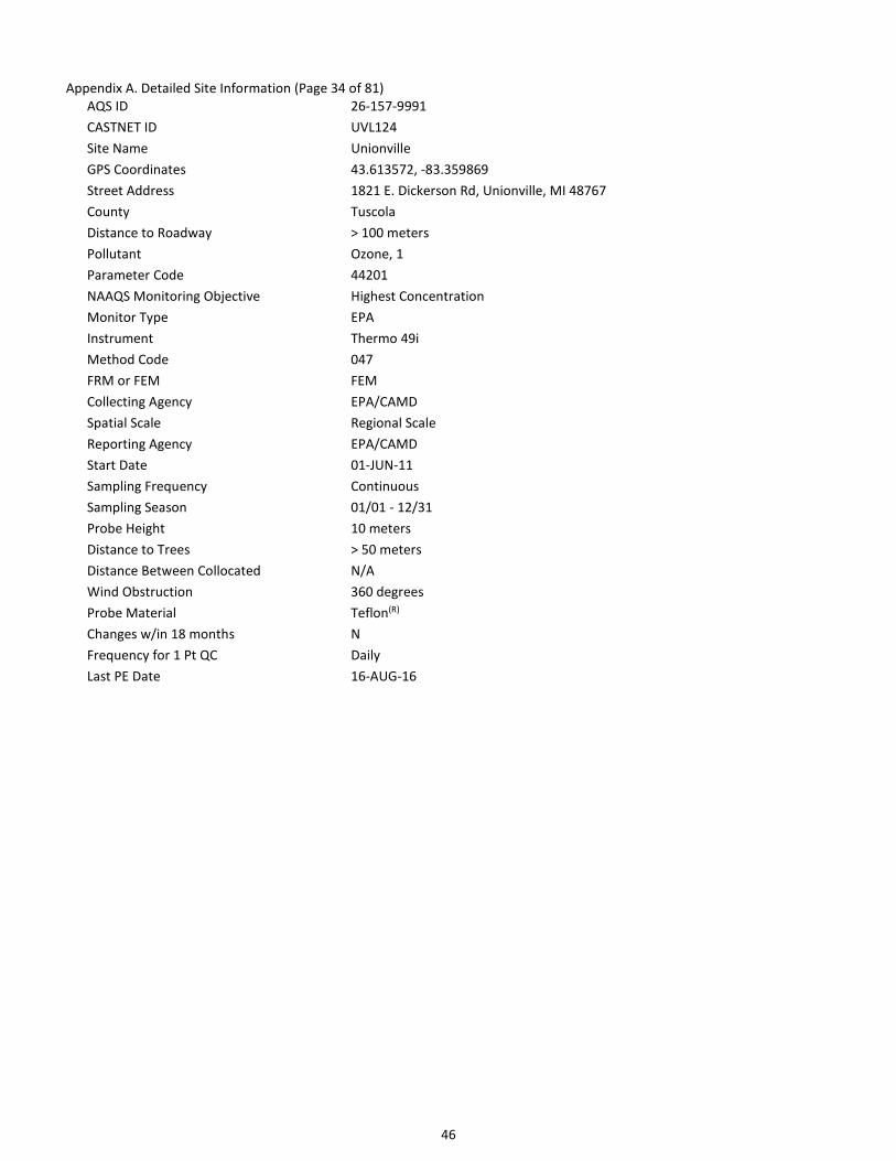
AQS ID 26-157-9991
CASTNET ID UVL124
Site Name Unionville
GPS Coordinates 43.613572, -83.359869
Street Address 1821 E. Dickerson Rd, Unionville, MI 48767
County Tuscola
Distance to Roadway > 100 meters
Pollutant Ozone, 1
Parameter Code 44201
NAAQS Monitoring Objective Highest Concentration
Monitor Type EPA
Instrument Thermo 49i
Method Code 047
FRM or FEM FEM
Collecting Agency EPA/CAMD
Spatial Scale Regional Scale
Reporting Agency EPA/CAMD
Start Date 01-JUN-11
Sampling Frequency Continuous
Sampling Season 01/01 - 12/31
Probe Height 10 meters
Distance to Trees > 50 meters
Distance Between Collocated N/A
Wind Obstruction 360 degrees
Probe Material Teflon(R)
Changes w/in 18 months N
Frequency for 1 Pt QC Daily
Last PE Date 16-AUG-16

47
Appendix A. Detailed Site Information (Page 35 of 81)
AQS ID 26-161-9991
CASTNET ID ANA115
Site Name Ann Arbor
GPS Coordinates 42.416636, -83.90218
Street Address 10070 Strawberry Lake Rd, Dexter, MI 48130
County Washtenaw
Distance to Roadway > 100 meters
CBSA Name Ann Arbor, MI Metropolitan Statistical Area
Pollutant Ozone, 1
Parameter Code 44201
NAAQS Monitoring Objective Highest Concentration
Monitor Type EPA
Instrument Thermo 49i
Method Code 047
FRM or FEM FEM
Collecting Agency EPA/CAMD
Spatial Scale Regional Scale
Reporting Agency EPA/CAMD
Start Date 01-JUN-11
Sampling Frequency Continuous
Sampling Season 01/01 - 12/31
Probe Height 10 meters
Distance to Trees > 50 meters
Distance Between Collocated N/A
Wind Obstruction 360 degrees
Probe Material Teflon(R)
Changes w/in 18 months N
Frequency for 1 Pt QC Daily
Last PE Date 15-AUG-16
48
Appendix A. Detailed Site Information (Page 36 of 81)
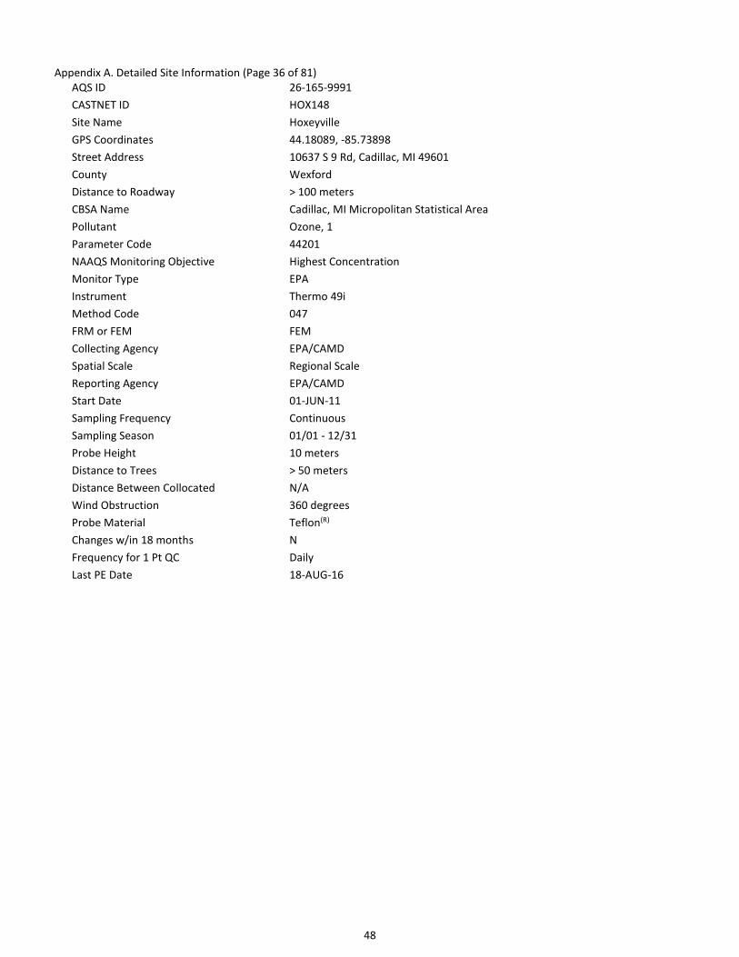
AQS ID 26-165-9991
CASTNET ID HOX148
Site Name Hoxeyville
GPS Coordinates 44.18089, -85.73898
Street Address 10637 S 9 Rd, Cadillac, MI 49601
County Wexford
Distance to Roadway > 100 meters
CBSA Name Cadillac, MI Micropolitan Statistical Area
Pollutant Ozone, 1
Parameter Code 44201
NAAQS Monitoring Objective Highest Concentration
Monitor Type EPA
Instrument Thermo 49i
Method Code 047
FRM or FEM FEM
Collecting Agency EPA/CAMD
Spatial Scale Regional Scale
Reporting Agency EPA/CAMD
Start Date 01-JUN-11
Sampling Frequency Continuous
Sampling Season 01/01 - 12/31
Probe Height 10 meters
Distance to Trees > 50 meters
Distance Between Collocated N/A
Wind Obstruction 360 degrees
Probe Material Teflon(R)
Changes w/in 18 months N
Frequency for 1 Pt QC Daily
Last PE Date 18-AUG-16

49
Appendix A. Detailed Site Information (Page 37 of 81)
AQS ID 27-137-0034
CASTNET ID VOY413
Site Name Voyageurs NP
GPS Coordinates 48.412518, -92.829225
Street Address Voyageurs National Park
County St. Louis
Distance to Roadway > 100 meters
CBSA Name Duluth, MN-WI Metropolitan Statistical Area
Pollutant Ozone, 1
Parameter Code 44201
NAAQS Monitoring Objective General/Background
Monitor Type NON-EPA FEDERAL
Instrument Thermo 49c
Method Code 047
FRM or FEM FEM
Collecting Agency National Park Service
Reporting Agency National Park Service
Start Date 01-JUL-96
Sampling Frequency Continuous
Sampling Season 01/01 - 12/31
Probe Height 10 meters
Distance to Trees > 50 meters
Distance Between Collocated N/A
Wind Obstruction 360 degrees
Probe Material Teflon(R)
Changes w/in 18 months N
Frequency for 1 Pt QC Daily
Last PE Date 29-AUG-16

50
Appendix A. Detailed Site Information (Page 38 of 81)
AQS ID 28-161-9991
CASTNET ID CVL151
Site Name Coffeeville
GPS Coordinates 34.002747, -89.799183
Street Address Jamie L. Whitten Plant Materials Center, Coffeeville, MS 38922
County Yalobusha
Distance to Roadway > 100 meters
Pollutant Ozone, 1
Parameter Code 44201
NAAQS Monitoring Objective Highest Concentration
Monitor Type EPA
Instrument Thermo 49i
Method Code 047
FRM or FEM FEM
Collecting Agency EPA/CAMD
Spatial Scale Regional Scale
Reporting Agency EPA/CAMD
Start Date 01-JAN-11
Sampling Frequency Continuous
Sampling Season 01/01 - 12/31
Probe Height 10 meters
Distance to Trees 17 meters
Distance Between Collocated N/A
Wind Obstruction 360 degrees
Probe Material Teflon(R)
Changes w/in 18 months N
Frequency for 1 Pt QC Daily
Last PE Date 19-FEB-16

51
Appendix A. Detailed Site Information (Page 39 of 81)
AQS ID 30-029-8001
CASTNET ID GLR468
Site Name Glacier NP
GPS Coordinates 48.510301, -113.996807
Street Address Glacier National Park
County Flathead
Distance to Roadway > 100 meters
CBSA Name Kalispell, MT Micropolitan Statistical Area
Pollutant Ozone, 1
Parameter Code 44201
NAAQS Monitoring Objective General/Background
Monitor Type NON-EPA FEDERAL
Instrument Thermo 49i
Method Code 047
FRM or FEM FEM
Collecting Agency National Park Service
Reporting Agency National Park Service
Start Date 01-APR-89
Sampling Frequency Continuous
Sampling Season 01/01 - 12/31
Probe Height 10 meters
Distance to Trees > 50 meters
Distance Between Collocated N/A
Wind Obstruction 360 degrees
Probe Material Teflon(R)
Changes w/in 18 months N
Frequency for 1 Pt QC Daily
Last PE Date 26-SEP-16

52
Appendix A. Detailed Site Information (Page 40 of 81)
AQS ID 31-107-9991
CASTNET ID SAN189
Site Name Santee Sioux
GPS Coordinates 42.829154, -97.854128
Street Address State Spur 54d, Niobrara, NE 68760
County Knox
Distance to Roadway > 100 meters
Pollutant Ozone, 1
Parameter Code 44201
NAAQS Monitoring Objective Highest Concentration
Monitor Type EPA
Instrument Thermo 49i
Method Code 047
FRM or FEM FEM
Collecting Agency EPA/CAMD
Spatial Scale Regional Scale
Reporting Agency EPA/CAMD
Start Date 01-JAN-11
Sampling Frequency Continuous
Sampling Season 01/01 - 12/31
Probe Height 10 meters
Distance to Trees > 50 meters
Distance Between Collocated N/A
Wind Obstruction 360 degrees
Probe Material Teflon(R)
Changes w/in 18 months N
Frequency for 1 Pt QC Daily
Last PE Date 09-SEP-16

53
Appendix A. Detailed Site Information (Page 41 of 81)
AQS ID 32-033-0101
CASTNET ID GRB411
Site Name Great Basin NP
GPS Coordinates 39.005121, -114.215932
Street Address Great Basin National Park
County White Pine
Distance to Roadway > 100 meters
Pollutant Ozone, 1
Parameter Code 44201
NAAQS Monitoring Objective Highest Concentration
Monitor Type NON-EPA FEDERAL
Instrument Thermo 49c
Method Code 047
FRM or FEM FEM
Collecting Agency National Park Service
Spatial Scale Regional Scale
Reporting Agency National Park Service
Start Date 01-SEP-93
Sampling Frequency Continuous
Sampling Season 01/01 - 12/31
Probe Height 10 meters
Distance to Trees 10 meters
Distance Between Collocated N/A
Wind Obstruction 360 degrees
Probe Material Teflon(R)
Changes w/in 18 months N
Frequency for 1 Pt QC Daily
Last PE Date 18-SEP-16

54
Appendix A. Detailed Site Information (Page 42 of 81)
AQS ID 33-009-9991
CASTNET ID WST109
Site Name Woodstock
GPS Coordinates 43.944519, -71.700787
Street Address Hubbard Brook Experimental Forest, North Woodstock, NH 03262
County Grafton
Distance to Roadway 50 meters
CBSA Name Lebanon, NH-VT Micropolitan Statistical Area
Pollutant Ozone, 1
Parameter Code 44201
NAAQS Monitoring Objective Highest Concentration
Monitor Type EPA
Instrument Thermo 49i
Method Code 047
FRM or FEM FEM
Collecting Agency EPA/CAMD
Spatial Scale Regional Scale
Reporting Agency EPA/CAMD
Start Date 01-JUN-11
Sampling Frequency Continuous
Sampling Season 01/01 - 12/31
Probe Height 10 meters
Distance to Trees 10 - 30 meters
Distance Between Collocated N/A
Wind Obstruction 360 degrees
Probe Material Teflon(R)
Changes w/in 18 months N
Frequency for 1 Pt QC Daily
Last PE Date 15-SEP-16

55
Appendix A. Detailed Site Information (Page 43 of 81)
AQS ID 34-021-9991
CASTNET ID WSP144
Site Name Wash. Crossing
GPS Coordinates 40.312303, -74.872663
Street Address Washington Crossing State Park, Titusville, NJ 08560
County Mercer
Distance to Roadway > 100 meters
CBSA Name Trenton-Ewing, NJ Metropolitan Statistical Area
Pollutant Ozone, 1
Parameter Code 44201
NAAQS Monitoring Objective Highest Concentration
Monitor Type EPA
Instrument Thermo 49i
Method Code 047
FRM or FEM FEM
Collecting Agency EPA/CAMD
Spatial Scale Regional Scale
Reporting Agency EPA/CAMD
Start Date 01-JAN-11
Sampling Frequency Continuous
Sampling Season 01/01 - 12/31
Probe Height 10 meters
Distance to Trees > 50 meters
Distance Between Collocated N/A
Wind Obstruction 360 degrees
Probe Material Teflon(R)
Changes w/in 18 months N
Frequency for 1 Pt QC Daily
Last PE Date 11-NOV-16
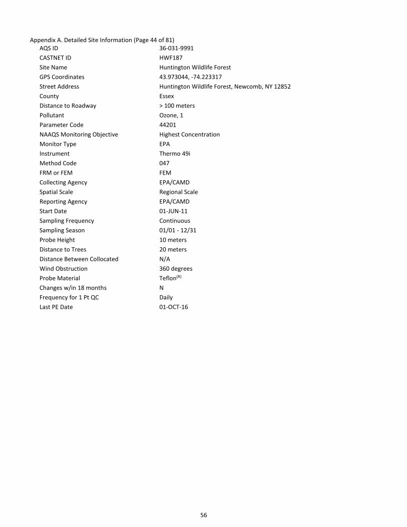
56
Appendix A. Detailed Site Information (Page 44 of 81)
AQS ID 36-031-9991
CASTNET ID HWF187
Site Name Huntington Wildlife Forest
GPS Coordinates 43.973044, -74.223317
Street Address Huntington Wildlife Forest, Newcomb, NY 12852
County Essex
Distance to Roadway > 100 meters
Pollutant Ozone, 1
Parameter Code 44201
NAAQS Monitoring Objective Highest Concentration
Monitor Type EPA
Instrument Thermo 49i
Method Code 047
FRM or FEM FEM
Collecting Agency EPA/CAMD
Spatial Scale Regional Scale
Reporting Agency EPA/CAMD
Start Date 01-JUN-11
Sampling Frequency Continuous
Sampling Season 01/01 - 12/31
Probe Height 10 meters
Distance to Trees 20 meters
Distance Between Collocated N/A
Wind Obstruction 360 degrees
Probe Material Teflon(R)
Changes w/in 18 months N
Frequency for 1 Pt QC Daily
Last PE Date 01-OCT-16
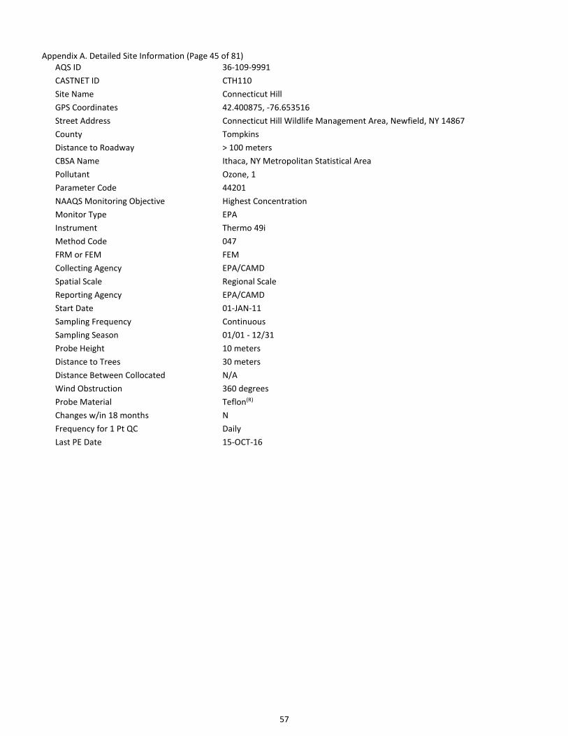
57
Appendix A. Detailed Site Information (Page 45 of 81)
AQS ID 36-109-9991
CASTNET ID CTH110
Site Name Connecticut Hill
GPS Coordinates 42.400875, -76.653516
Street Address Connecticut Hill Wildlife Management Area, Newfield, NY 14867
County Tompkins
Distance to Roadway > 100 meters
CBSA Name Ithaca, NY Metropolitan Statistical Area
Pollutant Ozone, 1
Parameter Code 44201
NAAQS Monitoring Objective Highest Concentration
Monitor Type EPA
Instrument Thermo 49i
Method Code 047
FRM or FEM FEM
Collecting Agency EPA/CAMD
Spatial Scale Regional Scale
Reporting Agency EPA/CAMD
Start Date 01-JAN-11
Sampling Frequency Continuous
Sampling Season 01/01 - 12/31
Probe Height 10 meters
Distance to Trees 30 meters
Distance Between Collocated N/A
Wind Obstruction 360 degrees
Probe Material Teflon(R)
Changes w/in 18 months N
Frequency for 1 Pt QC Daily
Last PE Date 15-OCT-16

58
Appendix A. Detailed Site Information (Page 46 of 81)
AQS ID 37-011-9991
CASTNET ID PNF126
Site Name Cranberry
GPS Coordinates 36.105435, -82.045015
Street Address Pisgah National Forest, Newland, NC 28657
County Avery
Distance to Roadway > 100 meters
Pollutant Ozone, 1
Parameter Code 44201
NAAQS Monitoring Objective Highest Concentration
Monitor Type EPA
Instrument Thermo 49i
Method Code 047
FRM or FEM FEM
Collecting Agency EPA/CAMD
Spatial Scale Regional Scale
Reporting Agency EPA/CAMD
Start Date 01-JAN-11
Sampling Frequency Continuous
Sampling Season 01/01 - 12/31
Probe Height 10 meters
Distance to Trees > 50 meters
Distance Between Collocated N/A
Wind Obstruction 360 degrees
Probe Material Teflon(R)
Changes w/in 18 months N
Frequency for 1 Pt QC Daily
Last PE Date 26-NOV-16

59
Appendix A. Detailed Site Information (Page 47 of 81)
AQS ID 37-031-9991
CASTNET ID BFT142
Site Name Beaufort
GPS Coordinates 34.884668, -76.620666
Street Address Open Grounds Farm, Beaufort, NC 28516
County Carteret
Distance to Roadway > 100 meters
CBSA Name Morehead City, NC Micropolitan Statistical Area
Pollutant Ozone, 1
Parameter Code 44201
NAAQS Monitoring Objective Highest Concentration
Monitor Type EPA
Instrument Thermo 49i
Method Code 047
FRM or FEM FEM
Collecting Agency EPA/CAMD
Spatial Scale Regional Scale
Reporting Agency EPA/CAMD
Start Date 01-JAN-11
Sampling Frequency Continuous
Sampling Season 01/01 - 12/31
Probe Height 10 meters
Distance to Trees > 50 meters
Distance Between Collocated N/A
Wind Obstruction 360 degrees
Probe Material Teflon(R)
Changes w/in 18 months N
Frequency for 1 Pt QC Daily
Last PE Date 10-NOV-16

60
Appendix A. Detailed Site Information (Page 48 of 81)
AQS ID 37-113-9991
CASTNET ID COW137
Site Name Coweeta
GPS Coordinates 35.060527, -83.43034
Street Address USDA Southern Research Station, Coweeta Hydrologic Laboratory, Otto, NC 28763
County Macon
Distance to Roadway > 100 meters
Pollutant Ozone, 1
Parameter Code 44201
NAAQS Monitoring Objective Highest Concentration
Monitor Type EPA
Instrument Thermo 49i
Method Code 047
FRM or FEM FEM
Collecting Agency EPA/CAMD
Spatial Scale Regional Scale
Reporting Agency EPA/CAMD
Start Date 01-JAN-11
Sampling Frequency Continuous
Sampling Season 01/01 - 12/31
Probe Height 10 meters
Distance to Trees > 50 meters
Distance Between Collocated N/A
Wind Obstruction 360 degrees
Probe Material Teflon(R)
Changes w/in 18 months N
Frequency for 1 Pt QC Daily
Last PE Date 13-APR-16

61
Appendix A. Detailed Site Information (Page 49 of 81)
AQS ID 37-123-9991
CASTNET ID CND125
Site Name Candor
GPS Coordinates 35.26333, -79.83754
Street Address 136 Perry Dr, Candor, NC 27229
County Montgomery
Distance to Roadway > 100 meters
Pollutant Ozone, 1
Parameter Code 44201
NAAQS Monitoring Objective Highest Concentration
Monitor Type EPA
Instrument Thermo 49i
Method Code 047
FRM or FEM FEM
Collecting Agency EPA/CAMD
Spatial Scale Regional Scale
Reporting Agency EPA/CAMD
Start Date 01-JAN-11
Sampling Frequency Continuous
Sampling Season 01/01 - 12/31
Probe Height 10 meters
Distance to Trees > 50 meters
Distance Between Collocated N/A
Wind Obstruction 360 degrees
Probe Material Teflon(R)
Changes w/in 18 months N
Frequency for 1 Pt QC Daily
Last PE Date 17-OCT-16

62
Appendix A. Detailed Site Information (Page 50 of 81)
AQS ID 38-007-0002
CASTNET ID THR422
Site Name Theodore Roosevelt NP
GPS Coordinates 46.894844, -103.377719
Street Address 13881 I94 East
County Billings
Distance to Roadway > 100 meters
CBSA Name Dickinson, ND Micropolitan Statistical Area
Pollutant Ozone, 1
Parameter Code 44201
NAAQS Monitoring Objective General/Background
Monitor Type SLAMS
Instrument Thermo 49i
Method Code 047
FRM or FEM FEM
Collecting Agency North Dakota - Dept of Health
Spatial Scale Regional Scale
Reporting Agency North Dakota - Dept of Health
Start Date 27-JUL-98
Sampling Frequency Continuous
Sampling Season 01/01 - 12/31
Probe Height 12.2 meters
Distance to Trees > 50 meters
Distance Between Collocated N/A
Wind Obstruction 360 degrees
Probe Material Teflon(R)
Changes w/in 18 months N
Frequency for 1 Pt QC Daily
Last PE Date 23-MAY-16

63
Appendix A. Detailed Site Information (Page 51 of 81)
AQS ID 39-017-9991
CASTNET ID OXF122
Site Name Oxford
GPS Coordinates 39.531115, -84.723547
Street Address Ecology Research Center, Miami University, Oxford, Ohio 45056
County Butler
Distance to Roadway > 100 meters
CBSA Name Cincinnati-Middletown, OH-KY-IN Metropolitan Statistical Area
Pollutant Ozone, 1
Parameter Code 44201
NAAQS Monitoring Objective Highest Concentration
Monitor Type EPA
Instrument Thermo 49i
Method Code 047
FRM or FEM FEM
Collecting Agency EPA/CAMD
Spatial Scale Regional Scale
Reporting Agency EPA/CAMD
Start Date 01-APR-11
Sampling Frequency Continuous
Sampling Season 01/01 - 12/31
Probe Height 10 meters
Distance to Trees > 50 meters
Distance Between Collocated N/A
Wind Obstruction 360 degrees
Probe Material Teflon(R)
Changes w/in 18 months N
Frequency for 1 Pt QC Daily
Last PE Date 16-APR-16

64
Appendix A. Detailed Site Information (Page 52 of 81)
AQS ID 39-047-9991
CASTNET ID DCP114
Site Name Deer Creek
GPS Coordinates 39.635888, -83.260563
Street Address Deer Creek State Park, Mt Sterling, OH 43143
County Fayette
Distance to Roadway > 100 meters
CBSA Name Washington Court House, OH Micropolitan Statistical Area
Pollutant Ozone, 1
Parameter Code 44201
NAAQS Monitoring Objective Highest Concentration
Monitor Type EPA
Instrument Thermo 49i
Method Code 047
FRM or FEM FEM
Collecting Agency EPA/CAMD
Spatial Scale Regional Scale
Reporting Agency EPA/CAMD
Start Date 01-APR-11
Sampling Frequency Continuous
Sampling Season 01/01 - 12/31
Probe Height 10 meters
Distance to Trees 15 meters
Distance Between Collocated N/A
Wind Obstruction 360 degrees
Probe Material Teflon(R)
Changes w/in 18 months N
Frequency for 1 Pt QC Daily
Last PE Date 16-APR-16

65
Appendix A. Detailed Site Information (Page 53 of 81)
AQS ID 39-121-9991
CASTNET ID QAK172
Site Name Quaker City
GPS Coordinates 39.942714, -81.337914
Street Address 58163 St. Johns Rd, Quaker City, OH 43773
County Noble
Distance to Roadway > 100 meters
Pollutant Ozone, 1
Parameter Code 44201
NAAQS Monitoring Objective Highest Concentration
Monitor Type EPA
Instrument Thermo 49i
Method Code 047
FRM or FEM FEM
Collecting Agency EPA/CAMD
Spatial Scale Regional Scale
Reporting Agency EPA/CAMD
Start Date 01-JAN-11
Sampling Frequency Continuous
Sampling Season 01/01 - 12/31
Probe Height 10 meters
Distance to Trees > 50 meters
Distance Between Collocated N/A
Wind Obstruction 360 degrees
Probe Material Teflon(R)
Changes w/in 18 months N
Frequency for 1 Pt QC Daily
Last PE Date 17-APR-16

66
Appendix A. Detailed Site Information (Page 54 of 81)
AQS ID 40-001-9009
CASTNET ID CHE185
Site Name Cherokee Nation
GPS Coordinates 35.750786, -94.669789
Street Address South Highway 59, Rr1, 1795 Dahlonegah Park Road, Stilwell, Oklahoma
County Adair
Distance to Roadway > 100 meters
Pollutant Ozone, 1
Parameter Code 44201
NAAQS Monitoring Objective Regional Transport & General/Background
Monitor Type TRIBAL & EPA
Instrument Teledyne ML9811
Method Code 091
FRM or FEM FEM
Collecting Agency EPA/CAMD
Spatial Scale Regional Scale
Reporting Agency EPA/CAMD
Start Date 01-JUL-02
Sampling Frequency Continuous
Sampling Season 01/01 - 12/31
Probe Height 10 meters
Distance to Trees > 50 meters
Distance Between Collocated N/A
Wind Obstruction 360 degrees
Probe Material Teflon(R)
Changes w/in 18 months N
Frequency for 1 Pt QC Daily
Last PE Date 01-APR-16

67
Appendix A. Detailed Site Information (Page 55 of 81)
AQS ID 42-001-9991
CASTNET ID ARE128
Site Name Arendtsville
GPS Coordinates 39.923241, -77.307863
Street Address 747 Winding Rd, Biglerville, PA 17307
County Adams
Distance to Roadway > 100 meters
CBSA Name Gettysburg, PA Micropolitan Statistical Area
Pollutant Ozone, 1
Parameter Code 44201
NAAQS Monitoring Objective Highest Concentration
Monitor Type EPA
Instrument Thermo 49i
Method Code 047
FRM or FEM FEM
Collecting Agency EPA/CAMD
Spatial Scale Regional Scale
Reporting Agency EPA/CAMD
Start Date 01-JAN-11
Sampling Frequency Continuous
Sampling Season 01/01 - 12/31
Probe Height 10 meters
Distance to Trees > 50 meters
Distance Between Collocated N/A
Wind Obstruction 360 degrees
Probe Material Teflon(R)
Changes w/in 18 months N
Frequency for 1 Pt QC Daily
Last PE Date 17-OCT-16

68
Appendix A. Detailed Site Information (Page 56 of 81)
AQS ID 42-027-9991
CASTNET ID PSU106
Site Name Penn State
GPS Coordinates 40.720902, -77.931759
Street Address 1366 Tadpole Rd, Pennsylvania Furnace, PA 16865
County Centre
Distance to Roadway > 100 meters
CBSA Name State College, PA Metropolitan Statistical Area
Pollutant Ozone, 1
Parameter Code 44201
NAAQS Monitoring Objective Highest Concentration
Monitor Type EPA
Instrument Thermo 49i
Method Code 047
FRM or FEM FEM
Collecting Agency EPA/CAMD
Spatial Scale Regional Scale
Reporting Agency EPA/CAMD
Start Date 01-APR-11
Sampling Frequency Continuous
Sampling Season 01/01 - 12/31
Probe Height 10 meters
Distance to Trees > 50 meters
Distance Between Collocated N/A
Wind Obstruction 360 degrees
Probe Material Teflon(R)
Changes w/in 18 months N
Frequency for 1 Pt QC Daily
Last PE Date 22-AUG-16

69
Appendix A. Detailed Site Information (Page 57 of 81)
AQS ID 42-047-9991
CASTNET ID KEF112
Site Name Kane Exp. Forest
GPS Coordinates 41.598119, -78.767866
Street Address Kane Experimental Forest, Allegheny National Forest, Wilcox, PA 15870
County Elk
Distance to Roadway > 100 meters
CBSA Name St. Marys, PA Micropolitan Statistical Area
Pollutant Ozone, 1
Parameter Code 44201
NAAQS Monitoring Objective Highest Concentration
Monitor Type EPA
Instrument Thermo 49i
Method Code 047
FRM or FEM FEM
Collecting Agency EPA/CAMD
Spatial Scale Regional Scale
Reporting Agency EPA/CAMD
Start Date 01-JUN-11
Sampling Frequency Continuous
Sampling Season 01/01 - 12/31
Probe Height 10 meters
Distance to Trees 20 meters
Distance Between Collocated N/A
Wind Obstruction 360 degrees
Probe Material Teflon(R)
Changes w/in 18 months N
Frequency for 1 Pt QC Daily
Last PE Date 17-AUG-16

70
Appendix A. Detailed Site Information (Page 58 of 81)
AQS ID 42-085-9991
CASTNET ID MKG113
Site Name M.K. Goddard
GPS Coordinates 41.426847, -80.145247
Street Address Maurice K Goddard State Park, Sandy Lake, PA 16145
County Mercer
Distance to Roadway 60 meters
CBSA Name Youngstown-Warren-Boardman, OH-PA Metropolitan
Statistical Area
Pollutant Ozone, 1
Parameter Code 44201
NAAQS Monitoring Objective Highest Concentration
Monitor Type EPA
Instrument Thermo 49i
Method Code 047
FRM or FEM FEM
Collecting Agency EPA/CAMD
Spatial Scale Regional Scale
Reporting Agency EPA/CAMD
Start Date 01-JUN-11
Sampling Frequency Continuous
Sampling Season 01/01 - 12/31
Probe Height 10 meters
Distance to Trees 10 - 30 meters
Distance Between Collocated N/A
Wind Obstruction 360 degrees
Probe Material Teflon(R)
Changes w/in 18 months N
Frequency for 1 Pt QC Daily
Last PE Date 15-AUG-16

71
Appendix A. Detailed Site Information (Page 59 of 81)
AQS ID 42-111-9991
CASTNET ID LRL117
Site Name Laurel Hill
GPS Coordinates 39.988309, -79.251573
Street Address Laurel Hill State Park, Rockwood, PA 15557
County Somerset
Distance to Roadway > 100 meters
CBSA Name Somerset, PA Micropolitan Statistical Area
Pollutant Ozone, 1
Parameter Code 44201
NAAQS Monitoring Objective Highest Concentration
Monitor Type EPA
Instrument Thermo 49i
Method Code 047
FRM or FEM FEM
Collecting Agency EPA/CAMD
Spatial Scale Regional Scale
Reporting Agency EPA/CAMD
Start Date 01-APR-11
Sampling Frequency Continuous
Sampling Season 01/01 - 12/31
Probe Height 10 meters
Distance to Trees > 50 meters
Distance Between Collocated N/A
Wind Obstruction 360 degrees
Probe Material Teflon(R)
Changes w/in 18 months N
Frequency for 1 Pt QC Daily
Last PE Date 23-AUG-16
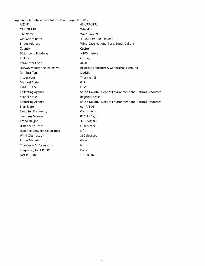
72
Appendix A. Detailed Site Information (Page 60 of 81)
AQS ID 46-033-0132
CASTNET ID WNC429
Site Name Wind Cave NP
GPS Coordinates 43.557639, -103.483856
Street Address Wind Cave National Park, South Dakota
County Custer
Distance to Roadway > 100 meters
Pollutant Ozone, 3
Parameter Code 44201
NAAQS Monitoring Objective Regional Transport & General/Background
Monitor Type SLAMS
Instrument Thermo 49i
Method Code 047
FRM or FEM FEM
Collecting Agency South Dakota - Dept of Environment and Natural Resources
Spatial Scale Regional Scale
Reporting Agency South Dakota - Dept of Environment and Natural Resources
Start Date 01-JAN-05
Sampling Frequency Continuous
Sampling Season 01/01 - 12/31
Probe Height 3.35 meters
Distance to Trees > 50 meters
Distance Between Collocated N/A
Wind Obstruction 360 degrees
Probe Material Glass
Changes w/in 18 months N
Frequency for 1 Pt QC Daily
Last PE Date 19-JUL-16
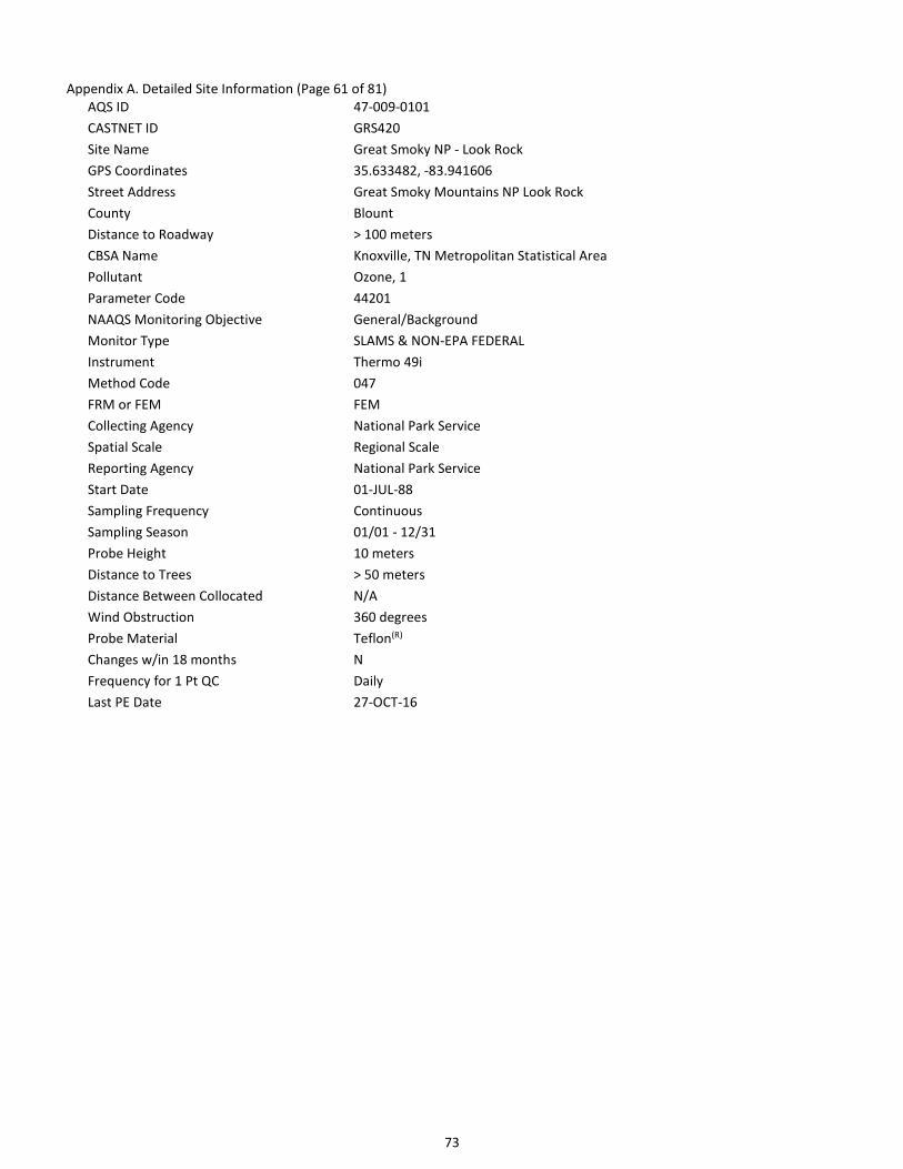
73
Appendix A. Detailed Site Information (Page 61 of 81)
AQS ID 47-009-0101
CASTNET ID GRS420
Site Name Great Smoky NP - Look Rock
GPS Coordinates 35.633482, -83.941606
Street Address Great Smoky Mountains NP Look Rock
County Blount
Distance to Roadway > 100 meters
CBSA Name Knoxville, TN Metropolitan Statistical Area
Pollutant Ozone, 1
Parameter Code 44201
NAAQS Monitoring Objective General/Background
Monitor Type SLAMS & NON-EPA FEDERAL
Instrument Thermo 49i
Method Code 047
FRM or FEM FEM
Collecting Agency National Park Service
Spatial Scale Regional Scale
Reporting Agency National Park Service
Start Date 01-JUL-88
Sampling Frequency Continuous
Sampling Season 01/01 - 12/31
Probe Height 10 meters
Distance to Trees > 50 meters
Distance Between Collocated N/A
Wind Obstruction 360 degrees
Probe Material Teflon(R)
Changes w/in 18 months N
Frequency for 1 Pt QC Daily
Last PE Date 27-OCT-16

74
Appendix A. Detailed Site Information (Page 62 of 81)
AQS ID 47-025-9991
CASTNET ID SPD111
Site Name Speedwell
GPS Coordinates 36.46983, -83.826511
Street Address 718 Russell Hill Rd, Speedwell, TN 37870
County Claiborne
Distance to Roadway > 100 meters
Pollutant Ozone, 1
Parameter Code 44201
NAAQS Monitoring Objective Highest Concentration
Monitor Type EPA
Instrument Thermo 49i
Method Code 047
FRM or FEM FEM
Collecting Agency EPA/CAMD
Spatial Scale Regional Scale
Reporting Agency EPA/CAMD
Start Date 01-MAR-11
Sampling Frequency Continuous
Sampling Season 01/01 - 12/31
Probe Height 10 meters
Distance to Trees > 50 meters
Distance Between Collocated N/A
Wind Obstruction 360 degrees
Probe Material Teflon(R)
Changes w/in 18 months N
Frequency for 1 Pt QC Daily
Last PE Date 12-MAR-16

75
Appendix A. Detailed Site Information (Page 63 of 81)
AQS ID 47-041-9991
CASTNET ID ESP127
Site Name Edgar Evins
GPS Coordinates 36.03893, -85.73305
Street Address Edgar Evans State Park, Smithville, TN 37166
County DeKalb
Distance to Roadway > 100 meters
Pollutant Ozone, 1
Parameter Code 44201
NAAQS Monitoring Objective Highest Concentration
Monitor Type EPA
Instrument Thermo 49i
Method Code 047
FRM or FEM FEM
Collecting Agency EPA/CAMD
Spatial Scale Regional Scale
Reporting Agency EPA/CAMD
Start Date 01-MAR-11
Sampling Frequency Continuous
Sampling Season 01/01 - 12/31
Probe Height 10 meters
Distance to Trees > 50 meters
Distance Between Collocated N/A
Wind Obstruction 360 degrees
Probe Material Teflon(R)
Changes w/in 18 months N
Frequency for 1 Pt QC Daily
Last PE Date 14-APR-16

76
Appendix A. Detailed Site Information (Page 64 of 81)
AQS ID 48-043-0101
CASTNET ID BBE401
Site Name Big Bend NP
GPS Coordinates 29.302651, -103.177813
Street Address Big Bend National Park, Texas
County Brewster
Distance to Roadway > 100 meters
Pollutant Ozone, 1
Parameter Code 44201
NAAQS Monitoring Objective Highest Concentration
Monitor Type NON-EPA FEDERAL
Instrument Thermo 49c
Method Code 047
FRM or FEM FEM
Collecting Agency National Park Service
Spatial Scale Regional Scale
Reporting Agency National Park Service
Start Date 01-OCT-90
Sampling Frequency Continuous
Sampling Season 01/01 - 12/31
Probe Height 10 meters
Distance to Trees > 50 meters
Distance Between Collocated N/A
Wind Obstruction 360 degrees
Probe Material Teflon(R)
Changes w/in 18 months N
Frequency for 1 Pt QC Daily
Last PE Date 08-MAR-16

77
Appendix A. Detailed Site Information (Page 65 of 81)
AQS ID 48-373-9991
CASTNET ID ALC188
Site Name Alabama-Coushatta
GPS Coordinates 30.701577, -94.674011
Street Address 361 Tombigbee Rd, Livingston, TX 77351
County Polk
Distance to Roadway > 100 meters
Pollutant Ozone, 1
Parameter Code 44201
NAAQS Monitoring Objective Highest Concentration
Monitor Type EPA
Instrument Thermo 49i
Method Code 047
FRM or FEM FEM
Collecting Agency EPA/CAMD
Spatial Scale Regional Scale
Reporting Agency EPA/CAMD
Start Date 01-APR-11
Sampling Frequency Continuous
Sampling Season 01/01 - 12/31
Probe Height 10 meters
Distance to Trees > 50 meters
Distance Between Collocated N/A
Wind Obstruction 360 degrees
Probe Material Teflon(R)
Changes w/in 18 months N
Frequency for 1 Pt QC Daily
Last PE Date 05-MAR-16

78
Appendix A. Detailed Site Information (Page 66 of 81)
AQS ID 48-381-9991
CASTNET ID PAL190
Site Name Palo Duro
GPS Coordinates 34.88061, -101.664703
Street Address Palo Duro Canyon State Park, Canyon, TX 79015
County Randall
Distance to Roadway > 100 meters
CBSA Name Amarillo, TX Metropolitan Statistical Area
Pollutant Ozone, 1
Parameter Code 44201
NAAQS Monitoring Objective Highest Concentration
Monitor Type EPA
Instrument Thermo 49i
Method Code 047
FRM or FEM FEM
Collecting Agency EPA/CAMD
Spatial Scale Regional Scale
Reporting Agency EPA/CAMD
Start Date 01-JUN-11
Sampling Frequency Continuous
Sampling Season 01/01 - 12/31
Probe Height 10 meters
Distance to Trees > 50 meters
Distance Between Collocated N/A
Wind Obstruction 360 degrees
Probe Material Teflon(R)
Changes w/in 18 months N
Frequency for 1 Pt QC Daily
Last PE Date 07-MAR-16

79
Appendix A. Detailed Site Information (Page 67 of 81)
AQS ID 49-037-0101
CASTNET ID CAN407
Site Name Canyonlands NP
GPS Coordinates 38.458323, -109.82126
Street Address Canyonlands National Park, Utah
County San Juan
Distance to Roadway > 100 meters
Pollutant Ozone, 1
Parameter Code 44201
NAAQS Monitoring Objective Highest Concentration
Monitor Type NON-EPA FEDERAL
Instrument Thermo 49i
Method Code 047
FRM or FEM FEM
Collecting Agency National Park Service
Spatial Scale Regional Scale
Reporting Agency National Park Service
Start Date 01-SEP-92
Sampling Frequency Continuous
Sampling Season 01/01 - 12/31
Probe Height 10 meters
Distance to Trees > 50 meters
Distance Between Collocated N/A
Wind Obstruction 360 degrees
Probe Material Teflon(R)
Changes w/in 18 months N
Frequency for 1 Pt QC Daily
Last PE Date 01-JUN-16

80
Appendix A. Detailed Site Information (Page 68 of 81)
AQS ID 49-047-1002
CASTNET ID DIN431
Site Name Dinosaur NM
GPS Coordinates 40.4373, -109.3046
Street Address Dinosaur National Monument
County Uintah
Distance to Roadway > 100 meters
CBSA Name Vernal, UT Micropolitan Statistical Area
Pollutant Ozone, 1
Parameter Code 44201
NAAQS Monitoring Objective General/Background
Monitor Type NON-EPA FEDERAL
Instrument Thermo 49i
Method Code 047
FRM or FEM FEM
Collecting Agency National Park Service
Reporting Agency National Park Service
Start Date 01-JAN-12
Sampling Frequency Continuous
Sampling Season 01/01 - 12/31
Probe Height 10 meters
Distance to Trees > 50 meters
Distance Between Collocated N/A
Wind Obstruction 360 degrees
Probe Material Teflon(R)
Changes w/in 18 months N
Frequency for 1 Pt QC Daily
Last PE Date 25-OCT-16

81
Appendix A. Detailed Site Information (Page 69 of 81)
AQS ID 51-071-9991
CASTNET ID VPI120
Site Name Horton Station
GPS Coordinates 37.329832, -80.55751
Street Address 1856 Horton Ln, Newport, VA 24128
County Giles
Distance to Roadway > 100 meters
CBSA Name Blacksburg-Christiansburg-Radford, VA Metropolitan
Statistical Area
Pollutant Ozone, 1
Parameter Code 44201
NAAQS Monitoring Objective Highest Concentration
Monitor Type EPA
Instrument Thermo 49i
Method Code 047
FRM or FEM FEM
Collecting Agency EPA/CAMD
Spatial Scale Regional Scale
Reporting Agency EPA/CAMD
Start Date 01-APR-11
Sampling Frequency Continuous
Sampling Season 01/01 - 12/31
Probe Height 10 meters
Distance to Trees > 50 meters
Distance Between Collocated N/A
Wind Obstruction 360 degrees
Probe Material Teflon(R)
Changes w/in 18 months N
Frequency for 1 Pt QC Daily
Last PE Date 17-OCT-16

82
Appendix A. Detailed Site Information (Page 70 of 81)
AQS ID 51-113-0003
CASTNET ID SHN418
Site Name Shenandoah NP - Big Meadows
GPS Coordinates 38.5231, -78.43471
Street Address Shenandoah NP Big Meadows
County Madison
Distance to Roadway > 100 meters
Pollutant Ozone, 1
Parameter Code 44201
NAAQS Monitoring Objective General/Background
Monitor Type SLAMS & NON-EPA FEDERAL
Instrument Thermo 49i
Method Code 047
FRM or FEM FEM
Collecting Agency National Park Service
Spatial Scale Regional Scale
Reporting Agency National Park Service
Start Date 01-JUL-85
Sampling Frequency Continuous
Sampling Season 01/01 - 12/31
Probe Height 10 meters
Distance to Trees > 50 meters
Distance Between Collocated N/A
Wind Obstruction 360 degrees
Probe Material Teflon(R)
Changes w/in 18 months N
Frequency for 1 Pt QC Daily
Last PE Date 21-OCT-16

83
Appendix A. Detailed Site Information (Page 71 of 81)
AQS ID 51-147-9991
CASTNET ID PED108
Site Name Prince Edward
GPS Coordinates 37.165222, -78.307067
Street Address Prince Edward-Gallion State Forest, Burkeville, VA 23922
County Prince Edward
Distance to Roadway > 100 meters
Pollutant Ozone, 1
Parameter Code 44201
NAAQS Monitoring Objective Highest Concentration
Monitor Type EPA
Instrument Thermo 49i
Method Code 047
FRM or FEM FEM
Collecting Agency EPA/CAMD
Spatial Scale Regional Scale
Reporting Agency EPA/CAMD
Start Date 01-JAN-11
Sampling Frequency Continuous
Sampling Season 01/01 - 12/31
Probe Height 10 meters
Distance to Trees > 50 meters
Distance Between Collocated N/A
Wind Obstruction 360 degrees
Probe Material Teflon(R)
Changes w/in 18 months N
Frequency for 1 Pt QC Daily
Last PE Date 21-OCT-16

84
Appendix A. Detailed Site Information (Page 72 of 81)
AQS ID 54-021-9991
CASTNET ID CDR119
Site Name Cedar Creek
GPS Coordinates 38.879503, -80.847677
Street Address Cedar Creek State Park, Cedarville, WV 26611
County Gilmer
Distance to Roadway > 100 meters
Pollutant Ozone, 1
Parameter Code 44201
NAAQS Monitoring Objective Highest Concentration
Monitor Type EPA
Instrument Thermo 49i
Method Code 047
FRM or FEM FEM
Collecting Agency EPA/CAMD
Spatial Scale Regional Scale
Reporting Agency EPA/CAMD
Start Date 01-APR-11
Sampling Frequency Continuous
Sampling Season 01/01 - 12/31
Probe Height 10 meters
Distance to Trees > 50 meters
Distance Between Collocated N/A
Wind Obstruction 360 degrees
Probe Material Teflon(R)
Changes w/in 18 months N
Frequency for 1 Pt QC Daily
Last PE Date 18-OCT-16

85
Appendix A. Detailed Site Information (Page 73 of 81)
AQS ID 54-093-9991
CASTNET ID PAR107
Site Name Parsons
GPS Coordinates 39.090434, -79.661742
Street Address USDA Northern Research Station, Monongahela National Forest, Parsons, WV 26287
County Tucker
Distance to Roadway > 100 meters
Pollutant Ozone, 1
Parameter Code 44201
NAAQS Monitoring Objective Highest Concentration
Monitor Type EPA
Instrument Thermo 49i
Method Code 047
FRM or FEM FEM
Collecting Agency EPA/CAMD
Spatial Scale Regional Scale
Reporting Agency EPA/CAMD
Start Date 01-JUN-11
Sampling Frequency Continuous
Sampling Season 01/01 - 12/31
Probe Height 10 meters
Distance to Trees > 50 meters
Distance Between Collocated N/A
Wind Obstruction 360 degrees
Probe Material Teflon(R)
Changes w/in 18 months N
Frequency for 1 Pt QC Daily
Last PE Date 18-OCT-16

86
Appendix A. Detailed Site Information (Page 74 of 81)
AQS ID 55-119-9991
CASTNET ID PRK134
Site Name Perkinstown
GPS Coordinates 45.206525, -90.597209
Street Address W 10746 County Highway M, Medford, WI 54451
County Taylor
Distance to Roadway > 100 meters
Pollutant Ozone, 1
Parameter Code 44201
NAAQS Monitoring Objective Highest Concentration
Monitor Type EPA
Instrument Thermo 49i
Method Code 047
FRM or FEM FEM
Collecting Agency EPA/CAMD
Spatial Scale Regional Scale
Reporting Agency EPA/CAMD
Start Date 01-APR-11
Sampling Frequency Continuous
Sampling Season 01/01 - 12/31
Probe Height 10 meters
Distance to Trees > 50 meters
Distance Between Collocated N/A
Wind Obstruction 360 degrees
Probe Material Teflon(R)
Changes w/in 18 months N
Frequency for 1 Pt QC Daily
Last PE Date 01-SEP-16

87
Appendix A. Detailed Site Information (Page 75 of 81)
AQS ID 56-001-9991
CASTNET ID CNT169
Site Name Centennial
GPS Coordinates 41.364531, -106.24002
Street Address Roosevelt National Forest, Centennial, WY 82055
County Albany
Distance to Roadway > 100 meters
CBSA Name Laramie, WY Micropolitan Statistical Area
Pollutant Ozone, 1
Parameter Code 44201
NAAQS Monitoring Objective Highest Concentration
Monitor Type EPA
Instrument Thermo 49i
Method Code 047
FRM or FEM FEM
Collecting Agency EPA/CAMD
Spatial Scale Regional Scale
Reporting Agency EPA/CAMD
Start Date 01-JUN-11
Sampling Frequency Continuous
Sampling Season 01/01 - 12/31
Probe Height 10 meters
Distance to Trees > 50 meters
Distance Between Collocated N/A
Wind Obstruction 360 degrees
Probe Material Teflon(R)
Changes w/in 18 months N
Frequency for 1 Pt QC Daily
Last PE Date 18-AUG-16

88
Appendix A. Detailed Site Information (Page 76 of 81)
AQS ID 56-003-0002
CASTNET ID BAS601
Site Name Basin
GPS Coordinates 44.28, -108.0411
Street Address Basin (WARMS Station)
County Big Horn
Distance to Roadway > 100 meters
Pollutant Ozone, 1
Parameter Code 44201
NAAQS Monitoring Objective General/Background
Monitor Type NON-EPA FEDERAL
Instrument Thermo 49i
Method Code 047
FRM or FEM FEM
Collecting Agency Bureau of Land Management - Wyoming office
Spatial Scale Regional Scale
Reporting Agency Bureau of Land Management – Wyoming office
Start Date 28-NOV-12
Sampling Frequency Continuous
Sampling Season 01/01 – 12/31
Probe Height 10 meters
Distance to Trees > 50 meters
Distance Between Collocated N/A
Wind Obstruction 360 degrees
Probe Material Teflon®
Changes w/in 18 months N
Frequency for 1 Pt QC Daily
Last PE Date 21-JUN-16

89
Appendix A. Detailed Site Information (Page 77 of 81)
AQS ID 56-035-9991
CASTNET ID PND165
Site Name Pinedale
GPS Coordinates 42.929031, -109.787796
Street Address Skyline Dr, Pinedale, WY 82941
County Sublette
Distance to Roadway > 100 meters
Pollutant Ozone, 1
Parameter Code 44201
NAAQS Monitoring Objective Highest Concentration
Monitor Type EPA
Instrument Thermo 49i
Method Code 047
FRM or FEM FEM
Collecting Agency EPA/CAMD
Spatial Scale Regional Scale
Reporting Agency EPA/CAMD
Start Date 01-JUN-11
Sampling Frequency Continuous
Sampling Season 01/–1 - 12/31
Probe Height 10 meters
Distance to Trees > 50 meters
Distance Between Collocated N/A
Wind Obstruction 360 degrees
Probe Material Teflon®(R)
Changes w/in 18 months N
Frequency for 1 Pt QC Daily
Last PE Date 17-JUN-16

90
Appendix A. Detailed Site Information (Page 78 of 81)
AQS ID 56-039-1011
CASTNET ID YEL408
Site Name Yellowstone NP
GPS Coordinates 44.565356, -110.400338
Street Address Yellowstone National Park
County Teton
Distance to Roadway > 100 meters
CBSA Name Jackson, WY-ID Micropolitan Statistical Area
Pollutant Ozone, 1
Parameter Code 44201
NAAQS Monitoring Objective General/Background
Monitor Type NON-EPA FEDERAL
Instrument Thermo 49c
Method Code 047
FRM or FEM FEM
Collecting Agency National Park Service
Spatial Scale Regional Scale
Reporting Agency National Park Service
Start Date 01-JUL-96
Sampling Frequency Continuous
Sampling Season 01/01 – 12/31
Probe Height 10 meters
Distance to Trees 15 meters
Distance Between Collocated N/A
Wind Obstruction 360 degrees
Probe Material Teflon®
Changes w/in 18 months N
Frequency for 1 Pt QC Daily
Last PE Date 08-NOV-16

91
Appendix A. Detailed Site Information (Page 79 of 81)
AQS ID 56-045-0003
CASTNET ID NEC602
Site Name Newcastle
GPS Coordinates 43.873, -104.1919
Street Address Newcastle, Warms Station
County Weston
Distance to Roadway > 100 meters
Pollutant Ozone, 1
Parameter Code 44201
NAAQS Monitoring Objective General/Background
Monitor Type NON-EPA FEDERAL
Instrument Thermo 49i
Method Code 047
FRM or FEM FEM
Collecting Agency Bureau of Land Management - Wyoming office
Spatial Scale Regional Scale
Reporting Agency Bureau of Land Management – Wyoming office
Start Date 14-NOV-12
Sampling Frequency Continuous
Sampling Season 01/01 – 12/31
Probe Height 10 meters
Distance to Trees > 50 meters
Distance Between Collocated N/A
Wind Obstruction 360 degrees
Probe Material Teflon®
Changes w/in 18 months N
Frequency for 1 Pt QC Daily
Last PE Date 24-AUG-16

92
Appendix A. Detailed Site Information (Page 80 of 81)
AQS ID 16-049-9991
CASTNET ID NPT006
Site Name Nez Perce Tribe
GPS Coordinates 46.2756, -116.0216
Street Address Woodland Road Kamiah, ID 83536
County Idaho
Distance to Roadway
Pollutant Ozone, 1
Parameter Code 44201
NAAQS Monitoring Objective Highest Concentration
Monitor Type EPA
Instrument Thermo 49i
Method Code 047
FRM or FEM FEM
Collecting Agency EPA/CAMD
Spatial Scale Regional Scale
Reporting Agency EPA/CAMD
Start Date 27-SEP-16
Sampling Frequency Continuous
Sampling Season 01/01 – 12/31
Probe Height 10 meters
Distance to Trees > 50 meters
Distance Between Collocated N/A
Wind Obstruction 360 degrees
Probe Material Teflon®
Changes w/in 18 months N
Frequency for 1 Pt QC Daily
Last PE Date 10-OCT-16

93
Appendix A. Detailed Site Information (Page 81 of 81)
AQS ID 35-045-0020
CASTNET ID CHC432
Site Name Chaco National Monument
GPS Coordinates 36.035000, -107.904167
Street Address
County San Juan
Distance to Roadway
Pollutant Ozone, 1
Parameter Code 44201
NAAQS Monitoring Objective General/Background and Highest Concentration
Monitor Type NON-EPA FEDERAL
Instrument Thermo 49i
Method Code 047
FRM or FEM FEM
Collecting Agency National Park Service
Spatial Scale Regional Scale
Reporting Agency National Park Service
Start Date 23-FEB-2017
Sampling Frequency Continuous
Sampling Season 01/01 – 12/31
Probe Height 10 meters
Distance to Trees > 50 meters
Distance Between Collocated N/A
Wind Obstruction 360 degrees
Probe Material Teflon®
Changes w/in 18 months Y
Frequency for 1 Pt QC Daily
Last PE Date 16-JUN-17

94
Appendix B. Quality Assurance Validation Template1
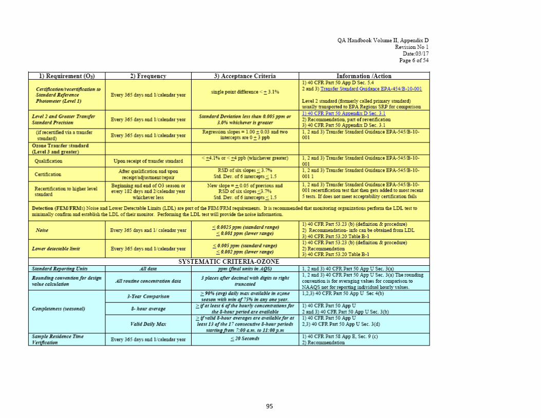
95
96

97
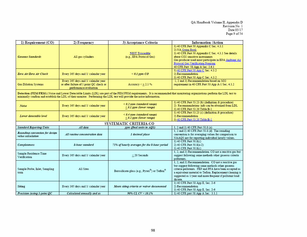
98

99
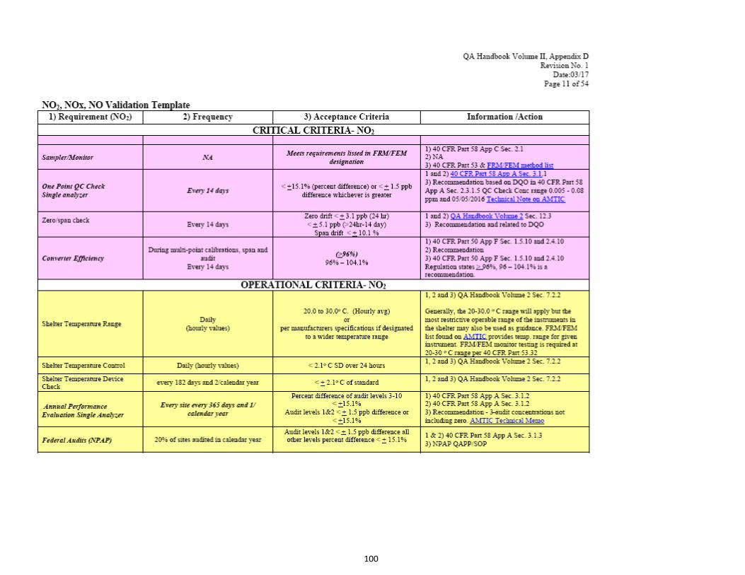
100

101

102

103

104

105
1 Table reproduced from OAQPS’ QA Handbook Appendix D Validation Templates.
Ambient Air Quality Monitoring Program EPA-454/B-17-001 January, 2017. Appendix D.
https://www3.epa.gov/ttn/amtic/files/ambient/pm25/qa/APP_D%20validation%20template%20version%2003_2017_for%20AMTIC%20Rev_1.pdf 2 Match numbered details within the 4) Information/Action column with columns (1) Requirement (pollutant), (2) Frequency, and (3) Acceptance Criteria.

106
Appendix C. Ozone Season by State1,2
1 Ozone season by State from 40 CFR Part 58, App D, Table D-3. 2 Air Quality Control Region (AQCR) as delineated in 40 CFR Part 81, Subpart B.

107
Appendix D. CASTNET QAPP Ozone Certification Flowchart

108
Appendix E. EPA Regional Office Contacts Information
EPA Region Name Phone Email
Region 1 Judge, Robert 617-918-8387 [email protected]
Region 2
Ruvo, Richard A.
Mustafa, Mustafa
212-637-4014
732-906-6881
Region 3 Hyden, Loretta 215-814-2113 [email protected]
Region 4
Rinck, Todd
Garver, Daniel
404-562-9062
404-562-9839
Region 5 McGrath, Jesse 312-886-1532 [email protected]
Region 6 Sather, Mark 214-665-8353 [email protected]
Region 7
Davis, Michael
Grooms, Leland
913-551-5042
913-551-5010
Region 8
Payton, Richard
Rickard, Joshua
303-312-6439
303-312-6460
Region 9
Biland, Larry
Flagg, Michael
415-947-4132
415-972-3372
Region 10 Hall, Christopher 206-553-0521 [email protected]
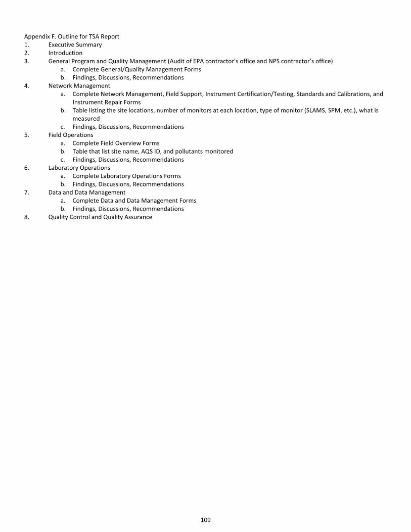
109
Appendix F. Outline for TSA Report
1. Executive Summary
2. Introduction
3. General Program and Quality Management (Audit of EPA contractor’s office and NPS contractor’s office)
a. Complete General/Quality Management Forms
b. Findings, Discussions, Recommendations
4. Network Management
a. Complete Network Management, Field Support, Instrument Certification/Testing, Standards and Calibrations, and
Instrument Repair Forms
b. Table listing the site locations, number of monitors at each location, type of monitor (SLAMS, SPM, etc.), what is
measured
c. Findings, Discussions, Recommendations
5. Field Operations
a. Complete Field Overview Forms
b. Table that list site name, AQS ID, and pollutants monitored
c. Findings, Discussions, Recommendations
6. Laboratory Operations
a. Complete Laboratory Operations Forms
b. Findings, Discussions, Recommendations
7. Data and Data Management
a. Complete Data and Data Management Forms
b. Findings, Discussions, Recommendations
8. Quality Control and Quality Assurance

110
Appendix G. Current list of 40 CFR Part 58 Compliant CASTNET Ozone and Trace Gas Monitors
EPA
RGN
ST AQS_ID POC PARAM SITE_ID AGY PQAO1 NOTES ‘112 ‘12 ‘13 ‘14 ‘15 ‘16 ‘17
1 CT 090159991 1 OZONE ABT147 EPA EPA Y Y Y Y Y Y Y
1 ME 230039991 1 OZONE ASH135 EPA EPA Y Y Y Y Y Y Y
1 ME 230090103 1 OZONE ACA416 NPS ME Y Y Y Y Y Y Y
1 ME 230199991 1 OZONE HOW132 EPA EPA Discontinued
10/2012
Y Y
1 NH 330099991 1 OZONE WST109 EPA EPA Y Y Y Y Y Y Y
2 NJ 340219991 1 OZONE WSP144 EPA EPA Y Y Y Y Y Y Y
2 NY 360319991 1 OZONE HWF187 EPA EPA Y Y Y Y Y Y Y
2 NY 361099991 1 OZONE CTH110 EPA EPA Y Y Y Y Y Y Y
3 MD 240199991 1 OZONE BWR139 EPA EPA Y Y Y Y Y Y Y
3 MD 240199991 1 SO2 1Hr BWR139 EPA EPA Discontinued
3/2017
Y Y Y Y
3 MD 240199991 2 SO2
5Min
BWR139 EPA EPA Discontinued
3/2017
Y Y Y Y
3 MD 240339991 1 OZONE BEL116 EPA EPA Y Y Y Y Y Y Y
3 PA 420019991 1 OZONE ARE128 EPA EPA Y Y Y Y Y Y Y
3 PA 420279991 1 OZONE PSU106 EPA EPA Y Y Y Y Y Y Y
3 PA 420479991 1 OZONE KEF112 EPA EPA Y Y Y Y Y Y Y
3 PA 420859991 1 OZONE MKG113 EPA EPA Y Y Y Y Y Y Y
3 PA 421119991 1 OZONE LRL117 EPA EPA Y Y Y Y Y Y Y
3 VA 510719991 1 OZONE VPI120 EPA EPA Y Y Y Y Y Y Y
3 VA 511130003 1 OZONE SHN418 NPS NPS Y Y Y Y Y Y Y
3 VA 511479991 1 OZONE PED108 EPA EPA Y Y Y Y Y Y Y
3 WV 540219991 1 OZONE CDR119 EPA EPA Y Y Y Y Y Y Y
3 WV 540939991 1 OZONE PAR107 EPA EPA Y Y Y Y Y Y Y
4 AL 010499991 1 OZONE SND152 EPA EPA Y Y Y Y Y Y Y
4 FL 120619991 1 OZONE IRL141 EPA EPA Y Y Y Y Y Y Y
4 FL 120779991 1 OZONE SUM156 EPA EPA Y Y Y Y Y Y Y
4 GA 132319991 1 OZONE GAS153 EPA EPA Y Y Y Y Y Y Y
4 KY 210610501 1 OZONE MAC426 NPS NPS Y Y Y Y Y Y Y
4 KY 211759991 1 OZONE CKT136 EPA EPA Y Y Y Y Y Y Y
4 KY 212219991 1 OZONE CDZ171 EPA EPA Y Y Y Y Y Y Y
4 KY 212299991 1 OZONE MCK131 EPA EPA Y Y Y Y Y Y Y
4 KY 212299991 2 OZONE MCK231 EPA EPA QA only
beginning
1/1/20153
Y Y Y Y
4 MS 281619991 1 OZONE CVL151 EPA EPA Y Y Y Y Y Y Y
4 NC 370119991 1 OZONE PNF126 EPA EPA Y Y Y Y Y Y Y
4 NC 370319991 1 OZONE BFT142 EPA EPA Y Y Y Y Y Y Y
4 NC 371139991 1 OZONE COW137 EPA EPA Y Y Y Y Y Y Y
4 NC 371239991 1 OZONE CND125 EPA EPA Y Y Y Y Y Y Y
4 TN 470090101 1 OZONE GRS420 NPS NPS Y Y Y Y Y Y Y
4 TN 470259991 1 OZONE SPD111 EPA EPA Y Y Y Y Y Y Y

111
EPA
RGN
ST AQS_ID POC PARAM SITE_ID AGY PQAO1 NOTES ‘112 ‘12 ‘13 ‘14 ‘15 ‘16 ‘17
4 TN 470419991 1 OZONE ESP127 EPA EPA Y Y Y Y Y Y Y
5 IL 170191001 1 OZONE BVL130 EPA EPA Y Y Y Y Y Y Y
5 IL 170191001 2 SO2 1Hr BVL130 EPA EPA Y Y Y Y Y
5 IL 170191001 3 SO2
5Min
BVL130 EPA EPA Y Y Y Y Y
5 IL 170191001 1 CO BVL130 EPA EPA Y Y Y Y Y
5 IL 170859991 1 OZONE STK138 EPA EPA Y Y Y Y Y Y Y
5 IL 171199991 1 OZONE ALH157 EPA EPA Y Y Y Y Y Y Y
5 IN 180839991 1 OZONE VIN140 EPA EPA Y Y Y Y Y Y Y
5 IN 181699991 1 OZONE SAL133 EPA EPA Y Y Y Y Y Y Y
5 MI 261579991 1 OZONE UVL124 EPA EPA Y Y Y Y Y Y Y
5 MI 261619991 1 OZONE ANA115 EPA EPA Y Y Y Y Y Y Y
5 MI 261659991 1 OZONE HOX148 EPA EPA Y Y Y Y Y Y Y
5 MN 271370034 1 OZONE VOY413 NPS NPS Y Y Y Y Y Y Y
5 OH 390179991 1 OZONE OXF122 EPA EPA Y Y Y Y Y Y Y
5 OH 390479991 1 OZONE DCP114 EPA EPA Y Y Y Y Y Y Y
5 OH 391219991 1 OZONE QAK172 EPA EPA Y Y Y Y Y Y Y
5 WI 551199991 1 OZONE PRK134 EPA EPA Y Y Y Y Y Y Y
6 AR 050199991 1 OZONE CAD150 EPA EPA Y Y Y Y Y Y Y
6 OK 400019009 1 OZONE CHE185 EPA CN Y Y Y Y Y Y Y
6 NM 350450020 OZONE CHC432 NPS NPS New site,
2017
Y
6 TX 480430101 1 OZONE BBE401 NPS NPS Y Y Y Y Y Y Y
6 TX 483739991 1 OZONE ALC188 EPA EPA Y Y Y Y Y Y
6 TX 483819991 1 OZONE PAL190 EPA EPA Y Y Y Y Y Y
7 KS 201619991 1 OZONE KNZ184 EPA EPA Discontinued
4/2013
Y Y
7 NE 311079991 1 OZONE SAN189 EPA EPA Y Y Y Y Y Y Y
8 CO 080519991 1 OZONE GTH161 EPA EPA Y Y Y Y Y Y Y
8 CO 080699991 1 OZONE ROM206 EPA EPA QA only
beginning
10/2012
Y Y
8 CO 080690007 1 OZONE ROM406 NPS NPS Y Y Y Y Y Y Y
8 CO 080830101 1 OZONE MEV405 NPS NPS Y Y Y Y Y Y Y
8 MT 300298001 1 OZONE GLR468 NPS NPS Y Y Y Y Y Y Y
8 ND 380070002 1 OZONE THR422 NPS ND Y Y Y Y Y Y Y
8 SD 460330132 3 OZONE WNC429 NPS SD Y Y Y Y Y Y Y
8 UT 490370101 1 OZONE CAN407 NPS NPS Y Y Y Y Y Y Y
8 WY 560019991 1 OZONE CNT169 EPA EPA Y Y Y Y Y Y Y
8 WY 560030002 1 OZONE BAS601 BLM BLM Y Y Y Y Y
8 WY 560359991 1 OZONE PND165 EPA EPA Y Y Y Y Y Y Y
8 WY 560391011 1 OZONE YEL408 NPS NPS Y Y Y Y Y Y Y
8 WY 560450003 1 OZONE NEC602 BLM BLM Y Y Y Y Y
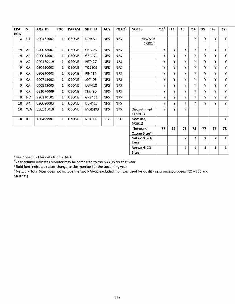
112
EPA
RGN
ST AQS_ID POC PARAM SITE_ID AGY PQAO1 NOTES ‘112 ‘12 ‘13 ‘14 ‘15 ‘16 ‘17
8 UT 490471002 1 OZONE DIN431 NPS NPS New site
1/2014
Y Y Y Y
9 AZ 040038001 1 OZONE CHA467 NPS NPS Y Y Y Y Y Y Y
9 AZ 040058001 1 OZONE GRC474 NPS NPS Y Y Y Y Y Y Y
9 AZ 040170119 1 OZONE PET427 NPS NPS Y Y Y Y Y Y Y
9 CA 060430003 1 OZONE YOS404 NPS NPS Y Y Y Y Y Y Y
9 CA 060690003 1 OZONE PIN414 NPS NPS Y Y Y Y Y Y Y
9 CA 060719002 1 OZONE JOT403 NPS NPS Y Y Y Y Y Y Y
9 CA 060893003 1 OZONE LAV410 NPS NPS Y Y Y Y Y Y Y
9 CA 061070009 1 OZONE SEK430 NPS NPS Y Y Y Y Y Y Y
9 NV 320330101 1 OZONE GRB411 NPS NPS Y Y Y Y Y Y Y
10 AK 020680003 1 OZONE DEN417 NPS NPS Y Y Y Y Y Y Y
10 WA 530531010 1 OZONE MOR409 NPS NPS Discontinued
11/2013
Y Y Y
10 ID 160499991 1 OZONE NPT006 EPA EPA New site,
9/2016
Y
Network
Ozone Sites4
77 79 78 78 77 77 78
Network SO2
Sites
2 2 2 2 1
Network CO
Sites
1 1 1 1 1
1 See Appendix I for details on PQAO 2 Year column indicates monitor may be compared to the NAAQS for that year 3 Bold font indicates status change to the monitor for the upcoming year 4 Network Total Sites does not include the two NAAQS-excluded monitors used for quality assurance purposes (ROM206 and
MCK231)
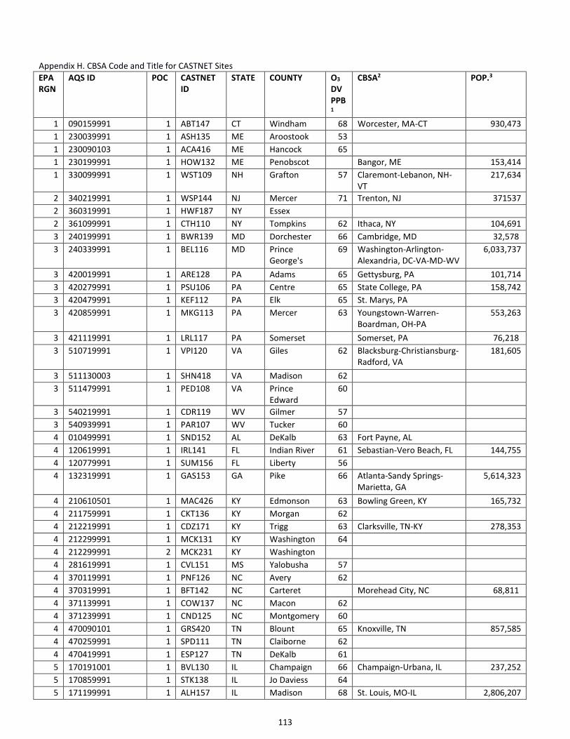
113
Appendix H. CBSA Code and Title for CASTNET Sites (continued)
EPA
RGN
AQS ID POC CASTNET
ID
STATE COUNTY O3
DV
PPB1
CBSA2 POP.3
1 090159991 1 ABT147 CT Windham 68 Worcester, MA-CT 930,473
1 230039991 1 ASH135 ME Aroostook 53
1 230090103 1 ACA416 ME Hancock 65
1 230199991 1 HOW132 ME Penobscot Bangor, ME 153,414
1 330099991 1 WST109 NH Grafton 57 Claremont-Lebanon, NH-
VT
217,634
2 340219991 1 WSP144 NJ Mercer 71 Trenton, NJ 371537
2 360319991 1 HWF187 NY Essex
2 361099991 1 CTH110 NY Tompkins 62 Ithaca, NY 104,691
3 240199991 1 BWR139 MD Dorchester 66 Cambridge, MD 32,578
3 240339991 1 BEL116 MD Prince
George's
69 Washington-Arlington-
Alexandria, DC-VA-MD-WV
6,033,737
3 420019991 1 ARE128 PA Adams 65 Gettysburg, PA 101,714
3 420279991 1 PSU106 PA Centre 65 State College, PA 158,742
3 420479991 1 KEF112 PA Elk 65 St. Marys, PA
3 420859991 1 MKG113 PA Mercer 63 Youngstown-Warren-
Boardman, OH-PA
553,263
3 421119991 1 LRL117 PA Somerset Somerset, PA 76,218
3 510719991 1 VPI120 VA Giles 62 Blacksburg-Christiansburg-
Radford, VA
181,605
3 511130003 1 SHN418 VA Madison 62
3 511479991 1 PED108 VA Prince
Edward
60
3 540219991 1 CDR119 WV Gilmer 57
3 540939991 1 PAR107 WV Tucker 60
4 010499991 1 SND152 AL DeKalb 63 Fort Payne, AL
4 120619991 1 IRL141 FL Indian River 61 Sebastian-Vero Beach, FL 144,755
4 120779991 1 SUM156 FL Liberty 56
4 132319991 1 GAS153 GA Pike 66 Atlanta-Sandy Springs-
Marietta, GA
5,614,323
4 210610501 1 MAC426 KY Edmonson 63 Bowling Green, KY 165,732
4 211759991 1 CKT136 KY Morgan 62
4 212219991 1 CDZ171 KY Trigg 63 Clarksville, TN-KY 278,353
4 212299991 1 MCK131 KY Washington 64
4 212299991 2 MCK231 KY Washington
4 281619991 1 CVL151 MS Yalobusha 57
4 370119991 1 PNF126 NC Avery 62
4 370319991 1 BFT142 NC Carteret Morehead City, NC 68,811
4 371139991 1 COW137 NC Macon 62
4 371239991 1 CND125 NC Montgomery 60
4 470090101 1 GRS420 TN Blount 65 Knoxville, TN 857,585
4 470259991 1 SPD111 TN Claiborne 62
4 470419991 1 ESP127 TN DeKalb 61
5 170191001 1 BVL130 IL Champaign 66 Champaign-Urbana, IL 237,252
5 170859991 1 STK138 IL Jo Daviess 64
5 171199991 1 ALH157 IL Madison 68 St. Louis, MO-IL 2,806,207

114
Appendix H. CBSA Code and Title for CASTNET Sites (continued)
EPA
RGN
AQS ID POC CASTNET
ID
STATE COUNTY O3
DV
PPB1
CBSA2 POP.3
5 180839991 1 VIN140 IN Knox 63 Vincennes, IN 37,938
5 181699991 1 SAL133 IN Wabash 67 Wabash, IN 32,252
5 261579991 1 UVL124 MI Tuscola 63
5 261619991 1 ANA115 MI Washtenaw Ann Arbor, MI 356,874
5 261659991 1 HOX148 MI Wexford 65 Cadillac, MI 47,923
5 271370034 1 VOY413 MN St. Louis 56 Duluth, MN-WI 280,218
5 390179991 1 OXF122 OH Butler 68 Cincinnati-Middletown,
OH-KY-IN
2,149,449
5 390479991 1 DCP114 OH Fayette 67 Washington Court House,
OH
28,800
5 391219991 1 QAK172 OH Noble 64
5 551199991 1 PRK134 WI Taylor 60
6 050199991 1 CAD150 AR Clark 62 Arkadelphia, AR 22,576
6 400019009 1 CHE185 OK Adair 64
6 0350450020 1 CHC432 NM San Juan Farmington, NM 123,785
6 480430101 1 BBE401 TX Brewster 64
6 483739991 1 ALC188 TX Polk
6 483819991 1 PAL190 TX Randall 66 Amarillo, TX 259,885
7 311079991 1 SAN189 NE Knox 64
8 080519991 1 GTH161 CO Gunnison 65
8 080690007 1 ROM406 CO Larimer 70 Fort Collins-Loveland, CO 324,122
8 080699991 1 ROM206 CO Larimer Fort Collins-Loveland, CO 324,122
8 080830101 1 MEV405 CO Montezuma 66
8 300298001 1 GLR468 MT Flathead 54 Kalispell, MT 94,924
8 380070002 1 THR422 ND Billings 58 Dickinson, ND 30,372
8 460330132 3 WNC429 SD Custer 59 Rapid City, SD 143,638
8 490370101 1 CAN407 UT San Juan 65
8 490471002 1 DIN431 UT Uintah Vernal, UT 36,867
8 560019991 1 CNT169 WY Albany 66 Laramie, WY 37,811
8 560030002 1 BAS601 WY Big Horn 59
8 560359991 1 PND165 WY Sublette
8 560391011 1 YEL408 WY Teton 61 Jackson, WY-ID 33,271
8 560450003 1 NEC602 WY Weston 62
9 040038001 1 CHA467 AZ Cochise 68 Sierra Vista-Douglas, AZ 127,448
9 040058001 1 GRC474 AZ Coconino 68 Flagstaff, AZ 137,682
9 040170119 1 PET427 AZ Navajo 66 Show Low, AZ 108,101
9 060430003 1 YOS404 CA Mariposa 74
9 060690003 1 PIN414 CA San Benito 68 San Jose-Sunnyvale-Santa
Clara, CA
1,952,872
9 060719002 1 JOT403 CA San
Bernardino
86 Riverside-San Bernardino-
Ontario, CA
4,441,890
9 060893003 1 LAV410 CA Shasta 66 Redding, CA 179,804
9 061070009 1 SEK430 CA Tulare 89 Visalia-Porterville, CA 458,198
9 320330101 1 GRB411 NV White Pine 68
10 020680003 1 DEN417 AK Denali 54
10 530531010 1 MOR409 WA Pierce Seattle-Tacoma-Bellevue,
WA
3,671,478

115
Appendix H. CBSA Code and Title for CASTNET Sites (continued)
EPA
RGN
AQS ID POC CASTNET
ID
STATE COUNTY O3
DV
PPB1
CBSA2 POP.3
10 160499991 1 NPT006 ID Idaho
1 Design values are displayed for the 2013-2015 sampling period when data completeness is sufficient. These values originate from
OAQPS’ Air Trends website: http://epa.gov/airtrends/values.html
2 CBSA = Core Based Statistical Area - A statistical geographic entity consisting of the county or counties associated with at least one
core (urbanized area or urban cluster) of at least 10,000 population, plus adjacent counties having a high degree of social and
economic integration with the core as measured through commuting ties with the counties containing the core.
Definitions of statistical areas are from the Office of Management and Budget Federal Register Notice Vol 65, No. 249. December 27,
2000.
http://www.whitehouse.gov/sites/default/files/omb/fedreg/metroareas122700.pdf
3POP. = CBSA 2014 Census from OAPQS’ AIRSRAQS.CORE_BASED_STATISTICAL_AREAS Census Population Data

116
Appendix I. Summary of Current CASTNET Ozone and Trace Gas Monitors
2017 SUMMARY
PQAO1 PQAO Name O3 Sites SO2 CO
1344 Environmental Protection Agency – Clean Air Markets Division 532 1 1
0745 National Park Service – Air Resources Division 21
1366 Bureau of Land Management – Wyoming State Office 2
905 Cherokee Nation 1
0973 South Dakota – Department of Environment and Natural Resources 1
0782 North Dakota – Department of Health 1
0635 Maine Department of Environmental Protection – Bureau of Air
Quality Control
1
Total 80 1 1
1 Principal Quality Assurance Organization (PQAO) as identified within the AQS AMP480 report. 2 EPA-CAMD’s site count of 52 includes two NAAQS Excluded ozone monitors: the EPA-sponsored QA monitor in Rocky Mountain
National Park, CO (ROM206) and the collocated QA monitor in Mackville, KY (MCK231).


