Gully erosion and environmental change: importance and research needs J. Poesen a, * , J. Nachtergaele a, G. Verstraeten a, C. Valentin b aLaboratory for Experimental Geomorphology, K.U. Leuven, Redingenstraat 16, 3000 Leuven, Belgium b IRD-Ambassade de France, BP 06 Vientiane, RPD Laos Received 12 July 2002; received in revised form 26 August 2002; accepted 28 August 2002 Abstract Assessing the impacts of climatic and, in particular, land use changes on rates of soil erosion by water is the objective of many national and international research projects. However, over the lastdecades, most research dealing with soil erosion by water has concentrated on sheet (interrill) and rill erosio n proces ses operating at the (runoff) plot scale. Relatively few studies have been conduct ed on gully erosion operating at larger spatial scales. Recent studies indicate that (1) gully erosion represents an important sediment source in a range of environments and (2) gullies are effective links for transferring runoff and sediment from uplands to valley bottoms and permanent channels where they aggravate off site effects of water erosion. In other words, once gullies develop, they increase the connectivity in the landscape. Many cases ofdamage (sediment and chemical) to watercourses and properties by runoff from agricultural land relate to (ephemera l) gull ying . Consequently , there is a nee d for monitor ing, experi mental and modelling studies of gully erosion as a basis for predicting the effects of environmental change (climatic and land use changes) on gully erosion rates. In this respect, various research questions can be identified. The most important ones are: (1) What is the contribut ion of gully erosion to overall soil loss and sediment product ion at various temporal and spatial scales and under different climatic and land use conditions? (2) Wha t are appropria te mea suring tec hniq ues for monitor ing and experi mental studies of the initiation and development of various gully types at various temporal and spatial scales? (3) Can we ide ntif y cri tica l thr esholds for the initia tion , developme nt and infill ing of gull ies in different environments in terms of flow hydraulics, rain, topography, soils and land use? (4) How doe s gul ly erosion int er ac t wit h hydr olo gic al pr ocesses as well as wit h ot her soil degradation processes? 0341-8162/03/$ - see front matterD 2003 Elsevier Science B.V. All rights reserved. PII: S0341-8162(02)00143-1 * Corresponding author. Tel.: +32-1632-6425; fax: +32-1632-6400. E-mail addresses: [email protected] (J. Poesen), [email protected] (C. Valentin). www.elsevier.com/locate/catena Catena 50 (2003) 91–133
Transcript
842019 Cat en a 2
httpslidepdfcomreaderfullcat-en-a-2 143
Gully erosion and environmental change
importance and research needs
J Poesena J Nachtergaelea G Verstraetena C Valentin b
a
Laboratory for Experimental Geomorphology KU Leuven Redingenstraat 16 3000 Leuven Belgium b IRD-Ambassade de France BP 06 Vientiane RPD Laos
Received 12 July 2002 received in revised form 26 August 2002 accepted 28 August 2002
Abstract
Assessing the impacts of climatic and in particular land use changes on rates of soil erosion by
water is the objective of many national and international research projects However over the last
decades most research dealing with soil erosion by water has concentrated on sheet (interrill) and rill
erosion processes operating at the (runoff) plot scale Relatively few studies have been conducted ongully erosion operating at larger spatial scales
Recent studies indicate that (1) gully erosion represents an important sediment source in a range
of environments and (2) gullies are effective links for transferring runoff and sediment from uplands
to valley bottoms and permanent channels where they aggravate off site effects of water erosion In
other words once gullies develop they increase the connectivity in the landscape Many cases of
damage (sediment and chemical) to watercourses and properties by runoff from agricultural land
relate to (ephemeral) gullying Consequently there is a need for monitoring experimental and
modelling studies of gully erosion as a basis for predicting the effects of environmental change
(climatic and land use changes) on gully erosion rates
In this respect various research questions can be identified The most important ones are
(1) What is the contribution of gully erosion to overall soil loss and sediment production at various
temporal and spatial scales and under different climatic and land use conditions
(2) What are appropriate measuring techniques for monitoring and experimental studies of the
initiation and development of various gully types at various temporal and spatial scales
(3) Can we identify critical thresholds for the initiation development and infilling of gullies in
different environments in terms of flow hydraulics rain topography soils and land use
(4) How does gully erosion interact with hydrological processes as well as with other soil
degradation processes
0341-816203$ - see front matter D 2003 Elsevier Science BV All rights reserved
PII S 0 3 4 1 - 8 1 6 2 ( 0 2 ) 0 0 1 4 3 - 1
Corresponding author Tel +32-1632-6425 fax +32-1632-6400
(5) What are appropriate models of gully erosion capable of predicting (a) erosion rates at various
temporal and spatial scales and (b) the impact of gully development on hydrology sediment
yield and landscape evolution
(6) What are efficient gully prevention and gully control measures What can be learned fromfailures and successes of gully erosion control programmes
These questions need to be answered first if we want to improve our insights into the impacts of
environmental change on gully erosion This paper highlights some of these issues by reviewing
recent examples taken from various environments
D 2003 Elsevier Science BV All rights reserved
Keywords Gully erosion Climate change Land use change Sediment yield Techniques Thresholds Flow
hydraulics Rainfall Topography Soils Infiltration Drainage Models Erosion control Connectivity
1 Introduction
Assessing the impacts of climatic and land use changes on rates of soil erosion by water is
the objective of many national and international research projects (eg Favis-Mortlock and
Boardman 1995 Williams et al 1996 Poesen et al 1996a Van Oost et al 2000 Nearing
2001) However over the last decades most research dealing with soil erosion by water has
mainly focussed on sheet (interrill) and rill erosion processes operating at the (runoff) plot
scale This is seen in (1) the numerous field studies where runoff plots have been established
in order to assess soil loss rates due to sheet (interrill) and rill erosion under various climaticconditions or land use practices (eg Risse et al 1993 Kosmas et al 1997) and (2) the use
of both empirical and process-based field-scale and catchment-scale soil erosion models
(eg Jetten et al 1999) addressing mainly sheet and rill erosion for assessing soil erosion
under global change or for establishing soil erosion risk maps at various scales (eg Van der
Knijff et al 2000) However in many landscapes under different climatic conditions and
with different land uses one can observe the presence and dynamics of various gully types
ie ephemeral gullies permanent or classical gullies and bank gullies (Figs 1ndash3) Field-
based evidence suggests that sheet and rill erosion as measured on runoff plots are not
realistic indicators of total catchment erosion nor do they indicate satisfactorily the
redistribution of eroded soil within a field It is through (ephemeral) gully erosion that alarge fraction of soil eroded within a field or catchment is redistributed and delivered to
watercourses (eg Evans 1993b)
Gully erosion is defined as the erosion process whereby runoff water accumulates and
often recurs in narrow channels and over short periods removes the soil from this narrow
area to considerable depths Permanent gullies (eg Fig 2) are often defined for
agricultural land in terms of channels too deep to easily ameliorate with ordinary farm
tillage equipment typically ranging from 05 to as much as 25ndash30 m depth (Soil Science
Society of America 2001)
In the 1980s the term ephemeral gully erosion was introduced to include concen-
trated flow erosion larger than rill erosion but less than classical gully erosion as aconsequence of the growing concern that this sediment source used to be overlooked in
traditional soil erosion assessments (Foster 1986 Grissinger 1996ab) Even though in
J Poesen et al Catena 50 (2003) 91ndash13392
842019 Cat en a 2
httpslidepdfcomreaderfullcat-en-a-2 343
Fig 1 Shallow ephemeral gully (ca 2 m wide) in cropland (cotton) near Athens GA USA (May 1991)
Fig 2 Permanent gully at Thysse Kamor Senegal (January 1996) Despite very low slope gradients (ie lt 005 m
mAgrave 1) and the presence of sandy soils (sand content gt80) gullies tend to develop rapidly in this Sahelian
environment Most gullies have been initiated during the early 1970s due to the protracted drought With a low
vegetation cover these sandy soils develop crusts which generate Hortonian runoff even during low intensity
rains ( lt 5 mm hAgrave 1) During the last two decades the rapid increase (over 2 per year) of the rural population has
led to a decrease of the land left under fallow reducing the organic matter content of the topsoil already strongly
depleted (ie lt 05) and leading to high runoff production rates Once runoff concentrates it promotes gully
erosion Gullies often originate in tracks made by cattle or vehicles
J Poesen et al Catena 50 (2003) 91ndash133 93
842019 Cat en a 2
httpslidepdfcomreaderfullcat-en-a-2 443
the literature ephemeral gullies are recorded on many photographs of erosion it is only
during the last two decades that these erosion phenomena have been recognised as being
a major part of the erosional systems on cropland (Evans 1993b) According to the SoilScience Society of America (2001) ephemeral gullies (eg Fig 1) are small channels
eroded by concentrated overland flow that can be easily filled by normal tillage only to
reform again in the same location by additional runoff events Poesen (1993) observed
ephemeral gullies to form in concentrated flow zones located not only in natural
drainage lines (thalwegs of zero order basins or hollows) but also along (or in) linear
landscape elements (eg drill lines dead furrows headlands parcel borders access
roads etc) Channel incisions in linear landscape elements are usually classified as rills
according to the traditional definitions that associate rill formation with the micro-relief
generated by tillage or land-forming operations (Haan et al 1994) However such
incisions may also become very large so this classification seems unsuited In order toaccount for any type of concentrated flow channels that would never develop in a
conventional runoff plot used to measure rates of interrill and rill erosion Poesen (1993)
distinguishes rills from (ephemeral) gullies by a critical cross-sectional area of 929 cm2
(square foot criterion) Hauge (1977) first used this criterion Other criteria include a
minimum width of 03 m and a minimum depth of about 06 m (Brice 1966) or a
minimum depth of 05 m (Imeson and Kwaad 1980) As to the upper limit of gullies no
clear-cut definition exists For instance Derose et al (1998) studied sediment production
by a large gully ie 500 m wide and 300 m deep In other words the boundary between
a large gully and a(n) (ephemeral) river channel is very vague Nevertheless it must be
acknowledged that the transition from rill erosion to ephemeral gully erosion (Fig 1) toclassical gully erosion (Fig 2) and to river channel erosion represents a continuum and
any classification of hydraulically related erosion forms into separate classes such as
Fig 3 Bank gully which developed in sunken lane bank (in the foreground) near Leefdaal Belgium (January
1994) Note the rills (to the right of the standing person) which connect the bank gully with the upland
J Poesen et al Catena 50 (2003) 91ndash13394
842019 Cat en a 2
httpslidepdfcomreaderfullcat-en-a-2 543
microrills rills megarills ephemeral gullies gullies is to some extent subjective
(Grissinger 1996ab) In fact Nachtergaele et al (2002a) demonstrated that (ephemeral)
gullies can be considered as channels characterised by a mean width (W ) between that of
rills and (small) rivers For all these channels W seems to be essentially controlled by peak flow discharge (Q) and the relation between both parameters can be expressed by
the equation W = aQb with a being a coefficient and the exponent b varying from 03
for rills over 04 for (ephemeral) gullies to 05 for (small) rivers (Fig 4) For gullies the
proposed W ndash Q relation only holds for concentrated flow incising relatively homogenous
soil material in terms of erodibility (ie soil erodibility remains constant with depth) If a
resistant soil horizon is present at shallow depth (eg frozen layer plough pan Bt-
horizon or fragipan) W will be much larger than the value predicted with this equation
In addition if a more erodible layer is pr esent at shallow depth this relation will not
hold anymore (Nachtergaele et al 2002a)
By definition bank gullies (Fig 3) develop wherever concentrated runoff crosses an
earth bank Given that the local slope gradient of the soil surface at the bank riser is very
steep (ie subvertical to vertical) bank gullies can rapidly develop at or below the soil
surface by hydraulic erosion piping and eventually mass movement processes even
Fig 4 Power relation between concentrated runoff discharge ( Q) and mean eroded channel width (W ) for various
types of eroded channels Note the change in exponent b from 03 for rills to 04 for gullies and 05 for small river
channels Vertical bars indicate transition zones between the established relations (after Nachtergaele et al
2002a)
J Poesen et al Catena 50 (2003) 91ndash133 95
842019 Cat en a 2
httpslidepdfcomreaderfullcat-en-a-2 643
though catchment areas are very small (Poesen and Govers 1990) Once initiated bank
gullies retreat by headcut migration into the more gentle sloping soil surface o f the bank
shoulder and further into low-angled pediments river or agricultural terraces (Poesen et
al 2002)So far no systematic compilation of morphological characteristics (eg length
width depth) of the different types of gullies and their controlling factors (eg
topography soil type land use hydrology) in a wide range of environments has been
made Such quantitative data would be needed so as to allow land managers to foresee
the type of gullies they might expect when land use changes are taking place
Recent field-based studies (eg see papers in this volume) indicate that (1) gully
erosion is an important soil degradation process in a range of environments causing
considerable soil losses and producing large volumes of sediment and (2) gullies are
effective links for transferring runoff and sediment from uplands to valley bottoms and
permanent channels where they aggravate offsite effects of water erosion (eg
flooding pollution) Field observations in different environments clearly indicate that
the development of (ephemeral) gullies increases the connectivity in the landscape and
hence also the sediment delivery to lowlands and watercourses Many cases of damage
(sediment and chemical) to watercourses and properties by runoff from agricultural
land relate to the occurrence of (ephemeral) gully erosion (eg Verstraeten and Poesen
1999 Boardman 2001) However soil losses caused by (ephemeral) gully erosion are
rarely accounted for in current soil loss assessment programmes (eg Liggitt and
Fincham 1989 Poesen et al 1996a Garen et al 1999) Consequently there is a
need for monitoring experimental and modelling studies of gully erosion as a basisfor predicting the effects of environmental change (climatic and land use changes) on
gully erosion rates In order to better predict impacts of environmental change on
gully erosion processes and rates more research efforts are needed For recent
literature reviews on gully erosion the reader is referred to Bocco (1991) Bull and
Kirkby (1997 2002) and Poesen et al (2002) This paper addresses some research
issuesquestions which are felt to be crucial if one wants to progress with the
prediction and the control of this geomorphicsoil degradation process under environ-
mental change
2 Contribution of gully erosion to soil loss and sediment production
What is the contribution of gully erosion to overall soil loss and sediment production
at various temporal and spatial scales and under different climatic and land use
conditions The answer to this question cannot be readily given (Poesen et al
1996b) but a compilation of data from various sources indicates that this contribution
may vary considerably Data collected in different parts of the world (Table 1) show that
soil loss rates by gully erosion (SLgully) represent from minimal 10 up to 94 of total
sediment yield caused by water erosion In this section we explore the main factors
controlling SLgully and we discuss some trends First of all we address the effects of spatial scale (size of study area) and temporal scale (time span) considered before
focussing on environmental factors
J Poesen et al Catena 50 (2003) 91ndash13396
842019 Cat en a 2
httpslidepdfcomreaderfullcat-en-a-2 743
Table 1
Contribution of (ephemeral) gully erosion to overall soil loss rates and sediment production rates by water erosion
Location SLgully
(ton haAgrave 1
year Agrave 1
)
SLgully
()
Source
Belgium Central 223 10 Govers and Poesen (1988)
France North na 10 ndash 45 Ludwig et al (1992)
Germany South na 12 ndash 29 Auerswald (1998)
USA New York 113 18 USDA-NRCS (1997)
USA Wisconsin 05 ndash 20 18 ndash 36 Trimble (1999)
USA Iowa 2 ndash 182 19 ndash 35 Laflen (1985)
USA Iowa 87 19 Bradford and Piest (1980)
France Normandy na 21 ndash 56 Cerdan et al (2003)
USA Michigan 27 21 USDA-NRCS (1997)
USA Iowa 67 24 USDA-NRCS (1997)
USA Louisiana 135 25 USDA-NRCS (1997)
Spain North ndash West 15 26 Valcarcel et al (2003
Romania na 37 Nedelcu (2001)USA Alabama 208 37 USDA-NRCS (1997)
China North 25 ndash 43 40 ndash 70 Li et al (2000)
USA Pennsylvania 40 41 USDA-NRCS (1997)
USA Illinois 116 42 USDA-NRCS (1997)
USA Maryland 90 43 USDA-NRCS (1997)
USA New Jersey 116 44 USDA-NRCS (1997)
Belgium Central 36 44 Poesen et al (1996b)
USA Iowa 119 45 Spomer and Hjelmfelt (1986)
France North na 46 ndash 55 Auzet et al (1995)
Portugal Bragancszliga 161 47 Vandekerckhove et al (1998)
USA Virginia 287 50 USDA-NRCS (1997)
Australia na 50 Wasson et al (1996)USA Alabama 197 ndash 359 50 ndash 60 Laflen (1985)
Spain Guadalentin 376 51 Poesen et al (2002)
Kenya Baringo 34 53 Oostwoud Wijdenes
and Bryan (1994)
Norway Leira basin 127 55 Bogen et al (1994)
Spain Catalunia na 58 Martinez-Casasnovas
et al (2002)
USA Vermont 137 58 USDA-NRCS (1997)
Argentina Northeast Patagonia na 58 Coronato and Del Valle (1993)
Spain 12 59 Oostwoud Wijdenes
et al (2000)
USA Mississippi 77 60 Grissinger and Murphey (1989)Australia New South Wales 01 60 Crouch (1990)
(continued on next page)
J Poesen et al Catena 50 (2003) 91ndash133 97
842019 Cat en a 2
httpslidepdfcomreaderfullcat-en-a-2 843
21 Spatial scale
Govers and Poesen (1988) measured SLgully to amount to 10 of total soil loss by
water erosion processes on a hillslope in central Belgium (Table 1) This relatively low
contribution of gully erosion to overall soil loss can be partly attributed to the limited size
of the study area considered ie 075 ha An illustration of the impact of area consideredon SLgully () can be deduced from data published by Poesen et al (1996b) who
measured the rill and gully volumes eroded on an abandoned agricultural plot in southndash
east Spain 200 m wide and 500 m long along a hillslope section at the footslopes of the
Sierra de Gata From the top of the plot down to 130 m ie within an area of 26 ha sheet
and rill erosion dominated and produced a mean soil loss of ca 2 tons haAgrave 1 year Agrave 1
whereas soil loss due to gully erosion remained lt 1 ton haAgrave 1 year Agrave 1 This resulted in a
SLgully figure of less than 33 When investigating the hillslope sections located more
downslope gully erosion became by far the dominant soil erosion process
(SLgully = 85) resulting in a mean soil loss figure of about 12 tons haAgrave 1 year Agrave 1
whereas soil loss by sheet and rill erosion remained unchanged Thus depending on thesize of the area considered in the range between 26 and 10 ha SLgully would range
between 33 and 85 In other words this example clearly shows that SLgully highly
depends on the size of the study area considered
Sediment yield data for two river basins in the US presented by Osterkamp and Toy
(1997) also clearly illustrate the importance of spatial scale when it comes to the
assessment of the contribution of SLgully to sediment yield At the runoff plot scale
interrill and rill erosion dominate and SLgully always equals 0 However once the study
areas considered exceed a critical value ranging between 1 and 10 ha gully erosion
becomes very important and even becomes the dominant sediment-producing process
An indication of the importance of sediment production by gullies in Mediterraneanenvironments can also be found when comparing mean sediment deposition rates in
Spanish reservoirs with sediment production rates by interrill and rill erosion measured on
Table 1 (continued )
Location SLgully
(ton haAgrave 1 year Agrave 1)
SLgully
()
Source
Belgium Central na 60 Quine et al (1994)USA Arizona 13 ndash 39 60 ndash 81 Osborn and Simanton (1989)
USA South California 368 71 Trimble (1997)
USA Delaware 56 71 USDA-NRCS (1997)
USA Washington 42 73 USDA-NRCS (1997)
Spain 649 74 Casali et al (2000)
Niger Ader Dutchi Massif 32 75 Heusch (1980)
Australia Northwest na 80 Wasson et al (2002)
Portugal Alentejo 32 80 Poesen et al (1996b)
Spain Almeria 97 83 Poesen et al (1996b)
China Guangdong na 87 diCenzo and Luk (1997)
Lesotho 15 94 Rydgren (1990)
SLgully is soil loss rate by gully erosion SLgully = 100 (ratio between SLgully and total SL rates due to
interrill rill and gully erosion)
J Poesen et al Catena 50 (2003) 91ndash13398
842019 Cat en a 2
httpslidepdfcomreaderfullcat-en-a-2 943
runoff plots (Poesen and Hooke 1997) Mean sediment de position rate measured over a
period of 5 ndash 101 years (Avendano Salas et al 1997) in Spanish reservoirs with
corresponding catchments ranging between 31 and 16952 km2 equals 43 tons haAgrave 1
year Agrave 1 and can even go up to 10 tons haAgrave 1 year Agrave 1 or more (Avendano Salas et al 1997Lo pez-Bermudez 1990 Romero Dıaz et al 1992 Sanz Montero et al in press) These
figures are significantly higher than reported short- to medium-term mean rates of interrill
and rill erosion in the Mediterranean as measured on runoff plots (Castillo et al 1997
Kosmas et al 1997 Andreu et al 1998 Puigdefabregas et al 1999 Romero-Diaz et al
1999 Cerda 2001) ie less than or equal to 01 ton haAgrave 1 year Agrave 1 for shrubland (matorral
n = 95 plot ndash years) and olive groves (n = 3) 02 ton haAgrave 1 year Agrave 1 for wheat (n = 65) and
Eucalyptus plantations (n = 12) and 14 tons haAgrave 1 year Agrave 1 for vines (n = 9) (Kosmas et al
1997) There are various possible reasons to explain the discrepancy between the reported
sediment production rates at the catchment scale and at the runoff plot scale One of these
is that at the catchment scale sediment production processes other than interrill and rill
erosion such as gully and channel erosion also operate Moreover most sediment produced
by interrill and rill erosion in uplands is often deposited at the foot of hillslopes or in
depressions within the landscape and therefore does not reach the river channel Hence
other sediment-generating processes in catchments such as gully or channel erosion must
play an important role in the production of sediments which are transported by
(ephemeral) rivers and which cause reservoir infilling This hypothesis is confirmed by
observations reported by Plata Bedmar et al (1997) who studied Cs137 content of
sediments deposited in the Puentes reservoir (southndasheast Spain) These authors reported
that only 40 of the sediment deposited in the Puentes reservoir between 1970 and 1994originated in the 10-cm-thick topsoil from the catchment (which was assumed to
accumulate most of the Cs137 fallout) Hence 60 of the sediment accumulated in the
reservoir came from subsurface soil horizons which contained no Cs137 It is most likely
that gully and river channel processes could be held responsible for the erosion and
transport of this sediment volume from subsurface horizons to the reservoir
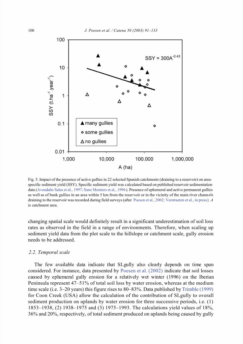
A recent survey within the catchments of 22 Spanish reservoirs clearly indicates that
specific sediment yield increases when the frequency of gullies increases in the catchment
(Fig 5 Poesen et al 2002 Verstraeten et al in press) For catchments where no gullies were
observed mean specific sediment yield was 074 ton haAgrave 1 year Agrave 1 (n = 3) For catchments
where numerous gullies could be observed however mean specific sediment yield was oneorder of magnitude larger ie 961 tons haAgrave 1 year Agrave 1 (n = 7) Catchments with some gullies
had an intermediate mean specific sediment yield of 297 tons haAgrave 1 year Agrave 1 (n = 12) In other
words the presence of (active) gullies in these Mediterranean catchments seems to be an
important indicator for the magnitude of sediment production within these catchments
All cited data clearly indicate that SLgully highly depends on the spatial scale
considered and that for particular spatial scales it can even become the dominant soil
erosion process Several studies have demonstrated that when scaling up area-specific soil
loss rates the latter do not remain constant or increase gradually with increasing size of the
considered study area but that area-specific soil loss rates may suddenly increase one
order of magnitude once a critical area (corresponding to a topographic threshold valueneeded for gullies to develop) has been exceeded (eg Poesen et al 1996b Osterkamp
and Toy 1997) Thus clearly neglecting soil losses caused by gully erosion when
J Poesen et al Catena 50 (2003) 91ndash133 99
842019 Cat en a 2
httpslidepdfcomreaderfullcat-en-a-2 1043
changing spatial scale would definitely result in a significant underestimation of soil loss
rates as observed in the field in a range of environments Therefore when scaling up
sediment yield data from the plot scale to the hillslope or catchment scale gully erosion
needs to be addressed
22 Temporal scale
The few available data indicate that SLgully also clearly depends on time span
considered For instance data presented by Poesen et al (2002) indicate that soil losses
caused by ephemeral gully erosion for a relatively wet winter (1996) on the Iberian
Peninsula represent 47ndash51 of total soil loss by water erosion whereas at the medium
time scale (ie 3ndash20 years) this figure rises to 80ndash83 Data published by Trimble (1999)
for Coon Creek (USA) allow the calculation of the contribution of SLgully to overall
sediment production on uplands by water erosion for three successive periods ie (1)1853ndash1938 (2) 1938ndash1975 and (3) 1975ndash1993 The calculations yield values of 18
36 and 20 respectively of total sediment produced on uplands being caused by gully
Fig 5 Impact of the presence of active gullies in 22 selected Spanish catchments (draining to a reservoir) on area-specif ic sediment yield (SSY) Specific sediment yield was calculated based on published reservoir sedimentation
data (Avendano Salas et al 1997 Sanz Montero et al 1996) Presence of ephemeral and active permanent gullies
as well as of bank gullies in an area within 5 km from the reser voir or in the vicinity of the main river channels
draining to the reservoir was recorded during field surveys (after Poesen et al 2002 Verstraeten et al in press) A
is catchment area
J Poesen et al Catena 50 (2003) 91ndash133100
842019 Cat en a 2
httpslidepdfcomreaderfullcat-en-a-2 1143
erosion These fluctuations are attributed to changing land use during these successive
periods More research is needed to assess and elucidate changes in SLgully when
considering different time periods
23 Environmental controls
Apart from s patial and temporal scale differences differences in SLgully for various
measuring sites (Table 1) or different time periods can also be attributed to differences in
gully types and to various environmental controls For (small) catchments SLgully = f
(gully type soil type land use climate topography)
231 Gully type
Poesen et al (1996b) found that rates of ephemeral gully erosion in central Belgium
ranged between 30 and 66 tons haAgrave 1 year Agrave 1 and exceeded by one order of magnitude
rates by bank gully erosion ie 03ndash06 ton haAgrave 1 year Agrave 1
232 Soil type
Field data collected by Evans (1993a) in the UK revealed that the contribution of
gully erosion in valley bottoms to total soil loss is most important in localities with
dominantly heavier textured soils Where soils were mostly silty coarse loamy or
sandy rill erosion on the hillslopes became more important reducing the relative
contribution of ephemeral gully erosion in valley bottoms to overall sediment
production In central Belgium ephemeral gully volumes that eroded in truncatedsoil profiles (ie with no Bt-horizon) can be four to five times larger than volumes
eroded by ephemeral gullies developing into intact soil profiles (Poesen 1993) In
addition where large amounts of rock fragments are present at the soil surface (eg
erosion pavements) sheet and rill erosion rates are usually relatively small compared
to (ephemeral) gully erosion rates (Poesen et al 1998)
233 Land use
For catchments with hillslopes producing small amounts of sediment by interrill and rill
erosion such as for instance hillslopes under grassland (Bradford and Piest 1980)
gullies contribute significantly more to overall sediment yield compared to sheet and rillerosion than if the hillslopes produced large amounts of sediment such as hillslopes under
cropland Similar observations for bare and crop-covered catchments have been reported
by Cerdan et al (2003) Development of infrastructure such as irrigation canals or roads in
a catchments can also induce an increase in gully erosion rate due to inappropriate
drainage of surface water (eg Nyssen 2001 Vanacker et al in press) Data collected by
Nyssen (2001) in the Ethiopian Highlands for instance indicate that SLgully evolved
from 33 to 55 after the construction of a road in the study area because of more runoff
concentration
234 Climate and weather Limited available data indicate that SLgully () is relatively more important in dry
environments compared to wet environments (Poesen et al 1996b Poesen and
J Poesen et al Catena 50 (2003) 91ndash133 101
842019 Cat en a 2
httpslidepdfcomreaderfullcat-en-a-2 1243
Hooke 1997) Data from central Belgium indicate that the relative contribution of
gully erosion to total sediment production within a given catchment decreases with
increasing return period (and thus intensity) of the rain event (Fig 6) Since low
intensity rains in the study area prevail in the winter period the relative contributionof gully erosion to total sediment production is higher during that period compared to
the spring and summer periods which are characterised by more intense rainstorms
(Vandaele and Poesen 1995) Depending on the observation period SLgully () will
be partly determined by the magnitude and frequency of rain events causing gully
erosion In addition data from Fig 6 indicate that any change in the rainfall regime
(due to a climate change) for a given area will most likely also affect SLgully () In
areas of pronounced continentality there may be a considerable seasonal variation in
SLgully because of a dominance of gully erosion by concentrated snowmelt runoff in
spring (with little or no sheet erosion because of the lack of raindrop impact forces
and the small velocity of sheet flow under a snow cover) and sheet and rill erosion
during thunderstorms in summer (Auerswald personal communication)
235 Topography
Although no data are available on the relation between SLgully () and topography it
is clear that topographic attributes such as slope gradient and drainage area affect the
Fig 6 Relation between return period of rain event and ratio of soil l oss by gully erosion and total soil loss by
water erosion in central Belgium [SLgully()] Data presented in Poesen et al (1996b) were measured by
Vandaele and Poesen (1995) for a 25-ha catchment whereas data from Beuselinck et al (2000) were measured in
a 250- and 300-ha catchment respectively
J Poesen et al Catena 50 (2003) 91ndash133102
842019 Cat en a 2
httpslidepdfcomreaderfullcat-en-a-2 1343
density of the drainage network and hence the probability of gully channel development
(see Section 43)
This section highlighted some factors controlling SLgully At present however no
tool is available to predict SLgully for different spatial and temporal scales and for arange of environmental conditions Clearly more research is needed in this domain if
we want to predict impacts of land use and climate changes on the risk for gully
erosion
3 Techniques for measuring gully erosion processes and rates
What are appropriate measuring techniques for monitoring and for experimental studies
of the initiation and development of different gully types at various temporal and spatial
scales Contrary to sheet and rill erosion where standardised procedures for assessment of
erosion rates exist (eg runoff plot technique widely used for collecting soil loss data for
assessment of erosion factors in eg RUSLE) no standardised procedures are available
for measuring gully erosion rates and controlling factors
Here we present a brief overview of recent field and laboratory-based techniques used
in order to assess gully erosion rates at various time scales
At the short-time scale ( lt 1 ndash10 years) both ground-based and airborne techniques
have been used to assess eroded volumes by gullying Measuring directly the volumes
of soil eroded by ephemeral gullying has been done in a range of cropland environ-
ments (eg Auzet et al 1995 Casali et al 1999 Vandaele and Poesen 1995 Nachtergaele et al 2001ab Valcarcel et al 2003 Oslashygarden 2003) Short-term
monitoring of gully head or gully wall retreat has been conducted by measuring
regularly the change in distance between the edge of the gully head or wall and
benchmark pins installed around the gully wall (eg Vandekerckhove et al 2001b
Oostwoud Wijdenes and Bryan 2001) or by measuring the three-dimensional mor-
phology of the gully wall using a direct contact protractor system (eg Sneddon et al
1988 Archibold et al 1996) Several studies have applied photogrammetric techni-
ques to sequential large-scale aerial photographs in order to determine the volume of
soil lost by concentrated flow erosion (eg Thomas et al 1986 Ries and Marzolff
2003 this volume) Ritchie et al (1994) measured gully cross-sections using a laser altimeter mounted in an aircraft Although several new techniques have been proposed
few of these have been tested in a wide range of environments
At the medium-time scale (10ndash70 years) aerial photographs have been analysed to
measure temporal changes in length area or volume of various gully types (eg Burkard
and Kostaschuk 1995 Derose et al 1998 Nachtergaele and Poesen 1999 Daba et al
2003 Ga bris et al 2003 Martinez-Casasnovas 2003) Only gully systems with
sufficiently large changes in morphology over time can be studied in this way For gullies
experiencing smaller changes over time Vandekerckhove et al (2001a) developed a
framework using dendrochronological methods for estimating medium-term gully erosion
rates based on the analysis of roots exposed by gully erosion browsing scars by ungulatesexposed and dead root ends root suckers stems branches or leading shoots of fallen trees
and a sequence of trees within a gully
J Poesen et al Catena 50 (2003) 91ndash133 103
842019 Cat en a 2
httpslidepdfcomreaderfullcat-en-a-2 1443
For the long-time scale several studies have used historical data (documents and maps)
artefacts and various dating techniques to reconstruct the conditions leading to significant
gully erosion in the past (eg Prosser and Winchester 1996 Trimble 1998 1999 Bork et
al 1998 Webb and Hereford 2001 Dotterweich et al 2003 Ga bris et al 2003)In order to better understand and model gully erosion processes several field and
laboratory-based experiments have been undertaken (for a recent overview of gully
erosion processes see Poesen et al 2002 Bull and Kirkby 2002) In the field
concentrated flow erosion has been simulated on undisturbed soil surfaces in order to
detect critical flow intensity parameters leading to significant soil detachment and
transport (eg Riley 1992 Prosser et al 1995 Franti et al 1999) However in the
field the relative importance of various subprocesses in gully development ie flow
detachment by flow shear stresses or by seepage forces plunge pool erosion headcutting
tension crack development and mass wasting on gully walls cannot always easily be
measured Therefore laboratory experiments with flumes ranging in length between 15
and 29 m filled with soil and using simulated concentrated flow erosion have been set up
to study the mechanics of channel development (eg Meyer 1989 Govers et al 1990
Robinson and Hanson 1996 Bennett et al 2000) Smaller laboratory flumes have been
used to investigate subprocesses of channel initiation and development under drainage and
seepage conditions (eg van der Poel and Schwab 1988 Zhu et al 1995 Bryan and
Rockwell 1998 Gabbard et al 1998 Poesen et al 1999 Bennett and Casali 2001
Romkens et al 2001)
Although a significant number of studies dealing with the measurement of gully
erosion rates exist the possibilities and limitations of the various monitoring andexperimental approaches used in these studies are not always clear In addition due to
a lack of standardisation the data on gully erosion rates obtained in various
environments are not always comparable Standardisation of the various measuring
techniques will lower the uncertainties on the measurements of gully erosion rates but
will still not always solve the problem of how to compare these erosion rates with
those caused by other erosion processes
4 Thresholds for gully development
Gully erosion clearly is a threshold phenomenon This geomorphic process occurs only
when a threshold in terms of flow hydraulics rainfall topography pedology and land use
has been exceeded Can we identify critical thresholds for the initiation development and
infilling of gullies in different environments
41 Hydraulic thresholds for gully development under various land uses
Gully channels can only develop if concentrated (overland) flow intensity during a
rain event exceeds a threshold value Horton (1945) first proposed the concept of a
threshold force required for channel initiation This force of flow is often expressed interms of the boundary flow shear stress (s b =Ugds with U= density of runoff water
g = acceleration due to gravity d = depth of flow and s = sine of the soil surface
J Poesen et al Catena 50 (2003) 91ndash133104
842019 Cat en a 2
httpslidepdfcomreaderfullcat-en-a-2 1543
gradient) The threshold force required to cause channel incision into the soil surface
in the concentrated flow zone is termed the critical flow shear stress (sc) A key
question is how large should sc be for (ephemeral)gullies to initiate
Critical flow shear stress values for incipient motion of individual soil particleshave been well studied Entrainment of loose silt and fine to medium sand grains
occurs at sc values of less than 1 Pa (as deduced from the Shields curve Vanoni and
Brooks 1975 p 99) For bare cohesive topsoils with soil shear strength values at
saturation up to 10 kPa laboratory experiments indicate that sc values can go up to 4
Pa (eg Rauws and Govers 1988 Brunori et al 1989 Crouch and Novruzzi 1989)
These sc values are of the same order as those reported for rill incision in bare
topsoils in the field under drainage conditions ie 18 ndash 106 Pa depending on soil
properties (texture soil water content content of calcium iron organic carbon and
potassium eg Gilley et al 1993) Soil shear strength values at saturation appear to
be a good indicator for sc (Poesen et al 1998) Experimental data collected by Huang
and Laflen (1996) indicate that critical flow conditions for rilling under seepage
conditions may be significantly less than those for drainage conditions Land manage-
ment practices may affect the critical flow shear stress values for concentrated flow
erosion as Franti et al (1999) reported that sc values for no-till were about twice that
for tilled soil Along the same lines Laflen and Beasly (1960)clearly demonstrated
that compaction of the topsoil increased sc values Living plant roots may increase
critical flow conditions for rill channel development (Li 1995 Sidorchuk and
Grigorev 1998)
In contrast with the number of publications on critical flow conditions for incipient rilling very few studies report critical flow conditions for incipient gullying During a rain
event many rills may develop but only a few may grow into a gully provided that flow
intensities exceed those needed for the erosion of a gully channel For cultivated land
Nachtergaele (2001) calculated critical shear stresses during peak flow that occurred in 33
ephemeral gully channels in central Belgium and in 40 ephemeral gully channels in
southern Portugal For each study area a frequency distribution of sc values was
established (Fig 7) sc ranges between 33 and 322 Pa (mean = 14 Pa) for ephemeral
gullies eroded in silt loam (loess-derived) topsoils in Belgium whereas sc ranges between
168 and 744 Pa (mean = 44 Pa) for ephemeral gullies formed in stony sandy loams in
Portugal In general an inverse relation between concentrated flow width and sc for ephemeral gully development in these study areas is observed (Poesen et al 2002) The
significant difference in sc between both study areas cannot be explained by differences in
land use as in both study areas ephemeral gullies developed in tilled cropland but are
attributed to different soil types Whereas no rock fragments are present in the Belgian
loess-derived soils rock fragment content of topsoils in southern Portugal amounts to 30
by mass on average Poesen et al (1999) demonstrated experimentally that rock fragment
content in topsoils significantly reduces the susceptibility of these soils to concentrated
flow erosion For noncultivated land in Australian valley floors Prosser (1996) reported sc
values for gully initiation of 21 Pa for bare clay 70 Pa for heavily degraded aquatic plants
or tussock and sedge gt105 Pa for undisturbed aquatic plants gt180 Pa for lightly degradedtussock and sedge and gt240 Pa for undisturbed tussock and sedge Grassed irrigation
canals have also been found to resist flow shear stresses of up to 260 Pa before showing
J Poesen et al Catena 50 (2003) 91ndash133 105
842019 Cat en a 2
httpslidepdfcomreaderfullcat-en-a-2 1643
signs of scour (Reid 1989 cited by Prosser 1996) Few studies deal with the hydraulic
geometry characteristics and hydraulic efficiency of various gully types (eg Billi and
Dramis 2003 Ionita 2003)
This review reveals that for prediction purposes more data are needed on critical
hydraulic conditions leading to gully initiation development and infilling in a range of
environments as well as for different land management practices Very few studies have
attempted to measure critical hydraulic conditions for incipient gullying in field conditions
mainly because of logistic constraints Therefore several studies have attempted to assesscritical environmental conditions for gullying in terms of rainfall topography soils (or
lithology) and land use as these factors control either the runoff hydraulics (eg rainfall
Fig 7 Distribution of calculated peak flow shear stress values at points where ephemeral gullies start (ie where
channel cross-section gt930 cm2) on loess-derived soils during winter and summer rains in Belgium (n = 33) and
on stony topsoils in the Alentejo (SE Portugal n = 40) (after Nachtergaele 2001)
J Poesen et al Catena 50 (2003) 91ndash133106
842019 Cat en a 2
httpslidepdfcomreaderfullcat-en-a-2 1743
topography) or the resistance of the soil surface to incision (eg soils) or both (eg land
use)
42 Rainfall thresholds
What are critical rainfall characteristics leading to the development of gullies in
dif ferent environments
Table 2 summarises some data on threshold rains ( P ) needed to initiate rills and
(ephemeral) gullies P values needed to initiate ephemeral gullies in cropland (ie
145 lt P lt 22 mm) are only slightly larger compared to those needed to initiate rills (ie
76lt P lt 25 mm) Differences in threshold rains for ephemeral gully development on
cropland between the various study areas ie 145 lt P lt 22 mm are attributed to different
Table 2
Rainfall thresholds for rill and (ephemeral) gully development under field conditions P = depth of rain event
P d = daily rain depth P i = rain intensity P iAgrave 30 = rain intensity calculated over 30 min
Erosion
process
Rain
threshold
Location Soilland use Source
Rill P dgt75 mm North Norfolk UK loamy to sandy
loam soils cropland
Evans and Nortcliff
(1978)
P = 10 mm and
P igt1 mm hAgrave 1
West Midlands UK sandy loam
soils cropland
Reed (1979)
P gt10 mm
(summer)
East Anglia UK all soil types cropland Evans (1981)
P d = 10 ndash 1 5 mm North Thailand clay soils cropland Turkelboom (1999)
P = 15 mm Alsace France loam soils Auzet (personal
communication)
P dgt15 mm and
P igt4 mm hAgrave 1
England and
Wales UK
sand loam soils cropland Chambers et al
(1992)
P = 20 mm and
P i = 3 mm hAgrave 1
Bedfordshire UK sand loam soils cropland Morgan (1980)
P dgt15 ndash 20 mm Scotland UK sandy loam and
loam soils cropland
Speirs and Frost
(1985)
P gt20ndash25 mm
during winter
lowland England
UK
all soil types cropland Evans (1980)
P gt30 mmduring 2 days
South DownsEngland UK
stony soils cropland Boardman (1990)
Ephemeral
gully
P = 1 45 mm Almeria Spain stony soils cropland Vandekerckhove et al
(2000)
P d =18 mm
(summer)
P d =15 mm
(winter)
Central Belgium silt loams cropland Nachtergaele (2001)
P = 17 mm Navarra Spain loamy soils cropland Casali et al (1999)
P = 20 mm North Thailand clay soils cropland Turkelboom (1999)
P = 22 mm and
P iAgrave 30 = 33 mm hAgrave 1
Extremadura shallow soils cropland Schnabel and Gomez
(1993)
Gully P dgt80 ndash 100 mm BombalaSE Australia
loamy sand andsandy loam soils
forestry operations
Prosser and Soufi(1998)
J Poesen et al Catena 50 (2003) 91ndash133 107
842019 Cat en a 2
httpslidepdfcomreaderfullcat-en-a-2 1843
states of the soil surface (roughness degree of sealing) as affected by tillage operations
and antecedent rains
Nachtergaele (2001) analysed 38 ephemeral gully erosion events that occurred over a
15-year period in central Belgium and found critical P values of 15 mm in (late) winter (n = 21) and of 18 mm in (early) summer (n = 17) which is attributed to a difference in soil
moisture content between winter and summer Threshold rains for gully development in
land under forestry operations in Australia are significantly larger ( P = 80ndash 100 mm) than
those for ephemeral gully development on seedbeds Sudden snowmelt on frozenthawing
soil presents a special case of a meteorologic threshold condition at higher latitudes higher
altitudes or areas with a continental climate which can lead to the rapid development of
ephemeral gullies Oslashygarden (2003) documents how the combination of frozen subsoils
saturated topsoils with low strength and intense rainfall led to the development of
ephemeral gullies in Norway even in areas with gentle slope gradients These observations
point to the fact that a gradual climate change to more unstable winter conditions (ie
freezing and thawing combined with intense rain) is likely to increase the risk of
(ephemeral) gully erosion One of the difficulties encountered when assessing critical
rain depths for gully initiation is the lack of representative rain data for the sites where
observations on gully erosion processes have been made (eg Vandekerckhove et al
2000)
43 Topographic thresholds and the role of land use
Where do gullies develop in the landscape Most soil erosion models (apart from someGIS-based models) do not predict the location of gullies However this is important for
land managers and for predicting possible impacts of climatic or land use changes on the
spatial distribution and density of gullies The main question here is where do gullies start
and where do they end in the landscape
431 Where do (ephemeral) gullies start
An approach to predict locations where gully heads might develop is presented by the
threshold concept first applied to geomorphic systems by Patton and Schumm (1975)
This concept is based on the assumption that in a landscape with a given climate and land
use there exists for a given slope gradient of the soil surface (S ) a critical drainage area ( A)necessary to produce sufficient runoff which will cause gully incision As slope steepens
this critical drainage area decreases and vice versa For different environmental conditions
and different gully initiating processes different thresholds apply Threshold lines for gully
development by hydraulic erosion can be represented by a power-type equation (Begin and
Schumm 1979 Vandaele et al 1996) S = aAb with a and b coefficients depending on the
environmental characteristics Kirkby et al (2003) shows that power law equations
describing sediment transport for water erosion occurring on runoff plots are consistent
with S ndash A relations describing the location of ephemeral and permanent gully channel head
location in the landscape The topographic threshold concept for gully initiation permits
one to predict for a given land use the location in the landscape where gully channels maydevelop by providing a physical basis for the initiation of gullies Various studies
conducted in a range of different environments have established critical S ndash A relations
J Poesen et al Catena 50 (2003) 91ndash133108
842019 Cat en a 2
httpslidepdfcomreaderfullcat-en-a-2 1943
for incipient permanent and ephemeral gullying (eg Patton and Schumm 1975 Harvey
1987 1996 Montgomery and Dietrich 1988 1994 Moore et al 1988 Riley and
Williams 1991 Boardman 1992 Prosser and Abernethy 1996 Prosser and Winchester
1996 Vandaele et al 1996 Vandekerckhove et al 1998 2000 Nachtergaele et al2001ab Nyssen et al in press Moeyersons 2003 Morgan and Mngomezulu 2003)
Poesen et al (1998) summarised and compared 10 published critical S ndash A data sets for
ephemeral gullies and permanent gullies in different environments and found that not only
the environmental characteristics but also the methodology used to assess critical S and A
also affects the reported topographic threshold for incipient gullying (Fig 8) Fig 8
indicates that topographic threshold conditions for gully initiation in noncultivated land
plot above those needed to initiate ephemeral gullies in cropland Other factors controlling
the position of the threshold lines are climate as well as all other factors controlling the
Fig 8 Relation between critical slope of soil surface and drainage area for incipient gully development in a
variety of environments (after Poesen et al 1998) Dotted lines indicate threshold conditions for ephemeral gully
development in cultivated cropland (1 ndash 5) Solid lines indicate threshold conditions for gully head development in
noncultivated land (6 = sagebrush and scattered trees 7 = open oak woodland and grasslands 8 = coastal prairie
9 = logged forest and 10 = swampy reed-covered valley floors) (1) Central Belgium field survey (Poesen
unpublished data) (2) Central Belgium analysis of aerial photos and topographic maps (Vandaele et al 1996)
(3) Portugal analysis of aerial photos and topographic maps (Vandaele et al 1996) (4) Fr ance analysis of aerial
photos and topographic maps (Vandaele et al 1996) (5) UK (Sout h Downs) field survey (Boar dman 1992) (6)
USA (Colorado) analysis of aerial photos and topographic maps (Patton and Schumm 1975) (7) USA (Sierra
Nevada) field survey (Montgomery and Dietrich 1988) (8) USA (California) field survey (Montgomery and
Dietrich 1988) (9) USA (Oregon) field survey (Montgomery and Dietrich 1988) (10) Australia (New South
Wales) field survey (Nanson and Erskine 1988)
J Poesen et al Catena 50 (2003) 91ndash133 109
842019 Cat en a 2
httpslidepdfcomreaderfullcat-en-a-2 2043
mechanisms of incipient gullying ie hydraulic erosion by concentrated overland flow
seepage flow and mass movement processes (Montgomery and Dietrich 1994 Kirkby
1994) From a comparison of six critical S ndash A data sets corresponding to various
Mediterranean study areas in Europe and collected using the same methodologyVandekerckhove et al (2000) found that vegetation type and cover were far more
important than climatic conditions in explaining differences in topographic thresholds
for different areas In cultivated fields topsoil structure and soil moisture condition as
controlled by the antecedent rainfall distribution are crucial factors affecting the S ndash A
relationships rather than daily rain for the gully-initiating events For rangelands
vegetation cover and type (annuals and perennials) at the time of gully head development
appears to be the most important factor differentiating between topographic thresholds
The importance of vegetation biomass in concentrated flow zones for reducing gully
initiation risk in semi-arid environments was also stressed by Graf (1979) and Nogueras et
al (2000) This statement is also in line with conclusions drawn from various studies in
Australia by Prosser (in press) lsquolsquoNatural vegetated surfaces in humid environments are
highly resistant to scour by concentrated overland flow and consequently are only
sensitive to gully erosion from extreme events or climate change experienced at 1000
years or longer time scales Once vegetation cover is degraded however these systems
become more sensitive to climate change and decadal scale changes can contribute to gully
initiation Many of these degraded hollow or valley bottoms would ultimately scour from
large events regardless of climate changing toward more intense runoff Particularly areas
of high intensity cropland have periods of low resistance to concentrated flow erosion
which make them quite sensitive to relatively small storms and changes to the intensity of rainfall and runoffrsquorsquo
From these conclusions it becomes clear that any land use change implying a
vegetation biomass decrease as well as a lowering of the erosion resistance of the topsoil
by tillage operations in the landscape and more particularly in concentrated flow zones
will decrease the threshold for incipient gullying This implies that for a given slope
gradient (S ) critical drainage area ( A) for gully head development will decrease and
therefore gully density will increase as pointed out by Kirkby (1988)
Several studies have been reported where the topographical threshold concept in
combination with a hydraulic threshold has been applied to predict areas at risk of
gullying (Dietrich et al 1993 Prosser and Abernethy 1996) Desmet and Govers (1997)and Desmet et al (1999) investigated the relative importance of slope gradient (S ) and
drainage area ( A) for the optimal prediction of the initiation and trajectory of ephemeral
gullies In the latter study a striking discrepancy was found between the high A exponent
(ie 07ndash15) required to predict optimally the trajectory of the gullies and the low A
exponent (ie 02) required to identify spots in the landscape where ephemeral gullies
begin
432 Where do (ephemeral) gullies end
Gullies usually end where the transporting capacity of the concentrated runoff drops
andor where the erosion resistance of the topsoil increases sharply A sudden change fromone land use to another might trigger sediment deposition instead of channel entrenchment
(vegetation-controlled sediment deposition eg Takken et al 1999 Beuselinck et al
J Poesen et al Catena 50 (2003) 91ndash133110
842019 Cat en a 2
httpslidepdfcomreaderfullcat-en-a-2 2143
2000 Steegen et al 2000) In many field conditions a lowering of the slope gradient with
increasing drainage area causes a drop in transporting capacity and hence a decrease in
gully channel depth (slope-controlled sediment deposition) In contrast with critical S ndash A
relations established for the location of gully heads few S ndash A relations have beenestablished for the location of sites where (ephemeral) gullies end (eg Poesen et al
1998 Vandekerckhove et al 2000 Nachtergaele et al 2001ab) Field measurements in
different cropland areas of northern Europe reveal that topographically induced sediment
deposition at the downlsope end of ephemeral gullies which developed in loamy to loamy
sand soils usually occurs in a narrow range of local slope gradient along catenas under
cropland ie 2 ndash4 However when rock fragment content of the topsoil increases
topographically induced sediment deposition occurs on steeper slopes ie up to 25ndash30
(Poesen et al 2002)
From this review we conclude that detailed information on the impact of various land
uses on topographic thresholds needed to initiate gullies under a range of climatic
conditions is rather scarce However such information is crucial for predicting where in
the landscape gully development might be expected under different environmental
conditions
44 Pedologic and lithologic controls
To what extent do soil type and lithology control gully development and gully
characteristics
441 Soil type
Many studies have investigated the susceptibility of soils (soil erodibility) to interrill
and rill erosion (for a recent review see Bryan 2000) Comparatively few studies have
investigated the susceptibility of soils to gully erosion Soil type and in particular the
vertical distribution of the erosion resistance of the various soil horizons largely controls
the size and more specifically the depth and cross-sectional morphology of gullies
Ireland et al (1939) were the first to point to the important role of the resistant Bt-horizons
in controlling gully depth and gully head shape in the southeastern USA Other studies
conducted on gully development in duplex soils in Australia (eg Sneddon et al 1988)
and on loess-derived soils in Europe (Poesen 1993) also came to the same conclusionPoesen (1993) found that soil shear strength at saturation of the various loess-derived soil
horizons is a good indicator of their resistance against concentrated flow erosion For
loess-derived soils Nachtergaele and Poesen (2002) showed that (1) sc and channel
erodibility (related to concentrated flow erosion) for a Bt-horizon was significantly larger
compared to sc and erodibility for an Ap or a C horizon and (2) that an increasing
antecedent moisture content of each horizon had a negative effect on their erodibility In
landscape positions where Bt-horizons are still present ephemeral gully depth is limited to
a maximum of 050 m However for landscape positions where no Bt-horizon is present
concentrated flow may erode ephemeral gullies several meters deep (Poesen 1993)
Erosion of Bt-horizons caused by various processes (ie water erosion tillage erosionremoval of soil during root and tuber crop harvesting land levelling) therefore largely
increases the risk for deep gully development Other reported soil horizons resistant to
J Poesen et al Catena 50 (2003) 91ndash133 111
842019 Cat en a 2
httpslidepdfcomreaderfullcat-en-a-2 2243
gully erosion are plough pans fragipans petrocalcic horizons or unweathered bedrock On
the other hand less permeable soil horizons can induce positive pore water pressures in the
overlying soil layers which in turn lowers the erosion resistance of these soil horizons
particularly when seepage conditions (return flow) occur (eg Moore et al 1988 Huangand Laflen 1996) This in turn may alter the topographic threshold for gully head initiation
(eg Montgomery and Dietrich 1994 Vandekerckhove et al 2000 Poesen et al 2002)
442 Lithology
Figs 9 and 10 illustrate two contrasting examples of how lithology (respectively hard
unweathered rock and unconsolidated loose sandy sediments) controls the size of gullies
that can develop under cropland The occurrence of landscapes heavily dissected by
gullies in the Mediterranean (ie badlands) is strongly controlled by particular lithologic
conditions ie the presence of unconsolidated or poorly sorted materials such as shales
gypsiferous and salty silt marls and siltndashclay deposits of Tertiary and Quaternary age
(Poesen and Hooke 1997 Gallart et al 2002) Faulkner et al (2003) report on the role
of site geochemistry in morphological development of badlands In contrast with sheet
and rill erosion relatively little is known about the properties of soils or parent materials
and the associated processes that control the dynamics of their resistance to gully
erosion
45 Land use thresholds
Gully development over the last 1500 years triggered by a combination of human-induced land cover changes and extreme rainfalls have been documented for various
Fig 9 Ephemeral gully in Vulci central Italy (November 1987) Note the hard unweathered bedrock at a depth
of ca 90 cm
J Poesen et al Catena 50 (2003) 91ndash133112
842019 Cat en a 2
httpslidepdfcomreaderfullcat-en-a-2 2343
parts of the world eg arroyo development in the southwestern US caused by theintroduction of cattle (which caused overgrazing) and a climatic shift (eg Webb and
Hereford 2001) gully initiation and development in eastern Australia since European
settlement 200 years ago (Prosser and Winchester 1996) gully development in the UK
in the 9th to the 10th century caused by a change in catchment hydrology in response
to human-induced vegetation change (Harvey 1996) or gully development in central
Europe due to high land use pressure and extreme rains in the 14th century in Germany
(Bork et al 1998) or during the Little Ice Age in Slovakia (Stankoviansky in press) In
many forested areas of Europe large gully systems can be often found (Fig 11) What
kind of environmental conditions have led to the development of these (large) gullies
and what do we learn from this Most of these gullies are the result of a land usedifferent from the present land use (in combination with extreme rainfall) in the past
rendering these landscapes more vulnerable to gully incision Much can be learned from
detailed case studies on environmental conditions leading to this kind of land
degradation (eg Poesen et al 2000 Dotterweich et al 2003 Ga bris et al 2003
Boardman et al 2003 Strunk 2003)
Several recent case studies have documented the significant impacts of a gradual or
sudden shift in land use on the triggering of gullying or the increase in gully erosion
rates For instance field observations in central Belgium indicate that the increase in
area under maize over the last two decades has resulted in an increased ephemeral
gully erosion risk (Nachtergaele 2001) Faulkner (1995) reported on the triggering of gully erosion associated with the expansion of unterraced almond cultivation after
hasty clearance of native Mediterranean matorral in southern Spain This land use
Fig 10 Large (ca 15ndash20 m deep and ca 30ndash40 m wide) permanent gully which developed in unconsolidated
Tertiary sandy sediments Owerri South Nigeria (April 1988) The development of such gullies leads to enhanced
subsurface drainage (water table lowering) of these hillslopes
J Poesen et al Catena 50 (2003) 91ndash133 113
842019 Cat en a 2
httpslidepdfcomreaderfullcat-en-a-2 2443
change also caused the development or reactivation of bank gullies along ephemeral
streams in southeastern Spain (Oostwoud Wijdenes et al 2000) Bork et al (2001)
documented the effect of agricultural intensification in the second half of the 20thcentury in the Upper Yangtze river basin (SW China) on rapid gully development and
the subsequent gully stabilisation as a consequence of reforestation by air seeding
Several studies conducted in a range of different environments have documented the
impact of road construction on the increased gully erosion risk on steep slopes (eg
Moeyersons 1991 Montgomery 1994 Wemple et al 1996 Croke and Mockler
2001 Nyssen 2001) Gully incision is significantly more likely below culverts on
steep slopes with longer than average contributing ditch length (Wemple et al 1996
Nyssen 2001) Montgomery (1994) showed that for a given slope gradient the
drainage area required to support a gully head is smaller for road-related runoff than
for undisturbed slopes Contributing road length and the gradient of the dischargehillslope have been successfully used to separate gullied and non-gullied flow
pathways within catchments (Croke and Mockler 2001) Burkard and Kostaschuk
(1997) attributed the increased growth rates of bank gullies along the shoreline of
Lake Huron to increased snowfall extreme flow events but also to the extension of
municipal drains and the use of subsurface drainage Vanacker et al (in press) have
documented the impact of collapsing irrigation canals and the mismanagement of
excess irrigation water on the extension of the rill and gully network in a semi-arid
region of Ecuador
Many more detailed case studies are needed if we want full understanding of the impact
of various types of land use change and its interaction with extreme weather conditions ongully development In addition more research is needed on the (socio-economic) drivers
of land use changes causing increased or decreased gully erosion risk
Fig 11 Old gully channel under forest most probably formed under a different land use (Poesen et al 2000
Tersaert forest Huldenberg Belgium February 2000)
J Poesen et al Catena 50 (2003) 91ndash133114
842019 Cat en a 2
httpslidepdfcomreaderfullcat-en-a-2 2543
5 Interaction between gully development hydrological and other soil degradation
processes
What is the impact of gully erosion on hydrological processes such as infiltration anddrainage Once gullies develop water infiltration rate through the gully bottom may be
significantly larger compared to that of the soil surface in the intergully areas if the gully
channel develops into more permeable horizons Through the gully bed and banks
significant runoff water transmission losses can then take place particularly in semi-arid
and arid environments as shown by Esteves and Lapetite (2003) in Niger Such water
transmission losses have also been reported to occur in smaller erosion channels (ie rills
eg Poesen and Bryan 1989 Par sons et al 1999) as well as in larger (ephemeral) river
channels (for recent review see Beven 2002) Recent studies (eg Leduc et al 2001
Avni in press) indicate that gully development in semi-arid areas may therefore lead to
significant groundwater recharge On the other hand if gullies develop into hillslopes with
temporary water tables they may cause an enhanced drainage and a rapid water table
lowering which results in a significant drying out of the soil profiles in the intergully areas
as observed by Moeyersons (2000) in Africa In addition Okagbue and Uma (1987)
reported that gullies located at the discharge areas of groundwater systems in southeastern
Nigeria may become very active during the peak recharge times of the rainy season
because high porendashwater pressures reduce the effective strength of the unconsolidated
materials along the seepage faces The seepage forces caused by exit hydraulic gradients at
the levels of seepage on the gully walls produce boiling conditions piping and tunnelling
that undermine the gully walls and activate their retreat (see also Fig 10) Most erosionmodels are driven by hydrological models (runoff) The previous discussion clearly
indicates that there are also important feedback mechanisms ie gully erosion may in
turn also control the intensity of some hydrological processes (water transmission losses or
groundwater depletion) These interactions deserve more attention
How does gully erosion interact with other soil degradation processes Once gullies
develop they often trigger other soil degradation processes such as piping soil fall or soil
topple (driven by gravity) after tension crack development and undercutting Furthermore
gully channels enhance the export of sediment produced on the intergully areas (sheet and
rill erosion) by increasing the connectivity in the landscape (eg Stall 1985 Poesen et al
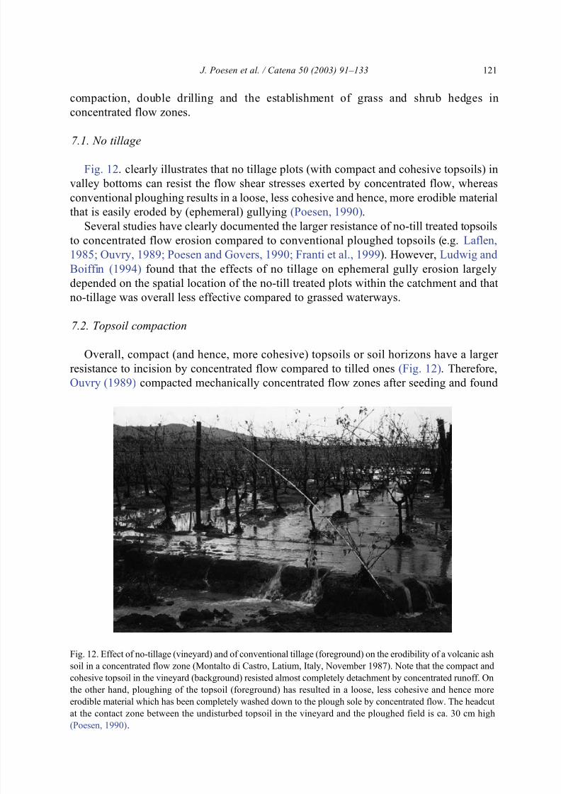
2002 Fig 5) which leads to an increased risk of sediment deposition downslope If nogully control measures are taken gully growth rates usually decline exponentially (eg
Graf 1977 Rutherford et al 1997 Nachtergaele et al 2002b) However in cropland
areas ephemeral gullies are usually filled in by tillage (tillage erosion and tillage
deposition) within less than a year of their initiation During subsequent storms (years)
the infilled soil material is usually eroded again by concentrated flow thereby increasing
the plan-form concavity of the site The newly created plan-form concavity increases the
probability for concentrated flow erosion Thus ephemeral gully erosion and tillage
erosion reinforce each other In various parts of Europe heavily dissected landscapes by
gullying (badlands) have been levelled thereby causing strong soil profile truncation in the
intergully areas and infilling of gullies with this material (eg Revel and Guiresse 1995Poesen and Hooke 1997 Torri 1999) Such land levelling operations have often resulted
in renewed gully incision of the levelled land as well as in shallow landsliding causing
J Poesen et al Catena 50 (2003) 91ndash133 115
842019 Cat en a 2
httpslidepdfcomreaderfullcat-en-a-2 2643
large soil losses (Clarke and Rendell 2000) In other words important interactions exist
between concentrated flow erosion and tillage erosion (Poesen 1993) as well as with
erosion caused by land levelling
The significant interactions between gully erosion on the one hand and hydrological(ie infiltration drainage) as well as other soil degradation processes (piping mass
wasting tillage erosion and erosion by land levelling) need to be better understood for
improving predictions of hydrological processes and land degradation rates under different
environmental conditions as well as for taking appropriate measures to control them
6 Gully erosion models
What are appropriate models of gully erosion capable of predicting (a) erosion rates at
various temporal and spatial scales and (b) the impact of gully development on hydrology
sediment yield and landscape evolution
61 Modelling ephemeral gullies and permanent gullies
At present only a few models claim to be capable of predicting ephemeral gully erosion
rates (Poesen et al 1998) ie CREAMS (Chemicals Runoff and Erosion from
Agricultural Management Systems Knisel 1980) ndashGLEAMS (Groundwater Loading
Effects of Agricultural Management Systems Knisel 1993) EGEM (Ephemeral Gully
Erosion Model Merkel et al 1988 Woodward 1999) and WEPP watershed model (Water Erosion Prediction Project Flanagan and Nearing 1995) The channel erosion routines
from both the EGEM and the WEPP watershed model are slightly modified procedures
from the CREAMS channel erosion routines (Lane and Foster 1980) In these models
concentrated flow detachment rate is proportional to the difference between (1) flow shear
stress exerted on the bed material and the critical shear stress and (2) the transport capacity
of the flow and the sediment load Net detachment occurs when flow shear stress exceeds
the critical shear stress of the soil or gully bed material and when sediment load is less than
transport capacity Net deposition occurs when sediment load is greater than transport
capacity
Although these models claim to have a great potential in predicting soil losses byephemeral gully erosion they have never been thoroughly tested for this erosion process
Recently the suitability of EGEM for predicting ephemeral gully erosion rates in various
cropland environments (Spain Portugal and Belgium) was evaluated by Nachtergaele et
al (2001ab) These authors found a very good relationship between predicted and
measured ephemeral gully volumes However as ephemeral gully length is an EGEM
input parameter both predicted and measured ephemeral gully volumes have to be divided
by this ephemeral gully length in order to test the predictive capability of EGEM The
resulting relationship between predicted and measured ephemeral gully cross-sections is
rather weak Therefore Nachtergaele et al (2001ab) concluded that EGEM is not capable
of predicting ephemeral gully erosion properly for the studied cropland environmentsFrom their study it becomes clear that ephemeral gully length ( L) is a key parameter in
determining the ephemeral gully volume as illustrated in Table 3 Results from this table
J Poesen et al Catena 50 (2003) 91ndash133116
842019 Cat en a 2
httpslidepdfcomreaderfullcat-en-a-2 2743
indicate that if one wants to assess total eroded ephemeral gully volume predicting gully
length correctly is relatively more important than predicting width (W ) or depth ( D)
correctly This is attributed to the fact that the range of typical values for L is significantly
larger than those of W and D ie 10 lt L lt 1000 m (factor 100) 03 lt W lt 6 m (factor 20)
and 03 lt D lt 3 m (factor 10) Most models concentrate on predicting gully cross-section
while their capacity of predicting gully length is rather poor
Besides all (ephemeral) gully erosion models listed above lack routines to predict the
location of gullies (Poesen et al 1998) However such information is important for land
managers and for predicting the impact of environmental change on the spatial distribution
and frequency of gullies Essentially predicting the location of (ephemeral) gullies is
answering the question where do (ephemeral) gullies start and where do they end in the
landscape
611 Where do (ephemeral) gullies startA possible approach to predict locations in the landscape where gully heads might
develop is to apply the topographic threshold concept as explained above and illustrated
in Fig 8 For each pixel in the landscape A and S must be calculated and using an
appropriate critical S ndash A relation for that environment one can then assess the risk of
having a gully head developing in this pixel Using such an approach Prosser and
Abernethy (1996) predicted the extent of a stable gully network successfully
612 Where do (ephemeral) gullies end
Ephemeral gullies end in a downslope direction where massive sediment deposition and
fan building occurs This is where either surface roughness increases suddenly (eg wherea different land use begins ie land use-induced sediment deposition) or where local slope
gradient decreases (ie slope-induced sediment deposition Beuselinck et al 2000) Here
transport capacity of the concentrated flow will drop sharply leading to sediment
deposition As reported above (Section 43) very few S ndash A relationships for sediment
deposition exist For several European cropland conditions Nachtergaele et al (2001ab)
reported data sets indicating that the topographic threshold (S ndash A relationship) for sediment
deposition at the bottom end of ephemeral gullies was smaller than the corresponding S ndash A
relationship for incipient ephemeral gullying The difference between the critical topo-
graphical conditions for ephemeral gully initiation and those for sedimentation are
different for the studied environments and depend among others on rock fragment content of the topsoils (Vandekerckhove et al 2000 Poesen et al 2002) These few data sets
allow one to locate the initiation point and the sediment deposition point of an ephemeral
Table 3
r 2-values for the relation between gully volume on the one hand and depth width and length on the other for
ephemeral gullies which developed in different cropland environments (based on Nachtergaele et al 2001ab)
Study area Number of gullies Depth Width LengthAlentejo (Portugal) 40 043 046 084
Guadalentin (Spain) 46 00002 052 079
Belgium (winter) 21 025 076 066
Belgium (summer) 28 0013 026 072
J Poesen et al Catena 50 (2003) 91ndash133 117
842019 Cat en a 2
httpslidepdfcomreaderfullcat-en-a-2 2843
gully based on topographic attributes (S and A) and on rock fragment content Con-
sequently ephemeral gully length can be derived by routing concentrated flow from the
gully head towards the fan at the gully end For other environments more data are needed
to predict ephemeral gully lengthDesmet et al (1999) investigated the possibility of predicting the location of ephemeral
gullies using an inverse relationship between local slope gradient (S ) and upslope
contributing area per unit length of contour (As) Predicted locations of ephemeral gullies
were confronted with the locations recorded in three intensively cultivated catchments
over a 5-year observation period The optimal relative area (As) exponent (relative to the
slope exponent) ranged from 07 to 15 A striking discrepancy was found between the
high relative area exponent required to predict optimally the entire trajectory of the
ephemeral gullies and the low relative area exponent (02) required to identify the spots in
the landscape where ephemeral gullies begin This indicates that zones in the landscape
where ephemeral gullies start are more controlled by slope gradient while the presence of
concavities control the trajectory of the gullies until the slope gradient is too low and
sediment deposition dominates Such an approach can be improved by incorporating the
presence of linear landscape elements soil surface state vegetation cover and possibly rain
to the input parameters Souchere et al (2003 this volume) present an expert-based model
for predicting the location and the volumes of ephemeral gullies whereas Kirkby et al
(2003) present power law equations describing the locations of ephemeral and permanent
gully channel heads
Over the last 15 years several studies have developed dynamic models that predict
rapid changes of gully morphology during the early stages of gully development andstatic models to calculate final morphometric parameters of permanent gullies in
different environments (eg Kemp 1987 Howard 1997 Sidorchuk 1999 Sidorchuk
et al 2003) Casali et al (2003) and Torri and Borselli (2003) present process-based
approaches to predict (ephemeral) gully cross-sections at various points along the
gully
A limited number of studies have focussed on predicting sediment yield from
intensively gullied badland catchments using process-based approaches which incorporate
gully erosion (eg Bathurst et al 1998ab Mathys et al 2003) Rey (2003) pointed at the
importance of vegetation cover on the gully floors and not total vegetation cover in the
catchment when predicting sediment yield from gullied catchments
62 Modelling gully headcut retreat
Once initiated (bank) gullies essentially expand by gully headcut retreat and to a lesser
extent by gully wall retreat Whether a bank gully retreats by a single headcut or by
multiple headcuts is controlled by factors such as topography material type and land use
and the processes involved have been discussed above
Oostwoud Wijdenes et al (2000) found for a study area in Southeast Spain that land use
has a significant impact on bank gully head erosion activity as indicated by features such
as sharp headcut edges presence of plunge pools tension cracks recent depositedsediments and flow marks Recent land use changes involving the extension of almond
cultivation appeared to intensify bank gully head activity In addition lithology had a clear
J Poesen et al Catena 50 (2003) 91ndash133118
842019 Cat en a 2
httpslidepdfcomreaderfullcat-en-a-2 2943
impact on bank gully headcut activity for the same land use type headcuts in marls sandy
loams and loams were significantly more active compared to headcuts that developed in
gravels and conglomerates Similar observations were reported for Romania by Radoane et
al (1995) These authors reported that mean rate of gully headcutting was over 15 myear Agrave 1 for gullies developing in sandy deposits and under 1 m year Agrave 1 for gullies cut in
marls and clays
Several studies have attempted to quantify and predict gully headcut retreat ( R) in a
range of environments including linear measurements (eg Thompson 1964 Seginer
1966 Soil Conservation Service 1966 De Ploey 1989 Burkard and Kostaschuk 1995
1997 Radoane et al 1995 Oostwoud Wijdenes and Bryan 2001 Vandekerckhove et
al 2001ab 2003 this volume) area measures (eg Beer and Johnson 1963 Burkard
and Kostaschuk 1995 1997) volumetric measures (eg Stocking 1980 Sneddon et al
1988 Vandekerckhove et al 2001ab 2003 this volume) and weight measures (eg
Piest and Spomer 1968) According to Stocking (1980) volumetric measures are the
best compromise avoiding difficult considerations of bulk density of soils no longer in
situ The resulting equations typically link R with parameters such as drainage area ( A)
above the gully head (an index for surface runoff volume) rainfall depth erodibility
height of the headcut relief energy of drainage basin and runoff response of the drainage
area Most of these equations are quite empirical and need to be established for each
study area In addition the time span considered affects the coefficients and exponents
in these equations Vandekerckhove et al (2003) show that when predicting R in
Southeast Spain the weight given to drainage basin area ( A) increases from the short
term (ie few years) to the long term (decades centuries) and attribute this to severalreasons Most studies have focussed on the medium-term retreat of gullies Little is
known about the processes and factors controlling the short-term gully head erosion of
gullies Predicting long-term gully head retreat rates seems to be more simple than short-
term retreat rates because of the stochastic nature of some gully wall subprocesses such
as tension crack development soil toppling and soil fall piping and fluting (Vande-
kerckhove et al 2003) Some attempts have been made to develop process-based gully
and Romkens (2003) present a holistic and energy-based conceptual framework for
modelling headcut dynamics
Although several attempts have been made to develop models for predicting either gully subprocesses or gully erosion in a range of environments there are still no reliable
(validated) models available allowing one to predict impacts of environmental change on
gully erosion rates at various temporal and spatial scales and their impacts on sediment
yield hydrological processes and landscape evolution
7 Gully prevention and control
When should gully prevention and control measures be taken Tolerable soil losses for
water erosion are usually defined solely for sheet and rill erosion (eg Renard et al 1997)What are tolerable soil losses for soil erosion by (ephemeral) gullying Is gully erosion not
tolerable at all or are small rates of gully erosion acceptable Researchers should address
J Poesen et al Catena 50 (2003) 91ndash133 119
842019 Cat en a 2
httpslidepdfcomreaderfullcat-en-a-2 3043
this question in order to provide a scientific base for deciding under what conditions gully
erosion needs to be prevented or controlled Future definitions of tolerable soil losses at the
scale of the catchment and beyond should take soil losses by (ephemeral) gully erosion
into account (Nearing personal communication)What are efficient gully prevention and gully control measures What can be learnt
from failures and successes of gully erosion control programmes Innovation in gully
erosion control research is rather limited compared to innovation in gully erosion process
research Traditional gully control approaches in concentrated flow zones are the
establishment of grassed waterways to prevent gully development (eg Ouvry 1989
Baade et al 1993) and of check dams wit h drop structures in gullies dissipating flow
energy so as to control their expansion (eg Heede and Mufich 1974 Schouten and Rang
1984) Grassed waterways are broad shallow channels often located within large fields
with the primary function to drain surface runoff from cropland without gullying along the
thalweg To serve this function as effectively as possible selected fast-growing grasses are
sown in the waterway and once established the grass is frequently mowed to reduce
hydraulic roughness otherwise the tall grass would induce sediment deposition that might
damage the sward and subsequently ephemeral gullies may develop (Fiener and
Auerswald 2002) Whereas grassed waterways are a common (ephemeral) gully erosion
control practice in North America (eg Chow et al 1999) this erosion control measure is
rarely adopted by farmers cultivating relatively small field plots or cultivating fields in
semi-arid parts of the world where it is difficult to establish and maintain a good vegetation
cover
Vegetation cover because of its thinness is often undervalued in terms of its controlover landscape incision and evolution Its resistance to erosion may be of the same order of
magnitude as the underlying bedrock (Howard 1997) Several studies have demonstrated
the crucial role of vegetation in valley bottoms when it comes to reducing incision by
concentrated flow and to triggering sediment deposition in different environments (eg see
critical flow shear stress values [sc] for bare and vegetated surfaces discussed above but
also Graf 1979 Prosser 1996 Sidorchuk and Grigorev 1998 Nogueras et al 2000 Rey
2003) Although the increased resistance to entrenchment by concentrated flow due to the
presence of vegetation has been mainly attributed to the impacts of the aboveground
biomass on overland flow energy dissipation through increased hydraulic resistance few
studies have also demonstrated the significant impacts of plant roots on the reinforcement of topsoils thereby increasing cohesion (eg Li 1995 Sidorchuk and Grigorev 1998)
Clearly the impacts of various vegetation types as well as the effects of the belowground
biomass on the resistance of topsoils to concentrated flow erosion remain under-researched
areas
Where possible natural vegetation with well-developed root mats should be (re-)
established in disturbed concentrated flow zones affected by gully erosion (eg
Sidorchuk and Grigorev 1998 Morgan and Mngomezulu 2003) In doing so soil loss
and sediment production will be cut down and the connectivity in the landscape will be
interrupted resulting in a smaller sediment delivery to valley bottoms or river channels
Very often this approach is not feasible and solutions adapted to local agricultural practices need to be found Several studies have come up with alternatives to grassed
waterways in order to control (ephemeral) gully erosion ie no tillage topsoil
J Poesen et al Catena 50 (2003) 91ndash133120
842019 Cat en a 2
httpslidepdfcomreaderfullcat-en-a-2 3143
compaction double drilling and the establishment of grass and shrub hedges in
concentrated flow zones
71 No tillage
Fig 12 clearly illustrates that no tillage plots (with compact and cohesive topsoils) in
valley bottoms can resist the flow shear stresses exerted by concentrated flow whereas
conventional ploughing results in a loose less cohesive and hence more erodible material
that is easily eroded by (ephemeral) gullying (Poesen 1990)
Several studies have clearly documented the larger resistance of no-till treated t opsoils
to concentrated flow erosion compared to conventional ploughed topsoils (eg Laflen
1985 Ouvry 1989 Poesen and Govers 1990 Franti et al 1999) However Ludwig and
Boiffin (1994) found that the effects of no tillage on ephemeral gully erosion largely
depended on the spatial location of the no-till treated plots within the catchment and that
no-tillage was overall less effective compared to grassed waterways
72 Topsoil compaction
Overall compact (and hence more cohesive) topsoils or soil horizons have a larger
resistance to incision by concentrated flow compared to tilled ones (Fig 12) Therefore
Ouvry (1989) compacted mechanically concentrated flow zones after seeding and found
Fig 12 Effect of no-tillage (vineyard) and of conventional tillage (foreground) on the erodibility of a volcanic ash
soil in a concentrated flow zone (Montalto di Castro Latium Italy November 1987) Note that the compact and
cohesive topsoil in the vineyard (background) resisted almost completely detachment by concentrated runoff On
the other hand ploughing of the topsoil (foreground) has resulted in a loose less cohesive and hence more
erodible material which has been completely washed down to the plough sole by concentrated flow The headcut
at the contact zone between the undisturbed topsoil in the vineyard and the ploughed field is ca 30 cm high
(Poesen 1990)
J Poesen et al Catena 50 (2003) 91ndash133 121
842019 Cat en a 2
httpslidepdfcomreaderfullcat-en-a-2 3243
that this treatment significantly reduced ephemeral gully development within drainage
basin areas smaller than 50 ha Along the same lines Poesen (1993) concluded that
knowledge of the thickness and resist ance properties of compact soil sublayers is crucial
(eg Nachtergaele and Poesen 2002) and that any tillage operation (eg subsoiling) inconcentrated flow zones leading to a loosening of these layers should be avoided so as to
prevent deep incisions by concentrated flow
73 Double drilling
More recently Gyssels et al (2002) observed that double drilling of wheat in
concentrated flow zones reduced rill and ephemeral gully erosion rates by 50 The
effect of double drilling on channel development was particularly clear in the early growth
stages of the wheat seedlings because of larger root densities and therefore larger cohesion
of the topsoils compared to conventionally drilled topsoils
74 Grass and shrub hedges
An alternative technique to prevent ephemeral gully development is to establish stiff
grass hedges (eg Dabny et al 1996 Ritchie et al 1997) These grass hedges are narrow
strips of stiff erect dense grass eg vetiver [Vetiveria zizanoides (L) Nash] and
miscanthus ( Miscanthus sinensis Andress) planted close to the contour across concen-
trated flow zones where they can retard and spread out surface runoff cause deposition of
eroded sediment and hence prevent gully incision Several studies have documented thehydraulic and erosionsedimentation processes triggered by these stiff grass hedges as well
as their effectiveness Bi et al (2002) report on the potential of planting seabuckthorn
( Hippophae rhamnoides L) in rows across concentrated flow zones hence creating
flexible dams for controlling gully erosion in China Along the same lines Rey (2003)
points to the crucial role of vegetation on gully beds triggering sediment deposition and
therefore reducing sediment delivery from gullied catchments However downslope of
(vegetation-induced) flow retardation zones the concentrated runoff may cause incision
because of a clear water effect as observed under various field conditions in central
Belgium and in southern Germany (Auerswald personal communication)
Where seepage (return flow) is a cause of (ephemeral) gully development soilconservation measures that only protect the topsoil and favour infiltration will have little
or no effect on concentrated flow erosion For these areas subsurface drainage aiming at
lowering the water table could be an important erosion control measure (eg Uma and
Onuoha 1988 Huang and Laflen 1996)
Despite the several case studies reported in the literature there is still a need for more
research on the effectiveness and cost-efficiency of gully prevention and control measures
Textbooks (eg Lal 1992 Grissinger 1996b) provide good principles to control gully
erosion but when applying them to particular conditions these techniques often need to be
adjusted to local conditions For instance Poesen (1989) reported that stabilising a bank
gully head in central Belgium with a rock plug did not work in loess-derived soils and analternative technique with geomembranes had to be developed A lot can be learned from
failures when applying (established) gully erosion control techniques and these need to be
J Poesen et al Catena 50 (2003) 91ndash133122
842019 Cat en a 2
httpslidepdfcomreaderfullcat-en-a-2 3343
documented in the literature More quantitative data are also needed on how management
practices of topsoils affect their resistance to incipient gully development Relatively little
is known about the role of various tillage practices and vegetation types on concentrated
flow erosion More particularly we are lacking quantitative information on the impacts of the belowground biomass (roots) on reinforcement of topsoils (and their erosion resist-
ance) which is rarely accounted for in erosion models However in field conditions roots
often play a crucial role in rill and gully development (eg Sidorchuk and Grigorev 1998
Gyssels et al 2002) More research is also needed on how spatial patterns of management
practices affect spatial patterns of gully erosion and sediment deposition rates (eg Takken
et al 1999)
Acknowledgements
The authors wish to thank the KU Leuven the Fund for Scientific ResearchmdashFlanders
and the European Commission (DG XII MEDALUS and MWISED projects) for
supporting various research projects related to gully erosion COST 623 made discussions
about soil erosion and global change in Europe and gully erosion in particular possible
through the funding of a series of workshops The authors are grateful to numerous
colleagues for stimulating discussions about environmental change impacts on soil
erosion Karl Auerswald John Boardman Gwendolyn Gyssels and Tom Vanwalleghem
are thanked for their critical comments on an earlier draft This paper is a contribution to
the Soil Erosion Network of the Global Change and Terrestrial Ecosystems Core Research
Programme which is part of the International GeospherendashBiosphere Programme
References
Andreu V Rubio JL Cerni R 1998 Effects of Mediterranean shrub cover on water erosion (Valencia
Spain) Journal of Soil and Water Conservation 53 (2) 112ndash120
Archibold OW De Boer DH Delanoy L 1996 A device for measuring gully headwall morphology Earth
Surface Processes and Landforms 21 1001ndash1005
Auerswald K 1998 Bodenerosion durch Wasser In Richter G (Ed) Bodenerosion Analyse und Bilanz eines
Auzet AV Boiffin J Ludwig B 1995 Concentrated flow erosion in cultivated catchments influence of soilsurface state Earth Surface Processes and Landforms 20 759ndash767
Avendano Salas C Sanz Montero E Cobo Rayan R Gomez Montana JL 1997 Sediment yield at Spanish
reservoirs and its relationship with the drainage basin area Commission Internationale des Grands Barrages
Dix-neuvieme Congres des Grands Barrages Florence Italy pp 863ndash873
Avni Y 2002 Gully incision inducing ongoing desertification in the arid regions of the Middle East Example
from the Negev Highlands southern Israel Proc 2nd Int Symp on Gully Erosion under Global Change
Chengdu China May 22ndash25 2002 (in press)
Baade J 1994 Gelandeexperiment zur Verminderung des Schwebstoffaukommens in landwirtschaftlichen
Einzugsgebieten PhD Thesis University of Heidelberg
Baade J Barsch D Mausbacher R Schukraft G 1993 Field experiments on the reduction of sediment yield
from arable land to receiving water courses (N-Kraichgau SW-Germany) In Wicherek S (Ed) Farm Land
Erosion in Temperate Plains and Hills Elsevier Amsterdam pp 471ndash480
Bathurst JC Lukey B Sheffield J Hiley RA 1998a Modelling badlands erosion with SHETRAN at Draix
southeast France IAHS Publications 249 129ndash136
J Poesen et al Catena 50 (2003) 91ndash133 123
842019 Cat en a 2
httpslidepdfcomreaderfullcat-en-a-2 3443
Bathurst JC Gonzalez E Salgado R 1998b Physically based modelling of gully erosion and sediment yield
at the basin scale In Wheater H Kirby C (Eds) Hydrology in a Changing Environment Wiley Chi-
chester UK pp 253ndash259
Beer CE Johnson HP 1963 Factors in gully growth in the deep loess area of western Iowa Transactions of
the ASAE 6 237ndash240
Begin ZB Schumm SA 1979 Instability of alluvial valley floors a method for its assessment Transactions
of the ASAE 22 347ndash350
Bennett SJ Casali J 2001 Effect of initial step height on headcut development in upland concentrated flows
Water Resources Research 37 1475ndash1484
Bennett SJ Casali J Robinson KM Kadavy KC 2000 Characteristics of actively eroding ephemeral
gullies in an experimental channel Transactions of the ASAE 43 (3) 641ndash649
Beuselinck L Steegen A Govers G Nachtergaele J Takken I Poesen J 2000 Characteristics of sediment
deposits formed by intense rainfall events in small catchments in the Belgian Loam Belt Geomorphology 32
69ndash82
Beven K 2002 Runoff generation in semi-arid areas In Bull LJ Kirkby MJ (Eds) Dryland Rivers
Hydrology and Geomorphology of Semi-arid Channels Wiley Chichester UK pp 57ndash105Bi C Tai Y Wang F Qiao W Li G Hu C 2002 Probe to integrated soil conservation techniques for soil
erosion prevention in soft rock area In Juren J (Ed) Sustainable Utilization of Global Soil and Water
Resources Technology and Method of Soil and Water Conservation Proc 12th International Soil Conser-
vation Organization Conference May 26ndash31 2002 Beijing China vol 3 Tsinghua Univ Press Beijing
pp 59ndash62
Billi P Dramis F 2003 Geomorphological investigation on gully erosion in the Rift valley and the northern
Highlands of Ethiopia Catena 50 353ndash368
Boardman J 1990 Soil erosion in the South Downs a review In Boardman J Foster IDL Dearing JA
(Eds) Soil Erosion on Agricultural Land Wiley Chichester UK pp 87ndash105
Boardman J 1992 Current erosion on the South Downs implications for the past In Bell M Boardman J
(Eds) Past and Present Soil Erosion Oxbow Oxford pp 9ndash19
Boardman J 2001 Storms floods and soil erosion on the South Downs East Sussex Autumn and Winter 2000ndash01 Geography 86 (4) 346ndash355
Boardman J Parsons AJ Holland R Holmes PJ Washington R 2003 Development of badlands and
gullies in the Sneeuberg Great Karoo South Africa Catena 50 165 ndash 184
Bocco G 1991 Gully erosion processes and models Progress in Physical Geography 15 (4) 392ndash406
Bogen J Berg H Sandersen F 1994 The contribution of gully erosion to the sediment budget of the River
Leira IAHS Publications 224 307ndash315
Bork HR Bork H Dalchow C Faust B Piorr H-R Schatz T 1998 Landschaftsentwicklung in Mitte-
leuropa Klett-Perthes Gotha Germany 328 pp
Bork HR Li Y Zhao Y Zhang J Shiquan Y 2001 Land use changes and gully development in the upper
Yangtze River Basin SW-China Journal of Mountain Science 19 (2) 97ndash103
Bradford J Piest R 1980 Erosional development of valley bottom gullies in the upper midwestern United
States In Coates DR Vitek JD (Eds) Geomorphic Thresholds Dowden amp Culver Stroudsburg Penn-sylvania pp 75ndash101
Brice JB 1966 Erosion and deposition in the loess-mantled Great Plains Medecine Creek drainage basin
Nebraska US Geological Survey Professional Paper 352H 235ndash339
Brunori F Penzo M Torri D 1989 Soil shear strength its measurement and soil detachability Catena 16
59ndash71
Bryan RB 2000 Soil erodibility and processes of water erosion on hillslope Geomorphology 32 385ndash415
Bryan RB Rockwell DL 1998 Water table control on rill initiation and implications for erosional response
Geomorphology 23 151ndash169
Bull LJ Kirkby MJ 1997 Gully processes and modelling Progress in Physical Geography 21 (3) 354 ndash 374
Bull LJ Kirkby M 2002 Channel heads and channel extension In Bull LJ Kirkby MJ (Eds) Dryland
Rivers Hydrology and Geomorphology of Semi-Arid Channels Wiley Chichester UK pp 263ndash298
Burkard MB Kostaschuk RA 1995 Initiation and evolution of gullies along the shoreline of Lake Huron
Geomorphology 14 211ndash219
J Poesen et al Catena 50 (2003) 91ndash133124
842019 Cat en a 2
httpslidepdfcomreaderfullcat-en-a-2 3543
Burkard MB Kostaschuk RA 1997 Patterns and controls of gully growth along the shoreline of Lake Huron
Earth Surface Processes and Landforms 22 901ndash911
Casali J Lo pez JJ Giraldez JV 1999 Ephemeral gully erosion in southern Navarra (Spain) Catena36 65ndash 84
Casali J Bennett SJ Robinson KM 2000 Processes of ephemeral gully erosion International Journal of
Sediment Research 15 31ndash41
Casali J Lo pez JJ Giraldez JV 2003 A process-based model for channel degradation application to
ephemeral gully erosion Catena 50 435ndash447
Castillo VM Martinez-Mena M Albaladejo J 1997 Runoff and soil loss response to vegetation removal in a
semiarid environment Soil Science Society of America Journal 61 (4) 1116ndash1121
Cerda A 2001 Erosion Hıdrica Del Suelo en el Territorio Valenciano Geoforma Ediciones Logrono Spain
79 pp
Cerdan O Le Bissonnais Y Couturier A Bourennane H Souchere V 2003 Rill erosion on cultivated
hillslopes during two extreme rainfall events in Normandy France Soil and Tillage Research 67 99ndash108
Chambers BJ Davies DB Holmes S 1992 Monitoring of water erosion on arable farms in England and
Wales 1989ndash1990 Soil Use and Management 8 (4) 163ndash170
Chow TL Rees HW Daigle JL 1999 Effectiveness of terracesgrassed waterway systems for soil and water conservation a field evaluation Journal of Soil and Water Conservation 3 577ndash583
Clarke M Rendell H 2000 The impact of the farming practice of remodelling hillslope topography on badland
morphology and soil erosion processes Catena 40 229ndash250
Coronato FR Del Valle HF 1993 Methodological comparison in the estimate of fluvial erosion in an arid
closed basin of northeastern Patagonia Journal of Arid Environments 24 231ndash239
Croke J Mockler S 2001 Gully initiation and road-to-stream linkage in a forested catchment southeastern
Australia Earth Surface Processes and Landforms 26 205 ndash 217
Crouch RJ 1990 Rates and mechanisms of discontinuous gully erosion in a red-brown earth catchment New
South Wales Australia Earth Surface Processes and Landforms 15 277ndash282
Crouch R Novruzzi T 1989 Threshold conditions for rill initiation on a vertisol Gunnedah NSW Aus-
tralia Catena 16 101ndash110
Daba S Rieger W Strauss P 2003 Assessment of gully erosion in eastern Ethiopia using photogrammetrictechniques Catena 50 273ndash291
Dabny SM Meyer LD Dunn GH Foster GR Alonso CV 1996 Stiff grass hedges A vegetative
alternative for sediment control Proceedings of the Sixth Federal Interagency Sedimentation Conference
vol 2 (X) pp 62ndash69
De Ploey J 1989 A model for headcut retreat in rills and gullies Catena Supplement 14 81ndash86
Derose RC Gomez B Marden M Trustrum N 1998 Gully erosion in Mangatu Forest New Zealand
estimated from digital elevation models Earth Surface Processes and Landforms 23 1045ndash1053
Desmet PJJ Govers G 1997 Two-dimensional modelling of the within-field variation in rill and gully
geometry and location related to topography Catena 29 283ndash306
Desmet PJJ Poesen J Govers G Vandaele K 1999 Importance of slope gradient and contributing area for
optimal prediction of the initiation and trajectory of ephemeral gullies Catena 37 377ndash392
diCenzo PD Luk SH 1997 Gully erosion and sediment transport in a small subtropical catchment SouthChina Catena 29 161ndash176
Dietrich WE Wilson CJ Montgomery DR McKean J 1993 Analysis of erosion thresholds channel
networks and landscape morphology using a digital terrain model Journal of Geology 101 (2) 259ndash278
Dotterweich M Schmitt A Schmidtchen A Bork HR 2003 Quantifying historical gully erosion in north-
ern Bavaria Catena 50 135ndash150
Esteves M Lapetite JM 2003 A multi-scale approach of runoff generation in a Sahelian gully catchment a
case study in Niger Catena 50 255ndash271
Evans R 1980 Characteristics of water-eroded fields in lowland England In De Boodt M Gabriels D (Eds)
Assessment of Erosion Wiley Chichester UK pp 77ndash87
Evans R 1981 Assessment of soil erosion and peat wastage for parts of East Anglia England A field
visit In Morgan RPC (Ed) Soil Conservation Problems and Prospects Wiley Chichester UK
pp 521ndash530
Evans R 1993a Extent frequency and rates of rilling of arable land in localities in England and Wales
J Poesen et al Catena 50 (2003) 91ndash133 125
842019 Cat en a 2
httpslidepdfcomreaderfullcat-en-a-2 3643
In Wicherek S (Ed) Farm Land Erosion in Temperate Plains Environment and Hills Elsevier Am-
sterdam pp 177ndash 190
Evans R 1993b On assessing accelerated erosion of arable land by water Soils and Fertilizers 56 (11)
1285ndash1293
Evans R Nortcliff S 1978 Soil erosion in north Norfolk Journal of Agricultural Science 90 185ndash192
Faulkner H 1995 Gully erosion associated with the expansion of unterraced almond cultivation in the coastal
Sierra de Lujar S Spain Land Degradation amp Rehabilitation 9 179ndash200
Faulkner H Alexander R Wilson BR 2003 Changes to the dispersive characteristics of soils along an
evolutionary slope sequence in the Vera badlands southeast Spain implications for site stabilisation Catena
50 243ndash254
Favis-Mortlock D Boardman J 1995 Nonlinear responses of soil-erosion to climate changemdasha modelling
study on the UK South-Downs Catena 25 (1ndash4) 365ndash387
Fiener P Auerswald K 2002 Concepts and effects of a multifunctional grassed waterway Soil Use and
Management (in press)
Flanagan DC Nearing M 1995 USDAmdashWater Erosion Prediction Project Hillslope Profile and watershed
Model Documentation National Soil Erosion Research Laboratory West Lafayette Indiana Report No 10Foster GR 1986 Understanding ephemeral gully erosion Soil Conservation vol 2 National Academy of
Science Press Washington DC pp 90ndash125
Franti TG Laflen JM Watson DA 1999 Predicting soil detachment from high-discharge concentrated
flow Transactions of the ASAE 42 (2) 329ndash335
Gabbard DS Huang C Norton LD Steinhardt GC 1998 Landscape position surface hydraulic gradients
and erosion processes Earth Surface Processes and Landforms 23 83ndash93
Ga bris GY Kertesz A Zambo L 2003 Land use change and gully formation over the last 200 years in a
hilly catchment Catena 50 151ndash164
Gallart F Sole A Puigdefabregas J Lazaro R 2002 Badland Systems in the Mediterranean In Bull LJ
Kirkby MJ (Eds) Dryland Rivers Hydrology and Geomorphology of Semi-Arid Channels Wiley Chi-
chester UK pp 300ndash326
Garen D Woodward D Geter F 1999 A user agencyrsquos view of hydrologic soil erosion and water qualitymodelling Catena 37 277ndash289
Gilley JE Elliot WJ Laflen JM Simanton JR 1993 Critical shear stress and critical flow rates for
initiation of rilling Journal of Hydrology 142 251ndash271
Govers G Poesen J 1988 Assessment of the interrill and rill contributions to total soil loss from an upland
field plot Geomorphology 1 343ndash354
Govers G Everaert W Poesen J Rauws G De Ploey J Lautridou JP 1990 A long flume study of the
dynamic factors affecting the resistance of a loamy soil to concentrated flow erosion Earth Surface Processes
and Landforms 15 313ndash328
Graf WL 1977 The rate law in fluvial geomorphology American Journal of Science 277 178ndash191
Graf WL 1979 The development of montane arroyos and gullies Earth Surface Processes and Landforms 4
1ndash14
Grissinger E 1996a Rill and gullies erosion In Agassi M (Ed) Soil Erosion Conservation and Rehabil-itation Marcel Dekker New York pp 153ndash167
Grissinger E 1996b Reclamation of gullies and channel erosion In Agassi M (Ed) Soil Erosion Conser-
vation and Rehabilitation Marcel Dekker New York pp 301ndash313
Grissinger EH Murphey JB 1989 Ephemeral gully erosion in the loess uplands Goodwin Creek watershed
Northern Mississippi USA Proceedings of the Fourth International Symposium on River Sedimentation
Bejing Symp June 1989 pp 51ndash58
Gyssels G Poesen J Nachtergaele J Govers G 2002 The impact of sowing density of small grains on rill
and ephemeral gully erosion in concentrated flow zones Soil and Tillage Research 64 (3 ndash 4) 189 ndash 201
Haan CT Barfield BJ Hayes JC 1994 Design Hydrology and Sedimentology for Small Catchments
Academic Press London p 239
Harvey AM 1987 Patterns of Quaternary aggradational and dissectional landform development in the Almeria
Region Southeast Spain a dry-region tectonically active landscape Die Erde vol 118 University of Berlin
Berlin pp 193ndash215
J Poesen et al Catena 50 (2003) 91ndash133126
842019 Cat en a 2
httpslidepdfcomreaderfullcat-en-a-2 3743
Harvey AM 1996 Holocene hillslope gully systems in the Howgill Fells Cumbria In Anderson MG
Brooks SM (Eds) Advances in Hillslope Processes vol 2 pp 731ndash752
Hauge C 1977 Soil erosion definitions California Geology 30 202ndash203
Heede BH Mufich JG 1974 Field and computer procedures for gully control by check dams Journal of
Environmental Management 2 1ndash49
Heusch B 1980 Erosion in the Ader Dutchi Massif (Niger) In De Boodt M Gabriels D (Eds) Assessment
of Erosion Wiley Chichester UK pp 521ndash528
Horton RE 1945 Erosional development of streams and their drainage basins hydrophysical approach to
quantitative morphology Geological Society of America Bulletin 56 275ndash370
Howard AD 1997 Simulation of gully erosion and bistable landforms In Wang SSY Langendoen
EJ Shields FD (Eds) Proc of the Conf on Management of Landscapes Disturbed by Channel
Incision Center for Computational Hydroscience and Engineering The University of Mississippi Oxford
MS pp 516ndash521
Huang CH Laflen JM 1996 Seepage and soil erosion for a clay loam soil Soil Science Society of America
Journal 60 408ndash416
Imeson AC Kwaad FJPM 1980 Gully types and gully prediction KNAG Geografisch Tijdschrift XIV 5430ndash441
Ionita I 2003 Hydraulic efficiency of the discontinuous gullies Catena 50 369ndash379
Ireland HA Sharpe CFS Eargle DH 1939 Principles of gully erosion in the Piedmont of South Carolina
USDA Technological Bulletin 633 (142 pp)
Jetten V de Roo A Favis-Mortlock D 1999 Evaluation of field-scale and catchment-scale soil erosion
models Catena 37 521ndash541
Kemp AC 1987 Towards a dynamic model of gully growth IAHS Publications 189 121ndash134
Kirkby KJ 1988 Hill slopes and hollows Nature 336 201
Kirkby M 1994 Thresholds and instability in stream head hollows a model of magnitude and frequency for
wash processes In Kirkby M (Ed) Process Models and Theoretical Geomorphology Wiley Chichester
UK pp 295ndash314
Kirkby MJ Bull LJ Poesen J Nachtergaele J Vandekerckhove L 2003 Observed and modelled dis-tributions of channel and gully headsmdashwith examples from SE Spain and Belgium Catena 50 415 ndash 434
Knisel WG 1980 CREAMS A Field-Scale Model for Chemicals Runoff and Erosion from Agricultural
Management Systems US Department of Agriculture Conservation Report No 26 640 pp
Knisel WG 1993 GLEAMS Groundwater Loading Effects of Agricultural Management Systems University
of Georgia Coastal Plains Experiment Station Biological and Agricultural Engineering Department Publi-
cation No 5 260 pp
Kosmas C Danalatos N Cammeraat LH Chabart M Diamantopoulos J Farand R Gutie rrez M Jacob
A Marques H Martinez-Fernandez J Mizara A Moustakas N Nicolau JM Oliveros C Pinna G
Puddu R Puigdefabregas J Roxo M Simao A Stamou G Tomasi N Usai D Vacca A 1997 The
effect of land use on runoff and soil erosion rates under Mediterranean conditions Catena 29 45ndash59
Laflen JM 1985 Effect of tillage systems on concentrated flow erosion In Pla IS (Ed) Soil Conservation
and Productivity vol 2 Universidad Central de Venezuela Maracay pp 798ndash809Laflen JM Beasly RP 1960 Effects of compaction on critical tractive forces in cohesive soils University of
Missouri Agricultural Experiment Station Research Bulletin 749
Lal R 1992 Restoring land degraded by gully erosion in the tropics Advances in Soil Science 17 123ndash152
Lane L Foster G 1980 Concentrated flow relationships In Knisel WG (Ed) CREAMS A Field-Scale
Model for Chemicals Runoff and Erosion from Agricultural Management Systems US Department of
Agriculture Conservation Report No 26 pp 474ndash 485
Leduc C Favreau G Schroeter P 2001 Long-term rise in a Sahelian water-table the Continental Terminal in
SouthndashWest Niger Journal of Hydrology 243 (1ndash2) 43ndash54
Li Y 1995 Plant Roots and Soil Anti-Scouribility on the Loess Plateau National Natural Science Foundation of
China Science Press Bejing 133 pp
Li Y Poesen J Zhang J 2000 Gully erosion an urgent problem needing consideration in China Book of
Abstracts Int Symp on Gully Erosion under Global Change KU Leuven Leuven Belgium 16ndash19 April
2000 84
J Poesen et al Catena 50 (2003) 91ndash133 127
842019 Cat en a 2
httpslidepdfcomreaderfullcat-en-a-2 3843
Liggitt B Fincham RJ 1989 Gully erosionmdashthe neglected dimension in soil-erosion research South African
Journal of Science 85 (1) 18 ndash 20
Lo pez-Bermudez F 1990 Soil erosion by water and the desertification of a semi-arid Mediterranean fluvial
Nachtergaele J Poesen J Oostwoud Wijdenes D Vandekerckhove L 2002b Medium-term evolution of a
gully developed in a loess-derived soil Geomorphology 46 (3ndash4) 223ndash239
Nanson GC Erskine WD 1988 Episodic changes in channels and floodplains on coastal rivers in New South
Wales In Warner RF (Ed) Fluvial Geomorphology of Australia Academic Press Australia Marrickville
NSW pp 201ndash221
Nearing MA 2001 Potential changes in rainfall erosivity in the US with climate change during the 21(st)
century Journal of Soil and Water Conservation 56 (3) 220ndash232
Nedelcu LO 2001 The usefulness of a new model for the gully-control structures effects prediction In Stott
DE Mohtar RH Steinhardt GC (Eds) Sustaining the Global Farm Selected papers from the 10th ISCO
conference May 24ndash29 1999 West Lafayette IN USA ISCO USDA and Purdue University USA CD-
ROM NSERL West Lafayette pp 1000ndash1007
Nogueras P Burjachs F Gallart F Puigdefabregas J 2000 Recent gully erosion in El Cautivo badlands
(Tabernas SE Spain) Catena 40 (2) 203ndash215
Nyssen J 2001 Erosion processes and soil conservation in a tropical mountain catchment under threat of anthropogenic desertificationmdasha case study from Northern Ethiopia Unpubl PhD thesis Dept Geogra-
phyndashGeology KU Leuven Belgium
Nyssen J Poesen J Moeyersons J Luyten E Veyret-Picot M Deckers J Haile M Govers G 2002
Impact of road building on gully erosion risk a case study from the northern Ethiopian highlands Earth
Surface Processes and Landforms (in press)
Okagbue CO Uma KO 1987 Performance of gully erosion control measures in southeastern Nigeria IAHS
Publications 167 163ndash172
Oostwoud Wijdenes DJ Bryan RB 1994 Gully headcuts as sediment sources on the Njemps Flats and initial
low-cost gully control measures Advances in GeoEcology 27 205ndash229
Oostwoud Wijdenes DJ Bryan RB 2001 Gully-head erosion processes on a semi-arid valley floor in Kenya
a case study into temporal variation and sediment budgeting Earth Surface Processes and Landforms 26
911ndash933Oostwoud Wijdenes DJ Poesen J Vandekerckhove L Ghesquiere M 2000 Spatial distribution of gully
head activity and sediment supply along an ephemeral channel in a Mediterranean environment Catena 39
147ndash167
Osborn HB Simanton JR 1989 Gullies and sediment yield Rangelands 11 (2) 51ndash56
Osterkamp WR Toy TJ 1997 Geomorphic considerations for erosion prediction Environmental Geology 29
(34) 152ndash157
Ouvry JF 1989 Effet des techniques culturales sur la susceptibilite des terrains a lrsquoerosion par ruisellement
concentre Experience du Pays de Caux (France) Cahiers ORSTOM Serie Pedologie 15 (1ndash2) 157ndash169
Oslashygarden L 2003 Rill and gully development during an extreme winter runoff event in Norway Catena 50
217ndash242
Parsons AJ Wainwright J Stone PM Abrahams AD 1999 Transmission losses in rills on dryland
hillslopes Hydrological Processes 13 (17) 2897 ndash 2905Patton PC Schumm SA 1975 Gully erosion Northwestern Colorado a threshold phenomenon Geology 3
88ndash90
Piest RF Spomer RG 1968 Sheet and gully erosion in the Missouri Valley Loessial Region Transactions of
the ASAE 11 850ndash853
Plata Bedmar A Cobo Rayan R Sanz Montero E Gomez Montana JL Avendano Salas C 1997 Influence
of the Puentes reservoir operation procedure on the sediment accumulation rate between 1954ndash1994 Com-
mission Internationale des Grands Barrages Proc 19th Congress Grands Barrages Florence Italy 1997
Q74 R52 835ndash847
Poesen J 1989 Conditions for gully formation in the Belgian Loam Belt and some ways to control them Soil
Technology Series 1 39ndash52
Poesen J 1990 Erosion process research in relation to soil erodibility and some implications for improving soil
quality In Albaladejo J Stocking M Diaz I (Eds) Soil Degradation and Rehabilitation in Mediterranean
Environmental Conditions Consejo Superior de Investigaciones Cientificas Spain pp 159ndash170
J Poesen et al Catena 50 (2003) 91ndash133 129
842019 Cat en a 2
httpslidepdfcomreaderfullcat-en-a-2 4043
Poesen J 1993 Gully typology and gully control measures in the European loess belt In Wicherek S (Ed)
Farm Land Erosion in Temperate Plains Environment and Hills Elsevier Amsterdam pp 221ndash239
Poesen J Bryan R 1989 Influence de la longueur de pente sur le ruissellement role de la formation de rigoles
et de croutes de sedimentation Cahiers ORSTOM Serie Pedologie 25 (1ndash2) 71ndash80
Poesen J Govers G 1990 Gully erosion in the loam belt of Belgium typology and control measures In
Boardman J Foster DL Dearing JA (Eds) Soil Erosion on Agricultural Land Wiley Chichester UK
pp 513ndash 530
Poesen J Hooke JM 1997 Erosion flooding and channel management in Mediterranean Environments of
southern Europe Progress in Physical Geography 21 (2) 157ndash199
Poesen J Boardman J Wilcox B Valentin C 1996a Water erosion monitoring and experimentation for
global change studies Journal of Soil and Water Conservation 51 (5) 386ndash390
Poesen J Vandaele K van Wesemael B 1996b Contribution of gully erosion to sediment production in
cultivated lands and rangelands IAHS Publications 236 251ndash266
Poesen J Vandaele K van Wesemael B 1998 Gully erosion importance and model implications In
Boardman J Favis-Mortlock DT (Eds) Modelling Soil Erosion by Water Springer-Verlag Berlin
NATO-ASI Series I-55285-311Poesen J de Luna E Franca A Nachtergaele J Govers G 1999 Concentrated flow erosion rates as
affected by rock fragment cover and initial soil moisture content Catena 36 315ndash329
Poesen J Nachtergaele J Deckers J 2000 Gullies in the Tersaert Forest (Huldenberg Belgium) climatic or
anthropogenic cause In Verstraeten G (Ed) Gully Erosion Processes in the Belgian Loess Belt Causes and
Consequences Excursion Guide International Symposium on Gully Erosion Under Global Change KU
Poesen J Vandekerckhove L Nachtergaele J Oostwoud Wijdenes D Verstraeten G van Wesemael B
2002 Gully erosion in dryland environments In Bull LJ Kirkby MJ (Eds) Dryland Rivers Hydrology
and Geomorphology of Semi-Arid Channels Wiley Chichester UK pp 229ndash262
Prasad SN Romkens MJM 2003 Energy formulations of head cut dynamics Catena 50 469 ndash 488
Prosser IP 1996 Thresholds of channel initiation in historical and Holocene times southeastern Australia
In Anderson MG Brooks SM (Eds) Advances in Hillslope Process vol 2 Wiley Chichester UK pp 687ndash708
Prosser IP 2002 Gully erosion land-use and climate change In Boardman J Favis-Mortlock D (Eds)
Climate change and soil erosion Imperial College Press London (in press)
Prosser IP Abernethy B 1996 Predicting the topographic limits to a gully network using a digital terrain
model and process thresholds Water Resources Research 32 (7) 2289ndash2298
Prosser IP Soufi M 1998 Controls on gully formation following forest clearing in a humid temperate
environment Water Resources Research 34 (12) 3661ndash 3671
Prosser IP Winchester SJ 1996 History and processes of gully initiation and development in eastern
Australia Zeitschrift fur Geomorphologie NF Supplementband 105 91ndash109
Prosser IP Dietrich WE Stevenson J 1995 Flow resistance and sediment transport by concentrated over-
land-flow in a grassland valley Geomorphology 13 (1ndash4) 71ndash86
Puigdefabregas J Sole A Gutierrez L del Barrio G Boer M 1999 Scales and processes of water andsediment redistribution in drylands results from the Rambla Honda field site in Southeast Spain Earth
Science Reviews 48 39ndash70
Quine TA Desmet PJ Govers G Vandaele K Walling DE 1994 A comparison of the roles of tillage and
water erosion in landform development and sediment export on agricultural land near Leuven Belgium IAHS
Publications 224 77ndash86
Radoane M Ichim I Radoane N 1995 Gully distribution and development in Moldavia Romania Catena
24 127ndash146
Rauws G Govers G 1988 Hydraulic and soil mechanical aspects of rill generation on agricultural soils
Journal of Soil Science 39 111ndash124
Reed AH 1979 Accelerated erosion of arable soils in the United Kingdom by rainfall and runoff Outlook on
Agriculture 10 41ndash48
Reid LM 1989 Channel initiation by surface runoff in grassland catchments Unpubl PhD Thesis University
of Washington Seattle
J Poesen et al Catena 50 (2003) 91ndash133130
842019 Cat en a 2
httpslidepdfcomreaderfullcat-en-a-2 4143
Renard KG Foster GR Weesies GA McCool DK Yoder DC 1997 Predicting soil erosion by water a
guide to conservation planning with the revised universal soil loss equation (RUSLE) USDA Agricultural
Handbook USDA Washington DC p 703
Revel JC Guiresse M 1995 Erosion due to cultivation of calcareous clay soils on the hillslides of south west
France I Effect of former farming practices Soil and Tillage Research 35 147ndash155
Rey F 2003 Influence of vegetation distribution on sediment yield in forested marly gullies Catena 50
549ndash562
Ries JB Marzolff I 2003 Monitoring of gully erosion in the central Ebro Basin by large scale aerial
photography taken from a remotely controlled blimp Catena 50 309ndash328 (this volume)
Riley SJ 1992 Modelling hydrogeomorphic processes to assess the stability of rehabilitated landforms Ranger
Uranium Mine Northern Territory Australiamdasha research strategy In Kirkby MJ (Ed) Process Models and
Theoretical Geomorphology Wiley Chichester UK pp 357 ndash 388
Riley SJ Williams DK 1991 Thresholds of gullying Arnhem Land Northern Territory Australia Malaysian
Journal of Tropical Geography 22 (2) 133ndash143
Risse LM Nearing MA Nicks AD Laflen JM 1993 Error assessment in the Universal Soil Loss
Equation Soil Science Society of America Journal 57 (3) 825ndash833Ritchie JC Grissinger EH Murphey JB Garbrecht JD 1994 Measuring channel and gully cross-sections
with an airborne laser altimeter Hydrological Processes 8 237ndash243
Ritchie JC Kemper WD Englert JM 1997 Narrow stiff grass hedges for erosion control IAHS Publica-
tions 245 195ndash203
Robinson KM Hanson GJ 1994 A deterministic headcut advance model Transactions of the ASAE 37 (5)
1437ndash1443
Robinson KM Hanson GJ 1996 Gully headcut advance Transactions of the ASAE 39 (1) 33ndash38
Romero Dıaz MA Cabezas F Lo pez Bermudez F 1992 Erosion and fluvial sedimentation in the River
Segura basin (Spain) Catena 19 379 ndash 3992
Romero-Diaz A Cammeraat LH Vacca A Kosmas C 1999 Soil erosion at three experimental sites in the
Mediterranean Earth Surface Processes and Landforms 24 1243ndash 1256
Romkens MJM Helming K Prasad SN 2001 Soil erosion under different rainfall intensities surfaceroughness and soil water regimes Catena 46 103ndash123
Rutherford ID Prosser IP Davis J 1997 Simple approaches to predicting rates and extent of gully
development In Wang SSY Langendoen EJ Shields FD (Eds) Management of Landscapes Dis-
turbed by Channel Incision Proc International Conference The University of Mississippi Oxford Mis-
sissippi May 19 ndash 23 1997 The Center for Computational Hydroscience and Engineering The University of
Mississippi Oxford Mississippi USA pp 1125ndash1130
Rydgren B 1990 A geomorphological approach to soil erosion studies in Lesothomdashcase studies of soil erosion
and land use in the southern Lesotho Lowlands In Stromquist L (Ed) Monitoring Soil Loss Levels at
Different Observation Levels Case Studies of Soil Erosion in the Lesotho Lowlands UNGI Rapport vol 74
pp 39ndash88
Sanz Montero ME Cobo Rayan R Avendano Salas C Gomez Montano JL 1996 Influence of the
drainage basin area on the sediment yield to Spanish reservoirs First European Conference and TradeExposition on Erosion Control IECA Barcelona May 1996 (in press)
Schnabel S Gomez A 1993 Variability of gully erosion in a small catchment in Southwest Spain Acta
Geologica Hispanica 28 (2 ndash 3) 27 ndash 35
Schouten CJ Rang MC 1984 Measurement of gully erosion and the effects of soil conservation techniques
in Puketurua experimental Basin (New Zealand) Zeitschrift fur Geomorphologie NF Supplementband 49
151ndash164
Seginer I 1966 Gully development and sediment yield Journal of Hydrology 4 236ndash253
Sidorchuk A 1999 Dynamic and static models of gully erosion Catena 37 401ndash414
Sidorchuk A Grigorev V 1998 Soil erosion on the Yamal Peninsula (Russian Arctic) due to gas field
exploitation Advances in GeoEcology 31 805ndash 811
Sidorchuk A Marker M Moretti S Rodolfi G 2003 Gully erosion modelling and landscape response in the
Mbuluzi River catchment of Swaziland Catena 50 507ndash525
Sneddon J Williams BG Savage JV Newman CT 1988 Erosion of a gully in duplex soils
J Poesen et al Catena 50 (2003) 91ndash133 131
842019 Cat en a 2
httpslidepdfcomreaderfullcat-en-a-2 4243
Results of a long-term photogrammetric monitoring program Australian Journal of Soil Research 26
401ndash408
Soil Conservation Service 1966 Procedure for determining rates of land damage land depreciation and volume
of sediment produced by gully erosion Technical Release 32 In FAO (Eds) Guidelines for Watershed
Soil Science Society of America 2001 Glossary of Soil Science Terms Soil Science Society of America
Madison WI httpwwwsoilsorgsssagloss
Souchere V Cerdan O Ludwig B Le Bissonnais Y Couturier A Papy F 2003 Modeling ephemeral gully
erosion in small cultivated catchments Catena 50 489ndash505 (this volume)
Speirs RB Frost CA 1985 The increasing incidence of accelerated soil water erosion on arable land in the
east of Scotland Research and Development in Agriculture 2 (3) 161ndash167
Spomer RG Hjelmfelt AT 1986 Concentrated flow erosion on conventional and conservation tilled water-
sheds Transactions of the ASAE 29 (1) 124ndash127 134
Stall JB 1985 Upland erosion and downstream sediment delivery In El-Swaify SA Moldenhauer WC Lo
A (Eds) Soil Erosion and Conservation Soil Conservation Society of America Ankeny IA pp 200ndash205
Stankoviansky M 2002 Historical evolution of permanent gullies in the Myjava Hill Land Slovakia Catena(in press)
Steegen A Govers G Nachtergaele J Takken I Beuselinck L Poesen J 2000 Sediment export by water
from an agricultural catchment in the Loam Belt of Central Belgium Geomorphology 33 (1ndash2) 25ndash36
Stocking MA 1980 Examination of factors controlling gully growth In De Boodt M Gabriels D (Eds)
Assessment of Erosion Wiley Chichester UK pp 505ndash520
Strunk H 2003 Soil degradation and overland flow as causes of gully erosion on mountain pastures and in
forests Catena 50 185ndash198
Takken I Beuselinck L Nachtergaele J Govers G Poesen J Degraer G 1999 Spatial evaluation of a
physically based distributed erosion model (LISEM) Catena 37 431ndash447
Thomas AW Welch R Jordan TR 1986 Quantifying concentrated-flow erosion on cropland with aerial
photogrammetry Journal of Soil and Water Conservation 4 249ndash252
Thompson JR 1964 Quantitative effect of watershed variables on rate of gully-head advancement Trans-actions of the ASAE 7 54ndash55
Torri D 1999 Responses of soil and erosionsedimentation systems Book of Abstracts International Confer-
ence on Synergies in Desertification Processes in the Mediterranean Region Societe Meteorologique de
France Perpignan France pp 43ndash49
Torri D Borselli L 2003 Equation for high-rate gully erosion Catena 50 449ndash467
Trimble S 1997 Contribution of stream channel erosion to sediment yield from an urbanizing watershed
Science 278 1442ndash1444
Trimble SW 1998 Dating fluvial processes from historical data and artefacts Catena 31 283ndash304
Trimble SW 1999 Decreased rates of alluvial sediment storage in the Coon Creek Basin Wisconsin 1975ndash 93
Science 285 1244ndash1246
Turkelboom F 1999 On-farm diagnosis of steepland erosion in northern Thailand Unpubl PhD thesis Fac of
Agricultural and Applied Biological Sciences KU Leuven 309 ppUma KO Onuoha KM 1988 Groundwater fluxes and gully development in SE Nigeria In Ofeagbu CO
(Ed) Groundwater and Mineral Resources of Nigeria Vieweg Wiesbaden pp 39ndash59
USDA-NRCS 1997 Americarsquos Private Land A Geography of Hope United States Department of Agriculturemdash
Natural Resources Conservation Service Washington DC p 39
Valcarcel M Taboada MT Paz A Dafonte J 2003 Ephemeral gully erosion in Northwestern Spain Catena
50 199ndash216 (this volume)
Vanacker V Govers G Poesen J Deckers J Dercon G Loaiza G 2002 The impact of environmental
change on the intensity and spatial pattern of water erosion in a semi-arid mountainous environment Catena
(in press)
Vandaele K Poesen J 1995 Spatial and temporal patterns of soil erosion rates in an agricultural catchment
central Belgium Catena 25 226 ndash 313
Vandaele K Poesen J Govers G van Wesemael B 1996 Geomorphic threshold conditions for ephemeral
gully incision Geomorphology 16 (2) 161ndash173
J Poesen et al Catena 50 (2003) 91ndash133132
842019 Cat en a 2
httpslidepdfcomreaderfullcat-en-a-2 4343
Vandekerckhove L Poesen J Oostwoud Wijdenes D de Figueiredo T 1998 Topographical thresholds for
ephemeral gully initiation in intensively cultivated areas of the Mediterranean Catena 33 271ndash292
Vandekerckhove L Poesen J Oostwoud Wijdenes D Nachtergaele J Kosmas C Roxo MJ De Figueir-
edo T 2000 Thresholds for gully initiation and sedimentation in Mediterranean Europe Earth Surface
Processes and Landforms 25 1201ndash1220
Vandekerckhove L Muys B Poesen J De Weerdt B Coppe N 2001a A method for dendrochronological
assessment of medium-term gully erosion rates Catena 45 123ndash161
Vandekerckhove L Poesen J Oostwoud Wijdenes D Gyssels G 2001b Short-term bank gully retreat rates
in Mediterranean environments Catena 44 133ndash161
Vandekerckhove L Poesen J Govers G 2003 Medium-term gully headcut retreat rates in Southeast Spain
determined from aerial photographs and ground measurements Catena 50 329ndash352 (this volume)
Van der Knijff JM Jones RJA Montanarella L 2000 Soil erosion risk assessment in Europe European Soil
Bureau European Communities EUR 19044 EN 32 pp
van der Poel P Schwab GO 1988 Plunge pool erosion in cohesive channels below a free overfall Trans-
actions of the ASAE 31 (4) 1148ndash1153
Vanoni VA Brooks NH 1975 Sedimentation Engineering Manuals and Reports on Engineering Practicevol 54 ASCE New York p 99
Van Oost K Govers G Desmet P 2000 Evaluating the effects of changes in landscape structure on soil
erosion by water and tillage Landscape Ecology 15 (6) 577ndash589
Verstraeten G Poesen J 1999 The nature of small-scale flooding muddy floods and retention pond sedi-
mentation in central Belgium Geomorphology 29 275ndash292
Verstraeten G Poesen J de Vente J Koninckx X 2002 Sediment yield variability in Spain a quantitative
and semi-qualitative analysis using reservoir sedimentation rates Geomorphology (in press)
Wasson RJ Olive LJ Rosewell CJ 1996 Rates of erosion and sediment transport in Australia IAHS
Publications 236 139ndash148
Wasson RJ Caitcheon G Murray AS McCulloch M Quade J 2002 Sourcing sediment using multi-
ple tracers in the catchment of Lake Argyle Nortwestern Australia Environmental Management 29 (5)
634ndash646Webb RH Hereford R 2001 Floods and geomorphic change in the southwestern United States an historical
perspective Proc Seventh Federal Interagency Sedimentation Conf March 25ndash29 Reno Nevada USA
IV30ndashIV37
Wemple BC Jones JA Grant GE 1996 Channel network extension by logging roads in two basins
western Cascades Water Resources Bulletin 32 (6) 1195ndash1207
Williams J Nearing M Nicks A Skidmore E Valentin C King K Savabi R 1996 Using soil erosion
models for global change studies Journal of Soil and Water Conservation 51 (5) 381ndash385
Woodward DE 1999 Method to predict cropland ephermeral gully erosion Catena 37 393ndash399
Zhu JC Gantzer CJ Peyton RL Alberts EE Anderson SH 1995 Simulated small-channel bed scour
and head cut erosion rates compared Soil Science Society of America Journal 59 211ndash 218
J Poesen et al Catena 50 (2003) 91ndash133 133
842019 Cat en a 2
httpslidepdfcomreaderfullcat-en-a-2 243
(5) What are appropriate models of gully erosion capable of predicting (a) erosion rates at various
temporal and spatial scales and (b) the impact of gully development on hydrology sediment
yield and landscape evolution
(6) What are efficient gully prevention and gully control measures What can be learned fromfailures and successes of gully erosion control programmes
These questions need to be answered first if we want to improve our insights into the impacts of
environmental change on gully erosion This paper highlights some of these issues by reviewing
recent examples taken from various environments
D 2003 Elsevier Science BV All rights reserved
Keywords Gully erosion Climate change Land use change Sediment yield Techniques Thresholds Flow
hydraulics Rainfall Topography Soils Infiltration Drainage Models Erosion control Connectivity
1 Introduction
Assessing the impacts of climatic and land use changes on rates of soil erosion by water is
the objective of many national and international research projects (eg Favis-Mortlock and
Boardman 1995 Williams et al 1996 Poesen et al 1996a Van Oost et al 2000 Nearing
2001) However over the last decades most research dealing with soil erosion by water has
mainly focussed on sheet (interrill) and rill erosion processes operating at the (runoff) plot
scale This is seen in (1) the numerous field studies where runoff plots have been established
in order to assess soil loss rates due to sheet (interrill) and rill erosion under various climaticconditions or land use practices (eg Risse et al 1993 Kosmas et al 1997) and (2) the use
of both empirical and process-based field-scale and catchment-scale soil erosion models
(eg Jetten et al 1999) addressing mainly sheet and rill erosion for assessing soil erosion
under global change or for establishing soil erosion risk maps at various scales (eg Van der
Knijff et al 2000) However in many landscapes under different climatic conditions and
with different land uses one can observe the presence and dynamics of various gully types
ie ephemeral gullies permanent or classical gullies and bank gullies (Figs 1ndash3) Field-
based evidence suggests that sheet and rill erosion as measured on runoff plots are not
realistic indicators of total catchment erosion nor do they indicate satisfactorily the
redistribution of eroded soil within a field It is through (ephemeral) gully erosion that alarge fraction of soil eroded within a field or catchment is redistributed and delivered to
watercourses (eg Evans 1993b)
Gully erosion is defined as the erosion process whereby runoff water accumulates and
often recurs in narrow channels and over short periods removes the soil from this narrow
area to considerable depths Permanent gullies (eg Fig 2) are often defined for
agricultural land in terms of channels too deep to easily ameliorate with ordinary farm
tillage equipment typically ranging from 05 to as much as 25ndash30 m depth (Soil Science
Society of America 2001)
In the 1980s the term ephemeral gully erosion was introduced to include concen-
trated flow erosion larger than rill erosion but less than classical gully erosion as aconsequence of the growing concern that this sediment source used to be overlooked in
traditional soil erosion assessments (Foster 1986 Grissinger 1996ab) Even though in
J Poesen et al Catena 50 (2003) 91ndash13392
842019 Cat en a 2
httpslidepdfcomreaderfullcat-en-a-2 343
Fig 1 Shallow ephemeral gully (ca 2 m wide) in cropland (cotton) near Athens GA USA (May 1991)
Fig 2 Permanent gully at Thysse Kamor Senegal (January 1996) Despite very low slope gradients (ie lt 005 m
mAgrave 1) and the presence of sandy soils (sand content gt80) gullies tend to develop rapidly in this Sahelian
environment Most gullies have been initiated during the early 1970s due to the protracted drought With a low
vegetation cover these sandy soils develop crusts which generate Hortonian runoff even during low intensity
rains ( lt 5 mm hAgrave 1) During the last two decades the rapid increase (over 2 per year) of the rural population has
led to a decrease of the land left under fallow reducing the organic matter content of the topsoil already strongly
depleted (ie lt 05) and leading to high runoff production rates Once runoff concentrates it promotes gully
erosion Gullies often originate in tracks made by cattle or vehicles
J Poesen et al Catena 50 (2003) 91ndash133 93
842019 Cat en a 2
httpslidepdfcomreaderfullcat-en-a-2 443
the literature ephemeral gullies are recorded on many photographs of erosion it is only
during the last two decades that these erosion phenomena have been recognised as being
a major part of the erosional systems on cropland (Evans 1993b) According to the SoilScience Society of America (2001) ephemeral gullies (eg Fig 1) are small channels
eroded by concentrated overland flow that can be easily filled by normal tillage only to
reform again in the same location by additional runoff events Poesen (1993) observed
ephemeral gullies to form in concentrated flow zones located not only in natural
drainage lines (thalwegs of zero order basins or hollows) but also along (or in) linear
landscape elements (eg drill lines dead furrows headlands parcel borders access
roads etc) Channel incisions in linear landscape elements are usually classified as rills
according to the traditional definitions that associate rill formation with the micro-relief
generated by tillage or land-forming operations (Haan et al 1994) However such
incisions may also become very large so this classification seems unsuited In order toaccount for any type of concentrated flow channels that would never develop in a
conventional runoff plot used to measure rates of interrill and rill erosion Poesen (1993)
distinguishes rills from (ephemeral) gullies by a critical cross-sectional area of 929 cm2
(square foot criterion) Hauge (1977) first used this criterion Other criteria include a
minimum width of 03 m and a minimum depth of about 06 m (Brice 1966) or a
minimum depth of 05 m (Imeson and Kwaad 1980) As to the upper limit of gullies no
clear-cut definition exists For instance Derose et al (1998) studied sediment production
by a large gully ie 500 m wide and 300 m deep In other words the boundary between
a large gully and a(n) (ephemeral) river channel is very vague Nevertheless it must be
acknowledged that the transition from rill erosion to ephemeral gully erosion (Fig 1) toclassical gully erosion (Fig 2) and to river channel erosion represents a continuum and
any classification of hydraulically related erosion forms into separate classes such as
Fig 3 Bank gully which developed in sunken lane bank (in the foreground) near Leefdaal Belgium (January
1994) Note the rills (to the right of the standing person) which connect the bank gully with the upland
J Poesen et al Catena 50 (2003) 91ndash13394
842019 Cat en a 2
httpslidepdfcomreaderfullcat-en-a-2 543
microrills rills megarills ephemeral gullies gullies is to some extent subjective
(Grissinger 1996ab) In fact Nachtergaele et al (2002a) demonstrated that (ephemeral)
gullies can be considered as channels characterised by a mean width (W ) between that of
rills and (small) rivers For all these channels W seems to be essentially controlled by peak flow discharge (Q) and the relation between both parameters can be expressed by
the equation W = aQb with a being a coefficient and the exponent b varying from 03
for rills over 04 for (ephemeral) gullies to 05 for (small) rivers (Fig 4) For gullies the
proposed W ndash Q relation only holds for concentrated flow incising relatively homogenous
soil material in terms of erodibility (ie soil erodibility remains constant with depth) If a
resistant soil horizon is present at shallow depth (eg frozen layer plough pan Bt-
horizon or fragipan) W will be much larger than the value predicted with this equation
In addition if a more erodible layer is pr esent at shallow depth this relation will not
hold anymore (Nachtergaele et al 2002a)
By definition bank gullies (Fig 3) develop wherever concentrated runoff crosses an
earth bank Given that the local slope gradient of the soil surface at the bank riser is very
steep (ie subvertical to vertical) bank gullies can rapidly develop at or below the soil
surface by hydraulic erosion piping and eventually mass movement processes even
Fig 4 Power relation between concentrated runoff discharge ( Q) and mean eroded channel width (W ) for various
types of eroded channels Note the change in exponent b from 03 for rills to 04 for gullies and 05 for small river
channels Vertical bars indicate transition zones between the established relations (after Nachtergaele et al
2002a)
J Poesen et al Catena 50 (2003) 91ndash133 95
842019 Cat en a 2
httpslidepdfcomreaderfullcat-en-a-2 643
though catchment areas are very small (Poesen and Govers 1990) Once initiated bank
gullies retreat by headcut migration into the more gentle sloping soil surface o f the bank
shoulder and further into low-angled pediments river or agricultural terraces (Poesen et
al 2002)So far no systematic compilation of morphological characteristics (eg length
width depth) of the different types of gullies and their controlling factors (eg
topography soil type land use hydrology) in a wide range of environments has been
made Such quantitative data would be needed so as to allow land managers to foresee
the type of gullies they might expect when land use changes are taking place
Recent field-based studies (eg see papers in this volume) indicate that (1) gully
erosion is an important soil degradation process in a range of environments causing
considerable soil losses and producing large volumes of sediment and (2) gullies are
effective links for transferring runoff and sediment from uplands to valley bottoms and
permanent channels where they aggravate offsite effects of water erosion (eg
flooding pollution) Field observations in different environments clearly indicate that
the development of (ephemeral) gullies increases the connectivity in the landscape and
hence also the sediment delivery to lowlands and watercourses Many cases of damage
(sediment and chemical) to watercourses and properties by runoff from agricultural
land relate to the occurrence of (ephemeral) gully erosion (eg Verstraeten and Poesen
1999 Boardman 2001) However soil losses caused by (ephemeral) gully erosion are
rarely accounted for in current soil loss assessment programmes (eg Liggitt and
Fincham 1989 Poesen et al 1996a Garen et al 1999) Consequently there is a
need for monitoring experimental and modelling studies of gully erosion as a basisfor predicting the effects of environmental change (climatic and land use changes) on
gully erosion rates In order to better predict impacts of environmental change on
gully erosion processes and rates more research efforts are needed For recent
literature reviews on gully erosion the reader is referred to Bocco (1991) Bull and
Kirkby (1997 2002) and Poesen et al (2002) This paper addresses some research
issuesquestions which are felt to be crucial if one wants to progress with the
prediction and the control of this geomorphicsoil degradation process under environ-
mental change
2 Contribution of gully erosion to soil loss and sediment production
What is the contribution of gully erosion to overall soil loss and sediment production
at various temporal and spatial scales and under different climatic and land use
conditions The answer to this question cannot be readily given (Poesen et al
1996b) but a compilation of data from various sources indicates that this contribution
may vary considerably Data collected in different parts of the world (Table 1) show that
soil loss rates by gully erosion (SLgully) represent from minimal 10 up to 94 of total
sediment yield caused by water erosion In this section we explore the main factors
controlling SLgully and we discuss some trends First of all we address the effects of spatial scale (size of study area) and temporal scale (time span) considered before
focussing on environmental factors
J Poesen et al Catena 50 (2003) 91ndash13396
842019 Cat en a 2
httpslidepdfcomreaderfullcat-en-a-2 743
Table 1
Contribution of (ephemeral) gully erosion to overall soil loss rates and sediment production rates by water erosion
Location SLgully
(ton haAgrave 1
year Agrave 1
)
SLgully
()
Source
Belgium Central 223 10 Govers and Poesen (1988)
France North na 10 ndash 45 Ludwig et al (1992)
Germany South na 12 ndash 29 Auerswald (1998)
USA New York 113 18 USDA-NRCS (1997)
USA Wisconsin 05 ndash 20 18 ndash 36 Trimble (1999)
USA Iowa 2 ndash 182 19 ndash 35 Laflen (1985)
USA Iowa 87 19 Bradford and Piest (1980)
France Normandy na 21 ndash 56 Cerdan et al (2003)
USA Michigan 27 21 USDA-NRCS (1997)
USA Iowa 67 24 USDA-NRCS (1997)
USA Louisiana 135 25 USDA-NRCS (1997)
Spain North ndash West 15 26 Valcarcel et al (2003
Romania na 37 Nedelcu (2001)USA Alabama 208 37 USDA-NRCS (1997)
China North 25 ndash 43 40 ndash 70 Li et al (2000)
USA Pennsylvania 40 41 USDA-NRCS (1997)
USA Illinois 116 42 USDA-NRCS (1997)
USA Maryland 90 43 USDA-NRCS (1997)
USA New Jersey 116 44 USDA-NRCS (1997)
Belgium Central 36 44 Poesen et al (1996b)
USA Iowa 119 45 Spomer and Hjelmfelt (1986)
France North na 46 ndash 55 Auzet et al (1995)
Portugal Bragancszliga 161 47 Vandekerckhove et al (1998)
USA Virginia 287 50 USDA-NRCS (1997)
Australia na 50 Wasson et al (1996)USA Alabama 197 ndash 359 50 ndash 60 Laflen (1985)
Spain Guadalentin 376 51 Poesen et al (2002)
Kenya Baringo 34 53 Oostwoud Wijdenes
and Bryan (1994)
Norway Leira basin 127 55 Bogen et al (1994)
Spain Catalunia na 58 Martinez-Casasnovas
et al (2002)
USA Vermont 137 58 USDA-NRCS (1997)
Argentina Northeast Patagonia na 58 Coronato and Del Valle (1993)
Spain 12 59 Oostwoud Wijdenes
et al (2000)
USA Mississippi 77 60 Grissinger and Murphey (1989)Australia New South Wales 01 60 Crouch (1990)
(continued on next page)
J Poesen et al Catena 50 (2003) 91ndash133 97
842019 Cat en a 2
httpslidepdfcomreaderfullcat-en-a-2 843
21 Spatial scale
Govers and Poesen (1988) measured SLgully to amount to 10 of total soil loss by
water erosion processes on a hillslope in central Belgium (Table 1) This relatively low
contribution of gully erosion to overall soil loss can be partly attributed to the limited size
of the study area considered ie 075 ha An illustration of the impact of area consideredon SLgully () can be deduced from data published by Poesen et al (1996b) who
measured the rill and gully volumes eroded on an abandoned agricultural plot in southndash
east Spain 200 m wide and 500 m long along a hillslope section at the footslopes of the
Sierra de Gata From the top of the plot down to 130 m ie within an area of 26 ha sheet
and rill erosion dominated and produced a mean soil loss of ca 2 tons haAgrave 1 year Agrave 1
whereas soil loss due to gully erosion remained lt 1 ton haAgrave 1 year Agrave 1 This resulted in a
SLgully figure of less than 33 When investigating the hillslope sections located more
downslope gully erosion became by far the dominant soil erosion process
(SLgully = 85) resulting in a mean soil loss figure of about 12 tons haAgrave 1 year Agrave 1
whereas soil loss by sheet and rill erosion remained unchanged Thus depending on thesize of the area considered in the range between 26 and 10 ha SLgully would range
between 33 and 85 In other words this example clearly shows that SLgully highly
depends on the size of the study area considered
Sediment yield data for two river basins in the US presented by Osterkamp and Toy
(1997) also clearly illustrate the importance of spatial scale when it comes to the
assessment of the contribution of SLgully to sediment yield At the runoff plot scale
interrill and rill erosion dominate and SLgully always equals 0 However once the study
areas considered exceed a critical value ranging between 1 and 10 ha gully erosion
becomes very important and even becomes the dominant sediment-producing process
An indication of the importance of sediment production by gullies in Mediterraneanenvironments can also be found when comparing mean sediment deposition rates in
Spanish reservoirs with sediment production rates by interrill and rill erosion measured on
Table 1 (continued )
Location SLgully
(ton haAgrave 1 year Agrave 1)
SLgully
()
Source
Belgium Central na 60 Quine et al (1994)USA Arizona 13 ndash 39 60 ndash 81 Osborn and Simanton (1989)
USA South California 368 71 Trimble (1997)
USA Delaware 56 71 USDA-NRCS (1997)
USA Washington 42 73 USDA-NRCS (1997)
Spain 649 74 Casali et al (2000)
Niger Ader Dutchi Massif 32 75 Heusch (1980)
Australia Northwest na 80 Wasson et al (2002)
Portugal Alentejo 32 80 Poesen et al (1996b)
Spain Almeria 97 83 Poesen et al (1996b)
China Guangdong na 87 diCenzo and Luk (1997)
Lesotho 15 94 Rydgren (1990)
SLgully is soil loss rate by gully erosion SLgully = 100 (ratio between SLgully and total SL rates due to
interrill rill and gully erosion)
J Poesen et al Catena 50 (2003) 91ndash13398
842019 Cat en a 2
httpslidepdfcomreaderfullcat-en-a-2 943
runoff plots (Poesen and Hooke 1997) Mean sediment de position rate measured over a
period of 5 ndash 101 years (Avendano Salas et al 1997) in Spanish reservoirs with
corresponding catchments ranging between 31 and 16952 km2 equals 43 tons haAgrave 1
year Agrave 1 and can even go up to 10 tons haAgrave 1 year Agrave 1 or more (Avendano Salas et al 1997Lo pez-Bermudez 1990 Romero Dıaz et al 1992 Sanz Montero et al in press) These
figures are significantly higher than reported short- to medium-term mean rates of interrill
and rill erosion in the Mediterranean as measured on runoff plots (Castillo et al 1997
Kosmas et al 1997 Andreu et al 1998 Puigdefabregas et al 1999 Romero-Diaz et al
1999 Cerda 2001) ie less than or equal to 01 ton haAgrave 1 year Agrave 1 for shrubland (matorral
n = 95 plot ndash years) and olive groves (n = 3) 02 ton haAgrave 1 year Agrave 1 for wheat (n = 65) and
Eucalyptus plantations (n = 12) and 14 tons haAgrave 1 year Agrave 1 for vines (n = 9) (Kosmas et al
1997) There are various possible reasons to explain the discrepancy between the reported
sediment production rates at the catchment scale and at the runoff plot scale One of these
is that at the catchment scale sediment production processes other than interrill and rill
erosion such as gully and channel erosion also operate Moreover most sediment produced
by interrill and rill erosion in uplands is often deposited at the foot of hillslopes or in
depressions within the landscape and therefore does not reach the river channel Hence
other sediment-generating processes in catchments such as gully or channel erosion must
play an important role in the production of sediments which are transported by
(ephemeral) rivers and which cause reservoir infilling This hypothesis is confirmed by
observations reported by Plata Bedmar et al (1997) who studied Cs137 content of
sediments deposited in the Puentes reservoir (southndasheast Spain) These authors reported
that only 40 of the sediment deposited in the Puentes reservoir between 1970 and 1994originated in the 10-cm-thick topsoil from the catchment (which was assumed to
accumulate most of the Cs137 fallout) Hence 60 of the sediment accumulated in the
reservoir came from subsurface soil horizons which contained no Cs137 It is most likely
that gully and river channel processes could be held responsible for the erosion and
transport of this sediment volume from subsurface horizons to the reservoir
A recent survey within the catchments of 22 Spanish reservoirs clearly indicates that
specific sediment yield increases when the frequency of gullies increases in the catchment
(Fig 5 Poesen et al 2002 Verstraeten et al in press) For catchments where no gullies were
observed mean specific sediment yield was 074 ton haAgrave 1 year Agrave 1 (n = 3) For catchments
where numerous gullies could be observed however mean specific sediment yield was oneorder of magnitude larger ie 961 tons haAgrave 1 year Agrave 1 (n = 7) Catchments with some gullies
had an intermediate mean specific sediment yield of 297 tons haAgrave 1 year Agrave 1 (n = 12) In other
words the presence of (active) gullies in these Mediterranean catchments seems to be an
important indicator for the magnitude of sediment production within these catchments
All cited data clearly indicate that SLgully highly depends on the spatial scale
considered and that for particular spatial scales it can even become the dominant soil
erosion process Several studies have demonstrated that when scaling up area-specific soil
loss rates the latter do not remain constant or increase gradually with increasing size of the
considered study area but that area-specific soil loss rates may suddenly increase one
order of magnitude once a critical area (corresponding to a topographic threshold valueneeded for gullies to develop) has been exceeded (eg Poesen et al 1996b Osterkamp
and Toy 1997) Thus clearly neglecting soil losses caused by gully erosion when
J Poesen et al Catena 50 (2003) 91ndash133 99
842019 Cat en a 2
httpslidepdfcomreaderfullcat-en-a-2 1043
changing spatial scale would definitely result in a significant underestimation of soil loss
rates as observed in the field in a range of environments Therefore when scaling up
sediment yield data from the plot scale to the hillslope or catchment scale gully erosion
needs to be addressed
22 Temporal scale
The few available data indicate that SLgully also clearly depends on time span
considered For instance data presented by Poesen et al (2002) indicate that soil losses
caused by ephemeral gully erosion for a relatively wet winter (1996) on the Iberian
Peninsula represent 47ndash51 of total soil loss by water erosion whereas at the medium
time scale (ie 3ndash20 years) this figure rises to 80ndash83 Data published by Trimble (1999)
for Coon Creek (USA) allow the calculation of the contribution of SLgully to overall
sediment production on uplands by water erosion for three successive periods ie (1)1853ndash1938 (2) 1938ndash1975 and (3) 1975ndash1993 The calculations yield values of 18
36 and 20 respectively of total sediment produced on uplands being caused by gully
Fig 5 Impact of the presence of active gullies in 22 selected Spanish catchments (draining to a reservoir) on area-specif ic sediment yield (SSY) Specific sediment yield was calculated based on published reservoir sedimentation
data (Avendano Salas et al 1997 Sanz Montero et al 1996) Presence of ephemeral and active permanent gullies
as well as of bank gullies in an area within 5 km from the reser voir or in the vicinity of the main river channels
draining to the reservoir was recorded during field surveys (after Poesen et al 2002 Verstraeten et al in press) A
is catchment area
J Poesen et al Catena 50 (2003) 91ndash133100
842019 Cat en a 2
httpslidepdfcomreaderfullcat-en-a-2 1143
erosion These fluctuations are attributed to changing land use during these successive
periods More research is needed to assess and elucidate changes in SLgully when
considering different time periods
23 Environmental controls
Apart from s patial and temporal scale differences differences in SLgully for various
measuring sites (Table 1) or different time periods can also be attributed to differences in
gully types and to various environmental controls For (small) catchments SLgully = f
(gully type soil type land use climate topography)
231 Gully type
Poesen et al (1996b) found that rates of ephemeral gully erosion in central Belgium
ranged between 30 and 66 tons haAgrave 1 year Agrave 1 and exceeded by one order of magnitude
rates by bank gully erosion ie 03ndash06 ton haAgrave 1 year Agrave 1
232 Soil type
Field data collected by Evans (1993a) in the UK revealed that the contribution of
gully erosion in valley bottoms to total soil loss is most important in localities with
dominantly heavier textured soils Where soils were mostly silty coarse loamy or
sandy rill erosion on the hillslopes became more important reducing the relative
contribution of ephemeral gully erosion in valley bottoms to overall sediment
production In central Belgium ephemeral gully volumes that eroded in truncatedsoil profiles (ie with no Bt-horizon) can be four to five times larger than volumes
eroded by ephemeral gullies developing into intact soil profiles (Poesen 1993) In
addition where large amounts of rock fragments are present at the soil surface (eg
erosion pavements) sheet and rill erosion rates are usually relatively small compared
to (ephemeral) gully erosion rates (Poesen et al 1998)
233 Land use
For catchments with hillslopes producing small amounts of sediment by interrill and rill
erosion such as for instance hillslopes under grassland (Bradford and Piest 1980)
gullies contribute significantly more to overall sediment yield compared to sheet and rillerosion than if the hillslopes produced large amounts of sediment such as hillslopes under
cropland Similar observations for bare and crop-covered catchments have been reported
by Cerdan et al (2003) Development of infrastructure such as irrigation canals or roads in
a catchments can also induce an increase in gully erosion rate due to inappropriate
drainage of surface water (eg Nyssen 2001 Vanacker et al in press) Data collected by
Nyssen (2001) in the Ethiopian Highlands for instance indicate that SLgully evolved
from 33 to 55 after the construction of a road in the study area because of more runoff
concentration
234 Climate and weather Limited available data indicate that SLgully () is relatively more important in dry
environments compared to wet environments (Poesen et al 1996b Poesen and
J Poesen et al Catena 50 (2003) 91ndash133 101
842019 Cat en a 2
httpslidepdfcomreaderfullcat-en-a-2 1243
Hooke 1997) Data from central Belgium indicate that the relative contribution of
gully erosion to total sediment production within a given catchment decreases with
increasing return period (and thus intensity) of the rain event (Fig 6) Since low
intensity rains in the study area prevail in the winter period the relative contributionof gully erosion to total sediment production is higher during that period compared to
the spring and summer periods which are characterised by more intense rainstorms
(Vandaele and Poesen 1995) Depending on the observation period SLgully () will
be partly determined by the magnitude and frequency of rain events causing gully
erosion In addition data from Fig 6 indicate that any change in the rainfall regime
(due to a climate change) for a given area will most likely also affect SLgully () In
areas of pronounced continentality there may be a considerable seasonal variation in
SLgully because of a dominance of gully erosion by concentrated snowmelt runoff in
spring (with little or no sheet erosion because of the lack of raindrop impact forces
and the small velocity of sheet flow under a snow cover) and sheet and rill erosion
during thunderstorms in summer (Auerswald personal communication)
235 Topography
Although no data are available on the relation between SLgully () and topography it
is clear that topographic attributes such as slope gradient and drainage area affect the
Fig 6 Relation between return period of rain event and ratio of soil l oss by gully erosion and total soil loss by
water erosion in central Belgium [SLgully()] Data presented in Poesen et al (1996b) were measured by
Vandaele and Poesen (1995) for a 25-ha catchment whereas data from Beuselinck et al (2000) were measured in
a 250- and 300-ha catchment respectively
J Poesen et al Catena 50 (2003) 91ndash133102
842019 Cat en a 2
httpslidepdfcomreaderfullcat-en-a-2 1343
density of the drainage network and hence the probability of gully channel development
(see Section 43)
This section highlighted some factors controlling SLgully At present however no
tool is available to predict SLgully for different spatial and temporal scales and for arange of environmental conditions Clearly more research is needed in this domain if
we want to predict impacts of land use and climate changes on the risk for gully
erosion
3 Techniques for measuring gully erosion processes and rates
What are appropriate measuring techniques for monitoring and for experimental studies
of the initiation and development of different gully types at various temporal and spatial
scales Contrary to sheet and rill erosion where standardised procedures for assessment of
erosion rates exist (eg runoff plot technique widely used for collecting soil loss data for
assessment of erosion factors in eg RUSLE) no standardised procedures are available
for measuring gully erosion rates and controlling factors
Here we present a brief overview of recent field and laboratory-based techniques used
in order to assess gully erosion rates at various time scales
At the short-time scale ( lt 1 ndash10 years) both ground-based and airborne techniques
have been used to assess eroded volumes by gullying Measuring directly the volumes
of soil eroded by ephemeral gullying has been done in a range of cropland environ-
ments (eg Auzet et al 1995 Casali et al 1999 Vandaele and Poesen 1995 Nachtergaele et al 2001ab Valcarcel et al 2003 Oslashygarden 2003) Short-term
monitoring of gully head or gully wall retreat has been conducted by measuring
regularly the change in distance between the edge of the gully head or wall and
benchmark pins installed around the gully wall (eg Vandekerckhove et al 2001b
Oostwoud Wijdenes and Bryan 2001) or by measuring the three-dimensional mor-
phology of the gully wall using a direct contact protractor system (eg Sneddon et al
1988 Archibold et al 1996) Several studies have applied photogrammetric techni-
ques to sequential large-scale aerial photographs in order to determine the volume of
soil lost by concentrated flow erosion (eg Thomas et al 1986 Ries and Marzolff
2003 this volume) Ritchie et al (1994) measured gully cross-sections using a laser altimeter mounted in an aircraft Although several new techniques have been proposed
few of these have been tested in a wide range of environments
At the medium-time scale (10ndash70 years) aerial photographs have been analysed to
measure temporal changes in length area or volume of various gully types (eg Burkard
and Kostaschuk 1995 Derose et al 1998 Nachtergaele and Poesen 1999 Daba et al
2003 Ga bris et al 2003 Martinez-Casasnovas 2003) Only gully systems with
sufficiently large changes in morphology over time can be studied in this way For gullies
experiencing smaller changes over time Vandekerckhove et al (2001a) developed a
framework using dendrochronological methods for estimating medium-term gully erosion
rates based on the analysis of roots exposed by gully erosion browsing scars by ungulatesexposed and dead root ends root suckers stems branches or leading shoots of fallen trees
and a sequence of trees within a gully
J Poesen et al Catena 50 (2003) 91ndash133 103
842019 Cat en a 2
httpslidepdfcomreaderfullcat-en-a-2 1443
For the long-time scale several studies have used historical data (documents and maps)
artefacts and various dating techniques to reconstruct the conditions leading to significant
gully erosion in the past (eg Prosser and Winchester 1996 Trimble 1998 1999 Bork et
al 1998 Webb and Hereford 2001 Dotterweich et al 2003 Ga bris et al 2003)In order to better understand and model gully erosion processes several field and
laboratory-based experiments have been undertaken (for a recent overview of gully
erosion processes see Poesen et al 2002 Bull and Kirkby 2002) In the field
concentrated flow erosion has been simulated on undisturbed soil surfaces in order to
detect critical flow intensity parameters leading to significant soil detachment and
transport (eg Riley 1992 Prosser et al 1995 Franti et al 1999) However in the
field the relative importance of various subprocesses in gully development ie flow
detachment by flow shear stresses or by seepage forces plunge pool erosion headcutting
tension crack development and mass wasting on gully walls cannot always easily be
measured Therefore laboratory experiments with flumes ranging in length between 15
and 29 m filled with soil and using simulated concentrated flow erosion have been set up
to study the mechanics of channel development (eg Meyer 1989 Govers et al 1990
Robinson and Hanson 1996 Bennett et al 2000) Smaller laboratory flumes have been
used to investigate subprocesses of channel initiation and development under drainage and
seepage conditions (eg van der Poel and Schwab 1988 Zhu et al 1995 Bryan and
Rockwell 1998 Gabbard et al 1998 Poesen et al 1999 Bennett and Casali 2001
Romkens et al 2001)
Although a significant number of studies dealing with the measurement of gully
erosion rates exist the possibilities and limitations of the various monitoring andexperimental approaches used in these studies are not always clear In addition due to
a lack of standardisation the data on gully erosion rates obtained in various
environments are not always comparable Standardisation of the various measuring
techniques will lower the uncertainties on the measurements of gully erosion rates but
will still not always solve the problem of how to compare these erosion rates with
those caused by other erosion processes
4 Thresholds for gully development
Gully erosion clearly is a threshold phenomenon This geomorphic process occurs only
when a threshold in terms of flow hydraulics rainfall topography pedology and land use
has been exceeded Can we identify critical thresholds for the initiation development and
infilling of gullies in different environments
41 Hydraulic thresholds for gully development under various land uses
Gully channels can only develop if concentrated (overland) flow intensity during a
rain event exceeds a threshold value Horton (1945) first proposed the concept of a
threshold force required for channel initiation This force of flow is often expressed interms of the boundary flow shear stress (s b =Ugds with U= density of runoff water
g = acceleration due to gravity d = depth of flow and s = sine of the soil surface
J Poesen et al Catena 50 (2003) 91ndash133104
842019 Cat en a 2
httpslidepdfcomreaderfullcat-en-a-2 1543
gradient) The threshold force required to cause channel incision into the soil surface
in the concentrated flow zone is termed the critical flow shear stress (sc) A key
question is how large should sc be for (ephemeral)gullies to initiate
Critical flow shear stress values for incipient motion of individual soil particleshave been well studied Entrainment of loose silt and fine to medium sand grains
occurs at sc values of less than 1 Pa (as deduced from the Shields curve Vanoni and
Brooks 1975 p 99) For bare cohesive topsoils with soil shear strength values at
saturation up to 10 kPa laboratory experiments indicate that sc values can go up to 4
Pa (eg Rauws and Govers 1988 Brunori et al 1989 Crouch and Novruzzi 1989)
These sc values are of the same order as those reported for rill incision in bare
topsoils in the field under drainage conditions ie 18 ndash 106 Pa depending on soil
properties (texture soil water content content of calcium iron organic carbon and
potassium eg Gilley et al 1993) Soil shear strength values at saturation appear to
be a good indicator for sc (Poesen et al 1998) Experimental data collected by Huang
and Laflen (1996) indicate that critical flow conditions for rilling under seepage
conditions may be significantly less than those for drainage conditions Land manage-
ment practices may affect the critical flow shear stress values for concentrated flow
erosion as Franti et al (1999) reported that sc values for no-till were about twice that
for tilled soil Along the same lines Laflen and Beasly (1960)clearly demonstrated
that compaction of the topsoil increased sc values Living plant roots may increase
critical flow conditions for rill channel development (Li 1995 Sidorchuk and
Grigorev 1998)
In contrast with the number of publications on critical flow conditions for incipient rilling very few studies report critical flow conditions for incipient gullying During a rain
event many rills may develop but only a few may grow into a gully provided that flow
intensities exceed those needed for the erosion of a gully channel For cultivated land
Nachtergaele (2001) calculated critical shear stresses during peak flow that occurred in 33
ephemeral gully channels in central Belgium and in 40 ephemeral gully channels in
southern Portugal For each study area a frequency distribution of sc values was
established (Fig 7) sc ranges between 33 and 322 Pa (mean = 14 Pa) for ephemeral
gullies eroded in silt loam (loess-derived) topsoils in Belgium whereas sc ranges between
168 and 744 Pa (mean = 44 Pa) for ephemeral gullies formed in stony sandy loams in
Portugal In general an inverse relation between concentrated flow width and sc for ephemeral gully development in these study areas is observed (Poesen et al 2002) The
significant difference in sc between both study areas cannot be explained by differences in
land use as in both study areas ephemeral gullies developed in tilled cropland but are
attributed to different soil types Whereas no rock fragments are present in the Belgian
loess-derived soils rock fragment content of topsoils in southern Portugal amounts to 30
by mass on average Poesen et al (1999) demonstrated experimentally that rock fragment
content in topsoils significantly reduces the susceptibility of these soils to concentrated
flow erosion For noncultivated land in Australian valley floors Prosser (1996) reported sc
values for gully initiation of 21 Pa for bare clay 70 Pa for heavily degraded aquatic plants
or tussock and sedge gt105 Pa for undisturbed aquatic plants gt180 Pa for lightly degradedtussock and sedge and gt240 Pa for undisturbed tussock and sedge Grassed irrigation
canals have also been found to resist flow shear stresses of up to 260 Pa before showing
J Poesen et al Catena 50 (2003) 91ndash133 105
842019 Cat en a 2
httpslidepdfcomreaderfullcat-en-a-2 1643
signs of scour (Reid 1989 cited by Prosser 1996) Few studies deal with the hydraulic
geometry characteristics and hydraulic efficiency of various gully types (eg Billi and
Dramis 2003 Ionita 2003)
This review reveals that for prediction purposes more data are needed on critical
hydraulic conditions leading to gully initiation development and infilling in a range of
environments as well as for different land management practices Very few studies have
attempted to measure critical hydraulic conditions for incipient gullying in field conditions
mainly because of logistic constraints Therefore several studies have attempted to assesscritical environmental conditions for gullying in terms of rainfall topography soils (or
lithology) and land use as these factors control either the runoff hydraulics (eg rainfall
Fig 7 Distribution of calculated peak flow shear stress values at points where ephemeral gullies start (ie where
channel cross-section gt930 cm2) on loess-derived soils during winter and summer rains in Belgium (n = 33) and
on stony topsoils in the Alentejo (SE Portugal n = 40) (after Nachtergaele 2001)
J Poesen et al Catena 50 (2003) 91ndash133106
842019 Cat en a 2
httpslidepdfcomreaderfullcat-en-a-2 1743
topography) or the resistance of the soil surface to incision (eg soils) or both (eg land
use)
42 Rainfall thresholds
What are critical rainfall characteristics leading to the development of gullies in
dif ferent environments
Table 2 summarises some data on threshold rains ( P ) needed to initiate rills and
(ephemeral) gullies P values needed to initiate ephemeral gullies in cropland (ie
145 lt P lt 22 mm) are only slightly larger compared to those needed to initiate rills (ie
76lt P lt 25 mm) Differences in threshold rains for ephemeral gully development on
cropland between the various study areas ie 145 lt P lt 22 mm are attributed to different
Table 2
Rainfall thresholds for rill and (ephemeral) gully development under field conditions P = depth of rain event
P d = daily rain depth P i = rain intensity P iAgrave 30 = rain intensity calculated over 30 min
Erosion
process
Rain
threshold
Location Soilland use Source
Rill P dgt75 mm North Norfolk UK loamy to sandy
loam soils cropland
Evans and Nortcliff
(1978)
P = 10 mm and
P igt1 mm hAgrave 1
West Midlands UK sandy loam
soils cropland
Reed (1979)
P gt10 mm
(summer)
East Anglia UK all soil types cropland Evans (1981)
P d = 10 ndash 1 5 mm North Thailand clay soils cropland Turkelboom (1999)
P = 15 mm Alsace France loam soils Auzet (personal
communication)
P dgt15 mm and
P igt4 mm hAgrave 1
England and
Wales UK
sand loam soils cropland Chambers et al
(1992)
P = 20 mm and
P i = 3 mm hAgrave 1
Bedfordshire UK sand loam soils cropland Morgan (1980)
P dgt15 ndash 20 mm Scotland UK sandy loam and
loam soils cropland
Speirs and Frost
(1985)
P gt20ndash25 mm
during winter
lowland England
UK
all soil types cropland Evans (1980)
P gt30 mmduring 2 days
South DownsEngland UK
stony soils cropland Boardman (1990)
Ephemeral
gully
P = 1 45 mm Almeria Spain stony soils cropland Vandekerckhove et al
(2000)
P d =18 mm
(summer)
P d =15 mm
(winter)
Central Belgium silt loams cropland Nachtergaele (2001)
P = 17 mm Navarra Spain loamy soils cropland Casali et al (1999)
P = 20 mm North Thailand clay soils cropland Turkelboom (1999)
P = 22 mm and
P iAgrave 30 = 33 mm hAgrave 1
Extremadura shallow soils cropland Schnabel and Gomez
(1993)
Gully P dgt80 ndash 100 mm BombalaSE Australia
loamy sand andsandy loam soils
forestry operations
Prosser and Soufi(1998)
J Poesen et al Catena 50 (2003) 91ndash133 107
842019 Cat en a 2
httpslidepdfcomreaderfullcat-en-a-2 1843
states of the soil surface (roughness degree of sealing) as affected by tillage operations
and antecedent rains
Nachtergaele (2001) analysed 38 ephemeral gully erosion events that occurred over a
15-year period in central Belgium and found critical P values of 15 mm in (late) winter (n = 21) and of 18 mm in (early) summer (n = 17) which is attributed to a difference in soil
moisture content between winter and summer Threshold rains for gully development in
land under forestry operations in Australia are significantly larger ( P = 80ndash 100 mm) than
those for ephemeral gully development on seedbeds Sudden snowmelt on frozenthawing
soil presents a special case of a meteorologic threshold condition at higher latitudes higher
altitudes or areas with a continental climate which can lead to the rapid development of
ephemeral gullies Oslashygarden (2003) documents how the combination of frozen subsoils
saturated topsoils with low strength and intense rainfall led to the development of
ephemeral gullies in Norway even in areas with gentle slope gradients These observations
point to the fact that a gradual climate change to more unstable winter conditions (ie
freezing and thawing combined with intense rain) is likely to increase the risk of
(ephemeral) gully erosion One of the difficulties encountered when assessing critical
rain depths for gully initiation is the lack of representative rain data for the sites where
observations on gully erosion processes have been made (eg Vandekerckhove et al
2000)
43 Topographic thresholds and the role of land use
Where do gullies develop in the landscape Most soil erosion models (apart from someGIS-based models) do not predict the location of gullies However this is important for
land managers and for predicting possible impacts of climatic or land use changes on the
spatial distribution and density of gullies The main question here is where do gullies start
and where do they end in the landscape
431 Where do (ephemeral) gullies start
An approach to predict locations where gully heads might develop is presented by the
threshold concept first applied to geomorphic systems by Patton and Schumm (1975)
This concept is based on the assumption that in a landscape with a given climate and land
use there exists for a given slope gradient of the soil surface (S ) a critical drainage area ( A)necessary to produce sufficient runoff which will cause gully incision As slope steepens
this critical drainage area decreases and vice versa For different environmental conditions
and different gully initiating processes different thresholds apply Threshold lines for gully
development by hydraulic erosion can be represented by a power-type equation (Begin and
Schumm 1979 Vandaele et al 1996) S = aAb with a and b coefficients depending on the
environmental characteristics Kirkby et al (2003) shows that power law equations
describing sediment transport for water erosion occurring on runoff plots are consistent
with S ndash A relations describing the location of ephemeral and permanent gully channel head
location in the landscape The topographic threshold concept for gully initiation permits
one to predict for a given land use the location in the landscape where gully channels maydevelop by providing a physical basis for the initiation of gullies Various studies
conducted in a range of different environments have established critical S ndash A relations
J Poesen et al Catena 50 (2003) 91ndash133108
842019 Cat en a 2
httpslidepdfcomreaderfullcat-en-a-2 1943
for incipient permanent and ephemeral gullying (eg Patton and Schumm 1975 Harvey
1987 1996 Montgomery and Dietrich 1988 1994 Moore et al 1988 Riley and
Williams 1991 Boardman 1992 Prosser and Abernethy 1996 Prosser and Winchester
1996 Vandaele et al 1996 Vandekerckhove et al 1998 2000 Nachtergaele et al2001ab Nyssen et al in press Moeyersons 2003 Morgan and Mngomezulu 2003)
Poesen et al (1998) summarised and compared 10 published critical S ndash A data sets for
ephemeral gullies and permanent gullies in different environments and found that not only
the environmental characteristics but also the methodology used to assess critical S and A
also affects the reported topographic threshold for incipient gullying (Fig 8) Fig 8
indicates that topographic threshold conditions for gully initiation in noncultivated land
plot above those needed to initiate ephemeral gullies in cropland Other factors controlling
the position of the threshold lines are climate as well as all other factors controlling the
Fig 8 Relation between critical slope of soil surface and drainage area for incipient gully development in a
variety of environments (after Poesen et al 1998) Dotted lines indicate threshold conditions for ephemeral gully
development in cultivated cropland (1 ndash 5) Solid lines indicate threshold conditions for gully head development in
noncultivated land (6 = sagebrush and scattered trees 7 = open oak woodland and grasslands 8 = coastal prairie
9 = logged forest and 10 = swampy reed-covered valley floors) (1) Central Belgium field survey (Poesen
unpublished data) (2) Central Belgium analysis of aerial photos and topographic maps (Vandaele et al 1996)
(3) Portugal analysis of aerial photos and topographic maps (Vandaele et al 1996) (4) Fr ance analysis of aerial
photos and topographic maps (Vandaele et al 1996) (5) UK (Sout h Downs) field survey (Boar dman 1992) (6)
USA (Colorado) analysis of aerial photos and topographic maps (Patton and Schumm 1975) (7) USA (Sierra
Nevada) field survey (Montgomery and Dietrich 1988) (8) USA (California) field survey (Montgomery and
Dietrich 1988) (9) USA (Oregon) field survey (Montgomery and Dietrich 1988) (10) Australia (New South
Wales) field survey (Nanson and Erskine 1988)
J Poesen et al Catena 50 (2003) 91ndash133 109
842019 Cat en a 2
httpslidepdfcomreaderfullcat-en-a-2 2043
mechanisms of incipient gullying ie hydraulic erosion by concentrated overland flow
seepage flow and mass movement processes (Montgomery and Dietrich 1994 Kirkby
1994) From a comparison of six critical S ndash A data sets corresponding to various
Mediterranean study areas in Europe and collected using the same methodologyVandekerckhove et al (2000) found that vegetation type and cover were far more
important than climatic conditions in explaining differences in topographic thresholds
for different areas In cultivated fields topsoil structure and soil moisture condition as
controlled by the antecedent rainfall distribution are crucial factors affecting the S ndash A
relationships rather than daily rain for the gully-initiating events For rangelands
vegetation cover and type (annuals and perennials) at the time of gully head development
appears to be the most important factor differentiating between topographic thresholds
The importance of vegetation biomass in concentrated flow zones for reducing gully
initiation risk in semi-arid environments was also stressed by Graf (1979) and Nogueras et
al (2000) This statement is also in line with conclusions drawn from various studies in
Australia by Prosser (in press) lsquolsquoNatural vegetated surfaces in humid environments are
highly resistant to scour by concentrated overland flow and consequently are only
sensitive to gully erosion from extreme events or climate change experienced at 1000
years or longer time scales Once vegetation cover is degraded however these systems
become more sensitive to climate change and decadal scale changes can contribute to gully
initiation Many of these degraded hollow or valley bottoms would ultimately scour from
large events regardless of climate changing toward more intense runoff Particularly areas
of high intensity cropland have periods of low resistance to concentrated flow erosion
which make them quite sensitive to relatively small storms and changes to the intensity of rainfall and runoffrsquorsquo
From these conclusions it becomes clear that any land use change implying a
vegetation biomass decrease as well as a lowering of the erosion resistance of the topsoil
by tillage operations in the landscape and more particularly in concentrated flow zones
will decrease the threshold for incipient gullying This implies that for a given slope
gradient (S ) critical drainage area ( A) for gully head development will decrease and
therefore gully density will increase as pointed out by Kirkby (1988)
Several studies have been reported where the topographical threshold concept in
combination with a hydraulic threshold has been applied to predict areas at risk of
gullying (Dietrich et al 1993 Prosser and Abernethy 1996) Desmet and Govers (1997)and Desmet et al (1999) investigated the relative importance of slope gradient (S ) and
drainage area ( A) for the optimal prediction of the initiation and trajectory of ephemeral
gullies In the latter study a striking discrepancy was found between the high A exponent
(ie 07ndash15) required to predict optimally the trajectory of the gullies and the low A
exponent (ie 02) required to identify spots in the landscape where ephemeral gullies
begin
432 Where do (ephemeral) gullies end
Gullies usually end where the transporting capacity of the concentrated runoff drops
andor where the erosion resistance of the topsoil increases sharply A sudden change fromone land use to another might trigger sediment deposition instead of channel entrenchment
(vegetation-controlled sediment deposition eg Takken et al 1999 Beuselinck et al
J Poesen et al Catena 50 (2003) 91ndash133110
842019 Cat en a 2
httpslidepdfcomreaderfullcat-en-a-2 2143
2000 Steegen et al 2000) In many field conditions a lowering of the slope gradient with
increasing drainage area causes a drop in transporting capacity and hence a decrease in
gully channel depth (slope-controlled sediment deposition) In contrast with critical S ndash A
relations established for the location of gully heads few S ndash A relations have beenestablished for the location of sites where (ephemeral) gullies end (eg Poesen et al
1998 Vandekerckhove et al 2000 Nachtergaele et al 2001ab) Field measurements in
different cropland areas of northern Europe reveal that topographically induced sediment
deposition at the downlsope end of ephemeral gullies which developed in loamy to loamy
sand soils usually occurs in a narrow range of local slope gradient along catenas under
cropland ie 2 ndash4 However when rock fragment content of the topsoil increases
topographically induced sediment deposition occurs on steeper slopes ie up to 25ndash30
(Poesen et al 2002)
From this review we conclude that detailed information on the impact of various land
uses on topographic thresholds needed to initiate gullies under a range of climatic
conditions is rather scarce However such information is crucial for predicting where in
the landscape gully development might be expected under different environmental
conditions
44 Pedologic and lithologic controls
To what extent do soil type and lithology control gully development and gully
characteristics
441 Soil type
Many studies have investigated the susceptibility of soils (soil erodibility) to interrill
and rill erosion (for a recent review see Bryan 2000) Comparatively few studies have
investigated the susceptibility of soils to gully erosion Soil type and in particular the
vertical distribution of the erosion resistance of the various soil horizons largely controls
the size and more specifically the depth and cross-sectional morphology of gullies
Ireland et al (1939) were the first to point to the important role of the resistant Bt-horizons
in controlling gully depth and gully head shape in the southeastern USA Other studies
conducted on gully development in duplex soils in Australia (eg Sneddon et al 1988)
and on loess-derived soils in Europe (Poesen 1993) also came to the same conclusionPoesen (1993) found that soil shear strength at saturation of the various loess-derived soil
horizons is a good indicator of their resistance against concentrated flow erosion For
loess-derived soils Nachtergaele and Poesen (2002) showed that (1) sc and channel
erodibility (related to concentrated flow erosion) for a Bt-horizon was significantly larger
compared to sc and erodibility for an Ap or a C horizon and (2) that an increasing
antecedent moisture content of each horizon had a negative effect on their erodibility In
landscape positions where Bt-horizons are still present ephemeral gully depth is limited to
a maximum of 050 m However for landscape positions where no Bt-horizon is present
concentrated flow may erode ephemeral gullies several meters deep (Poesen 1993)
Erosion of Bt-horizons caused by various processes (ie water erosion tillage erosionremoval of soil during root and tuber crop harvesting land levelling) therefore largely
increases the risk for deep gully development Other reported soil horizons resistant to
J Poesen et al Catena 50 (2003) 91ndash133 111
842019 Cat en a 2
httpslidepdfcomreaderfullcat-en-a-2 2243
gully erosion are plough pans fragipans petrocalcic horizons or unweathered bedrock On
the other hand less permeable soil horizons can induce positive pore water pressures in the
overlying soil layers which in turn lowers the erosion resistance of these soil horizons
particularly when seepage conditions (return flow) occur (eg Moore et al 1988 Huangand Laflen 1996) This in turn may alter the topographic threshold for gully head initiation
(eg Montgomery and Dietrich 1994 Vandekerckhove et al 2000 Poesen et al 2002)
442 Lithology
Figs 9 and 10 illustrate two contrasting examples of how lithology (respectively hard
unweathered rock and unconsolidated loose sandy sediments) controls the size of gullies
that can develop under cropland The occurrence of landscapes heavily dissected by
gullies in the Mediterranean (ie badlands) is strongly controlled by particular lithologic
conditions ie the presence of unconsolidated or poorly sorted materials such as shales
gypsiferous and salty silt marls and siltndashclay deposits of Tertiary and Quaternary age
(Poesen and Hooke 1997 Gallart et al 2002) Faulkner et al (2003) report on the role
of site geochemistry in morphological development of badlands In contrast with sheet
and rill erosion relatively little is known about the properties of soils or parent materials
and the associated processes that control the dynamics of their resistance to gully
erosion
45 Land use thresholds
Gully development over the last 1500 years triggered by a combination of human-induced land cover changes and extreme rainfalls have been documented for various
Fig 9 Ephemeral gully in Vulci central Italy (November 1987) Note the hard unweathered bedrock at a depth
of ca 90 cm
J Poesen et al Catena 50 (2003) 91ndash133112
842019 Cat en a 2
httpslidepdfcomreaderfullcat-en-a-2 2343
parts of the world eg arroyo development in the southwestern US caused by theintroduction of cattle (which caused overgrazing) and a climatic shift (eg Webb and
Hereford 2001) gully initiation and development in eastern Australia since European
settlement 200 years ago (Prosser and Winchester 1996) gully development in the UK
in the 9th to the 10th century caused by a change in catchment hydrology in response
to human-induced vegetation change (Harvey 1996) or gully development in central
Europe due to high land use pressure and extreme rains in the 14th century in Germany
(Bork et al 1998) or during the Little Ice Age in Slovakia (Stankoviansky in press) In
many forested areas of Europe large gully systems can be often found (Fig 11) What
kind of environmental conditions have led to the development of these (large) gullies
and what do we learn from this Most of these gullies are the result of a land usedifferent from the present land use (in combination with extreme rainfall) in the past
rendering these landscapes more vulnerable to gully incision Much can be learned from
detailed case studies on environmental conditions leading to this kind of land
degradation (eg Poesen et al 2000 Dotterweich et al 2003 Ga bris et al 2003
Boardman et al 2003 Strunk 2003)
Several recent case studies have documented the significant impacts of a gradual or
sudden shift in land use on the triggering of gullying or the increase in gully erosion
rates For instance field observations in central Belgium indicate that the increase in
area under maize over the last two decades has resulted in an increased ephemeral
gully erosion risk (Nachtergaele 2001) Faulkner (1995) reported on the triggering of gully erosion associated with the expansion of unterraced almond cultivation after
hasty clearance of native Mediterranean matorral in southern Spain This land use
Fig 10 Large (ca 15ndash20 m deep and ca 30ndash40 m wide) permanent gully which developed in unconsolidated
Tertiary sandy sediments Owerri South Nigeria (April 1988) The development of such gullies leads to enhanced
subsurface drainage (water table lowering) of these hillslopes
J Poesen et al Catena 50 (2003) 91ndash133 113
842019 Cat en a 2
httpslidepdfcomreaderfullcat-en-a-2 2443
change also caused the development or reactivation of bank gullies along ephemeral
streams in southeastern Spain (Oostwoud Wijdenes et al 2000) Bork et al (2001)
documented the effect of agricultural intensification in the second half of the 20thcentury in the Upper Yangtze river basin (SW China) on rapid gully development and
the subsequent gully stabilisation as a consequence of reforestation by air seeding
Several studies conducted in a range of different environments have documented the
impact of road construction on the increased gully erosion risk on steep slopes (eg
Moeyersons 1991 Montgomery 1994 Wemple et al 1996 Croke and Mockler
2001 Nyssen 2001) Gully incision is significantly more likely below culverts on
steep slopes with longer than average contributing ditch length (Wemple et al 1996
Nyssen 2001) Montgomery (1994) showed that for a given slope gradient the
drainage area required to support a gully head is smaller for road-related runoff than
for undisturbed slopes Contributing road length and the gradient of the dischargehillslope have been successfully used to separate gullied and non-gullied flow
pathways within catchments (Croke and Mockler 2001) Burkard and Kostaschuk
(1997) attributed the increased growth rates of bank gullies along the shoreline of
Lake Huron to increased snowfall extreme flow events but also to the extension of
municipal drains and the use of subsurface drainage Vanacker et al (in press) have
documented the impact of collapsing irrigation canals and the mismanagement of
excess irrigation water on the extension of the rill and gully network in a semi-arid
region of Ecuador
Many more detailed case studies are needed if we want full understanding of the impact
of various types of land use change and its interaction with extreme weather conditions ongully development In addition more research is needed on the (socio-economic) drivers
of land use changes causing increased or decreased gully erosion risk
Fig 11 Old gully channel under forest most probably formed under a different land use (Poesen et al 2000
Tersaert forest Huldenberg Belgium February 2000)
J Poesen et al Catena 50 (2003) 91ndash133114
842019 Cat en a 2
httpslidepdfcomreaderfullcat-en-a-2 2543
5 Interaction between gully development hydrological and other soil degradation
processes
What is the impact of gully erosion on hydrological processes such as infiltration anddrainage Once gullies develop water infiltration rate through the gully bottom may be
significantly larger compared to that of the soil surface in the intergully areas if the gully
channel develops into more permeable horizons Through the gully bed and banks
significant runoff water transmission losses can then take place particularly in semi-arid
and arid environments as shown by Esteves and Lapetite (2003) in Niger Such water
transmission losses have also been reported to occur in smaller erosion channels (ie rills
eg Poesen and Bryan 1989 Par sons et al 1999) as well as in larger (ephemeral) river
channels (for recent review see Beven 2002) Recent studies (eg Leduc et al 2001
Avni in press) indicate that gully development in semi-arid areas may therefore lead to
significant groundwater recharge On the other hand if gullies develop into hillslopes with
temporary water tables they may cause an enhanced drainage and a rapid water table
lowering which results in a significant drying out of the soil profiles in the intergully areas
as observed by Moeyersons (2000) in Africa In addition Okagbue and Uma (1987)
reported that gullies located at the discharge areas of groundwater systems in southeastern
Nigeria may become very active during the peak recharge times of the rainy season
because high porendashwater pressures reduce the effective strength of the unconsolidated
materials along the seepage faces The seepage forces caused by exit hydraulic gradients at
the levels of seepage on the gully walls produce boiling conditions piping and tunnelling
that undermine the gully walls and activate their retreat (see also Fig 10) Most erosionmodels are driven by hydrological models (runoff) The previous discussion clearly
indicates that there are also important feedback mechanisms ie gully erosion may in
turn also control the intensity of some hydrological processes (water transmission losses or
groundwater depletion) These interactions deserve more attention
How does gully erosion interact with other soil degradation processes Once gullies
develop they often trigger other soil degradation processes such as piping soil fall or soil
topple (driven by gravity) after tension crack development and undercutting Furthermore
gully channels enhance the export of sediment produced on the intergully areas (sheet and
rill erosion) by increasing the connectivity in the landscape (eg Stall 1985 Poesen et al
2002 Fig 5) which leads to an increased risk of sediment deposition downslope If nogully control measures are taken gully growth rates usually decline exponentially (eg
Graf 1977 Rutherford et al 1997 Nachtergaele et al 2002b) However in cropland
areas ephemeral gullies are usually filled in by tillage (tillage erosion and tillage
deposition) within less than a year of their initiation During subsequent storms (years)
the infilled soil material is usually eroded again by concentrated flow thereby increasing
the plan-form concavity of the site The newly created plan-form concavity increases the
probability for concentrated flow erosion Thus ephemeral gully erosion and tillage
erosion reinforce each other In various parts of Europe heavily dissected landscapes by
gullying (badlands) have been levelled thereby causing strong soil profile truncation in the
intergully areas and infilling of gullies with this material (eg Revel and Guiresse 1995Poesen and Hooke 1997 Torri 1999) Such land levelling operations have often resulted
in renewed gully incision of the levelled land as well as in shallow landsliding causing
J Poesen et al Catena 50 (2003) 91ndash133 115
842019 Cat en a 2
httpslidepdfcomreaderfullcat-en-a-2 2643
large soil losses (Clarke and Rendell 2000) In other words important interactions exist
between concentrated flow erosion and tillage erosion (Poesen 1993) as well as with
erosion caused by land levelling
The significant interactions between gully erosion on the one hand and hydrological(ie infiltration drainage) as well as other soil degradation processes (piping mass
wasting tillage erosion and erosion by land levelling) need to be better understood for
improving predictions of hydrological processes and land degradation rates under different
environmental conditions as well as for taking appropriate measures to control them
6 Gully erosion models
What are appropriate models of gully erosion capable of predicting (a) erosion rates at
various temporal and spatial scales and (b) the impact of gully development on hydrology
sediment yield and landscape evolution
61 Modelling ephemeral gullies and permanent gullies
At present only a few models claim to be capable of predicting ephemeral gully erosion
rates (Poesen et al 1998) ie CREAMS (Chemicals Runoff and Erosion from
Agricultural Management Systems Knisel 1980) ndashGLEAMS (Groundwater Loading
Effects of Agricultural Management Systems Knisel 1993) EGEM (Ephemeral Gully
Erosion Model Merkel et al 1988 Woodward 1999) and WEPP watershed model (Water Erosion Prediction Project Flanagan and Nearing 1995) The channel erosion routines
from both the EGEM and the WEPP watershed model are slightly modified procedures
from the CREAMS channel erosion routines (Lane and Foster 1980) In these models
concentrated flow detachment rate is proportional to the difference between (1) flow shear
stress exerted on the bed material and the critical shear stress and (2) the transport capacity
of the flow and the sediment load Net detachment occurs when flow shear stress exceeds
the critical shear stress of the soil or gully bed material and when sediment load is less than
transport capacity Net deposition occurs when sediment load is greater than transport
capacity
Although these models claim to have a great potential in predicting soil losses byephemeral gully erosion they have never been thoroughly tested for this erosion process
Recently the suitability of EGEM for predicting ephemeral gully erosion rates in various
cropland environments (Spain Portugal and Belgium) was evaluated by Nachtergaele et
al (2001ab) These authors found a very good relationship between predicted and
measured ephemeral gully volumes However as ephemeral gully length is an EGEM
input parameter both predicted and measured ephemeral gully volumes have to be divided
by this ephemeral gully length in order to test the predictive capability of EGEM The
resulting relationship between predicted and measured ephemeral gully cross-sections is
rather weak Therefore Nachtergaele et al (2001ab) concluded that EGEM is not capable
of predicting ephemeral gully erosion properly for the studied cropland environmentsFrom their study it becomes clear that ephemeral gully length ( L) is a key parameter in
determining the ephemeral gully volume as illustrated in Table 3 Results from this table
J Poesen et al Catena 50 (2003) 91ndash133116
842019 Cat en a 2
httpslidepdfcomreaderfullcat-en-a-2 2743
indicate that if one wants to assess total eroded ephemeral gully volume predicting gully
length correctly is relatively more important than predicting width (W ) or depth ( D)
correctly This is attributed to the fact that the range of typical values for L is significantly
larger than those of W and D ie 10 lt L lt 1000 m (factor 100) 03 lt W lt 6 m (factor 20)
and 03 lt D lt 3 m (factor 10) Most models concentrate on predicting gully cross-section
while their capacity of predicting gully length is rather poor
Besides all (ephemeral) gully erosion models listed above lack routines to predict the
location of gullies (Poesen et al 1998) However such information is important for land
managers and for predicting the impact of environmental change on the spatial distribution
and frequency of gullies Essentially predicting the location of (ephemeral) gullies is
answering the question where do (ephemeral) gullies start and where do they end in the
landscape
611 Where do (ephemeral) gullies startA possible approach to predict locations in the landscape where gully heads might
develop is to apply the topographic threshold concept as explained above and illustrated
in Fig 8 For each pixel in the landscape A and S must be calculated and using an
appropriate critical S ndash A relation for that environment one can then assess the risk of
having a gully head developing in this pixel Using such an approach Prosser and
Abernethy (1996) predicted the extent of a stable gully network successfully
612 Where do (ephemeral) gullies end
Ephemeral gullies end in a downslope direction where massive sediment deposition and
fan building occurs This is where either surface roughness increases suddenly (eg wherea different land use begins ie land use-induced sediment deposition) or where local slope
gradient decreases (ie slope-induced sediment deposition Beuselinck et al 2000) Here
transport capacity of the concentrated flow will drop sharply leading to sediment
deposition As reported above (Section 43) very few S ndash A relationships for sediment
deposition exist For several European cropland conditions Nachtergaele et al (2001ab)
reported data sets indicating that the topographic threshold (S ndash A relationship) for sediment
deposition at the bottom end of ephemeral gullies was smaller than the corresponding S ndash A
relationship for incipient ephemeral gullying The difference between the critical topo-
graphical conditions for ephemeral gully initiation and those for sedimentation are
different for the studied environments and depend among others on rock fragment content of the topsoils (Vandekerckhove et al 2000 Poesen et al 2002) These few data sets
allow one to locate the initiation point and the sediment deposition point of an ephemeral
Table 3
r 2-values for the relation between gully volume on the one hand and depth width and length on the other for
ephemeral gullies which developed in different cropland environments (based on Nachtergaele et al 2001ab)
Study area Number of gullies Depth Width LengthAlentejo (Portugal) 40 043 046 084
Guadalentin (Spain) 46 00002 052 079
Belgium (winter) 21 025 076 066
Belgium (summer) 28 0013 026 072
J Poesen et al Catena 50 (2003) 91ndash133 117
842019 Cat en a 2
httpslidepdfcomreaderfullcat-en-a-2 2843
gully based on topographic attributes (S and A) and on rock fragment content Con-
sequently ephemeral gully length can be derived by routing concentrated flow from the
gully head towards the fan at the gully end For other environments more data are needed
to predict ephemeral gully lengthDesmet et al (1999) investigated the possibility of predicting the location of ephemeral
gullies using an inverse relationship between local slope gradient (S ) and upslope
contributing area per unit length of contour (As) Predicted locations of ephemeral gullies
were confronted with the locations recorded in three intensively cultivated catchments
over a 5-year observation period The optimal relative area (As) exponent (relative to the
slope exponent) ranged from 07 to 15 A striking discrepancy was found between the
high relative area exponent required to predict optimally the entire trajectory of the
ephemeral gullies and the low relative area exponent (02) required to identify the spots in
the landscape where ephemeral gullies begin This indicates that zones in the landscape
where ephemeral gullies start are more controlled by slope gradient while the presence of
concavities control the trajectory of the gullies until the slope gradient is too low and
sediment deposition dominates Such an approach can be improved by incorporating the
presence of linear landscape elements soil surface state vegetation cover and possibly rain
to the input parameters Souchere et al (2003 this volume) present an expert-based model
for predicting the location and the volumes of ephemeral gullies whereas Kirkby et al
(2003) present power law equations describing the locations of ephemeral and permanent
gully channel heads
Over the last 15 years several studies have developed dynamic models that predict
rapid changes of gully morphology during the early stages of gully development andstatic models to calculate final morphometric parameters of permanent gullies in
different environments (eg Kemp 1987 Howard 1997 Sidorchuk 1999 Sidorchuk
et al 2003) Casali et al (2003) and Torri and Borselli (2003) present process-based
approaches to predict (ephemeral) gully cross-sections at various points along the
gully
A limited number of studies have focussed on predicting sediment yield from
intensively gullied badland catchments using process-based approaches which incorporate
gully erosion (eg Bathurst et al 1998ab Mathys et al 2003) Rey (2003) pointed at the
importance of vegetation cover on the gully floors and not total vegetation cover in the
catchment when predicting sediment yield from gullied catchments
62 Modelling gully headcut retreat
Once initiated (bank) gullies essentially expand by gully headcut retreat and to a lesser
extent by gully wall retreat Whether a bank gully retreats by a single headcut or by
multiple headcuts is controlled by factors such as topography material type and land use
and the processes involved have been discussed above
Oostwoud Wijdenes et al (2000) found for a study area in Southeast Spain that land use
has a significant impact on bank gully head erosion activity as indicated by features such
as sharp headcut edges presence of plunge pools tension cracks recent depositedsediments and flow marks Recent land use changes involving the extension of almond
cultivation appeared to intensify bank gully head activity In addition lithology had a clear
J Poesen et al Catena 50 (2003) 91ndash133118
842019 Cat en a 2
httpslidepdfcomreaderfullcat-en-a-2 2943
impact on bank gully headcut activity for the same land use type headcuts in marls sandy
loams and loams were significantly more active compared to headcuts that developed in
gravels and conglomerates Similar observations were reported for Romania by Radoane et
al (1995) These authors reported that mean rate of gully headcutting was over 15 myear Agrave 1 for gullies developing in sandy deposits and under 1 m year Agrave 1 for gullies cut in
marls and clays
Several studies have attempted to quantify and predict gully headcut retreat ( R) in a
range of environments including linear measurements (eg Thompson 1964 Seginer
1966 Soil Conservation Service 1966 De Ploey 1989 Burkard and Kostaschuk 1995
1997 Radoane et al 1995 Oostwoud Wijdenes and Bryan 2001 Vandekerckhove et
al 2001ab 2003 this volume) area measures (eg Beer and Johnson 1963 Burkard
and Kostaschuk 1995 1997) volumetric measures (eg Stocking 1980 Sneddon et al
1988 Vandekerckhove et al 2001ab 2003 this volume) and weight measures (eg
Piest and Spomer 1968) According to Stocking (1980) volumetric measures are the
best compromise avoiding difficult considerations of bulk density of soils no longer in
situ The resulting equations typically link R with parameters such as drainage area ( A)
above the gully head (an index for surface runoff volume) rainfall depth erodibility
height of the headcut relief energy of drainage basin and runoff response of the drainage
area Most of these equations are quite empirical and need to be established for each
study area In addition the time span considered affects the coefficients and exponents
in these equations Vandekerckhove et al (2003) show that when predicting R in
Southeast Spain the weight given to drainage basin area ( A) increases from the short
term (ie few years) to the long term (decades centuries) and attribute this to severalreasons Most studies have focussed on the medium-term retreat of gullies Little is
known about the processes and factors controlling the short-term gully head erosion of
gullies Predicting long-term gully head retreat rates seems to be more simple than short-
term retreat rates because of the stochastic nature of some gully wall subprocesses such
as tension crack development soil toppling and soil fall piping and fluting (Vande-
kerckhove et al 2003) Some attempts have been made to develop process-based gully
and Romkens (2003) present a holistic and energy-based conceptual framework for
modelling headcut dynamics
Although several attempts have been made to develop models for predicting either gully subprocesses or gully erosion in a range of environments there are still no reliable
(validated) models available allowing one to predict impacts of environmental change on
gully erosion rates at various temporal and spatial scales and their impacts on sediment
yield hydrological processes and landscape evolution
7 Gully prevention and control
When should gully prevention and control measures be taken Tolerable soil losses for
water erosion are usually defined solely for sheet and rill erosion (eg Renard et al 1997)What are tolerable soil losses for soil erosion by (ephemeral) gullying Is gully erosion not
tolerable at all or are small rates of gully erosion acceptable Researchers should address
J Poesen et al Catena 50 (2003) 91ndash133 119
842019 Cat en a 2
httpslidepdfcomreaderfullcat-en-a-2 3043
this question in order to provide a scientific base for deciding under what conditions gully
erosion needs to be prevented or controlled Future definitions of tolerable soil losses at the
scale of the catchment and beyond should take soil losses by (ephemeral) gully erosion
into account (Nearing personal communication)What are efficient gully prevention and gully control measures What can be learnt
from failures and successes of gully erosion control programmes Innovation in gully
erosion control research is rather limited compared to innovation in gully erosion process
research Traditional gully control approaches in concentrated flow zones are the
establishment of grassed waterways to prevent gully development (eg Ouvry 1989
Baade et al 1993) and of check dams wit h drop structures in gullies dissipating flow
energy so as to control their expansion (eg Heede and Mufich 1974 Schouten and Rang
1984) Grassed waterways are broad shallow channels often located within large fields
with the primary function to drain surface runoff from cropland without gullying along the
thalweg To serve this function as effectively as possible selected fast-growing grasses are
sown in the waterway and once established the grass is frequently mowed to reduce
hydraulic roughness otherwise the tall grass would induce sediment deposition that might
damage the sward and subsequently ephemeral gullies may develop (Fiener and
Auerswald 2002) Whereas grassed waterways are a common (ephemeral) gully erosion
control practice in North America (eg Chow et al 1999) this erosion control measure is
rarely adopted by farmers cultivating relatively small field plots or cultivating fields in
semi-arid parts of the world where it is difficult to establish and maintain a good vegetation
cover
Vegetation cover because of its thinness is often undervalued in terms of its controlover landscape incision and evolution Its resistance to erosion may be of the same order of
magnitude as the underlying bedrock (Howard 1997) Several studies have demonstrated
the crucial role of vegetation in valley bottoms when it comes to reducing incision by
concentrated flow and to triggering sediment deposition in different environments (eg see
critical flow shear stress values [sc] for bare and vegetated surfaces discussed above but
also Graf 1979 Prosser 1996 Sidorchuk and Grigorev 1998 Nogueras et al 2000 Rey
2003) Although the increased resistance to entrenchment by concentrated flow due to the
presence of vegetation has been mainly attributed to the impacts of the aboveground
biomass on overland flow energy dissipation through increased hydraulic resistance few
studies have also demonstrated the significant impacts of plant roots on the reinforcement of topsoils thereby increasing cohesion (eg Li 1995 Sidorchuk and Grigorev 1998)
Clearly the impacts of various vegetation types as well as the effects of the belowground
biomass on the resistance of topsoils to concentrated flow erosion remain under-researched
areas
Where possible natural vegetation with well-developed root mats should be (re-)
established in disturbed concentrated flow zones affected by gully erosion (eg
Sidorchuk and Grigorev 1998 Morgan and Mngomezulu 2003) In doing so soil loss
and sediment production will be cut down and the connectivity in the landscape will be
interrupted resulting in a smaller sediment delivery to valley bottoms or river channels
Very often this approach is not feasible and solutions adapted to local agricultural practices need to be found Several studies have come up with alternatives to grassed
waterways in order to control (ephemeral) gully erosion ie no tillage topsoil
J Poesen et al Catena 50 (2003) 91ndash133120
842019 Cat en a 2
httpslidepdfcomreaderfullcat-en-a-2 3143
compaction double drilling and the establishment of grass and shrub hedges in
concentrated flow zones
71 No tillage
Fig 12 clearly illustrates that no tillage plots (with compact and cohesive topsoils) in
valley bottoms can resist the flow shear stresses exerted by concentrated flow whereas
conventional ploughing results in a loose less cohesive and hence more erodible material
that is easily eroded by (ephemeral) gullying (Poesen 1990)
Several studies have clearly documented the larger resistance of no-till treated t opsoils
to concentrated flow erosion compared to conventional ploughed topsoils (eg Laflen
1985 Ouvry 1989 Poesen and Govers 1990 Franti et al 1999) However Ludwig and
Boiffin (1994) found that the effects of no tillage on ephemeral gully erosion largely
depended on the spatial location of the no-till treated plots within the catchment and that
no-tillage was overall less effective compared to grassed waterways
72 Topsoil compaction
Overall compact (and hence more cohesive) topsoils or soil horizons have a larger
resistance to incision by concentrated flow compared to tilled ones (Fig 12) Therefore
Ouvry (1989) compacted mechanically concentrated flow zones after seeding and found
Fig 12 Effect of no-tillage (vineyard) and of conventional tillage (foreground) on the erodibility of a volcanic ash
soil in a concentrated flow zone (Montalto di Castro Latium Italy November 1987) Note that the compact and
cohesive topsoil in the vineyard (background) resisted almost completely detachment by concentrated runoff On
the other hand ploughing of the topsoil (foreground) has resulted in a loose less cohesive and hence more
erodible material which has been completely washed down to the plough sole by concentrated flow The headcut
at the contact zone between the undisturbed topsoil in the vineyard and the ploughed field is ca 30 cm high
(Poesen 1990)
J Poesen et al Catena 50 (2003) 91ndash133 121
842019 Cat en a 2
httpslidepdfcomreaderfullcat-en-a-2 3243
that this treatment significantly reduced ephemeral gully development within drainage
basin areas smaller than 50 ha Along the same lines Poesen (1993) concluded that
knowledge of the thickness and resist ance properties of compact soil sublayers is crucial
(eg Nachtergaele and Poesen 2002) and that any tillage operation (eg subsoiling) inconcentrated flow zones leading to a loosening of these layers should be avoided so as to
prevent deep incisions by concentrated flow
73 Double drilling
More recently Gyssels et al (2002) observed that double drilling of wheat in
concentrated flow zones reduced rill and ephemeral gully erosion rates by 50 The
effect of double drilling on channel development was particularly clear in the early growth
stages of the wheat seedlings because of larger root densities and therefore larger cohesion
of the topsoils compared to conventionally drilled topsoils
74 Grass and shrub hedges
An alternative technique to prevent ephemeral gully development is to establish stiff
grass hedges (eg Dabny et al 1996 Ritchie et al 1997) These grass hedges are narrow
strips of stiff erect dense grass eg vetiver [Vetiveria zizanoides (L) Nash] and
miscanthus ( Miscanthus sinensis Andress) planted close to the contour across concen-
trated flow zones where they can retard and spread out surface runoff cause deposition of
eroded sediment and hence prevent gully incision Several studies have documented thehydraulic and erosionsedimentation processes triggered by these stiff grass hedges as well
as their effectiveness Bi et al (2002) report on the potential of planting seabuckthorn
( Hippophae rhamnoides L) in rows across concentrated flow zones hence creating
flexible dams for controlling gully erosion in China Along the same lines Rey (2003)
points to the crucial role of vegetation on gully beds triggering sediment deposition and
therefore reducing sediment delivery from gullied catchments However downslope of
(vegetation-induced) flow retardation zones the concentrated runoff may cause incision
because of a clear water effect as observed under various field conditions in central
Belgium and in southern Germany (Auerswald personal communication)
Where seepage (return flow) is a cause of (ephemeral) gully development soilconservation measures that only protect the topsoil and favour infiltration will have little
or no effect on concentrated flow erosion For these areas subsurface drainage aiming at
lowering the water table could be an important erosion control measure (eg Uma and
Onuoha 1988 Huang and Laflen 1996)
Despite the several case studies reported in the literature there is still a need for more
research on the effectiveness and cost-efficiency of gully prevention and control measures
Textbooks (eg Lal 1992 Grissinger 1996b) provide good principles to control gully
erosion but when applying them to particular conditions these techniques often need to be
adjusted to local conditions For instance Poesen (1989) reported that stabilising a bank
gully head in central Belgium with a rock plug did not work in loess-derived soils and analternative technique with geomembranes had to be developed A lot can be learned from
failures when applying (established) gully erosion control techniques and these need to be
J Poesen et al Catena 50 (2003) 91ndash133122
842019 Cat en a 2
httpslidepdfcomreaderfullcat-en-a-2 3343
documented in the literature More quantitative data are also needed on how management
practices of topsoils affect their resistance to incipient gully development Relatively little
is known about the role of various tillage practices and vegetation types on concentrated
flow erosion More particularly we are lacking quantitative information on the impacts of the belowground biomass (roots) on reinforcement of topsoils (and their erosion resist-
ance) which is rarely accounted for in erosion models However in field conditions roots
often play a crucial role in rill and gully development (eg Sidorchuk and Grigorev 1998
Gyssels et al 2002) More research is also needed on how spatial patterns of management
practices affect spatial patterns of gully erosion and sediment deposition rates (eg Takken
et al 1999)
Acknowledgements
The authors wish to thank the KU Leuven the Fund for Scientific ResearchmdashFlanders
and the European Commission (DG XII MEDALUS and MWISED projects) for
supporting various research projects related to gully erosion COST 623 made discussions
about soil erosion and global change in Europe and gully erosion in particular possible
through the funding of a series of workshops The authors are grateful to numerous
colleagues for stimulating discussions about environmental change impacts on soil
erosion Karl Auerswald John Boardman Gwendolyn Gyssels and Tom Vanwalleghem
are thanked for their critical comments on an earlier draft This paper is a contribution to
the Soil Erosion Network of the Global Change and Terrestrial Ecosystems Core Research
Programme which is part of the International GeospherendashBiosphere Programme
References
Andreu V Rubio JL Cerni R 1998 Effects of Mediterranean shrub cover on water erosion (Valencia
Spain) Journal of Soil and Water Conservation 53 (2) 112ndash120
Archibold OW De Boer DH Delanoy L 1996 A device for measuring gully headwall morphology Earth
Surface Processes and Landforms 21 1001ndash1005
Auerswald K 1998 Bodenerosion durch Wasser In Richter G (Ed) Bodenerosion Analyse und Bilanz eines
Auzet AV Boiffin J Ludwig B 1995 Concentrated flow erosion in cultivated catchments influence of soilsurface state Earth Surface Processes and Landforms 20 759ndash767
Avendano Salas C Sanz Montero E Cobo Rayan R Gomez Montana JL 1997 Sediment yield at Spanish
reservoirs and its relationship with the drainage basin area Commission Internationale des Grands Barrages
Dix-neuvieme Congres des Grands Barrages Florence Italy pp 863ndash873
Avni Y 2002 Gully incision inducing ongoing desertification in the arid regions of the Middle East Example
from the Negev Highlands southern Israel Proc 2nd Int Symp on Gully Erosion under Global Change
Chengdu China May 22ndash25 2002 (in press)
Baade J 1994 Gelandeexperiment zur Verminderung des Schwebstoffaukommens in landwirtschaftlichen
Einzugsgebieten PhD Thesis University of Heidelberg
Baade J Barsch D Mausbacher R Schukraft G 1993 Field experiments on the reduction of sediment yield
from arable land to receiving water courses (N-Kraichgau SW-Germany) In Wicherek S (Ed) Farm Land
Erosion in Temperate Plains and Hills Elsevier Amsterdam pp 471ndash480
Bathurst JC Lukey B Sheffield J Hiley RA 1998a Modelling badlands erosion with SHETRAN at Draix
southeast France IAHS Publications 249 129ndash136
J Poesen et al Catena 50 (2003) 91ndash133 123
842019 Cat en a 2
httpslidepdfcomreaderfullcat-en-a-2 3443
Bathurst JC Gonzalez E Salgado R 1998b Physically based modelling of gully erosion and sediment yield
at the basin scale In Wheater H Kirby C (Eds) Hydrology in a Changing Environment Wiley Chi-
chester UK pp 253ndash259
Beer CE Johnson HP 1963 Factors in gully growth in the deep loess area of western Iowa Transactions of
the ASAE 6 237ndash240
Begin ZB Schumm SA 1979 Instability of alluvial valley floors a method for its assessment Transactions
of the ASAE 22 347ndash350
Bennett SJ Casali J 2001 Effect of initial step height on headcut development in upland concentrated flows
Water Resources Research 37 1475ndash1484
Bennett SJ Casali J Robinson KM Kadavy KC 2000 Characteristics of actively eroding ephemeral
gullies in an experimental channel Transactions of the ASAE 43 (3) 641ndash649
Beuselinck L Steegen A Govers G Nachtergaele J Takken I Poesen J 2000 Characteristics of sediment
deposits formed by intense rainfall events in small catchments in the Belgian Loam Belt Geomorphology 32
69ndash82
Beven K 2002 Runoff generation in semi-arid areas In Bull LJ Kirkby MJ (Eds) Dryland Rivers
Hydrology and Geomorphology of Semi-arid Channels Wiley Chichester UK pp 57ndash105Bi C Tai Y Wang F Qiao W Li G Hu C 2002 Probe to integrated soil conservation techniques for soil
erosion prevention in soft rock area In Juren J (Ed) Sustainable Utilization of Global Soil and Water
Resources Technology and Method of Soil and Water Conservation Proc 12th International Soil Conser-
vation Organization Conference May 26ndash31 2002 Beijing China vol 3 Tsinghua Univ Press Beijing
pp 59ndash62
Billi P Dramis F 2003 Geomorphological investigation on gully erosion in the Rift valley and the northern
Highlands of Ethiopia Catena 50 353ndash368
Boardman J 1990 Soil erosion in the South Downs a review In Boardman J Foster IDL Dearing JA
(Eds) Soil Erosion on Agricultural Land Wiley Chichester UK pp 87ndash105
Boardman J 1992 Current erosion on the South Downs implications for the past In Bell M Boardman J
(Eds) Past and Present Soil Erosion Oxbow Oxford pp 9ndash19
Boardman J 2001 Storms floods and soil erosion on the South Downs East Sussex Autumn and Winter 2000ndash01 Geography 86 (4) 346ndash355
Boardman J Parsons AJ Holland R Holmes PJ Washington R 2003 Development of badlands and
gullies in the Sneeuberg Great Karoo South Africa Catena 50 165 ndash 184
Bocco G 1991 Gully erosion processes and models Progress in Physical Geography 15 (4) 392ndash406
Bogen J Berg H Sandersen F 1994 The contribution of gully erosion to the sediment budget of the River
Leira IAHS Publications 224 307ndash315
Bork HR Bork H Dalchow C Faust B Piorr H-R Schatz T 1998 Landschaftsentwicklung in Mitte-
leuropa Klett-Perthes Gotha Germany 328 pp
Bork HR Li Y Zhao Y Zhang J Shiquan Y 2001 Land use changes and gully development in the upper
Yangtze River Basin SW-China Journal of Mountain Science 19 (2) 97ndash103
Bradford J Piest R 1980 Erosional development of valley bottom gullies in the upper midwestern United
States In Coates DR Vitek JD (Eds) Geomorphic Thresholds Dowden amp Culver Stroudsburg Penn-sylvania pp 75ndash101
Brice JB 1966 Erosion and deposition in the loess-mantled Great Plains Medecine Creek drainage basin
Nebraska US Geological Survey Professional Paper 352H 235ndash339
Brunori F Penzo M Torri D 1989 Soil shear strength its measurement and soil detachability Catena 16
59ndash71
Bryan RB 2000 Soil erodibility and processes of water erosion on hillslope Geomorphology 32 385ndash415
Bryan RB Rockwell DL 1998 Water table control on rill initiation and implications for erosional response
Geomorphology 23 151ndash169
Bull LJ Kirkby MJ 1997 Gully processes and modelling Progress in Physical Geography 21 (3) 354 ndash 374
Bull LJ Kirkby M 2002 Channel heads and channel extension In Bull LJ Kirkby MJ (Eds) Dryland
Rivers Hydrology and Geomorphology of Semi-Arid Channels Wiley Chichester UK pp 263ndash298
Burkard MB Kostaschuk RA 1995 Initiation and evolution of gullies along the shoreline of Lake Huron
Geomorphology 14 211ndash219
J Poesen et al Catena 50 (2003) 91ndash133124
842019 Cat en a 2
httpslidepdfcomreaderfullcat-en-a-2 3543
Burkard MB Kostaschuk RA 1997 Patterns and controls of gully growth along the shoreline of Lake Huron
Earth Surface Processes and Landforms 22 901ndash911
Casali J Lo pez JJ Giraldez JV 1999 Ephemeral gully erosion in southern Navarra (Spain) Catena36 65ndash 84
Casali J Bennett SJ Robinson KM 2000 Processes of ephemeral gully erosion International Journal of
Sediment Research 15 31ndash41
Casali J Lo pez JJ Giraldez JV 2003 A process-based model for channel degradation application to
ephemeral gully erosion Catena 50 435ndash447
Castillo VM Martinez-Mena M Albaladejo J 1997 Runoff and soil loss response to vegetation removal in a
semiarid environment Soil Science Society of America Journal 61 (4) 1116ndash1121
Cerda A 2001 Erosion Hıdrica Del Suelo en el Territorio Valenciano Geoforma Ediciones Logrono Spain
79 pp
Cerdan O Le Bissonnais Y Couturier A Bourennane H Souchere V 2003 Rill erosion on cultivated
hillslopes during two extreme rainfall events in Normandy France Soil and Tillage Research 67 99ndash108
Chambers BJ Davies DB Holmes S 1992 Monitoring of water erosion on arable farms in England and
Wales 1989ndash1990 Soil Use and Management 8 (4) 163ndash170
Chow TL Rees HW Daigle JL 1999 Effectiveness of terracesgrassed waterway systems for soil and water conservation a field evaluation Journal of Soil and Water Conservation 3 577ndash583
Clarke M Rendell H 2000 The impact of the farming practice of remodelling hillslope topography on badland
morphology and soil erosion processes Catena 40 229ndash250
Coronato FR Del Valle HF 1993 Methodological comparison in the estimate of fluvial erosion in an arid
closed basin of northeastern Patagonia Journal of Arid Environments 24 231ndash239
Croke J Mockler S 2001 Gully initiation and road-to-stream linkage in a forested catchment southeastern
Australia Earth Surface Processes and Landforms 26 205 ndash 217
Crouch RJ 1990 Rates and mechanisms of discontinuous gully erosion in a red-brown earth catchment New
South Wales Australia Earth Surface Processes and Landforms 15 277ndash282
Crouch R Novruzzi T 1989 Threshold conditions for rill initiation on a vertisol Gunnedah NSW Aus-
tralia Catena 16 101ndash110
Daba S Rieger W Strauss P 2003 Assessment of gully erosion in eastern Ethiopia using photogrammetrictechniques Catena 50 273ndash291
Dabny SM Meyer LD Dunn GH Foster GR Alonso CV 1996 Stiff grass hedges A vegetative
alternative for sediment control Proceedings of the Sixth Federal Interagency Sedimentation Conference
vol 2 (X) pp 62ndash69
De Ploey J 1989 A model for headcut retreat in rills and gullies Catena Supplement 14 81ndash86
Derose RC Gomez B Marden M Trustrum N 1998 Gully erosion in Mangatu Forest New Zealand
estimated from digital elevation models Earth Surface Processes and Landforms 23 1045ndash1053
Desmet PJJ Govers G 1997 Two-dimensional modelling of the within-field variation in rill and gully
geometry and location related to topography Catena 29 283ndash306
Desmet PJJ Poesen J Govers G Vandaele K 1999 Importance of slope gradient and contributing area for
optimal prediction of the initiation and trajectory of ephemeral gullies Catena 37 377ndash392
diCenzo PD Luk SH 1997 Gully erosion and sediment transport in a small subtropical catchment SouthChina Catena 29 161ndash176
Dietrich WE Wilson CJ Montgomery DR McKean J 1993 Analysis of erosion thresholds channel
networks and landscape morphology using a digital terrain model Journal of Geology 101 (2) 259ndash278
Dotterweich M Schmitt A Schmidtchen A Bork HR 2003 Quantifying historical gully erosion in north-
ern Bavaria Catena 50 135ndash150
Esteves M Lapetite JM 2003 A multi-scale approach of runoff generation in a Sahelian gully catchment a
case study in Niger Catena 50 255ndash271
Evans R 1980 Characteristics of water-eroded fields in lowland England In De Boodt M Gabriels D (Eds)
Assessment of Erosion Wiley Chichester UK pp 77ndash87
Evans R 1981 Assessment of soil erosion and peat wastage for parts of East Anglia England A field
visit In Morgan RPC (Ed) Soil Conservation Problems and Prospects Wiley Chichester UK
pp 521ndash530
Evans R 1993a Extent frequency and rates of rilling of arable land in localities in England and Wales
J Poesen et al Catena 50 (2003) 91ndash133 125
842019 Cat en a 2
httpslidepdfcomreaderfullcat-en-a-2 3643
In Wicherek S (Ed) Farm Land Erosion in Temperate Plains Environment and Hills Elsevier Am-
sterdam pp 177ndash 190
Evans R 1993b On assessing accelerated erosion of arable land by water Soils and Fertilizers 56 (11)
1285ndash1293
Evans R Nortcliff S 1978 Soil erosion in north Norfolk Journal of Agricultural Science 90 185ndash192
Faulkner H 1995 Gully erosion associated with the expansion of unterraced almond cultivation in the coastal
Sierra de Lujar S Spain Land Degradation amp Rehabilitation 9 179ndash200
Faulkner H Alexander R Wilson BR 2003 Changes to the dispersive characteristics of soils along an
evolutionary slope sequence in the Vera badlands southeast Spain implications for site stabilisation Catena
50 243ndash254
Favis-Mortlock D Boardman J 1995 Nonlinear responses of soil-erosion to climate changemdasha modelling
study on the UK South-Downs Catena 25 (1ndash4) 365ndash387
Fiener P Auerswald K 2002 Concepts and effects of a multifunctional grassed waterway Soil Use and
Management (in press)
Flanagan DC Nearing M 1995 USDAmdashWater Erosion Prediction Project Hillslope Profile and watershed
Model Documentation National Soil Erosion Research Laboratory West Lafayette Indiana Report No 10Foster GR 1986 Understanding ephemeral gully erosion Soil Conservation vol 2 National Academy of
Science Press Washington DC pp 90ndash125
Franti TG Laflen JM Watson DA 1999 Predicting soil detachment from high-discharge concentrated
flow Transactions of the ASAE 42 (2) 329ndash335
Gabbard DS Huang C Norton LD Steinhardt GC 1998 Landscape position surface hydraulic gradients
and erosion processes Earth Surface Processes and Landforms 23 83ndash93
Ga bris GY Kertesz A Zambo L 2003 Land use change and gully formation over the last 200 years in a
hilly catchment Catena 50 151ndash164
Gallart F Sole A Puigdefabregas J Lazaro R 2002 Badland Systems in the Mediterranean In Bull LJ
Kirkby MJ (Eds) Dryland Rivers Hydrology and Geomorphology of Semi-Arid Channels Wiley Chi-
chester UK pp 300ndash326
Garen D Woodward D Geter F 1999 A user agencyrsquos view of hydrologic soil erosion and water qualitymodelling Catena 37 277ndash289
Gilley JE Elliot WJ Laflen JM Simanton JR 1993 Critical shear stress and critical flow rates for
initiation of rilling Journal of Hydrology 142 251ndash271
Govers G Poesen J 1988 Assessment of the interrill and rill contributions to total soil loss from an upland
field plot Geomorphology 1 343ndash354
Govers G Everaert W Poesen J Rauws G De Ploey J Lautridou JP 1990 A long flume study of the
dynamic factors affecting the resistance of a loamy soil to concentrated flow erosion Earth Surface Processes
and Landforms 15 313ndash328
Graf WL 1977 The rate law in fluvial geomorphology American Journal of Science 277 178ndash191
Graf WL 1979 The development of montane arroyos and gullies Earth Surface Processes and Landforms 4
1ndash14
Grissinger E 1996a Rill and gullies erosion In Agassi M (Ed) Soil Erosion Conservation and Rehabil-itation Marcel Dekker New York pp 153ndash167
Grissinger E 1996b Reclamation of gullies and channel erosion In Agassi M (Ed) Soil Erosion Conser-
vation and Rehabilitation Marcel Dekker New York pp 301ndash313
Grissinger EH Murphey JB 1989 Ephemeral gully erosion in the loess uplands Goodwin Creek watershed
Northern Mississippi USA Proceedings of the Fourth International Symposium on River Sedimentation
Bejing Symp June 1989 pp 51ndash58
Gyssels G Poesen J Nachtergaele J Govers G 2002 The impact of sowing density of small grains on rill
and ephemeral gully erosion in concentrated flow zones Soil and Tillage Research 64 (3 ndash 4) 189 ndash 201
Haan CT Barfield BJ Hayes JC 1994 Design Hydrology and Sedimentology for Small Catchments
Academic Press London p 239
Harvey AM 1987 Patterns of Quaternary aggradational and dissectional landform development in the Almeria
Region Southeast Spain a dry-region tectonically active landscape Die Erde vol 118 University of Berlin
Berlin pp 193ndash215
J Poesen et al Catena 50 (2003) 91ndash133126
842019 Cat en a 2
httpslidepdfcomreaderfullcat-en-a-2 3743
Harvey AM 1996 Holocene hillslope gully systems in the Howgill Fells Cumbria In Anderson MG
Brooks SM (Eds) Advances in Hillslope Processes vol 2 pp 731ndash752
Hauge C 1977 Soil erosion definitions California Geology 30 202ndash203
Heede BH Mufich JG 1974 Field and computer procedures for gully control by check dams Journal of
Environmental Management 2 1ndash49
Heusch B 1980 Erosion in the Ader Dutchi Massif (Niger) In De Boodt M Gabriels D (Eds) Assessment
of Erosion Wiley Chichester UK pp 521ndash528
Horton RE 1945 Erosional development of streams and their drainage basins hydrophysical approach to
quantitative morphology Geological Society of America Bulletin 56 275ndash370
Howard AD 1997 Simulation of gully erosion and bistable landforms In Wang SSY Langendoen
EJ Shields FD (Eds) Proc of the Conf on Management of Landscapes Disturbed by Channel
Incision Center for Computational Hydroscience and Engineering The University of Mississippi Oxford
MS pp 516ndash521
Huang CH Laflen JM 1996 Seepage and soil erosion for a clay loam soil Soil Science Society of America
Journal 60 408ndash416
Imeson AC Kwaad FJPM 1980 Gully types and gully prediction KNAG Geografisch Tijdschrift XIV 5430ndash441
Ionita I 2003 Hydraulic efficiency of the discontinuous gullies Catena 50 369ndash379
Ireland HA Sharpe CFS Eargle DH 1939 Principles of gully erosion in the Piedmont of South Carolina
USDA Technological Bulletin 633 (142 pp)
Jetten V de Roo A Favis-Mortlock D 1999 Evaluation of field-scale and catchment-scale soil erosion
models Catena 37 521ndash541
Kemp AC 1987 Towards a dynamic model of gully growth IAHS Publications 189 121ndash134
Kirkby KJ 1988 Hill slopes and hollows Nature 336 201
Kirkby M 1994 Thresholds and instability in stream head hollows a model of magnitude and frequency for
wash processes In Kirkby M (Ed) Process Models and Theoretical Geomorphology Wiley Chichester
UK pp 295ndash314
Kirkby MJ Bull LJ Poesen J Nachtergaele J Vandekerckhove L 2003 Observed and modelled dis-tributions of channel and gully headsmdashwith examples from SE Spain and Belgium Catena 50 415 ndash 434
Knisel WG 1980 CREAMS A Field-Scale Model for Chemicals Runoff and Erosion from Agricultural
Management Systems US Department of Agriculture Conservation Report No 26 640 pp
Knisel WG 1993 GLEAMS Groundwater Loading Effects of Agricultural Management Systems University
of Georgia Coastal Plains Experiment Station Biological and Agricultural Engineering Department Publi-
cation No 5 260 pp
Kosmas C Danalatos N Cammeraat LH Chabart M Diamantopoulos J Farand R Gutie rrez M Jacob
A Marques H Martinez-Fernandez J Mizara A Moustakas N Nicolau JM Oliveros C Pinna G
Puddu R Puigdefabregas J Roxo M Simao A Stamou G Tomasi N Usai D Vacca A 1997 The
effect of land use on runoff and soil erosion rates under Mediterranean conditions Catena 29 45ndash59
Laflen JM 1985 Effect of tillage systems on concentrated flow erosion In Pla IS (Ed) Soil Conservation
and Productivity vol 2 Universidad Central de Venezuela Maracay pp 798ndash809Laflen JM Beasly RP 1960 Effects of compaction on critical tractive forces in cohesive soils University of
Missouri Agricultural Experiment Station Research Bulletin 749
Lal R 1992 Restoring land degraded by gully erosion in the tropics Advances in Soil Science 17 123ndash152
Lane L Foster G 1980 Concentrated flow relationships In Knisel WG (Ed) CREAMS A Field-Scale
Model for Chemicals Runoff and Erosion from Agricultural Management Systems US Department of
Agriculture Conservation Report No 26 pp 474ndash 485
Leduc C Favreau G Schroeter P 2001 Long-term rise in a Sahelian water-table the Continental Terminal in
SouthndashWest Niger Journal of Hydrology 243 (1ndash2) 43ndash54
Li Y 1995 Plant Roots and Soil Anti-Scouribility on the Loess Plateau National Natural Science Foundation of
China Science Press Bejing 133 pp
Li Y Poesen J Zhang J 2000 Gully erosion an urgent problem needing consideration in China Book of
Abstracts Int Symp on Gully Erosion under Global Change KU Leuven Leuven Belgium 16ndash19 April
2000 84
J Poesen et al Catena 50 (2003) 91ndash133 127
842019 Cat en a 2
httpslidepdfcomreaderfullcat-en-a-2 3843
Liggitt B Fincham RJ 1989 Gully erosionmdashthe neglected dimension in soil-erosion research South African
Journal of Science 85 (1) 18 ndash 20
Lo pez-Bermudez F 1990 Soil erosion by water and the desertification of a semi-arid Mediterranean fluvial
Nachtergaele J Poesen J Oostwoud Wijdenes D Vandekerckhove L 2002b Medium-term evolution of a
gully developed in a loess-derived soil Geomorphology 46 (3ndash4) 223ndash239
Nanson GC Erskine WD 1988 Episodic changes in channels and floodplains on coastal rivers in New South
Wales In Warner RF (Ed) Fluvial Geomorphology of Australia Academic Press Australia Marrickville
NSW pp 201ndash221
Nearing MA 2001 Potential changes in rainfall erosivity in the US with climate change during the 21(st)
century Journal of Soil and Water Conservation 56 (3) 220ndash232
Nedelcu LO 2001 The usefulness of a new model for the gully-control structures effects prediction In Stott
DE Mohtar RH Steinhardt GC (Eds) Sustaining the Global Farm Selected papers from the 10th ISCO
conference May 24ndash29 1999 West Lafayette IN USA ISCO USDA and Purdue University USA CD-
ROM NSERL West Lafayette pp 1000ndash1007
Nogueras P Burjachs F Gallart F Puigdefabregas J 2000 Recent gully erosion in El Cautivo badlands
(Tabernas SE Spain) Catena 40 (2) 203ndash215
Nyssen J 2001 Erosion processes and soil conservation in a tropical mountain catchment under threat of anthropogenic desertificationmdasha case study from Northern Ethiopia Unpubl PhD thesis Dept Geogra-
phyndashGeology KU Leuven Belgium
Nyssen J Poesen J Moeyersons J Luyten E Veyret-Picot M Deckers J Haile M Govers G 2002
Impact of road building on gully erosion risk a case study from the northern Ethiopian highlands Earth
Surface Processes and Landforms (in press)
Okagbue CO Uma KO 1987 Performance of gully erosion control measures in southeastern Nigeria IAHS
Publications 167 163ndash172
Oostwoud Wijdenes DJ Bryan RB 1994 Gully headcuts as sediment sources on the Njemps Flats and initial
low-cost gully control measures Advances in GeoEcology 27 205ndash229
Oostwoud Wijdenes DJ Bryan RB 2001 Gully-head erosion processes on a semi-arid valley floor in Kenya
a case study into temporal variation and sediment budgeting Earth Surface Processes and Landforms 26
911ndash933Oostwoud Wijdenes DJ Poesen J Vandekerckhove L Ghesquiere M 2000 Spatial distribution of gully
head activity and sediment supply along an ephemeral channel in a Mediterranean environment Catena 39
147ndash167
Osborn HB Simanton JR 1989 Gullies and sediment yield Rangelands 11 (2) 51ndash56
Osterkamp WR Toy TJ 1997 Geomorphic considerations for erosion prediction Environmental Geology 29
(34) 152ndash157
Ouvry JF 1989 Effet des techniques culturales sur la susceptibilite des terrains a lrsquoerosion par ruisellement
concentre Experience du Pays de Caux (France) Cahiers ORSTOM Serie Pedologie 15 (1ndash2) 157ndash169
Oslashygarden L 2003 Rill and gully development during an extreme winter runoff event in Norway Catena 50
217ndash242
Parsons AJ Wainwright J Stone PM Abrahams AD 1999 Transmission losses in rills on dryland
hillslopes Hydrological Processes 13 (17) 2897 ndash 2905Patton PC Schumm SA 1975 Gully erosion Northwestern Colorado a threshold phenomenon Geology 3
88ndash90
Piest RF Spomer RG 1968 Sheet and gully erosion in the Missouri Valley Loessial Region Transactions of
the ASAE 11 850ndash853
Plata Bedmar A Cobo Rayan R Sanz Montero E Gomez Montana JL Avendano Salas C 1997 Influence
of the Puentes reservoir operation procedure on the sediment accumulation rate between 1954ndash1994 Com-
mission Internationale des Grands Barrages Proc 19th Congress Grands Barrages Florence Italy 1997
Q74 R52 835ndash847
Poesen J 1989 Conditions for gully formation in the Belgian Loam Belt and some ways to control them Soil
Technology Series 1 39ndash52
Poesen J 1990 Erosion process research in relation to soil erodibility and some implications for improving soil
quality In Albaladejo J Stocking M Diaz I (Eds) Soil Degradation and Rehabilitation in Mediterranean
Environmental Conditions Consejo Superior de Investigaciones Cientificas Spain pp 159ndash170
J Poesen et al Catena 50 (2003) 91ndash133 129
842019 Cat en a 2
httpslidepdfcomreaderfullcat-en-a-2 4043
Poesen J 1993 Gully typology and gully control measures in the European loess belt In Wicherek S (Ed)
Farm Land Erosion in Temperate Plains Environment and Hills Elsevier Amsterdam pp 221ndash239
Poesen J Bryan R 1989 Influence de la longueur de pente sur le ruissellement role de la formation de rigoles
et de croutes de sedimentation Cahiers ORSTOM Serie Pedologie 25 (1ndash2) 71ndash80
Poesen J Govers G 1990 Gully erosion in the loam belt of Belgium typology and control measures In
Boardman J Foster DL Dearing JA (Eds) Soil Erosion on Agricultural Land Wiley Chichester UK
pp 513ndash 530
Poesen J Hooke JM 1997 Erosion flooding and channel management in Mediterranean Environments of
southern Europe Progress in Physical Geography 21 (2) 157ndash199
Poesen J Boardman J Wilcox B Valentin C 1996a Water erosion monitoring and experimentation for
global change studies Journal of Soil and Water Conservation 51 (5) 386ndash390
Poesen J Vandaele K van Wesemael B 1996b Contribution of gully erosion to sediment production in
cultivated lands and rangelands IAHS Publications 236 251ndash266
Poesen J Vandaele K van Wesemael B 1998 Gully erosion importance and model implications In
Boardman J Favis-Mortlock DT (Eds) Modelling Soil Erosion by Water Springer-Verlag Berlin
NATO-ASI Series I-55285-311Poesen J de Luna E Franca A Nachtergaele J Govers G 1999 Concentrated flow erosion rates as
affected by rock fragment cover and initial soil moisture content Catena 36 315ndash329
Poesen J Nachtergaele J Deckers J 2000 Gullies in the Tersaert Forest (Huldenberg Belgium) climatic or
anthropogenic cause In Verstraeten G (Ed) Gully Erosion Processes in the Belgian Loess Belt Causes and
Consequences Excursion Guide International Symposium on Gully Erosion Under Global Change KU
Poesen J Vandekerckhove L Nachtergaele J Oostwoud Wijdenes D Verstraeten G van Wesemael B
2002 Gully erosion in dryland environments In Bull LJ Kirkby MJ (Eds) Dryland Rivers Hydrology
and Geomorphology of Semi-Arid Channels Wiley Chichester UK pp 229ndash262
Prasad SN Romkens MJM 2003 Energy formulations of head cut dynamics Catena 50 469 ndash 488
Prosser IP 1996 Thresholds of channel initiation in historical and Holocene times southeastern Australia
In Anderson MG Brooks SM (Eds) Advances in Hillslope Process vol 2 Wiley Chichester UK pp 687ndash708
Prosser IP 2002 Gully erosion land-use and climate change In Boardman J Favis-Mortlock D (Eds)
Climate change and soil erosion Imperial College Press London (in press)
Prosser IP Abernethy B 1996 Predicting the topographic limits to a gully network using a digital terrain
model and process thresholds Water Resources Research 32 (7) 2289ndash2298
Prosser IP Soufi M 1998 Controls on gully formation following forest clearing in a humid temperate
environment Water Resources Research 34 (12) 3661ndash 3671
Prosser IP Winchester SJ 1996 History and processes of gully initiation and development in eastern
Australia Zeitschrift fur Geomorphologie NF Supplementband 105 91ndash109
Prosser IP Dietrich WE Stevenson J 1995 Flow resistance and sediment transport by concentrated over-
land-flow in a grassland valley Geomorphology 13 (1ndash4) 71ndash86
Puigdefabregas J Sole A Gutierrez L del Barrio G Boer M 1999 Scales and processes of water andsediment redistribution in drylands results from the Rambla Honda field site in Southeast Spain Earth
Science Reviews 48 39ndash70
Quine TA Desmet PJ Govers G Vandaele K Walling DE 1994 A comparison of the roles of tillage and
water erosion in landform development and sediment export on agricultural land near Leuven Belgium IAHS
Publications 224 77ndash86
Radoane M Ichim I Radoane N 1995 Gully distribution and development in Moldavia Romania Catena
24 127ndash146
Rauws G Govers G 1988 Hydraulic and soil mechanical aspects of rill generation on agricultural soils
Journal of Soil Science 39 111ndash124
Reed AH 1979 Accelerated erosion of arable soils in the United Kingdom by rainfall and runoff Outlook on
Agriculture 10 41ndash48
Reid LM 1989 Channel initiation by surface runoff in grassland catchments Unpubl PhD Thesis University
of Washington Seattle
J Poesen et al Catena 50 (2003) 91ndash133130
842019 Cat en a 2
httpslidepdfcomreaderfullcat-en-a-2 4143
Renard KG Foster GR Weesies GA McCool DK Yoder DC 1997 Predicting soil erosion by water a
guide to conservation planning with the revised universal soil loss equation (RUSLE) USDA Agricultural
Handbook USDA Washington DC p 703
Revel JC Guiresse M 1995 Erosion due to cultivation of calcareous clay soils on the hillslides of south west
France I Effect of former farming practices Soil and Tillage Research 35 147ndash155
Rey F 2003 Influence of vegetation distribution on sediment yield in forested marly gullies Catena 50
549ndash562
Ries JB Marzolff I 2003 Monitoring of gully erosion in the central Ebro Basin by large scale aerial
photography taken from a remotely controlled blimp Catena 50 309ndash328 (this volume)
Riley SJ 1992 Modelling hydrogeomorphic processes to assess the stability of rehabilitated landforms Ranger
Uranium Mine Northern Territory Australiamdasha research strategy In Kirkby MJ (Ed) Process Models and
Theoretical Geomorphology Wiley Chichester UK pp 357 ndash 388
Riley SJ Williams DK 1991 Thresholds of gullying Arnhem Land Northern Territory Australia Malaysian
Journal of Tropical Geography 22 (2) 133ndash143
Risse LM Nearing MA Nicks AD Laflen JM 1993 Error assessment in the Universal Soil Loss
Equation Soil Science Society of America Journal 57 (3) 825ndash833Ritchie JC Grissinger EH Murphey JB Garbrecht JD 1994 Measuring channel and gully cross-sections
with an airborne laser altimeter Hydrological Processes 8 237ndash243
Ritchie JC Kemper WD Englert JM 1997 Narrow stiff grass hedges for erosion control IAHS Publica-
tions 245 195ndash203
Robinson KM Hanson GJ 1994 A deterministic headcut advance model Transactions of the ASAE 37 (5)
1437ndash1443
Robinson KM Hanson GJ 1996 Gully headcut advance Transactions of the ASAE 39 (1) 33ndash38
Romero Dıaz MA Cabezas F Lo pez Bermudez F 1992 Erosion and fluvial sedimentation in the River
Segura basin (Spain) Catena 19 379 ndash 3992
Romero-Diaz A Cammeraat LH Vacca A Kosmas C 1999 Soil erosion at three experimental sites in the
Mediterranean Earth Surface Processes and Landforms 24 1243ndash 1256
Romkens MJM Helming K Prasad SN 2001 Soil erosion under different rainfall intensities surfaceroughness and soil water regimes Catena 46 103ndash123
Rutherford ID Prosser IP Davis J 1997 Simple approaches to predicting rates and extent of gully
development In Wang SSY Langendoen EJ Shields FD (Eds) Management of Landscapes Dis-
turbed by Channel Incision Proc International Conference The University of Mississippi Oxford Mis-
sissippi May 19 ndash 23 1997 The Center for Computational Hydroscience and Engineering The University of
Mississippi Oxford Mississippi USA pp 1125ndash1130
Rydgren B 1990 A geomorphological approach to soil erosion studies in Lesothomdashcase studies of soil erosion
and land use in the southern Lesotho Lowlands In Stromquist L (Ed) Monitoring Soil Loss Levels at
Different Observation Levels Case Studies of Soil Erosion in the Lesotho Lowlands UNGI Rapport vol 74
pp 39ndash88
Sanz Montero ME Cobo Rayan R Avendano Salas C Gomez Montano JL 1996 Influence of the
drainage basin area on the sediment yield to Spanish reservoirs First European Conference and TradeExposition on Erosion Control IECA Barcelona May 1996 (in press)
Schnabel S Gomez A 1993 Variability of gully erosion in a small catchment in Southwest Spain Acta
Geologica Hispanica 28 (2 ndash 3) 27 ndash 35
Schouten CJ Rang MC 1984 Measurement of gully erosion and the effects of soil conservation techniques
in Puketurua experimental Basin (New Zealand) Zeitschrift fur Geomorphologie NF Supplementband 49
151ndash164
Seginer I 1966 Gully development and sediment yield Journal of Hydrology 4 236ndash253
Sidorchuk A 1999 Dynamic and static models of gully erosion Catena 37 401ndash414
Sidorchuk A Grigorev V 1998 Soil erosion on the Yamal Peninsula (Russian Arctic) due to gas field
exploitation Advances in GeoEcology 31 805ndash 811
Sidorchuk A Marker M Moretti S Rodolfi G 2003 Gully erosion modelling and landscape response in the
Mbuluzi River catchment of Swaziland Catena 50 507ndash525
Sneddon J Williams BG Savage JV Newman CT 1988 Erosion of a gully in duplex soils
J Poesen et al Catena 50 (2003) 91ndash133 131
842019 Cat en a 2
httpslidepdfcomreaderfullcat-en-a-2 4243
Results of a long-term photogrammetric monitoring program Australian Journal of Soil Research 26
401ndash408
Soil Conservation Service 1966 Procedure for determining rates of land damage land depreciation and volume
of sediment produced by gully erosion Technical Release 32 In FAO (Eds) Guidelines for Watershed
Soil Science Society of America 2001 Glossary of Soil Science Terms Soil Science Society of America
Madison WI httpwwwsoilsorgsssagloss
Souchere V Cerdan O Ludwig B Le Bissonnais Y Couturier A Papy F 2003 Modeling ephemeral gully
erosion in small cultivated catchments Catena 50 489ndash505 (this volume)
Speirs RB Frost CA 1985 The increasing incidence of accelerated soil water erosion on arable land in the
east of Scotland Research and Development in Agriculture 2 (3) 161ndash167
Spomer RG Hjelmfelt AT 1986 Concentrated flow erosion on conventional and conservation tilled water-
sheds Transactions of the ASAE 29 (1) 124ndash127 134
Stall JB 1985 Upland erosion and downstream sediment delivery In El-Swaify SA Moldenhauer WC Lo
A (Eds) Soil Erosion and Conservation Soil Conservation Society of America Ankeny IA pp 200ndash205
Stankoviansky M 2002 Historical evolution of permanent gullies in the Myjava Hill Land Slovakia Catena(in press)
Steegen A Govers G Nachtergaele J Takken I Beuselinck L Poesen J 2000 Sediment export by water
from an agricultural catchment in the Loam Belt of Central Belgium Geomorphology 33 (1ndash2) 25ndash36
Stocking MA 1980 Examination of factors controlling gully growth In De Boodt M Gabriels D (Eds)
Assessment of Erosion Wiley Chichester UK pp 505ndash520
Strunk H 2003 Soil degradation and overland flow as causes of gully erosion on mountain pastures and in
forests Catena 50 185ndash198
Takken I Beuselinck L Nachtergaele J Govers G Poesen J Degraer G 1999 Spatial evaluation of a
physically based distributed erosion model (LISEM) Catena 37 431ndash447
Thomas AW Welch R Jordan TR 1986 Quantifying concentrated-flow erosion on cropland with aerial
photogrammetry Journal of Soil and Water Conservation 4 249ndash252
Thompson JR 1964 Quantitative effect of watershed variables on rate of gully-head advancement Trans-actions of the ASAE 7 54ndash55
Torri D 1999 Responses of soil and erosionsedimentation systems Book of Abstracts International Confer-
ence on Synergies in Desertification Processes in the Mediterranean Region Societe Meteorologique de
France Perpignan France pp 43ndash49
Torri D Borselli L 2003 Equation for high-rate gully erosion Catena 50 449ndash467
Trimble S 1997 Contribution of stream channel erosion to sediment yield from an urbanizing watershed
Science 278 1442ndash1444
Trimble SW 1998 Dating fluvial processes from historical data and artefacts Catena 31 283ndash304
Trimble SW 1999 Decreased rates of alluvial sediment storage in the Coon Creek Basin Wisconsin 1975ndash 93
Science 285 1244ndash1246
Turkelboom F 1999 On-farm diagnosis of steepland erosion in northern Thailand Unpubl PhD thesis Fac of
Agricultural and Applied Biological Sciences KU Leuven 309 ppUma KO Onuoha KM 1988 Groundwater fluxes and gully development in SE Nigeria In Ofeagbu CO
(Ed) Groundwater and Mineral Resources of Nigeria Vieweg Wiesbaden pp 39ndash59
USDA-NRCS 1997 Americarsquos Private Land A Geography of Hope United States Department of Agriculturemdash
Natural Resources Conservation Service Washington DC p 39
Valcarcel M Taboada MT Paz A Dafonte J 2003 Ephemeral gully erosion in Northwestern Spain Catena
50 199ndash216 (this volume)
Vanacker V Govers G Poesen J Deckers J Dercon G Loaiza G 2002 The impact of environmental
change on the intensity and spatial pattern of water erosion in a semi-arid mountainous environment Catena
(in press)
Vandaele K Poesen J 1995 Spatial and temporal patterns of soil erosion rates in an agricultural catchment
central Belgium Catena 25 226 ndash 313
Vandaele K Poesen J Govers G van Wesemael B 1996 Geomorphic threshold conditions for ephemeral
gully incision Geomorphology 16 (2) 161ndash173
J Poesen et al Catena 50 (2003) 91ndash133132
842019 Cat en a 2
httpslidepdfcomreaderfullcat-en-a-2 4343
Vandekerckhove L Poesen J Oostwoud Wijdenes D de Figueiredo T 1998 Topographical thresholds for
ephemeral gully initiation in intensively cultivated areas of the Mediterranean Catena 33 271ndash292
Vandekerckhove L Poesen J Oostwoud Wijdenes D Nachtergaele J Kosmas C Roxo MJ De Figueir-
edo T 2000 Thresholds for gully initiation and sedimentation in Mediterranean Europe Earth Surface
Processes and Landforms 25 1201ndash1220
Vandekerckhove L Muys B Poesen J De Weerdt B Coppe N 2001a A method for dendrochronological
assessment of medium-term gully erosion rates Catena 45 123ndash161
Vandekerckhove L Poesen J Oostwoud Wijdenes D Gyssels G 2001b Short-term bank gully retreat rates
in Mediterranean environments Catena 44 133ndash161
Vandekerckhove L Poesen J Govers G 2003 Medium-term gully headcut retreat rates in Southeast Spain
determined from aerial photographs and ground measurements Catena 50 329ndash352 (this volume)
Van der Knijff JM Jones RJA Montanarella L 2000 Soil erosion risk assessment in Europe European Soil
Bureau European Communities EUR 19044 EN 32 pp
van der Poel P Schwab GO 1988 Plunge pool erosion in cohesive channels below a free overfall Trans-
actions of the ASAE 31 (4) 1148ndash1153
Vanoni VA Brooks NH 1975 Sedimentation Engineering Manuals and Reports on Engineering Practicevol 54 ASCE New York p 99
Van Oost K Govers G Desmet P 2000 Evaluating the effects of changes in landscape structure on soil
erosion by water and tillage Landscape Ecology 15 (6) 577ndash589
Verstraeten G Poesen J 1999 The nature of small-scale flooding muddy floods and retention pond sedi-
mentation in central Belgium Geomorphology 29 275ndash292
Verstraeten G Poesen J de Vente J Koninckx X 2002 Sediment yield variability in Spain a quantitative
and semi-qualitative analysis using reservoir sedimentation rates Geomorphology (in press)
Wasson RJ Olive LJ Rosewell CJ 1996 Rates of erosion and sediment transport in Australia IAHS
Publications 236 139ndash148
Wasson RJ Caitcheon G Murray AS McCulloch M Quade J 2002 Sourcing sediment using multi-
ple tracers in the catchment of Lake Argyle Nortwestern Australia Environmental Management 29 (5)
634ndash646Webb RH Hereford R 2001 Floods and geomorphic change in the southwestern United States an historical
perspective Proc Seventh Federal Interagency Sedimentation Conf March 25ndash29 Reno Nevada USA
IV30ndashIV37
Wemple BC Jones JA Grant GE 1996 Channel network extension by logging roads in two basins
western Cascades Water Resources Bulletin 32 (6) 1195ndash1207
Williams J Nearing M Nicks A Skidmore E Valentin C King K Savabi R 1996 Using soil erosion
models for global change studies Journal of Soil and Water Conservation 51 (5) 381ndash385
Woodward DE 1999 Method to predict cropland ephermeral gully erosion Catena 37 393ndash399
Zhu JC Gantzer CJ Peyton RL Alberts EE Anderson SH 1995 Simulated small-channel bed scour
and head cut erosion rates compared Soil Science Society of America Journal 59 211ndash 218
J Poesen et al Catena 50 (2003) 91ndash133 133
842019 Cat en a 2
httpslidepdfcomreaderfullcat-en-a-2 3943
Nachtergaele J Poesen J Sidorchuk A Torri D 2002a Prediction of concentrated flow width in ephemeral
Nachtergaele J Poesen J Oostwoud Wijdenes D Vandekerckhove L 2002b Medium-term evolution of a
gully developed in a loess-derived soil Geomorphology 46 (3ndash4) 223ndash239
Nanson GC Erskine WD 1988 Episodic changes in channels and floodplains on coastal rivers in New South
Wales In Warner RF (Ed) Fluvial Geomorphology of Australia Academic Press Australia Marrickville
NSW pp 201ndash221
Nearing MA 2001 Potential changes in rainfall erosivity in the US with climate change during the 21(st)
century Journal of Soil and Water Conservation 56 (3) 220ndash232
Nedelcu LO 2001 The usefulness of a new model for the gully-control structures effects prediction In Stott
DE Mohtar RH Steinhardt GC (Eds) Sustaining the Global Farm Selected papers from the 10th ISCO
conference May 24ndash29 1999 West Lafayette IN USA ISCO USDA and Purdue University USA CD-
ROM NSERL West Lafayette pp 1000ndash1007
Nogueras P Burjachs F Gallart F Puigdefabregas J 2000 Recent gully erosion in El Cautivo badlands
(Tabernas SE Spain) Catena 40 (2) 203ndash215
Nyssen J 2001 Erosion processes and soil conservation in a tropical mountain catchment under threat of anthropogenic desertificationmdasha case study from Northern Ethiopia Unpubl PhD thesis Dept Geogra-
phyndashGeology KU Leuven Belgium
Nyssen J Poesen J Moeyersons J Luyten E Veyret-Picot M Deckers J Haile M Govers G 2002
Impact of road building on gully erosion risk a case study from the northern Ethiopian highlands Earth
Surface Processes and Landforms (in press)
Okagbue CO Uma KO 1987 Performance of gully erosion control measures in southeastern Nigeria IAHS
Publications 167 163ndash172
Oostwoud Wijdenes DJ Bryan RB 1994 Gully headcuts as sediment sources on the Njemps Flats and initial
low-cost gully control measures Advances in GeoEcology 27 205ndash229
Oostwoud Wijdenes DJ Bryan RB 2001 Gully-head erosion processes on a semi-arid valley floor in Kenya
a case study into temporal variation and sediment budgeting Earth Surface Processes and Landforms 26
911ndash933Oostwoud Wijdenes DJ Poesen J Vandekerckhove L Ghesquiere M 2000 Spatial distribution of gully
head activity and sediment supply along an ephemeral channel in a Mediterranean environment Catena 39
147ndash167
Osborn HB Simanton JR 1989 Gullies and sediment yield Rangelands 11 (2) 51ndash56
Osterkamp WR Toy TJ 1997 Geomorphic considerations for erosion prediction Environmental Geology 29
(34) 152ndash157
Ouvry JF 1989 Effet des techniques culturales sur la susceptibilite des terrains a lrsquoerosion par ruisellement
concentre Experience du Pays de Caux (France) Cahiers ORSTOM Serie Pedologie 15 (1ndash2) 157ndash169
Oslashygarden L 2003 Rill and gully development during an extreme winter runoff event in Norway Catena 50
217ndash242
Parsons AJ Wainwright J Stone PM Abrahams AD 1999 Transmission losses in rills on dryland
hillslopes Hydrological Processes 13 (17) 2897 ndash 2905Patton PC Schumm SA 1975 Gully erosion Northwestern Colorado a threshold phenomenon Geology 3
88ndash90
Piest RF Spomer RG 1968 Sheet and gully erosion in the Missouri Valley Loessial Region Transactions of
the ASAE 11 850ndash853
Plata Bedmar A Cobo Rayan R Sanz Montero E Gomez Montana JL Avendano Salas C 1997 Influence
of the Puentes reservoir operation procedure on the sediment accumulation rate between 1954ndash1994 Com-
mission Internationale des Grands Barrages Proc 19th Congress Grands Barrages Florence Italy 1997
Q74 R52 835ndash847
Poesen J 1989 Conditions for gully formation in the Belgian Loam Belt and some ways to control them Soil
Technology Series 1 39ndash52
Poesen J 1990 Erosion process research in relation to soil erodibility and some implications for improving soil
quality In Albaladejo J Stocking M Diaz I (Eds) Soil Degradation and Rehabilitation in Mediterranean
Environmental Conditions Consejo Superior de Investigaciones Cientificas Spain pp 159ndash170
J Poesen et al Catena 50 (2003) 91ndash133 129
842019 Cat en a 2
httpslidepdfcomreaderfullcat-en-a-2 4043
Poesen J 1993 Gully typology and gully control measures in the European loess belt In Wicherek S (Ed)
Farm Land Erosion in Temperate Plains Environment and Hills Elsevier Amsterdam pp 221ndash239
Poesen J Bryan R 1989 Influence de la longueur de pente sur le ruissellement role de la formation de rigoles
et de croutes de sedimentation Cahiers ORSTOM Serie Pedologie 25 (1ndash2) 71ndash80
Poesen J Govers G 1990 Gully erosion in the loam belt of Belgium typology and control measures In
Boardman J Foster DL Dearing JA (Eds) Soil Erosion on Agricultural Land Wiley Chichester UK
pp 513ndash 530
Poesen J Hooke JM 1997 Erosion flooding and channel management in Mediterranean Environments of
southern Europe Progress in Physical Geography 21 (2) 157ndash199
Poesen J Boardman J Wilcox B Valentin C 1996a Water erosion monitoring and experimentation for
global change studies Journal of Soil and Water Conservation 51 (5) 386ndash390
Poesen J Vandaele K van Wesemael B 1996b Contribution of gully erosion to sediment production in
cultivated lands and rangelands IAHS Publications 236 251ndash266
Poesen J Vandaele K van Wesemael B 1998 Gully erosion importance and model implications In
Boardman J Favis-Mortlock DT (Eds) Modelling Soil Erosion by Water Springer-Verlag Berlin
NATO-ASI Series I-55285-311Poesen J de Luna E Franca A Nachtergaele J Govers G 1999 Concentrated flow erosion rates as
affected by rock fragment cover and initial soil moisture content Catena 36 315ndash329
Poesen J Nachtergaele J Deckers J 2000 Gullies in the Tersaert Forest (Huldenberg Belgium) climatic or
anthropogenic cause In Verstraeten G (Ed) Gully Erosion Processes in the Belgian Loess Belt Causes and
Consequences Excursion Guide International Symposium on Gully Erosion Under Global Change KU
Poesen J Vandekerckhove L Nachtergaele J Oostwoud Wijdenes D Verstraeten G van Wesemael B
2002 Gully erosion in dryland environments In Bull LJ Kirkby MJ (Eds) Dryland Rivers Hydrology
and Geomorphology of Semi-Arid Channels Wiley Chichester UK pp 229ndash262
Prasad SN Romkens MJM 2003 Energy formulations of head cut dynamics Catena 50 469 ndash 488
Prosser IP 1996 Thresholds of channel initiation in historical and Holocene times southeastern Australia
In Anderson MG Brooks SM (Eds) Advances in Hillslope Process vol 2 Wiley Chichester UK pp 687ndash708
Prosser IP 2002 Gully erosion land-use and climate change In Boardman J Favis-Mortlock D (Eds)
Climate change and soil erosion Imperial College Press London (in press)
Prosser IP Abernethy B 1996 Predicting the topographic limits to a gully network using a digital terrain
model and process thresholds Water Resources Research 32 (7) 2289ndash2298
Prosser IP Soufi M 1998 Controls on gully formation following forest clearing in a humid temperate
environment Water Resources Research 34 (12) 3661ndash 3671
Prosser IP Winchester SJ 1996 History and processes of gully initiation and development in eastern
Australia Zeitschrift fur Geomorphologie NF Supplementband 105 91ndash109
Prosser IP Dietrich WE Stevenson J 1995 Flow resistance and sediment transport by concentrated over-
land-flow in a grassland valley Geomorphology 13 (1ndash4) 71ndash86
Puigdefabregas J Sole A Gutierrez L del Barrio G Boer M 1999 Scales and processes of water andsediment redistribution in drylands results from the Rambla Honda field site in Southeast Spain Earth
Science Reviews 48 39ndash70
Quine TA Desmet PJ Govers G Vandaele K Walling DE 1994 A comparison of the roles of tillage and
water erosion in landform development and sediment export on agricultural land near Leuven Belgium IAHS
Publications 224 77ndash86
Radoane M Ichim I Radoane N 1995 Gully distribution and development in Moldavia Romania Catena
24 127ndash146
Rauws G Govers G 1988 Hydraulic and soil mechanical aspects of rill generation on agricultural soils
Journal of Soil Science 39 111ndash124
Reed AH 1979 Accelerated erosion of arable soils in the United Kingdom by rainfall and runoff Outlook on
Agriculture 10 41ndash48
Reid LM 1989 Channel initiation by surface runoff in grassland catchments Unpubl PhD Thesis University
of Washington Seattle
J Poesen et al Catena 50 (2003) 91ndash133130
842019 Cat en a 2
httpslidepdfcomreaderfullcat-en-a-2 4143
Renard KG Foster GR Weesies GA McCool DK Yoder DC 1997 Predicting soil erosion by water a
guide to conservation planning with the revised universal soil loss equation (RUSLE) USDA Agricultural
Handbook USDA Washington DC p 703
Revel JC Guiresse M 1995 Erosion due to cultivation of calcareous clay soils on the hillslides of south west
France I Effect of former farming practices Soil and Tillage Research 35 147ndash155
Rey F 2003 Influence of vegetation distribution on sediment yield in forested marly gullies Catena 50
549ndash562
Ries JB Marzolff I 2003 Monitoring of gully erosion in the central Ebro Basin by large scale aerial
photography taken from a remotely controlled blimp Catena 50 309ndash328 (this volume)
Riley SJ 1992 Modelling hydrogeomorphic processes to assess the stability of rehabilitated landforms Ranger
Uranium Mine Northern Territory Australiamdasha research strategy In Kirkby MJ (Ed) Process Models and
Theoretical Geomorphology Wiley Chichester UK pp 357 ndash 388
Riley SJ Williams DK 1991 Thresholds of gullying Arnhem Land Northern Territory Australia Malaysian
Journal of Tropical Geography 22 (2) 133ndash143
Risse LM Nearing MA Nicks AD Laflen JM 1993 Error assessment in the Universal Soil Loss
Equation Soil Science Society of America Journal 57 (3) 825ndash833Ritchie JC Grissinger EH Murphey JB Garbrecht JD 1994 Measuring channel and gully cross-sections
with an airborne laser altimeter Hydrological Processes 8 237ndash243
Ritchie JC Kemper WD Englert JM 1997 Narrow stiff grass hedges for erosion control IAHS Publica-
tions 245 195ndash203
Robinson KM Hanson GJ 1994 A deterministic headcut advance model Transactions of the ASAE 37 (5)
1437ndash1443
Robinson KM Hanson GJ 1996 Gully headcut advance Transactions of the ASAE 39 (1) 33ndash38
Romero Dıaz MA Cabezas F Lo pez Bermudez F 1992 Erosion and fluvial sedimentation in the River
Segura basin (Spain) Catena 19 379 ndash 3992
Romero-Diaz A Cammeraat LH Vacca A Kosmas C 1999 Soil erosion at three experimental sites in the
Mediterranean Earth Surface Processes and Landforms 24 1243ndash 1256
Romkens MJM Helming K Prasad SN 2001 Soil erosion under different rainfall intensities surfaceroughness and soil water regimes Catena 46 103ndash123
Rutherford ID Prosser IP Davis J 1997 Simple approaches to predicting rates and extent of gully
development In Wang SSY Langendoen EJ Shields FD (Eds) Management of Landscapes Dis-
turbed by Channel Incision Proc International Conference The University of Mississippi Oxford Mis-
sissippi May 19 ndash 23 1997 The Center for Computational Hydroscience and Engineering The University of
Mississippi Oxford Mississippi USA pp 1125ndash1130
Rydgren B 1990 A geomorphological approach to soil erosion studies in Lesothomdashcase studies of soil erosion
and land use in the southern Lesotho Lowlands In Stromquist L (Ed) Monitoring Soil Loss Levels at
Different Observation Levels Case Studies of Soil Erosion in the Lesotho Lowlands UNGI Rapport vol 74
pp 39ndash88
Sanz Montero ME Cobo Rayan R Avendano Salas C Gomez Montano JL 1996 Influence of the
drainage basin area on the sediment yield to Spanish reservoirs First European Conference and TradeExposition on Erosion Control IECA Barcelona May 1996 (in press)
Schnabel S Gomez A 1993 Variability of gully erosion in a small catchment in Southwest Spain Acta
Geologica Hispanica 28 (2 ndash 3) 27 ndash 35
Schouten CJ Rang MC 1984 Measurement of gully erosion and the effects of soil conservation techniques
in Puketurua experimental Basin (New Zealand) Zeitschrift fur Geomorphologie NF Supplementband 49
151ndash164
Seginer I 1966 Gully development and sediment yield Journal of Hydrology 4 236ndash253
Sidorchuk A 1999 Dynamic and static models of gully erosion Catena 37 401ndash414
Sidorchuk A Grigorev V 1998 Soil erosion on the Yamal Peninsula (Russian Arctic) due to gas field
exploitation Advances in GeoEcology 31 805ndash 811
Sidorchuk A Marker M Moretti S Rodolfi G 2003 Gully erosion modelling and landscape response in the
Mbuluzi River catchment of Swaziland Catena 50 507ndash525
Sneddon J Williams BG Savage JV Newman CT 1988 Erosion of a gully in duplex soils
J Poesen et al Catena 50 (2003) 91ndash133 131
842019 Cat en a 2
httpslidepdfcomreaderfullcat-en-a-2 4243
Results of a long-term photogrammetric monitoring program Australian Journal of Soil Research 26
401ndash408
Soil Conservation Service 1966 Procedure for determining rates of land damage land depreciation and volume
of sediment produced by gully erosion Technical Release 32 In FAO (Eds) Guidelines for Watershed
Soil Science Society of America 2001 Glossary of Soil Science Terms Soil Science Society of America
Madison WI httpwwwsoilsorgsssagloss
Souchere V Cerdan O Ludwig B Le Bissonnais Y Couturier A Papy F 2003 Modeling ephemeral gully
erosion in small cultivated catchments Catena 50 489ndash505 (this volume)
Speirs RB Frost CA 1985 The increasing incidence of accelerated soil water erosion on arable land in the
east of Scotland Research and Development in Agriculture 2 (3) 161ndash167
Spomer RG Hjelmfelt AT 1986 Concentrated flow erosion on conventional and conservation tilled water-
sheds Transactions of the ASAE 29 (1) 124ndash127 134
Stall JB 1985 Upland erosion and downstream sediment delivery In El-Swaify SA Moldenhauer WC Lo
A (Eds) Soil Erosion and Conservation Soil Conservation Society of America Ankeny IA pp 200ndash205
Stankoviansky M 2002 Historical evolution of permanent gullies in the Myjava Hill Land Slovakia Catena(in press)
Steegen A Govers G Nachtergaele J Takken I Beuselinck L Poesen J 2000 Sediment export by water
from an agricultural catchment in the Loam Belt of Central Belgium Geomorphology 33 (1ndash2) 25ndash36
Stocking MA 1980 Examination of factors controlling gully growth In De Boodt M Gabriels D (Eds)
Assessment of Erosion Wiley Chichester UK pp 505ndash520
Strunk H 2003 Soil degradation and overland flow as causes of gully erosion on mountain pastures and in
forests Catena 50 185ndash198
Takken I Beuselinck L Nachtergaele J Govers G Poesen J Degraer G 1999 Spatial evaluation of a
physically based distributed erosion model (LISEM) Catena 37 431ndash447
Thomas AW Welch R Jordan TR 1986 Quantifying concentrated-flow erosion on cropland with aerial
photogrammetry Journal of Soil and Water Conservation 4 249ndash252
Thompson JR 1964 Quantitative effect of watershed variables on rate of gully-head advancement Trans-actions of the ASAE 7 54ndash55
Torri D 1999 Responses of soil and erosionsedimentation systems Book of Abstracts International Confer-
ence on Synergies in Desertification Processes in the Mediterranean Region Societe Meteorologique de
France Perpignan France pp 43ndash49
Torri D Borselli L 2003 Equation for high-rate gully erosion Catena 50 449ndash467
Trimble S 1997 Contribution of stream channel erosion to sediment yield from an urbanizing watershed
Science 278 1442ndash1444
Trimble SW 1998 Dating fluvial processes from historical data and artefacts Catena 31 283ndash304
Trimble SW 1999 Decreased rates of alluvial sediment storage in the Coon Creek Basin Wisconsin 1975ndash 93
Science 285 1244ndash1246
Turkelboom F 1999 On-farm diagnosis of steepland erosion in northern Thailand Unpubl PhD thesis Fac of
Agricultural and Applied Biological Sciences KU Leuven 309 ppUma KO Onuoha KM 1988 Groundwater fluxes and gully development in SE Nigeria In Ofeagbu CO
(Ed) Groundwater and Mineral Resources of Nigeria Vieweg Wiesbaden pp 39ndash59
USDA-NRCS 1997 Americarsquos Private Land A Geography of Hope United States Department of Agriculturemdash
Natural Resources Conservation Service Washington DC p 39
Valcarcel M Taboada MT Paz A Dafonte J 2003 Ephemeral gully erosion in Northwestern Spain Catena
50 199ndash216 (this volume)
Vanacker V Govers G Poesen J Deckers J Dercon G Loaiza G 2002 The impact of environmental
change on the intensity and spatial pattern of water erosion in a semi-arid mountainous environment Catena
(in press)
Vandaele K Poesen J 1995 Spatial and temporal patterns of soil erosion rates in an agricultural catchment
central Belgium Catena 25 226 ndash 313
Vandaele K Poesen J Govers G van Wesemael B 1996 Geomorphic threshold conditions for ephemeral
gully incision Geomorphology 16 (2) 161ndash173
J Poesen et al Catena 50 (2003) 91ndash133132
842019 Cat en a 2
httpslidepdfcomreaderfullcat-en-a-2 4343
Vandekerckhove L Poesen J Oostwoud Wijdenes D de Figueiredo T 1998 Topographical thresholds for
ephemeral gully initiation in intensively cultivated areas of the Mediterranean Catena 33 271ndash292
Vandekerckhove L Poesen J Oostwoud Wijdenes D Nachtergaele J Kosmas C Roxo MJ De Figueir-
edo T 2000 Thresholds for gully initiation and sedimentation in Mediterranean Europe Earth Surface
Processes and Landforms 25 1201ndash1220
Vandekerckhove L Muys B Poesen J De Weerdt B Coppe N 2001a A method for dendrochronological
assessment of medium-term gully erosion rates Catena 45 123ndash161
Vandekerckhove L Poesen J Oostwoud Wijdenes D Gyssels G 2001b Short-term bank gully retreat rates
in Mediterranean environments Catena 44 133ndash161
Vandekerckhove L Poesen J Govers G 2003 Medium-term gully headcut retreat rates in Southeast Spain
determined from aerial photographs and ground measurements Catena 50 329ndash352 (this volume)
Van der Knijff JM Jones RJA Montanarella L 2000 Soil erosion risk assessment in Europe European Soil
Bureau European Communities EUR 19044 EN 32 pp
van der Poel P Schwab GO 1988 Plunge pool erosion in cohesive channels below a free overfall Trans-
actions of the ASAE 31 (4) 1148ndash1153
Vanoni VA Brooks NH 1975 Sedimentation Engineering Manuals and Reports on Engineering Practicevol 54 ASCE New York p 99
Van Oost K Govers G Desmet P 2000 Evaluating the effects of changes in landscape structure on soil
erosion by water and tillage Landscape Ecology 15 (6) 577ndash589
Verstraeten G Poesen J 1999 The nature of small-scale flooding muddy floods and retention pond sedi-
mentation in central Belgium Geomorphology 29 275ndash292
Verstraeten G Poesen J de Vente J Koninckx X 2002 Sediment yield variability in Spain a quantitative
and semi-qualitative analysis using reservoir sedimentation rates Geomorphology (in press)
Wasson RJ Olive LJ Rosewell CJ 1996 Rates of erosion and sediment transport in Australia IAHS
Publications 236 139ndash148
Wasson RJ Caitcheon G Murray AS McCulloch M Quade J 2002 Sourcing sediment using multi-
ple tracers in the catchment of Lake Argyle Nortwestern Australia Environmental Management 29 (5)
634ndash646Webb RH Hereford R 2001 Floods and geomorphic change in the southwestern United States an historical
perspective Proc Seventh Federal Interagency Sedimentation Conf March 25ndash29 Reno Nevada USA
IV30ndashIV37
Wemple BC Jones JA Grant GE 1996 Channel network extension by logging roads in two basins
western Cascades Water Resources Bulletin 32 (6) 1195ndash1207
Williams J Nearing M Nicks A Skidmore E Valentin C King K Savabi R 1996 Using soil erosion
models for global change studies Journal of Soil and Water Conservation 51 (5) 381ndash385
Woodward DE 1999 Method to predict cropland ephermeral gully erosion Catena 37 393ndash399
Zhu JC Gantzer CJ Peyton RL Alberts EE Anderson SH 1995 Simulated small-channel bed scour
and head cut erosion rates compared Soil Science Society of America Journal 59 211ndash 218
J Poesen et al Catena 50 (2003) 91ndash133 133
842019 Cat en a 2
httpslidepdfcomreaderfullcat-en-a-2 4343
Vandekerckhove L Poesen J Oostwoud Wijdenes D de Figueiredo T 1998 Topographical thresholds for
ephemeral gully initiation in intensively cultivated areas of the Mediterranean Catena 33 271ndash292
Vandekerckhove L Poesen J Oostwoud Wijdenes D Nachtergaele J Kosmas C Roxo MJ De Figueir-
edo T 2000 Thresholds for gully initiation and sedimentation in Mediterranean Europe Earth Surface
Processes and Landforms 25 1201ndash1220
Vandekerckhove L Muys B Poesen J De Weerdt B Coppe N 2001a A method for dendrochronological
assessment of medium-term gully erosion rates Catena 45 123ndash161
Vandekerckhove L Poesen J Oostwoud Wijdenes D Gyssels G 2001b Short-term bank gully retreat rates
in Mediterranean environments Catena 44 133ndash161
Vandekerckhove L Poesen J Govers G 2003 Medium-term gully headcut retreat rates in Southeast Spain
determined from aerial photographs and ground measurements Catena 50 329ndash352 (this volume)
Van der Knijff JM Jones RJA Montanarella L 2000 Soil erosion risk assessment in Europe European Soil
Bureau European Communities EUR 19044 EN 32 pp
van der Poel P Schwab GO 1988 Plunge pool erosion in cohesive channels below a free overfall Trans-
actions of the ASAE 31 (4) 1148ndash1153
Vanoni VA Brooks NH 1975 Sedimentation Engineering Manuals and Reports on Engineering Practicevol 54 ASCE New York p 99
Van Oost K Govers G Desmet P 2000 Evaluating the effects of changes in landscape structure on soil
erosion by water and tillage Landscape Ecology 15 (6) 577ndash589
Verstraeten G Poesen J 1999 The nature of small-scale flooding muddy floods and retention pond sedi-
mentation in central Belgium Geomorphology 29 275ndash292
Verstraeten G Poesen J de Vente J Koninckx X 2002 Sediment yield variability in Spain a quantitative
and semi-qualitative analysis using reservoir sedimentation rates Geomorphology (in press)
Wasson RJ Olive LJ Rosewell CJ 1996 Rates of erosion and sediment transport in Australia IAHS
Publications 236 139ndash148
Wasson RJ Caitcheon G Murray AS McCulloch M Quade J 2002 Sourcing sediment using multi-
ple tracers in the catchment of Lake Argyle Nortwestern Australia Environmental Management 29 (5)
634ndash646Webb RH Hereford R 2001 Floods and geomorphic change in the southwestern United States an historical
perspective Proc Seventh Federal Interagency Sedimentation Conf March 25ndash29 Reno Nevada USA
IV30ndashIV37
Wemple BC Jones JA Grant GE 1996 Channel network extension by logging roads in two basins
western Cascades Water Resources Bulletin 32 (6) 1195ndash1207
Williams J Nearing M Nicks A Skidmore E Valentin C King K Savabi R 1996 Using soil erosion
models for global change studies Journal of Soil and Water Conservation 51 (5) 381ndash385
Woodward DE 1999 Method to predict cropland ephermeral gully erosion Catena 37 393ndash399
Zhu JC Gantzer CJ Peyton RL Alberts EE Anderson SH 1995 Simulated small-channel bed scour
and head cut erosion rates compared Soil Science Society of America Journal 59 211ndash 218