Page 1 CEQA Findings of Fact and Statement of Overriding Considerations Merced to Fresno Section May 2012 Project Environmental Impact Report / Environmental Impact Statement Sacramento Stockton Modesto Merced Transbay Transit Center Fresno Kings/Tulare (Potential Station) Gilroy San Jose Redwood City or Palo Alto (Potential Station) Millbrae-SFO Bakersfield Palmdale San Fernando/Burbank Ontario Airport Norwalk Riverside/Corona Murrieta Escondido San Diego East San Gabriel Valley Los Angeles Anaheim
2.1 Background – Description of Statewide High-Speed Train System ..................... 2-1 2.1.1 General Description of HST System Infrastructure in the Merced
to Fresno Section ........................................................................... 2-1 2.1.2 Description of Hybrid Alternative, Downtown Merced Station
Location, and Downtown Fresno Mariposa Street Station Location ..... 2-3 2.1.3 Project Design Features ................................................................. 2-3
3.0 FINDINGS ON SPECIFIC IMPACTS AND MITIGATION MEASURES .................. 3-1 3.1 Transportation (Chapter 3.2 in the Final EIR/EIS) ............................................ 3-1 3.2 Air Quality and Global Climate Change (Chapter 3.3 in the Final EIR/EIS) ......... 3-18 3.3 Noise and Vibration (Chapter 3.4 in the Final EIR/EIS) .................................... 3-21 3.4 Public Utilities and Energy (Chapter 3.6 in the Final EIR/EIS) .......................... 3-26 3.5 Biological Resources and Wetlands (Chapter 3.7 in the Final EIR/EIS) .............. 3-26 3.6 Hazardous Materials and Waste (Chapter 3.10 in the Final EIR/EIS) ................. 3-70 3.7 Safety and Security (Chapter 3.11 in the Final EIR/EIS) .................................. 3-71 3.8 Socioeconomics, Communities, and Environmental Justice
(Chapter 3.12 in the Final EIR/EIS) ............................................................... 3-71 3.9 Agricultural Lands(Chapter 3.14 in the Final EIR/EIS) ..................................... 3-72 3.10 Parks, Recreation, and Open Space (Chapter 3.15 in the Final EIR/EIS) ........... 3-73 3.11 Aesthetics and Visual Resources (Chapter 3.16 in the Final EIR/EIS) ................ 3-75 3.12 Cultural and Paleontological Resources (Chapter 3.17 in the Final EIR/EIS) ...... 3-81
4.0 CUMULATIVE IMPACTS .................................................................................... 4-1 4.1 Transportation ............................................................................................. 4-1 4.2 Air Quality and Global Climate Change ........................................................... 4-1 4.3 Noise and Vibration ...................................................................................... 4-2 4.4 Biological Resources and Wetlands ................................................................. 4-2 4.5 Agricultural Lands ......................................................................................... 4-3 4.6 Parks, Recreation, and Open Space ................................................................ 4-3 4.7 Aesthetics and Visual Resources .................................................................... 4-3 4.8 Cultural and Paleontological Resources ........................................................... 4-4
5.0 REGIONAL GROWTH ........................................................................................ 5-1 5.1 Growth-Inducing Effects of the HST System Statewide and in the Merced to
Fresno Section ............................................................................................. 5-1 5.2 Indirect Effects Related to Growth from the HST System ................................. 5-3
6.0 FEASIBILITY OF POTENTIAL ALTERNATIVES .................................................. 6-1 6.1 Alternatives Considered in the Project EIR/EIS and Not Selected for Approval .... 6-2 6.2 Alternatives Suggested by Commenters .......................................................... 6-3 6.3 Alternatives Previously Considered and Not Carried Forward for Study in
the EIR/EIS .................................................................................................. 6-5 6.4 Preferred Hybrid Alternatives ......................................................................... 6-5 6.5 Conclusion on Alternatives ............................................................................ 6-6
7.0 STATEMENT OF OVERRIDING CONSIDERATIONS ........................................... 7-1 7.1 General Findings on Significant and Unavoidable Impacts Associated with
the Hybrid Alternative ................................................................................... 7-1 7.2 Overriding Considerations for the HST System and for the Hybrid Alternative .... 7-3
7.2.1 Benefits of the Statewide High-Speed Train System .......................... 7-3 8.0 CONCLUSIONS ................................................................................................. 8-1
CALIFORNIA HIGH-SPEED TRAIN PROJECT EIR/EIS CEQA FINDING OF FACT AND MERCED TO FRESNO SECTION STATEMENT OF OVERRIDING CONSIDERATIONS
Page ii
Attachments
1 Project Design Features
2 Noise and Vibration Mitigation Guidelines
Tables
1 N&V-1
Figures
1 California HST System Initial Study Corridors
2 Preferred Alternative – Hybrid
3 Downtown Merced Station
4 Downtown Fresno Mariposa Station
CALIFORNIA HIGH-SPEED TRAIN PROJECT EIR/EIS CEQA FINDING OF FACT AND MERCED TO FRESNO SECTION STATEMENT OF OVERRIDING CONSIDERATIONS
Page 1-1
1.0 INTRODUCTION These CEQA Findings of Fact and Statement of Overriding Considerations are intended to fulfill the responsibilities of the California High-Speed Rail Authority (Authority) under the California Environmental Quality Act (CEQA) for its approval of the Hybrid Alternative, including the downtown Merced station location, and the Downtown Fresno Mariposa Street station location within the Merced to Fresno Section of the California High-Speed Train (HST) System. CEQA provides that no public agency shall approve a project or program as proposed, if it would result in significant environmental effects as identified in an EIR, unless it adopts and incorporates feasible mitigation to avoid and reduce such effects and adopt appropriate findings. Section 21081 of the Public Resources Code provides as follows:
Pursuant to the policy stated in Sections 21002 and 21002.1, no public agency shall approve or carry out a project for which an environmental impact report has been certified which identifies one or more significant effects on the environment that would occur if the project is approved or carried out unless both of the following occur:
(a) The public agency makes one or more of the following findings with respect to each significant effect:
(1) Changes or alterations have been required in, or incorporated into, the project which mitigate or avoid the significant effects on the environment.
(2) Those changes or alterations are within the responsibility and jurisdiction of another
public agency and have been, or can and should be, adopted by that other agency. (3) Specific economic, legal, social, technological, or other considerations, including
considerations for the provision of employment opportunities for highly trained workers, make infeasible the mitigation measures or project alternatives identified in the environmental impact report.
(b) With respect to significant effects which were subject to a finding under paragraph (3) of subdivision
(a), the public agency finds that specific overriding economic, legal, social, technological, or other benefits of the project outweigh the significant effects on the environment.
These findings include a description of the Hybrid Alternative (preferred alternative) for the Merced to Fresno HST section, findings concerning potentially significant environmental impacts and mitigation to address such impacts, a discussion of cumulative and growth-inducing impacts, and a statement of overriding considerations.
The custodian of the documents and other materials that constitute the record of proceedings upon which these CEQA findings of fact and statement of overriding considerations are based is the California High-Speed Rail Authority, 770 L Street, Suite 800, Sacramento, CA 95814, (916) 324-1541.
CALIFORNIA HIGH-SPEED TRAIN PROJECT EIR/EIS CEQA FINDING OF FACT AND MERCED TO FRESNO SECTION STATEMENT OF OVERRIDING CONSIDERATIONS
Page 2-1
2.0 PROJECT DESCRIPTION 2.1 Background – Description of Statewide High-Speed
Train System
The Authority has responsibility for planning, designing, constructing, and operating the California HST system. Its mandate is to develop a high-speed rail system coordinating with the state’s existing transportation network, which includes intercity rail and bus lines, regional commuter rail lines, urban rail and bus transit lines, highways, and airports.
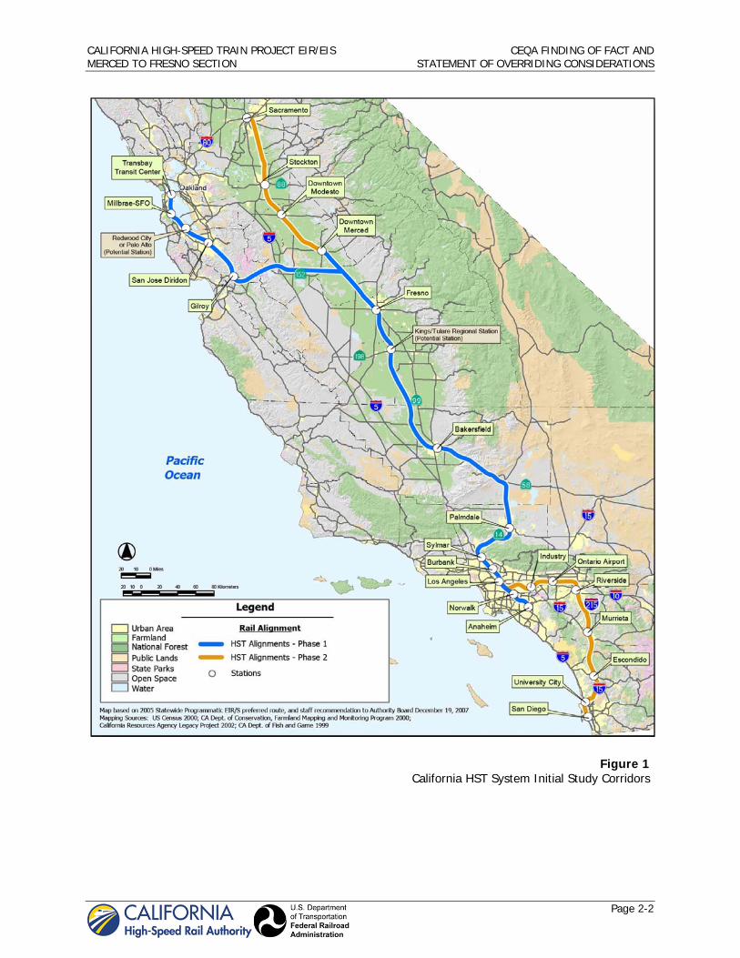
The California HST system will provide intercity, high-speed service on more than 800 miles of track throughout California, connecting the major population centers of Sacramento, the San Francisco Bay Area, the Central Valley, Los Angeles, the Inland Empire, Orange County, and San Diego. The Authority and FRA prepared two first-tier environmental impact report/environmental impact statement (EIR/EIS) documents to select preferred alignments and station locations to advance for more detailed study in second-tier EIR/EISs. Figure 1 shows the statewide HST system resulting from the first-tier EIR/EISs and first-tier decisions. The HST system will use state-of-the-art, electrically powered, high-speed, steel-wheel-on-steel-rail technology, including contemporary safety, signaling, and automated train-control systems, with trains capable of operating up to 220 miles per hour (mph) over a fully grade-separated, dedicated guideway alignment.
The Authority plans two phases: Phase 1 (built in stages dependent on funding availability) will connect San Francisco to Los Angeles/Anaheim via the Pacheco Pass and the Central Valley with a mandated express travel time of 2 hours and 40 minutes or less and Phase 2 will connect the Central Valley to the state’s capital, Sacramento, and will extend the system from Los Angeles to San Diego. The Statewide HST system as approved through first-tier decisions has been divided into nine individual sections for more detailed, second-tier analysis. The Merced to Fresno Section is one of the nine individual sections undergoing second-tier environmental review. The HST System would operate more than 200 trains per day after full buildout.
2.1.1 General Description of HST System Infrastructure in the Merced to Fresno Section
Chapter 2 of the Merced to Fresno Section Final Project EIR/EIS describes the general components of HST System infrastructure that are part of, and included in, this Merced to Fresno Section.
System Design Performance, Safety, and Security: The HST would be a fully grade-separated and access-controlled guideway with intrusion detection and monitoring systems. All aspects of the HST system will conform to federal requirements regarding transportation security and safety.
Train Vehicles: Train vehicles, although not selected as part of this project, are anticipated to be an electric multiple unit (EMU) concept with a computer-based automatic train control system.
Stations: Stations include station platforms and trackway, arrival and departure facilities, and parking. The Merced to Fresno section has two stations, one in the City of Merced and one in the City of Fresno.
Track: The HST track would travel from Merced to Fresno, mostly along existing transportation corridors, as depicted in Chapter 2. The track, or guideway, includes multiple different vertical profiles, as described in Chapter 2.
Grade Separations: The HST would be fully grade separated from all crossing traffic through roadway overcrossings or undercrossings, or through elevation of the HST.
CALIFORNIA HIGH-SPEED TRAIN PROJECT EIR/EIS CEQA FINDING OF FACT AND MERCED TO FRESNO SECTION STATEMENT OF OVERRIDING CONSIDERATIONS
Page 2-2
Figure 1 California HST System Initial Study Corridors
CALIFORNIA HIGH-SPEED TRAIN PROJECT EIR/EIS CEQA FINDING OF FACT AND MERCED TO FRESNO SECTION STATEMENT OF OVERRIDING CONSIDERATIONS
Page 2-3
Railroad Wye: The Merced to Fresno Section includes a railroad wye, which allows for a connection between the east/west alignment of the San Jose to Merced Section and the north/south alignment of the Merced to Fresno Section, as described generally in chapter 2, section 2.2.6.
Traction Power Distribution: The project includes a traction power distribution system allowing trains to draw electric power form a catenary system fed through an overhead contact system. The catenary system consists of a series of mast poles with contact wires suspended from the mast poles. The catenary system will be connected to traction power substations spaced at approximately 30-mile intervals. Switching and paralleling stations will be required at approximately 15-mile intervals, at the midpoint between the traction power substations. Signaling and train control elements include small huts within the right of way that house signal relay and microprocessor components, and related equipment.
Track Structure: HST track will be constructed with ballast and ties, with continuous welded rail, for all at-grade sections, and slab construction will be used for elevated structures exceeding 1,000 feet in length where operating speeds are planned for 220 mph. The curves in the wye section are also assumed to be on structure.
Maintenance Facilities: A maintenance of way facility will provide for equipment, materials, and replacement parts storage, and support quarters and staging areas for HST System maintenance personnel. A heavy vehicle maintenance and layover facility is also under consideration for the Merced to Fresno section, but is not proposed for final approval at this time.
Operations Control Center: An operations control center would be part of the heavy maintenance facility.
2.1.2 Description of Hybrid Alternative, Downtown Merced Station Location, and Downtown Fresno Mariposa Street Station Location
Chapter 7 of the Merced to Fresno Section Final Project EIR/EIS identifies the Hybrid Alternative as the preferred north/south alignment for the Merced to Fresno Section, as shown in Figure 2. The Hybrid Alternative follows and is adjacent to the Union Pacific Railroad alignment from Merced to approximately Buchanan Hollow Road and from north of the San Joaquin River to Fresno. The Hybrid Alternative follows and is adjacent to the Burlington Northern Santa Fe Railroad alignment from north of the San Joaquin River to approximately Madera Acres. As shown on Figure 2, the Hybrid Alternative varies north of Madera Acres at approximately Avenue 19 ½ depending on the eventual selection of the east/west connection and wye. For purposes of these findings of fact, all alternatives within the area denoted with the rectangle on Figure 2 are selected to be carried forward for further study and consideration as part of the San Jose to Merced Draft Project EIR/EIS. These alternatives carried forward include the Avenue 21, Avenue 24, and SR 152 east/west connections and wyes. A final decision on the alignment within this area is anticipated to occur at the conclusion of the San Jose to Merced EIR/EIS process.
Chapter 7 of the Merced to Fresno Section Final Project EIR/EIS also describes the downtown Merced station location, between Martin Luther King Jr. Way and G Street, and the downtown Fresno Mariposa Street station location as preferred, as shown in Figures 3 and 4.
The Authority is deferring a decision on a Heavy Maintenance Facility site at this time. The impacts of a Heavy Maintenance Facility is therefore not addressed further in these Findings.
2.1.3 Project Design Features
The Merced to Fresno HST incorporates many design features and Best Management Practices (BMPs) that are identified in the Final Project EIR/EIS and included in detail in the Technical Reports. As a result of applying these design features and BMPs, the project will avoid significant impacts in several resource areas, including EMI/EMF, hydrology and water resources, geology and soils and hazardous materials and wastes. In addition, the regulatory requirements for many activities provide additional assurance that significant impacts to the environment will not occur.
CALIFORNIA HIGH-SPEED TRAIN PROJECT EIR/EIS CEQA FINDING OF FACT AND MERCED TO FRESNO SECTION STATEMENT OF OVERRIDING CONSIDERATIONS
Page 2-4
Figure 2 Preferred Alternative – Hybrid
CALIFORNIA HIGH-SPEED TRAIN PROJECT EIR/EIS CEQA FINDING OF FACT AND MERCED TO FRESNO SECTION STATEMENT OF OVERRIDING CONSIDERATIONS
Page 2-5
Figure 4 Downtown Fresno Mariposa
Station Source: URS (2011).
Figure 3 Downtown Merced Station
CALIFORNIA HIGH-SPEED TRAIN PROJECT EIR/EIS CEQA FINDING OF FACT AND MERCED TO FRESNO SECTION STATEMENT OF OVERRIDING CONSIDERATIONS
Page 2-6
The applicable regulatory requirements and project design features that are part of the project are described for the following issue areas in more detail in the corresponding chapters of the Final Project EIR/EIS and also included in Attachment 1:
Transportation –Chapter 3.2, section 3.2.2, section 3.2.6 Air Quality and Global Climate Change – Chapter 3.3, section 3.3.2, section 3.3.8 Noise and Vibration – Chapter 3.4, section 3.4.2, section 3.4.6 Public Utilities and Energy – Chapter 3.6, section 3.6.2, section 3.6.6 Biological Resources and Wetlands – Chapter 3.7, section 3.7.2, section 3.7.6 Hydrology and Water Resources – Chapter 3.8, section 3.8.2, section 3.8.6 Geology and Soils – Chapter 3.9, section 3.9.2, section 3.9.6 Hazardous Materials and Wastes – Chapter 3.10, section 3.10.2, section 3.10.6 Safety and Security – Chapter 3.11, section 3.11.2, section 3.11.6 Socioeconomics, Communities, and Environmental Justice – chapter 3.12, section 3.12.2, section
3.12.6 Station Planning, Land Use, and Development –Chapter 3.13, section 3.13.2, section 3.13.16 Agricultural Lands – Chapter 3.14, section 3.14.2, section 3.14.6 Parks, Recreation, and Open Space, Chapter 3.15, section 3.15.2 Aesthetics and Visual Resources – Chapter 3.16, section 3.16.2, section 3.16.6 Cultural and Paleontological Resources – chapter 3.17, section 3.17.2, section 3.17.6
CALIFORNIA HIGH-SPEED TRAIN PROJECT EIR/EIS CEQA FINDING OF FACT AND MERCED TO FRESNO SECTION STATEMENT OF OVERRIDING CONSIDERATIONS
Page 3-1
3.0 FINDINGS ON SPECIFIC IMPACTS AND MITIGATION MEASURES
The environmental effects of the Hybrid Alternative and station locations for the entire Merced to Fresno HST section that would be potentially significant are described in Chapter 3 of Volume 1 of the Final Project EIR/EIS. These impacts are set forth and summarized below, along with mitigation measures the Authority adopts, that will avoid or substantially lessen those potentially significant or significant impacts. The impact and mitigation measure findings below depend upon and therefore incorporate by reference the full analysis and conclusions contained within the Final Project EIR/EIS.
Also set forth in these findings are those impacts that the Authority finds cannot with certainty be avoided or reduced to a less-than-significant level even with the adoption of all feasible mitigation measures proposed in the Final Project EIR/EIS. In adopting these findings and mitigation measures, the Authority also adopts a Statement of Overriding Considerations. The Statement of Overriding Considerations describes the economic, social, and other benefits of the Hybrid Alternative that will render these significant unavoidable environmental impacts acceptable.
The Authority is not required to make findings or adopt mitigation measures or policies as part of this decision for impacts that are less-than-significant or beneficial. The resource areas that include one or more less-than-significant impacts without mitigation, or beneficial impacts, include:
Transportation Air Quality and Global Climate Change Noise and Vibration Electromagnetic Fields and Electromagnetic Interference Public Utilities and Energy Hydrology and Water Resources Geology, Soils, and Seismicity Hazardous Materials and Wastes Safety and Security Socioeconomics, Communities, and Environmental Justice Station Planning, Land Use, and Development Agricultural Lands Cumulative Impacts
3.1 Transportation (Chapter 3.2 in the Final EIR/EIS)
As described in Section 3.2.3.2 of the Final EIR/S, the traffic analysis was performed using a dual baseline approach to ensure complete and adequate analysis in light of uncertainties created by recent CEQA case law (three prior to the Final EIR/S preparation and one – Neighbors for Smart Rail v. Exposition Metro Line Construction Authority (April 17) – since. The dual approach compares project traffic to existing traffic (Existing Plus Project), and compares project traffic to traffic likely to be present in the “background” in 2035 (based on regional growth without HST) (Future (2035) Plus Project). These are two different analytical ways of evaluating the same potential impact. Nevertheless, the Authority below makes findings for the impact results under both approaches. Because the HST project will not be operational for many years, however, mitigation based on the future plus project scenario (rather than on the existing plus project scenario) shall be implemented; mitigation at the same intersection or road segment twice, under the two analytical approaches, is not required and will not leave any impact unmitigated. In two cases (identified below), impacts could be present under the existing plus project scenario that are not present under the future plus project scenario; mitigation for these two impacts shall be implemented.
CALIFORNIA HIGH-SPEED TRAIN PROJECT EIR/EIS CEQA FINDING OF FACT AND MERCED TO FRESNO SECTION STATEMENT OF OVERRIDING CONSIDERATIONS
Page 3-2
TR IMPACT #1. Permanent Road Closures The Hybrid Alternative would result in permanently closing numerous roadways. There may be potential impacts associated with property access as a result of these closures depending on the availability of alternative access routes. Due to the potential of potential property access issues, the road closure impacts would be significant under CEQA.
TR-MM#1: Access Maintenance for Property Owners. This mitigation measure would address TR IMPACT #1 (Permanent road closures). Maintain access for owners to property within the construction area to a level that maintains pre-project viability of the property for its pre-project use. If a proposed road closure restricts current access to a property, provide alternative access via connections to existing roadways. If adjacent road access is not available, prepare new road connections, if feasible. If alternative road access is not feasible, the property will be acquired.
The potential impacts associated with property access as a result of the road closures would be addressed with implementation of TR-MM#1 through the identification of alternative access routes or developing new road connections. Impacts associated with permanent road closures will be reduced to a less than significant impact under CEQA with TR-MM #1.
TR IMPACT #2. Fresno Area between Herndon Avenue and Shaw Avenue Intersection Impacts Existing Plus Project. The Hybrid Alternative would significantly impact one intersection (Cornelia Avenue/Shaw Avenue) in the AM peak and two intersections (Intersection 5 – Blythe Avenue and Shaw Avenue and Cornelia Avenue/Shaw Avenue) in the PM peak under existing plus project conditions, by adding traffic and lowering LOS to unacceptable levels (either below LOS D or increasing V/C ratio of an LOS E or F intersection by .04 or more, as stated in the Final EIR/S), which is a significant impact under CEQA.
TR-MM#4: Add a Signal to Intersection to Improve LOS/Operation. This mitigation measure would address TR IMPACT #2 (Fresno area between Herndon Avenue and Shaw Avenue Intersection Impacts – Existing Plus Project). Add traffic signals to affected unsignalized intersections in order to improve LOS and intersection operation.
TR MM#7: Widen Approaches to Intersections. This mitigation measure would address TR IMPACT #2 (Fresno area between Herndon Avenue and Shaw Avenue Intersection Impacts – Existing Plus Project). Widen approaches in order to improve LOS and intersection operation.
TR MM#8: Add Exclusive Turn Lanes to Intersections. This mitigation measure would address TR IMPACT #2 (Fresno area between Herndon Avenue and Shaw Avenue Intersection Impacts – Existing Plus Project). Add exclusive turn lanes at specific intersections in order to improve LOS and intersection operations.
The traffic impacts associated at the identified intersections would be addressed by:
signalizing the intersection at Cornelia Avenue/Shaw Avenue and widening the approach to provide a second left-turn lane at Blythe/Avenue/Shaw Avenue (per Final EIR/S Table 3.2-52)
Implementation of TR-MM#4, TR-MM#7, and TR-MM#8 would address traffic impacts associated at the identified intersections and therefore would reduce the impacts to a level less than significant under CEQA. Future (2035) Plus Project The Hybrid Alternative would significantly impact seven intersections (Golden State Boulevard/Santa Ana Avenue, Cornelia Avenue and Shaw Avenue, Blythe Avenue/Shaw Avenue, Cornelia Avenue/Golden State Boulevard, Figarden Drive/Bullard Avenue, Veterans Boulevard/Bullard Avenue, and Veterans
CALIFORNIA HIGH-SPEED TRAIN PROJECT EIR/EIS CEQA FINDING OF FACT AND MERCED TO FRESNO SECTION STATEMENT OF OVERRIDING CONSIDERATIONS
Page 3-3
Boulevard/Golden State Boulevard) in the AM and/or PM peak hours under future (2035) plus project conditions, by adding traffic and lowering LOS to unacceptable levels (either below LOS D or increasing V/C ratio of an LOS E or F intersection by .04 or more, as stated in the Final EIR/S), which is a significant impact under CEQA.
TR MM#3: Modify Signal Phasing. This mitigation measure would address TR IMPACT #2 (Fresno area between Herndon Avenue and Shaw Avenue Intersection Impacts – Future (2035) Plus Project). Modify traffic signal phasing sequence to improve operations at a signalized intersection.
TR-MM#4: Add a Signal to Intersection to Improve LOS/Operation. This mitigation measure would address TR IMPACT #2 (Fresno area between Herndon Avenue and Shaw Avenue Intersection Impacts – Future (2035) Plus Project). This mitigation is only necessary when signal warrants are met, and such warrants for certain of the intersections requiring this mitigation are met after 2020, as described in the Final EIR/EIS. Such intersections shall be monitored on an annual basis and signal installed when warrants are met.
TR MM#5: Restripe Intersections. This mitigation measure would address TR IMPACT #2 (Fresno area between Herndon Avenue and Shaw Avenue Intersection Impacts – Future (2035) Plus Project). Restripe specific intersections surrounding proposed HST station locations in order to improve LOS and intersection operations.
TR MM#6: Modify Signal Timing. This mitigation measure would address TR IMPACT #2 (Fresno area between Herndon Avenue and Shaw Avenue Intersection Impacts – Future (2035) Plus Project). Modify signal timing (to optimize cycle length and/or splits) at specific intersections surrounding proposed HST station locations in order to improve LOS and intersection operations.
TR MM#7: Widen Approaches to Intersections. This mitigation measure would address TR IMPACT #2 (Fresno area between Herndon Avenue and Shaw Avenue Intersection Impacts – Future (2035) Plus Project). Details regarding TR-MM#7 are described above.
TR MM#8: Add Exclusive Turn Lanes to Intersections. This mitigation measure would address TR IMPACT #2 (Fresno area between Herndon Avenue and Shaw Avenue Intersection Impacts – Future (2035) Plus Project). Details regarding TR-MM#8 are described above.
TR MM#9: Convert Two-Way Stop to Four-Way Stop. This mitigation measure would address TR IMPACT #2 (Fresno area between Herndon Avenue and Shaw Avenue Intersection Impacts – Future (2035) Plus Project). Convert two-way stop controlled intersection to an all-way stop controlled intersection.
TR MM#10: Grade Separate Through Movements. This mitigation measure would address TR IMPACT #2 (Fresno area between Herndon Avenue and Shaw Avenue Intersection Impacts – Future (2035) Plus Project). Modify the intersection to provide an overpass for through movements to improve LOS and intersection operations.
The traffic impacts associated at the identified intersections would be addressed by (per Final EIR/S Table 3.2-53):
signalizing the intersection, widening the northbound approach to provide dual left-turn lanes and one through lane, and widening downstream of Santa Ana Avenue from one receiving lane to two receiving lanes to accommodate the dual left-turn lanes from northbound approach on Golden State Boulevard for the Golden State Boulevard/Santa Ana Avenue intersection
signalizing the intersection, restriping eastbound approach to provide one left-turn lane, two through lanes, and one right-turn lane, widening westbound approach to provide two left-turn lanes, two through lanes and one right-turn lane, widening northbound approach to provide one left-turn lane, one through lane, and one channelized right-turn, widening southbound approach to provide one left-turn lane, one through lane, and one right-turn lane, and widening downstream on Cornelia Avenue
CALIFORNIA HIGH-SPEED TRAIN PROJECT EIR/EIS CEQA FINDING OF FACT AND MERCED TO FRESNO SECTION STATEMENT OF OVERRIDING CONSIDERATIONS
Page 3-4
form one receiving lane to two receiving lanes to accommodate the second left-tune lane from westbound approach on Shaw Avenue for the Cornelia Avenue/Shaw Avenue intersection
widening eastbound approach to provide a second left-turn lane at Blythe Avenue/Shaw Avenue
signalizing the intersection at Cornelia Avenue/Golden State Boulevard
restriping westbound approach to provide two left-turn lanes, one through lane and one right-turn lane for the Figarden Drive/Bullard Avenue intersection
grade separating through movement on Veterans Boulevard, restriping eastbound approach to provide one left-turn lane and two right-turn lanes, restriping northbound approach to provide three left-turn lanes and one through lane, and modifying the signal timing at the Veterans Boulevard/Bullard Avenue intersection
restriping eastbound approach to provide one left-turn lane and four through lanes, widening westbound approach to provide additional left-turn lane and a through lane, and modify northbound and southbound right-turn as free movements at the Veterans Boulevard/Golden State Boulevard connector.
Implementation of TR-MM#3, TR-MM#4, TR-MM#5, TR-MM#6, TR-MM#7, TR-MM#8, TR-MM#9, and TR-MM#10 will address traffic impacts associated at the identified intersections and therefore will reduce the impacts to a level less than significant under CEQA.
TR IMPACT #3. Fresno Area between Herndon Avenue and Shaw Avenue Roadway Impacts – Future (2035) Plus Project The Hybrid Alternative would impact one roadway segment (Veterans Boulevard between Golden State Boulevard and Bullard Avenue) with the addition of the HST project traffic. The volume to capacity (V/C) ratio on this roadway segment, operating at worse than LOS D without the project, increases with project traffic by more than 0.04 compared to the future (2035) No Project Conditions.
An impact is considered a significant impact under CEQA for roadway segments (operating at lower than LOS D) that result in an increase in the V/C ratio of 0.04 or more with project-related traffic. Because traffic at this roadway segment would experience an unacceptable increase in traffic, the impact would be significant under CEQA.
TR MM#11: Add Lanes to the Segment. This mitigation measure would address TR IMPACT #3 (Fresno area between Herndon Avenue and Shaw Avenue Roadway Impacts – Future (2035) Plus Project). Add travel lanes to the roadway segment in order to increase capacity and improve roadway operations.
The traffic impacts associated at the identified roadway segment would be addressed by (per Final EIR/S Table 3.2-53):
adding one lane in each direction along Veterans Boulevard between Golden State Boulevard and Bullard Avenue
Implementation of TR-MM#11 will address traffic impacts associated at the identified roadway segment and therefore will reduced the impacts to a level less than significant under CEQA.
TR IMPACT #4. Fresno Area between McKinley Avenue and SR 180 Roadway Impacts – Future (2035) Plus Project The Hybrid Alternative would impact two roadway segments (West Olive Avenue between SR 99 ramps and North West Avenue and West Belmont Avenue between Arthur Avenue and SR 99 ramps) with the addition of the HST project traffic. The volume to capacity (V/C) ratio on this roadway segment along
CALIFORNIA HIGH-SPEED TRAIN PROJECT EIR/EIS CEQA FINDING OF FACT AND MERCED TO FRESNO SECTION STATEMENT OF OVERRIDING CONSIDERATIONS
Page 3-5
West Belmont Avenue increases by more than 0.04 compared to the future (2035) No Project Conditions. This segment along West Olive Avenue drops from LOS D to LOS E.
An impact is considered a significant impact under CEQA for roadway segments that result in an increase in the V/C ratio of 0.04 or more with project-related traffic and if the addition of project-related traffic results in a reduction in LOS below LOS D. Because traffic at these roadway segments would experience an unacceptable increase in traffic, the impact would be significant under CEQA.
TR MM#11: Add Lanes to the Segment. This mitigation measure would address TR IMPACT #4 (Fresno area between McKinley Avenue and SR 180 Roadway Impacts – Future (2035) Plus Project). Details regarding TR-MM#11 are described above.
The traffic impacts associated at the identified roadway segments would be addressed by (per FEIR/S Table 3.2-55):
adding one lane in each direction along West Olive Avenue between SR 99 ramps and North West Avenue
adding one lane in each direction along West Belmont Avenue between North Arthur Avenue and SR 99 ramps
Implementation of TR-MM#11 will address traffic impacts associated at the identified roadway segments and therefore will reduced the impacts to a level less than significant under CEQA.
TR IMPACT #5. Fresno Area between McKinley Avenue and SR 180 Intersection Impacts Existing Plus Project. The Hybrid Alternative would impact three intersections (West Olive Avenue/SR 99 southbound ramps, West Belmont Avenue/SR 99 southbound ramps, and West Belmont Avenue/SR 99 northbound ramps) in the PM peak under existing plus project conditions.
An impact is considered a significant impact under CEQA if the addition of project-related traffic results in a reduction in LOS below LOS D. Because traffic at these intersections would experience an unacceptable increase in traffic, the impact would be significant under CEQA. TR-MM#4: Add a Signal to Intersection to Improve LOS/Operation. This mitigation measure would address TR IMPACT #5 (Fresno area between McKinley Avenue and SR 180 Intersection Impacts – Existing Plus Project). Details regarding TR-MM#4 are described above. The traffic impacts associated at the identified intersections would be addressed by (per Final EIR/S Table 3.2-54):
signalizing the intersection at West Olive Avenue/SR 99 southbound ramps
signalizing the intersection and provide a protected phasing for westbound left-turn movement at West Belmont Avenue/SR 99 southbound ramps
signalizing the intersection at West Belmont Avenue/SR 99 northbound ramps
Implementation of TR-MM#4 would address traffic impacts associated at the identified intersections and therefore would reduce the impacts to a level less than significant under CEQA. Future (2035) Plus Project The Hybrid Alternative would impact five intersections (West Olive Avenue/SR 99 southbound ramps, West Olive Avenue/SR 99 northbound ramps, West Olive Avenue/North West Avenue, West Belmont
CALIFORNIA HIGH-SPEED TRAIN PROJECT EIR/EIS CEQA FINDING OF FACT AND MERCED TO FRESNO SECTION STATEMENT OF OVERRIDING CONSIDERATIONS
Page 3-6
Avenue/SR 99 southbound ramps, and West Belmont Avenue/SR 99 northbound ramps) in the AM and/or PM peak hours under future (2035) plus project conditions. An impact is considered a significant impact under CEQA if the addition of project-related traffic results in a reduction in LOS below LOS D. Because traffic at these intersections would experience an unacceptable increase in traffic, the impact would be significant under CEQA. TR-MM#4: Add a Signal to Intersection to Improve LOS/Operation. This mitigation measure would address TR IMPACT #5 (Fresno area between McKinley Avenue and SR 180 Intersection Impacts – Future (2035) Plus Project). Details regarding TR-MM#4 are described above. TR MM#7: Widen Approaches to Intersections. This mitigation measure would address TR IMPACT #5 (Fresno area between McKinley Avenue and SR 180 Intersection Impacts – Future (2035) Plus Project). Details regarding TR-MM#7 are described above. TR MM#8: Add Exclusive Turn Lanes to Intersections. This mitigation measure would address TR IMPACT #5 (Fresno area between McKinley Avenue and SR 180 Intersection Impacts – Future (2035) Plus Project). Details regarding TR-MM#8 are described above. The traffic impacts associated at the identified intersections would be addressed by (per Final EIR/S Table 3.2-55):
widening the southbound approach to provide additional left-turn lane at West Olive Avenue/SR 99 southbound ramps
widening the northbound approach to provide exclusive left-turn lane at West Olive Avenue/SR 99 northbound ramps
signalizing the intersection at West Olive Avenue/North West Avenue
signalizing the intersection at West Belmont Avenue/ SR 99 southbound ramps
signalizing the intersection at West Belmont Avenue/ SR 99 northbound ramps
Implementation of TR-MM#4, TR-MM#7, and TR-MM#8 will address traffic impacts associated at the identified intersections and therefore will reduced the impacts to a level less than significant under CEQA. TR IMPACT #6. SR 99 Relocation Freeway Impacts – Future (2035) Plus Project The Hybrid Alternative would require the realignment of SR 99 in Fresno. For future (2035) plus project conditions, freeway operations results for northbound SR 99 are as follows:
Up to Ashlan Avenue, operations under future (2035) plus project conditions are the same or better than under future (2035) No Project conditions.
North of Ashlan Avenue, operations under future (2035) plus project and future (2035) No Project conditions are the same because the mainline improvements end south of Ashlan Avenue.
For future (2035) plus project conditions, freeway operations results for southbound SR 99 are as follows:
North of Ashlan Avenue, operations under future (2035) plus project and future (2035) No Project conditions are the same because the mainline improvements end south of Ashlan Avenue.
Operations from Ashlan Avenue to Clinton Avenue improve under future (2035) plus project conditions because of adding the auxiliary lane and eliminating several southbound ramps. Overall,
CALIFORNIA HIGH-SPEED TRAIN PROJECT EIR/EIS CEQA FINDING OF FACT AND MERCED TO FRESNO SECTION STATEMENT OF OVERRIDING CONSIDERATIONS
Page 3-7
the peak period LOS improves from LOS E under future (2035) No Project conditions to LOS C under future (2035) plus project conditions.
An impact is considered a significant impact under CEQA if the addition of project-related traffic results in a reduction in LOS below LOS D. Because traffic at these segments along SR 99 would experience an unacceptable increase in traffic, the impact would be significant under CEQA. TR MM#2: Add Southbound Auxiliary Lane to SR 99. This mitigation measure would address TR IMPACT #6 (SR 99 Relocation Freeway Impacts – Future (2035) Plus Project). Add southbound auxiliary lane south of the Clinton Avenue on-ramp to Olive Avenue. Implementation of TR-MM#2 will address traffic impacts associated at the identified segments along SR 99 and therefore will reduce the impacts to a level less than significant under CEQA. TR IMPACT #7. SR 99 Relocation Intersection Impacts Existing Plus Project The Hybrid Alternative would impact two intersections (Clinton Avenue/Weber Avenue and Dakota Avenue/Brawley Avenue) in the PM peak under existing plus project conditions. An impact is considered a significant impact under CEQA if the addition of project-related traffic results in a reduction in LOS below LOS D. Because traffic at these intersections would experience an unacceptable increase in traffic, the impact would be significant under CEQA. TR-MM#4: Add a Signal to Intersection to Improve LOS/Operation. This mitigation measure would address TR IMPACT #7 (SR 99 Relocation Intersection Impacts – Existing Plus Project). Details regarding TR-MM#4 are described above. TR MM#5: Restripe Intersections. This mitigation measure would address TR IMPACT #7 (SR 99 Relocation Intersection Impacts – Existing Plus Project). Details regarding TR-MM#5 are described above. TR MM#7: Widen Approaches to Intersections. This mitigation measure would address TR IMPACT #7 (SR 99 Relocation Intersection Impacts – Existing Plus Project). Details regarding TR-MM#7 are described above. TR MM#8: Add Exclusive Turn Lanes to Intersections. This mitigation measure would address TR IMPACT #7 (SR 99 Relocation Intersection Impacts – Existing Plus Project). Details regarding TR-MM#8 are described above. The traffic impacts associated at the identified intersections associated with the SR 99 realignment would be addressed by (per Final EIR/S Table 3.2-56):
widening southbound approach to provide second left-turn lane and widening northbound approach to provide second left-turn lane for the Clinton Avenue/Weber Avenue intersection
signalizing the intersection, restriping northbound approach to include exclusive left-turn lane and shared through-right-turn lane, and widening southbound approach to include exclusive left-turn, through, and exclusive right-turn lanes for the Dakota Avenue/Brawley Avenue intersection
Implementation of TR-MM#4, TR-MM#5, TR-MM#7, and TR-MM#8 would address traffic impacts associated at the identified intersections and therefore would reduce the impacts to a level less than significant under CEQA.
CALIFORNIA HIGH-SPEED TRAIN PROJECT EIR/EIS CEQA FINDING OF FACT AND MERCED TO FRESNO SECTION STATEMENT OF OVERRIDING CONSIDERATIONS
Page 3-8
Future (2035) Plus Project The Hybrid Alternative would impact seven intersections (Clinton Avenue/Brawley Avenue, Clinton Avenue/Marks Avenue, Clinton Avenue/SR 99 southbound ramps, Clinton Avenue/SR 99 northbound ramps, Clinton Avenue/Weber Avenue, Shields Avenue/Brawley Avenue, Dakota Avenue/Brawley Avenue, and Ashlan Avenue – SR 99 southbound ramps/Parkway Drive) in the AM and/or PM peak hours under future (2035) plus project conditions. An impact is considered a significant impact under CEQA if the addition of project-related traffic results in a reduction in LOS below LOS D. Because traffic at these intersections would experience an unacceptable increase in traffic, the impact would be significant under CEQA. TR-MM#4: Add a Signal to Intersection to Improve LOS/Operation. This mitigation measure would address TR IMPACT #7 (SR 99 Relocation Intersection Impacts – Future (2035) Plus Project). Details regarding TR-MM#4 are described above. TR MM#5: Restripe Intersections. This mitigation measure would address TR IMPACT #7 (SR 99 Relocation Intersection Impacts – Future (2035) Plus Project). Details regarding TR-MM#5 are described above. TR MM#7: Widen Approaches to Intersections. This mitigation measure would address TR IMPACT #7 (SR 99 Relocation Intersection Impacts – Future (2035) Plus Project). Details regarding TR-MM#7 are described above. TR MM#8: Add Exclusive Turn Lanes to Intersections. This mitigation measure would address TR IMPACT #7 (SR 99 Relocation Intersection Impacts – Future (2035) Plus Project). Details regarding TR-MM#8 are described above. The traffic impacts associated at the identified intersections would be addressed by (per Final EIR/S Table 3.2-57):
widening southbound approach to provide second left-turn lane at the Clinton Avenue/Brawley Avenue intersection
widening northbound approach to provide exclusive northbound right-turn lane and restriping southbound approach to include two left-turn lanes and one shared through-right-turn lane at the Clinton Avenue/Marks Avenue intersection
widening eastbound approach to provide exclusive eastbound right-turn lane at the Clinton Avenue/SR 99 southbound ramps intersection
widening southbound approach to provide second left-turn lane and widening eastbound approach to provide second left-turn lane at the Clinton Avenue/Weber Avenue intersection
signalizing the intersection at Shields Avenue/Brawley Avenue
Signalizing the intersection, restriping northbound approach to include exclusive left-turn lane and shared through-right-turn lane, restriping westbound approach to include exclusive left-turn lane and shared through-right-turn lane, widening southbound approach to include exclusive left-turn, through, and exclusive right-turn lanes, and widening eastbound approach to include exclusive left-turn and shared through-right-turn lane at the Dakota Avenue/Brawley Avenue intersection
Adding second northbound right-turn lane at Ashland Avenue – SR 99 southbound ramps/Parkway Drive
CALIFORNIA HIGH-SPEED TRAIN PROJECT EIR/EIS CEQA FINDING OF FACT AND MERCED TO FRESNO SECTION STATEMENT OF OVERRIDING CONSIDERATIONS
Page 3-9
Implementation of TR-MM#4, TR-MM#5, TR-MM#7, and TR-MM#8 will address traffic impacts associated at the identified intersections and therefore will reduce the impacts to a level less than significant under CEQA. TR IMPACT #8. HST Station Area Roadway Impacts Existing Plus Project The Merced Station would impact one roadway segment under Option A (V Street west of 13th Street) and two roadway segments under Option B (V Street west of 13th Street and M Street between 13th Street and 16th Street) would be impacted with the addition of the HST project traffic. The volume to capacity (V/C) ratio on these roadway segments would increase by more than 0.04 with project-added traffic. An impact is considered a significant impact under CEQA for roadway segments that result in an increase in the V/C ratio of 0.04 or more with project-related traffic. Because traffic at these roadway segments would experience an unacceptable increase in traffic, the impact would be significant under CEQA. TR MM#11: Add Lanes to the Segment. This mitigation measure would address TR IMPACT #8 (HST Station Area Roadway Impacts – Existing Plus Project). Details regarding TR-MM#11 are described above. The traffic impacts associated at the identified roadway segments would be addressed by (per Final EIR/S Table 3.2-58):
adding one travel lane in each direction along M Street between 13th Street and 16th Street adding one travel lane in each direction along V Street west of 13th Street (Option A only)
Implementation of TR-MM#11 would address traffic impacts associated at the identified roadway segments and therefore would reduce the impacts to a level less than significant under CEQA.
Future (2035) Plus Project The Merced Station would impact five roadway segments under Option A (Main Street between Yosemite Parkway and G Street, 16th Street between R Street and Martin Luther King Jr. Way , M Street between 13th Street and 16 Street, Martin Luther King Jr. Way between Childs Avenue and 13th Street, and G Street between 13th Street and 16th Street) and eight roadway segments under Option B (Main Street between Yosemite Parkway and G Street, 16th Street between R Street and M Street, 16th Street between Martin Luther King Jr. Way and M Street, V Street west of 13th Street, V Street between 13th Street and 16th Street, M Street between 13th Street and 16th Street, Martin Luther King Jr. Way between Childs Avenue and 13 Street, and G Street between 13th Street and 16th Street) with the addition of the HST project traffic. The volume to capacity (V/C) ratio on these roadway segments would increase by more than 0.04 with project-added traffic or have a further reduction in LOS below D. The Fresno Station would impact seven roadway segments under the Tulare Street Underpass Option (H Street between East Divisadero Street and Stanislaus Street, Stanislaus Street between Broadway Street and E Street, Fresno Street between G Street and SR 99 northbound ramps, Tulare Street between Broadway Street and Van Ness Avenue, Divisadero Street between North Fresno Street and SR 41 ramps, Stanislaus Street between Broadway Street and Fulton Street, and Stanislaus Street between L Street and M Street) and ten roadway segments under the Tulare Street Overpass Option (H Street between East Divisadero Street and Stanislaus Street, Stanislaus Street between Broadway Street and E Street, Fresno Street between Van Ness Avenue and Broadway Street, Fresno Street between G Street and SR 99 northbound ramps, Divsadero Street between North Fresno Street and SR 41 ramps, Van Ness Avenue
CALIFORNIA HIGH-SPEED TRAIN PROJECT EIR/EIS CEQA FINDING OF FACT AND MERCED TO FRESNO SECTION STATEMENT OF OVERRIDING CONSIDERATIONS
Page 3-10
between Ventura Avenue and SR 41 ramps, Stanislaus Street between E Street and F Street, F Street between Stanislaus Street and Tuolumne Street, Stanislaus Street between G St and H St, and Stanislaus Street between Broadway Street and Fulton Street) with the addition of the HST project traffic. The volume to capacity (V/C) ratio on these roadway segments would increase by more than 0.04 with project-added traffic or have a further reduction in LOS below D. An impact is considered a significant impact under CEQA for roadway segments that result in an increase in the V/C ratio of 0.04 or more with project-related traffic. An impact is also considered a significant impact under CEQA if the addition of project-related traffic results in a reduction in LOS below LOS D. Because traffic at these roadway segments would experience an unacceptable increase in traffic, the impact would be significant under CEQA. TR MM#11: Add Lanes to the Segment. This mitigation measure would address TR IMPACT#8 (HST Station Area Roadway Impacts – Future (2035) Plus Project). Details regarding TR-MM#11 are described above. The traffic impacts associated with the Merced Station at the identified roadway segments would be addressed by (per Table 3.2-59): adding one travel lane in each direction on Main Street between Yosemite Parkway and G Street
adding one travel lane in each direction on 16th Street between R Street and Martin Luther King Jr. Way
adding one travel lane in each direction on V Street west of 13th Street to 16th Street (Option B only)
adding one travel lane in each direction on M Street between 13st Street and 16th Street
adding one travel lane in each direction on Martin Luther King Jr. Way between Childs Avenue and 13th Street
adding one travel lane in each direction on S Street between 13th Street and 16th Street
The traffic impacts associated with the Fresno Station at the identified roadway segments would be addressed by (per Final EIR/S Table 3.2-60):
add one travel lane in each direction on H Street between East Divisadero Street and Stanislaus Street
adding one travel lane in each direction on Stanislaus Street between Broadway Street and E Street
adding one travel lane in each direction on Fresno Street between Van Ness Avenue and Broadway Street (Tulare Street Underpass Option only)
adding one travel lane in each direction on Fresno Street between G Street and SR 99 northbound ramps
adding one travel lane in each direction on Tulare Street between Broadway Street and Van Ness Avenue (Tulare Street Underpass Option only)
adding one travel lane in each direction on Divsadero Street between North Fresno Street and SR 41 ramps
adding one travel lane in each direction on Van Ness Avenue between Ventura Avenue and SR 41 ramps (Tulare Street Overpass Option only)
adding one travel lane in each direction on Stanislaus Street between E Street and F Street (Tulare Street Overpass Option only)
CALIFORNIA HIGH-SPEED TRAIN PROJECT EIR/EIS CEQA FINDING OF FACT AND MERCED TO FRESNO SECTION STATEMENT OF OVERRIDING CONSIDERATIONS
Page 3-11
adding one travel lane in each direction on F Street between Stanislaus Street and Tuolomne Street (Tulare Street Overpass Option only)
adding one travel lane in each direction on Stanislaus Street between G Street and H Street (Tulare Street Overpass Option only)
adding one travel lane in each direction on Stanislaus Street between Broadway Street and Fulton Street
adding one travel lane in each direction on Stanislaus Street between L Street and M Street (Tulare Street Underpass Option only)
Implementation of TR-MM#11 will address traffic impacts associated at the identified roadway segments and therefore will reduced the impacts to a level less than significant under CEQA. TR IMPACT #9. HST Station Area Intersection Impacts Existing Plus Project The Merced Station would impact seven intersections under Option A (16th Street/SR 59, 15th Street/M Street, 14th Street/Martin Luther King Jr. Way, 13th Street/G Street, SR 99 northbound off-ramp/Yosemite Parkway, 16th Street/Canal Street, and Main Street/H Street) and six intersections under Option B (16th Street/SR 59, 14th Street/Martin Luther King Jr. Way, 13th Street/G Street, SR 99 northbound off-ramp/Yosemite Parkway, 16th Street/Canal Street, and Main Street/H Street) with the addition of the HST project traffic resulting in a reduction in LOS below LOS D. The impact at 16th Street/Canal Street is not present under the Future (2035) Plus Project scenario. The Fresno Station would impact seven intersections under the Tulare Street Underpass Option (SR 99 northbound ramps/Ventura Avenue, Divisadero Street/SR 41 northbound ramps/Tulare Street, H Street/Divisadero Street, North Blackstone Avenue/SR 180 westbound ramps, H Street/Ventura Street, Stanislaus Street/F Street, and Stanislaus Street/N Street) and six intersections under the Tulare Street Overpass Option (SR 99 northbound ramps/Ventura Avenue, Divisadero Street/SR 41 ramps/Tulare Street, H Street/Divisadero Street, North Blackstone Avenue/SR 180 westbound ramps, Stanislaus Street/F Street, and Stanislaus Street/N Street) with the addition of the HST project traffic resulting in a reduction in LOS below LOS D. The impact at Divisadero Street/SR 41 northbound ramps/Tulare Street is not present under the Future (2035) Plus Project scenario.
An impact is considered a significant impact under CEQA if the addition of project-related traffic results in a reduction in LOS below LOS D. Because traffic at these intersections would experience an unacceptable increase in traffic, the impact would be significant under CEQA. TR-MM#4: Add a Signal to Intersection to Improve LOS/Operation. This mitigation measure would address TR IMPACT #9 (HST Station Area Intersection Impacts – Existing Plus Project). Details regarding TR-MM#4 are described above. TR MM#5: Restripe Intersections. This mitigation measure would address TR IMPACT #9 (HST Station Area Intersection Impacts – Existing Plus Project). Details regarding TR-MM#5 are described above. TR MM#6: Modify Signal Timing. This mitigation measure would address TR IMPACT #9 (HST Station Area Intersection Impacts – Existing Plus Project). Details regarding TR-MM#6 are described above. TR MM#7: Widen Approaches to Intersections. This mitigation measure would address TR IMPACT #9 (HST Station Area Intersection Impacts – Existing Plus Project). Details regarding TR-MM#7 are described above.
CALIFORNIA HIGH-SPEED TRAIN PROJECT EIR/EIS CEQA FINDING OF FACT AND MERCED TO FRESNO SECTION STATEMENT OF OVERRIDING CONSIDERATIONS
Page 3-12
TR MM#8: Add Exclusive Turn Lanes to Intersections. This mitigation measure would address TR IMPACT #9 (HST Station Area Intersection Impacts – Existing Plus Project). Details regarding TR-MM#8 are described above. The traffic impacts associated with the Merced Station at the identified intersections would be addressed by (per Final EIR/S Table 3.2-58):
signalizing the intersection at 16th/SR 59
widening eastbound and westbound approaches to provide one left-through lane and one right-through lane at the 15th Street/M Street intersection (Option A only)
widening southbound approach to provide left-turn lane at the 14th Street/Martin Luther King Jr. Way intersection
signalizing the intersection at 13th Street/G Street
signalizing the intersection at SR 99 northbound off-ramps/SR 140
restriping eastbound approach from one shared-through left lane and one exclusive right-turn lane to one exclusive left-turn lane and a shared through-right-lane at 16th Street/Canal Street
converting two-way stop controlled intersection to an all-way stop controlled intersection at Main Street/H Street
The traffic impacts associated with the Fresno Station at the identified intersections would be addressed by (per Final EIR/S Table 3.2-60):
restriping the northbound approach to provide one exclusive left-turn lane and one shared through/right-turn lane at the intersection of SR 99 northbound ramps/Ventura Avenue
retiming the existing signal at Divisadero Street/SR 41 northbound ramps/Tulare Street
retiming the existing signal in the AM at H Street/Divisadero Street
retiming the existing signal in the AM at north Blackstone Avenue/SR 180 westbound ramps
signalizing the intersection at H Street/Ventura Street (Tulare Street Underpass Option only)
signalizing the intersection at Stanislaus Street/F Street
signalizing the intersection at Stanislaus Street/N Street
Implementation of TR-MM#3, TR-MM#4, TR-MM#5, TR-MM#6, TR-MM#7, and TR-MM#8 would address traffic impacts associated at the identified intersections and therefore would reduce the impacts to a level less than significant under CEQA. The impact at 16th Street/Canal Street (Merced area) is not present under the Future (2035) Plus Project scenario, and TR MM#5 is therefore required (per Table 3.2-58) and will mitigate this impact to less than significant. The impact at Divisadero Street/SR 41 northbound ramps/Tulare Street (Fresno area) is not present under the Future (2035) Plus Project scenario, and TR MM#6 is therefore required (per Table 3.2-60) and will mitigate this impact to less than significant.
Future (2035) Plus Project The Merced Station would impact 20 intersections under Option A (16th Street/SR 59, 13th Street – SR 99 southbound off-ramp/V Street, 16th Street/V Street, 15th Street/M Street, Childs Avenue/Martin Luther King Jr. Way, SR 99 southbound ramps/Martin Luther King Jr. Way, SR 99 northbound ramps/ Martin Luther King Jr. Way, 14th Street/Martin Luther King Jr. Way, 16th Street/Martin Luther King Jr. Way, 13th Street/G Street, SR 99 – 14th Street/G Street, SR 99 northbound off-ramp/Yosemite Parkway, Motel
CALIFORNIA HIGH-SPEED TRAIN PROJECT EIR/EIS CEQA FINDING OF FACT AND MERCED TO FRESNO SECTION STATEMENT OF OVERRIDING CONSIDERATIONS
Page 3-13
Drive/Glen Avenue/Yosemite Parkway, 14th Street/O Street, 13th Street/M Street, 14th Street/M Street, 15th Street/Canal Street, 11th Street/Martin Luther King Jr. Way, Main Street/H Street, and Main Street/G Street) and 19 intersections under Option B (16th Street/SR 59, 13th Street – SR 99 southbound off-ramp/V Street, 16th Street/V Street, 15th Street/M Street, Childs Avenue/Martin Luther King Jr. Way, SR 99 southbound ramps/Martin Luther King Jr. Way, SR 99 northbound ramps/Martin Luther King Jr. Way, 14th Street/Martin Luther King Jr. Way, 16th Street/Martin Luther King Jr. Way, 13th Street/G Street, SR 99 – 14th Street/G Street, SR 99 northbound off-ramp/Yosemite Parkway, Motel Drive/Glen Avenue/Yosemite Parkway, 13st Street/M Street, 14th Street/M Street, 15th Street/Canal Street, 11th Street/Martin Luther King Jr. Way, Main Street/H Street, and Main Street/G Street) with the addition of the HST project traffic resulting in a reduction in LOS below LOS D. The Fresno Station would impact 38 intersections under the Tulare Street Underpass Option (Van Ness Avenue/SR 41 northbound ramp, SR 99 northbound ramps/Ventura Avenue, E Street/Ventura Avenue, Broadway Street/Ventura Avenue, Van Ness Avenue/Ventura Avenue, H Street/Kern Street, F Street/Tulare Street, H Street/Tulare Street, Van Ness Avenue/Tulare Street, U Street/Tulare Street, SR 99 southbound ramps/Fresno Street, SR 99 northbound ramps/Fresno Street, Van Ness Avenue/Fresno Street, Fresno Street/Divisadero Street, Van Ness Avenue/Tuolumne Street, Van Ness Avenue/Stanislaus Street, H Street/San Joaquin Street, H Street/Amador Street, H Street/Divisadero Street, Van Ness Avenue/Divisadero Street, H Street/Roosevelt Street, North Blackstone Avenue/East McKenzie Avenue, Van Ness Avenue/SR 180 eastbound ramps, Van Ness Avenue/SR 180 westbound ramps, North Blackstone Avenue/East Belmont Avenue, North Abby Street/SR 180 eastbound ramps, North Blackstone Avenue/SR 180 westbound ramps, Broadway Street/Amador Street, F Street/Fresno Street, G Street/Mono Street, H Street/Ventura Street, South Van Ness Avenue/East California Avenue, Golden State Boulevard/East Church Avenue, South East Avenue/Golden State Boulevard, Golden State Boulevard/East Jensen Avenue, Stanislaus Street/L Street, Stanislaus Street/M Street, and Stanislaus Street/N Street) and 36 intersections under the Tulare Street Overpass Option (Van Ness Avenue/SR 41 northbound ramp, SR 99 northbound ramps/Ventura Avenue, E Street/Ventura Avenue, Broadway Street/Ventura Avenue, Van Ness Avenue/Ventura Avenue, E Street/Tulare Street, U Street/Tulare Street, SR 99 southbound ramps/Fresno Street, SR 99 northbound ramps/Fresno Street, Van Ness Avenue/Fresno Street, Fresno Street/Divisadero Street, Van Ness Avenue/Tuolumne Street, E Street/Stanislaus Street, Broadway Street/Stanislaus Street, H Street/San Joaquin Street, H Street/Amador Street, H Street/Divisadero Street, Van Ness Avenue/Divisadero Street, H Street/Roosevelt Street, North Blackstone Avenue/East McKenzie Avenue, Van Ness Avenue/SR 180 eastbound ramps, Van Ness Avenue/SR 180 westbound ramps, North Blackstone Avenue/East Belmont Avenue, North Abby Street/SR 180 eastbound ramps, North Blackstone Avenue/SR 180 westbound ramps, Broadway Street/Amador Street, F Street/Fresno Street, South Van Ness Avenue/East California Street, Golden State Boulevard/East Church Avenue, South East Avenue/Golden State Boulevard, Golden State Boulevard/East Jensen Avenue, Stanislaus Street/F Street, Tuolumne Street/F Street, Stanislaus Street/L Street, Stanislaus Street/M Street, and Stanislaus Street/N Street) with the addition of the HST project traffic resulting in a reduction in LOS below LOS D. An impact is considered a significant impact under CEQA if the addition of project-related traffic results in a reduction in LOS below LOS D. Because traffic at these intersections would experience an unacceptable increase in traffic, the impact would be significant under CEQA. TR MM#3: Modify Signal Phasing. This mitigation measure would address TR IMPACT #9 (HST Station Area Intersection Impacts – Future (2035) Plus Project). Details regarding TR-MM#3 are described above. TR-MM#4: Add a Signal to Intersection to Improve LOS/Operation. This mitigation measure would address TR IMPACT #9 (HST Station Area Intersection Impacts – Future (2035) Plus Project). Details regarding TR-MM#4 are described above.
CALIFORNIA HIGH-SPEED TRAIN PROJECT EIR/EIS CEQA FINDING OF FACT AND MERCED TO FRESNO SECTION STATEMENT OF OVERRIDING CONSIDERATIONS
Page 3-14
TR MM#5: Restripe Intersections. This mitigation measure would address TR IMPACT #9 (HST Station Area Intersection Impacts – Future (2035) Plus Project). Details regarding TR-MM#5 are described above. TR MM#6: Modify Signal Timing. This mitigation measure would address TR IMPACT #9 (HST Station Area Intersection Impacts – Future (2035) Plus Project). Details regarding TR-MM#6 are described above. TR MM#7: Widen Approaches to Intersections. This mitigation measure would address TR IMPACT #9 (HST Station Area Intersection Impacts – Future (2035) Plus Project). Details regarding TR-MM#7 are described above. TR MM#8: Add Exclusive Turn Lanes to Intersections. This mitigation measure would address TR IMPACT #9 (HST Station Area Intersection Impacts – Future (2035) Plus Project). Details regarding TR-MM#8 are described above. TR MM#9: Convert Two-Way Stop to Four-Way Stop. This mitigation measure would address TR IMPACT #9 (HST Station Area Intersection Impacts – Future (2035) Plus Project). Details regarding TR-MM#9 are described above. The traffic impacts associated with the Merced Station at the identified intersections would be addressed by (per Final EIR/S Table 3.2-59):
signalizing the intersection, widening northbound approach to add second right-turn lane, widening westbound approach to add second left-turn lane, providing signal phasing to “overlap” northbound right-turn movement with westbound left-turn movement and westbound right-turn with southbound left-turn movement at 16th Street/SR 59
restriping the southbound approach from left-turn, through, shared through-right-turn lane to left-turn lane, and shared through-right-turn lane and widening SR 99 southbound off-ramp to add exclusive right-turn lane at 13th Street – SR 99 southbound off-ramp/V Street
modifying the signal timing at 16th Street/V Street
signalizing the intersection at 15th Street/M Street (meets signal warrant between 2020 and 2025)
widening the southbound approach on Childs Avenue to provide exclusive right-turn lane at Childs Avenue/Martin Luther King Jr. Way
signalizing the intersection at SR 99 southbound ramps/Martin Luther King Jr. Way
signalizing the intersection at SR 99 northbound ramps/Martin Luther King Jr. Way
signalizing the intersection at 14th Street/Martin Luther King Jr. Way
signalizing the intersection, restriping northbound approach from single lane to shared left-through and right-turn lane, widening eastbound approach to provide a second through lane, and restriping westbound approach from an exclusive right-turn lane to a shared through-right-turn lane at 13th Street/G Street
signalizing the intersection at SR 99 southbound off-ramp/14st Street/G Street
signalizing the intersection, restriping eastbound approach to provide a second through lane, and widening westbound approach to add a second through lane at SR 99 northbound off-ramp/Yosemite Parkway
CALIFORNIA HIGH-SPEED TRAIN PROJECT EIR/EIS CEQA FINDING OF FACT AND MERCED TO FRESNO SECTION STATEMENT OF OVERRIDING CONSIDERATIONS
Page 3-15
restriping southbound approach to provide exclusive right-turn lane and restriping eastbound approach from exclusive right-turn lane to a shared though-right-turn lane at Motel Drive/Glen Avenue/Yosemite Parkway
converting two-way stop controlled intersection to an all-way stop controlled intersection at 14th Street/O Street (Option A only)
signalizing the intersection at 13th Street/M Street (meets signal warrant between 2020 and 2025)
signalizing the intersection at 14th Street/M Street (meets signal warrant between 2020 and 2025)
signalizing the intersection at 15th Street/Canal Street (meets signal warrant between 2020 and 2025)
signalizing the intersection at 11th Street/Martin Luther King Jr. Way (meets signal warrant between 2020 and 2025)
signalizing the intersection at Main Street/H Street (meets signal warrant between 2020 and 2025)
optimizing cycle length at Main Street/G Street
The traffic impacts associated with the Fresno Station at the identified intersections would be addressed by (per Final EIR/S Table 3.2-61):
restriping the eastbound approach to provide one exclusive left-turn lane and on shared left/through/right-turn lane at the intersection of Van Ness Avenue/SR 41 northbound ramp
signalizing the intersection at SR 99 northbound ramps/Ventura Avenue
signalizing the intersection at Broadway Avenue/Ventura Avenue
widening the northbound approach to add one exclusive right-turn, on left-turn lane, and one through lane and modifying the signal phasing to provide protected left-turn phases for the northbound and southbound approaches for Broadway Avenue/Ventura Avenue (Tulare Street Underpass Option)
widening the eastbound approach to add two exclusive left-turn lanes, two through lanes, and one exclusive right-turn lane and modifying the signal phasing to provide protected left-turn phases for the northbound and southbound approaches for Broadway Avenue/Ventura Avenue (Tulare Street Overpass Option)
modifying the existing traffic signal phasing to provide protected left-turn phases for the northbound and southbound approaches for Van Ness Avenue/Ventura Street intersection
widening the east bound approach to provide one exclusive left-turn lane and one exclusive right-turn lane at the intersection at H Street/Kern Street (Tulare Street Underpass Option only)
widening the southbound approach to provide one exclusive left-turn lane and one shared through/right-turn lane; widening the westbound approach to provide one exclusive left-turn lane, one through lane, and one exclusive right-turn lane; and modifying the signal phasing to provide protected left-turn phases for the eastbound and westbound approaches for E Street/Tulare Street intersection (Tulare Street Overpass Option only)
widening the northbound approach to provide one exclusive left-turn, and one shared through/right-turn lane; widening the southbound approaches to provide one exclusive left-turn lane, and one shared through/right-turn lane; widening the westbound approach to provide one exclusive right-turn lane, one exclusive left-turn lane, and one through lane; and modifying the signal phasing to provide protected left-turn phases for all approaches for F Street/Tulare Street (Tulare Street Underpass Option only)
CALIFORNIA HIGH-SPEED TRAIN PROJECT EIR/EIS CEQA FINDING OF FACT AND MERCED TO FRESNO SECTION STATEMENT OF OVERRIDING CONSIDERATIONS
Page 3-16
widening westbound approach to provide one exclusive right-turn lane, on exclusive left-turn lane, and two through lanes; widening northbound approach to provide one exclusive right-turn lane, one exclusive left-turn lane, and two through lanes; and widening southbound approach to provide one exclusive right-turn lane, one exclusive left-turn lane, and two through lanes for H Street/Tulare Street (Tulare Street Underpass Option only)
widening the westbound approach to provide one exclusive left-turn lane, two through lanes, and one exclusive right-turn lane at the intersection of Van Ness Avenue/Tulare Street (Tulare Street Underpass Option only)
modifying the existing traffic signal phasing to provide protected left0turn phases for the eastbound and westbound approaches at U Street/Tulare Street
widening the eastbound approach to provide two exclusive through lanes and one exclusive through lanes and one exclusive right-turn lane at the intersection of SR 99 southbound ramps/Fresno Street
restriping the eastbound approach to provide two exclusive left-turn lanes and one exclusive through lane at SR 99 northbound ramps/Fresno Street (Tulare Street Underpass Option)
restriping the westbound approach to provide one through lane, one shared through/right-turn lane, and one exclusive right-turn lane at SR 99 northbound ramps/Fresno Street (Tulare Street Overpass Option)
widening the southbound approach to provide one exclusive left-turn lane, one exclusive through lane, and one exclusive right turn lane at the intersection of Van Ness Avenue/Fresno Street (Tulare Street Underpass Option)
widening the northbound approach to provide two exclusive left-turn lanes, one through lane, and one shared through/right-turn lane and widening the eastbound approach to provide two exclusive left-turn lanes, one through lane, and one shared through/right-turn lane at the intersection of Van Ness Avenue/Fresno Street (Tulare Street Overpass Option)
modifying the existing traffic signal to provide split phases for the eastbound and westbound approaches at the intersection of Fresno Street/Divisadero Street
widening eastbound approach to provide one exclusive left-turn lane, one through lane and one exclusive right-turn lane at Van Ness Avenue/Tuolumne Street
restriping the westbound approach to provide one shared left/though lane, one through lane, and one shared through/right-turn lane; restriping the southbound approach to provide one shared left/through lane and one exclusive right-turn lane; and modifying signal phasing to provide split phasing on eastbound and westbound approaches at E Street/Stanislaus Street (Tulare Street Overpass Option only)
restriping the southbound approach to provide shared left/through lane and on exclusive right-turn lane and modifying the signal phasing to provide permissive phase on northbound and southbound approaches at Broadway Street/Stanislaus Street (Tulare Street Overpass Option only)
widening westbound approach to provide one exclusive left0turn lane, one through lane and one shared through/right-turn lane at Van Ness Avenue/Stanislaus Street (Tulare street Underpass Option only)
signalizing the intersection at H Street/San Joaquin Street
signalizing the intersection and widening southbound approach to provide on exclusive left-turn lane and one through lane at H Street/Amador Street
CALIFORNIA HIGH-SPEED TRAIN PROJECT EIR/EIS CEQA FINDING OF FACT AND MERCED TO FRESNO SECTION STATEMENT OF OVERRIDING CONSIDERATIONS
Page 3-17
restriping the westbound approach to provide one shared through/right/left-turn lane and two exclusive right-turn lanes; widening the northbound approach to provide two exclusive left-turn lanes and one shared through/right-turn lane; and widening the southbound approach to provide additional left0turn lane (on H Street) at H Street/Divisadero Street
widening the eastbound approaches to provide one shared left/through lane, one exclusive through lane, and one exclusive right-turn lane and widening the westbound approach to provide one shared left/through lane, one exclusive through lane, and one exclusive right-turn lane at the intersection of Van Ness Avenue/Divisadero Street
widening the westbound approach (S Street) to provide one shared through/right-turn lane, one exclusive through lane, and one exclusive left0turn lane at H Street/Roosevelt Street
widening the westbound approach to provide one exclusive left0turn lane and one exclusive through lane at North Blackstone Avenue/East McKenzie Avenue
restriping the northbound approach to provide one exclusive through lane, one shared through/right0turn lane, and one exclusive right-turn lane at the intersection of Van Ness Avenue/SR 180 eastbound ramps
widening the eastbound approach to provide one additional exclusive left-turn lane at the intersection of Van Ness Avenue/SR 180 westbound ramps
widening the southbound approach to provide one exclusive left-turn lane, two exclusive through lanes, and one shared through/right-turn lane at the intersection of North Blackstone Avenue/East Belmont Avenue
restriping the northbound approach to provide one shared left/through lane, one exclusive through lane, one shared through/right-turn lane, and one exclusive right-turn lane at the intersection of North Abby Street/SR 180 eastbound ramps
widening the eastbound approach to provide one additional exclusive right-turn lane at the intersection of North Blackstone Avenue/SR 180 westbound ramps
signalizing the intersection at Broadway Street/Amador Street
restriping the northbound approach to provide one exclusive left-turn lane, on exclusive through lane, and one shared through/right-turn lane; widening the westbound approach to provide one exclusive left-turn lane, two through lanes and one exclusive right-turn lane; and widening the eastbound approach to provide two exclusive left-turn lanes, one through lane, and one shared through/right-turn lane at Fresno Street/F Street (Tulare Street Underpass Option)
restriping the northbound approach to provide one exclusive left-turn lane, one exclusive through lane, and one shared through/right-turn lane; widening the westbound approach to provide one exclusive left-turn lane, one through lane, one shared through/right-turn lane, and one exclusive right-turn lane; widening the eastbound approach to provide two exclusive left-turn lanes, one through lane, and one shared through/right-turn lane at Fresno Street/F Street (Tulare Street Overpass Option)
signalizing the intersection at H Street/Ventura Street (Tulare Street Underpass Option only)
signalizing the intersection at G Street/Mono Street (Tulare Street Underpass Option only)
signalizing the intersection; widening northbound approach to provide exclusive left-turn lane; widening southbound approach to provide exclusive left-turn lane; and modifying signal phasing on northbound and southbound approaches to provide protected plus permissive left-turn phasing at the intersection of South Van Ness Avenue/East California Street
CALIFORNIA HIGH-SPEED TRAIN PROJECT EIR/EIS CEQA FINDING OF FACT AND MERCED TO FRESNO SECTION STATEMENT OF OVERRIDING CONSIDERATIONS
Page 3-18
providing an exclusive right-turn lane in the northbound direction and modifying signal phasing on all approaches to provide protected plus permissive left0turn phase at Golden State Boulevard/East Church Avenue
increasing the cycle length (in the PM Peak Hour only) at South East Avenue/Golden State Boulevard
providing an exclusive right-turn lane for both northbound and southbound approaches at Golden State Boulevard/East Jensen Avenue
widening the northbound approach to provide one exclusive left-turn lane and two exclusive right-turn lanes at Stanislaus Street/F Street (Tulare Street Overpass Option only)
restriping the eastbound approach to provide one exclusive left-turn lane, one shared left/through lane and one exclusive right0turn lane at Tuolumne Street/F Street (Tulare Street Overpass Option only)
widening the northbound approach to provide one exclusive left-turn lane and one shared through/right-turn lane at Stanislaus Street/L Street
widening the southbound approach to provide one shared left/through lane and one exclusive right-turn lane at Stanislaus Street/M Street
widening the westbound approach to provide one exclusive left-turn lane, one through lane and one shared through/right-turn lane at Stanislaus Street/N Street
Implementation of TR-MM#3, TR-MM#4, TR-MM#5, TR-MM#6, TR-MM#7, TR-MM#8, and TR-MM#9 will address traffic impacts associated at the identified intersections and therefore will reduced the impacts to a level less than significant under CEQA No findings are made regarding potential traffic impacts from the HMF sites because the HMF site is not being selected as part of these findings and associated approval.
3.2 Air Quality and Global Climate Change (Chapter 3.3 in the Final EIR/EIS)
AQ IMPACT #1. Regional Impacts – Construction of the HST Would Exceed the CEQA Emissions Threshold for VOC and NOX. Regional emissions from construction would occur with the construction of the Hybrid Alternative. Specifically, NOX emissions would exceed CEQA significance thresholds from 2013 through 2020 and VOC emissions would exceed CEQA significance thresholds in 2014, 2015, and 2019. This could cause violations of NO2 and O3 air quality standards or contribute substantially to NO2 and O3 existing or projected air quality violations. Exceeding or contributing to an exceedance of any air quality standard or contributing substantially to an existing or projected air quality violation is considered a significant impact under CEQA. VOC emissions and NOX emissions during construction would exceed CEQA significance thresholds, in the years noted, and the project may violate an air quality standard and/or contribute substantially to an existing or projected air quality violation for VOC and NOX and therefore would be a significant impact under CEQA. AQ-MM#1: Reduce Criteria Exhaust Emissions from Construction Equipment. This mitigation measure would address AQ IMPACT #1 (Regional Impacts – Construction of the HST would exceed the CEQA emissions threshold for VOC and NOX). This mitigation measure will apply to heavy-duty construction equipment used during the construction phase. All off-road construction diesel equipment will use the cleanest reasonably available equipment (including newer equipment and/or tailpipe
CALIFORNIA HIGH-SPEED TRAIN PROJECT EIR/EIS CEQA FINDING OF FACT AND MERCED TO FRESNO SECTION STATEMENT OF OVERRIDING CONSIDERATIONS
Page 3-19
retrofits), but in no case less clean than the average fleet mix, as set forth in CARB’s Non-Road/Offroad 2007 database. The contractor will document efforts it undertook to locate newer equipment (such as, in order of priority, Tier 4, Tier 3 or Tier 2 equipment) and/or tailpipe retrofit equivalents. The contractor shall provide documentation of such efforts, including correspondence with at least two construction equipment rental companies. A copy of each unit’s certified tier specification and any required CARB or SJVAPCD operating permit will be made available at the time of mobilization of each piece of equipment. The contractor shall keep a written record (supported by equipment hours meters where available) of equipment usage during project construction for each piece of equipment. AQ-MM#2: Reduce Criteria Exhaust Emissions from On-Road Construction Vehicles. This mitigation measure would address AQ IMPACT #1 (Regional Impacts – Construction of the HST would exceed the CEQA emissions threshold for VOC and NOX). This mitigation measure applies to on-road trucks used to haul construction materials, including fill, ballast, rail ties, and steel. Material hauling trucks will consist of an average fleet mix of equipment model year 2010 or newer, to the extent reasonably practicable. The contractor shall provide documentation of efforts to secure such fleet mix. The contractor shall keep a written record of equipment usage during project construction for each piece of equipment. AQ-MM#1 and AQ-MM#2 shall be applied first to mitigate Impact AQ#1. If successful, they will reduce VOC and NOX emissions, but not below the significance thresholds. Accordingly, AQ-MM#4 shall be implemented to mitigate any remaining emissions that exceed the significance thresholds. AQ-MM#4: Offset Project Construction Emissions through a SJVAPCD Voluntary Emissions Reduction Agreement (VERA). This mitigation measure would address AQ IMPACT #1 (Regional Impacts – Construction of the HST would exceed the CEQA emissions threshold for VOC and NOX). The Authority and SJVAPCD will enter into a contractual agreement to mitigate the project’s actual emissions that exceed thresholds by providing funds for the district’s Emission Reduction Incentive Program1(SJVAPCD, 2011) to fund grants for projects that achieve emission reductions, thus offsetting project-related impacts on air quality. The project will reduce actual construction emissions for VOC and NOX that exceed significance/General Conformity thresholds through the VERA program. To lower overall cost, funding for the VERA program, to cover estimated construction emissions for any funded construction phase, shall be provided at the beginning of the construction phase, as reasonable and permitted by appropriation. At a minimum, mitigation/offsets shall occur in the year of impact, or as otherwise permitted by 40 CFR Part 93 Section 93.163. Although VOC emissions and NOX emissions would exceed CEQA significance thresholds during certain years of construction, this impact would only last through the construction period and emissions could be reduced through AQ-MM #1, AQ-MM #2 and would be offset through the VERA program (AQ-MM#4). VOC emission and NOX emission impacts during construction will be reduced to a less than significant impact under CEQA with AQ-MM #1, AQ-MM #2, and AQ-MM #4. AQ IMPACT #2. Regional Impacts – Material Hauling Outside the SJVAB Would Exceed CEQA Emissions Thresholds for NOX in the BAAQMD and the SCAQMD. The Hybrid Alternative would be constructed using ballast, sub-ballast, and concrete slabs. Sub-ballast and concrete slab would be available within the SJVAB (emissions from which are accounted for in AQ Impact #1). However, at least some of the ballast could potentially be transported from the Bay Area air basin and the South Coast air basin, thereby exceeding or contributing to an exceedance of the NOX air quality standards applicable in those air basins, or contributing substantially to an existing or projected NOX air quality violation in those other air basins, which is considered a significant impact under CEQA. AQ-MM#2: Reduce Criteria Exhaust Emissions from On-Road Construction Vehicles. This mitigation measure would address AQ IMPACT #2 (Regional Impacts – Material hauling outside the
1 See www.valleyair.org/Grant_Programs/GrantPrograms.htm
CALIFORNIA HIGH-SPEED TRAIN PROJECT EIR/EIS CEQA FINDING OF FACT AND MERCED TO FRESNO SECTION STATEMENT OF OVERRIDING CONSIDERATIONS
Page 3-20
SJVAB would exceed CEQA emissions thresholds for NOX in the BAAQMD and the SCAQMD). Details regarding AQ-MM#2 are described above. AQ-MM#5: Purchase Offsets and Offsite Emission Mitigation for Emissions Associated with Hauling Ballast Material in BAAQMD and the SCAQMD Air Districts. This mitigation measure would address AQ IMPACT #2 (Regional Impacts – Material hauling outside the SJVAB would exceed CEQA emissions thresholds for NOX in the BAAQMD and the SCAQMD). Actual NOX emissions from ballast hauling shall be reported to the South Coast AQMD and offsets purchased from the South Coast AQMD for actual emissions exceeding the thresholds. In the Bay Area AQMD, actual NOX emissions above the district’s significance threshold will be mitigated through an offsite emission mitigation program to achieve emission reduction due to material hauling in Bay Area AQMD. Potential offsite mitigation programs include the Bay Area AQMD’s Carl Moyer Memorial Air Quality Standards Attainment Program (CMP) or other air district emission reduction incentive programs. Material hauling outside the SJVAB would exceed CEQA emission thresholds for NOX in the SCAQMD and BAAQMD for certain hauling scenarios. This could potentially cause violations of NO2 and O3 air quality standards or contribute substantially to NO2 and O3 existing or projected air quality violations in those air districts. Emissions associated with hauling ballast material in SCAQMD and BAAQMD will be reduced to a less than significant impact under CEQA with AQ-MM #2 and AQ-MM #5. AQ IMPACT #3. Compliance with Air Quality Plans – Construction of the HST would Impede Implementation of Air Quality Plans for VOC and NOX Construction activities would involve heavy-duty construction equipment and have the potential to cause adverse air quality impacts. VOC emissions and NOX emissions during construction would exceed CEQA significance thresholds during certain years of construction (see AQ IMPACT #1) which may impede the 8-hour SJVAPCD 2007 Ozone Plan and the 2004 Extreme Ozone 1-hour Plan. Exceeding or contributing to an exceedance of any air quality standard or contributing substantially to an existing or projected air quality violation which then causes conflict with or obstruction of implementation of applicable air quality plans are considered as significant impacts under CEQA. VOC emissions and NOX emissions during construction would exceed CEQA significance thresholds (see AQ IMPACT #1) and the project would therefore conflict with the 1-hour Ozone Attainment plan and the 8-hour Ozone Attainment Plan and therefore would be a significant impact under CEQA. AQ-MM#1: Reduce Criteria Exhaust Emissions from Construction Equipment. This mitigation measure would address AQ IMPACT #3 (Compliance with Air Quality Plans – Construction of the HST would Impede Implementation of Air Quality Plans for VOC and NOX). Details regarding AQ-MM#1 are described above. AQ-MM#2: Reduce Criteria Exhaust Emissions from On-Road Construction Vehicles. This mitigation measure would address AQ IMPACT #3 (Compliance with Air Quality Plans – Construction of the HST would Impede Implementation of Air Quality Plans). Details regarding AQ-MM#2 are described above. AQ-MM#4: Offset Project Construction Emissions through a SJVAPCD Voluntary Emissions Reduction Agreement. This mitigation measure would address AQ IMPACT #3 (Compliance with Air Quality Plans – Construction of the HST would Impede Implementation of Air Quality Plans for VOC and NOX). Details regarding AQ-MM#4 are described above. Although VOC emissions and NOX emissions would exceed CEQA significance thresholds during certain years of construction and therefore could impede implementation and compliance with air quality plans, this impact would only last through the construction period and emissions would be offset through the VERA program. VOC emission and NOX emission impacts during construction could be reduced through AQ-MM #1, AQ-MM #2 and will be reduced to a less than significant impact under CEQA with AQ-MM #4.
CALIFORNIA HIGH-SPEED TRAIN PROJECT EIR/EIS CEQA FINDING OF FACT AND MERCED TO FRESNO SECTION STATEMENT OF OVERRIDING CONSIDERATIONS
Page 3-21
AQ IMPACT #4. Localized Impacts – Construction of the Alignment May Expose Sensitive Receptors to Temporary Substantial Pollutant Concentrations from Concrete Batch Plants The concrete batch plants are estimated to generate 18 tons/year of particulate emissions with the construction of the Hybrid Alternative. The concrete generated would include concrete for the elevated structures (elevated rail) and retaining wall (retained fill rail). These concrete batch plants would be located along the alignment. Exposing sensitive receptors because of proximity of emissions to substantial pollutant concentrations is considered a significant impact under CEQA. The particulate emissions generated by the concrete batch plants located along the alignment could be a significant impact under CEQA if located within 1,000 feet of sensitive receptors. AQ-MM#3: Reduce the Potential Impact of Concrete Batch Plants. This mitigation measure would address AQ IMPACT #4 (Localized Impacts – Construction of the Alignment May Expose Sensitive Receptors to Temporary Substantial Pollutant Concentrations from Concrete Batch Plants). Concrete batch plants will be sited at least 1,000 feet from sensitive receptors, including daycare centers, hospitals, senior care facilities, residences, parks, and other areas where people may congregate. According to California EPA and CARB’s Air Quality and Land Use Handbook: A Community Health Perspective (CEPA and CARB 2005), emission impacts at receptors would be greatly reduced, and reduced to less than significant, by locating the batch plant facilities 1,000 feet from sensitive receptors. Impacts associated with the exposure of sensitive receptors to temporary substantial pollutant concentrations from concrete batch plants will be reduced to a less than significant impact under CEQA with AQ-MM #3. No findings are made regarding potential air quality impacts from the HMF sites because the HMF site is not being selected as part of these findings and associated approval.
3.3 Noise and Vibration (Chapter 3.4 in the Final EIR/EIS)
N&V IMPACT #1. Construction Noise By using the Federal Transit Administration (FTA) construction impact noise methodology, criteria and the typical equipment noise for rail construction, and assuming that construction noise reduces by 6 dB for each doubling of distance from the center of the site, the EIR/EIS estimated the screening distances for construction noise impact. These estimates suggest that the potential for construction noise impact would be minimal for commercial and industrial land use, with impact screening distances of 79 feet and 45 feet, respectively. For residential land use, the potential for temporary construction noise impact would be limited to locations within approximately 141 feet of the alignment. However, the potential for noise impact from nighttime construction could extend to residences as far as 446 feet, but the Authority will work to minimize this potential impact. The exposure of persons or generation of noise levels in excess of standards for a severe impact established by the FRA for high-speed ground transportation and the FTA for transit projects is considered a significant impact under CEQA. These standards cover both permanent and temporary/periodic increases in ambient noise levels in the project vicinity above levels existing without the project. For residences within 141 feet of the alignment, or within 446 feet during nighttime, construction impacts would be a significant impact under CEQA. N&V-MM#1: Construction Noise Mitigation Measures. This mitigation measure would address N&V IMPACT #1 (Construction noise). Monitor construction noise to verify compliance with the limits. Provide the contractor the flexibility to meet the FTA construction noise limits in the most efficient and cost-effective manner. The contractor would have the flexibility of either prohibiting certain noise-generating activities during nighttime hours or providing additional noise control measures to meet the noise limits.
CALIFORNIA HIGH-SPEED TRAIN PROJECT EIR/EIS CEQA FINDING OF FACT AND MERCED TO FRESNO SECTION STATEMENT OF OVERRIDING CONSIDERATIONS
Page 3-22
To meet required noise limits, the following noise control mitigation measures will be implemented as necessary, for nighttime and daytime:
Install a temporary construction site sound barrier near a noise source.
Avoid nighttime construction in residential neighborhoods.
Locate stationary construction equipment as far as possible from noise-sensitive sites.
Re-route construction-related truck traffic along roadways that will cause the least disturbance to residents.
During nighttime work, use smart back-up alarms, which automatically adjust the alarm level based on the background noise level, or switch off back-up alarms and replace with spotters.
Use low-noise emission equipment.
Implement noise-deadening measures for truck loading and operations.
Monitor and maintain equipment to meet noise limits.
Line or cover storage bins, conveyors, and chutes with sound-deadening material.
Use acoustic enclosures, shields, or shrouds for equipment and facilities.
Use high-grade engine exhaust silencers and engine-casing sound insulation.
Prohibit aboveground jackhammering and impact pile driving during nighttime hours.
Minimize the use of generators to power equipment.
Limit use of public address systems.
Grade surface irregularities on construction sites.
Use moveable sound barriers at the source of the construction activity.
Limit or avoid certain noisy activities during nighttime hours.
To mitigate noise related to pile driving, the use of an augur to install the piles instead of a pile driver would reduce noise levels substantially. If pile driving is necessary, limit the time of day that the activity can occur.
Although noise impacts would occur during construction activities, the construction activities are considered temporary as they would cease after completion. The Authority finds that temporary noise impacts associated with high-speed train construction will be substantially lessened or avoided, and reduced to a less than significant impact under CEQA, with implementation of N&V-MM #1. N&V IMPACT #2. Construction Vibration During construction, some equipment may cause ground-borne vibration, most notably pile-driving equipment. Construction equipment can produce vibration levels at 25 feet that range from 58 VdB for a small bulldozer to 112 VdB for a pile driver. The exposure of persons or generation of excessive ground-borne vibration or ground-borne noise levels is considered a significant impact under CEQA. There is a potential for severe vibration impacts with
CALIFORNIA HIGH-SPEED TRAIN PROJECT EIR/EIS CEQA FINDING OF FACT AND MERCED TO FRESNO SECTION STATEMENT OF OVERRIDING CONSIDERATIONS
Page 3-23
receivers present within vibration criterion-level contours during construction associated with pile driving and therefore construction vibration impacts would be a significant impact under CEQA. N&V-MM#2: Construction Vibration Mitigation Measures. This mitigation measure would address N&V IMPACT #2 (Construction vibration). Building damage from construction vibration is only anticipated from impact pile driving at very close distances to buildings. If piling is more than 25 to 50 feet from buildings, or if alternative methods such as push piling or augur piling can be used, damage from construction vibration is not expected to occur. Other sources of construction vibration do not generate high enough vibration levels for damage to occur. When a construction scenario has been established, preconstruction surveys would be conducted at locations within 50 feet of piling to document the existing condition of buildings in case damage is reported during or after construction. Damaged buildings would be repaired or compensation paid.
Although vibration impacts would occur during construction activities, the construction activities are considered temporary as they would cease after completion. The Authority finds that construction vibration impacts will be substantially lessened or avoided, and reduced to a less than significant impact under CEQA, with implementation of N&V-MM #2. N&V IMPACT #3. Operational Noise Impacts The Final Project EIR/EIS assessed noise impacts from operation of the HST on noise-sensitive land uses by comparing existing, measured noise levels with future noise levels predicted for the project. The future noise levels with HST were developed following the FRA Guidance manual, as described in Chapter 3.4 of the Final Project EIR/EIS and as further documented in the Merced to Fresno Section Noise and Vibration Technical Report. The Hybrid Alternative would result in severe noise impacts from operation, specifically at 509 to 520 residences, 3 hotels, 1 church, and 1 park, prior to implementation of any mitigation measures in 2035, as the term “severe” is defined under the FRA Guidance Manual. The exposure of persons or generation of noise levels in excess of standards for a severe impact established by the FRA for high-speed ground transportation and the FTA for transit projects is considered a significant impact under CEQA. These standards cover both permanent and temporary/periodic increases in ambient noise levels in the project vicinity above levels existing without the project. In locations with sensitive receptors where train speeds and operations are high, severe noise impacts would be a significant impact under CEQA. The Hybrid Alternative would also require a relocation of SR 99 between Ashlan Avenue and Clinton Avenue in Fresno to accommodate the HST tracks. The proposed change in SR 99 would shift the roadway approximately 80 feet to the west, closer to a number of residences. Noise would increase, with impacts projected for 221 residences and 1 hotel. This increase in noise from the SR 99 shift as part of the project is a component of the operational noise impacts of implementing the Hybrid Alternative. N&V-MM#3: Implement Noise and Vibration Mitigation Guidelines. This mitigation measure would address N&V IMPACT #3 (Operational noise impacts). California High-Speed Train Project Noise and Vibration Mitigation Guidelines (Guidelines) will be applied for ballast and tie track along the alignment. These Noise Guidelines will also be applied for slab track along the alignment. The Guidelines are included as Attachment 2 to these CEQA Findings. Various options exist to address the potentially severe noise effects from HSTs and from shifting SR 99. With input from local jurisdictions and balancing technological factors, such as structural and seismic safety, cost, number of affected receptors, and effectiveness, mitigation measures from among those identified in the Guidelines and summarized below will be selected and implemented. The mitigation measure or suite of mitigation measures for severe noise impacts will be designed to reduce the noise level from HST operations from "severe" to "moderate" according to the provisions of the FRA noise and vibration manual (FRA 2005). The Guidelines include the following mitigation measures for severe operational noise impacts:
CALIFORNIA HIGH-SPEED TRAIN PROJECT EIR/EIS CEQA FINDING OF FACT AND MERCED TO FRESNO SECTION STATEMENT OF OVERRIDING CONSIDERATIONS
Page 3-24
Install sound barriers. Depending on the height and location relative to the tracks, sound barriers can achieve between 5 and 15 dB of noise reduction. The primary requirements for an effective sound barrier are that the barrier must (1) be high enough and long enough to break the line-of-sight between the sound source and the receiver, (2) be of an impervious material with a minimum surface density of 4 pounds per square foot, and (3) not have any gaps or holes between the panels or at the bottom. Because many materials meet these requirements, aesthetics, durability, cost, and maintenance considerations usually determine the selection of materials for sound barriers. Depending on the situation, sound barriers can become visually intrusive. Typically, the sound barriers style is selected with input from the local jurisdiction to reduce the visual effect of barriers on adjacent lands uses. For example, sound barriers could be solid or transparent, of various colors, materials, and surface treatments.
The maximum sound barrier height would be 14 feet for at-grade sections; however, all sound barriers would be designed to be as low as possible while still achieving a substantial noise reduction. Berm and berm/wall combinations are the preferred types of sound barriers where space and other environmental constraints permit. On aerial structures, the maximum sound barrier height would also be 14 feet, but barrier material would be limited by engineering weight restrictions for barriers on the structure. Sound barriers on the aerial structure should still be designed to be as low as possible while still achieving a substantial noise reduction. Sound barriers on aerial structures and at-grade could consist of solid, semitransparent, and transparent materials.
Work with the communities to determine how the use and height of sound barriers would be determined using jointly developed performance criteria. Other solutions may result in higher numbers of residual impacts than reported herein. Options may be to reduce the height of sound barriers and combine barriers with sound insulation or to accept higher than the FRA’s current noise thresholds.
Install building sound insulation. Sound insulation of residences and institutional buildings to improve the outdoor-to-indoor noise reduction is a mitigation measure that can be provided when the use of sound barriers is not feasible in providing a reasonable level (5 to 7 dB) of noise reduction. Although this approach has no effect on noise in exterior areas, it may be the best choice for sites where sound barriers are not feasible or desirable and for buildings where indoor sensitivity is of most concern. Substantial improvements in building sound insulation (on the order of 5 to 10 dB) can often be achieved by adding an extra layer of glazing to windows, by sealing holes in exterior surfaces that act as sound leaks, and by providing forced ventilation and air conditioning so that windows do not need to be opened. Establish performance criteria to balance existing noise events and ambient roadway noise conditions as factors for determining mitigation measures.
Acquire easements on properties severely affected by noise. Another option for mitigating noise impacts is for the Authority to acquire easements on residences likely to be affected by HST operations in which the homeowners would accept the future noise conditions. This approach is usually taken only in isolated cases where other mitigation options are infeasible, impractical, or too costly.
Table N&V-1 show the number and length of sound barriers for the Hybrid Alternative that meet the noise mitigation guidelines.
CALIFORNIA HIGH-SPEED TRAIN PROJECT EIR/EIS CEQA FINDING OF FACT AND MERCED TO FRESNO SECTION STATEMENT OF OVERRIDING CONSIDERATIONS
Page 3-25
Table N&V-1 Proposed Hybrid Alternative Sound Barriers
Impact Component
Number of Cost-Effective Barriers
Total Length of All Barriers
(ft)
Number of Severe Impacts
Eliminateda
Number of Severe Impacts
Remaining
Hybrid Alternative 14 54,100 400 25
SR 99 Shift 3 12,320 222 0
a With the sound barrier, the noise effect is reduced from a severe to a moderate level.
N&V-MM#4: Vehicle Noise Specification. This mitigation measure would address N&V IMPACT #3 (Severe operational noise impacts). In the procurement of an HST vehicle technology, the Authority will require bidders to meet the federal regulations applicable at the time of procurement (currently a 93 dB level standard for cars operating at speeds of greater than 45 mph). Depending on the available technology, this could significantly reduce the number of impacts throughout the corridor.
N&V-MM#5: Special Trackwork at Crossovers and Turnouts. This mitigation measure would address N&V IMPACT #3 (Severe operational noise impacts). Because the impacts of HST wheels over rail gaps at turnouts increases HST noise by approximately 6 dB over typical operations, turnouts can be a major source of noise impact. If the turnouts cannot be moved from sensitive areas, the project can use special types of trackwork that eliminate the gap.
N&V-MM#6: Additional Noise Analysis During Final Design. This mitigation measure would address N&V IMPACT #3 (Severe operational noise impacts). If final design of the track base or final vehicle specifications result in changes to the assumptions underlying the noise analysis, reassess noise impacts and recommendations for mitigation and provide supplemental environmental documentation, as required by CEQA and NEPA.
These mitigation measures are commonly used approaches for similar scale transportation projects in the United States and internationally and have proven to be effective in minimizing potential impact. These measures are also consistent with measures in e FRA Guidance Manual, and are commonly used to mitigate potential impacts from HST systems.
Implementation of the above mitigation measures, with application of the Noise and Vibration Mitigation Guidelines, indicates that many significant noise impacts will be substantially lessened or avoided. The Guidelines indicate, however, that the Authority commits to work with local jurisdictions and communities on the determination of whether or not to implement sound barriers, and whether the jurisdiction or community would prefer lower barriers, even where a lower barrier might be less effective at mitigating noise impacts. In some instances, sound barriers that meet the Guidelines are not fully effective at reducing noise from severe to moderate levels. Accordingly, although the Authority finds that implementation of N&V-MM#3, N&V-MM#4, N&V-MM#5, and N&V-MM#6 will substantially lessen or avoid noise impacts in many circumstances, this is not the case in all circumstances. The Authority further finds that uncertainty about the effectiveness of mitigation measures remains because of the important role that local jurisdictions and communities will play in determining the use of sound barriers. Out of an abundance of caution, the Authority therefore finds that operational noise impacts from the HST are significant and unavoidable under CEQA, even though in many instances mitigation measures will effectively reduce the impact to a less than significant level.
Noise impacts at Roeding Park, and mitigation measures for these impacts are discussed under Parks, Recreation, and Open Space, below.
CALIFORNIA HIGH-SPEED TRAIN PROJECT EIR/EIS CEQA FINDING OF FACT AND MERCED TO FRESNO SECTION STATEMENT OF OVERRIDING CONSIDERATIONS
Page 3-26
3.4 Public Utilities and Energy (Chapter 3.6 in the Final EIR/EIS)
PUE IMPACT #1. Conflicts with Existing Substations An electrical substation northeast of the Madera city limits would be located in the study area for road improvements associated with the Hybrid Alternative. The Hybrid Alternative with the Ave 21 Wye would affect a substation along the Ave 21 Wye, however, the Ave 21 Wye is not being approved as part of this project, so it is not an impact of this project approval. Nevertheless, to the extent the Avenue 21 Wye is carried forward for further consideration, the Authority is including this impact in these findings. Conflict with a fixed facility, such as an electrical substation or wastewater treatment plant, is considered a significant impact under CEQA. The Hybrid Alternative would conflict with an existing substation, and would potentially conflict with a second substation, and therefore the impact is significant impact under CEQA. PUE-MM#1: Redesign to Avoid Substation This mitigation measure would address PUE IMPACT #1 (Conflicts with existing substations). Roadway modifications associated with the Hybrid Alternative would affect a substation. The final project design will avoid these conflicts through refinements of project features.
PUE-MM#2: Move existing substation. If the Ave 21 Wye requires relocation of a substation, the existing substation could be moved to one of five potential locations, as shown in Figure 3.6-8 in the Final Project EIR/EIS.
The Authority finds that changes in the project design will be incorporated into the project and will avoid or substantially lessen the significant impact, and reduce it to a less then significant level with implementation of PUE-MM#1 and PUE-MM#2. The potential for impacts to a substation along the Ave 21 Wye will be subject to further study, but the Authority commits to include PUE–MM#1 and PUE-MM #2 in the San Jose to Merced EIR/EIS.
3.5 Biological Resources and Wetlands (Chapter 3.7 in the Final EIR/EIS)
BIO IMPACT #1. Introduction of Noxious Weeds Ground disturbance associated with grading and construction necessary to develop the Hybrid Alternative of the HST may result in introduction of noxious weeds. Introduction of noxious weeds, due to their potential effects on sensitive species habitat, their effects on sensitive natural communities, and their effects on riparian habitats and wetlands, is considered a significant impact under CEQA.
Bio-MM#4: Prepare and Implement a Weed Control Plan. Prior to ground-disturbing activities, the
Contractor will prepare and implement a Weed Control Plan to minimize or avoid the spread of weeds during ground-disturbing activities. The Weed Control Plan will address the following:
Schedule for conducting noxious weed surveys to be conducted in coordination with the Biological
Resources Management Plan (BRMP)(Bio-MM#5).
Success criteria for noxious and invasive weed control as established by a qualified biologist. The success criteria will be linked to the HMMP for compensatory mitigation sites, and the standards for
CALIFORNIA HIGH-SPEED TRAIN PROJECT EIR/EIS CEQA FINDING OF FACT AND MERCED TO FRESNO SECTION STATEMENT OF OVERRIDING CONSIDERATIONS
Page 3-27
onsite work during construction will limit invasive species to less than 5% and non-native herbaceous species to less than 25%. If these success criteria have not been met by the end of the BRMP monitoring and implementation period, monitoring and control efforts will continue and remedial actions will be identified and implemented until success criteria are met. Based on monitoring results, additional or revised measures may be needed to ensure the introduction and spread of noxious weeds is not promoted by the construction and operation of the HST.
Provisions to ensure that the development of the Weed Control Plan will be coordinated with development of the Restoration and Revegetation Plan (RRP)(Bio-MM#6) so that the RRP incorporates measures to reduce the spread and establishment of noxious weeds and incorporates percent cover of noxious weeds into revegetation performance standards. Identify weed control treatments including permitted herbicides, and manual and mechanical methods for application. Restrict herbicide application from use in environmentally sensitive areas (ESAs).
Determine timing of the weed control treatment for each plant species.
Identify fire prevention measures.
The Contractor will implement the Weed Control Plan during the construction period and require that maintenance crews follow the guidelines in the Weed Control Plan during the project period. The Authority or its designee will appoint the responsible party during the operations period. A monthly memorandum will be prepared by the Project Biologist to document the progress of the plan and its implementation.
Bio-MM#5: Prepare and Implement a Biological Resources Management Plan. During final design, and prior to construction, the Project Biologist will prepare the Biological Resources Management Plan (BRMP) and assemble the biological resources mitigation measures. In the BRMP, the Project Biologist will include terms and conditions from applicable permits and agreements and make provisions for monitoring assignments, scheduling, and responsibility. The BRMP will also include habitat replacement and revegetation protection during ground-disturbing activities, performance (growth) standards, maintenance criteria, and monitoring requirements for temporary and permanent native plant community impacts. The BRMP will form the parameters for the biology mitigation measures from the EIR/EIS, including terms and conditions as applicable from the USFWS, USACE, SWRCB, and CDFG permits. The BRMP will be prepared for all phases of project implementation but may be exclusively prepared for each construction package.
The goal of the BRMP is to assist the Project Biologist with an organized reporting tool to ensure the mitigation measures and terms and conditions are implemented in a timely manner and are reported on. These include all avoidance, minimization, repair, mitigation, and compensatory actions stated in the mitigation measures or terms and conditions from the permits referenced above. These measures and conditions are tracked through final design, implementation, and post-construction phases. Specific performance standards are habitat-based and are related to success of onsite or offsite repair of temporary impacts, or more permanent impacts that are compensated at an offsite location. Habitat-based mitigation applies to compensatory mitigation or permittee-responsible mitigation for impacts on special-status plants, special-status wildlife, special-status plant communities, or jurisdictional waters and are generally addressed in the Bio-MM#56 as part of the HMMP. Performance standards are targets for determining the effectiveness of the mitigation and assessing the need for adaptive management (e.g., mitigation design or maintenance revisions). Success criteria are formal criteria that must be met after a specific timeframe to meet regulatory requirements of the permitting agencies. These are habitat-based performance standards that include consideration for the establishment of a species or habitat. Since species are nested within habitats, the performance standards are primarily based on vegetation, substrate, and hydrology conditions. The performance standards for the establishment of any temporary or permanent impacts on these resources are recognized in those resource categories, but are more specifically covered in the specific performance standards/guidelines shown in Bio-MM#56. The overarching goal is to neutralize the impacts with respect to species and habitat impacted.
CALIFORNIA HIGH-SPEED TRAIN PROJECT EIR/EIS CEQA FINDING OF FACT AND MERCED TO FRESNO SECTION STATEMENT OF OVERRIDING CONSIDERATIONS
Page 3-28
The BRMP will help the long-term perpetuation of biological resources within the temporarily disturbed areas, as well as protect adjacent targeted habitats. The BRMP will contain but not be limited to the following information:
a. Specific measures for the protection of special-status species.
b. Identification (on construction plans) of the locations and quantity of habitats to be avoided or removed, including locations where habitats are to be restored.
c. Procedures for vegetation analyses of temporarily impacted habitats to approximate their relative composition, as well as procedures for site preparation, irrigation, planting, and maintenance. This information may be used to determine the requirements of the revegetation areas for both onsite temporary impacts and offsite compensatory sites.
d. Sources of plant materials and methods of propagation.
e. Specific parameters for determining the amount of replacement habitat for temporary disturbance areas identified consistent with mitigation ratios and permit conditions.
f. Specification of parameters for maintenance and monitoring of re-established habitats, including weed control measures, frequency of field checks, and monitoring reports for temporary disturbance areas.
g. Specification of performance standards for the re-established plant communities within the construction limits.
h. Remedial measures, such as a form of adaptive management, to be taken if performance standards are not met.
i. Methodologies and requirements for monitoring the restoration/replacement efforts, which will be a combination of qualitative and quantitative data consistent with mitigation measures and permit conditions.
j. Measures to preserve topsoil and control erosion.
k. Design of protective fencing around ESAs and ERAs and the construction staging areas.
l. Specification of location and quantities of gallinaceous guzzlers (catch basin/artificial watering structures) if needed; specification of monitoring of water levels in guzzlers.
m. Location of trees to be protected as wildlife habitat (roosting sites) and locations for planting replacement trees.
n. Specification of the purpose, type, frequency, and extent of chemical use for insect and disease control operations as part of vegetative maintenance within sensitive habitat areas.
o. Specific construction monitoring programs for habitats of concern and special-status species, as needed.
p. Specific measures for the protection of vernal pool habitat and riparian areas. These measures may include but are not limited to: erosion and siltation control measures, protective fencing guidelines, dust control measures, grading techniques, construction area limits, and biological monitoring requirements.
q. Provisions for biological monitoring during ground-disturbing activities to confirm compliance and success of protective measures. The monitoring procedures will: (1) identify specific locations of wildlife habitat and sensitive species to be monitored, (2) identify the frequency of monitoring
CALIFORNIA HIGH-SPEED TRAIN PROJECT EIR/EIS CEQA FINDING OF FACT AND MERCED TO FRESNO SECTION STATEMENT OF OVERRIDING CONSIDERATIONS
Page 3-29
and the monitoring methodology (for each habitat and sensitive species to be monitored), (3) list required qualifications of biological monitor(s), and (4) identify reporting requirements.
The Weed Control Plan prepared and implemented (Bio-MM#4) will ensure that noxious weeds to not invade areas disturbed by project construction activities. The Plan will have specific success criteria in terms of future presence of invasive and non-native plant species in restored areas. Implementation of The Weed Control Plan will be integrated with the RRP, and will be implemented and reported as part of the overall BRMP (Bio-MM#5). The Authority finds that with the implementation of these measures the impact posed by the introduction of noxious weeds would be substantially lessened or avoided, and reduced below a level of significance. BIO IMPACT #2: Construction of the HST would disturb Great Valley mixed riparian forest and other riparian habitat. Riparian communities that would be impacted by the Hybrid Alternative of the HST include Great Valley mixed riparian forest, Central Coast arroyo willow riparian forest, Great Valley riparian scrub, and Great Valley oak riparian forest. Up to 27.18 acres of Great Valley mixed riparian forest would be permanently impacted either directly or indirectly. Up to 4.07 acres of Great Valley mixed riparian forest would be temporarily impacted. Impacts to other riparian communities would total up to 7.33 acres of permanent direct and indirect impacts, and 0.22 acre of temporary impacts. These special-status plant communities are generally located on the banks of natural waterways including streams, sloughs, and rivers and, in some cases, constructed watercourses. Riparian areas form transition zones between terrestrial and aquatic ecosystems, and provide essential habitat for a large variety of terrestrial and aquatic wildlife species, including special-status species. The Construction of the HST would impact temporarily or permanently impact up to 31.25 acres of Great Valley mixed riparian forest and an additional 7.31 acres of other riparian habitat. This impact to riparian habitat would be a significant impact under CEQA. Bio-MM#4: Prepare and Implement a Weed Control Plan (Described Above).
Bio-MM#5: Prepare and Implement a Biological Resources Management Plan (Described Above).
Bio-MM#6: Prepare and Implement a Restoration and Revegetation Plan. During final design, the Contractor’s Biologist will prepare a restoration and revegetation plan (RRP) for upland communities and verified by the Project Biologist. This is a complement for site restoration in addition to the temporary effects for riparian plant communities (Bio-MM#15) and for jurisdictional waters (Bio-MM#43). In the RRP, address impacts on habitat subject to temporary ground disturbances that will require decompaction or regrading, if appropriate. The standards for onsite work during construction will limit invasive species to less than 5% and nonnative herbaceous species to less than 25% unless otherwise called out in the final approved seed mix. The Project Biologist will approve the seed mix.
During ground-disturbing activities, the Contractor will implement the RRP in temporarily disturbed areas. The Project Biologist will prepare and submit compliance reports to document implementation. The RRP compliance reports will be prepared and submitted to the Mitigation Manager.
Bio-MM#7: Delineate Environmentally Sensitive Areas and Environmentally Restricted Areas (on plans and in-field) (Described Above). Prior to ground-disturbing activities, to the extent practicable, the Project Biologist will verify that environmentally sensitive areas (ESAs) and environmentally restricted areas (ERAs) are delineated as appropriate. ESAs are areas within the construction zones containing suitable habitat for special-status species and habitats of concern that may allow construction activities, but have restrictions based on the presence of special-status species or habitats of concern at the time of construction. ERAs are areas outside the construction footprint that must be protected in-place during all construction activities.
CALIFORNIA HIGH-SPEED TRAIN PROJECT EIR/EIS CEQA FINDING OF FACT AND MERCED TO FRESNO SECTION STATEMENT OF OVERRIDING CONSIDERATIONS
Page 3-30
Prior to ground-disturbing activities, the Contractor’s Biologist will include all ESAs and ERAs on final construction plans (including grading and landscape plans). Prepare, review and approve the map of all ESAs and ERAs on the design drawings and work to update the map as necessary.
Prior to ground-disturbing activities, the Contractor will mark ESAs and ERAs with high visibility temporary fencing to prevent encroachment of construction personnel and equipment onto sensitive areas. Designate the two categories, ESA and ERA, differently in the field (e.g., different colored flagging/fencing). Use sub-meter accurate GPS equipment to delineate all ESAs and ERAs. Remove ESA and ERA fencing when construction is complete or the resource has been cleared according to agency permit conditions in the MMRP and construction drawings and specifications. The Project Biologist will submit memoranda regarding the field delineation of all ESAs/ERAs to the Mitigation Manager. These areas will receive ongoing monitoring during site preparation and construction activities.
Bio-MM#8: Equipment Staging Areas. Prior to ground-disturbing activities, the Contractor will locate staging areas for construction equipment outside sensitive biological resources including habitat for special-status species, habitats of concern(e.g., wetlands, waters of the U.S., riparian communities), and wildlife movement corridors, to the maximum extent possible. The Project Biologist will submit memoranda to the Mitigation Manager documenting compliance.
Bio-MM#10: Vehicle Traffic. During ground-disturbing activities, the Contractor will restrict project-related vehicle traffic, within the construction area, to established roads, construction areas, and other designated areas. Establish vehicle traffic locations disturbed by previous activities to prevent further adverse effects. Observe a 20 mph speed limit for construction areas with potential special-status species habitat. Clearly flag and mark access routes and prohibit off-road traffic. The Project Biologist will submit a memorandum to the Mitigation Manager documenting compliance on a weekly basis.
Bio-MM#15: Restore Temporary Riparian Impacts. During post-construction, the Contractor’s Biologist will revegetate all disturbed riparian areas using appropriate plants and seed mixes. The Project Biologist will monitor restoration activities consistent with provisions in the HMMP as described in Bio-MM#56. Performance standards for riparian communities are generally described in Bio-MM#56. It is important to recognize that Bio-MM#56 includes standards that apply to several resource areas (e.g., jurisdictional waters, riparian habitat, California tiger salamander habitat). The Project Biologist will submit a memorandum to the Mitigation Manager documenting compliance and other reporting requirements in the 1600 Streambed Alteration Agreement.
The Weed Control Plan prepared and implemented (Bio-MM#4) will ensure that noxious weeds to not invade areas disturbed by project construction activities. The Plan will have specific success criteria in terms of future presence of invasive and non-native plant species in restored areas. Implementation of The Weed Control Plan will be integrated with the RRP (Bio-MM#6), and will be implemented and reported as part of the overall BRMP (Bio-MM#5). Prior to project construction ESAs and ERAs, which will include riparian areas adjacent to project construction, will be identified and delineated (Bio-MM#7) to prevent impacts to sensitive areas outside the approved project footprint. Construction equipment will be staged in non-sensitive areas (Bio-MM#8). During project construction vehicle routes and speeds will be controlled to minimize impact on sensitive habitats (Bio-MM#10). Riparian areas temporarily impacted through construction will be through a long-term restoration and monitoring program (Bio-MM#15). The Authority finds that implementation of these measures will substantially lessen, and reduce to a level below significance, impacts to riparian habitat.
BIO IMPACT #3: Construction of the HST would disturb suitable habitat that has potential to support special-status plant species. Construction of the HST Hybrid Alternative would impact potentially suitable habitat of up to 36 special-status plant species. These species are regulated by the USFWS and the CDFG. This impact is considered a significant impact under CEQA.
CALIFORNIA HIGH-SPEED TRAIN PROJECT EIR/EIS CEQA FINDING OF FACT AND MERCED TO FRESNO SECTION STATEMENT OF OVERRIDING CONSIDERATIONS
Page 3-31
Bio-MM#3: Prepare and Implement a Worker Environmental Awareness Program. Prior to ground-disturbing activities, the Mitigation Manager or designee will prepare and implement a WEAP for construction crews. WEAP training materials will include the following: discussion of the federal ESA, CESA, BGEPA, and the MBTA; consequences and penalties for violation or noncompliance with these laws and regulations and project permits; identification and value of special-status plants, special-status wildlife, jurisdictional waters, and special-status plant communities; hazardous substance spill prevention and containment measures; the contact person in the event of the discovery of a dead or injured wildlife species; and review of mitigation measures. In the WEAP, the Mitigation Manager will detail construction timing in relation to habitat and species’ life stage requirements and discuss project maps, showing areas of planned minimization and avoidance measures.
A fact sheet conveying this information will be prepared by the Mitigation Manager for distribution to the construction crews and to other individuals who enter the construction footprint. Upon completion of the WEAP training, construction crews will sign a form stating that they attended the training and understand and will comply with the information presented. Construction crews will be informed during the WEAP training that, to the extent possible, travel within the marked project site will be restricted to established roadbeds. Established roadbeds include all pre-existing and project-constructed unimproved, as well as improved roads.
Bio-MM#4: Prepare and Implement a Weed Control Plan (Described Above).
Bio-MM#5: Prepare and Implement a Biological Resources Management Plan (Described Above).
Bio-MM#6: Prepare and Implement a Restoration and Revegetation Plan (Described Above).
Bio-MM#7: Delineate Environmentally Sensitive Areas and Environmentally Restricted Areas (on plans and in-field) (Described Above).
Bio-MM#8: Equipment Staging Areas (Described Above).
Bio-MM#10: Vehicle Traffic (Described Above).
Bio-MM#14: Post-Construction Compliance Reports. After each construction period is completed, the Project Biologist will submit post-construction compliance reports consistent with the appropriate agency (e.g., USFWS, NMFS, and CDFG) protocols, including compliance with resource agency permits (i.e., Section 7 of the federal ESA, Section 2081 of CESA and Section 401 and 404 of FCWA and 1600 of Fish and Game Code). The Project Biologist will submit a memorandum to the Mitigation Manager documenting compliance. The frequency of the memorandum compilation and submission will be consistent with regulatory compliance permits.
Bio-MM#18: Prepare and Implement Plan for Salvage, Relocation, and/or Propagation of Special-Status Plant Species. The Contractor’s Biologist will prepare a plan prior to ground-disturbing activities to address monitoring, salvage, relocation, and propagation of special-status plant species. The plan will be submitted to the Project Biologist for concurrence. The relocation or propagation of plants and seed will be performed at a suitable mitigation site, as appropriate per species. Documentation will include provisions that address the techniques, location, and procedures required for the successful establishment of the plant populations. The plan will include provisions for performance that address survivability requirements, maintenance, monitoring, implementation, and the annual reporting requirements. Permit conditions issued by the appropriate resource agencies (e.g., USFWS, CDFG) will guide the development of the plan and performance standards. The Project Biologist will submit a memorandum to the Mitigation Manager documenting compliance.
Bio-MM#19: Conduct Pre-Construction Sampling and Assessment for Vernal Pool Fauna. Prior to ground-disturbing activities, the Project Biologist will conduct pre-construction, non-protocol surveys in seasonally inundated habitats (seasonal wetland, non-inundated wetlands) within the construction footprint. The Project Biologist will conduct general aquatic surveys at a suitable interval after the first
CALIFORNIA HIGH-SPEED TRAIN PROJECT EIR/EIS CEQA FINDING OF FACT AND MERCED TO FRESNO SECTION STATEMENT OF OVERRIDING CONSIDERATIONS
Page 3-32
significant storm event of the rainy season (October 15 to June 1), as feasible prior to ground-disturbing activities. The sampling is an assessment of the hydrological, biological and ecological conditions of each seasonal wetland and open waters. This assessment will determine the quality and suitability of seasonal wetlands for special-status species (e.g., vernal pool branchiopods, western spadefoot toads, and California tiger salamanders) and later assist in determining which materials (e.g., soils, viable plant seeds, vernal pool cysts) may be collected. The sampling is an assessment that will be useful in understanding the species present and will help guide the implementation of performance standards to be consistent with Bio-MM#20: Implement and Monitor Vernal Pool Protection, for vernal pool special-status species (e.g., vernal pool branchiopods, western spadefoot toads, and California tiger salamanders).The Project Biologist will submit a report within 1 month of completing the field work and submit to the Mitigation Manager and Authority or its designee. The report will provide the documentation and the results of the sampling, including the results of the data collected and compared with the performance standards.
All project construction personnel will be trained to recognize and avoid special-status species and their habitat (Bio-MM#3). The Weed Control Plan prepared and implemented (Bio-MM#4) will ensure that noxious weeds to not invade areas disturbed by project construction activities. The Plan will have specific success criteria in terms of future presence of invasive and non-native plant species in restored areas. Implementation of The Weed Control Plan will be integrated with the RRP (Bio-MM#6), and will be implemented and reported as part of the overall BRMP (Bio-MM#5). Prior to project construction ESAs and ERAs, which will include riparian areas adjacent to project construction, will be identified and delineated (Bio-MM#7) to prevent impacts to sensitive areas outside the approved project footprint. Construction equipment will be staged in non-sensitive areas (Bio-MM#8). During project construction vehicle routes and speeds will be controlled to minimize impact on sensitive habitats (Bio-MM#10). Riparian areas temporarily impacted through construction will be through a long-term restoration and monitoring program (Bio-MM#15). A plan will be implemented within the construction footprint and other areas potentially affected by construction activity to guide the salvage, relocation, and propagation special-status plant species (Bio-MM#17). This examination will include sampling and assessment of vernal pools (Bio-MM#18), which will provide baseline data necessary for formulation of performance standards necessary for subsequent mitigation of impacts to vernal pools and other aquatic resources. All of these activities will be documented though post-construction compliance reports (Bio-MM#14). The Authority finds that implementation of these measures will substantially lessen, and reduce to a level below significance, impacts to habitat with the potential to support special-status plant species.
BIO IMPACT #4: Construction of the HST would disturb suitable habitat that has potential to support vernal pool branchiopods Construction of the HST would affect potentially suitable habitat for vernal pool branchiopods including the federally listed vernal pool fairy shrimp, vernal pool tadpole shrimp, and Conservancy fairy shrimp. The HST project would directly impact up to 15.7 acres and indirectly impact up to 11.57 acres of potentially suitable habitat for these and other vernal pool branchiopods. Impacts to vernal pool communities that provide potential habitat for vernal pool branchiopods would be signficant under CEQA. Bio-MM#3: Prepare and Implement a Worker Environmental Awareness Program (Described Above).
Bio-MM#4: Prepare and Implement a Weed Control Plan (Described Above).
Bio-MM#5: Prepare and Implement a Biological Resources Management Plan (Described Above).
Bio-MM#6: Prepare and Implement a Restoration and Revegetation Plan (Described Above).
Bio-MM#7: Delineate Environmentally Sensitive Areas and Environmentally Restricted Areas (on plans and in-field) (Described Above) .
CALIFORNIA HIGH-SPEED TRAIN PROJECT EIR/EIS CEQA FINDING OF FACT AND MERCED TO FRESNO SECTION STATEMENT OF OVERRIDING CONSIDERATIONS
Page 3-33
Bio-MM#8: Equipment Staging Areas (Described Above).
Bio-MM#10: Vehicle Traffic (Described Above).
Bio-MM#12: Work Stoppage. During ground-disturbing activities, the Project Biologist or Biological Monitor will halt work in the event that a special-status wildlife species gains access to the construction footprint. This work stoppage will be coordinated with the resident engineer and/or the Authority or its designee. The work stoppage will occur within the area where the potential construction activity could affect the species; other work may continue. This will be determined prior to direction given to the Contractor. At this direction, the Contractor will suspend ground-disturbing activities in the immediate construction area that could reasonably result in a “take” of special-status wildlife species. The Contractor will continue the suspension until the individual leaves voluntarily, is relocated to a release area using USFWS- and/or CDFG-approved handling techniques and relocation methods, or as required by USFWS or CDFG. The Project Biologist will submit a memorandum to the Mitigation Manager documenting compliance within 1 day of the work stoppage and subsequent action.
Bio-MM#20: Seasonal Vernal Pool Work Restriction. For seasonal avoidance of special-status vernal pool branchiopods and vernal pool-dependent species (e.g., California tiger salamander), the Contractor will not work within 250 feet of aquatic habitats suitable for these species (e.g., vernal pools and other seasonal wetlands) from October 15 to June 1 (corresponding to the rainy season), or as determined through informal or formal consultation with the USFWS or USACE. Ground-disturbing activities may begin once the habitat is no longer inundated for the season. If any work remains to be completed after October 15, exclusion fencing and erosion control measures will be placed at the vernal pools and other seasonal wetlands by the Contractor’s Biologist. The fencing will act as a buffer between ground-disturbing activities and the vernal pools and other seasonal wetlands as determined through consultations with USFWS/USACE. The Project Biologist will document compliance through a memorandum to the Mitigation Manager during the establishment of the fencing activities.
Bio-MM#21: Implement and Monitor Vernal Pool Protection. If construction impacts can be avoided, vernal pool(s) will be protected by erecting exclusion fencing. The Contractor’s Biologist, under the supervision of the Project Biologist, will erect and maintain the exclusion fencing. For construction impacts on vernal pools and other seasonal wetlands that cannot be avoided, the Contractor’s Biologist will apply geotextile fabric and a layer of gravel over the affected vernal pool(s) prior to ground-disturbing activities to protect the contours in cases where the pool is not directly, permanently impacted from the construction footprint. The Contractor will implement this measure within the construction areas during one dry season period. Resource agency consultations with the USFWS/USACE will occur as needed to determine impacts per construction schedules and based on permit conditions.
If temporary impacts occur beyond the dry season (approximately June 1 to October 15) and the vernal pool(s) cannot be fenced, the Contractor’s Biologist in coordination with the Project Biologist will collect a representative sampling of soils from the vernal pool(s) prior to initiating ground-disturbing activities within vernal pools as applicable per USFWS and/or CDFG consultations. The representative soil sample(s) will contain viable plant seeds and vernal pool branchiopod cysts to be preserved from the vernal pool(s). These samples may be incorporated into other specified vernal pools. If construction impacts take more than one full wet-dry season offsite mitigation will be implemented.
Bio-MM#44: Restore Temporary Impacts on Jurisdictional Waters. During or post-construction, the Contractor will restore disturbed jurisdictional waters using stockpiled and segregated soils. The Contractor’s Biologist will conduct revegetation using appropriate plants and seed mixes, and conduct maintenance monitoring consistent with the provisions in the HMMP (Bio-MM#56). The Project Biologist will document compliance with memorandum submitted to the Mitigation Manager.
CALIFORNIA HIGH-SPEED TRAIN PROJECT EIR/EIS CEQA FINDING OF FACT AND MERCED TO FRESNO SECTION STATEMENT OF OVERRIDING CONSIDERATIONS
Page 3-34
Bio-MM#45: Monitor Construction Activities within Jurisdictional Waters. During ground-disturbing activities, the Project Biological Monitor will conduct monitoring within jurisdictional waters, including monitoring of the installation of protective devices (silt fencing, sandbags, fencing, etc.), installation and/or removal of creek crossing fill, construction of access roads, vegetation removal, and other associated construction activities. The Project Biological Monitor will conduct biological monitoring to document adherence to habitat avoidance and minimization measures addressed in the project mitigation measures and as listed in the USFWS, CDFG, SWRCB, and USACE permits conditions. The Project Biological Monitor will report and document compliance consistent with requirements in the permitting documents, including frequency and timing and submittals.
All project construction personnel will be trained to recognize and avoid special-status species and their habitat (Bio-MM#3). The Weed Control Plan prepared and implemented (Bio-MM#4) will ensure that noxious weeds to not invade areas disturbed by project construction activities. The Plan will have specific success criteria in terms of future presence of invasive and non-native plant species in restored areas. Implementation of The Weed Control Plan will be integrated with the RRP (Bio-MM#6), and will be implemented and reported as part of the overall BRMP (Bio-MM#5). Prior to project construction ESAs and ERAs, which will include riparian areas adjacent to project construction, will be identified and delineated (Bio-MM#7) to prevent impacts to sensitive areas outside the approved project footprint. Construction equipment will be staged in non-sensitive areas (Bio-MM#8). During project construction vehicle routes and speeds will be controlled to minimize impact on sensitive habitats (Bio-MM#10). During construction, biological monitors will be empowered to temporarily halt construction activity to prevent impacts to observed special-status species (Bio-MM#12). Construction activity will be restricted in the vicinity of vernal pools during the period in which they are inundated (Bio-MM#19). In those instances where work must occur in proximity to pools, fencing and sedimentation protection will be installed. In instances where temporary impacts to vernal pools are unavoidable, soil from the pool will be collected to salvage viable plant seeds and vernal pool branchiopod cysts for use in subsequent mitigation (Bio-MM#20). Temporarily impacted wetlands will be restored using salvaged, stockpiled soils and appropriate seed mixes (Bio-MM#43). Construction activity in wetland areas will be monitored to ensure that measures are taken to prevent impacts to adjacent wetlands and to assure adherence to relevant conditions of Resource Agency-issued permits (Bio-MM#44). All of these activities will be documented though post-construction compliance reports (Bio-MM#14). The Authority finds that implementation of these measures will substantially lessen, and reduce to a level below significance, impacts to habitat of vernal pool branchiopods.
BIO IMPACT #5: Construction of the HST would disturb suitable habitat that has potential to support the valley elderberry longhorn beetle. The HST would impact populations of Mexican elderberry shrubs, specifically along the San Joaquin River area. The HST project would affect habitat communities that potentially contain elderberry shrubs. The HST would directly impact up to 1.31 acres and indirectly impact up to 2.43 acres of vegetation that may contain elderberry shrubs that provide habitat for the valley elderberry longhorn beetle. All habitats with elderberry shrubs are assumed to be occupied by the valley elderberry longhorn beetle. Populations of the valley elderberry longhorn beetle are regulated by USFWS; the loss of elderberry shrubs could impair the survival of self-sustaining populations. Consequently, the potential impact on suitable habitat for valley elderberry longhorn beetles would be significant under CEQA. Bio-MM#3: Prepare and Implement a Worker Environmental Awareness Program (Described Above).
Bio-MM#4: Prepare and Implement a Weed Control Plan (Described Above).
Bio-MM#5: Prepare and Implement a Biological Resources Management Plan (Described Above).
Bio-MM#6: Prepare and Implement a Restoration and Revegetation Plan (Described Above).
CALIFORNIA HIGH-SPEED TRAIN PROJECT EIR/EIS CEQA FINDING OF FACT AND MERCED TO FRESNO SECTION STATEMENT OF OVERRIDING CONSIDERATIONS
Page 3-35
Bio-MM#7: Delineate Environmentally Sensitive Areas and Environmentally Restricted Areas (on plans and in-field) (Described Above).
Bio-MM#8: Equipment Staging Areas (Described Above).
Bio-MM#10: Vehicle Traffic (Described Above).
Bio-MM#11: Entrapment Prevention (Described Above). The Contractor’s biologist will cover all excavated, steep-sided holes or trenches, more than 8 inches deep, at the close of each working day with plywood or similar materials, or provide a minimum of one escape ramp per 10 feet of trenching constructed of earth fill. The Contractor’s Biologist will thoroughly inspect such holes or trenches for trapped animals before leaving the construction site each day.
The Contractor’s Biologist will screen all culverts, or similar enclosed structures, with a diameter of 4 inches or greater to prevent use by wildlife. The Contractor’s Biologist will ensure that cleared and stored material at the construction site for common and special-status wildlife species before the material is subsequently used or moved. The Project Biologist will submit a memorandum to the Mitigation Manager documenting compliance on a weekly basis.
Bio-MM#12: Work Stoppage (Described Above).
Bio-MM#13: ‘Take’ Notification and Reporting. The Contractor’s Biologist in coordination with the Project Biologist and Mitigation Manager will notify the USFWS and/or CDFG immediately in the case of an accidental death or injury to a federal or state listed species during project-related activities. The Authority or its designee will be notified prior to the notification to the agencies. The Project Biologist will submit a memorandum to the Mitigation Manager documenting compliance.
Bio-MM#22: Implement Conservation Guidelines During the Construction Period for Valley Elderberry Longhorn Beetle. Prior to and during ground-disturbing activities, the Contractor will implement the avoidance and minimization measures detailed in the Conservation Guidelines for the Valley Elderberry Longhorn Beatle (USFWS 1999a). These measures include establishing and maintaining appropriate buffer areas around elderberry plants, surveying for beetle boreholes in affected shrubs, restricting the use of chemicals that might harm beetles, and mowing. After ground-disturbing activities are completed, restore any damage to buffer areas containing elderberry shrubs according to specifications within the Conservation Guidelines for the Valley Elderberry Longhorn Beatle (USFWS 1999a).
In areas where encroachment on the 100-foot buffer has been approved by the USFWS, the Contractor will provide a minimum setback of at least 20 feet from the dripline of each Mexican elderberry plant. In buffer areas, ground-disturbing activities should be minimized, and any damaged area should be restored by the Contractor following construction.
The Contractor will erect signage every 50 feet along the edge of the avoidance area with the following information: "This area is habitat of the valley elderberry longhorn beetle, a federally threatened species, and must not be disturbed. This species is protected by the federal ESA of 1973, as amended. Violators are subject to prosecution, fines, and imprisonment.” The signs should be clearly readable from a distance of 20 feet, and must be maintained by the Contractor for the duration of ground-disturbing activities.
To prevent encroachment, these buffer areas must continue to be protected per USFWS protocol (after ground-disturbing activities) from adverse effects of the project (USFWS 1999a) during the construction phase. The Contractor will include protective measures such as fencing, signage, weeding, and trash removal to enforce the protection of the valley elderberry longhorn beetle and its associated habitat. The
CALIFORNIA HIGH-SPEED TRAIN PROJECT EIR/EIS CEQA FINDING OF FACT AND MERCED TO FRESNO SECTION STATEMENT OF OVERRIDING CONSIDERATIONS
Page 3-36
Project Biologist will submit a memorandum to the Mitigation Manager documenting compliance on a weekly basis or at other appropriate intervals.
All project construction personnel will be trained to recognize and avoid special-status species and their habitat (Bio-MM#3). The Weed Control Plan prepared and implemented (Bio-MM#4) will ensure that noxious weeds to not invade areas disturbed by project construction activities. The Plan will have specific success criteria in terms of future presence of invasive and non-native plant species in restored areas. Implementation of The Weed Control Plan will be integrated with the RRP (Bio-MM#6), and will be implemented and reported as part of the overall BRMP (Bio-MM#5). Prior to project construction ESAs and ERAs, which will include riparian areas adjacent to project construction, will be identified and delineated (Bio-MM#7) to prevent impacts to sensitive areas outside the approved project footprint. Construction equipment will be staged in non-sensitive areas (Bio-MM#8). During project construction vehicle routes and speeds will be controlled to minimize impact on sensitive habitats (Bio-MM#10). Measures will be taken to ensure that holes, trenches, and culverts do not entrap wildlife (Bio-MM#11). During construction, biological monitors will be empowered to temporarily halt construction activity to prevent impacts to observed special-status species (Bio-MM#12). The USFWS and/or CDFG will immediately be notified in the case of an accidental death or injury to a federal or state listed species during project-related activities (Bio-MM#13). The project will implement avoidance and minimization measures to protect the Valley Elderberry Longhorn Beatle (Bio-MM#21). All of these activities will be documented though post-construction compliance reports (Bio-MM#14). The Authority finds that implementation of these measures will substantially lessen, and reduce to a level below significance, impacts to valley elderberry longhorn beetle.
BIO IMPACT #6: Construction of the HST would disturb California tiger salamander habitat. HST construction would potentially disturb suitable breeding and upland habitat for California tiger salamanders. All suitable vernal pool and other seasonal wetland habitat with associated upland areas are assumed to be occupied by California tiger salamanders. The HST project would directly impact up to 15.57 acres of potentially suitable breeding habitat and 71.41 acres of potentially suitable upland habitat. The HST would indirectly impact up to 11.57 acres of potentially suitable breeding habitat and up to 149.05 acres of potentially suitable upland habitat. Populations of these special-status amphibians are regulated by both CDFG and USFWS; the loss of suitable breeding and upland habitat could impair the survival of self-sustaining populations. The potential impact on suitable habitat for California tiger salamanders would be significant under CEQA. Bio-MM#3: Prepare and Implement a Worker Environmental Awareness Program (Described Above).
Bio-MM#4: Prepare and Implement a Weed Control Plan (Described Above)
Bio-MM#5: Prepare and Implement a Biological Resources Management Plan (Described Above)
Bio-MM#6: Prepare and Implement a Restoration and Revegetation Plan (Described Above).
Bio-MM#7: Delineate Environmentally Sensitive Areas and Environmentally Restricted Areas (on plans and in-field) (Described Above).
Bio-MM#8: Equipment Staging Areas (Described Above).
Bio-MM#9: Mono-Filament Netting. During ground-disturbing activities, the Project Biologist will verify that plastic mono-filament netting (erosion-control matting) or similar material is not used in erosion control materials; substitutes include coconut hair matting or tackified hydroseeding compounds. The Project Biologist will submit memoranda to the Mitigation Manager documenting compliance monthly, or as appropriate, through the life of the project construction.
Bio-MM#10: Vehicle Traffic (Described Above).
CALIFORNIA HIGH-SPEED TRAIN PROJECT EIR/EIS CEQA FINDING OF FACT AND MERCED TO FRESNO SECTION STATEMENT OF OVERRIDING CONSIDERATIONS
Bio-MM#15: Restore Temporary Riparian Impacts. During post-construction, the Contractor’s Biologist will revegetate all disturbed riparian areas using appropriate plants and seed mixes. The Project Biologist will monitor restoration activities consistent with provisions in the HMMP as described in Bio-MM#56. Performance standards for riparian communities are generally described in Bio-MM#56. It is important to recognize that Bio-MM#56 includes standards that apply to several resource areas (e.g., jurisdictional waters, riparian habitat, California tiger salamander habitat). The Project Biologist will submit a memorandum to the Mitigation Manager documenting compliance and other reporting requirements in the 1600 Streambed Alteration Agreement.
Bio-MM#20: Seasonal Vernal Pool Work Restriction (Described Above).
Bio-MM#21: Implement and Monitor Vernal Pool Protection (Described Above).
Bio-MM#22: Implement Conservation Guidelines During the Construction Period for Valley Elderberry Longhorn Beetle (Described Above).
Bio-MM#23: Translocation of California Tiger Salamanders. Prior to ground-disturbing activities, the Project Biologist or designee will conduct a pre-construction survey and relocate any California tiger salamanders from within the construction footprint in accordance with the Interim Guidance on Site Assessment and Field Surveys for Determining Presence or a Negative Finding of the California Tiger Salamander (USFWS 2003). The relocation will occur for any individuals within the construction footprint per coordination with the USFWS. The Project Biologist will conduct pit trapping. The Contractor’s Biologist will work in coordination with the Project Biologist when installing amphibian exclusion fencing specified in Bio-MM#23. The Project Biologist will submit a memorandum to the Mitigation Manager documenting compliance on a weekly basis or at other appropriate intervals.
Bio-MM#24: Erect Amphibian Exclusion Fencing. The Contractor’s Biologist will install exclusion barriers (i.e., silt fences) to influence the movement of California tiger salamander, including other amphibian species, within impacted areas. The barriers can be used to exclude California tiger salamander, and other amphibian species, from ground-disturbing areas and to guide breeding adults toward pre-identified mitigation ponds. Exclusion fencing will be maintained by the Contractor throughout the California tiger salamander’s entire active period (November to April) or until all ground-disturbing activities are completed, whichever occurs first. Exclusion fencing must be trenched into the soil at least 4 inches in depth with the soil compacted against both sides of the fence for its entire length to prevent amphibians from passing under the fence. Barriers must be inspected by the Contractor’s Biologist at least twice weekly on non-consecutive days and after any significant rain event (defined as a 0.75 inch downpour or 1.5 inches of rain in any 24-hour period). Barriers will be installed by the Contractor with turn-arounds at any access openings needed in the fencing, to redirect amphibians away from openings. The Project Biologist will submit a memorandum to the Mitigation Manager documenting compliance.
Bio-MM#44: Restore Temporary Impacts on Jurisdictional Waters (Described Above).
Bio-MM#45: Monitor Construction Activities within Jurisdictional Waters (Described Above).
All project construction personnel will be trained to recognize and avoid special-status species and their habitat (Bio-MM#3). The Weed Control Plan prepared and implemented (Bio-MM#4) will ensure that noxious weeds to not invade areas disturbed by project construction activities. The Plan will have specific success criteria in terms of future presence of invasive and non-native plant species in restored areas.
CALIFORNIA HIGH-SPEED TRAIN PROJECT EIR/EIS CEQA FINDING OF FACT AND MERCED TO FRESNO SECTION STATEMENT OF OVERRIDING CONSIDERATIONS
Page 3-38
Implementation of The Weed Control Plan will be integrated with the RRP (Bio-MM#6), and will be implemented and reported as part of the overall BRMP (Bio-MM#5). Prior to project construction ESAs and ERAs, which will include riparian areas adjacent to project construction, will be identified and delineated (Bio-MM#7) to prevent impacts to sensitive areas outside the approved project footprint. Construction equipment will be staged in non-sensitive areas (Bio-MM#8). Appropriate erosion-control matting will be employed (Bio-MM#9). During project construction vehicle routes and speeds will be controlled to minimize impact on sensitive habitats (Bio-MM#10). Measures will be taken to ensure that holes, trenches, and culverts do not entrap wildlife (Bio-MM#11).
During construction, biological monitors will be empowered to temporarily halt construction activity to prevent impacts to observed special-status species (Bio-MM#12). The USFWS and/or CDFG will immediately be notified in the case of an accidental death or injury to a federal or state listed species during project-related activities (Bio-MM#13). All temporarily impacted riparian areas will be revegetated using appropriate plants and seed mixes (Bio-MM#15). Construction activity will be restricted in the vicinity of vernal pools during the period in which they are inundated (Bio-MM#19). In those instances where work must occur in proximity to pools, fencing and sedimentation protection will be installed. In instances where temporary impacts to vernal pools are unavoidable, soil from the pool will be collected to salvage viable plant seeds and vernal pool branchiopod cysts for use in subsequent mitigation (Bio-MM#20). The project will implement avoidance and minimization measures to protect the Valley Elderberry Longhorn Beatle (Bio-MM#21). Prior to ground-disturbing activities, California tiger salamanders surveys will be conducted and individuals relocated from within the construction footprint (Bio-MM#22). Amphibian fencing will be installed to direct California tiger salamanders and other amphibian species away from project construction areas towards mitigation ponds (Bio-MM#23). Temporarily impacted wetlands will be restored using salvaged, stockpiled soils and appropriate seed mixes (Bio-MM#43). Construction activity in wetland areas will be monitored to ensure that measures are taken to prevent impacts to adjacent wetlands and to assure adherence to relevant conditions of Resource Agency-issued permits (Bio-MM#44). All of these activities will be documented though post-construction compliance reports (Bio-MM#14). The Authority finds that implementation of these measures will substantially lessen, and reduce to a level below significance, impacts to habitat of California tiger salamanders.
BIO IMPACT #7: Construction of the HST would disturb western spadefoot toad habitat. HST construction would potentially disturb suitable breeding and upland habitat for western spadefoot toads. All suitable vernal pool and other seasonal wetland habitat with associated suitable upland areas are assumed to be occupied by western spadefoot toads. Populations of these special-status amphibians are regulated by CDFG; the loss of suitable breeding and upland habitat could impair the survival of self-sustaining populations. The potential impact on suitable habitat for western spadefoot toads would be significant under CEQA. Bio-MM#3: Prepare and Implement a Worker Environmental Awareness Program (Described Above).
Bio-MM#4: Prepare and Implement a Weed Control Plan (Described Above)
Bio-MM#5: Prepare and Implement a Biological Resources Management Plan (Described Above)
Bio-MM#6: Prepare and Implement a Restoration and Revegetation Plan (Described Above).
Bio-MM#7: Delineate Environmentally Sensitive Areas and Environmentally Restricted Areas (on plans and in-field) (Described Above).
Bio-MM#8: Equipment Staging Areas (Described Above).
Bio-MM#25: Conduct Emergence and Larval Surveys for Western Spadefoot Toad. The Project Biologist or designee (qualified herpetologist) will conduct pre-construction emergence and larval surveys for western spadefoot toad during the fall and winter rainy season. Emergence surveys will be conducted within the appropriate time period(s) after precipitation events as evaluated by a qualified herpetologist and will be partially in tandem with California tiger salamander surveys. Potential breeding depressions, including vernal pools, will be surveyed for western spadefoot toad larvae concurrently with special-status vernal pool branchiopod and California tiger salamander pre-construction surveys. Adults found within the construction footprint during emergence surveys will be relocated to an appropriate area adjacent to another pool suitable for breeding. Pre-construction surveys will help identify the proper implementation of mitigation measures, identify state and federal permit requirements, and inform the accurate implementation of mitigation requirements. The Project Biologist will submit a memorandum to the Mitigation Manager documenting compliance after surveys are complete.
Bio-MM#45: Monitor Construction Activities within Jurisdictional Waters (Described Above).
Bio-MM#46: Install Wildlife Fencing. Prior to operation of the HST, the Contractor’s Biologist will install free-ranging mammal-proof fencing along portions of the proposed project consistent with final design. The Project Biologist will verify that the installation is consistent with the designated terms and conditions in the applicable permits. The Project Biologist will prepare and submit a memorandum to the Mitigation Manager documenting compliance.
All project construction personnel will be trained to recognize and avoid special-status species and their habitat (Bio-MM#3). The Weed Control Plan prepared and implemented (Bio-MM#4) will ensure that noxious weeds to not invade areas disturbed by project construction activities. The Plan will have specific success criteria in terms of future presence of invasive and non-native plant species in restored areas. Implementation of The Weed Control Plan will be integrated with the RRP (Bio-MM#6), and will be implemented and reported as part of the overall BRMP (Bio-MM#5). Prior to project construction ESAs and ERAs, which will include riparian areas adjacent to project construction, will be identified and delineated (Bio-MM#7) to prevent impacts to sensitive areas outside the approved project footprint. Construction equipment will be staged in non-sensitive areas (Bio-MM#8). Appropriate erosion-control matting will be employed (Bio-MM#9). During project construction vehicle routes and speeds will be controlled to minimize impact on sensitive habitats (Bio-MM#10). Measures will be taken to ensure that holes, trenches, and culverts do not entrap wildlife (Bio-MM#11). During construction, biological monitors will be empowered to temporarily halt construction activity to prevent impacts to observed special-status species (Bio-MM#12). The USFWS and/or CDFG will immediately be notified in the case of an accidental
CALIFORNIA HIGH-SPEED TRAIN PROJECT EIR/EIS CEQA FINDING OF FACT AND MERCED TO FRESNO SECTION STATEMENT OF OVERRIDING CONSIDERATIONS
Page 3-40
death or injury to a federal or state listed species during project-related activities (Bio-MM#13). All temporarily impacted riparian areas will be revegetated using appropriate plants and seed mixes (Bio-MM#15). Construction activity will be restricted in the vicinity of vernal pools during the period in which they are inundated (Bio-MM#19). In those instances where work must occur in proximity to pools, fencing and sedimentation protection will be installed. In instances where temporary impacts to vernal pools are unavoidable, soil from the pool will be collected to salvage viable plant seeds and vernal pool branchiopod cysts for use in subsequent mitigation (Bio-MM#20). The project will implement avoidance and minimization measures to protect the valley elderberry longhorn beetle (Bio-MM#21). Amphibian fencing will be installed to direct California tiger salamanders and other amphibian species away from project construction areas towards mitigation ponds (Bio-MM#23). Potential breeding areas within the construction footprint will be surveyed for western spadefoot toad larvae; adults found during emergence surveys will be relocated to an appropriate area adjacent to another pool suitable for breeding (Bio-MM#24). Construction activity in wetland areas will be monitored to ensure that measures are taken to prevent impacts to adjacent wetlands and to assure adherence to relevant conditions of Resource Agency-issued permits (Bio-MM#44). Mammal-proof fencing will be installed the project corridor consistent with final design (Bio-MM#45). All of these activities will be documented though post-construction compliance reports (Bio-MM#14). The Authority finds that implementation of these measures will substantially lessen, and reduce to a level below significance, impacts to habitat of western spadefoot toads. BIO IMPACT #8: Construction of the HST would disturb habitat that supports the western pond turtle. HST construction would disturb suitable habitat for populations of western pond turtles. All suitable aquatic habitats are assumed to be occupied by western pond turtles. Populations of these special-status reptiles are regulated by CDFG; the loss of suitable habitat could impair the survival of self-sustaining populations. The potential impact on suitable habitat for western pond turtles would be significant under CEQA. Bio-MM#3: Prepare and Implement a Worker Environmental Awareness Program (Described Above).
Bio-MM#5: Prepare and Implement a Biological Resources Management Plan (Described Above)
Bio-MM#6: Prepare and Implement a Restoration and Revegetation Plan (Described Above).
Bio-MM#7: Delineate Environmentally Sensitive Areas and Environmentally Restricted Areas (on plans and in-field) (Described Above).
Bio-MM#8: Equipment Staging Areas (Described Above).
Bio-MM#26: Conduct Western Pond Turtle Pre-Construction Surveys and Relocation. Prior to ground-disturbing activities, conduct pre-construction surveys for western pond turtles to determine the presence or absence of western pond turtles within the construction footprint. If western pond turtles are
CALIFORNIA HIGH-SPEED TRAIN PROJECT EIR/EIS CEQA FINDING OF FACT AND MERCED TO FRESNO SECTION STATEMENT OF OVERRIDING CONSIDERATIONS
Page 3-41
found within the construction footprint, conduct daily clearance surveys prior to the initiation of any construction activities.
If a western pond turtle nest will be affected by ground-disturbing activities, relocate the eggs according to relocation protocol coordinated with CDFG for all life stages of western pond turtles. Relocate hatchling and adult turtles outside of the construction footprint in suitable habitat. The Project Biologist will submit a memorandum to the Mitigation Manager documenting compliance.
Bio-MM#27: Conduct Western Pond Turtle Monitoring. During ground-disturbing activities, the Project Biologist will observe all construction activities within habitat that supports populations of western pond turtles. If ESAs are deemed necessary, the Project Biologist will conduct a clearance survey for western pond turtles prior to the time the fence is installed. If necessary, conduct daily clearance surveys prior to construction. The Project Biologist will submit a memorandum to the Mitigation Manager documenting compliance.
Bio-MM#28: Implement Western Pond Turtle Avoidance and Relocation. Prior to ground-disturbing activities, if a western pond turtle nesting area is present and will be affected by ground-disturbing activities as determined by the Project Biologist, the Contractor will avoid western pond turtle nesting areas. If avoidance is not feasible, as determined by the Authority or its designee, the Project Biologist will coordinate with CDFG to identify where to relocate western pond turtles. The Project Biologist will coordinate specific trapping and relocation protocols with CDFG for adults, hatchlings, and eggs prior to ground-disturbing activities. The Contractor will not move eggs or hatchlings without prior coordination with the Project Biologist and concurrence from CDFG. The Project Biologist will submit a memorandum to the Mitigation Manager documenting compliance on a weekly basis or as determined appropriate pending construction progress.
Bio-MM#44: Restore Temporary Impacts on Jurisdictional Waters (Described Above).
Bio-MM#45: Monitor Construction Activities within Jurisdictional Waters (Described Above).
All project construction personnel will be trained to recognize and avoid special-status species and their habitat (Bio-MM#3). The Weed Control Plan prepared and implemented (Bio-MM#4) will ensure that noxious weeds to not invade areas disturbed by project construction activities. The Plan will have specific success criteria in terms of future presence of invasive and non-native plant species in restored areas. Implementation of The Weed Control Plan will be integrated with the RRP (Bio-MM#6), and will be implemented and reported as part of the overall BRMP (Bio-MM#5). Prior to project construction ESAs and ERAs, which will include riparian areas adjacent to project construction, will be identified and delineated (Bio-MM#7) to prevent impacts to sensitive areas outside the approved project footprint. Construction equipment will be staged in non-sensitive areas (Bio-MM#8). Appropriate erosion-control matting will be employed (Bio-MM#9). During project construction vehicle routes and speeds will be controlled to minimize impact on sensitive habitats (Bio-MM#10). During construction, biological monitors will be empowered to temporarily halt construction activity to prevent impacts to observed special-status species (Bio-MM#12). The USFWS and/or CDFG will immediately be notified in the case of an accidental death or injury to a federal or state listed species during project-related activities (Bio-MM#13). All temporarily impacted riparian areas will be revegetated using appropriate plants and seed mixes (Bio-MM#15). Preconstruction surveys for western pond turtles will be conducted within the project footprint in advance of construction activities; any eggs, hatchlings, or adult turtles will be relocated in suitable off-site habitat (Bio-MM#25). Construction in western pond turtle habitat will be monitored. If necessary, ESAs will be fenced off after clearance surveys, which will be conducted as-needed (Bio-MM#26). Western pond turtle nesting areas will be monitored and avoided during project construction. If avoidance is impossible, relocation would occur after coordination with CDFG (Bio-MM#27). Temporarily impacted wetlands will be restored using salvaged, stockpiled soils and appropriate seed mixes (Bio-MM#43). Construction activity in wetland areas will be monitored to ensure that measures are taken to prevent impacts to adjacent wetlands and to assure adherence to relevant conditions of Resource Agency-issued permits (Bio-MM#44). All of these activities will be documented though post-construction
CALIFORNIA HIGH-SPEED TRAIN PROJECT EIR/EIS CEQA FINDING OF FACT AND MERCED TO FRESNO SECTION STATEMENT OF OVERRIDING CONSIDERATIONS
Page 3-42
compliance reports (Bio-MM#14). The Authority finds that implementation of these measures will substantially lessen, and reduce to a level below significance, impacts to habitat of western pond turtles.
BIO IMPACT #10: Construction of the HST would disturb nesting Swainson’s hawk. Raptors nest in exposed sites within riparian habitat, roadside trees, windbreaks, oak woodlands, and power lines. Several species were identified within the survey area, including Swainson’s hawks. Construction disturbance within the April 1 to September 1 breeding season could result in the loss of fertile eggs or nestlings through nest abandonment. Loss of Swainson’s hawk nests through physical removal, nest abandonment, or reproductive suppression of these regionally rare species would constitute a significant impact under CEQA. Bio-MM#3: Prepare and Implement a Worker Environmental Awareness Program (Described Above).
Bio-MM#5: Prepare and Implement a Biological Resources Management Plan (Described Above)
Bio-MM#7: Delineate Environmentally Sensitive Areas and Environmentally Restricted Areas (on plans and in-field) (Described Above).
Bio-MM#8: Equipment Staging Areas (Described Above).
Bio-MM#10: Vehicle Traffic (Described Above).
Bio-MM#12: Work Stoppage (Described Above).
Bio-MM#13: ‘Take’ Notification and Reporting (Described Above).
Bio-MM#29: Conduct Pre-Construction Surveys and Monitoring for Raptors. Prior to ground-disturbing activities, the Project Biologist or designee will conduct pre-construction surveys for nesting raptors if construction and habitat removal activities are scheduled to occur during the breeding season (February 1 to August 15). The Project Biologist or designee will conduct surveys in areas within 300 feet of the construction footprint. Modify the required survey dates based on local conditions. If breeding raptors with active nests are found, establish a 300-foot buffer around the nest and phase construction activities within the buffer(s) until the young have fledged from the nest or the nest is abandoned. Approve construction activities within the buffer area, pending site conditions that will not jeopardize the nest.
The Project biologist will conduct pre-construction surveys for bald and golden eagle nests within ¼ mile of the construction footprint. If nesting bald or golden eagles are identified, the Contractor’s Biologist in coordination with the Project Biologist will establish a 1,000-foot buffer area. The Project Biologist or designee will adjust the 1,000-foot buffer as needed to reflect existing conditions including ambient noise, topography, and disturbance with the approval of the USFWS or CDFG, as appropriate. The Project Biologist or designee will conduct regular monitoring of the nest to determine success/failure and to confirm that project activities are not conducted within the buffer(s) until the nesting cycle is complete or the nest fails. The Project Biologist or designee will document the results of the surveys and the ongoing monitoring, and provide a copy of the monitoring reports for impact areas to the respective agencies. The Project Biologist or designee will approve ground-disturbing activities within the buffer area, pending site conditions that will not jeopardize the nest. The Project Biologist will submit a memorandum to the Mitigation Manager documenting compliance.
CALIFORNIA HIGH-SPEED TRAIN PROJECT EIR/EIS CEQA FINDING OF FACT AND MERCED TO FRESNO SECTION STATEMENT OF OVERRIDING CONSIDERATIONS
Page 3-43
Bio-MM#31: Raptor Protection on Power Lines. During final design, the Contractor will verify that the catenary system and masts are designed to be raptor-safe, in accordance with the Suggested Practices for Raptor Protection on Power Lines: The State of the Art in 2006 (Avian Power Line Interaction Committee 2006). The Project Biologist will check the final design drawings and submit a memorandum to the Mitigation Manager documenting compliance.
Bio-MM#32: Conduct Pre-Construction Surveys for Swainson’s Hawks. The Project Biologist or designee will conduct pre-construction surveys for Swainson’s hawks during the nesting season (March 1 through September 15) within the construction footprint and within a 0.5-mile buffer. The Project Biologist or designee will conduct the pre-construction nest surveys at least 30 days prior to ground-disturbing activities and phase with project construction. The pre-construction surveys will determine the status (i.e., active, inactive) of the nest and then will be used to set up nest avoidance strategies (Bio-MM#33). The Project Biologist will submit a memorandum to the Mitigation Manager documenting compliance with the measure.
Bio-MM#33: Swainson’s Hawk Nest Avoidance. If active Swainson’s hawk nests (defined as a nest used one or more times in the last 5 years) are found within 0.5 mile of the construction footprint during the nesting season (March 1 to September 15), the Contractor’s Biologist will implement buffers restricting construction activities, following CDFG’s Staff Report Regarding Mitigation for Impacts to Swainson’s Hawks (Buteo swainsoni) in the Central Valley of California (CDFG 1994). Adjustments to the buffer(s) will require prior approval by CDFG as coordinated by the Project Biologist. The buffers and nest condition will then be monitored (see Bio-MM#33). The Project Biologist will submit a memorandum to the Mitigation Manager documenting compliance on a weekly basis.
Bio-MM#34: Monitor Removal of Nest Trees for Swainson’s Hawks. Prior to ground-disturbing activities, the Project Biologist or designee will monitor nest trees for Swainson’s hawks in the construction footprint that are not removed. If a nest tree for a Swainson’s hawk must be removed, the Contractor will obtain a Management Authorization (including conditions to offset the loss of the nest tree) from the CDFG, as described in CDFG’s Staff Reporting Regarding Mitigation for Impacts to Swainson’s Hawks (Buteo swainsoni) in the Central Valley of California (CDFG 1994). The Management Authorization will specify the tree removal period, generally between October 1 and February 1. If ground-disturbing activities or other project-related activities may cause nest abandonment by a Swainson’s hawk or forced fledging within the specified buffer area, monitoring of the nest site (funded by the Authority) by the Project Biologist will be required to determine if the nest is abandoned. The Project Biologist will submit a memorandum to the Mitigation Manager documenting compliance on a weekly basis during the appropriate season.
All project construction personnel will be trained to recognize and avoid special-status species and their habitat (Bio-MM#3). All biological resource mitigation will be coordinated via the implementation of a BRMP (Bio-MM#5). Prior to project construction ESAs and ERAs, which will include riparian areas adjacent to project construction, will be identified and delineated (Bio-MM#7) to prevent impacts to sensitive areas outside the approved project footprint. Construction equipment will be staged in non-sensitive areas (Bio-MM#8). During project construction vehicle routes and speeds will be controlled to minimize impact on sensitive habitats (Bio-MM#10). During construction, biological monitors will be empowered to temporarily halt construction activity to prevent impacts to observed special-status species (Bio-MM#12). The USFWS and/or CDFG will immediately be notified in the case of an accidental death or injury to a federal or state listed species during project-related activities (Bio-MM#13). If construction is to occur during the breeding season, nesting raptor surveys will be conducted; species-appropriate buffers will be established and nests will be monitored (Bio-MM#28). Project catenary systems and masts will be designed to be raptor-safe (Bio-MM#30). Pre-construction surveys for Swainson’s hawks will be conducted during the nesting season (Bio-MM#31); appropriate avoidance strategies and buffers will be implemented for active nests (Bio-MM#32). If a nest tree for a Swainson’s hawk must be removed, a Management Authorization will be obtained from CDFG (Bio-MM#33). All of these activities will be documented though post-construction compliance reports (Bio-MM#14). The Authority finds that implementation of these measures will substantially lessen, and reduce to a level below significance, impacts to nesting Swainson’s hawks.
CALIFORNIA HIGH-SPEED TRAIN PROJECT EIR/EIS CEQA FINDING OF FACT AND MERCED TO FRESNO SECTION STATEMENT OF OVERRIDING CONSIDERATIONS
Page 3-44
BIO IMPACT #11: Construction of the HST would disturb breeding birds, including raptors.
Construction activities (e.g., grubbing, grading, excavation, and driving off-road) could remove or disturb potential nesting habitat for birds, including raptors. If construction occurs during the breeding season (February 1 to September 1), active nests could also be disturbed, potentially causing the loss of eggs or developing young. The direct or indirect loss of nests through physical removal, nest abandonment, or reproductive suppression of these species would constitute a significant impact under CEQA. Bio-MM#3: Prepare and Implement a Worker Environmental Awareness Program (Described Above).
Bio-MM#5: Prepare and Implement a Biological Resources Management Plan (Described Above)
Bio-MM#7: Delineate Environmentally Sensitive Areas and Environmentally Restricted Areas (on plans and in-field) (Described Above).
Bio-MM#8: Equipment Staging Areas (Described Above).
Bio-MM#10: Vehicle Traffic (Described Above).
Bio-MM#12: Work Stoppage (Described Above).
Bio-MM#13: ‘Take’ Notification and Reporting (Described Above).
Bio-MM#29: Conduct Pre-Construction Surveys and Monitoring for Raptors (Described Above).
Bio-MM#30: Conduct Pre-Construction Surveys and Delineate Active Nest Exclusion Areas for Other Breeding Birds. In the event active bird nests are encountered during the pre-construction survey, the Project Biologist or designee will determine the nest avoidance buffer zones as appropriate. The Project Biologist or designee will coordinate with the Contractor’s Biologist to establish the suitable buffers consistent with the intent of the MBTA and as determined by the Project Biologist. The Project Biologist or designee will delineate nest avoidance buffers established for ground nesting birds in a manner that does not create predatory bird perch points in close proximity (150 feet) to the active nest site. The Project Biological Monitor will monitor active bird nests weekly or more frequently pending status of nest and status of fledgling development. The Contractor’s Biologist will maintain the nest avoidance buffer zone until nestlings have fledged or the nest is abandoned. The Project Biologist will submit a memorandum to the Mitigation Manager documenting compliance.
Bio-MM#31: Raptor Protection on Power Lines (Described Above).
All project construction personnel will be trained to recognize and avoid special-status species and their habitat (Bio-MM#3). All biological resource mitigation will be coordinated via the implementation of a BRMP (Bio-MM#5). Prior to project construction ESAs and ERAs, which will include riparian areas adjacent to project construction, will be identified and delineated (Bio-MM#7) to prevent impacts to sensitive areas outside the approved project footprint. Construction equipment will be staged in non-sensitive areas (Bio-MM#8). During project construction vehicle routes and speeds will be controlled to minimize impact on sensitive habitats (Bio-MM#10). During construction, biological monitors will be empowered to temporarily halt construction activity to prevent impacts to observed special-status species (Bio-MM#12). The USFWS and/or CDFG will immediately be notified in the case of an accidental death or injury to a federal or state listed species during project-related activities (Bio-MM#13). If construction is to occur during the breeding season, nesting raptor surveys will be conducted; species-appropriate buffers will be established and nests will be monitored (Bio-MM#28). Active nests encountered during pre-construction surveys will be adequately buffered and monitored Bio-MM#29). Project catenary systems and masts will
CALIFORNIA HIGH-SPEED TRAIN PROJECT EIR/EIS CEQA FINDING OF FACT AND MERCED TO FRESNO SECTION STATEMENT OF OVERRIDING CONSIDERATIONS
Page 3-45
be designed to be raptor-safe (Bio-MM#30). All of these activities will be documented though post-construction compliance reports (Bio-MM#14). The Authority finds that implementation of these measures will substantially lessen, and reduce to a level below significance, impacts to breeding birds, including raptors. BIO IMPACT #12: Construction of the HST would disturb or cause the loss of burrowing owls and their habitat.
Burrowing owls extensively use open landscapes with suitable artificial or natural burrows. Suitable habitat exists along the majority of the right-of-way. Vibration from construction equipment along with increased vehicular traffic could collapse inhabited burrows. Indirect impacts would occur from the loss of habitat due to nonnative plant species colonizing the area. This species is regulated by the CDFG and these impacts to burrowing owls and their habitat would constitute a significant impact under CEQA. Bio-MM#3: Prepare and Implement a Worker Environmental Awareness Program (Described Above).
Bio-MM#5: Prepare and Implement a Biological Resources Management Plan (Described Above)
Bio-MM#7: Delineate Environmentally Sensitive Areas and Environmentally Restricted Areas (on plans and in-field) (Described Above).
Bio-MM#8: Equipment Staging Areas (Described Above).
Bio-MM#10: Vehicle Traffic (Described Above).
Bio-MM#13: ‘Take’ Notification and Reporting (Described Above).
Bio-MM#35: Conduct Pre-Construction Surveys for Burrowing Owls. Prior to ground-disturbing activities, the Project Biologist or designee will conduct pre-construction surveys in accordance with CDFG’s Staff Report on Burrowing Owl Mitigation (CDFG 1995). The Project Biologist or designee will conduct these surveys at appropriate timeframes within suitable habitat located in the construction footprint and a 500-foot buffer. Results of the surveys will be used to inform Bio-MM#35. The Project Biologist will submit a memorandum to the Mitigation Manager documenting compliance on a weekly basis.
Bio-MM#36: Burrowing Owl Avoidance and Minimization. Implement burrowing owl avoidance and minimization measures following CDFG’s Staff Report on Burrowing Owl Mitigation (CDFG 1995).
The Contractor will not disturb occupied burrowing owl burrows during the nesting season (February 1 through August 31) unless it is verified that either the birds have not begun egg-laying and incubation, or that juveniles from the occupied burrows are foraging independently and are capable of independent survival as determined by the Project Biologist or designee. Eviction outside the nesting season may be permitted pending evaluation of eviction plans and receipt of formal written approval from the CDFG authorizing the eviction.
Unless otherwise authorized by CDFG, the Contractor’s Biologist will establish a 250-foot buffer (as an environmentally sensitive area) between the construction work area and nesting burrowing owls during the nesting season. The Contractor will maintain this protected area until August 31 or a time set at CDFG’s discretion and based upon monitoring evidence, until the young owls are foraging independently.
CALIFORNIA HIGH-SPEED TRAIN PROJECT EIR/EIS CEQA FINDING OF FACT AND MERCED TO FRESNO SECTION STATEMENT OF OVERRIDING CONSIDERATIONS
Page 3-46
Unless otherwise authorized by CDFG, the Contractor’s Biologist will establish a 160-foot buffer (as an environmentally sensitive area) between the construction work area and occupied burrows during the non-breeding season (September 1 through January 31). The Contractor will maintain this protected area until January 31 or at CDFG’s discretion and based upon monitoring evidence, until the young owls are foraging independently.
If burrowing owls must be moved away from the construction footprint, the Contractor’s Biologist will undertake the passive relocation measures in accordance with CDFG’s (1995) guidelines. The Project Biologist will submit a memorandum to the Mitigation Manager documenting compliance on a weekly basis.
All project construction personnel will be trained to recognize and avoid special-status species and their habitat (Bio-MM#3). All biological resource mitigation will be coordinated via the implementation of a BRMP (Bio-MM#5). Prior to project construction ESAs and ERAs, which will include riparian areas adjacent to project construction, will be identified and delineated (Bio-MM#7) to prevent impacts to sensitive areas outside the approved project footprint. Construction equipment will be staged in non-sensitive areas (Bio-MM#8). During project construction vehicle routes and speeds will be controlled to minimize impact on sensitive habitats (Bio-MM#10). The USFWS and/or CDFG will immediately be notified in the case of an accidental death or injury to a federal or state listed species during project-related activities (Bio-MM#13). Pre-construction surveys will be conducted within the project footprint and buffer (Bio-MM#34). Impacts to burrowing owls will be avoided and minimized in accordance with CDFG directives (Bio-MM#35). All of these activities will be documented though post-construction compliance reports (Bio-MM#14). The Authority finds that implementation of these measures will substantially lessen, and reduce to a level below significance, impacts to western burrowing owls and their habitat.
BIO IMPACT #13: Construction of the HST would disturb breeding or nonbreeding bats.
Increased lighting after sunset would disrupt foraging activities by special-status bat species, causing them to leave an area that has prolonged disturbance. Nocturnal insects are drawn by lighting, which in turn attracts foraging bats. Special-status bats that are attracted to lighted construction areas would have higher potential mortality through disorientation and impacts with construction equipment. Direct impacts on bats would include mortality of individuals during construction and temporary disturbances from noise, dust, and ultrasonic vibrations from construction equipment. This potential construction disturbance to bat species would constitute a significant impact under CEQA Bio-MM#3: Prepare and Implement a Worker Environmental Awareness Program (Described Above).
Bio-MM#5: Prepare and Implement a Biological Resources Management Plan (Described Above)
Bio-MM#7: Delineate Environmentally Sensitive Areas and Environmentally Restricted Areas (on plans and in-field) (Described Above).
Bio-MM#8: Equipment Staging Areas (Described Above).
Bio-MM#10: Vehicle Traffic (Described Above).
Bio-MM#12: Work Stoppage (Described Above).
Bio-MM#13: ‘Take’ Notification and Reporting (Described Above).
Bio-MM#37: Conduct Pre-Construction Surveys for Special-Status Bat Species. Prior to any ground-disturbing activities, the Project Biological Monitor or designee will conduct a visual and acoustic
CALIFORNIA HIGH-SPEED TRAIN PROJECT EIR/EIS CEQA FINDING OF FACT AND MERCED TO FRESNO SECTION STATEMENT OF OVERRIDING CONSIDERATIONS
Page 3-47
pre-construction survey for roosting bats. Include a minimum of one day and one evening in the visual pre-construction survey. The Project Biologist, in coordination with the Mitigation Manager, will contact CDFG if any hibernation roosts or active nurseries are identified within the construction footprint, as appropriate. The Project Biologist will submit a memorandum to the Mitigation Manager documenting compliance.
Bio-MM#38: Bat Avoidance and Relocation. During ground-disturbing activities, the Contractor will avoid active hibernation roosts. If avoidance of the hibernation roost is not feasible, the Contractor’s Biologist will prepare a relocation plan and coordinate the construction of an alternative bat roost with CDFG. The Contractor will implement the Bat Roost Relocation Plan prior to the commencement of construction activities.
Remove roosts with approval from CDFG before hibernation begins (October 31), or after young are flying (July 31), using exclusion and deterrence techniques described in Bio-MM#38 below. The timeline to remove vacated roosts is between August 1 and October 31. All effort to avoid disturbance to maternity roosts will be made during construction activities. The Project Biologist will submit a memorandum to the Mitigation Manager documenting compliance.
Bio-MM#39: Bat Exclusion and Deterrence. During ground-disturbing activities, if non-breeding or non-hibernating individuals or groups of bats are found within the construction footprint, the bats will be safely excluded by either opening the roosting area to change lighting and airflow conditions, or by installing one-way doors, or other appropriate methods specified by CDFG. The Contractor will leave the roost undisturbed by project-related activities for a minimum of one week after implementing exclusion and/or eviction activities. The Contractor will not implement exclusion measures to evict bats from established maternity roosts or occupied hibernation roosts. The Project Biologist will submit a memorandum to the Mitigation Manager documenting compliance.
All project construction personnel will be trained to recognize and avoid special-status species and their habitat (Bio-MM#3). All biological resource mitigation will be coordinated via the implementation of a BRMP (Bio-MM#5). Prior to project construction ESAs and ERAs, which will include riparian areas adjacent to project construction, will be identified and delineated (Bio-MM#7) to prevent impacts to sensitive areas outside the approved project footprint. Construction equipment will be staged in non-sensitive areas (Bio-MM#8). During project construction vehicle routes and speeds will be controlled to minimize impact on sensitive habitats (Bio-MM#10). The USFWS and/or CDFG will immediately be notified in the case of an accidental death or injury to a federal or state listed species during project-related activities (Bio-MM#13). Prior to any ground-disturbing activities, pre-construction survey for roosting bats will be conducted; CDFG will be contacted if any hibernation roosts or active nurseries are identified within the construction footprint (Bio-MM#36). During ground-disturbing activities, active bat hibernation roosts will be avoided. If avoidance of the hibernation roost is not feasible, relocation will be coordinated with CDFG (Bio-MM#37). During ground-disturbing activities, if non-breeding or non-hibernating bats are found within the construction footprint, the bats will be safely excluded (Bio-MM#38). All of these activities will be documented though post-construction compliance reports (Bio-MM#14). The Authority finds that implementation of these measures will substantially lessen, and reduce to a level below significance, impacts to bats.
BIO IMPACT #14: Construction of the HST would disturb American badger dens.
HST construction may result in direct impacts on American badger dens as a result of construction equipment crushing burrows. Indirect impacts on badger dens would potentially include alteration of soils, such as compaction. These impacts to the dens of this special-status species are significant under CEQA.
Bio-MM#3: Prepare and Implement a Worker Environmental Awareness Program (Described Above).
Bio-MM#5: Prepare and Implement a Biological Resources Management Plan (Described Above)
CALIFORNIA HIGH-SPEED TRAIN PROJECT EIR/EIS CEQA FINDING OF FACT AND MERCED TO FRESNO SECTION STATEMENT OF OVERRIDING CONSIDERATIONS
Page 3-48
Bio-MM#6: Prepare and Implement a Restoration and Revegetation Plan. During final design, the Contractor’s Biologist will prepare a restoration and revegetation plan (RRP) for upland communities and verified by the Project Biologist. This is a complement for site restoration in addition to the temporary effects for riparian plant communities (Bio-MM#15) and for jurisdictional waters (Bio-MM#43). In the RRP, address impacts on habitat subject to temporary ground disturbances that will require decompaction or regrading, if appropriate. The standards for onsite work during construction will limit invasive species to less than 5% and nonnative herbaceous species to less than 25% unless otherwise called out in the final approved seed mix. The Project Biologist will approve the seed mix.
During ground-disturbing activities, the Contractor will implement the RRP in temporarily disturbed areas. The Project Biologist will prepare and submit compliance reports to document implementation. The RRP compliance reports will be prepared and submitted to the Mitigation Manager.
Bio-MM#7: Delineate Environmentally Sensitive Areas and Environmentally Restricted Areas (on plans and in-field) (Described Above).
Bio-MM#8: Equipment Staging Areas (Described Above).
Bio-MM# 40: Conduct Pre-Construction Surveys for American Badger. Prior to ground-disturbing activities, the Project Biologist or designee will conduct pre-construction surveys for American badger den sites within suitable habitats in the construction footprint. The Project Biologist will conduct these surveys no more than 30 days before the start of ground-disturbing activities and phase with project build out. The Project Biologist will submit a memorandum to the Mitigation Manager documenting compliance.
Bio-MM#41: American Badger Avoidance. The Contractor’s Biologist will establish a 50-foot buffer around occupied American badger dens. The Contractor will establish a 200-foot buffer around badger maternity dens through the pup-rearing season (February 15 through July 1). Adjustments to the buffer(s) will require prior approval by CDFG as coordinated by the Project Biologist. The Project Biologist will submit a memorandum to the Mitigation Manager documenting compliance.
Bio-MM#44: Restore Temporary Impacts on Jurisdictional Waters (Described Above).
Bio-MM#45: Monitor Construction Activities within Jurisdictional Waters (Described Above).
All project construction personnel will be trained to recognize and avoid special-status species and their habitat (Bio-MM#3). All biological resource mitigation will be coordinated via the implementation of a BRMP (Bio-MM#5). Temporarily impacted upland areas will be restored via implementation of an RRP (Bio-MM#6). Prior to project construction ESAs and ERAs, which will include riparian areas adjacent to project construction, will be identified and delineated (Bio-MM#7) to prevent impacts to sensitive areas outside the approved project footprint. Construction equipment will be staged in non-sensitive areas (Bio-MM#8). During project construction vehicle routes and speeds will be controlled to minimize impact on sensitive habitats (Bio-MM#10). Measures will be taken to ensure that holes, trenches, and culverts do not entrap wildlife (Bio-MM#11). During construction, biological monitors will be empowered to temporarily halt construction activity to prevent impacts to observed special-status species (Bio-MM#12). A 50-foot buffer will be established around occupied American badger dens; a 200-foot buffer will be established around badger maternity dens through the pup-rearing season (Bio-MM#40). Prior to the start of ground-disturbing activities, pre-construction surveys for the San Joaquin kit fox will be conducted (Bio-MM#41). Temporarily impacted wetlands will be restored using salvaged, stockpiled soils and appropriate seed mixes (Bio-MM#43). Construction activity in wetland areas will be monitored to ensure that measures are taken to prevent impacts to adjacent wetlands and to assure adherence to relevant conditions of Resource Agency-issued permits (Bio-MM#44). All of these activities will be
CALIFORNIA HIGH-SPEED TRAIN PROJECT EIR/EIS CEQA FINDING OF FACT AND MERCED TO FRESNO SECTION STATEMENT OF OVERRIDING CONSIDERATIONS
Page 3-49
documented though post-construction compliance reports (Bio-MM#14). The Authority finds that implementation of these measures will substantially lessen, and reduce to a level below significance, impacts to American badger dens.
BIO IMPACT #15: Construction of the HST would disturb San Joaquin kit fox dens.
Impacts on San Joaquin kit fox dens may occur during HST construction since this species has the potential to actively use the construction footprint and adjacent areas. This direct impact to this special status species in considered significant under CEQA. Bio-MM#3: Prepare and Implement a Worker Environmental Awareness Program (Described Above).
Bio-MM#5: Prepare and Implement a Biological Resources Management Plan (Described Above)
Bio-MM#7: Delineate Environmentally Sensitive Areas and Environmentally Restricted Areas (on plans and in-field) (Described Above).
Bio-MM#8: Equipment Staging Areas (Described Above).
Bio-MM#42: Conduct Pre-Construction Surveys for San Joaquin Kit Fox (Described Above).
Bio-MM#43: Minimize Impacts on San Joaquin Kit Fox. The Contractor’s Biologist will Implement USFWS’ Standard Measures for Protection of the San Joaquin Kit Fox Prior to or During Ground Disturbance (USFWS 1999b) to minimize ground disturbance-related impacts on this species. The Project Biologist will submit a memorandum to the Mitigation Manager documenting compliance.
Bio-MM#44: Restore Temporary Impacts on Jurisdictional Waters (Described Above).
Bio-MM#45: Monitor Construction Activities within Jurisdictional Waters (Described Above).
All project construction personnel will be trained to recognize and avoid special-status species and their habitat (Bio-MM#3). All biological resource mitigation will be coordinated via the implementation of a BRMP (Bio-MM#5). Temporarily impacted upland areas will be restored via implementation of an RRP (Bio-MM#6). Prior to project construction ESAs and ERAs, which will include riparian areas adjacent to project construction, will be identified and delineated (Bio-MM#7) to prevent impacts to sensitive areas outside the approved project footprint. Construction equipment will be staged in non-sensitive areas (Bio-MM#8). During project construction vehicle routes and speeds will be controlled to minimize impact on sensitive habitats (Bio-MM#10). Measures will be taken to ensure that holes, trenches, and culverts do not entrap wildlife (Bio-MM#11). During construction, biological monitors will be empowered to temporarily halt construction activity to prevent impacts to observed special-status species (Bio-MM#12). The USFWS and/or CDFG will immediately be notified in the case of an accidental death or injury to a federal or state listed species during project-related activities (Bio-MM#13). Prior to the start of ground-disturbing activities, pre-construction surveys for the San Joaquin kit fox will be conducted (Bio-MM#41).
CALIFORNIA HIGH-SPEED TRAIN PROJECT EIR/EIS CEQA FINDING OF FACT AND MERCED TO FRESNO SECTION STATEMENT OF OVERRIDING CONSIDERATIONS
Page 3-50
Measures will be taken to minimize impacts to San Joaquin kit fox during ground-disturbing activities (Bio-MM#42). Temporarily impacted wetlands will be restored using salvaged, stockpiled soils and appropriate seed mixes (Bio-MM#43). Construction activity in wetland areas will be monitored to ensure that measures are taken to prevent impacts to adjacent wetlands and to assure adherence to relevant conditions of Resource Agency-issued permits (Bio-MM#44). All of these activities will be documented though post-construction compliance reports (Bio-MM#14). The Authority finds that implementation of these measures will substantially lessen, and reduce to a level below significance, impacts to San Joaquin kit fox dens.
BIO IMPACT #16: Construction of the HST would temporarily convert special-status plant communities (e.g., Great Valley mixed riparian forest, coastal and valley freshwater marsh, vernal pools).
HST construction would temporarily impact up to 4.07 acres of Great Valley mixed riparian forest, up to 0.22 acre of other riparian vegetation communities, and 1.64 acres of Freemont Cottonwood forested wetlands. Impacts to these special-status plant communities are a significant impact under CEQA
Bio-MM#4: Prepare and Implement a Weed Control Plan (Described Above)
Bio-MM#5: Prepare and Implement a Biological Resources Management Plan (Described Above)
Bio-MM#6: Prepare and Implement a Restoration and Revegetation Plan (Described Above).
Bio-MM#7: Delineate Environmentally Sensitive Areas and Environmentally Restricted Areas (on plans and in-field) (Described Above).
Bio-MM#8 (Described Above
Bio-MM#10: Vehicle Traffic (Described Above).
Bio-MM#19: Conduct Pre-Construction Sampling and Assessment for Vernal Pool Fauna (Described Above).
Bio-MM#20: Seasonal Vernal Pool Work Restriction (Described Above).
Bio-MM#21: Implement and Monitor Vernal Pool Protection (Described Above).
Bio-MM#44: Restore Temporary Impacts on Jurisdictional Waters (Described Above).
Bio-MM#45: Monitor Construction Activities within Jurisdictional Waters (Described Above).
The Weed Control Plan prepared and implemented (Bio-MM#4) will ensure that noxious weeds to not invade areas disturbed by project construction activities. All biological resource mitigation will be coordinated via the implementation of a BRMP (Bio-MM#5). Temporarily impacted upland areas will be restored via implementation of an RRP (Bio-MM#6). Prior to project construction ESAs and ERAs, which will include riparian areas adjacent to project construction, will be identified and delineated (Bio-MM#7) to prevent impacts to sensitive areas outside the approved project footprint. Construction equipment will be staged in non-sensitive areas (Bio-MM#8). During project construction vehicle routes and speeds will be controlled to minimize impact on sensitive habitats (Bio-MM#10). Prior to construction, vernal pools and other seasonal wetlands will be sampled and assessed to provide baseline data for formulation of performance standards for subsequent mitigation of impacts to vernal pools and other aquatic resources (Bio-MM#18). Construction activity will be restricted in the vicinity of vernal pools during the period in which they are inundated (Bio-MM#19). In those instances where work must occur in proximity to pools, fencing and sedimentation protection will be installed. In instances where temporary impacts to vernal pools are unavoidable, soil from the pool will be collected to salvage viable plant seeds and vernal pool
CALIFORNIA HIGH-SPEED TRAIN PROJECT EIR/EIS CEQA FINDING OF FACT AND MERCED TO FRESNO SECTION STATEMENT OF OVERRIDING CONSIDERATIONS
Page 3-51
branchiopod cysts for use in subsequent mitigation (Bio-MM#20). Temporarily impacted wetlands will be restored using salvaged, stockpiled soils and appropriate seed mixes (Bio-MM#43). Construction activity in wetland areas will be monitored to ensure that measures are taken to prevent impacts to adjacent wetlands and to assure adherence to relevant conditions of Resource Agency-issued permits (Bio-MM#44). All of these activities will be documented though post-construction compliance reports (Bio-MM#14). The Authority finds that implementation of these measures will substantially lessen, and reduce to a level below significance, impacts resulting from temporary conversion of special-status plant communities.
BIO IMPACT #17: Construction of the HST would have indirect impacts on jurisdictional waters.
Indirect impacts on jurisdictional waters resulting from HST construction would potentially include: erosion, siltation, and runoff into natural and constructed watercourses, and soil and water contamination from construction equipment leaks. These impacts would be significant under CEQA. Bio-MM#3: Prepare and Implement a Worker Environmental Awareness Program (Described Above).
Bio-MM#4: Prepare and Implement a Weed Control Plan (Described Above)
Bio-MM#5: Prepare and Implement a Biological Resources Management Plan (Described Above)
Bio-MM#7: Delineate Environmentally Sensitive Areas and Environmentally Restricted Areas (on plans and in-field) (Described Above).
Bio-MM#8: Equipment Staging Areas (Described Above).
Bio-MM#19: Conduct Pre-Construction Sampling and Assessment for Vernal Pool Fauna (Described Above).
Bio-MM#20: Seasonal Vernal Pool Work Restriction (Described Above).
Bio-MM#21: Implement and Monitor Vernal Pool Protection (Described Above).
Bio-MM#44: Restore Temporary Impacts on Jurisdictional Waters (Described Above).
Bio-MM#45: Monitor Construction Activities within Jurisdictional Waters (Described Above).
All project construction personnel will be trained to recognize and avoid special-status species and their habitat (Bio-MM#3). The Weed Control Plan prepared and implemented (Bio-MM#4) will ensure that noxious weeds to not invade areas disturbed by project construction activities. All biological resource mitigation will be coordinated via the implementation of a BRMP (Bio-MM#5). Prior to project construction ESAs and ERAs, which will include riparian areas adjacent to project construction, will be identified and delineated (Bio-MM#7) to prevent impacts to sensitive areas outside the approved project footprint. Construction equipment will be staged in non-sensitive areas (Bio-MM#8). During project construction vehicle routes and speeds will be controlled to minimize impact on sensitive habitats (Bio-MM#10). All temporarily impacted riparian areas will be revegetated using appropriate plants and seed mixes (Bio-MM#15). Prior to construction, vernal pools and other seasonal wetlands will be sampled and assessed to provide baseline data for formulation of performance standards for subsequent mitigation of impacts to vernal pools and other aquatic resources (Bio-MM#18). Construction activity will be restricted in the vicinity of vernal pools during the period in which they are inundated (Bio-MM#19). In those
CALIFORNIA HIGH-SPEED TRAIN PROJECT EIR/EIS CEQA FINDING OF FACT AND MERCED TO FRESNO SECTION STATEMENT OF OVERRIDING CONSIDERATIONS
Page 3-52
instances where work must occur in proximity to pools, fencing and sedimentation protection will be installed. In instances where temporary impacts to vernal pools are unavoidable, soil from the pool will be collected to salvage viable plant seeds and vernal pool branchiopod cysts for use in subsequent mitigation (Bio-MM#20). Temporarily impacted wetlands will be restored using salvaged, stockpiled soils and appropriate seed mixes (Bio-MM#43). Construction activity in wetland areas will be monitored to ensure that measures are taken to prevent impacts to adjacent wetlands and to assure adherence to relevant conditions of Resource Agency-issued permits (Bio-MM#44). All of these activities will be documented though post-construction compliance reports (Bio-MM#14). The Authority finds that implementation of these measures will substantially lessen, and reduce to a level below significance, indirect impacts to jurisdictional waters. BIO IMPACT #21: Construction of the HST would disturb Camp Pashayan (San Joaquin River Ecological Reserve).
A portion of Camp Pashayan (within the San Joaquin River Ecological Reserve) is within and adjacent to the construction footprint of the Hybrid Alternative. Impacts on Camp Pashayan would be significant under CEQA Bio-MM#15: Restore Temporary Riparian Impacts (Described Above).
Bio-MM#17: Conduct Pre-Construction Surveys for Special-Status Plant Species. The Project Biologist will conduct pre-construction surveys for special-status plant species in suitable habitat areas, subject to ground-disturbing activities. The surveys will be conducted in the appropriate season prior to ground-disturbing activities for salvage and relocation activities. The Project Biologist will use the results of the Special-Status Plants Survey Report (prepared as part of the Biological Resources Technical Report), including mapping of locations of special-status plant species, to determine focused locations for the pre-construction surveys, as appropriate. The Project Biologist will work with the Contractor’s Biologist to mark and avoid locations of all special-status plant species observed where feasible or incorporate the species into the relocation/compensation program defined in Bio-MM#48: Compensate for Impacts on Special-Status Plant Species.
Prior to ground-disturbing activities, the Contractor will protect any populations of special-status plant species identified during the surveys within 100 feet of the construction footprint as ERAs. As appropriate, the Contractor’s Biologist will update the special-status or habitats of concern mapping within the construction limits, based upon resource agency permits.
The Contractor’s Biologist will determine the locations of special-status plant species on construction drawings and identified as ESAs within the construction footprint. Plant populations within 100 feet of the construction limits will be fenced as ERAs by the Contractor’s Biologist. Terms and conditions from Section 7 and Section 2081 agreements will be incorporated as appropriate. The Project Biologist will provide verification and report through memorandum to the Mitigation Manager.
Bio-MM#18: Prepare and Implement Plan for Salvage, Relocation, and/or Propagation of Special-Status Plant Species (Described Above).
Bio-MM#19: Conduct Pre-Construction Sampling and Assessment for Vernal Pool Fauna (Described Above).
Bio-MM#20: Seasonal Vernal Pool Work Restriction (Described Above).
Bio-MM#21: Implement and Monitor Vernal Pool Protection (Described Above).
Bio-MM#44: Restore Temporary Impacts on Jurisdictional Waters (Described Above).
Bio-MM#45: Monitor Construction Activities within Jurisdictional Waters (Described Above).
CALIFORNIA HIGH-SPEED TRAIN PROJECT EIR/EIS CEQA FINDING OF FACT AND MERCED TO FRESNO SECTION STATEMENT OF OVERRIDING CONSIDERATIONS
Page 3-53
PK-MM#4: Acquire Park Property for Camp Pashayan. Final design will continue to seek to minimize right-of-way impacts and pier placement in Camp Pashayan. Mitigation will include in-lieu fee for property impacts associated with pier installation as well as revegetation of disturbed areas with native plantings (consistent the CDFG vegetation/landscaping plans for the reserve).
The columns placed within Camp Pashayan would require the acquisition of Camp Pashayan property. However, the area under the elevated guideway could be used as parkland after construction and there would be no closures of existing paved vehicular/bicycle/pedestrian access entry points to the park.
All temporarily impacted riparian areas will be revegetated using appropriate plants and seed mixes (Bio-MM#15). Pre-construction surveys for special-status plant species will be conducted. Identified special-status plant species will be protected via establishment of ERAs and ESAs and, when necessary relocated or compensated for (Bio-MM#16). A plan will be implemented within the construction footprint and other areas potentially affected by construction activity to guide the salvage, relocation, and propagation special-status plant species (Bio-MM#17). Prior to construction, vernal pools and other seasonal wetlands will be sampled and assessed to provide baseline data for formulation of performance standards for subsequent mitigation of impacts to vernal pools and other aquatic resources (Bio-MM#18). Construction activity will be restricted in the vicinity of vernal pools during the period in which they are inundated (Bio-MM#19). In those instances where work must occur in proximity to pools, fencing and sedimentation protection will be installed. In instances where temporary impacts to vernal pools are unavoidable, soil from the pool will be collected to salvage viable plant seeds and vernal pool branchiopod cysts for use in subsequent mitigation (Bio-MM#20). Temporarily impacted wetlands will be restored using salvaged, stockpiled soils and appropriate seed mixes (Bio-MM#43). Construction activity in wetland areas will be monitored to ensure that measures are taken to prevent impacts to adjacent wetlands and to assure adherence to relevant conditions of Resource Agency-issued permits (Bio-MM#44). Areas temporarily impacted within Camp Pashayan will be revegetated in accordance with CDFG Vegetation/landscaping plans (PK-MM#4). All of these activities will be documented though post-construction compliance reports (Bio-MM#14). The Authority finds that implementation of these measures will substantially lessen, and reduce to a level below significance, impacts resulting from disturbance of Camp Pashayan (San Joaquin River Ecological Reserve).
BIO IMPACT #22: Project period impacts from the HST would permanently convert Great Valley mixed riparian forest and other riparian habitat (Coastal and Valley Freshwater Marsh and vernal pools addressed in BIO IMPACT #16).
Project period impacts from the HST would directly and permanently convert up to 4.96 acres of Great Valley mixed riparian forest and up to 1.23 acres of other riparian vegetation communities. These impacts would be significant under CEQA. Bio-MM#4: Prepare and Implement a Weed Control Plan (Described Above)
Bio-MM#49: Compensate for Permanent Riparian Impacts. The Authority will compensate for permanent impacts on Great Valley mixed riparian forest and other riparian habitats, determined in consultation with the appropriate agencies (e.g., CDFG), by restoring nearby areas to suitable habitat through permittee-responsible mitigation and/or by purchasing credits in a mitigation bank. Other relevant regulatory permits addressing riparian impacts include the CDFG 1600 Streambed Alteration Agreement, the USACE Section 404 Permit, and the SWRCB 401 Permit. The HMMP will provide the planning details as referenced in Bio-MM#56. Bio-MM#56 provides documentation and reporting requirements.
Compensation will be based on the following ratios (acres of mitigation to acres of impact):
CALIFORNIA HIGH-SPEED TRAIN PROJECT EIR/EIS CEQA FINDING OF FACT AND MERCED TO FRESNO SECTION STATEMENT OF OVERRIDING CONSIDERATIONS
Page 3-54
Great Valley Mixed Riparian Forest: 2:1 Other Riparian: 2:1
Bio-MM#57: Conduct Delineation of Jurisdictional Waters and State Streambeds. The Authority or its designee, prior to final design, will conduct a jurisdictional delineation, documenting jurisdictional waters and state streambeds consistent with USACE, SWRCB, and CDFG guidance. As part of the delineation, determine the functions and values of the jurisdictional waters using accepted methods such as the CRAM so that the functions and values have been replaced and that no net loss of jurisdictional waters and state streambed values occurs. Develop habitat replacement guidelines to identify and quantify habitats that are to be removed and identify the locations for restoring or relocating habitats. The Project Biologist will submit a memorandum to the Mitigation Manager documenting compliance.
Bio-MM#58: Prepare and Implement a Habitat Mitigation and Monitoring Plan. As part of the USFWS, USACE, SWRCB, and CDFG permit applications and prior to ground-disturbing activities, the Authority or its designee will prepare an HMMP to mitigate for temporary and permanent impacts on jurisdictional waters and state streambeds. The HMMP will detail performance standards, including percent cover of native species, survivability, canopy cover requirements, wildlife utilization, the acreage basis, restoration ratios, and the combination of onsite and/or offsite mitigation. Preference shall be given to conduct the mitigation within the same watershed where the impact occurs. The Authority or its designee will conduct work with the USACE, SWQCB, and CDFG to develop appropriate avoidance, minimization, mitigation, and monitoring measures to be incorporated into the HMMP. The intent of the HMMP is to mitigate for the lost functions and values of impacts on jurisdictional waters and state streambeds consistent with resource agency requirements and conditions presented in Sections 404 and 401 of the CWA and Section 1600 of the CFGC. It is also anticipated that since listed species such as California tiger salamander, colusa grass, and vernal pool branchiopods are nested within these habitats, the HMMP will also serve to mitigate for listed species through Section 7 of ESA and CESA 2081. The Project Biologist will submit a memorandum to the Mitigation Manager documenting compliance. In the HMMP, the applicant or its designee shall incorporate the following standard requirements consistent with USACE, SWRCB, and CDFG guidelines:
Description of the project impact/site. Goal(s) (i.e., functions and values) of the compensatory mitigation project. Description of the proposed compensatory mitigation site. Implementation plan for the proposed compensatory mitigation site. Maintenance activities during the monitoring period. Monitoring plan for the compensatory mitigation site. Completion of compensatory mitigation. Contingency measures.
Additionally, the following will be included at a minimum for the implementation plan:
Site analysis for appropriate soils and hydrology.
Site preparation specifications based on site analysis, including but not limited to grading and weeding.
Soil and plant material salvage from impact areas, as appropriate to the timing of impact and restoration as well as the location of restoration sites.
Specifications for plant and seed material appropriate to the locality of the mitigation site.
Specifications for site maintenance to establish the habitats, including but not limited to weeding and temporary irrigation.
CALIFORNIA HIGH-SPEED TRAIN PROJECT EIR/EIS CEQA FINDING OF FACT AND MERCED TO FRESNO SECTION STATEMENT OF OVERRIDING CONSIDERATIONS
Page 3-55
Habitat restoration, enhancement, and/or establishment activities will be conducted on some of the compensatory (i.e., selected permittee-responsible) mitigation sites to achieve the mitigation goals. A detailed design of the mitigation habitats will be created in coordination with the permitting agencies and be described in the HMMP. It is recognized that several HMMPs will be developed consistent with the selected mitigation sites and the resources mitigated at each. The primary engineering and construction contractors will ensure, through coordination with the Project Biologist, that construction is implemented in a manner that minimizes disturbance of such areas to the extent feasible. Temporary fencing will be used during construction to avoid sensitive biological resources that are adjacent to construction areas and can be avoided.
Performance standards are targets for determining the effectiveness of the mitigation and assessing the need for adaptive management (e.g., mitigation design or maintenance revisions). Success criteria are formal criteria that must be met after a specific timeframe to meet regulatory requirements of the permitting agencies. Where applicable, replacement planting/seeding will be implemented if monitoring demonstrates that performance goals or success criteria are not met during a particular monitoring interval.
The criteria for measuring performance will be used to determine whether the habitat improvement is trending toward sustainability (i.e., reduced human intervention) and to assess the need for adaptive management. These criteria must be met for the habitat improvement to be declared successful, both during a particular monitoring year and at the end of the establishment period. These performance criteria will be developed in consultation with the permitting agencies. The criteria include:
Percent survival of planted trees (65–85%).
Percent survival of transplanted trees (60–85%).
Percent relative canopy cover (5–35%).
Percent cover of invasive species (<1%).
Percent cover of nonnative herbaceous plants (<10–25%).
Percent absolute cover of native species (>50–80%).
Percent relative cover of native species (>50%).
Percent total cover of plant species (20–75%).
Percent relative cover of wetland indicator species (75–90%).
Water level within +/-6 inches (or other measurement) of design.
Species composition and community diversity, relative to reference sites, and/or as described in the guidelines issued by permitting agencies (e.g., USFWS conservation guidelines for valley elderberry longhorn beetle).
Performance goals and success criteria will be provided for each of the years of monitoring and will be specific to habitat types at each permittee-responsible mitigation site. The monitoring schedule will be detailed in the site-specific HMMPs. To be deemed successful, the site may be required to meet the success criteria only in selected years. However, if success criteria are not met in specific years, remedial measures, including regrading, adjustment to modify the hydrological regime, and/or replacement planting or seeding, must be implemented and that year’s monitoring must be repeated the following year until the success criteria are met. The success criteria specified must be reached without human intervention (e.g., irrigation, replacement plantings) aside from maintenance practices described in the site-specific HMMPs for maintenance during the establishment period.
CALIFORNIA HIGH-SPEED TRAIN PROJECT EIR/EIS CEQA FINDING OF FACT AND MERCED TO FRESNO SECTION STATEMENT OF OVERRIDING CONSIDERATIONS
Page 3-56
Where the HST alignment affects an existing mitigation bank, the Authority or its designee will modify the mitigation ratio to meet the vernal pool mitigation requirement. The Authority or its designee will relocate the affected portion of the mitigation bank or compensate the landowner in accordance with the Uniform Relocation and Real Property Policy Act of 1970, as amended.
The Project Biologist will oversee the implementation of all HMMP elements and monitor consistent with the prescribed maintenance and performance monitoring requirements.
The Project Biologist will prepare annual monitoring reports for 5 years (or less if success criteria are met as described earlier) and/or other documentation prescribed in the resource agency permits. In addition, the Project Biologist will document compliance and submit to the Mitigation Manager.
Bio-MM#59: Compensate for Permanent Impacts on Jurisdictional Waters. The Authority or its designee will mitigate permanent wetland impacts through compensation determined in consultation with the USACE, SWRCB, USFWS, and CDFG, in order to be consistent with the HMMP (Bio-MM#56). Regulatory compliance for jurisdictional waters includes relevant terms and conditions from the USACE 404 Permit, SWRCB 401 Permit, and CDFG 1600 Streambed Alteration Agreement. The Project Biologist will submit a memorandum to the Mitigation Manager documenting compliance. Performance standards for jurisdictional waters are generally described in Bio-MM#56. It is important to recognize that Bio-MM#56 includes standards that apply to several resource areas (e.g., jurisdictional waters, riparian habitat, California tiger salamander habitat).
Compensation could include one of the following:
Purchase of credits from an agency-approved mitigation bank.
Fee-title-acquisition of natural resource agency-related property.
Purchase or establishment of a conservation easement with an endowment for long-term management of the property-specific conservation values.
In-lieu fee contribution determined through negotiation and consultation with the various natural resource regulatory agencies.
Base compensation for permanent impacts on the following ratios (acres of mitigation to acres of impact), pending agency confirmation:
Vernal pools and other seasonal wetlands: 2:1 Preservation and 1:1 Creation.
Coastal and Valley Freshwater Marsh: 1:1.
Other Wetlands: Between 1.1:1 and 1.5:1 (1:1 onsite and 0.1 to 0.5:1 offsite), based on function and values lost.
Ratios determined in consultation with the appropriate agencies.
The Authority will mitigate impacts on jurisdictional waters by replacing, creating, restoring, or preserving the identified resource at the ratios presented below or other ratio that compensates for functions and values lost. The Authority or its designee will consider modifying the vernal pool mitigation ratio in the final permits based on site-specific conditions and the specific life history requirements of vernal pool branchiopods, California tiger salamanders, and Western spadefoot toads.
Where the HST Alternative affects an existing mitigation bank, the Authority or its designee will modify the mitigation ratio to meet the vernal pool mitigation requirement. Relocate the affected portion of the mitigation bank or provide compensation to the holder of the conservation easement, in accordance with the Uniform Relocation and Real Property Policy Act of 1970, as amended.
CALIFORNIA HIGH-SPEED TRAIN PROJECT EIR/EIS CEQA FINDING OF FACT AND MERCED TO FRESNO SECTION STATEMENT OF OVERRIDING CONSIDERATIONS
Page 3-57
Through the HMMP reporting program and the applicable terms and conditions from the USACE 404 Permit, SWRCB 401 Permit, and the CDFG 1600 Streambed Alteration Agreement, the Project Biologist will document compliance and submit to the Mitigation Manager.
Bio-MM#60: Offsite Habitat Restoration, Enhancement, and Preservation. Prior to site preparation at the mitigation site, the Authority or its designee will consider the offsite habitat restoration, enhancement, or preservation program, and identify short-term temporary and/or long-term permanent effects on the natural landscape. A determination will be made on any effects from the physical alteration of the site to onsite biological resources, including plant communities, land cover types, and the distribution of special-status plants and wildlife.
Appropriate seasonal restrictions (e.g., breeding season) may be applicable if appropriate habitats exist onsite. Activities resulting in the physical alteration of the site include grading/modifications to onsite topography, stockpiling, storage of equipment, installation of temporary irrigation, removal of invasive species, and drainage feature treatments. In general, the long-term improvements to habitat functions and values will offset temporary effects during restoration, enhancement, or preservation activities.
The offsite habitat restoration, enhancement, and preservation program will be designed, implemented, and monitored consistent with the terms and conditions of the USACE Section 404 Permit, CDFG 1600 Streambed Alteration Agreement, and CESA and federal ESA as they apply to their jurisdiction and resources onsite. Potential effects on site-specific hydrology and the downstream resources will be evaluated as a result of implementation of the restoration-related activity. Site-specific BMPs and an SWPPP will be implemented as appropriate.
The Authority or its designee will report on compliance with permitting requirements. The Project Biologist will be responsible for the monitoring and tracking of the program and will prepare a memorandum of compliance and submit to the Mitigation Manager.
The Weed Control Plan prepared and implemented (Bio-MM#4) will ensure that noxious weeds to not invade areas disturbed by project construction activities. Permanent impacts to Great Valley mixed riparian forest and other riparian habitats will be mitigated at a 2:1 ratio as approved by CDFG (Bio-MM#47). Prior to final design a jurisdictional delineation of jurisdictional waters and state streambeds will be conducted. The functions and values of the jurisdictional waters will be defined to ensure that, after habitat replacement, no net loss of jurisdictional waters and state streambed values occurs. Habitat replacement guidelines will be developed and locations for restoring or relocating habitats identified (Bio-MM#55). An HMMP will be prepared to guide mitigation for temporary and permanent impacts on jurisdictional waters and state streambeds. It will establish mitigation ratios, performance standards, and monitoring protocols (Bio-MM#56). Impacts to jurisdictional wetlands will be mitigated through replacing, creating, restoring, or preserving wetlands in accordance with the HMMP and permits issued by the Resource Agencies (Bio-MM#57). Offsite habitat restoration, enhancement, and preservation program will be designed, implemented, and monitored consistent site assessments and with guidance from Resource Agency permit conditions (Bio-MM#58). All of these activities will be documented though post-construction compliance reports (Bio-MM#14). The Authority finds that implementation of these measures will substantially lessen, and reduce to a level below significance, impacts resulting from conversion of Great Valley mixed riparian forest and other riparian habitat.
BIO IMPACT #23: Project period impacts from the HST would permanently convert suitable habitat that has potential to support special-status plant species.
Project period impacts would include conversion of potentially suitable habitat for a variety of special-status plant and animal species. Conversion of this suitable habitat, which is assumed to be occupied, is significant under CEQA.
Bio-MM#4: Prepare and Implement a Weed Control Plan (Described Above)
CALIFORNIA HIGH-SPEED TRAIN PROJECT EIR/EIS CEQA FINDING OF FACT AND MERCED TO FRESNO SECTION STATEMENT OF OVERRIDING CONSIDERATIONS
Bio-MM#50: Compensate for Impacts on Special-Status Plant Species. Prior to Final Design and during the permitting process, the Authority will comply with CESA and the federal ESA by implementing the following measures:
Purchase credits from an existing mitigation bank or conduct a special-status plant re-establishment program within the same watershed or in proximity to the impact area at a 1:1 ratio. The success of the special status plant species program is related to the success of the vernal pools. Restored areas must be similar in species composition and ecosystem function to the reference habitat to be considered completed and successful at the end of the monitoring period. In general, this means that data collected on restored or enhanced pools must fall within the range of data obtained from reference pools. General performance standards and guidelines are presented in Bio-MM#56.
Mitigate the impacts on special-status plants in accordance with the USFWS Biological Opinion and/or CDFG 2081(b).
The Project Biologist will submit a memorandum to the Mitigation Manager documenting compliance.
Bio-MM#51: Implement Conservation Guidelines During the Project Period for Valley Elderberry Longhorn Beetle. The Authority or its designee will conduct compensatory mitigation for the valley elderberry longhorn beetle, including transplantation and replacement of elderberry shrubs, and maintenance for replacement shrubs, following the USFWS’ Conservation Guidelines for the Valley Elderberry Longhorn Beetle (USFWS 1999a). Performance standards for valley elderberry longhorn beetle habitat are generally described in Bio-MM#56. It is important to recognize that Bio-MM#56 includes standards that apply to several resource areas (e.g., jurisdictional waters, riparian habitat, California tiger salamander habitat).The Project Biologist will submit a memorandum to the Mitigation Manager documenting compliance.
Bio-MM#57: Conduct Delineation of Jurisdictional Waters and State Streambeds (Described Above).
Bio-MM#58: Prepare and Implement a Habitat Mitigation and Monitoring Plan (Described Above).
Bio-MM#59: Compensate for Permanent Impacts on Jurisdictional Waters (Described Above).
Bio-MM#60: Offsite Habitat Restoration, Enhancement, and Preservation (Described Above).
The Weed Control Plan prepared and implemented (Bio-MM#4) will ensure that noxious weeds to not invade areas disturbed by project construction activities. The Authority will compensate for impacts to special-status plant habitat at a 1:1 ratio via mitigation bank purchases of a re-establishment program. The compensation will be implemented consistent with the requirements of the USFWS Biological Opinion and/or CDFG 2081(b) determination (Bio-MM#48). Compensatory mitigation for the valley elderberry longhorn beetle will be implemented in the form of transplantation and replacement of elderberry shrubs, and maintenance for replacement shrubs (Bio-MM#49). Prior to final design a jurisdictional delineation of jurisdictional waters and state streambeds will be conducted. The functions and values of the jurisdictional waters will be defined to ensure that, after habitat replacement, no net loss of jurisdictional waters and state streambed values occurs. Habitat replacement guidelines will be developed and locations for restoring or relocating habitats identified (Bio-MM#55). An HMMP will be prepared to guide mitigation for temporary and permanent impacts on jurisdictional waters and state streambeds. It will establish mitigation ratios, performance standards, and monitoring protocols (Bio-MM#56). Impacts to jurisdictional wetlands will be mitigated through replacing, creating, restoring, or preserving wetlands in accordance with the HMMP and permits issued by the Resource Agencies (Bio-MM#57). Offsite habitat restoration, enhancement, and preservation program will be designed, implemented, and monitored consistent site assessments and with guidance from Resource Agency permit conditions (Bio-MM#58). All
CALIFORNIA HIGH-SPEED TRAIN PROJECT EIR/EIS CEQA FINDING OF FACT AND MERCED TO FRESNO SECTION STATEMENT OF OVERRIDING CONSIDERATIONS
Page 3-59
of these activities will be documented though post-construction compliance reports (Bio-MM#14). The Authority finds that implementation of these measures will substantially lessen, and reduce to a level below significance, impacts to habitat that has potential to support special-status plant species.
BIO IMPACT #24: Project period impacts from the HST would permanently convert suitable habitat that has the potential to support vernal pool branchiopods.
The HST would directly impact up to 2.82 acres of vernal pools. Vernal pools are suitable habitat for vernal pool branchiopods, which are special-status species. This impact would be significant under CEQA.
Bio-MM#4: Prepare and Implement a Weed Control Plan (Described Above)
Bio-MM#57: Conduct Delineation of Jurisdictional Waters and State Streambeds (Described Above).
Bio-MM#58: Prepare and Implement a Habitat Mitigation and Monitoring Plan (Described Above).
Bio-MM#59: Compensate for Permanent Impacts on Jurisdictional Waters (Described Above).
Bio-MM#60: Offsite Habitat Restoration, Enhancement, and Preservation (Described Above).
The Weed Control Plan prepared and implemented (Bio-MM#4) will ensure that noxious weeds to not invade areas disturbed by project construction activities. Prior to final design a jurisdictional delineation of jurisdictional waters and state streambeds will be conducted. The functions and values of the jurisdictional waters will be defined to ensure that, after habitat replacement, no net loss of jurisdictional waters and state streambed values occurs. Habitat replacement guidelines will be developed and locations for restoring or relocating habitats identified (Bio-MM#55). An HMMP will be prepared to guide mitigation for temporary and permanent impacts on jurisdictional waters and state streambeds. It will establish mitigation ratios, performance standards, and monitoring protocols (Bio-MM#56). Impacts to jurisdictional wetlands will be mitigated through replacing, creating, restoring, or preserving wetlands in accordance with the HMMP and permits issued by the Resource Agencies (Bio-MM#57). Offsite habitat restoration, enhancement, and preservation program will be designed, implemented, and monitored consistent site assessments and with guidance from Resource Agency permit conditions (Bio-MM#58). All of these activities will be documented though post-construction compliance reports (Bio-MM#14). The Authority finds that implementation of these measures will substantially lessen, and will reduce to a level below significance, impacts to habitat that has potential to support vernal pool branchiopods.
BIO IMPACT #25: Project period impacts from the HST would permanently convert suitable habitat that has the potential to support valley elderberry longhorn beetle.
The HST would displace populations of Mexican elderberry shrubs, specifically along the San Joaquin River area. Up to 1.31 acres of habitat that potentially contains elderberry shrubs would be directly impacted. All habitats with elderberry shrubs are assumed to be occupied by the valley elderberry longhorn beetle. Populations of the valley elderberry longhorn beetle are regulated by USFWS; the loss of elderberry shrubs could impair the survival of self-sustaining populations. Consequently, the potential impact resulting from conversion of valley elderberry longhorn beetle habitat would be significant under CEQA.
Bio-MM#4: Prepare and Implement a Weed Control Plan (Described Above)
CALIFORNIA HIGH-SPEED TRAIN PROJECT EIR/EIS CEQA FINDING OF FACT AND MERCED TO FRESNO SECTION STATEMENT OF OVERRIDING CONSIDERATIONS
Page 3-60
Bio-MM#51: Implement Conservation Guidelines During the Project Period for Valley Elderberry Longhorn Beetle (Described Above).
Bio-MM#60: Offsite Habitat Restoration, Enhancement, and Preservation (Described Above).
The Weed Control Plan prepared and implemented (Bio-MM#4) will ensure that noxious weeds to not invade areas disturbed by project construction activities. Compensatory mitigation for the valley elderberry longhorn beetle will be implemented in the form of transplantation and replacement of elderberry shrubs, and maintenance for replacement shrubs (Bio-MM#49). Offsite habitat restoration, enhancement, and preservation program will be designed, implemented, and monitored consistent site assessments and with guidance from Resource Agency permit conditions (Bio-MM#58). All of these activities will be documented though post-construction compliance reports (Bio-MM#14). The Authority finds that implementation of these measures will substantially lessen, and reduce to a level below significance, impacts to habitat that has potential to support valley elderberry longhorn beetle.
BIO IMPACT #26: Project period impacts from the HST would permanently convert suitable habitat that has the potential to support California tiger salamander.
The HST footprint would displace potentially suitable breeding and upland habitat for California tiger salamanders. Up to 15.57 acres of potentially suitable breeding habitat and up to 71.41 acres of potentially suitable upland habitat would be directly impacted. All suitable vernal pool and other seasonal wetland habitat with associated upland areas are assumed to be occupied by California tiger salamanders. Populations of this special-status amphibian are regulated by both CDFG and USFWS; the loss of suitable breeding and upland habitat could impair the survival of self-sustaining populations. The conversion of suitable habitat for California tiger salamanders would be significant under CEQA.
Bio-MM#4: Prepare and Implement a Weed Control Plan (Described Above)
Bio-MM#52: Compensate for Impacts on California Tiger Salamander. the Authority or its designee will determine compensatory mitigation for the temporary and permanent loss of suitable upland and aquatic breeding habitat through agency consultation with the USFWS and CDFG. Performance standards for California tiger salamander habitat are generally described in Bio-MM#56. It is important to recognize that Bio-MM#56 includes standards that apply to several resource areas (e.g., jurisdictional waters, riparian habitat, California tiger salamander habitat). Compensatory mitigation could include one of the following:
Purchase of credits from an agency-approved mitigation bank.
Fee-title-acquisition of natural resource regulatory agency-approved property.
Purchase or establishment of a conservation easement with an endowment for long-term management of the property-specific conservation values.
In-lieu fee contribution determined through negotiation and consultation with the various natural resource regulatory agencies.
Implementation of USFWS Biological Opinion and/or CDFG 2081(b).
The Project Biologist will submit a memorandum documenting compliance to the Mitigation Manager.
Bio-MM#57: Conduct Delineation of Jurisdictional Waters and State Streambeds (Described Above).
Bio-MM#58: Prepare and Implement a Habitat Mitigation and Monitoring Plan (Described Above).
Bio-MM#59: Compensate for Permanent Impacts on Jurisdictional Waters (Described Above).
CALIFORNIA HIGH-SPEED TRAIN PROJECT EIR/EIS CEQA FINDING OF FACT AND MERCED TO FRESNO SECTION STATEMENT OF OVERRIDING CONSIDERATIONS
Page 3-61
Bio-MM#60: Offsite Habitat Restoration, Enhancement, and Preservation (Described Above).
The Weed Control Plan prepared and implemented (Bio-MM#4) will ensure that noxious weeds to not invade areas disturbed by project construction activities. Compensatory mitigation for the temporary and permanent loss of California tiger salamander habitat will occur via purchase of credits, land, or easements, or through a fee contribution, in consultation with the USFWS and CDFG (Bio-MM#50). Prior to final design a jurisdictional delineation of jurisdictional waters and state streambeds will be conducted. The functions and values of the jurisdictional waters will be defined to ensure that, after habitat replacement, no net loss of jurisdictional waters and state streambed values occurs. Habitat replacement guidelines will be developed and locations for restoring or relocating habitats identified (Bio-MM#55). An HMMP will be prepared to guide mitigation for temporary and permanent impacts on jurisdictional waters and state streambeds. It will establish mitigation ratios, performance standards, and monitoring protocols (Bio-MM#56). Impacts to jurisdictional wetlands will be mitigated through replacing, creating, restoring, or preserving wetlands in accordance with the HMMP and permits issued by the Resource Agencies (Bio-MM#57). Offsite habitat restoration, enhancement, and preservation program will be designed, implemented, and monitored consistent site assessments and with guidance from Resource Agency permit conditions (Bio-MM#58). All of these activities will be documented though post-construction compliance reports (Bio-MM#14). The Authority finds that implementation of these measures will substantially lessen, and reduce to a level below significance, impacts to California tiger salamander.
BIO IMPACT #27: Project period impacts from the HST would permanently convert suitable habitat that has the potential to support western spadefoot toad.
The HST footprint would displace potentially suitable breeding and upland habitat for western spadefoot toad. All suitable vernal pool and other seasonal wetland habitat with associated upland areas are assumed to be occupied by California western spadefoot toad. Populations of this special-status amphibian are regulated by CDFG; the loss of suitable breeding and upland habitat could impair the survival of self-sustaining populations. The conversion of suitable habitat for western spadefoot toad would be significant under CEQA.
Bio-MM#4: Prepare and Implement a Weed Control Plan (Described Above)
Bio-MM#25: Conduct Emergence and Larval Surveys for Western Spadefoot Toad (Described Above).
Bio-MM#52: Compensate for Impacts on California Tiger Salamander (Described Above).
Bio-MM#57: Conduct Delineation of Jurisdictional Waters and State Streambeds (Described Above).
Bio-MM#58: Prepare and Implement a Habitat Mitigation and Monitoring Plan (Described Above).
Bio-MM#59: Compensate for Permanent Impacts on Jurisdictional Waters (Described Above).
Bio-MM#60: Offsite Habitat Restoration, Enhancement, and Preservation (Described Above).
The Weed Control Plan prepared and implemented (Bio-MM#4) will ensure that noxious weeds to not invade areas disturbed by project construction activities. Potential breeding areas within the construction footprint will be surveyed for western spadefoot toad larvae; adults found during emergence surveys will be relocated to an appropriate area adjacent to another pool suitable for breeding (Bio-MM#24). Compensatory mitigation for the temporary and permanent loss of California tiger salamander habitat will occur via purchase of credits, land, or easements, or through a fee contribution, in consultation with the USFWS and CDFG (Bio-MM#50). Prior to final design a jurisdictional delineation of jurisdictional waters and state streambeds will be conducted. The
CALIFORNIA HIGH-SPEED TRAIN PROJECT EIR/EIS CEQA FINDING OF FACT AND MERCED TO FRESNO SECTION STATEMENT OF OVERRIDING CONSIDERATIONS
Page 3-62
functions and values of the jurisdictional waters will be defined to ensure that, after habitat replacement, no net loss of jurisdictional waters and state streambed values occurs. Habitat replacement guidelines will be developed and locations for restoring or relocating habitats identified (Bio-MM#55). An HMMP will be prepared to guide mitigation for temporary and permanent impacts on jurisdictional waters and state streambeds. It will establish mitigation ratios, performance standards, and monitoring protocols (Bio-MM#56). Impacts to jurisdictional wetlands will be mitigated through replacing, creating, restoring, or preserving wetlands in accordance with the HMMP and permits issued by the Resource Agencies (Bio-MM#57). Offsite habitat restoration, enhancement, and preservation program will be designed, implemented, and monitored consistent site assessments and with guidance from Resource Agency permit conditions (Bio-MM#58). All of these activities will be documented though post-construction compliance reports (Bio-MM#14). The Authority finds that implementation of these measures will substantially lessen, and reduce to a level below significance, impacts resulting from permanent conversion of suitable habitat that has the potential to support western spadefoot toad.
BIO IMPACT #28: Project period impacts from the HST would permanently convert suitable habitat that has the potential to support western pond turtle.
The HST footprint contains potentially suitable habitat for populations of western pond turtles. All suitable aquatic habitats are assumed to be occupied by western pond turtles. Populations of these special-status reptiles are regulated by CDFG; the loss of suitable habitat could impair the survival of self-sustaining populations. The conversion of suitable habitat for western pond turtles would be significant under CEQA.
Bio-MM#4: Prepare and Implement a Weed Control Plan (Described Above)
Bio-MM#49: Compensate for Permanent Riparian Impacts (Described Above).
Bio-MM#53: Implement Western Pond Turtle Mitigation Measures. The Authority or its designee will mitigate the impacts on western pond turtle in accordance with the USFWS Biological Opinion and/or CDFG 2081(b). The Project Biologist will submit a memorandum documenting compliance to the Mitigation Manager.
Bio-MM#57: Conduct Delineation of Jurisdictional Waters and State Streambeds (Described Above).
Bio-MM#58: Prepare and Implement a Habitat Mitigation and Monitoring Plan (Described Above).
Bio-MM#59: Compensate for Permanent Impacts on Jurisdictional Waters (Described Above).
Bio-MM#60: Offsite Habitat Restoration, Enhancement, and Preservation (Described Above).
The Weed Control Plan prepared and implemented (Bio-MM#4) will ensure that noxious weeds to not invade areas disturbed by project construction activities. Permanent impacts to Great Valley mixed riparian forest and other riparian habitats will be mitigated at a 2:1 ratio as approved by CDFG (Bio-MM#47). Impacts to western pond turtle habitat will be mitigated in accordance with the USFWS Biological Opinion and/or CDFG 2081(b) (Bio-MM#28). Prior to final design a jurisdictional delineation of jurisdictional waters and state streambeds will be conducted. The functions and values of the jurisdictional waters will be defined to ensure that, after habitat replacement, no net loss of jurisdictional waters and state streambed values occurs. Habitat replacement guidelines will be developed and locations for restoring or relocating habitats identified (Bio-MM#55). An HMMP will be prepared to guide mitigation for temporary and permanent impacts on jurisdictional waters and state streambeds. It will establish mitigation ratios, performance standards, and monitoring protocols (Bio-MM#56). Impacts to jurisdictional wetlands will be mitigated through replacing, creating, restoring, or preserving wetlands in accordance with the HMMP and permits issued by the Resource Agencies (Bio-MM#57). Offsite habitat restoration, enhancement, and preservation program will be designed, implemented, and monitored
CALIFORNIA HIGH-SPEED TRAIN PROJECT EIR/EIS CEQA FINDING OF FACT AND MERCED TO FRESNO SECTION STATEMENT OF OVERRIDING CONSIDERATIONS
Page 3-63
consistent site assessments and with guidance from Resource Agency permit conditions (Bio-MM#58). All of these activities will be documented though post-construction compliance reports (Bio-MM#14). The Authority finds that implementation of these measures will substantially lessen, and reduce to a level below significance, impacts resulting from permanent conversion of suitable habitat that has the potential to support western pond turtle.
BIO IMPACT #30: Project period impacts from the HST would permanently convert suitable habitat that has the potential to support nesting Swainson’s hawk.
Raptors, including Swainson’s hawks, nest in exposed sites within riparian habitat, roadside trees, windbreaks, and oak woodlands. Vegetation cover of this type would be displaced by the HST. Conversion of these cover types could affect breeding opportunities for Swainson’s hawks, and would be a significant impact under CEQA.
Bio-MM#4: Prepare and Implement a Weed Control Plan (Described Above)
Bio-MM#49: Compensate for Permanent Riparian Impacts (Described Above).
Bio-MM#54: Compensate for Loss of Swainson’s Hawk Foraging Habitat. To compensate for the loss of Swainson’s hawk foraging habitat, the Authority or its designee will provide compensatory mitigation that follows the ratios recommended by CDFG’s (1994) Staff Report Regarding Mitigation for Impacts on Swainson’s hawks in the Central Valley. The Project Biologist will submit a memorandum documenting compliance to the Mitigation Manager. The ratios are based on the distance from the construction footprint to the closest active nest site (which for this species is defined as a nest used one or more times in the last 5 years), as follows:
Compensate where impacts on foraging habitat occur within 1 mile of an active nest tree, at a 1:1 ratio on agricultural lands or other suitable foraging habitat; or at a 0.5:1 ratio where habitat can be managed for prey production.
Compensate where impacts on foraging habitat occur within 5 miles, but more than 1 mile from an active nest tree, at a 0.75:1 ratio.
Compensate where impacts on foraging habitat occur within 10 miles, but more than 5 miles from an active nest tree, at a 0.5:1 ratio.
Mitigate the impacts on special-status plants in accordance with the USFWS Biological Opinion and/or CDFG 2081(b).
Bio-MM#57: Conduct Delineation of Jurisdictional Waters and State Streambeds (Described Above).
Bio-MM#58: Prepare and Implement a Habitat Mitigation and Monitoring Plan (Described Above).
Bio-MM#59: Compensate for Permanent Impacts on Jurisdictional Waters (Described Above).
Bio-MM#60: Offsite Habitat Restoration, Enhancement, and Preservation (Described Above).
The Weed Control Plan prepared and implemented (Bio-MM#4) will ensure that noxious weeds to not invade areas disturbed by project construction activities. Permanent impacts to Great Valley mixed riparian forest and other riparian habitats will be mitigated at a 2:1 ratio as approved by CDFG (Bio-MM#47). Impacted Swainson’s hawk foraging habitat will be compensated for at ratios recommended by CDFG in the Central Valley (Bio-MM#52). Prior to final design a jurisdictional delineation of jurisdictional waters and state streambeds will be conducted. The functions and values of the jurisdictional waters will be defined to ensure that, after habitat replacement, no net loss of jurisdictional waters and state
CALIFORNIA HIGH-SPEED TRAIN PROJECT EIR/EIS CEQA FINDING OF FACT AND MERCED TO FRESNO SECTION STATEMENT OF OVERRIDING CONSIDERATIONS
Page 3-64
streambed values occurs. Habitat replacement guidelines will be developed and locations for restoring or relocating habitats identified (Bio-MM#55). An HMMP will be prepared to guide mitigation for temporary and permanent impacts on jurisdictional waters and state streambeds. It will establish mitigation ratios, performance standards, and monitoring protocols (Bio-MM#56). Impacts to jurisdictional wetlands will be mitigated through replacing, creating, restoring, or preserving wetlands in accordance with the HMMP and permits issued by the Resource Agencies (Bio-MM#57). Offsite habitat restoration, enhancement, and preservation program will be designed, implemented, and monitored consistent site assessments and with guidance from Resource Agency permit conditions (Bio-MM#58). All of these activities will be documented though post-construction compliance reports (Bio-MM#14). The Authority finds that implementation of these measures will substantially lessen the impacts, and reduce to a level below significance, impacts resulting from permanent conversion of suitable habitat that has the potential to support nesting Swainson’s hawk.
BIO IMPACT #31: Project period impacts from the HST would permanently convert suitable habitat that has the potential to support burrowing owls.
Burrowing owls extensively use open landscapes with suitable artificial or natural burrows. Suitable habitat exists along the majority of the right-of-way, and would be displaced by the HST footprint. Populations of this special-status bird are regulated by CDFG. Conversion of suitable habitat with the potential to support burrowing owls would be a significant impact under CEQA.
Bio-MM#55: Compensate for Loss of Burrowing Owl Foraging and Breeding Habitat. The Authority or its designee will provide base compensatory mitigation for the temporary and permanent loss of foraging and breeding habitat on the number of western burrowing owl pairs or individuals affected. Compensation will be at a 6.5:1 ratio (acres of habitat: number of pairs or individuals). Mitigate each occupied burrow destroyed by enlarging or enhancing existing unsuitable burrows at a 2:1 ratio based on CDFG’s (1995) Staff Report on Burrowing Owl Mitigation. The Project Biologist will submit a memorandum to the Mitigation Manager documenting compliance.
Temporary and permanent loss of foraging and breeding habitat for western burrowing owls will be compensated at a ratio of 6.5 acres per pair or individual. Destroyed burrows will be replaced by enlarging of enhancing existing unsuitable burrows at a 2:1 ration (Bio-MM#53). All of these activities will be documented though post-construction compliance reports (Bio-MM#14). These measures will reduce impacts resulting from permanent conversion of suitable habitat that has the potential to support western burrowing owls to a level below significance.
BIO IMPACT #32: Project period impacts from the HST would permanently convert suitable habitat that has the potential to support breeding birds, including raptors and burrowing owls.
Suitable habitat exists among the majority of the right-of-way for breeding birds, and would be displaced by the HST footprint. Nesting birds are regulated by both CDFG and USFWS. Impacts to nesting birds would be a significant impact under CEQA.
Bio-MM#4: Prepare and Implement a Weed Control Plan (Described Above)
Bio-MM#49: Compensate for Permanent Riparian Impacts (Described Above).
CALIFORNIA HIGH-SPEED TRAIN PROJECT EIR/EIS CEQA FINDING OF FACT AND MERCED TO FRESNO SECTION STATEMENT OF OVERRIDING CONSIDERATIONS
Page 3-65
Bio-MM#54: Compensate for Loss of Swainson’s Hawk Foraging Habitat (Described Above).
Bio-MM#57: Conduct Delineation of Jurisdictional Waters and State Streambeds (Described Above).
Bio-MM#58: Prepare and Implement a Habitat Mitigation and Monitoring Plan (Described Above).
Bio-MM#59: Compensate for Permanent Impacts on Jurisdictional Waters (Described Above).
Bio-MM#60: Offsite Habitat Restoration, Enhancement, and Preservation (Described Above).
The Weed Control Plan prepared and implemented (Bio-MM#4) will ensure that noxious weeds to not invade areas disturbed by project construction activities. Permanent impacts to Great Valley mixed riparian forest and other riparian habitats will be mitigated at a 2:1 ratio as approved by CDFG (Bio-MM#47). Impacted Swainson’s hawk foraging habitat will be compensated for at ratios recommended by CDFG in the Central Valley (Bio-MM#52). Prior to final design a jurisdictional delineation of jurisdictional waters and state streambeds will be conducted. The functions and values of the jurisdictional waters will be defined to ensure that, after habitat replacement, no net loss of jurisdictional waters and state streambed values occurs. Habitat replacement guidelines will be developed and locations for restoring or relocating habitats identified (Bio-MM#55). An HMMP will be prepared to guide mitigation for temporary and permanent impacts on jurisdictional waters and state streambeds. It will establish mitigation ratios, performance standards, and monitoring protocols (Bio-MM#56). Impacts to jurisdictional wetlands will be mitigated through replacing, creating, restoring, or preserving wetlands in accordance with the HMMP and permits issued by the Resource Agencies (Bio-MM#57). Offsite habitat restoration, enhancement, and preservation program will be designed, implemented, and monitored consistent site assessments and with guidance from Resource Agency permit conditions (Bio-MM#58). All of these activities will be documented though post-construction compliance reports (Bio-MM#14). The Authority finds that implementation of these measures will substantially lessen, and reduce to a level below significance, impacts resulting from permanent conversion of suitable habitat that has the potential to support breeding birds, including raptors and burrowing owls.
BIO IMPACT #33: Project period impacts from the HST would permanently convert suitable habitat that has the potential to support special-status bats.
Special-status bats are known to occupy California annual grassland, agricultural lands, trees and rocky outcrops, all of which occur in the HST project footprint. All suitable habitats are assumed to be occupied by special-status bats. Populations of special-status bats are regulated by CDFG; the conversion of suitable habitat could impair the survival of self-sustaining populations. The impact resulting from conversion of suitable habitat would be significant under CEQA.
Bio-MM#4: Prepare and Implement a Weed Control Plan (Described Above)
Bio-MM#49: Compensate for Permanent Riparian Impacts (Described Above).
Bio-MM#57: Conduct Delineation of Jurisdictional Waters and State Streambeds (Described Above).
Bio-MM#58: Prepare and Implement a Habitat Mitigation and Monitoring Plan (Described Above).
Bio-MM#59: Compensate for Permanent Impacts on Jurisdictional Waters (Described Above).
CALIFORNIA HIGH-SPEED TRAIN PROJECT EIR/EIS CEQA FINDING OF FACT AND MERCED TO FRESNO SECTION STATEMENT OF OVERRIDING CONSIDERATIONS
Page 3-66
Bio-MM#60: Offsite Habitat Restoration, Enhancement, and Preservation (Described Above).
The Weed Control Plan prepared and implemented (Bio-MM#4) will ensure that noxious weeds to not invade areas disturbed by project construction activities. Permanent impacts to Great Valley mixed riparian forest and other riparian habitats will be mitigated at a 2:1 ratio as approved by CDFG (Bio-MM#47). Prior to final design a jurisdictional delineation of jurisdictional waters and state streambeds will be conducted. The functions and values of the jurisdictional waters will be defined to ensure that, after habitat replacement, no net loss of jurisdictional waters and state streambed values occurs. Habitat replacement guidelines will be developed and locations for restoring or relocating habitats identified (Bio-MM#55). An HMMP will be prepared to guide mitigation for temporary and permanent impacts on jurisdictional waters and state streambeds. It will establish mitigation ratios, performance standards, and monitoring protocols (Bio-MM#56). Impacts to jurisdictional wetlands will be mitigated through replacing, creating, restoring, or preserving wetlands in accordance with the HMMP and permits issued by the Resource Agencies (Bio-MM#57). Offsite habitat restoration, enhancement, and preservation program will be designed, implemented, and monitored consistent site assessments and with guidance from Resource Agency permit conditions (Bio-MM#58). All of these activities will be documented though post-construction compliance reports (Bio-MM#14). The Authority finds that implementation of these measures will substantially lessen, and reduce to a level below significance, impacts resulting from permanent conversion of suitable habitat that has the potential to support special-status bats.
BIO IMPACT #34: Project period impacts from the HST would permanently convert suitable habitat that has the potential to support American badger dens.
American badgers occupy California annual grassland, which occurs in the HST project footprint. All suitable habitat is assumed to be occupied. Populations of American badger are regulated by CDFG; the conversion of suitable habitat could impair the survival of self-sustaining populations. The impact resulting from conversion of suitable habitat would be significant under CEQA.
Bio-MM#4: Prepare and Implement a Weed Control Plan (Described Above)
Bio-MM#48: Construction in Wildlife Movement Corridors. Before ground-disturbing activities, the Contractor’s Biologist will submit a construction avoidance and minimization plan for the Eastman Lake-Bear Creek ECA to the Project Biologist for concurrence. During ground-disturbing activities, the Contractor will keep the Eastman Lake-Bear Creek ECA riparian corridors (including Deadman and Dutchman creeks) free of all equipment, storage materials, construction materials, and any significant potential impediments. The Contractor will minimize ground-disturbing activities within the Eastman Lake-Bear Creek ECA riparian corridors (Deadman and Dutchman creeks) during nighttime hours to the extent practicable. In addition, keep nighttime illumination (e.g., for security) from spilling into the ECA or shield nighttime lighting to avoid illumination spilling into the ECA. Inspections will verify compliance and the Project Biologist will report through an appropriate memorandum to the Mitigation Manager.
Bio-MM#57: Conduct Delineation of Jurisdictional Waters and State Streambeds (Described Above).
Bio-MM#58: Prepare and Implement a Habitat Mitigation and Monitoring Plan (Described Above).
Bio-MM#59: Compensate for Permanent Impacts on Jurisdictional Waters (Described Above).
Bio-MM#60: Offsite Habitat Restoration, Enhancement, and Preservation (Described Above).
The Weed Control Plan prepared and implemented (Bio-MM#4) will ensure that noxious weeds to not invade areas disturbed by project construction activities. Mammal-proof fencing will be installed the project corridor consistent with final design (Bio-MM#45). During construction, measures will be
CALIFORNIA HIGH-SPEED TRAIN PROJECT EIR/EIS CEQA FINDING OF FACT AND MERCED TO FRESNO SECTION STATEMENT OF OVERRIDING CONSIDERATIONS
Page 3-67
taken to minimize impacts to the Eastman Lake-Bear Creek ECA riparian corridors (Bio-MM#46). Prior to final design a jurisdictional delineation of jurisdictional waters and state streambeds will be conducted. The functions and values of the jurisdictional waters will be defined to ensure that, after habitat replacement, no net loss of jurisdictional waters and state streambed values occurs. Habitat replacement guidelines will be developed and locations for restoring or relocating habitats identified (Bio-MM#55). An HMMP will be prepared to guide mitigation for temporary and permanent impacts on jurisdictional waters and state streambeds. It will establish mitigation ratios, performance standards, and monitoring protocols (Bio-MM#56). Impacts to jurisdictional wetlands will be mitigated through replacing, creating, restoring, or preserving wetlands in accordance with the HMMP and permits issued by the Resource Agencies (Bio-MM#57). Offsite habitat restoration, enhancement, and preservation program will be designed, implemented, and monitored consistent site assessments and with guidance from Resource Agency permit conditions (Bio-MM#58). All of these activities will be documented though post-construction compliance reports (Bio-MM#14). The Authority finds that implementation of these measures will substantially lessen, and reduce to a level below significance, impacts resulting from permanent conversion of suitable habitat that has the potential to support American badger dens.
BIO IMPACT #35: Project period impacts from the HST would permanently convert suitable habitat that has the potential to support San Joaquin kit fox dens.
San Joaquin kit fox occupy California annual grassland and agricultural lands, which occur in the HST project footprint. All suitable habitat is assumed to be occupied. Populations of San Joaquin kit fox are regulated by CDFG and USFWS; the conversion of suitable habitat could impair the survival of self-sustaining populations. The impact resulting from conversion of suitable habitat would be significant under CEQA.
Bio-MM#4: Prepare and Implement a Weed Control Plan (Described Above)
Bio-MM#48: Construction in Wildlife Movement Corridors (Described Above).
Bio-MM#56: Compensate for Destruction of Natal Dens. The Authority or its designee will mitigate the destruction of kit fox natal dens by the purchase of suitable, approved habitat (USFWS and CDFG). Replace habitat at a minimum of 1:1 acre of habitat in order to provide additional protection and habitat in a location consistent with the recovery of the species. Mitigate the impacts on San Joaquin kit fox in accordance with the USFWS Biological Opinion and/or CDFG 2081(b). The Project Biologist will submit a memorandum to the Mitigation Manager documenting compliance.
Bio-MM#57: Conduct Delineation of Jurisdictional Waters and State Streambeds (Described Above).
Bio-MM#58: Prepare and Implement a Habitat Mitigation and Monitoring Plan (Described Above).
Bio-MM#59: Compensate for Permanent Impacts on Jurisdictional Waters (Described Above).
Bio-MM#60: Offsite Habitat Restoration, Enhancement, and Preservation (Described Above).
The Weed Control Plan prepared and implemented (Bio-MM#4) will ensure that noxious weeds to not invade areas disturbed by project construction activities. Mammal-proof fencing will be installed the project corridor consistent with final design (Bio-MM#45). During construction, measures will be taken to minimize impacts to the Eastman Lake-Bear Creek ECA riparian corridors (Bio-MM#46). Destruction of kit fox natal dens by will be mitigated by the purchase of approved (USFWS and CDFG) habitat at a minimum replacement ratio of 1:1 (Bio-MM#54). Prior to final design a jurisdictional delineation of jurisdictional waters and state streambeds will be conducted. The
CALIFORNIA HIGH-SPEED TRAIN PROJECT EIR/EIS CEQA FINDING OF FACT AND MERCED TO FRESNO SECTION STATEMENT OF OVERRIDING CONSIDERATIONS
Page 3-68
functions and values of the jurisdictional waters will be defined to ensure that, after habitat replacement, no net loss of jurisdictional waters and state streambed values occurs. Habitat replacement guidelines will be developed and locations for restoring or relocating habitats identified (Bio-MM#55). An HMMP will be prepared to guide mitigation for temporary and permanent impacts on jurisdictional waters and state streambeds. It will establish mitigation ratios, performance standards, and monitoring protocols (Bio-MM#56). Impacts to jurisdictional wetlands will be mitigated through replacing, creating, restoring, or preserving wetlands in accordance with the HMMP and permits issued by the Resource Agencies (Bio-MM#57). Offsite habitat restoration, enhancement, and preservation program will be designed, implemented, and monitored consistent site assessments and with guidance from Resource Agency permit conditions (Bio-MM#58). All of these activities will be documented though post-construction compliance reports (Bio-MM#14). The Authority finds that implementation of these measures will substantially lessen, and reduce to a level below significance, impacts resulting from permanent conversion of suitable habitat that has the potential to support San Joaquin kit fox.
BIO IMPACT #36: Project period impacts from the HST would permanently convert special-status plant communities (Great Valley Mixed Riparian and other riparian addressed in BIO IMPACT #22).
Construction of the HST has the potential to displace populations of 36 special-status plant species and their habitats. All potentially suitable habitats for special-status plants are assumed to be occupied by populations of special-status plants. Special-status plant populations are regulated by both CDFG and USFWS. The loss of habitat could impair the survival of self-sustaining populations. Consequently, the impact resulting from the conversion of habitat would be significant under CEQA.
Bio-MM#4: Prepare and Implement a Weed Control Plan (Described Above)
Bio-MM#49: Compensate for Permanent Riparian Impacts (Described Above).
Bio-MM#51: Implement Conservation Guidelines During the Project Period for Valley Elderberry Longhorn Beetle (Described Above).
Bio-MM#57: Conduct Delineation of Jurisdictional Waters and State Streambeds (Described Above).
Bio-MM#58: Prepare and Implement a Habitat Mitigation and Monitoring Plan (Described Above).
Bio-MM#59: Compensate for Permanent Impacts on Jurisdictional Waters (Described Above).
Bio-MM#60: Offsite Habitat Restoration, Enhancement, and Preservation (Described Above).
The Weed Control Plan prepared and implemented (Bio-MM#4) will ensure that noxious weeds to not invade areas disturbed by project construction activities. Permanent impacts to Great Valley mixed riparian forest and other riparian habitats will be mitigated at a 2:1 ratio as approved by CDFG (Bio-MM#47). Compensatory mitigation for the valley elderberry longhorn beetle will be implemented in the form of transplantation and replacement of elderberry shrubs, and maintenance for replacement shrubs (Bio-MM#49). Prior to final design a jurisdictional delineation of jurisdictional waters and state streambeds will be conducted. The functions and values of the jurisdictional waters will be defined to ensure that, after habitat replacement, no net loss of jurisdictional waters and state streambed values occurs. Habitat replacement guidelines will be developed and locations for restoring or relocating habitats identified (Bio-MM#55). An HMMP will be prepared to guide mitigation for temporary and permanent impacts on jurisdictional waters and state streambeds. It will establish mitigation ratios, performance standards, and monitoring protocols (Bio-MM#56). Impacts to jurisdictional wetlands will be mitigated through replacing, creating, restoring, or preserving wetlands in accordance with the HMMP and permits issued by the Resource Agencies (Bio-MM#57). Offsite
CALIFORNIA HIGH-SPEED TRAIN PROJECT EIR/EIS CEQA FINDING OF FACT AND MERCED TO FRESNO SECTION STATEMENT OF OVERRIDING CONSIDERATIONS
Page 3-69
habitat restoration, enhancement, and preservation program will be designed, implemented, and monitored consistent site assessments and with guidance from Resource Agency permit conditions (Bio-MM#58). All of these activities will be documented though post-construction compliance reports (Bio-MM#14). The Authority finds that implementation of these measures will substantially lessen, and reduce to a level below significance, project period impacts resulting in a permanent conversion of special-status plant communities.
BIO IMPACT #37: Project period impacts from the HST would permanently convert jurisdictional waters
Construction of the HST would displace wetlands and jurisdictional waters regulated by CDFG, the USFWS, and the ACOE. This conversion would be significant under CEQA.
Bio-MM#4: Prepare and Implement a Weed Control Plan (Described Above)
Bio-MM#57: Conduct Delineation of Jurisdictional Waters and State Streambeds (Described Above).
Bio-MM#58: Prepare and Implement a Habitat Mitigation and Monitoring Plan (Described Above).
Bio-MM#59: Compensate for Permanent Impacts on Jurisdictional Waters (Described Above).
Bio-MM#60: Offsite Habitat Restoration, Enhancement, and Preservation (Described Above).
The Weed Control Plan prepared and implemented (Bio-MM#4) will ensure that noxious weeds to not invade areas disturbed by project construction activities. Prior to final design a jurisdictional delineation of jurisdictional waters and state streambeds will be conducted. The functions and values of the jurisdictional waters will be defined to ensure that, after habitat replacement, no net loss of jurisdictional waters and state streambed values occurs. Habitat replacement guidelines will be developed and locations for restoring or relocating habitats identified (Bio-MM#55). An HMMP will be prepared to guide mitigation for temporary and permanent impacts on jurisdictional waters and state streambeds. It will establish mitigation ratios, performance standards, and monitoring protocols (Bio-MM#56). Impacts to jurisdictional wetlands will be mitigated through replacing, creating, restoring, or preserving wetlands in accordance with the HMMP and permits issued by the Resource Agencies (Bio-MM#57). Offsite habitat restoration, enhancement, and preservation program will be designed, implemented, and monitored consistent site assessments and with guidance from Resource Agency permit conditions (Bio-MM#58). All of these activities will be documented though post-construction compliance reports (Bio-MM#14). The Authority finds that implementation of these measures will substantially lessen, and reduce to a level below significance, project period impacts resulting in a permanent conversion of jurisdictional waters.
BIO IMPACT #40: The HST would affect Camp Pashayan (within the San Joaquin River Ecological Reserve).
Construction of the HST would displace vegetation within Camp Pashayan (within the San Joaquin River Ecological Reserve). This impact would be significant under CEQA.
PK-MM#1: Compensate for Staging in Park Property for Construction. The Authority will coordinate with the respective jurisdictions to establish appropriate compensation in terms of allowance or additional property to accommodate for displaced park use during construction. Options will include preparing a plan for alternative public recreation resources during the period of closure, and preparing signs and newsletters describing the project, its schedule, and the alternative public recreational opportunities. Alternative parks and recreational resources will include the installation of recreational facilities, trails, and landscaping on lands currently owned by the city but not already developed, or it will
CALIFORNIA HIGH-SPEED TRAIN PROJECT EIR/EIS CEQA FINDING OF FACT AND MERCED TO FRESNO SECTION STATEMENT OF OVERRIDING CONSIDERATIONS
Page 3-70
include temporary park development on open lands until the park can be reopened. Landscaping replacement will include replacement grass areas, tree replacement on a ratio of two 5-inch caliber trees for every tree removed and two shrubs for every shrub removed. All other facilities will be replaced or moved on a one-for-one ratio, including play equipment, benches, and the like.
Although the southern area of the park that would be affected during construction does not include recreational facilities for activities that require the use of equipment or designated facilities, courses, or fields, the area that would be affected is an area that can currently be actively used and would be completely closed to visitor use for a period of approximately 2 to 4 years while construction takes place in the vicinity of the park.
PK-MM#4: Acquire Park Property for Camp Pashayan (Described Above).
Trees and shrubs impacted within Camp Pashayan will be replaced at a 2:1 ratio. Areas temporarily impacted within Camp Pashayan will be revegetated in accordance with CDFG Vegetation/landscaping plans (PK-MM#4). The Authority finds that implementation of these measures will substantially lessen, and reduce biological impacts to Camp Pashayan below a level of significance.
3.6 Hazardous Materials and Waste (Chapter 3.10 in the Final EIR/EIS)
HMW IMPACT #1. Temporary Hazardous Material and Waste Activities within 0.25-mile of a School During construction, demolition, and excavation activities, the project would potentially emit hazardous air emissions or handle extremely hazardous wastes above threshold quantities referenced in Public Resources Code section 21151.4 and described in Health and Safety Code section 25532(j). Twelve schools are located in the vicinity of potential construction activities for the Hybrid Alternative. Potentially hazardous materials and items containing potentially hazardous materials would be used in railway construction and demolition of existing structures within the construction footprint could require the removal of asbestos containing materials and lead-based paint from the project site. The potential for project construction, demolition, and excavations to emit or handle hazardous materials, substances, or waste in the proximity of schools is considered a significant impact under CEQA. Because of the potential for the accidental release of extremely hazardous materials, the effect of HST construction related to routine transport and handling of hazardous or acutely hazardous materials within 0.25-mile of an existing or proposed school would be significant under CEQA. HMW-MM#1: Limit the Use of Extremely Hazardous Materials Near Schools. This mitigation measure would address HMW IMPACT #1 (Handling of extremely hazardous materials within 0.25-mile of a school). The contractor shall not handle an extremely hazardous substance (as defined in California Public Resources Code Section 21151.4) or a mixture containing extremely hazardous substances in a quantity equal to or greater than the state threshold quantity specified pursuant to subdivision (j) of Section 25532 of the Health and Safety Code within 0.25 mile of a school. Signage would be used to delimit all work areas within 0.25 mile of a school and the contractor would be required to monitor all use of extremely hazardous substances.
The Authority finds that this construction mitigation measure for hazardous materials and wastes is consistent with California Public Resources Code Section 21151.4. The Authority further finds that changes or alterations have been made with this mitigation measure that will substantially lessen or avoid the impact.
CALIFORNIA HIGH-SPEED TRAIN PROJECT EIR/EIS CEQA FINDING OF FACT AND MERCED TO FRESNO SECTION STATEMENT OF OVERRIDING CONSIDERATIONS
Page 3-71
3.7 Safety and Security (Chapter 3.11 in the Final EIR/EIS)
S&S IMPACT #2. Increased Demand for Fire, Rescue, and Emergency Services at Stations The Downtown Merced and Downtown Fresno stations would introduce new passengers into these cities, which could increase the demand for fire and ambulance services. These stations would have onsite security patrols, so no increased demand for police protection is anticipated. There is potential for an impact on emergency response times, which is considered significant under CEQA. S&S-MM#2: Monitor Response of Local Fire, Rescue, and Emergency Service Providers to Incidents at Stations and Provide a Fair Share of Cost of Service. This mitigation measure would address S&S IMPACT #2 (Increased demand for fire, rescue, and emergency services at stations). Upon approval of the Merced to Fresno Section, the Authority will monitor service levels in the vicinity of the Merced and Fresno stations and in order to establish baseline service demands. “Service levels” consist of the monthly volume of calls for fire and police protection, as well as city- or fire protection district-funded emergency medical technician/ambulance calls that occur within the station service areas. Prior to operation of the stations for HST service, the Authority will enter into an agreement with the public service providers of fire, police, and emergency services to fund the Authority’s fair share of services above the average baseline service demand level for the station service areas (as established during the monitoring period). The fair share will be based on projected passenger use for the first year of operations, with a growth factor for the first 5 years of operation. This cost-sharing agreement will include provisions for ongoing monitoring and future negotiated amendments as the stations are expanded or passenger use increases. Such amendments will be made on a regular basis for the first 5 years of station operation, as will be provided in the agreement. To make sure that services are made available, impact fees will not constitute the sole funding mechanism, although impact fees may be used to fund capital improvements or fixtures (for example, police substation, additional fire vehicles, onsite defibrillators) necessary to service delivery.
After the first 5 years of operation, the Authority will enter into a new or revised agreement with the public service providers of fire, police, and emergency services to fund the Authority’s fair share of services. The fair share will take into account the volume of ridership, past record and trends in service demand at the stations, new local revenues derived from station area development, and any services that the Authority may be providing at the station.
The Authority finds that this mitigation measure will substantially lessen or avoid impacts on emergency response times. With mitigation, this impact is less than significant.
3.8 Socioeconomics, Communities, and Environmental Justice (Chapter 3.12 in the Final EIR/EIS)
SO IMPACT #3. Displacement of Community Facility A homeless shelter in downtown Merced would be acquired under the Hybrid Alternative. Displacing substantial numbers of people, necessitating the construction of replacement housing elsewhere is considered a significant impact under CEQA. The Hybrid Alternative would displace a community facility with the acquisition of a homeless shelter in downtown Merced and therefore would be a significant impact under CEQA. SO-MM#4: Implement Measures to Reduce Impacts Associated with the Relocation of Community Facilities. This mitigation measure would address SO IMPACT #3 (Displacement of
CALIFORNIA HIGH-SPEED TRAIN PROJECT EIR/EIS CEQA FINDING OF FACT AND MERCED TO FRESNO SECTION STATEMENT OF OVERRIDING CONSIDERATIONS
Page 3-72
community facility). Minimize impacts associated with the acquisition of the homeless shelter in Merced, by conducting outreach and coordinating with the facility prior to acquisition. Coordinate with the respective parties prior to land acquisition to reconfigure or relocate facilities, as necessary, to minimize disruption to activities. To reduce disruption to the use of this community facility the Authority will make sure that reconfiguring of land uses or buildings or relocating of community facilities is completed before the demolition of any existing structures. Work with the City of Merced to facilitate the construction of the facilities prior to demolition of the existing structures. During the design process, the Outreach Team will conduct targeted outreach efforts for these facilities to understand and determine their needs for siting criteria. This mitigation measure will be effective in minimizing the impacts of the project by completing new facilities prior to relocation being necessary, and by involving affected facilities in the process of identifying new locations for their facilities.
SO-MM#5: Continue Outreach to Disproportionately and Negatively Affected Environmental Justice Communities of Concern. This mitigation measure would address SO IMPACT #3 (Displacement of community facility). The Authority will continue to conduct substantial environmental justice outreach activities in adversely affected neighborhoods to obtain resident feedback on potential impacts and suggestions for mitigation measures. Input from these communities will be used to refine project features during the design phase and facilitate the identification of the highest priority mitigation measures developed for the Merced to Fresno section. In addition, to offset any disproportionate effects, the Authority will develop special recruitment, training, and job set-aside programs so that minority and low-income populations are able to benefit from the jobs created by the project. This type of outreach is common for large infrastructure projects with long construction periods and has been found to be effective.
The Authority finds that these mitigation measure will substantially lessen or avoid impacts related to acquisition of the homeless shelter. With mitigation, this impact is less than significant.
3.9 Agricultural Lands(Chapter 3.14 in the Final EIR/EIS)
Ag IMPACT #1. Permanent Conversion of Agricultural Land to Nonagricultural Use The Hybrid Alternative would require the permanent conversion of up to approximately 1,273 to 1,426 acres of Important Farmland. The Hybrid Alternative would also affect up to approximately 78 acres to 117 acres of Grazing Land. This acreage includes a range because it represents the range of potential conversion including the east/west connection and wye. Although the acreages of permanent conversion of agricultural land to nonagricultural use under the Hybrid Alternative includes the wyes, the wyes are not being approved as part of this project, so those areas impacted by the wyes are not an impact of this project approval. The conversion of Prime Farmland, Unique Farmland, or Farmland of Statewide Importance, as shown on the maps prepared for Farmland Mapping and Monitoring Program, to a nonagricultural use is considered a significant impact under CEQA. AG-MM#1: Preserve the Total Amount of Prime Farmland, Farmland of Statewide Importance, Farmland of Local Importance, and Unique Farmland. This mitigation measure would address Ag IMPACT #1 (Permanent conversion of agricultural land to nonagricultural land). The Authority will enter into an agreement with the DOC California Farmland Conservancy Program to implement the preservation of farmland. The Authority will fund the California Farmland Conservancy Program’s work to identify suitable agricultural land for mitigation of impacts and to fund the purchase of agricultural conservation easements from willing sellers. The performance standards for this measure are to preserve Important Farmland in an amount commensurate with the quantity and quality of the converted farmlands, within the same agricultural regions as the impacts occur, at a replacement ratio of not less than 1:1. The California Farmland Conservancy Program will work with local, regional, or
CALIFORNIA HIGH-SPEED TRAIN PROJECT EIR/EIS CEQA FINDING OF FACT AND MERCED TO FRESNO SECTION STATEMENT OF OVERRIDING CONSIDERATIONS
Page 3-73
statewide entities whose purpose includes the acquisition and stewardship of agricultural conservation easements.
The Authority and California Farmland Conservancy Program will develop selection criteria under this agreement to guide the pursuit and purchase of conservation easements. These will include, but are not limited to, provisions to ensure that the easements will conform to the requirements of Public Resources Code Section 10252 and to prioritize the acquisition of willing seller easements on lands that are adjacent to other protected agricultural lands or that would support the establishment of greenbelts and urban separators.
In addition, the Authority has incorporated establishment and administering of a farmland consolidation program to sell remnant parcels to neighboring landowners for consolidation with adjacent farmland properties. In addition, the program will assist the owners of remnant parcels in selling those remnants to adjacent landowners, upon request. The goal of the program is to provide for continued agricultural use on the maximum feasible amount of remnant parcels that otherwise may not uneconomical to farm. The program will focus on severed remainder parcels, including those that were under Williamson Act or Farmland Security Act contract at the time of right-of-way acquisition and have become too small to remain in the local Williamson Act or Farmland Security Act program. The program will assist landowners in obtaining lot line adjustments where appropriate to incorporate remnant parcels into a larger parcel that is consistent with size requirements under the local government general plan. The program will operate for a minimum of 5 years after construction of the section is completed.
The Authority finds that although the above mitigation measures and design feature will result in permanent preservation of Important Farmlands for agricultural use that may not otherwise receive such permanent protection, the Hybrid Alternative will still result in a permanent loss of agricultural land to nonagricultural use. Implementation of AG-MM#1 preserves Important Farmland and prevents it future loss. Implementation of the farmland consolidation program would ensure that remnant parcels are maintained in agricultural use, or available for agricultural use, to the maximum extent practical and feasible. In light of the loss of Important Farmlands for agricultural use, however, the permanent conversion of agricultural land to nonagricultural use for the project is considered a significant and unavoidable impact under CEQA.
3.10 Parks, Recreation, and Open Space (Chapter 3.15 in the Final EIR/EIS)
PK IMPACT #4. Restricted Use at Camp Pashayan (City of Fresno) Only the southern end of the park would be located in the construction zone (the area that would be beneath the HST structure) would be access-restricted to such recreational users as hikers, swimmers, and fishermen during construction, for safety purposes (due to overhead work). However, the area under the elevated tracks would be available for recreational activities after construction (per the Authority’s policy on air-rights consistent with restrictions related to HST operations, maintenance, and security). Although area of the park that would be affected does not include recreational facilities for activities that require the use of equipment or designated facilities, courses, or fields, the area that would be affected is an area that can currently be actively used and would be completely closed to visitor use for a period of approximately 2 to 4 years while construction take place in the vicinity of the park. Preventing the use of an established or planned park, recreation, or open space is considered a significant impact under CEQA. The construction activities located at the southern end of Camp Pashayan and the duration of the construction activities would restrict the recreational use of this area for safety purposes and therefore would be a significant impact under CEQA. PK-MM#1: Compensate for Staging in Park Property for Construction. This mitigation measure would address PK IMPACT #4 (Restricted use at Camp Pashayan). The Authority will coordinate with the respective jurisdictions to establish appropriate compensation in terms of allowance or additional property
CALIFORNIA HIGH-SPEED TRAIN PROJECT EIR/EIS CEQA FINDING OF FACT AND MERCED TO FRESNO SECTION STATEMENT OF OVERRIDING CONSIDERATIONS
Page 3-74
to accommodate for displaced park use during construction. Options will include preparing a plan for alternative public recreation resources during the period of closure, and preparing signs and newsletters describing the project, its schedule, and the alternative public recreational opportunities. Alternative parks and recreational resources will include the installation of recreational facilities, trails, and landscaping on lands currently owned by the city but not already developed, or it will include temporary park development on open lands until the park can be reopened. Landscaping replacement will include replacement grass areas, tree replacement on a ratio of two 5-inch caliber trees for every tree removed and two shrubs for every shrub removed. All other facilities will be replaced or moved on a one-for-one ratio, including play equipment, benches, and the like.
Although the southern area of the park that would be affected during construction does not include recreational facilities for activities that require the use of equipment or designated facilities, courses, or fields, the area that would be affected is an area that can currently be actively used and would be completely closed to visitor use for a period of approximately 2 to 4 years while construction takes place in the vicinity of the park. The Authority therefore finds that the duration of this impact results in it being considered significant and unavoidable under CEQA, even with implementation of PK-MM #1. PK IMPACT #7. Acquisition of Camp Pashayan Park Property The Hybrid Alternative would require the acquisition of 0.6 acre of park area associated with Camp Pashayan for support columns and easement needed for the HST elevated structure. Acquisition of a recreational resource that would result in a diminished capacity to the resource for specific and defined recreational activities is considered a significant impact under CEQA. The acquisition of 0.6 acre of park area at Camp Pashayan would reduce the use of park and trail use and therefore would be a significant impact under CEQA. PK-MM#4: Acquire Park Property for Camp Pashayan. This mitigation measure would address PK IMPACT #7 (Acquisition of Camp Pashayan property). Final design will continue to seek to minimize right-of-way impacts and pier placement in Camp Pashayan. Mitigation will include in-lieu fee for property impacts associated with pier installation as well as revegetation of disturbed areas with native plantings (consistent the CDFG vegetation/landscaping plans for the reserve).
The columns placed within Camp Pashayan would require the acquisition of Camp Pashayan property. However, the area under the elevated guideway could be used as parkland after construction and there would be no closures of existing paved vehicular/bicycle/pedestrian access entry points to the park. The Authority finds that impacts associated with the acquisition of Camp Pashayan property will be substantially lessened or avoided with implementation of PK-MM #4. PK IMPACT #8. Noise Impacts at Roeding Park (City of Fresno) The Hybrid Alternative would result in noise impacts from project operations on the eastern portion of Roeding Park. Under FRA guidance, the projected noise increase on Roeding Park as a Category 3 land use would be considered a significant impact under CEQA. In addition, noise impacts on a historic resource as defined under Criterion (v) in 36 CFR 800.5 identifies the introduction of visual, atmospheric or audible elements that diminish the integrity of the property’s significant historic features as an adverse effect. Roeding Park includes a number of park and recreational amenities as well as a Japanese-American World war II Memorial. Substantial increases in noise levels could be perceived as a detriment to users of the facility at Roeding Park, which is considered as both a park and historic resource, and therefore would be a significant impact under CEQA. PK-MM#5: Address Noise at Roeding Park with City of Fresno. This mitigation measure would address PK IMPACT #8 (Noise impacts at Roeding Park). To mitigate the noise impacts, a sound barrier approximately 2,800 feet in length will be constructed. It is assumed that a sound barrier will be 10 to
CALIFORNIA HIGH-SPEED TRAIN PROJECT EIR/EIS CEQA FINDING OF FACT AND MERCED TO FRESNO SECTION STATEMENT OF OVERRIDING CONSIDERATIONS
Page 3-75
14 feet tall and have aesthetic treatment. A 10-foot-high sound barrier will reduce noise to 64 dBA at 250 feet inside the park and residual noise effects will occur. A 14-foot-high sound barrier will reduce noise effects to within 1dB of no impact. The sound barrier will result in visual effects, but would not change the existing visual quality. The visual character of the eastern part of the park will change as one moves closer to the edge of the park. The landscape character at the park’s edge will change with the presence and build of the sound barrier compared to the existing chain link fence, flat roadway, and open views. However, the sound barrier, with aesthetic treatment of shrubs located along the park side of the wall, will improve the park’s visual quality and setting by blocking views of the existing transportation facilities outside the park’s visual quality and setting by blocking views of the existing transportation facilities outside the park that detract from its setting. Aesthetic treatment of the sound barrier will be selected with input from the community. The mitigation measure will be further refined in consultation with the owners and maintenance keepers of the park and recreational facilities.
The Authority will work with the City of Fresno, as the park owner, to address noise impacts. The Authority finds that with implementation of PK-MM #5, noise impacts at Roeding Park will be reduced to a less than significant level under CEQA, and will be substantially lessened or avoided. However, it is possible that the City of Fresno would view the projected noise levels as acceptable and preferable to the implementation of mitigation measures. In this case, the impacts on Roeding Park, both as a park and a historic resource, would remain significant under CEQA. Out of an abundance of caution, the Authority therefore finds that noise impacts on Roeding Park may remain significant, depending on the outcome of further discussions with the City of Fresno. This impact is therefore considered significant and unavoidable for purposes of these findings.
3.11 Aesthetics and Visual Resources (Chapter 3.16 in the Final EIR/EIS)
VQ IMPACT #1. Visual Disturbance during Construction. Construction equipment, earthmoving activities, the construction of structures, and concrete plant operations may degrade the visual aesthetics for adjacent viewers. Construction can cause dust, and material stockpiles can create an untidy appearance, collectively degrading the visual unity and intactness of the surroundings. The substantial degradation of the existing visual character or quality of the site and its surroundings is considered a significant impact under CEQA. The construction activities could create visual nuisance in some urban areas, particularly in areas adjacent to residential areas, and therefore would be a significant impact under CEQA. VQ-MM#1: Minimize Visual Disruption During Construction and from Construction Activities. This mitigation measure would address VQ IMPACT #1 (Visual Disturbance during Construction). The project will adhere to local jurisdiction construction requirements (if applicable) regarding construction-related visual/aesthetic disruption. In order to minimize visual disruption, construction will employ the following activities:
Minimize pre-construction clearing to that necessary for construction.
Limit the removal of buildings to those that would obstruct project components.
When possible, preserve existing vegetation, particularly vegetation along the edge of construction areas that may help screen views.
After construction, regrade areas disturbed by construction, staging, and storage to original contours and revegetate with plant material similar in replacement numbers and type to that which was removed upon completion of construction, based upon local jurisdictional requirements. If there are no local jurisdictional requirements to follow, replace removed vegetation at a 1:1 replacement ratio
CALIFORNIA HIGH-SPEED TRAIN PROJECT EIR/EIS CEQA FINDING OF FACT AND MERCED TO FRESNO SECTION STATEMENT OF OVERRIDING CONSIDERATIONS
Page 3-76
for shrubs and small trees, and 2:1 replacement ratio for mature trees. For example, if 10 mature trees in an area are removed, replant 20 younger trees that after 5 to 15 years (depending upon the growth rates of the trees) would provide coverage that was similar to the coverage provided by the trees that were removed for construction.
To the extent feasible, do not locate construction staging sites within immediate foreground distance (0 to 500 feet) of existing residential, recreational, or other high-sensitivity receptors. Where such siting is unavoidable, staging sites will be screened from sensitive receptors using appropriate solid screening materials such as temporary fencing and walls. Any graffiti or visual defacement of temporary fencing and walls will be painted over or removed within 5 business days.
Implementation of this mitigation measure is not expected to result in secondary impacts. Although the visual degradation during construction would be more noticeable in urban areas adjacent to residences and parkways, particularly the Merced and Fresno downtown areas and Madera Acres, the construction activities are considered temporary as they would cease after completion. The Authority finds that implementation of VW-MM # 1 will substantially lessen or avoid impacts associated with the visual disturbance during construction, and this impact will be reduced to a less than significant impact under CEQA. VQ IMPACT #2. Nighttime Lighting during Construction. Construction lighting would result in temporary impacts on areas surrounding construction activities. Lighting associated with nighttime construction would affect aesthetics and visual resources through an increase in ambient light, which may adversely affect nighttime views. This may be an annoyance not only in urban areas, such as Merced and Fresno, but also in residential areas along the alignment. The creation of a new source of substantial light or glare which would adversely affect day or nighttime area views is considered a significant impact under CEQA. The lighting associated with nighttime construction activities would affect nighttime views in some urban areas, particularly in areas adjacent to residential areas, and therefore would be a significant impact under CEQA. VQ-MM#2: Minimize Light Disturbance during Construction. Where construction lighting will be required during nighttime construction, shield such lighting and direct it downward in such a manner that the light source is not visible offsite, and so that the light does not fall outside the boundaries of the project site to avoid light spillage offsite. Implementation of this mitigation measure is not expected to result in secondary impacts.
Although the light disturbance during nighttime construction would be more noticeable in urban areas adjacent to residences and parkways, particularly the Merced and Fresno downtown areas and Madera Acres, the construction activities are considered temporary as they would cease after completion. The HMF sites, whether in urban or rural areas, would have similar temporary construction impacts. The Authority finds that impacts associated with the light disturbance during nighttime construction will be substantially lessened or avoided, and reduced to a less than significant impact under CEQA, with implementation of VQ-MM #2. VQ IMPACT#5 and VQ IMPACT #6. Lower Visual Quality in the West of SR 99 Landscape Unit. The SR 233/Robertson Boulevard scenic corridor is located within the West of SR 99 Landscape Unit. An overpass within the SR 233/Robertson Boulevard scenic corridor would substantially alter the existing views and visual character in an area where viewer sensitivity is high. The substantial damage to scenic resources, including, but not limited to trees, rock outcroppings, and historical buildings within a state scenic highway is considered a significant impact under CEQA. The overpass within the SR 233/Robertson
CALIFORNIA HIGH-SPEED TRAIN PROJECT EIR/EIS CEQA FINDING OF FACT AND MERCED TO FRESNO SECTION STATEMENT OF OVERRIDING CONSIDERATIONS
Page 3-77
Boulevard scenic corridor would degrade the visual quality and character of the West of SR 99 Landscape Unit, and therefore would be a significant impact under CEQA. Overpasses would potentially have long-term adverse visual effects because the elevated structures and the sloped fill structures required to support the elevated roadway would occupy large areas. The area has scattered residences and cluster of trees dispersed in expansive grasslands. Travelers on the road and nearby residents are assumed to have moderate and high viewer sensitivity, respectively. The elevated guideway would be dominant in the view. In addition, the overcrossings will require the removal of orchards and trees. The substantial degradation of existing visual quality or character of the site and its surroundings is considered a significant impact under CEQA. The overpasses and elevated structures would degrade visual quality and character of the West of SR 99 Landscape Unit by blocking views, changing the views and landscape, and removing orchard trees, and therefore would be a significant impact under CEQA. Neither the Ave 21 Wye nor the Ave 24 Wye is being approved as part of this project, so visual impacts in these areas are not an impact of this project approval. Nevertheless, because the Avenue 21 Wye and Ave 24 Wye are being carried forward for further consideration, the Authority is including these impacts in these findings. VQ-MM#5: Provide Landscape Treatments Along the HST Project Overcrossings and Retained Fill Elements of the HST This mitigation measures would address VQ IMPACT #5 and # 6 (Lower Visual Quality in the West of SR 99 Landscape Unit). Upon the completion of construction, the Authority will plant the surface of the ground supporting the overpasses (slope-fill overpasses) and retained fill elements with vegetation consistent with the surrounding landscape in terms of vegetative type, color, texture, and form. During final design, the Authority will consult with the affected cities and counties regarding the landscaping program for planting the slopes of the overcrossings and retained fill. Plant species will be selected on the basis of their mature size and shape, growth rate, and drought tolerance. No species that is listed on the Invasive Species Council of California’s list of invasive species will be planted. The landscaping will be continuously maintained and appropriate irrigation systems will be installed, if needed. Where wall structures supporting the overpasses or retained fill are proposed, the structure will employ architectural details and low-maintenance trees and other vegetation to screen the structure, minimize graffiti, and reduce the effects of large walls. Surface coatings will be applied on wood and concrete to facilitate cleaning and the removal of graffiti. Any graffiti or visual defacement or damage of fencing and walls will be painted over or repaired within a reasonable time after notification. Implementation of this mitigation measure is not expected to result in secondary impacts.
Although the Authority will work with the affected jurisdictions regarding the landscaping program during final design to address the visual impacts and the ground supporting the overpasses (slope-fill and retained fill elements) will be landscaped after construction with vegetation consistent with the surrounding area, the introduction of a new overpass in a scenic corridor would alter existing views and visual character in an area where viewer sensitivity is high. The permanent impacts on the views, visual character, and visual quality of the SR 233/Robertson Boulevard scenic corridor in the West of SR 99 Landscape Unit would remain significant under CEQA with implementation of VQ-MM#5.
Because the elevated guideways run parallel to the boulevard and nearby residences, the duration of exposure to changes in the landscape would be moderately long. The encroachment of the Hybrid Alternative and Ave 21 Wye or Ave 24 Wye and the alteration of the overall cohesion in the view would substantially alter the visual character and reduce the visual quality. The permanent impacts on the views, visual character, and visual quality of the West of SR 99 Landscape Unit would remain significant under CEQA with implementation of VQ-MM#5. The Authority finds that the permanent impacts on the views, visual character, and visual quality would remain significant under CEQA, even with implementation of VQ-MM#5, and that the impact is significant and unavoidable. The Authority will carry forward the Wyes for further study, along with the SR 152 east/west connection and wye, and the Authority will carry forward VQ-MM#5 into the San Jose to Merced EIR/EIS process.
CALIFORNIA HIGH-SPEED TRAIN PROJECT EIR/EIS CEQA FINDING OF FACT AND MERCED TO FRESNO SECTION STATEMENT OF OVERRIDING CONSIDERATIONS
Page 3-78
CALIFORNIA HIGH-SPEED TRAIN PROJECT EIR/EIS CEQA FINDING OF FACT AND MERCED TO FRESNO SECTION STATEMENT OF OVERRIDING CONSIDERATIONS
Page 3-79
VQ IMPACT #11. Sound Barrier and Retaining Wall Would Block Views. The Hybrid Alternative would require the use of sound barriers along the guideway and overcrossing retaining walls in urbanized area, potentially blocking existing views, depending on the barrier or wall height, location, and materials. Sound barriers and retaining walls can be visual barriers and can contribute to visual degradation, especially when installed at-grade and in proximity to moderately to highly sensitive viewers. Their impact will vary depending upon their design, height, and location, as well as the existing viewshed that is affected. The substantial degradation of existing visual quality or character of the site and its surroundings is considered a significant impact under CEQA. The sound barriers and retaining walls would degrade visual quality and character by blocking views, changing the views and landscape, and therefore would be a significant impact under CEQA. VQ-MM#5: Provide Landscape Treatments Along the HST Project Overcrossings and Retained Fill Elements of the HST. This mitigation measure would address VQ IMPACT #11 (Sound barrier and retaining wall would block views). Upon the completion of construction, the Authority will plant the surface of the ground supporting the overpasses (slope-fill overpasses) and retained fill elements with vegetation consistent with the surrounding landscape in terms of vegetative type, color, texture, and form. During final design, the Authority will consult with the affected cities and counties regarding the landscaping program for planting the slopes of the overcrossings and retained fill. Plant species will be selected on the basis of their mature size and shape, growth rate, and drought tolerance. No species that is listed on the Invasive Species Council of California’s list of invasive species will be planted. The landscaping will be continuously maintained and appropriate irrigation systems will be installed, if needed. Where wall structures supporting the overpasses or retained fill are proposed, the structure will employ architectural details and low-maintenance trees and other vegetation to screen the structure, minimize graffiti, and reduce the effects of large walls. Surface coatings will be applied on wood and concrete to facilitate cleaning and the removal of graffiti. Any graffiti or visual defacement or damage of fencing and walls will be painted over or repaired within a reasonable time after notification. Implementation of this mitigation measure is not expected to result in secondary impacts.
Although the Authority will work with the affected jurisdictions regarding the landscaping program during final design to address the visual impacts and the ground supporting the overpasses (slope-fill and retained fill elements) will be landscaped after construction with vegetation consistent with the surrounding area, the introduction of a new overpass in a scenic corridor would alter existing views and visual character in an area where viewer sensitivity is high. The Authority finds that the permanent impacts on the views, visual character, and visual quality of the SR 233/Robertson Boulevard scenic corridor in the West of SR 99 Landscape Unit would remain significant under CEQA, even with implementation of VQ-MM#5. VQ-MM#6: Provide Sounds Barrier Treatments. This mitigation measure would address VQ IMPACT #11 (Sound Barrier and Retaining Wall Would Block Views). The Authority will design a range of sound barrier treatments for visually sensitive areas, such as those where residential views of open landscaped areas would change or in urban areas where sound barriers would adversely affect the existing character and setting. The Authority will develop the treatments during final design and integrate them into the final project design. The treatments will include, but are not limited to, the following:
Sound barriers along elevated guideways may incorporate transparent materials, where sensitive views would be adversely affected by solid sound barriers.
Sound barriers will use non-reflective materials and will be of a neutral color.
Surface design enhancements and vegetation appropriate to the visual context of the area will be installed with the sound barriers. Vegetation will be installed consistent with the provisions of VQ-MM#5. Surface enhancements will be consistent with the design features developed under VQ-MM#3 (see below), and will include architectural elements (i.e. stamped pattern, surface articulation, and
CALIFORNIA HIGH-SPEED TRAIN PROJECT EIR/EIS CEQA FINDING OF FACT AND MERCED TO FRESNO SECTION STATEMENT OF OVERRIDING CONSIDERATIONS
Page 3-80
decorative texture treatment) as determined acceptable to the local jurisdiction. Surface coatings will be used on wood and concrete sound barriers to facilitate cleaning and the removal of graffiti.
Implementation of this mitigation measure is not expected to result in secondary impacts. VQ-MM#3: Incorporate Design Criteria for Elevated and Station Elements That Can Adapt to Local Context. This mitigation measure is referenced and included in VQ-MM#6 to address VQ IMPACT #11 (Sound Barrier and Retaining Wall Would Block Views). During final design of elevated guideways and the Merced and Fresno stations, the Authority will coordinate with local jurisdictions on the design of these facilities so that they are designed appropriately to fit in with the visual context of the areas near them. This will include the following activities:
For stations: During the station design process, establish a local consultation process with the City of Merced and the City of Fresno to identify and integrate local design features into the station design through a collaborative context-sensitive solutions approach. The process will include activities to solicit community input in their respective station areas. This effort will be coordinated with the station area planning process that will be undertaken by those cities under their station area planning grants.
For elevated guideways in cities or unincorporated communities: During the elevated guideway design process, establish a process with the city or county with jurisdiction over the land along the elevated guideway to advance the final design through a collaborative context-sensitive solutions approach. Participants in the consultation process will meet on a regular basis to develop a consensus on the urban design elements to be incorporated into the final guideway designs. The process will include activities to solicit community input in the affected neighborhoods.
Actions taken to help achieve integration with the local design context during the context-sensitive solutions process will include the following:
Design HST stations and associated structures such as elevators, escalators, and walkways to be
attractive architectural elements or features that add visual interest to the streetscapes near them.
Design HST station parking structures and adjacent areas to integrate visually into the areas where they would be located. Where the city has adopted applicable downtown design guidelines, the parking structures and adjacent areas will be designed to be compatible with the policies and principles of those guidelines.
For the elevated guideways and columns, incorporate architectural elements, such as graceful curved or tapered sculptural forms and decorative surfaces, to provide visual interest. Include decorative texture treatments on large-scale concrete surfaces such as parapets and other portions of elevated guideways. Include a variety of texture, shadow lines, and other surface articulation to add visual and thematic interest. Closely coordinate the design of guideway columns and parapets with station and platform architecture to promote unity and coherence where guideways lie adjacent to stations.
Integrate trees and landscaping into the station streetscape and plaza plans where possible to soften and buffer the appearance of guideways, columns, and elevated stations. This will be consistent with the principles of crime prevention through environmental design.
For the stations, structures, and related open spaces: incorporate design features that provide interest and reflect the local design context. These features could include landscaping, lighting, and public art.
The designs within cities and unincorporated communities will reflect the results of the context-sensitive solutions design process. During the context-sensitive solutions design process, the HST Project’s obligations and constraints related to planning, mitigation, engineering, performance, funding, and operational requirements will be taken into consideration.
CALIFORNIA HIGH-SPEED TRAIN PROJECT EIR/EIS CEQA FINDING OF FACT AND MERCED TO FRESNO SECTION STATEMENT OF OVERRIDING CONSIDERATIONS
Page 3-81
The sound barrier placements, whether at-grade or on elevated guideways, could block views, create places for unwanted graffiti, and become unattractive. The sound barriers and retaining walls would substantially alter the visual character and reduce the visual quality. The Authority finds that the permanent impacts on the views, visual character, and visual quality as a result of the sound barriers and retaining walls would remain significant under CEQA, even with implementation of VQ-MM#5 and VQ-MM#6, and that the impact is significant and unavoidable. VQ IMPACT #12. Traction Power Distribution Stations Would Alter Visual Character or Block Views. The Hybrid Alternative would require the placement of traction power distribution stations at approximately 30-mile intervals along the alignment, which would potentially alter the visual character of adjacent lands and/or potentially alter the visual character of adjacent lands and/or potentially block views towards areas beyond the alignment, depending on the site and location of the station. The stations would vary in size and spacing, depending on whether they are paralleling stations, switching stations, or traction power substations. Some of the stations would include radio communication towers of an open-truss or solid pole design, and with obstruction warning lights on top, all depending upon the terrain and tower height. The substantial degradation of existing visual quality or character of the site and its surroundings is considered a significant impact under CEQA. The traction power distribution stations would degrade visual quality and character by blocking views, changing the views and landscape, and therefore would be a significant impact under CEQA. VQ-MM#7: Screen Traction Power Distribution Station and HMF. This mitigation measure would address VQ IMPACT #12 (Traction Power Distribution Stations Would Alter Visual Character or Block Views). Upon completion of station or HMF construction, the Authority will screen the traction power substations (located at approximately 30-mile intervals along any of the HST alternatives) and HMF from public view through the use of landscaping or solid walls/fences. This will consist of context-appropriate landscaping of a type and scale that does not draw attention to the station. Plant species will be selected on the basis of their mature size and shape, growth rate, hardiness, and drought tolerance. No species that is listed on the Invasive Species Council of California’s list of invasive species will be planted. The landscaping will be continuously maintained and appropriate irrigation systems will be installed within the landscaped areas. Walls will be constructed of cinder-block or similar material and will be painted a neutral color to blend in with the surrounding context. If a chain-link or cyclone fence is used, it will include wood slats in the fencing. Any graffiti or visual defacement or damage of fencing and walls will be painted over or repaired within a reasonable period as agreed between the Authority and local jurisdiction. Implementation of this mitigation measure is not expected to result in secondary impacts.
Depending on the size and location of the traction power distribution stations, there could be impacts with substantial impacts. However, these facilities are located distant from sensitive viewers or can be screened such that over time they become integrated into the landscape. Where appropriate, stations would be screened from public view by landscaping and a wall or fence. The Authority finds that impacts associated with the traction power distribution stations will be substantially lessened or avoided, and reduced to a less than significant impact under CEQA, with implementation of VQ-MM #7.
3.12 Cultural and Paleontological Resources (Chapter 3.17 in the Final EIR/EIS)
Arch IMPACT #1. Effect on Significant Prehistoric and Historic-Era Archaeological Resources During Construction The construction of the Hybrid Alternative would affect six archaeological resources. These archaeological sites include one National Register of Historic Places (NRHP)-eligible prehistoric site, one multi-component site, three prehistoric sites, one potential, but as-yet-unconfirmed prehistoric site (the
CALIFORNIA HIGH-SPEED TRAIN PROJECT EIR/EIS CEQA FINDING OF FACT AND MERCED TO FRESNO SECTION STATEMENT OF OVERRIDING CONSIDERATIONS
Page 3-82
potential burial site). There is also a previously documented prehistoric archaeological site associated with the Castle Commerce HMF. The Hybrid Alternative crosses both named and unnamed streams and rivers that are considered to be sensitive for prehistoric archaeological resources which may be affected by construction activities. A substantial adverse change in the significance of an archaeological resource pursuant to Section 15064.5 is considered a significant impact under CEQA. All of these resources or potential resources identified with the Hybrid Alternative are subject to construction period impacts and therefore would be a significant impact under CEQA. Arch-MM#1: Conduct Archaeological Training. This mitigation measure would address Arch IMPACT #1 (Effect on significant prehistoric and historic-era archaeological resources during construction). Prior to ground-disturbing activities within the project alternatives, a qualified professional archaeologist, who meets the Secretary of the Interior’s (SOI’s) Standards for Archaeology, will develop a training program and printed material to be presented to construction personnel. The purpose of this training and accompanying materials will be to familiarize construction personnel with the relevant legal (Section 106/NEPA/CEQA) context for cultural resources of the project and with the types of cultural sites, features, and artifacts that could be uncovered during construction activities. These training sessions will be conducted prior to commencing construction within discrete portions of the project alternatives or as needed as construction crews and supervisors may change.
The archaeological training program is further detailed in the Archaeological Treatment Plan (ATP), which will focus on the treatment of known buried historic properties and will provide guidance in the event of unanticipated discoveries. This is being developed with input from all consulting parties, including:
Merced County City of Merced City of Merced Design Review Board/Commission and Historic Preservation Commission Fresno County City of Fresno City of Fresno Historic Preservation Program Fresno County Landmarks and Records Advisory Commission Madera County City of Madera California State Historic Preservation Office (SHPO) Advisory Council on Historic Preservation (ACHP) In addition, consultation is being undertaken with participating parties and entities that have expressed a formal interest in being involved with the project, including Native American tribes. The ATP will reflect the input of all parties. The ATP is a living document, monitored by all of the consulting parties so that compliance activities and mitigation commitments can be tracked. The ATP will be also be tied to the Memorandum of Agreement (MOA), which will also contain compliance and tracking stipulations tied to each specific mitigation item. The combination of the ATP and the MOA, along with ongoing coordination with the consulting parties, tracks and measures the commitments.
Arch-MM#2: Halt Work in the Event of an Archaeological Discovery. This mitigation measure would address Arch IMPACT #1 (Effect on significant prehistoric and historic-era archaeological resources during construction). If any cultural resources are discovered during ground-disturbing activities, all work within 50 feet of the resources will halt, and the project proponent will consult with a qualified archaeologist to assess the significance of the find, according to CEQA Guidelines Section 15064.5, and any work may proceed on other parts of the project site while mitigation for historical resources or unique archaeological resources is being carried out. An Unanticipated Discoveries Plan will be developed in coordination with the consulting parties to detail the specific procedures to be followed if archaeological materials are found during construction. This plan is a part of the ATP, which is also being developed through a consultative process.
CALIFORNIA HIGH-SPEED TRAIN PROJECT EIR/EIS CEQA FINDING OF FACT AND MERCED TO FRESNO SECTION STATEMENT OF OVERRIDING CONSIDERATIONS
Page 3-83
The California State Lands Commission (CSLC) will be notified if the find is a cultural resource on or in the submerged lands of California, consequently under the jurisdiction of the CSLC. The project proponent will comply with all applicable rules and regulations promulgated by CSLC with respect to cultural resources located in submerged lands, and in accordance with the Programmatic Agreement (PA).
If human remains are encountered, the project proponent will comply with applicable laws and regulations regarding notification and disposition of the remains. If the coroner determines that the remains are Native American, the coroner will notify the Native American Heritage Commission (NAHC) under Health and Safety Code 7050.5.
If any find is determined to be significant, the project proponent and the archaeologist will meet to determine the appropriate avoidance measures or other appropriate mitigation in conjunction with the SHPO and the MOA signatories. All significant cultural materials recovered will be, as necessary and at the discretion of the consulting archaeologist, subject to scientific analysis, professional museum curation, and documentation according to current professional standards as determined in the project MOA. In considering any suggested mitigation proposed by the consulting archaeologist to mitigate impacts on historical resources or unique archaeological resources, a determination will be made whether avoidance is necessary and feasible in light of factors such as the nature of the find, project design, costs, and other considerations.
If, in consultation with the consulting archaeologist, it is determined that a significant archaeological resource is present and that the resource could be adversely affected by the proposed project, one of the following actions may be followed, as feasible:
If prudent and feasible, redesign the project to avoid any adverse effect on the significant archaeological resource.
Implement Arch-MM#3, Intentional Site Burial for Site Preservation.
Implement an archaeological data recovery program (ADRP) (unless the archaeologist determines that the archaeological resource is of greater interpretive use than research significance and that interpretive use of the resource is feasible). If the circumstances warrant an ADRP, such a program will be conducted. Together with a project archaeologist, the scope of the ADRP will be determined. The archaeologist will prepare a draft ADRP, which will identify the scientific/historical research questions that are applicable to the expected resource, the data classes the resource is expected to possess, and how the expected data classes will address the applicable research questions. Pursuant to Section VIII(C)(1) of the PA, the Authority will provide the ADRP as an element of the treatment plan prepared for the section to the MOA signatories and MOA concurring parties for review and comment. Data recovery, in general, should be limited to the portions of the historical property that could be adversely affected by the proposed project. Destructive data recovery methods will not be applied to portions of the archaeological resources if nondestructive methods are practical.
Performance tracking of this mitigation measure will be based upon successful implementation and approval of the documentation by the SHPO and appropriate consulting parties.
Arch-MM#3: Plan an Intentional Site Burial Preservation In-Place. This mitigation measure would address Arch IMPACT #1 (Effect on significant prehistoric and historic-era archaeological resources during construction). If project engineering concludes that avoidance is not feasible, a process to determine whether the site can be preserved through intentional site burial will be considered. When complete avoidance is not possible, preservation in-place is the preferred form of mitigation for an “historical resource of an archaeological nature” because it retains the relationships between artifact and context, and may avoid conflicts with groups associated with the site, pursuant to CEQA Guidelines 15126.4(b)(3)(A). The process, presented in overview below, is specified in detail in the ATP, which is being developed in coordination with all of the project’s consulting parties.
CALIFORNIA HIGH-SPEED TRAIN PROJECT EIR/EIS CEQA FINDING OF FACT AND MERCED TO FRESNO SECTION STATEMENT OF OVERRIDING CONSIDERATIONS
Page 3-84
To intentionally bury a site, it will be necessary to conduct test excavations to determine the vertical and horizontal extent of the identified resources discovered as planning proceeds or through accidental discovery. If excavations have not yet been conducted for the purpose of evaluating the site for eligibility in accordance with Section 106 of the National Historic Preservation Act (NHPA), the Authority will contract with a qualified archaeologist to conduct a formal excavation of the site to delineate the site boundaries and to determine the site’s eligibility for the CRHR or NRHP.
If found to be eligible, and avoidance is not possible, consideration will be given to intentional site burial. The contracted archaeologist will, in addition to the formal delineation of the site boundaries, prepare and implement a design plan to dictate the conditions of the intentional site burial according to the recommendations discussed in the National Park Service Technical Brief Number 5, Intentional Site Burial: A Technique to Protect Against National or Mechanical Loss (Thorne 1991).
Among the requirements of an effective capping, the mechanical process of burying the site must be designed in a manner that will make sure that the site matrix is protected during the placement process and during the operation of the HST. Preconstruction testing can be used to determine the construction equipment and fill material load limits that are allowable without causing compression or warpage of the artifact and feature components of the site.
If the preconstruction testing determines that compression or warpage of the site is probable and the mitigation will not effectively reduce the effects of the project to less than significant levels, additional mitigation, such as data recovery, will be necessary. Furthermore, if it is determined that the engineering requirements of the construction and operation of the HST at the location of the site prohibit the effective avoidance of the site, or if the surrounding conditions prohibit the protection or preservation of the archaeological components, the mitigation of data recovery will be the only feasible mitigation (see Arch-MM#2 above). In addition, the Authority will make provisions with the contracted archaeologist to monitor the site after the burial process is completed.
Performance tracking of this mitigation measure will be based upon successful implementation and the approval of the documentation by the SHPO and appropriate consulting parties.
Arch-MM#4: Conduct Archaeological Monitoring in Proximity to identified Sites or Areas of Sensitivity. This mitigation measure would address Arch IMPACT #1 (Effect on significant prehistoric and historic-era archaeological resources during construction). Ground-disturbing activities that have the potential to affect archaeological remains may occur in areas that have been identified as either the location of a known archaeological site, or in an area known to be sensitive for the presence of buried cultural resources. The Authority will retain the services of a qualified archaeological monitor who will be present during all ground-disturbing construction activities occurring in native sediments/soils. The process for archaeological monitoring, presented in overview below, will be specified in detail in the ATP, developed in coordination with all of the project’s consulting parties.
In the event that cultural resources are exposed during construction, following guidelines presented in the ATP, the archaeological monitors will be empowered to temporarily halt activities in the immediate vicinity of the discovery while it is evaluated for significance. If the archaeologist determines that the cultural resources exposed are unique archaeological resources as defined by Section 21083.2 of CEQA, then the archaeologist will conduct additional excavations to avoid impacts on these resources by the development. If they are not “unique,” then no further mitigation will be required. Unique cultural resources will be determined based on the criteria set forth in Section 21083.2 of CEQA. The Authority will seek Native American input and consultation under terms and conditions specified in the ATP and MOA.
Performance tracking of this mitigation measure is based upon successful implementation and approval of the documentation by the SHPO and appropriate consulting parties.
CALIFORNIA HIGH-SPEED TRAIN PROJECT EIR/EIS CEQA FINDING OF FACT AND MERCED TO FRESNO SECTION STATEMENT OF OVERRIDING CONSIDERATIONS
Page 3-85
The mitigation measures described above and provided in the ATP are consistent with best practices within the professional archaeological community and are commensurate with mitigation measures for similar scale transportation projects. They have proven to be effective in achieving the stewardship goals of Section 106 and CEQA review.
Soil excavation or compaction resulting from the use of heavy machinery on the construction site itself or in staging areas may affect the integrity of artifact-bearing deposits associated with known and as-yet undiscovered archaeological resources, including subsurface buried archaeological deposits, may exist, but are currently unknown. Construction areas related to ground disturbance could contain unknown resources. However, with appropriate worker training, procedures to halt work in the case of an archaeological discovery, process for preservation in-place in the case where avoidance is not possible, and monitoring efforts during construction activities, the Authority finds that construction impacts to significant prehistoric and historic-era archaeological resources will be substantially lessened or avoided, and reduced to a less than significant impact under CEQA, with implementation of Arch-MM #1, Arch-MM #2, Arch-MM #3, and Arch-MM #4.
Pale IMPACT #2. Effect on Paleontological Resources during Construction The Hybrid Alternative would cross geological units and sediments with moderate paleontological sensitivity, as identified in Table 3.17-7 in the Final EIR/EIS, which may be affected by construction activities.
The direct or indirect destruction of a unique paleontological resource or site or unique geologic feature is considered a significant impact under CEQA. These geologic units and sediments with moderate paleontological sensitivity associated with the Hybrid Alternative are subject to construction period impacts and therefore would be a significant impact under CEQA.
Pale-MM#1: Engage a Paleontological Resources Specialist to Direct Monitoring during Construction. This mitigation measure would address Pale IMPACT #1 (Effect on paleontological resources during construction). At least 120 days prior to construction, a paleontological resources specialist (PRS) will be designated for the project and will be responsible for determining where and when paleontological resources monitoring should be conducted. Paleontological resources monitors (PRMs) will be selected by the PRS based on their qualifications, and the scope and nature of their monitoring will be determined and directed based on the Paleontological Resource Monitoring and Mitigation Plan (PRMMP). The PRS will be responsible for developing and implementing the Worker Environmental Awareness Program training. All management and supervisory personnel and construction workers involved with ground-disturbing activities will be required to take this training prior to beginning work on the project and will be provided with the necessary resources for response in case paleontological resources are found during construction. The PRS will document any discoveries, as needed, evaluate the potential resource, and assess the significance of the find under the criteria set forth in CEQA Guidelines Section 15064.5.
Pale-MM#2: Prepare and Implement a Paleontological Resource Monitoring and Mitigation Plan (PRMMP). This mitigation measure would address Pale IMPACT #1 (Effect on paleontological resources during construction). Paleontological monitoring and mitigation measures are restricted to those construction-related activities that will result in the disturbance of paleontologically sensitive sediments. The PRMMP will include a description of when and where construction monitoring will be required; emergency discovery procedures; sampling and data recovery procedures; procedures for the preparation, identification, analysis, and curation of fossil specimens and data recovered; preconstruction coordination procedures; and procedures for reporting the results of the monitoring and mitigation program.
In general, the monitoring program will reflect site-specific construction of the selected option. The PRMMP will be consistent with Society of Vertebrate Paleontology guidelines (SVP 1995a,b) for the mitigation of construction-related impacts on paleontological resources. The PRMMP will also be
CALIFORNIA HIGH-SPEED TRAIN PROJECT EIR/EIS CEQA FINDING OF FACT AND MERCED TO FRESNO SECTION STATEMENT OF OVERRIDING CONSIDERATIONS
Page 3-86
consistent with the SVP (1996) conditions for receivership of paleontological collections and any specific requirements of the designated repository for any fossils collected.
Pale-MM#3: Halt Construction when Paleontological Resources are Found. This mitigation measure would address Pale IMPACT #1 (Effect on paleontological resources during construction). If fossil or fossil-bearing deposits are discovered during construction, regardless of the individual making a paleontological discovery, construction activity in the immediate vicinity of the discovery will cease. This requirement will be spelled out in both the PRMMP and the Worker Environmental Awareness Program. Construction activity may continue elsewhere provided that it continues to be monitored as appropriate. If the discovery is made by someone other than a PRM or the PRS, a PRM or the PRS will immediately be notified.
Surficial activities such as staging and clearing usually do not affect paleontological resources because the associated disturbance does not extend deep enough to impact paleontological sensitive sediment, but construction activities that may impact paleontological resources include excavation, heavy equipment usage and movement at depth, and drilling. However, with monitoring efforts during construction activities, prepare and implement a monitoring and mitigation plan, procedures to halt work in the case of the discovery of paleontological resources, the Authority finds that construction impacts to significant paleontological resources will be substantially lessened or avoided, and reduced to a less than significant impact under CEQA, with implementation of Pale-MM #1, Pale-MM #2, and Pale-MM #3. Hist IMPACT #1. Effect on Historically Significant Built-Environment Resources during Construction The construction of the Hybrid Alternative would cause substantial adverse changes to up to 11 historical resources. Specifically, a direct adverse effect under Section 106 to two historic properties Weber Avenue Overcrossing and Belmont Avenue Subway and Traffic Circle); physical demolition, destruction, relocation, or alteration of one historic resource (Pacific Coast Seeded Raisin Company/Del Monte Plant No. 68); indirect adverse effect under Section 106 to two historic properties (Southern Pacific Railroad Depot and Bank of America); and substantial adverse change to four historical resources (No. 1528-1548 Tulare Street, Haruji Ego Family Building, Hobbs Parsons Produce Building, and Komoto’s Department Store and Hotel). A substantial adverse change in the significance of a historical resource pursuant to Section 15064.5 is considered a significant impact under CEQA. All of these historical resources identified with the Hybrid Alternative are subject to construction period impacts and therefore would be a significant impact under CEQA. Hist-MM#1: Avoid Adverse Construction Vibration Effects. This mitigation measure would address Hist IMPACT #1 (Effect on historically significant built-environment resources during construction). The HST Project will develop construction methods to avoid indirect adverse effects or substantial adverse change to any historic properties (Section 106) or historical resources (CEQA) from vibration caused by construction activities. Vibration from impact pile-driving during construction could cause the physical destruction, damage, or alteration of historic properties or historical resources if the pile-driving is within 25 to 50 feet of the building. Because this impact pile-driving could cause adverse effects or substantial adverse changes, alternative construction methods causing less than 0.12 peak particle velocity of one inch per second (0.12 PPV in/sec) measured at the receptor would be developed for construction activities near historic properties or historical resources if they are determined to be extremely susceptible to vibration damage. If piling is more than 50 feet from buildings, or if alternative methods such as push piling or auger piling can be used, damage from construction vibration should not be an issue. Preconstruction surveys conducted at locations within 50 feet of piling would document existing condition of buildings in case there is an issue during or after construction.
CALIFORNIA HIGH-SPEED TRAIN PROJECT EIR/EIS CEQA FINDING OF FACT AND MERCED TO FRESNO SECTION STATEMENT OF OVERRIDING CONSIDERATIONS
Page 3-87
The mitigation measure described above is consistent with FRA’s High-Speed Ground Transportation Noise and Vibration Impact Assessment (2005) for evaluation of noise and vibration impacts associated with HSTs.
A BETP will be prepared that provides additional detail on the methodology for the avoidance of adverse vibration effects, and how that will be implemented during the project. The BETP is being developed in coordination with the project’s consulting parties to verify that all parties have a role in the generation of this plan. Performance tracking of this mitigation measure is based upon successful implementation and the approval of the documentation by the SHPO and appropriate consulting parties.
Hist-MM#2: Develop Protection and Stabilization Measures. This mitigation measure would address Hist IMPACT #1 (Effect on historically significant built-environment resources during construction). The Built Environment Treatment Plan (BETP) will identify historic properties/historical resources that will require protection and/or stabilization prior to the start of construction of the project. Properties subject to this mitigation activity include any that are physically affected, and/or relocated, and/or in close enough proximity to require protection. This mitigation will be used to confirm that adverse effects on historic properties/historical resources will be either avoided entirely, or minimized to the extent possible. This mitigation will be developed in consultation with the landowner and land-owning agencies, as well as the SHPO and the MOA signatories, as required by the PA. Such measures will include, but will not be limited to, vibration monitoring of construction in the vicinity of historic properties; cordoning off of resources, such as traffic, equipment storage, and personnel, from construction activities; shielding of resources from dust or debris; and stabilization of buildings adjacent to construction. For buildings that are to be moved, such measures will include stabilization of buildings and structures before, during, and after relocation; protection of buildings and structures during temporary storage; and relocation at a new site and during subsequent rehabilitation. Moving buildings could result in minor impacts on air emissions from equipment and vehicles and minor effects on developed or undeveloped sites.
Protection and stabilization measures proposed for impacted resources will be presented in more detail in the BETP, a plan that is being developed with critical input from all of the project’s consulting parties. This mitigation measure is consistent with best practices within the professional historic preservation community and is commensurate with mitigation measures for similar scale transportation projects. Similar mitigation measures have proven to be effective in achieving the stewardship goals of Section 106 and CEQA review. Performance tracking of this mitigation measure is based upon successful implementation and the approval of the documentation by the SHPO and appropriate consulting parties.
Hist-MM#3: Minimize Adverse Effects through Relocation of Historic Structures. This mitigation measure would address Hist IMPACT #1 (Effect on historically significant built-environment resources during construction). The BETP will identify historic properties/historical resources that will be relocated to help avoid destruction and minimize the direct adverse effect of their physical damage or alteration. The plan for relocation and implementation of relocation will take place prior to construction. The relocation of the historic properties/historical resources will take into account the historic site and layout (i.e., the orientation of the buildings to the cardinal directions), as well as their potential re-use. All structures will be thoroughly recorded in a Historic Structure Report (HSR), and the relocation plan will provide for stabilization of the structures before, during, and after the move.
The project’s consulting parties will provide input to develop the relocation of historic structures section of the BETP in an effort to provide a comprehensive and thorough approach that would best meet the needs of the parties as well as the resources. This mitigation measure is consistent with best practices within the professional historic preservation community and is commensurate with mitigation measures for similar scale transportation projects. Relocating historic structures has proven to be effective in achieving the stewardship goals of Section 106 and CEQA review. Performance tracking of this mitigation measure is based upon successful relocation of resources and the approval of the process by the SHPO and appropriate consulting parties.
CALIFORNIA HIGH-SPEED TRAIN PROJECT EIR/EIS CEQA FINDING OF FACT AND MERCED TO FRESNO SECTION STATEMENT OF OVERRIDING CONSIDERATIONS
Page 3-88
Hist-MM#5: Prepare and Submit NRHP Nominations. This mitigation measure would address Hist IMPACT #1 (Effect on historically significant built-environment resources during construction). The BETP will identify specific historic properties/historical resources for nomination to the NRHP Program of the National Park Service (NPS). Properties subject to this mitigation will be treated in consultation with the landowner, or land-owning agencies, and the CEQA lead agency (i.e., the Authority). Current photographs of the property used in the nomination(s) will be taken prior to the start of project construction. The nomination document may also use other current and/or historic images prepared as part of other mitigation activities.
This mitigation measure is consistent with best practices within the professional historic preservation community and is commensurate with mitigation measures for similar scale transportation projects. Preparing and submitting NRHP nominations has proven to be effective in achieving the stewardship goals of Section 106 and CEQA review. Performance tracking of this mitigation measure is based upon successful implementation and approval of the documentation by the SHPO and appropriate consulting parties.
Hist-MM#6: Prepare and Submit NRHP Nominations. This mitigation measure would address Hist IMPACT #1 (Effect on historically significant built-environment resources during construction). The BETP identifies specific historical resources for nomination to the CRHR Program at the California OHP. Current photographs of the resource used in the nomination(s) will be made prior to the start of construction. The nomination document may also use current and/or historic images prepared as part of other mitigation activities. Properties subject to this mitigation will be treated in consultation with the landowner, or land-owning agencies, and the CEQA lead agency (i.e., the Authority).
This mitigation measure is consistent with best practices within the professional historic preservation community and is commensurate with mitigation measures for similar scale transportation projects. Preparing and submitting CRHR nominations has proven to be effective in achieving the stewardship goals of Section 106 and CEQA review. Performance tracking of this mitigation measure is based upon successful implementation and approval of the documentation by the SHPO and appropriate consulting parties.
Hist-MM#7: Prepare and Submit Historic American Building Survey (HABS)/Historic American Engineering Record (HAER)/Historic American Landscape Survey (HALS) Documentation. This mitigation measure would address Hist IMPACT #1 (Effect on historically significant built-environment resources during construction). The BETP identifies specific historical resources that would be physically altered, damaged, relocated, or destroyed by the project and that may be documented in compliance with the HABS/HAER/HALS programs. Consultation with the SHPO, NPS, and the consulting parties will be required if any of the resources must be documented to these standards.
Prior to the start of construction, in consultation with the Western Regional Office of the NPS, Oakland, California, large-format (4-inch by 5-inch, or larger, negative-size) black and white photographs will be taken of these historic properties/historical resources showing them in context, as well as details of character-defining features. The photographs will be processed for archival permanence in accordance with HABS/HAER/HALS photographic specifications. Each view will be fully captioned and, if necessary, perspective corrected. Oblique aerial photography will be considered as a photographic recordation option in these coordination efforts.
The recordation will follow the NPS HABS/HAER/HALS guidelines, and the report format, views, and other documentation details will be coordinated with the NPS. It is anticipated that the recordation of historic properties will be completed to Level II HABS written data standards and will include archival and digital reproduction of historic images, plans, and drawings, if available. Copies of the documentation will be offered to the appropriate local governments, historical societies and agencies, and libraries. The documentation will also be offered in printed and electronic form to any repository or organization upon which SHPO, the Authority, and local agency with jurisdiction over the property, through consultation, may agree. The electronic copy of the report may also be placed on an agency or organization’s web site.
CALIFORNIA HIGH-SPEED TRAIN PROJECT EIR/EIS CEQA FINDING OF FACT AND MERCED TO FRESNO SECTION STATEMENT OF OVERRIDING CONSIDERATIONS
Page 3-89
This mitigation measure is consistent with best practices within the professional historic preservation community and is commensurate with mitigation measures for similar scale transportation projects. Preparing and submitting HABS/HAER/HALS documentation has proven to be effective in achieving the stewardship goals of Section 106 and CEQA review. Performance tracking of this mitigation measure is based upon successful implementation and approval of the documentation by the SHPO and appropriate consulting parties.
Hist-MM#8: Prepare Historic Structure Reports. This mitigation measure would address Hist IMPACT #1 (Effect on historically significant built-environment resources during construction). The BETP identifies historic properties/historical resources that would be physically altered, damaged, or relocated that would be subject to an HSR. The HSR will be prepared prior to the start of construction. The HSR will follow the general guidelines for such reports as described in the California OHP publication, “Historic Structure Report Format” (OHP n.d.). The scope of each HSR will be developed in consultation with the land-owning agencies, the SHPO, and appropriate consulting parties. The HSR will include documentation of existing landscaping, if appropriate. The HSRs may be used in the ongoing planning process and re-use of the properties, and may be coordinated with the other mitigation documentation activities, such as HABS/HAER records.
This mitigation measure is consistent with best practices within the professional historic preservation community and is commensurate with mitigation measures for similar scale transportation projects. Preparing HSRs has proven to be effective in achieving the stewardship goals of Section 106 and CEQA review. Performance tracking of this mitigation measure is based upon successful implementation and approval of the documentation by the SHPO and appropriate consulting parties.
Hist-MM#9: Prepare Interpretive Exhibits. This mitigation measure would address Hist IMPACT #1 (Effect on historically significant built-environment resources during construction). Some historic properties/historical resources may be identified in the BETP for historic interpretation. Interpretive exhibits will provide information regarding the specific historic property or historical resource. The interpretive exhibits will utilize images, narrative history, drawings, or other material produced for the mitigation described above, including the HABS/HAER reports, NRHP and CRHR nominations, or other archival sources. The interpretive exhibits may be in the form of, but are not limited to, interpretive display panels and/or printed material for dissemination to the public. The interpretive exhibits may be installed at local libraries, historical societies, or public buildings.
All historic properties/historical resources demolished by the project will be the subject of informative permanent metal plaques that will be installed at the site of the demolished historic property, or at nearby public locations. The plaques will provide a brief history of the property, its engineering/architectural features and characteristics, and the reasons for and date of its demolition.
This mitigation measure is consistent with best practices within the professional historic preservation community and is commensurate with mitigation measures for similar scale transportation projects. Preparing interpretive exhibits has proven to be effective in achieving the stewardship goals of Section 106 and CEQA review. Performance tracking of this mitigation measure is based upon successful implementation and approval of the documentation by the SHPO and appropriate consulting parties.
Hist-MM#10: Plan Repair of Inadvertent Damage. This mitigation measure would address Hist IMPACT #1 (Effect on historically significant built-environment resources during construction). The BETP provides a plan for the repair of inadvertent damage to historic properties/historical resources. The plan will be developed prior to construction, and it states that damage resulting from the project to any of the historic properties/historical resources near construction activities will be repaired in accordance with the SOI’s Standards for Rehabilitation. The HSR, and/or HABS/HAER, recordation will photographically document the condition of historic properties/historical resources prior to the start of construction to establish the baseline condition for assessing damage. A copy of this photographic documentation will be provided to the landowner or land-owning agencies. Prior to implementation, plans for any repairs to
CALIFORNIA HIGH-SPEED TRAIN PROJECT EIR/EIS CEQA FINDING OF FACT AND MERCED TO FRESNO SECTION STATEMENT OF OVERRIDING CONSIDERATIONS
Page 3-90
historic properties will be submitted for SHPO review and comment to verify conformance with the SOI’s Standards for Rehabilitation.
This mitigation measure is consistent with best practices within the professional historic preservation community and is commensurate with mitigation measures for similar scale transportation projects. This type of measure has proven to be effective in achieving the stewardship goals of Section 106 and CEQA review. Performance tracking of this mitigation measure is based upon successful repair of any damage to historic properties/historical resources and approval of that work by the SHPO and appropriate consulting parties.
Built environment resources would be directly or indirectly adversely affected or experience substantial adverse change from construction activities associated with the Hybrid Alternative. The Authority therefore finds that this impact will remain as a significant impact under CEQA, even with implementation of Hist-MM #1, Hist-MM #2, Hist-MM #3, Hist-MM #5, Hist-MM #6, Hist-MM #7, Hist-MM #8, Hist-MM #9, and Hist-MM #10. The impact is therefore significant and unavoidable. Hist IMPACT #2. Effect on Historically Significant Built-Environment Resources during Construction The construction of the Hybrid Alternative would cause substantial adverse changes to historically significant built-environment resources, specifically, an indirect adverse effect under Section 106 to Roeding Park. A substantial adverse change in the significance of a historical resource pursuant to Section 15064.5 is considered a significant impact under CEQA. Roeding Park is subject to construction period impacts and therefore would be a significant impact under CEQA. Hist-MM#1: Avoid Adverse Construction Vibration Effects. This mitigation measure would address Hist IMPACT #2 (Effect on historically significant built-environment resources during construction). Details regarding Hist-MM#1 are described above.
Hist-MM#2: Develop Protection and Stabilization Measures. This mitigation measure would address Hist IMPACT #2 (Effect on historically significant built-environment resources during construction). Details regarding Hist-MM#2 are described above.
Hist-MM#3: Minimize Adverse Effects through Relocation of Historic Structures. This mitigation measure would address Hist IMPACT #2 (Effect on historically significant built-environment resources during construction). Details regarding Hist-MM#3 are described above.
Hist-MM#4: Minimize Adverse Operational Noise Effects. This mitigation measure would address Hist IMPACT #2 (Effect on historically significant built-environment resources during construction). The BETP will identify historic properties/historical resources that will be subject to treatment to help minimize indirect adverse effects caused by operational noise of the HST Project. Properties subject to this mitigation will be identified in the BETP and will be treated in consultation with the landowner, or land-owning agencies, and the CEQA lead agency (Authority). Preliminary project design options, such as noise walls, have been developed to help reduce noise impacts and follow FRA methodologies for noise abatement.
The measures proposed to help minimize adverse effects caused by operational noise will be presented in more detail in the BETP, a plan that is being developed with critical input from all of the project’s consulting parties. Performance tracking of this mitigation measure is based upon successful implementation and approval of the documentation by the SHPO and appropriate consulting parties. Design options implemented as part of mitigation measures, such as noise walls, have the potential to cause additional impacts, such as visual and setting alterations. Additional environmental studies will be conducted to address these potential impacts as necessary.
CALIFORNIA HIGH-SPEED TRAIN PROJECT EIR/EIS CEQA FINDING OF FACT AND MERCED TO FRESNO SECTION STATEMENT OF OVERRIDING CONSIDERATIONS
Page 3-91
These options will be further developed during project design and will be implemented during construction. Historic properties/ Historical resources subject to this mitigation measure will be thoroughly recorded in the appropriate format of the Historic American Building Survey (HABS)/Historic American Engineering Record (HAER)/ Historic American Landscape Survey (HALS) programs (see Hist-MM#7, below) prior to construction of the HST Project.
The mitigation measure described above is consistent with FRA’s High-Speed Ground Transportation Noise and Vibration Impact Assessment (2005) for evaluation of noise and vibration impacts associated with HSTs.
Hist-MM#5: Prepare and Submit NRHP Nominations. This mitigation measure would address Hist IMPACT #2 (Effect on historically significant built-environment resources during construction). Details regarding Hist-MM#5 are described above.
Hist-MM#6: Prepare and Submit NRHP Nominations. This mitigation measure would address Hist IMPACT #2 (Effect on historically significant built-environment resources during construction). Details regarding Hist-MM#6 are described above.
Hist-MM#7: Prepare and Submit Historic American Building Survey (HABS)/Historic American Engineering Record (HAER)/Historic American Landscape Survey (HALS) Documentation. This mitigation measure would address Hist IMPACT #2 (Effect on historically significant built-environment resources during construction). Details regarding Hist-MM#7 are described above.
Hist-MM#8: Prepare Historic Structure Reports. This mitigation measure would address Hist IMPACT #2 (Effect on historically significant built-environment resources during construction). Details regarding Hist-MM#8 are described above.
Hist-MM#9: Prepare Interpretive Exhibits. This mitigation measure would address Hist IMPACT #2 (Effect on historically significant built-environment resources during construction). Details regarding Hist-MM#9 are described above.
Hist-MM#10: Plan Repair of Inadvertent Damage. This mitigation measure would address Hist IMPACT #2 (Effect on historically significant built-environment resources during construction). Details regarding Hist-MM#10 are described above.
Built environment resources would be directly or indirectly adversely affected or experience substantial adverse change from construction activities associated with the Hybrid Alternative. Although the construction activities will introduce new visual elements that would diminish the integrity of the significant features and alter the immediate surroundings, Roeding Park is located immediately adjacent to the Hybrid Alternative and construction activities are temporary and would cause an indirect adverse effect under Section 106. The Authority finds that construction impacts to Roeding Park, a historically significant built-environment resource, will be substantially lessened or avoided, and reduced to a less than significant impact under CEQA, with implementation of Hist-MM #1, Hist-MM #2, Hist-MM #4, Hist-MM #5, Hist-MM #6, Hist-MM #7, Hist-MM #8, Hist-MM #9, and Hist-MM #10. Hist IMPACT #3. Effect on Historically Significant Built-Environment Resources during Operation The Hybrid Alternative would cause an indirect adverse effect under Section 106 to Roeding Park. Specifically, the Hybrid Alternative would result in noise impacts from project operations on the eastern portion of Roeding Park.
A substantial adverse change in the significance of an historical resource pursuant to Section 15064.5 is considered a significant impact under CEQA. Under FRA guidance, the projected noise increase on Roeding Park as a Category 3 land use would be considered a significant impact under CEQA. In addition, noise impacts on a historic resource as defined under Criterion (v) in 36 CFR 800.5 identifies the
CALIFORNIA HIGH-SPEED TRAIN PROJECT EIR/EIS CEQA FINDING OF FACT AND MERCED TO FRESNO SECTION STATEMENT OF OVERRIDING CONSIDERATIONS
Page 3-92
introduction of visual, atmospheric or audible elements that diminish the integrity of the property’s significant historic features as an adverse effect. Roeding Park includes a number of park and recreational amenities as well as a Japanese-American World War II Memorial. Substantial increases in noise levels could be perceived as a detriment to users of the facility at Roeding Park, which is considered as both a park and historic resource, and therefore would be a significant impact under CEQA. PK-MM#5: Address Noise at Roeding Park with City of Fresno. This mitigation measure would address Hist IMPACT #3 (Effect on historically significant built-environment resources during operation). Details regarding PK-MM#5 are described under Parks, Recreation, and Open Space.
Hist-MM#4: Minimize Adverse Operational Noise Effects. This mitigation measure would address Hist IMPACT #3 (Effect on historically significant built-environment resources during construction). Details regarding Hist-MM#4 are described above.
The Authority will work with the City of Fresno, as the park owner, to address noise impacts. The Authority finds that with PK-MM #5, noise impacts at Roeding Park will be substantially lessened or avoided, and reduced to a less than significant impact under CEQA. However, it is possible that the City of Fresno would view the projected noise levels as acceptable and preferable to the implementation of mitigation measures. In this case, the impacts on Roeding Park, both as a park and a historic resource, will remain significant under CEQA. Out of an abundance of caution, the Authority therefore finds that noise impacts on Roeding Park may remain significant, depending on the outcome of further discussions with the City of Fresno, and therefore finds the impact is significant and unavoidable.
CALIFORNIA HIGH-SPEED TRAIN PROJECT EIR/EIS CEQA FINDING OF FACT AND MERCED TO FRESNO SECTION STATEMENT OF OVERRIDING CONSIDERATIONS
Page 4-1
4.0 CUMULATIVE IMPACTS 4.1 Transportation
The analysis in Section 3.2 of the Final EIR/S of the Future (2035) Plus Project scenario is inherently cumulative because it represents the cumulative condition of the project traffic combined with other past, present and reasonably foreseeable (based on traffic growth projections from regional and local agencies) future projects. Section 3.1 of these Findings describes and makes findings regarding the impacts under that Future (2035) Plus Project scenario, which the Authority hereby also adopts as the cumulative impacts findings. Because impacts under that scenario will be fully mitigated to less than significant, and because the project will reduce regional VMT and therefore regional traffic, the impacts are not cumulatively considerable.
4.2 Air Quality and Global Climate Change
Construction of the Merced to Fresno section of the HST Project would increase regional pollutant emissions above the applicable thresholds for VOC and NOx; however, these emissions would be below the SJVAPCD CEQA thresholds after mitigation. However, combined with the Fresno to Bakersfield HST Section and the San Joaquin Valley portion of the San Jose to Merced HST Section, it is likely that the regional pollutant impacts for some pollutants in some years that were less than significant for the Merced to Fresno section before mitigation will be significant, requiring further mitigation. For example, the SJVAPCD has adopted a threshold of significance for PM2.5 and PM10 of 15 tons per year. The Merced-Fresno segment construction would emit an estimated 8.5 tons of PM10 in 2014, which is under the threshold. It is likely that, when combined with the Fresno to Bakersfield segment (which likely would involve construction in 2014, if that segment is approved) the aggregate emissions PM10 emissions from construction will be above the 15-ton threshold. The same result is likely for VOC emissions in 2016, which at an estimated 8.6 tons for the Merced Fresno segment is below the 10-ton threshold for VOC, but very likely will be above the threshold in 2016 when combined with the Fresno Bakersfield segment. Similar to these examples, the emissions for these other segments are being studied and will be totaled (with the Merced to Fresno emissions) in the EIR/EIS and general conformity documents at the time of their approval to determine whether, as totaled/aggregated, applicable thresholds are exceeded. If thresholds are exceeded in the aggregate, the emissions shall be mitigated through AQ-MM#1, AQ-MM#2 and AQ-MM#4. In other words, the portions of the statewide HST project located within the SJVAB shall be treated in the aggregate, as the Fresno-Bakersfield and San Jose-Merced segments move forward and final construction emissions estimates are available, and shall be mitigated in the aggregate. . The past, present, and reasonably foreseeable projects in the region would have significant air quality impacts under CEQA and the contribution of the project construction on air quality impacts with implementation of mitigation measures would be cumulatively considerable under CEQA; mitigation may render the contribution less than cumulatively considerable, but because the extent and certainty of such mitigation is not known at this time (because the Fresno-Bakersfield and San Jose-Merced segment final emissions estimates are not available), it is not possible to so conclude.
Cumulative impacts on air quality caused by the buildout of other projects envisioned by the local general plans would have incremental effects on air quality, which is cumulatively considerable under CEQA. However, operation of the HST Project would reduce regional VMT and consequently reduce criteria pollutants emissions. Although there would be significant cumulative impacts due to expected regional growth and development, operation of the HST would help the region attain air quality standards and plans by reducing the amount of regional traffic and providing an alternative mode of transportation. Operation of the HST Project would decrease emissions of criteria pollutants, thus resulting in a net benefit to regional air quality. Because operation of the HST Project would help the region attain air quality standards, the HST Project would have a cumulatively beneficial effect on air quality.
CALIFORNIA HIGH-SPEED TRAIN PROJECT EIR/EIS CEQA FINDING OF FACT AND MERCED TO FRESNO SECTION STATEMENT OF OVERRIDING CONSIDERATIONS
Page 4-2
Regulatory agencies continue to pass more stringent GHG emission standards with the goal of reducing the amount of pollutant emissions in the atmosphere. While many of these regulations have not yet been implemented, they are anticipated to be in effect prior to the project planning horizon of 2035. Even with these regulatory reductions, the expected growth in the region would result in significant cumulative increases in GHG emissions. There is also a possibility that the HST Project’s demand for electricity (16.55 to 11.04 gigawatt hours per day for ridership cases of ticket price 50% to 83% of air fare) would result in indirect GHG emissions impacts from power generation facilities. The Authority has adopted a policy to purchase renewable, clean power energy sources, However, because power distribution by utilities through the state power grid cannot be divided and drawn from specific power resources, there may be emissions associated with the energy resource used to power the HST system. Increased GHG emissions from past, present, and foreseeable projects in the region would result in a cumulatively considerable impact under CEQA. However, the HST Project would overall decrease GHG emissions by reducing vehicle and aircraft trips and also would result in a net reduction in CO2 emissions. This reduction in GHG emissions would more than offset the GHG emission increases associated with project facilities operation. Therefore, the Hybrid Alternative would result in a net decrease in GHG emissions and would have a cumulatively beneficial effect on global climate change.
4.3 Noise and Vibration
As described in the Programmatic documents, the HST System would create long-term noise impacts from the introduction of a new transportation system. The HST System would operate more than 200 trains per day after full buildout. In rural areas, where typical noise is approximately 60 dBA, passing trains would result in an average noise increase of 11 dBA. In urban areas, the increases would range from 0 to 7 dBA. Noise mitigation (e.g., sound attenuation walls) may be balanced with other objectives of more importance to the adjoining land uses, such as visual aesthetics and integration with the community context. The Authority is committed to mitigating with multiple measures to reduce severe noise effects in the living and sleeping area of buildings. However, there is the possibility of residual severe noise effects for exterior areas (defined as having substantial intensity) during HST operations along the alignment and at the HST stations. The Roeding Regional Park and Fresno Chaffee Zoo Facility Master Plans (City of Fresno 2011) environmental review analysis identifies that existing conditions in conjunction with the HST alternative would result in potential significant cumulative noise impacts. However, this EIR/EIS has identified mitigation with a noise wall and therefore the noise could be lower than current conditions. Alternatively, the HST System would also result in benefits from long-term noise reduction due to the construction of separated grade crossings, such as the grade crossings proposed in Madera Acres and Olive Avenue in Fresno. This would eliminate freight horns for these neighborhoods and for Roeding park users for the Olive Avenue crossing. The cumulative effects of past, present and foreseeable projects in combination with the HST Project, even with mitigation, would be cumulatively considerable under CEQA. To minimize the potential cumulative effects of overlapping construction activities within the same area, the Authority would work with local jurisdictions to identify construction schedules of other nearby projects and coordinate construction and project activities. This may reduce cumulative construction noise impacts of multiple projects whose noise impacts may be individually minor but cumulatively considerable.
4.4 Biological Resources and Wetlands
Wetlands may be affected by the project and other foreseeable projects. Potential wetland losses would be small relative to the quantity of existing wetland habitat in the study area but would contribute to the net loss of wetland habitat within the California Central Valley. Avoidance, minimization, and mitigation measures would minimize impacts on wetlands, but would be cumulatively considerable under CEQA.
The cumulative condition with the Hybrid Alternative’s contribution would increase the extent and concentration of invasive plant species. Without weed control measures, potential impacts resulting from the spread of these species could be cumulatively considerable under CEQA.
CALIFORNIA HIGH-SPEED TRAIN PROJECT EIR/EIS CEQA FINDING OF FACT AND MERCED TO FRESNO SECTION STATEMENT OF OVERRIDING CONSIDERATIONS
Page 4-3
The cumulative condition with the HST Project’s contribution could contribute to potential cumulative impacts on wetlands and other Waters of the United States and state (e.g., vernal pools and creeks with a riparian corridor) and special status species (e.g., San Joaquin kit fox, western spadefoot, California tiger salamander, migratory nesting birds, valley elderberry longhorn beetle, and western burrowing owl). These impacts could include loss of wetlands, hydrological changes to wetlands, and loss of habitat for special status species. Most impacts would not be cumulatively considerable under CEQA; however, the overall amount of land that would be converted to urban and transportation uses under the cumulative condition and buildout of the HST System, would be cumulatively considerable for impacts to wetlands under CEQA.
4.5 Agricultural Lands
The Hybrid Alternative would require the acquisition of farmland and conversion of farmland to nonagricultural uses which is considered a cumulatively considerable impact. Although conversion to urban uses in many cases is consistent with local plans and policies that identify areas for planned future growth, loss of Important Farmland would be cumulatively considerable under CEQA. However, even with the implementation of a mitigation measure to preserve the total amount of Prime Farmland, Farmland of Statewide Importance, Farmland of Local Importance, and Unique Farmland, farmland impacts would remain cumulatively considerable under CEQA because of the large amount of farmland conversion.
4.6 Parks, Recreation, and Open Space
Roeding Park would experience cumulatively considerable impacts from construction of the HST Project, the Roeding Regional Park and Fresno Chaffee Zoo Facility Master Plan (City of Fresno 2011) renovations, and planned auxiliary lanes on SR 99 between Clinton Avenue and Fresno Street, which would possibly encroach on the park. Projects proposed in the Park and Zoo Master Plan would convert an existing portion of the park to zoo and amusement park uses. The combination of impacts from these projects, which would include temporary closure of portions of the park, along with noise, dust, and visual changes within and immediately adjacent to the park, would be cumulatively considerable under CEQA.
Roeding Park in Fresno could experience impacts that would be cumulatively considerable under CEQA as a result of the projects proposed in the Roeding Regional Park and Fresno Chaffee Zoo Master Plan (City of Fresno 2011), which would convert an existing portion of the park to zoo and amusement park uses; planned auxiliary lanes on SR 99 between Clinton Avenue and Fresno Street, which would possibly encroach on the park; and the HST Project, which would cause severe noise impacts along the eastern portion of the park without mitigation. The Authority will work with the City of Fresno, as the park owner, to address noise impacts. However, it is possible that the City of Fresno would view the projected noise levels as acceptable and preferable to the implementation of mitigation measures. In this case, the impacts on Roeding Park, both as a park and a historic resource, would remain significant under CEQA. Out of an abundance of caution, the Authority therefore finds for purposes of these findings that noise impacts on Roeding Park may remain significant, depending on the outcome of further discussions with the City of Fresno. This would be a considerable contribution to the cumulative impact.
4.7 Aesthetics and Visual Resources
Construction activities would create temporary visual changes from demolition, vegetation removal, construction staging areas, construction lighting, and general construction activities. Construction can have a moderate but temporary cumulative visual impact where multiple projects are under construction in the same area. This could occur along SR 99 and in urban areas where HST stations and other infrastructure and development projects would be under construction in a large area for multiple years. In these areas, cumulative visual impacts of construction would be cumulatively considerable under CEQA. The HST Project will implement mitigation measures for visual resources, however, even with the implementation of mitigation measures for the HST Project, construction visual impacts will remain cumulatively considerable under CEQA.
CALIFORNIA HIGH-SPEED TRAIN PROJECT EIR/EIS CEQA FINDING OF FACT AND MERCED TO FRESNO SECTION STATEMENT OF OVERRIDING CONSIDERATIONS
Page 4-4
4.8 Cultural and Paleontological Resources
Prehistoric sites are common in riverbank and floodplain areas, and burial sites are sometimes encountered during ground-disturbing activities. It is likely that known and unknown archaeological resources could be disturbed and cultural resources damaged or destroyed during project construction activities. Significant and unavoidable losses of unique archaeological resources (as defined in Public Resources Code Section 21083.2) or a historical resource (as defined in Section 21083.2 of CEQA and Section 15064.5 of the state CEQA guidelines) could occur when excavations encounter archaeological deposits that cannot be removed or recovered (e.g., under levees) or where recovery would not sufficiently prevent the loss of significant cultural resources. Construction activities include monitoring and many measures to mitigate findings during construction in accordance with state and federal laws. If such permanent losses were to occur, cumulative construction impacts would cumulatively considerable under CEQA.
Historical architectural resources could also be damaged or require removal from areas in and around the study area. Furthermore, local projects and the secondary effects of redevelopment pressures around the HST stations would potentially result in the removal of historical buildings in Downtown Merced and Downtown Fresno. If these resources meet the definition of a historical resource or a historic resource (as defined in Section 106, 36 CFR 800), their modification or destruction would be significant. Although the implementation of mitigation measures would reduce the effects on significant cultural resources, significant impacts may still occur. There could be a loss of significant cultural artifacts, and due to this likelihood, cumulative impacts could be cumulatively considerable under CEQA.
Although implementation of mitigation measures can reduce cumulative impacts, it cannot avoid them entirely, and impacts on archaeological and cultural resources would remain cumulatively considerable under CEQA.
CALIFORNIA HIGH-SPEED TRAIN PROJECT EIR/EIS CEQA FINDING OF FACT AND MERCED TO FRESNO SECTION STATEMENT OF OVERRIDING CONSIDERATIONS
Page 5-1
5.0 REGIONAL GROWTH Under CEQA, an EIR must discuss “the ways in which the proposed project could foster economic or population growth, or the construction of additional housing, either directly or indirectly, in the surrounding environment.” (CEQA Guidelines, § 15162.2, subd. (d).) Under CEQA, growth is not assumed to be necessarily beneficial or detrimental. Whether the future effects from growth will be subject to separate environmental analysis is a relevant consideration. (Napa Citizens for Honest Government v. Napa County Bd. of Supervisors (2001) 91 Cal.App.4th 342, 369.)
The purpose of the HST system as a whole, and in the Merced to Fresno Section, is not to facilitate population growth or additional housing development. Rather, as discussed in Chapter 1 of the Final Project EIR/EIS, the purpose of the statewide HST System is to provide a reliable high-speed electric-powered train system that links the metropolitan areas of the state, and that delivers predictable and consistent travel times. A further objective is to provide an interface with commercial airports, mass transit, and the highway network and to relieve capacity constraints of the existing transportation system as increases in intercity travel demand in California occur, in a manner sensitive to and protective of California’s unique natural resources.
As documented in Chapter 1 of the Final Project EIR/EIS, the need for improvements to intercity travel in California as a whole and in the San Joaquin Valley relates to:
Future growth in demand for intercity travel, including the growth in demand within the central part of the San Joaquin Valley region.
Capacity constraints that will result in increasing congestion and travel delays, including those in the central part of the San Joaquin Valley region.
Unreliability of travel stemming from congestion and delays, weather conditions, accidents, and other factors that affect the quality of life and economic well-being of residents, businesses, and tourism in California, including the central part of the San Joaquin Valley region.
Reduced mobility as a result of increasing demand on limited modal connections between major airports, transit systems, and passenger rail in the state, including the central part of the San Joaquin Valley region.
Poor and deteriorating air quality and pressure on natural resources and agricultural lands as a result of expanded highways and airports and urban development pressures, including those within the central part of the San Joaquin Valley region.
Nevertheless, transportation investments such as the HST system can lead to reduced travel times and costs, improved accessibility to regions or parts of regions, and reduced travel accidents and reduced air pollution. These effects contribute to economic growth by allowing time and money previously spent on travel to be used for other purposes, attracting businesses and residents to places with increased accessibility or improved quality of life, and reducing overall costs to society. The population and employment growth that result from economic growth comprise the growth-inducing effects of transportation investments such as the HST system. This growth can contribute additional effects on human and natural resources beyond those directly attributable to the changes in the transportation system, which the EIR refers to as growth-related indirect impacts.
5.1 Growth-Inducing Effects of the HST System Statewide and in the Merced to Fresno Section
The EIR’s discussion of regional growth and indirect impacts from growth was based on two evaluation methods. HST construction and operations-related employment impacts were estimated using a Regional
CALIFORNIA HIGH-SPEED TRAIN PROJECT EIR/EIS CEQA FINDING OF FACT AND MERCED TO FRESNO SECTION STATEMENT OF OVERRIDING CONSIDERATIONS
Page 5-2
Input-Output Modeling System (RIMS) II multiplier model of the region including Merced, Madera, and Fresno counties. RIMS II multipliers are regional input/output multipliers used to estimate regional economic activity changes generated by changes in regional industries. Short-term/temporary employment by year for construction was estimated, as well as long-term/permanent employment from operation of the HST within the Merced to Fresno section.
Induced population and employment effects were evaluated using the TREDIS2 macroeconomic simulation model, which was used for the 2008 Bay Area to Central Valley Final Program EIR/EIS. This model estimates the economic impact of transportation investments on business output, business attraction, employment, and population, and was applied to forecast growth in the 11 counties that comprise the Bay Area to Central Valley study area (Alameda, Contra Costa, San Francisco, San Mateo, Santa Clara, Fresno, Madera, Merced, Sacramento, San Joaquin, and Stanislaus counties) as well as 5 other multi-county regions across the state. For the Project EIR/EIS, this population and employment growth estimates were updated to year 2035. The information was used to allocate county-level population and employment throughout each county that would occur with the HST, and to also examine the land consumption involved with accommodating growth and the secondary impacts that may occur.
In general, the HST would create additional employment and business opportunities and would attract higher-wage jobs to Merced, Madera, and Fresno counties as compared to the No Project Alternative. However, growth in population and employment in the three-county region is anticipated to be quite high already under the No Project Alternative in 2035, and the HST would only slightly raise projected population and growth beyond that anticipated under the No Project Alternative.
The following summarizes the effects identified in the Final Project EIR/EIS:
Construction Period Growth Effects: Construction of the Hybrid Alternative over the anticipated multi-year construction schedule would result in annual direct and indirect induced employment ranging from 9,400 to 12,020 annual job years over the construction period. Construction of the Merced and Fresno HST stations would result in direct and indirect induced employment of 810 annual job years over the construction period. Employment effects from construction of the HMF are not discussed here as an HMF site is not being selected with this project approval.
As with any large construction project, an influx of population is expected; however, because of the high unemployment levels in the construction industries in the San Joaquin Valley, many new construction jobs are anticipated to be filled by residents in the region. As discussed in Chapter 2 of the Final Project EIR/EIS, there is an adequate supply of housing in the three-county region that can be reasonably anticipated to accommodate the anticipated influx of population due to construction that would require housing. Construction of the Hybrid Alternative is therefore not anticipated to lead to growth in the form of new or expanded housing beyond what is existing or planned under the No Project Alternative.
Long-term HST Operations Growth Effects: The Final Project EIR/EIS analyzes growth effects from operation of the HST system, without distinguishing between alignment alternatives. The following summarizes the conclusions of the analysis:
Population Effects: Statewide population is expected to grow by about 34% between 2010 and 2035 under the No Project Alternative. In the same time period, population is expected to grow by 66% for the San Joaquin Valley, almost twice the level project for the State as a whole. Between 2010 and 2035, population is expected to increase by about 80% in Merced County, more than 100% in Madera County, and 59% in Fresno County. With the HST, there will be a small incremental effect of increased population in the three counties as compared to the No Project Alternative, identified as an increase of about 78,400 persons, or 3 % of current expectations. The increment of additional population growth with HST in Merced, Madera, and Fresno counties represents the increased accessibility provided by the transportation investment.
2 The Transportation Economic Development Impact System (TREDIS) model is designed specifically to evaluate the full economic development impacts of multimodal transportation investments. For this analysis, TREDIS was run in conjunction with the ReDYN economic modeling system to capture full dynamic economic feedback.
CALIFORNIA HIGH-SPEED TRAIN PROJECT EIR/EIS CEQA FINDING OF FACT AND MERCED TO FRESNO SECTION STATEMENT OF OVERRIDING CONSIDERATIONS
Page 5-3
Employment Effects: Statewide employment is expected to increase by about 26% between 2010 and 2035 under the No Project Alternative. Employment in the three-county region is expected to grow by about 62% in this time period. Compared to the No Project Alternative, it is estimated that 32,000 jobs would be created in 2035 within the three-county from operation of the HST. This number includes both direct jobs to operate and maintain the project (about 1300 jobs) as well as indirect and induced jobs created to support the new workers as well as additional jobs created based on increased connectivity and growth in the regional economy. This amounts to about a 3.8% increase in total employment as compared to the No Project Alternative, however, this would be a somewhat smaller percentage if compared to the Regional Transportation Plan 2035 projects.
Housing Demand and Land Consumption Effects: Based on population projections, housing demand is expected to grow by about 62% in the three county region between 2010 and 2035 under the No Project Alternative. The incremental increase of approximately 78,400 people with the HST would result in a need for housing and infrastructure to accommodate the additional population. The analysis showed that if current population density trends were to continue, this could require an additional 7845 acres of land in the three-county area. The cities and counties in the study area have adequate space to accommodate housing growth beyond that anticipated under the No Project Alternative, within the existing urban spheres of influence of the cities.
In addition, as discussed in Chapters 2, 3.13, and 3.18 of the Final Project EIR/EIS, analysis indicates that land consumption trends can reasonably be anticipated to change with the presence of the HST system to follow a more dense, compact pattern of growth with housing and population focused around HST stations. This conclusion is based on international experience, analysis at the Program EIR/EIS level, and analysis for the Merced to Fresno Section Project EIR/EIS. The Authority’s station area development policies emphasize planning to encourage densified development patterns around the station areas in Merced and Fresno, reducing pressure for additional consumption of agricultural lands to accommodate less dense growth. The Authority is providing matching funds for station area planning for Merced and Fresno station areas to facilitate realization of the potential shift in development patterns. Additionally, the 2014 Regional Transportation Plans/Sustainable Communities Strategies required to be adopted by the Madera, Merced, and Fresno councils of government under Senate Bill 375 (2008) are expected to include incentives for investment in compact growth in order to meet the San Joaquin Valley’s greenhouse gas reduction targets and related regional housing needs allocations. This will discourage sprawl.
5.2 Indirect Effects Related to Growth from the HST System
As stated above, the HST system will result in a small, incremental increase in population and employment in Merced, Madera, and Fresno counties as compared to the No Project Alternative. Despite the relatively small magnitude of the expected growth, the growth could contribute to indirect impacts on the human and natural environment. Many of these indirect, growth-related impacts derive from increased urbanization needed to accommodate the additional population and employment. Much of the potential incremental growth associated with the HST system is likely to be focused around HST stations because these locations would receive the highest accessibility benefit with HST service.
The following summarizes the analysis in the Final Project EIR/EIS:
Overall regional traffic conditions are expected to improve with the HST system (because of reduced regional VMT caused by HST), despite the estimated 1.2% increase in study area population and employment with the HST. Some increase in local traffic concentrated around urban HST stations, consistent with this increased growth, is expected.
Regional air quality is expected to improve over the long term with the HST system (because of reduced auto and air travel in the region caused by HST), however, the increased population and employment growth may contribute to localized emissions due to increased traffic around stations.
CALIFORNIA HIGH-SPEED TRAIN PROJECT EIR/EIS CEQA FINDING OF FACT AND MERCED TO FRESNO SECTION STATEMENT OF OVERRIDING CONSIDERATIONS
Page 5-4
HST-induced growth could require development of incremental energy production and/or transmission capacity as compared to the No Project Alternative. The potential increased density in the vicinity of the proposed HST stations in Merced and Fresno would limit the amount of energy required for construction of and access to future infrastructure projects, reduce demand for large-volume transportation-related infrastructure projects, and result in savings in building-related energy use. Because existing spheres of influence could accommodate the growth, the physical extension of utilities would not be greater with the HST than under the No Project Alternative.
Socioeconomic changes from growth under the Preferred Pacheco Pass Network Alternative are expected to be small, and therefore indirect land use compatibility impacts from induced growth are also expected to be small. Growth associated with the HST system would be distributed across various communities, would be reflected in infill development and increased development densities around stations, and is not expected to result in a significant increase in demand for municipal services. Planning for such services is within the purview of local and regional agencies and expected growth in the future would be within typical planning horizons for such services.
Growth under the No Project Alternative in 2035 would affect about 91,000 acres of farmland within Merced, Madera, and Fresno counties. While the HST would foster a small increment of additional population growth that conceivably could require an additional approximately 7800 acres of farmland if current development patterns/trends remain the same, analysis suggests that the HST will result in a net decrease in farmland conversion statewide.
While it is reasonable to anticipate that the anticipated growth would be accommodated within the current urban spheres of influence in the three-county area, it is not possible to predict the specific location(s) where the increment of future growth related to the HST will occur. The decisions regarding where to approve additional housing is in the hands of local government agencies. Future growth-accommodating residential development will be the subject of separate environmental review under CEQA, and must conform to local general plans, be consistent with regional transportation plans, and also conform to requirements of state law, including the Sustainable Communities Strategy in SB 375.
Based on the foregoing discussion, the Authority finds that the growth effects of the HST, while a small incremental of anticipated growth under the No Project Alternative, have the potential to create positive and negative secondary impacts on the physical environment. The Authority further finds that the mitigation measures identified in these findings by resource area will be effective in substantially lessening or avoiding the secondary adverse impacts of HST-related growth.
CALIFORNIA HIGH-SPEED TRAIN PROJECT EIR/EIS CEQA FINDING OF FACT AND MERCED TO FRESNO SECTION STATEMENT OF OVERRIDING CONSIDERATIONS
Page 6-1
6.0 FEASIBILITY OF POTENTIAL ALTERNATIVES
CEQA requires the lead agency, the High-Speed Rail Authority, to consider a reasonable range of potentially feasible alternatives to the proposed Program. See Public Resources Code sections 21002 and 21081; see also CEQA Guidelines section 15126.6. “Feasible” means capable of being accomplished in a successful manner within a reasonable time, taking into account economic, environmental, legal, social and technological factors. CEQA Guidelines section 15364. The range of alternatives to be considered is governed by a “rule of reason” that requires the EIR to set forth only those alternatives necessary to permit a reasoned choice. The alternatives shall be limited to ones that would avoid or substantially lessen any of the significant effects of the project. Of those alternatives, the EIR need examine in detail only the ones that the lead agency determines could feasibly attain most of the basic objectives of the project. CEQA Guidelines section 15126.6(f). Additionally, CEQA does not require the consideration of alternatives that are incompatible with the fundamental objectives of the Project or alternatives that would change the basic nature of the Project. See Save San Francisco Bay Association v. San Francisco Bay Conserv. & Dev. Commission (1992) 10 Cal.App 4th 908, 919; Marin Mun. Water Dist. v. KG Land Cal.Corp.(1991) 235 Cal.App. 3d 1652. As discussed above, prior to moving forward with the project, CEQA requires that the lead agency find that “specific economic, legal, social, technological, or other considerations, including considerations for the provision of employment opportunities for highly trained workers, make infeasible the project alternatives identified in the environmental impact report” (Public Resources Code Section 21002). The determination of infeasibility “involves a balancing of various ‘economic, environmental, social, and technological factors’” (City of Del Mar v. City of San Diego (1982) 133 Cal.App.3rd 401, 417). Where there are competing and conflicting interests to be resolved, the determination of infeasibility “is not a case of straightforward questions of legal or economic feasibility,” but rather, based on policy considerations. (California Native Plant Society v. City of Santa Cruz (2009) 177 Cal.App. 4th 957) “[A]n alternative that is ‘impractical or undesirable from a policy standpoint’ may be rejected as infeasible. (2 Kostka & Zischke, Practice Under the Cal. Environmental Quality Act, supra, section 17.29, p. 824).” (California Native Plant Society v. City of Santa Cruz (2009) 177 Cal.App. 4th 957) The key policy considerations that must be balanced in determining the feasibility of the three project alternatives, particularly the BNSF and UPRR/SR99 Alternatives, include the following: Minimizing urban sprawl and impacts on the natural environment (Streets and Highways Code
Section 2704.09) –most of the lands outside of existing urbanized areas and transportation corridors provide some habitat value although they are largely converted to agricultural use. Alternative alignments that would avoid environmental impacts on residents and businesses or divergence from transportation corridors in order to maintain high speed operations will generally adversely affect natural resources outside of urban areas. The BNSF and UPRR/SR99 Alternatives would have similarly minimal effects on urban sprawl because access is limited to the stations and induced growth could be accommodated within currently planned spheres of influence (see Section 3.18, Regional Growth, of the Final EIR/EIS).
Locating stations “in areas with good access to local mass transit or other modes of transportation” (Streets and Highways Code Section 2704.09[h])
Compliance with Section 404 CWA requirements – Section 404 permits are issued to the “least environmentally damaging practicable alternative” (LEDPA) based largely on the potential for the alternative to adversely affect Waters of the U.S. and jurisdictional wetlands (Section 404(b)(1)). Alternatives other than the LEDPA would not receive the federal Section 404 permit that is necessary to build the HST project. The USACE and EPA concurred that the Hybrid Alternative is the preliminary LEDPA (letters from USACE dated March 26, 2012 and from EPA dated March 23, 2012).
CALIFORNIA HIGH-SPEED TRAIN PROJECT EIR/EIS CEQA FINDING OF FACT AND MERCED TO FRESNO SECTION STATEMENT OF OVERRIDING CONSIDERATIONS
Page 6-2
Complexity of construction – generally, construction is more complex within urban areas than in rural areas due to the necessity to minimize impacts on neighboring residences and businesses that are substantially more numerous in urban areas and the greater potential for conflicts with public utilities and infrastructure (i.e., sewer and water lines, local streets) in urban areas.
CEQA requires the avoidance, minimization, or other mitigation of environmental impacts, including noise, biological resource impacts, community separation, and agricultural resource impacts, on sensitive resources adjoining the alignment, when feasible. Avoiding impacts on residents and businesses in urban areas by routing portions of the HST alignment outside of transportation corridors increases the effects on agricultural resources.
A project alternative must meet most or all of the project objectives – selecting an alternative that does not meet the project objectives would result in a project that does not meet its basic purpose and need.
6.1 Alternatives Considered in the Project EIR/EIS and Not Selected for Approval
The Final EIR/EIS included two alignment alternatives in addition to the Preferred (Hybrid) Alternative and Fresno Kern Street station alternative in addition to the preferred Fresno Mariposa Street station. These alternatives are described in detail in Chapter 2 of the EIR/EIS. The required No-Project Alternative has also been analyzed in the EIR/EIS. The BNSF and UPRR/SR99 Alternatives are alternative HST alignments that meet most or all of the project objectives. The Fresno station alternative would similarly meet most project objectives. The alternatives analyzed in the EIR/EIS are those that were considered potentially feasible by the Authority. In these findings, the High Speed Rail Authority Board is making the final determination of feasibility for each of the four EIR/EIS alternatives that have been rejected. The determination of final feasibility is a necessary preliminary step before the Authority’s adoption of its statement of overriding considerations. (City of Marina v. Board of Trustees of California State University (2006) 39 Cal.4th 341) The Final EIR/EIS Summary is the basis for the following discussion, except where reference is made to the LEDPA or to specific statutes and plans. The No-Project Alternative would result in no construction and operation of the HST system. As a result, it would not meet any of the project objectives and would not allow the Authority to comply with its statutory mandate to “prepare a plan for the construction and operation of a high-speed train network for the state” (Public Utilities Code Section 185032) and of Proposition 1A (Streets and Highways Code Section 2704, et seq.) to develop an HST project. It is therefore rejected on that basis. The BNSF Alternative would result in higher impacts on the natural and residential environment than the other alternatives. This alternative has the most visual impacts of the three alternative alignments analyzed. It would pass through the community of Le Grand, separating the existing community and disrupting community continuity through the acquisition of parcels for the HST right-of-way and creating visual discontinuity. The BNSF Alternative affects the existing Great Valley Conservation Bank (which provides biological mitigation for other projects) and of the three alignment alternatives affects the most acreage of vernal pools and other seasonal wetlands. This alternative does not qualify as the LEDPA for the HST Merced to Fresno section (refer to the USACE’s “Checkpoint C” determination). Balancing policy considerations, this alternative would result in unacceptably large impacts on both the natural environment and existing communities. Further, because it would not qualify as the LEDPA, the necessary Section 404 permit could not be issued and this alternative could not be built. The UPRR/SR99 Alternative stays the closest to an existing transportation corridor (approximately 5% of this alignment would be outside the corridor) and has the greatest extent of elevated track among the three alignment alternatives considered. Because this alternative would cut through both central Madera and Chowchilla, it would place the HST in close proximity to existing residences and businesses within urbanized areas. The UPRR/SR99 Alternative requires the most displacements of residences and
CALIFORNIA HIGH-SPEED TRAIN PROJECT EIR/EIS CEQA FINDING OF FACT AND MERCED TO FRESNO SECTION STATEMENT OF OVERRIDING CONSIDERATIONS
Page 6-3
businesses of the three alternative alignments analyzed. As a result, the UPRR/SR99 Alternative would result in more community impacts (i.e., operational noise, construction impacts, adverse effects on historic properties, and separation of existing communities) than the other alternatives. In addition, it would be relatively complex to construct because of the need to accommodate existing infrastructure and utilities, as well as the number of acquisitions within the urbanized areas. This alternative does not qualify as the LEDPA for the HST Merced to Fresno section (refer to the USACE’s “Checkpoint C” determination). Balancing policy considerations, this alternative would result in unacceptable levels of impacts on urbanized areas, as illustrated by the number of residences and businesses displaced, and the extent of elevated track (which can affect visual resources as well as divide communities). Further, because it would not qualify as the LEDPA, the necessary Section 404 permit could not be issued and this alternative could not be built, rendering this alternative infeasible. The Fresno Kern Street Station Alternative would construct the HST station at a location approximately one block from the existing Greyhound bus station. The Greyhound bus station would be separated from the HST station and associated transit center by a parking lot. Balancing the policy consideration of Streets and Highways Code Section 2704.09[h], by separating the Greyhound station from the HST station and attached transit center, this location would not provide convenient multi-modal access. Along this line, the City of Fresno’s Transportation Master Plan includes relocating the city’s transit center across from the Downtown Fresno HST Station and specifies that the Mariposa Street Station Alternative would better serve the planned transit improvements for the downtown area. Because of the City’s planning and the orientation of the Downtown Fresno City Center, the Fresno Street Station Alternative would not provide these opportunities for transit-oriented development. Balancing policy considerations, particularly those related to intermodal coordination at HST stations, the Fresno Street Station Alternative is rejected.
6.2 Alternatives Suggested by Commenters
Commenters on the Draft EIR/EIS suggested a number of additional alternatives for consideration. These include the following general proposals: Build the HST project completely within existing transportation corridors, specifically the SR99
corridor.
Build the HST project along the I-5 corridor.
Improve the existing Amtrak line in order to provide faster service along that line and do not build a HST project.
Build the HST line along the Western Madera (“A3”) alignment.
These alternatives are infeasible for the reasons described below. The HST project requires an alignment that will allow operation of the trains at 220 mph, meet the project objectives described in Chapter 1, Purpose and Need, of the Final EIR/EIS (see section 1.2.3), and qualify as the LEDPA for purposes of Section 404 permitting. Each of the suggested alternatives fails to meet one or more of these requirements. Build the HST Project Within Existing Transportation Corridors. This suggested alternative is discussed in MF-Response-GENERAL-2 in the Final EIR/EIS, which is hereby incorporated by reference. Existing transportation corridors, including SR99 and the BNSF and UPRR rail lines are not designed to accommodate HST service. In order to maintain the 220 mph design speed, the HST requires that curve radii be not less than 5-miles. SR99 contains numerous curves that do not meet this standard and are therefore too tight for the HST to maintain full speed. This alternative would increase the potential that the HST project could not meet the Proposition 1A requirement that the duration of a trip from San
CALIFORNIA HIGH-SPEED TRAIN PROJECT EIR/EIS CEQA FINDING OF FACT AND MERCED TO FRESNO SECTION STATEMENT OF OVERRIDING CONSIDERATIONS
Page 6-4
Francisco to Los Angeles Union Station not exceed 2 hours, 40 minutes (Streets and Highways Code Section 2704.09). Contrary to the assertions of commenters who have suggested this alternative, Proposition 1A does not mandate that the alignment remain within existing transportation and utility corridors. The exact language of the initiative is: “In order to reduce impacts on communities and the environment, the alignment for the high-speed train system shall follow existing transportation or utility corridors to the extent feasible and shall be financially viable, as determined by the authority.” (Streets and Highways Code Section 2704.09[g]) Clearly, the HST alignment is not required to remain within an existing corridor if the Authority determines that this is infeasible. The constraints that the existing corridors place on high-speed operations make remaining totally within those corridors infeasible. Build the HST Along the I-5 Corridor. This alternative was previously considered and rejected for further study in decisions by the Authority and the FRA on the 2005 Final Statewide Program EIR/EIS, as explained in Section 2.3.2 and MF-Response-GENERAL-2 of the Final EIR/EIS which are hereby incorporated by reference. Operating the HST along the I-5 corridor would not meet the objective of maximizing intermodal transportation opportunities because there are no intermodal opportunities along the lightly populated I-5 corridor. This would also conflict with Streets and Highways Code Section 2704.09(h) which provides that “[s]tations shall be located in areas with good access to local mass transit or other modes of transportation.” In addition, because the corridor is lightly populated, the installation of stations there would necessarily be growth-inducing by stimulating currently unplanned development in the areas around the stations. Further, traffic between the existing population centers along SR99 to the stations would stimulate development along the connecting roads. This would conflict with the directive of Streets and Highways Code Section 2704.09(i) to minimize urban sprawl. The alternative is rejected for these reasons. Improve the Existing Amtrak Line. This alternative would not meet the key objectives of providing intercity rail service at speeds of 220 mph as part of a system connecting the Bay Area to the L.A. Basin. Even with improvements, Amtrak service would be constrained by freight rail operations. Service along the Amtrak line shares the track with and defers passage to regularly scheduled freight train service. As a result, future Amtrak trains on an improved line could run no faster than freight service allows. In addition, sharing tracks with heavy freight trains precludes maintaining the tight tolerances in the track necessary to high-speed train operations (this is one reason why no existing HST system shares its tracks with freight trains). These factors would make high-speed operation infeasible. Further, the existing Amtrak line does not extend to the L.A. Basin. Therefore, it could not meet the objective of providing service from Bay to Basin. Western Madera (A-3). The Western Madera alternative is infeasible because it is inconsistent with a key project objective identified in the DEIR/EIS; and it does not comply with the related mandate set out by Proposition 1A (2008). This alternative is approximately 60.9 miles in length. Approximately 41.9 miles of that length (about 69%) would be outside of existing transportation corridors. The extensive portion of the Western Madera alternative that is outside of established transportation corridors conflicts with the following objective described in the DEIR/EIS: “Maximize the use of existing transportation corridors and rights-of-way, to the extent feasible.” This objective is taken from Proposition 1A and Streets and Highways Code Section 2704.09(g), which states: “In order to reduce impacts on communities and the environment, the alignment for the high-speed train system shall follow existing transportation or utility corridors to the extent feasible and shall be financially viable, as determined by the authority.” In comparison, the BNSF alternative has 23% of its alignment outside of transportation corridors, and the UPRR alternative has about 5 % of it outside of transportation corridors. The length of the Hybrid alternative that is not in a transportation corridor varies depending on the Wye that will eventually be selected (because the Hybrid utilizes a portion of the Wye alignment). With the Ave 24 Wye, the Hybrid is
CALIFORNIA HIGH-SPEED TRAIN PROJECT EIR/EIS CEQA FINDING OF FACT AND MERCED TO FRESNO SECTION STATEMENT OF OVERRIDING CONSIDERATIONS
Page 6-5
40% outside transportation corridors; with the Ave 21 Wye, the Hybrid is 12.5% outside transportation corridors. In addition, the Western Madera alternative would not qualify as the LEDPA (the USACE and EPA concurred as part of “Checkpoint B” of the Section 404 submittal) and therefore would not be eligible for a Section 404 permit. That would prevent its construction.
6.3 Alternatives Previously Considered and Not Carried Forward for Study in the EIR/EIS
The Authority has undergone an extensive and public screening process for alternatives to study in the Project EIR/EIS. The many potential alternatives considered, but eliminated from detailed study, are summarized in Chapter 2 of the Final Project EIR/EIS and considered in the Preliminary Alternatives Analysis Report (April 2010) the Supplemental Alternatives Analysis Report (August 2010), Supplemental Alternatives Analysis Report (May 2011). The Authority finds that each potential alternative considered in these documents and not carried forward into the EIR/EIS for detailed study was appropriately eliminated. Such potential alternatives either failed to adequately meet the project purpose and need/project objectives, failed to offer a substantial environmental advantage to one or more of the alternatives studied in the EIR/EIS, and/or were deemed to not be feasible from a cost, technical, or engineering perspective. The Authority therefore finds all such alternative to be infeasible.
6.4 Preferred Hybrid Alternatives
The selection of the Hybrid Alternative over the UPRR/SR 99 and the BNSF alternative involves a series of tradeoffs and balancing considerations. Each of the north/south alignments presents different types and degrees of environmental impacts. The Hybrid Alternative would result in fewer effects on community resources than either of the other two alternatives but substantially less than the UPRR/SR 99 Alternative, for which impacts would be exacerbated during construction for impacts such as noise, dust, air quality, and reduced access to parks and businesses. Overall, in balancing the effects on the natural and community resources, the Hybrid alternative minimizes environmental impacts the most. Of the three alternative alignments, it would qualify as the LEDPA for issuance of the necessary Section 404 permits. The Hybrid Alternative represents the least constructability issues, which is also reflected in being the lowest cost alternative. This is because this alternative is shorter than the BNSF Alternative and has less elevated guideway and fewer impacts on adjacent infrastructure than the UPRR/SR 99 Alternative. The Hybrid Alternative offers the second best travel time, taking only 30 seconds longer between San Francisco and Los Angeles, a minute more between Merced and Fresno, and the same amount of time between San Francisco and Merced compared to the UPRR/SR 99 Alternative. The BNSF Alternative would have the same travel time as the Hybrid Alternative between San Francisco and Los Angeles, but otherwise it would take as much as 4 minutes longer than the other two alternatives. Overall, the Hybrid Alternative best meets the regulatory requirements and balances the minimization of impacts on the environment, farmland, and communities. It would avoid the greater impacts on the environment and rural communities in Merced County that occur with the BNSF Alternative, and would avoid the greater impacts on more urban areas along the UPRR/SR 99 Alternative, such as in the City of Madera. The Authority finds that the Hybrid Alternative is the environmentally superior alternative overall that best meets the project purpose and need and project objectives.
CALIFORNIA HIGH-SPEED TRAIN PROJECT EIR/EIS CEQA FINDING OF FACT AND MERCED TO FRESNO SECTION STATEMENT OF OVERRIDING CONSIDERATIONS
Page 6-6
6.5 Conclusion on Alternatives
In summary, the Authority finds that there are no feasible alternatives that would avoid or substantially lessen the significant adverse impacts of the Hybrid Alternative that would remain after application of mitigation measures, while still meeting the project’s underlying purpose and project objectives. Because adverse environmental impacts remain, the Authority will adopt a Statement of Overriding Considerations, as discussed in the following chapter.
CALIFORNIA HIGH-SPEED TRAIN PROJECT EIR/EIS CEQA FINDING OF FACT AND MERCED TO FRESNO SECTION STATEMENT OF OVERRIDING CONSIDERATIONS
Page 7-1
7.0 STATEMENT OF OVERRIDING CONSIDERATIONS
The Final Project EIR/EIS and the CEQA Findings of Fact conclude that implementing the Hybrid Alternative will result in certain significant impacts to the environment that cannot be avoided or substantially lessened with the application of feasible mitigation measures or feasible alternatives. This Statement of Overriding Considerations is therefore necessary to comply with CEQA, Public Resources Code, section 21081, and the State CEQA Guidelines, section 15093. The significant and unavoidable impacts and the benefits related to implementing the HST system in the Merced to Fresno Section via the Hybrid Alternative are described below. The Authority Board has carefully weighed these impacts and benefits of the Hybrid Alternative. As described below, the Authority finds that the benefits of implementing the Hybrid Alternative outweigh the significant and unavoidable environmental impacts.
7.1 General Findings on Significant and Unavoidable Impacts Associated with the Hybrid Alternative
Based upon the Final Project EIR/EIS and the CEQA Findings of Fact contained herein, as well as the evidentiary materials supporting these documents, the Authority finds that implementing the Hybrid Alternative could result in the following list of significant and unavoidable impacts to the environment: Noise and Vibration
N&V IMPACT # 3 – Operational Noise Impacts
Agricultural Lands
AG IPMACT # 1 – Permanent Conversion of Agricultural Land to Non-agricultural Use
Parks, Recreation, and Open Space
PK IMPACT # 4 – Restricted Use at Camp Pashayan (City of Fresno)
PK IMPACT # 8 – Noise Impacts at Roeding Park (City of Fresno)
Aesthetics and Visual Resources
VQ IMPACT# 5 – Lower Visual Quality in the West of SR 99 Landscape Unit.
VQ IMPACT# 6 – Lower Visual Quality in the West of SR 99 Landscape Unit.
VQ IMPACT# 11 – Sound Barriers and Retaining Walls Would Block Views:
Cultural and Paleontological Resources
Hist IMPACT# 1 – Effects on Historically Significant Built Environmental Resources During Construction
CALIFORNIA HIGH-SPEED TRAIN PROJECT EIR/EIS CEQA FINDING OF FACT AND MERCED TO FRESNO SECTION STATEMENT OF OVERRIDING CONSIDERATIONS
Page 7-2
Hist IMPACT # 3 - Effects on Historically Significant Built Environmental Resources During Operation
Cumulative Impacts
The operation of the HST Hybrid Alternative would result in a net decrease in GHG emissions as a result of a reduction in regional traffic and would have a cumulatively beneficial effect on global climate change, thereby helping the region to attain air quality standards. Construction of the HST, in combination with the buildout of other projects envisioned in the General Plans of local communities, would result in a cumulatively considerable impact under CEQA.
Noise impacts of past, present and foreseeable projects resulting in incremental increases in noise urban areas in combination with the HST Project, would be cumulatively considerable.
The overall amount of land that would be converted to urban and transportation uses under the cumulative condition and buildout of the HST System, would result in cumulatively considerable impacts on wetlands.
Impacts associated with the conversion of agricultural lands to nonagricultural land uses would result in cumulatively considerable impacts.
The multiple planned projects in and around Roeding Park, including the HST, that would result in permanent closure of a portion of the park and result in noise, dust, and visual impacts would be cumulatively considerable under CEQA.
While the Hybrid Alternative would have the least potential for cumulative visual impacts, the visual impacts associated with construction of multiple projects in a large area for several years would have cumulatively considerable impacts.
Due to the high likelihood of permanent loss of archaeological and cultural resources, the impacts of the project would be cumulatively considerable under CEQA.
With the approval of the project and the adoption of these findings, the Authority is committing to implement the mitigation measures identified for the Hybrid Alternative to ensure that significant impacts are mitigated to a less than significant level to the extent feasible, and that the project’s contribution to cumulative impacts is minimized and mitigated to the extent feasible. The Authority further finds that while the mitigation measures it adopts as part of the CEQA Findings of Fact will substantially lessen or avoid many of the significant environmental impacts discussed in the Final Project EIR/EIS, and mitigation adopted to address one area may result in beneficial effects in other subject areas, the above impacts will not all be mitigated to a less than significant level, and remain significant and unavoidable. The Authority finds that each of the following specific economic, legal, social, technological, environmental and other considerations and benefits of the Hybrid Alternative, separately and independently, outweigh the unavoidable adverse environmental effects of the project, and each one is an overriding consideration independently warranting project approval. The Authority finds that the significant unavoidable impacts of the project are overridden by each of these considerations, standing alone. The significant unavoidable environmental effects remaining after adoption of mitigation measures are considered acceptable in light of these significant benefits of the Hybrid Alternative, as described in this statement of overriding considerations.
CALIFORNIA HIGH-SPEED TRAIN PROJECT EIR/EIS CEQA FINDING OF FACT AND MERCED TO FRESNO SECTION STATEMENT OF OVERRIDING CONSIDERATIONS
Page 7-3
7.2 Overriding Considerations for the HST System and for the Hybrid Alternative
There are numerous benefits of the HST system as a whole, and of the Hybrid Alternative, which outweigh the significant and unavoidable adverse effects of implementing the Hybrid Alternative for the Merced to Fresno Section. These benefits are in the areas of transportation, the environment, land use planning, economics, and social considerations. These benefits are documented in the Final Project EIR/EIS, which considered a scenario in which the 800-mile Full System (Phase 1 and Phase 2 full buildout) would be operating and generating benefits in 2035. These benefits, summarized below, are more robust than those associated with the implementation strategy laid out in the Revised 2012 Business Plan adopted by the Authority Board on April 12, 2012. Additional information on the potential lower range of benefits in 2035 is also provided, based on the scenarios in the Business Plan. This information illustrates that while benefits would be lower in 2035 under the Business Plan scenarios, the HST system offers important benefits to the State and these benefits would build over time. A brief summary of the differences in benefits associated with the Revised 2012 Business Plan are included in each of the benefit topics below.
7.2.1 Benefits of the Statewide High-Speed Train System
7.2.1.1 Transportation Benefits
The capacity of California’s intercity transportation system is insufficient to meet existing and future demand and the current and project future congestion of the system will continue to result in deteriorating transportation conditions, reduced reliability, and increased travel times. The system has not kept pace with the tremendous increase in population, economic activity, and tourism in California. The interstate highway system, commercial airports, and conventional passenger rail system serving the intercity travel market are operating at or near capacity and will require large public investments for maintenance and expansion to meet existing demand and future growth over the next 20 years and beyond. Moreover, the ability to expand major highways and key airports is uncertain; some needed expansions may be impractical or may be constrained by physical, political, or other factors. As documented in the statewide Program EIR/EIS, the HST system would meet the need for a safe and reliable mode of travel that would link the major metropolitan areas of the state and deliver predictable, consistent travel times sustainable over time. The HST system also would provide quick, competitive travel times between California’s major intercity markets. For intermediate intercity trips such as Fresno to Los Angeles, the HST system would provide considerably quicker travel times than either air or automobile transportation, and would bring frequent HST service to portions of the state such as the Central Valley that are not well served by air transportation. In addition, the passenger cost for travel via the HST service would be lower than for travel by air for the same intercity markets.. The Merced to Fresno section is the backbone of the HST system and the preferred Hybrid Alternative would provide comparable travel times to the UPRR/SR 99 Alternative, but would avoid the higher cost of additional elevated construction and the greater community impacts associated with other alternatives (Section 7.4.4). By providing a new intercity, interregional, and regional passenger mode, the HST system will improve connectivity and accessibility to other existing transit modes and airports. Travel options available in the Central Valley and other areas of the state with limited bus, rail, and air service for intercity trips will be improved. The HST system within the Central Valley would provide beneficial transportation impacts beyond additional modal connectivity. The change from vehicles to HST would reduce daily auto trips and corresponding vehicle delay and congestion. A substantial amount of intercity auto travel (primarily using SR 99) would divert to HST service, relieving projected future congestion on SR 99. The reduction in future intercity trips would also improve the ability of SR 99 to accommodate freight traffic and would improve projected travel speeds on the freeway (Section 3.2.5.1). The HST system also provides system
CALIFORNIA HIGH-SPEED TRAIN PROJECT EIR/EIS CEQA FINDING OF FACT AND MERCED TO FRESNO SECTION STATEMENT OF OVERRIDING CONSIDERATIONS
Page 7-4
redundancy in cases of extreme events such as adverse weather or petroleum shortages (HST trains are powered by electricity which can be generated from non-petroleum-fueled sources; automobiles and airplanes currently require petroleum). The HST system will provide a predominantly separate transportation system that will be less susceptible to many factors influencing reliability, such as capacity constraints, congestion, and incidents that disrupt service. The HST system will add capacity to the state’s transportation infrastructure and reduce traffic on certain intercity highways and around airports to the extent that intercity trips are diverted to the HST system. Diversions from the automobile to HST could lead to a projected 6.5% to 10% reduction in vehicles miles traveled on the highway system to or from the Central Valley, or a reduction of up to 180 million vehicle miles traveled annually (Section 3.2, page 3.2-37). Under the Revised 2012 Business Plan, the reduction in VMT would be approximately 36 to 38 percent of what would be achieved under the Full System buildout described in the Final Project EIR/EIS. The HST will also eliminate delays at existing at-grade crossings where the HST system will provide grade separation. The HST system also will decrease injuries and fatalities due to diversion of trips from highways, will improve connectivity, and will add a variety of connections to existing modes, additional frequencies, and greater flexibility. The HST system within the Central Valley would provide a new regional surface transportation system that complements and connects with existing transportation modes. At a regional level, HST service would reduce vehicle miles traveled by providing motorists an alternative to relying on existing interregional and intercity freeways and highways. Within the three counties of Merced, Madera and Fresno, vehicle miles traveled would be reduced by 6.5% to 10% depending on HST fares. The HST system would be grade-separated from freeways, highways, and roads, allowing vehicular traffic to pass unimpeded under or over the rail corridor (Section 3.2.5.3). 7.2.1.2 Benefits to the Environment
In addition to reducing highway congestion, the HST system as a whole will provide substantial improvement in air quality, transportation energy efficiency, and noise. The HST system will decrease air pollution statewide and in all air basins analyzed by reducing pollution generated by automobile combustion engines. As a result of decreased vehicle miles traveled by automobiles and decreased automobile congestion. Compared to the No Project scenario, the HST system will result in a reduction of up to 12.7 million barrels of oil by 2030 and 3.9 million metric tons (8.6 billion pounds) of greenhouse gas (GHG) emissions annually by 2035, helping the State reduce GHG emissions consistent with the gals of AB 32 and Executive Order S-3-05. The Central Valley contribution to this reduction would be up to 0.56 million metric tons (1.2 billion pounds) of GHG emissions annually by 2035 for the preferred Hybrid Alternative. The Phase 1 Blended approach outlined in the Revised 2012 Business Plan, would yield a GHG emissions reduction of approximately .84 to 1.4 million metric tons annually. The HST system will also increase energy efficiency in transportation use because HST uses less energy to move passengers than either airplanes or automobiles. A high-speed train requires about one-third of the energy required for an airplane to carry a passenger 1 mile, and less than half that required for an automobile to carry a passenger 1 mile. (Section 1.2.4.4, page 1-21). In addition, noise reduction will occur in locations where grade separations eliminate horn and crossing gate noise at existing grade crossings. The statewide HST system has minimized environmental impacts following existing transportation corridors. The preferred alignment and stations locations for the system as a whole have been crafted to avoid and/or minimize the potential impacts to cultural, park, recreational and wildlife refuges to the greatest extent practicable. In this way, the HST system meets the purpose and need and project objectives for improving the State’s transportation options, while doing so in an environmentally sensitive way. The U.S. Army Corps of Engineers and the U.S. Environmental Protection Agency have both concurred (USACE March 26, 2012 and USEPA March 23, 2012) that the Hybrid Alternative is the Least Environmentally Damaging Practicable Alternative (LEDPA). For this reason, the Hybrid Alternative is the
CALIFORNIA HIGH-SPEED TRAIN PROJECT EIR/EIS CEQA FINDING OF FACT AND MERCED TO FRESNO SECTION STATEMENT OF OVERRIDING CONSIDERATIONS
Page 7-5
network alternative for the Merced to Fresno Section that will have the highest likelihood of being efficiently constructed and operated. 7.2.1.3 Consistency with State Policies in Executive Order S-3-05, Assembly Bill 32
and Senate Bill 375
In 2005, California set statewide targets for reducing greenhouse gas (GHG) emissions. Executive Order S-3-05 requires that GHG emissions be reduced to 2000 levels by the year 2010, to 1990 levels by the year 2020, and 80% below 1990 levels by the year 2050. Shortly after the issuance of this executive order, the California State Legislature passed Assembly Bill 32 (AB 32), the Global Warming Solutions Act of 2006. AB 32 recognizes that California is the source of substantial amounts of GHG emissions and that global climate change poses a serious threat to the economic well-being, public health, natural resources, and the environment of California. AB 32 requires that the California Air Resources Board (CARB), the state agency charged with regulating air quality, establish a statewide greenhouse gas emissions limit to be achieved by 2020, with the intent that the emissions limit continue in existence and be used to maintain and continue reductions in emissions of greenhouse gasses beyond 2020. AB 32 also requires that CARB create a plan and implement rules to achieve “real, quantifiable, cost-effective reductions of greenhouse gases” in California. This plan was developed by CARB in 2008 as the Climate Change Scoping Plan (California Air Resources Board 2008), the state’s road map to reaching the GHG reduction goals required by AB 32. The Plan supports the implementation of a High-Speed Rail System to provide more mobility choice and reduce GHG emissions. The “Approved Scoping Plan” was adopted by the CARB in December 2008 and reapproved by the CARB in August 2011 after additional alternatives analysis was added in response to litigation. Adopted in September 2008, Senate Bill 375 (SB 375) provides a new planning process to coordinate community development and land use planning with Regional Transportation Plans (RTPs), in an effort to reduce sprawling land use patterns, and thereby reduce VMT and associated VMT. SB 375 is one major tool being utilized to meet the AB 32 goals. SB 375 sets priorities to help California meet GHG reduction goals and requires that RTPs prepared by MPOs include a “sustainable communities strategy” that supports the GHG emission reduction targets set by the California Air Resources Board (CARB). The first SCS document(s) for the Central Valley are not required to be completed as of 2012. However, because of the potential for increased TOD-type development and other land-use planning benefits (discussed below) in the Merced and Fresno areas from HST implementation there, the HST will be supportive of the SCS document(s) by providing a HST as a transportation opportunity with its associated benefits to land use patterns, which will can the SCS document(s) meet SB 375 GHG reduction targets. By way of analogy, the SCS recently completed by SCAG includes Phase 1 of the California HST, and therefore includes the analysis performed to demonstrate that SCAG's RTP/SCS meets the greenhouse gas emission reduction targets set by the Air Resources Board per the requirements of SB 375." The transportation sector is responsible for about 40% of California's GHG emissions (California Air Resources Board 2010). Emissions of criteria pollutants (carbon monoxide, lead, nitrogen dioxide, particulate matter, ozone, and sulfur dioxide) and GHG emissions from motor vehicles are directly related to the amount of fuel burned and affect air quality in the San Joaquin Valley. The San Joaquin Valley Air Basin exceeds federal and state air quality standards for ozone, PM2.5, and for the state’s 24-hour standard for PM10. The projected population growth (see Section 3.19, Regional Growth) in the San Joaquin Valley will result in an increase in VMT (see Section 3.2, Transportation) and the volume of pollutants emitted by motor vehicles. The continued increase in traffic will exacerbate the existing air quality problem and impede the region’s ability to attain state and federal ambient air quality standards. Because emissions are directly proportional to the amount of fuel burned, offering effective transportation choices that can reduce driving will be critical for reducing these emissions. Compared to travel by car, an electric-powered HST system would reduce carbon dioxide (CO2) emissions. The HST System would provide a more energy-efficient travel mode; a trip on the HST System would use one-third the energy of a similar trip by air, and one-fifth the energy of a trip made by car (Bay Area Council Economic Institute 2008). In addition, the HST system affords a new opportunity to
CALIFORNIA HIGH-SPEED TRAIN PROJECT EIR/EIS CEQA FINDING OF FACT AND MERCED TO FRESNO SECTION STATEMENT OF OVERRIDING CONSIDERATIONS
Page 7-6
serve as the backbone of a comprehensive transportation network with connectivity between the statewide, regional, and local transit systems. Providing an interconnected network of alternative transportation options that support more concentrated development around major transit access points, establishes a new framework for the state to integrate land use and transportation decision-making. 7.2.1.4 Land Use Planning Benefits
In the vicinity of HST stations, the HST system will generally be compatible with local, regional, and state plans and policies that support rail systems, including the HST, and transit-oriented development (TOD). It will offer opportunities for increased infill development and redevelopment of downtown centers, which would reduce pressures for conversion of surrounding agricultural land to non-agricultural uses. The HST system will promote transit-oriented, higher-density development around transit nodes as the key to stimulate in-fill development that makes more efficient use of land and resources, can better sustain population growth, and reduce development pressures on the surrounding agricultural lands. The increased density of development in and around HST stations yields the additional public benefit of making public infrastructure improvements more cost-effective. The HST stations in Merced and Fresno would create a beneficial change in visual character when viewed from adjacent downtown locations. The indirect effects of the project would be most noticeable at the HST stations and are expected to result in an overall increase in visual quality (Section 3.16). Additionally, the HST system is expected to be a catalyst for wider adoption of smart growth principles in communities near HST stations. The HST system will also meet the need for improved inter-modal connectivity with existing local and commuter transit systems. HST stations in California will be multi-modal transportation hubs (Section 3.13). The concept of the HST station as a transportation hub, is also consistent with the Revised 2012 Business Plan, the primary difference being a lower level of ridership projected during the early years on implementation and operation. All the selected high-speed rail station locations will provide linkage with local and regional transit, airports, and highways. In particular, convenient links to other rail services (heavy rail, commuter rail, light rail, and conventional intercity) will promote TOD at stations by increasing ridership and pedestrian activity at these “hub” stations. A high level of accessibility and activity at the stations can make the nearby area more attractive for additional economic activity (Section 3.13). Most of the potential stations identified for further evaluation at the project level are located in the heart of the downtown/central city areas of California’s major cities, minimizing potential impacts on the environment and maximizing connectivity with other modes of transportation. 7.2.1.5 Economic Benefits
The HST system will generate economic benefits related to revenue generated by the system, economic growth and jobs generated by construction and operation of the system, benefits from reduced delays to air and auto travelers, and economic advantages related to proximity to the HST system. As noted in Chapter 1 of the 2008 Final Program EIR, the market for intercity travel in California is projects to grow substantially over the next 20 years. By 2030, the HST system is forecast to carry up to approximately 100 million intercity passengers and is expected to generate revenues that would substantially exceed operations and maintenance costs. Construction of the HST system will generate the equivalent of about 990,000 construction related job years for construction of the blended Phase 1 HST system , including about 17,500 job years within Merced, Madera and Fresno counties Revised 2012 Business Plan, page 9-12). Operations and maintenance of the HST system would directly employ about 2,900 people by 2040, and the potential statewide creation of about 400,000 long-term permanent jobs . Operation of the HST system is estimated to create approximately 1,300 direct jobs, and overall about 32,000 new jobs within the three regional counties. In addition, the HST system would improve the economic productivity of workers engaging in intercity travel by providing an option to avoid the delays and unpredictability associated with air and highway travel. These economic benefits are in marked contrast to the cost of expanding airports and highways, which would be approximately twice the cost of the HST system to meet the future
CALIFORNIA HIGH-SPEED TRAIN PROJECT EIR/EIS CEQA FINDING OF FACT AND MERCED TO FRESNO SECTION STATEMENT OF OVERRIDING CONSIDERATIONS
Page 7-7
transportation demand, even assuming this type of expansion is even feasible (Revised 2012 Business Plan, page 3-15). Finally, experiences in other countries have shown that an HST system can provide a location advantage to those areas in proximity to an HST station because an HST system would improve accessibility to labor and customer markets, potentially improving the competitiveness of the state’s industries and the overall economy. Businesses that locate in proximity to an HST station could operate more efficiently than businesses that locate elsewhere (Section 3.13). This competitive advantage may be quite pronounced in high-wage employment sectors that are frequently in high demand in many communities. 7.2.1.6 Social Benefits
The HST system would provide an opportunity for connectivity for sectors of the population who currently are limited in their travel options.. In addition, HST is a mode of transportation that can enhance and strengthen urban centers. In combination with appropriate local land use policies, the increased accessibility afforded by the high-speed service could encourage more intensive development and may lead to higher property values around stations (Section 3.12).
CALIFORNIA HIGH-SPEED TRAIN PROJECT EIR/EIS CEQA FINDING OF FACT AND MERCED TO FRESNO SECTION STATEMENT OF OVERRIDING CONSIDERATIONS
Page 8-1
8.0 CONCLUSIONS Implementing the HST in the Merced to Fresno Section will result in significant environmental impacts, regardless of which alternative is selected. The decision of how to implement the HST system in the Merced to Fresno Section therefore involves a balancing of different types and degrees of environmental impacts in different locations. The Hybrid Alternative will contribute to achieving the distinct benefits of the HST system as a whole, including improved transportation and reduced congestion, improved air quality, energy savings, and greater opportunities for smart-growth land use planning. Though the benefits of the HST system would take longer to accrue under the implementation strategy laid out in the Revised 2012 Business Plan, benefits would still occur with the early implementation of the project and would continue to accrue over time during the life of the project. At the same time, the Hybrid Alternative minimizes adverse impacts on the environment and qualifies as the environmentally preferable alternative. The Authority therefore finds that each of the transportation, environmental, land use, economic, and social benefits of the Hybrid Alternative separately and independently outweigh the adverse environmental impacts that will remain after adoption and application of all mitigation measures listed in this document.
ATTACHMENT 1
PROJECT DESIGN FEATURES
CALIFORNIA HIGH-SPEED TRAIN PROJECT EIR/EIS ATTACHMENT 1 MERCED TO FRESNO SECTION
Page A-1
This attachment to the CEQA Findings of Fact and Statement of Overriding Considerations includes project design features that are incorporated into, and considered a part of, the high-speed train project described generally in Chapter 2 of the Merced to Fresno Final Project EIR/EIS. These design features are organized by the Final EIR/EIS resource topic and include design features described in the EIR/EIS chapters, as modified by the Errata.
TRANSPORTATION DESIGN FEATURES
During project design and construction, the Authority and FRA would implement the following design features to reduce impacts on transportation.
1) Off-Street Parking for Construction-Related Vehicles. Provide adequate off-street parking for all construction-related vehicles throughout the construction period. If adequate parking cannot be provided on the construction sites, designate a remote parking area and use a shuttle bus to transfer construction workers to the job site.
2) Maintenance of Pedestrian Access. Prepare specific construction management plans to address maintenance of pedestrian access during the construction period. Pedestrian access-limiting actions would include, but not be limited to, sidewalk closures, bridge closures, crosswalk closures or pedestrian rerouting at intersections, placement of construction-related material within pedestrian pathways or sidewalks, and other actions that may affect the mobility or safety of pedestrians during the construction period. If sidewalks are maintained along the construction site frontage, provide covered walkways. Pedestrian access should be maintained unless maintaining access would be unsafe for pedestrians.
3) Maintenance of Bicycle Access. Prepare specific construction management plans to address maintenance of bicycle access during the construction period. Bicycle access-limiting actions would include, but not be limited to, bike lane closures or narrowing, closure or narrowing of streets that are designated bike routes, bridge closures, placement of construction-related materials within designated bike lanes or along bike routes, and other actions that may affect the mobility or safety of bicyclists during the construction period. Bicycle access should be maintained unless maintaining access would be unsafe for bicyclists.
4) Restriction on Construction Hours. Construction activities, such as material deliveries and construction employees arriving and departing the site, would generally occur outside the AM and PM peak periods of travel on weekdays in areas that experience congestion during those hours.
5) Construction Truck Routes. Deliver all construction-related equipment and materials on the local- government-designated truck routes. Prohibit heavy construction vehicles from accessing the site via other routes.
6) Protection of Public Roadways and Railways (freight and passenger rail) during Construction. Repair any structural damage to public roadways and railways (freight and passenger rail), returning any damaged sections to their original structural condition. Survey the condition of the public roadways along truck routes providing access to the proposed project site both before construction and after construction is complete. For railways, a “shoofly” track would be constructed within the right-of-way, where necessary, to allow existing train lines to bypass any areas closed for construction activities. Upon completion, tracks would be opened and repaired; or new mainline track would be constructed, and the “shoofly” would be removed. Complete a before-and-after survey report and submit to the Authority for review, indicating the location and extent of any damage.
7) Maintenance of Public Transit Access and Routes. Coordinate with the appropriate transit jurisdiction before limiting access to public transit or limiting movement of public transit vehicles. Potential actions that would impact access to transit include, but are not limited to, relocating or removing bus stops, limiting access to bus stops or transfer facilities, or otherwise restricting or constraining public transit operations. Public transit access and routing would be maintained where feasible.
CALIFORNIA HIGH-SPEED TRAIN PROJECT EIR/EIS ATTACHMENT 1 MERCED TO FRESNO SECTION
Page A1-2
8) Construction Transportation Plan. The design-builder will prepare a detailed Construction Transportation Plan for the purpose of minimizing the impact of construction and construction traffic on adjoining and nearby roadways. The Construction Transportation Plan will be prepared in close consultation with the pertinent city or county, and will be reviewed and approved by the Authority prior to commencing any construction activities. This plan will address in detail the activities to be carried out in each construction phase, with the requirement of maintaining traffic flow during peak travel periods. Such activities include, but are not limited to, the routing and scheduling of materials deliveries, materials staging and storage areas, construction employee arrival and departure schedules, employee parking locations, and temporary road closures, if any. The plan will provide traffic controls pursuant to the California Manual on Uniform Traffic Control Devices sections on temporary traffic controls (Caltrans 2012) and would include a traffic control plan that includes, at minimum, the following elements:
Temporary signage to alert drivers and pedestrians to the construction zone.
Flag persons or other methods of traffic control.
Traffic speed limitations in the construction zone.
Temporary road closures and provisions for alternative access during the closure.
Detour provisions for temporary road closures. Alternating one-way traffic will be considered as an alternative to temporary closures where practical and where it would result in better traffic flow than a detour.
Identified routes for construction traffic.
Provisions for safe pedestrian and bicycle passage, or convenient detour.
Provisions to minimize access disruption to residents, businesses, customers, delivery vehicles, and buses to the extent practical. Where road closures are required during construction, limit to the hours that are least disruptive to access for the adjacent land uses.
Provisions for farm equipment access.
Provisions for 24-hour access by emergency vehicles.
Safe vehicular and pedestrian access to local businesses and residences during construction. The plan will provide for scheduled transit access where construction would otherwise impede such access. Where an existing bus stop is within the work zone, the design-builder will provide a temporary bus stop at a convenient location away from where construction is occurring. Adequate measures will be taken to separate students and parents walking to and from the temporary bus stop from the construction zone.
Advance notification to the local school district of construction activities and rigorously maintained traffic control at all school bus loading zones, to ensure the safety of school children
Project Design Features 1-7 and 9-10.
9) Construction during Special Events. Provide a mechanism to prevent roadway construction activities from reducing roadway capacity below pre-project capacity during major athletic events or other special events that attract a substantial number of visitors. Mechanisms to maintain roadway capacity include police officers directing traffic, special event parking, and use of traffic cones and within-the-curb parking or shoulder lanes for through traffic.
10) Additional Features in the cities of Merced and Fresno. In addition to the measures listed above, the Authority will also perform the following in the cities of Merced and Fresno:
CALIFORNIA HIGH-SPEED TRAIN PROJECT EIR/EIS ATTACHMENT 1 MERCED TO FRESNO SECTION
Page A1-3
During construction, vehicle detection will be maintained on the existing, temporary, and/or new roadway alignment for all intersection approaches that have existing detection.
Changeable message signs (CMSs) will be employed to advise motorists of lane closures or detours ahead. The CMSs will be deployed 7 days prior to the start of construction at that location.
Where project construction would cause delays on major roadways during the construction period, the project will provide for a network of CMS locations to provide adequate driver notification. For example, construction-related delays at the railroad grade separations that lead to SR 99 freeway interchanges will require CMS placement to the east to allow drivers to make alternate route decisions. In the case of work on Shaw Avenue in Fresno, recommended placement would be a CMS at Shaw Avenue just east of State Route 41 and a CMS at Shaw Avenue just east of Palm Avenue. Similar CMS usage will be required along Ashlan Avenue, Clinton Avenue, McKinley Avenue, Olive Avenue, and Belmont Avenue.
The Authority, in conjunction with the City of Fresno Public Works Department and the City of Merced, will develop a traffic management plan on the surface transportation network to ensure minimum public safety service levels.
During project construction, the alignment of roadways will be grade-separated and freeway overpasses to be reconstructed will be offset from the existing alignment to facilitate staged construction wherever possible.
In Fresno in particular, Clinton Avenue over SR 99 and Ashlan Avenue over UPRR will be offset from their existing alignments to allow for the existing roadway to remain open while the new structure is being built. This type of staging may necessitate temporary ramps to and from SR 99 during various phases of construction. Four travel lanes will be maintained from 7 a.m. to 9 a.m. and from 4 p.m. to 6 p.m. on Shaw Avenue from Cornelia to Blythe Avenue (at UPRR), on Ashlan Avenue from Parkway to Valentine Avenue (at UPRR), and on Clinton Avenue from Marks Avenue to Weber Avenue (at SR 99).
The Veterans Boulevard overpass and construction of new alignments of Golden State Boulevard and Bullard Avenue will be completed and open to traffic prior to the closure of the Carnegie Avenue at grade railroad crossing.
During any Belmont Avenue closures that are determined to be necessary, the adjacent crossings of Olive Avenue and Divisadero Street will remain open with no lane closures at the two crossings.
With regard to the existing railroad crossings at Divisadero, Tuolumne, and Stanislaus streets, two of the three crossings will remain open during construction.
AIR QUALITY AND GLOBAL CLIMATE CHANGE DESIGN FEATURES
During project design and construction, the Authority and FRA would implement the following design features to reduce impacts on air quality.
Trucks will be covered to reduce significant fugitive dust emissions while hauling soil and other similar material.
All trucks and equipment will be washed before exiting the construction site.
Exposed surfaces and unpaved roads will be watered three times daily.
Vehicle travel speed on unpaved roads will be reduced to 15 miles per hour.
Any dust-generating activities will be suspended when wind speed exceeds 25 mph.
CALIFORNIA HIGH-SPEED TRAIN PROJECT EIR/EIS ATTACHMENT 1 MERCED TO FRESNO SECTION
Page A1-4
All disturbed areas, including storage piles, that are not being actively used for construction purposes will be effectively stabilized for dust emissions using water or a chemical stabilizer/suppressant, or covered with a tarp or other suitable cover or vegetative ground cover.
All onsite unpaved roads and offsite unpaved access roads will be effectively stabilized for dust emissions using water or a chemical stabilizer/suppressant.
All land clearing, grubbing, scraping, excavation, land leveling, grading, cut and fill, and demolition activities will be effectively controlled for fugitive dust emissions by an application of water or by presoaking. With the demolition of buildings up to six stories in height, all exterior surfaces of the buildings will be wetted during demolition.
All materials transported offsite will be covered or effectively wetted to limit visible dust emissions, and at least 6 inches of freeboard space from the top of the container will be maintained.
All operations will limit or expeditiously remove the accumulation of mud or dirt from adjacent public streets at the end of each workday. The use of dry rotary brushes is expressly prohibited except where preceded or accompanied by sufficient wetting to limit the visible dust emissions. Use of blower devices is expressly forbidden.
Following the addition of materials to, or the removal of materials from, the surface of outdoor storage piles, piles will be effectively stabilized for fugitive dust emissions using sufficient water or a chemical stabilizer/suppressant.
Within urban areas, trackout will be immediately removed when it extends 50 or more feet from the site and at the end of each workday.
Any site with 150 or more vehicle trips per day will prevent carryout and trackout.
Use of low-VOC paint that contains less than 10% of VOC contents. (VOC, 10%). A Super-compliant or Clean Air paint that has a lower a VOC content than those required by South Coast AQMD Rule 1113, will also be used when available.
NOISE AND VIBRATION DESIGN FEATURES
During construction, the Authority will follow FRA and FTA have guidelines for minimizing noise and vibration impacts at sensitive receptors.
EMI/EMF DESIGN FEATURES
The HST project will comply with applicable federal and state laws and regulations related to EMI/EMF, as summarized in Appendix 3.5-A, Applicability of Laws, Regulations, and Design Standards for EMI/EMF. Project design includes an Electromagentic Compatibility Program Plan, which provides for electromagnetic compatibility of HST equipment and facilities with themselves, with equipment and facilities of the HST’s neighbors, and with passengers, workers, and neighbors of the HST. The EMCPP also will guide and coordinate the EMC design, analysis, test, documentation, and certification activities among HST project management, systems, and sections through the project phases; conform with the EMC-related HST system requirements; and comply with applicable regulatory requirements, including EMC requirements in 49 CFR 200-299 for the HST systems and sections. will follow the EMCPP to avoid EMI/EMC conflicts and to ensure the HST operational safety.
PUBLIC UTILITIES/ENERGY DESIGN FEATURES
The project design incorporates precautions to avoid existing utilities and design elements that minimize electricity consumption (e.g., using regenerative braking, and energy saving equipment and facilities).
CALIFORNIA HIGH-SPEED TRAIN PROJECT EIR/EIS ATTACHMENT 1 MERCED TO FRESNO SECTION
Page A1-5
To enhance the benefits of the HST, the Authority has set a goal to procure renewable electricity to provide power for HST operations. The Authority is a member of the Sustainability Partnership with FRA, the U.S. Department of Housing and Urban Development (Region 9), Federal Transit Administration (Region 9), and EPA (Region 9), established by a memorandum of understanding (MOU). This MOU serves as an umbrella agreement covering broad efforts to promote sustainability for the HST System, including implementing the renewable energy policy goal for HST operations. The Authority accessed technical assistance from the Department of Energy’s National Renewable Energy Laboratory (NREL) through the EPA as part of this partnership. The laboratory developed a Strategic Energy Plan that provides signatory agencies and the Authority with guidelines to meet the goals established in the MOU. The plan recommended a net-zero approach to powering operations with 100% renewable energy. HST Project buildings would conform to U.S. Green Building Council Leadership in Energy and Environmental Design (i.e., LEED) rating standards for environmentally sustainable new construction; HST facilities, including HST stations and any HMFs, would be certified, at minimum, at the Silver Level, and would be required to meet or exceed energy efficiency targets with the goal of zero net energy use for facilities. Achieving the Authority’s policy goal of using up to 100% renewable energy sources for the HST System would result in a total estimated reduction in fossil fuel energy resources for the HST System of up to 12.7 million barrels of oil annually by 2030 (Authority 2008).
BIOLOGICAL RESOURCES DESIGN FEATURES
he Merced to Fresno Section includes project design features such as those that minimize effects from crossing the San Joaquin River, effectively manage and reduce runoff and discharges, and facilitate wildlife movement.
Project Design Options for the San Joaquin River
A program-level environmental document on the SJRRP has been prepared (Draft Program EIS/EIR for the San Joaquin River Restoration Program [Reclamation and DWR 2011]). The location of the project crossing is in Reach 1, which has been identified as the reach where spawning may occur. During an initial coordination meeting with Reclamation and the DWR on June 6, 2011, it was determined that the project design would not conflict with the SJRRP; however, this will be further evaluated as part of the permitting process, including ESA Section 7 consultation with NMFS. The Authority would continue to coordinate with the SJRRP.
Since the release of the Merced to Fresno Section Draft EIR/EIS, additional coordination has occurred under Section 7 of the Federal Endangered Species Act with the USFWS and NMFS for the preparation and submittal of the Biological Assessments (BAs). This coordination, particularly with NMFS, has resulted in two project design options for the crossing of the San Joaquin River.
One design option for the river crossing utilizes a continuation (as on upland areas) of the spacing of the columns of the elevated structure as it approaches the river crossing within the inundated river channel. The proposed configuration or span arrangement utilizes piers/foundations at a spacing of 110 feet and results in the placement of 3 piers within the wetted perimeter of the typical low flow channel of the river. Construction would require work in the river channel for placement of the piers.
A second design option has a configuration that uses a combination of the typical precast segmental construction up to the north bank of the river with a two-span (320- to 160-foot) steel truss superstructure spanning the main portion of the low flow channel. This second design minimizes the need to enter the wetted perimeter of the low-flow river channel. Construction would require temporary work in the river channel, including for placement of temporary piers.
As required, the construction of foundations within the edge of the active waterway will use construction methods such as the installation of sheet pile cofferdams to isolate the activity from the water column to minimize the potential for adverse effects on anadromous fish within the construction footprint. In addition, for the installation of both temporary and permanent steel casings for cast-in-drilled-hole pile
CALIFORNIA HIGH-SPEED TRAIN PROJECT EIR/EIS ATTACHMENT 1 MERCED TO FRESNO SECTION
Page A1-6
construction, sheet piling for cofferdams, and pipe or H-piling for falsework, vibratory pile hammers will be used to minimize underwater acoustic impacts.
The number of foundation elements is directly related to the span arrangement necessary to meet the requirements for bridge hydraulics. Since the future crossing would be located upstream of the two existing bridge structures that carry SR 99 and the UPRR, the hydraulic effect of the placement of new piers within the river corridor on downstream structures and the geomorphology of the channel will be considered during the design of the final configuration of the structure. The HST crossing would be designed with the planned increase in river flows and would not conflict with the goals of the restoration flows.
Regardless of the design option, the HST crossing will be designed with due consideration for the anticipated increases in river flows resulting from the implementation of the SJRRP and to minimize any appreciable changes in scour, sediment transport and deposition, or changes in geomorphic processes that could alter habitat conditions in a manner that will impede the reestablishment of these species. The Authority, in partnership with the design-build team, will design and conduct a hydraulics/hydrology analysis with appropriate modeling tools and incorporate site-specific data, including the needed geotechnical investigations, to establish the design requirements, including sizing and siting of features, as well as construction techniques that are compatible with habitat conditions that support salmonid utilization of the San Joaquin River within the area impacted by the proposed HST crossing.
The design will be evaluated in consultation with NMFS, CDFG, Reclamation, and the USACE.
Project Design Features for Stormwater Management and Treatment
During the detailed design phase, the design-build team will evaluate each receiving stormwater system’s capacity to accommodate project runoff. As necessary, this phase will include the following:
Design onsite stormwater management measures, such as detention or selected upgrades to the receiving system, to provide adequate capacity.
Design and construct onsite stormwater management facilities to capture runoff and provide treatment prior to discharge for pollutant-generating surfaces, including station parking areas, access roads, new road over- and underpasses, reconstructed interchanges, and new or relocated roads and highways.
Consider the use of constructed wetland systems, biofiltration and bioretention systems, wet ponds, organic mulch layers, planting soil beds, and vegetated systems (biofilters) such as vegetated swales and grass filter strips.
Use portions of the HMF site for on site infiltration of runoff, if feasible, or for stormwater detention if not. Incorporate vegetated setbacks from streams.
Project Design Features for Flood Protection
Design of the project will allow the HST to remain operational during flood events and will minimize increases in 100-year flood elevations, including the following:
In Special Flood Hazard Areas (SFHA), raise the track at least 4 feet above the 100-year flood elevation.
Minimize development within the floodplain as appropriate. Avoid placement of facilities in the floodplain (e.g., at the Castle Commerce Center HMF site and the Gordon-Shaw HMF) or raise the ground with fill above the base-flood elevation.
CALIFORNIA HIGH-SPEED TRAIN PROJECT EIR/EIS ATTACHMENT 1 MERCED TO FRESNO SECTION
Page A1-7
Crossing design will maintain a floodwater surface elevation of no greater than 0.1 foot above current levels (zero rise within designated floodways). The following design considerations will minimize the effects of pier placement in the floodways:
Design site crossings to be as nearly perpendicular to the channel as feasible to minimize bridge length.
Orient piers to be parallel to the expected high water flow direction to minimize flow disturbance.
Elevate bridge crossings at least 3 feet above the high water surface elevation to provide adequate clearance for floating debris or as required by local agencies. (The Central Valley Flood Protection Board requires that the bottom members [soffit] of a proposed bridge be at least 3 feet above the calculated water surface elevation for the design flood. The required clearance may be reduced to 2 feet on minor streams at sites where significant amounts of stream debris are unlikely.)
Conduct engineering analyses of channel scour depths at each crossing to evaluate the necessary embedment depth for bridge piers. Implement scour-control measures to reduce erosion potential.
Use quarry stone, cobblestone, or their equivalent for erosion control along rivers and streams, complemented with native riparian plantings or other natural stabilization alternatives that will restore and maintain a natural riparian corridor, where feasible.
Place bedding materials under stone protection at locations where the underlying soils require stabilization resulting from streamflow velocity.
Construction Stormwater Pollution Prevention Plan
The SWRCB Construction General Permit (2009-0009 DWQ) (SWRCB 2009) establishes three erosion risk levels that are based on site erosion and receiving-water risk factors. A preliminary analysis indicates that most of the project will fall under Erosion Risk Level 1, the lowest risk level. The portion of the project vicinity draining to the San Joaquin River will fall under Erosion Risk Level 2. Erosion Risk Level 2 measures also will be carried out anywhere in the project vicinity where construction activities are conducted within or immediately adjacent to sensitive environmental areas such as streams, wetlands, and vernal pools.
The Construction General Permit requires preparation and implementation of a Stormwater Pollution Prevention Plan (SWPPP), which will identify BMPs to minimize potential short-term increases in sediment transport caused by construction, including erosion control requirements, stormwater management, and channel dewatering for affected stream crossings. These BMPs could include measures to provide permeable surfaces where feasible and to retain and treat stormwater on site. Other BMPs include strategies to manage the overall amount and quality of stormwater runoff. Typical BMPs include:
Practices to minimize the contact of construction materials, equipment, and maintenance supplies with stormwater.
Limiting fueling and other activities using hazardous materials to areas distant from surface water, providing drip pans under equipment, and daily checks for vehicle condition.
Practices to reduce erosion of exposed soil, including soil stabilization, watering for dust control, perimeter silt fences, placement of rice straw bales, and sediment basins.
Practices to maintain water quality including silt fences, stabilized construction entrances, grass buffer strips, ponding areas, organic mulch layers, inlet protection, and Baker tanks and sediment traps to settle sediment.
Practices to capture and provide proper offsite disposal of concrete washwater, including isolation of runoff from fresh concrete during curing to prevent it from reaching the local drainage system, and
CALIFORNIA HIGH-SPEED TRAIN PROJECT EIR/EIS ATTACHMENT 1 MERCED TO FRESNO SECTION
Page A1-8
possible treatment with dry ice or other acceptable means to reduce the alkaline character of the runoff (high pH) that typically results from new concrete.
Development of a spill prevention and emergency response plan to manage potential fuel or other spills.
Use of diversion ditches to intercept offsite surface runoff.
Where feasible, avoidance of areas that may have substantial erosion risk, including areas with erosive soils and steep slopes.
Where feasible, limiting construction to dry periods when flows in water bodies are low or absent.
Central Valley Regional Water Quality Board, Order No. 5-00-175, Waste Discharge Requirements General Order for Dewatering and Other Low Threat Discharges to Surface Waters
This order is a permit that covers construction dewatering discharges and some other listed discharges that do not contain significant quantities of pollutants, and that either: (1) are 4 months or less in duration, or (2) have an average dry-weather discharge that does not exceed 0.25 million gallons per day.
Maintain Pre-Project Hydrology
Avoid increasing existing peak stormwater flows from the project site. This will be accomplished by emphasizing onsite retention of stormwater runoff using measures such as flow dispersion, infiltration, and evaporation, supplemented by detention, where required. Additional flow control measures could be implemented where local regulations or drainage requirements dictate.
Industrial Stormwater Pollution Prevention Plan
The stormwater general permit (97-03-DWQ) (SWRCB 2000) requires the preparation of an SWPPP and a monitoring plan for industrial facilities, including vehicle maintenance facilities associated with transportation operations. The permit includes performance standards for pollution control.
Air Quality Fugitive Dust Control
Fugitive dust control measures are administered through Rule 8011. According to Rule 8011, the San Joaquin Valley Air Pollution Control District (SJVAPCD) requires the implementation of control measures for fugitive dust emission sources. These measures are not considered mitigation measures because they are required by law.
Wildlife-dedicated Crossings
Crossing structures dedicated to facilitating wildlife movement will be included in the design, as discussed in Chapter 2 of the Final EIR/EIS.
HYDROLOGY AND WATER QUALITY DESIGN FEATURES
During project design and construction, the Authority will ensure the measures outlined below are implemented to reduce and avoid impacts on water resources as discussed in Section 3.8.5, Environmental Consequences. Appendix C of the Merced to Fresno Section Hydraulics and Floodplain Technical Report (Authority and FRA 2012) provides a matrix that lists relevant standards and regulations for these impacts. These measures and standards are discussed in greater detail in support documents prepared for the preliminary design, including the following:
CALIFORNIA HIGH-SPEED TRAIN PROJECT EIR/EIS ATTACHMENT 1 MERCED TO FRESNO SECTION
Merced to Fresno Section Hydraulics and Floodplain Technical Report (project-wide, and for Construction Package 1A) (Authority and FRA 2012a).
Merced to Fresno Section Stormwater Management Plan (project-wide, and for Construction Package 1A) (Authority and FRA 2012b).
These measures are considered to be part of the project and are described in the following text. Additionally, the project would require an Individual Section 404 Permit from USACE. This permit would have conditions to further minimize water quality impacts.
Project Design Features for Stormwater Management and Treatment. During the detailed design phase, evaluate each receiving stormwater system’s capacity to accommodate project runoff. As necessary, design onsite stormwater management measures, such as detention or selected upgrades to the receiving system, to provide adequate capacity. Design and construct onsite stormwater management facilities to capture runoff and provide treatment prior to discharge for pollutant-generating surfaces, including station parking areas, access roads, new road over- and underpasses, reconstructed interchanges, and new or relocated roads and highways. Use low-impact development (LID) techniques to retain runoff onsite and to reduce offsite runoff, to the extent practical. Consider the use of constructed wetland systems, biofiltration and bioretention systems, wet ponds, organic mulch layers, planting soil beds, and vegetated systems (biofilters) such as vegetated swales and grass filter strips. Use portions of the HMF site for onsite infiltration of runoff, if feasible, or for stormwater detention, if not. Incorporate vegetated set-backs from streams, such as Canal Creek and Berenda Creek.
Project Design Features for Flood Protection. Design the project both to remain operational during flood events and to minimize increases in 100-year flood elevations, including the following:
Establish track elevation to prevent saturation and infiltration of stormwater into the sub-ballast. During the design storm, maintain 2 feet of freeboard between the sub-ballast and the water surface elevation.
Minimize development within the floodplain as appropriate. Avoid placement of facilities in the floodplain (e.g., at the Castle Commerce Center HMF site and the Gordon-Shaw HMF) or raise the ground with fill above the base-flood elevation.
Design of the crossings would maintain a floodwater surface elevation of no greater than 0.1 foot above current levels (zero rise within designated floodways). The following design considerations would minimize the effects of pier placement in the floodways:
Design site crossings to be as nearly perpendicular to the channel as feasible to minimize bridge length.
Orient piers to be parallel to the expected high water flow direction to minimize flow disturbance.
Elevate bridge crossings at least 3 feet above the high water surface elevation to provide adequate clearance for floating debris or as required by local agencies. (The CVFPB requires that the bottom members [soffit] of a proposed bridge be at least 3 feet above the design floodplain. The required clearance may be reduced to 2 feet on minor streams at sites where significant amounts of stream debris are unlikely.)
Conduct engineering analyses of channel scour depths at each crossing to evaluate the depth for burying the bridge piers and abutments. Implement scour-control measures to reduce erosion potential.
CALIFORNIA HIGH-SPEED TRAIN PROJECT EIR/EIS ATTACHMENT 1 MERCED TO FRESNO SECTION
Page A1-10
Use quarry stone, cobblestone, or their equivalent for erosion control along rivers and streams, complemented with native riparian plantings or other natural stabilization alternatives that would restore and maintain a natural riparian corridor, where feasible.
Place bedding materials under the stone protection at locations where the underlying soils require stabilization resulting from streamflow velocity.
Construction Stormwater Pollution Prevention Plan. The SWRCB Construction General Permit (Order No. 2009-0009-DWQ, NPDES No. CAS000002) (SWRCB 2009) establishes three erosion risk levels that are based on site erosion and receiving-water risk factors. A preliminary analysis indicates that most of the project would fall under Erosion Risk Level 1, the lowest risk level. The portion of the project vicinity draining to the San Joaquin River would fall under Erosion Risk Level 2. Erosion Risk Level 2 measures also would be carried out anywhere in the project vicinity where construction activities are conducted within or immediately adjacent to sensitive environmental areas such as streams, wetlands, and vernal pools.
The Construction General Permit requires preparation and implementation of a SWPPP, which would provide BMPs to minimize potential short-term increases in sediment transport caused by construction, including erosion control requirements, stormwater management, and channel dewatering for affected stream crossings. These BMPs could include measures to provide permeable surfaces where feasible and to retain and treat stormwater onsite. Other BMPs include strategies to manage the overall amount and quality of stormwater runoff. The Construction SWPPP will include measures to address the following:
Hydromodification management to ensure maintenance of pre-project hydrology by emphasizing onsite retention of stormwater runoff using measures such as flow dispersion, infiltration, and evaporation, supplemented by detention, where required. Additional flow control measures could be implemented where local regulations or drainage requirements dictate.
Practices to minimize the contact of construction materials, equipment, and maintenance supplies with stormwater.
Limiting fueling and other activities using hazardous materials to areas distant from surface water, providing drip pans under equipment, and daily checks for vehicle condition.
Practices to reduce erosion of exposed soil, including soil stabilization, watering for dust control, perimeter silt fences, placement of rice straw bales, and sediment basins.
Practices to maintain water quality including silt fences, stabilized construction entrances, grass buffer strips, ponding areas, organic mulch layers, inlet protection, and Baker tanks and sediment traps to settle sediment.
Practices to capture and provide proper offsite disposal of concrete washwater, including isolation of runoff from fresh concrete during curing to prevent it from reaching the local drainage system, and possible treatment with dry ice or other acceptable means to reduce the alkaline character of the runoff (high pH) that typically results from new concrete.
Development of a spill prevention and emergency response plan to handle potential fuel or other spills.
Use of diversion ditches to intercept offsite surface runoff.
Where feasible, avoidance of areas that may have substantial erosion risk, including areas with erosive soils and steep slopes.
Where feasible, limit construction to dry periods when flows in water bodies are low or absent.
CALIFORNIA HIGH-SPEED TRAIN PROJECT EIR/EIS ATTACHMENT 1 MERCED TO FRESNO SECTION
Page A1-11
Central Valley Regional Water Quality Board, Order No. 5-00-175 (NPDES No. CAG995001), Waste Discharge Requirements General Order for Dewatering and Other Low Threat Discharges to Surface Waters. This order is a permit that covers construction dewatering discharges and some other listed discharges that do not contain significant quantities of pollutants, and that either (1) are 4 months or less in duration, or (2) have an average dry-weather discharge that does not exceed 0.25 million gallons per day.
The CVFPB regulates specific river, creek, and slough crossings for flood protection. These crossings must meet the provisions of Title 23 of the CCR. Title 23 requires that new crossings maintain hydraulic capacity through such measures as in-line piers, adequate streambank height (freeboard), and measures to protect against streambank and channel erosion. Section 208.10 requires that improvements, including crossings, be constructed in a manner that does not reduce the channel’s capacity or functionality, or that of any federal flood control project. The CVFPB reviews encroachment permit applications for approval of a new channel crossing or other channel modification. For a proposed crossing or placement of a structure near a federal flood control project, the CVFPB coordinates review of the encroachment permit application with USACE pursuant to assurance agreements with USACE and the USACE Operation and Maintenance Manuals under Title 33 CFR, Section 208.10 and Title 33 U.S.C., Section 408. Under Section 408 of the Rivers and Harbors Act, USACE must approve any proposed modification that involves a federal flood control project. A Section 408 permit would be required if construction modifies a federal levee. A Section 208.10 permit would be required where the project encroaches on a federal facility but does not modify it.
Industrial Stormwater Pollution Prevention Plan. The stormwater general permit (Order No. 97- 03-DWQ, NPDES No. CAS000001) requires preparation of a SWPPP and a monitoring plan for industrial facilities, including vehicle maintenance facilities associated with transportation operations. The permit includes performance standards for pollution control. The HMF would meet the stormwater treatment requirements of the Industrial General Permit.
GEOLOGY, SOILS, AND SEISMICITY DESIGN FEATURES
Project design will incorporate existing design measures and BMPs based upon federal and state regulations and based on the Program EIR/EIS documents. Table 5-1 in the Merced to Fresno Section Geology and Soils Technical Report (Authority and FRA 2012a) provides a matrix that lists relevant standards and regulations for the impacts identified above in Section 3.9.5, Environmental Consequences. Site-specific explorations would be carried out as design work progresses so that the Authority can incorporate site-specific engineering solutions that adhere to standard engineering design practices and codes into the design to reduce risks associated with geology, soils, and seismicity. Versions of the standard engineering design guidelines and standards applicable at the time this document was prepared (2011) are described below; the versions of these guidelines and standards applicable at the time of final design and construction will be used.
2010 AASHTO Load and Resistance Factor Design (LRFD) Bridge Design Specifications (5th Edition) and the 2009 AASHTO Guide Specifications for LRFD Seismic Bridge Design: These documents provide guidance for characterization of soils, as well as methods to be used in the design of bridge foundations and structures, retained cuts and retained fills, at-grade segments, and buried structures. These design specifications would provide minimum specifications for evaluating the seismic response of the soil and structures. (AASHTO 2009, 2010)
Federal Highway Administration (FHWA) Circulars and Reference Manuals: These documents provide detailed guidance on the characterization of geotechnical conditions at sites, methods for performing foundation design, and recommendations on foundation construction. These guidance documents include methods for designing retaining walls used for retained cuts and retained fills, foundations for elevated structures, and at-grade segments. Some of the documents include guidance on methods of mitigating geologic hazards that are encountered during design.
CALIFORNIA HIGH-SPEED TRAIN PROJECT EIR/EIS ATTACHMENT 1 MERCED TO FRESNO SECTION
Page A1-12
AREMA Manual: These guidelines deal with rail systems. Although they cover many of the same general topics as AASHTO, they are more focused on best practices for rail systems. The manual includes principles, data, specifications, plans, and economics pertaining to the engineering, design, and construction of railways. (AREMA 2009)
California Building Code (CBC): CBC is based on 2009 IBC. This code contains general building design and construction requirements relating to fire and life safety, structural safety, and access compliance.
IBC and ASCE 7: These codes and standards provide minimum design loads for buildings and other structures. They would be used for the design of the maintenance facilities and stations. Sections in IBC and ASCE-7 provide minimum requirements for geotechnical investigations, levels of earthquake ground shaking, minimum standards for structural design, and inspection and testing requirements. (ICC 2006 and ASCE 2010)
Caltrans Design Standards: Caltrans has specific minimum design and construction standards for all aspects of transportation system design, ranging from geotechnical explorations to construction practices. Caltrans design standards include state-specific amendments to the AASHTO LRFD Bridge Design Specifications and Guide Specifications for LRFD Seismic Bridge Design. These amendments provide specific guidance for the design of deep foundations used to support elevated structures, for design of mechanically stabilized earth (MSE) walls used for retained fills, and for design of various types of cantilever (e.g., soldier pile, secant pile, and tangent pile) and tie-back walls used for retained cuts.
ASTM International: ASTM has developed standards and guidelines for all types of material testing, from soil compaction testing to concrete strength testing. The ASTM standards also include minimum performance requirements for materials. Most of the guidelines and standards cited above use ASTM or a corresponding series of standards from AASHTO to assure that quality is achieved in the constructed project. (ASTM 2012)
To manage geologic, soils, and seismic hazards, projects implement specific design measures to reduce and avoid impacts during construction and operation. These practices include the following:
Limit Groundwater Withdrawal: Control the amount of groundwater withdrawal, re-inject groundwater at specific locations, or use alternate foundations to offset the potential for settlement. This control is important for locations with retained cuts in areas of high groundwater and where existing buildings are located near the depressed track section.
Monitor Slopes: Incorporate slope monitoring into final design where a potential for long-term instability exists from gravity or seismic loading. This practice is important near at-grade sections where slope failure could result in loss of track support or where slope failure could result in additional earth loading to foundations supporting elevated structures.
Suspend Operations Before and After Earthquake: Use motion-sensing instruments to provide ground-motion data; implement a control system to shut down HST operations temporarily during or after an earthquake to reduce risks. Monitoring is appropriate for any location where high ground motions could damage the HST track system. Candidate locations would include elevated guideways, retained earth, retained cut, and at-grade segments.
Conduct Geotechnical Inspections: Prior to and throughout construction, conduct geotechnical inspections to verify that no new, unanticipated conditions are encountered and to determine the locations of unstable soils in need of improvement.
Improve Unstable Soils: For unstable soils the risk of ground failure can be minimized or avoided by various methods. If the soft or loose soils are shallow, they can be excavated and replaced with competent soils. Where unsuitable soils are deeper, ground improvement methods such as stone columns, cement deep soil mixing (CDSM), or jet grouting could be used. Alternately, if sufficient construction time is available, preloading in combination with prefabricated vertical drains (wicks) and staged construction can be used to gradually improve the strength of the soil without causing bearing
CALIFORNIA HIGH-SPEED TRAIN PROJECT EIR/EIS ATTACHMENT 1 MERCED TO FRESNO SECTION
Page A1-13
capacity failures. Both over-excavation and ground improvement methods have been successfully used to improve similar soft or loose soils. The application of these methods is most likely at stream and river crossings, where soft soils could occur; however, localized deposits could occur at other locations along the alignment. The ground improvement or over-excavation methods may also be necessary at the start of approach fills for elevated track sections or retained earth segments of the alignment if the earth loads exceed the bearing capacity of the soil. Alternately, at these locations earth fills might be replaced by light-weight fill such as extruded polystyrene (geofoam), or short columns and cast-in-drill hole (CIDH) piles might be used to support the transition from the elevated track to the at-grade alignment.
Improve Settlement-Prone Soils: Settlement-prone soils are improved prior to facility construction. Ground improvement is used to transfer new earth loads to deeper, more competent soils. Another alternative is to use preloads and surcharges with wick drains to accelerate settlement within areas that are predicted to undergo excessive settlement. By using the preload and surcharge with wick drains, settlement would be forced to occur. The application of these methods is most likely at stream and river crossings, where soft soils are more likely to occur. Where groundwater is potentially within 50 feet of the ground surface, any below-ground excavations use well points in combination with sheetpile walls to limit the amount of settlement of adjacent properties from temporary water drawdown. Alternately, water can be re-injected to make up for localized water withdrawal.
Prevent Water and Wind Erosion: Many engineering methods exist for controlling water and wind erosion of soils. These include use of straw bales and mulches, revegetation, and covering areas with geotextiles. Where the rate of water runoff could be high, rip rap and rip rap check dams could be used to slow down the rate of water runoffs. Other BMPs for water are discussed in Section 3.8 Hydrology and Water Resources. Implementation of these methods is important where large sections of earth would be exposed during construction, such as for retained-cut segments.
Modify or Remove and Replace Soils with Shrink-Swell Potential and Corrosion Characteristics: One option is to excavate and replace soils that represent the highest risk. In locations where shrink-swell potential is marginally unacceptable, soil additives would be mixed with existing soil to reduce the shrink-swell potential. The decision whether to remove or treat the soil is made on the basis of specific shrink-swell potential or corrosivity characteristics of the soil, the additional costs for treatment versus excavation and replacement, as well as the long-term performance characteristics of the treated soil. This practice is important for at-grade segments of the alignment because these are most likely to be affected by shrink-swell potential or corrosive soils.
Evaluate and Design for Large Seismic Ground Shaking: Conduct detailed seismic studies to establish the most up-to-date estimation of levels of ground motion. Use updated Caltrans seismic design criteria in the design of any structures supported in or on the ground. These design procedures and features reduce the potential that moments, shear forces, and displacements that result from inertial response of the structure lead to collapse of the structure. In critical locations, pendulum base isolators can reduce the levels of inertial forces. New composite materials can enhance seismic performance.
Secondary Seismic Hazards: As discussed above, various ground improvement methods can be implemented to reduce the potential for liquefaction, liquefaction-induced lateral spreading or flow of slopes, or post-earthquake settlement. Ground improvement around CIDH piles improves the lateral capacity of the CIDH during seismic loading. CDSM or jet grouting develop resistance to lateral flow or spreading of liquefied soils.
HAZARDOUS MATERIALS AND WASTES DESIGN FEATURES
As part of the project, materials and wastes would be handled, transported, and disposed of in accordance with applicable state and federal regulations, such as RCRA, CERCLA, the Hazardous Materials Release Response Plans and Inventory Law, and the Hazardous Waste Control Act (see Section 3.3, Air Quality, for regulations applying to hazardous air pollutants). During the property acquisition process, analysis of properties acquired for construction of the HST will be conducted, including title searches and determination of which properties require further assessment for hazardous material contamination.
CALIFORNIA HIGH-SPEED TRAIN PROJECT EIR/EIS ATTACHMENT 1 MERCED TO FRESNO SECTION
Page A1-14
Where current site conditions or documented past land use practices provide a reason to believe that an unusual buildup of potentially hazardous materials has occurred, the Authority will conduct a Phase 1 environmental site assessment in accordance with standard ASTM methodologies
to characterize the site. The determination of what parcels require soil testing and where testing should occur would be informed by the Phase 1 environmental site assessment and made in conjunction with state and local agency officials. Testing and appropriate remediation would be conducted prior to construction. Remediation activities may include removal of contamination, in situ treatment, or soil capping. Nominal design variances, such as the addition of a plastic barrier beneath the ballast material to limit the potential release of volatile subsurface contaminants, may be implemented in conjunction with site investigation and remediation. All work within 1,000 feet of a landfill would require methane protection measures, including gas detection systems and personnel training, pursuant to Title 27, the hazardous materials contingency plan, and BMPs.
Undocumented contamination could be encountered during construction activities and the Authority will work closely with local agencies to resolve any such conflicts. A construction management plan will be developed that will include provisions for the disturbance of undocumented contamination. In addition, demolition plans will be prepared for the safe dismantling and removal of building components and debris. The demolition plans will include a plan for lead and asbestos abatement. Further, an SPCC plan or, for smaller quantities, a spill prevention and response plan, will be implemented that prescribes BMPs to follow to clean up any hazardous material release. During operation of the HST, hazardous materials monitoring plans, such as a hazardous materials business plan and an SPCC plan, will be implemented.
To the extent feasible, the Authority is committed to identifying, avoiding, and minimizing hazardous substances in the material selection process for construction, operation, and maintenance of the HST System. Moreover, the Authority will evaluate the full inventory of hazardous materials employed on an annual basis and replace hazardous substances with nonhazardous materials to the extent possible. These standards and material specifications would aid in promoting safety for passengers and employees.
Existing standards and regulations address many of the impacts identified in this analysis. Table 6-4 in the Merced to Fresno Section Hazardous Materials/Wastes Technical Report (Authority and FRA 2012) provides a matrix that indicates relevant standards and regulations for these impacts.
SAFETY AND SECURITY DESIGN FEATURES
Project design would incorporate engineering measures and best management practices based on federal and state regulations and on Program EIR/EIS documents. The standard engineering design guidelines and regulatory requirements include the following:
Final design includes development of a detailed construction transportation plan that would involve coordination with local jurisdictions on emergency vehicle access. The plan would also include a traffic control plan that addresses temporary road closures, detour provisions, allowable routes, and alternative access. Engineering design and construction phases include preliminary hazard analysis, ・collision hazard analysis, and threat and vulnerability assessment methods.
Preliminary hazard analyses follow the U.S. Department of Defense’s System Safety Program Plan Requirements (MIL-STD-882D) (U.S. Department of Defense 2000) to identify and evaluate the facility hazards and vulnerabilities so that the design can address and either eliminate or minimize them.
Threat and vulnerability assessments establish provisions for the deterrence and detection of, as well as the response to, criminal and terrorist acts for rail facilities and system operations. Provisions include security education and employee training specific to terrorism awareness, right-of-way fencing, intrusion detection, closed-circuit televisions, and other design features to reduce criminal and terrorist activities. Intrusion detection technology could also alert to the presence of inert
CALIFORNIA HIGH-SPEED TRAIN PROJECT EIR/EIS ATTACHMENT 1 MERCED TO FRESNO SECTION
Page A1-15
objects, such as toppled tall structures or derailed freight trains, and could stop HST operations to avoid collisions.
Construction Safety and Health Plans (CSHPs) establish the minimum safety and health guidelines for contractors of, and visitors to, construction projects. CSHPs require contractors to develop and implement site-specific measures that address regulatory requirements to protect human health and property at construction sites.
Construction Safety and Health Plans (CSHPs) establish the minimum safety and health guidelines for contractors of, and visitors to, construction projects. CSHPs require contractors to develop and implement site-specific measures that address regulatory requirements to protect human health and property at construction sites.
Fire/Life Safety Programs (FLSPs) implement the requirements set forth in the Federal Rail Safety Act. FLSPs address the safety of passengers and employees during emergency response. The FLSP also would address the needs of disabled persons. An FLSP is coordinated with local emergency response organizations to provide them with an understanding of the rail system, facilities, and operations, and to obtain their input for modifications to emergency response operations and facilities, such as evacuation routes.
System Security Plans address design features intended to maintain security at the stations within the track right-of-way, at stations, and onboard trains. The design standards and guidelines require emergency walkways on both sides of the tracks for both elevated and at-grade sections. Adequate space would be provided along at-grade sections of the alignment to allow emergency response access. Ground access would be available from elevated tracks where access to ground equipment is required. This ground access could be used in the event of an emergency. Additional ground access would be considered, consistent with fire and rescue procedures and where practical operational standards include a system-specific police force.
Standard operating procedures and emergency operating procedures include industry best practices, such as the FRA-mandated Roadway Worker Protection Program. They address the day-to-day operation and emergency situations to maintain the safety of employees, passengers, and the public.
System Safety Program Plans (SSPPs) incorporate FRA requirements and are implemented upon FRA approval. These plans are based on the principles outlined in The Manual for Development of System Safety Program Plans for Commuter Railroads (American Public Transportation Association 2006) and address project design, construction, testing, and operation.
Rail systems must comply with Highway-Rail Grade Crossing Guidelines for High-Speed Passenger Rail (FRA 2009b) and future safety regulations the FRA develops for high-speed passenger rail.
Worker safety in the workplace is generally governed by the Occupational Health and Safety Act of 1970, which established the Occupational Safety and Health Administration (OSHA). The State of California, under an agreement with OSHA, operates an occupational safety and health program in accordance with Section 18 of the Occupational Safety and Health Act of 1970.In California, OSHA enforcement of workplace requirements is performed by Cal OSHA. Under Cal OSHA regulations, as of July 1, 1991, every employer in California must establish, implement, and maintain an injury and illness prevention program.
HST urban design guidelines (Authority 2011b) require implementing the principles of crime prevention through environmental design. This is a design method that focuses on reducing opportunities for crime through the design and management of the physical environment. Four basic principles of crime prevention through environmental design would be considered during station and site planning: territoriality (designing physical elements that express ownership of the station or site); natural surveillance (arranging physical features to maximize visibility); improve sightlines (provide
CALIFORNIA HIGH-SPEED TRAIN PROJECT EIR/EIS ATTACHMENT 1 MERCED TO FRESNO SECTION
Page A1-16
clear views of surrounding areas); and access control (physical guidance of people coming and going from a space).
SOCIOECONOMICS, COMMUNITIES, AND ENVIRONMENTAL JUSTICE DESIGN FEATURES
The Authority must comply with the Uniform Relocation Act in implementing the project. The provisions of the Uniform Relocation Act apply to all acquisitions of real property or displacements of persons resulting from federal or federally assisted programs and projects. The Uniform Relocation Act provides for the fair and equitable treatment of those displaced persons. The Uniform Relocation Act requires that the owning agency notify all affected owners of the acquiring agency’s intent to acquire an interest in their property, including a written offer letter of just compensation specifically describing those property interests and assign a right-of-way specialist to each property owner to assist them with the process. The Uniform Relocation Act also provides for benefits to displaced individuals to assist them both financially and with advisory services to help them relocate their residences or businesses. Benefits are available to both owner occupants and tenants of either residential or business properties.
The Uniform Relocation Act requires provision of relocation benefits to all eligible persons regardless of race, color, religion, sex, or national origin. Benefits to which eligible owners or tenants may be entitled will be determined on an individual basis and explained in detail by an assigned right-of-way specialist.
Similarly, the project must adhere to California Relocation Assistance Act requirements. Just compensation is measured by the “fair market value” of the property, which is considered to be “the highest price on the date of valuation that would be agreed to by a seller, being willing to sell, but under no particular or urgent necessity for so doing, nor obliged to sell; and a buyer, being ready, willing and able to buy but under no particular necessity for so doing, each dealing with the other with the full knowledge of all the uses and purposes for which the property is reasonably adaptable and available.” (Code of Civil Procedure Section 1263.320a.).
The Authority has developed more detailed information about how it plans to comply with the Uniform Act and the California Relocation Assistance Act. The Authority has developed three detailed relocation assistance documents modeled after Caltrans versions. The documents are listed below and included in Appendix 3.12-A:
Your Rights and Benefits as a Displacee under the Uniform Relocation Assistance Program (Residential).
Your Rights and Benefits as a Displacee under the Uniform Relocation Assistance Program (Mobile Home).
Your Rights and Benefits as a Displaced Business, Farm or Nonprofit Organization under the Uniform Relocation Assistance Program.
In addition, the following are incorporated into the project as design features:
Develop and implement a construction management plan. The design-build contractor will develop and implement a construction management plan, for approval by the Authority, to address communications, community impacts, visual protection, air quality, safety controls, noise controls, and traffic controls to minimize impacts on property owners and businesses, including low income households and minority populations, and to maintain access to local businesses, residences, and emergency services. Communications to the public will be consistent with the ongoing outreach efforts and providing in other languages, as required, including Spanish, Lao, and Hmong. The plan will maintain access to local businesses during construction and use signs to instruct customers regarding access to businesses during construction. In addition, the plan will include efforts to coordinate with local transit providers to minimize impacts on local and regional bus routes in affected communities. Construction management
CALIFORNIA HIGH-SPEED TRAIN PROJECT EIR/EIS ATTACHMENT 1 MERCED TO FRESNO SECTION
Page A1-17
plans are standard for large infrastructure projects such as this one and are considered effective in minimizing community impacts.
Develop a relocation mitigation plan. Before any acquisitions occur, the Authority will develop a relocation mitigation plan, in consultation with affected cities and counties. In addition to establishing a program to minimize the economic disruption related to relocation, the relocation mitigation plan will be written in a style that also enables it to be used as a public information document. The plan will be intended to meet the following objectives:
Provide affected property and business owners and tenants a high level of individualized assistance in situations when relocation is necessary.
Make a best effort to minimize the permanent closure of displaced businesses and non-profit agencies as a result of relocations.
Within the limits established by law and regulation, minimize the economic disruption caused to tenants and residents by relocation.
In individual situations where warranted, consider the cost of obtaining the entitlement permits necessary to relocate to a suitable location and take those costs into account when establishing the fair market value of the property.
Provide those business owners who require complex permitting (such as dairies) with regulatory compliance assistance.
The relocation mitigation plan will include the following components:
A description of the appraisal, acquisition, and relocation process that describes the activities of the appraisal and relocation specialists, for the benefit of the reader.
A means of assigning appraisal and relocation staff to affected property owners, tenants, or other residents on an individual basis.
Individualized assistance to affected property owners, tenants, or other residents in applying for funding, including research to summarize loans, grants, and federal aid available, and research of demographically similar areas for relocation.
Creation of an ombudsman’s position to act as a single point of contact for property owners, residents, and tenants with questions about the relocation process. The ombudsman would also act to address property owners’, tenants’, and other residents’ concerns about the relocation process as it applies to their situations.
STATION PLANNING, LAND USE, AND DEVELOPMENT DESIGN FEATURES
Between the Program EIR/EIS documents and the project EIR/EIS, refined planning (i.e., HST Station Area Development: General Principles and Guidelines [Authority 2008]) has resulted in fewer anticipated conflicts regarding land use and planning. The program design strategies of involving the local jurisdictions in the development of station planning and alignment design considerations, identification of issues, and avoidance measures and solutions, as well as providing information to assist the local jurisdictions to accommodate the proposed HST and TOD opportunities around stations in the updates of local general plans, collectively reduce the potential for land use conflicts. By working with the local jurisdictions it is possible to identify any potential land use conflicts and work to avoid or minimize the issues. The Authority will continue to engage the local jurisdictions in continued planning and TOD opportunities. The Authority is assisting the cities of Merced and Fresno with funding for station area planning, and will work cooperatively with these jurisdictions as part of that process.
CALIFORNIA HIGH-SPEED TRAIN PROJECT EIR/EIS ATTACHMENT 1 MERCED TO FRESNO SECTION
Page A1-18
AGRICULTURAL LAND DESIGN FEATURES
Single Point of Contact: The Authority will assign a representative to act as a single point of contact to assist each confined animal facility owner during the process of obtaining new or amended permits or other regulatory
compliance necessary for the continued operation or relocation of the facility. The Authority will consider and may provide compensation when acquisition of confined animal site would either require relocation of the facility or amendment of its existing regulatory permits.
Research: During the HST testing phase, the Authority will fund a program to undertake original research on the
wind and noise effects of HST operations on agricultural activities. The Authority will engage qualified researchers within the University of California or California State University system to undertake this research. The researcher will be selected by the Authority through a request for proposal process. The research will include monitoring of noise and wind effects at representative points along the test track. The research period will include the testing phase and extend 2 years after commencement of revenue service. The Authority will publicly distribute a report of the findings of the research program.
The research will include, but is not limited to, the following subjects:
Generated wind speed, duration, and area of influence from HST trainsets at typical operational speeds.
Effects of HST-generated wind on the effectiveness of honeybee pollination.
Dust production as a result of typical HST operations, including entrainment and dispersal patterns of dust in the HST slipstream.
Generated noise levels and duration from HST trainsets at typical operational speeds.
Noise contours depicting modeled noise levels at distance from the tracks.
Practical methods for reducing effects on agriculture.
Farmland Consolidation Program. The Authority will establish and administer a farmland consolidation program to sell remnant parcels to neighboring landowners for consolidation with adjacent farmland properties. In addition, the program will assist the owners of remnant parcels in selling those remnants to adjacent landowners, upon request. The goal of the program is to provide for continued agricultural use on the maximum feasible amount of remnant parcels that otherwise may not uneconomical to farm. The program will focus on severed remainder parcels, including those that were under Williamson Act or Farmland Security Act contract at the time of right-of-way acquisition and have become too small to remain in the local Williamson Act or Farmland Security Act program. The program will assist landowners in obtaining lot line adjustments where appropriate to incorporate remnant parcels into a larger parcel that is consistent with size requirements under the local government general plan. The program will operate for a minimum of 5 years after construction of the section is completed.
The Authority and FRA expect that productive farmland would b e farmed in some manner, and not left idle in perpetuity. However, the Authority and FRA recognize that constructing the Merced to Fresno section of the HST Project would have a disruptive effect on farm ownership that would temporarily idle some remainder parcels. The intent of this mitigation measure is to take responsibility for the disruptive effects and proactively work to restore remainder parcels to productive agricultural use (and not rely on market forces to accomplish the same result). This process would be a series of real estate transactions, and the Authority would be using the same real property transaction processes used by Caltrans; this process features the use of Authority right-of-way agents who generally follow Caltrans procedures. The State of California has a long history of managing real estate transactions through Caltrans and other
CALIFORNIA HIGH-SPEED TRAIN PROJECT EIR/EIS ATTACHMENT 1 MERCED TO FRESNO SECTION
Page A1-19
state entities (e.g., Department of General Services), which helps promote the success of the Authority’s farmland consolidation program.
PARKS, RECREATION, AND OPEN SPACE DESIGN FEATURES
None.
AESTHETICS AND VISUAL QUALITY DESIGN FEATURES
The Authority has adopted design standards and Design Guidelines that are established to create a minimum aesthetic quality to a long lasting infrastructure. Many of these elements are articulated in Table 3.16-2 found in Section 3.16.5.3 High-Speed Train Alternatives. The Authority’s Urban Design Guidelines for the California High Speed Train Project (Authority 2011a) briefly discusses the principles of context-sensitive solutions to guide the design of stations. This approach is equally applicable to elevated guideways and will be employed to mitigate visual impacts through context-sensitive design. Aesthetic Guidelines for Non-Station Structures (TM 200-06) (Authority 2011b) will also guide design of the HST components. These standards and guidelines work to minimize and avoid aesthetic effects on the adjacent surroundings where possible.
CULTURAL AND PALEONTOLOGICAL RESOURCES DESIGN FEATURES
The HST Project has considered avoidance and minimization measures consistent with commitments in the Program EIR/EIS documents. Under Section 106 there are several regulatory requirements that must be followed during construction of any federally and state-funded project, such as halting work in the event of an unanticipated discovery. In addition, mitigation measures have been developed for treatment of adverse effects on compensate for impacts that cannot be avoided. Cultural resources mitigation measures and commitments could occur prior to, during, and following construction. Protective measures, such as conducting archaeological training, building stabilization or archaeological site capping, and recordation of resources would take place prior to construction; other protective measures such as vibration monitoring for built resources or monitoring for archaeological resources during ground disturbing activities would occur during construction. Measures that could take place after construction may include interpretive programs, including displays, interpretive signage, etc.
The PA established the framework for the development and implementation of measures to avoid, minimize, and/or mitigate adverse effects on historic properties caused by the HST System, in compliance with Section 106 and NEPA. The PA also established that a MOA would be prepared for each section of the HST Project to detail the HST Project commitments to implement these mitigations. The MOA for the Merced to Fresno Section is being tiered from the PA and the Program EIR/EIS documents and is being developed in consultation with the SHPO and the ACHP. Based on the mitigation measures described below, the Archaeological Treatment Plan (ATP) and the Built Environment Treatment Plan (BETP) mechanisms will include a defined process by which these mitigation measures will be refined and applied to each identified resource. As such, they provide specific performance standards that assure that each impact will be avoided or mitigated to the extent possible at the time the mitigation measures are applied to the specific resource. These measures will then be recorded in the MOA as an enforceable tool. The MOA will be completed and executed before the Record of Decision on the Merced to Fresno Section is issued.
Per the PA, treatment plans are being prepared for the Merced to Fresno Section: an ATP and a BETP. The MOA and the treatment plans will describe the mitigation and treatment activities associated with the project. The MOA will include input from signatories, consulting and concurring parties, and other interested members of the public in the development of appropriate treatment measures.
The ATP and BETP will provide detailed descriptions of mitigation measures for historic properties (Section 106) and historical resources (CEQA) adversely affected by the project. These plans will include
CALIFORNIA HIGH-SPEED TRAIN PROJECT EIR/EIS ATTACHMENT 1 MERCED TO FRESNO SECTION
Page A1-20
descriptions of measures that would be implemented to mitigate adverse effects and impacts on historic properties and historical resources. The ATP will focus on the treatment of known buried historic properties and will provide guidance in the event of unanticipated discoveries. The BETP will be based on recommended preconstruction investigations that include, but are not limited to, conditions assessments; vibration analysis; and requirements for the moving, storing, shoring, stabilizing, monitoring, and rehabilitation or restoration of buildings. The ATP and BETP will also outline the provisions of the other mitigation measures to be carried out for this project, such as responses to inadvertent damage, or interpretation mitigation (see mitigation measures below). The treatment plans will be finalized and approved prior to construction activities that could adversely affect historic properties or historical resources, and will include one or more of the mitigation measures listed below.
ATTACHMENT 2
NOISE AND VIBRATION MITIGATION GUIDELINES
CALIFORNIA HIGH-SPEED TRAIN PROJECT EIR/EIS ATTACHMENT 2 MERCED TO FRESNO SECTION
Page A2-1
Proposed California High-Speed Train Project
Noise and Vibration Mitigation Guidelines
1.0 Purpose The California High-Speed Rail Authority (Authority) and Federal Railroad Administration (FRA) conducted a noise and vibration impact analysis consistent with FRA methods for the proposed California High-Speed Train (HST) System. Adverse noise impacts and vibration impacts are anticipated in several areas along the alternatives. To reduce these potential impacts, mitigation measures such as constructing sound barriers or insulating affected buildings could be implemented. To the extent that mitigation measures are feasible and reasonable, they may be applied at the source, along the alignment, or at the receiving building. Criteria for implementing noise mitigation include balancing effectiveness, physical feasibility, cost, and density and proximity of sensitive receptors.
This memorandum presents the Authority’s noise and vibration mitigation guidelines and incorporates by reference the guidelines, definitions, and technical manuals recognized by FRA as being consistent with FRA noise and vibration mitigation requirements. The guidelines are subject to revision.
2.0 Regulatory Requirements The National Environmental Policy Act (NEPA) and California Environmental Quality Act (CEQA) establish a mandate for federal and state agencies to incorporate environmental protection and enhancement measures into their proposed programs and projects. The FRA encourages noise abatement for HST projects where severe noise impacts are identified by using the methods in the FRA guidance manual (FRA 2005). The guidance manual includes noise criteria and guidelines to determine the need for mitigation. Noise criteria are stated in terms of outdoor exposure to project-related noise compared with existing noise levels. The manual defines three levels of impact: (1) No Impact, (2) Moderate Impact, and (3) Severe Impact. Project-related noise in the No Impact range is not likely annoying and is considered acceptable by FRA without mitigation. Moderate Impact means project-related noise would be noticeable and may result in some complaints from affected sites, but that impacts are not considered significant under CEQA and mitigation would not be required. Project-related noise in the Severe Impact range represents the most compelling need for mitigation and indicates a high level of annoyance from project noise at affected sites; these impacts are considered to be significant in the context of NEPA, Section 106 of the National Historic Preservation Act, and CEQA.
3.0 Noise Mitigation Guidelines In general, feasible and effective noise mitigation is required when severe or significant impacts are identified. Mitigation guidelines for the three impact categories identified by FRA are as follows:
No Impact: No mitigation required.
Moderate Impact: Mitigation not required but may be considered at the discretion of the Authority.
Severe Impact: Consideration of feasible and effective mitigation is required if impacts cannot be avoided. The Authority will take steps to reduce noise substantially through mitigation measures that are reasonable, physically feasible, practical, and cost-effective.
Potential noise impact is assessed and mitigation will be considered for undeveloped lands where sensitive receptors will be if there is substantial physical progress (e.g., laying the building foundation) toward the construction of the property by the time the notice of intent of the project has been issued.
CALIFORNIA HIGH-SPEED TRAIN PROJECT EIR/EIS ATTACHMENT 2 MERCED TO FRESNO SECTION
Page A2-2
3.1 Mitigation of Severe Noise Impacts
The Authority has examined different mitigation measures to avoid, minimize, or mitigate severe noise impacts. If severe noise impacts cannot be avoided through project design changes, then the Authority will take steps to reduce severe noise substantially through mitigation measures that are reasonable, physically feasible, practical, and cost-effective.
The following criteria will be used for evaluating the reasonableness of any particular potential noise barrier as mitigation for severe noise impacts:
Project noise-related increase over existing noise levels.
Number of noise sensitive sites affected. Generally, at least 10 sites would have to be affected to justify a sound barrier.
Sound barriers less than 800 feet long generally should not be considered.
Barrier heights above 14 feet will not be recommended. Mitigation options for areas that require barriers over 14 feet tall will be studied on a case by case basis.
Is the cost range for the noise barrier within $45,000 (2010 dollars) per benefited residence?
Does a substantial majority of the community approve of implementation?
Section 4(f) and Section 106 properties with severe or moderate noise impacts may require mitigation, may not be subject to these guidelines, and will be evaluated on a case-by-case basis.
3.1.1 Substantial Noise Reduction
A sound barrier should be constructed only if it would result in a minimum outdoor noise reduction of 5 decibels (dB).
3.1.2 Physically Feasible
Noise mitigation measures must be designed, constructed, installed, or implemented in compliance with structural requirements related to ground conditions, wind loading, seismic risk, safety considerations, accessibility, material maintainability and longevity, and applicable engineering design practices and technology.
Sound barriers are the most common noise mitigation measure. The maximum sound barrier height would be 14 feet for at-grade sections; however, all sound barriers should be designed to be as low as possible to achieve a substantial noise reduction. Berm and berm/wall combinations are the preferred types of sound barriers where space and other environmental constraints permit.
On aerial structures, the maximum sound barrier height would also be 14feet, but barrier material would be limited by engineering weight restrictions for barriers on the structure. Sound barriers on the aerial structure should still be designed to be as low as possible to achieve a substantial noise reduction.
3.1.3 Visual Effects
Sound barriers could consist of solid, semitransparent, and transparent materials. Barriers could have visual effects, depending on their location and height. Sound barriers could be treated to reduce visual impacts.
CALIFORNIA HIGH-SPEED TRAIN PROJECT EIR/EIS CEQA FINDING OF FACT AND MERCED TO FRESNO SECTION STATEMENT OF OVERRIDING CONSIDERATIONS
Page A2-3
3.1.4 Cost-Effectiveness
The cost of any particular sound barrier as mitigation cannot exceed $45,000 per benefitted building. This cost is determined by dividing the total cost of the mitigation measure by the number of affected noise-sensitive buildings that receive a substantial (i.e., 5-dB or greater) outdoor noise reduction. This calculation will generally limit the use of sound barrier mitigation in rural areas that have few and/or isolated residential buildings. If the density of residential dwellings is insufficient to make a sound barrier cost-effective, then other noise abatement measures, such as sound insulation, will be considered on a case-by-case basis. If sound insulation is identified as an alternative mitigation measure, the treatment must provide a substantial increase in noise reduction (i.e., 5 dB [A-weighted scale] or greater) between the outside to inside noise levels for the interior rooms exposed to HST-related noise. If sound insulation is not possible, feasible, or cost-effective, then the Authority will consider other measures, such as purchasing a noise easement.
3.1.5 Reasonable
The above factors will have to be balanced to accomplish a package of noise mitigation measures that are effective but reasonable. Reasonableness implies that good judgment and common sense have been applied during the decision-making process. Reasonableness is determined on the basis of several factors regarding the individual circumstances and the specific needs of affected receivers.
4.0 Vibration Mitigation Guidelines Reactions to vibration impacts depend on the maximum levels for an average repeated train pass-by event. The frequency of events is a consideration in the FRA vibration impacts criteria. The FRA guidance manual provides vibration criteria. The FRA distinguishes between frequent and infrequent vibration events, defining frequent as more that 70 vibration or train pass-by events per day.
An HST may operate within close proximity to existing freight or passenger rail trains where ground vibration already may be present. In such cases, the impact of new HST service is assessed as follows:
Infrequently Freight or Passenger Rail Services: Four or fewer freight and/or passenger trains per day; HST impact is assessed using the FRA vibration criteria.
Moderate Freight or Passenger Rail Services: If up to 12 freight and/or passenger trains per day and FRA impact criteria are already exceeded, then HST is considered to cause no impact if its vibration is 5 dB lower than the existing freight and passenger rail operations. If not, HST impact is assessed using the FRA vibration criteria.
Heavy Freight or Passenger Rail Services: If HSTs pass by at less than half as often as freight and passenger trains, then no impact exists unless the HST vibration exceeds the vibration levels of the freight and passenger operations.
Where the HST track is closer to vibration sensitive receivers than an existing rail corridor, impact will be assessed if the existing train vibration levels are increased significantly. A significant increase is 3 vibration dB (VdB) or more.
Potential vibration impact is assessed and mitigation will be considered for undeveloped lands where sensitive receptors will be if there is substantial physical progress (e.g., laying the building foundation) toward the construction of the property by the time the notice of intent of the project has been issued.
CALIFORNIA HIGH-SPEED TRAIN PROJECT EIR/EIS ATTACHMENT 2 MERCED TO FRESNO SECTION
Page A2-4
4.1 Vibration Mitigation
Vibration mitigation will be considered whenever the criterion is exceeded as determined by detailed analysis. If found feasible and reasonable, mitigation measures will be included as part of the HST projects.
4.2 Vibration Guidelines
To the extent they are feasible and reasonable, vibration mitigation measures may be applied at the source, along the path, or at the receiving building. However, the most effective measures are generally those that are applied at the source.
The Authority will use the following cost-benefit criteria to determine the reasonableness of implementing vibration mitigation:
The minimum length of track mitigated must be determined from calculations based on the FRA detailed analysis methods.
The vibration mitigation treatment must provide a minimum of 3-VdB reduction for every impacted receiver to be considered effective.
The Authority will apply the following formula to determine if the mitigation is cost-effective: Length x cost/foot divided by VdB reduction divided by the number of buildings benefitted. If this dollar amount exceeds $45,000, the treatment is not considered to be cost-effective.
The cost-benefit criteria are designed to ensure that vibration mitigation is installed in areas where receivers would benefit significantly but not in areas where they would do little or no good.
5.0 References Cited Federal Railroad Administration (FRA). 2005. High-Speed Ground Transportation Noise and Vibration
Impact Assessment. Final report. October.
Federal Transit Administration (FTA). 2006. Transit Noise and Vibration Impact Assessment. FTA-VA-90-1003-06. May.
MITIGATION MEASURES CONSTRUCTION NOISE AND
VIBRATIONS
Mitigation Measures Mitigation Measures for Construction Noise and Vibration
Construction Noise Mitigation Measures
Monitor construction noise to verify compliance with the limits. Provide the contractor the flexibility to meet the FTA construction noise limits in the most efficient and cost-effective manner. The contractor would have the flexibility of either prohibiting certain noise-generating activities during nighttime hours or providing additional noise control measures to meet the noise limits. To meet required noise limits, the following noise control mitigation measures will be implemented as necessary, for nighttime and daytime:
Install a temporary construction site sound barrier near a noise source.
Avoid nighttime construction in residential neighborhoods.
Locate stationary construction equipment as far as possible from noise-sensitive sites.
Re-route construction-related truck traffic along roadways that will cause the least disturbance to residents.
During nighttime work, use smart back-up alarms, which automatically adjust the alarm level based on the background noise level, or switch off back-up alarms and replace with spotters.
Use low-noise emission equipment.
Implement noise-deadening measures for truck loading and operations.
Monitor and maintain equipment to meet noise limits.
Line or cover storage bins, conveyors, and chutes with sound-deadening material.
Use acoustic enclosures, shields, or shrouds for equipment and facilities.
Use high-grade engine exhaust silencers and engine-casing sound insulation.
Prohibit aboveground jackhammering and impact pile driving during nighttime hours.
Minimize the use of generators to power equipment.
Limit use of public address systems.
Grade surface irregularities on construction sites.
Use moveable sound barriers at the source of the construction activity.
Limit or avoid certain noisy activities during nighttime hours.
To mitigate noise related to pile driving, the use of an augur to install the piles instead of a pile driver would reduce noise levels substantially. If pile driving is necessary, limit the time of day that the activity can occur.
Construction Vibration Mitigation Measures
Building damage from construction vibration is only anticipated from impact pile driving at very close distances to buildings. If piling is more than 25 to 50 feet from buildings, or if alternative methods such as push piling or augur piling can be used, damage from construction vibration is not expected to occur. Other sources of construction vibration do not generate high enough vibration levels for damage to occur. When a construction scenario has been established, preconstruction surveys will be conducted at locations within 50 feet of piling to document the existing condition of buildings in case damage is reported during or after construction. Damaged buildings would be repaired or compensation paid.
Mitigation Measures for Operational Noise and Vibration
Operational Noise Mitigation Measures
Various options exist to address the potentially severe noise effects from HSTs. The mitigation measure or suite of mitigation measures for severe noise impacts shall be designed to reduce the noise level from HST operations from “severe” to “moderate” according to the provisions of the FRA noise and vibration manual (FRA 2005). With input from local jurisdictions and balancing technological factors, such as structural and seismic safety, cost, number of affected receptors, and effectiveness, mitigation measures would be selected and implemented from among the following:
Install sound barriers. Depending on the height and location relative to the tracks, sound barriers can achieve between 5 and 15 dB of noise reduction. The primary requirements for an effective sound barrier are that the barrier must (1) be high enough and long enough to break the line-of-sight between the sound source and the receiver, (2) be of an impervious material with a minimum surface density of 4 pounds per square foot, and (3) not have any gaps or holes between the panels or at the bottom. Because many materials meet these requirements, aesthetics, durability, cost, and maintenance considerations usually determine the selection of materials for sound barriers. Depending on the situation, sound barriers can become visually intrusive. Typically, the sound barriers style is selected with input from the local jurisdiction to reduce the visual effect of barriers on adjacent lands uses. For example, sound barriers could be solid or transparent, of various colors, materials, and surface treatments.
The maximum sound barrier height would be 14 feet for at-grade sections; however, all sound barriers would be designed to be as low as possible while still achieving a substantial noise reduction. Berm and berm/wall combinations are the preferred types of sound barriers where space and other environmental constraints permit. On aerial structures, the maximum sound barrier height would also be 14 feet, but barrier material would be limited by engineering weight restrictions for barriers on the structure. Sound barriers on the aerial structure should still be designed to be as low as possible while still achieving a substantial noise reduction. Sound barriers on aerial structures and at-grade could consist of solid, semitransparent, and transparent materials.
Install building sound insulation. Sound insulation of residences and institutional buildings to improve the outdoor-to-indoor noise reduction is a mitigation measure that can be provided when the use of sound barriers are not feasible in providing a reasonable level (5 to 7 dB) of noise reduction. Although this approach has no effect on noise in exterior areas, it may be the best choice for sites where sound barriers are not feasible or desirable and for buildings where indoor sensitivity is of most concern. Substantial improvements in building sound insulation (on the order of 5 to 10 dB) can often be achieved by adding an extra layer of glazing to windows, by sealing holes in exterior surfaces that act as sound leaks, and by providing forced ventilation and air conditioning so that windows do not need to be opened. Establish performance criteria to balance existing noise events and ambient roadway noise conditions as factors for determining mitigation measures.
Acquire easements on properties severely affected by noise. Another option for mitigating noise impacts is to acquire easements on residences likely to be impacted by HST operations by paying the homeowners to accept the future noise conditions. This approach is usually taken only in isolated cases where other mitigation options are infeasible, impractical, or too costly.
Vehicle noise specification. In the procurement of an HST vehicle technology, the Authority will require bidders to meet the federal regulations (40 CFR Part 201.12/13) at the time of procurement for locomotives (currently a 90 dB level standard) and rail cars (currently a 93 dB level standard for cars operating at speeds of greater than 45 mph). Depending on the available technology, this could significantly reduce the number of impacts throughout the corridor.
Special trackwork at crossovers and turnouts. Because the impacts of HST wheels over rail gaps at turnouts increases HST noise by approximately 6 dB over typical operations, turnouts can be a major source of noise impact. If the turnouts cannot be moved from sensitive areas, the project can use special types of trackwork that eliminate the gap.
Additional noise analysis during final design. If final design of the track base or final vehicle specifications results in changes to the assumptions underlying the noise analysis, reassess noise impacts and recommendations for mitigation and provide supplemental environmental documentation, as required by CEQA and NEPA.
Heavy maintenance facilities measures. In order to reduce the noise from the heavy maintenance facility, the follow noise mitigation measures are available:
Enclose as many of the maintenance activities within the facility as possible.
Eliminate windows in the maintenance building that would face toward noise sensitive land uses adjacent to the facility. If windows are required to be located on the side of the facility facing noise-sensitive land uses, they should be the fixed type of windows with a sound transmission class (STC) rating of at least 35. If the windows must of operable design, they should be closed during nighttime maintenance activities.
Close maintenance facility doors where the rails enter the facility during nighttime maintenance activities.
Maintenance tracks that cannot be located within the maintenance facility should be located on the far side of the facility from adjacent noise-sensitive receivers.
For maintenance tracks that cannot be installed away from noise-sensitive receivers, install noise barrier along the maintenance tracks in order to protect the adjacent to noise-sensitive receivers.
All mechanical equipment (compressors, pumps, generators, etc.) should be located within the maintenance facility structure.
Any mechanical equipment located exterior to the maintenance facility (compressors, pumps, generators, etc.) should be located on the far side of the facility from adjacent noise-sensitive receivers. If this is not possible, this equipment should be located within noise enclosures to mitigate the noise during operation.
All ventilation ducting for the maintenance facility should be pointed away from the adjacent noise-sensitive receivers.
Operational Vibration Mitigation Measures
Implement Project Vibration Mitigation. Mitigation for operational vibration impacts can take place at the source, sensitive receiver, or along the propagation path from the source to the sensitive receiver. Measures include:
Vibration Mitigation Procedures and Descriptions
Mitigation Procedure
Location of Mitigation Description
Location and Design of Special Trackwork
Source Careful review of crossover and turnout locations during the preliminary engineering stage. When feasible, relocate special trackwork to a less vibration-sensitive area. Installation of spring frogs eliminates gaps at crossovers and helps reduce vibration levels.
Vehicle Suspension Source Rail vehicle should have low unsprung weight, soft primary suspension, minimum metal-on-metal contact between moving parts of the truck, and smooth wheels that are perfectly round.
Special Track Support Systems
Source Floating slabs, resiliently supported ties, high resilience fasteners and ballast mats all help reduce vibration levels from track support system.
Building Modifications
Receiver For existing buildings, if vibration-sensitive equipment is affected by train vibration, the floor upon which the vibration-sensitive equipment is located could be stiffened and isolated from the remainder of the building. For new buildings, the building foundation should be supported by elastomer pads similar to bridge bearing pads.
Trenches Along Vibration Propagation Path
A trench can be an effective vibration barrier if it changes the propagation characteristics of the soil. It can be open or solid. Open trenches can be filled with materials such as styrofoam. Solid barriers can be constructed with sheet piling, rows of drilled shafts filled with either concrete or a mixture of soil and lime, or concrete poured into a trench.
Buffer Zones Receiver Negotiate a vibration easement from the affected property owners or expand rail right-of-way.