4.1 The Duality of Karst Aquifers and Investigation Methods
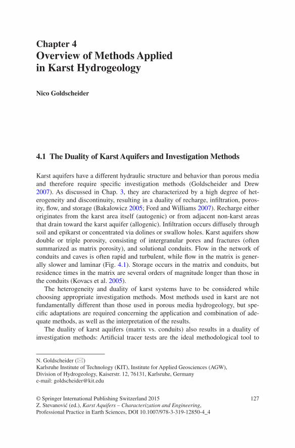
Karst aquifers have a different hydraulic structure and behavior than porous media and therefore require specific investigation methods (Goldscheider and Drew 2007). As discussed in Chap. 3, they are characterized by a high degree of het-erogeneity and discontinuity, resulting in a duality of recharge, infiltration, poros-ity, flow, and storage (Bakalowicz 2005; Ford and Williams 2007). Recharge either originates from the karst area itself (autogenic) or from adjacent non-karst areas that drain toward the karst aquifer (allogenic). Infiltration occurs diffusely through soil and epikarst or concentrated via dolines or swallow holes. Karst aquifers show double or triple porosity, consisting of intergranular pores and fractures (often summarized as matrix porosity), and solutional conduits. Flow in the network of conduits and caves is often rapid and turbulent, while flow in the matrix is gener-ally slower and laminar (Fig. 4.1). Storage occurs in the matrix and conduits, but residence times in the matrix are several orders of magnitude longer than those in the conduits (Kovacs et al. 2005).
The heterogeneity and duality of karst systems have to be considered while choosing appropriate investigation methods. Most methods used in karst are not fundamentally different than those used in porous media hydrogeology, but spe-cific adaptations are required concerning the application and combination of ade-quate methods, as well as the interpretation of the results.
The duality of karst aquifers (matrix vs. conduits) also results in a duality of investigation methods: Artificial tracer tests are the ideal methodological tool to
N. Goldscheider (*) Karlsruhe Institute of Technology (KIT), Institute for Applied Geosciences (AGW), Division of Hydrogeology, Kaiserstr. 12, 76131, Karlsruhe, Germanye-mail: [email protected]
study the rapid flow components in the conduit network (Goldscheider et al. 2008), whereas natural tracers, such as stable or radioactive isotopes, can be used to obtain information on the slow-flow and long-storage components in the matrix (Geyer et al. 2008; Maloszewski et al. 2002).
The hydraulic structure of karst systems results in a high degree of variability. Karst systems often react quickly and strongly on precipitation events or snow-melt. The water table or hydraulic head in conduits can vary by tens of meters or even more than 100 m. Flow velocities in conduits were reported to vary by a factor of 10 or more, and the discharge of karst springs is also highly variable. Discharge variations by several orders of magnitude within a few hours or days are common at karst springs. Along with water table and discharge, the physical, chemical, and microbial compositions of karst groundwater and spring water also show marked variations (Ravbar et al. 2011).
This variability represents a major challenge in the exploitation and manage-ment of karst water resources, but also requires methodological adaptations. Isolated measurements and observations are never adequate to characterize a karst system. Continuous monitoring of water levels, spring discharge, and water qual-ity is crucial in karst research. The dynamics of karst can only be captured on the basis of continuous, long-term, and event-based observations (Pronk et al. 2006; Savoy et al. 2011). Therefore, adapted monitoring and sampling techniques are crucial in studying karst systems. For the same reasons, tracer tests, water bal-ances, and other methods should ideally be applied repeatedly, during different flow conditions, to capture the variability of flow velocities, flow directions, and drainage divides (Göppert and Goldscheider 2008).
The following sections present an overview of methods used to study karst aquifer systems, their structure, hydraulic duality, and dynamics. Numerical mod-els and other mathematical approaches are not described in this section, but pre-sented in Chap. 10 as well as in several review articles (Hartmann et al. 2014) and book chapters (Kovacs and Sauter 2007). The focus of this chapter is on experi-mental and field-based methods, methodological adaptations, and combinations of methods that are most specific for karst. More general, hydrogeological methods are described in various other textbooks, such as Fetter (2001).
Fig. 4.1 View of a karst spring illustrating the duality of karst: Rapid and turbulent flow in the conduits, while porosity and permeability in the adjacent rock matrix are much lower. This duality also requires a duality of investigation methods. Karst spring at Cirque de Consolation, French Jura Mountains
1294 Overview of Methods Applied in Karst Hydrogeology
4.2 The Karst Hydrogeology Toolbox
Available methods in karst hydrogeology include geological, geophysical and spe-leological methods, hydrologic and hydraulic techniques, the use of natural trac-ers, such as isotopes and hydrochemical parameters, as well as the application of artificial tracer tests (Goldscheider and Drew 2007). The choice of appropriate methods and the sequence of methods applied depend on the practical or scientific research questions, but also on the level of previous knowledge and on the availa-ble time, money, staff, and instrumentation. The following sections briefly present the most important methods of the “karst hydrogeology toolbox” and discuss the advantages, fields of applications, and limitation of the individual methods (con-densed in Table 4.1).
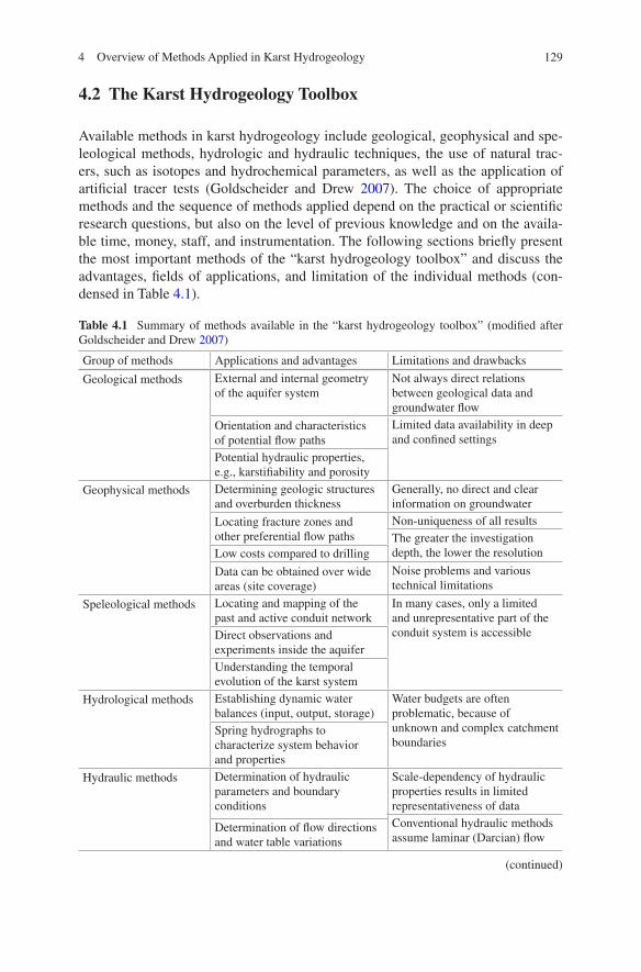
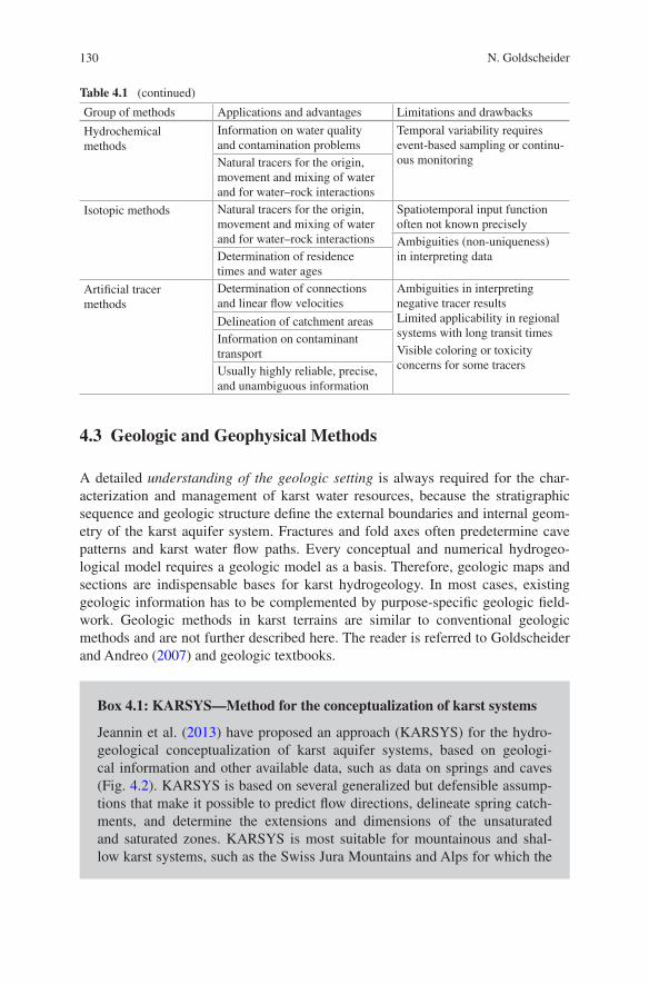
Table 4.1 Summary of methods available in the “karst hydrogeology toolbox” (modified after Goldscheider and Drew 2007)
Group of methods Applications and advantages Limitations and drawbacks
Geological methods External and internal geometry of the aquifer system
Not always direct relations between geological data and groundwater flow
Orientation and characteristics of potential flow paths
Limited data availability in deep and confined settings
Potential hydraulic properties, e.g., karstifiability and porosity
Geophysical methods Determining geologic structures and overburden thickness
Generally, no direct and clear information on groundwater
Locating fracture zones and other preferential flow paths
Non-uniqueness of all resultsThe greater the investigation depth, the lower the resolutionLow costs compared to drilling
Data can be obtained over wide areas (site coverage)
Noise problems and various technical limitations
Speleological methods Locating and mapping of the past and active conduit network
In many cases, only a limited and unrepresentative part of the conduit system is accessibleDirect observations and
experiments inside the aquiferUnderstanding the temporal evolution of the karst system
Hydrological methods Establishing dynamic water balances (input, output, storage)
Water budgets are often problematic, because of unknown and complex catchment boundaries
Spring hydrographs to characterize system behavior and properties
Hydraulic methods Determination of hydraulic parameters and boundary conditions
Scale-dependency of hydraulic properties results in limited representativeness of dataConventional hydraulic methods assume laminar (Darcian) flow
Determination of flow directions and water table variations
(continued)
130 N. Goldscheider
Table 4.1 (continued)
Group of methods Applications and advantages Limitations and drawbacks
Hydrochemical methods
Information on water quality and contamination problems
Temporal variability requires event-based sampling or continu-ous monitoringNatural tracers for the origin,
movement and mixing of water and for water–rock interactions
Isotopic methods Natural tracers for the origin, movement and mixing of water and for water–rock interactions
Spatiotemporal input function often not known preciselyAmbiguities (non-uniqueness) in interpreting dataDetermination of residence
times and water ages
Artificial tracer methods
Determination of connections and linear flow velocities
Ambiguities in interpreting negative tracer resultsLimited applicability in regional systems with long transit times
Delineation of catchment areasInformation on contaminant transport Visible coloring or toxicity
concerns for some tracersUsually highly reliable, precise, and unambiguous information
4.3 Geologic and Geophysical Methods
A detailed understanding of the geologic setting is always required for the char-acterization and management of karst water resources, because the stratigraphic sequence and geologic structure define the external boundaries and internal geom-etry of the karst aquifer system. Fractures and fold axes often predetermine cave patterns and karst water flow paths. Every conceptual and numerical hydrogeo-logical model requires a geologic model as a basis. Therefore, geologic maps and sections are indispensable bases for karst hydrogeology. In most cases, existing geologic information has to be complemented by purpose-specific geologic field-work. Geologic methods in karst terrains are similar to conventional geologic methods and are not further described here. The reader is referred to Goldscheider and Andreo (2007) and geologic textbooks.
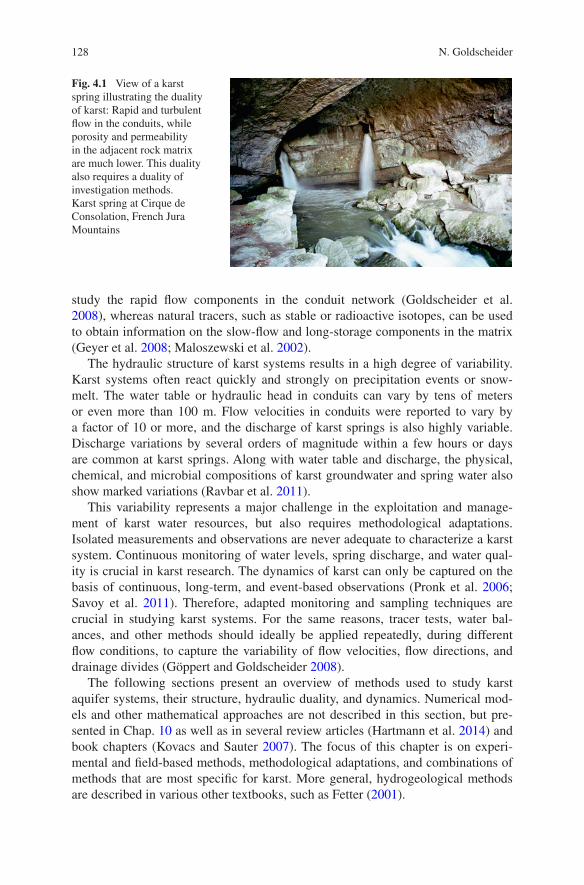
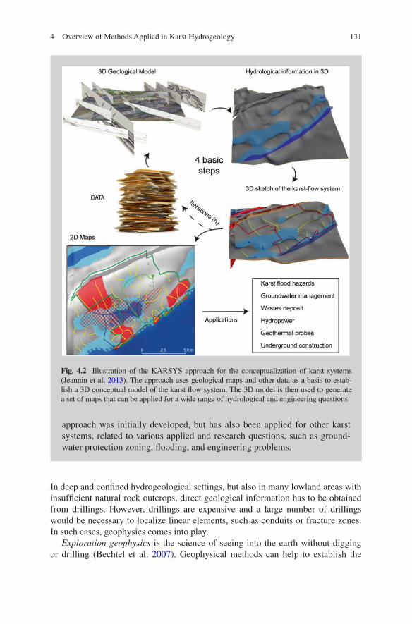
Box 4.1: KARSYS—Method for the conceptualization of karst systems
Jeannin et al. (2013) have proposed an approach (KARSYS) for the hydro-geological conceptualization of karst aquifer systems, based on geologi-cal information and other available data, such as data on springs and caves (Fig. 4.2). KARSYS is based on several generalized but defensible assump-tions that make it possible to predict flow directions, delineate spring catch-ments, and determine the extensions and dimensions of the unsaturated and saturated zones. KARSYS is most suitable for mountainous and shal-low karst systems, such as the Swiss Jura Mountains and Alps for which the
1314 Overview of Methods Applied in Karst Hydrogeology
approach was initially developed, but has also been applied for other karst systems, related to various applied and research questions, such as ground-water protection zoning, flooding, and engineering problems.
Fig. 4.2 Illustration of the KARSYS approach for the conceptualization of karst systems (Jeannin et al. 2013). The approach uses geological maps and other data as a basis to estab-lish a 3D conceptual model of the karst flow system. The 3D model is then used to generate a set of maps that can be applied for a wide range of hydrological and engineering questions
In deep and confined hydrogeological settings, but also in many lowland areas with insufficient natural rock outcrops, direct geological information has to be obtained from drillings. However, drillings are expensive and a large number of drillings would be necessary to localize linear elements, such as conduits or fracture zones. In such cases, geophysics comes into play.
Exploration geophysics is the science of seeing into the earth without digging or drilling (Bechtel et al. 2007). Geophysical methods can help to establish the
132 N. Goldscheider
geological setting of a karst system, but can also be used to identify hydraulically relevant structures, such as fracture zones or large conduits.
Different geophysical methods measure different physical properties, such as gravity, electrical resistivity, or acoustic wave velocities. Geophysical methods can be grouped into active and passive ones. Passive methods use existing geophysical fields, such as the natural gravity field of the earth, while active methods introduce a signal into the earth, as it is done in explosion seismic.
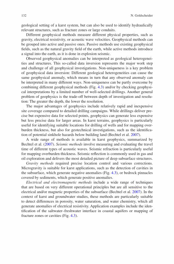
Observed geophysical anomalies can be interpreted as geological heterogenei-ties and structures. This so-called data inversion represents the major work step and challenge of all geophysical investigations. Non-uniqueness is a key problem of geophysical data inversion: Different geological heterogeneities can cause the same geophysical anomaly, which means in turn that any observed anomaly can be interpreted in many different ways. Non-uniqueness can be partly overcome by combining different geophysical methods (Fig. 4.3) and/or by checking geophysi-cal interpretations by a limited number of well-selected drillings. Another general problem of geophysics is the trade-off between depth of investigation and resolu-tion: The greater the depth, the lower the resolution.
The major advantages of geophysics include relatively rapid and inexpensive site coverage compared to detailed drilling campaigns. While drillings deliver pre-cise but expensive data for selected points, geophysics can generate less expensive but less precise data for larger areas. In karst terrains, geophysics is particularly useful for identifying suitable locations for drilling of wells and for mapping over-burden thickness, but also for geotechnical investigations, such as the identifica-tion of potential sinkhole hazards below building land (Bechtel et al. 2007).
A wide range of methods is available in karst geophysics, summarized by Bechtel et al. (2007). Seismic methods involve measuring and evaluating the travel time of different types of acoustic waves. Seismic refraction is particularly useful for mapping overburden thickness. Seismic reflection is commonly used in gas and oil exploration and delivers the most detailed picture of deep subsurface structures.
Gravity methods required precise location control and various corrections. Microgravity is suitable for karst applications, such as the detection of cavities in the subsurface, which generate negative anomalies (Fig. 4.3), or bedrock pinnacles covered by sediments, which generate positive anomalies.
Electrical and electromagnetic methods include a wide range of techniques that are based on very different operational principles but are all sensitive to the electrical and/or magnetic properties of the subsurface (Bechtel et al. 2007). In the context of karst and groundwater studies, these methods are particularly suitable to detect differences in porosity, water saturation, and water chemistry, which all generate anomalies of electrical resistivity. Application examples include the iden-tification of the saltwater–freshwater interface in coastal aquifers or mapping of fracture zones or cavities (Fig. 4.3).
1334 Overview of Methods Applied in Karst Hydrogeology
Box 4.2: Advantage of combining different geophysical methods
Figure 4.3 presents a combined depiction of two geophysical images of Port Kennedy Bone Cave in Pennsylvania, USA. The cave is a major site for Pleistocene fossils that was initially discovered in the nineteenth cen-tury. Later on, the cave was filled with waste material, and the cave location got lost. In 2005, the cave was rediscovered by an interdisciplinary research effort including the application of microgravity and electrical resistivity tomography. The combined application of different geophysical methods helps to overcome the problem of non-uniqueness that is inherent to all geo-physical investigations.
Fig. 4.3 Geophysical images of Port Kennedy Bone Cave (PA, USA) that has been redis-covered by microgravity and electrical resistivity tomography (courtesy of Tim Bechtel, Enviroscan Inc.)
134 N. Goldscheider
Borehole geophysics (Logging) is an indispensable supplement to the analysis of drilling cores. Drilling cores allow detailed lithological, mineralogical, geochemical, and paleontological analyses, while borehole geophysics makes it possible to study a wide range of physical underground properties in situ. Temperature logs are a sim-ple type of borehole geophysics and an example of a relevant underground property that cannot be obtained from drilling cores. Bechtel et al. (2007) summarize avail-able borehole geophysical methods and their uses in karst and hydrogeology studies.
4.4 Speleological Methods
Caves make it possible to access the karst system and directly observe and study flow and transport in the unsaturated zone and in the aquifer (Jeannin et al. 2007). Many accessible caves represent older parts of the drainage network that are no longer active today, while large parts of the active flow system are often developed in deep phreatic conduits that can only be accessed by divers or that are too narrow to be entered by humans (Palmer 1991). Nevertheless, caving has revealed great knowledge on karst systems and is increasingly recognized as a valuable asset to karst hydrogeological investigations. Speleologists can produce detailed cave maps that illustrate the geometry of karst conduit networks—although with the important restrictions mentioned above.
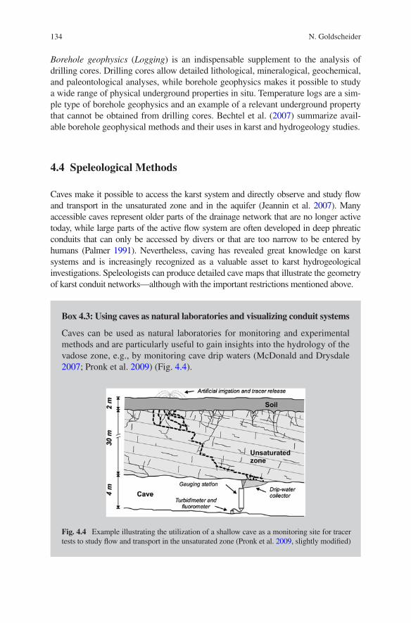
Box 4.3: Using caves as natural laboratories and visualizing conduit systems
Caves can be used as natural laboratories for monitoring and experimental methods and are particularly useful to gain insights into the hydrology of the vadose zone, e.g., by monitoring cave drip waters (McDonald and Drysdale 2007; Pronk et al. 2009) (Fig. 4.4).
Fig. 4.4 Example illustrating the utilization of a shallow cave as a monitoring site for tracer tests to study flow and transport in the unsaturated zone (Pronk et al. 2009, slightly modified)
1354 Overview of Methods Applied in Karst Hydrogeology
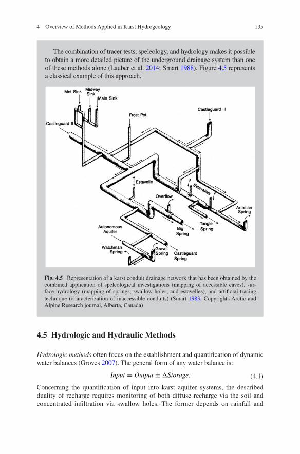
The combination of tracer tests, speleology, and hydrology makes it possible to obtain a more detailed picture of the underground drainage system than one of these methods alone (Lauber et al. 2014; Smart 1988). Figure 4.5 represents a classical example of this approach.
Fig. 4.5 Representation of a karst conduit drainage network that has been obtained by the combined application of speleological investigations (mapping of accessible caves), sur-face hydrology (mapping of springs, swallow holes, and estavelles), and artificial tracing technique (characterization of inaccessible conduits) (Smart 1983; Copyrights Arctic and Alpine Research journal, Alberta, Canada)
4.5 Hydrologic and Hydraulic Methods
Hydrologic methods often focus on the establishment and quantification of dynamic water balances (Groves 2007). The general form of any water balance is:
Concerning the quantification of input into karst aquifer systems, the described duality of recharge requires monitoring of both diffuse recharge via the soil and concentrated infiltration via swallow holes. The former depends on rainfall and
(4.1)Input = Output ±�Storage.
136 N. Goldscheider
snowmelt, but intermediate storage in the soil or snowpack and evapotranspira-tion losses have to be considered. The latter can be determined by continuous flow monitoring at sinking streams. Quantification of the output requires continuous discharge monitoring at karst springs. However, in many case, not all groundwater flows to monitored springs but may drain toward adjacent surface waters or other aquifers. In these cases, water balances are more difficult and require sophisticated hydrogeological methods (as discussed in Chap. 6). Water storage can occur at many places in the hydrologic system, such as the soil, the unsaturated zone, or the aquifer, thus requiring a wide range of different methods. Differences in aqui-fer storage can be observed by water-level measurements at observation wells and piezometers (hydraulic methods, see below).
Continuous discharge monitoring at karst springs is not only required to establish dynamic water balances, but also delivers hydrographs that are invalu-able tools in karst hydrogeology, particularly in combination with chemographs, i.e., time series of various physicochemical or chemical parameters (Grasso and Jeannin 2002; Hartmann et al. 2013). Spring hydrographs and chemographs can be used for the overall characterization of karst systems (Kovacs and Perrochet 2008) and to better understand the system behavior during floods (Winston and Criss 2004) or droughts (Fiorillo 2009).
Flow nets are two-dimensional representations of groundwater flow and con-sist of equipotential lines and flow lines. Real groundwater flow is always a three-dimensional phenomenon and can be described by equipotential surfaces and flow lines (Fetter 2001). Equipotential surfaces are locations of equal hydraulic head, which can be measured at piezometers. However, the construction of meaning-ful flow nets or flow fields in karst aquifers is complicated by their heterogeneity, hydraulic discontinuity, and anisotropy. Therefore, the interpretation of piezometer data and the construction of flow nets in karst aquifers need to be done with care and caution, and predicted flow directions must be checked with tracer tests and compared with geological and speleological information.
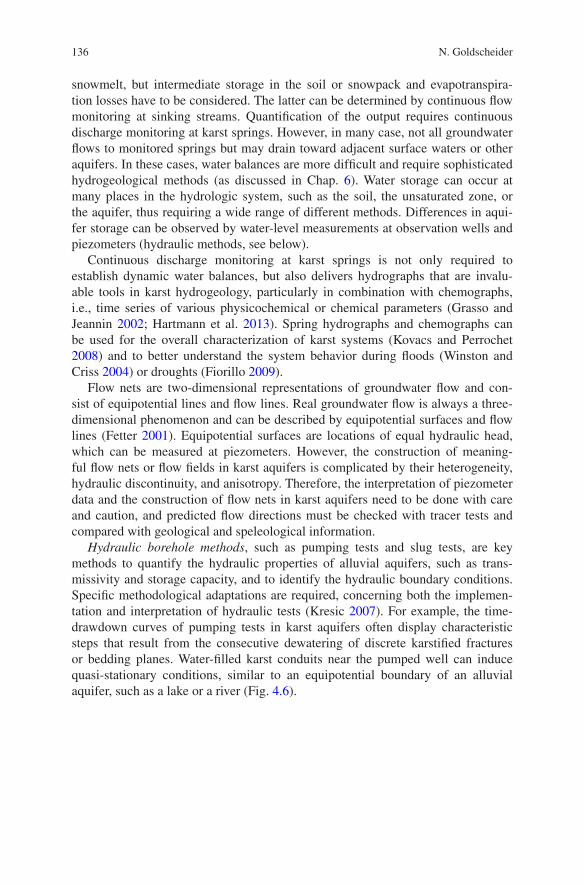
Hydraulic borehole methods, such as pumping tests and slug tests, are key methods to quantify the hydraulic properties of alluvial aquifers, such as trans-missivity and storage capacity, and to identify the hydraulic boundary conditions. Specific methodological adaptations are required, concerning both the implemen-tation and interpretation of hydraulic tests (Kresic 2007). For example, the time-drawdown curves of pumping tests in karst aquifers often display characteristic steps that result from the consecutive dewatering of discrete karstified fractures or bedding planes. Water-filled karst conduits near the pumped well can induce quasi-stationary conditions, similar to an equipotential boundary of an alluvial aquifer, such as a lake or a river (Fig. 4.6).
1374 Overview of Methods Applied in Karst Hydrogeology
4.6 Hydrochemical and Isotopic Methods
Hydrochemical and microbiological methods are either applied to characterize water quality and contamination problems, or the obtained parameters are used as “natural tracers” to determine transit times, the origin and mixing of different water types as well as hydrologic or biogeochemical processes in the aquifer sys-tem. Due to the high degree of variability of karst systems, continuous monitor-ing or event-based high-frequency sampling is generally preferred. Hunkeler and Mudry (2007) group the available parameters into (i) precipitation-related param-eters, (ii) soil-related parameters, (iii) carbonate-rock-related parameters, (iv) parameters related to other rock types, and (v) compounds of anthropogenic origin.
The primary result of detailed physicochemical and hydrochemical monitoring at a karst spring is a so-called chemograph. As described above, chemographs can be combined with hydrographs in order to gain insights into the behavior of the karst system, particularly in response to intense precipitation events or droughts (Grasso et al. 2003; Raeisi et al. 2007).
Fig. 4.6 Examples of characteristic time—drawdown curves obtained from pumping tests in karst aquifers (not to scale). a The consecutive drainage of three discrete karstified fractures or bedding planes creates a stepped curve. b A nearby water-filled karst conduit causes quasi-sta-tionary conditions (modified after Kresic 2007, Copyrights Taylor and Francis/Balkema, London)
138 N. Goldscheider
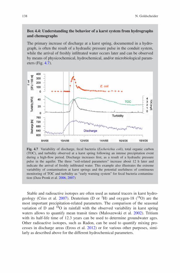
Box 4.4: Understanding the behavior of a karst system from hydrographs and chemographs
The primary increase of discharge at a karst spring, documented in a hydro-graph, is often the result of a hydraulic pressure pulse in the conduit system, while the arrival of freshly infiltrated water occurs later and can be observed by means of physicochemical, hydrochemical, and/or microbiological param-eters (Fig. 4.7).
Fig. 4.7 Variability of discharge, fecal bacteria (Escherichia coli), total organic carbon (TOC), and turbidity observed at a karst spring following an intense precipitation event during a high-flow period. Discharge increases first, as a result of a hydraulic pressure pulse in the aquifer. The three “soil-related parameters” increase about 12 h later and indicate the arrival of freshly infiltrated water. This example also illustrates the extreme variability of contamination at karst springs and the potential usefulness of continuous monitoring of TOC and turbidity as “early warning system” for fecal bacteria contamina-tion (Data Pronk et al. 2006, 2007)
Stable and radioactive isotopes are often used as natural tracers in karst hydro-geology (Criss et al. 2007). Deuterium (D or 2H) and oxygen-18 (18O) are the most important precipitation-related parameters. The comparison of the seasonal variation of D and 18O in rainfall with the observed variability in karst spring waters allows to quantify mean transit times (Maloszewski et al. 2002). Tritium with its half-life time of 12.3 years can be used to determine groundwater ages. Other radioactive isotopes, such as Radon, can be used to quantify mixing pro-cesses in discharge areas (Eross et al. 2012) or for various other purposes, simi-larly as described above for the different hydrochemical parameters.
1394 Overview of Methods Applied in Karst Hydrogeology
4.7 Artificial Tracer Methods
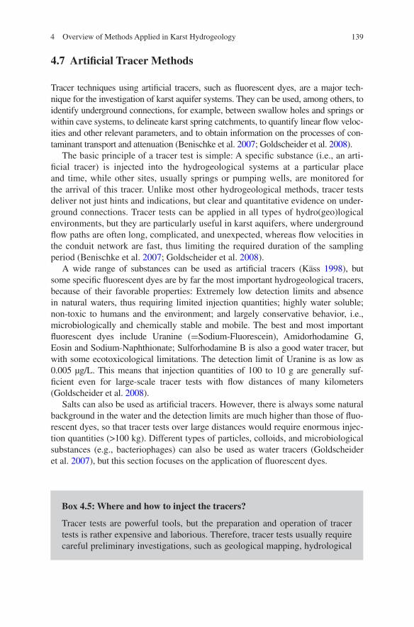
Tracer techniques using artificial tracers, such as fluorescent dyes, are a major tech-nique for the investigation of karst aquifer systems. They can be used, among others, to identify underground connections, for example, between swallow holes and springs or within cave systems, to delineate karst spring catchments, to quantify linear flow veloc-ities and other relevant parameters, and to obtain information on the processes of con-taminant transport and attenuation (Benischke et al. 2007; Goldscheider et al. 2008).
The basic principle of a tracer test is simple: A specific substance (i.e., an arti-ficial tracer) is injected into the hydrogeological systems at a particular place and time, while other sites, usually springs or pumping wells, are monitored for the arrival of this tracer. Unlike most other hydrogeological methods, tracer tests deliver not just hints and indications, but clear and quantitative evidence on under-ground connections. Tracer tests can be applied in all types of hydro(geo)logical environments, but they are particularly useful in karst aquifers, where underground flow paths are often long, complicated, and unexpected, whereas flow velocities in the conduit network are fast, thus limiting the required duration of the sampling period (Benischke et al. 2007; Goldscheider et al. 2008).
A wide range of substances can be used as artificial tracers (Käss 1998), but some specific fluorescent dyes are by far the most important hydrogeological tracers, because of their favorable properties: Extremely low detection limits and absence in natural waters, thus requiring limited injection quantities; highly water soluble; non-toxic to humans and the environment; and largely conservative behavior, i.e., microbiologically and chemically stable and mobile. The best and most important fluorescent dyes include Uranine (=Sodium-Fluorescein), Amidorhodamine G, Eosin and Sodium-Naphthionate; Sulforhodamine B is also a good water tracer, but with some ecotoxicological limitations. The detection limit of Uranine is as low as 0.005 µg/L. This means that injection quantities of 100 to 10 g are generally suf-ficient even for large-scale tracer tests with flow distances of many kilometers (Goldscheider et al. 2008).
Salts can also be used as artificial tracers. However, there is always some natural background in the water and the detection limits are much higher than those of fluo-rescent dyes, so that tracer tests over large distances would require enormous injec-tion quantities (>100 kg). Different types of particles, colloids, and microbiological substances (e.g., bacteriophages) can also be used as water tracers (Goldscheider et al. 2007), but this section focuses on the application of fluorescent dyes.
Box 4.5: Where and how to inject the tracers?
Tracer tests are powerful tools, but the preparation and operation of tracer tests is rather expensive and laborious. Therefore, tracer tests usually require careful preliminary investigations, such as geological mapping, hydrological
140 N. Goldscheider
measurements and water balances, and the application of hydrochemical and isotopic methods to obtain first indications on aquifer properties, catchment areas, flow, and mixing processes. On this basis, tracer tests can be used to check research hypotheses and obtain clear evidence on underground con-nections and catchments.
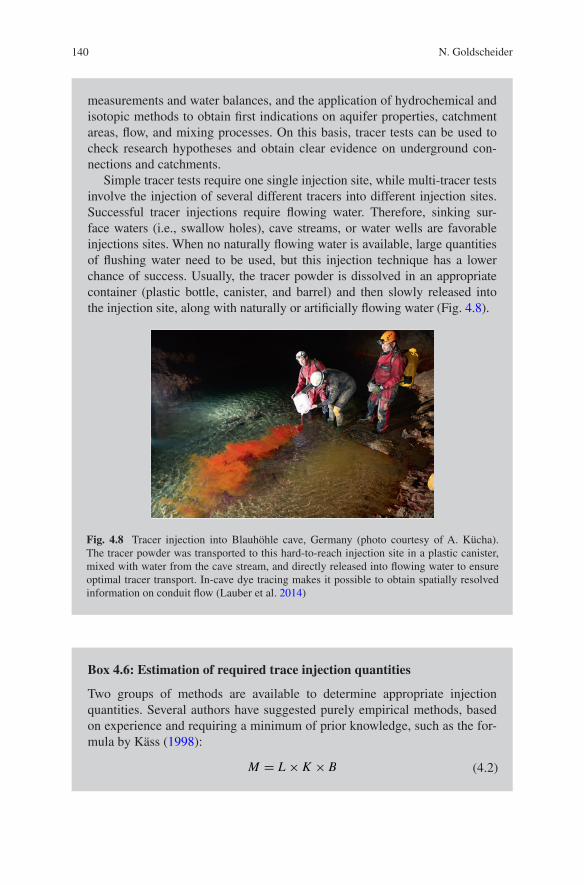
Simple tracer tests require one single injection site, while multi-tracer tests involve the injection of several different tracers into different injection sites. Successful tracer injections require flowing water. Therefore, sinking sur-face waters (i.e., swallow holes), cave streams, or water wells are favorable injections sites. When no naturally flowing water is available, large quantities of flushing water need to be used, but this injection technique has a lower chance of success. Usually, the tracer powder is dissolved in an appropriate container (plastic bottle, canister, and barrel) and then slowly released into the injection site, along with naturally or artificially flowing water (Fig. 4.8).
Fig. 4.8 Tracer injection into Blauhöhle cave, Germany (photo courtesy of A. Kücha). The tracer powder was transported to this hard-to-reach injection site in a plastic canister, mixed with water from the cave stream, and directly released into flowing water to ensure optimal tracer transport. In-cave dye tracing makes it possible to obtain spatially resolved information on conduit flow (Lauber et al. 2014)
Box 4.6: Estimation of required trace injection quantities
Two groups of methods are available to determine appropriate injection quantities. Several authors have suggested purely empirical methods, based on experience and requiring a minimum of prior knowledge, such as the for-mula by Käss (1998):
(4.2)M = L × K × B
1414 Overview of Methods Applied in Karst Hydrogeology
where
M is required tracer mass (kg),L is relevant distance (km),K is a coefficient for the tracer type (e.g., one for Uranine, two for Amidorho-
damine G, 15 for Naphthionate, and 20,000 for NaCl), andB is a coefficient for the hydrogeological framework conditions (e.g., 0.1–
1.0 for karst conduits)
According to this formula, a tracer test in karst over 10 km distance would require 1–10 kg of Uranine (or 2–20 tons of salt!).
Alternatively, the required tracer injection quantity can be determined on the basis of quantitative transport equations, such as the Advection–Dispersion Model (ADM) described further below. This approach requires more input data (that are usually not available prior to the tracer test) but also represents a more objective and defensible basis of estimation (Field 2003).
Three groups of methods are available for sampling and monitoring the arrival of the injected tracers at springs or other observation sites: integrative sampling, discrete sampling, or continuous monitoring. In the case of fluorescent dyes, inte-grative sampling can be done by means of charcoal adapters that are placed in the water, usually for a time period of several days. Fluorescent dyes accumulate in the charcoal and can later be eluted and analyzed in the laboratory. This technique is cheap and timesaving but delivers only qualitative results (basically Yes or No). It can thus be used for a large number of minor sampling sites, such as small and rather unimportant springs.
Discrete sampling means to take water samples at given time intervals, either manually (grab sampling) or by means of automatic samplers. The samples can then be analyzed quantitatively in the laboratory thus generating a series of time-concentration data. This sampling method is highly reliable and reproducible, but also requires sufficient staff and/or auto-samplers.
Continuous monitoring of fluorescent tracers involves the application of field fluorimeters. Different models are available, such as downhole or flow-through fluorimeters with up to four optical channels that make it possible to monitor sev-eral fluorescent tracers and turbidity at the same time (Schnegg 2002). The UV channel can also be used for organic carbon monitoring (Pronk et al. 2006).
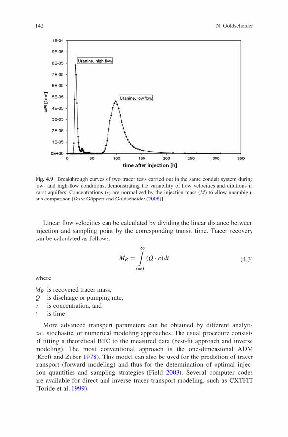
The primary result of a tracer test is a breakthrough curve (BTC), where tracer concentrations are plotted versus time (Fig. 4.9). A well-documented BTC is a much more convincing evidence for an underground connection than an isolated result from a single charcoal bag or from scarce water samples. Furthermore, several relevant flow and transport parameters can be directly obtained from the BTC, such as the time of first arrival, the peak time, and the maximum concentration. Concentrations are either plotted as absolute values (e.g., in µg/L) or normalized by the respective injection quantity to allow better comparison of BTCs from multi-tracer tests.
142 N. Goldscheider
Linear flow velocities can be calculated by dividing the linear distance between injection and sampling point by the corresponding transit time. Tracer recovery can be calculated as follows:
where
MR is recovered tracer mass,Q is discharge or pumping rate,c is concentration, andt is time
More advanced transport parameters can be obtained by different analyti-cal, stochastic, or numerical modeling approaches. The usual procedure consists of fitting a theoretical BTC to the measured data (best-fit approach and inverse modeling). The most conventional approach is the one-dimensional ADM (Kreft and Zuber 1978). This model can also be used for the prediction of tracer transport (forward modeling) and thus for the determination of optimal injec-tion quantities and sampling strategies (Field 2003). Several computer codes are available for direct and inverse tracer transport modeling, such as CXTFIT (Toride et al. 1999).
(4.3)MR =
∞∫
t=0
(Q · c)dt
Fig. 4.9 Breakthrough curves of two tracer tests carried out in the same conduit system during low- and high-flow conditions, demonstrating the variability of flow velocities and dilutions in karst aquifers. Concentrations (c) are normalized by the injection mass (M) to allow unambigu-ous comparison [Data Göppert and Goldscheider (2008)]
1434 Overview of Methods Applied in Karst Hydrogeology
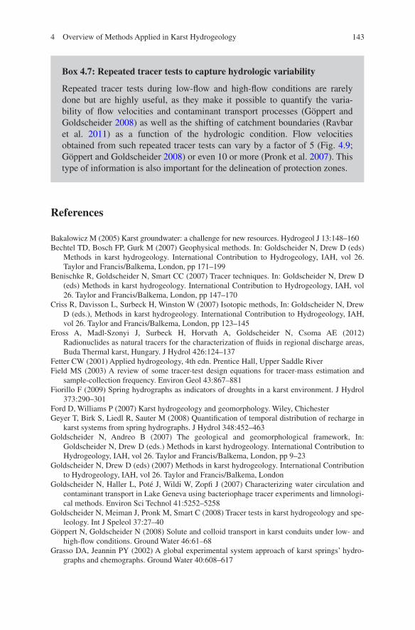
Box 4.7: Repeated tracer tests to capture hydrologic variability
Repeated tracer tests during low-flow and high-flow conditions are rarely done but are highly useful, as they make it possible to quantify the varia-bility of flow velocities and contaminant transport processes (Göppert and Goldscheider 2008) as well as the shifting of catchment boundaries (Ravbar et al. 2011) as a function of the hydrologic condition. Flow velocities obtained from such repeated tracer tests can vary by a factor of 5 (Fig. 4.9; Göppert and Goldscheider 2008) or even 10 or more (Pronk et al. 2007). This type of information is also important for the delineation of protection zones.
References
Bakalowicz M (2005) Karst groundwater: a challenge for new resources. Hydrogeol J 13:148–160Bechtel TD, Bosch FP, Gurk M (2007) Geophysical methods. In: Goldscheider N, Drew D (eds)
Methods in karst hydrogeology. International Contribution to Hydrogeology, IAH, vol 26. Taylor and Francis/Balkema, London, pp 171–199
Benischke R, Goldscheider N, Smart CC (2007) Tracer techniques. In: Goldscheider N, Drew D (eds) Methods in karst hydrogeology. International Contribution to Hydrogeology, IAH, vol 26. Taylor and Francis/Balkema, London, pp 147–170
Criss R, Davisson L, Surbeck H, Winston W (2007) Isotopic methods, In: Goldscheider N, Drew D (eds.), Methods in karst hydrogeology. International Contribution to Hydrogeology, IAH, vol 26. Taylor and Francis/Balkema, London, pp 123–145
Eross A, Madl-Szonyi J, Surbeck H, Horvath A, Goldscheider N, Csoma AE (2012) Radionuclides as natural tracers for the characterization of fluids in regional discharge areas, Buda Thermal karst, Hungary. J Hydrol 426:124–137
Fetter CW (2001) Applied hydrogeology, 4th edn. Prentice Hall, Upper Saddle RiverField MS (2003) A review of some tracer-test design equations for tracer-mass estimation and
sample-collection frequency. Environ Geol 43:867–881Fiorillo F (2009) Spring hydrographs as indicators of droughts in a karst environment. J Hydrol
373:290–301Ford D, Williams P (2007) Karst hydrogeology and geomorphology. Wiley, ChichesterGeyer T, Birk S, Liedl R, Sauter M (2008) Quantification of temporal distribution of recharge in
karst systems from spring hydrographs. J Hydrol 348:452–463Goldscheider N, Andreo B (2007) The geological and geomorphological framework, In:
Goldscheider N, Drew D (eds.) Methods in karst hydrogeology. International Contribution to Hydrogeology, IAH, vol 26. Taylor and Francis/Balkema, London, pp 9–23
Goldscheider N, Drew D (eds) (2007) Methods in karst hydrogeology. International Contribution to Hydrogeology, IAH, vol 26. Taylor and Francis/Balkema, London
Goldscheider N, Haller L, Poté J, Wildi W, Zopfi J (2007) Characterizing water circulation and contaminant transport in Lake Geneva using bacteriophage tracer experiments and limnologi-cal methods. Environ Sci Technol 41:5252–5258
Goldscheider N, Meiman J, Pronk M, Smart C (2008) Tracer tests in karst hydrogeology and spe-leology. Int J Speleol 37:27–40
Göppert N, Goldscheider N (2008) Solute and colloid transport in karst conduits under low- and high-flow conditions. Ground Water 46:61–68
Grasso DA, Jeannin PY (2002) A global experimental system approach of karst springs’ hydro-graphs and chemographs. Ground Water 40:608–617
144 N. Goldscheider
Grasso DA, Jeannin PY, Zwahlen F (2003) A deterministic approach to the coupled analysis of karst springs’ hydrographs and chemographs. J Hydrol 271:65–76
Groves C (2007) Hydrological methods, In: Goldscheider N, Drew D (eds) Methods in karst hydrogeology. International Contribution to Hydrogeology, IAH, vol 26. Taylor and Francis/Balkema, London, pp 45–64
Hartmann A, Goldscheider N, Wagener T, Lange J, Weiler M (2014) Karst water resources in a changing world: review of hydrological modeling approaches. Rev Geophys 52(3):218–242
Hartmann A, Weiler M, Wagener T, Lange J, Kralik M, Humer F, Mizyed N, Rimmer A, Barbera JA, Andreo B, Butscher C, Huggenberger P (2013) Process-based karst modelling to relate hydrodynamic and hydrochemical characteristics to system properties. Hydrol Earth Syst Sci 17:3305–3321
Hunkeler D, Mudry J (2007) Hydrochemical methods. In: Goldscheider N, Drew D (eds) Methods in karst hydrogeology. International Contribution to Hydrogeology, IAH, vol 26. Taylor and Francis/Balkema, London, pp 93–121
Jeannin PY, Eichenberger U, Sinreich M, Vouillamoz J, Malard A, Weber E (2013) KARSYS: a pragmatic approach to karst hydrogeological system conceptualisation. Assessment of groundwater reserves and resources in Switzerland. Environ Earth Sci 69:999–1013
Jeannin PY, Groves C, Häuselmann P (2007) Speleological investigations, In: Goldscheider N, Drew D (eds) Methods in karst hydrogeology. International Contribution to Hydrogeology, IAH, vol 26. Taylor and Francis/Balkema, London, pp 25–44
Käss W (1998) Tracing technique in geohydrology. Balkema, Brookfield, p 581Kovacs A, Perrochet P (2008) A quantitative approach to spring hydrograph decomposition. J
Hydrol 352:16–29Kovacs A, Perrochet P, Kiraly L, Jeannin PY (2005) A quantitative method for the characterisa-
tion of karst aquifers based on spring hydrograph analysis. J Hydrol 303:152–164Kovacs A, Sauter M (2007) Modelling karst hydrodynamics. In: Goldscheider N, Drew D (eds.)
Methods in karst hydrogeology. International Contribution to Hydrogeology, IAH, vol 26. Taylor and Francis/Balkema, London, pp 201–222
Kreft A, Zuber A (1978) Physical meaning of dispersion equation and its solution for different initial and boundary conditions. Chem Eng Sci 33:1471–1480
Kresic N (2007) Hydraulic methods. In: Goldscheider N, Drew D (eds.) Methods in karst hydrogeology. International Contribution to Hydrogeology, IAH, vol 26. Taylor and Francis/Balkema, London, pp 65–91
Lauber U, Ufrecht W, Goldscheider N (2014) Spatially resolved information on karst conduit flow from in-cave dye tracing. Hydrol Earth Syst Sci 18:435–445
Maloszewski P, Stichler W, Zuber A, Rank D (2002) Identifying the flow systems in a karstic-fissured-porous aquifer, the Schneealpe, Austria, by modelling of environmental O-18 and H-3 isotopes. J Hydrol 256:48–59
McDonald J, Drysdale R (2007) Hydrology of cave drip waters at varying bedrock depths from a karst system in southeastern Australia. Hydrol Process 21:1737–1748
Palmer AN (1991) Origin and morphology of limestone caves. Geol Soc Am Bull 103:1–21Pronk M, Goldscheider N, Zopfi J (2006) Dynamics and interaction of organic carbon, turbidity
and bacteria in a karst aquifer system. Hydrogeol J 14:473–484Pronk M, Goldscheider N, Zopfi J (2007) Particle-size distribution as indicator for fecal bacteria
contamination of drinking water from karst springs. Environ Sci Technol 41:8400–8405Pronk M, Goldscheider N, Zopfi J, Zwahlen F (2009) Percolation and particle transport in the
unsaturated zone of a karst aquifer. Ground Water 47:361–369Raeisi E, Groves C, Meiman J (2007) Effects of partial and full pipe flow on hydrochemographs
of Logsdon river, Mammoth Cave Kentucky USA. J Hydrol 337:1–10Ravbar N, Engelhardt I, Goldscheider N (2011) Anomalous behaviour of specific electrical
conductivity at a karst spring induced by variable catchment boundaries: the case of the Podstenjsek spring, Slovenia. Hydrol Process 25:2130–2140
Savoy L, Surbeck H, Hunkeler D (2011) Radon and CO2 as natural tracers to investigate the recharge dynamics of karst aquifers. J Hydrol 406:148–157
1454 Overview of Methods Applied in Karst Hydrogeology
Schnegg PA (2002) An inexpensive field fluorometer for hydrogeological tracer tests with three tracers and turbidity measurement. In: XXXII IAH and ALHSUD congress Groundwater and human development, Oct 2002, Balkema, Rotterdam, Mar del Plata, Argentina, pp 1484–1488
Smart CC (1983) The hydrology of the Castleguard karst, Columbia Icefields, Alberta, Canada. Arct Alp Res 15:471–486
Smart CC (1988) Artificial tracer techniques for the determination of the structure of conduit aquifers. Ground Water 26:445–453
Toride N, Leij FJ, van Genuchten MT (1999) The CXTFIT code for estimating transport parame-ters from laboratory or field tracer experiments. US Salinity Laboratory, USDA, ARS, Riverside
Winston WE, Criss RE (2004) Dynamic hydrologic and geochemical response in a perennial karst spring. Water Resour Res 40(W05106):11