39
GEOCHRONOLOGIC METHODS FOR KARST By Douglas J. Frost February 13, 1975 Sidney E. V.'hi te Advisor

GEOCHRONOLOGIC METHODS FOR KARST
By
Douglas J. Frost
February 13, 1975
Sidney E. V.'hi te Advisor

Acknowledgements
I would like to extend my gratitude to the following
people who gave me help and encouragement in providing this
study of karst.
To Margery A. Tibbets for her great help in obtaining
library material.
To Tony Shalosky, Bill Shalosky, and Ted Spellmire for
pulling me through caves and encouraging me to study the
realm of the subsurface.
To Chuck Mitchell and Steve Thacker for help in the
hydrologic analyses.
To Dr. Garry McKenzie and Dr. Sidney White for instilling
in me the desire to pursue this course of study and the
reviewing of my manuscript.
ii
Geochronologic Methods for Karst
Abstract
Karst topography is related to specialized climatic and lithographic criteria. Through an understanding of these basic processes an interpretative analysis of geochronologic dating can develop into an informative sequence.
Chemical formula of karst, which I have first outlined, is essential to the question of location of such topography. The next logical step is defining those forms of karst which are found in temperate climatic areas. These can be applied to give relative dates of development. Special attention was applied to subterranean karst since these features tend to prevail longer than contemporary surface structures. Indirect methods for relative dates were also included to show they can be used in conjunction with the other principles. Finally, two practical examples, using these techniques, are shown. The central Kentucky and southern Indiana karst regions were studied in order to place relative dates on the formation of the cave systems.
This accumulation of the various methods based upon the knowledge of karst formation will show the state of karst studies in today's text. By using these systems, a resolution of the question of ancient karst time tables can be pursued.
iii

Acknowledgements
Abstract .
Process of Karst
Chemistry of Karst
Karst Forms
TABLE OF CONTENTS
Geochronologic Methods for Karst
Practical Applications of Geochronology
Summary
References
Illustrations:
Map of Garrison Chapel Valley
iv
ii
iii
1
2
5
13
22
32
33
29

Process of Karst
Before a serious undertaking of any science can be
performed, constants of definitions and methods must be
established. The understanding of karst, like other geologic
processes, has been built upon by countless workers, and it
is from these the following has evolved.
The term karst is derived from the German form of the
Slav word krs or kras, meaning rock. Originally, it denoted
a regional area of massive limestone to the north and south
of the part of Rjeka in Yugoslavia. This area was character
ized by great numbers of sinkholes, karren, and underground
streams. Today the term is used more widely to classify a
type of terrain with distinctive and unique landforms caused
by the solution of rock.
With the morphologic investigation of karst in heated
research, criteria for karst was generally established by
1930. Grund, Katzer, and others were responsible for the
research to this point. They maintained the following:
(1) The relationships between soluble and other rocks shows
definite geomorphic landforms. (2) The relationship between
soluble and insoluble rocks may modify the circulation of
water in joints, fissures, and fractures and influence the
development of karst features. (3) The lithology of karst

2
relief is decisive; however, formation of karst is dependent
upon exposure of coverage by alluvium and other sediment
deposits. (4) Water was determined to be the medium for the
solutional process. A method of defining climatic-ecologic
influences was discussed in several papers; however, none
agreed upon this classification. (5) The circulation of water
through fractures was determined by Lehmann in 1932, but not
convincingly demonstrated until Corbel in 1957 gave proof of
movement of water several thousands of meters below sea level.
Thus, the standard for evaluation of karst was evolved, and
it is from these that various systems of nomenclature are
borrowed (Herak, 1972).
A workable translation of karst process could simply be
stated as the solution of limestone rock by acid through the
medium of water, with or without subsequent deposition of
by-products. Thus karren (karst features) found in limestone
is true karst. Karren found in granite or sandstone is
considered pseudo-karst phenomena. Basis of karst is there
fore dependent on rock type (Paloc, 1966).
Chemistry of Karst
The climatic-ecological variables affect the dynamic
process of karst in two ways: first, it determines the rate
of reaction, and secondly it gives variance to the amount of
material available for reaction. The process remains the
same chemically whether it is alpine or tropical karst in
question.

3
The formula of solution can best be shown by using the
Debye-Hickel method (Daniels, 1955).
V activities coefficient
K equilibrium constant
(H+) (HC03
-)
H2co
3
10-6.30
10-10.30
10-8.28
(1)
(2)
(3)
(4)
(5)
As we see, the log of the number is actually in pH readings.
This can tell us some important information in that any water
not in dynamic equilibrium under these conditions may dissolve
limestone. More often in the study of karst water, we look

4
for the state of saturation with respect to calcite. This
can be done by either comparing the product of the measured
Caz+ concentration and carbon dioxide partial pressure with
the saturation product of calcium carbonate at the desired
temperature or by comparing measured pH and Caz+ concentration
with equilibrium curves of Trombe (195Z).
The question of the formation of the carbonic acid has
seen much debate within recent years. Most feel that the
carbon dioxide is developed in soil conditions. The normal
atmospheric pressure of carbon dioxide is 3.0 x 10- 4 ATM.
Rain water, in equilibrium with atmospheric carbon dioxide,
should contain 1.37 x 10- 5 moles per liter of COz.
It was recognized that the soil contained many more
times the carbon dioxide content than the atmosphere.
Gerstenhaur used a technique applied to karst studies by
Miotke (1968) of the measurement of COz in the atmosphere.
He found in a study of the soil that seasonal fluctuation
from .04% to 3.7% of carbon dioxide has corresponding
variations in the air at grass level. He summarized that there
was a strong correlative effect between soil-air carbon
dioxide content.
One important point in the discussion remains to be seen.
The solution of bedrock is dependent upon the absence of
the vapor phase of carbon dioxide during downward trend. If
it becomes an open system, then the carbon dioxide is
regained by the air with subsequent deposition of calcium
carbonate.
5
Karst Forms
The formation of karst forms is a function of maturity
of the terrain on which it develops. An unspoken code of
definition exists among the researchers in this field of
study. The various landforms are more easily understood if
separated into those forms above ground and those below the
surface. While it is true that those forms above the ground
tend to be larger and better defined, those features found
in the subterrain are more often preserved as characteristic
indications of paleohydrologic factors.
We shall begin our review with those surface karst forms
found in the middle latitudes (Gvozde, 1961).
Karren (lapies) are solutional features characteristic
of the barren calcareous surfaces, considered by many to be
isolated cyclic processes which do not pass into larger
forms. It is indicative of pure, hard limestone types (Cviji'c,
1924). Jamas, deep open pits, are solution features developed
from fractures and fissures in limestone. They connect sur
face with underground cavities. Little is known of their
development; they are, however, similar to ponors, which are
swallow holes. Both are rarely accessible features, difficult
to study firsthand.
Kamenice are shallow dish-like impressions on consolidated
calcarous blocks. These are excellent examples of marginal
corrosion due to a lack of vertical jointing.

6
Dolines are considered the fundamental features of
classic karst topography. They are the sinkholes which
develop with maturity of such landforms. Usually found in
massive phases of limestone, the factors controlling develop
ment are (1) geologic structure of limestone, (2) relief of
the land (as a function of water runoff), (3) variations of
the water level within the limestone, (4) climatic factors,
(5) vegetative cover (determines solution process and can
modify water discharge patterns).
Uvalas are next in the cyclic sequence of doline formation.
This type is formed when dolines enlarge until a narrow bridge
of land separates them. The bridges tend to coalesce to
give it a distinctive characteristic.
Polje is considered a later form of karstic cyclic
development. It refers to the impervious beds and deposits
overlying many karst limestones and surface fluvial modelling.
In one respect it can be a depositional feature in that
fragmented rocks are lithified by calcium carbonate deposited
into breccias or conglomerates.
Rillen karren and Rinner karren are specific forms of
karren and need greater attention. These may vary from
a few centimeters to about 20 meters (Bogli, 1960). Solution
of limestone beneath vegetation cover produces types of
microlandforms different from those formed from the action of
intensive rain showers upon bard limestone surfaces.
As stated previously, certain karst forms may be given

7
as a function of cover. Quinlan (1972) had detailed karstic
types by using physical parameters of cover, lithology,
climate, geologic setting, physiography, hydrology, modifi
cation of karst before and after dominant process, and types
of major landforms. We are interested now primarily with
preserved surface paleokarst forms. In order to preserve
these forms the karst must be buried due to the fact that
karst is a continuing process and would soon be diminished by
more recent solution.
The four basic types of covered karst (Quinlan, 1972) are
(1) subsoil karst, covered with residual soil (the Mammoth
Cave area in the Mississippian Plateau of central Kentucky
is an example), (2) mantled karst, covered by a relatively
thin veneer of postkarst rock or sediment (an example of
this type is the Mitchell Plain of Indiana), (3) buried karst,
covered by a relatively thick cover of postkarst rock or
sediment (not part of a comternporary landscape as are the first
two), (4) interstratal karst, covered by prekarst rock,
formed by solution of limestone in the subsurface. The
problem is, therefore, twofold: identification of relic karst
as opposed to recent and determining the relationship of the
covering material to the landform.
This can be solved by using those forms produced beneath
the original surface. Features found within this realm can
be categorized into three groups: negative, positive, and
subsurface.

Negative karstic relief is basically that which is
dissolved from the limestone. Included in this group are
sinkholes formed primarily by acidic water perculating
down vertical fractures above the ground water table. They
are considerably more complex than was first realized in
8
that they bear a direct relationship to the impermeable cap
rock. The prerequisites for development include: (1) thick
limestone sequence, (2) method of penetration of caprock,
(3) capture of surface flow. Pits are entirely or partially
opened structures of this type, while sinkholes are obstructed
versions of these cylindrical forms. Domes refer to the
concave portions of pits at the top or entrance of water flow
from within the cave (Quinlan, 1972).
Minor forms are negative stalactites and negative stalag
mites. These form when water flowing through the fractures
and fissures is still acidic in content and makes a perfect
inverse pattern of the positive variety.
Fluting marks are vertical solutional ridges on the walls
of pits. They are most constant where the limestone is
homogeneous.
Scallops are found where water is actively moving across
a limestone cave wall. They vary in size from a centimeter
up to a meter in width. Often found in cave passages, they
denote an eroding stream condition. Scallops also form on
pit walls. These are good indicators, along with flute
marks, of a change in flow rates of water entering a pit.

Fluting marks with scallops imposed, therefore, mean an
increase of water over time into a given pit.
9
The positive forms of karst are formed by the deposi
tional processes of the karstic cycle. The minerals most
commonly found include calcite, aragonite, gypsum, celestite,
and some clay minerals (impure iron oxides). The several
ways chemically these substances are deposited include
escape of the carbon dioxide of the water into the atmosphere
(if the carbon dioxide pressure is less) with subsequent
deposits of dissolved material. The mechanisms include
evaporation and/or activation by splash or stream wall contact.
The principal forms for our study include the stalactite.
By evaporation of water, these are grown by addition of
material in a precise concentric ring as they grow outward
and downward.
Stalagmites develop on the floor of caverns by the
splash effect, thus releasing carbon dioxide and material.
They show no given pattern of growth except as a function of
growth water (with constituents) available.
Spillovers of water in caves tend to produce gours or
dams. The carbon dioxide is released and the evaporation is
increased with agitation. Spillover points are projected
radially outward and upward forming the circular arcs of
dams, convex downstream. If distributed over an increasing
area and then adjoining dams coalesce, they form terraces
of rimstone dams (Lange, 1968).

Flowstone is a structureless depositional feature that
tends to coat cave walls with varying thicknesses. It can be
produced by either dripping or flowing water along a cave
wall.
Cave coral is an encrusting, mammilary or bulbous type
relief which develops under submerged conditions. This can
develop in standing pools although flowing streams are the
more common method of deposition.
10
Up to this point we have described various formations
beneath the surface. Many more types do develop and just as
surface features, the criteria for their growth is exacting.
Availability of material, temperature requirements, humidity,
among others, geneally make these unsuitable for geochronologic
interpretation until more research is performed. The relation
ship of bedding planes and joints control the location of
these features in the cave proximity.
The third group of karstic features is the subsurface type.
This includes breccia pipes formed by stoping over voids.
Although not common, these can be well preserved and extend
3000 feet above gypsum beds (Landes, 1945).
Beds of solutional breccia formed in response to the
widespread leaching of relative soluble rocks is still
another feature. Principally, these are residual deposits,
possibly altered by weathering or fillings of various types
of solution-produced cavities (Quinlan, 1972).
The major type of subsurface karst is caves. In reality,
this includes all the processes and forms described to this

point. We can thus add that this includes all the various
fillings of travertine, collapsed rock from ceiling and
wall, and both fluvial and aeolian sediment~ To make
11
serious interpretative analyses of their formational sequence
we must realize and understand the physical entities
involved.
Karst formations can be separated by area on basis of
mountain-platform structures. We are concerned with the
horizontal areas or platform terrain. It is notable, however,
that caves in folded limestone regions have received special
attention due to the possibility of evaluating the factor
of solubility in the different limestone beds (this stems
from the fact that caves tend to form along the trace of
a fold in such formations) (Moore, 1960). This has led some
workers to classify caves into a given "cave physiographic
province," by such attributes as the same formation or the
same general geologic history. Horizontal or flat lying
rocks are those dipping less than five degrees.
Next a study of the relationship of the joints and
fractures should be reviewed. We need to understand the
physical development of cave genesis to see such a working
order. Vadose caves, such as defined by Davis, Rhoades,
and others, include the structural concept of eroding
vertically oriented seepage generally above the ground water
level. Pits and sinkholes are examples of vadose structures.
Water table caves are those that form by relatively fast
flowing which is being discharged along the top of a quasi-
static reservoir. It is almost impossible to demonstrate

12
the quasi-static realm; thus the matter becomes that of a
comparative scale. Swinnerton allowed 200 feet along a
vertical zone of the water table for his model of development.
This type poses considerable conceptual problems of scale.
Phreatic caves are those formed below the level set for
water-table type caverns (Ford, 1971).
Several corollaries can be set forth from the above.
Water will strive to flow along the gradient, or path, of
maximum potential difference. Those systems obtaining a
nearly vertical flow (or drop) will consequently have a higher
rate of solution. Ford found the type of cave developed was
governed by the frequency of fissures significantly penetrated
by ground water and the geometric proportionality (bedding
ratio: joint ratio) of the fissure network. Thus, we
see the indirect consequences of solutional effects of ground
water. Horizontal areas tend to make horizontal passages due
to the lay of ground water regimens.
Shapes themselves of the caves are controlled by rates
of reaction. Generally uniform solution rates are constant
around the walls of a structure (Lange, 1968). Nonuniform
solution, then, reflects differences of temperature and
pressures. Lange (1968) has calculated constant and
exponential gradients reflecting these changes. He has
found the tendency for rounded objects to have sharpened
corners under solution where sharpened inside corners tend to
round inversely.
Geochronologic Methods for Karst
For any age determination of a geologic feature some
knowledge of the development must be made beforehand. The
following can be considered guides to the recognition of
13
paleo surfaces. The most obvious is the physical and
paleontological characteristics of unconformities. Structures
previously mentioned serve as guides and indexes of such
relief. In association with the unconformities there are
three types of probable boundary changes: (1) silicification
described by Leith (1925) in which weathered carbonate had
been replaced by fine, lacey silica. (2) Dedolomitization
occurrences might also be useful (Filkman, 1969), but this
may prove to be ambiguous because it also occurs in the
vicinity of solution breccia horizons and it is therefore
commonly a result of interstratal karstification. (3) Due
to the differential breaking of calcite and secondary enrich
ment in phosphates, many inconformity horizons are character
ized by slightly phosphatic surfaces (Cook, 1970).
The occurrence of length-slow chalcedony in solutional
breccias may be quite useful. This form occurs when it
replaces an anhydrite or gypsum or when it replaced carbonate
minerals in an evaporite environment.
If the karst is more recent (which is to say if it is
subsoil or mantled karst), then we can use depositional
features such as those found in caves to determine a span of
development for them. It must be understood, however, that

14
these forms represent the second part of growth for karst.
Few are made until the cave has been opened to outside atmo-
spheric conditions.
Carbon 14 dating can be used by the following reasoning.
The co 2 used to dissolve the Caco 3 comes from decaying organic
material, thus it will have normal cl4 concentrations. HC0 3
ions formed from the co 2 will completely mix with the Caco 3 .
On redeposition of the Caco 3 the c 14 will at least be half
of that of a tree on the outside. Accuracy of + 2000 years
back to 30,000 years is possible (Broecker, Olson, 1959).
It is possible to use isotopic oxygen ratios as climatic
indicators. Temperature dependent fluctuations in the
ol 8;o16 composition of calcite deposited in speleothems has
been the principal method brought forward. It is determined
by two factors, the isotopic concentration of the water going
over the structure and the temperature at which the calcite
. d . d I . . . h c 14 d . . b is epos1te . n conJunct1on wit at1ng, it can e
related to other geologic events (Hendy, Wilson, 1968).
In some caves Th 230;u234 ratios can be determined. This
is, however, dependent upon depositional minerals in the
formations. This method could give dates as much as 350,000
years before the present.
Those methods discussed previously are absolute time
scale determinations. Many times financial resources or
special depositional requirements make such methods inoperable.
Relative ages can be conceived if time is taken to analyze

15
variables that influence the structure of karst. Climatic
data can prove useful to such interpretation. We have been
making reference to middle latitudes of karst formation. All
of these areas would receive the same amount of rainfall were
it not for special topographic features and differences in
altitudes. Prolonged periods of cold weather set up con
ditions for development of glaciers. The modern day examples
could prove a valuable key to knowledge of past events. The
Castle Guard area in the Columbia Icefield in the Canadian
Rockies (Ford, 1967) are such an occurrence where close
juxtaposition of karst, glacier, and periglacial erosional
features can be observed. Karst features occur on surfaces
recently abandoned by the ice. Outside the margins of
neoglacial moraines, limestone surfaces are reduced to
felsenmeer devoid of karst. Beyond 2300 meters from the
glacier sinkholes are extensively developed. This area provides
an excellent example of karst development at the periphery
of temperate-climate glaciers (Ford, 1967).
The question of destruction of karst on barren rock is
understandable. Yet what of those karst forms produced in
the periglacial climate such an interstratal karst types where
more ground water is available. It has been found that in
the Knox dolomite in Kentucky, karst surfaces of 15 to 20 feet
average depths with some going to 170 feet under a soil
subsurface of 30 to 40 feet. Preservation of relic features
contained therein would yield correlatable information. Pre
viously existing barren rock, now covered, presents problems

16
also. Trudgill (1968), working on karst in Ireland, has found
published literature is contradictory, maintaining that the
solution of limestone is greater under cover than those
surfaces that are barren. He found a correlation between the
pH of glacial till in drumlins and the percentage of carbonate
within a till with the presence or absence of dissection
beneath it. His results are preliminary and could reflect,
chemically, reaction within the till itself rather than
subsurface till relationships.
Probably the single feature of karst most researched is
that of sinkhole development with its relationship to drainage
patterns. Lithologic requirements are a massive limestone
with a cap of resistant sandstone, shale, or chert. The
solution of the limestone usually occurs on the edges of the
escarpment, although domepits occur under the capping rocks.
Mammoth Cave Plateau capped by the Dripping Springs escarpment
represents such an occurrence, although the lower Pennyvile
Plateau escarpment lacks any such pits. The relationship of
its development seems to be one of maturity of the drainage
system of the karst rivers. As old pits are destroyed by
continued solution, new ones are created near the head waters
of the river. This is due to the fact that most pits and
sinkholes are found in valleys dissecting ridge masses.
Quinlan and Pohl (1967) take the approach that vertical shafts
actively promote slope retreat rather than are a consequence
of it. The thought that pits and valley rivers bear a
significant relationship is solidified by the difference in
elevation of the lip of the sinkhole and that of the drainage

17
river. Still much must be done before formulas can accurately
determine time intervals.
Denudation rates applied to karst have been used in
conjunction with carbon 14 dating where redeposition of
dissolved material was found. This, however, leaves a wide
margin of error in that precise areas of solution are at best
conjectural. Jean Corbel has brought this phase of karst
research into new light. He used the climatic formula of
4ET100 = dissolved C0 3 content, where E is equal to pre
cipitation minus evaporation in decimeters and T is equal to
the calcium carbonate in miligrams per liter. He used this
formula in calculations of karst solution in the northern
parts of Canada. Another worker in the field raises serious
question with Corbel's formula. D. Ingle Smith, applying
his results versus the formula, with the Canadian latitude
74°N, found solution about 2 mm per 1000 years. This was one
sixth the value expected from Corbel of periglacial climate
and continuous cover of permafrost. The equation was further
modified by Williams in 1964 to give a more accurate field
formula to work in karst. His additions are S = ETN/lOD,
where S is the limestone removed in meters per year, E is the
mean annual water surplus in decimeters, T is the total
hardness in ppm, D is the density of the rock, and N is the
fraction of the basin occupied by the limestone.
Indirect relationships of denudation rates have also
been applied. Measurements of pH, hardness, ratio of Mg and
18
Ca as they flow through karstic rock can give significant figures
for rates of solution by applying ratios of these figures before
and after they flow through a given terrain.
Methodology, when working with solutional and depositional
characteristics, has spun off in search of relatable features.
The black coating in some caves is caused by humic acid, the
residue being humate. The insoluble akile-organic matter
sometimes makes up 5-10% of a sample. In one recent study
of a cave in Tennessee 71% of the residue was pollen and spore
fragments of recent and Pleistocene age. Care should be
taken in order that the top level of the cave which would
contain the oldest fragments of such material be evaluated.
On karst-formed ponds (such as filled-in sinkholes) pollen
and spores do not fare as well. In one study of cores in
the Mammoth Cave Plateau area several ponds were studied. In
the south Dale pond 8 meters of clay was brought up. The
first 7 meters contained recent spores denoting rapid deposition.
Below 450 centimeters no spores or pollen were found, sug
gesting that either they were flushed out through fractures
below or rapid decay plus a short interval of large accumu
lation of clay made conditions unfavorable (Wright, Sprass,
and Watson, 1966). In recent years, some credibility to age
determination of caves has been brought by vertebrate remains
found in soil and sand deposits. In caves of the midwest
two researchers, J. Kukla and V. Lozels, have found no
vertebrate fossils older than Wisconsin age.

19
Another approach taken is the selective study of deposition
of alluvium in caves. A pattern (due principally to hydrologic
factors) has developed of such deposition--caves show no clay
deposits that are not preceded by sand, gravel, and finally
silt. This tends to be a function of water velocity as the
level of water is eventually lowered or water diminishes in
amount available, then the energy needed to carry large sizes
of bedload decreases. I have often been able to dig through
the silt and clay horizons to connect passages. The type of
clay can lend important clues to formation of karstic terrain
also. This can best be considered a paleoclimatic indicator.
Most of the caves of Indiana and central Kentucky contain
clay horizons which are primarily a red, reduced variety,
reminiscent of the conditions today found in hot, humid climates.
Correlation of clays or even entire sequences is possible when
studying the alluvium within caves. Simultaneous events can
then be understood more readily.
Other mineral species can also be found within the
deposition of karst. Again, paleoclimatic indicators have
been used to outline conditions in prehistoric times necessary
for their formation. Pyrite and marcasite are found in some
Ohio and Kentucky caves and are usually associated with
reducing environments. Their breakdown by bacteria creates
sulphuric acid which hastens the solutional methods typical
of karst. Gypsum, which most people know as the "flowers"
found in caverns such as Mammoth Cave, is probably the second
most important element formed in karst next to calcium

20
carbonate. It is formed by evaporation, with the fill of some
arid lands in the southwestern United States comprised of 50%
gypsum. Gypsum is found in nearly all the caves of Kentucky
and Indiana. In Mammoth Cave the reaction which forms it is
+ -2 4H + so4 + Caco 3 + Caso4 · 2H 2o + co 2 . It is characteristic
of the dryer levels of the cave. Anhydrite, Caso 4 , is found
in only the driest portions of the caves often in association
with gypsum.
Celestite, SrS04 , is the third most abundant mineral.
The anthigenic celestite and primary gypsum are usually
found together, the amount of celestite being limited by
the element of strontium available in meteoric water. The
sulphates are all indicative of an arid climate (Pohl and
White, 1965).
Many other minerals occur within the confines of caves,
such as malachite, magnesite, and hydrous sodium sulfate, but
their relationship to previous karstic solutions and/or
deposition is questionable. Until further study, their use
as interpretative devices is questionable. Aragonite,
polymorphic with calcite, could become a principal chrono-
logic tool in determining absolute or relative ages of karst
terrain. Some stalactites found in central Kentucky contain
alternating bands of calcite and aragonite. Still stalactites
of pure aragonite are known. Other occurrences include the
clay banks along abandoned stream beds of caverns and in the
gravel along active streams. Calcite is the stable form of
the mineral under natural conditions. Aragonite will begin

21
to convert to calcite upon heating to 400°C in dry air or at
lower temperatures in contact with water. Recent studies by
Siegel and Reams (1966) show interesting relationships.
Calcium carbonate made by bubbling co 2 through powdered
calcite crystals, limestone, and coralline aragonite, when
filtered and allowed to evaporate, at various temperatures
yielded only calcite. Similar studies using dolomite and an
artifically prepared aragonite-calcite mixture yielded calcite
at lower temperatures and aragonite at higher temperatures.
Researchers have found that the borderline cases of aragonite
versus calcite formation are directly influenced by the
amounts of iron, magnesium, and strontium within the solution.
Rates of change, perhaps like the radioactive elements, could
give valuable information on time of formation and original
constituents of the area involved. Since aragonite is
formed under a much narrower range of conditions than calcite
and is much less widespread, its presence could be a key
to its past (Mason and Berry, 1959).
Stalactites, themselves, have been used as an indicative
source of minimum dating for karst topography. An object of
known age, coated by calcium carbonate for x number of years,
should upon examination of the thickness of coating give a
relative age of deposition when applied to the largest formation
in that particular cave system. Such formations are dependent
upon the amount of ground water, lithology of that one area
of occurrence, atmospheric carbon dioxide and fracture
pattern of the locality. They are, however, independent of

seasonal variations of temperature, rainfall, etc., and the
entire cave system in general, i.e., where one stalactite
grows fast, others 50 feet away may grow at a slower rate.
Therefore, we see that such data in literature as "one inch
every hundred years in growth" becomes meaningless.
Practical Applications of Geochronology
22
A system of definition is only valuable if it can be
used. The following review and practical fieldwork will show
the validity of such methods.
The Mammoth Cave - Flint Ridge network is perhaps the
most extensively researched system in the world. A total
length of 156 miles, estimations have shown the length to
possibly go over 200 miles when further exploration is con
ducted. Dating the formation of the system becomes the task
of immense magnitude due to its size.
In order to understand the development of the cave system,
an interpretation of the central Kentucky karst area must
be undertaken. This plain is part of a fairly continuous
karst belt developed on Meramac and lowest Chester strata
(Mississippian) which extends from southern Indiana through
northern Alabama. The thickness of stratigraphic units vary
with estimates of different workers. A regional, fairly
uniform dip, to the northwest is the only feature of this
strata continuous throughout the area.
Structural and stratigraphic controls have been shown to
exist for the karst landforms by A. P. Howard (1968). La
Valle (1965) indirectly related pit development to these

23
stratigraphic influences.
Regional outcrops of these formations give a character
istic pattern of solution while the nature of the landforms
are often not obvious. The outcrop pattern of the lower
part of the St. Genevieve may be correlated with zones of
"low" sink plains and to a lesser extent with high sink
plains. The upper part of the St. Louis formation generally
underlies broad, "high" sink plains. The lower strata of
the St. Louis generally support surface drainage which in
many instances disappears into the skin plains developed in
the upper part of the St. Louis. The lowest part of the St.
Louis limestone and the Warsaw-Salem and underlying formations
are generally characterized by surface drainage with minor
local sink zones. The major distinguishing formation is the
Big Clifty Sandstone, part of the Chester series. This unit
acts as an escarpment in the development of pits and solutional
valleys in the Mammoth Cave area. This escarpment is called
the Dripping Springs Escarpment in this region and separates
the two major karst areas into the Pennyrile Plain to the
south and southwest, and the Mammoth Cave Plateau to the north.
The Pennyrile Plain contains surface karst features
such as dolines and polje which are only slightly developed.
These occur mainly on the Warsaw, St. Louis, and St. Genevieve
limestones and generally are smooth, lightly developed structures
of less than 10 meters deep. Surface alluvium tends to disguise
such features in this area from none karst area.

24
To the north lies the Mammoth Cave Plateau which contains
much larger karst dolines. Averaging 30 meters in diameter,
they extend to depths of 30-70 meters below the level of the
rim. Large karst valleys were found on this plateau. The
largest cave systems are found in this region which contains
the upper part of the St. Genevieve limestone.
Most methods for dating karst would prove unacceptable
for this large cave system. It contains at least 7 levels of
identifiable passages including the ones now submerged. Alan
D. Howard (1968) provided excellent statistics for this area
in relating pit development to stratigraphic and structural
controls--it is reasonable to assume domepits can only develop
up to the highest level of a valley ridge, thus would prove
useless in maturity rates for this karst terrain. Ph and
calcium rates removal such as Corbel's formula would likewise
prove unacceptable in that large widths of the passages
(and the narrow vertical levels) provide information that
solution has not been a constant factor. The most promising
feature comes from correlation of the cave passage elevation
to that Ohio River drainage basin during the late Tertiary
and Pleistoene. Major cave levels have a distinct relationship
to the flood plain development of the Green River which is
the principal drainage system of the caverns. This can best
be seen in several stages.
The first would be the Teays system, filled by Nebraskan
till, diverted the head waters of the Teays into the Ohio
River Valley causing deep and rapid entrenchment during the
Aftonian Interglacial Period.
The second stage would consist of Kanasan Glaciation
partially alluviating the valleys and filling the caves.
The third stage would be the development of the Green
River terraces at the same elevation of distinct cave level
formation during the Yarmouth Interglacial Period.
The fourth stage, the Illinoian Glaciation, develops
another level, with a gravel-fill locally in the cave and
related terraces during the Sangamon Interglacial Period.
25
The final stage proves most complex. An uplift with
subsequent downcutting was followed by a static period. The
streams and weather change due to the Wisconsin Glaciation
brought in the large amounts of reddish brown to red sandy
silt formed during the Sangamon Interglacial Period.
The passages are found to be correlatable to terrace
formation of the Green River, but some contradictory evidence
has developed. Scallops in the southern portion of the cave
network show drainage going to the south, not the northern
path to the Ohio River system. Still, I feel this can be
resolved by using other data found in the underground karst.
Correlatin~ clay deposits at different levels would show
direction of flow prior to uplift. Also study of primitive
flow patterns (perhaps causing the differences of karst
development on the Pennyrile Plateau) would shed light on
this subject.
Oxygen isotopic analyses of the deposition formations
would confirm paleoclimatic conditions of the downcutting
episodes. Absolute dating tends to give minimum periods of
formation of the system. Dating of bat guano deposits by
c14 methods gave a date of 38,000 years (Davies, 1972).
Large deposits of gypsum, anhydrite, and a type of
reddish silt tends to substantiate the paleoclimatic
conditions during the interglacial periods.
26
Much work remains to be done in pinpointing formational
dates in this system, but it would be safe to say the solution
began at the time of the Nebraskan period if our hypotheses
are correct.
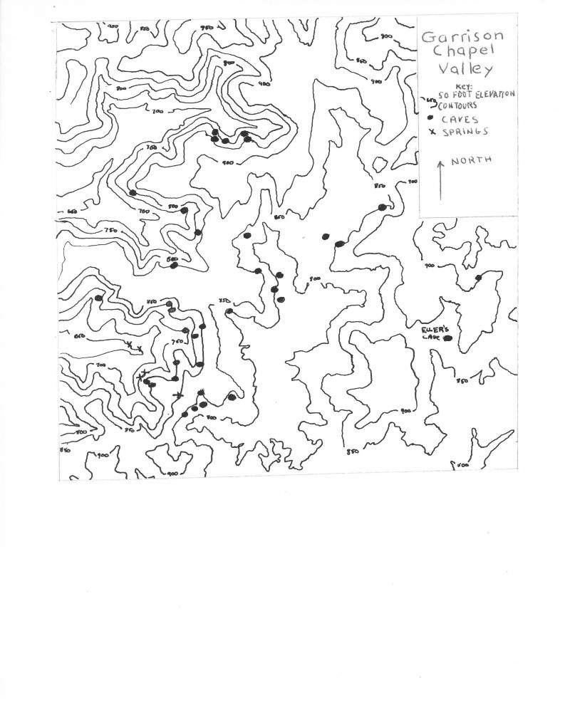
Taking another example from the field, we can use less
rigorous methods for determining karstic geochronology. The
area under study was the cave system of Garrison Chapel Valley,
Monroe County, Indiana.
The stratigraphy of the region is similar to that of
Kentucky. The crawford Upland in which this system is located
is the Indiana equivalent of the Mammoth Cave Plateau. The
St. Louis and St. Genevieve limestones are present. The
Paoli Limestone here is similar to the Girken limestone in
the Kentucky area. Dip of the bedrock is difficult to cal
culate since the individual units change in a short distance.
A general figure is 25 feet per mile to the west (Gray, 1962).
Karst features on the surface include karren, limited
to occasional outcrops of limestone at the peaks of hills

27
and streambeds, and dolines of 10 to 20 meters depth at the
higher elevations. Solutional valleys and pits tend to be
buried by the glacial drift which usually accumulates in the
valleys from 20 to 112 feet in thickness (Gray, 1962).
Again we must turn to the subsurface karst features to
interpret a time scale to understand formational events. A
good model for simple methods of chronologic determinations
is one which has had both a constant rate of solution and
also a stable drainage pattern. These exist only in theory,
thus Garrison Chapel Valley is no exception. On a plain, just
west of Bloomington, lies an area which is drained by great
sinks opposite the heads of the streams in this region. A
little further South Indian Creek begins on this plain and
continues south with gentle grade compared with the previous
streams.
The water entering the large sinks just mentioned is
really the head waters of Indian Creek. The water, after
entering these sinks, appears in the deeply incised heads of
Richland Creek instead of continuing down Indian Creek, in
other works, subterranean stream piracy by Richland Creek.
This diversion of water was brought about by the location of
the streams in question with respect to the rock structure.
Indian Creek lay upon a table land of soluble rock with
lower streams on either side of it. The headwaters of
Richland Creek northeast of Stanford are at a level of 680
to 700 feet above sea level. They were cut by the top of
the St. Louis Limestones which dip west from the Indian Creek

28
plain into Richland Creek valley. A west branch of Indian
Creek lay at an elevation of 800 feet but a half mile or more
to the east. The divide between the two is formed of shales
and sandstones (Beede, 1911).
The Garrison Chapel Valley system is a singular level
complex of caves. This should, in comparison with the
Kentucky example, show that conditions were different for
development of the caves.
The map shows the locations of the known pits in the
area. We must consider, though, that most are covered with
glacial drift. It should be noted that none reach the highest
elevations in this location which gives reason to assume that
the maturity of this karst region is not as "old" as the fully
developed system in the Mammoth Cave region (Powell, 1961).
This is not to say development of both systems formed
independently. The type of terrigenous karst is similar to
that formed in front of the Canadian Glacier example. The
difference could therefore be the proximity of the glacier
to the karst area and the variation of climate affecting the
region (such as permafrost areas and amount of water available).
By studying glacial boundaries in Indiana (Thornbury, 1937),
it can be recognized that at least two of the glaciations
extended over this system. Other supporting evidence for the
relationship of these systems is the red soil in Indiana's
Mitchell Plain, known in the area as "terra rossa." This is
analogous to the red clay soil in the Mammoth - Flint Ridge
System.
30
The best methods are chosen using more absolute methodology.
I used Williams' formula (1964) in doing a calculation of
the rate of removal for this particular area. The formula
is S = ETN/lOD. The variables were previously discussed on
Page 17.
The samples of water were collected at the points located
on the map within the cave itself; a fifth sample was taken
from a standing pool to provide a standard for the other
samples. Corbel used calcium ppm in his calculations since
other solubles should remain the same when strictly speaking
of karst transformation rates. I, too, have taken this
liberty in order to show my example more clearly.
E The last 100-year average for rainfall was 44
inches. Evaporation is estimated in this section at
31 inches per year. This leaves 13 inches surplus
or 3.3 decimeters.
T The formula calls for total hardness; however, taking
the preliminary hardness and final hardness (in
N
this case hardness is equal to calcium in solution)
then obtaining difference should give local solution
of calcium. Ellers Cave calcium gave 58 ppm for
an average of 56 ppm. The subsequent spring
discharges gave 80 ppm and 64 ppm for an average
of 72 ppm of calcium. Thus, 72 - 56 = 16 ppm.
Amount of basin occupied by the limestone. In this
case only the argillaceous and chertbeds present
give difficulties in a determative calculation.
Both are local base levels for the cave at several
---- -~--~-----------------
31
points. By inspection of the system, no more than
25% of either of these are outcrops in our basin;
thus N = 1.33
D This is density, but if the limestone is not porous,
then specific gravities can be used. On five samples
obtained of the St. Louis Limestone of this cave an
average value of 2.74 was obtained. Thus, D = 2.74.
The formula is therefore S = 3.3 x 16 x 1.33/10 x 2.74 and
S = 2.56 m3/ per year. By studying known systems in the area
we find at least 25,000 feet of passages between Eller's cave
entrance and the spring discharge point, with an average of
3 x 2.5 feet width and height.
The total volume removed is 7.5 x 25,000
3 This is about 57,164 m .
187,500 ft 3 .
Assuming constancy of conditions, this would assume to
take 22,329 years.
Granted many variables can be entered into this formula
such as true length, volume, etc., but the basic formation date
of this system would still be well before the time of the
Illinoian Glaciation.
Comparing the two examples given, climate and proximity
to the recent glaciers could well account for their differences.
This could well provide information that the glaciers had a
direct effect upon karst development.

32
Summary
Geochronologic indicators for karst can be a useful tool
for all phases of science. By defining conditions such as
climate, topography, episodes of glaciation, and drainage,
a possible clue for present surfaces exists.
Much research needs to be done; absolute dating should
be precisely scaled to account for varying conditions.
Relative methods can be worked out for many other constituents
of both surface and cave karst. Considering the amount of
oil found and other valuable resources within karst
topography, it will be but a short time before this neglected
field of geology is given due credit.
33
References
1. Beede, J. W., "Cycle of Drainage in the Bloomington Quadrangle," Indiana Academy of Science Proceedings, 1911.
2. Bogli, A., "Kalklosung und Karrenbildung," L Geomorphol., 2:4-21, 1960.
3. Cook, P. J., "Repeated Diagenetic Calcitization, Phosphatization, and Silicification in the Phosphoria Formation," Geol. Soc. Am. Bull. ~' 1970, pp. 2107-2116.
4. Corbel, J., "Les Karst du Nord-Ovest de l'Europe et de Quelques de Comparaison," Inst. Etudes Rhodaniennes Mem. Doc., No. 12, 1957.
5. Cvijic, J., "Types Morphologiques de Terrains Calcaires," Glasnik Geograph, Drustv, Vol. No. 10, 1924a.
6. Davies, W. E., Important Karst Regions of the Northern Hemisphere, Elsiever Publishing Co., New York, 1972, pp. 4 8 7 - 501.
7. Dever, Garland R. Jr., Preston McGrain, Compositional Variations in High-Calcium Limestone Deposits in Western Kentucky, Kentucky Geological Survey Reprint No. 39, 1972.
8. Ford, D. C., "A New Explanation of Limestone Cavern Genesis," Caves and Karst, Vol. 4, No. 33.
9. Ford, D. C., "Research Methods on Karst Geomorphology," Guelph Uni. Symph. on Geomorph. 1st, 197la, pp. 23-47.
10. Gray, Henry H., Outcrop Features of the Mansfield Formation in Southwestern Indiana, Indiana Geological Survey, Report of Progress No. 26, November 1962.
11. Gvozketsky, N. A., Physical Formation of Karst, Academy of Sciences, 1961.
12. Hendy, C. H., A. T. Wilson, "Palroclimatic Data from Speleothems," Nature, Vol. 219, July 1968, pp. 48-51.

34
References (continued)
13. Howard, Alan D., "Stratigraphic and Structural Controls on Landform Development in the Central Kentucky Karst," Natl. Speleol. Soc. Bull., Vol. 30, No. 4, 1968.
14. Landes, K. K., The MacKinac Breccia, Michigan Geol. Survey, Pub. 44~945, pp. 121-154.
15. Lange, Arthur L., "Geometric Basis for Cave Interpretation," Caves and Karst, Vol. 22, Part I, 1968.
16. LaVelle, P. D., "Areal Variation of Karst Topography in South Central Kentucky," unpublished doctoral dissertation, State University of Iowa, 1965.
17. Lehmann, 0., Die Hydrographic des Karstes, Enzyklopadie der Erdkundle Deuticke, Leipzig.
18. Leith, C. K., Silicification of Erosion Surfaces, Econ. Geol. No. 20, 1925, pp. 513-523.
19. Livesay, Ann, Geology of the Mammoth Cave National Park Area, Kentucky Geological Survey Special Publication ~7, 1953.
20. Love, D. L., Spelunker's Guide, C.I.S. Publication IN-1, Bloomington, Indiana, 1972.
21. Mason, B., L. G. Berry, Elements of Mineralogy, W. H. Freeman and Company, 1959, pp. 32-g:-337.
22. Matthews, Robley K., Dynamic Stratigraphy, Prnetice-Hall, Inc., Engelwood Cliffs, New Jersey, 1974.
23. Miotke, F. D., "Karst: Preliminary Report," Caves and Karst, Vol. 14, No. 4, 1968.
24. Moore, G. W., Natl.:.. Speleol. Soc. Bull., Vol. 22, Part 1.
25. Paloc, H., Carte Hydrogeologique de la Region Karstique Nordmontpellieraine, Bureau de Recherches Geologiques et Minieres, Paris, 1964-1968.
26. Pohl, E. R., W. B. White, "Sulfate Minerals, Their Origin in the Central Kentucky Karst," Journal of Geology, Vol. 50, September 1965, pp. 1461-1465. ~
27. Powell, Richard L., Caves of Indiana, Indiana Geological Survey Circular No. 8, October 1961, pp. 1-27.

35
References (continued)
28. Quinlan, James F., Recognition of Paleokarst, 24th IGC, Section G, 1972.
29. Quinlan, J. F., E. R. Pohl, Vertical Shafts, paper presented at Annual Meeting of American Association for the Advancement of Science, 1967.
30. Smith, Ned M., The Sanders Group and Subjacent Muldraugh Formation in Indiana, Indiana Geological Survey Report of Progres~ No. 29.
31. Thornbury, W. D., Glacial Geology of Southern and South Central Indiana, Ind. Dept. Cons. Div. Geology, 1937.
32. Trombe, F., Traite de Speleologie, Payot, Paris, 1952.
33. Wayne, William J., Thickness of Drift and Bedrock Physiography of Indiana North of the WISConsin Glacial Boundary, Indiana Geological Survey Report of Progress No. 7, June 1956.
34. Wright, H. E. Jr., B. Sprass, and R. A. Watson, Pollen Analyses of the Sediment from Ponds in the Central Kentucky KarS"f"; N.S.S., vor:-zs, No.lf, October 1966.


