Chapter 7: The Woodland Vegetation Type The rdeves representing the Maytenus heterophylla - Acalypha angustata- and Maytenus heteruphylla- Rhus pentheri communities are separated by TWINSPAN from the rest of the data set to form the Woodland Vegetation Type (see Chapter 4). This Vegetation Type is dominated by woody species, although in some cases the vegetation merges into grassveld. As a result of the origin of the nutrient rich soil, namely from Dolerite, the vegetation can be classified as sweet veld, resulting in intensive grazing by cattle, causing changes in dominance of species in some communities. The result of this intensive grazing pressure on the vegetation is the creation of disturbed areas with forbs prominent in the herbaceous layer. These woodlands are restricted to the crests and slopes of rocky hills in the eastern and central parts of the study area (Figure 7.1). The hills were formed from sills and dykes of Karoo Dolerite origin (Figure 7.2). Due to the small size of these dolerite dykes and sills, they are not mapped on the 1 : 1 000 000 Geological Map. Subsequently they are not identified by means of the ARC.· INFO computer programme that was used to derive the geology represented in the sample plots. The Dolerite was, however, noted during the field survey. Karoo Dolerite is a dark-grey to nearly black, igneous rock, popularly known as "Ysterklip", which intrude the sedimentary rocks of the Karoo Sequence. The occurrence and distribution of this rock is therefore mainly limited to the central Karoo Basin and the adjacent areas. The texture of dolerite varies considerably, mostly being fme- to medium grained, but coarse-grained types are also found. A result of the woody nature of the communities where this vegetation type is located, a physiognomy different from the surrounding grassland areas is created. This vegetation consists of a grass layer with a shrubby woody element that becomes dominant in the case of the Maytenus heterophy/la - Rhus pentheri community. The presence of the woody species Maytenus heterophylla is diagnostic to the Woodland Vegetation Type. 119
Transcript
Chapter 7: The Woodland Vegetation Type
The rdeves representing the Maytenus heterophylla - Acalypha angustata- and Maytenus
heteruphylla- Rhus pentheri communities are separated by TWINSPAN from the rest of
the data set to form the Woodland Vegetation Type (see Chapter 4). This Vegetation
Type is dominated by woody species, although in some cases the vegetation merges into
grassveld. As a result of the origin of the nutrient rich soil, namely from Dolerite, the
vegetation can be classified as sweet veld, resulting in intensive grazing by cattle, causing
changes in dominance of species in some communities. The result of this intensive
grazing pressure on the vegetation is the creation of disturbed areas with forbs prominent
in the herbaceous layer.
These woodlands are restricted to the crests and slopes of rocky hills in the eastern and
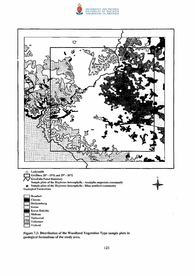
central parts of the study area (Figure 7.1). The hills were formed from sills and dykes of
Karoo Dolerite origin (Figure 7.2). Due to the small size of these dolerite dykes and sills,
they are not mapped on the 1 : 1 000 000 Geological Map. Subsequently they are not
identified by means of the ARC.· INFO computer programme that was used to derive the
geology represented in the sample plots. The Dolerite was, however, noted during the
field survey. Karoo Dolerite is a dark-grey to nearly black, igneous rock, popularly
known as "Ysterklip", which intrude the sedimentary rocks of the Karoo Sequence. The
occurrence and distribution of this rock is therefore mainly limited to the central Karoo
Basin and the adjacent areas. The texture of dolerite varies considerably, mostly being
fme- to medium grained, but coarse-grained types are also found.
A result of the woody nature of the communities where this vegetation type is located, a
physiognomy different from the surrounding grassland areas is created. This vegetation
consists of a grass layer with a shrubby woody element that becomes dominant in the case
of the Maytenus heterophy/la - Rhus pentheri community. The presence of the woody
species Maytenus heterophylla is diagnostic to the Woodland Vegetation Type.
119
(i Ladysmith r:=J. Gridlinc~ 28°- 29°8 and 29°- 30°E /V KwaZulu-Natal Boundary
e Sample plots of the Maytcnus hcterophylla- Acalypha angustata community e Sample plots of the Maytcnus hctcrophylla- Rhus pcnthcri community
Altitude
Altitude of the study area, contours lOOm intcn·al 750-1100
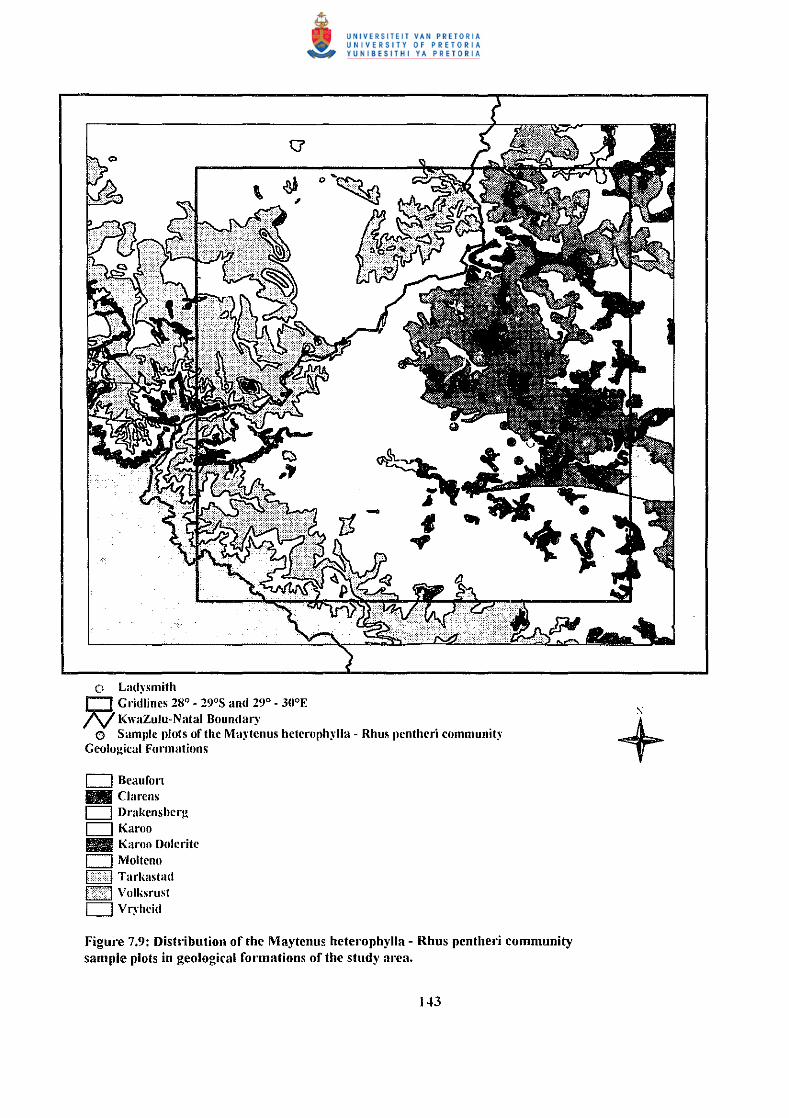
Figure 7.2: Disllibution of the Woodland Vegetation Type sample plots in ge~logical formations of the study area.
121
N
+
The absence of Monocymbium ceresiiforme separates this vegetation type from the
Grassveld Vegetation Type. Various woody species occur abundantly in the sub
communities and variations of the Woodland Vegetation Type. The tree Rhus dentata
differentiates this Vegetation Type from the Open Thomveld Vegetation Type. The
Southern Tall Grassveld (Acocks #65) and the Valley Bushveld (Acocks # 23) are
represented in the Woodland Vegetation Type.
The Woodland Vegetation Type is divided by TWINSPAN into the following
communities:
7 .I. The Maytenus heterophylla - Acalypha angustata community
7.2. The Maytenus heterophylla- Rhus pentheri community
Although the Maytenus heterophylla - Acalypha angustata community contain elements
of grassveld, the geological substratum as well s~ the presence and absence of
characteristic and diagnostic species resulted in the inclusion into the Woodland
Vegetation Type. Acocks (1988) described this area as an open savanna with Acacia
species in a sourish, mixerl grassveld, abundant on dolerite. The vegetation on the
hillsides is marginal to the Valley Bushveld and Scrub Forest, which merges into the
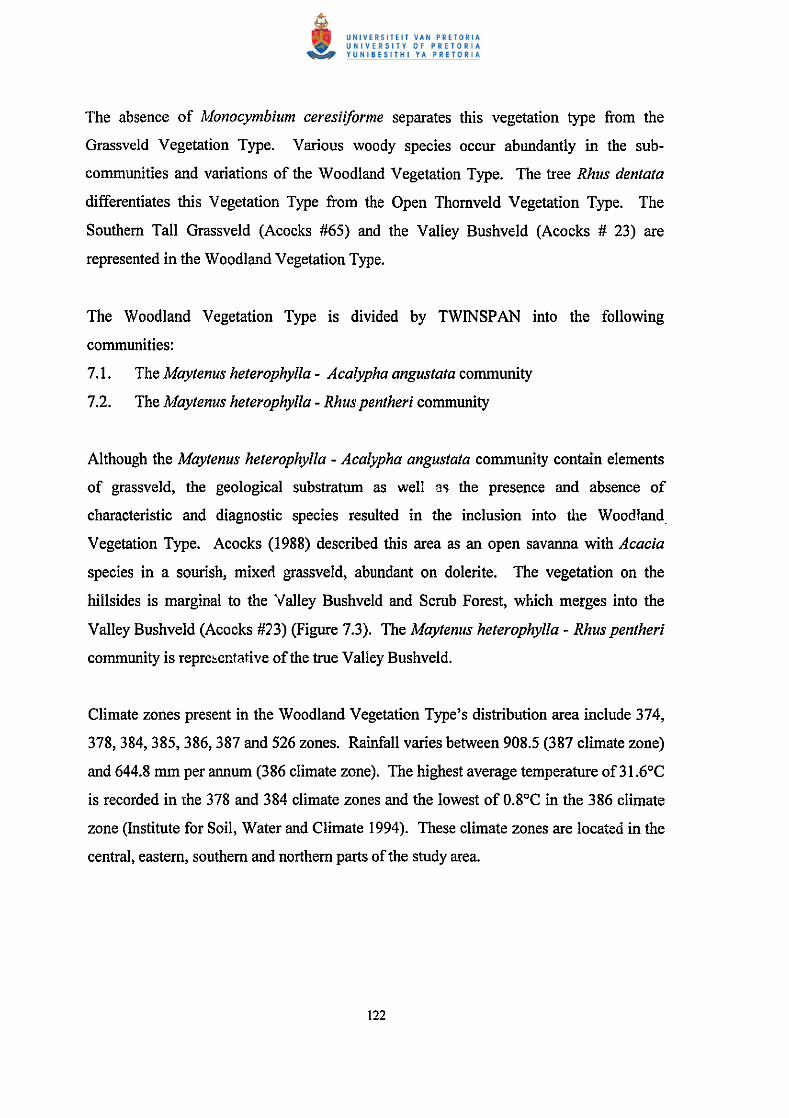
Valley Bushveld (Acocks #'23) (Figure 7.3). The Maytenus heterophylla- Rhus pentheri
community is reprehentative of the true Valley Bushveld.
Climate zones present in the Woodland Vegetation Type's distribution area include 374,
378, 384, 385, 386, 387 and 526 zones. Rainfall varies between 908.5 (387 climate zone)
and 644.8 mm per annum (386 climate zone). The highest average temperature of31.6°C
is recorded in the 378 and 384 climate zones and the lowest of 0.8°C in the 386 climate
zone (Institute for Soil, Water and Climate I 994). These climate zones are located in the
central, eastern, southern and northern parts of the study area.
122
() Lad)·smith D. Gridlincs 28°- 29°8 and 29°- 30°E N KwaZulu-Natal Bounda~·
0
•
• •• • •
• • •
• •
" e Sample plots of the Ma~·tcnus hctcroph~·lla- Aca~ypha angustata community e Sample plots of the Maytcnus hctcrophylla- Rhus pcnthcri community
Acock.'i Veld T~·pcs Ia Cymbopogon- Thcmcda V jd (S~mdy) (#.t8'1 r=J Highl:md Sour\"Cid and Dofmc Sournh.l (#4-1) + CJ Highland Suurnld to C~·mbo)wgon- Thcmcd~ Transition (Eastcm Frt·c State High\'Cid) (~9) hi::rl Natal Sour S:md•cld (#66) CJ Southern Tall Grass\·cld (#65) .. Thcmcda Veld to C~·mhopupogon- Thcmcda Veld Transition (Patch~·) (#53) IE::] Thcmcda- Fcstuca Alpine Veld (#58) 111111 Valle)· Bush•·cld (#23)
Figuo~ 7.3: Distl'ibution of the Woodland Vegetation Type sample plots in Acocks Veld Types of the study area.
123
7.1 The Mayt!?IIIIS lzeteroplzylla- Acalypha augustata community
Two Way Indicator Species Analysis (TWINSP AN) separated this community from the
Maytenus heterophylla - Rhus pentheri community. The classification by means of
TWINSP AN and subsequent refinement by means of Braun-Blanquet procedures,
resal:ed in the recognition of the following sub-communities and variations (Table 9.1):
7. i .I The Trachypogon spica/us- Cheilanthes viridus sub-community
7.1.1.1
7.1.1.2
7.1.2
7.1.2.1
7.1.2.2
7.1.2.3
7.1.2.4
7 .1.2.4.1
7.1.2.4.2
7.1.2.5
The Euclea crispa - Pelargonium luridum variation
The Aloe marlothii- Cheilanthes viridus variation
The Acacia sieberiana - He/ichrysum rugulosum sub-community
The Cussonia paniculata -Melin is repens variation
The Diospyros lycioides - Cymbopogon excavatus variation
The Acacia sieberiana - Lippia javanica variation
The Elionurus muticus - Diheteropogon amplectens variation
The Eragrostis curvula - Diheteropogon amplectens sub-variation
The Scabiosa columbaria - Elionurus muticus sub-variation
The Hyparrhenia dregeana - Leucas glabrata variation
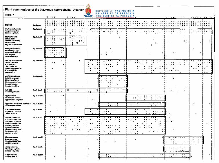
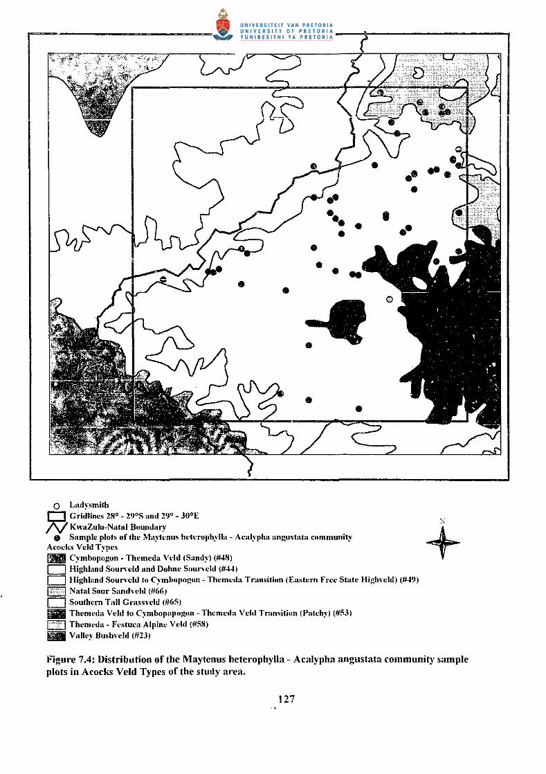
The Maytenus heterophylla - Acalypha angustata community represents the Southern
Tall Grassveld (#65) described by Acocks (1988), with some elements of the Natal Sour
Sandveld (#66) (Figure 7.4). Granger (1996) described the greater part of this community
as the Natal Central Bushveld (#25), lying at lower altitudes. However, elements of the
North-eastern Mountain Grassland (Bredenkamp et. a!. 1996c) (#43) and the Wet Cold
Highveld Grassland (Bredenkamp et. a!. 1996a) (#41) both present at higher altitudes, are
also found (Figure 7 .5).
124
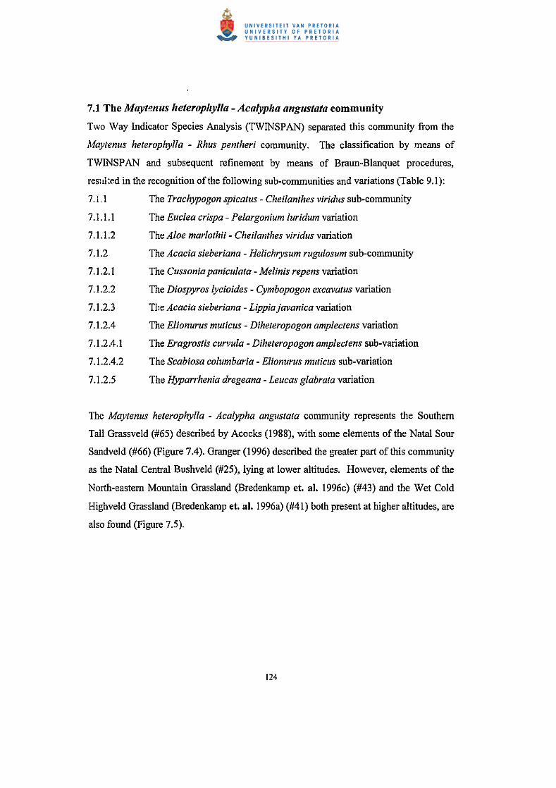
Plant communities of the Maytenus heterophylla- Acalypha angustata community.
Tablo7.1
' , , , . ' . , ' '' , ' " , ' "' , ' .. • I I I I I I I I I ' ' ' ' ' ' ' ' ' • .. .. ' ' ' I 0 "' ' I ' ' ' z z z z z 2 l 4 ' n o o o 1 ' '" 2 z 3 3 3 ' ' '" 3llll35 I 3 3 3 3 5 ' "' ' I ' 3334444 I ' .. , 9 0 0 l I ' ". • ' 5525177 7 7 l 0 • ' ' t Q I 0 0 1 2 I 0 0 I . , '" Zl44400 ' 7 1 1 1 z I I I a I
IIPECIES 8p. G"'UP I ' 1710134 I • ' ' ' " I I ~ 0 . ' ' ' ' 7171901 • 7 2 ' I 4 5 Z 7 I ' 0 l 1 5 7 4 ' 7 .. ' .. " ". 0$:13710 I $ I I I
I 1 • !I Aal.I);>'IIM!gUS!ato I . ' ' . ' .. I ' . ' ' I ' .. . I ' ' ... ' ' I ' ' . ... ' .. , ' . ' I ' . '. 1 I A • I LJ>onolir~ ' ' . . ' .. ' ' ' . . ' . .. . ' I I ' I I C.O..I.lnltH!rri"lduJ Sp.G,upD I . ' .. . . ' • A A 1 .. ' ' . ' I I I Euc;~oaaupo I ' ' ' ' '" I . . ' I . I I . I I I
~-- I ' ' . I ' . ' ' I I I ' ' I I . I ~~- I ' ' ' I . ' ' ' I I . I . ' . ' I I . I ~I"OJ)Ial!IIW .. ' ' I I ' I I
I I I I ~- ...... Sp.Q,upC I ' ' ' ' I I . . I I Prota:~••PP. I • R • • .. I I ~lefiOO>'" I ' ' ... I . . ' .. I . Rotusflrlldus I ' ' ' ' I . ' I I
li il I -- Sp.G"'IIJIG . ' ' ' ' . . ' ' . .. ' Ri'labdo~c:ai)<SIIo ' I I ' ' ' . ' ' -- ' . I ' . . ' . ' I I
I! ! !I I
P)?n.oo«.~~"""""~ 5p.QrcupH ' ' . . ' ' . . . . ' ' . ' So~ot> ...... ~ . ' ' I . ' ... ' I I
' ' ! i i il·
I ' ~("<!J::.\>!.Iol Sp. Group I ' ' . . . .. . . . . . ' I H~>=OU I . ' . . ' . . ' I ' 7Rg~ntlP'JI':.I" ' ' . . . . . . . ' . ' ' ' C<>rrrafl()doctpM!a Gp.Q,..,upJ ' . . . . . . . ' . . . . . ' .. ' . .. ' ' .. .. ' ' . ' ' ' ~.~(JIIh~o I . ' . ' . ' ... . ' . ' . ' . . . . . .. I ' ' -- I ' ' ' ' . ' . I ' ' .. ' ' ' ' ' ' . I . I I Rhollclu~JSirld«rtllto ' . . ' ' ' . . .. I . '
. ' ' I I . ' --- ' .. .. ' . . ' . I , .. . ' ' ' ' ' . . I I I Cotlpobofi.Y.enW ' . I . . ' .. . ' . . ' . I I ' ~l.:tltnlmei;U . ' I ' ' . . ' ' ' ' ' I ' ' ' I ' ' ~-"' ' . ' . ' .. ' . I . . I I Clabbe• /lh..to . ' ' . ' .. . .. .. . ' ' ' ' £liorn.nnm.t.,... lp.O,..,upK ' ' ' ' ' ' ' ' . ' . ' ' ' ' ' ' ~ ' il ~~ I . I ' I ' 1: •• 1 • I .. ~UOf•:M I I ' I .. .. I . ~3~: I I I ' ' . .
I I I
li il Abl:tfg<urdl'a owta !lp.O,..,upL ' ' I . ' .. 171~11Q«fa I ' ' I ' . -*- I I I l ' . I
I! ! ! !I. . """""""" sa.G,upM I ' . ". ' SltilOdorMOWI I ' ' ' . ' . I ' ' ' I
Sample plots of this community are located on slopes of rocky hills. A high degree of
rockiness is characteristic, except for the Hyparrhenia dregeana - Leucas gli.lbrata
variation. Soils represent the Mispah form (Orhtic A, hard rock) (Macvicar et. al. 1977).
The vegetation of the rvcky hills tends to be open with shrubby clements of woody
species. The woody layer is less prominent than in the Maytenus heterophylla - Rhus
pentheri community, mostly found in the Valley Bushveld (Acocks #23). The
characteristic species Acalypha angus/ala (Species group A) is widely distributed
throughout the study area and is associated with open grassveld.
These communities are difficult to reach due to steep slopes and high degree of rockiness.
The geology comprises of Karoo Dolerite sills and dykes, present as rocky hills (Figure
7.6). The vegetation of this community is over-utilised, thus causing encroachment of
woody species not normally present. This over-utilisation is also confirmed by the
prominent forbs in the herbaceous layer.
This community is distinguished from the Maytenus heterophylla - Rhus pentheri
community by the presence of the forbs Acalypha angustata and Leonotis ocymifolia
(Species group A) (Table 7.1). The general species present (Species group W) as well as
species that are prominent in most c1 th.: sub-communities and variations indicate that
this community should be regarded as grassveld that is transitional to the Maytenus
heterophylla - Rhus pentheri community. Many of these species are widely distributed
throughout the grassveld in the study area. A woody succulent species that is
conspicuous on most hillslopes is Aloe marlothii (Species group R), creating a
conspicuous physiognomy.
Climate zones that are present in the distribution area of the Maytenus heterophylla -
Acalypha angustata community includes zones 378, 384, 385, 387 and 526 (Institute for
Soil, Climate and Water 1994). Rainfall varies from a minimum of 695.9 (climate zone
526) to a maximum of908.5 mm (climate zone 387) per annum. A moisture gradient is
present in this community.
126
0 Lad~·smith
Q_ Gridlines 28°- 29°S and 29°- 30°E N KwaZulu-Natal Boundal1"'
• •
•• • • • • •
0 Sample plots of thl· Ma~'h:nus hl'tcro)Jh:"·lla - Acal)·pha angustata communil)· Acocl{s V cld T)·pcs ll!ill Cymbopo~on- Themeda Vdd (Sand)·) (#.18) c:::J Highland Sourwld and Dohne Suun dd (#44)
•• • • • • •
CJ Highhmd Soun·cld to C:'·mhopogun- Thcmcda Tr-.msition (Eastern Free State Highn·ld) (#49) P•<•l Natal Sour Sandwld (#66) c:::J Southern Tall Grassnld (#65) Iiiii Thcmeda Veld to C~:mhopopogon- Thcmcda Veld Transition (Patch)·) (#53) F . 7] Themeda- Festuea Alpine Veld (#58) ll!il Valle)· Bushwld (#23)
" +
Figure 7.4: llistJibution of the Maytenus heter·ophylla- Acalypha angustata community sample plots in A cocks Veld Types of the study ar·ea.
127
• Ladysmith D. Gridlines 28°- 29°S and 29°- 30°E N KwaZulu-Natal Boundary
g Sample plots of the Ma;ytcnus hctcroph~·lla- Acal)·pha angustata community Low and Rebelo Vegetation Types - Afromontanc Forest (#2) ®ttil Valle~· Thickets (#5) k"'!?l Natal Central Bushwld (#25) 0 Moist Cool Highwld Grassland (#39' CJ Moist Cold High,·eld Grassland (#40) 0 Wet Cold High,·cld Grassland (#41) llfl! Moist Upland Grassland (#42) [=.J North-eastern Mountain Grassland (f~3) f¥3i:~~l Afro Mountain Grassland (#45) h I Alii Mountian Grassland (#46)
~
+
Figure 7.5: Distribution of the Maytenus hetet·ophylla - Acalypha angustata community sample plots in Low and Rebelo Vegetation Types of the study area.
128
Certain sample plots occur in the dry northern and central eastern parts, while others are
present in the central and southern parts, where rainfall is higher. Some sample plots are
located in the high mountain areas with a high rainfall and mist. The average rainfall
figures of the different climate zones are relative low when compared to a rainfall of
1510.8 mm per annum in the 360 climate zone. The 360 climate zone is situated in the
western part of the study area in the high mountain regions.
Only small differences in altitude were noted in the different variations of the Maytenus
heterophylla - Acalypha angustata community. Altitude ranges from 1 000 - 1 400 m.
Only in some ~'ases are altitudinal differences important in differentiating between
variations. Climatic and geographical differences are however important in determining
the distribution of the variations.
7.1 I. The Trachypogon spica/us- Cizeilantlzes viridis sub-community
Sample plots representing this sub-community are located on the crests and slopes of
rocky hills in the eastern central and northeastern parts of the study area. Shallow soils of
the Mispah soil form are predominantly found, rockiness is high and the rock cover varies
between 15 and 60%. The size of the rocks is in the 500 - 1 000 mm class. Species that
are diagnostic to this community, include the xerophytic fern Cheilanthes viridis, the
woody species Euclea crispa and the forb Rhynchosia reptabunda as well as the grass
species Tristachya leucothrix and the dwarf shrub Rhus discolor (Species group B) (Table
9.1).
This sub-community is found in the Southern Tall Grassveld (#65), described by Acocks
(1988). This correlates with the North-eastern Mountain Grassland (#43) described by
Bredenkamp et. a!. ( 1996c) as predominantly grassland on shallow lithosoils, derived
from a variety of rock types.
Utilisation is severe and most sample plots represent disturbed areas, with species like
Conyza podocephala (Species group I) and various other forb species present. Due to
129
differences in floristic composition, altitude, geographical position and climatic
influences, this sub-community is divided into two variations.
7.1.1.1 The Euclea crispa- Pelargonium luridum variation
Sample plots representing this variation are located on crests anu slopes (20°) of rocky
hills in the northeastern part of the study area. The altitude ranges from I 200 to I 400 m
a.m.s.l. The Southern Tall Grassveld (#65), described by Acocks (1988) is represented.
Bredenkamp et. a!. (1996c) described this vegetation as North-eastern Mountain
Grassland (#43). The Euclea crispa- Pelargonium luridum variation is found in the 387
climate zone with an average rainfall of 908.5 mm per annum. Mean average
temperatures vary between a maximum of 26.5 oc in January and a minimum of 4.4 oc during July. Soils are shallow and rock cover varies between 31 and 60%, rocks of up to
1 000 mm diameter are found.
This variation is characterised by Species Group C (Table 7 .I), consisting of the
characteristic forb species Pelargonium luridum, Protasparagus spp., Chaetacanthus
setiger, Eriospermum spp. and Rubus rigidus. Prominent species occurring in this
variation, but not found in the Aloe marlothii - Cheilanthes viridus variation, include the
grass species Eragrostis racemosa, Eragrostis curvu/a (Species group W) and the forb
species Lactuca capensis and Crabbea hirsuta (Species group J). It is further
distinguished by the absence of species groups R and V.
The grazing intensity is not severe, partly as a result of inaccessibility, subsequently a
high vegetation cover is noted. However, the presence of many forbs and unpalatable
grass species, such as Paspalum dilatatum (Species group J), Melinis repens and
Cymbopogon excavatus (Species group W) is an indication that the vegetation of this
variation is indeed disturbed to a certain state.
130
0 Ladysmith D Gridlines 28° - 29°S and 29° - 30°E 1'\/KwaZulu-Natal Boundary
fJ Sample plots of the Maytenus heterophylla - Acalypha angustata community Geological Formations
D Beaufort
- Clarens D Drakensberg D Karoo - Karoo Dolerite D Molteno ki? q Tarkastad a Volksrust D Vryheid
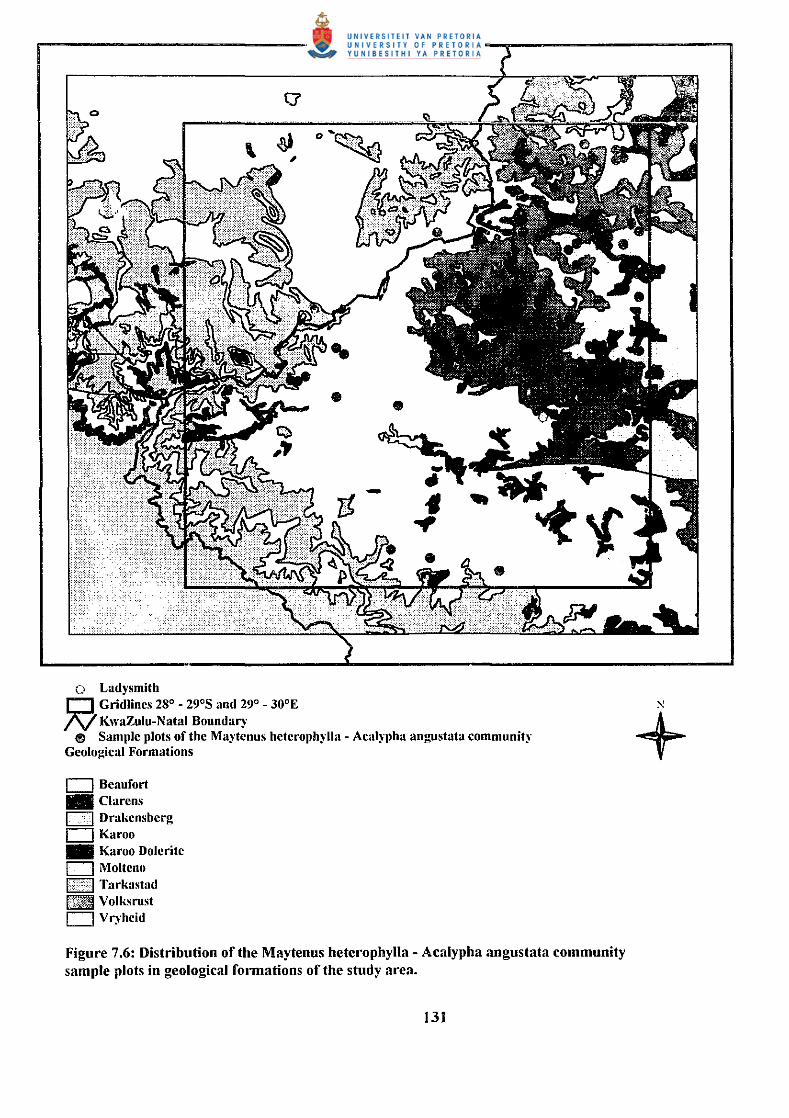
Figm·e 7.6: Distribution of the Maytenus heterophylla - Acalypha angustata community sample plots in geological fotmations of the study m·ea.
131
7.1.1.2 The Aloe marlotlzii- Clzeilantlzes viridus variation
The absence of species group C and the presence of species groups R and V (Table 7 .I)
distinguish tllis variation from the Euclea crispa - Pelargonium luridum variation.
Sample plots of this variation occur at altitudes (1 000 to 1 200m a.m.s.l.) lower than the
Euclea crispa - Pelargonium luridum variation and under slightly drier conditions.
Sample plots representing this variation are present on the crests and slopes of rocky hills
distributed throughout the eastern central parts of the study are~. Various climate zones
are represented, the average rainfall is however lower than in the Euclea crispa -
PelargoniU111luridum variation (650 - 750 mm per annum) (Institute for Soil, Climate and
Water 1994). Slopes of20° incline, rocks with diameter of 1 000 mm and cover of 40%
are present in this variation.
Utilisation and grazing in this variation varies considerably, from areas with little
evidence of grazing to sample plots representing a disturbed condition. This is evident in
the many forb species and individuals that are present, but not necessarily donlinating the
vegetation. Prominent species include the grasses Hyparrhenia hirta, Melinis repens and
Cymbopogou .:xcavatus (Species group W), the fern Cheilanthes viridus (Species group
B), th. woody succulent Aloe marlothii (Species group R) and Rhus denta!a (Species
group W). This variation is poor in species.
7 .1.2 The Acacia sieberiana - Helichrysum rugulosum sub-community
This sub-community is characterised by the presence of Species Group D with the
characteristic species Helichrysum rugulosum, Setaria sphacelata, Hypoxis rigidula, Sida
rhombifolia, Solanum elaeagnifolium, Hypoxis iridifolia and Acacia caffra, as well as the
absence of Species Groups B and C (Table 7.1 ).
The Acacia sieberiana - Helichrysum rugulosum sub-community is found on the crests
and slopes of rocky hills with a well developed herbaceous layer. The woody layer is
represented by a few tree species, namely Cussonia paniculata (Species group F), Grewia
occidentalis (Species group P), Aloe marlothii (Species group R), Diospyros lycioides,
132
Cephalanthus natalensis (Species group S), Rhus dentata and Acacia sieberiana (Species
group W). Most of these species are present as shrubs and seedlings. Various climate
zones and veld types are represented in the distribution area of this sub-community. The
high degree of rockiness (30 - 50 % cover) resulted in the presence of the Mispah form.
The average rock size varies between 250 and 1000 mm. This sub-community is divided
into five variations.
7.1.2.1 The Cussonia paniculata- Melinis repens variation
This variation is situated in the central and eastern parts of the study area at altitudes
ranging from 1 000 to 1 200 m a.m.s.I. Sample plots are located on crests and slopes of
rocky hills. The average rock cover is more than 45% and rocks are larger than 500 mm.
The vegetation, described by Granger (1996) as Natal Central Bushveld (#25), is an open
savanna with scattered Acacia species and secondary grassland, dominated by
Hyparrhenia hirta.
The woody component is well developed, with the trees Cussonia paniculata (Species
group F), Aloe marlothii (Species group R), Maytenus heterophylla (Species group A),
Rhus dentata and Acacia sieberiana (Species group W) prominent. The herbaceous layer
is prominent with Helichrysum rugulosum (Species group D), Hermannia depressa
(Species group 0) and various other forb species.
Prominent grass species that occur in this variation include Aristida congesta ssp.
barbicollis (Species group N), Themeda triandra (Species group V), Hyparrhenia hirta,
Melinis repens and Cymbopogon excavatus (Species group W). No diagnostic species
group is recognised, but this variation is distinguished from other variations in the Acacia
sieberiana - Helichrysum rugulosum sub-community due to the absence of species groups
G, H, K, L, M, P, T and U (Table 7.1).
133
7 .1.2.2 The Diospyros lycioides- Cymbopogon excavatus variation
Sample plots of this variation are distributed throughout the central and northern parts of
the study area, and are situated on the crests and slopes of rocky hills in the Natal Central
Bushveld (#25) (Granger 1996). A high cover ofrocks is present (60 %), with sizes in
the order of 500 mm diameter. Sample plots of this variation are distributed in various
climate zones, the average rainfall is 650 to 750 mm per annum. A high degree of
utilisation, with further habitat factors like rockiness, steep slope incline and shallow soils
combined, result in a vegetation that is sensitive to grazing. The effect of grazing is
evident in the numerous forbs present, including Acalypha angustata (Species group A),
Helichrysum rugulosum (Species group D), Conyza podocephala (Species group J),
Berkheya radula (Species group N), Hermannia depressa, Phyllanthus parvulus (Species
group 0), Sea bios a columbaria and Schkuhria pinnata (Species group S).
The Diospyros lycioides - Cymbopogon excavatus variation is characterised by species
group E (Table 7.1). Woody species occurring in this variation include Grewia
occidentalis (Species group P), Diospyros lycioides (Species group S), Rhus dentata and
Acacia sieberiana (Species group W). This variation is grassland being invaded by tree
species as a result of poor agricultural practises.
7.1.2.3 The Acacia sieberiana- Lippiajava11ica variation
Various climate zones and veld types are represented in this variation. Sample plots are
distributed in the northern and eastern parts, also in the high altitude mountains in the
west of the study area. As is characteristically of the Maytenus heterophylla - Acalypha
angustata community, steep and rocky slopes also prevail in this variation. The rock
cover is more than 45% and rocks can be as big as 1 000 mm diameter. Utilisation is
severe and this is reflected in many forbs h1 the herbaceous layer.
The Acacia sieberiana - Lippia javanica variation is characterised by species group G
(Table 7.1 ). The forb layer is prominent, with species like Helichrysum rugulosum
(Species group D), Lippia javanica, Rhabdosiella calycina (Species group G),
134
Hermannia depressa (Species group 0), Anthospermum rigidum (Species group S),
Lantana rugosa and Bidens pilosa (Species group W) prominent. Other species that have
a high cover include the grass species Themeda triandra (Speci~s group V), Hyparrhenia
hirta, Eragrostis plana, Hyparrhenia dregeana, Melinis repens, Cymbopogon excavatus
(Species group W) as well as the woody species Diospyros lycioides (Species group S),
Rhus dentata and Acacia sieberiana (Species group W).
7.1.2.4 The Elionurus mutic11s- Dilteteropogon amplectens variation
This variation is distributed through the central, central-western and southern parts of the
study area, in various climate zones and veld types. The soil form is exclusively of the
Mispah form as a result of a high degree of rockiness. Steep slopes and crests of rocky
hills with a dominant herbaceous layer and few woody species are characteristic of this
variation, as indicated by the characteristic species group K, consisting of Elionurus
muticus, Dicoma anomala, Convolvulus saggitatus, Aristida meridiana/is and Rhus
pentheri (Table 7.1 ).
Species that have a high cover in this variation are the grasses Trachypogon spicatus
(Species group W), Themeda triandra (Species group V), Hyparrhenia hirta,
Cymbopogon excavatus, Diheteropogon amplectens and Eragrostis curvula (Species
group W). The forbs Acalypha angustata (Species group A), Chaet<>canthus costatus,
Anthospermum rigidum and Scabiosa columbaria (Species group S), the woody
succulent Aloe marlothii (Species group R) and the woody species Diospyros lycioides
(Species group S) and Rhus dentata (Species group W) are also prominent.
Differences in climate as well as grazing intensity, veld management in the past and
subsequently a slight difference in species composition caused the development of two
sub-variations.
135
7.1.2.4.1 The Eragrostis curvula- Abildgaardia ovata sub-variation
This sub-variation is characterised by species group L and is distinguished from the
Scabiosa columbaria - Aster peglerae sub-variation by the presence of species groups M,
N and 0 as well as the absence of the woody species Grewia occident a/is (Species group
P) (Table 7.1). Prominent grasses in this sub-variation include Elionurus muticus
(Species group K), Trachypogon spicatus (Species group W), Themeda triandra (Species
group V), Hyparrhenia hirta, Melinis repens, Cymbopogon excavatus, Diheteropogon
amplectens and Eragrostis curvula (Species group W). The forbs Turbina oblongata
(Species group N), Hermannia depressa (Species group 0), Scabiosa columbaria
(Species group S), the woody succulent Aloe marlothii (Species group R) and the tree
Acacia sieberiana (Species group A) have high cover abundance values.
This sub-variation is distributed throughout the central western and southern parts of the
study area, predominantly in the 378 climate zone with an average rainfall of 707.8 mrn
per annum. This is lower than the average rainfall of the Scabiosa columbaria - Aster
peglerae sub-variation (850.00 mrn per annum) (Institute for Soil, Climate and Water
1994). The vegetation of the Eragrostis curvula - Abildgaardia ovata sub-vari?tion is
associated with open rocky hills in the Southern Tall Grassveld (Acocks 1988) (#65) or
the Natal Central Bushveld (Granger 1996) (#25). Few woody elements, except for Aloe
marlothii (Species group R), Rhus dentata, Acacia sieberiana (Species group W) and
Diospyros lycioides (Species group S) are present.
Slopes on the rocky hills are steep, up to 25°, and the rockiness percentage of the soil
surface is more than 46%, with rocks exceeding 500 mrn diameter. Grazing is severe, but
veld condition is good with grass species, such as Trachypogon spicatus (Species group
W), Themeda triandra (Species group V), Hyparrhenia hirta, Diheteropogon amplectens
and Eragrostis curvula (Species group W) dominant.
136
7.1.2.4.2 The Scabiosu columbaria- Aster peglerae sub-variation
This sub-variation is found on slopes of rocky hills, comprising the Karoo Dolerite
geological Formation. Soils are shallow and of the Mispah soil form (Macvicar ct. al.
1977), rockiness is characteristically high ( 40%) and the rock~ are up to I 000 mm
diameter. Sample plots of this variation are situated in the North-eastern Mountain
Grassland (#43), described by Bredenkamp et. al. (1996c) and the Highland Sourveld
(#44), described by Acocks (1988) as a pure grassveld with scrubbiness on the slopes.
The 384 climate zone, with an average rainfall of 850.0 rnm per annum is represented.
The vegetation has been utilised more severely than the Diheteropogon amplectens -
Abildgaardia ovata sub-variation, this is noticeable in the lower presence of palatable
grass species mentioned in the Eragrostis curvula - Abildgaardia ovata sub-variation.
Unpalatable grass species with a high cover such as Elionurus muticus (Species group K),
Melinis repens and Cymbopogon excavatus (Species group W), with various herbaceous
species, such as Acalypha angustata (Species group A), Aster peglerae (Species group
Q), Chaetacanthus costa/us and Scabiosa columbaria (Species group S) occur in this sub
variation.
7.1.2.5 The Hyparrlrenia dregeana- Leucas glabrata variation
Sample plots representing this variation are located on hill slopes situated in the 384
climate zone with an average rainfall of 850.0 mm per annum. Rocks are absent and soils
are deep, yellow and grey sandy-loam, derived from sandstone and shales of the Beaufort
Group. This variation is situated in the Wet Cold Highveld Grasslands (#41 ), described
by Bredenkamp et. al. (1996a) as moderately dense grassland, dominated by grasses.
A well developed woody component is present, consisting of Acacia cajfra (Species
group D) and Acacia sieberiana (Species group W), as well as a prominent grass layer of
Themeda triandra (Species group V), Hyparrhenia hirta, Cymbopogon excavatus,
Eragrostis curvu/a and Hyparrhenia dregeana (Species group W). This variation is
characterised by the presence of species group T as well as the absence of species groups
137
B, C and E to S (Table 7.1). Very few forb species are present, because of the dominant
grass layer, with only Acalypha angustata (Species E;roup A), Sida rhombifolia, Hypoxis
iridifolia (Species group D), Leucas glabrata (Species group T), Berkheya setifera
(Species group U) and Tagetus minuta (Species group W) occurring frequently.
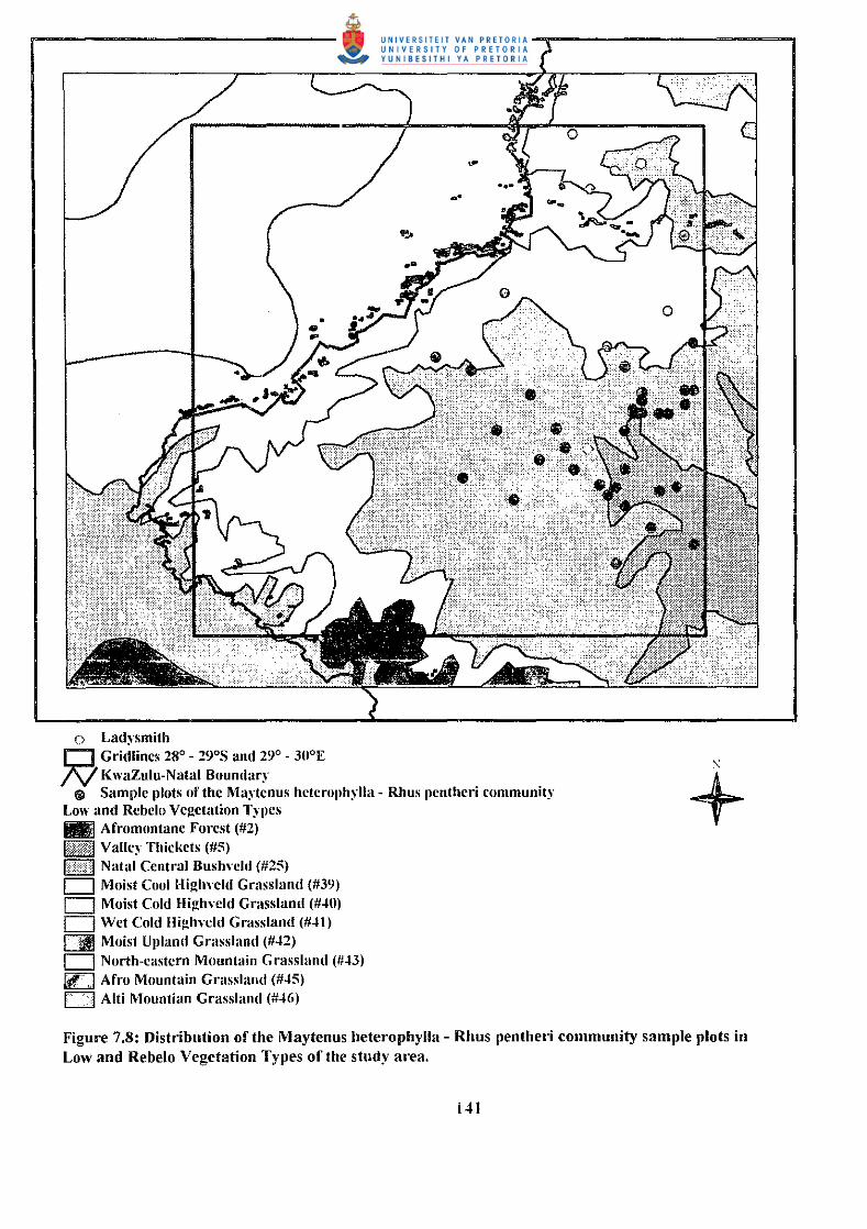
7.2 The Maytenus lteterophy/la- Rims pentheri com:;mni:)
The Two Way Indicator Species Analysis (TWINSPAN) (Hill 1979) separated this
woodland community from the Maytenus heterophylla -Acalypha angustata community.
Classification of the releves by means of TWINSP AN and subsequent refinement by
Braun-Blanquet procedures resulted in the recognition of the following sub-communities,
variations and sub-variations (Table 7.2):
7.2.1 The Acacia karroo -Acacia nilotica sub-community
7.2.1.1
7.2.1.2
7.2.1.2.1
7.2.1.2.2
7.2.1.2.3
7.2.1.2.4
7.2.1.2.5
7.2.2
7.2.2.1
7.2.2.2
The Panicum maximum - Bothriochloa insculpta variation
The Eragrostis superba - Sporobolus pyramidalis variation
The Buddleya loricata -Aloe marlothii sub-variation
The Vepris lanceolata - Ziziphus mucronata sub-variation
The Euclea natalensis - Hyparrhenia hirta sub-variation
The Eragrostis superba - Aristida congest a ssp. barbicollis sub-variation
The Acacia karroo - Heteropogon contortus sub-variation
The Rhus dentata - Paspalum dilatatum sub-community
The Acacia sieberiana - Bidens pilosa variation
The Cephalanthus natalensis - Diospyros lycioides variation
Sample plots of this community are found mainly in the Valley Bushveld (#23), described
by Acocks ( 1988) as the vegetation found in the valleys of numerous rivers draining into
the Indian Ocean (Figure 7. 7). These valleys are hot and receive less rain than the
intervening ridges, from 500 to 900 mm per annum. It is described by Low and Rebelo
(1996) as Valley Thickets (Lubke 1996) (#5), vegetation with a closed canopy of
138
Plant communities of the Maytenus hotorophylla ·Rhus pentherl community