35
City of Crystal, Minnesota Quiet Zone Application Canadian Pacific Paynesville Subdivision From Milepost 6.94 to 7.09 City of Crystal, Minnesota January 20, 2017 SRF No. 10039

City of Crystal, Minnesota Quiet Zone Application
Canadian Pacific Paynesville Subdivision From Milepost 6.94 to 7.09
City of Crystal, Minnesota
January 20, 2017
SRF No. 10039

Introduction This Quiet Zone Application is being submitted on behalf of the City of Crystal, Minnesota. The proposed quiet zone is located on the Paynesville Subdivision of the SOO Line/Canadian Pacific Railroad (CP). The proposed quiet zone will include two public at-grade crossings at Douglas Drive and West Broadway Avenue (County Road 8) in the City of Crystal. Hennepin County is the public authority responsible for each of these crossings. The City has been in close coordination with the County regarding the proposed quiet zone improvements.
All affected parties have the opportunity to submit information or comments within 60 days of the date of this Application. Please submit all information and/or comments to John Sutter, City of Crystal Community Development Director, who will serve as the point of contact for this project. John Sutter can be reached by telephone at 763-531-1130 or by email at [email protected]. Additional contact information is included at the end of this Application.
List of Crossings within the Quiet Zone Quiet Zone Name: City of Crystal, MN Quiet Zone
The current train volumes through the corridor are 24 trains per day at a maximum speed of 25 mph. The proposed quiet zone crossings, including the USDOT crossing ID numbers and the most recent daily traffic volumes, are summarized in Table 1. All traffic volumes were collected in June 2015. The locations of the proposed quiet zone crossings are shown in Figure 1.
Table 1. Proposed Quiet Zone Crossings
Crossing Name USDOT Crossing ID Average Daily Traffic
Douglas Drive (County Road 102) 688953S 8,357
West Broadway Avenue (County Road 8) 688952K 7,268
The current version of the USDOT grade crossing inventory forms for these crossings are included in Attachment A. They have been updated to reflect current traffic volumes and warning devices. There have been no accidents or incidents at any of the crossings in the last five years.
Crystal, Minnesota Quiet Zone Application 1 SRF Consulting Group, Inc.
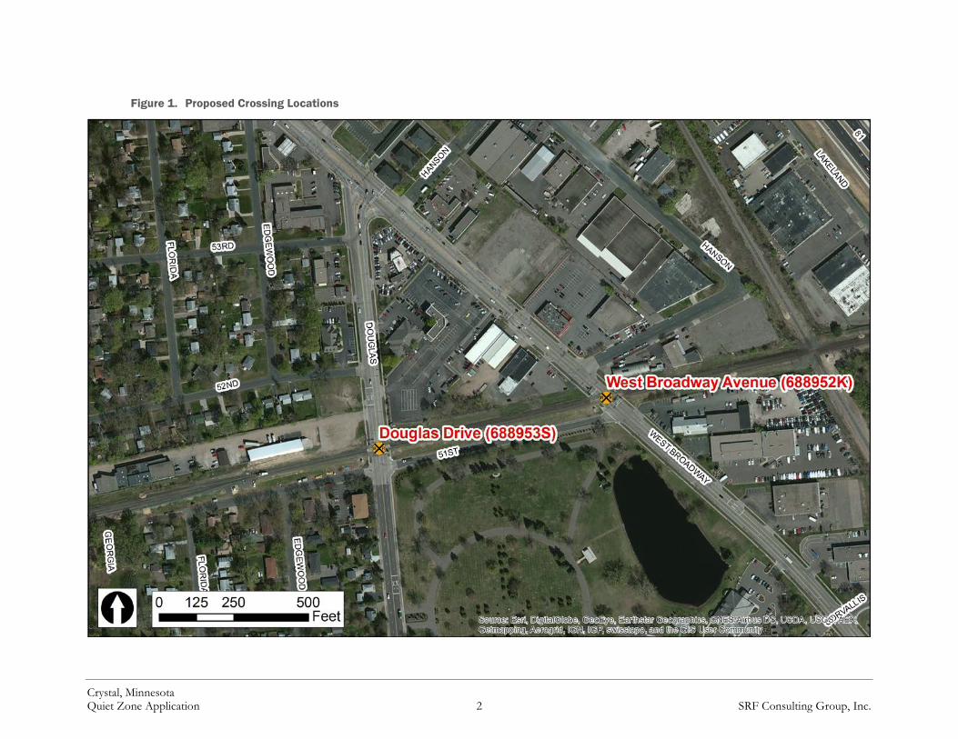
Figure 1. Proposed Crossing Locations
Crystal, Minnesota Quiet Zone Application 2 SRF Consulting Group, Inc.

Detail Concerning the Present Safety Measures According to the Federal Railroad Administration’s (FRA) Train Horn Rule, each public crossing in a new quiet zone must be equipped with gates and flashing lights with power out indicators. The Rule also requires that crossings be equipped with constant warning time (CWT) detectors where reasonably practical. Both crossings in the proposed quiet zone are equipped with the requisite gates, flashing lights, and CWT detectors.
Detailed Information about the Diagnostic Team Review The City has been in coordination with a number of organizations during this effort including the FRA, CP, Hennepin County, and the Minnesota Department of Transportation (MnDOT). The meeting minutes from a January 7, 2016 diagnostic meeting with representatives from these organizations are included in Attachment B.
Detailed Information on SSM/ASM Improvements The City intends to qualify for quiet zone implementation under regulator provision 222.39(b) by implementing Alternative Safety Measures (ASMs) at the Douglas Drive and West Broadway Avenue crossings. The City has been in close coordination with both Hennepin County and MnDOT regarding the specifics of the improvements for each crossing. It should be noted that the improvements described below differ somewhat from the improvements first described in the Notice of Intent (NOI). They have been modified to address the comments received from multiple stakeholders following the submittal of the NOI. Further information is included in the section Statement of Efforts to Address Comments.
Douglas Drive (688953S)
The City has proposed a 66-foot non-traversable median to the north of the crossing. A commercial business access prevents a full 100-foot median. The length of this median has been reduced from what was shown in the NOI to provide adequate turning geometry for tractor-trailers accessing the property in the northwest quadrant of the crossing.
The City has proposed a reduced length 43-foot non-traversable median to the south of the crossing as well as the closure of 51st Place to the west of the intersection. The length of this median is longer than what was shown in the NOI, but is still limited by the need to maintain a westbound left turn movement from 51st Place. The City has been in coordination with local emergency responders to ensure that proper access is maintained to properties on the truncated portion of 51st Place.
Crystal, Minnesota Quiet Zone Application 3 SRF Consulting Group, Inc.

These improvements qualify as an ASM under the Train Horn Rule due to the length of the southern median (<60 feet) and the risk reduction has been prorated to account for this. Advance warning signs and pavement markings will be installed compliant with the Manual on Uniform Traffic Control Devices (MUTCD). Left turn movement prohibition signs (R3-2) will also be installed on the southern median to prohibit southbound to eastbound left turns. A layout of the proposed improvements is shown in Figure 2.
Additional improvements will be made to ensure pedestrian connections are maintained. Truncated dome pedestrian warning strips will also be installed on the sidewalk approaches to the crossing.
West Broadway Avenue (688952K)
The City has proposed a 54-foot median to the north of the crossing (not including the portion of the median between the gate arm and the tracks). A longer median is not possible due to the proximity of Hanson Court.
The proximity of 51st Place on the south side of the crossing presents obstacles for safety improvements. It is important that access be maintained for northbound left turn movements onto 51st Place. This is a particularly critical movement for emergency vehicles when passing trains prevent the use of the West Broadway crossing. However, both Hennepin County and MnDOT stressed the importance of adequately restricting eastbound left turns from 51st Place onto West Broadway.
In order to satisfy both of these goals, the City is proposing a 14-foot median to the south of the crossing (not including the portion of the median between the gate arm and the tracks) as well as an additional 17-foot median after a gap to allow for the northbound left turn movement. In order to prevent eastbound left turns, a 100-foot median and “pork chop” raised median island will be installed on 51st Place in order channelize eastbound vehicles into a right turn. Left turn movement prohibition signs (R3-2) will also be installed on the 51st Place median to highlight the prohibition of this movement.
These improvements qualify as an ASM under the Train Horn Rule due to the reduced-length medians on each side of the crossing. Due to the proximity of 51st Place and the complexity of the improvements, the City will assume no risk reduction credit for the southern median. Even with this conservative estimation, the proposed improvements are sufficient to reduce the Quiet Zone Risk Index to a level below the Risk Index With Horns. Advance warning signs and pavement markings will also be installed compliant with the (MUTCD). A layout of the proposed improvements is shown in Figure 3.
Additional improvements will be made to ensure pedestrian connections are maintained. Truncated dome pedestrian warning strips will also be installed on the sidewalk approaches to the crossing.
Crystal, Minnesota Quiet Zone Application 4 SRF Consulting Group, Inc.

Figure 2. Douglas Drive Proposed Crossing Improvements
Crystal, Minnesota Quiet Zone Application 5 SRF Consulting Group, Inc.

Figure 3. West Broadway Avenue Proposed Crossing Improvements
Crystal, Minnesota Quiet Zone Application 6 SRF Consulting Group, Inc.

Statement of Efforts to Address Comments The City has made efforts to include all relevant stakeholders in the quiet zone review and implementation process. Following the submittal of the NOI, the City received comments from MnDOT and Hennepin County regarding the proposed improvements at each crossing. Through ongoing coordination with both parties, the City has revised its proposed improvements to address the concerns raised. The proposed improvements described in the previous section reflect these coordination efforts. A copy of the comments received as well as meeting minutes summarizing and documenting the City’s coordination efforts are included in Attachment C.
Commitment to Implementation The City of Crystal, Minnesota is submitting this Application to the FRA to express its desire to establish a quiet zone at two rail crossings along the CP Paynesville Subdivision. In order to qualify for quiet zone status, the City intends to implement ASM improvements at each of the crossings sufficient to bring the Quiet Zone Risk Index below the Risk Index with Horns. The City is committed to implementing a safe quiet zone that satisfies all of the requirements set forth in the FRA’s Train Horn Rule.
Quiet Zone Risk Analysis In order to qualify for quiet zone implementation, the crossing improvements must reduce the QZRI of the corridor to below either the RIWH or the Nationwide Significant Risk Threshold (NSRT). The NSRT is currently set at 14,347.
The results of the FRA’s web calculator and ASM calculation spreadsheet assuming the implementation of the improvements described above are included in Attachment D. The baseline QZRI for the corridor is 35,170 compared to a RIWH of 21,085. After implementation of the proposed improvements, the QZRI will be reduced to 16,746, which is below the RIWH, thereby meeting the requirements set forth by the FRA for implementing a quiet zone.
Crystal, Minnesota Quiet Zone Application 7 SRF Consulting Group, Inc.

Point of Contact Information Quiet Zone Name: City of Crystal, MN Quiet Zone
Date: January 20, 2017
The following individual is responsible for monitoring compliance with §222:
Name: John Sutter Title: Community Development Director Organization: City of Crystal Address: 4141 Douglas Drive
Crystal, MN 55422-1696 Phone: 763-531-1130 Email: [email protected]
Notification List Notice of this Quiet Zone Application was provided to the following individuals:
Name: Robert Lauby Title: Associate Administrator for Safety Organization: Federal Railroad Administration Address: 1200 New Jersey Avenue
Washington, DC 20590
Name: Tammy Wagner Title: Regional Crossing Manager Organization: Federal Railroad Administration Address: 200 West Adams Street, Suite 310
Chicago, IL 60606
Name: Ronald Ries Title: Staff Director – Highway Rail Crossing and Trespasser Division Organization: Federal Railroad Administration Address: 1200 New Jersey Avenue, Mail Stop 25
Washington, DC 20590
Name: Tom Domres Title: Regional Crossing and Trespasser Manager Organization: Federal Railroad Administration Address: 3651 Glenhurst Ave S
St. Louis Park, MN 55416
Crystal, Minnesota Quiet Zone Application 8 SRF Consulting Group, Inc.

Name: Jim H. Krieger Title: Manager Public Works – Southern Region Organization: Canadian Pacific Railroad Address: 120 South 6th Street, Suite 900 Minneapolis, Minnesota 55402
Name: Jim Weatherhead Title: Rail Administrator Organization: Minnesota Department of Transportation Address: 395 John Ireland Blvd – MS 470 St. Paul, MN 55155-1800 Name: Joe Gladke Title: Assistant Director, Engineering and Transit Planning Organization: Hennepin County Address: 701 4th Ave S. Suite 400 Minneapolis, MN 55415 Name: Mark Ray Title: City Engineer/ Public Works Director Organization: City of Crystal Address: 4141 Douglas Drive North Crystal, MN 55422-1696
Crystal, Minnesota Quiet Zone Application 9 SRF Consulting Group, Inc.

Attachment A:
USDOT Grade Crossing Inventory Forms

U. S. DOT CROSSING INVENTORY FORM DEPARTMENT OF TRANSPORTATION FEDERAL RAILROAD ADMINISTRATION OMB No. 2130-0017 Instructions for the initial reporting of the following types of new or previously unreported crossings: For public highway-rail grade crossings, complete the entire inventory Form. For private highway-rail grade crossings, complete the Header, Parts I and II, and the Submission Information section. For public pathway grade crossings (including pedestrian station grade crossings), complete the Header, Parts I and II, and the Submission Information section. For Private pathway grade crossings, complete the Header, Parts I and II, and the Submission Information section. For grade-separated highway-rail or pathway crossings (including pedestrian station crossings), complete the Header, Part I, and the Submission Information section. For changes to existing data, complete the Header, Part I Items 1-3, and the Submission Information section, in addition to the updated data fields. Note: For private crossings only, Part I Item 20 and Part III Item 2.K. are required unless otherwise noted. An asterisk * denotes an optional field. A. Revision Date (MM/DD/YYYY) _____/_____/_________
B. Reporting Agency C. Reason for Update (Select only one) D. DOT Crossing Inventory Number Railroad Transit Change in
Data New Crossing
Closed No Train Traffic
Quiet Zone Update
State Other Re-Open Date Change Only
Change in Primary Operating RR
Admin. Correction
Part I: Location and Classification Information 1. Primary Operating Railroad _____________________________________________________
2. State ________________________________
3. County ____________________________________
4. City / Municipality In Near __________________________
5. Street/Road Name & Block Number ________________________________| __________________ (Street/Road Name) |* (Block Number)
6. Highway Type & No. _______________________________________
7. Do Other Railroads Operate a Separate Track at Crossing? Yes No If Yes, Specify RR ____________, ____________, ____________, _____________
8. Do Other Railroads Operate Over Your Track at Crossing? Yes No If Yes, Specify RR ____________, ____________, ____________, _____________
9. Railroad Division or Region None _______________________
10. Railroad Subdivision or District None _______________________
11. Branch or Line Name None _______________________
12. RR Milepost _______|____________|____________ (prefix) | (nnnn.nnn) | (suffix)
13. Line Segment * _________________________
14. Nearest RR Timetable Station * __________________________
15. Parent RR (if applicable) N/A _____________________________
16. Crossing Owner (if applicable) N/A _________________________________
17. Crossing Type Public Private
18. Crossing Purpose Highway Pathway, Ped. Station, Ped.
19. Crossing Position At Grade RR Under RR Over
20. Public Access (if Private Crossing) Yes No
21. Type of Train Freight Intercity Passenger Commuter
Transit Shared Use Transit Tourist/Other
22. Average Passenger Train Count Per Day Less Than One Per Day Number Per Day_____
23. Type of Land Use Open Space Farm Residential Commercial Industrial Institutional Recreational RR Yard 24. Is there an Adjacent Crossing with a Separate Number? Yes No If Yes, Provide Crossing Number __________________
25. Quiet Zone (FRA provided) No 24 Hr Partial Chicago Excused Date Established _________________
26. HSR Corridor ID __________________ N/A
27. Latitude in decimal degrees (WGS84 std: nn.nnnnnnn)
28. Longitude in decimal degrees (WGS84 std: -nnn.nnnnnnn)
29. Lat/Long Source Actual Estimated
30.A. Railroad Use *
31.A. State Use *
30.B. Railroad Use *
31.B. State Use *
30.C. Railroad Use *
31.C. State Use *
30.D. Railroad Use *
31.D. State Use *
32.A. Narrative (Railroad Use) *
32.B. Narrative (State Use) *
33. Emergency Notification Telephone No. (posted) _________________________________
34. Railroad Contact (Telephone No.) ______________________________________
35. State Contact (Telephone No.) _________________________________
Part II: Railroad Information 1. Estimated Number of Daily Train Movements 1.A. Total Day Thru Trains (6 AM to 6 PM) __________
1.B. Total Night Thru Trains (6 PM to 6 AM) __________
1.C. Total Switching Trains __________
1.D. Total Transit Trains __________
1.E. Check if Less Than One Movement Per Day How many trains per week? ______
2. Year of Train Count Data (YYYY) __________
3. Speed of Train at Crossing 3.A. Maximum Timetable Speed (mph) __________ 3.B. Typical Speed Range Over Crossing (mph) From __________ to __________
4. Type and Count of Tracks Main __________ Siding __________ Yard __________ Transit __________ Industry __________ 5. Train Detection (Main Track only) Constant Warning Time Motion Detection AFO PTC DC Other None 6. Is Track Signaled? Yes No
7.A. Event Recorder Yes No
7.B. Remote Health Monitoring Yes No
FORM FRA F 6180.71 (Rev. 3/15) OMB approval expires 3/31/2018 Page 1 OF 2
✘ ✘06 06 2014
688953S
SOO Line Railroad Company [SOO] MINNESOTA HENNEPIN
CRYSTALDOUGLAS DRIVE✘
CSAH102
✘ ✘
MNS
ST PAUL SERVIC PAYNESVILLE MP0007.09
CRYSTAL CP
✘
✘ ✘
0
✘
✘ ✘
45.0401000 -93.3489990
F-0754
800-716-9132 651-366-3667
10 10 6
1510 15
1
✘
✘

FORM FRA F 6180.71 (Rev. 3/15) OMB approval expires 3/31/2018 Page 2 OF 2
U. S. DOT CROSSING INVENTORY FORM
A. Revision Date (MM/DD/YYYY) PAGE 2 D. Crossing Inventory Number (7 char.)
Part III: Highway or Pathway Traffic Control Device Information 1. Are there Signs or Signals? Yes No
2. Types of Passive Traffic Control Devices associated with the Crossing
2.A. Crossbuck Assemblies (count)
2.B. STOP Signs (R1-1) (count)
2.C. YIELD Signs (R1-2) (count)
2.D. Advance Warning Signs (Check all that apply; include count) None W10-1 ________ W10-3 ________ W10-11 __________ W10-2 ________ W10-4 ________ W10-12 __________
2.E. Low Ground Clearance Sign (W10-5) Yes (count_______) No
2.F. Pavement Markings 2.G. Channelization Devices/Medians
2.H. EXEMPT Sign (R15-3) Yes No
2.I. ENS Sign (I-13) Displayed Yes No
Stop Lines RR Xing Symbols
Dynamic Envelope None
All Approaches One Approach
Median None
2.J. Other MUTCD Signs Yes No 2.K. Private Crossing Signs (if private) Yes No
2.L. LED Enhanced Signs (List types) Specify Type _______________
Specify Type _______________ Specify Type _______________
Count __________ Count __________ Count __________
3. Types of Train Activated Warning Devices at the Grade Crossing (specify count of each device for all that apply) 3.A. Gate Arms (count) Roadway _____ Pedestrian _____
3.B. Gate Configuration 3.C. Cantilevered (or Bridged) Flashing Light Structures (count)
3.D. Mast Mounted Flashing Lights (count of masts) _________
3.E. Total Count of Flashing Light Pairs
2 Quad 3 Quad 4 Quad
Full (Barrier) Resistance Median Gates
Over Traffic Lane _____ Not Over Traffic Lane _____
Incandescent LED
Incandescent Back Lights Included
LED Side Lights Included
3.F. Installation Date of Current Active Warning Devices: (MM/YYYY) ______/___________ Not Required
3.G. Wayside Horn 3.H. Highway Traffic Signals Controlling Crossing Yes No
3.I. Bells (count)
Yes No
Installed on (MM/YYYY) ______/__________
3.J. Non-Train Active Warning Flagging/Flagman Manually Operated Signals Watchman Floodlighting None
3.K. Other Flashing Lights or Warning Devices Count ___________ Specify type ______________________
4.A. Does nearby Hwy Intersection have Traffic Signals? Yes No
4.B. Hwy Traffic Signal Interconnection Not Interconnected For Traffic Signals For Warning Signs
4.C. Hwy Traffic Signal Preemption 5. Highway Traffic Pre-Signals Yes No
6. Highway Monitoring Devices (Check all that apply) Yes - Photo/Video Recording Yes – Vehicle Presence Detection None
Simultaneous Advance
Storage Distance * ____________ Stop Line Distance * ____________
Part IV: Physical Characteristics 1. Traffic Lanes Crossing Railroad One-way Traffic Two-way Traffic Number of Lanes _______ Divided Traffic
2. Is Roadway/Pathway Paved?
Yes No
3. Does Track Run Down a Street?
Yes No
4. Is Crossing Illuminated? (Street lights within approx. 50 feet from nearest rail) Yes No
5. Crossing Surface (on Main Track, multiple types allowed) Installation Date * (MM/YYYY) _______/__________ Width * ______________ Length * _______________ 1 Timber 2 Asphalt 3 Asphalt and Timber 4 Concrete 5 Concrete and Rubber 6 Rubber 7 Metal 8 Unconsolidated 9 Composite 10 Other (specify) ________________________________________________________
6. Intersecting Roadway within 500 feet? Yes No If Yes, Approximate Distance (feet) _________________
7. Smallest Crossing Angle 0° – 29° 30° – 59° 60° - 90°
8. Is Commercial Power Available? *
Yes No
Part V: Public Highway Information 1. Highway System
(01) Interstate Highway System (02) Other Nat Hwy System (NHS) (03) Federal AID, Not NHS (08) Non-Federal Aid
2. Functional Classification of Road at Crossing (0) Rural (1) Urban
(1) Interstate (5) Major Collector (2) Other Freeways and Expressways (3) Other Principal Arterial (6) Minor Collector (4) Minor Arterial (7) Local
3. Is Crossing on State Highway System? Yes No
4. Highway Speed Limit ___________ MPH Posted Statutory
5. Linear Referencing System (LRS Route ID) *
6. LRS Milepost *
7. Annual Average Daily Traffic (AADT) Year _______ AADT _____________
8. Estimated Percent Trucks ___________________ %
9. Regularly Used by School Buses? Yes No Average Number per Day ___________
10. Emergency Services Route Yes No
Submission Information - This information is used for administrative purposes and is not available on the public website.
Submitted by __________________________________ Organization _______________________________________ Phone _______________ Date _____________ Public reporting burden for this information collection is estimated to average 30 minutes per response, including the time for reviewing instructions, searching existing data sources, gathering and maintaining the data needed and completing and reviewing the collection of information. According to the Paperwork Reduction Act of 1995, a federal agency may not conduct or sponsor, and a person is not required to, nor shall a person be subject to a penalty for failure to comply with, a collection of information unless it displays a currently valid OMB control number. The valid OMB control number for information collection is 2130-0017. Send comments regarding this burden estimate or any other aspect of this collection, including for reducing this burden to: Information Collection Officer, Federal Railroad Administration, 1200 New Jersey Ave. SE, MS-25 Washington, DC 20590.
06/06/2014 688953S
✘ 0 0✘
✘✘ ✘
✘
20
22
0
011
✘ 1
6 SIDELIGHT
✘
4 ✘✘ ✘
✘
✘ -75 ✘ ✘
✘
✘
✘
35
✘
✘
2011 009700 05 ✘ 97

U. S. DOT CROSSING INVENTORY FORM DEPARTMENT OF TRANSPORTATION FEDERAL RAILROAD ADMINISTRATION OMB No. 2130-0017 Instructions for the initial reporting of the following types of new or previously unreported crossings: For public highway-rail grade crossings, complete the entire inventory Form. For private highway-rail grade crossings, complete the Header, Parts I and II, and the Submission Information section. For public pathway grade crossings (including pedestrian station grade crossings), complete the Header, Parts I and II, and the Submission Information section. For Private pathway grade crossings, complete the Header, Parts I and II, and the Submission Information section. For grade-separated highway-rail or pathway crossings (including pedestrian station crossings), complete the Header, Part I, and the Submission Information section. For changes to existing data, complete the Header, Part I Items 1-3, and the Submission Information section, in addition to the updated data fields. Note: For private crossings only, Part I Item 20 and Part III Item 2.K. are required unless otherwise noted. An asterisk * denotes an optional field. A. Revision Date (MM/DD/YYYY) _____/_____/_________
B. Reporting Agency C. Reason for Update (Select only one) D. DOT Crossing Inventory Number Railroad Transit Change in
Data New Crossing
Closed No Train Traffic
Quiet Zone Update
State Other Re-Open Date Change Only
Change in Primary Operating RR
Admin. Correction
Part I: Location and Classification Information 1. Primary Operating Railroad _____________________________________________________
2. State ________________________________
3. County ____________________________________
4. City / Municipality In Near __________________________
5. Street/Road Name & Block Number ________________________________| __________________ (Street/Road Name) |* (Block Number)
6. Highway Type & No. _______________________________________
7. Do Other Railroads Operate a Separate Track at Crossing? Yes No If Yes, Specify RR ____________, ____________, ____________, _____________
8. Do Other Railroads Operate Over Your Track at Crossing? Yes No If Yes, Specify RR ____________, ____________, ____________, _____________
9. Railroad Division or Region None _______________________
10. Railroad Subdivision or District None _______________________
11. Branch or Line Name None _______________________
12. RR Milepost _______|____________|____________ (prefix) | (nnnn.nnn) | (suffix)
13. Line Segment * _________________________
14. Nearest RR Timetable Station * __________________________
15. Parent RR (if applicable) N/A _____________________________
16. Crossing Owner (if applicable) N/A _________________________________
17. Crossing Type Public Private
18. Crossing Purpose Highway Pathway, Ped. Station, Ped.
19. Crossing Position At Grade RR Under RR Over
20. Public Access (if Private Crossing) Yes No
21. Type of Train Freight Intercity Passenger Commuter
Transit Shared Use Transit Tourist/Other
22. Average Passenger Train Count Per Day Less Than One Per Day Number Per Day_____
23. Type of Land Use Open Space Farm Residential Commercial Industrial Institutional Recreational RR Yard 24. Is there an Adjacent Crossing with a Separate Number? Yes No If Yes, Provide Crossing Number __________________
25. Quiet Zone (FRA provided) No 24 Hr Partial Chicago Excused Date Established _________________
26. HSR Corridor ID __________________ N/A
27. Latitude in decimal degrees (WGS84 std: nn.nnnnnnn)
28. Longitude in decimal degrees (WGS84 std: -nnn.nnnnnnn)
29. Lat/Long Source Actual Estimated
30.A. Railroad Use *
31.A. State Use *
30.B. Railroad Use *
31.B. State Use *
30.C. Railroad Use *
31.C. State Use *
30.D. Railroad Use *
31.D. State Use *
32.A. Narrative (Railroad Use) *
32.B. Narrative (State Use) *
33. Emergency Notification Telephone No. (posted) _________________________________
34. Railroad Contact (Telephone No.) ______________________________________
35. State Contact (Telephone No.) _________________________________
Part II: Railroad Information 1. Estimated Number of Daily Train Movements 1.A. Total Day Thru Trains (6 AM to 6 PM) __________
1.B. Total Night Thru Trains (6 PM to 6 AM) __________
1.C. Total Switching Trains __________
1.D. Total Transit Trains __________
1.E. Check if Less Than One Movement Per Day How many trains per week? ______
2. Year of Train Count Data (YYYY) __________
3. Speed of Train at Crossing 3.A. Maximum Timetable Speed (mph) __________ 3.B. Typical Speed Range Over Crossing (mph) From __________ to __________
4. Type and Count of Tracks Main __________ Siding __________ Yard __________ Transit __________ Industry __________ 5. Train Detection (Main Track only) Constant Warning Time Motion Detection AFO PTC DC Other None 6. Is Track Signaled? Yes No
7.A. Event Recorder Yes No
7.B. Remote Health Monitoring Yes No
FORM FRA F 6180.71 (Rev. 3/15) OMB approval expires 3/31/2018 Page 1 OF 2
✘ ✘06 06 2014
688952K
SOO Line Railroad Company [SOO] MINNESOTA HENNEPIN
CRYSTALW BROADWAY AVE✘
CSAH 8
✘ ✘
TCWR
ST PAUL SERVIC PAYNESVILLE MP0006.94
CRYSTAL CP
✘
✘ ✘
0
✘
✘ ✘
45.0419010 -93.3505020
F-0072B
800-716-9132 651-366-3667
10 10 0
1510 15
1
✘
✘

FORM FRA F 6180.71 (Rev. 3/15) OMB approval expires 3/31/2018 Page 2 OF 2
U. S. DOT CROSSING INVENTORY FORM
A. Revision Date (MM/DD/YYYY) PAGE 2 D. Crossing Inventory Number (7 char.)
Part III: Highway or Pathway Traffic Control Device Information 1. Are there Signs or Signals? Yes No
2. Types of Passive Traffic Control Devices associated with the Crossing
2.A. Crossbuck Assemblies (count)
2.B. STOP Signs (R1-1) (count)
2.C. YIELD Signs (R1-2) (count)
2.D. Advance Warning Signs (Check all that apply; include count) None W10-1 ________ W10-3 ________ W10-11 __________ W10-2 ________ W10-4 ________ W10-12 __________
2.E. Low Ground Clearance Sign (W10-5) Yes (count_______) No
2.F. Pavement Markings 2.G. Channelization Devices/Medians
2.H. EXEMPT Sign (R15-3) Yes No
2.I. ENS Sign (I-13) Displayed Yes No
Stop Lines RR Xing Symbols
Dynamic Envelope None
All Approaches One Approach
Median None
2.J. Other MUTCD Signs Yes No 2.K. Private Crossing Signs (if private) Yes No
2.L. LED Enhanced Signs (List types) Specify Type _______________
Specify Type _______________ Specify Type _______________
Count __________ Count __________ Count __________
3. Types of Train Activated Warning Devices at the Grade Crossing (specify count of each device for all that apply) 3.A. Gate Arms (count) Roadway _____ Pedestrian _____
3.B. Gate Configuration 3.C. Cantilevered (or Bridged) Flashing Light Structures (count)
3.D. Mast Mounted Flashing Lights (count of masts) _________
3.E. Total Count of Flashing Light Pairs
2 Quad 3 Quad 4 Quad
Full (Barrier) Resistance Median Gates
Over Traffic Lane _____ Not Over Traffic Lane _____
Incandescent LED
Incandescent Back Lights Included
LED Side Lights Included
3.F. Installation Date of Current Active Warning Devices: (MM/YYYY) ______/___________ Not Required
3.G. Wayside Horn 3.H. Highway Traffic Signals Controlling Crossing Yes No
3.I. Bells (count)
Yes No
Installed on (MM/YYYY) ______/__________
3.J. Non-Train Active Warning Flagging/Flagman Manually Operated Signals Watchman Floodlighting None
3.K. Other Flashing Lights or Warning Devices Count ___________ Specify type ______________________
4.A. Does nearby Hwy Intersection have Traffic Signals? Yes No
4.B. Hwy Traffic Signal Interconnection Not Interconnected For Traffic Signals For Warning Signs
4.C. Hwy Traffic Signal Preemption 5. Highway Traffic Pre-Signals Yes No
6. Highway Monitoring Devices (Check all that apply) Yes - Photo/Video Recording Yes – Vehicle Presence Detection None
Simultaneous Advance
Storage Distance * ____________ Stop Line Distance * ____________
Part IV: Physical Characteristics 1. Traffic Lanes Crossing Railroad One-way Traffic Two-way Traffic Number of Lanes _______ Divided Traffic
2. Is Roadway/Pathway Paved?
Yes No
3. Does Track Run Down a Street?
Yes No
4. Is Crossing Illuminated? (Street lights within approx. 50 feet from nearest rail) Yes No
5. Crossing Surface (on Main Track, multiple types allowed) Installation Date * (MM/YYYY) _______/__________ Width * ______________ Length * _______________ 1 Timber 2 Asphalt 3 Asphalt and Timber 4 Concrete 5 Concrete and Rubber 6 Rubber 7 Metal 8 Unconsolidated 9 Composite 10 Other (specify) ________________________________________________________
6. Intersecting Roadway within 500 feet? Yes No If Yes, Approximate Distance (feet) _________________
7. Smallest Crossing Angle 0° – 29° 30° – 59° 60° - 90°
8. Is Commercial Power Available? *
Yes No
Part V: Public Highway Information 1. Highway System
(01) Interstate Highway System (02) Other Nat Hwy System (NHS) (03) Federal AID, Not NHS (08) Non-Federal Aid
2. Functional Classification of Road at Crossing (0) Rural (1) Urban
(1) Interstate (5) Major Collector (2) Other Freeways and Expressways (3) Other Principal Arterial (6) Minor Collector (4) Minor Arterial (7) Local
3. Is Crossing on State Highway System? Yes No
4. Highway Speed Limit ___________ MPH Posted Statutory
5. Linear Referencing System (LRS Route ID) *
6. LRS Milepost *
7. Annual Average Daily Traffic (AADT) Year _______ AADT _____________
8. Estimated Percent Trucks ___________________ %
9. Regularly Used by School Buses? Yes No Average Number per Day ___________
10. Emergency Services Route Yes No
Submission Information - This information is used for administrative purposes and is not available on the public website.
Submitted by __________________________________ Organization _______________________________________ Phone _______________ Date _____________ Public reporting burden for this information collection is estimated to average 30 minutes per response, including the time for reviewing instructions, searching existing data sources, gathering and maintaining the data needed and completing and reviewing the collection of information. According to the Paperwork Reduction Act of 1995, a federal agency may not conduct or sponsor, and a person is not required to, nor shall a person be subject to a penalty for failure to comply with, a collection of information unless it displays a currently valid OMB control number. The valid OMB control number for information collection is 2130-0017. Send comments regarding this burden estimate or any other aspect of this collection, including for reducing this burden to: Information Collection Officer, Federal Railroad Administration, 1200 New Jersey Ave. SE, MS-25 Washington, DC 20590.
06/06/2014 688952K
✘ 0 0✘
✘✘
✘
✘
✘
10
22
0
011
✘ 1
4 SIDES
✘
4 ✘✘ ✘
✘
✘ -200 ✘ ✘
✘
✘
✘
35
✘
✘
2011 008000 05 ✘ 37
Attachment B:
Diagnostic Meeting Minutes

SRF No.9084
1
CRYSTAL, MN
QUIET ZONE DIAGNOSTIC MEETING
MEETING MINUTES
January 7, 2016
ATTENDEES:
John Sutter, City of Crystal
Mark Ray, City of Crystal
Joe Gladke, Hennepin County
Jim Weatherhead, MnDOT
Tom Domres, FRA
Tammy Wagner, FRA
Jim H. Krieger, CP
Andy Mielke, SRF Consulting
Michael Palermo, SRF Consulting
The diagnostic meeting participants, including representatives from the City of Crystal, the Federal
Railroad Administration (FRA), Hennepin County, Canadian Pacific (CP), and the Minnesota
Department of Transportation (MnDOT), met at the City of Crystal Public Works Building to
discuss the steps necessary to implement a quiet zone in the City of Crystal under the FRA’s Train
Horn Rule. A copy of the sign-in sheet with contact information is provided as an attachment.
The meeting began with introductions and a brief project overview. The purpose of the meeting
was to investigate and gather input on the various Supplemental Safety Measure (SSM) and
Alternative Safety Measure (ASM) options available at each crossing in the proposed quiet zone.
The quiet zone diagnostic meeting is also an opportunity to identify any other concerns or issues
related to the crossings such as safety, traffic operations, etc.
Two public crossings, located along the Canadian Pacific Railroad at West Broadway Avenue and
Douglas Drive were identified for review. Meeting packets were distributed to the diagnostic team.
The packets included the following materials:
1. 8.5x11 aerial map showing the locations of the railroad and proposed quiet zone crossings
2. 8.5x11 aerial maps showing the layout of each crossing
3. United States Department of Transportation (USDOT) grade crossing inventory forms for
each of the crossings
4. A blank evaluation sheet for the diagnostic team members to document their preferred
SSM/ASM improvement options and other field notes
FRA crash reports for both of the crossings were also collected and made available. However,
since no crashes have occurred within the last five years, these reports were not included in the
diagnostic packet. The FRA’s risk calculation formulas consider only crashes occurring within a
five-year timeframe. SRF explained that each crossing meets the minimum quiet zone
requirements of gates, lights, and constant warning time (CWT) detection. The FRA Inventory

Crystal, MN Quiet Zone Page 2
Diagnostic Team Meeting Minutes
Form indicated motion detector circuitry. However, CWT was confirmed on site to be installed at
both crossings.
A summary of the notes, discussion items, and recommended improvements for each crossing is
provided in the tables on the following pages. General comments from the meeting that apply to
all crossings are as follows:
1. The U.S. DOT Crossing Inventory Form was corrected. The maximum time table speed is
25 MPH not 15 MPH. There are 24 trains running on the line with 12 during the day and
12 at night.
2. The City of Crystal asked if the rear train speed was an issue as opposed to the head of the
train. It was clarified that the current standards for the area do not allow an increase of
speed until the rear of the train crosses the switch. From a quiet zone perspective only the
head speed is important.
3. Either channelization devices or non-traversable medians were identified as the preferred
crossing improvement type for these crossing. Other improvement options were discussed
but determined to be unsuitable or undesirable.
a. In the case of non-traversable medians, the diagnostic team recommended a height
of eight to ten inches rather than the required six. If any portion of the median is
found to be less than six inches, the median will not be compliant with the Train
Horn Rule. The extra height allows for some degree of contractor error and provides
space for a roadway overlay without affecting the effectiveness of the medians.
The next steps of the quiet zone implementation process were also reviewed. Following the
diagnostic meeting, CP and the City will work to identify the appropriate crossing improvements
at each crossing necessary to qualify for a quiet zone. If the quiet zone moves forward, a Notice of
Intent will be submitted to all stakeholders providing an overview of the proposed improvements.
This notice is subject to a 60-day review period. Due to the close proximity of public roadways at
some of the crossings, it is anticipated that ASM crossing improvements will be used, requiring
the submittal of a Quiet Zone Application to the FRA. This application must be reviewed by the
FRA’s Railroad Safety Board and the processing time is currently estimated at six to nine months.
Construction of the improvements typically occurs following FRA approval of this application.
Construction may occur prior to approval, but any modifications required by the FRA would need
to be incorporated. Once the Quiet Zone Application is approved and the crossing improvements
are installed, a Notice of Quiet Zone Establishment will be submitted to all stakeholders. The quiet
zone will go into effect 21 days after this notice.

Crystal, MN Quiet Zone Page 3
Diagnostic Team Meeting Minutes
West Broadway Avenue FRA Crossing ID: 688952K Crossing Improvement Options (Rank Top 3):
SSM
s:
2 4-Quadrant Gate Non-Traversable Medians Channelized Delineators Wayside Horns Closure One-Way Streets
ASM
s:
3-Quadrant Gate 1 Reduced Length Non-Traversable Medians Reduced Length Channelized Delineators Other (Describe):
No Treatment
Notes:
Crossing was confirmed to have CWT.
North side of the crossing would allow for 68’ median before a commercial access.
A left-in, right-in-right-out is suggested for 51st Place due to the skewed crossing. This will prevent drivers from turning from 51st Place (EB to NB) to circumvent the gates.
A median is proposed south of the crossing to provide additional safety benefits while still providing westbound access to 51st Place.
If left turn mitigation cannot be achieved with a ¾ median restriction, MnDOT recommends that 4-Quadrant gates be installed at the West Broadway Crossing.
Douglas Drive FRA Crossing ID: 688953S Crossing Improvement Options (Rank Top 3):
SSM
s:
4-Quadrant Gate Non-Traversable Medians Channelized Delineators Wayside Horns Closure One-Way Streets
ASM
s:
3-Quadrant Gate 1 Reduced Length Non-Traversable Medians Reduced Length Channelized Delineators Other (Describe):
No Treatment
Notes:
Crossing was confirmed to have CWT.
North side of the crossing would allow for 84’ median before a commercial access.
South side of the crossing would allow for 31’ median/channelized device due to the proximity of 51st Place. This length qualifies only as an ASM, requiring a Quiet Zone
Application. MnDOT noted that they will be reconstructing the crossing in 2017. It will follow the
current layout.

Attachment C:
Comments in Response to NOI and Summary of Ongoing Coordination


Minnesota Department of Transportation
Office of Freight and Commercial Vehicle Operations Mail Stop 470 395 John Ireland Blvd. Tel: 651/215-6330 St. Paul, MN 55155-1899 Fax: 651/366-3720
An Equal Opportunity Employer
April 14, 2016 Phone: 651/366-3671 [email protected] Mr. John Sutter, Community Development Director City of Crystal 4141 Douglas Drive Crystal, MN Re: City of Crystal; Notice of Intent for a Quiet Zone - State of Minnesota response Railroad: Canadian Pacific Location: Douglas Drive (aka CSAH 102) US DOT # 688953S West Broadway Ave (aka CSAH 8) US DOT # 688952K Dear Mr. Sutter The State agrees with the City of Crystal’s determination that the left turn move from EB 51st Place to NB West Broadway needs to be prohibited unless four-quadrant gates are installed at the West Broadway crossing as part of the proposed quiet zone implementation. However, the State does not agree that the left turn vehicles movement from 51st Place to NB West Broadway has been adequately addressed with use of prohibitive signing alone. Without “pork chop” channelization on 51st Place, in the State’s opinion, prohibitive signing alone is an insufficient safety mitigation to prevent gate circumvention via a left turn to NB West Broadway from EB 51st Place. The installation of the non-traversable median on West Broadway, without a “pork chop” on 51st Place, may actually promote an illegal gate circumventing left turn movement from 51st Place by inadvertently defining a path towards the crossing that would circumvent that NB West Broadway railroad warning device and gate. The demonstrated movements of heavy commercial vehicles making this left turn as witnessed during the diagnostics with the fact that this Canadian Pacific rail line carries Bakken Crude Oil trains, combined with the loss of a train horn, requires at a minimum, the additional channelization as shown in figure 5 of the final report. An estimated cost of $50,000 + limited R/W needs for the modifications per the report (page 8) is reasonable and prudent in lieu of the cost of a four-quad gate system as safety mitigation for the skewed, close proximity intersection of West Broadway and 51st Place to the Canadian Pacific tracks. Recent crash events in Minnesota remind us that we must be vigilant when considering the interaction of heavy commercial vehicles and rail lines that routinely carry sensitive materials. Without some form of additional mitigation (pork chop, or 4-quad gates) to prevent left turn gate circumvention described above the State does not support the establishment of this quiet zone mitigations as proposed at West Broadway Ave per the final report prepared by SRF Consulting Group.
Addendum: December 16, 2016 The State has reviewed two concept drawings by SRF Consulting Group dated 12/9/2016 and submitted to the State by the City of Crystal on 12/14/2016. The concepts well address the concerns raised above at W. Broadway and add additional traffic mitigations at Douglas Drive. The State takes no exception to a Quiet Zone being established based on the two concepts received on 12/14/2016. The State commends the City of Crystal for the efforts made to address the concerns of the State. Sincerely, Jim Weatherhead – Project Manager Railroad Administration cc: Joe Gladke, Assistant Director of Engineering & Transit Planning, Hennepin County Tom Domres, Regional Crossing and Trespass Manager, FRA File

Record of Meeting
H:\Projects\10000\10039\_Correspondence\Meetings\Meeting Records\161216_ProjectMtg\10039_QZ_MtgRecord_161216.docx
SRF No. 10039
Location: City of Crystal City Hall
Client: City of Crystal
Date: December 12, 2016 1:00-2:30 p.m.
Subject: City of Crystal Quiet Zone
Attendees: Brandon Maas, Mark Ray, Nate Will, John Sutter, Jon Krieg, Nick Peterson, Joe
Gladke, Chris Ryan, Andy Mielke
Summary of Meeting
1. Introductions
- A copy of the sign-in sheet for the meeting is attached.
a. Goals of meeting
- Identify and discuss project impacts.
b. Project Schedule and Deliverables
- File Quiet Zone Application with Railroad – Beginning of January.
- Final Plans – By January 31st.
2. Discussion Items:
a. Project Design Intro
b. Design Issues and Questions at Douglas Drive
i. Existing Pavement Section
- Existing roadway is bituminous and a monolithic curb median is acceptable by
the County.
ii. Curb Typical Section
- Monolithic curb median for center median. A surmountable curb is to be used
for the 51st Place dead end.
iii. 51st Place Dead End
- There is no direct access to Douglas Drive from the apartment building on the
corner of 51st Place/Douglas Drive. The City prefers grass be planted where
the existing 51st Place pavement will be removed and installation of a single
red diamond sign for the road closure. Snow storage should also be considered
when deciding the curb type/signing/landscaping. The dead end curb location

City of Crystal Quiet Zone Meeting December 12, 2016 Page 2 of 3
H:\Projects\10000\10039\_Correspondence\Meetings\Meeting Records\161216_ProjectMtg\10039_QZ_MtgRecord_161216.docx
was discussed to accommodate large vehicle turn-around movements and a
good location may be the easterly line of the existing apartment parking lot.
iv. Sidewalk Crossing vs Right of Way
- No sidewalk connection will be provided from dead end section of 51st Place
to Douglas Drive. Additionally, pedestrian accommodations will need to be
looked at in the Northeast quadrant of Douglas Drive/51st Place. Truncated
domes should also be incorporated into the project on the north and south
sides of the railroad tracks on both sides of Douglas Drive per the County’s
request. The City also requested that the existing bituminous boulevard be
removed and replaced with grass and the bituminous sidewalk should be
replaced with concrete in the areas adjacent to the railroad tracks.
v. Other Items
- The southerly most median was removed on Douglas Drive and the now
southerly most median should be extended to discourage southbound Douglas
Drive to eastbound 51st Place turning movements.
- The County mentioned there may also be existing drainage structures within
the project limits and, if so, evaluation of the structures for traffic passing
over/near the structures may be warranted.
c. Design Issues and Questions at Broadway Avenue
i. Existing Pavement Section
- Existing roadway is bituminous and a monolithic curb median is acceptable by
the County.
ii. Curb Typical Section
- Monolithic curb median for center median. A parallel sidewalk to Broadway
Avenue was desirable to accommodate snow plowing (6-foot width) and curb
cuts in the median for the sidewalk to cross 51st Place is acceptable.
Additionally, the pedestrian ramp in the northwest quadrant of Broadway
Avenue/51st Place may need to be reconstructed to current ADA
requirements. Similar to Douglas Drive, truncated domes should be
incorporated into the project on the north and south sides of the railroad
tracks on both sides of Broadway Avenue per the County’s request. The City
also requested the existing bituminous boulevard be removed and replaced
with grass.
iii. Cemetery Right of Way
- The corner parcel (Cemetery) has committed to supplying the necessary right
of way for the right turn lane and future sidewalk needs.

City of Crystal Quiet Zone Meeting December 12, 2016 Page 3 of 3
H:\Projects\10000\10039\_Correspondence\Meetings\Meeting Records\161216_ProjectMtg\10039_QZ_MtgRecord_161216.docx
iv. Driveway by Others
- The driveway relocation at 5170 West Broadway Avenue will be designed and
constructed by the property owner (Hennepin County) and will not be part of
the City’s project or bid package.
v. Other Items
- Right turn lane from eastbound 51st Place to southbound Broadway Avenue
should be a STOP condition.
- The County requested the City to consider installing a depressed concrete
median, flush with existing bituminous pavement, between the southerly two
medians on Broadway Avenue to discourage drivers from weaving around the
medians. The City was not in favor of this as it is not a common treatment at
public intersections. The City will evaluate the depressed median with their
maintenance department and respond to the County.
- The County mentioned there may also be existing drainage structures within
the project limits and, if so, evaluation of the structures for traffic passing
over/near the structures may be warranted.
Actions Needed
Task Responsible
Party Due Date
Resolution
Look at pedestrian accommodations in the locations specified above and add necessary accommodations to the design.
SRF Final Plans (By January 31st)
Check existing roadway lighting spacing on Broadway Avenue.
SRF Final Plans (By January 31st)
City of Crystal to evaluate depressed median between southerly two medians on Broadway Avenue for the left turning movement from northbound Broadway to westbound 51st Place and formulate a response to Hennepin County.
City of Crystal Final Plans (By January 31st)
Send out Quiet Zone Application to the Railroad with updated dimensioned drawings.
SRF January 17th


DO
UG
LA
S
DR
51ST PL N
51ST PL N
66'
43'
LEGEND
RAISED MEDIANS & CURBS
PAVED ROADWAY
EXISTING RIGHT OF WAY
CONCRETE TRAILS & SIDEWALKS
200 40
scale in feet
SUBJECT TO CHANGE
PRELIMINARY
H:\
Proje
cts\1
0000\1
0039\C
AD
_BIM\G
raphics\Q
uiet
Zone G
raphics\1
0039_g
mb01.d
gn
12/28/2016Job #10039
FIGURE 151ST Place North and Douglas Drive
QUIET ZONE
CRYSTAL, MN

HANSON CT
N
51ST PL N
W BR
OA
DW
AY
AVE/CS
AH 8
14'
54'
51'
17'
LEGEND
RAISED MEDIANS & CURBS
PAVED ROADWAY
EXISTING RIGHT OF WAY
CONCRETE TRAILS & SIDEWALKS
200 40
scale in feet
SUBJECT TO CHANGE
PRELIMINARY
H:\
Proje
cts\1
0000\1
0039\C
AD
_BIM\G
raphics\Q
uiet
Zone G
raphics\1
0039_g
mb02.d
gn
12/28/2016Job #10039
FIGURE 251ST Place and West Broadway Avenue / CSAH 8
QUIET ZONE
CRYSTAL, MN

Page 1 of 2
January 12, 2017 Joseph Gladke, PE Assistant Director, Engineering and Transit Planning Community Works | Hennepin County Public Works 701 4th Ave S #400 Minneapolis, MN 55415 Subject: Traversable center concrete median on West Broadway at 51st Place Dear Joe, At our December 16, 2016 meeting about the proposed quiet zone, county staff requested that the city evaluate the potential for a traversable center concrete median in West Broadway at 51st Place just south of the rail crossing. The reason for this request was concern that drivers traveling northbound on West Broadway would make illegal vehicle movements in an attempt to navigate through the railroad crossing while the gates are down. Staff from all groups present agreed that the proposed intersection/crossing configuration is consistent with other crossings and drivers should not experience confusion due to some unique circumstance. Furthermore, even if a driver experienced confusion they would then need to make some unnatural movements (drive on the wrong side of the raised median, turn a corner at a steep angle only to then need to make another movement to get in a normal travel lane) to potentially put themselves in harm’s way. The conversation then gravitated to the individual who was willingly going to make aggressive, illegal maneuvers in an attempt to cross the railroad tracks while the gates were on their way down or in the down position. One possible method of further discouraging such drivers would be to connect the two proposed raised concrete medians on the south side of the railroad crossing with a poured concrete traversable median. The intent of such medians is to present drivers with an appearance of a continuous median to discourage crossing movements. Methods such as these are common in locations where access needs to be provided to private properties when their access is not in ideal locations. Examples include near signalized intersections or long corridors that have raised median separated between directions of travel to encourage right in/right out movements.
4141 Douglas Drive North • Crystal, Minnesota 55422-1696 Tel: (763) 531-1000 • Fax: (763) 531-1188 • www.crystalmn.gov

Page 2 of 2
The intersection of West Broadway and 51st Avenue is an intersection of two public streets, not private driveways. Crossing the median from northbound West Broadway to westbound 51st Place is to be available to all of the traveling public (as compared to those just trying to get to a specific business). The traversable median is not the right application for this intersection because it would discourage a completely legal movement all of the time in an attempt to discourage an illegal movement that has a small window in which it could occur. Additionally, there are really two types of drivers to consider at the intersection: The first time driver who has never traveled through before, and the driver who has done so. • For the first time driver, the traversable median may cause confusion that could pose a
safety risk. As an example, a driver who is traveling on W. Broadway Ave for the first time may be looking to turn west on 51st. Because they are looking to turn on a street, they are probably not looking for a traversable concrete median as the location to turn. When they do identify the intersection, if they slam on the breaks they could be rear-ended. Or, they could make an illegal U-turn further to the north.
• For the driver who has previously traveled through the intersection, they will know that that median is traversable. So if they decide that they are going to try and beat the gates and all the stars line up in terms of the timing of their arrival, they already know that they can cut through the median. Hence, the theoretical benefit of the continuous median is in reality non-existent and potentially more of a liability.
The city and county both share an understanding that safety is important for all transportation system users. We do not take our role in creating a safe transportation system lightly and sometimes creative solutions are needed. I appreciate the county’s request for an evaluation of the appropriateness of a continuous concrete median with traversable center section. However, for the reasons previously stated, this is not a viable option in this location. The city would like to move this project forward with two separated center medians in West Broadway, one located between the rail crossing and 51st Place, and the other located south of 51st Place. Sincerely,
Mark Ray, P.E. City Engineer/Public Works Director Cc: Jon Krieg, HCPW Nick Peterson, HCPW Nate Will, SRF Chris Ryan, SRF Andy Mielke, SRF

Attachment D:
Risk Calculation Inputs and Results


2/2/2016 FRA Quiet Zone Calculator
https://safetydata.fra.dot.gov/quiet/myzone_2.aspx?zoneid=37699 1/1
Print This Page
Home | Help | Contact | logoff [email protected]
Create New Zone
Manage Existing Zones
Log Off
Step by Step Instructions:
Step 1: To specify New WarningDevice (For PreRule Quiet Zone Only)and/or SSM, click the MODIFY Button
Step 2: Select proposed warningdevice or SSM. Then click the UPDATEbutton.To generate a spreadsheet ofthe values on this page, click on ASMbutton—This spreadsheet can then beused for ASM calculations.
Step 3: Repeat Step (2) until theSELECT button is shown at thebottom right side of this page. Notethat the SELECT button is shownONLY when the Quiet Zone Risk Indexfalls below the NSRT or the Risk Indexwith Horn.
Step 4: To save the scenario and continue, click the SELECT button
Cancel Change Scenario: CRYSTAL_ M_47206 Continue
Crossing Street Traffic Warning Device PreSSM SSM Risk 688952K W BROADWAY AVE 7268 Gates 0 0 35,056.01 MODIFY
688953S DOUGLAS DRIVE 8357 Gates 0 0 35,283.95 MODIFY
* Only Public At Grade Crossings are listed.
Click for Supplementary Safety Measures[SSM]
Click for ASM spreadsheet: ASM * Note:The use ofASMs requires an application to and approval from the FRA.
Summary
Proposed Quiet Zone: CRYSTAL_ MN
Type: New 24hour QZ
Scenario: CRYSTAL_ M_47206
Estimated Total Cost: $0.00
Nationwide Significant RiskThreshold: 14347 .00
Risk Index with Horns: 21085.12
Quiet Zone Risk Index: 35169.98

Crystal, MN Quiet ZoneASM Risk Calculation Worksheet
ASM Median Improvements
ZoneID SenarioID Crossing StreetWarningDevice SSM PreSSM RiskIndex
Eff. of Pre- SSM
Eff. of new SSM RIWH
RIWH w/Pre-SSMs Pre-ASM eff
RIWH w/Pre-ASMs
Eff. of New ASM
Final Risk Index
37665 47172 688952K W BROADWAY AVE Gates 0 0 35,056 - - 21,017 21,017 0 21,017 0.360 22,436 37665 47172 688953S DOUGLAS DRIVE Gates 0 0 35,284 - - 21,153 21,153 0 21,153 0.687 11,056
Average 21,085 21,085 21,085 16,746
Crossing Improvements Effectiveness Calculation NSRT 13,347 W BROADWAY AVE 54' median north; 0' median south 0.8 * AVERAGE(54/60, 0/60) RIWH 21,085 DOUGLAS DRIVE 66' median north; 43' median south 0.8 * AVERAGE(66/66, 43/60) QZRI 16,746


