Dear Resident: 2017 Floodplain Management Plan (FMP) Annual Implementation Progress Report The City of Los Angeles joined the National Flood Insurance Program (NFIP) in 1980, which made fed- erally-backed flood insurance available to all City residents. The NFIP/Community Rating System (CRS) was implemented by the Federal Emergency Management Agency (FEMA) in 1990 as a program for recognizing and encouraging community flood- plain management activities that exceed the mini- mum NFIP requirements. Flood insurance premium rates are adjusted to reflect the reduced flood risk. Since October 2005, the City has received a class 7 rating under CRS, which means the residents within FMEA-designated Special Flood Hazard Area(s) (SFHA) receive a 15% flood insurance premium dis- count and others in the City outside the SFHA re- ceive a 5% discount. As a participant in the NFIP, the City of Los Angeles produces a yearly Floodplain Management Plan (FMP) progress report. The FMP describes the pro- gress and latest issues affecting the Floodplain Man- agement Plan and floodplains of the city. It is highly encouraged that residents living within the City of Los Angeles participates as a stakeholder in the preparation of the FMP. Interested party can con- tact: [email protected]CITY OF LOS ANGELES NATIONAL FLOOD INSURANCE PROGRAM Annual Newsletter 2017-2018 City of Los Angeles BUREAU OF ENGINEERING Street & Stormwater Division 1149 S. Broadway, Suite 810 Los Angeles, CA 90015 As a covered entity under Title II of the American with Disabilities Act, the City of Los Angeles does not discriminate on the basis of disability and, upon request, will provide reasonable accommodation to ensure equal access to its programs, services and activities. Presorted Standard Mail U.S. Postage PAID Los Angeles, CA. Permit No. 12932 Average Yearly Rainfall According to the latest statistics from National Oceanic and Atmospheric Administration’s (NOAA) National Climatic Data Center, precipitation averaged across the Continental United States in 2016 was 31.70 inches, 1.76 inches above the 20 th century average. This was the 24th wettest year on record. Since 1985, precipitation across the Continental United States has increased at an average rate of 0.16 inch per decade. Per County of Los Angeles precipitation records for the 2016-17 water year (from October 1, 2016 to September 30, 2017), the Downtown Los An- geles ( USC) gauge ended the water year with 19.07 inches of rain. (This is about 37.8% above average rainfall of 13.84 inches.) Recent Activities Open Pacific Coastal Map Revision for Los Angeles County FEMA’s Open Pacific Coast (OPC) Study in Region 9 is part of the California Coastal Analysis and Mapping Pro- jects (CCAMP) and FEMA’s Risk Mapping, Assessment, Planning (Risk MAP) program. The OPC Study revises and updates the coastal flooding and wave data for the Flood Insurance Study reports and Flood Insurance Rate Map panels for 15 California counties, including Los Angeles County and its subsidiary cities. FEMA distributed the pre- liminary FIRM panels, FIS report, Summary of Map Actions (SOMA) and GIS database for Los Angeles County and In- corporated Areas on October 28, 2016. Consultation Coor- dination Officer (CCO) meetings to review flood risk infor- mation and ordinance adoption for the new map revision were held on December 6-7, 2016. The 90-day public appeal and comment period started on August 9 th and will end on November 6, 2017. Once FEMA finishes resolving the appeals and comments, Letter of Fi- nal Determination to Los Angeles County communities is expected to be sent out in the Spring of 2018. The effec- tive date of the updated FIRM panels (for flood insurance rating and building code enforcement purposes) will be 6 months later. Addition information can be found online at: www.r9coastal.org http://eng.lacity.org/preliminary-open-pacific-coast-study National Flood Insurance Program’s (NFIP) Rein- surance Program for 2017 To be financially prepared for large and uncertain costs of extreme flooding events, FEMA created the NFIP Reinsur- ance Program in September 2016 and expanded its initial placement in January 2017 securing more than $1 billion in reinsurance from 25 global reinsurers. FEMA received the authority to secure reinsurance from the private markets through the Biggert-Waters Flood In- surance Reform Act of 2012 and the Homeowners Flood Insurance Affordability Act of 2014. Through the Reinsur- ance Program, NFIP gains financial stability and secures for itself an improved robust position to cover potential claims related to catastrophic flooding losses. For more information about the Reinsurance Program, visit: https://www.fema.gov/nfip-reinsurance-program Continue on 1 Recent Activities (Continued from page 1) Potential addition of Special Flood Hazard Area (SFHA) near Glendale Narrows of Los Angeles River In April 2017, the City of Los Angeles (CITY) submitted an application for a Letter of Map Revision (LOMR) to FEMA for re- view and approval. The application package includes the hydraulic modeling for 100-year and 500-year storm events for the existing conditions of an approximately 13-mile-stretch of the Los Angeles River, from Barham Boulevard to 1 st Street in the CITY. The modeling was done by the United States Army Corps of Engineers (USACE) using the Hydrologic Engineering Center River Analysis System (HEC-RAS) 5.0.5 software in order to generate preliminary floodplain maps for 100-year and 500-year storm events. A letter from FEMA, dated October 23, 2017, was received by the CITY indicating that additional information is needed to proceed with the LOMR application review. If and when the LOMR application is approved, FEMA will issue Preliminary Flood Insurance Rate Map (FIRM) for public review/comments before Final Map is issued. There will be a 6 months of adoption period before the new FIRM becomes effective after the Final Map is issued. Ballona Creek Physical Map Revision The City of Los Angeles has received a notification letter from FEMA, dated August 24, 2017, stating that the 90-day statutory appeal peri- od for the Ballona Creek Physical Map Revision is scheduled to start on 9/7/2017 and ends on 12/05/2017. The letter also includes the criteria for appeal. After the 90-day appeal period, FEMA will issue the final map after incorporated appeal comments, if any. The final map will become effective after 6 months of map adoption period. More information can be found under “Project Documents” and “Fact Sheet” in the websites: http://eng.lacity.org/ballona http://www.r9map.org/Pages/ProjectDetailsPage.aspx?choLoco=19&choProj=456 10
Transcript
Dear Resident:
2017 Floodplain Management Plan (FMP) Annual Implementation Progress Report The City of Los Angeles joined the National Flood Insurance Program (NFIP) in 1980, which made fed-erally-backed flood insurance available to all City residents. The NFIP/Community Rating System (CRS) was implemented by the Federal Emergency Management Agency (FEMA) in 1990 as a program for recognizing and encouraging community flood-plain management activities that exceed the mini-mum NFIP requirements. Flood insurance premium rates are adjusted to reflect the reduced flood risk. Since October 2005, the City has received a class 7 rating under CRS, which means the residents within FMEA-designated Special Flood Hazard Area(s) (SFHA) receive a 15% flood insurance premium dis-count and others in the City outside the SFHA re-ceive a 5% discount. As a participant in the NFIP, the City of Los Angeles produces a yearly Floodplain Management Plan (FMP) progress report. The FMP describes the pro-gress and latest issues affecting the Floodplain Man-agement Plan and floodplains of the city. It is highly encouraged that residents living within the City of Los Angeles participates as a stakeholder in the preparation of the FMP. Interested party can con-tact: [email protected]
CITY OF LOS ANGELES NATIONAL FLOOD INSURANCE PROGRAM
Annual Newsletter 2017-2018
City of Los Angeles BUREAU OF ENGINEERING Street & Stormwater Division 1149 S. Broadway, Suite 810 Los Angeles, CA 90015
As a covered entity under Title II of the American with Disabilities Act, the City of Los Angeles does not discriminate on the basis of disability and, upon request, will provide reasonable accommodation to ensure equal access to its programs,
services and activities.
Presorted Standard Mail U.S. Postage
PAID Los Angeles, CA. Permit No. 12932
Average Yearly Rainfall According to the latest statistics from National Oceanic and Atmospheric Administration’s (NOAA) National Climatic Data Center, precipitation averaged across the Continental United States in 2016 was 31.70 inches, 1.76 inches above the 20
th century average. This was the 24th wettest
year on record. Since 1985, precipitation across the Continental United States has increased at an average rate of 0.16 inch per decade. Per County of Los Angeles precipitation records for the 2016-17 water year (from October 1, 2016 to September 30, 2017), the Downtown Los An-geles (USC) gauge ended the water year with 19.07 inches of rain. (This is about 37.8% above average rainfall of 13.84 inches.)
Recent Activities
Open Pacific Coastal Map Revision for Los Angeles County FEMA’s Open Pacific Coast (OPC) Study in Region 9 is
part of the California Coastal Analysis and Mapping Pro-
jects (CCAMP) and FEMA’s Risk Mapping, Assessment,
Planning (Risk MAP) program. The OPC Study revises and
updates the coastal flooding and wave data for the Flood
Insurance Study reports and Flood Insurance Rate Map
panels for 15 California counties, including Los Angeles
County and its subsidiary cities. FEMA distributed the pre-
liminary FIRM panels, FIS report, Summary of Map Actions
(SOMA) and GIS database for Los Angeles County and In-
corporated Areas on October 28, 2016. Consultation Coor-
dination Officer (CCO) meetings to review flood risk infor-
mation and ordinance adoption for the new map revision
were held on December 6-7, 2016.
The 90-day public appeal and comment period started on
August 9th
and will end on November 6, 2017. Once FEMA
finishes resolving the appeals and comments, Letter of Fi-
nal Determination to Los Angeles County communities is
expected to be sent out in the Spring of 2018. The effec-
tive date of the updated FIRM panels (for flood insurance
rating and building code enforcement purposes) will be 6
months later. Addition information can be found online at:
National Flood Insurance Program’s (NFIP) Rein-surance Program for 2017 To be financially prepared for large and uncertain costs of extreme flooding events, FEMA created the NFIP Reinsur-ance Program in September 2016 and expanded its initial placement in January 2017 securing more than $1 billion in reinsurance from 25 global reinsurers. FEMA received the authority to secure reinsurance from the private markets through the Biggert-Waters Flood In-surance Reform Act of 2012 and the Homeowners Flood Insurance Affordability Act of 2014. Through the Reinsur-ance Program, NFIP gains financial stability and secures for itself an improved robust position to cover potential claims related to catastrophic flooding losses. For more information about the Reinsurance Program, visit: https://www.fema.gov/nfip-reinsurance-program
Continue on 1
Recent Activities (Continued from page 1)
Potential addition of Special Flood Hazard Area (SFHA) near Glendale Narrows of Los Angeles River In April 2017, the City of Los Angeles (CITY) submitted an application for a Letter of Map Revision (LOMR) to FEMA for re-view and approval. The application package includes the hydraulic modeling for 100 -year and 500-year storm events for the existing conditions of an approximately 13 -mile-stretch of the Los Angeles River, from Barham Boulevard to 1 st Street in the CITY. The modeling was done by the United States Army Corps of Engineers (USACE) using the Hydrologic Engineering Center River Analysis System (HEC-RAS) 5.0.5 software in order to generate preliminary floodplain maps for 100 -year and 500-year storm events. A letter from FEMA, dated October 23, 2017, was received by the CITY indicating that additional information is needed to proceed with the LOMR application review. If and when the LOMR application is approved, FEMA will issue Preliminary Flood Insurance Rate Map (FIRM) for public review/comments before Final Map is issued. There will be a 6 months of adoption period before the new FIRM becomes effective after the Final Map is issued.
Ballona Creek Physical Map Revision The City of Los Angeles has received a notification letter from FEMA, dated August 24, 2017, stating that the 90-day statutory appeal peri-od for the Ballona Creek Physical Map Revision is scheduled to start on 9/7/2017 and ends on 12/05/2017. The letter also includes the criteria for appeal. After the 90-day appeal period, FEMA will issue the final map after incorporated appeal comments, if any. The final map will become effective after 6 months of map adoption period.
More information can be found under “Project Documents” and “Fact Sheet” in the websites: http://eng.lacity.org/ballona http://www.r9map.org/Pages/ProjectDetailsPage.aspx?choLoco=19&choProj=456
The original storm drain system was developed in the 1930
by the Army Corps of Engineers. As the City began to grow
rapidly in the 1920s and 1930s, rainwater that was once
absorbed by miles of undeveloped land began to run off
the newly paved and developed areas, increasing amount
of water flowing into Los Angeles rivers and local creeks.
These waterways could not contain the increased amount
of water and the region experienced massive flooding. Be-
cause of this, the Army Corp of Engineers lined the Los
Angeles River and Ballona Creek with concrete and started
the development of an underground urban drainage sys-
tem. As Los Angeles continued to grow, a complex drain-
age system developed.
Today, the City’s storm drain system total 35,000 catch
basins, over 1,500 miles of underground pipes, and 100
miles of open channels. Runoff from approximately 1,060
square miles of developed land reach Santa Monica and
San Pedro Bays through approximately 60 storm drain out-
falls. Approximately 100 million gallons of water flow
through Los Angeles' storm drain system on an average
dry day. When it rains, the amount of water flowing through
the channels can increase to 10 billion gallons reaching
speeds of 35 mph and depths of 25 feet. Runoff from
streets, parking lots, yards, etc. enters the storm drain, re-
ceives no treatment and flows directly to the ocean. Paint
thinner and paint products, motor oil, pesticides, Styrofoam
cups, paper, human and animal wastes, antifreeze, golf
balls, dirty diapers and dead animals are found everyday in
the storm drain system. Every year, roughly 40 tons of
trash and debris are deposited onto our local beaches from
stormwater runoff. It’s important to our environment and
safety that we keep our waterways clean.
A stream is a watercourse that is naturally occurring swale
or depression, or engineered channel which carries fresh
or estuarine water either seasonally or year round. It is the
desire of the City of Los Angeles to protect streams and
the native riparian area vegetation along stream systems
and riparian areas. Los Angeles Municipal Code Sections
64.07,64.08, and 64.09 prohibit anything that obstructs or
interferes with the flow of water through a water course or
channel in any manner without proper permits.
If you want to know more about our storm drain sys-
tem, please log on to:
http://www.lastormwater.org
Typical Flood Problems
Hillside Drainage Problem
This occurs on properties located at the bottoms of steep
hills. Floods happen when the drainage system is deficient
or inadequately designed. Runoff is not diverted to the
street and enters the home or garage. In some situations,
neighbors change the normal drainage patterns, creating
flood risks to other properties.
Mudslides from slope failures are also common problems. If ero-
sion on your property is a problem or if others have change the
normal drainage patterns, you can call (213) 485-4820 to re-
quest an investigation, or information on how to protect your
home. Sandbags are provided free during the rainy season
(please refer to the City Services Phone List provided).
Street Drainage Problem
Flooding may occur when street runoff enters private property.
If the property is located on a street sump area (lowest point of
the nearby streets), or if the building pads on these properties
are lower than the street level, and/or the driveway is sloped
toward the house and garage, the street flow can pond. Drain-
age problems can be caused by undersized or broken City
storm drains, or clogged City catch basins. If this problem ap-
plies to you, you can call the Bureau of Engineering to request
a drainage investigation, and the Bureau of Sanitation at (800)
974-9794 to request that the catch basins be cleaned or ob-
structions removed from City drains.
On-Site Drainage Problem
When private drain inlets or v-ditches are inadequate or be-
come plugged with yard debris, water ponds within the property
and cannot drain to the street. Underground garages with insuf-
ficient drainage are also commonly flooded.
Other Hazards
These properties have site-specific problems that need special
and individual attention. For example:
Buildings damaged by coastal flooding exacerbated by a
storm drain failure;
Catastrophic rains far exceeding drain capacity;
Buildings built too low into the bed of a natural water-
course;
Groundwater seepage enters the lower level of the
house, flooding the basement after heavy storms.
Flood Prevention Tips
■ Keep drainage areas (ditches, swales, small channels)
free of debris.
■ Consult an engineer to design a permanent water/flood
debris control device, if needed.
■ Ensure that drainage pipes within your property are
cleared and work properly.
■ Landscape slope areas with plants suitable for fire re-
tardant and erosion control.
■ Report clogged catch basins to request cleaning and
floodwaters overtopping the curb for engineering in-
vestigations.
DRAINAGE SYSTEM MAINTENANCE
3 8
FLOOD ZONE
Flood Zone Map
The flood zone map of the City of Los Angeles is included as an insert of this newsletter. If you want to verify whether or not your property is located within a flood zone, you can log on at: http://navigatela.lacity.org or email us at [email protected] or call (213) 485-4820.
The Bureau of Engineering keeps copies of the DFIRM for the City of Los Angeles. If you have recently purchased or re-financed your home, your lender may require you to obtain a flood insurance policy. Whether you own or rent the property you live in, you need to know the flood risks associated with the flood designation in order to take precautions that protect your interests. The City of Los Angeles prepares annual mail-ing to provide you with information that may help you under-stand and reduce the flood risk surrounding your home. If you have questions regarding this publication, you can email the City of Los Angeles at [email protected] or call (213) 485-4820.
What Can Homeowners Do if They Believe Their Homes are Erroneously Included in the Flood Zone ?
If a homeowner can show that the home is located above the Base Flood Elevation (BFE) he/she can apply for a map amendment by completing an application for a Letter of Map Amendment (LOMA) and submitting this request to FEMA. A LOMA application (known as MT-EZ) can be obtained on line at: http://www.fema.gov/forms
FEMA’s review is free to individual property owners who apply for single lot LOMA review. However, a Registered Profession-al Engineer or Licensed Land Surveyor will need to be hired by the homeowner to certify the elevation information in the application. More information is available by accessing FE-MA’s web site at: http://www.fema.gov/letter-map-amendment-letter-map-revision-based-fill-process
If you would like assistance in completing a LOMA application from a Map Specialist, you may call the FEMA Map Service Center toll-free at (877)-FEMA-MAP or (877)-336-2627. Please note that the City does not approve or deny any map amendment requests since the FIRMs are published by a fed-eral agency.
Building or Remodeling in the Flood Zone
All developments in the floodplain, not just construction of buildings, need local permits.
The Lowest Finished Floor (LFF) of all new buildings and ex-isting building undergoing substantial improvement (including remodeling) located in SFHA must be one foot higher than the expected Base Flood Elevation (BFE) per City Ordinance No. 172081.
Certain flood hazard areas are considered floodways or pas-sages to the 100-year flow, therefore, no new development will be allowed. Other areas that experience high velocity flow and heavy debris loads may require special design considerations.
No basements for residential structures located in the flood zones will be permitted in new buildings. Substantial improve-ments and substantial damage residential projects (including multiple residential units) will be required to seal any existing basements.
Mandeville Canyon is considered a Flood Risk Area and de-velopers are likely to be required to obtain a watercourse per-mit per Special Order SO003-1005. A copy of the Special Order can be obtained by emailing a request to [email protected].
If your property is in the flood zone, please contact the City’s NFIP information line at (213) 485-4820 or email us at: [email protected] before designing your project.
What are Substantial Improvements?
Any reconstruction, rehabilitation, addition, or other im-provement of a structure, the cost of which equals or ex-ceeds 50 percent of the market value of the structure be-fore the "start of construction" of the improvement. This term includes structures which have incurred "substantial damage," regardless of the actual repair work performed. The term does not, however, include either:
■ Any project for improvement of a structure to correct ex-isting violations of state or local health, sanitary, or safety code specifications which have been identified by the lo-cal code enforcement official and which are the minimum necessary to assure safe living conditions or
■ Any alterations of a "historic structure," provided that the alteration will not preclude the structure's continued des-ignation as a "historic structure."
Floodplain management requirements apply to new con-struction and substantial improvements.
What is a Floodplain and Special Flood Hazard Areas (SFHA)?
Floodplain is defined as any land area susceptible to being inundated by flood waters from any source.
SFHAs are areas subject to inundation by a 100-year flood, a flood that has a 1-percent or greater chance of being equaled or exceeded during any given year. They are shown on the DFIRM as zones labeled with the letters A, AO, AH, A1-A30, AE, A99, AR, AR/AE, AR/AO, AR/A1-A30, AR/A, V, VE, and V1-V30. In an SFHA, there is at least a 1 in 4 chance of flood-ing during a 30-year mortgage. All home and business own-ers in these areas with mortgages from Federally-regulated or insured lenders are required to buy flood insurance.
For a more thorough explanation of a Floodplain and SFHA please check out: http://www.fema.gov/floodplain-management/flood-zones
The most visible features of the City of Los Angeles are the 270 miles of open flood control channels, which include the Los Angeles River, Dominguez Channel, and Ballona Creek. They serve to collect rainwater from most of the City’s storm drains and smaller open channels, and move the water out to either the Santa Monica Bay or San Pedro Bay. When it rains, it fills up with fast flowing water that can kill anyone who gets caught up or swept away in it. It is illegal to enter the flood control channels at anytime.
What if I see someone fall into the channel?
Immediately call 911. Do not go into the channel to try to save them. Don’t try to save them using a rope as the force of the water will pull you in. Find some sort of flotation de-vice, Styrofoam ice chests, foam cushions, any unattached object they can use to hang on to.
What if I fall in?
Remain calm, float on your back with your head up from the water. Use your feet and legs to steer yourself clear of ob-structions. If a large obstacle is blocking the channel, try to flip over your stomach and approach the object head on, and crawl over the top of it. People die in swift water when they get pinned or trapped against debris. Never finding yourself in this situation is the best way of surviving swift waters.
■ Do not walk through flowing water. ■ Do not drive through a flooded area. ■ Stay away from power lines and electrical wires. ■ If flooded, have your electricity turned off by the Department of Water and Power. ■ Look out for animals, especially snakes. ■ Be alert for gas leaks.
Emergency Alert System
On January 7, 2010, Los Angeles County officials launched an Emergency Alert System, similar to reverse 911, that will notify residents and businesses by phone, text or e-mail about dangerous conditions in their area. Residents and businesses will be contacted if there are emergencies like wildfires or floods near their home or offices, and tell them whether evacuation is necessary.
The Sheriff Department's Emergency Communications Cen-ter will be responsible for sending out the alerts. Members of the public who would rather receive the emergency notifi-cation via their cell phone or e-mail account will have to reg-ister that information through the www.alert.lacounty.gov web site.
You will also have the option of registering your fax numbers and voice-over Internet Protocol (IP) lines. But only one phone number or e-mail address may be entered per street address. If the number is busy or does not answer, the sys-tem will be re-dialed twice. If it reaches an answering ma-chine, the system leaves a message. The system will also have the ability to detect and communicate with telecommu-nication devices for the deaf.
PERSONAL SAFETY DURING A FLOOD
4 5
Tsunami - What to Do
Tsunamis (pronounced soo-ná-mees), also known as seis-mic sea waves (mistakenly called “tidal waves”), are a se-ries of enormous waves created by an underwater disturb-ance such as an earthquake, landslide, volcanic eruption, or meteorite. A tsunami can move hundreds of miles per hour in the open ocean and smash into land with waves as high as 100 feet or more. From the area where the tsuna-mi originates, waves travel outward in all directions. Once the wave approaches the shore, it builds in height. The topography of the coastline and the ocean floor will influ-ence the size of the wave. There may be more than one wave and the succeeding one may be larger than the one before. That is why a small tsunami at one beach can be a giant wave a few miles away. All tsunamis are potentially dangerous, even though they may not damage every coastline they strike. A tsunami can strike anywhere along most of the U.S. coastline. The most destructive tsunamis have occurred along the coasts of California, Oregon, Washington, Alaska, and Hawaii. Earthquake-induced movement of the ocean floor most often generates tsuna-mis. If a major earthquake or landslide occurs close to shore, the first wave in a series could reach the beach in a few minutes, even before a warning is issued. Areas are at greater risk if they are less than 25 feet above sea level and within a mile of the shoreline. Drowning is the most common cause of death associated with a tsunami. Tsu-nami waves and the receding water are very destructive to structures in the run-up zone. Other hazards include flood-ing, contamination of drinking water, and fires from gas lines or ruptured tanks.
What to Do Before and During a Tsunami
The following are guidelines for what you should do if a tsunami is likely in your area:
1. Turn on your radio to learn if there is a tsunami warn-ing.
2. If an earthquake occurs and you are in a coastal area move inland to higher ground immediately and stay there.
3. Stay away from the beach. Never go down to the beach to watch a tsunami come in. If you can see the wave you are too close to escape it.
CAUTION - If there is noticeable recession in water away from the shoreline this is nature’s tsunami warning and it should be heeded. You should move away immediately.
What to Do After a Tsunami
The following are guidelines for the period following a tsu-nami:
1. Stay away from flooded and damaged areas until offi-cials say it is safe to return.
2. Stay away from debris in the water; it may pose a safe-ty hazard to boats and people. Save yourself - not your possessions
See http://www.ready.gov/tsunamis for more information.
6
7
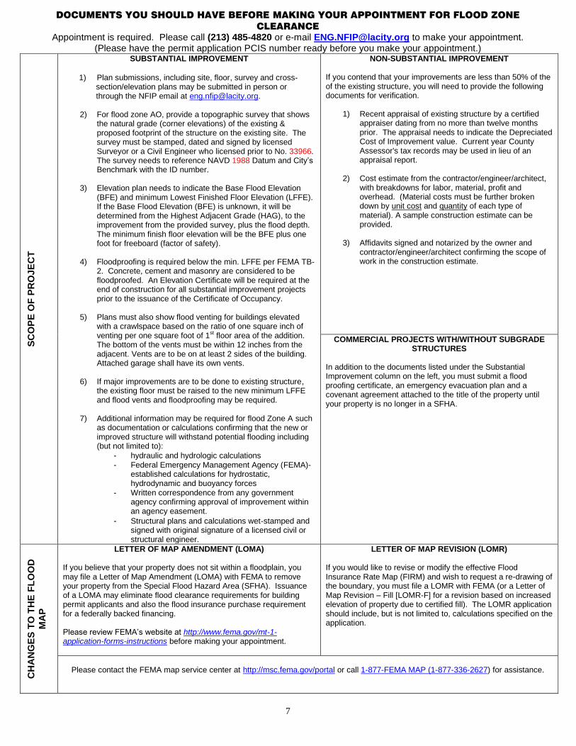
DOCUMENTS YOU SHOULD HAVE BEFORE MAKING YOUR APPOINTMENT FOR FLOOD ZONE
CLEARANCE
Appointment is required. Please call (213) 485-4820 or e-mail [email protected] to make your appointment. (Please have the permit application PCIS number ready before you make your appointment.)
SC
OP
E O
F P
RO
JE
CT
SUBSTANTIAL IMPROVEMENT
1) Plan submissions, including site, floor, survey and cross-
section/elevation plans may be submitted in person or through the NFIP email at [email protected].
2) For flood zone AO, provide a topographic survey that shows the natural grade (corner elevations) of the existing & proposed footprint of the structure on the existing site. The survey must be stamped, dated and signed by licensed Surveyor or a Civil Engineer who licensed prior to No. 33966. The survey needs to reference NAVD 1988 Datum and City’s Benchmark with the ID number.
3) Elevation plan needs to indicate the Base Flood Elevation
(BFE) and minimum Lowest Finished Floor Elevation (LFFE). If the Base Flood Elevation (BFE) is unknown, it will be determined from the Highest Adjacent Grade (HAG), to the improvement from the provided survey, plus the flood depth. The minimum finish floor elevation will be the BFE plus one foot for freeboard (factor of safety).
4) Floodproofing is required below the min. LFFE per FEMA TB-
2. Concrete, cement and masonry are considered to be floodproofed. An Elevation Certificate will be required at the end of construction for all substantial improvement projects prior to the issuance of the Certificate of Occupancy.
5) Plans must also show flood venting for buildings elevated
with a crawlspace based on the ratio of one square inch of venting per one square foot of 1st floor area of the addition. The bottom of the vents must be within 12 inches from the adjacent. Vents are to be on at least 2 sides of the building. Attached garage shall have its own vents.
6) If major improvements are to be done to existing structure,
the existing floor must be raised to the new minimum LFFE and flood vents and floodproofing may be required.
7) Additional information may be required for flood Zone A such
as documentation or calculations confirming that the new or improved structure will withstand potential flooding including (but not limited to):
- hydraulic and hydrologic calculations - Federal Emergency Management Agency (FEMA)-
established calculations for hydrostatic, hydrodynamic and buoyancy forces
- Written correspondence from any government agency confirming approval of improvement within an agency easement.
- Structural plans and calculations wet-stamped and signed with original signature of a licensed civil or structural engineer.
NON-SUBSTANTIAL IMPROVEMENT If you contend that your improvements are less than 50% of the of the existing structure, you will need to provide the following documents for verification.
1) Recent appraisal of existing structure by a certified appraiser dating from no more than twelve months prior. The appraisal needs to indicate the Depreciated Cost of Improvement value. Current year County Assessor's tax records may be used in lieu of an appraisal report.
2) Cost estimate from the contractor/engineer/architect,
with breakdowns for labor, material, profit and overhead. (Material costs must be further broken down by unit cost and quantity of each type of material). A sample construction estimate can be provided.
3) Affidavits signed and notarized by the owner and contractor/engineer/architect confirming the scope of work in the construction estimate.
In addition to the documents listed under the Substantial Improvement column on the left, you must submit a flood proofing certificate, an emergency evacuation plan and a covenant agreement attached to the title of the property until your property is no longer in a SFHA.
CH
AN
GE
S T
O T
HE
FL
OO
D
MA
P
LETTER OF MAP AMENDMENT (LOMA)
If you believe that your property does not sit within a floodplain, you may file a Letter of Map Amendment (LOMA) with FEMA to remove your property from the Special Flood Hazard Area (SFHA). Issuance of a LOMA may eliminate flood clearance requirements for building permit applicants and also the flood insurance purchase requirement for a federally backed financing. Please review FEMA’s website at http://www.fema.gov/mt-1-application-forms-instructions before making your appointment.
LETTER OF MAP REVISION (LOMR)
If you would like to revise or modify the effective Flood Insurance Rate Map (FIRM) and wish to request a re-drawing of the boundary, you must file a LOMR with FEMA (or a Letter of Map Revision – Fill [LOMR-F] for a revision based on increased elevation of property due to certified fill). The LOMR application should include, but is not limited to, calculations specified on the application.
Please contact the FEMA map service center at http://msc.fema.gov/portal or call 1-877-FEMA MAP (1-877-336-2627) for assistance.