Page 1 of 3 COASTAL CONSERVANCY Supplement to Staff Recommendation March 22, 2018 EEL RIVER ESTUARY AND CENTERVILLE SLOUGH ENHANCEMENT PROJECT: IMPLEMENTATION Project No.: 12-018-04 Project Manager: Michael Bowen Staff presents this supplement to the existing Staff Recommendation in order to provide information to the Conservancy and the public that provides context to the March 20, 2018 letter submitted to the Conservancy on behalf of the L.D.O’Rourke Foundation (LDOF), L&K Russ Cattle and Ranch Company LLC, Jack Russ, Linda Russ, and Jay Russ (collectively, “the LDOF/Russ Parties”) (Exhibit A). Staff wishes to ensure that the record is complete before the Conservancy makes a decision on the Staff Recommendation. The administrative record, should litigation ensue, would include, but not be limited to, this written supplement (with attachments), comments and presentations made at the March 22, 2018 hearing, and all evidence relied upon by staff in arriving at its recommendations. Conservancy staff received a request on March 20 in the late afternoon from the LDOF/Russ Parties to “defer authorization of any disbursements to The Wildlands Conservancy pending appropriate revisions to the Project to address the serious deficiencies that have been identified by the California Department of Fish and Wildlife (CDFW), as well as further environmental review under the California Environmental Quality Act.” Staff recommends proceeding with the Recommended Action for several reasons. The CDFW Conservation Engineering Branch Technical Memorandum (“CDFW Memo”) cited by the LDOF/Russ Parties contains errors and misinterpretations, and is taken out of context. Other technical memoranda (attached as Exhibits B and C) provide assessments that provide substantial evidence to support conclusions contrary to those reached in the CDFW Memo, and those reached by the LDOF/Russ Parties in their review of that memo. No information presented refutes the technical analysis that went into the EIR, project designs, or the CEQA Determination (attached to the Staff Recommendation as Exhibit 5) required by the Settlement Agreement (attached to the Staff Recommendation as Exhibit 4). No evidence has been presented that makes the recommended actions arbitrary and capricious, and no substantial evidence has been presented that there are unexamined new significant effects under CEQA requiring project modifications or additional review.
Transcript
Page 1 of 3
COASTAL CONSERVANCY
Supplement to Staff Recommendation March 22, 2018
EEL RIVER ESTUARY AND CENTERVILLE SLOUGH ENHANCEMENT PROJECT:
IMPLEMENTATION
Project No.: 12-018-04 Project Manager: Michael Bowen
Staff presents this supplement to the existing Staff Recommendation in order to provide information to the Conservancy and the public that provides context to the March 20, 2018 letter submitted to the Conservancy on behalf of the L.D.O’Rourke Foundation (LDOF), L&K Russ Cattle and Ranch Company LLC, Jack Russ, Linda Russ, and Jay Russ (collectively, “the LDOF/Russ Parties”) (Exhibit A). Staff wishes to ensure that the record is complete before the Conservancy makes a decision on the Staff Recommendation. The administrative record, should litigation ensue, would include, but not be limited to, this written supplement (with attachments), comments and presentations made at the March 22, 2018 hearing, and all evidence relied upon by staff in arriving at its recommendations.
Conservancy staff received a request on March 20 in the late afternoon from the LDOF/Russ Parties to “defer authorization of any disbursements to The Wildlands Conservancy pending appropriate revisions to the Project to address the serious deficiencies that have been identified by the California Department of Fish and Wildlife (CDFW), as well as further environmental review under the California Environmental Quality Act.” Staff recommends proceeding with the Recommended Action for several reasons. The CDFW Conservation Engineering Branch Technical Memorandum (“CDFW Memo”) cited by the LDOF/Russ Parties contains errors and misinterpretations, and is taken out of context. Other technical memoranda (attached as Exhibits B and C) provide assessments that provide substantial evidence to support conclusions contrary to those reached in the CDFW Memo, and those reached by the LDOF/Russ Parties in their review of that memo. No information presented refutes the technical analysis that went into the EIR, project designs, or the CEQA Determination (attached to the Staff Recommendation as Exhibit 5) required by the Settlement Agreement (attached to the Staff Recommendation as Exhibit 4). No evidence has been presented that makes the recommended actions arbitrary and capricious, and no substantial evidence has been presented that there are unexamined new significant effects under CEQA requiring project modifications or additional review.
Page 2 of 3
The CDFW Memo Evidence regarding the project’s projected benefits to salmonids and other biological resources outweighs the CDFW Memo’s concerns about the Project’s efficacy in this respect. Attached to this Supplement is a technical memorandum (Exhibit B) from GHD, Inc. and H.T. Harvey to California Trout, and a biological memorandum (Exhibit C) from H.T. Harvey to the Conservancy regarding the multiple biological benefits of the Project.
Further hydraulic evaluation
The LDOF/Russ letter and its attached letter from Matthew O’Connor describe further modelling that could be done. The hydraulic analysis done to support the EIR and permit applications, as well as the supplemental modelling done pursuant to the Settlement Agreement, is more than sufficient. No further analysis is legally required. Additional modelling and design refinements will naturally occur as the Project moves from 65% Design Level to Final Design. The Conservancy welcomes the participation of the LDOF/Russ Parties in that process.
Water Level Monitoring Stations
Conservancy staff acknowledges that no provisional data from the new Water Level Monitoring Stations was provided to the LDOF/Russ Parties as of March 20. The Project Team (consisting of the State Coastal Conservancy, The Wildlands Conservancy, California Trout, GHD, Inc., Kamman Hydrology and Engineering, and H.T. Harvey) determined that quarterly reporting of data, after technical review by Kamman for accuracy, would be a timely and appropriate approach. SCC staff was in routine contact with Kamman Hydrology and Engineering, GHD, Inc. and other Project Team members to ascertain whether or not the data collection was proceeding as planned, and whether any data collected provided any cause for concern or reevaluation of the Project assumptions. Kamman reported one gauge failure to the Project Team during a January 30, 2018 telephone call. Kamman also indicated that the data appeared as expected, and communicated to SCC staff that none of the data suggested additional modeling or analysis under CEQA would be advisable at this time. The first quarterly report of water level data (Exhibit D) was received by SCC from Kamman on March 21. The Russ Parties were notified that the data was available for their review the following morning.
Page 3 of 3
Inner Marsh Berm The LDOF/Russ letter contends that a new boundary survey revealed that the EIR was predicated on a misunderstanding regarding land ownership. In fact, the boundary survey and the CEQA Determination interpreting the boundary survey only clarified an understanding that was established in the Draft EIR, Recirculated Draft EIR and Final EIR regarding what might transpire if the LDOF does not grant access to its portion of the Inner March Berm for construction. Conservancy staff and the Project Team examined a variety of alternatives and determined that the least environmentally damaging and socially preferable option would be to simply construct a temporary parallel road approximately 425’ in length and 10’ wide, adjacent to the disputed section of berm road. Conservancy staff concluded, based on expert opinion, that the potential for temporary impacts to one-tenth of an acre of low productivity pasture/seasonal wetlands and agricultural uplands, with no sensitive biological or cultural resources nearby, within the 1,200-acre Project footprint for the construction of a temporary haul road, is low, and falls well within the realm of standard construction techniques and causes no new significant effects under CEQA. Conservancy staff notes that the existing berm road is legally available to and used in common by all parties (The Wildlands Conservancy and the LDOF/Russ Parties) through a drainage easement to access and maintain existing infrastructure of common interest, such as the Cut-Off Slough Tidegate. Conclusion The LDOF/Russ Parties provide no basis for deferral of the Conservancy’s decision, other than a questionable inter-office technical memorandum from CDFW, which the Conservancy and the Project Team have already analyzed and responded to. Staff recommends denial of the LDOF/Russ Parties’ request and recommends authorization of funding for the CEQA-certified and partially permitted Project.
Donald E. Sobelman [email protected] 415.848.4824 Direct 415.848.4825 Fax
Downey Brand LLP 455 Market Street, Suite 1500 San Francisco, CA 94105 415.848.4800 Main downeybrand.com
March 20, 2018
VIA HAND DELIVERY Board of Directors California State Coastal Conservancy 1515 Clay Street, 10th Floor Oakland, CA 94612-1401 Re: March 22, 2018 Public Hearing on California State Coastal Conservancy (CSCC)
Consideration and Possible Authorization to Disburse Up to $1,511,462 to The Wildlands Conservancy to Implement the Eel River Estuary and Centerville Slough Enhancement Project (Project) (Agenda Item No. 6).
Chairman Bosco and Members of the CSCC Board of Directors: I am writing to you concerning the above-described agenda item, on behalf of the L. D. O’Rourke Foundation (LDOF), Russ Ranch & Timber Company, LLC, L & K Russ Cattle & Ranch Company LLC, Jack Russ, Linda Russ, and Jay Russ (collectively, “LDOF/Russ Parties”). The LDOF/Russ Parties respectfully request that CSCC defer authorization of any disbursements to The Wildlands Conservancy pending appropriate revisions to the Project to address the serious deficiencies that have been identified by the California Department of Fish and Wildlife (CDFW), as well as further environmental review under the California Environmental Quality Act (CEQA). Although CSCC’s Staff Report for this agenda item includes several letters of support for the Project from 2016 and early 2017, those letters of support predate the November 8, 2017 memorandum by CDFW’s Conservation Engineering staff (“CDFW Memorandum”), which concludes in part as follows:
The project provides limited fish passage in and out of the Inner Marsh when juvenile salmonids are anticipated to move. It also provides very limited fish passage into Cut‐Off Slough for spawning adult salmonids. The limited tidal exchange in Cut‐Off Slough reduces water quality and adversely impacts channel morphology in both Russ Creek and Centerville Slough. Centerville Slough is predicted to have poor water quality and does not connect to Shaw Creek
March 20, 2018 Page 2
and therefore provides no fish benefit. Based on further water quality modeling, the Inner Marsh may provide some seasonal habitat to salmonid species more tolerant of saline environments than Coho Salmon. However, with the 65% BOD engineer’s cost estimate for the project at $9,300,000, the benefit to those non‐listed species is too limited to be cost effective. From the Department’s perspective, it is essential that major restoration projects within the Eel River Estuary provide benefit to Coho Salmon.1
CDFW’s analysis and findings are never mentioned in the Staff Report, and they are contrary to the key proposed findings in the Staff Report. As discussed further below, the failure to address the CDFW Memorandum, as well as deficiencies in CSCC’s further CEQA analysis, legally require the Board to defer any decision on disbursement of funds for the Project. Moreover, such deferral is the only prudent course of action, given that CDFW’s findings call into question both whether the proposed objectives of the Project can be achieved in a cost-effective manner and whether the Project can ever be fully funded. Background The LDOF/Russ Parties previously submitted extensive comments on the environmental impact report (EIR) for the Project and filed a petition for writ of mandate in Humboldt County Superior Court challenging the legal adequacy of the EIR. That litigation was resolved by a settlement and release agreement (“Settlement Agreement”),2 which required CSCC to prepare a written determination as to whether developments since CSCC’s certification of the Project EIR on February 2, 2017 require further environmental review under CEQA (“CEQA Determination”).3 The LDOF/Russ Parties and their predecessors have owned and/or managed a significant portion of the lands and agricultural resources in the area impacted by the Project for many decades. The LDOF/Russ Parties have supported, and continue to support, implementation of the proposed Project, so long as (1) the Project is designed to achieve the proposed objectives of the Project, (2) CSCC conducts full and appropriate environmental review under CEQA, and (3) the Project will not result in significant harm to the LDOF/Russ Parties’ lands and associated agricultural, water, and biological resources. Unfortunately, the CDFW Memorandum and CSCC’s CEQA Determination demonstrate that none of these three basic conditions have been met. CDFW Memorandum The CDFW Memorandum essentially concludes that one of the key objectives of the Project—ecosystem restoration that will have a beneficial impact on salmonid populations—will not be
1 CDFW Memorandum, attached hereto as Exhibit A, at pp. 7-8 (“Conclusions”); emphasis added. 2 Attached to the Staff Report as Exhibit 4. 3 Attached to the Staff Report as Exhibit 5. This CEQA Determination is not paginated.
March 20, 2018 Page 3
met, given the current design of the Project. In addition to the findings of CDFW quoted above (from the “Conclusions” section of the Memorandum), it is important to note the following additional analysis and findings from the Memorandum: Inner Marsh (pp. 1-3)
• “Fish passage is possible only 12% of the time through the gated culverts that separate the Inner Marsh from Cut‐Off slough. Thus, juvenile Coho Salmon that do enter the Inner Marsh may become stranded in water that is too salty during spring and summer months. . . . Other juvenile salmonids that are more tolerant of saline conditions, i.e. Chinook Salmon, may be able to use the Inner Marsh during the spring and summer if they are able to access the habitat during the limited access windows. Water quality conditions in the Inner Marsh during the summer have not been modeled [for the current Project design].”
• “Conservation Engineering is concerned with the longevity of these topographic features
[deeper pond habitat that may be suitable for salmonids]. Further sediment transport analyses are necessary to show that these features will persist after going through long stretches of ponding when the tide gates are closed.”
• “Furthermore, the controlled nature of the tidal exchange may negatively impact water
depths, sediment transport, dissolved oxygen, temperature, and salinity levels, as well as significantly limit fish passage opportunities.”
Cut-Off Slough (p. 4)
• “The proposed side hinge gates on the outlet of Cut‐Off Slough are anticipated to be open about 33% of the time during the dry season. Fish passage for juvenile salmonids is further reduced by excessive flow velocities through the tide gates and can only occur 15% of the time. Water quality is expected to be poor due to infrequent and very limited muted tidal exchange. The dotted red line in Figure 4 shows that the maximum tidal exchange will be 1.5 feet. The water is likely to be both high in temperature and salinity.”
• “The timing and duration of the opened tide gates are unlikely to attract adult salmonids
seeking to move upstream into tributaries to find spawning opportunities.” Centerville Slough (p. 5)
• [T]he extent of the excavation of Centerville Slough does not provide any benefit to fish passage, should salmonids happen to pass through the tide gates on Cut‐Off Slough during their limited open time. It is not clear what tidal prism Centerville Slough is designed to accommodate.”
March 20, 2018 Page 4
• “Furthermore, there are concerns about water quality in Centerville Slough given the very limited tidal exchange allowed by the tide gates on Cut‐Off Slough.”
Russ Creek (pp. 5-7)
• “Conservation Engineering is also concerned about the proposed design for Russ Creek. Russ Creek carries a significant sediment load that is deposited in the channel and also spreads bedload and suspended load out onto its floodplain (Figure 5).”
• “Conservation Engineering is not convinced that the design will work as intended and anticipates that there will continue to be unpredictable areas of deposition and channel avulsion.”
• “Maintenance frequency and costs can be unpredictable and established vegetation and aquatic habitat can be disturbed or destroyed by the maintenance activities.”
Sea Level Rise (p. 7)
• “The KHE (2016) report provides an estimate of sea level rise of 1 foot for the project area. Conservation Engineering is concerned that this estimate is not conservative enough, given that the estimate is based on 2050 projections and the life of the project exceeds that time. . . . The report also expected that the tide gates would remain open for fish passage for a far greater amount of time than the current [Project design]. In addition, the report was based on the project having a fish window that was always open for passage. As such, the report did not anticipate that sea level rise would have much of an impact on fish passage and channel morphology. Since the 65% BOD [i.e., current Project design] has much more limited open times for the tide gates and no fish window, the fish passage and channel geometry need to be reanalyzed with sea level rise conditions. It is anticipated that fish passage will be even further reduced.”
Oddly, the Staff Report contains no discussion of the CDFW Memorandum’s analysis and findings—it simply ignores these critical points.4 Yet, many of the proposed consistency findings for this Board decision are contradicted by the CDFW Memorandum. For example: 4 The only potential reference is contained in the CEQA Determination that is an exhibit to the Staff Report, which states:
[S]ince certification of the EIR, the Conservancy has received direct and indirect requests from resource agencies, principally CDFW, to modify project operations in a way that the resources agencies perceive would provide greater habitat benefit for off-channel rearing juvenile coho salmon. Indeed, CDFW has declined project funding through two separate grant programs on the rationale that the project is insufficiently beneficial for aquatic species, and overly protective of agricultural resources. The Conservancy disagrees with this position, and has determined that no changes or modifications to the project design or operations plan are warranted at this time, particularly in the absence of project participation by other beneficiaries of the existing or proposed infrastructure.
March 20, 2018 Page 5
� The proposed finding of consistency with CSCC’s enabling legislation is based in large
part on the assertion that “[i]mplementation activities under this grant will benefit a variety of natural resources within and outside the coastal zone (Pub. Resources Code § 31251.2), particularly coastal salmon populations of the Eel River that utilize habitat within and outside the Coastal Zone.”
� The proposed finding of consistency with CSCC’s 2018-2022 Strategic Plan Goals and
Objectives asserts consistency with Goal 5, Objective C (“the Project will preserve fish and wildlife corridors between core habitat areas along the coast and from coastal to inland habitat areas”), Goal 6, Objective E (“the project will restore fish passage and fish habitat and ensure sufficient instream flow and favorable water temperatures”), Goal 6, Objective G (“the project will significantly improve water quality in the Eel Estuary for the benefit of coastal and ocean resources by restoring tidal prism and providing durable and freely available access to a true freshwater-saltwater ecotone”), and Goal 8, Objective C (“the project will increase resilience to sea level rise using nature-based solutions and other multi-benefit strategies . . . while also reestablishing and preserving a fish and wildlife corridor through historic Centerville Slough”).
� The proposed finding of consistency with CSCC’s Project Selection Criteria and
Guidelines relies on the assertion that the Project is consistent with CDFW’s Recovery Strategy for California Coho Salmon, the National Marine Fisheries Service’s Final Recovery Plan for the Southern Oregon/Northern California Coast Evolutionarily Significant Unit of Coho Salmon (Oncorhynchus kisutch), and the provisions of CDFW’s California State Wildlife Action Plan 2015 Update (SWAP 2015 Update) that address salmonid populations.
It would be a prejudicial abuse of the Board’s discretion to make these findings of consistency, given the analysis set forth in the CDFW Memorandum and the complete absence of any substantial evidence in the record casting any doubt on that analysis. Moreover, it would be an abdication of the Board’s duty to responsibly manage its grant funding. Disbursement of over $1.5 million by CSCC for this $7.7 million project cannot be justified, when CSCC admits that CDFW has refused to provide funding for the Project under two grant programs,5 and less than $1.0 million in additional grant funding has been secured to date.6 Particularly given CDFW’s critique of the benefits of the Project, and CDFW’s finding that the Project will not be cost-
Even if this statement is a reference to the CDFW Memorandum (which is entirely unclear), CSCC’s blanket assertion of disagreement with CDFW’s critique is unsupported by facts, analysis, or other substantial evidence. Moreover, the LDOF/Russ Parties note that they are unaware of any assertion by CDFW, in writing or otherwise, that the Project is “overly protective of agricultural resources,” as the CEQA Determination asserts. 5 See excerpt from CEQA Determination, quoted at footnote 4, above. 6 See Staff Report at page 5.
March 20, 2018 Page 6
effective,7 it is the height of speculation to assume that over $5 million in additional funding will ever be secured to complete the Project, from either other government agencies or private funding sources. CEQA Determination Although CSCC certified an EIR for the Project in February 2017, CSCC has an ongoing obligation under CEQA to ensure that further environmental review is not required due to intervening events. Under the CEQA Guidelines, a lead agency must conduct additional CEQA review of a project in several instances, including where “[n]ew information of substantial importance, which was not known or could not have been known with the exercise of reasonable diligence at the time the previous EIR was certified” shows that “the project will have one or more significant effects not discussed in the previous EIR” or “[s]ignificant effects previously examined will be substantially more severe than previously shown in the previous EIR.” 14 Cal. Code Regs. §15162(a)(3)(A)-(B), (b) (emphasis added). The CEQA Determination prepared by CSCC asserts that no such new information of substantial importance exists, and that therefore no further CEQA review is needed. However, that conclusion is contradicted by the CEQA Determination itself and other substantial evidence. First, the CEQA Determination entirely ignores the analysis and findings in the CDFW Memorandum, and it contains no discussion or data related to any of the issues raised by CDFW. Instead, there is only a vague reference to “requests” by resource agencies, including CDFW, to “modify project operations in a way that the resource agencies perceive would provide greater habitat benefit for off-channel rearing juvenile coho salmon.” The CEQA Determination merely states that CSCC “disagrees” with those requests and then asserts, in a conclusory manner, that “no changes or modifications to the project design or operations plan are warranted at this time,” and that “no new CEQA documentation is warranted at this time.”8 However, the CDFW Memorandum clearly contains significant new information that casts into doubt both:
� CSCC’s prior finding that the Project will meet the objectives for the Project stated in the EIR, most importantly the objective to “[i]mprove access to restored aquatic habitats for salmonids and other aquatic dependent species by increasing or creating migratory access between estuarine and inland waters and by restoring overwintering and rearing habitat for juvenile salmonids” (see Draft EIR, Section 2.2); and
� the EIR’s analysis and findings regarding the significance of Project impacts related to biological resources, hydrology, and water quality (see Draft EIR, Sections 3.4 and 3.9).
7 See CDFW Memorandum at pp. 7-8 (“Conclusions”). 8 See excerpt from CEQA Determination, quoted at footnote 4, above.
March 20, 2018 Page 7
Essentially, CSCC has two options. It may either (1) modify the Project to address the deficiencies stated in the CDFW Memorandum and then conduct CEQA review of the modified Project, or (2) conduct additional CEQA review of the Project as currently proposed, to evaluate the new information concerning biological resources, hydrology, and water quality, and mitigate all related significant impacts. What CSCC cannot do is proceed with funding the Project, while entirely ignoring this significant new information from CDFW. Second, as discussed in further detail in the enclosed letter from Matthew O’Connor, Ph.D, CEG,9 although the hydraulic analyses and modelling conducted pursuant to the Settlement Agreement’s technical scope of work did generate useful data and information, a wide range of potential conditions have still not been evaluated, and therefore the evaluation of the Project’s effects on hydrology in the Project area remains incomplete. In particular, the EIR did not address either (1) impacts related to water elevations in the Inner Marsh that are reasonably foreseeable (i.e., between 2.5 and 4 feet); or (2) the fact that the Cutoff Slough tide gates are private property (constructed and maintained by the Russ Parties) and there is no agreement in place to operate and maintain those gates to facilitate the Project. Third, as Dr. O’Connor notes, three new Water Level Monitoring Stations were installed pursuant to the technical scope of work, and CSCC has been collecting water level data from these stations and existing stations, including during significant storm events, over the last three months. However, none of that data has been provided to the LDOF/Russ Parties10 or, for that matter, to the Board. The CEQA Determination merely states that “[p]rovisional data validates all prior understanding of the project area, and indicates that no further analysis under CEQA is necessary.” This conclusory statement is not supported by any data, analysis of data, or expert opinion. As such, it is not substantial evidence that supports CSCC’s determination that no further CEQA review is required. Moreover, the LDOF/Russ Parties have effectively been precluded from analyzing the data—and potentially providing substantial evidence to rebut this assertion—due to CSCC’s failure to disclose the data in a timely manner. Finally, a new boundary survey, completed following certification of the Project EIR, determined that the EIR’s analysis was predicated on a misunderstanding of the ownership of the Inner Marsh Berm. As a result, CSCC concedes that two modifications to the Project will be necessary unless LDOF agrees to grant access to portions of the Inner Marsh Berm: (1) temporary expansion of 425 linear feet of the Inner Marsh Berm and road prism by 10 feet, in order to move and stage equipment during Project construction; and (2) remediation of 4,250 square feet of area impacted by that temporary road. The CEQA Determination summarily states that the Project may proceed with these “slight modifications that do not cause new potentially significant impacts.” Again, this conclusory statement is not supported by any data, analysis of
9 Attached hereto as Exhibit B. 10 The technical scope of work requires that such data be “timely provided” to the LDOF/Russ Parties. CSCC has not explained why, as of March 20, 2018, no such data has been provided.
March 20, 2018 Page 8
data, or expert opinion. As such, it is not substantial evidence that supports CSCC’s determination that no further CEQA review is required. Conclusion For the reasons stated above, it would be a prejudicial abuse of the Board’s discretion, and a violation of CEQA, if it were to adopt Staff’s recommendations and proposed findings and authorize disbursement of funds for the Project at this time. Should CSCC take such actions, the LDOF/Russ Parties, individually and collectively, reserve all rights to challenge those actions in a court of competent jurisdiction.11 Respectfully submitted,
Donald Sobelman Downey Brand LLP cc (via email): Sam Schuchat, Executive Officer ([email protected]) Jeannette MacMillan, Staff Counsel ([email protected]) Michael Bowen, Project Manager, North Coast ([email protected]) David Alderson, Deputy Attorney General ([email protected]) Tim Needham, attorney for The Wildlands Conservancy ([email protected]) Walter Collins, attorney for California Trout ([email protected])
11 The LDOF/Russ Parties also specifically reserve all rights, and by this letter do not waive any rights, to file appropriate claims against CSCC and other responsible parties—which may include claims for inverse condemnation, injunctive relief, and damages—should the Project be constructed and implemented in a manner that results in a taking of their property, other harm or damage to their property or businesses, or an impairment of their property rights in any way, whether via tidal inundation or otherwise.
EXHIBIT A
Interoffice
Technical MEMORANDUM
To: Trevor Tollefson Senior Environmental Scientist – Supervisor FRGP
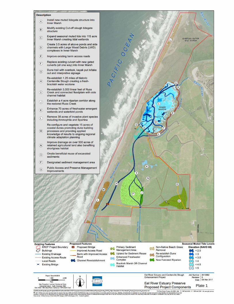
Region 1 From: Marjorie Caisley, P.E. Senior Hydraulic Engineer Conservation Engineering Date: 8 November 2017 Subject: EREP 65% Design Review The following constitutes Conservation Engineering’s review of GHD’s 65% design submittal for
the Eel River Estuary and Centerville Slough Enhancement Project (Project), Grant Agreement
P1210301, on the Eel River Estuary Preserve (EREP). The Fisheries Restoration Grants Program
(FRGP) funded the design of the Project with the intention of likely funding the implementation
of the Project. The Department’s goals in funding the project were to provide upstream adult
fish passage into Russ and Shaw Creeks during spawning season and juvenile access to
enhanced rearing habitat in the Inner Marsh and various sloughs and creeks in the project area.
The comments are categorized by project feature, but also include a section on sea level rise
that relates to all project features. Some of the review comments point out that the Project
now has features that would not be fundable by FRGP. The Project features are shown on Plate
1 at the back of this memorandum.
Inner Marsh
Department fisheries biologists have provided further detail on the distribution of the different
age classes of juvenile Coho Salmon in the estuary environment. The young of the year (YOY)
tend to redistribute into off channel settings in April and May. At this point in their life cycle,
they still require fresh water. Data provided on salinities in Figure 1 (Kamman 2016) indicate
that salinities tend to rise abruptly in the spring both inside and outside the project area. When
this happens the YOY would be looking to migrate upstream into the fresh water of Russ and
Shaw Creeks. However, fish passage out of the Inner Marsh into Cut‐off Slough, which connects
to Russ and Shaw Creeks, is very limited. Fish passage is possible only 12% of the time through
the gated culverts that separate the Inner Marsh from Cut‐Off slough. Thus, juvenile Coho
Salmon that do enter the Inner Marsh may become stranded in water that is too salty during
spring and summer months. Other juvenile salmonids that are more tolerant of saline
conditions, i.e. Chinook Salmon, may be able to use the Inner Marsh during the spring and
summer if they are able to access the habitat during the limited access windows. Water quality
conditions in the Inner Marsh during the summer have not been modeled for the 65% BOD.
Further modeling of salinity, water temperature, and dissolved oxygen would be necessary in
order to fund an off‐channel project (CDFW 2017).
Figure 1. Salinity data from Cut‐Off Slough and Inner Marsh
While much of the Inner Marsh elevations will be set to encourage salt marsh plant species, there will be some areas set aside for deeper pond habitat that may be suitable for these other salmonids. The bottoms of the ponds will be set at 0.0 or 1.0 foot elevation (NAVD 88) with channels connecting them to the main tide gate channel that have bottom elevations set at 2.0 feet (NAVD 88). As such, these ponds will be at least 1 foot deep and will have ingress and egress on a daily basis when the tide gets above 2.0 feet. However, Conservation Engineering is concerned with the longevity of these topographic features. Further sediment transport analyses are necessary to show that these features will persist after going through long stretches of ponding when the tide gates are closed.
Consultation with Department fisheries biologists suggests that YOY and 1+ Coho Salmon are seeking off‐channel and tributary habitat at the beginning of the wet season. This is the same time when tide gate operations would become more restrictive to fish passage. During the wet season, the 65% BOD notes that the Inner Marsh gates are closed when water levels in the estuary are above 2.5 feet. The estuary water level is in blue in Figure 2. The stage of the Eel River at Fernbridge is in brown. Anytime the Eel River water level rises due to a winter storm, the estuary level rises above 2.5 feet. An orange line has been drawn at the 2.5 foot water level. The BOD also states that the Inner Marsh tide gates will open if the water level in the marsh
exceeds the estuary water level, even if the estuary water level is above 2.5 feet. This is shown in Figure 3. At the tail end of the December 2014 storms, on the receeding limb of the hydrograph, there start to be narrow bands of time with fish passage. However, it is likely that the fish have either found velocity refuge elsewhere or have already been flushed out of the system by the time the Inner Marsh becomes accessible.
Finally, it should be noted that the Inner Marsh is designed as an off‐channel feature. The FRGP (2017) Proposal Solicitation Notice states that off‐channel “projects that will not be considered for funding include those where the constructed habitat would be used as a point of water diversion, or that involve the installation of a flashboard dam, head gate, or other mechanical structure to guarantee project performance.” The tide gates fall under the category of other mechanical structure to guarantee project performance. There are several reasons why FRGP does not fund off‐channel projects that have mechanical structures. In this case, the competing needs of the fish and the neighboring landowners and the ability to change the function of the muted tide gate regulator makes any benefits to fish subject to perceptions that the neighbors may have about the cause of any future flooding. Furthermore, the controlled nature of the tidal exchange may negatively impact water depths, sediment transport, dissolved oxygen, temperature, and salinity levels, as well as significantly limit fish passage opportunities.
Figure 2. Eel River Estuary water levels during winter storm events
Figure 3. Brief periods of fish passage at base flow conditions or as storms recede
Cut‐Off Slough
The proposed side hinge gates on the outlet of Cut‐Off Slough are anticipated to be open about
33% of the time during the dry season. Fish passage for juvenile salmonids is further reduced by
excessive flow velocities through the tide gates and can only occur 15% of the time. Water
quality is expected to be poor due to infrequent and very limited muted tidal exchange. The
dotted red line in Figure 4 shows that the maximum tidal exchange will be 1.5 feet. The water is
likely to be both high in temperature and salinity.
No percentage of open time is given for the Cut‐Off Slough tide gates during the wet season.
Similarly, no graphs are included of fish passage through the Cut‐Off Slough tide gates, only for
the Inner Marsh tide gates, which stay open longer. The Cut‐Off Slough tide gates will only be
open when the water level in the slough exceeds the water level in the Eel River Estuary. This
will happen at the receding limb of the storm hydrograph on the Eel when the ponded water
behind the tide gates can drain. The amount of time that this occurs will be very limited. The
timing and duration of the opened tide gates are unlikely to attract adult salmonids seeking to
move upstream into tributaries to find spawning opportunities.
Figure 4. Limited tidal exchange in Cut‐Off Slough is shown by the dashed red line
Centerville Slough
The excavation of the newly constructed Centerville Slough will end at the property boundary
and will not be connected to Shaw Creek. As such, the extent of the excavation of Centerville
Slough does not provide any benefit to fish passage, should salmonids happen to pass through
the tide gates on Cut‐Off Slough during their limited open time. It is not clear what tidal prism
Centerville Slough is designed to accommodate. The BOD discusses eventual connection of
Centerville Slough to both the Inner Marsh and to the Angels Camp area on the neighboring
property. However, neither of those connections are supported by neighboring landowners at
this time. Thus, it would appear that Centerville Slough is likely oversized and prone to filling in
and vegetating. Furthermore, there are concerns about water quality in Centerville Slough
given the very limited tidal exchange allowed by the tide gates on Cut‐Off Slough. Additionally,
the BOD states “given the lack of upstream hydraulic connectivity it is unknown how the lack of
circulation will influence water quality conditions.” Finally, the BOD also discusses the potential
for installing one‐way gates on Centerville Slough and Western Drainage to prevent the tidal
prism from extending onto the Russ property. The report discusses debris blockage issues
related to these gates, but does not discuss their impacts on fish passage. These gates would be
an added expense and due to potential fish passage and debris issues, would not be supported
by Conservation Engineering.
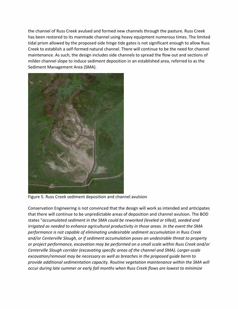
Russ Creek
Conservation Engineering is also concerned about the proposed design for Russ Creek. Russ
Creek carries a significant sediment load that is deposited in the channel and also spreads
bedload and suspended load out onto its floodplain (Figure 5). At various points over the years,
the channel of Russ Creek avulsed and formed new channels through the pasture. Russ Creek
has been restored to its manmade channel using heavy equipment numerous times. The limited
tidal prism allowed by the proposed side hinge tide gates is not significant enough to allow Russ
Creek to establish a self‐formed natural channel. There will continue to be the need for channel
maintenance. As such, the design includes side channels to spread the flow out and sections of
milder channel slope to induce sediment deposition in an established area, referred to as the
Sediment Management Area (SMA).
Figure 5. Russ Creek sediment deposition and channel avulsion Conservation Engineering is not convinced that the design will work as intended and anticipates
that there will continue to be unpredictable areas of deposition and channel avulsion. The BOD
states “accumulated sediment in the SMA could be reworked (leveled or tilled), seeded and
irrigated as needed to enhance agricultural productivity in those areas. In the event the SMA
performance is not capable of eliminating undesirable sediment accumulation in Russ Creek
and/or Centerville Slough, or if sediment accumulation poses an undesirable threat to property
or project performance, excavation may be performed on a small scale within Russ Creek and/or
Centerville Slough corridor (excavating specific areas of the channel and SMA). Larger‐scale
excavation/removal may be necessary as well as breaches in the proposed guide berm to
provide additional sedimentation capacity. Routine vegetation maintenance within the SMA will
occur during late summer or early fall months when Russ Creek flows are lowest to minimize
potential erosion and sediment transport and to minimize impacts to salmonid and wildlife
species.”
It should be noted that the Fisheries Restoration Grants Program does not fund projects with
side channels that have the intention of regular maintenance of a constructed channel feature
that would not otherwise be formed and maintained by the stream itself (CDFW 2017). Maintenance frequency and costs can be unpredictable and established vegetation and aquatic
habitat can be disturbed or destroyed by the maintenance activities. Grant program funds are
intended to fund projects that restore geomorphic functions to stream channels.
Dune Protection
The Department has, on numerous occasions, stated that the dune protection elements of the
Project do not have fish benefit. One of the purposes of re‐establishing Centerville Slough in its
historic alignment is the Western Drainage channel is expected to become filled in over time.
Thus, from a fisheries perspective, there is no need to maintain the functionality of the Western
Drainage channel. It remains unclear to the Department why the dune protection element is
included in the Project.
Sea Level Rise
The KHE (2016) report provides an estimate of sea level rise of 1 foot for the project area.
Conservation Engineering is concerned that this estimate is not conservative enough, given that
the estimate is based on 2050 projections and the life of the project exceeds that time. The
report analyzes the effects of sea level rise on neighboring properties, water surface elevations
and velocities in project sloughs and streams, and wave overwash. The report also expected
that the tide gates would remain open for fish passage for a far greater amount of time than
the current 65% BOD. In addition, the report was based on the project having a fish window
that was always open for passage. As such, the report did not anticipate that sea level rise
would have much of an impact on fish passage and channel morphology. Since the 65% BOD
has much more limited open times for the tide gates and no fish window, the fish passage and
channel geometry need to be reanalyzed with sea level rise conditions. It is anticipated that fish
passage will be even further reduced.
Conclusions
The project provides limited fish passage in and out of the Inner Marsh when juvenile salmonids
are anticipated to move. It also provides very limited fish passage into Cut‐Off Slough for
spawning adult salmonids. The limited tidal exchange in Cut‐Off Slough reduces water quality
and adversely impacts channel morphology in both Russ Creek and Centerville Slough.
Centerville Slough is predicted to have poor water quality and does not connect to Shaw Creek
and therefore provides no fish benefit. Based on further water quality modeling, the Inner
Marsh may provide some seasonal habitat to salmonid species more tolerant of saline
environments than Coho Salmon. However, with the 65% BOD engineer’s cost estimate for the
project at $9,300,000, the benefit to those non‐listed species is too limited to be cost effective.
From the Department’s perspective, it is essential that major restoration projects within the Eel
River Estuary provide benefit to Coho Salmon.
If the grantee intends to move the project forward, it will be important to continue to work closely with the cooperating agencies with expertise in estuary habitat and knowledge of salt‐water species that could best benefit from the fish passage opportunities and resulting habitat conditions.
References
California Department of Fish and Wildlife (CDFW). 2017. Fisheries Habitat Restoration 2017
Proposal Solicitation Notice.
GHD, Inc. 2017. Eel River Estuary and Centerville Slough Enhancement Project on the Eel River
Estuary Preserve: Basis of 65% Design Report.
Kamman Hydrology & Engineering, Inc. (KHE). 2016. Draft Hydraulic Design and Feasibility
Assessment Report: Eel River Estuary and Centerville Slough Enhancement Project Humboldt
County, California.
Plate 1
EXHIBIT B
O’Connor Environmental, Inc. www.oe-i.com (707) 431-2810 Hydrology & Hydraulics ▪ Hydrogeology ▪ Geomorphology P.O. Box 794, Healdsburg, CA 95448
March 16, 2018 Donald Sobelman Downey Brand LLP 455 Market Street, Suite 1500 San Francisco, CA 94105 SUBJECT: Eel River Estuary and Centerville Slough Enhancement Project (ERECSEP): Written Determination Regarding Additional CEQA Compliance O’Connor Environmental, Inc. (OEI) has reviewed the above referenced document which is undated and with unattributed authorship. It was provided via e-mail to you by Jeannette MacMillan, Staff Counsel of California State Coastal Conservancy (CSCC), who attributed the document to Michael Bowen (CSCC) for presentation to the CSCC Board on March 22, 2018. This document reports on the status of additional analysis of the ERECSEP required per terms of a settlement agreement between CSCC and our clients-Russ Ranch & Timber Company LLC and L.D. O’Rourke Foundation (Clients). Among other things, the settlement agreement included a “Technical Scope of Work” that was proposed by OEI in consultation with Clients intended to address potentially significant environmental effects of the project not analyzed to the satisfaction of OEI on behalf of Clients. The Technical Scope of Work (TSW) was to be fulfilled by the ERECSEP design team. Item 1 of the TSW was to further evaluate potential project effect on flooding and drainage on Clients’ property adjacent to the ERECSEP site using a 2-dimensional hydraulic model (MIKE FLOOD) developed by the project design team. This analysis supplemented the analysis of potential flooding and drainage effects used for CEQA that was based on a 1-dimensional hydraulic model that we reviewed and believe to be inappropriate for this environmental setting. Item 2 of the TSW provided for installation of three new Water Level Monitoring Stations, data from which is intended to describe pre-project baseline water levels in areas along the periphery of the project site not previously monitored. These data are intended to “allow for analysis for evidence of changes in the correlation and/or depth or duration of inundation indicative of improving or worsening flooding conditions”. These data have as yet not been made available to Clients or OEI; the settlement agreement stipulates that the date will “timely provided”. Item 3 of the TSW provided for specification of ERECSEP monitoring cross-sections at locations where sedimentation could potentially occur that would affect Clients’ property. Item 4 of the TSW provided for clarification of definitions of “trigger thresholds” related to ERECSEP cross-section monitoring. Item 5 of the TSW provided for an analysis using the 2-dimensional hydraulic model of hypothetical sedimentation above the “trigger threshold” to evaluate the magnitude of change in water level associated with the specified depth of sedimentation.
O’Connor Environmental, Inc. www.oe-i.com (707) 431-2810 Hydrology & Hydraulics ▪ Hydrogeology ▪ Geomorphology P.O. Box 794, Healdsburg, CA 95448
The project design team evaluated hydrologic scenarios specified in the TSW as requested and reviewed the results with OEI in a teleconference on October 13, 2017. The hydraulic analyses conducted per Item 1 of the TSW examined inundation effects of a 10-year storm event extending 48 hours beyond the inflow peak, with specified initial conditions of inundation of the Inner Marsh at water elevations of 2.5 feet and 4 feet, and of terrain upgradient of the Inner Marsh to an elevation of 4 ft with the Inner Marsh tide gates closed. While these model scenarios indicated insignificant effects on off-site inundation, it should be noted that there is a much wider range of potential initial conditions and storm conditions that could occur that have not been evaluated. In addition, the operational plan for the Inner Marsh tide gates remains to be determined. This operational plan will determine to a significant degree the initial conditions of inundation and available water storage capacity for different magnitudes of storm runoff events that could cause flooding of Clients’ property. Consequently, it has not yet been possible to fully evaluate the effects of the ERECSEP on the extent and duration of flooding of Clients’ property. CSCC and the ERECSEP design team should continue to improve the 2-dimensional hydraulic model using new monitoring data (TSW Item 2) for improved model calibration and/or validation. Specifically, the new water level monitoring data should be used to validate the 1-dimensional hydraulic modeling that is the basis for the CEQA analysis. One of our concerns about that modeling is that the calibration relies on data collected only at the Inner Marsh tide gates, with no calibration data from upstream areas nearer the properties of Russ and O’Rourke. CSCC and the ERECSEP design team should continue to evaluate potential project effects on flooding and inundation using the 2-dimension hydraulic model. In particular, alternative operational plans for the Inner Marsh tide gates should be evaluated using the model, and these efforts should be subject to technical peer review so that Clients and the public can assess the potential significance of ERECSEP effects on neighboring lands and other aspects of the environment. Respectfully, Matthew O’Connor, PhD, CEG #2449 President, O’Connor Environmental, Inc.
March 21, 2018
Mr. Douglas Bosco, Chairman State Coastal Conservancy 1330 Broadway, Suite 1330 Oakland, CA 94612
Dear Chair Bosco,
The Wildlands Conservancy would like to express our gratitude to the State Coastal Conservancy staff and its leadership for the years of planning behind this moment on the Eel River Estuary and Centerville Slough Enhancement project.
Large, landscape-scale enhancement projects require a great deal of coordination with agencies and adjacent landowners to achieve success. A balancing of priorities is necessary to achieve the best resources outcome, while at the same time respecting land uses that may be in conflict with those outcomes.
Given the legal obligations of Wildlands to uphold a communal Drainage Easement that protects the rights of adjacent landowners, whose agricultural operations are dependent upon the tide gates and drainage structures on our property, we feel the best design balance has been struck.
After committing years of staff resources in partnership with the Conservancy and other funders, and expending years in the study of biological and engineering design alternatives, and thorough public vetting, the project is ready to move toward final design and implementation.
The engineering plans have been modified to meet the criteria of "do no harm" to adjacent landowners agricultural operations, and at the same time, achieve a demonstrated 95% improvement in tidal accessibility to endangered salmon and other cold-water fish. A number of additional marine and wetland species habitats are also improved.
While we have secured a number of funding sources in addition to the application before the Conservancy Board today, it has been a source of disappointment to have
been denied CDFW Prop 1 funding, on the basis that the project design is too favorable to agricultural interests. The problem with this premise is that the key to making the project more favorable would mean the taking of adjacent landowner's productive agricultural property. Fortunately, Wildlands has alternative sources of funding to replace the CDFW Prop 1 components.
The Wildlands Conservancy is a private landowner, offering a substantial portion of its lands to be restored to habitat for fish and wildlife, while being mindful to uphold its obligations under the law to adjacent landowners. CDFW's response offered criticism focused primarily on defining the tide gates as 'fish barriers' rather than acknowledging their 'modifications for fish passage' and seemingly without sensitivity to the offering of private lands for a landscape-scale restoration project that will not benefit Wildlands financially. Let us be clear, without the tide gates, the adjacent landowners would suffer irreparable harm, and some income derived from the Wildlands property for management would be negatively impacted.
We, and staff of the SCC, have tried persistently to meet with CDFW staff to discuss the conflicts and resolve them, but thus far, CDFW has not set a date. California Trout, another of our key partners, has sent CDFW the HT Harvey memorandum, in addition to staff responses, that answer CDFW criticisms in a thorough way. The criticisms that can be addressed have been addressed.
Wildlands again, expresses our thanks to the Conservancy Board and staff for their persistence, patience and leadership on this important estuary restoration project, and ask for your continued support by voting to fund this project.
Sincerely,
Dan York Vice President The Wildlands Conservancy (661) 858-1115(909) 797-8507