Principal Investigator/Program Director(Last, First, Middle): Feddersen, Falk Coastal Ocean Modeling Core Proposal PROJECT SUMMARY The Coastal Ocean Modeling Core will provide coastal ocean model predictions to the Center’s three R01 studies in the San Diego South Bay region. The Core addresses the Center’s common theme of the effects of marine pollution discharges on the coastal ocean, biological communities, and their subsequent impact on human health. Specifically, the Core will support the R01 research projects by providing hindcasts or forecasts of contaminant, sediment or phytoplankton transport and fate. The evaluation of point source pollution impacts in coastal waters requires resolving the various multi-scale space/time ocean physics (from estuaries to the inner-shelf) of the receiving waters that control the fate and trans- port of the discharge. For example, estuaries are primarily tidal driven, the surfzone (region near the shoreline) is driven by breaking waves, and the inner-shelf is driven by winds, tides, stratification, and mesoscale processes. Each of these forcing mechanisms have different time- and length-scales, which the coastal ocean modeling system must resolve. After river-released constituent or contaminant leaves the estuary it enters the surfzone. Constituents leaving the surfzone or released from a submerged Publicly Operated Treatment Works experience inner-shelf processes. Many contaminants bind to sediments, and therefore understanding the transport and settling of sediment released from the estuary is also critical. Furthermore, the Tijuana River Estuary is a source of elevated nutrient loading of the coastal ocean, resulting in chronically elevated phytoplankton concentrations exposed to toxic contaminants. The task (and challenge) for the proposed Core is to provide physical ocean state and transport conditions at the appropriate scales to the three R01s. The Center’s Coastal Ocean Modeling Core will develop a framework for coupling open-source community-developed wave (SWAN), estuarine circulation (Delft3D) and nested (surfzone to inner-shelf) coastal ocean circulation models (ROMS). This framework will include assimilation of the real-time ocean surface currents measured in the region. In conjunction, the NCSTM sediment transport model and a planktonic ecosystem model will be integrated. The skill in modeling the regional coastal ocean will be evaluated against over a decade’s worth of ocean observations in the San Diego South Bay region, and leverage previous modeling developments efforts by the Core PIs which focused on establishing skill to forecast particular ocean processes (surfzone transport, internal waves, wind driven circulation, tidal flows). This framework will be applied to the San Diego South Bay region to provide hindcasts, exposure kernels, and forecasts of the transport and fate of marine pollutants, sediment, and phytoplankton. The result will be estimates of plume transport and fate (dilution) of pollution source (used by all R01 projects), of the toxic, contaminant-laden sediment deposition within this region (R01-1 and R01-3), and bulk phytoplankton concentrations (R01-2) in the San Diego South Bay region. PHS 398/2590 (Rev. 06/09) Page 1 Continuation Format Page
Transcript
Principal Investigator/Program Director(Last, First, Middle): Feddersen, Falk
Coastal Ocean Modeling Core Proposal
PROJECT SUMMARY
The Coastal Ocean Modeling Core will provide coastal ocean model predictions to the Center’s three R01 studiesin the San Diego South Bay region. The Core addresses the Center’s common theme of the effects of marinepollution discharges on the coastal ocean, biological communities, and their subsequent impact on human health.Specifically, the Core will support the R01 research projects by providing hindcasts or forecasts of contaminant,sediment or phytoplankton transport and fate.
The evaluation of point source pollution impacts in coastal waters requires resolving the various multi-scalespace/time ocean physics (from estuaries to the inner-shelf) of the receiving waters that control the fate and trans-port of the discharge. For example, estuaries are primarily tidal driven, the surfzone (region near the shoreline) isdriven by breaking waves, and the inner-shelf is driven by winds, tides, stratification, and mesoscale processes.Each of these forcing mechanisms have different time- and length-scales, which the coastal ocean modelingsystem must resolve. After river-released constituent or contaminant leaves the estuary it enters the surfzone.Constituents leaving the surfzone or released from a submerged Publicly Operated Treatment Works experienceinner-shelf processes. Many contaminants bind to sediments, and therefore understanding the transport andsettling of sediment released from the estuary is also critical. Furthermore, the Tijuana River Estuary is a sourceof elevated nutrient loading of the coastal ocean, resulting in chronically elevated phytoplankton concentrationsexposed to toxic contaminants.
The task (and challenge) for the proposed Core is to provide physical ocean state and transport conditions atthe appropriate scales to the three R01s. The Center’s Coastal Ocean Modeling Core will develop a framework forcoupling open-source community-developed wave (SWAN), estuarine circulation (Delft3D) and nested (surfzoneto inner-shelf) coastal ocean circulation models (ROMS). This framework will include assimilation of the real-timeocean surface currents measured in the region. In conjunction, the NCSTM sediment transport model and aplanktonic ecosystem model will be integrated. The skill in modeling the regional coastal ocean will be evaluatedagainst over a decade’s worth of ocean observations in the San Diego South Bay region, and leverage previousmodeling developments efforts by the Core PIs which focused on establishing skill to forecast particular oceanprocesses (surfzone transport, internal waves, wind driven circulation, tidal flows).
This framework will be applied to the San Diego South Bay region to provide hindcasts, exposure kernels, andforecasts of the transport and fate of marine pollutants, sediment, and phytoplankton. The result will be estimatesof plume transport and fate (dilution) of pollution source (used by all R01 projects), of the toxic, contaminant-ladensediment deposition within this region (R01-1 and R01-3), and bulk phytoplankton concentrations (R01-2) in theSan Diego South Bay region.
PHS 398/2590 (Rev. 06/09) Page 1 Continuation Format Page
Principal Investigator/Program Director(Last, First, Middle): Feddersen, Falk
Coastal Ocean Modeling Core Proposal
SPECIFIC AIMS
Statement of Need: The ocean transports and dilutes human generated pollution, sediments that contaminantsbind to, and phytoplankton generated toxins. Knowledge of such transport and fate of contaminants and toxinsallows estimates of bio-accumulation in consumed shell-fish or direct exposure to humans. As part of the Centerfor Marine Toxins and Health, this Coastal Ocean Modeling Core will develop a modeling system for pollutanttransport and fate in the San Diego South Bay Region.
Coastal Ocean Modeling Core Specific Aims: The overall goals of the Core are to develop a modeling systemfor pollutant, sediment, and phytoplankton transport and fate for the San Diego South Bay coastal region that canbe used in a hindcast, nowcast, or forecast mode. The model will cover the very different dynamical regimes ofthe well-mixed shallow estuary, to the surfzone, and onto the inner shelf. The specific aims for the Coastal OceanModeling Core are:
Aim 1: Set up and couple the coastal ocean circulation model ROMS, the wave model SWAN, the NCSTMsediment transport model, and the planktonic ecosystem model.
Aim 2: Test the modeling system against available oceanographic observations of waves, currents, and temper-ature.
Aim 3: Develop a data assimilation capability for the modeling systemAim 4: Develop a pollution transport and dilution module for each of the land-based (Tijuana River and Punta
Bandera) and outfall based (South Bay and Point Loma Ocean Outfalls) sources of pollution in the SouthernSan Diego region.
Aim 5: Develop hindcast and forecast capabilities for the modeling system, particularly the pollution plume trans-port and fate component, including uncertainties. Provide these estimates to the 3 R01 projects. Makethese predictions available as a web application to stakeholders (see letters).
Impact: The model results from the Coastal Ocean Modeling Core will be used by the three R01 projects (seethe Center diagram in the Center proposal). For example, spatial and time-dependent exposure histories toendocrine disrupting compounds will be developed for R01-3 project Genetic analysis of endocrine disruption incoastal waters. However, this Core can also be considered an intellectual and human-health impacts stand-aloneproject. New insight about the transport and exchange between well-mixed shallow estuaries, the surfzone, andthe inner-shelf will be gained. Almost exclusively, these systems are studied in isolation. Furthermore, predictionsof pollutant plumes also will have stand-alone benefit to the coastal communities in the region that are significantlyimpacted by marine pollution (see support letters).
The modeling system is physics-based and thus will be applicable to any coastal region, not just SouthernCalifornia, and can be used to analyze and forecast exposure to hazards beyond those identified in the Center’sR01 projects. These software tools and/or forecasts will be made publicly available to groups responsible forevaluating the risks to human health from discharges and natural hazards. An example of this application is tothe San Diego Point Loma outfall, which is controversial for its Advanced Primary level of treatment. The costs ofupgrading to Secondary treatment are huge, and so the expected results of such treatment decisions should bequantifiable with verified error estimates to aid in the cost-benefit analysis.
PHS 398/2590 (Rev. 06/09) Page 2 Continuation Format Page
Principal Investigator/Program Director(Last, First, Middle): Feddersen, Falk
Coastal Ocean Modeling Core
(a) Significance
A serious limitation to previous efforts to study the effect of anthropogenic (chemical contaminants) or naturalmarine toxins on human health is the lack of knowledge regarding the physical context (currents, mixing) and thetransport and fate of such contaminants. For example, the amount of contaminant bio-accumulation in a musseldepends on the organism’s exposure to the contaminant plume. In the San Diego South Bay region there aredistinct coastal ocean pollution sources in an estuary, surfzone, and on the inner-shelf, which each have their owndynamical regime. The pollution plume from each can cross from one regime to another. Pollutants often enterthe ocean at the surfzone (e.g., Tijuana river mouth) and are transported along the shoreline. Outfall pollutionalso can be transported to the shoreline [Kim et al., 2009]. Both of these mechanisms can deliver pollutants torecreational beach users. The effects of transport in the surfzone have been neglected in exposure modeling[i.e., Kim et al., 2009]. Thus, a modeling system that can accurately estimate pollution transport and fate overall three regions is critical to deepening our understanding of the human health impacts of pollution exposurethrough either direct contact or via the food web.
Commonly used shoreline water quality models are completely statistical and tailored for a particular shorelineregion [e.g., Frick et al., 2008]. For an example, see Virtual Beach (http://www.epa.gov/ceampubl/swater/vb2/).These models lack connection to physical transport and dilution and biological mortality processes, These modelsare tuned to a particular location, poorly handle episodic events, cannot be directly used in other regions withoutre-tuning, and the causes of model failure are difficult to diagnose. Hydrodynamic and tracer transport modelsare slowly being adopted both to understand detailed mechanisms of surfzone and nearshore tracer transportand dilution [Clark et al., 2011] and to model nearshore water quality [Zhu et al., 2011]. The former uses acomplicated, high spatial- and temporal-resolution model that highly-resolves surfzone mixing and dispersionprocesses. However, such a model is computationally expensive and does not allow for the inclusion of inner-shelfprocesses. The latter [Zhu et al., 2011] is a relatively simple depth-averaged model that neglects many relevantprocesses to pollutant transport include including vertical structure, stratification, and wave forcing. Althoughperhaps appropriate for shallow, unstratified regions within Biscane Bay, Miami FL, it is not applicable for generalcoastline regions.
In the surfzone, breaking waves are the dominant mechanisms forcing currents and dilution. Obliquely incidentbreaking waves can drive strong alongshore currents and eddies within the surfzone, The circulation of the innershelf is driven by tides, local atmospheric forcing (winds, heat, freshwater), and the effects of remote forcingas carried by eddies and coastally-trapped waves. The effect of wind waves is much weaker on the inner-shelfthan in the surfzone. The San Diego South Bay region is particularly complicated, due to relatively weak windsand complicated coastline and bathymetry, so no one mechanism dominates. Many existing models, includingseveral in use at SIO, have been shown to work well for other shelf regions. Under most river flow conditions, theTJ River Estuary is classified as vertically mixed, with a barotropic tidal pressure-gradient driven circulation andstrong boundary layer mixing.
An important modeling challenge is to combine an estuary model, surfzone model (largely driven by waves),and an inner-shelf model, either by nesting the finer surf-zone grid inside the coarser inner shelf model or by usingmethods that allow for varying grid resolution or via unstructured grids. The proposed modeling system includesestuary, surfzone, and inner-shelf regions. Such a modeling system spanning a diverse dynamical regime hasjust begun to be explored in any region in the world. Such a modeling system would have stand-along intellectualbenefit, revealing significant insights into the transport and connection pathways between these three regions.
Fine-scale modeling of coastal ocean waves, currents, and pollutant plume transport and fate across theseregimes will be used to provide hindcast and forecast estimates of ocean and pollution state that will provideguidance on exposure risks, exposure pathways, and targeted ocean sampling for the three R01 projects. ThisCoastal Ocean Modeling system will also be applicable to any coastal region, not just San Diego. The Core
PHS 398/2590 (Rev. 06/09) Page 3 Continuation Format Page
Principal Investigator/Program Director(Last, First, Middle): Feddersen, Falk
modeling system also will have stand-alone human health benefits through the public availability of pollutantexposure forecasts to coastal communities, beyond those identified in the Center’s R01 project.
(b) Innovation
We plan to develop a unique and innovative coastal ocean and estuary modeling system for currents, stratification,waves, sediment transport, pollutant transport and dilution, and a planktonic ecosystem model in the San DiegoSouth Bay region. Integrated modeling system for the coastal region within 5-10 km of the shoreline, that includesthe inner-shelf, the surfzone, estuary, and transition regions does not yet exist. This modeling system will betested with observations and used to both hindcast and forecast pollutant plume exposure, sediment transportand deposition, and phytoplankton estimates to the three R01 projects. In addition, model predictions will bemade available as a web application for stakeholders, and software will also be made publicly available.
The Coastal Ocean Model System, to be developed in Aim 1, tested in Aim 2, and utilized in Aims 3 and 4,will be based on existing open-source community models. The coastal ocean circulation model will be based onROMS - Regional Ocean Modeling System [Shchepetkin and McWilliams, 2005; Haidvogel et al., 2008]. ROMSis a three-dimensional, free surface, topography-following, hydrostatic, primitive equation model for currents,temperature, and salinity. The model implements both SMP and distributed parallelism and allows for modelnesting. Recently, both vortex-force [Uchiyama et al., 2010] and radiation stress [Kumar et al., 2011] waveforcing mechanisms have been included in ROMS, allowing for surfzone application. ROMS is in use to makehindcasts, nowcasts, and forecasts of ocean conditions in a number of more offshore environments. Most relevantto the Coastal Ocean Modeling Core, ROMS is currently used at NASA/JPL to give real-time predictions at 1 kmresolution of currents (including tides) and ocean temperature in the Southern California Bight as part of theSouthern California Coastal Ocean Observing System (SCCOOS).
The wave model that will be used to propagate waves across the shelf and model their breaking is the open-source third-generation wave model SWAN (Simulating WAves Nearshore). It computes random, short-crestedwind-generated waves in coastal regions and inland waters. This spectral model that allows for an realisticincident wave field, wave propagation in time and space, shoaling, refraction due to current and depth, current-induced frequency shifting, whitecapping, bottom friction and depth-induced breaking.
The ROMS model can include the National Community Sediment-Transport Model (NCSTM), a sophisticatedsediment transport model Warner et al. [2008]. The NCSTM model can solve for the evolution of a multi-layersediment bed morphology, allowing for both cohesive and non-cohesive sediments. Both kinds of sediments mayhave as many custom size classes as are needed, meaning specification of grain size, density, settling velocity,critical shear stress for erosion, and erodibility. Sediment is moved by the model currents and redistributed,evolving the sediment bed structure as part of the model. This capability of the model will be very important forthe credible calculation of the fate of contaminated sediments, and it has been extensively tested by the WoodsHole USGS.
A planktonic ecosystem model also will be embedded within the Coastal Ocean Modeling System. TheROMS model comes with several ecosystem models, including that of Franks et al. [1986]. In addition, theNEMURO ecosystem model [Kishi et al., 2007] has been carefully re-parameterized for the California CurrentSystem and Southern California Bight ecosystems based on data collected during the NSF-funded CaliforniaCurrent Ecosystem Long-Term Ecological Research program (CCE-LTER). This ecosystem model will providethe larger context for interpreting the dynamics of the target dinoflagellate species.
(c) Approach
Background: The PIs have unique expertise in developing ocean model hindcast/nowcast/forecast systems.Previously, for the region near Huntington Beach CA, Feddersen developed a real time wave and alongshorecurrent system that accurately reproduced wave height and surfzone alongshore current conditions over 2 months
PHS 398/2590 (Rev. 06/09) Page 4 Continuation Format Page
Principal Investigator/Program Director(Last, First, Middle): Feddersen, Falk
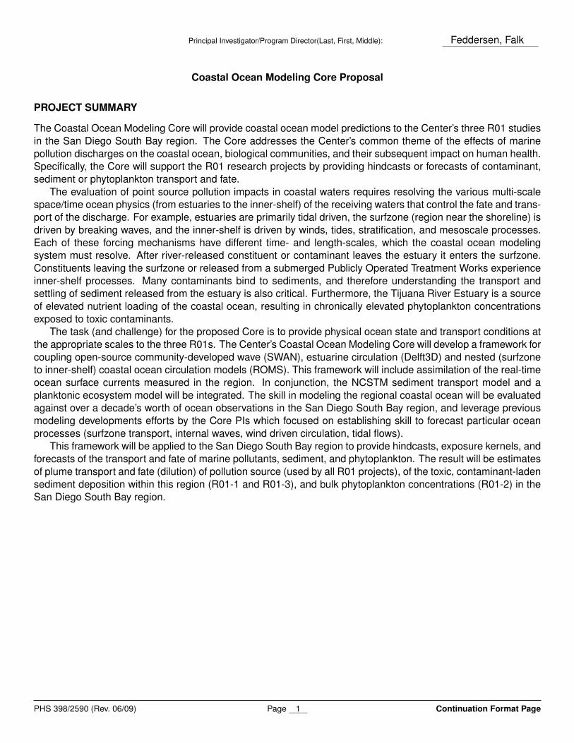
Figure 1: Time series of observed (blue) and modeled (red) breaking significant wave height Hs (top) and surfzone-averaged (cross-shore averaged) mean alongshore current (bottom) at Huntington Beach CA from the HB06 experiment.
during the SCCOOS-funded HB06 experiment (Figure 1). Because the Huntington Beach region was alongshoreuniform and because pollutant transport was not explicitly modeled, the HB06 surfzone model is simpler than theproposed ROMS surfzone model. The San Diego South Bay region has significant alongshore non-uniformitiesnear the Tijuana River mouth and in the region north towards Coronado necessitating use of the more complexROMS model. PI Cornuelle is the leader of the Consortium on the Ocean’s Role in Climate (CORC) modelingcomponent at SIO. The goal of CORC modeling is to provide dynamically consistent state estimates of oceancirculation and density structure - together with surface momentum and buoyancy fluxes, using the MITgcmmodel. The focus region is the California Current - the equator-ward flowing region within 500 km of the NorthAmerican West Coast. Cornuelle is also engaged in tide-resolving modeling of the San Diego region and is partof a forecasting project for the Loop Current in the Gulf of Mexico. co-PI Terrill is leading efforts at collecting real-time observations in the San Diego South Bay region and at developing an observation based plume trackingmodel.
Aim 1, Coastal Ocean Model System Setup: The wave (SWAN), circulation (ROMS), sediment transport (NC-STMS), estuary (Delft3D), and planktonic ecosystem models must first be set up for the region and coupledtogether.
Coastal Ocean Circulation Model: The San Diego South Bay regional circulation model will be based on ROMS.It will include three nested components,
1. A San Diego regional component spanning from North of Point Loma to Rosarito Beach Mexico and fromwithin a few 100 m of shore to the 400 m depth at a grid resolution of 400 m. This component will bedenoted the outer component. This component will use the SCCOOS Southern California ROMS 1 km gridspacing ocean estimate as an outer boundary condition.
2. A San Diego South bay region component that covers from Mission Beach to the Coronado Islands, from10 m depth to 200 m depth. This region includes the Point Loma and South Bay Ocean Outfalls and theSan Diego Bay. It will be nested within component 1) and will have grid resolution of 150 m.
3. A near-shore surfzone component that covers the region within about 300 m from the shoreline from PuntaBandera to Coronado (30 km), the region dominated by wave forcing effects, This component will be nested
PHS 398/2590 (Rev. 06/09) Page 5 Continuation Format Page
Principal Investigator/Program Director(Last, First, Middle): Feddersen, Falk
within 2). It will have cross-shore grid resolution gradually increasing from 2 or 3 meters near the shore to50 m at the outer edge, and alongshore resolution of 50 m.
Wave Model: The SWAN wave model for the San Diego South Bay region will run on a single grid and beused primarily as input for the inner-most nearshore ROMS nest. Initially, coupling to ROMS will be one-way,but eventually two-way coupling will be explored. The SWAN wave model will be initialized on the outer modelboundary using Coastal Data Information Program (CDIP) wave model output.
Sediment Transport Model: The NCSTM sediment transport model will be coupled to the inner two nests ofROMS. The model will be initialized using the real-time flow rate measurements from the Tijuana River estuary.Observations of sediment size distribution in the estuary will be used to constrain the sediment flux into the ocean.
Estuary Model: The Delft3D model will be used in Estuary mode. Tidal forcing and ocean temperatures will beused as estuary mouth boundary conditions. The main channel of the estuary is morphologically stable, andexisting bathymetry from the the Tijuana Estuary Research Reserve will be used.
Planktonic Ecosystem Model: Both ROMS and the NEMORO planktonic ecosystem models will be embeddedwithin the Coastal Ocean Modeling system to estimate nutrient fluxes and phytoplankton blooms. Both modelswill be evaluated against historical Chlorophyll and phytoplankton data in the region. This model will be in allROMS nests.
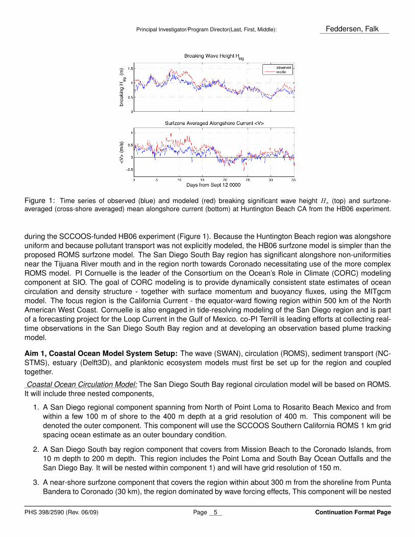
Plume Model: A three-dimensional plume (advection and diffusion) plume model will be developed for the variousSan Diego South Bay pollution sources. Source input for the Tijuana River Estuary will be based on real-time riverflow estimates and the tides. The results of the plume model will give a higher degree of pollutant concentrationinformation than a coarse particle plume model (e.g., Figure 2).
Additional Components: High resolution ocean bathymetry is available for the region from SCCOOS. Additionalinput necessary for the model is the wind field. Modeled WRF or COAMPS winds from regional modeling centerswill be used as model input for the San Diego South Bay Coastal Ocean Model.
Aim 2, Comparison to Observations: The models will be tested and improved by comparison to observations.A significant number of previous oceanographic observations already have been collected in the San Diego SouthBay region, where the land and outfall pollution sources are located. This Core effort will leverage existing SanDiego ocean monitoring observations and infrastructure. For example, there are surface current maps generatedby high-frequency (HF) radar that provide a 1 km resolution product is available from an array of 5 radars deployedin the U.S.-Mexico border region. Data within the 1–2 km range cell adjacent to the coastline does not representthe transport within the surfzone where the pollution sources and the dominant transport occurs (e.g., Figure 2 ofCenter Proposal). These surface currents are presently used for estimating the location of plumes offshore thesurfzone, but have significant uncertainty in the surfzone and nearshore waters that are not covered. This arrayis maintained by the Coastal Ocean Research and Development Center (CORDC) at SIO led by co-PI Terrill. HFradar has growing coverage across U.S. coastal waters, with approximately 140 radars now operating across theGulf, west, and east coasts. In addition, a multi-year record of stratification and currents directly above the SouthBay Ocean Outfall and (a shorter record) at the end of the Imperial Beach Pier are available for model validation.PD Feddersen was PI on the IB09 experiment which obtained detailed surfzone and inner shelf waves, currentsand water-quality observations during the fall of 2009 in Imperial Beach, CA. Upwelling, including internal tidesurges to surf, are one potential contributor to phytoplankton blooms. SCCOOS maintains a HAB surveillanceprogram which can be used to test the planktonic ecosystem model. Long term measurements of internal wavesand Chlorophyll have been made off of the SIO pier which also can be used to test the NPZ model. Additionalobservations collected by USGS and the San Diego Sanitation District will also be utilized to test and constrainthe model, as well as any future observations.
PHS 398/2590 (Rev. 06/09) Page 6 Continuation Format Page
Principal Investigator/Program Director(Last, First, Middle): Feddersen, Falk
Aim 3, Data Assimilation: After the models have been successful in statistical tests against the observations,data assimilation (or state estimation) will be used to synchronize the model with the observations for hindcastsand forecasts. The primary assimilation method implemented in ROMS is four-dimensional variational optimiza-tion (4DVAR). The 4DVAR method uses the adjoint and tangent-linear versions of the ROMS model to optimizethe model controls (initial conditions, boundary conditions, and forcing) so that a free forward integration of themodel with the altered controls matches the observations to within the expected error during assimilation timewindow. For relatively short windows, as are envisioned here, the balance and smoothing constraints that arenow available as part of ROMS must be employed. The nowcasts and forecasts will be run starting in 2009,but can extend back to 2007 if necessary for better testing, since the HF radar surface current observations andother SCCOOS observations are available. The model will be run in a series of non-overlapping update cycles. Ineach cycle, the final state from the previous cycle will be run forward using forcing and boundary conditions fromSouthern California Bight ROMS. The model will be sampled at the space-time locations of the observations,and the differences will be back-projected using the adjoint model to produce adjusted controls. This adjustmentcycle will continue until the cost function (which penalizes both model-data misfits and control adjustments) is nolonger decreasing. The optimized controls will be used to run the model forward through the assimilation windowand onward to forecast out for as long as skill is seen, probably up to a week. The forecast will use forecastsof atmospheric forcing and ocean boundary conditions when and where they are available, and use climatol-ogy otherwise. The hindcasts and forecasts will be compared to observations to assess skill and improve theimplementation. Once the system works well on existing observations, it will be implemented using the currentobservations to make near-real-time forecasts for dissemination to the related projects and to the public.
Aim 4, Hindcasts, Exposure Kernels, and Forecasts: The Core will provide the R01 projects with specifichindcasts of the ocean/estuary state during periods of interest to provide specific guidance for water sampling orocean state estimates during and prior to water sampling. Time-exposure histories for various sampling regionswill be provided. For example, exposure of R01-1 mussel outplants to plume water or turbot (flat-fish with alimited range) to contaminant-laden sediment will be estimated. In addition, model-based fine-grained exposurekernels (analogous to Figure 3) for water quality degradation at various locations will be developed. In and ofitself this will have significant human-health impacts, but will also be useful to the R01-1 and R01-3 projects inmussel or fish outplant sampling. A real-time forecast capability for the Coastal Ocean Modeling system willbe developed using assimilated observations and predicted waves and winds. The existing observations willbe used to test the skill of the forecast capability for currents and temperature at predictions of one, three, andfive days. Model predictions of plume transport and fate will be made available on the web, which will be ofgreat use to stakeholders (see support letters). The Core will interface with the R01 projects providing them withpollution/sediment/phytoplankton transport and fate forecasts.
Timeline:
YEAR 1: Tasks include: Set up (construct grids and supply forcing and boundary conditions) for SWAN andthe three ROMS models at various resolutions. Each model is first set up and run stand-alone in order to testand refine each component before coupling the grids together. Set up SWAN grid with CDIP outer boundaryconditions. Test against CDIP model predictions and 2009 wave-buoy observations. Set up surfzone model gridwith simple wave stress forcing, compare to surfzone observations from 2009 IB09 experiment and USGS study.Gather atmospheric forcing and JPL ROMS boundary conditions and start test runs for comparison with HF radar,buoy and other regional observations. (Aims 1 & 2)
YEAR 2: Tasks include: Implement ROMS nesting. Initially implement one-way nesting from outer-grid to theinner grid. Integrate the NCSTS sediment transport model into the ROMS nests. Develop the plume modelfor the TJ River Estuary, Punta Bandera, and South Bay Ocean Outfall pollution sources. Begin developingassimilation capabilities. (Aims 1, 2, 3, & 4)
PHS 398/2590 (Rev. 06/09) Page 7 Continuation Format Page
Principal Investigator/Program Director(Last, First, Middle): Feddersen, Falk
Figure 2: Snapshot of the Tijuana River (TJR) plume track model (upper panel) and the histogram of the particles withinthe near-coast cell (lower panel). The hourly released particles at the TJR mouth (black plus mark) are tracked for threedays, and the color of particle represents the age of the particle since it was released.
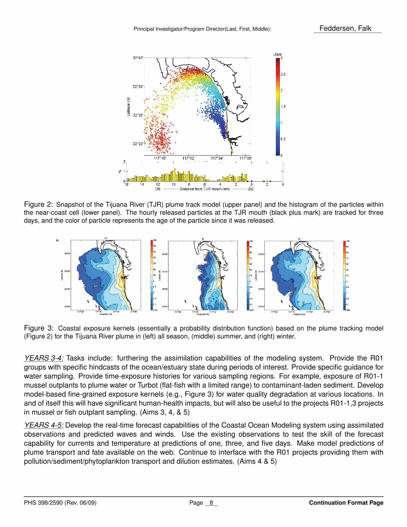
Figure 3: Coastal exposure kernels (essentially a probability distribution function) based on the plume tracking model(Figure 2) for the Tijuana River plume in (left) all season, (middle) summer, and (right) winter.
YEARS 3-4: Tasks include: furthering the assimilation capabilities of the modeling system. Provide the R01groups with specific hindcasts of the ocean/estuary state during periods of interest. Provide specific guidance forwater sampling. Provide time-exposure histories for various sampling regions. For example, exposure of R01-1mussel outplants to plume water or Turbot (flat-fish with a limited range) to contaminant-laden sediment. Developmodel-based fine-grained exposure kernels (e.g., Figure 3) for water quality degradation at various locations. Inand of itself this will have significant human-health impacts, but will also be useful to the projects R01-1,3 projectsin mussel or fish outplant sampling. (Aims 3, 4, & 5)
YEARS 4-5: Develop the real-time forecast capabilities of the Coastal Ocean Modeling system using assimilatedobservations and predicted waves and winds. Use the existing observations to test the skill of the forecastcapability for currents and temperature at predictions of one, three, and five days. Make model predictions ofplume transport and fate available on the web. Continue to interface with the R01 projects providing them withpollution/sediment/phytoplankton transport and dilution estimates. (Aims 4 & 5)
PHS 398/2590 (Rev. 06/09) Page 8 Continuation Format Page
Principal Investigator/Program Director(Last, First, Middle): Feddersen, Falk
Literature Cited
Clark, D. B., F. Feddersen, and R. T. Guza, Boussinesq modeling of surfzone tracer plumes, part 2: Tracer plumesand cross-shore dispersion, J. Geophys. Res., in press, 2011.
Franks, P., J. Wroblewski, and G. Flierl, Behavior of a simple plankton model with food-level acclimation byherbivores, Marine Biology, 91(1), 121–129, doi:10.1007/BF00397577, 1986.
Frick, W. E., Z. Ge, and R. G. Zepp, Nowcasting and forecasting concentrations of biological contaminants atbeaches: A feasibility and case study, Env. Sci. & Tech., 42(13), 4818–4824, doi:10.1021/es703185p, 2008.
Haidvogel, D. B., et al., Ocean forecasting in terrain-following coordinates: Formulation and skill as-sessment of the Regional Ocean Modeling System, J. Computational Physics, 227 (7), 3595–3624, doi:10.1016/j.jcp.2007.06.016, 2008.
Kim, S. Y., E. J. Terrill, and B. D. Cornuelle, Assessing Coastal Plumes in a Region of Multiple Discharges: TheUS-Mexico Border, Environmental Science & Technology, 43(19), 7450–7457, doi:10.1021/es900775p, 2009.
Kishi, M. J., et al., NEMURO - a lower trophic level model for the North Pacific marine ecosystem, EcologicalModelling, 202(1-2, SI), 12–25, doi:10.1016/j.ecolmodel.2006.08.021, 11th PICES Annua Meeting, Qingdao,PEOPLES R CHINA, 2002, 2007.
Kumar, N., G. Voulgaris, and J. C. Warner, Implementation and modification of a three-dimensional radia-tion stress formulation for surf zone and rip-current applications, Coastal Eng., 58(12), 1097–1117, doi:10.1016/j.coastaleng.2011.06.009, 2011.
Shchepetkin, A., and J. McWilliams, The regional oceanic modeling system (ROMS): a split-explicit,free-surface, topography-following-coordinate oceanic model, Ocean Modelling, 9(4), 347–404, doi:10.1016/j.ocemod.2004.08.002, 2005.
Uchiyama, Y., J. C. McWilliams, and A. F. Shchepetkin, Wave-current interaction in an oceanic circulationmodel with a vortex-force formalism: Application to the surf zone, Ocean Modelling, 34(1-2), 16–35, doi:10.1016/j.ocemod.2010.04.002, 2010.
Warner, J. C., C. R. Sherwood, R. P. Signell, C. K. Harris, and H. G. Arango, Development of a three-dimensional,regional, coupled wave, current, and sediment-transport model, Computers & Geosciences, 34(10), 1284–1306, doi:10.1016/j.cageo.2008.02.012, 2008.
Zhu, X., J. D. Wang, H. M. Solo-Gabriele, and L. E. Fleming, A water quality modeling study of non-point sourcesat recreational marine beaches, Water Research, 45(9), 2985–2995, doi:10.1016/j.watres.2011.03.015, 2011.
PHS 398/2590 (Rev. 06/09) Page 9 Continuation Format Page


![The Core PPT [Autosaved] Core.pdf · thecore universiti)brunei)darussalam jalan)tungku)link,)gadong)be1410 negara)brunei)darussalam tel:)+673)246)3001)ext2140](https://static.documents.pub/doc/80x56/600cb02f8deef96c672498ca/the-core-ppt-autosaved-corepdf-thecore-universitibruneidarussalam-jalantungkulinkgadongbe1410.jpg)


![Ocean wave height determined from inland seismometer data ...iodlabs.ucsd.edu/peter/pdfs/Bromirski_etal_JGRC_1999.pdf · waves that are prominent sources of microseisms in the [0.2,0.5]](https://static.documents.pub/doc/80x56/5f0880757e708231d4225381/ocean-wave-height-determined-from-inland-seismometer-data-waves-that-are-prominent.jpg)