Coastal Subsidence along Eastern seaboard and Gulf of Mexico Timothy H. Dixon 1 , Makan A. Karegar 1 , Rocco Malservisi 1 and Simon E. Engelhart 2 1- School of Geosciences, University of South Florida, Tampa 2- Department of Geosciences, University of Rhode Island,, Kingston
Transcript
Coastal Subsidence along Eastern
seaboard and Gulf of Mexico
Timothy H. Dixon1, Makan A. Karegar1, Rocco Malservisi1
and Simon E. Engelhart2
1- School of Geosciences, University of South Florida, Tampa
2- Department of Geosciences, University of Rhode Island,, Kingston
Coastal Flood Exposure
Future risk reflects both sea level rise and
coastal subsidence
Natural and human-made causes
This talk focuses on coastal subsidence
Compare two independent data bases:
Geological RSL (last 4 Ka) and GPS (last
decade)
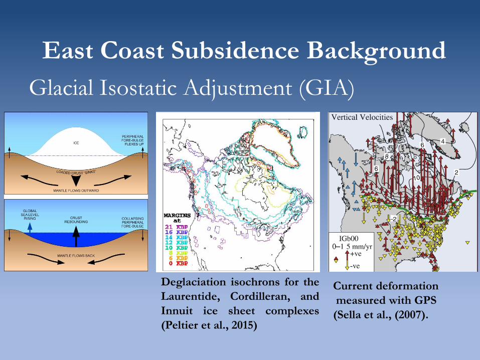
East Coast Subsidence Background
Glacial Isostatic Adjustment (GIA)
Deglaciation isochrons for the
Laurentide, Cordilleran, and
Innuit ice sheet complexes
(Peltier et al., 2015)
Current deformation
measured with GPS
(Sella et al., (2007).
Subsidence measurements
Late Holocene Rate of Relative Sea Level [Engelhart and Horton, 2012; Kemp el al., 2014]:
Tectonic activity along passive margin of Eastern seaboard
assumed to be negligible.
Effect of sediment compaction minimized by using basal peat
samples.
RSL trends reflect spatially-variable land motion primarily
dominated by GIA.
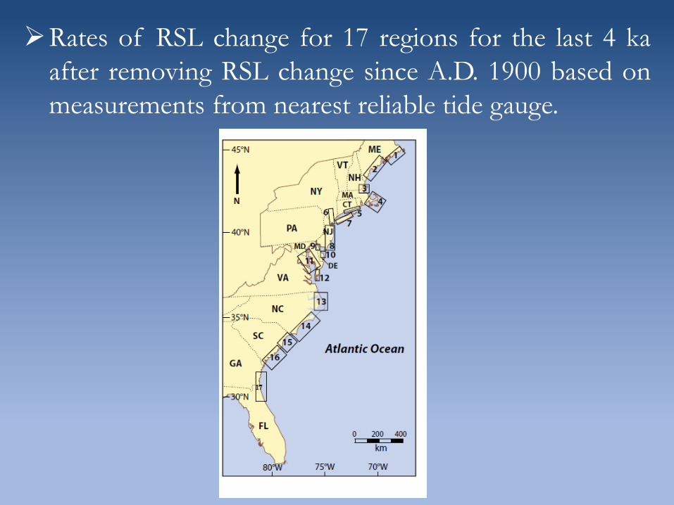
Rates of RSL change for 17 regions for the last 4 ka
after removing RSL change since A.D. 1900 based on
measurements from nearest reliable tide gauge.
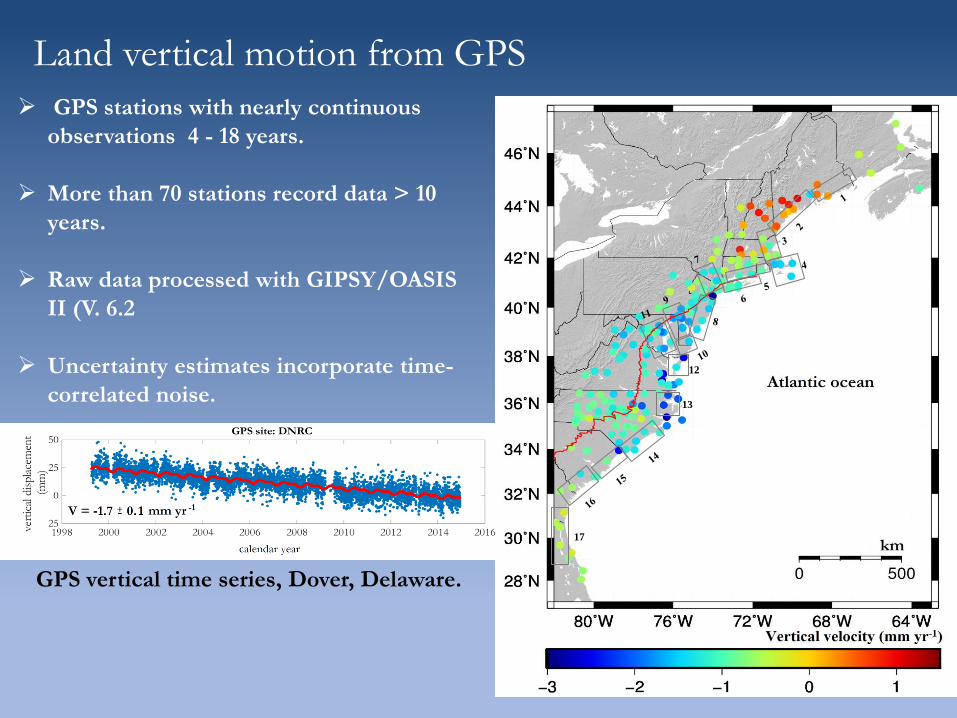
Land vertical motion from GPS
12
13
17
GPS stations with nearly continuous
observations 4 - 18 years.
More than 70 stations record data > 10
years.
Raw data processed with GIPSY/OASIS
II (V. 6.2
Uncertainty estimates incorporate time-
correlated noise.
GPS vertical time series, Dover, Delaware.
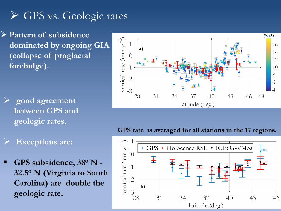
GPS vs. Geologic rates
GPS rate is averaged for all stations in the 17 regions.
Pattern of subsidence
dominated by ongoing GIA
(collapse of proglacial
forebulge).
good agreement
between GPS and
geologic rates.
Exceptions are:
GPS subsidence, 38o N -
32.5o N (Virginia to South
Carolina) are double the
geologic rate.
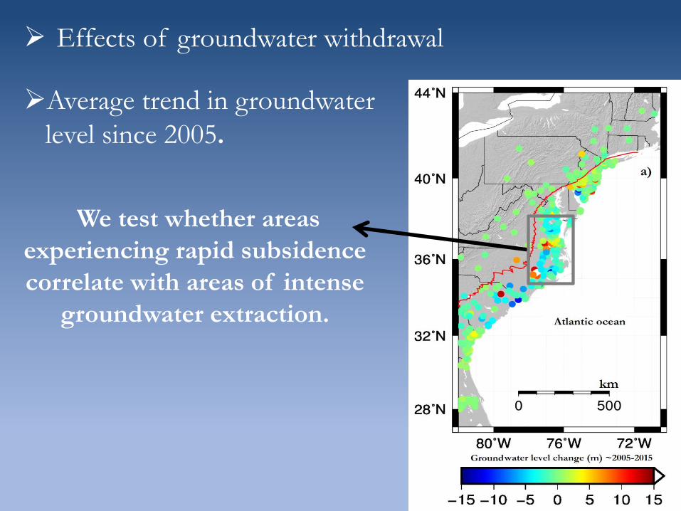
Effects of groundwater withdrawal
Average trend in groundwater
level since 2005.
We test whether areas
experiencing rapid subsidence
correlate with areas of intense
groundwater extraction.
GPS rates corrected for GIA (GPS rate minus geologic
rate) versus average trend in groundwater level changes.
Note correlation between rapid subsidence and groundwater
depletion. GPS subsidence rates are double the geologic rates,
suggesting that excessive groundwater extraction drives rapid
land subsidence.
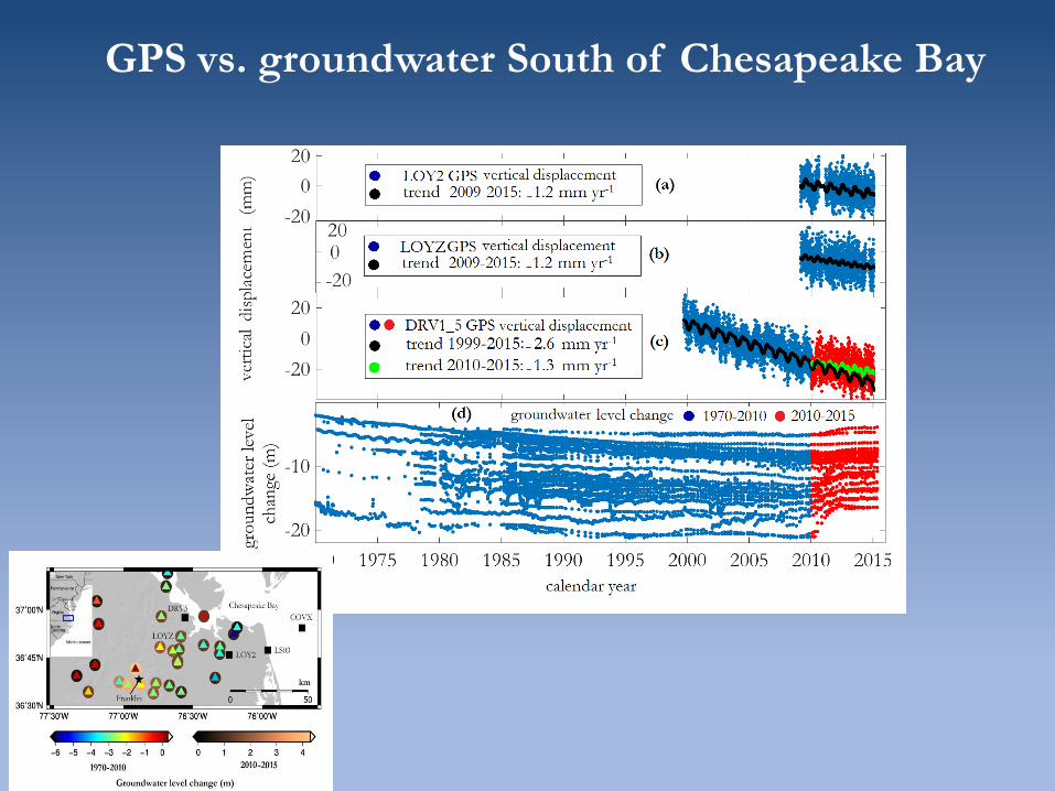
Southern Chesapeake
Bay region
GPS vs. groundwater South of Chesapeake Bay
Installation of more than 130 new cGPS stations in eastern
coastal NA since 2006 represents a significant improvement
in our ability to precisely define present-day vertical motions
in this region, improving our ability to understand and predict
RSL variations and long-term flood hazard.
Comparison of present-day land vertical motions estimated
from GPS with rates of late Holocene RSL rise indicates
substantial agreement in most areas.
Subsidence of Eastern seaboard of NA continues with
constant rate with GIA as the main deriver.
Exceptions are related to areas of recent excessive
groundwater extraction in Virginia (38o N) and South
Carolina (32.5o N). Tide gauge records, therefore, should be
used with caution for studying sea level rise in this region.
Summary
Three-dimensional surface velocity field for the
Mississippi Delta
GPS observations:
Geomorphic boundary
Karegar et al. (2015), Geology
Regional pattern in subsidence:
Sediment loading
Sediment compaction
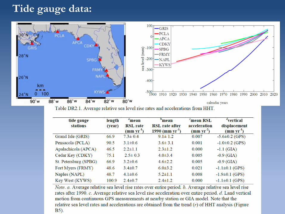
Tide gauge data:
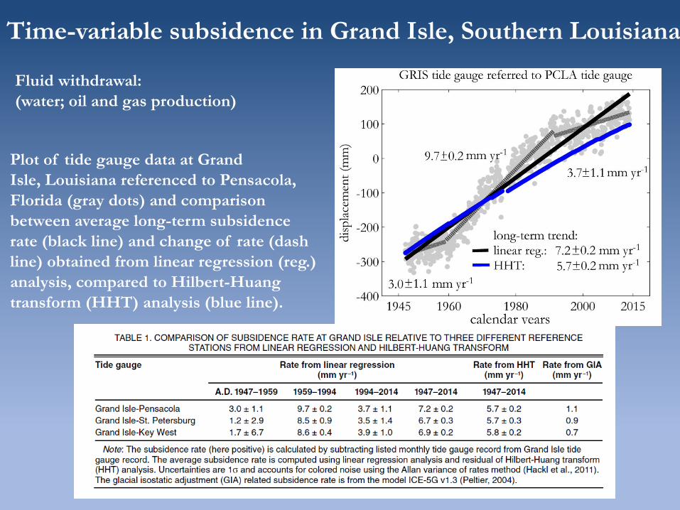
Time-variable subsidence in Grand Isle, Southern Louisiana
Plot of tide gauge data at Grand
Isle, Louisiana referenced to Pensacola,
Florida (gray dots) and comparison
between average long-term subsidence
rate (black line) and change of rate (dash
line) obtained from linear regression (reg.)
analysis, compared to Hilbert-Huang
transform (HHT) analysis (blue line).
Fluid withdrawal:
(water; oil and gas production)
The current rate of relative sea-level rise (combined effect of
land subsidence and sea-level rise) along parts of the coastal
delta is ~8–9 mm/yr.
Most tide gauge stations have recorded sea-level-rise acceleration
after A.D. 1970.
The agreement between the subsidence rate obtained from a
decade of GPS measurements and those estimated from
multidecadal tide gauge records using the HHT method indicates
that continuous GPS measurements adequately measure