Town of Mississippi Mills COMMITTEE OF THE WHOLE AGENDA Tuesday, April 7, 2015 Immediately following Council beginning at 6:00 p.m. Council Chambers, Municipal Office A. APPROVAL OF AGENDA B. DISCLOSURE OF PECUNIARY INTEREST C. DELEGATIONS/PRESENTATIONS/PUBLIC MEETINGS 1. Carleton Place and District Memorial Hospital – Annual presentation provided by Toni Surko, CEO 2. Public Meeting and Background Report for Zoning By-law Amendment #Z-02-15 2241497 Ontario Ltd, 430 Ottawa St Pages 1-4 3. Public Meeting and Background Report for Zoning By-law Amendment #Z-07-15 Norman & Gina Pratt, 6156 Martin St. N Pages 5-8 D. CONSENT MATTERS (for information) Building Reports – Monthly Report, February, 2015 Page 9 Animal Control – Monthly Report, February 2015 Page 10 D. STAFF REPORTS (for action and direction) Administration 1. Mileage for Council Pages 11-15 2. Councillor Benefit Packages Options Pages 16-20 Roads & Public Works 1. Provincial Groundwater Monitoring Network Contract Renewal – MVCA Pages 21-23 Planning & Development 1. Zoning By-law Administrative Amendment #7, Paintball definitions Pages 24-29 2. Zoning By-law Amendment #Z-05-15, 251 Mitcheson Street, Baker’s Quarry Pages 30-36 3. Zoning By-law Amendment #Z-06-15, 4698 Dark’s Side Road, Wright’s Pages 37-45 4. Zoning By-law Amendment #Z-12-14, Millrun Phase 1C Pages 46-54 5. Site Plan Control - Mill Run Phase 1B Pages 55-62 6. ANSI Policy Review Pages 63-96
Transcript
Town of Mississippi Mills
COMMITTEE OF THE WHOLE AGENDA
Tuesday, April 7, 2015
Immediately following Council beginning at 6:00 p.m. Council Chambers, Municipal Office
A. APPROVAL OF AGENDA B. DISCLOSURE OF PECUNIARY INTEREST C. DELEGATIONS/PRESENTATIONS/PUBLIC MEETINGS
1. Carleton Place and District Memorial Hospital – Annual presentation provided by Toni Surko, CEO
2. Public Meeting and Background Report for Zoning By-law Amendment #Z-02-15 2241497 Ontario Ltd, 430 Ottawa St Pages 1-4 3. Public Meeting and Background Report for Zoning By-law Amendment #Z-07-15 Norman & Gina Pratt, 6156 Martin St. N Pages 5-8
D. CONSENT MATTERS (for information)
Building Reports – Monthly Report, February, 2015 Page 9 Animal Control – Monthly Report, February 2015 Page 10
D. STAFF REPORTS (for action and direction) Administration
1. Mileage for Council Pages 11-15 2. Councillor Benefit Packages Options Pages 16-20 Roads & Public Works 1. Provincial Groundwater Monitoring Network Contract Renewal – MVCA Pages 21-23 Planning & Development
Committee of the Whole Agenda April 7, 2015 Page 2 F. OTHER/NEW BUSINESS
1. Council selection for Municipal Grants Working Group 2. Councillor Ferguson’s motion from March 3, 2015 Page 97
G. CLOSED SESSION/IN CAMERA
1. Municipal Land Acquisition (Municipal Act, Section 239 2(c)) 2. Staffing Contract Review (Municipal Act, Section 239 2(b))
H. NOTICE OF MOTION I. MINUTES
Motion to approve: Committee of the Whole Minutes - March 9 and March 17, 2015 Pages 98-106 Motion to receive: Cost Sharing with User Groups, working group – March 5, 2015 Pages 107-108 Mississippi River Power Corporation Minutes - January 22, 2015 Pages 109-112 MRPC General Manager Operational Report – January, 2015 Pages 113-115 Community Policing Advisory Minutes – March 3, 2015 Pages 116-121
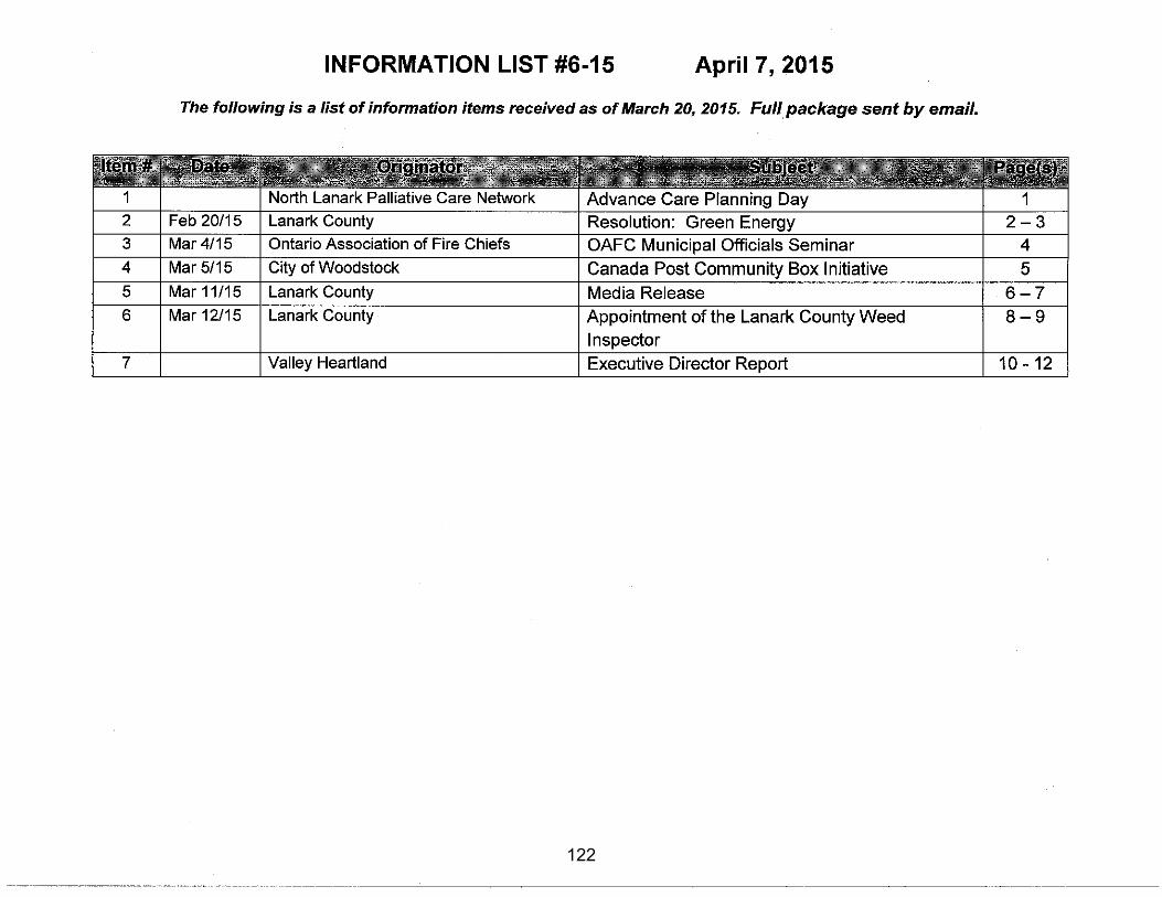
J. MISCELLANEOUS ITEMS 1. Information List Page 122 2. Task List Pages 123-124 3. Meeting Calendars Pages 125-126
K. ANNOUNCEMENTS/QUESTIONS OF STAFF Council Meeting, Special – April 14, 2015, 6:00 p.m. Council Meeting, Regular – April 21, 2015, 6:00 p.m. Committee of the Whole– April 21, 2015, immediately following Council
L. ADJOURNMENT
THE CORPORATION OF THE TOWN OF MISSISSIPPI MILLS
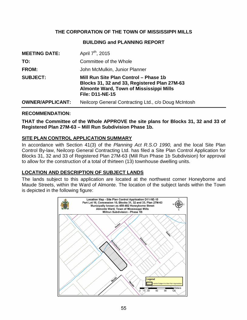
BUILDING and PLANNING REPORT MEETING DATE: April 7th, 2015 TO: Committee of the Whole FROM: Stephen Stirling – Town Planner SUBJECT: ALMONTE SQUARE COPA 12 (D14-22-15) AND
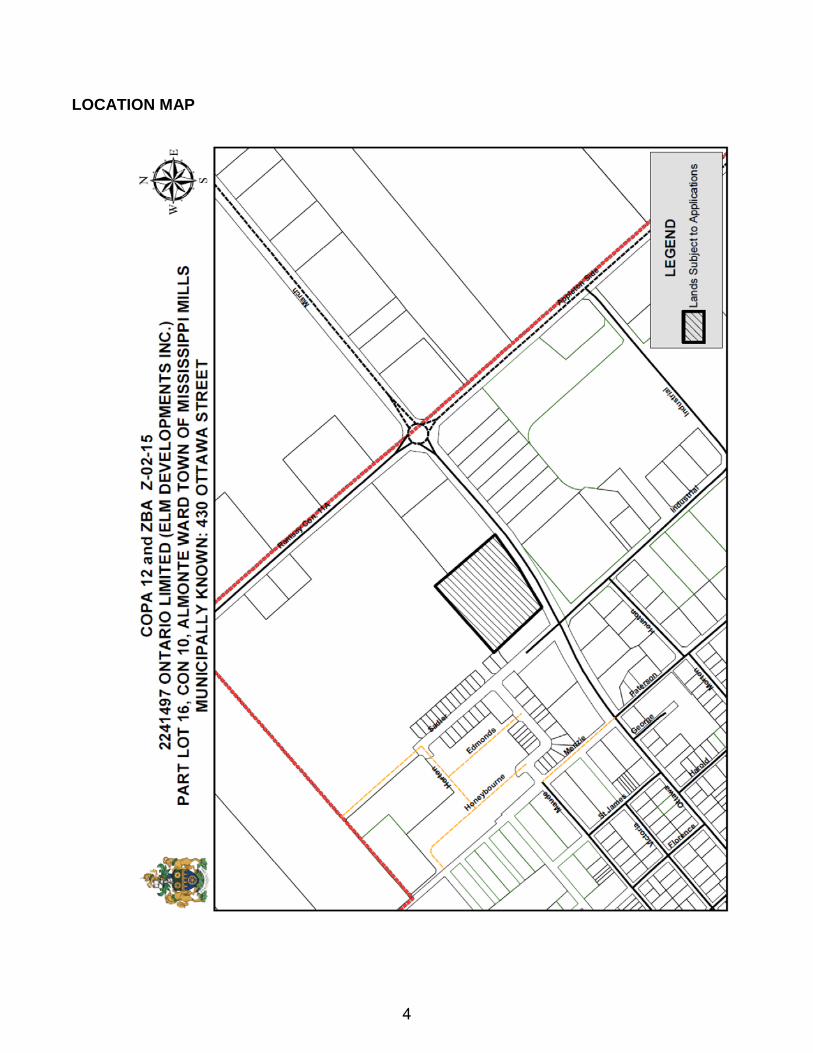
ZONING BY-LAW AMENDMENT #Z-02-15 (D14-22-15) Part of Lot 16, Concession 10, Registered Plan 27R-8445 being Parts 1 to 4, 9 to 11 Registered Plan 27R-8990 Part 1, Almonte Ward, Town of Mississippi Mills, municipally known as 430 Ottawa Street. BACKGROUND REPORT
RECOMMENDATION THAT the Committee of the Whole receives this background report for information purposes.
BACKGROUND 2241497 Ontario Limited has submitted applications for amendments to the Community Official Plan and Zoning By-law #11-83 to permit a gas bar on a portion of the lands described as Part of Lot 16, Concession 10, Almonte Ward in the Town of Mississippi Mills. The property is the current location of a local shopping centre, municipally known as Almonte Square. In 2011, the property was rezoned to allow the interior corridors to be used as leasable retail space, permit a new commercial retail pad in the southwest corner of the property and a minor reduction in on-site parking. The purpose and intent of the Official Plan Amendment and Zoning By-law Amendment is a site specific amendment of a 3.1ha (7.6ac) portion of the subject property to:
Community Official Plan: • permit a gas bar in the Well Head Protection Area-2-Year Caption Zone
Zoning By-law #11-83:
• Permit a gas bar in the Shopping Centre Commercial Exception 4 (C4-4) Zone • Reduce the required number of parking spaces from 281 to 260
DESCRIPTION OF SURROUNDING PROPERTIES AND SUBJECT PROPERTY The subject property is located on the north side of Ottawa Street, east of the Sadler Drive/Ottawa Street intersection. The subject property has a lot area of 2.58ha (6.38ac) with approximately 176.2m (578.08ft) of direct frontage on Ottawa Street. The property is a
1
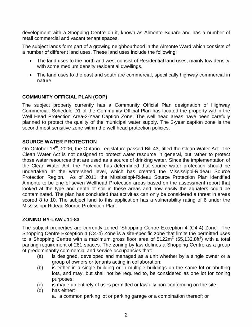
development with a Shopping Centre on it, known as Almonte Square and has a number of retail commercial and vacant tenant spaces. The subject lands form part of a growing neighbourhood in the Almonte Ward which consists of a number of different land uses. These land uses include the following:
• The land uses to the north and west consist of Residential land uses, mainly low density with some medium density residential dwellings.
• The land uses to the east and south are commercial, specifically highway commercial in nature.
COMMUNITY OFFICIAL PLAN (COP) The subject property currently has a Community Official Plan designation of Highway Commercial. Schedule D1 of the Community Official Plan has located the property within the Well Head Protection Area-2-Year Caption Zone. The well head areas have been carefully planned to protect the quality of the municipal water supply. The 2-year caption zone is the second most sensitive zone within the well head protection policies. SOURCE WATER PROTECTION On October 18th, 2006, the Ontario Legislature passed Bill 43, titled the Clean Water Act. The Clean Water Act is not designed to protect water resource in general, but rather to protect those water resources that are used as a source of drinking water. Since the implementation of the Clean Water Act, the Province has determined that source water protection should be undertaken at the watershed level, which has created the Mississippi-Rideau Source Protection Region. As of 2011, the Mississippi-Rideau Source Protection Plan identified Almonte to be one of seven Wellhead Protection areas based on the assessment report that looked at the type and depth of soil in these areas and how easily the aquafers could be contaminated. The plan has concluded that activities can only be considered a threat in areas scored 8 to 10. The subject land to this application has a vulnerability rating of 6 under the Mississippi-Rideau Source Protection Plan. ZONING BY-LAW #11-83 The subject properties are currently zoned “Shopping Centre Exception 4 (C4-4) Zone”. The Shopping Centre Exception 4 (C4-4) Zone is a site-specific zone that limits the permitted uses to a Shopping Centre with a maximum gross floor area of 5122m2 (55,132.8ft2) with a total parking requirement of 281 spaces. The zoning by-law defines a Shopping Centre as a group of predominantly commercial and service occupancies that:
(a) is designed, developed and managed as a unit whether by a single owner or a group of owners or tenants acting in collaboration;
(b) is either in a single building or in multiple buildings on the same lot or abutting lots, and may, but shall not be required to, be considered as one lot for zoning purposes;
(c) is made up entirely of uses permitted or lawfully non-conforming on the site; (d) has either:
a. a common parking lot or parking garage or a combination thereof; or
2
b. a group of parking lots or parking garages or a combination thereof which are managed as a unit by the same owner, owners or tenants of the commercial and service occupancies required in paragraph (a) above, and are on the same lot or lots as the commercial and service occupancies required in subparagraph (a) above.
CONCLUSION THAT the Committee of the Whole receives this background report for information purposes. All of which is respectfully submitted, _________________ _________________ Stephen Stirling MCIP, RPP Diane Smithson Town Planner Reviewed by CAO
3
LOCATION MAP
4
THE CORPORATION OF THE TOWN OF MISSISSIPPI MILLS
BUILDING and PLANNING REPORT MEETING DATE: April 7th, 2015 TO: Committee of the Whole FROM: John McMulkin – Junior Planner SUBJECT: BACKGROUND REPORT – ZONING BY-LAW AMENDMENT #Z-07-15
North Part Lot 21, Concession 10 Ramsay Ward, Town of Mississippi Mills Municipally known as 6156 Martin Street North
RECOMMENDATION: THAT the Committee of the Whole receives this background report for information purposes. BACKGROUND, PURPOSE AND EFFECT Norman and Gina Pratt own an agricultural property located within the Ward of Ramsay. The owners had originally applied for a minor variance to reduce the minimum lot area requirement in order to facilitate the construction of a second accessory detached dwelling, but were advised by Staff that a temporary zoning by-law amendment to permit a garden suite would be a more appropriate approach. The purpose and intent of the zoning by-law amendment is to change the zoning of a portion of the subject property to allow for the establishment of a detached garden suite as a temporary use for up to 10 years. A garden suite is described in the Town’s Community Official Plan as a temporary dwelling unit accessory to a primary residence which offers an alternative arrangement for housing elderly parents, handicapped family members or other similar individuals. The garden suite would be occupied by Norman Pratt’s elderly brother, Mr. James Pratt, in order to for him to be close to his family as he ages and there are increased demands for social care and support. The development proposal involves the construction of a new one-storey detached dwelling, which would be considered the new principal dwelling, with the existing two-storey detached dwelling being considered the garden suite. The portion of the property where the existing dwelling is located would be rezoned from the “Agricultural (A)” Zone to the “Agricultural Exception 23 Temporary (A-23t)” Zone in order to permit the establishment of the garden suite. Once the garden suite is no longer needed, the dwelling will either be decommissioned or removed, as per the terms and conditions of the subsequent garden suite agreement. DESCRIPTION OF SUBJECT LANDS The subject property is located on the east side of Martin Street North, north of McPhail Side Road and within the Ward of Ramsay. The irregular property is ±37.49ha (92.63ac) in lot area and has a lot frontage of ±304.50m (999ft) along the abandoned railway lands. There is a right-
5
of-way easement registered over the property to the southwest (6154 Martin Street North) which provides driveway access to the property over the abandoned railway. The subject property is currently occupied by a detached dwelling and several farm buildings. A stream flows from a small pond across the westerly half of the property and into the Mississippi River to the southwest of the property. The property is surrounded by agricultural properties with active farming operations to the north and south, non-farm residential properties and agricultural properties to the west, and municipally owned conservation land to the east.
COMMUNITY OFFICIAL PLAN (COP) The subject lands are designated “Agriculture”, “Rural” and “Locally Significant Wetland” in the Town’s COP. The Agriculture and Rural designations permit agricultural uses and non-farm residential uses including a detached dwelling and a garden suite. The Flood Plain designation permits agricultural uses, forestry, conservation, wildlife management, outdoor recreation uses and similar activities provided no buildings or structures are located within the flood plain. ZONING BY-LAW #11-83 The subject lands are currently zoned “Agricultural (A)”, “Rural (RU)” and “Environmental Protection (EP)” by the Town’s Comprehensive Zoning By-law #11-83. The A and RU Zones permit residential uses such as a detached dwelling and a garden suite, and non-residential uses such as agricultural uses and other similar uses. The EP Zone permits conservation and existing uses, as well as forestry and agricultural uses excluding related buildings and structures. The portion of the property where the existing dwelling is located would be rezoned from the “Agricultural (A)” Zone to the “Agricultural Exception 23 Temporary (A-23t)” Zone in order to permit the establishment of the garden suite. CONCLUSION
RECOMMENDATION: THAT the Committee of the Whole receives this background report for information purposes. All of which is respectfully submitted, __________________ John McMulkin, BES Junior Planner __________________ ___________________ Stephen Stirling MCIP, RPP Diane Smithson Town Planner Reviewed by CAO
6
APPENDIX Location Map
Zoning By-law Amendment Application Z-07-15
7
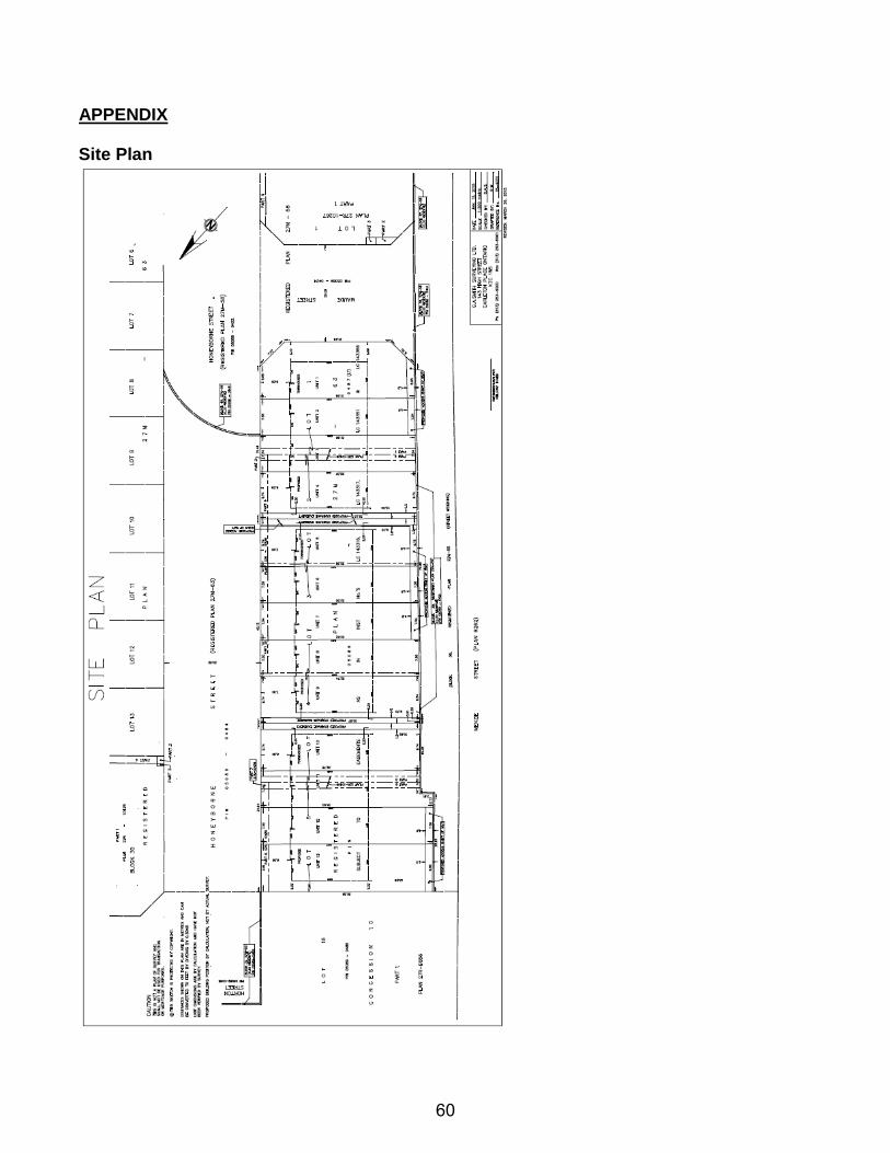
Site Plans
8
TOWN OF MISSISSIPPI MILLS
BUILDING PERMITS
COMPARISON BY PERMIT TYPEYearly activity up to the MARCH 24, 2015
Type Count Work Value Permit Fees Type Count Work Value Permit FeesDemolitions 12 $71,400.00 $1,520.00
New Res. Construction 11 $ 2,079,050.00 $ 18,313.36 New Res. Construction 79 $14,445,275.00 $156,728.76New Com. Construction 0 New Com. Construction 6 $2,290,000.00 $11,557.68Addition Res. 0 Addition Res. 15 $566,200.00 $6,541.96Addition Com. 0 Addition Com. 2 $390,000.00 $6,831.84Alteration Res. 15 $ 333,950.00 $ 6,469.18 Alteration Res. 97 $1,125,846.00 $26,577.48Alteration Com. 2 $ 50,300.00 $ 1,148.00 Alteration Com. 26 $1,264,180.00 $22,567.60Other 0 Other 8 $41,700.00 $858.00Pool 0 Pool 16 $201,700.00 $3,017.70Garage/Accessory-Building 0 Garage/Accessory-Building 26 $542,300.00 $5,516.08Agriculture 0 Agriculture 5 $208,100.00 $1,507.40Mixed-use 0 Mixed-use 6 $13,062,000.00 $103,927.08Change of Use 0 Change of Use 2 $6,500.00 $304.00YEAR TO DATE 28 $ 2,463,300.00 $ 25,930.54 YEAR TO DATE 300 $34,215,201.00 $347,455.58
Number of Units Number of Units
7 430 60 03 211 211 72
2015 Permit Activity
2015 SUMMARY OF NEW RESIDENTIAL UNITS *TO DATE*
Type
Single Family DwellingSemi-Detached
2014 Permit Activity
Town House/Row HouseApartment/Condo/Change of Use
Duplex
2014 SUMMARY OF NEW RESIDENTIAL UNITS *TO DATE*
Type
Single Family DwellingSemi-Detached
DuplexTown House/Row House
Apartment/Condo/Change of Use** Includes 4 Rebuilds
Notes: Cancelled permits for six (6) new townhouse units (Almonte BP#14-228 - 233 issued October) Cancelled permit for one (1) new single family dwelling unit (Ramsay BP#14-179 issued October)
** Please note "rebuilts" replace original home due to fire damage or demolition of homes.
** Includes 4 Rebuilds
3/30/2015 1 March report permits by type for council building permits 2015.xlsx
9
10
THE CORPORATION OF THE TOWN OF MISSISIPPI MLLS
COMMITTEE REPORT
DATE: April 7, 2015 TO: Committee of the Whole FROM: Rhonda Whitmarsh, Treasurer SUBJECT: MILEAGE FOR COUNCIL RECOMMENDATION: THAT the Committee of the Whole recommends that the Council remuneration by-law for 2015 include Option 1 of the Treasurer’s report dated April 7, 2015; AND FURTHERMORE THAT the Council remuneration by-law for 2015 also include the conditions for mileage claims noted in the same report. BACKGROUND: During 2015 budget deliberations, Councillor Gillis prepared a report on Council remuneration and benefits which contained several recommendations that the Committee of the Whole voted on individually. The following motion related to Council mileage was passed at the Committee of the Whole meeting held on February 9, 2015. Moved by Councillor McCubbin Seconded by Councillor Abbott THAT Committee of the Whole approves the implementation of discretionary and conditional mileage coverage for round trip travel greater than 25 km.
CARRIED
After the budget meeting, I heard from several Councillors on this issue who provided suggestions as to options that could be considered. The above motion passed at Committee of the Whole is somewhat restrictive with respect to the 25 km limit and in my opinion is not binding until the budget and Council remuneration by-law are approved by Council. I have therefore provided options for the payment of mileage that do not necessarily conform to the above motion. The motion also does not refer to Council mileage but that was the original intent of the motion. DISCUSSION: The options that are presented are for Council’s consideration and represent the easiest options to administer while providing fairness to Council members. The options are based on the following conditions:
1. Council mileage being discussed in this report refers to all Committee of the Whole meetings both regular and special but does not refer to all other committee meetings within the municipality that Councillors may be required to
11
attend. All other committee meeting attendance within the municipality is deemed to be covered by the 1/3 tax free remuneration paid to all members of Council annually.
2. Conferences/seminars/meeting attendance for Council business outside the municipality will continue to be reimbursed at the applicable mileage rate based on submitted claims.
3. Kilometres calculated per Council member mileage claims are for round trip travel from the Council member’s place of residence.
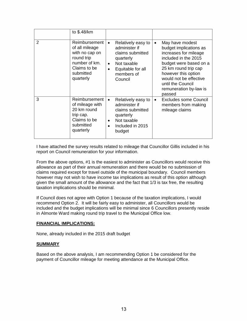
The payment of mileage to Council members can be made one of two ways; as a monthly allowance or as a reimbursement at the current mileage rate. Allowances Under the Federal Income Tax Act, allowances for travel/mileage are taxable. For most employees, an allowance would be taxable at 100%, but for municipal elected officials, the allowance would be 1/3 tax free similar to Council remuneration. Reimbursements The reimbursement of mileage for Council members is not taxable under the Federal Income Tax Act as long as it is reasonable. The Income Tax Act prescribes per km rates (below 5,000 km and over 5,000 km) which the municipality currently follows when establishing annual mileage reimbursement rates for all municipal employees and Council and is presently $.48/km. Option Description Advantages Disadvantages 1 Annual mileage
allowance as follows: • Resides in
Almonte Ward-$150
• Resides in Ramsay Ward-$400
• Resides in Pakenham Ward-$600
Calculated by considering avg. km to municipal office for members and approx. number of meetings per year compared
• Easy to administer
• Provides an amount to all Council members
• Included in 2015 budget
• Does not reimburse for actual mileage
• Is 2/3 taxable
12
to $.48/km
2 Reimbursement of all mileage with no cap on round trip number of km. Claims to be submitted quarterly
• Relatively easy to administer if claims submitted quarterly
• Not taxable • Equitable for all
members of Council
• May have modest budget implications as increases for mileage included in the 2015 budget were based on a 25 km round trip cap however this option would not be effective until the Council remuneration by-law is passed
3 Reimbursement of mileage with 20 km round trip cap. Claims to be submitted quarterly
• Relatively easy to administer if claims submitted quarterly
• Not taxable • Included in 2015
budget
• Excludes some Council members from making mileage claims
I have attached the survey results related to mileage that Councillor Gillis included in his report on Council remuneration for your information. From the above options, #1 is the easiest to administer as Councillors would receive this allowance as part of their annual remuneration and there would be no submission of claims required except for travel outside of the municipal boundary. Council members however may not wish to have income tax implications as result of this option although given the small amount of the allowance and the fact that 1/3 is tax free, the resulting taxation implications should be minimal. If Council does not agree with Option 1 because of the taxation implications, I would recommend Option 2. It will be fairly easy to administer, all Councillors would be included and the budget implications will be minimal since 6 Councillors presently reside in Almonte Ward making round trip travel to the Municipal Office low. FINANCIAL IMPLICATIONS: None, already included in the 2015 draft budget SUMMARY Based on the above analysis, I am recommending Option 1 be considered for the payment of Councillor mileage for meeting attendance at the Municipal Office.
13
Respectfully Submitted Reviewed By Rhonda Whitmarsh, Diane Smithson Treasurer CAO
14
15
THE CORPORATION OF THE TOWN OF MISSISIPPI MLLS
COMMITTEE REPORT
DATE: April 7, 2015 TO: Committee of the Whole FROM: Diane Smithson, Chief Administrative Officer SUBJECT: BENEFITS FOR COUNCILLORS RECOMMENDATION: THAT the Committee of the Whole recommends that Council proceed with Option 1 – Status Quo for benefits coverage for Councillors during the 2014-2018 term of Council; AND FURTHERMORE THAT Council revisit benefit coverage at the beginning of each Council term to decide on any program changes. BACKGROUND: During 2015 budget deliberations, Councillor Gillis prepared a report on Council remuneration and benefits which contained several recommendations that the Committee of the Whole voted on individually. The following motion related to Council benefits was passed at the Committee of the Whole meeting held on February 9, 2015. Moved by Councillor Wilkinson Seconded by Councillor Edwards THAT Committee of the Whole instructs staff to prepare a report on providing benefits such as life insurance, drug plan, dental plan and pension to members of Council.
CARRIED
DISCUSSION: Currently only Accidental Death and Dismemberment benefits are provided to members of Council through the Town’s general insurance program offered through Jardine, Lloyd Thompson. No other benefits such as health and dental, life insurance, or pension plan are provided to members of Council. The benefits program offered to full time staff includes the following: A. GROUP INSURANCE
• Life insurance- 200% of annual earnings to a maximum of $300,000.00 which reduces by 50% at age 65. Dependant and child coverage max of $5,000 and $2,500 respectively
• Long term disability – 67% of monthly pay to a maximum of $5,000 per month effective after 119 days
16
• Accidental death and dismemberment to a maximum of 200% of annual earnings to a maximum of $300,000 which reduces by 50% at age 65
• Semi-private hospital care • Emergency travel assistance • Medical expenses – after $50.00 family deductible and $25.00 single
deductible per calendar year, reimbursement is 100% • Dental expenses – 80% pay out of expenses (no deductible); maximum
$1,000 per year per family member The Town of Mississippi Mills is responsible for all premium costs with the exception of Long Term Disability (LTD), which is paid by employees. LTD premiums that are paid by an employee are non-taxable when the benefits are utilized.
B. PENSION PLAN
The Pension Plan for the employees of the Town of Mississippi Mills is the Ontario Municipal Employees Retirement System (OMERS) and will be administered in accordance with the OMERS Act and Regulation.
The information presented below is based on a similar benefits program that is currently offered to staff. In addition, the following assumptions have been made: • The estimates provided are based on current benefits rates. There is a renewal
coming up effective June 1, 2015 at which point rates will change affecting the overall costs. At this time, it is unclear what the renewal rates will be, however, they will be increasing.
• Benefits, if approved, would not take effect until January 1, 2016. Having said this, the estimates provided are based on 2015 program costs as rates for 2016 are not yet known
• The Town could offer a benefits program as long as five (5) or more members are covered under the plan. It is suggested that the council plan, if approved, be set up as a separate billing group to track their experience separately to assist with future premium adjustments.
• Insurers would not provide coverage for Long Term Disability for councillors as they are considered a part-time position
BENEFIT DESCRIPTION / COMMENTS ANNUAL COST
IMPLICATION OMERS Pension Plan
Council may choose to enrol all council members (including the head of council) or the head of council only. The council members, without the head of council, cannot participate in the OMERS plan. At the effective date of council participation, existing council members may individually elect to join the OMERS pension plan. A council member who does not join the plan on the effective date may choose to participate at a
Based on the current ages of council members and the timing for a decision, there would be two members who could not participate due to their ages. There would be a further member who would
17
future date. If Council decides to participate in OMERS, any new, future member of council must join the OMERS plan, provided the enrolment occurs no later than November 30 of the year of his/her 71st birthday. No member can join beyond the age of 71. The Council, as a class, is treated separately for purposes of OMERS membership. Where a municipality has decided to keep 1/3 of the council member’s salary as non-taxable expense reimbursement, only 2/3 excluding any additional non-taxable allowances or reimbursements may be included in contributory earnings.
be ineligible in 2016 for the same reason. Based on nine (9) members participating at a current contribution rate of 9% of earnings (matched by the council member), the annual cost would be: $9,227.31
Life Insurance Based on 2 x the councillor’s salary which reduces by 50% between 65 and 70 years of age. Only 8 of 11 members are eligible as there is no coverage for members 70 years of age or older and of the remaining 8, only 5 are eligible for full coverage.
$648.00 annual cost
Dependent Life Dependant and child coverage max of $5,000 and $2,500 respectively. Again, only 8 members of Council are currently eligible for this coverage
$108.00 annual cost
Extended Medical Coverage
Includes drug coverage, paramedical expenses and semi-private hospital coverage. Only 8 members of Council are currently eligible for this coverage
$11,892.00 annual cost
Dental Coverage 80% pay out of expenses. Only 8 members of Council are currently eligible for this coverage
$5,448.00 annual cost
TOTAL COST $27,323.31 annual cost
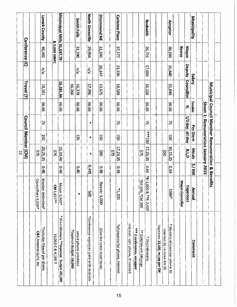
I have attached the survey results related to benefits that Councillor Gillis included in his report on Council remuneration as Appendix ‘A’ for your information. OPTIONS: 1. Status quo - As only eight (8) members of Council are eligible to participate in the
majority of benefits noted above given the age of members, Staff is recommending that benefits not be provided during the 2014-2018 Council term as it is not a program that all members of Council can participate in equally. Throughout the term,
18
there will be additional members who will not be able to continue with the benefits program given their age. Should Council decide to proceed with some level of benefit coverage, Staff recommend that it not commence until January 1, 2016 as funds have not been included in the 2015 budget. There would be no budgetary impact associated with this recommendation.
2. Full Benefits Coverage – this option would include providing the full range of benefits
coverage noted above. It should be kept in mind that not all members of Council will be able to participate in the program.
Council does have the option to alter the terms of the program such that the coverage offered would be customized to Council and would not be the same as the package offered to staff. An example would include, rather than providing a multiple of salary for life insurance, a flat rate coverage of $25,000 or $50,000 could be offered instead.
The cost implication of proceeding with this option that is similar to the program offered to staff is noted above for 2016 but will change in accordance with any rate increases.
3. Partial Benefits Coverage – this option would include proceeding with some of the
benefits above i.e. OMERS only. Life, Dependent Life, Medical and Dental, are a group package of benefits that have to be offered together except that if a member of Council has medical and dental coverage through their spouse, they would be able to provide proof of same and be excluded from these two components only. If Council decides to proceed with benefits, life and dependent life would be mandatory for those members who are eligible to participate in these portions of the program.
However, Council could alter the terms of the program such that the coverage offered would be customized to Council and would not be the same as the package offered to staff. An example would include, rather than providing a multiple of salary for life insurance, a flat rate coverage of $25,000 or $50,000 could be offered instead. The cost implications associated with this would depend on the coverage Council decided to proceed with.
FINANCIAL IMPLICATIONS: The cost implications associated with the different types of benefits are noted above. These rates will change each year depending on the ages of the members and any rate changes at the time of benefit renewals. SUMMARY Based on the above analysis, I am recommending Option 1, status quo be considered for councillor benefit coverage during the 2014-2018 term of council and that this matter be revisited at the start of every council term. Respectfully Submitted Diane Smithson Chief Administrative Officer
19
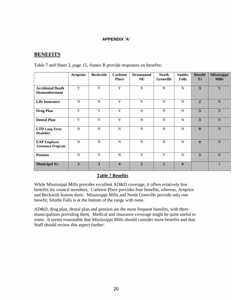
APPENDIX ‘A’ BENEFITS Table 7 and Sheet 2, page 15, Annex B provide responses on benefits:
Arnprior Beckwith Carleton Place
Drummond NE
North Grenville
Smiths Falls
Benefit Ys
Mississippi Mills
Accidental Death Dismemberment
Y Y Y N N N 3 Y
Life Insurance N N Y Y N N 2 N
Drug Plan Y Y Y N N N 3 N
Dental Plan Y Y Y N N N 3 N
LTD Long Term Disability
N N N N N N 0 N
EAP Employee Assistance Program
N N N N N N 0 N
Pension N Y N Y Y N 3 N
Municipal Ys 3 3 4 2 1 0 1
Table 7 Benefits
While Mississippi Mills provides excellent AD&D coverage, it offers relatively few benefits for council members. Carleton Place provides four benefits, whereas, Arnprior and Beckwith feature three. Mississippi Mills and North Grenville provide only one benefit; Smiths Falls is at the bottom of the range with none.
AD&D, drug plan, dental plan and pension are the most frequent benefits, with three municipalities providing them. Medical and insurance coverage might be quite useful to some. It seems reasonable that Mississippi Mills should consider more benefits and that Staff should review this aspect further.
20
THE CORPORATION OF THE TOWN OF MISSISSIPPI MILLS
ROADS AND PUBLIC WORKS REPORT MEETING DATE: April 7, 2015 TO: Committee of the Whole FROM: W. Troy Dunlop, Director of Roads and Public Works SUBJECT: PROVINCIAL GROUNDWATER MONITORING NETWORK CONTRACT RENEWAL - MVCA RECOMMENDATION: THAT the Committee of the Whole recommends that Council pass the necessary by-law authorizing the Mayor and Clerk to enter into a six year contract with the Mississippi Valley Conservation Authority for groundwater monitoring facilities on Pick Road. BACKGROUND: The Provincial Ground Water Monitoring Network is a partnership program between all 36 Conservation Authorities to collect and manage baseline groundwater level and quality information for the Ministry of Environment and Climate Change (MOECC). Currently the Mississippi Valley Conservation Authority monitors 8 wells throughout the watershed hourly for water temperature and water level. Wells sampled for water quality have samples taken once a year in the fall. Water samples are then sent off to an accredited MOECC laboratory where a variety of parameters, including nutrients and metals, are analyzed. This program allows the partnership to monitor long-term trends in groundwater levels and quality which can be impacted by changes in land use as well as climate. DISCUSSION: On March 11, 2015, the Town of Mississippi Mills received a request by the Mississippi Valley Conservation Authority to renew the landowner agreement for the monitoring well on Pick Road (see Attachment A). Landowner agreements are generally updated every six years and these agreements set the rights and responsibilities for the owner of the well and as the corresponding landowner. These wells serve as an important planning tool in monitoring and tracking the effects of climate change and as such it is recommended that the Town continue to support the program by granting continued use of facilities on Pick Road. FINANCIAL IMPLICATIONS: None.
21
SUMMARY: The Mississippi Valley Conservation Authority (MVCA) currently participates in a Provincial Ground Water Monitoring Network with all 36 conservation authorities in the province. This program monitors the quantity and quality of ground water and monitors any trends that may be reflective of climate change. The MVCA has eight well facilities in the watershed and one of these existing wells can be found on Pick Road. Landowner agreements are in place for each of the wells throughout the province and agreements are renewed on a six year term. Staff have reviewed the terms of the landowner agreement and are recommending that Council authorize a new six year agreement for the Pick Road monitoring well. Respectfully submitted, Reviewed by, _________________________________ _________________________________ W. Troy Dunlop, C.E.T. Diane Smithson, CAO Director of Roads and Public Works
22
23
THE CORPORATION OF THE TOWN OF MISSISSIPPI MILLS
BUILDING and PLANNING REPORT MEETING DATE: April 7, 2015 TO: Committee of the Whole FROM: Stephen Stirling, Town Planner SUBJECT: ADMINISTRATIVE AMENDMENT 7 TO ZONING BY-LAW #11-83
PAINTBALL OPERATION DEFINITIONS RECOMMENDATION: THAT the Committee of the Whole recommends that Council APPROVE the necessary Zoning By-law Amendment to provide a definition for “Paintball Operation, Commercial” and a definition for “Paintball Operation, Private” within Section 5 of the Town’s Comprehensive Zoning By-law #11-83.
BACKGROUND Staff was directed by a motion of the Committee of the Whole at their May 6th, 2014 meeting to prepare a report explaining the history of the paintball operation located on the 12th Concession in Ramsay and to provide recommendations on how to address these types of proposals. This direction stems from a noise complaint regarding a paintball operation located at 1214 Ramsay Concession 12, which is a ±21.92ha (54.17ac) property designated “Agriculture” in the Town’s Community Official Plan (COP) and zoned “Agricultural (A)” by Zoning By-law #11-83. In response to the complaint, Staff wrote the owner a letter on June 19th, 2013 explaining that a paintball facility is not a permitted use on the property and that a search of Town records did not provide any documents to support its legal existence. The letter informed the owner that in order to operate a paintball facility on the property, the owner would be required to submit and receive approval for applications for a Zoning By-law Amendment and a Community Official Plan Amendment. The owner wrote a letter back to Staff on July 9th, 2013 explaining that the paintball facility is not operated for commercial purposes, as they have allowed their friends to use their property free of charge to practice the sport on Saturdays at a specified time. The paintball practice would occur on a regular basis, typically from 8:00 a.m. to approximately 2:00 p.m. or 3:00 p.m. In addition to the team practice, Marked Paintball also hosted a couple of birthday parties for players or their children. Staff wrote the owner a subsequent letter on August 2nd, 2013 noting that while the response letter clearly states that the owner is not operating a commercial paintball facility on the subject property, the Town would like to confirm that the guests using the property are also not doing so. The Town has been conducting an ongoing investigation of the use of the subject property in order to ensure compliance with the Zoning By-law.
24
PURPOSE AND EFFECT OF APPLICATION The purpose of the amendment is to provide definitions for a “paintball operation” in order to ensure that these establishments are directed to the most appropriate locations. Paintballing is currently permitted within the “Highway Commercial (C3)”, “Tourist Commercial (C6)”, “Light Industrial (M1)”, “Medium Industrial (M2)” and “Parkland and Open Space (OS)” Zones in conjunction with the permitted use of an “amusement park”. The definition of an amusement park is as follows:
“AMUSEMENT PARK” means an indoor or outdoor entertainment facility providing for a range of activities and recreation, including a zoo or aquarium, electronic or mechanical rides such as a go-cart track or sports-adventure and participation games such as laser tag; paintballing; batting cage; or miniature golf facility.
A “paintball operation” is not a defined use within Section 5 of the Town’s current Comprehensive Zoning By-law #11-83, and as such, is not listed as a permitted use within any zoning category. However, given that a paintball operation can include a recreational team or club, a paintball operation might be permitted within a “sports arena” or by the general nature of how the permitted use of a “commercial club” is defined. A commercial club is defined as “a building or premises used as an athletic, recreational or social club operated for gain or profit.” Commercial clubs and sports arenas are permitted in many parts of the Town that are zoned for commercial, industrial or recreational purposes. For example, commercial clubs are permitted within the “Downtown Commercial (C2)” and “Highway Commercial (C3)” Zones, while a sports arena is permitted within the “Community Facility (I)” and “Parkland and Open Space (OS)” Zones. Some of these zones may not be desirable locations for a paintball operation, and without specific mention of paintball operations in the Zoning By-law, it is possible under current zoning regulations to locate these uses in many parts of the Town without limitation on the numbers of such uses that may be established. In order to ensure that proposals for paintball operations are directed to the most appropriate locations, it is recommended that they be defined as a separate use, but not be permitted within any zone. This way, any person or organization looking to establish a future paintball operation not located within the C3, C6, M1, M2 or OS Zones would be required to file an application for a Zoning By-law Amendment to Council. This approach to restricting the establishment of paintball operations is consistent with the policies of the COP and would give Council more control over the location of these facilities to ensure compatibility with surrounding land uses.
COMMUNITY OFFICIAL PLAN (COP) Given that a paintballing is permitted in conjunction with an Amusement Park use within the C3, C6, M1, M2 and OS Zones, it would also be permitted within the associated “Highway Commercial”, “Rural”, “Industrial” and “Parkland and Open Space” land use designations of the Community Official Plan (COP). Any proposal for a paintball operation not located within these designations would be subject to a Community Official Plan Amendment, in addition to the required Zoning By-law Amendment.
25
COMMENTS FROM INTERNAL CIRCULATION Comments received based on the circulation of this application have been summarized below:
CAO: No concerns or objections. CBO: No concerns or objections. Fire Chief: No concerns or objections. Director of Roads and Public Works: No concerns or objections. Recreation Coordinator: No concerns or objections.
COMMENTS FROM EXTERNAL AGENCY CIRCULATION The application was not circulated to external agencies.
COMMENTS FROM THE PUBLIC The Town held a Public Meeting on January 13th, 2015, to provide an opportunity for the public to speak to the application. During the Public Meeting, two residents spoke in favour of or in opposition to the application. Ms. McPhail was concerned that the new definitions would result in the loss of her right to enjoy her property, while Mr. Postma questioned whether this by-law would address the paintball operation on the neighbouring property. The intent of the by-law is to balance the rights of all property owners. The by-law will allow property owners and their neighbours to personally enjoy the use their property while ensuring that one’s personal enjoyment of their property does not significantly impact the neighbours right to also enjoy their own property. At the time this staff report was prepared, the Town only received one written submission that did not support the application. Halina Knap is of the opinion that there is too much government involvement in public freedom, the Town shouldn’t be trying to fix something that “ain’t broken”, and that these amendments are unnecessary expenditures of public monies (see Appendix). It is noted that the reasons for the preparation of Administrative Amendment 7 are stated in the Background and Purpose & Effect sections of this report. There are no additional expenditures of public monies as these amendments are being prepared in-house by existing municipal planning staff.
IMPLEMENTATION The above example of the paintball facility located at 1214 Ramsay Concession 12 illustrates that while paintball facilities can be operated for both commercial and private (non-profit) purposes, the issue regarding land use compatibility with surrounding properties remains the same. While commercial businesses generally have greater demands on municipal infrastructure due to the consistency of their operations and the traffic they generate, the impacts incurred due to nuisances from noise remain the same regardless of whether they are operated for commercial or private purposes. Therefore, Staff is recommending that the Town be proactive in its approach to future proposals for paintball facilities by implementing both a definition for a Commercial Paintball Operation and a Private Paintball Operation. The proposed definitions of the uses are outlined below:
26
“PAINTBALL OPERATION, COMMERCIAL” means a building or part of a building or lot or part of a lot where the use of facilities and/or accessories are sold to persons to engage in target practice, games of combat and related activities using paintball pellets ejected from air rifles, pistols or other devices. A Commercial Paintball Operation may include an accessory retail store and/or a restaurant. “PAINTBALL OPERATION, PRIVATE” means a building or part of a building or lot or part of a lot other than a Commercial Paintball Operation where the use of facilities and/or accessories are provided to persons to engage in target practice, games of combat and related activities using paintball pellets ejected from air rifles, pistols or other devices. A Private Paintball Operation is not operated for gain or profit.
In addition to a Commercial Paintball Operation, its definition also includes an accessory retail store and a restaurant. The retail store would be for the sale of equipment and related accessories to support the paintball operation and the restaurant use is there to recognize that the operation may not be located in an area within close proximity to food establishments.
It is noted that since any future proposal for a paintball operation would be subject to a Zoning By-law Amendment, Council can modify these definitions on a case-by-case basis to address the site-specific circumstances of each proposal to ensure compatibility within its surrounding environment.
CONCLUSION Based on the preceding evaluation, Staff is of the opinion that the proposed Zoning By-law Amendment approach is an appropriate tool for minimizing potential land use conflicts between incompatible land uses. By defining both Commercial Paintball Operations and Private Paintball Operations within Section 5 of the Town’s Comprehensive Zoning By-law #11-83 but not permitting them within any zone, Council will have more control over the location of these establishments. This will ultimately achieve the goal of ensuring that proposals for paintball operations are compatible with surrounding properties while respecting the values of the community. RECOMMENDATION: THAT the Committee of the Whole recommends that Council APPROVE the necessary Zoning By-law Amendment to provide a definition for “Paintball Operation, Commercial” and a definition for “Paintball Operation, Private” within Section 5 of the Town’s Comprehensive Zoning By-law #11-83. All of which is respectfully submitted, __________________ ___________________ Stephen Stirling MCIP, RPP Diane Smithson Town Planner Reviewed by CAO
27
ATTACHMENT
28
DRAFT BY-LAW
THE CORPORATION OF THE TOWN OF MISSISSIPPI MILLS
BY-LAW NO. 15-__ BEING a by-law to amend By-law No. 11-83 being the Zoning By-law for the Town of Mississippi Mills. NOW THEREFOREthe Council of the Corporation of the Town of Mississippi Mills pursuant to Section 34 of the Planning Act, R.S.O. 1990, Chapter P.13, enacts as follows: 1. By-law No. 11-83, as amended, is hereby further amended by adding the following
definitions to Section 5:
“PAINTBALL OPERATION, COMMERCIAL” means a building or part of a building or lot or part of a lot where the use of facilities and/or accessories are sold to persons to engage in target practice, games of combat and related activities using paintball pellets ejected from air rifles, pistols or other devices. A Commercial Paintball Operation may include an accessory retail store and/or a restaurant. “PAINTBALL OPERATION, PRIVATE” means a building or part of a building or lot or part of a lot other than a Commercial Paintball Operation where the use of facilities and/or accessories are provided to persons to engage in target practice, games of combat and related activities using paintball pellets ejected from air rifles, pistols or other devices. A Private Paintball Operation is not operated for gain or profit.
2. This By-Law takes effect from the date of passage by Council and comes into force and effect pursuant to the provisions of the Planning Act, R.S.O 1990.
BY-LAW read, passed, signed and sealed in open Council this ___day of __________, 2015.
_________________________ _________________________ Shaun McLaughlin, Mayor Julie Oram, Clerk
29
THE CORPORATION OF THE TOWN OF MISSISSIPPI MILLS
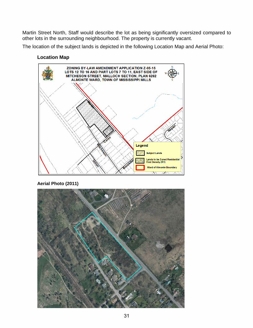
BUILDING and PLANNING REPORT MEETING DATE: April 7th, 2015 TO: Committee of the Whole FROM: John McMulkin, Junior Planner SUBJECT: ZONING BY-LAW AMENDMENT APPLICATION Z-05-15
Lots 12 to 16 and Part Lots 7 to 11, East Side of Mitcheson Street, Malloch Section, Plan 6262 Almonte Ward, Town of Mississippi Mills Municipally known as 251 Mitcheson Street
RECOMMENDATION: THAT the Committee of the Whole recommends that Council APPROVE the necessary Zoning By-law Amendment to change the zoning of the severed parcels of land from the property legally described as Lots 12 to 16 and Part Lots 7 to 11, East Side of Mitcheson Street, Malloch Section, Plan 6262, Almonte Ward, Town of Mississippi Mills, municipally known as 251 Mitcheson Street, from the “Residential First Density Exception 4 (R1-4)” Zone to the “Residential First Density (R1)” Zone in order to re-establish the permitted uses of the R1 Zone on these severed parcels. BACKGROUND, PURPOSE AND EFFECT John Pattison of Baker’s Quarry Inc. owns a large residential property located within the Ward of Almonte. The owner received provisional consent approval from the County of Lanark Land Division Committee on September 8, 2014 for the creation of two (2) residential infill building lots (File Nos. B14/044 & B14/045) by way of severances from the above-noted property. The owner has noted that he plans to eventually develop the retained lands into a plan of subdivision at some point in the future (see Appendix). The purpose of the zoning by-law amendment is to satisfy a condition of this provisional consent approval by rezoning these severed lots to an appropriate zoning category. The proposed amendment would change the zoning of a portion of the subject property from the “Residential First Density Exception 4 (R1-4)” Zone to the “Residential First Density (R1)” Zone. The R1-4 Zone restricts the permitted uses to one (1) single detached dwelling. As such, the R1-4 Zone does not permit accessory uses or any other uses normally permitted under the R1 Zone. Therefore, the applicant is seeking a zoning by-law amendment in order to permit the uses of the R1 Zone on two (2) lots which have been provisionally approved by the Lanark County Land Division Committee. DESCRIPTION OF SUBJECT LANDS AND SURROUNDING PROPERTIES The subject property is located at the northwest corner of Carss Street and Martin Street North, just inside the Ward of Almonte boundary along Martin Street North. Based on the ±2.22ha (5.48ac) lot area of the property and the lot frontage of ±266.36m (873.88ft) along
30
Martin Street North, Staff would describe the lot as being significantly oversized compared to other lots in the surrounding neighbourhood. The property is currently vacant. The location of the subject lands is depicted in the following Location Map and Aerial Photo:
Location Map
Aerial Photo (2011)
31
The subject property is generally surrounded by Town owned open space to the north, a future urban expansion area with scattered rural-residential properties to the east, and residential properties to the west and south. A closed waste disposal site is located to the northeast, accessed by a driveway entrance from Martin Street North. The residential properties to the west are further surrounded by vacant land designated for future residential development, located within a westerly boundary of the Ward of Almonte along the Mississippi River. An unopened right-of-way borders the north side of the property, as well as halfway down the west side of the property connecting with Mitcheson Street.
SERVICING & INFRASTRUCTURE The subject property is currently vacant and fronts onto Mitcheson and Carss Streets, municipally owned and maintained roads, as well as onto Martin Street North, a County owned and maintained road. The severed parcels would be serviced by municipal water and sewer services and would have driveway access from Carss Street.
COMMENTS FROM INTERNAL CIRCULATION Comments received based on the circulation of this application have been summarized below:
CBO: No concerns or objections. Director of Roads and Public Works: No concerns or objections. Recreation Coordinator: No concerns or objections. Town Clerk: No concerns or objections.
COMMENTS FROM EXTERNAL AGENCY CIRCULATION The application was not circulated to external agencies.
COMMENTS FROM THE PUBLIC The Town held a Public Meeting on March 17th, 2015, to provide an opportunity for the public to speak to the application. During the Public Meeting, no one spoke in favour of or in opposition to the application. No comments have been received from the public as of the date this report was prepared.
EVALUATION OF THE APPLICATION
COMMUNITY OFFICIAL PLAN (COP) The subject lands are designated “Residential” within the Town’s COP. The Residential designation permits low and medium density residential uses and associated accessory uses. As such, the proposal conforms to the residential policies of the COP.
ZONING BY-LAW #11-83 The subject lands are currently zoned “Residential First Density Exception 4 (R1-4)” by the Town’s Comprehensive Zoning By-law No. 11-83. The R1-4 Zone restricts the permitted uses to one (1) single detached dwelling. As such, the R1-4 Zone does not permit accessory uses or any other uses normally permitted under the R1 Zone. Therefore, the applicant is seeking a
32
Zoning By-law Amendment to the “Residential First Density (R1)” Zone in order to permit the uses of the R1 Zone on two (2) lots which have been provisionally approved by the Lanark County Land Division Committee. The intent of the R1-4 Zone is to prohibit the construction of accessory buildings and structures in order to protect the property for future development purposes. Now that there have been two (2) severances to the property that will be serviced by municipal water and sewer services, it is appropriate to rezone this portion of the subject property to the R1 Zone category in order to facilitate the development of the severed lots.
CONCLUSION Overall, Staff supports the subject rezoning application. The proposed amendment would satisfy a condition of provisional consent approval by rezoning these severed lots to an appropriate zoning category to allow for their development in accordance with the R1 Zone provisions. The proposal conforms to the residential policies of the Community Official Plan and meets the intent of Zoning By-law #11-83. It is further noted that the public expressed no concerns with the application at the public meeting held on March 17, 2015. Therefore, Staff recommends that the subject zoning by-law amendment be approved. RECOMMENDATION: THAT the Committee of the Whole recommends that Council APPROVE the necessary Zoning By-law Amendment to change the zoning of the severed parcels of land from the property legally described as Lots 12 to 16 and Part Lots 7 to 11, East Side of Mitcheson Street, Malloch Section, Plan 6262, Almonte Ward, Town of Mississippi Mills, municipally known as 251 Mitcheson Street, from the “Residential First Density Exception 4 (R1-4)” Zone to the “Residential First Density (R1)” Zone in order to re-establish the permitted uses of the R1 Zone on these severed parcels. All of which is respectfully submitted, __________________ John McMulkin, BES Junior Planner __________________ ___________________ Stephen Stirling MCIP, RPP Diane Smithson Town Planner Reviewed by CAO
33
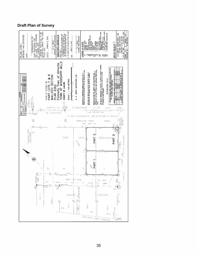
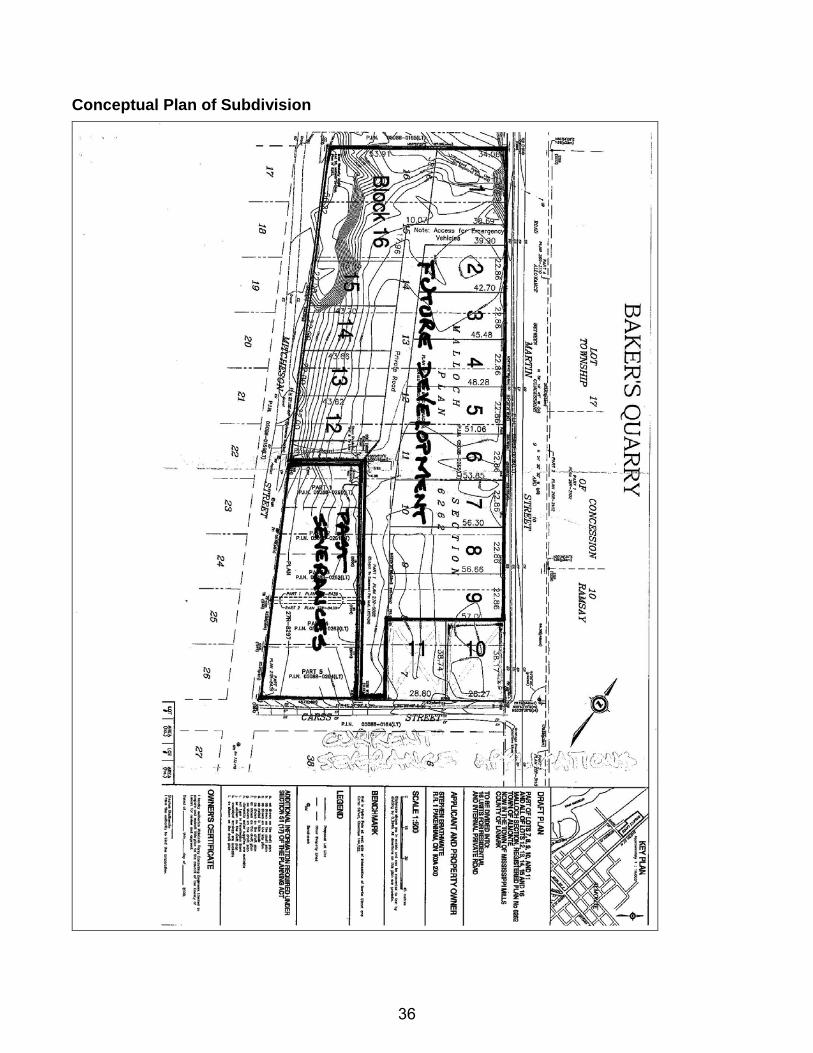
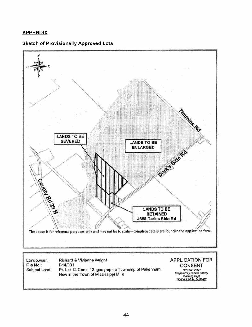
APPENDIX Sketch of Provisionally Approved Lots
34
Draft Plan of Survey
35
Conceptual Plan of Subdivision
36
THE CORPORATION OF THE TOWN OF MISSISSIPPI MILLS
BUILDING and PLANNING REPORT MEETING DATE: April 7th, 2015 TO: Committee of the Whole FROM: John McMulkin, Junior Planner SUBJECT: ZONING BY-LAW AMENDMENT APPLICATION Z-06-15
Part Lot 12, Concession 12, Being Part 2 on Plan 26R-2439 Pakenham Ward, Town of Mississippi Mills Municipally known as 4698 Dark’s Side Road
RECOMMENDATION:
THAT the Committee of the Whole recommends that Council APPROVE the necessary Zoning By-law Amendment to change the zoning of a portion of the retained parcel of land from the property legally described as Part Lot 12, Concession 12, Being Part 2 on Plan 26R-2439, Pakenham Ward, Town of Mississippi Mills, from the “Development (D)” Zone to the “Development Exception 9 (D-9)” Zone in order to recognize its reduced lot area as a result of the lot addition severance;
AND FURTHERMORE THAT the Committee of the Whole recommends that Council APPROVE the necessary Zoning By-law Amendment to change the zoning of a portion of the severed parcel of land from the property legally described as Part Lot 12, Concession 12, Being Part 2 on Plan 26R-2439, Pakenham Ward, Town of Mississippi Mills, from the “Development (D)” Zone to the “Agricultural (A)” Zone in order to permit agricultural uses on this severed portion. BACKGROUND, PURPOSE AND EFFECT Richard and Vivianne Wright received provisional consent approval from the County of Lanark Land Division Committee on October 14, 2014 (LDC File No. B14/031) for a lot addition severance from the above-noted property in order to convey lands being used to support an active farming operation to the abutting farm located at 4596 Dark’s Side Road. Sketches of the proposed lots are contained within the Appendix. The proposed amendment would change the zoning of a portion of the subject property from the “Development (D)” Zone to the “Agricultural (A)” Zone in order to permit agricultural uses on the severed portion of the lands being conveyed to the abutting farm. The proposed amendment would also change the zoning of a portion of the retained residential lot from the “Development (D)” Zone to a “Development Exception 9 (D-9)” Zone in order to recognize its reduced lot area as a result of the lot addition severance. DESCRIPTION OF SUBJECT LANDS AND SURROUNDING PROPERTIES The subject property is located on the north side of Dark’s Side Road, east of County Road 29 and in the Ward of Pakenham. The property is bounded by the Mississippi River to the north, is
37
currently ±8.82ha (21.79ac) in size, and has a lot frontage of ±129.56m (425ft) along Dark’s Side Road. Post severance, the property’s lot area will be reduced to 2.2ha (5.427ac) while maintaining its existing frontage. The location of the subject lands is depicted in the following Location Map and Aerial Photo:
Location Map
Aerial Photo (2011)
38
The property is designated “Residential”, “Agriculture” and “Flood Plain” in the Town’s Community Official Plan (COP), and zoned “Development (D)”, “Agricultural (A)” and “Environmental Hazard (EH)” by Zoning By-law #11-83. These zoning boundaries follow the boundaries of the appropriate land use designations in the COP listed above, while the portion of the property zoned D is located within the Village of Pakenham settlement area boundary. 4698 Dark’s Side Road is currently occupied by a detached dwelling, a barn and two (2) sheds, all of which will remain on the property post severance. The surrounding area consists of similarly sized agricultural properties to the north, east and south, with residential properties located to the west within the Village of Pakenham. SERVICING & INFRASTRUCTURE The subject property is serviced by private well and septic services and front onto Dark’s Side Road, a municipally owned and maintained road. The servicing and infrastructure demands would not change as a result of this application or the lot addition severance.
COMMENTS FROM INTERNAL CIRCULATION Comments received based on the circulation of this application have been summarized below:
CAO: No concerns or objections. Fire Chief: No concerns or objections. CBO: No concerns or objections. Director of Roads and Public Works: No concerns or objections. Recreation Coordinator: No concerns or objections. Town Clerk: No concerns or objections.
COMMENTS FROM EXTERNAL AGENCY CIRCULATION The application was not circulated to external agencies.
COMMENTS FROM THE PUBLIC The Town held a Public Meeting on March 17th, 2015, to provide an opportunity for the public to speak to the application. During the Public Meeting, no one spoke in favour of or in opposition to the application. No comments have been received from the public as of the date this report was prepared.
EVALUATION OF THE APPLICATION
COMMUNITY OFFICIAL PLAN (COP) The subject lands are designated “Residential”, “Agriculture” and “Flood Plain” in the Town’s COP. The Residential designation permits low and medium density residential uses and associated accessory uses. The Agriculture designation permits agricultural uses and non-farm residential uses. The Flood Plain designation permits agricultural uses, forestry, conservation, wildlife management, outdoor recreation uses and similar activities provided no
39
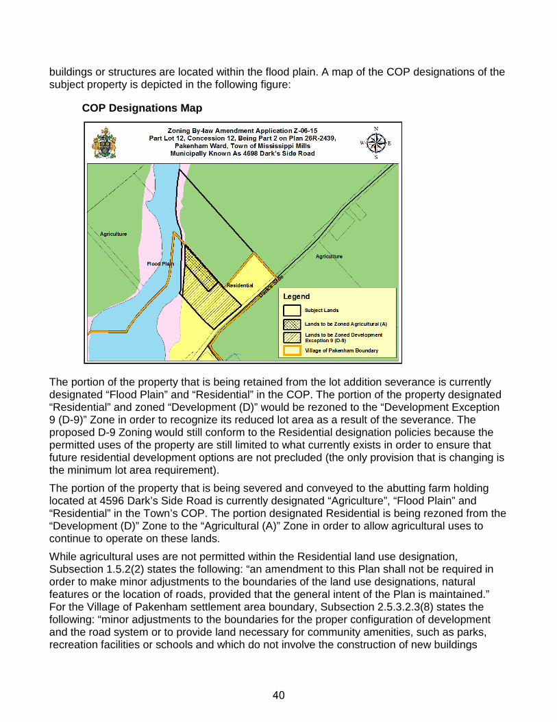
buildings or structures are located within the flood plain. A map of the COP designations of the subject property is depicted in the following figure:
COP Designations Map
The portion of the property that is being retained from the lot addition severance is currently designated “Flood Plain” and “Residential” in the COP. The portion of the property designated “Residential” and zoned “Development (D)” would be rezoned to the “Development Exception 9 (D-9)” Zone in order to recognize its reduced lot area as a result of the severance. The proposed D-9 Zoning would still conform to the Residential designation policies because the permitted uses of the property are still limited to what currently exists in order to ensure that future residential development options are not precluded (the only provision that is changing is the minimum lot area requirement). The portion of the property that is being severed and conveyed to the abutting farm holding located at 4596 Dark’s Side Road is currently designated “Agriculture”, “Flood Plain” and “Residential” in the Town’s COP. The portion designated Residential is being rezoned from the “Development (D)” Zone to the “Agricultural (A)” Zone in order to allow agricultural uses to continue to operate on these lands. While agricultural uses are not permitted within the Residential land use designation, Subsection 1.5.2(2) states the following: “an amendment to this Plan shall not be required in order to make minor adjustments to the boundaries of the land use designations, natural features or the location of roads, provided that the general intent of the Plan is maintained.” For the Village of Pakenham settlement area boundary, Subsection 2.5.3.2.3(8) states the following: “minor adjustments to the boundaries for the proper configuration of development and the road system or to provide land necessary for community amenities, such as parks, recreation facilities or schools and which do not involve the construction of new buildings
40
outside of the identified boundary may be considered through an amendment to the Zoning By-law.” Given that the residentially designated portion of the severed parcel being conveyed to the abutting farm is of a small size (±0.7ha) and that agricultural uses have existed on this portion, Staff is of the opinion that the proposal constitutes a minor boundary adjustment that would not require an amendment to the Community Official Plan. In accordance with Subsection 2.5.3.2.3(8), the subject zoning by-law amendment would also amend the boundary of the Village of Pakenham settlement area to follow the easterly lot line boundary of the subject retained lot. Post severance, the severed parcel is being merged with the abutting farm already occupied by a detached dwelling, so there is no concern that the proposal would allow for an additional residential dwelling to be constructed outside of the settlement area boundary. In addition, the Residential designation and Village of Pakenham settlement area boundaries would be amended to reflect the proposed amendment through the next Community Official Plan Review. Therefore, Staff is of the opinion that the proposal maintains the general intent and purpose of the COP. ZONING BY-LAW #11-83 The subject lands are currently zoned “Development (D)”, “Agricultural (A)” and “Environmental Hazard (EH)” by Zoning By-law #11-83. The D Zone restricts the lot area, lot frontage, uses, buildings and structures to what legally existed on the effective date of the zoning by-law. The A Zone permits residential uses such as a detached dwelling and a garden suite, and non-residential uses such as agricultural uses and other similar uses. As no development of buildings or structures is contemplated as a result of this application, there is no concern as to the proposal infringing upon the development restrictions of the EH Zone. A map of the current zoning of the property is depicted in the following figure:
Current Zoning Map
41
The proposed amendments would change the zoning of a portion of the subject property from the “Development (D)” Zone to the “Agricultural (A)” Zone in order to permit agricultural uses on the severed portion of the property and change the zoning of the retained residential lot from the “Development (D)” Zone to a “Development Exception 9 (D-9)” Zone in order to recognize its reduced lot area as a result of the lot addition severance. By rezoning the retained portion of the D Zone to the D-9 Zone, the overall intent of the D Zone is being maintained by limiting the range of permitted uses what currently exists. Rezoning a portion of the severed parcel being conveyed to the abutting farm from the D Zone to the A Zone is also necessary in order to continue to permit agricultural uses to operate from these lands. It is noted that the buildings located on the retained residential lot comply with all lot coverage and setback requirements (see Draft Plan of Survey in Appendix). It is further noted that the schedules to Zoning By-law #11-83 would also be amended to reflect the revised Village of Pakenham settlement area boundary along the new easterly property line of the retained parcel from the lot addition severance. CONCLUSION
Overall, Staff supports the subject rezoning application. The proposed amendment would satisfy a condition of provisional consent approval by rezoning the retained and severed lands to an appropriate zoning category to recognize the reduced lot area requirement of the D Zone while allowing for agricultural uses to operate on the entirety of the severed lands being conveyed to the abutting farm. The Village of Pakenham settlement area boundary would also be amended to outline the new easterly property line of the retained parcel from the lot addition severance. It is noted that the public expressed no concerns with the application at the public meeting held on March 17, 2015. Therefore, Staff recommends that the subject zoning by-law amendment be approved.
RECOMMENDATION:
THAT the Committee of the Whole recommends that Council APPROVE the necessary Zoning By-law Amendment to change the zoning of the retained parcel of land from the property legally described as Part Lot 12, Concession 12, Being Part 2 on Plan 26R-2439, Pakenham Ward, Town of Mississippi Mills, from the “Development (D)” Zone to the “Development Exception 7 (D-9)” Zone in order to recognize its reduced lot area as a result of the lot addition severance;
AND FURTHERMORE THAT the Committee of the Whole recommends that Council APPROVE the necessary Zoning By-law Amendment to change the zoning of a portion of the severed parcel of land from the property legally described as Part Lot 12, Concession 12, Being Part 2 on Plan 26R-2439, Pakenham Ward, Town of Mississippi Mills, from the “Development (D)” Zone to the “Agricultural (A)” Zone in order to permit agricultural uses on this severed portion.
42
All of which is respectfully submitted, __________________ John McMulkin, BES Junior Planner __________________ ___________________ Stephen Stirling MCIP, RPP Diane Smithson Town Planner Reviewed by CAO
43
APPENDIX Sketch of Provisionally Approved Lots
44
Draft Plan of Survey
45
THE CORPORATION OF THE TOWN OF MISSISSIPPI MILLS
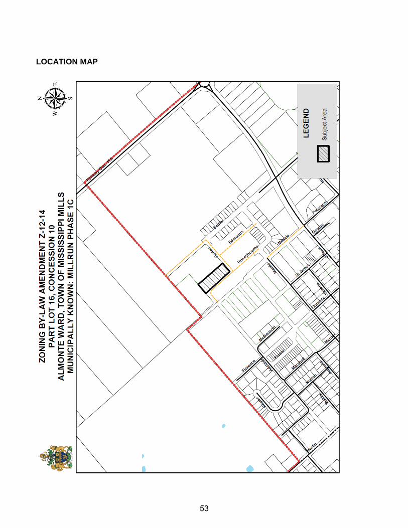
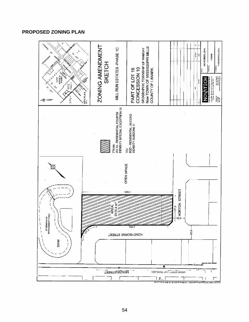
BUILDING and PLANNING REPORT MEETING DATE: April 7th, 2015 TO: Committee of the Whole FROM: Stephen Stirling - Planner SUBJECT: ZONING BY-LAW AMENDMENT #Z-12-14
Part of Lot 16, Concession 10, Almonte Ward, Town of Mississippi Mills Municipally Known: Millrun Phase 1C
RECOMMENDATION: “THAT the Committee of the Whole recommends that Council APPROVE the necessary Zoning By-Law Amendment to change the zoning of the lands described as Part of Lot 16, Concession 10, Almonte Ward, Town of Mississippi Mills, known as Millrun Phase 1C, from “Residential Fourth Density Special Exception 13 (R4-13) Zone” to “Residential Second Density Subzone D (R2D) Zone”. BACKGROUND Menzie Inc. (Regional Group) is the landowner of the subject lands, described as Part of Lot 16, Concession 10, Almonte Ward, Town of Mississippi Mills. On October 27th, 2012, the developer received draft plan approval for a multi-phased subdivision development known as Millrun Phases 1A and 1B and on August 28th, 2013, for Phase 1C. These three (3) phases of the plan of subdivision consisted of a mix of residential housing forms, being single detached lots, semi-detached lots, townhome blocks and a condominium block. To date, Phase 1A of the development is approaching completion, Phase 1B is currently under construction and Phase 1C has been draft approved. As draft plan approved, Phases 1A, 1B and 1C of the Millrun subdivision consisted of a total of 144 residential dwelling units, being 46 single family dwellings, 38 semi-detached dwellings, 24 townhome dwellings and 36 condominium apartments. Changes in market conditions required the developers to respond to these demands by modifying the forms of housing to target community demands. As such, the first redline change in Phases 1B and 1C replaced the 10 semi-detached dwellings (20 units in total) with 27 townhouse units. The second redline change to the draft approved plan of subdivision changed the block of land set aside for the small condominium development (36 units) to a grouping of 5 semi-detached lots (10 semi-detached dwellings units). In both cases the change in housing form did not impact the road layout in the approved draft plan of subdivision. The zoning amendment being sought can be summarized as follows:
46
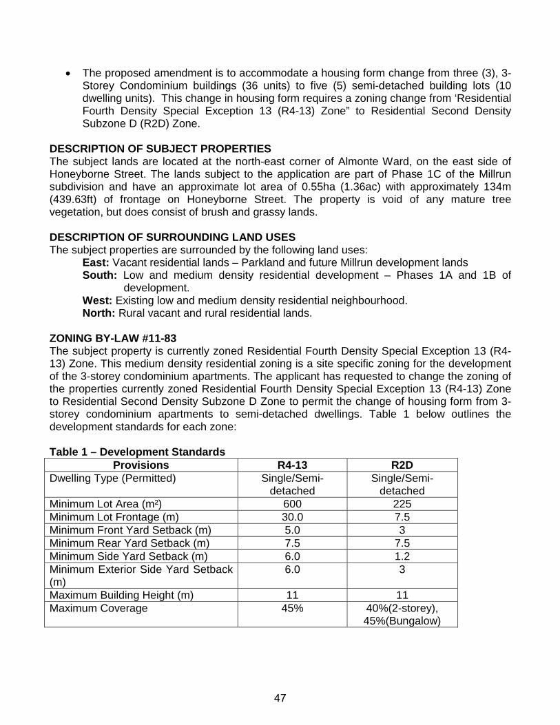
• The proposed amendment is to accommodate a housing form change from three (3), 3-Storey Condominium buildings (36 units) to five (5) semi-detached building lots (10 dwelling units). This change in housing form requires a zoning change from ‘Residential Fourth Density Special Exception 13 (R4-13) Zone” to Residential Second Density Subzone D (R2D) Zone.
DESCRIPTION OF SUBJECT PROPERTIES The subject lands are located at the north-east corner of Almonte Ward, on the east side of Honeyborne Street. The lands subject to the application are part of Phase 1C of the Millrun subdivision and have an approximate lot area of 0.55ha (1.36ac) with approximately 134m (439.63ft) of frontage on Honeyborne Street. The property is void of any mature tree vegetation, but does consist of brush and grassy lands. DESCRIPTION OF SURROUNDING LAND USES The subject properties are surrounded by the following land uses:
East: Vacant residential lands – Parkland and future Millrun development lands South: Low and medium density residential development – Phases 1A and 1B of
development. West: Existing low and medium density residential neighbourhood. North: Rural vacant and rural residential lands.
ZONING BY-LAW #11-83 The subject property is currently zoned Residential Fourth Density Special Exception 13 (R4-13) Zone. This medium density residential zoning is a site specific zoning for the development of the 3-storey condominium apartments. The applicant has requested to change the zoning of the properties currently zoned Residential Fourth Density Special Exception 13 (R4-13) Zone to Residential Second Density Subzone D Zone to permit the change of housing form from 3-storey condominium apartments to semi-detached dwellings. Table 1 below outlines the development standards for each zone: Table 1 – Development Standards
Provisions R4-13 R2D Dwelling Type (Permitted) Single/Semi-
detached Single/Semi-
detached Minimum Lot Area (m²) 600 225 Minimum Lot Frontage (m) 30.0 7.5 Minimum Front Yard Setback (m) 5.0 3 Minimum Rear Yard Setback (m) 7.5 7.5 Minimum Side Yard Setback (m) 6.0 1.2 Minimum Exterior Side Yard Setback (m)
6.0 3
Maximum Building Height (m) 11 11 Maximum Coverage 45% 40%(2-storey),
45%(Bungalow)
47
It should be noted that the Zoning By-law also contains the following provisions which apply to the townhouses within the R2D Zone:
a) The minimum lot area and lot frontage requirements are per dwelling unit. b) The minimum side yard adjoining an end unit shall be 1.2 metres. c) The minimum dwelling unit area shall be 46m² (495 ft²) plus 9.5m² (102ft²) for each
bedroom. d) Maximum gross density shall be 15 units per ha e) If the dwelling type is a bungalow, maximum lot coverage is 45%.
PROVINCIAL POLICY STATEMENT (PPS) 2014 The PPS provides direction on matters of provincial interest related to land use planning and development. Generally speaking, the PPS encourages new residential development to occur within established settlement areas, on full municipal services, and in the form of intensification or redevelopment. This policy direction is highlighted in the following subsections of the PPS: 1.1.1 Healthy, liveable and safe communities are sustained by:
a. promoting efficient development and land use patterns which sustain the financial well-being of the Province and municipalities over the long term;
b. accommodating an appropriate range and mix of residential, employment (including industrial, commercial and institutional uses), recreational and open space uses to meet long-term needs;
e. promoting cost-effective development standards to minimize land consumption and servicing costs;
1.1.3.1 Settlement areas shall be the focus of growth and their vitality and regeneration shall be promoted. 1.1.3.2 Land use patterns within settlement areas shall be based on:
a. densities and a mix of land uses which: 1. efficiently use land and resources; 2. are appropriate for, and efficiently use, the infrastructure and public
service facilities which are planned or available, and avoid the need for their unjustified and/or uneconomical expansion
1.1.3.4 Appropriate development standards should be promoted which facilitate intensification, redevelopment and compact form, while avoiding or mitigating risks to public health and safety. 1.1.3.6 New development taking place in designated growth areas should occur adjacent to the existing built-up area and shall have a compact form, mix of uses and densities that allow for the efficient use of land, infrastructure and public service facilities.
48
1.4.3 Planning authorities shall provide for an appropriate range of housing types and densities to meet projected requirements of current and future residents of the regional market area by:
a) establishing and implementing minimum targets for the provision of housing which is affordable to low and moderate income households. However, where planning is conducted by an upper-tier municipality, the upper-tier municipality in consultation with the lower-tier municipalities may identify a higher target(s) which shall represent the minimum target(s) for these lower-tier municipalities;
b) permitting and facilitating: i) all forms of housing required to meet the social, health and well-being
requirements of current and future residents, including special needs requirements; and
ii) all forms of residential intensification and redevelopment in accordance with policy 1.1.3.3;
c) directing the development of new housing towards locations where appropriate levels of infrastructure and public service facilities are or will be available to support current and projected needs;
d) promoting densities for new housing which efficiently use land, resources, infrastructure and public service facilities, and support the use of alternative transportation modes and public transit in areas where it exists or is to be developed; and
e) establishing development standards for residential intensification, redevelopment and new residential development which minimize the cost of housing and facilitate compact form, while maintaining appropriate levels of public health and safety.
Staff views the proposed zoning uses and development standards as an efficient and logical use of the subject lands. This form of development is desirable as it is cost effective for housing to service on a per unit basis, it provides affordable housing options, and allows for growth to be accommodated within existing settlement area boundaries versus requiring boundary expansions. With this in mind, Staff views the proposal to be in keeping with the provisions of the PPS COMMUNITY OFFICIAL PLAN (COP) The subject properties are designated as ‘Residential’ by the Town’s COP. This designation allows for a wide range of low and medium density residential uses, including the proposed townhouse development. The goal of the Growth and Settlement Section of the COP is to “Promote managed, co-ordinate and fiscally responsible growth, which represents an efficient use of land and is environmentally sustainable; and direct the majority of new growth to areas where municipal services are available and where capacity exists to support new development”. The following is a list of notable objectives to achieve this goal:
49
• Establish an urban density which promotes a sustainable and efficient use of the land.
The proposed zoning amendment will maintain a housing form/development standard that will maintain an efficient use of the serviced urban lands while creating appropriate lots for development. As per Section 3.6.1 of the COP, the goal of the Plan is to: “Promote a balanced supply of housing to meet the present and future social and economic needs of all segments of the community”. The following is a list of notable objectives contained within the COP intended to implement this goal as well as commentary related to the proposed development:
• Promote and support development which provides for affordable, rental and/or increased density of housing types. The proposed zoning amendment would maintain a range of housing options on smaller lots which will potentially create affordable units.
• Ensure that land use policies and zoning do not establish barriers to a more
balanced supply of housing. The proposal would maintain a balanced housing supply in a developing neighbourhood which has a mix of housing forms comprised of single detached residential dwellings, semi-detached dwellings and townhouse dwellings.
• Direct the majority of new residential development to areas where municipal
sewer and water services are/will be available and which can support new development. While new infrastructure will be required to service the proposed development, municipal sewer and water services are available within the existing neighbourhood surrounding the subject properties.
As per Section 3.6.5 of the COP, sets out the policies associated with the range of housing types to be provided in new developments with the intent to provide a diverse range of housing options. The following is a list of development polices contained within the COP:
• The Town shall support a wide range of housing types, zoning standards and subdivision design standards. The proposed zoning amendment would maintain a range of housing options consistent with those already in the development.
• The Town has established the following housing mix targets. o Low Density - 70% o Medium Density – 30%
The proposed zoning amendment would create a ratio of residential housing in Phase 1C of the development being 42% low density and 58 being medium density. The proposed density exceeds the target mix as set out in the COP.
• Low density residential development shall include single detached dwellings, semi-detached dwellings, duplex, converted dwellings and triplex housing. In
50
general, the gross density for a low density residential development shall be 15 units per hectare (6units per acre) Both the Zoning By-law and the COP reference a maximum gross density of 15 units per net hectare. While the Zoning By-law does not define ‘gross density’, the COP defines it as: “The density of the residential development in an area, including all local roads and parks.” The proposed housing form amendment in Phase 1C proposes a total of 5 semi-detached residential lots on the block of land, being 10 semi-detached dwelling units. The lands subject to the zoning amendment and housing form change is 0.73ha (1.81ac), which would permit a maximum yield of 11 units to satisfy the 15 units per gross hectare for the low density development. The revised plan will create a total of 10 units on those lands, which is in keeping with the density objectives.
COMMENTS FROM INTERNAL CIRCULATION: Comments received based on the circulation of this application have been summarized below:
CAO: No comments, concerns or objections Clerk: No comments received Chief Building Official: No comments received. Director of Roads and Public Works: The Mill Run Phase 1C zoning amendment results in a lower density than permitted under the current zoning designations. The impact is therefore lower in nature in terms of municipal servicing / traffic. No objections or concerns. The Developer will be obligated to provide updated study reports in support of registrations for Phase 1C as required under the draft plan approval. These reports should ultimately reflect the final zoning arrangements as approved. Fire Chief: No concerns or objections. Recreation Coordinator: No concerns or objections.
COMMENTS FROM EXTERNAL AGENCY CIRCULATION: Canada Post: No comments received. Catholic District School Board of Eastern Ontario: No comments received. Enbridge Gas Distribution Inc.: No comments received. Ottawa River Power Corp.: No concerns or objections. Rogers Cable Communications Inc.: No comments received. Upper Canada District School Board: No comments received. PUBLIC MEETING COMMENTS: The Town held a public meeting regarding the zoning application on February 3rd, 2015. No comments regarding the proposed zoning amendment were provided at the meeting. ANALYSIS One of the core principles within the PPS and the Community Official Plan is the efficient use of infrastructure and servicing land through intensification. The overall benefit resulting from compact forms of development, as proposed in the amendment, is affordability as the cost for
51
infrastructure development and maintenance is spread over more lots making the community more sustainable in the future. Staff is also of the opinion that the proposed zoning amendment reflects the policies outlined by the Province of Ontario and goals and objectives contained in the Community Official Plan. The marginal reduction in density in Phase 1C resulting from the changes in the residential development forms will not impact the broad range of housing options available in the community by allowing for smaller, more dense residential lots that will make the potential of home ownership more likely and affordable. In considering the proposed amendment, it is clear that the proposal is sensitive to the issue of development within established neighbourhoods and growing communities with a goal to ensure compatibility. In this case, the proposed amendment ensures that the proposed form of residential development is consistent in size and massing to existing residential dwelling in the neighbourhood thus mitigating any potential conflict from the development. The proposed zoning and ultimately land use change is appropriate for the proposed form of development and accomplishes the ultimate goal of efficiently using existing serviceable lands. It provides diverse forms of housing and affordable housing while ensuring compatibility within the community. Finally, the zoning amendment reflects an affordable form of housing being sought by the community as a whole while respecting the small town character of Almonte. It is important to note that the proposed zoning amendment will slightly reduce the density levels of Phase 1C by only 9 units. This decrease will not impact the municipal services being provided to the neighbourhood. CONCLUSION Overall, Planning Staff is in support of the proposal as it represents an efficient use of subject properties and future infrastructure, and is in keeping with the policies of the Town’s Official Plan and the Provincial Policy Statement. RECOMENDATION: “THAT the Committee of the Whole recommend that Council APPROVE the necessary Zoning By-Law Amendment to change the zoning of the lands described as Part of Lot 16, Concession 10, Almonte Ward, Town of Mississippi Mills, known as Millrun Phase 1C, from “Residential Fourth Density Special Exception 13 (R4-13) Zone” to “Residential Second Density Subzone D (R2D) Zone”. All of which is respectfully submitted, _________________ _________________ Stephen Stirling MCIP, RPP Diane Smithson Town Planner Reviewed by CAO
52
LOCATION MAP
53
PROPOSED ZONING PLAN
54
THE CORPORATION OF THE TOWN OF MISSISSIPPI MILLS
BUILDING and PLANNING REPORT
MEETING DATE: April 7th, 2015 TO: Committee of the Whole FROM: John McMulkin, Junior Planner SUBJECT: Mill Run Site Plan Control – Phase 1b Blocks 31, 32 and 33, Registered Plan 27M-63 Almonte Ward, Town of Mississippi Mills File: D11-NE-15 OWNER/APPLICANT: Neilcorp General Contracting Ltd., c/o Doug McIntosh
RECOMMENDATION: THAT the Committee of the Whole APPROVE the site plans for Blocks 31, 32 and 33 of Registered Plan 27M-63 – Mill Run Subdivision Phase 1b. SITE PLAN CONTROL APPLICATION SUMMARY In accordance with Section 41(3) of the Planning Act R.S.O 1990, and the local Site Plan Control By-law, Neilcorp General Contracting Ltd. has filed a Site Plan Control Application for Blocks 31, 32 and 33 of Registered Plan 27M-63 (Mill Run Phase 1b Subdivision) for approval to allow for the construction of a total of thirteen (13) townhouse dwelling units. LOCATION AND DESCRIPTION OF SUBJECT LANDS The lands subject to this application are located at the northwest corner Honeyborne and Maude Streets, within the Ward of Almonte. The location of the subject lands within the Town is depicted in the following figure:
55
Zoning / Community Official Plan / Land Use The subject blocks are currently designated “Residential” within the Town’s Community Official Plan (COP) and zoned “Residential Third Density Subzone E (R3E)” by Zoning By-law #11-83. The Residential designation and R3E Zone permit townhouse dwellings. Lot Size and Dimensions Block 31 This block is ±1,235.22m² (13,295.80ft²) in area with a frontage of ±34.64m (113.65ft) along Honeyborne Street and a depth of ±35.7m (117.13ft). Block 32 This block is ±1,625.06m² (17,492.00ft²) in area with a frontage of ±42.12m (138.19ft) along Honeyborne Street and a depth of ±38.6m (126.64ft). Block 33 This block is ±1,023.75m² (11,019.55ft²) in area with frontages of ±31.48m (103.28ft) along Honeyborne Street and ±32.5m (106.63ft) along Maude Street and a depth of ±32.5m (106.63ft). REVIEW Grading and Servicing The Grading and Servicing Plans have been approved. Additional utility information will be requested as it relates to Hydro/Bell and Enbridge and Staff will pursue those details directly with Novatech. Site Access The proposed site plan shows access to the townhouse dwellings being provided by paired driveways, which is consistent with what was approved on June 24, 2014 through a redline change to the registered plan of subdivision. Building Configuration / Façade The elevations provided show the exterior of the townhouses consisting of a partial brick front and vinyl siding façade with vinyl siding along the side and rear of the dwellings. The proposed townhouses will utilize similar finishes, and be of a nearly identical design to the units currently being constructed on Blocks 32 and 33 in Phase 1a of the subdivision (see Figures 1 to 2 below). The proposed townhouses on Blocks 31, 32 and 33 in Phase 1b consist of dwellings with entrances fronting onto Honeyborne Street. The proposed form will continue to develop an existing streetscape established in Phase 1a and contribute to its attractiveness of the overall development. The applicant has sited the middle townhouse dwelling located on Block 32 an additional one (1) metre back from the street in order to create a diversity of setbacks along the street. The staggering of front yard setbacks along the street is recommended by the Town’s Urban Design Guidelines in order to create a visually interesting streetscape. It has
56
however resulted in a situation where the exposed side wall of Unit A in Block 32 can only be accessed from the abutting lot. As such, the applicant will be required to prepare a reference plan outlining a registered maintenance easement at the exposed side wall between Units A and B in Block 32 as part of the Site Plan Control Agreement in order to ensure that the owner of Unit A has legal access over the abutting property for maintenance purposes. The design of the dwelling units minimizes the projection of the attached garage in order to improve the relationship between the private and public realms by encouraging interaction with activities on the street. Furthermore, the locations of the proposed dwellings meet all setback provisions of Zoning By-law #11-83. Figure 1 – Block 32 Front Elevations
Figure 2 – Block 33 Front Elevations
57
Lot Coverage / Density The following table outlines the lot coverage percentages for each of the townhouse blocks:
Block Lot Area Building Footprint Lot Coverage # of Dwelling Units
31 ±1,235.22m² ~488.15m² ~39.52% (Max 55%) 4
32 ±1,625.06m² ~632.19m² ~38.90% (Max 55%) 5
33 ±1,023.75m² ~490.23m² ~47.89% (Max 55%) 4
TOTAL ±3,884.03m² ~1,610.57m² ~41.50% (Max 55%) 13
The proposed coverage percentages fall well under the maximum permitted lot coverage of 55% for townhouses as outlined in Table 15.2A – R3 Zone of the Town’s Zoning By-law #11-83. The unit count for each block matches what was approved on June 24, 2014 through a redline change to the registered plan of subdivision. Based on the total 126 proposed units and the total area of ±9.3ha (23ac) for the entire Phase 1 of the subdivision, the overall density calculation for the entire development would be ±13.5 units per gross hectare. This density is generally consistent with the gross residential density target of 15 to 35 units per gross hectare for the Ward of Almonte outlined in Subsection 2.5.3.2.3(4) – General Policies of the Town’s Community Official Plan. The block identified for the townhouse development (medium density) has a net density of ±33.5 units per net hectare, which is under the maximum permitted net density of 35 units per net hectare required by Zoning By-law #11-83. Landscaping The following table outlines the proposed trees for each of the townhouse blocks compared to what is shown on the overall landscaping plan associated with the approved plan of subdivision: Block Site Plan - Species Total # Approved Plan - Species Total # 31 (1) Japanese Lilac
(2) Redmond Linden 3 (5) Armstrong Red Maple
(2) Balsam Fir (5) Redmond Linden
12
32 (3) Armstrong Red Maple (1) Redmond Linden
4
33 (2) Japanese Lilac (2) White Spruce
4
TOTAL 11 12 The proposed landscape plan and tree species are generally consistent with the approved subdivision landscape plan, with the exception being that the applicant has chosen smaller sized trees from the approved subdivision landscape plan that can be accommodated on the smaller townhouse lots. The applicant has noted on the landscape plan that the four (4) required trees that are unable to be accommodated on the proposed townhouse lots will be planted elsewhere in the subdivision in a location to the satisfaction of the Town. In addition, the rear yards of the block shall be bounded by a wooden fence.
58
Parking With regards to parking, Table 9.2 – Minimum Parking Space Rates requires a minimum of one (1) off-street parking space per townhouse dwelling unit, while Table 9.3 – Minimum Visitor Parking Space Rates requires 0.2 off-street parking spaces per townhouse unit for visitor parking. The proposed site plan demonstrates that one (1) parking space can be accommodated within the attached garage to each townhouse dwelling unit, as well as an additional space being provided on the driveways to each unit. As such, the proposed site plan significantly exceeds the minimum parking requirements of Zoning By-law #11-83. CONCLUSION The proposed site plans satisfy the provisions of Zoning By-law #11-83 and are consistent with relevant planning policies of the Community Official Plan. It is recommended that the Committee approve the applications. All of which is respectfully submitted, __________________ John McMulkin, BES Junior Planner __________________ ___________________ Stephen Stirling MCIP, RPP Diane Smithson Town Planner Reviewed by CAO
59
APPENDIX Site Plan
60
Elevations – Blocks 31 and 33
Elevations – Block 32
61
62
THE CORPORATION OF THE TOWN OF MISSISSIPPI MILLS
BUILDING and PLANNING REPORT MEETING DATE: April 7th, 2015 TO: Committee of the Whole FROM: Stephen Stirling - Planner MCIP, RPP SUBJECT: NATURAL HERITAGE POLICY REVIEWOF THE BURNT LANDS ANSI
MISSISSIPPI MILLS RECOMMENDATION: “THAT the Committee of the Whole recommends that Council direct staff to proceed with the amendments to the Community Official Plan and the Comprehensive Zoning By-law #11-83 regarding protection of the Burnt Lands Alvar, an Areas of Natural Scientific Interest (ANSI), and initiate the public consultation process AND FURTHERMORE THAT Council give consideration to approving an Interim Control By-law to protect the lands in the interim until the Community Official Plan and Zoning By-law Amendments are completed.” PURPOSE The purpose of this report is to review the two previous reports prepared by Dr. Tineke Kuiper and the Mississippi Valley Field Naturalists that were presented to the Committee of the Whole for the Town of Mississippi Mills on February 17th, 2015, regarding the need to amend current Community Official Plan Polices and Zoning By-law #11-83 zoning provisions in order to provide better protection of Areas of Natural and Scientific Interest, notable the Burnt lands Alvar ANSI, in the Town of Mississippi Mills. BACKGROUND The Provincial Policy Statement, 2014 (PPS) defines Areas of Natural and Scientific Interest as areas of land and water containing natural landscapes or features that have been identified as having life science or earth science values related to protection, scientific study or education. The PPS has identified ANSIs (Areas of Natural and Scientific Interest) as being important environmental features that need to be protected. The Town of Mississippi Mills currently has four ANSIs within its municipal boundaries, being the Appleton Wetland, Burnt Lands, Panmure Alvar and the White Lake ANSIs. These ANSIs are separated into two categories, being Provincially Significant ANSIs or Candidate ANSIs. The Burnt lands ANSI represent the best example of an Alvar in ecodistrict 6E11 and eastern
63
Ontario and as such has been designated by Ministry of Natural Resources and Forestry (MNRF) as being Provincially Significant. A recent cluster lot application in the Town has raised concerns regarding current Community Official Plan and zoning by-law policies and their ability to protect these environmentally sensitive areas. Lanark County Land Division Committee noted current weaknesses within the local planning policies. The Committee suggested that the Town review and improve its goals and objectives in the Community Official Plan and current zoning by-law against the implementation policies regarding natural heritage features and their protection. Furthermore, the Committee also suggested that the Town review its current zoning by-law provisions, as the local zoning by-law is the local legislative tool that implements the policies of the Community Official Plan. DESCRIPTION OF SUBJECT LANDS The lands subject to this policy review consist of the four ANSIs within the municipal boundaries identified in the Community Official Plan as the Appleton Wetland ANSI, Burnt Lands ANSI and the White Lake ANSI.
64
PROVINCIAL POLICY STATEMENT (2014) The PPS provides policy direction on matters of provincial interest related to land use planning, development and natural heritage protection. As per Section 3(5)(a) of the Planning Act, R.S.O. 1990, all planning decisions must be consistent with the PPS. The following is a list of applicable sections of the PPS as well as a review of the proposal against these policies: 2.0 Wise Use and Management of Resources
Ontario's long-term prosperity, environmental health, and social well-being depend on conserving biodiversity, protecting the health of the Great Lakes, and protecting natural heritage, water, agricultural, mineral and cultural heritage and archaeological resources for their economic, environmental and social benefits.
Accordingly:
2.1 Natural Heritage
2.1.1 Natural features and areas shall be protected for the long term. 2.1.2 The diversity and connectivity of natural features in an area, and the long-term
ecological function and biodiversity of natural heritage systems, should be maintained, restored or, where possible, improved, recognizing linkages between and among natural heritage features and areas, surface water features and ground water features.
2.1.4 Development and site alteration shall not be permitted in: a) significant wetlands in Ecoregions 5E, 6E and 7E1; and b) significant coastal wetlands.
2.1.5 Development and site alteration shall not be permitted in: a) significant wetlands in the Canadian Shield north of Ecoregions 5E, 6E
and 7E1; b) significant woodlands in Ecoregions 6E and 7E (excluding islands in Lake
Huron and the St. Marys River)1; c) significant valleylands in Ecoregions 6E and 7E (excluding islands in Lake
Huron and the St. Marys River)1; d) significant wildlife habitat; e) significant areas of natural and scientific interest; and f) coastal wetlands in Ecoregions 5E, 6E and 7E1 that are not subject to
policy 2.1.4(b)
unless it has been demonstrated that there will be no negative impacts on the natural features or their ecological functions.
2.1.7 Development and site alteration shall not be permitted in habitat of endangered
species and threatened species, except in accordance with provincial and federal requirements.
65
2.1.8 Development and site alteration shall not be permitted on adjacent lands to the
natural heritage features and areas identified in policies 2.1.4, 2.1.5, and 2.1.6 unless the ecological function of the adjacent lands has been evaluated and it has been demonstrated that there will be no negative impacts on the natural features or on their ecological functions.
2.1.9 Nothing in policy 2.1 is intended to limit the ability of agricultural uses to
continue.
Provincial Policy Statement Definitions Areas of natural and scientific interest (ANSI): means areas of land and water containing natural landscapes or features that have been identified as having life science or earth science values related to protection, scientific study or education.
Development: means the creation of a new lot, a change in land use, or the construction of buildings and structures requiring approval under the Planning Act, but does not include: a) activities that create or maintain infrastructure authorized under an environmental
assessment process; b) works subject to the Drainage Act; or c) for the purposes of policy 2.1.4(a),underground or surface mining of minerals or
advanced exploration on mining lands in significant areas of mineral potential in Ecoregion 5E, where advanced exploration has the same meaning as under the Mining Act. Instead, those matters shall be subject to policy 2.1.5(a).
COMMUNITY OFFICIAL PLAN The Community Official Plan outlines a number of policies associated with the protection of the ANSIs and includes the following:
3.1.1 Goal and Objectives It is a goal of this Plan to:
Protect and enhance the quality of the environment and the long-term health of the ecosystem. All other goals of this Plan shall attempt to satisfy the environmental goal.
With regard to the Burnt Lands ANSI, the following objectives are designed to implement the goal:
1. Support development which is environmentally sustainable, energy efficient and which conserves the natural features and characteristics of the land, lakes and rivers;
2. Establish an inventory of environmentally sensitive/significant areas to be protected (wetlands, ANSIs, water bodies, significant wooded areas, significant areas of wildlife habitat, fish habitat and endangered and threatened species habitat);
3. Require an environmental review for development proposed on lands within or adjacent to areas that have been designated as environmentally sensitive/significant;
66
3.1.2 Environmental and Natural Heritage Features This Plan identifies certain environmental and natural heritage features by means of land use designations (i.e. provincial and locally significant wetlands and waterways). Other features and areas are identified by means of symbols or overlays, specifically ANSIs and significant wildlife habitat (including deer yards). Others, such as forestry resources, fish habitat and significant habitat of endangered or threatened species are addressed through policy only. A number of other natural environment and heritage features, such as groundwater aquifers, air quality and woodlands have yet to be assessed. The Town shall work together with other agencies and groups to identify the features and areas. As information becomes available, Council shall undertake the appropriate Amendments to this Plan to address these matters. Council may, with the co-operation of appropriate agencies and/or the Environmental Advisory Committee carryout public education on the environmental land use policies of this Plan.
3.1.2.2 Area of Natural and Scientific Interest An Area of Natural and Scientific Interest (ANSI) is a natural heritage feature which has been identified and evaluated by the Ministry of Natural Resources based on specific natural functions and features which exist.
3.1.2.2.1 General Policies The policies governing development in and around lands designated as ANSIs on Appendix A are as follows:
1. Within the area identified as ANSI, existing development shall be permitted. The establishment of single dwellings on existing lots of record shall be permitted, subject to all of the relevant policies of this Plan. Development (subdivisions, site plan, zoning amendments, minor variances, consents) may take place in accordance with the land use designation shown on the Schedule to this Plan only when it has been demonstrated through an Environmental Impact Assessment that there shall be no negative effects on the natural features or ecological functions of the ANSI.
2. Development (subdivisions, site plan, zoning amendments, minor variances, consents) within 50 m of an ANSI area, may take place in accordance with the land use designation shown on the Schedule to this Plan only when it has been demonstrated through an Environmental Impact Assessment that there shall be no negative effects on the natural features or ecological functions of the ANSI. This is not a setback requirement, but rather a requirement for a review of development proposals within the “50 metre adjacent lands”.
3. Notwithstanding the above, existing agricultural uses are permitted to continue within and adjacent to ANSIs. New or expanded agricultural structures or the clearing or draining of lands within and adjacent to an ANSI shall be permitted only when it has been demonstrated through an Environmental Impact Assessment that there shall be no negative effects on the natural features or ecological functions of the ANSI.
4. As additional ANSIs are evaluated by the Ministry of Natural Resources, the Council shall incorporate the new ANSIs into this Plan through an Official Plan Amendment.
67
5. The Town endorses and encourages the principles of sustainable land stewardship of ANSI resources. Tax incentives are available through the MNR when it is demonstrated that proper land stewardship is being carried out on lands which are identified as ANSIs.
Community Official Plan Definitions Areas of natural and scientific interest (ANSI):
Areas of land and water containing natural landscapes or features that have been identified as having life science or earth science values related to protection, scientific study, or education.
Development: Is a term which means the creation of a new lot, a change in land use, or the construction of buildings and structures, requiring approval under the Planning Act, but does not include: • activities that create or maintain infrastructure authorized under an environmental
assessment process; • those works subject to the Drainage Act; • underground or surface mining of minerals or advanced exploration on mining lands
in significant areas of mineral potential in Ecoregion 5E, where advanced exploration has the same meaning as under the Mining Act.
REPORTS SUMMARY At the February 17th, 2015 Committee of the Whole meeting for the Town, two reports regarding the protection of Areas of Natural and Scientific Interest were presented to the Committee of the Whole. The intent of the reports was to identify the challenges in local planning policies regarding the protection of the Areas of Natural and Scientific Interest and put forth possible solutions. The solutions that were put forward can be summarized as follows: Community Official Plan
• Update Section 3.1.2.2 of the Community Official Plan to be consistent with PPS 2014 • Development and site alteration shall not be permitted in the ANSI, unless an
Environmental Impact Assessment (EIA) has been performed to demonstrate that there will be no negative impacts on the natural features or ecological functions;
• Permit the construction of a single detached dwelling on an existing lot of record; • Require site plan control for any development within the ANSI; • Development or site alteration within 120m of an ANSI requires an Environmental
Impact Assessment (EIA) to demonstrate that there will be no negative impact on the natural features or the ecological functions of the ANSI;
• Cluster Lot Development shall not be permitted in an ANSI; • No site alteration to accommodate a new or expanding farm operation; and, • Site alteration within an ANSI shall not exceed more than 5m beyond the building
envelope and total soil depth as a result shall not more than 10cm in depth.
68
Zoning By-law • Expand the EP zone to include ANSIs • Limit uses in the EP Zone to Conservation, Existing Uses, and Forestry (excluding
buildings or structures); • Agricultural uses excluding related buildings or structures not permitted; and, • Create Environmental Protection Subzones to accommodate limited development; i.e.
EP1 would permit a detached dwelling. DISCUSSION The Province of Ontario has identified the importance of protecting the natural heritage areas for future generations. Municipalities like the City of Ottawa have established Official Plan policies focused on the protection of environmentally sensitive features. The protection of these features is then further entrenched into the local zoning by-laws by capturing the environmental sensitive features into lands designated as Environmental Protection (EP) Zones. The table below summarizes the proposed amendments to the Town of Mississippi Mills Community Official Plan policies and Zoning By-law #11-83 regulations against the Provincial Policy Statement, 2014 (PPS), City of Ottawa planning policies and the February 17th, 2015 report.
PROPOSED ANSI POLICY REVIEW TO PPS AND OTTAWA PROPOSED POLICY - Objectives PPS OTTAWA MISSISSIPPI MILLS
OFFICIAL PLAN POLICIES Development/site alteration in ANSI (EIA required)
Construction of a new dwelling/existing lot Yes Yes Yes Creation of Lot Yes No Yes
Cluster Lot Development N/A N/A No Development/site alteration on abutting lands Yes Yes Yes Require Site Plan Control N/A No Yes Site alteration for new or expanding farm (EIA required)
Yes N/A No
Limit site alteration to building area N/A N/A Yes ZONING AMENDMENT
Use EP Zone to protect ANSI N/A Yes Yes Subzone to permit Development (EIA required) N/A Yes Yes PROPOSED COPA POLICY REVIEW Development and Site Alteration within an ANSI It is important to remember that development, as defined in the PPS and the COP, is not just limited to the construction of buildings and structures, but also includes lot creation. Based on this, the amendments as proposed seem to create confusion regarding the ability to create lots because it would appear to prohibit lot creation on one hand and permit it on another. It is the intent of the proposed amendments to limit physical development in ANSIs to the construction of a single detached dwelling on an existing lot of record, and to limit lot creation for
69
conservation purposes or for a maximum of two residential building lots created from an original Township lot. The PPS does permit development (including lot creation) or site alteration in an ANSI, provided the EIA can demonstrate that there will be no negative impacts on the natural features or their ecological functions. This allows municipalities to develop ANSI development/site alteration policies in a manner that reflects their own community, provided they meet or exceed the provincial objectives. The concept of cluster lot development occurring within an ANSI raises concerns about cumulative impact on sensitive environmental features such as ANSIs. The cluster lot development is a rural residential development consisting of 3 to 5 lots accessed by a private road. Where the development cannot be screened by vegetation or topography the dwellings are to be setback from the road a minimum of 100m. From a rural perspective, this form of development is fairly intense. If this form of development occurs in an ANSI, the impacts of the development have the potential to extend an additional 120 metres into the ANSI, beyond the developed area. Should this occur on adjacent properties, the cumulative impact on the ANSI has the potential to be significant. This raises the following question: Is this level of development in an environmentally sensitive area (e.g. ANSI) appropriate? Development or Site Alteration within 120m requires EIA The COP amendment is proposing to prohibit development or site alteration on adjacent lands within 120 metres of an ANSI unless an EIA is completed which demonstrates no negative impacts on the natural features or the ecological functions of the ANSI. The language contained mirrors much of the proposed policy, but does not specify an area of influence. That being said, the Natural Heritage Reference Manual, a technical manual for implementing natural heritage polices of the PPS (2005), does provide direction in this matter and recommends that adjacent lands are those within 120 metres of a life science ANSI and within 50 metres of an earth science ANSI. No site alteration for new or expanding farms Policy 3.1.2.2.3 of the proposed amendment recommends permitting existing agricultural uses only on lands adjacent to an ANSI. The policy goes on to state: “no new or expanded agricultural structures or the clearing or drainage of lands within an ANSI”. The policy also notes that these activities can only occur when it has been demonstrated through an EIA that the development or site alteration will have no negative impact on the natural features or the ecological functions of the ANSI. Outright prohibiting the expansion of existing farm buildings or the clearing and drainage of lands abutting or within the ANSI goes beyond polices contained in the PPS. The PPS permits development and/or site alteration within an ANSI or in lands abutting an ANSI only if an EIA demonstrates that the development or site alteration will have no negative impact on the natural feature or its ecological function. We would be remiss not to make clear that the Town does not have any agricultural lands or operations within the Burnt Lands ANSI, which limits the application of this policy to the portion of the policy addressing abutting agricultural lands.
70
Limit site alteration to a building envelope The report proposes to regulate the amount of site alteration and type of fill being used on the property to the building envelope and 5 metres beyond. The intent of the policy is to accommodate the development of the property while limiting the amount of disruption to the ANSI soil composition. In this case it is critical to understand that a building envelope is an area of the property that meets all required setbacks that can be built upon. With this understanding the application of this policy allows for site alteration to occur 5 metres beyond the setbacks. With lots in the rural area being of a much larger size, this level of site alteration could have a significant impact to the ANSI. It is instead suggested that site alteration be limited to an area 5 metres beyond the area needed for the buildings, structures, and well and septic systems. Site Plan Control The proposed amendments would require development in an ANSI to be subject to site plan control. While the PPS does not address the issue of implementation, it will only allow development in an ANSI if an EIA demonstrates that the development or site alteration will have no negative impact on the natural feature or its ecological function. Requiring site plan control for the development will provide the tool to implement any required conditions determined by the EIA and will register them against the property. Additional Community Official Plan Policies Amendments to be considered: With the ultimate goal of the proposed amendment being to protect Provincially Significant ANSIs, other Community Official Plan Amendments that could be considered include the following:
• Section 3.1.1 of the COP provides a clear goal regarding environmental land use policies in Mississippi Mills. The objectives need to be amended to provide objectives for the development and protection of lands within ANSIs.
• Holding Provision Policies: Add a policy to Section 5.3.3 for the requirement of obtaining site plan control approval and the preparation of an EIA prior to development within provincially significant ANSI lands and the lifting of the holding symbol
• Permit Conservation Severances: This would allow lands to be severed and sold to conservation groups. As a condition of the severance, the property must be rezoned Environmental Protection (EP) zone to prohibit any development or site alteration on the property.
• Limit the maximum size of a severance to 1 hectare. Where lots can be created, the goal would be to encourage smaller rural lots in an effort to minimize any impact on the ANSI as much as possible.
• Update the ANSI Mapping to reflect the ANSI categories. There are currently two types of ANSIs, being life science ANSIs and earth science ANSIs. Within these two categories, there are Provincially Significant ANSIs and Candidate ANSIs. The COP should contain an amendment to reflect these ANSIs.
71
• Provide definitions for the new ANSIs in the definition section of the COP. This would include ANSI (Life Science), ANSI (Earth Science), Candidate Earth Science ANSI and Candidate Life Science ANSI.
• Both provincial and local planning policies require the completion of an EIA to permit development or site alteration within an ANSI. The COP also needs to provide polices regarding the detailed requirements and scope of the EIA.
• With the proposed amendment creating policy around building areas and building envelopes, it is important that these terms are defined.
• The extension of the existing public road network into an ANSI shall not be permitted. PROPOSED ZONING BY-LAW AMENDMENT REVIEW The intent of the proposed zoning amendment is to provide additional protection to environmentally sensitive lands, such as Areas of Natural Scientific Interest (ANSI). The amendment can be summarized as follows:
• Expand the purpose of the Environmental Protection (EP) Zone to include Areas of Natural Scientific Interest (ANSI) to be protected for ecological, educational and recreational uses.
• Uses in the Environmental Protection (EP) Zone would be limited to Conservation, Existing Uses, Forestry excluding related buildings or structures, and single detached dwellings. The amendment also proposes to remove “agricultural uses excluding related buildings or structures”.
• Under the Environmental Protection (EP) Zone there could be various subzones to accommodate development or site alteration, such as the EP1 subzone to permit a single detached dwelling on a lot fronting on a maintained public road, subject to site plan control approval.
The provincial direction regarding the environmental health of environmentally sensitive areas is to protect the long term environmental health by “conserving biodiversity, protecting the health of the Great Lakes, and protecting natural heritage, water, agricultural, mineral and cultural heritage and archaeological resources for their economic, environmental and social benefits”. Expanding the definition of the Environmental Protection Zone is in keeping with the provincial environmental objectives. The proposed uses in the Environmental Protection Zone are intended to limit development in an ANSI in order to provide further protection to its natural heritage. The uses permitted are limited to conservation, existing uses, forestry (excluding related buildings or structures), with a single detached dwelling only being permitted in the first subzone. Additional subzones could address other development or site alteration related matters. The proposed zoning does not address the issue of accessory buildings for the permitted uses; consideration should be given to include accessory uses for any of the permitted uses. The PPS permits the development or site alteration on lands within and/or abutting an ANSI provided that an EIA is completed that demonstrates the development or site alteration does not have a negative impact on the ecological function or feature of the site. Despite this, the Burnt Lands ANSI is habitat for many animals and vegetative species that rely on a specific vegetative environment to create their habitat. Allowing a forestry operation in the ANSI could
72
have devastating impact on the ANSI and consideration should be given to remove this use in an ANSI. Section 38.3 titled Public Road Infrastructure, as proposed, does not permit the expansion of the public road system within the EP Zone. The intent of the zoning by-law is to regulate and prohibit the use and the erection, use, bulk, height, spacing of and other matters relating to buildings and structures on private property. Section 38.3 as proposed in the by-law cannot be regulated under the zoning by-law and should be removed. Expansion of public infrastructure needs to be addressed through policies contained in the Community Official Plan. Finally, the amendment proposed the potential to create one or more subzone(s) within the Environmental Protection Zone to accommodate the construction of a single detached dwelling and other structures, subject to the completion of an Environmental Impact Assessment and site plan control approval as proposed in the draft COPA policies. The provision would be consistent with the proposed Community Official Plan Amendment policies. The subzone should also include any accessary structures. Consideration should be given to placing a “Holding” provision on the property to ensure that when a property can be developed that the Environmental Impact Assessment and site plan control approval has been granted prior to the permit being issued. The end result is that lifting the holding provision will act as the trigger to ensure that these requirements are met. It is noted that the proposed zoning does not include any zoning provisions regarding setback, building height or coverage. With the development of the property reflecting that of a rural form, it is suggested that the Rural zoning provisions be applied. That being said, the final building area must be defined through the Environmental Impact Assessment. Additional Zoning By-law provisions to be considered: With the ultimate goal to provide additional protection to Provincially Significant ANSIs by including them in the Environmental Protection Zone, other amendments that should be considered include the following:
• Include all provincially significant ANSI lands in an Environmental Protection Zone with a “Holding” provision to ensure that when a property can be developed that all conditions are addressed prior to the issuance of a building permit, being the EIA and site plan control approval.
• Zoning Provisions: With the identified ANSI lands being in the rural area, the development form of the properties will reflect the rural character. As a result, the zoning provisions should also reflect the Rural Zone development standards.
• The proposed zoning provisions are for Provincially Significant ANSI and the zoning amendment should reflect that. This will require an update of the current schedules regarding the Provincially Significant ANSI and provide appropriate definitions.
COMMUNITY OFFICIAL PLAN AMENDMENT - STAFF RECOMMENDED AMENDMENTS Section 3.1.1 Goals and Objectives Is amended by adding the following Environmental Land Use policy objective:
73
Wetlands and Areas of Natural Scientific Interest (ANSI) are recognized as important environmental resources that will be protected for ecological, educational and recreational resources. Area of Natural Scientific Interest The current Section 3.1.2.2 Areas of Natural and Scientific Interest (see Appendix B for current version in the COP) is repealed and replaced by the following:
3.1.2.2 Areas of Natural and Scientific Interest A life science Area of Natural and Scientific Interest (ANSI) is an Area of land and water containing natural landscapes of features that has been identified and evaluated by the Ministry of Natural Resources and Forestry (MNRF) based on the presence of specific natural features and areas that are important for their natural features and ecological functions as a legacy of the natural landscape. The following policies apply: Policies
The policies governing development in and around lands designated as ANSI, shown in Appendix A to Schedule A are as follows:
1. Development (including lot creation) and site alteration shall not be permitted
within areas identified as ANSI except for the establishment of a single detached dwelling or for conservation purposes. A single detached dwelling may be permitted on a lot, subject to site plan control and all of the relevant policies of this Plan and only when it has been demonstrated through an Environmental Impact Assessment that there shall be no negative impacts on the natural features or ecological functions of the ANSI and no cumulative degradation as a result of successive development or site alteration activities.
2. Development (including lot creation) and site alteration within 120 m of an ANSI, may take place in accordance with the land use designations shown on the Schedule to this Plan only when it has been demonstrated through an Environmental Impact Assessment that there shall be no negative impacts on the natural features or ecological functions of the ANSI.
3. Within the Burnt Lands Alvar ANSI, there currently are no agricultural practices and no new or expanded agricultural structures or clearing or draining of lands are permitted. Within lands adjacent to this ANSI, such activities shall only occur when it has been demonstrated through an Environmental Impact Assessment that there shall be no negative impacts on the natural features or ecological functions of the ANSI.
4. Notwithstanding the above, existing agricultural uses are permitted to continue in or adjacent to an ANSI. New or expanded agricultural structures or the clearing or draining of lands within an ANSI are not permitted unless it has been demonstrated through an Environmental Impact Assessment that there shall be no negative impacts on the natural features or ecological functions of the ANSI.
74
5. As the Ministry of Natural Resources and Forestry evaluates additional ANSIs, the Council shall incorporate the new ANSI into this Plan through an Official Plan Amendment.
6. The Town endorses and encourages the principles of sustainable land stewardship of ANSI resources.
7. The Town shall not extend nor shall it permit the extension of the existing public road system within the ANSI area.
Severances and Lot Creation (Rural)
Section 3.3.6 Severances and Lot Creation is amended in policy 4 by adding at the end of the second sentence after “original township lot” the following (see Appendix C for current version in the COP): “except that in the case of an Area of Natural and Scientific Interest (ANSI) a holding is defined as an original township lot.”
Is further amended by adding a new policy 7 that will read:
A severance for conservation purposes will be permitted in an area identified to have an ANSI. A conservation severance will not count towards the maximum number of permitted severances of a land holding. The Town shall impose a condition on the severance, which shall require a zoning by-law amendment to rezone the property to Environmental Protection zone to prohibit any development on the property. Cluster Lot Development
Section 3.3.7 Cluster Lot Development is amended by adding the following sentence at the end of the first paragraph (see Appendix D for current version in the COP): “Cluster lot development is not permitted in an Area of Natural and Scientific Interest.” Section 5.3.3 Holding Zones is amended by adding the following clause in policy 4 following clause (vii) as follows (see Appendix E for current version in the COP): “(viii) retain a qualified professional to prepare an Environmental Impact Assessment (EIA) demonstrating that development and site alteration within the provincially significant Area of
75
Natural or Scientific Interest (ANSI) will not negatively impact the natural features or ecological functions of the ANSI, or lead to cumulative damage at the landscape level” Section 5.3.6 Site Plan Control is amended by adding the following clause in policy 7 following clause (xiv) as follows (see Appendix E for current version in the COP): “(xv) in the case of development in an Area of Natural and Scientific Interest if fill is needed it shall be screened sand, and be generally limited to the area for a septic bed; but if needed elsewhere shall not extend beyond 5 m of the building area as defined in the Environmental Impact Assessment and the total height of soil (including existing soil over limestone), as a result of adding fill, shall be no more than 10 cm in height” Section 5.15 Definitions
Adding the following new definitions: Building Envelope: an area of the property that meets all required setbacks that can be built upon. Building Area: the area within the building envelope defined by the Environmental Impact Assessment where development can occur. ANSI (Life Science): are areas of natural and scientific interest that have been identified and recommended for protection by the Ministry of Natural Resources and Forestry or the other sources and that contain significant segments of Ontario’s biodiversity and natural landscapes. Those ANSIs that have been deemed as Provincially Significant by the MNRF are the best representation of that feature within the ecodistrict. ANSI Candidate (Life Science): are areas of natural and scientific interest that have been identified and recommended for protection by the Ministry of Natural Resources and Forestry or the other sources but have not been formally confirmed through the Ministry’s confirmation procedure that contain significant segments of Ontario’s biodiversity and natural landscapes. ANSI (Earth Science): are areas of natural and scientific interest that have been identified and recommended for protection by the Ministry of Natural Resources and Forestry or the other sources that are geological in nature and consist of some of the most significant representative examples of the bedrock, fossil and land forms in Ontario. Candidate ANSI (Earth Science): are areas of natural and scientific interest that have been identified and recommended for protection by the Ministry of Natural Resources
76
and Forestry or the other sources but have not been formally confirmed through the Ministry’s confirmation procedure that are geological in nature and consist of some of the most significant representative examples of the bedrock, fossil and land forms in Ontario.
ZONING AMENDMENT – COMPREHENSIVE ZONING BY-LAW #11-83 Section 38 of the Zoning By-law (see Appendix B), refers to the Environmental Protection (EP) Zone. The agricultural and forestry uses are proposed for removal as their use would be detrimental to the ANSI and the use currently does not take place in the area. Proposed amendments are as follows: SECTION 38 - ENVIRONMENTAL PROTECTION (EP) ZONE Purpose of the Zone
The purpose of the Environmental Protection Zone (EP) is to:
(1) recognize lands which are designated in the Official Plan as Wetlands as well as the Burnt Lands Alvar Areas of Natural Scientific Interest (ANSI) that contain important environmental resources which must be protected for ecological, educational and recreational reasons;
(2) permit only those uses which are compatible with and assist in the protection of the environmental attributes of these lands, or are in keeping with applicable Official Plan policies; and (3) regulate development to minimize the impact of any buildings or structures within these environmental areas. 38.1 USES PERMITTED
No person shall within any EP Zone use any lot for any purpose except for one or more of the following uses:
- Conservation - Uses, buildings and structures legally existing at the date of passing of this By-law.
38.2 STRUCTURES PERMITTED
No building or structure shall be erected or enlarged and no change of use shall be permitted.
38.3 ENVIRONMENTAL PROTECTION SUBZONE Notwithstanding the EP zoning designation, on those lands designated as EP subzone the following uses shall be permitted:
77
Environmental Protection 1 (EP1) Zone In the EP1 subzone, the following structures and uses are permitted:
Single family dwelling and accessory buildings and structures in accordance with the EP subzone development standards:
Environmental Protection Subzone 1 Holding (EP1-h) Zone The holding provision shall be lifted once the following has been completed to the Town’s satisfaction: 1. An Environmental Impact Assessment undertaken by a qualified professional
demonstrating that there is no negative impact on the natural features of the ANSI or their ecological function; and
2. Approval of a site plan control application. 38.4 EP SUBZONE DEVELOPMENT STANDARDS Provisions Non-Farm Residential Lot Area, Maximum (ha) 1 Lot Frontage, Minimum (m) 45 Side Yard, Minimum (m) 6 Rear Yard, Minimum (m) 9 Front Yard, Minimum (m) 9 Exterior Side Yard, Minimum (m) 9 Maximum Height of detached dwelling (m) 11 Lot Coverage, Maximum 15% Minimum Separation from accessory detached dwelling to any structure where animals are housed (m)
30
Minimum Separation between non-farm buildings and structures on lands adjacent to the Agricultural designation (m)
150
INTERIM CONTROL BY-LAW As the impacts of local planning policies come into effect, municipalities may experience unanticipated results of new policies which can have long standing unintended effects. Section 38 of the Planning Act provides municipalities the opportunity to prevent development on specific classes of lands for a one year period in order to allow them to assess the issues related to subject lands and to then develop tailored policies based upon best practices determined in the research. This process is referred to as an “Interim Control By-law”. To implement an interim control by-law council must pass a by-law or resolution directing staff to closely review impacts of potential policies related to the area of study. Current planning legislation does not require notice or a hearing to pass the by-law, but a notice of passing must be provided to the property owners and public bodies within 30 days of passing the by-law. The property owners and public bodies do have the ability to appeal to the Ontario Municipal Board within 60 days of receiving notice of the passing of the by-law.
78
The Community Official Plan supports this legislation. Section 5.13 of the COP grants Council the authority to place a freeze on development lands, as permitted under the Zoning By-law, where there are serious concerns about the impact of potential development on subject lands (such as environmental concerns). The COP policies allow the Town to pass an Interim Control By-law for a one year period. If the Interim Control By-law is amended the time period associated with the Interim Control By-law can be extend provided that the total period of time during which the by-law is in effect does not exceed two years from the date of passing. To allow for the review, direction and implementation of the new planning policies within a municipality, the Interim Control By-law process is an option available to the Town permitted under the Planning Act. This legislative process can be implemented either as a standalone process to allow the municipality time to study the issue in detail or in conjunction with a proposed amendment allowing time for implementation. While the Town continues to evaluate concerns related to development in the ANSI and undertakes public consultation regarding potential policies tailored to address identified concerns, it is recommended that the Town consider an Interim Control By-law. This would allow the Town time to assess the situation without the concerns of development potentially significantly impacting these natural heritage features. CONCLUSION The provincially significant Burnt Lands ANSI straddles two municipalities, being the Town of Mississippi Mills and the City of Ottawa. With the feature being managed by the two municipalities it is important that the protection policy measures associated with the natural feature are consistent or at the very least similar in nature. The amendments as proposed are similar to those already in effect in Ottawa and are consistent with the Natural Heritage policies contained in the PPS. With this in mind, it is staff’s recommendation that Council consider the adoption of an interim control by-law, and proceed with the amendments to the Community Official Plan and the Comprehensive Zoning By-law #11-83 and initiate the public consultation process in accordance with the provisions noted above. All of which is respectfully submitted. _________________________ ___________________________ Stephen Stirling, MCIP, RPP Reviewed by CAO Planner Diane Smithson
79
ATTACHMENTS
THE CORPORATION OF THE TOWN OF MISSISSIPPI MILLS
BUILDING AND PLANNING DEPARTMENT
MEETING DATE: February 17, 2015 TO: COMMITTEE OF THE WHOLE FROM: Tineke Kuiper, PhD SUBJECT: Official Plan Amendment for Areas of Natural and Scientific Interest RECOMMENDATION: “That the Committee of the Whole recommends that Council APPROVE staff proceeding to a public meeting with an Official Plan Amendment in accordance with the Planning Report prepared by Tineke Kuiper, PhD dated February 17, 2015 and as amended by planning staff as necessary as soon as possible in order to provide better environmental protection to the Areas of Natural and Scientific Interest in the Town of Mississippi Mills.” BACKGROUND: The Burnt Lands Alvar is a Provincially Significant Area of Natural and Significant Interest (ANSI) (Life Science) that was identified by the Ontario Ministry of Natural Resources and Forestry (OMNRF) in 1983. Other ANSIs in Mississippi Mills include the Panmure Alvar and several Wetlands. It should be noted that at a landscape level, the unique vegetation of the overall Burnt Lands Alvar represents a mosaic, comprised of many major elements that tend to blend into one another. Any proposals to develop within it must be scrutinized carefully. Thus through better legislation at the municipal level, it is important to limit development in these areas and protect these globally significant ANSIs for future generations. For example, cluster lots, because of their large footprint, should not be considered here. The proposed Official Plan Amendments and the accompanying Zoning By-law Amendment are intended to achieve better protection. DESCRIPTION OF SUBJECT LANDS: ANSI’s and Wetlands are designated in Appendix A to Schedule A of the Community Official Plan. The Burnt Lands Alvar ANSI is located about 3 km east of Almonte on both sides of the March Rd (Figure 1), and is approximately 2241 ha in area, with 1252 ha in the Town of Mississippi Mills and 968 ha in the City of Ottawa (Table 1). In Mississippi Mills about 1078 ha is privately owned. Of the approximately 516 ha Burnt Lands Alvar Nature Reserve, 381 ha was formerly Crown land and is now owned and managed by Ontario Ministry of Natural Resource and Forestry, Ontario Parks; 135 ha is the former Department of National Defense property, owned by the Nature Conservancy of Canada after they acquired it in 1998, and now leased for 99 years to Ontario Parks for protection under provincial park policy and regulation. There are two major quarries, one in Mississippi Mills zoned as MQ, and one in Ottawa, both of which are excluded from the ANSI area. All current agricultural operations in this area are outside the boundaries of the Burnt Lands Alvar ANSI.
80
PROVINCIAL POLICY STATEMENT 2014: The Burnt Lands Alvar ANSI is noted for its unique flora and fauna, including providing “habitat of endangered species and threatened species” that contribute to the quality and diversity of this identifiable geographic area. It falls under part a) of the definition of significant in the Provincial Policy Statement (PPS), as “an area identified as provincially significant by the Ontario Ministry of Natural Resources using evaluation procedures established by the Province, as amended from time to time”. This area represents the best example of an alvar in eastern Ontario, and one of the four best examples in North America. The level of protection afforded to this feature by virtue of it being identified as provincially significant is outlined in policy 2.1.5 of the PPS, and as such “development and site alteration shall not be permitted in this area unless it has been demonstrated that there will be no negative impacts on the natural feature or its ecological functions,” where negative impacts means “degradation that threatens the health and integrity of the natural feature or its ecological functions for which the area is identified, due to single, multiple or successive development or site alteration activities.” Furthermore, under PPS 2.1.2, “the diversity and connectivity of this feature, and the long-term ecological function and biodiversity should be maintained, restored or, where possible, improved,” and under PPS 2.1.1: “natural features and areas shall be protected for the long term.” LANARK COUNTY SUSTAINABLE COMMUNITIES OFFICIAL PLAN: Provincially significant ANSI have been identified by the Ontario Ministry of Natural Resources and Forestry as being the most representative and best examples of natural heritage and are designated on Schedule A to their Official Plan. These areas shall be protected from negative impacts of development. Furthermore, Section 5.3.2 indicates that the County’s natural heritage features, including non significant features, should be conserved and rehabilitated for the benefit of future generations according to best management practices undertaken today and as they evolve. COMMUNITY OFFICIAL PLAN and Zoning By-law #11-83: The Burnt Lands Alvar ANSI and other ANSI are currently designated as ANSI’s in Appendix A to Schedule A of the Community Official Plan (COP). The proposed COP Amendments pertain to section 3.1.2.2 that describe policies for ANSI, but which at present are not consistent with the PPS; section 3.3.7 that describes a pilot project, which, by consent, may consider clustered rural non-farm residential development; section 3.3.6, which deals with Severances and Lot Creation; and section 5.3.6, which deals with policies regarding Site Plan Control. LANARK LAND DIVISION COMMITTEE The Land Division Committee has recommended that the Town of Mississippi Mills improve their legislation to protect environmentally significant areas such as the Burnt Lands Alvar ANSI (see excerpt in Appendix A). PURPOSE AND EFFECT: Decisions on the appropriate levels of protection and appropriate land uses for an identified ANSI are the responsibility of municipalities under authority of the Planning Act. At the request of municipalities, MNR staff may provide information (i.e. Natural Heritage Manual; technical reports), advice, and guidelines in areas such as appropriate natural heritage policies, mapping, specific information on natural heritage values, and approaches to evaluating impacts. Whereas the municipal Zoning bylaw provides the vehicle by which appropriate zoning and associated uses and
81
provisions for designated areas in a municipality are established, the COP provides the Policies that guide the types of land use and restrictions that should be considered when development is contemplated. With regard to ANSIs, the COP has some shortcomings, which will be addressed through the suggested Official Plan Amendments (OPAs).These proposed Amendments are consistent with recommendations from the PPS 2014, the Lanark OP and general provisions in the COP. In general, lot creation in an ANSI is discouraged. The OPAs, together with the proposed Zoning Bylaw Amendment, will serve to minimize development, which is known to have a cumulative negative impact on the Burnt Lands Alvar ANSI and that would lead to its degradation. This will help to ensure that this provincially significant ANSI and other Alvars will be protected for future generations. PROPOSED AMENDMENTS TO VARIOUS SECTIONS OF THE COP
A. The current Section 3.1.2.2 Areas of Natural and Scientific Interest (see Appendix B for current version in the COP) is repealed and replaced by the following:
3.1.2.2 Areas of Natural and Scientific Interest A life science Area of Natural and Scientific Interest (ANSI) is an Area that has been identified and evaluated by the Ministry of Natural Resources and Forestry (MNRF) based on the presence of specific natural features and areas that are important for their natural features and ecological functions as a legacy of the natural landscape. The following policies apply: Policies
The policies governing development in and around lands designated as ANSI, shown in Appendix A to Schedule A are as follows:
1. Development and site alteration shall not be permitted within the
areas as ANSI except the establishment of a single detached dwelling on an existing lot of record may be permitted subject to site plan control and all of the relevant policies of this Plan and only when it has been demonstrated through an Environmental Impact Assessment that there shall be no negative impacts on the natural features or ecological functions of the ANSI and no cumulative degradation as a result of successive development or site alteration activities.
2. Development and site alteration within 120 m of an ANSI, may take
place in accordance with the land use designations shown on the Schedule to this Plan only when it has been demonstrated through an Environmental Impact Assessment that there shall be no negative impacts on the natural features or ecological functions of the ANSI.
3. Notwithstanding the above, existing agricultural uses are permitted
to continue adjacent to ANSI. No new or expanded agricultural structures or the clearing or draining of lands within an ANSI shall be permitted. In lands adjacent to an ANSI, such activities shall only occur when it has been demonstrated through an Environmental Impact Assessment that there shall be no negative impacts on the natural features or ecological functions of the ANSI.
82
4. As the Ministry of Natural Resources and Forestry evaluates
additional ANSI, the Council shall incorporate the new ANSI into this Plan through an Official Plan Amendment.
5. The Town endorses and encourages the principles of sustainable
land stewardship of ANSI resources.
6. The Town shall not extend nor shall it permit the extension of the existing public road system within the ANSI area.
B. Section 3.3.6 Severances and Lot Creation
is amended in policy 4 by adding at the end of the second sentence after “original township lot” the following (see Appendix C for current version in the COP):
“except that in the case of an Area of Natural and Scientific Interest (ANSI) a holding is defined as an original township lot.”
B. Section 3.3.7 Cluster Lot Development
is amended by adding the following sentence at the end of the first paragraph (see Appendix D for current version in the COP):
“Cluster lot development is not permitted in an Area of Natural and Scientific Interest.”
C. Section 5.3.6 Site Plan Control
is amended by adding the following clause in policy 7 following clause (xiv) as follows (see Appendix E for current version in the COP):
“(xv) in the case of development in an Area of Natural and Scientific Interest if fill is needed it shall be screened sand, and be generally limited to the area for a septic bed; but if needed elsewhere shall not extend beyond 5 m of the building envelope and the total height of soil (including existing soil over limestone), as a result of adding fill, shall be no more than10 cm in height”
CONCLUSION: The proposed Community Official Plan amendment, which will include the Provincially Significant Burnt Lands ANSI and other ANSI, will provide better protection to the ANSI by providing clarity on the type of development that is permitted there. It is consistent with the PPS 2014, and the County of Lanark’s as well as the Town’s Official Plans.
83
RECOMMENDATION: “That the Committee of the Whole recommends that Council APPROVE staff proceeding to a public meeting with an Official Plan Amendment in accordance with the Planning Report prepared by Tineke Kuiper, PhD dated February 17, 2015 and as amended by planning staff as necessary as soon as possible in order to provide better environmental protection to the Areas of Natural and Scientific Interest in the Town of Mississippi Mills.” Respectfully submitted: Tineke Kuiper, PhD Diane Smithson,
CAO
84
Figure 1
Table 1
Burnt Lands Areas (in ha)
Total MM Ottawa
Overall 2240.7 1252.3 988.4 Parks 515.6 174 314.6 excluded from ANSI area
Pits 231.4 81 150.4 Severed 55.1 32 23.1 Roads 4.72 0.53 4.2 GIS data provided by A. Broadbent, MVCA, Jan 26, 2015
APPENDIX A
85
“The Land Division Committee complimented the MVFN on their dedicated work and suggested that the MVFN continue their work advising the Town to develop policies within the Official Plan and subsequent zoning by-law that would protect sensitive locations of the ANSI from being developed” (from LDC Minutes, November 10, 2014). APPENDIX B Current version (COP 2006)
3.1.2.2 Area of Natural and Scientific Interest
An Area of Natural and Scientific Interest (ANSI) is a natural heritage feature which has been identified and evaluated by the Ministry of Natural Resources based on specific natural functions and features which exist.
3.1.2.2.1 General Policies
The policies governing development in and around lands designated as ANSIs on Appendix A are as follows:
1. Within the area identified as ANSI, existing development shall be permitted. The establishment of single dwellings on existing lots of record shall be permitted, subject to all of the relevant policies of this Plan. Development (subdivisions, site plan, zoning amendments, minor variances, and consents) may take place in accordance with the land use designation shown on the Schedule to this Plan only when it has been demonstrated through an Environmental Impact Assessment that there shall be no negative effects on the natural features or ecological functions of the ANSI.
2. Development (subdivisions, site plan, zoning amendments, minor variances, consents) within 50 m of an ANSI area, may take place in accordance with the land use designation shown on the Schedule to this Plan only when it has been demonstrated through an Environmental Impact Assessment that there shall be no negative effects on the natural features or ecological functions of the ANSI. This is not a setback requirement, but rather a requirement for a review of development proposals within the “50 metre adjacent lands”.
3. Notwithstanding the above, existing agricultural uses are permitted to continue within and adjacent to ANSIs. New or expanded agricultural structures or the clearing or draining of lands within and adjacent to an ANSI shall be permitted only when it has been demonstrated through an Environmental Impact Assessment that there shall be no negative effects on the natural features or ecological functions of the ANSI.
4. As additional ANSIs are evaluated by the Ministry of Natural Resources, the Council shall incorporate the new ANSIs into this Plan through an Official Plan Amendment.
5. The Town endorses and encourages the principles of sustainable land stewardship of ANSI resources. Tax incentives are available through the MNR when it is demonstrated that proper land stewardship is being carried out on lands which are identified as ANSIs.
APPENDIX C Current version (COP 2006)
3.3.6 Severances and Lot Creation Severances and the creation of lots within the Rural designation shall be limited to the following:
4. The number of rural non-farm residential lots created by severance per land holding shall be limited to two lots created plus the remnant lot, except where otherwise specifically provided for in this Plan. A holding is defined as a parcel of land held in a conveyable ownership as of July 1, 1973 or an original township lot. *** Consents for a boundary adjustment, partial discharge of mortgage, easement or right-of-way shall not be considered toward the maximum number of consents per holding. A rural non-farm residential severance must be consistent with the following policies:
86
APPENDIX D Current version (COP 2006)
3.3.7 Cluster Lot Development A cluster lot development is a grouping of three to five lots (not including the retained parcel) created by consent for clustered rural non-farm residential development. The main purpose of this alternative form of rural residential development is to direct housing away from public roads, reduce the visual impact of strip development, and increase the financial viability of scattered rural residential development. ***
APPENDIX E 4. The Town may use holding provisions of the Planning Act where there is a need for the
owner/developer to: 6.
(i) enter into a Site Plan Control or Subdivider's Agreement with the Town; (ii) make arrangements for the installation of sanitary or storm sewer, water and/or road services; (iii) make arrangements for environmental or physical improvements to the site; (iv) provide architectural or design drawings; (v) receive final approval for a plan of subdivision or condominium, and ensure that all the phasing
conditions have been met; (vi) make financial arrangements with the Town, including possible cash-in-lieu of parking; (vii) make arrangements to deal with site development constraints including decommissioning of
contaminated sites; or, (viii) ensure the development/redevelopment is in accordance with the design criteria of this Plan.
APPENDIX F Current version (COP 2006)
i. Site Plan Control
7. The Town may require any or all of the following provisions to be made through the Site Plan Approval and Agreement process: (i) road widening of streets to the minimum road right-of-way widths in accordance with Section 4.6.4,
Local Roads Policies; (ii) access and egress onto roads and any necessary upgrading of the road; (iii) off-street vehicular loading and parking facilities; (iv) the location, height and type of buildings to be located on the property; (v) signage; (vi) lighting of lands, buildings or structures; (vii) all means of pedestrian access; (viii) landscaping and all finished elevations; (ix) facilities for the storage of garbage and other waste material; (x) required municipal or utility easements;
87
(xi) grading or alteration in elevation or contour of the land, storm water management and legal outlet for storm water and the improvements which may be required to such facilities;
(xii) provisions for site alterations during the construction phase; (xiii) securities; and, (xiv) protection and/or enhancement of environmental features, including areas of aquifer vulnerability. ***
88
THE CORPORATION OF THE TOWN OF MISSISSIPPI MILLS
BUILDING AND PLANNING DEPARTMENT
MEETING DATE: February 17, 2015 TO: COMMITTEE OF THE WHOLE FROM: Tineke Kuiper, PhD SUBJECT: ZONING BYLAW AMENDMENT to expand the current Environmental
Protective (EP) zone to include Areas of Natural Scientific Interest (ANSI) RECOMMENDATION: “That the Committee of the Whole recommends that Council APPROVE staff proceeding to a public meeting with a Zoning By-law Amendment in accordance with the Planning Report prepared by Tineke Kuiper, PhD dated February 17, 2015 and as amended by planning staff as necessary as soon as possible to include those rural lands that are designated in the Community Official Plan as Areas of Natural Scientific Interest (ANSI) and zoned Rural (RU) into the Environmental Protection (EP) zone (section 38).” BACKGROUND: The Burnt Lands Alvar is a Provincially Significant Area of Natural and Significant Interest (ANSI) (Life Science) that was identified by the Ontario Ministry of Natural Resources and Forestry (OMNRF) in 1983. Other ANSI in Mississippi Mills include the Panmure Alvar and several Wetlands. It should be noted that at a landscape level, the unique vegetation of the overall Burnt Lands Alvar represents a mosaic, comprised of many major elements that tend to blend into one another. It is important to protect these globally significant ANSIs for future generations. While the City of Ottawa offers protection through zoning the Burnt Lands ANSI, under their jurisdiction, as an Environmental Protection (EP) zone, the Town of Mississippi Mills offers no protection as the ANSI is zoned Rural. The proposed Zoning By-law Amendment and accompanying Official Plan Amendments are intended to achieve better protection. DESCRIPTION OF SUBJECT LANDS: ANSI’s and Wetlands are designated in Appendix A to Schedule A of the Community Official Plan. The Burnt Lands Alvar ANSI is located about 3 km east of Almonte on both sides of the March Rd (Figure 1), and is approximately 2241 ha in area, with 1252 ha in the Town of Mississippi Mills and 968 ha in the City of Ottawa (Table 1). In Mississippi Mills about 1078 ha is privately owned. Of the approximately 516 ha Burnt Lands Alvar Nature Reserve, 381 ha was formerly Crown land and is now owned and managed by Ontario Ministry of Natural Resource and Forestry, Ontario Parks; 135 ha is the former Department of National Defense property, owned by the Nature Conservancy of Canada after they acquired it in 1998, and now leased for 99 years to Ontario Parks for protection under provincial park policy and regulation. There are two major quarries, one in Mississippi Mills zoned as MQ, and one in Ottawa, both of which are excluded from the ANSI area. All current agricultural operations in this area are outside the boundaries of the Burnt Lands Alvar ANSI.
89
PROVINCIAL POLICY STATEMENT 2014: The Burnt Lands Alvar ANSI is noted for its unique flora and fauna, including providing “habitat of endangered species and threatened species” that contribute to the quality and diversity of this identifiable geographic area. It falls under part a) of the definition of significant in the Provincial Policy Statement (PPS), as “an area identified as provincially significant by the Ontario Ministry of Natural Resources using evaluation procedures established by the Province, as amended from time to time”. This area represents the best example of an alvar in eastern Ontario, and one of the four best examples in North America. The level of protection afforded to this feature by virtue of it being identified as provincially significant is outlined in policy 2.1.5 of the PPS, and as such “development and site alteration shall not be permitted in this area unless it has been demonstrated that there will be no negative impacts on the natural feature or its ecological functions,” where negative impacts means “degradation that threatens the health and integrity of the natural feature or its ecological functions for which the area is identified, due to single, multiple or successive development or site alteration activities.” Furthermore, under PPS 2.1.2, “the diversity and connectivity of this feature, and the long-term ecological function and biodiversity should be maintained, restored or, where possible, improved,” and under PPS 2.1.1: “ natural features and areas shall be protected for the long term.” LANARK COUNTY SUSTAINABLE COMMUNITIES OFFICIAL PLAN: Provincially significant ANSI have been identified by the Ontario Ministry of Natural Resources and Forestry as being the most representative and best examples of natural heritage and are designated on Schedule A to their Official Plan. These areas shall be protected from negative impacts of development. Furthermore, section 5.3.2 indicates that the County’s natural heritage features, including non significant features, should be conserved and rehabilitated for the benefit of future generations according to best management practices undertaken today and as they evolve. COMMUNITY OFFICIAL PLAN and Zoning By-law #11-83: The Burnt Lands Alvar ANSI and other ANSI are currently designated as ANSI in Appendix A to Schedule A of the Community Official Plan. They are zoned “Rural” under Zoning By-law #11-83. The rural zoning offers no protection to these ANSI other than the requirement for an Environmental Impact Assessment to be performed when considering development. LANARK LAND DIVISION COMMITTEE The Land Division Committee has recommended that the Town of Mississippi Mills improve their legislation to protect environmentally significant areas such as the Burnt Lands Alvar ANSI (see excerpt in Appendix A). PURPOSE AND EFFECT: Decisions on the appropriate levels of protection and appropriate land uses for an identified ANSI are the responsibility of municipalities under authority of the Planning Act. At the request of municipalities, MNR staff may provide information (i.e. Natural Heritage Manual; technical reports), advice, and guidelines in areas such as appropriate natural heritage policies, mapping, specific information on natural heritage values, and approaches to evaluating impacts. However, the municipal Zoning bylaw provides the vehicle by which appropriate zoning and associated uses and provisions for designated areas in a municipality are established. Including Wetlands, the Burnt
90
lands ANSI, and other Alvars under the EP zone is consistent with this approach, as well as with recommendations from the PPS 2014, the Lanark OP and the COP. This will prevent increased development that has a known cumulative negative impact on the Burnt Lands Alvar ANSI and that would lead to its degradation. The EP zoning will help to ensure that this provincially significant ANSI and other Alvars will be protected for future generations. PROPOSED AMENDMENTS TO SECTION 38 OF ZONING BYLAW #11-83: Section 38 of the Zoning By-law (see Appendix B), refers to the Environmental Protection (EP) Zone. The agricultural use is being proposed for removal as its use would be detrimental to the ANSI and the use currently does not take place in the area. Proposed amendments are as follows: SECTION 38 - ENVIRONMENTAL PROTECTION (EP) ZONE Purpose of the Zone
The purpose of the Environmental Protection Zone (EP) is to:
(1) recognize lands which are designated in the Official Plan as Wetlands and Areas of Natural Scientific Interest (ANSI) that contain important environmental resources which must be protected for ecological, educational and recreational reasons;
(2) permit only those uses which are compatible with and assist in the protection of the environmental attributes of these lands, or are in keeping with applicable Official Plan policies; and (3) regulate development to minimize the impact of any buildings or structures within these environmental areas. 38.1 USES PERMITTED
No person shall within any EP Zone use any lot for any purpose except for one or more of the following uses:
- Conservation - Existing uses - Forestry excluding related buildings or structures -[ Agricultural uses excluding related buildings or structures]
38.2 STRUCTURES PERMITTED
No building or structure shall be erected or enlarged and no change of use shall be permitted.
38.3 PUBLIC ROAD INFRASTRUCTURE No expansion of the public road system shall be permitted within the EP Zone. 38.4 EP SUBZONES
EP1 Subzone
In the EP1 Subzone, the following structures are permitted:
91
One detached dwelling, on a lot fronting on a maintained public road, subject to site plan approval.
NOTE: Development in an EP zone or adjacent to an EP zone may be regulated under the Conservation Authorities Act, and, in addition to a building permit from the municipality under the Building Code Act, may require a permit from the Conservation Authority or other authority having jurisdiction over the regulated area. CONCLUSION: The proposed zoning by-law amendment, which will include the Provincially Significant Burnt Lands ANSI and other ANSI under the EP zone and introduces an EP subzone, will provide better protection to the ANSI by providing clarity on the type of development that is permitted there. It is consistent with the PPS 2014, the County of Lanark’s as well the Town’s Official Plans and based on an approach that is similar, to what is done by the City of Ottawa. RECOMMENDATION: “That the Committee of the Whole recommends that Council APPROVE staff proceeding to a public meeting with a Zoning By-law Amendment in accordance with the Planning Report prepared by Tineke Kuiper, PhD dated February 17, 2015 and as amended by planning staff as necessary as soon as possible to include those rural lands that are designated in the Community Official Plan as Areas of Natural Scientific Interest (ANSI) and zoned Rural (RU) into the Environmental Protection (EP) zone (section 38).” Respectfully submitted: Tineke Kuiper, PhD Diane Smithson,
CAO
92
Figure 1
93
Figure 2
Table 1
Burnt Lands Areas (in ha)
Total MM Ottawa
Overall 2240.7 1252.3 988.4 Parks 515.6 174 314.6 excluded from ANSI area
Pits 231.4 81 150.4 Severed 55.1 32 23.1 Roads 4.72 0.53 4.2 GIS data provided by A. Broadbent, MVCA, Jan 26, 2015
94
APPENDIX A “The Land Division Committee complimented the MVFN on their dedicated work and suggested that the MVFN continue their work advising the Town to develop policies within the Official Plan and subsequent zoning by-law that would protect sensitive locations of the ANSI from being developed” (from LDC Minutes, November 10, 2014). APPENDIX B Mississippi Mills current Zoning Bylaw: SECTION 38 - ENVIRONMENTAL PROTECTION (EP) ZONE PURPOSE OF THE ZONE The purpose of the Environmental Protection (EP) Zone is to:
(1) recognize lands which are designated in the Community Official Plan as Wetlands;
(2) permit only those uses which are compatible with and assist in the protection of the environmental attributes of these lands, or are in keeping with applicable Community Official Plan policies; and
(3) regulate development to minimize the impact of any buildings or structures within these environmental areas.
38.1 USES PERMITTED No person shall within any EP Zone use any lot for any purpose except for one or more of the following uses:
- Conservation - Existing uses - Forestry excluding related buildings or structures - Agricultural uses excluding related buildings or structures
38.2 STRUCTURES PERMITTED No building or structure shall be erected or enlarged and no change of use shall be permitted. APPENDIX C City of Ottawa Zoning Bylaw EP - Environmental Protection Zone (Sections 183-184) Purpose of the Zone The purpose of the EP-Environmental Protection Zone is to:
(1) recognize lands which are designated in the Official Plan as Significant wetlands, Natural Environment Areas and Urban Natural Features that contain important environmental resources which must be protected for ecological, educational and recreational reasons; (By-law 2012-334)
(2) permit only those uses which are compatible with and assist in the protection of
the environmental attributes of these lands, or are in keeping with applicable Official Plan policies; and
(3) regulate development to minimize the impact of any buildings or structures within
these environmental areas. 183. In the EP Zone:
95
Permitted Uses (1) The following uses are permitted subject to:
(a) the provisions of subsection 183(2); environmental preserve and education area forestry operation
Zone Provisions
(2) The zone provisions are set out in Table 183 below. TABLE 183- EP ZONE PROVISIONS EP Subzones 184. In the EP Zone, the following subzones apply: EP1 Subzone
(1) In the EP1 Subzone, the following use is also permitted: utility installation, see Part 3, Section 91
EP2 Subzone
(2) In the EP2 Subzone, (a) the following uses are also permitted:
agricultural use, see Part 2, Section 62 one detached dwelling on a lot fronting on a public street home-based business, see Part 5, Section 127
(b) the provisions of Table 183 applicable to a detached dwelling also apply to all agricultural use buildings and structures.
EP3 Subzone
(3) In the EP3 Subzone, (a) the following uses are also permitted:
one detached dwelling on a lot fronting on a public street
home-based business, see Part 5, Section 127 (b) an accessory building or structure associated with a detached dwelling or a home-based business may be located no further than 60m from the detached dwelling.
NOTE: Development in an EP zone or adjacent to an EP zone may be regulated under the Conservation Authorities Act, and, in addition to a building permit from the municipality under the Building Code Act, may require a permit from the Conservation Authority or other authority having jurisdiction over the regulated area.
96
Councillor Ferguson’s motion WHEREAS in order to ensure transparency within Council, enhance dialogue, and provide more meaningful debate, BE IT RESOLVED THAT staff prepare a policy paper on (how, why, when) volunteer expertise in the research, preparation and presentation of documents in support of specific issues/causes is required, AND FURTHERMORE THAT it be identified as to what procedure/screening is included to ensure the “Conflict of Interest” issues are addressed.
97
A meeting of the COMMITTEE OF THE WHOLE was held on Tuesday, March 17, 2015 in Council Chambers. PRESENT: Committee: Councillor Paul Watters, Chairperson
Mayor Shaun McLaughlin Councillor Duncan Abbott Councillor Bernard Cameron Councillor Christa Lowry
Councillor Jill McCubbin Councillor Jane Torrance
Councillor Val Wilkinson
Staff: Julie Oram, Town Clerk Troy Dunlop, Director of Roads and Public Works (left 8:30 p.m.) Rhonda Whitmarsh, Treasurer (left 7:53 p.m.) Pam Harris, Chief Librarian John McMulkin, Junior Planner (left 8:30 p.m.) Pascal Meunier, Fire Chief (left 8:00 p.m.) ABSENT: Councillor John Edwards
Councillor Denzil Ferguson Councillor Alex Gillis
Councillor Watters called the meeting to order at 7:00 p.m. A. APPROVAL OF AGENDA
Moved by Councillor McCubbin Seconded by Councillor Torrance BE IT RESOLVED THAT the agenda be approved as presented.
CARRIED
B. DISCLOSURE OF PECUNIARY INTEREST Councillor Abbott declared a potential pecuniary interest on Item C.1., Baker’s Quarry Inc., Zoning by-law amendment as he owns lands in close proximity to the subject lands. Councillor McCubbin declared a potential pecuniary interest on Item E. Staff Reports, Administration & Library #2., as she is an employee of the Library.
C. DELEGATIONS/PRESENTATIONS/PUBLIC MEETINGS Councillor Abbot declared a potential pecuniary interest as he owns lands in close proximity to the subject lands and left the meeting for the following item. 1. Public Meeting and Background Report for Zoning By-law Amendment
#Z-05-15 – Baker’s Quarry Inc. John McMulkin, Junior Planner, provided background information on the proposed rezoning which would satisfy a condition of provisional consent approval and would permit the uses of the R1 Zone.
98
No one appeared to speak to the application and there were no written comments received by the Clerk.
2. Public Meeting and Background Report for Zoning By-law Amendment #Z-06-15 – Richard and Vivianne Wright
John McMulkin, Junior Planner, provided background information on the proposed rezoning which would satisfy a condition of provisional consent approval and would permit agricultural used on the severed portion and recognize the lot area and residential uses of the retained portion. No one appeared to speak to the application there were no written comments received by the Clerk.
1. Energy and Justice Campaigner – Andrea Harde-Donohue spoke to Council regarding the threats posed by the proposed Trans Canada Ontario East Pipeline project and the spill risk potential to at least 90 watersheds and 961 waterways between Alberta and New Brunswick. Ms. Harde-Donohue advised Council that the Trans Canada application before the Ontario Energy Board is missing approximately 95% of the information and expressed concerns that not enough information is known about bitumen, the tar sands product that is planned to be pumped through the pipeline. She felt that based on the projections; the project is all about expansion and exporting.
D. CONSENT MATTERS 1. Fire Reports to February 28, 2015
Moved by Councillor Abbott Seconded by Councillor Lowry THAT the Fire reports to February 28, 2015 be received.
CARRIED
E. STAFF REPORTS
Administration & Library
1. Heritage Conservation District Steering Committee Terms of Reference Moved by Mayor McLaughlin
Seconded by Councillor Torrance THAT the Committee of the Whole recommend that Council APPROVE the Terms of Reference for the Heritage Conservation District Steering Committee. Moved by Councillor Torrance Seconded by Councillor Wilkinson THAT the Terms of Reference be amended to add to Section 6.1 – “and the Heritage Committee” immediately following “forwarded to the Committee of the Whole”
CARRIED The vote was called on the motion as amended
99
THAT the Committee of the Whole recommend that Council APPROVE the Terms of Reference for the Heritage Conservation District Steering Committee, as amended.
CARRIED-MOTION PREPARED
Councillor McCubbin declared a potential pecuniary interest as she is an employee of the Library Board and left the meeting for the following item. 2. Library 2015 Budget Revision
Moved by Mayor McLaughlin Seconded by Councillor Wilkinson
THAT Committee of the Whole receives the Library 2015 Budget Revision report dated March 10, 2015. Moved by Councillor Torrance Seconded by Councillor Lowry That the Library budget be reinstated back to 6%.
DEFEATED
Councillor Torrance requested a recorded vote Yeas – Councillors Cameron, Lowry, Torrance Nays – Councillors Abbott, Watters, Wilkinson, Mayor McLaughlin The vote was called on the original motion. THAT Committee of the Whole receives the Library 2015 Budget Revision report dated March 10, 2015.
CARRIED
Fire 1. Approval of Tender for Fire Department Bunker Gear Moved by Councillor Lowry Seconded by Councillor Torrance THAT Committee of the Whole recommends that Council approves awarding Tender No. 15-07 for Fire Department Bunker Gear to Safe Design in the amount of $34,024.30.
CARRIED-MOTION PREPARED 2. Proposed amendments to the Fire Department Establishing Regulating By-law Moved by Councillor Abbott Seconded by Mayor McLaughlin THAT Committee of the Whole recommends that Council approves passing the proposed By-law to establish and regulate the Mississippi Mills Fire Department.
CARRIED-BY-LAW PREPARED
100
Roads & Public Works 1. Drinking Water and Wastewater Systems Fourth Quarter, 2014 Report Moved by Councillor Wilkinson Seconded by Councillor Lowry THAT the Committee of the Whole receives the Roads and Public Works staff report titled “Drinking Water and Wastewater Systems Report Fourth Quarter – 2014” for information.
CARRIED-MOTION PREPARED 2. Drinking Water System Annual Summary Report – 2014 Moved by Councillor Torrance Seconded by Councillor McCubbin THAT the Committee of the Whole recommends that Council receive the 2014 Summary Report for the Town’s Drinking Water System pursuant to the requirements of Ontario Regulation 170 03 (Safe Drinking Water Act – 2002).
CARRIED-MOTION PREPARED
3. Wastewater Treatment Facility 2014 Annual Report Moved by Mayor McLaughlin Seconded by Councillor Abbott THAT the Committee of the Whole recommends that Council receive the 2014 Annual Report for the Town’s wastewater treatment facility as prepared by the Ontario Clean Water Agency.
CARRIED-MOTION PREPARED
4. Ontario Clean Water Agency Contract Extension Moved by Councillor Abbott Seconded by Councillor Lowry THAT the Committee of the Whole recommends that Council pass the necessary by-law authorizing the Mayor and Clerk to enter into a two year extension of the fixed price contract with the Ontario Clean Water Agency for the water treatment facilities and sewage pump stations from April 1, 2015 to March 31, 2017; AND THAT the Committee of the Whole recommends that Council pass the necessary by-law authorizing the Mayor and Clerk to enter into a two year extension of the cost plus contract with the Ontario Clean Water Agency for the wastewater treatment facility from April 1, 2015 to March 31, 2017.
CARRIED-BY-LAWS PREPARED
Planning & Development
1. Zoning By-law Administrative Amendment #8 – 11384 Highway #7 Moved by Councillor Wilkinson Seconded by Councillor Lowry
101
THAT the Committee of the Whole recommends that Council APPROVE the necessary Zoning By-law Amendment to change the zoning of the property legally described as Part Lot 1, Concession 5, being Part 1 on Plan 26R-769, except Part 1 on Plan 27R-5306, municipally known as 11384 Highway 7, Ramsay Ward, Town of Mississippi Mills, in order to re-establish the “Highway Commercial (C3)” Zone permitted uses that were removed from the property unintentionally as a result of the enactment of the Town’s Comprehensive Zoning By-law No. 11-83.
CARRIED-BY-LAW PREPARED 2. Site Plan Control – Victoria Woolen Mill Moved by Mayor McLaughlin Seconded by Councillor Abbott THAT the Committee of the Whole recommends that Council APPROVE the site plan amendment to the Victoria Woollen Mill, described as Part Lots 22 and 23, Part of Lots 22 and 23, North Side of Mill Street, Part of the Mississippi River and Part of Mill Street, Registered Plan 6262, Almonte Ward, Town of Mississippi Mills, known municipally as 7 Mill Street.”
CARRIED
F. OTHER/NEW BUSINESS
G. CLOSED SESSION/IN CAMERA
Moved by Mayor McLaughlin Seconded by Councillor Abbott BE IT RESOLVED THAT the Committee of the Whole move in camera at 8:35 p.m. to discuss personal matters about an identifiable individual, including municipal or local board employees, (Municipal Act, Section 239 2(b)); a request made under MFIPPA (Municipal Act, Section 239 3); a proposed or pending acquisition or disposition of land by the municipality or local board (Municipal Act, Section 239 2(c)).
CARRIED Moved by Mayor McLaughlin Seconded by Councillor McCubbin BE IT RESOLVED THAT the Committee of the Whole returns to regular session at 9:40 p.m. CARRIED Rise & Report 1. Staff Hiring Moved by Mayor McLaughlin Seconded by Councillor Torrance
102
THAT Committee of the Whole recommends that Council approve the hiring of Employee No. 0686 on a permanent basis as Junior Planner/Planning Coordinator after successfully completing his six (6) month probationary period.
CARRIED-MOTION PREPARED 2. Freedom of Information Request Moved by Councillor Cameron Seconded by Councillor Abbott That Committee of the Whole recommends that Council deny the request to waive fees for FOI File No. 14-003 as per the Clerk’s report dated March 17, 2015.
CARRIED-MOTION PREPARED 3. Municipal Land No action required
H. NOTICE OF MOTION
I. MINUTES Moved by Councillor Abbott Seconded by Councillor McCubbin BE IT RESOLVED THAT the Committee of the Whole minutes dated February 26, 2015, March 3, 2015 and March 4, 2015 be approved as printed.
CARRIED
Moved by Councillor Abbott Seconded by Councillor McCubbin BE IT RESOLVED THAT the Heritage Advisory minutes for January 28, 2015 and February 25, 2015 be received.
CARRIED Moved by Councillor Torrance Seconded by Councillor Lowry BE IT RESOLVED THAT the Heritage Conservation District Steering Committee minutes for March 4, 2015 be received.
CARRIED
J. INFORMATION PACKAGE, TASK LIST AND MEETING CALENDAR
Moved by Councillor McCubbin Seconded by Councillor Abbott BE IT RESOLVED THAT the Information Package, Task List and Meeting Calendar be received.
CARRIED 103
K. ANNOUNCEMENTS/QUESTIONS OF STAFF Council Meeting – Special Budget, March 24, 2015 7:00 p.m.
Council Meeting – Regular, April 7, 2015, 6:00 p.m. Council Meeting – Special, April 14, 2015 Committee of the Whole – April 7, 2015, immediately following Council Mayor McLaughlin advised that the special March 24, 2015 Council meeting was cancelled. Councillor Torrance requested that only regular meetings of Council be reported in the 2015 Council attendance report. Councillor Cameron requested the Heritage Committee provide Council with the current policy on tax relief and heritage incentives.
L. ADJOURNMENT Moved by Mayor McLaughlin Seconded by Councillor Abbott BE IT RESOLVED THAT the Committee of the Whole meeting be adjourned.
A meeting of the COMMITTEE OF THE WHOLE was held on Monday, March 9, 2015 in Council Chambers. PRESENT: Committee: Councillor Paul Watters, Chairperson
Mayor Shaun McLaughlin Councillor Duncan Abbott Councillor Bernard Cameron Councillor John Edwards Councillor Denzil Ferguson Councillor Christa Lowry
Councillor Jill McCubbin Councillor Jane Torrance
Councillor Val Wilkinson
Staff: Diane Smithson, CAO Julie Oram, Town Clerk
Steve Stirling, Planner Troy Dunlop, Director of Roads & Public Works Calvin Murphy, Recreation Manager
ABSENT: Councillor Alex Gillis Councillor Watters called the meeting to order at 6:00 p.m. A. APPROVAL OF AGENDA
Moved by Councillor Ferguson Seconded by Councillor Abbott BE IT RESOLVED THAT the agenda be approved as presented.
CARRIED
B. DISCLOSURE OF PECUNIARY INTEREST
C. OTHER/NEW BUSINESS
Mayor McLaughlin requested Council observe a moment of silence in recognition of the passing of Stanley Mills, Veteran, former Almonte Councillor and founder of The Mills.
D. CLOSED SESSION/IN CAMERA
Moved by Mayor McLaughlin Seconded by Councillor Lowry BE IT RESOLVED THAT the Committee of the Whole move in camera at 6:10 p.m. to discuss a proposed or pending acquisition or disposition of land by the municipality or local board (Section 239 2(c)).
CARRIED
105
Moved by Councillor Abbott Seconded by Councillor Lowry BE IT RESOLVED THAT the Committee of the Whole returns to regular session at 8: 55 p.m. CARRIED Rise & Report 1. Municipal Land Moved by Mayor McLaughlin Seconded by Councillor Edwards THAT Committee of the Whole approves the Municipal Lands Working Group proceed with direction provided in the closed session.
CARRIED
E. NOTICE OF MOTION
F. ANNOUNCEMENTS/QUESTIONS OF STAFF Council – 6:00 p.m., March 17, 2015
Committee of the Whole – March 17, 2015, immediately following Council Mayor McLaughlin indicated that a special meeting may be required to approve the budget on March 24, 2015. Several Councillors were unsure if they would be able to attend.
K. ADJOURNMENT Moved by Councillor Edwards Seconded by Councillor Lowry BE IT RESOLVED THAT the Committee of the Whole meeting be adjourned.
This meeting is to discuss how various user groups might be able to contribute to both current and future projects.
In the 2015 budget the following projects are allocated:
Tennis Club repairs $48,000.00
Lawn Bowling lighting upgrades $ 4,000.00
Curling Club- TSSA updates $20,000.00
All properties belong to the Town. There are currently three agreements in place, one for each of the various clubs ,all stating that they are responsible for minor maintenance costs.
• TSSA updates to the Curling Club must be completed and found in compliance by July 2015. TSSA has the ability to shut down the facility if work is not completed. The Curling Club was successful in obtaining a grant for $30,000.00 towards new rocks. They have completed work in the lounge area; painting, new curtains, new carpets. The Curling Club is looking at changing the hacks at a cost of $1,000.00. There will be a proposal coming forth to Council where the Curling Club would be prepared to pay for this cost if the Town would relinquish their share of the wall sign income that they receive annually.
• The Lawn Bowling Club has successfully received grant money to help with maintenance items in the past (grass cutting machine). They are currently applying for a grant regarding accessibility to the courts.
107
• The Almonte Tennis Club have participated with upgrade costs in the past including contributions towards surface repairs in 2007 and net posts in 2010. They have done cleaning and crack repairs to the surface. The 2015 budget proposed putting together plans and court work at the tennis club. After some discussion, it was recommended that Calvin ask each of the groups for 25% of the repair costs included in the 2015 Budget for each of the facilities. As a result, the Curling Club would be asked to contribute $5,000.00, the Lawn Bowling Club $1,000.00 and the Tennis Club $12,000.00. These minutes are to be forwarded to Council for review/approval prior to Calvin approaching the user groups. Final direction is to be provided by Council.
Meeting was adjourned at 2:40pm.
_________________________
Bonnie Ostrom, Recording Secretary
108
Mississippi River Power Corp. Meeting #166, Thursday, January 22, 2015
At 8:00am, in the offices of Mississippi River Power, 28 Mill Street, Almonte Attendance: President Paul Virgin, Vice-President Adrian Foster (by telephone), Directors
Lyman Gardiner, Garry Dalgity and Mayor Shaun McLaughlin General Manager - Scott Newton Absent: none Additions to the Agenda: none Approval of Agenda: Motion #1-166 Moved by Director Garry Dalgity, Seconded by Mayor Shaun McLaughlin. That the agenda for meeting #166 be approved as printed and circulated, all in favour, CARRIED. Approval of Expenditure Report: Motion #2-166 Moved by Director Garry Dalgity, Seconded by Director Lyman Gardiner. That the expenditure reports for the pay periods ending December 11, 2014, in the amount of $105,353.99, December 23, 2014, in the amount of $25,727.18, January 8, 2015, in the amount of $49,218.27, and January 22, 2015, in the amount of $158,052.27, be approved, all in favour, CARRIED. Approval of Minutes: Motion #3-166 Moved by Director Adrian Foster, Seconded by Mayor Shaun McLaughlin. That the minutes of the one-hundred and sixty-fifth meeting of the Mississippi River Power Corp. held on December 9, 2014, be approved as printed, all in favour, CARRIED. Correspondence: - New member welcome - Waterotor - Ontario Power Authority/Independent Electricity System Operator - Infrastructure Ontario loan payment error
109
Action on Correspondence: President Paul Virgin welcomed Garry Dalgity to the Board. Scott brought forward a concern to the Board, that all four of the new members were given terms by Council, that expire on December 31, 2018. The Board asked that Scott discuss this with CAO Diane Smithson, to see if a staggering of terms can be implemented. Scott will continue discussions with Waterotor about their turbine test. The Board asked that Scott request a formal proposal, with drawings as well as a letter of indemnification from them prior to the test. Ongoing Issues: Scott reported that we are still awaiting reply from all Defendants regarding our Statement of Claim for the losses and expenses relating to Penstock #1. Board members reviewed the proposed Metcalfe GeoHeritage Park Planting Plan prepared by The Mississippi Valley Conservation Authority. All members agreed that Option #1 was preferred. It was suggested that Scott put the two options on our website for one month, asking the public for input, prior to informing the MVCA of our decision. There was a discussion about holding a grand opening of the park once the landscaping work is completed. This would be done in conjunction with the Metcalfe Park GeoHeritage Committee, who would like to host a grand re-opening of the relocated GeoHeritage display. It was suggested that we also hold an ‘open-house’ of the generating station that day, with guided tours. Scott updated the Board on the progress with the DC Battery investigation. JL Richards have all of the information they need and are working on the report and recommendations. They would like to meet in February for a preliminary review of the report. Scott will let President Paul Virgin know when that meeting will take place. There was a lengthy discussion about the two dams down the North Channel in Almonte. Ownership of the dams has recently changed. The Board advised Scott to meet with the new owner regarding MRPC’s interest in the dams, and report back to the Board. Scott informed the Board that the Workplace Emergency Evacuation Plan was received last month and Scott gave a copy to Mississippi Mills Fire Chief Pascal Meunier. The Board asked Scott to write a letter to the Chief to go with the report, asking for acceptance and approval of the plan as prepared. Risk Management was discussed briefly. Scott explained that this is an ongoing item and is being developed and updated constantly. The Board reviewed the preliminary budget and discussed several items. Scott will work on getting some revenue projections for a ‘worst case scenario’ year in terms of flows. President Paul Virgin recommended that MRPC pay Scott’s home internet bill as he often does work from home.
110
Motion #4-166 Moved by Director Garry Dalgity, Seconded by Director Lyman Gardiner. That MRPC pay Scott Newton’s home internet bill, at cost of $70 monthly, all in favour, CARRIED. General Manager Scott Newton recommended that employee Merlin Knapton be given one additional week of vacation, starting in 2015, for a total of four weeks annually. MRPC’s Employee Agreement states that, “From the commencement of employment to the end of the ninth year of employment, the employee will receive three (3) weeks vacation pay”. That is followed by, “From the beginning of the tenth year of employment to the end of the nineteenth year of employment, the employee will receive four (4) weeks vacation pay.” Mr. Knapton is just entering his third year with MRPC, and still in his first year as a full-time employee, so three weeks vacation is the right amount as per the agreement. However the Employee Agreement also states, “At the Board’s discretion, employees who are hired by MRPC, with related years of professional experience may receive the respective vacation entitlements in accordance with the Vacation with Pay Schedule.” A discussion was held, leading to the following motion. Motion #5-166 Moved by Mayor Shaun McLaughlin, Seconded by Director Garry Dalgity. That Merlin Knapton be offered one additional week of vacation pay per year, effective January 1, 2015, bringing his annual total to four weeks of vacation pay, all in favour, CARRIED. Operations Report: Scott read the Operations Report. See attached report. Motion #6-166 Moved by Director Lyman Gardiner, Seconded by Director Garry Dalgity. That the Operations Report be approved as presented, all in favour,
CARRIED. New Business: Director Adrian Foster asked if the Board members could receive the Expenditure Reports summary page via email prior to each meeting (for all reports requiring approval at that meeting). The next meeting will be held at the call of the President, at Mississippi River Power Corp.’s office, located at 28 Mill Street.
111
Motion #8-165 Moved by Director Lyman Gardiner, Seconded by Director Garry Dalgity. That the meeting be adjourned at 10:25am, all in favour, CARRIED. -------------------------------------------------- ---------------------------------------------------- Scott Newton, General Manager Paul Virgin, President -------------------------------------------------- Lyman Gardiner, Director
112
Operations Report to Directors - Mississippi River Power Corp. January 22, 2015
Last regular meeting – December 9, 2014 Generation for the month of December was 1,578,737. We generated 356,578 Kilowatt hours on peak, at a rate of $0.1485 per KWh for a total of $52,951.86. We generated 1,222,159 KWh off peak, at a rate of $0.1133 per KWh, for a total of $138,470.16. Our total generation revenue for the month of December was $191,422.47. At the time of our last meeting, the flow at the Appleton stream gauge was measured at about 20 cms, which was below the seasonal average of 38.4 cms. The flows did rise near the end of December to a peak of about 30 cms. As of yesterday, the flow was just over 23 cms, well below the seasonal average of 43.6 cms. With this flow, we’ve been generating at full capacity with one unit. Despite the numerous bitterly cold nights we’ve had this winter, we’ve had very little frazil ice. We’ve been running at full capacity on one unit for the past couple of weeks with zero shutdowns or reductions in output. Compare that to the same period last year, when we actually had enough water to generate at full capacity with both units, but only did so for less than 50% of the time due to the frazil issues, including multiple complete shutdowns or shutdowns of one unit. Our good fortune with regard to the lack of frazil can be attributed solely to the excellent ice cover on the upper river. Last year, with higher flows, it was more difficult for Enerdu to maintain a consistent level on the upper river resulting in significantly less ice coverage. On December 9th, the day of our last meeting, there was a planned outage of our generating station to enable ORPC and Hydro One to perform substation maintenance safely. We were offline for nearly 7 hours. In mid-December CHC was in to remove the chiller from the basement of our new station. It had not been performing as anticipated and was doing more harm than good. CHC disconnected and removed the chiller and left intact what was shown to be a beneficial cooling system realized in the closed loop system utilizing the tube and shell heat exchanger. They also left the PLC monitoring / data recording system which gives us the ability to collect and analyze cooling water temps and flow rates to each generator. The plant effectively has two operating systems in place: 1) a closed loop utilizing a tube and shell heat exchanger and pump with river water cooling, and 2) a straight river water cooling system (our original cooling design). Also in mid-December Ray, Merlin and I assembled and installed the new desk and filing cabinet system in the office at the generating station. On December 19th, Geoff Shewfelt from Gedawinovo was in to assist Merlin in replacing the 4X relay in control cabinet #1. Since they changed this relay, the issues we were having with random shutdowns and the difficulties with restarting unit #1, have been eliminated. On December 21st, while Merlin was cleaning the racks, one of the hydraulic hoses on the Hawk blew. We had identified these hoses as potential weak points that could cause downtime, so we had spares made for each size last year. As a result, we were able to change the hose fairly quickly, resulting in no downtime. Ray took the blown hose to Carleton Auto Parts to have a new spare made.
113
Over the past several months we had been having issues connecting the laptop in MS#1 to the server at the generating station. Having this connection is crucial in the winter months as it allows us to start/stop, back off, or increase a unit when ice or debris is in the trashracks. On December 22nd I switched some of the wiring in the main communication cabinet in the old station and finally got the laptop working. We are still experiencing communication issues with the laptop at our office however. I’ve received a quotation from Gedawinovo to install a new web-based communication system. On December 29th, the flows had come up enough that we were able to start the second unit. We were able to run both until January 7th, when the temperature and water dropped enough that we were only able to run one. On January 7th at approximately 11:40pm, we had a brief shutdown due to a power outage in town. Ray responded and restarted the unit within 20 minutes. Earlier this month, Ray and Merlin replaced some broken bolts on the drive wheel of the Hawk. They got higher grade bolts and torqued them accordingly. After we received the replacement seal kit for the self-cleaning strainer earlier this month, Ray and Merlin replaced all of the seals on January 13th. They noted that the shaft is showing signs of serious wear. We will look in to having a stainless steel shaft made this summer. On January 14th, Ray noticed a hydraulic leak coming from the Lift Pump on unit #1. Ray and Merlin investigated and found a blown o-ring on the control valve. They installed a new one and ordered some spares from Carleton Auto Parts. Earlier this week, Ray and Merlin added two 4x4 logs to the bywash, to reduce the flow through that channel and hopefully reduce the ice build-up in it. Also this week, Ray and Merlin assembled the last of our storage shelving in the mezzanine at the generating station. With all of this shelving, our station is starting to look a lot more organized, is safer, and better suited for tours. We’ve had multiple issues with our phone lines in the office lately. I’ve had Bell here twice to repair our fax line, which is now working again. I also had Paul Watters here to install a phone line in the boardroom so that we could use a conference phone for future meetings. Therefore it makes perfect sense to note that we also purchased a conference phone this week. That’s all for this month.
114
Generation Stats *This section shows annual figures* Budget Generation 2010 $1,200,000 Note: New facility came online April 9 Actual Generation 2010 $1,787,669 Actual Generation 2010 (KWh) 15,049,158 Budget Generation 2011 $2,271,000 Actual Generation 2011 $2,317,824 Actual Generation 2011 (KWh) 19,333,998 Budget Generation 2012 $2,281,000 Note: both units shutdown June 13 through end of year Actual Generation 2012 $1,256,445 Actual Generation 2012 (KWh) 10,543,534 Budget Generation 2013 $2,290,000 Note: units came online Feb 23 and Nov 9 respectively Actual Generation 2013 $2,093,606 Note: does not include recoverable losses Actual Generation 2013 (KWh) 17,285,220 *This section shows figures representing the period of January 1 – December 31* Budget Generation 2014 $2,299,000 Actual Generation 2014 $2,948,670 Actual Generation 2014 (KWh) 24,288,843 __________________________ ________________________ Scott Newton, General Manager ________________________
115
The Corporation of the Town of Mississippi Mills
COMMUNITY POLICING ADVISORY COMMITTEE MINUTES
A meeting of the Community Policing Advisory Committee for The Corporation of the Town of Mississippi Mills was held on Tuesday, March 3, 2015 at 9:30 a.m. in the Council Chambers, Town Municipal Centre. Committee Members: Grant Chaplin, Chairperson
Anne Mason, Vice Chairperson Councillor Denzil Ferguson Councillor Jane Torrance Mayor Shaun McLaughlin
Others: S/Sgt Tim Spence, Lanark County OPP Detachment Absent: Inspector Derek Needham, Lanark County OPP Detachment Diane Smithson called the meeting to order at 9:39 a.m. and proceeded with the Election of Officers section of the agenda. A. ELECTION OF OFFICERS
Diane Smithson called for nominations for the position of Chairperson, Vice-Chair Person, and Secretary Moved by Anne Mason Seconded by Mayor Shaun McLaughlin THAT Grant Chaplin be nominated for the position of Chairperson for 2015
CARRIED Grant Chaplin accepted the nomination. The Secretary called for further nominations. Moved by Grant Chaplin Seconded by Mayor Shaun McLaughlin THAT Councillor Denzil Ferguson be nominated for the position of Chairperson for 2015
CARRIED Denzil Ferguson declined the nomination Grant Chaplin accepted the position of Chairperson and thanked the Board members for the nomination.
116
Moved by Grant Chaplin Seconded by Councillor Jane Torrance THAT Anne Mason be nominated for the position of Vice-Chairperson for 2015
CARRIED No further nominations were received. Moved by Anne Mason Seconded by Councillor Jane Torrance THAT Diane Smithson be appointed the position of Secretary for 2015
CARRIED The meeting was turned over to Chairperson Grant Chaplin.
B. APPROVAL OF AGENDA
Moved by Councillor Denzil Ferguson Seconded by Mayor Shaun McLaughlin THAT the agenda be accepted.
CARRIED
C. DISCLOSURE OF PECUNIARY INTEREST
Mr. Chaplin requested that any member having a pecuniary interest declare it now or at the time of discussion. No pecuniary interest was disclosed by any member of the Committee at this time.
D. APPROVAL OF MINUTES FROM PREVIOUS MEETING(S)
Moved by Anne Mason Seconded Councillor Denzil Ferguson THAT the minutes of the Mississippi Mills Police Services Board meeting held on October 7, 2014 be approved as amended by substituting Anne Mason’s name where Mr. Chaplin’s name appears in Section B ‘Disclosure of Pecuniary Interest’
CARRIED
E. DELEGATIONS
None
F. REPORTS OPP Report – Presented by S/Sgt Sergeant Tim Spence on behalf of Inspector Derek Needham.
117
• Speeding on Ski Hill Road The OPP deployed a speed spy over 2 weekends January 30th-31st and February 6th-9th. The average speed of 993 vehicles recorded over the February 6-9 weekend resulted in an average speed of 50km/hr with only 2 vehicles recorded over 70km/hr. Results did not indicate any major issue of speeding and further patrols at this time would not be a good use of resources. The results were discussed with the resident who issued the concern. Other means of reducing speed, such as signage is to be reviewed by Public Works Department. OPP believes that the use of the speed spy offers a ‘true’ sense of the problem, and can be essential in targeting resources to an area at a specific time.
• The committee recommended that the speed spy focus on the following roads.
• Martin Street • Malcolm Street • Paterson Street • Wolf Grove Rd • Wilson Street • Bellamy Road • Ottawa Street • Bay Hill – Almonte St.
• OPP 2013 4th Quarter Statistics – the following statistics were noted by S/ Sgt Tim
Spence: Joint task force highly successful and effective for the apprehension /
disbursement of Biker Gangs and Drug traffickers within the Ottawa and local area
All reports/incidents are logged into GIS Mapping to create patterns and forecast trends within an area to better target enforcement efforts
Calls to Service have increased particularly in the area of fuel theft. 100 calls have been received and are registered as theft under $500. Prevention tactics such as signage, pump visibility, and personnel management would decrease incidents. Mississippi Mills may want to consider passing a by-law to recoup costs and put ownership back on the businesses
911 Calls/Hang-ups. Cell phone/pocket dial is the main offender. More means are needed to inform the public and educate people against wasted use of police time. Although this is not considered a ‘young person’ issue, more information will be provided to students during school visits to inform and to advise of consequences.
• There has been little increase in Domestic Violence as a good program is in place.
G. BUSINESS ARISING OUT OF MINUTES
1. Updated task chart #1 – No Committee is currently in place for Mississippi Mills. A joint Municipal Drug Strategy Committee meeting of all County Committees will take place on March 26th – Mississippi Mills is looking at focusing more on Health and Well-being #2 – Inspector Needham was not in attendance to provide updates. Committee would like to see write ups in the local media to advise the public on the status of various matters. #3 – No updates on customer service
118
#4 – New Task added: Comparison of advantages of remaining section 5.1 or converting to Section 10.
Moved by Mayor Shaun McLaughlin
Seconded Councillor Denzil Ferguson THAT Mississippi Mills remain as a 5.1 policed community for 2015 and revisit the issue at the end of the year to determine if any changes should be made at that time.
WITHDRAWN Anne Mason expressed concerns with regard to the membership, frequency of meeting and status of the Community Policing Advisory Committee. The Secretary is to look into more information regarding the current differences between Section 10 and Section 5.1 policed communities and report at the next meeting.
H. CORRESPONDENCE
CPAC01-03-15 Supt. Rick Philbin, Bureau Commander, Municipal Policing Bureau Dated October 29,2014 Re: 2014 Semi-Annual Policing Costs – Ontario Provincial Police CPAC02-03-15 Ken East, President, OAPSB Dated November 4th, 2014 Re: Independent Citizen Governance of Police – Reasons and Principles CPAC03-03-15 Ontario Association of Police Services Boards – Zone 2 – Eastern
Ontario Region Annual General Meeting dated December 5, 2014
CPAC04-03-15 Andrew Eamer, Commander – Business Management Bureau, Opp Corporate Services. Date January 26, 2015 Re: Update on PSB Reporting Tool and request for feedback CPAC05-03-15 Roger De Gannes, Manager - Traffic Office, Ministry of Transportation Ontario. Dated January 29, 2015 Re: Consultation on Ontario’s Default Speed Limit Sent to council to make changes if they deem necessary. CPAC06-03-15 Ken East, President, OAPSB Dated February 17, 2015 Re: 2015 Membership in the Ontario Association of Police Services Board CPAC07-03-15 Lanark County Association of Police Services Board Regular Meeting Minutes dated February 18, 2015
119
Correspondence items CPAC01-03-15 to CPAC07-03-15 were accepted as information except as otherwise noted above.
I. OTHER/NEW BUSINESS
1. Motion to renew memberships with Canadian Association of Police Governance (CAPG) - $277.00, the Ontario Association of Police Service Boards (OAPSB) -$565.00 and the Ontario Association of Police Service Boards Zone 2 (OAPSB Zone 2) – $75.00 Moved by Anne Mason Seconded by Councillor Denzil Ferguson THAT the municipality agree to join the Canadian Association of Police Governance, Ontario Association of Police Services Boards (OAPSB) and the OAPSB Zone 2 and pay the associated membership fees for 2015
CARRIED
2. Participation in Champlain Youth Justice Service Collaborative – Pages 101-108 The following information was noted by Councillor Jane Torrance who attended the meeting
• The program is about identifying problem youth and providing intervention at the age of 12 years – as prevention for future criminal activities.
• Police can identify need for future services and can provide information and direction for services needed.
• The program has launched in surrounding areas and is currently receiving very positive feedback
• Lanark has withdrawn from the program stating it overlaps with other programs currently in place.
Councillor Torrance will continue participating in the Collaborative. The Secretary is to make inquiries with Inspector Derek Needham as why Lanark is not participating in the program.
3. Protection to Persons and Property – Police – Approval of 2015 Policing Budget and
recommend inclusion in Town’s Draft 2015 Budget. The Secretary reviewed the changes included in the 2015 proposed budget compared to the 2014 budget. In order to reduce the impact of the large increase in the policing budget in 2015 and 2016, funds will be pulled from reserves over the next 2 years. The following motion was then passed: Moved by Councillor Denzil Ferguson Seconded by Mayor Shaun McLaughlin THAT the proposed 2015 Policing Budget be approved and provided to Council for inclusion in the Town’s overall 2015 budget.
CARRIED
120
J. “IN CAMERA” SESSION None
K. MEETING ANNOUNCEMENTS
• Next regular meeting of Community Policing Advisory Committee – Tuesday, June 2, 2015 at 9:30 a.m.
• Next Joint Lanark County PSB meeting. Meeting set for June 17th at 9:30 am. Location to be determined.
• Next OAPSB Zone 2 meeting is scheduled for Friday, April 24, 2015 at the Timber Run
Golf Club, Lanark Highlands. Grant Chaplin cannot attend. Councillor Denzil Ferguson will be in attendance.
L. ADJOURNMENT Moved by Councillor Denzil Ferguson Seconded by Mayor Shaun McLaughlin THAT the meeting be adjourned at 11:35 a.m.
A1Development of a policy for the review of council remuneration to be completed every four years prior to the election of the new council.
9-Feb-15
Motion passed at the February 915 Budget meeting
A2 Relaunch Riverwalk Committee 17-Feb-15 Motion passed at the February 17/15 meeting
A3Conduct of Council and Staff communications review 17-Mar-15
Motion passed at the March 17/15 meeting
COUNCIL
DAYCARE
D1
Prepare a comprehensive plan on the future of the daycare centre
Business plan to address how to offset the increasing contributions to the Daycare
Daycare 18-Nov-10 22-Sep-11
22-Oct-13
On-going. The Ministry has recently issued a report entitled "Ontario Early Years Policy Framework" which sets out the vision, guiding principles and key areas for action for early years and support systems for children aged 0-6 and their parents. The Childcare Manager at the County of Lanark is being trained on the new framework and will in turn training Daycare Directors. A report will then follow. The Town should work with Carleton Place and Perth with regard to the impacts of recent provincial changes.Childcare managers trying to develop a solution. If not, Treasurers from Carleton Place and Mississippi Mills will meet with County CAO to discuss. Mary Lou White making a presentation to Council on Oct. 1 to address changes to the Daycare funding formula and the implications to the daycares at the local level and highlight changes to daycares provincially.CoW April 15th - Treasurer requesting direction for business plan. CoW decision to defer until Province has updated legislation and changes to ratios and funding.
ECONOMIC & CULTUREEC1 Town Website Culture New website policy is under development and will be circulated once ready for approval.
RECREATION
R1 Almonte Skateboard Park RecreationNov 27/14
$30,000 remains in reserves for this project. A presentation by the Skate park committee to the new Council occured March 3/15 with updated information.
Staff to undergo a general review of the Sign By-law, when the time permits. Last review committee agreed that the next version of the by-law should be reviewed by the next Council. Expected to be done April, 2015.
P2 Site Alteration By-law for ANSI Lands Planning 18-Nov-13
Staff to review the Site Alteration By-law. Draft is with MNR and MVCA, hoping to have a copy of the policy ready late 2014, early 2015.
Staff to examine policies related to shooting ranges and similar facilities, and to provide guidance on amendments to the Community Official Plan and Zoning By-law that will direct such facilities to the most appropriate locations Report to COW - October 7, 2014
Staff to provide background information on operation and recommendations on how to deal with.
P5 Review By-law 03-62 - Night Sky Policy Planning 3-Jun-14
Staff to review the the application and enforcement of By-law 03-62 - Night Sky Policy. Staff have met with previous Lighting Committee member to discuss by-law and are working on the review. Hoping to have reponse by laet 2014, early 2015.
P5 Peer Review of Draft Natural Heritage Plan
27-Jan-15
Peer review of the Draft Natural Heritage Plan submitted by Mississippi Field Naturalist