Community Community - - Based Flood Early Based Flood Early Warning System (CBFEWS) Warning System (CBFEWS) Prepared by: Prepared by: Eng Eng ’ ’ r r . . Hilario Hilario G. Esperanza G. Esperanza Eng Eng ’ ’ r r . Socrates F. . Socrates F. Paat Paat , Jr. , Jr. Flood Forecasting Branch Flood Forecasting Branch PAGASA Weather Bureau PAGASA Weather Bureau Department of Science and Technology Department of Science and Technology Philippines Philippines
Transcript
CommunityCommunity--Based Flood Early Based Flood Early Warning System (CBFEWS)Warning System (CBFEWS)
Prepared by:Prepared by:EngEng’’rr. . HilarioHilario G. EsperanzaG. EsperanzaEngEng’’rr. Socrates F. . Socrates F. PaatPaat, Jr., Jr.
Flood Forecasting BranchFlood Forecasting BranchPAGASA Weather BureauPAGASA Weather Bureau
Department of Science and TechnologyDepartment of Science and TechnologyPhilippinesPhilippines
Outline of PresentationOutline of Presentation
Weather-causing phenomenaClimate of the PhilippinesRationale of CBFEWSActivitiesProgress of implementation
The climate of the Philippines is influenced by the complex interactions of the various factors such as :
Geographic location and topography
Linear systemsPrincipal Air StreamsSemi-permanent cyclones and anti-cyclones
Tropical Cyclones
Ocean currents
CLASSIFICATION OF TROPICAL CYCLONES• TROPICAL DEPRESSION - maximum sustained
winds is from 45 to 63 kph.• TROPICAL STORM - maximum sustained winds is
from 64 to 117 kph.• TYPHOON – maximum sustained winds is 118 kph
and higher.
Public Storm Warning Signals#1- Wind speed 30-60 kph in 36 hours#2- Wind speed 61-100 kph in 24 hours#3- Wind speed 101-185 kph in 18 hours#4- Wind speed greater than 185 kph in 12 hours
((Super Typhoon- used by Joint Tropical Warning Center when max. winds is greater than 215 kph).
•Typhoon season is from June to December although no month is typhoon free
•Peak months are July, August and September
Frequency of Tropical Cyclone OccurrenceFrequency of Tropical Cyclone Occurrence
THE PHILIPPINE AREA OF RESPONSIBILITY [PAR]THE PHILIPPINE AREA OF RESPONSIBILITY [PAR]
ONCE A TROPICAL CYCLONE IS INSIDE THE PARPAR, IT IS GIVEN A PILIPINO NAME
Average Tropical Cyclone Tracks
JAN
MAR
JAN
MAR
FEB
MARJANFEB
First Quarter (Jan,Feb,Mar) First Quarter (Jan,Feb,Mar) AprMay
May Jun
JunApr
MayApr
JunApr
Second Quarter (April, May, June)
JULJUL AUGAUG SEPSEP
AUGAUG
SEPSEP
JULJUL
AUGAUG
AUGAUG
AUGAUGJULJUL
SEPSEP
Third Quarter (July, Aug, Sep)
OCTNOV
DEC
NOV
NOV
NOV DEC
DEC
DECDEC
OCT
NOV
Fourth Quarter (Oct, Nov, Dec)
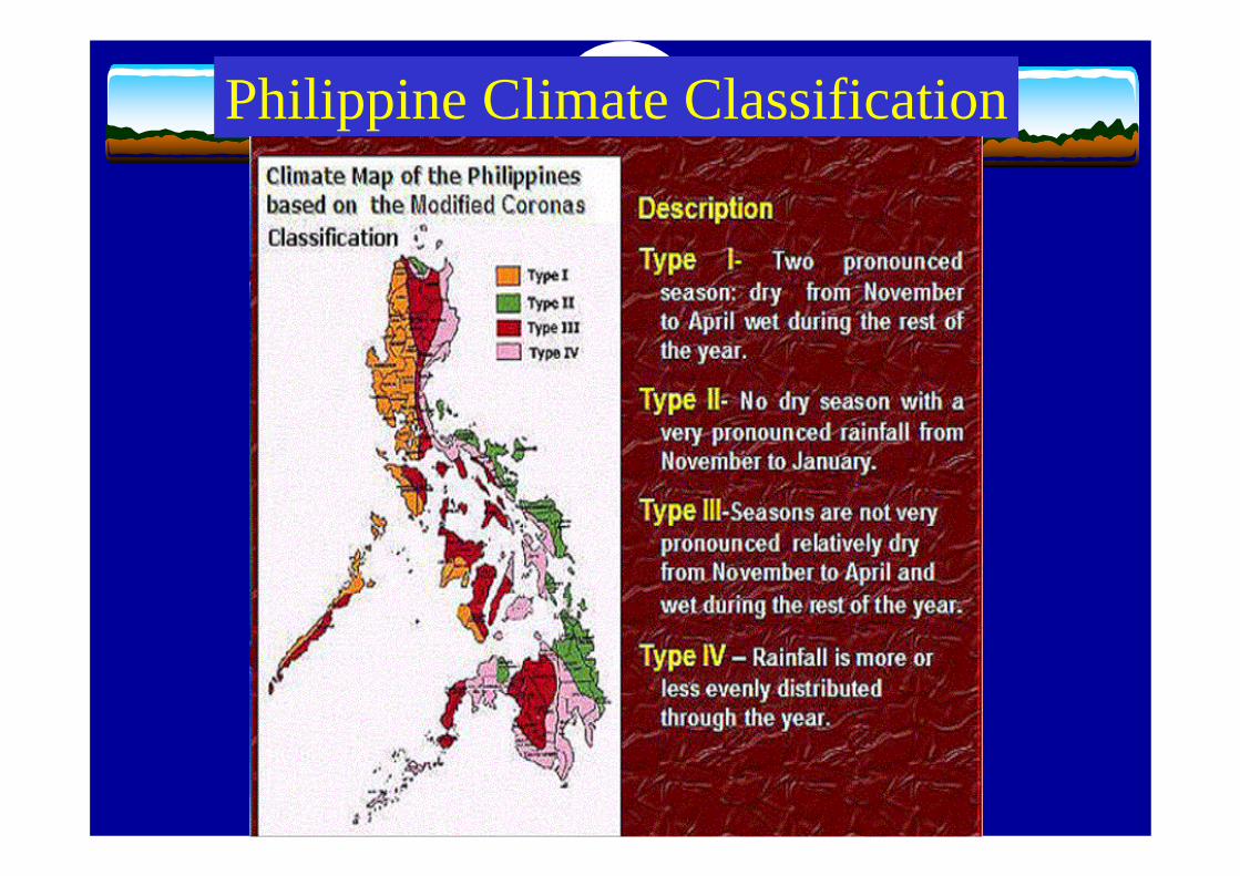
Philippine Climate Classification
• Every year ~ 20 tropical cyclones enterthe Philippine Area of Responsibility (PAR)
• ~ 9 make landfall• Affected by monsoons & other weathersystems
• Casualties and damages due to hydro-meteorological hazards are high
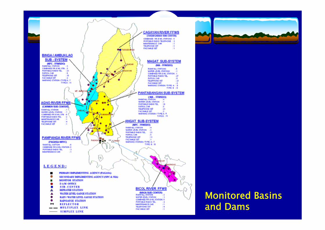
Monitored Basins and Dams
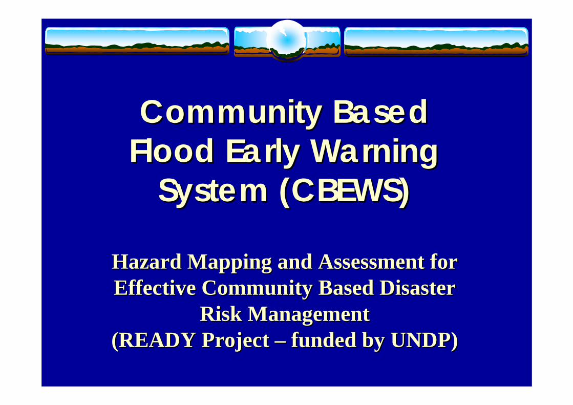
Community Based Community Based Flood Early Warning Flood Early Warning
System (CBEWS)System (CBEWS)
Hazard Mapping and Assessment for Hazard Mapping and Assessment for Effective Community Based Disaster Effective Community Based Disaster
Risk ManagementRisk Management(READY Project (READY Project –– funded by UNDP)funded by UNDP)
The CommunityThe Community--based Conceptbased Concept
Why pursue a CBFEWS?Why pursue a CBFEWS?
• It empowers local government units (LGU’s) and the communities to protect themselves against floods.
• They are in the best position to undertake preparedness measures against floods.
• It is sustainable.
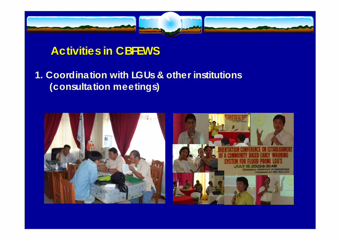
Activities in CBFEWSActivities in CBFEWS
1. Coordination with LGUs & other institutions (consultation meetings)
Activities in CBFEWSActivities in CBFEWS
2. Survey (tabletop) and design of network
Activities in CBFEWSActivities in CBFEWS3. Site survey (ocular inspection)
(Verification of identified sites for accessibility, communication, etc. get coordinates)
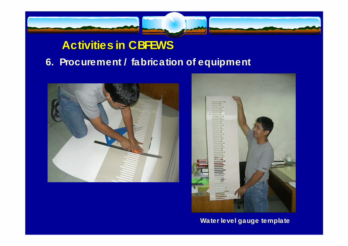
Activities in CBFEWSActivities in CBFEWS4. Procurement / fabrication of equipment
AUTOMATIC
RAIN GAUGE
Battery-operated LCD Monitor(inside the building)
Activities in CBFEWSActivities in CBFEWS5. Procurement / fabrication of equipment
Activities in CBFEWSActivities in CBFEWS6. Procurement / fabrication of equipment
Water level gauge template
Activities in CBFEWSActivities in CBFEWS
7. Installation of equipment (raingauge)
Standard Raingauge
Rain Gauge
Activities in CBFEWSActivities in CBFEWS
8. Installation of equipment (automatic raingauge)
Activities in CBFEWSActivities in CBFEWS9. Installation of equipment (water level gauge)
Standard Raingauge
CUT-OUT PATTERN (MADE OF CARDBOARD)
SPRAY PAINT
LADDER
Activities in CBFEWSActivities in CBFEWS10. Discharge Measurement & Cross-sectioning
(hydrographic survey measurement)
River cross-sectioning activities are undertaken to establish assessment levels for flood warning.
Discharge or river flow measurement
Activities in CBFEWSActivities in CBFEWS11. Training of LGU personnel & members of community
Formal training (lecture)
On-the-job training
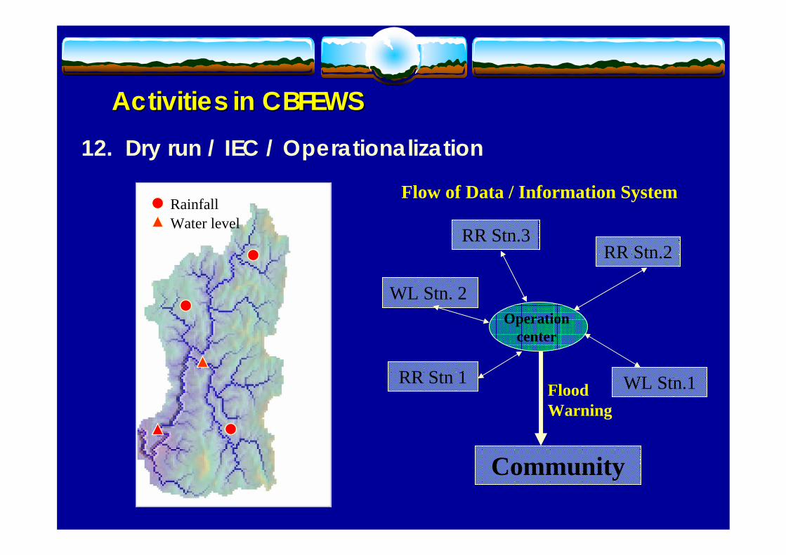
Activities in CBFEWSActivities in CBFEWS12. Dry run / IEC / Operationalization
RR Stn.3
RR Stn 1
RR Stn.2
Operation center
WL Stn. 2
WL Stn.1
Community
Flood Warning
Flow of Data / Information SystemRainfallWater level
Activities in CBFEWSActivities in CBFEWS13. MOA signing, passage of local ordinance in support
of the CBEWS LEGISLATIVE SUPPORT (LEGISLATIVE SUPPORT (DumangasDumangas, Iloilo), Iloilo)
•• ORDINANCE NO 2005ORDINANCE NO 2005--01 01 entitled, entitled, ““AN ORDINANCE AN ORDINANCE PROVIDING AN ANNUAL PROVIDING AN ANNUAL APPROPRIATION FOR THE APPROPRIATION FOR THE MAINTENANCE AND OTHER MAINTENANCE AND OTHER OPERATIONAL EXPENSES OF OPERATIONAL EXPENSES OF THE COMMUNITYTHE COMMUNITY--BASED BASED FLOOD AND DROUGHT FLOOD AND DROUGHT FORECASTING AND FORECASTING AND WARNING SYSTEM IN WARNING SYSTEM IN DUMANGAS, ILOILODUMANGAS, ILOILO””. .
Provincial GovernmentProvincial Government
Responsibilities of InstitutionsResponsibilities of Institutions
1. Coordinate with municipalities in the establishment of CBEWS; 2. Assist PAGASA in identifying the suitable communication
facilities/network for the CBEWS;3. Organize trainings/meetings for CBEWS; 4. Facilitate the signing of the MOA among stakeholders; 5. Monitor and ensure the smooth implementation of the project and
the smooth operation of the CBEWS; 6. Assist the municipalities in the allocation of funds for operation
& maintenance of the CBEWS through the enactment of a municipal ordinance; and
7. Provide all observed data and information to PAGASA on a monthly basis.
MunicipalitiesMunicipalities1. Assist PAGASA in the site survey, fabrication & installation of
rainfall, water level and tide gauges & flood markers & hydrographic surveys;
2. Ensure the implementation of the project by signing the Memorandum of agreement;
3. Provide two observers per station to be trained by PAGASA;4. Operate, maintain and secure the installed equipment;5. Ensure the sustainability of the system through the passage of
an ordinance in support of the CBEWS6. Prepare and issue flood advisories/warnings to threatened
communities; and7. Provide real-time data and warnings to the Provincial
Government and the designated operation center.
Responsibilities of InstitutionsResponsibilities of Institutions
PAGASA PAGASA 1. Coordinate with the LGUs and concerned institutions in the
establishment of the CBEWS.2. Conduct survey and design monitoring network in coordination
with LGUs.3. Install monitoring equipment in collaboration with LGUs.4. Train LGUs in the fabrication and installation of monitoring
instruments.5. Train LGUs on observation, recording and transmission of data.6. Train Municipal Planning and Development Officer & other
key municipal personnel in the analysis of data & preparation of warnings/advisories.
7. Conduct monitoring and evaluation of CBEWS.
Responsibilities of InstitutionsResponsibilities of Institutions
OCD Regional OfficeOCD Regional Office1. Assist PAGASA in the coordination of the project with
LGUs and other agencies. 2. Assist in information & warning dissemination. 3. Assist in monitoring & evaluation of CBEWS and provide
data on casualties and damages.
DOST Regional OfficeDOST Regional Office1. Assist PAGASA in the coordination of the project with
LGUs and other agencies. 2. Assist in information & warning dissemination. 3. Assist in monitoring & evaluation of CBEWS.
Responsibilities of InstitutionsResponsibilities of Institutions
1. Lower 1. Lower PampangaPampanga River Basin (River Basin (BulacanBulacan))
• Initiative and funded by the Provincial Government of Bulacan
• Operational in June 2005• Transmission of data & warnings:
SMS/voice• Memorandum of Agreement
(MOA) & Local ordinance enacted
• Project cost ~PhP1.0M
PID on flood disaster mitigation to members of DCCs
Citation was given to PAGASA by the Prov’l. Gov’t. of BulacanInstallation of Water
Level GaugeInstallation of
Raingauge Gauge
2. 2. JalaurJalaur River Basin River Basin • Initiative of Municipal
Government (Dumangas, Iloilo)• Commenced in June 2003• Funding: National Disaster
Coordinating Council (NDCC)• Transmission of data & warnings:
Survey and design of networkFabrication and installation of rainfall and water level gaugesMOA signed and local ordinance enactedPreparation of operations manual
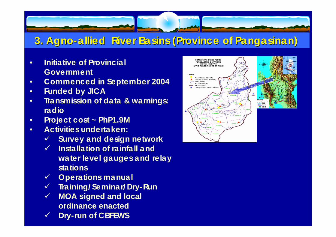
3. 3. AgnoAgno--allied River Basins (Province of allied River Basins (Province of PangasinanPangasinan))
• Initiative of Provincial Government
• Commenced in September 2004• Funded by JICA• Transmission of data & warnings:
Survey and design network Installation of rainfall and water level gauges and relay stationsOperations manualTraining/Seminar/Dry-RunMOA signed and local ordinance enactedDry-run of CBFEWS
• Commenced April 01, 2006• Funded by UNDP (AusAID)
with counterpart from LGUs• Coordination meetings with
LGU’s & other institutions –conducted
• Draft Memorandum of Agreement – under review by LGUs & gov’t. institutions (OCD & DOST CARAGA)
• Survey and design of network
• Procurement & fabrication of equipment.
• Installation of the equipment • IEC/Dry-run
4. 4. SurigaoSurigao del del SurSur River BasinsRiver Basins
• Commenced June 2006• Funded by UNDP (AusAID)
with counterpart from LGUs• Coordination meetings with
LGU’s & other institutions –June 15, 2006
• Draft Memorandum of Agreement – under review by LGUs & gov’t. institutions (OCD & DOST CARAGA)
• Survey and design of network –completed
• Procurement & fabrication of equipment
• Installation of equipment• IEC / Dry-Run
5. 5. SurigaoSurigao del Norte River Basinsdel Norte River Basins
•12 Municipalities (excluding Dinagat Is.)
•11 River Basins
•11 Major River & Creeks (Lengths~8 to 38 kms)
(1:50 Topographic Maps)
*Contours
*Spot elevations
Target areas of CBFEWSTarget areas of CBFEWS
Pampanga river basin(Pampanga, Nueva Ecija and Bulacan)
Agno river basin (Beguet, Pangasinan & Tarlac)
Surigao del Sur
Zamboanga del Sibuguey
On-going
Antique
Cagayan river basin(Cagayan, Isabela and Nueva Viscaya)
Surigao del NorteTelemetered
Proposed
Bicol river basin (Camarines Sur, CamarinesNorte & small part of Albay)
Leyte Island (Leyte& So Leyte)
N & E Samar
Nueva Viscaya
Aurora
Bohol
Abra river basin (Abra & Ilocos Sur)
Operational
THANK YOUTHANK YOU“tracking the sky . . . helping the country”
For additional information, VISIT us athttp://www.pagasa.dost.gov.ph