74
Community Based Participatory Watershed Development Part 1 January 2005 Addis Ababa Ethiopia First Edition A Guideline MoARD Before After

German Technical CooperationAmhara Micro-enterprise Development, Agricultural
Research, Extension and Watershed Management ProjectUnited NationsWorld Food Programme
Community Based Participatory Watershed Development
Part 1
January 2005Addis AbabaEthiopia
First Edition
A Guideline
MoARD
Befo
reAf
ter
Comm
unity Based Participatory W
atershed Developm
entA G
uideline
�
�
�
��
��
��
���
�
���������������������������������������

Community-based Participatory Watershed Development:
A Guideline
EditorsLakew DestaVolli CarucciAsrat Wendem-AgeňehuYitayew Abebe
Contributors (Alphabetical)Yitayew Abebe, AMAREWTariku Alemu, WFPAbiye Astatke, ILRIVolli Carucci, WFPLakew Desta, MoARDSileshi Getahun, MoARDTesfai Mebrahtu, GTZKent Reid, AMAREWKai Sonder, ILRIArega Yirga, WFPYihenew Zewdie, WFP
January 2005Ministry of Agriculture and Rural DevelopmentAddis Ababa, Ethiopia
Correct citation: Lakew Desta, Carucci, V., Asrat Wendem-Ageňehu and Yitayew Abebe (eds). 2005. Community Based Participatory Watershed Development: A Guideline. Ministry of Agriculture and Rural Development, Addis Ababa, Ethiopia.
FEDERAL DEMOCRATIC REPUBLIC OF ETHIOPIAMINISTRY OF AGRICULTURE AND RURAL DEVELOPMENT
Part 1

Ordering Information
To order copies please contact:
Ministry of Agriculture and Rural DevelopmentNatural Resources SectorP.O.Box 62347Addis AbabaEthiopiaTel.: +251-1-514389Fax: +251-1-514190E-mail: [email protected]
Material in this publication may be freely quoted or reprinted with acknowledgment.
Photo credits:
WFP - United Nations World Food Programme (by Mario diBari)FAO - Food and Agricultural Organization of the United NationsICARDA - International Center for Agricultural Research in the Dry AreasGansu-China - International Rainwater Harvesting Training CenterRELMA - Regional Land Management UnitVolli Carucci, WFPAbiye Astatke, ILRITesfai Mebrahtu, GTZLeul Kahsay, Private ConsultantHunie Nega, MoARDBerhanu Fentaw, MoARDLakew Desta, MoARD

iii
ACKNOWLEDGEMENTS
The preparation of this Guideline was prompted by the timely decision of the Ethiopian Government to promote and expand community watershed development in the country. In so doing, the preparation of a common guideline for use by wereda agriculture offices and other stakeholders was felt as a necessary starting point. The preparation of this Guideline would not have been possible without the contributions and efforts of various individuals and institutions for which we are quite grateful.
We would like to thank all institutions and projects, namely AMAREW, GTZ, ILRI, WFP, USAID who allowed their staff to engage in this important activity. The latter participated in a week-long workshop designed to enrich the manual with regional and wereda experts. We are also grateful to the various contributors and editors who did a marvelous job. The active participation and contribution of all, in particular, Volli Carucci and Lakew Desta is quite immense, as they have been involved in the process right form the beginning of drafting the concepts and outline of the Guideline throughout the course of preparation of the initial draft document, reviewing and amending the same until the final product was produced.
Equally important is our indebtedness to USAID and WFP for their financial and logistical support rendered to conduct the workshop, and to cover the cost of printing the final Guideline.
We are confident that they would share with us the reward of this effort: to see watershed development in Ethiopia as the important precursor to eradicating poverty from Ethiopia.
Professor Tekalign Mamo, State MinisterMinistry of Agriculture and Rural Development


v
FOREWORD
This Guideline addresses important developmental activity and the contents give information on how to plan, design and implement community watershed development activities. The Guideline provides consolidated and normative information for field workers and wereda sector offices. The effort is particularly important at a time when the Ethiopian Government has put a strategy that soil conservation, water harvesting, afforestation and land rehabilitation activities in general should be implemented following a watershed approach. The Guideline has been designed in such a way that important steps are followed by implementers and the community members are involved right from the inception of the idea up to its implementation and impact assessment.
The Guideline consists of two parts. The first part with two sections discusses the steps to be followed, interventions and the technologies to be implemented. The second part is the annex. Unlike many watershed guidelines prepared elsewhere, it was felt necessary to include the second section where interventions and technologies are discussed (although in brief form) so that users can have better understanding of what each intervention is all about. As much as possible, the discussions have been enriched with illustrations. For those users who require additional information, the task force has also prepared annexes as Part 2 which is an elaborated version of some of the steps and the various technologies.
The draft manual was discussed and enriched in a week-long workshop attended by regional experts. There is a plan to translate this Guideline into Amharic, Oromiffa and Tigrigna. It is hoped that this would further facilitate the implementation of watershed development by the rural community.
While this is the outcome of a joint effort made by all major stakeholders engaged in community watershed development, we hope to come up with similar important guidelines in the near future.
Prof. Tekalign MamoState MinisterMinistry of Agriculture and Rural Development

Community Based Participatory Watershed Development: A Guidelinevi Community Based Participatory Watershed Development: A Guideline
Acronyms
AMAREW Amhara Micro-enterprise Development, AgriculturalResearch, Extension and Watershed Management Project
BoARD Bureau of Agriculture and Rural DevelopmentCBO Community Based Organization CPWD Community Based Participatory Watershed DevelopmentCWT Community Watershed TeamDA Development Agent FAO Food and Agriculture Organization of the United NationsFSD Farming Systems DevelopmentFTC Farmers Training CenterGTZ German Technical CooperationHH(s) Household(s)ICRAF International Center for Research in Agro-forestryILRI International Livestock Research InstituteIPM Integrated Pest ManagementKWT Kebele Watershed TeamLLPPA Local Level Participatory Planning Approach
MERET Managing Environment Resources to Enable Transition to more Sustainable Livelihoods
MoA Ministry of AgricultureM&E Monitoring and EvaluationMoARD Ministry of Agriculture and Rural DevelopmentNRM Natural Resources Management
NWDPRA National Watershed Development Project for Rainfall Areas for India
NGO Non Governmental OrganizationPI Problem IdentificationPLUP Participatory Land Use PlanningNPSU National Project Support UnitP&ME Participatory Monitoring and EvaluationPRA Participatory Rural AppraisalPWDP Participatory Watershed Development PlanningSS Soil StorageSWC Soil and Water ConservationTVET Agricultural Technical Vocational Education and TrainingUSAID United States Agency for International DevelopmentWB World BankWFP World Food ProgramWR Wealth RankingWWT Wereda Watershed Team
vii
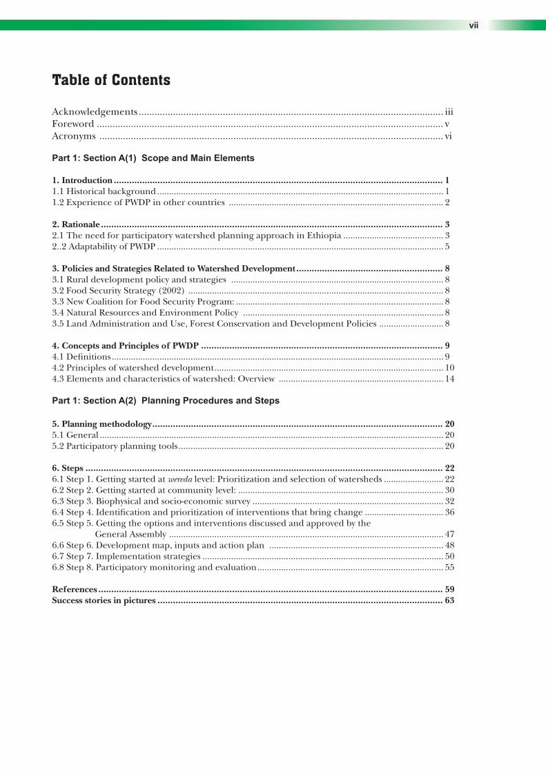
Table of Contents Acknowledgements .................................................................................................................... iiiForeword .................................................................................................................................... vAcronyms ................................................................................................................................... vi
Part 1: Section A(1) Scope and Main Elements
1. Introduction ................................................................................................................................ 11.1 Historical background ........................................................................................................................ 11.2 Experience of PWDP in other countries .......................................................................................... 2
2. Rationale ..................................................................................................................................... 32.1 The need for participatory watershed planning approach in Ethiopia .......................................... 32..2 Adaptability of PWDP ........................................................................................................................ 5
3. Policies and Strategies Related to Watershed Development ......................................................... 83.1 Rural development policy and strategies ......................................................................................... 83.2 Food Security Strategy (2002) ........................................................................................................... 83.3 New Coalition for Food Security Program: ....................................................................................... 83.4 Natural Resources and Environment Policy .................................................................................... 83.5 Land Administration and Use, Forest Conservation and Development Policies ........................... 8
4. Concepts and Principles of PWDP .............................................................................................. 94.1 Definitions ........................................................................................................................................... 94.2 Principles of watershed development ................................................................................................ 104.3 Elements and characteristics of watershed: Overview ..................................................................... 14
Part 1: Section A(2) Planning Procedures and Steps
5. Planning methodology ................................................................................................................. 205.1 General ................................................................................................................................................ 205.2 Participatory planning tools ............................................................................................................... 20
6. Steps ........................................................................................................................................... 226.1 Step 1. Getting started at wereda level: Prioritization and selection of watersheds ......................... 226.2 Step 2. Getting started at community level: ...................................................................................... 306.3 Step 3. Biophysical and socio-economic survey ................................................................................ 326.4 Step 4. Identification and prioritization of interventions that bring change ................................. 366.5 Step 5. Getting the options and interventions discussed and approved by the General Assembly ................................................................................................................... 476.6 Step 6. Development map, inputs and action plan ......................................................................... 486.7 Step 7. Implementation strategies ..................................................................................................... 506.8 Step 8. Participatory monitoring and evaluation .............................................................................. 55
References ...................................................................................................................................... 59Success stories in pictures ............................................................................................................... 63

Community Based Participatory Watershed Development: A Guidelineviii Community Based Participatory Watershed Development: A Guideline
List of Tables
Table 1. Analysis of possible interactions between the different sub-watersheds of the main watershed .....................................................................42
List of Figures
Figure 1. The land degradation – food-insecurity – poverty vicious cycle ...........................................6Figure 2. A watershed unit ....................................................................................................................9Figure 3. The resemblance between a watershed and a tree ..............................................................13Figure 4. Recognizing people’s and watershed potentials for conservation-based water harvesting ....................................................................................17Figure 5. Community watershed relationships – Example A ..............................................................28Figure 6. Community watershed relationships – Example B ...............................................................28Figure 7. Watershed categories ..............................................................................................................41
Part 1: Section B Infotechs
Infotechs on technologies ...........................................................................................................64 Introduction .................................................................................................................................65 Main features of infotechs ...........................................................................................................651. Physical soil and water conservation ...........................................................................................672. Flood control and improved drainage .......................................................................................813. Water harvesting .........................................................................................................................914. Soil fertility management and biological soil conservation .................................................................................................................................1255. Agro-forestry, forage development and forestry ........................................................................1416. Gully control .................................................................................................................................1557. Feeder roads .................................................................................................................................167
Intervention number

Part 1: Section A(1)
SCOPE AND MAIN ELEMENTS


1
Introduction 1. 1 Historical background Planning the development of watersheds for Ethiopia started in the 1980’s. A planning unit for developing large watersheds comprised 30-40 thousand hectares. The purpose was mostly for implementing natural resource conservation and development programs. Large-scale efforts remained mostly unsatisfactory due to lack of effective community participation, limited sense of responsibility over assets created, and unmanageable planning units. The lessons learned from this experience encouraged MoA and support agencies like FAO to initiate pilot watershed planning approaches on a bottom-up basis, using smaller units and following community-based approaches. As a result the minimum planning and subwatershed approaches were introduced. Minimum planning at the initial stage involved shifting from larger watersheds to smaller sub-watersheds. These were tested at the pilot stage through FAO technical assistance under MoA during 1988–91.
MoA and WFP technical staff developed simple participatory and community-based watershed planning Guidelines: the LLPPA (Local Level Participatory Planning Approach). LLPPA was developed for Development Agents, as a practical approach focusing mostly on integrated NRM interventions, productivity intensification measures, and small-scale community infrastructure such as water ponds and feeder roads. During the last 10 years, hundreds of community plans were prepared and implemented with significant results. To date, LLPPA is at the core of the MoARD-WFP assisted MERET project to combat land degradation and food insecurity in several regions.
Several NGOs and bilateral organizations also adopted participatory land use-planning approach in the last decade in their respective areas of intervention and in close collaboration with government partners. For instance, both GTZ and SOS Sahel have followed a Participatory Land Use-Planning (PLUP) approach. GTZ succeeded with this approach in South Gondar, North and West Shoa of Oromia and in some weredas of Tigray introduced and mainstreamed the participatory element into the land use-planning and natural resources management approach introducing with biological and physical soil and water conservation measures, crops and farming practices; in North Wello and Wolaita, SOS Sahel focused on integration and management aspects, self reliance and piloted area closure sharing arrangements and use rights.
The AMAREW project, operating in two weredas of Amhara region, has gained experience in participatory watershed management on a pilot basis in two weredas of Amhara Region promotes four interrelated components: micro-enterprise development, agricultural research and extension, and watershed management, with significant efforts on group formation and organization for watershed development and management. The watershed-focused approach ensures site-specific application of suitable interventions and active participation of the community. Other organizations have also played a relevant role in promoting watershed management planning in Ethiopia in various regions and weredas.
The collective experience comprising different approaches, combined with the need to have a common and standardized more effective approach to the country as a whole, gave birth to the current community-based participatory watershed development guidelines.

Community Based Participatory Watershed Development: A GuidelineCommunity Based Participatory Watershed Development: A Guideline
1. 2 Experience of PWDP in other countries
1. 2. 1 Successful watershed initiatives
Many countries, particularly those having significant areas with complex, mountainous, and fragile ecosystems have developed national watershed programs or projects. The Indian National Watershed Development Project for Rain fed Areas (NWDPRA) is a major initiative operating in conformity with the Common Approach for Watershed Development. It was jointly formulated and adopted by the Ministry of Agriculture and Rural Development incorporating lessons learnt from successful projects, especially in community participation.
China successfully practices the concept of small watershed-based development. The overall plan for the management of a small watershed emphasizes on comprehensive erosion control measures including measures for hill slope and gully stabilization, regulating river system and rearranging farmlands. Combining soil erosion control measures with the optimum utilization of biological measures has further developed principles of soil erosion control. Appropriate management and use of degraded watersheds have obviously resulted in large-scale ecological, economical and social benefits to farmers. Other Asian countries like Nepal, The Philippines and Indonesia have also remarkable and often large-scale watershed development programs.
Participatory conservation and watershed-based approaches have been successfully introduced and expanded in various countries in Africa, particularly in Kenya, Niger, Burkina Faso and Mali, to name a few. Such programs have been realized within the context of combating desertification and poverty reduction efforts.
1. 2. 2 Problems and failures encountered with watershed development
Watershed development has been problematic when applied in a rigid and conventional manner. This is true when applied without community participation and using only hydrological planning units, where a range of interventions remained limited and post-rehabilitation management aspects were neglected. This resulted in various failures or serious shortcomings difficult to correct. Some examples can be cited in Ethiopia and elsewhere. For instance, the case of the large Borkena dam in South Wello in the 80’s where the dam was constructed before sufficient conservation measures were in place. Besides, runoff and sedimentation rates were seriously underestimated. It resulted in the filling with silt and coarse materials of the multi-million Birr dam within one rainy season. Other examples in Ethiopia include large-scale watershed planning using top-down approaches and rigid technical packages during the 80’s that resulted in unsatisfactory performance of several conservation efforts. This shows that a poorly planned watershed approach could result in complete failure. In India there have been cases of over-exploitation of water-tables resulting from an intensive watershed treatment where some of the major benefits have been reduced, particularly for the poor, because of the competitive use of water resources by richer farmers for irrigation. Other cases of failure included upper ridges planted with monocultures of eucalyptus trees, which depleted water-tables and had negative ecological effect on soils.
2

3
2. Rationale2. 1 The need for participatory watershed development planning approach in Ethiopia
2. 1. 1 Main objectives of the Community-based Participatory Watershed Development (CPWD)
The overall objective of Participatory Watershed Development is to improve the livelihood of community/households in rural Ethiopia through comprehensive and integrated natural resource development. It aims at productivity enhancement measures for improved income generation opportunities, enhanced livelihood support systems and high resilience to shocks.
The second objective is to optimize the use of existing natural resources and untapped potentials in both already degraded areas and in the remaining potential areas in the country.
More specific objectives include:1. conserving soil, rainwater and vegetation effectively for productive uses;2. harvesting surplus water to create water sources in addition to ground water recharge;3. promoting sustainable farming and stabilize crop yields by adopting suitable soil, water,
nutrient and crop management practices;4. rehabilitating and reclaim marginal lands through appropriate conservation measures
and mix of trees, shrubs and grasses, based on land potential;5. enhancing the income of individuals by the diversified agriculture produce, increased
employment opportunities and cottage enterprises, particularly for the most vulnerable, linked to the sustained use of natural resources.
2. 1. 2 Objective of the Guideline
The Guideline aims to build upon existing community-based participatory watershed efforts to harmonize and consolidate planning procedures at the grass-roots level. The intent is to provide DAs and rural communities with a workable and adaptable planning tool, whether located in a low rainfall or high rainfall area, in a severely degraded and food-insecure area or in a food secure and not yet seriously affected by land degradation area, in a cereal-plough farming system or on an Enset-hoe one, for both men, women and for the youth.
In this regard, another main objective of the participatory watershed planning guideline is also to provide practical guidance on the correct selection of technologies under different conditions and their sequentially correct implementation. Different interventions will be summarized in planning procedures and included in some detail as packages in the Annexes and in other support documents. Finally, the Guideline would be used as a reference for TVET and FTCs theoretical and practical trainings.
2. 1. 3 PWDP as a foundation for sustainable agricultural development in rural Ethiopia
PWDP to combat the land degradation-food insecurity-poverty nexus: Ethiopia has mostly complex and fragile landscapes. Land degradation seriously affects livelihoods and food security of millions in Ethiopia and threatens the livelihood of many more. The main land degradation arises from (1) high soil erosion rates as a result of steep slopes, continuous encroachment and cultivation of marginal lands; (2) long history of deforestation, overgrazing, negative coping strategies such as the burning of animal dung, extensive use of charcoal, reduced rotation periods, and others;

Community Based Participatory Watershed Development: A Guideline4 Community Based Participatory Watershed Development: A Guideline
Recurrent cycles of drought and inadequate infrastructure have further aggravated the problem. Consequently, the farming systems that exist in the country are progressively impoverished and more vulnerable to shocks. These are serious constraints to sustainable development and a main cause of unstable, over-simplified and drought prone production systems.
Therefore, participatory watershed planning and development is a vital necessity in complex landscapes. Interactions, between and within, communities depend on what happens at different levels of the watershed. Watershed planning has moved away from conventional land use-planning exercise to a logical interpretation of the potentials of the land as a function of the needs, demands for and aspirations of the people living in the watersheds, including the interactions between people’s activities and the land resources. Participatory watershed planning is thus the key to understand what is needed to be done at various levels to sustain, improve and diversify production while developing and managing the natural resource base, promote income generation opportunities, increase access to basic services (roads, markets, schools, water, and the like.) and make livelihood systems resilient to shocks.
Relationship between livelihoods and watersheds in rural Ethiopia: All over Ethiopia, watershed logic governs water regimes, erosion levels, biomass availability, productivity levels, the quality of infrastructure and countless other activities. In degraded watersheds, opportunities for water harvesting and management are few and of limited use; access roads are continuously damaged or they are not suited for construction, access to clean water for domestic use are very difficult and incidence of water-borne diseases is very high. Unstable watersheds induce unstable production systems and inefficiency of input utilization as erosion also erodes efforts to enhance productivity. Moreover, income generation opportunities linked to introduction of cash crops, bee-keeping, livestock fattening or dairy, and others, largely depend on the conditions or “health” of the watersheds. They depend as well on the interactions between communities and the different levels of the watershed units. Increased vulnerability to drought and food insecurity is directly linked to the conditions of the watershed and its limited capacity to support local livelihoods. The opposite occurs with protected and developed watershed systems, which generate multiple positive effects on people’s livelihoods, the environment and for the overall economy of the area.
Potentials and opportunities linked to PWDP. The potential for community-based watershed development in Ethiopia are huge. This applies both for already severely degraded and food-insecure areas as well as for those areas classified as food-secure and surplus-producing. The latter definition should not be misleading as these areas are also subject to high erosion and deforestation rates, gradually losing their potential. These areas should rapidly undertake corrective actions to reverse degradation trends and retain as well as improve their potential. The amount and type of activities, including technological interventions, may differ but the same principles and recommendations apply.
In other words, participatory watershed planning should be considered as an instrument to “bring rural households back to business” in food-insecure and degraded contexts and “keep rural households in business” in other areas. Besides, watershed development also enables new opportunities to emerge, linked to water development, diversified crops, access to markets, reclaimed land, fertility improvement, off-farm activities, and others. Thus, the watershed, or catchment area, is the natural framework for resource development in relation to crop production systems as well as resource conservation and utilization.

5
Equally important, PWDP is a practical and effective tool for utilizing at best the different disciplines related to agriculture and food security, in a way that they mutually reinforce each other. Natural resources, inputs and extension, livestock, water and marketing are all connected and will greatly benefit from using a participatory watershed planning framework.
Watershed development benefits local households and farmers, the local community, and the society at large.
Benefits to households:
• Improved water availability and fertility levels for crop production and diversification.
• Improved soil quality and better drainage.
• Increased access to biomass for multipurpose use (firewood, fodder, fruits, construction, and others) and higher profits.
• Increased resilience to shocks and Improved livelihoods.
• Increased participation in income generation activities.
Benefits to local community:• Lower land-
development costs.• Reduced erosion,
deforestation, flooding and waterlogging.
• Increased overall agricultural productivity and access to markets and basic services.
• Improved livelihood options, including for the poorest households.
• A more dependable, clean water supply for domestic and industrial use – recharge of aquifers.
Benefits to the society at large:
• Better conservation of natural resources and biodiversity.
• Less danger from floods to downstream farmlands.
• Reduced sedimentation of costly irrigation projects and protection of major infrastructure (e.g. roads) Increased water supply and improved health.
• Reduced occurrence of drought and increased stability of production systems.
2. 2 Adaptability of PWDP
2. 2. 1 PWDP in diverse ecosystems
PWDP can be applied in almost all contexts but needs to be tailored to local conditions. The approach can be adapted to suit different sizes of watersheds and accommodate community and kebele administrative boundaries. It can also be adapted to accommodate relationships between communities and watersheds as well as the application of the various technologies under different conditions. The same measure, for instance a soil bund, has different design and different vegetative stabilization requirements if constructed in dry weyna dega or in moist weyna dega conditions. Watershed planning for a community located at the foot of a single hillside or few hills will be largely different from watershed planning for communities located under broad mountainous ranges and where the watershed includes complex vertical and horizontal relationships. The second will need various community-based sub-watershed plans to be prepared and linked one to the other to achieve the intended results.
Adaptability is also required to treat watersheds with various measures. There are numerous relationships at the level of a watershed and the infinite sub-divisions possible to identify. There may be large interactions for large watersheds that influence major hydrology and local economies of an area. An example is recharging of water-tables and protection of feeder
Rationale

Community Based Participatory Watershed Development: A Guideline6 Community Based Participatory Watershed Development: A Guideline
INAD
EQU
ATE
C
ON
SER
VATI
ON
PO
LIC
Y
AND
APP
LIC
ATIO
N
Figu
re 1
. TH
E LA
ND
DEG
RA
DA
TIO
N-F
OO
D IN
SEC
URIT
Y-P
OV
ERTY
VIC
IOU
S C
YC
LE

7
roads. Very small interactions at the level of a micro-watershed, up to a farmer’s homestead level or further down between sections of the homestead are another example. What can be improved at the homestead level is often closely linked to what can be done on a larger watershed level. For example, hand-dug wells and small- scale irrigation at an individual household level is now possible in several weredas as a result of systematic treatment with moisture conservation-based measures of large watersheds. A small effort over a few hectares would not generate such results. On the other hand, watershed principles will be applied to the smallest unit of interventions, including between measures within a single plot of land.
Finally, flexibility is needed in the way watershed-planning units themselves are delineated. Planning units should be community-based (gott, kushet, genda, and others) but specific watershed units identified within and outside the community boundaries based upon hydrology and land-use interactions. Quite often, there will be interventions that will need to include more than a single community or kebele. In this case, each community-based watershed plan will contribute to larger plans and share major interactions and activities with other (s).
2. 2. 2 Application and relevance of PWDP in pastoralist systems
PWDP as explained in this Guideline is more suited for settled agriculture but can be adapted to suit the needs of agro-pastoralists and pastoralists. The latter are traditionally rather mobile along transhumance (grazing) routes, which are the result of decades of experience and adaptation to climatic and environmental conditions. Instead of defined watershed units, an “area-based” watershed approach is to be applied, where specific areas along rangelands and transhumance routes will be developed following watershed principles. However, at regional, zonal and wereda levels, broad watershed units should be delineated within which specific areas are identified for interventions. The interventions will be executed following specific sub-watershed interactions. The most critical needs are always water and animal feed. Water development for pastoral areas is commonly seen as a failure because of the concentration of animals and the rapid degradation of land around few water points. The strategy should be directed to create sufficient grazing reserves for pastoralists to use at times of drought and along transhumance routes. For agro-pastoralists, an entire set of conservation and water harvesting measures can be implemented to enable them to stay longer in a given location (increased crop and fodder production as well as access to water supply). Specific recommendations will be provided for pastoralist systems in several sections of the Guideline and in the Annexes.
Rationale

Community Based Participatory Watershed Development: A Guideline8 Community Based Participatory Watershed Development: A Guideline
3. Policies and Strategies Related to Watershed DevelopmentSeveral strategies and policies refer and support the need for development of natural resources, community participation and diversified agriculture. 3. 1 Rural Development Policy and Strategies
Proper use and management of agricultural land implies improving land productivity through encouraging different conservation and rehabilitation mechanisms and rational utilization of the country’s land resource. Enough emphasis should also be placed to conserve and rationally utilize water resources. Natural resource conservation is the base for sustainable agriculture. Participatory natural resource conservation and management that ensures real benefit to communities is envisaged.
3. 2 Food Security Strategy (2002)
The strategy is targeted mainly to chronically food-insecure, moisture-deficit and pastoral areas. The focus is on environmental rehabilitation to reverse the current trend in land degradation, and as a source of income generation for food insecure households. Watershed-based water harvesting and introduction of high value crops, livestock, and agro-forestry development are new elements in the revised strategy.
3. 3 New Coalition for Food Security Program
In this program, Integrated Participatory Watershed Management Planning is suggested for planning and implementation of food-security interventions.
3. 4 Natural Resources and Environment Policy
The overall policy goal is to improve and enhance the health and quality of life of all Ethiopians. The goal is to promote sustainable social and economic development through sound management and use of natural, human-made and cultural resources and the environment as a whole.
3. 5 Land Administration and Use, Forest Conservation and Development Policies
The government is currently reviewing those policies for endorsement. Land-use certification activity has already started in various regions. This is believed to strongly support the current participatory watershed development initiative.

9
4. Concepts and Principles of PWDP 4. 1 Definitions
4. 1. 1 A watershed
A watershed is defined as any surface area from which runoff resulting from rainfall is collected and drained through a common confluence point. The term is synonymous with a drainage basin or catchment area. Hydrologically, watershed could be defined as an area from which the runoff drains through a particular point in the drainage system (Figure 2). A watershed is made up of the natural resources in a basin, especially water, soil, and vegetative factors. At the socio-economic level a watershed includes people, their farming system (including livestock) and interactions with land resources, coping strategies, social and economic activities and cultural aspects.
Figure 2. A watershed unit
A B
a
b
Drainage line
Watershed boundaries
Watershed direction
Common outlet
A is the watershed divide for the larger watershedB is the watershed divide for the smaller watersheda is the water course for the larger watershedb is the water course for the smaller watershed
4. 1. 2 Participatory watershed development
Participatory watershed development can be defined as the rational and socially acceptable utilization of all the natural resources for optimum production to fulfill the present need with minimal degradation of natural resources such as land, water, and environment. It should be underlined that people’s needs and aspirations drive the planning process. Local farmers, other land users and the wider community who depend on the land must be involved from the very beginning of the planning process since they are the ones that will live with the end result. Consequently, it should be emphasized that the adequacy of planning depends on the human element and not only on the physical or technical aspects. Therefore, planning must start from the people living on the land.
Participatory watershed development and planning must go beyond initial consultations with the “target population” after which the project designers go back to the office to write up a detailed project proposal. Participation in planning requires a mechanism for priority rating and decision-making at the local level. People need to be informed about available alternatives. They need to feel that their concerns are being addressed. Initial planning must be followed by a system of monitoring and evaluation so that rural people themselves will be able to follow and measure progress made on joint decisions, and make changes if necessary to ensure satisfactory results.

Community Based Participatory Watershed Development: A Guideline10 Community Based Participatory Watershed Development: A Guideline
It can also be explained as the involvement of communities and households in the stages of planning, implementation and monitoring and evaluation of watershed development. The key for success will be the full participation of men and women, and their agreement in the selection and integration of various technologies within the natural boundaries of a watershed area for optimum use of land and water resources. This includes land improvements, rehabilitation, and other technical works as well as betterment of people. Water can be developed and managed if a watershed is taken as a planning unit. People’s activities depend on the watershed for their livelihood and survival, and in turn are responsible for the proper or improper use of the resource. Therefore, people’s participation is critical for the success of participatory watershed management as it aims to create a self-supporting system essential for sustainability.
The concept of participatory watershed development and management emphasizes a multi-disciplinary and multi-institutional approach for multiple interventions, which includes effective use of any form of assistance and community contribution, as well as the sound management of assets created. Human resource development and participation of the whole community in planning is essential since it is the people who have to benefit from watershed development and manage their resources.
Participatory watershed development is also intended to generate greater cohesion within the society and enable its poorest members to benefit from the various assets created and eventually to overcome their food insecurity.
4. 2 Principles of watershed development
4. 2. 1 Main principles
Participatory: Watershed communities need to be involved in all stages of planning, implementation and management of watershed development activities. It is a continuous process and not a one time exercise. Different participatory techniques will be used based upon existing and innovative experience. Gender sensitive: Women are the most affected by environmental hardships; for example, they need to walk long hours to fetchh increasingly scarce water, firewood and animal dung in addition to attending livestock, to name a few. Their involvement in watershed development planning, implementation and management is the key to ensure that they equally benefit from the various measures. Building upon local experience, strength and what works: Local knowledge is essential to improve existing technologies, to adapt new ones and to manage natural resources and other measures once they are introduced and established. Best practices should be identified and disseminated.Realistic, integrated, productive and manageable: Watershed development planning should be realistic, based upon local capacity, locally available resources and other forms of government and partners support. Integrated conservation and development of the natural resources base is the guiding principle for watershed development together with the optimum use of social resources. To the extent possible watershed development activities should provide tangible and quick benefits to households. This is possible if measures are designed to accommodate both production and conservation requirements. Some measures, however, need some time before the full benefits can be achieved. In this case, combination of measures with short and longer term benefits is essential. This can be achieved if quality criteria and integration aspects of the interventions are met.

11
Watershed logic and potential respected: Adoption of ridge to valley approach, of manageable size, and focused on interactions between land uses and their capability. Simple land use and features descriptions would help to find suitable range of technical options to optimize existing land use or changing it for the better in respect of both biophysical and social requirements. Due emphasis will be placed on production enhancement activities by optimizing productivity per unit area, per unit time, and per unit of water for both land owners and landless families. In this regard, the role of quality physical structures, vegetative cover and biological measures will be emphasized. Reclamation and rehabilitation of degraded and marginal lands, including gullies, through alternative and productive land-use systems will be promoted as a main activity in most areas. In semi-arid and arid areas, great attention will be provided for water harvesting in situ and off site.The need for flexibility at different levels: Flexibility is a key criteria required in PWDP to fit in local conditions. Flexibility is needed during the selection of community watersheds, their size (slightly smaller or larger than the ranges indicated) and clustering and during the steps of the procedures. Similarly, flexibility is essential when considering the choice and design of measures within the agreed criteria of quality and integration. Cost-sharing and empowerment/ownership building: Cost-sharing by stakeholders contributes to the sustainability of a project for establishing the responsibility of various stakeholders in the management of the resources. Various forms of local contributions are possible based upon social networks and group formation mechanisms. Complementary to food security and rural development mainstream (including HIV/AIDs, health and education, and others): To the extent possible, watershed development planning will incorporate additional elements related to basic services and social infrastructure. These activities will all benefit from participatory watershed development framework.
4. 2. 2 Size of the watershed
A watershed may be only a few hectares as drainage area for filling small ponds or hundreds of square kilometers for rivers. The size of the watershed should be based on the community or communities depending on the watershed. A suitable watershed size is required for effective planning for conservation and maximum production. Efficient management of watershed resources is possible through an appropriate unit so that the resources are managed and handled effectively, collectively and simultaneously. The maximum size of the watershed that should be taken as a planning unit is suggested to range from 200 to 500 ha. Lower size than 200 ha may occur and may be considered in few cases but usually these smaller units are to be included as sub-watersheds within community watersheds. Some exceptions on the upper side may occur, particularly in drier areas where villages are scattered under larger watershed units and natural resource development is possible only if larger units are considered. In this case, however, sub-watershed units can be identified and prioritized for key interventions before others.
As the decision-making unit for any watershed is the community, the starting point for planning is the community and its surroundings. Within the above size range, a watershed will be then selected as much as possible to:
• Include the community or most parts of a community comprising the smallest unit available (gott, kushet, genda, and others). One kebele could have several watershed plans.
• Include more than one community where the interactions between two or more communities are closely linked to the watershed they share. The number of communities should be within one kebele.
Concepts and Principles of PWDP

Community Based Participatory Watershed Development: A Guideline12 Community Based Participatory Watershed Development: A Guideline
• Include only a portion of a community that is widely scattered having two or more main sub-watersheds cross the community. In this case, several sub-watershed plans can be developed and linked one to the other (see section 6.1.3).
Based on the experience of various countries, a watershed size of 500 hectares creates homogeneity in most aspects. This facilitates greater planning and implementation. It is the maximum size recommended in this Guideline. When the size is large, it is difficult to organize the community to undertake the surveying, planning, implementing, and monitoring tasks at one go. Those watersheds with high and diverse development potential will tend to be smaller than those in the arid and pastoral areas having limited agricultural potential.
The size of a watershed to be chosen for land development/soil conservation also depends upon the objective(s) of the nature of the land development planning to be attempted. If the major objective is to conserve rainfall and replenish water-tables in dry areas, for example through moisture conservation-based activities (trench bunds, and others.), then the size of the watershed can be larger, between 500 and 1000 ha, a conventional size for planning soil and water conservation treatment. The same is true for protecting feeder roads crossing various villages under fragile hillsides and some other works. In this case, different village or community level watershed plans can be clustered (grouped) and form logical continuums and broader watershed units for those specific activities of common interest or mutually beneficial (like the raising of water-tables).
For integrated development of watershed for agricultural purposes, time and available resources are important criteria when deciding the size.
4. 2. 3 Watershed and sub-watersheds: Linkages and intervention logic
All watersheds can be divided into smaller sub-watersheds. Each watershed or sub-watershed hydrological unit is connected, and any modification of the land use in watershed or sub-watershed will reflect on the water as well as sediment yield of the overall watershed. Watershed can be classified as micro-watershed, sub-watershed, broader or critical watershed, major watershed, sub-basin and basin.
There is quite interesting resemblance between a tree and a watershed (see Figure 3). A tree can be explained as leaves leading to small branches and these small branches leading to larger branches and the larger branches lead to the trunk of the tree. Also there is similarity between administrative ladder and watershed as village (e.g. gott), sub- kebele, kebele, wereda, Zone, Region, and national. So there is always intervention logic between the small and larger watersheds and continuum exists. Finally, a whole watershed treatment means generation of abundance of resources and wealth.

Concepts and Principles of PWDP
Linkages: Once the broader watershed unit has been chosen, smaller sub-watershed units can be identified within this unit to prioritize activities and their sequence. There are interactions between the watershed and sub-watershed that may be extremely important to remember and to consider. Some are simple and obvious; others are less evident and need to be looked at more carefully. These interactions are based not only on how drainage and surface runoff but also on land use and socio-economic factors. Step 4 of Section A(2) illustrates common situations in the field and some problems that may occur when interactions and factors related to watershed management are neglected.
In general terms, an overall watershed treatment is required. Although integrated and comprehensive treatments are the ideal solution, this may not be possible because of resources, cost-benefit issues or because of local priorities and other factors. However, this can take place sequentially and through time using a flexible and timely spaced approach. Sometimes watersheds will only be partially treated. This is acceptable only if it does not affect the performance of the treated parts and worsens the status of the untreated area.
Intervention logic: The selection and logical sequence of the different interventions should be geared by farmers’ interests and by how those interests can be addressed based upon the biophysical characteristics of the landscape. Technical support is also needed to visualize watershed potentials and logic. Intervention logic is not only related to the type of activities that should be undertaken sequentially or simultaneously but also to a number of agreements and arrangements required for different land users to agree on what, where, by whom and how to do things. A feeder road or a water pond may be a priority for the community. However, without treatment of upper watershed areas, these two assets will not be sustainable and thus be severely damaged. Those upper sections may need to be closed and planted, which in turn implies sharing arrangements, control grazing agreements, choice of type of conservation measures to support plantation and control runoff, choice of species, and the like. During the selection of measures such interactions will determine the best sequence to follow and the risks to avoid. This Guideline and support documents will provide information on main interactions and integration requirements for various technologies and interventions. The two examples below further clarify intervention logic.
A B
a
b
Figure 3. The resemblance between a watershed and a tree (for legend A, B, a, b see figure 2)
13

Example 1: Soil bunds may be requested by a group of farmers from a given area but it may easily happen that implementation cannot take place because their land is located below a hillside and thus likely to be damaged by runoff draining from the hillside after rains. It would then be necessary to involve another group of land users who have rights over those hills or consult the community (ies) if the area is under communal use rights (such as grazing). In this case, problems may be encountered such as the lack of interest in treating the hillside, disputes over use rights, and different opinions on what measures to apply on the hillsides and access to labor opportunities, and others. It is only after clear agreements are reached on what, where, how, by whom and when the treatment of the hillside is going to take place that soil bunds become a viable option for that area.
Example 2: In many areas, there is considerable untapped potential for water harvesting. Understanding the potential of a watershed can provide the answer for what type of measure to select, for example choosing micro-ponds and/or hand-dug wells. Hand-dug wells for small-scale irrigation are more advantageous but water-tables can be too deep with limited flow. In many parts of the country geological fractures are frequent and superficial, which means that upper aquifers/water-tables can be recharged and water available close to the ground level (5-10 meters). However, water-tables will be recharged if adequate and significant treatment of hillsides is undertaken. Trenches combined with other measures (infiltration pits, and others) can be very effective in this regard. Once this treatment is completed hand-dug wells are feasible. In other circumstances micro-ponds will be the best choice provided they are also integrated with upper micro-watershed rehabilitation – often a combination of the two is also possible depending on the topography of the area.
4. 3 Elements and characteristics of watershed: Overview
4. 3. 1 Biophysical (water, land, vegetation)
The watershed includes climate (rainfall, altitude, and winds), drainage and water, soil, vegetation, specific topographic features (gradient and length of slope, shape and direction and past/current erosion features (rill, gullies, land slides, and the like). Land use includes homesteads, cultivated land, grazing land, forest (natural and artificial), degraded areas used for various purposes. Some areas have more potential than others. However, watershed development applies to potential as well as less potential areas, as both are not only interconnected but also can recover or improve their productivity with specific set of measures and management.
4. 3. 2 Socio-economic
The socio-economic elements and characteristics of a watershed involve population, farming systems, social setups, economic activities, vulnerability profile, gender, and the like. Watershed development planning is a principle approach that fits community level planning. It aims to improve the livelihood of the community, men and women alike. Watershed planning is democratic. It embraces the views of various categories of people in the watershed (s). Although all community members are expected to benefit from watershed development, specific attention is required to address problems of resource poor and vulnerable families and promote the empowerment of women. Specific initiatives involve:
• Equal participation in planning, wage and employment opportunities for women and most vulnerable households;
• Preferential allocation to resource poor households of usufruct rights over the common
Community Based Participatory Watershed Development: A Guideline14

15
land resources before starting planning;• Development of marginal lands assigned to resource poor families and women headed
families on a priority basis;• Location of water harvesting structures nearer to the lands owned and cultivated by
resource poor families;• Providing support (assets building) to land poor, landless and labor constrained families
through multiple interventions undertaken through community efforts as solidarity and mutual-help schemes.
4. 3. 3 Watershed degradation features
Depletion of water resources: Ethiopia suffers from what is referred as a “recurrent wastage of most of its rainwater”. With loss of water through surface runoff soil is also eroded, thus triggering the whole chain of negative consequences leading to chronic food insecurity. In most developing countries, only 20–50% of total surface runoff is controlled and effectively used. Ethiopia is among them as topography, inadequate farming practices, and lack of conservation hamper water and moisture retention and its efficient use. Runoff is the portion of rainfall that does not infiltrate into the soil where it falls and scours away.
Waste of rainwater occurs when (1) it does not infiltrate and satisfy the crop water requirements, and when (2) the part that leaves the plot as runoff is not intercepted and is lost away unproductively. When rainwater infiltrates rapidly it also has a high probability to recharge water-tables and make ground water available for small-scale irrigation or supply springs for various uses. Depletion of water resources is directly linked to the disappearance of vegetative cover and surface protection systems. High runoff also implies high erosion rates and soil degradation, lower infiltration and a vicious cycle of depletion. Scarcity of water for domestic and livestock use is a major consequence of degradation in Ethiopia, with serious repercussions on health, incomes and the quality of life of people. Out of the total population, only 24 percent have access to safe drinking water. Close connection with the conditions of the watersheds can be made, clearly showing that water is scarcer where watersheds are degraded. Therefore, for effective harvesting and utilization of surface and subsurface water sources for both domestic, livestock and production uses, watershed development is the most appropriate modality.
Soil erosion and land degradation; Soil erosion is one of the most important component of land degradation. Soil erosion and degradation is a reduction in soil depth and fertility. It is caused by erosion (soil removal, loss of nutrients), reduced soil water holding capacity and excessive exploitative use of the land (cultivation of steep slopes, shallow soils, tillage, overgrazing, encroachment of forests/closed areas, and others). If land and water resources are not protected and conserved against the forces of erosion, soil resources degradation occurs in various forms. In degraded watersheds, forms of degradations can be physical, biological and chemical.
Impoverishment of the vegetative cover; Impoverishment of the vegetative cover is reduction of the vegetative cover and biomass caused by climatic factors, over utilization of vegetation (such as cutting of trees, overuse of crop residues for animal feed and fuelwood, overgrazing, and burning), erosion and reduced soil fertility. If watersheds are not managed properly then the natural resources (soil, water, fauna - vegetation and flora) are degraded rapidly and in due course cannot be used for betterment of humans.
The linkages among these three factors are obvious: land degradation is mostly responsible for reduction of the vegetative cover and ultimately depletion of the water resources which in turn makes the soil, water and vegetation more vulnerable to further aggravation in
Concepts and Principles of PWDP

Community Based Participatory Watershed Development: A Guideline16 Community Based Participatory Watershed Development: A Guideline
degradation of the watershed. The chain reaction could ultimately lead to desertification or disappearance of the potential of the land to sustain life and livelihoods.
Damage to infrastructure; Severe soil erosion and lack of vegetative cover seriously affect the road network and negatively impact on sedimentation rates in water reservoirs (pollution and decreased capacity) and damage to irrigation schemes. The cost in terms of maintenance and repairs is huge. A watershed approach will largely mitigate and avoid these effects.
4. 3. 4 Existing and untapped potentials for optimizing use of water and soil in a watershed
Water harvesting opportunities; Water harvesting is an integral part of watershed development and needs to be seen as a key factor to improve people’s livelihoods through providing opportunities for income generation, restore and enhance land productivity, support the rehabilitation of degraded lands, enhance the development of natural resources, and contribute to small-scale infrastructure development. Water harvesting is about conserving moisture in situ as well as using surface runoff effectively. Figure 4 is one example on how to recognize conservation-based water harvesting potentials in a watershed.
The potential for production and conservation-based water harvesting in Ethiopia, both in the highlands and lowlands, is immense and barely exploited. Several interventions are listed in the watershed planning guidelines, information kits and support documents. Valuable experiences from which to draw lessons and expand best practices exist. These need to be expanded. However, water harvesting practices are only possible if integrated with soil conservation and watershed development. The correct watershed planning will also identify which water harvesting measure is more suitable for a given area or location.
Land rehabilitation, reclamation and productivity enhancement; Related to the above, degraded lands in Ethiopia constitute large parts of entire weredas and regions. Some areas are more degraded than others. Unfortunately, the “degradation trend” of the latter is also fast, with the higher erosion rates being recorded in the high potential areas for cultivation. This implies a need to conserve and protect watersheds across the country. Degradation occurs on all lands, cultivated, grazing, and others. However, over 60% of the total erosion in the country occurs on cultivated lands. In all cases, vast severely eroded areas can still be converted to productive units for crops, fodder or trees. Most importantly, rehabilitation of degraded areas is essential for exploiting the water harvesting potential of the area, to protect and enhance the productivity of cultivated areas and to increase overall biomass for multipurpose uses.
Land reclamation intervenes in cases where degradation is either very severe or in lands considered unsuitable for production as very arid or affected by other problems (such as salinity and frost). There are also excellent opportunities for reversing such trends by using watershed development principles. Activities may be costly but often worth the investment. For example use of rainfall multiplier systems for very dry areas (upto 250 mm rainfall) enables food, fodder and tree crops production to occur, grazing reserves to be developed and dry land forests to be established. Large gully networks can be harnessed through a combination of vegetative and physical measures, including innovative approaches such as soil storage overflow dams. Overall, watershed development highlights potentials that exist in every land use and its conditions, even most degraded ones.
Protection, development and sustainable management of forests; Watershed development is also about greening landscapes, including protecting existing natural forests or re-foresting with multipurpose species denuded areas. This activity has multiple functions, like

Plateau treated with stone faced bunds with runoff-runon system using C/CA 1:1 – tie ridging and stabilization along bunds with legume trees/shrubs + control grazing.
SS dams in series + closure of catchment area (plantation of crops on SS dam based upon sedimenta-tion rate – start with ring cultivation).
Escarpment under clo-sure + checkdams on small gullies
Streambank plantation and stabilisation.
Large water pond based on flooded area using percolation dam (earth dam + ga-bion flow structure). Cultivation during the dry season on residual moisture.Irrigated perimeters using hand-dug
wells (each for 0.1-0.25 ha plots) – hor-ticulture. Microponds also possible, in-cluding in villages.
Stone bunds on upper parts and stone faced soil bunds on medium and lower slopes + lateral spillways and gully con-trol. Bunds also stabilised with legume shrubs.
Farm dam for livestock uses, fish, etc.
Before
After
Concepts and Principles of PWDP
Hillsides with trenches and eye-brow basins C/CA 3-5:1 for trees +/- cash crops in lower slopes.
Figure 4. Recognizing people’s and watershed potentials for conservation based water harvesting
17

increase access to firewood, forage, fruits, timber, dyes, gums, and forest related activities like bee-keeping, and others. Stable, productive and resilient agricultural systems are highly diversified. Monocultures, particularly if applied to forestry, are destructive systems, and they are dissociated from diversification of income generation and multiple benefits. In complex landscapes, this holds true even more, as hydrology and access to water heavily depend on composition and extent of forest coverage as well as the status of re-vegetated areas. “Money grows on trees” is an expression used in systems that see trees and other planting materials integral part of agricultural systems, able to ensure both environmental and economic benefits and stability. It implies that local people, women in particular, become shareholders of the “green factory”, intended as forests and agro-forestry systems. Nursery areas are part of such systems and, in degraded and deforested environments, a point of departure to improve and manage rehabilitated areas in a stable, diversified and risk-averting manner. Furthermore, revegetation in watershed development means water harvesting opportunities multiplied tenfold. Degraded areas can generate significant income through reforestation if supported by conservation-based water harvesting measures.
Sustained, long lasting and effective use of rural infrastructure; Watershed development will immensely benefit feeder roads and other major road networks particularly in fragile and steep terrains. Although several major road networks will be established prior to the rehabilitation of all concerned watersheds, they will benefit from this activity in due time. However, inter-community feeder roads and mountain tracks will be included in the community-based watershed planning from the design to the management stages. The same will occur for community ponds, larger reservoirs and related irrigation schemes.
Promotion of income generation activities; Watershed development is also intended to enable series of new income-based activities to emerge and expand, taking advantage of the multiple benefits generated by water harvesting and moisture conservation, increased productivity and diversity of crops, fodder and trees. Small cottage industries, specific high value crops, bee-keeping, improved packaging and eco-tourism are but a few options that need to be exploited to increase and diversify incomes, and promote off-farm and on-farm employment for the poor.
Watershed development and conflict resolution; Lack of opportunities and competitive use of scarce natural resources tend to exacerbate divisions within rural communities, erode traditional solidarity functions (as a result of depleted resources), provoke uncontrolled out-migration and triggers various forms of conflicts over the use of natural resources. Typical is the use of grazing lands and water points, a detrimental encroachment of steep slopes and damage to downstream areas, and the like. Participatory watershed development has the in-built function to resolve conflicts during planning and implementation stages through building the assets base of farmers and generating a wide range of new opportunities as stated above. However, social conflicts can also erupt as a result of these very same opportunities and benefits. Therefore, management of watersheds should be governed by proper management structures, a solid legal environment and continuous support from technical and social departments within and outside the agriculture sector.
Community Based Participatory Watershed Development: A Guideline18

19
5 Planning methodology5. 1 General5. 2 Participatory planning tools6 Steps6. 1 Step 1. Getting started at wereda level:
Prioritization and selection of watersheds6. 2 Step 2. Getting started at community level6. 3 Step 3. Biophysical and socio-economic
survey6. 4 Step 4. Identification and prioritization of
interventions that bring change
6. 5 Step 5. Getting the options and interventions discussed and approved by the General Assembly
6. 6 Step 6. Development map, inputs and action plan
6. 7 Step 7. Implementation strategies6. 8 Step 8. Participatory monitoring and
evaluationReferences
Part 1: Section A(2)PLANNING PROCEDURES AND STEPS

Community Based Participatory Watershed Development: A Guideline20 Community Based Participatory Watershed Development: A Guideline
5. Planning Methodology5. 1 General
Proper planning depends on the human element and not only on physical or technical aspects. Therefore, planning must start from the bottom. Local farmers, other land users and the wider community who depend on the land must be involved from the very beginning of the planning process since they are the ones that will live with its results. As stated in chapter (A), this guideline clearly recognizes women’s role in watershed planning, implementation and Monitoring and Evaluation (M&E), and will focus on specific interventions for and by women.
Watershed management includes the treatment of land by using appropriate biological and physical measures in such a manner that the results are economically, environmentally and socially acceptable. Natural resources development, conservation and management constitute the foundation of watershed planning.
The basic elements included in the planning process are soil conservation and water harvesting, forestry and agroforestry, crop and livestock production and small-scale rural infrastructure (including water, feeder roads, small-scale irrigation, and the like), representing the major sectors in agricultural development. Therefore, agronomists, livestock’s specialists, foresters and conservationists should interact together, combining skills and experience and their respective strengths.
PWDP is also an essential planning tool for chronic food deficit areas, frequently affected by droughts and food insecurity. Specific assistance and programmes targeted to support affected communities and food-insecure households can be effectively used for productive assets building by using cash and/or food resources made available (safety nets, relief, and others). In this manner poor households can be assisted while contributing to the development of their area.
Furthermore, the guideline will also focus on areas considered food-secure but currently at risk of rapidly loosing their agriculture potential because of high degradation rates. Common thinking labels such areas as high potential areas. They will remain so only if comprehensive conservation-based approaches are introduced and implemented following watershed logic. Specific recommendations will be made to prevent these areas to fall into lower productivity and high degradation trends.
5. 2 Participatory planning tools
Various participatory techniques are used to promote local participation. They originate from different methodologies widely applied throughout the world. In Ethiopia, they originate from Local level Participatory Planning Approach (LLPPA), Participatory Rural Appraisal (PRA), Farming System Development (FSD), Participatory Land Use-Planning, and the like. These techniques are designed to ensure involvement of the whole community in the exercise. The planning team can also obtain as much information as possible within the limited time available. Additionally, participatory watershed planning is designed to be as simple and practical as possible, so that one or more Development Agent (s) and the community can prepare a plan together.

21
Participatory planning methods and techniques described in this Guideline:
Working in an interdisciplinary team (as much as possible) Participatory targeting Gender sensitization Group meetings and brainstorming Vulnerability/wealth ranking Problem identification and ranking Semi-structured interviews Transect walks Village and households mapping Soil, vegetation and topographic surveys Watershed and community area delineation Action planning Participatory and result-based monitoring.
Planning Methodology

Community Based Participatory Watershed Development: A Guideline22 Community Based Participatory Watershed Development: A Guideline22 Community Based Participatory Watershed Development: A GuidelineCommunity Based Participatory Watershed Development: A GuidelineCommunity Based Participatory Watershed Development: A Guideline
6. Steps6. 1 STEP 1. Getting started at wereda level: Prioritization and selection of watersheds
6. 1. 1 General considerations
This section highlights organizational aspects at wereda level to enable the correct selection of community watersheds, the broader interactions between communities and the importance of such interactions for a number of wereda-level development interventions. One or more Development Agents (DAs) are assigned to work in every kebele. They should therefore be able to use the PWDP Guideline to prepare community-based watershed plans based on local conditions and priorities. However, watershed and community boundaries do not always overlap. Further, more than one community’s involvement may be required to complete a specific watershed plan. In this case, two or more plans will be prepared: one for each community and another for its sub-watershed. Each community will also liaison with the other (s) for specific interventions. Several examples are provided in the Guideline.
6. 1. 2 Forming and organizing wereda level watershed team
Composition and organization of wereda watershed team: Participatory watershed planning requires the involvement and commitment of various disciplines. This is not only logical but also advantageous as different activities are mutually reinforcing. Treatment of watersheds with specific conservation measures and the consequent replenishment of water-tables are essential for small-scale irrigation and the enhancement of soil fertility. This is a key factor for the introduction and expansion of horticulture and integrated pest management, marketing and countless other activities.
Within the context of this guideline and taking into account practical factors, there should be a group of “CORE WEREDA WATERSHED TEAM” (WWT) experts assigned to support and follow-up PWDP work and technical issues. Additional experts can be assigned by the wereda to further strengthen the WWT as per the expansion of watershed planning in various kebeles, the range of activities and integration required. Under ideal conditions, the wereda core team is composed of 10 experts as follows:
Composition of the wereda core team:1 Soil Conservation Expert1 Forestry/Agro-forestry Expert1 Agronomist (plant management, IPM)1 Water Harvesting /Irrigation Expert 1 Home Agent1 Livestock Expert1 Land Use and Administration Expert1 Food Security Expert (Economist/Socio-economist/Agro-economist)1 Cooperative/Marketing and Inputs Expert1 Rural Road Construction Expert
The team leader will be the Soil Conservation Expert assisted by the Agronomist. The Wereda Agriculture and Rural Development Head will assign the core team, lead and facilitate the activities of the team.

Community Based Participatory Watershed Development: A GuidelineCommunity Based Participatory Watershed Development: A GuidelineStepsCommunity Based Participatory Watershed Development: A Guideline 23Steps 23
The CORE team’s functions:
(1) Participate in the selection and prioritization of community watersheds in the wereda(2) Identify major interactions between community watersheds. Ensure coordination
takes place between community watersheds/planning teams/DAs during planning, implementation and M and E for those areas that need to form logical continuums or watershed clusters (critical watersheds, broader territorial units, and others)
(3) Organize orientation and training of DAs in watershed planning and implementation issues, including follow-up and on-the-job training, preparation of information kits and teaching aids
(4) Assist DAs during watershed plans preparation (5) Collect and review watershed plans, prepare wereda level aggregated watershed plans, and
use of watershed plans for upgrading of wereda strategic plans (6) Assist coordination between different community watershed plans, particularly for specific
interactions that need to be carried out jointly between communities (7) Provide technical support and training to DAs and farmers, including promotion of field
days and experience sharing (8) Assist in mobilizing and coordinating resource requirements (of the community,
government, external support, and others) for implementation of watershed plans(9) Coordinate additional technical support from wereda, zone or regions as required (10)Prepare proposals for linkages/synergies with other institutions, for example health and education (11)Ensure timely result-based monitoring using participatory approaches and yearly review of watershed plans by DAs and communities (12)Assist in proper documentation, dissemination and networking of watershed development activities in the wereda (13)Integrate family planning with watershed development (14)Hold regular meetings every two weeks to review the progress.
Note: Where there are not enough wereda experts as proposed, the respective wereda Agriculture and Rural Development Office is expected to arrange possible ways of organizing existing experts and find out mechanisms for capacity building through provision of technical training. In this regard, the suggested minimum scenario considered sufficient for participatory watershed development is:
1 Soil Conservation Expert1 Agronomist (plant management, IPM)1 Water harvesting /Irrigation expert 1 Livestock expert
Tasks related to forestry and simple feeder roads will be handled by the soil conservation expert. The agronomist will support issues related to home economics, inputs and marketing. Land use and administration issues as policy matters will be dealt by the council of administration body at wereda level. The core team members will also deal with overall food security issues as they occur.
This composition is considered as only temporary and SHOULD NOT be followed in weredas that have the staff listed in the normal core team membership. The minimum list is then only allowed in areas with limited manpower availability. As soon as additional manpower is made available, this minimum number will aim to reach the standard composition.

Community Based Participatory Watershed Development: A Guideline24 Community Based Participatory Watershed Development: A Guideline24 Community Based Participatory Watershed Development: A GuidelineCommunity Based Participatory Watershed Development: A GuidelineCommunity Based Participatory Watershed Development: A Guideline
Main tasks and coordination of other stakeholders (NGOs, and others): In several weredas, the presence of NGOs and other partners need to be considered for watershed planning as they often support or could support watershed-based interventions and could play an important role in supporting planning, implementation and M&E. In this case, the wereda core watershed team should be flexible to include any other relevant resource person from partners. This is also relevant for enriching watershed procedures and providing additional support for training and implementation at community level.
6. 1. 3 Wereda pre-planning level work
(i) Identification of major watershed and critical watershed units in the wereda: By using 1: 50,000 topomaps and the collective knowledge of wereda experts, begin with marking major drainage courses (consisting of rivers/streams, other drainage lines, and the like) and demarcate
(a) major watersheds (size can widely vary from 6000 to 20,000 ha). Topomaps are usually available at wereda level – if not, they should be acquired from the Ethiopian Mapping Agency through Regional/zonal land-use team. However, there may be few cases where accurate topomaps are not available or it takes time to receive those maps. This should not delay the possibility to identify major watersheds using sketch maps or other administrative maps and identify communities and range of communities where watershed planning can start;
(b) Each of these major watersheds can be divided into: sub-watersheds broader/ critical watershed units, each having an area that could range from 2000 to 6000 ha. These broader or critical units will contain one or more kebeles and several communities.
These broader (critical) watersheds are very important as they are often representative of important hydrological and socio-economic units. The units include several interacting communities with their respective sub-watersheds and micro-watersheds. The ultimate goal is the complete treatment of these units through the systematic and logical treatment of each of the smaller community watershed units.
The wered-level prioritization of the critical watersheds/clusters should be carried out on the basis of priorities set by the Wereda Watershed Team. The Wereda Watershed Team will use different criteria to select the broader watershed or territorial units for prioritization.
The main criteria would include:
• position of watersheds within major ones (upper sections of large watersheds) • degradation levels (specific watersheds in a wereda could be more degraded than others)• levels of food insecurity (to decide what options are suitable)• protection of potential areas• specific objectives (water, flood protection, major reclamation, and others)• manpower and resources availability.
Quite often, a combination or most of the above criteria will be used to select the broader units within which the community-based watersheds will be identified.
Relevance of identifying broader/critical watershed units: Although the scope of the Guideline is to provide DAs and communities with a workable planning tool at community level, the ultimate goal is to reach significant coverage within the wereda to induce multiple and mutually reinforcing

Community Based Participatory Watershed Development: A GuidelineCommunity Based Participatory Watershed Development: A GuidelineStepsCommunity Based Participatory Watershed Development: A Guideline 25Steps 25
results. The broader or critical watershed units will include one or sometimes more (2-3 max) Kebeles that belong to a common and strongly linked watershed. These units are defined as critical (broader units, clusters, and other) watersheds because they should be considered as the logical vision of “work achieved” and sustainable impact in terms of high productivity increase and development of the natural resources base for a defined number of communities which are strongly interdependent.
Coordination of community watersheds within critical watershed units: It is suggested that a kebele-level watershed team (KWT) is created by bringing together members from each community watershed team. The KWT shall ensure liaison between kebeles and sites for those activities that need to be prioritized and reach coverage through joint effort. The kebele watershed team(s) need to ensure coordination between all the community watershed sites belonging to a common critical watershed for specific activities of common interest and benefit.
Composition of the KWT will include the (1) Kebele Chairman; (2) Kebele Rural Development Head; (3) three DAs; (4) one male representative/leader of each community (gott, kushet, genda); (5) one female representative/leader of each community (gott, kushet, genda); (6) one respected and influential person from each community (gott, kushet, genda,etc.); and (7) representative of the youth.
Attendance may not be full during the first KWT meeting.
KWT roles and tasks:
1. Ensure watershed planning is organized in each community, 2. Set priorities based on needs and watershed logic 3. Coordinate interventions that concern more than one community or two Kebeles 4. Responsible for resources allocation 5. Assist in targeting and quality control 6. Settle disputes and provision of support on specific issues like land certification. 7. Provide overall guidance on watershed management requirements8. Assist communities in monitoring and evaluation, compilation of reports, training and
organization of field days and experience-sharing within and between kebeles9. Hold a regular meeting once in two weeks to review progress made.
(ii) Identification of community watersheds within broader units: Each of the prioritized critical watersheds can be further subdivided based upon community locations into community-based sub-watersheds (hereafter called community watershed for practical purposes), each having an area of about 500 ha (see section 4.2.2). As much as possible, the watershed should include the selected community area or more villages if small and scattered.
Sometimes the community is demarcated by a sub-watershed only in their upper ridges and then follows a river, gorge or gully boundary. The same occurs between kebeles. The “community watershed” can follow these boundaries for major community planning purposes as it still fulfills the “ridge to valley logic of interventions”. However, the DA and the community watershed team should also mark the sub-watershed boundaries outside the community ones for those measures that need the two communities’ involvement (for example to treat the gully). Some examples are given in the coming pages.

Community Based Participatory Watershed Development: A Guideline26 Community Based Participatory Watershed Development: A Guideline26 Community Based Participatory Watershed Development: A GuidelineCommunity Based Participatory Watershed Development: A GuidelineCommunity Based Participatory Watershed Development: A Guideline
This step has to remain flexible and practical. Normally, a community watershed will include most if not all of one community area (gott, and the like). However, there may be cases where it is better to group two communities together to form a community watershed. This is recommended when there are strong linkages between communities with common sub-watershed boundaries.
(iii) Selection and Priority Setting of Community watersheds with respect to resources: There may be constraints related to resources both in terms of priority areas to treat first before others as per their location within the watersheds, the availability of manpower that could be limited in some areas or specific conditions (food insecurity, and others) that indicate higher priority and availability of resources for implementation. Priority setting and selection of community watersheds can be conducted in an objective manner by using a combination or all of the following parameters listed below:
• Agro-ecological diversity• Agriculture potential• Watershed logic and sequence (location/orientation in upper reaches of the broader
watershed)• Severity of land degradation and encroachment • Food insecurity and support activities.
NOTE:
• Watershed planning is a BINDING ELEMENT for community planning
• In other words, each DA can develop kebele and community plans with interventions designed based on watershed interactions and potentials. This will occur for each kebele and community by delineating and understanding watershed and sub-watershed influences within and outside kebele and community boundaries.
• These influences are from (1) upper ridges, (2) adjacent sites treatment, (3) downstream effects and overall outcomes
• From a socio-economic perspective, it will mean that each community development plan will include interventions based on the application of watershed planning principles and logic
• From a coordination and intervention logic perspective, it means that wereda experts and DAs will identify which activities should be implemented following agreement by the various gots/kushets/gendas or kebeles to treat their respective portion of sub-watersheds.
(iv) Community watersheds, administrative and socio-economic units: The following are common cases of watershed and community interactions where a given community or gott/kushet/genda may be:
(1) Exactly located within a specific sub-watershed, (2) Include part of its land within one sub-watershed and the other part with another or
more sub-watersheds (for example divided by a stream/gorge), (3) The community is included as part of one sub-watershed (for example at a lower slope). (4) Combination of (2) and (3).Scenario 1 is the easiest and simplest. However, specific interventions for water development, feeder roads construction and the like may need the involvement of one or more adjacent communities. The treatment of additional adjacent community watersheds could make a

Community Based Participatory Watershed Development: A GuidelineCommunity Based Participatory Watershed Development: A GuidelineCommunity Based Participatory Watershed Development: A Guideline 27
big difference in recharge of water-tables, protection of infrastructure and overall amount of runoff and flood that reaches downstream areas. In this regard, the DA and the wereda watershed team should recognize those potentials and plan for additional community watershed plans
Scenario 2 is quite common in the field. Community watershed plans will include two or more parts of sub-watersheds that will be shared with upper, lower or adjacent communities.
Figure 5 shows one broader unit which includes two community watersheds. However, the administrative line (boundary) that divides two communities follows a river and does not overlap the sub-watershed line except for the upper ridges. In this case, there are watershed sections of the community No 2 that belong to watershed No 1.
The two planning units can be delineated by specifying both types of boundaries and community watershed planning for each community will include those activities that may fall outside community boundaries.
Scenarios 3 and 4 are represented in Figures 6 and may seem complicated. They are as if the entire set of interactions and the watershed logic are not clear. All the three communities have interactions with each other – some more than others.
In this example, communities 1 and 3 largely depend on Community 2 treatment as Community 2 is located upstream. Community 3 has two sub-watershed areas and one is shared between the three communities. Furthermore, Community 1 is likely to benefit the most from an overall treatment of watershed areas of communities 2 and 3 as it is located in the lowest portion of the broader watershed and get higher water-tables that allow construction of hand-dug wells, flood protection, and others.
This illustration shows that interactions between sub-watersheds for each community should be identified and understood. This example also indicates some priority interventions that need to be done. The first is the treatment of Community 2 watershed, able to generate suitable conditions for downstream treatment. However, there are also specific micro-watershed and sub-watershed activities that do not need to wait till upper treatment is completed to start.
Steps 27

Community Based Participatory Watershed Development: A Guideline28 Community Based Participatory Watershed Development: A GuidelineCommunity Based Participatory Watershed Development: A Guideline
Figures 5 (top) and 6 (bottom). Community watershed relationships – Examples A and B
Community Based Participatory Watershed Development: A Guideline28

Community Based Participatory Watershed Development: A GuidelineCommunity Based Participatory Watershed Development: A GuidelineStepsCommunity Based Participatory Watershed Development: A Guideline 29Steps 29
These examples are intended to facilitate community planning and accommodate watershed principles within community areas and administrative units. In all circumstances wereda experts and DAs should indicate where both the village boundaries end within the boundaries of the sub-watersheds. This also means that there could be series of plans for two or more adjacent communities to satisfy watershed interactions and logic.
NOTE: The wereda watershed team may not be able to delineate with sufficient precision each community watershed but probably can delineate the broader watershed units and a first draft of community watersheds. The final community-based planning units will be determined only after reconnaissance visits at community level.
(v) Identification and organization of DAs’ tasks (include equipment, materials, training needs, and the like)
• Meet DAs to discuss pre-selection of broader units and community watersheds: The wereda watershed team should make advantage of regular monthly or quarterly meetings with DAs to explain watershed planning principles and request DAs’s assistance to discuss the position of Kebele and communities within watershed units.
• Undertake DAs training on watershed principles and technological options: DAs may have broad concept of watershed planning but may not possess sufficient mapping skills, socio-economic planning, participatory methods and technical skills on specific measures. Wereda training should be organized and training materials provided. A specific area and community could be selected for the exercise and serve both purposes of planning and training.
• Organize materials and equipment: for both training and surveying/planning work at community watershed level. Such items include:
• Teaching aids: for example enlarged copies of watershed sketch highlighting micro-macro interactions, enlarged maps of the Kebele and sub-watersheds (if available), stationery, planning module, and others.
• Copy of the infotech document (DA)• Paper clinometer for slope measurement• Topomap 1:50,000 or direction compass for sketching• Measuring tape and/or string for distance measurement• Line levels and range poles• Other items of relevance
Some of the above items may be available at kebele and community level.
6. 1. 4 First visit at community (ies) level
Reconnaissance visits at Kebele and community level and validation of pre-planning work. This work is undertaken by the wereda watershed team together with the DAs of the selected kebeles where the broader watershed units have been delineated and prioritized. Some sub-watershed units may be already identified but need to be checked in the field.
A pre-planning validation field visit plan is prepared. The first visit can be undertaken by the entire wereda watershed planning team and serve as training. Later on, the watershed team can split in 2-3 experts’ smaller teams to cover other Kebeles.
First discussion with Kebele/community leaders and DAs. The Wereda Watershed Team (WWT) and the DA introduce and explain watershed management principles to the Kebele leaders and representatives. The WWT explain the intervention logic and provides some concrete

Community Based Participatory Watershed Development: A Guideline30 Community Based Participatory Watershed Development: A Guideline30 Community Based Participatory Watershed Development: A GuidelineCommunity Based Participatory Watershed Development: A GuidelineCommunity Based Participatory Watershed Development: A Guideline
examples of typical watershed interactions, for example flood control, water-table recharge, spring development, gully control, and others. Let the community representatives reach some of these conclusions based on their own experience in the locality.
Using topomaps and visual references discuss with DAs and Kebele leaders the following points:
(1) The broader or critical watershed boundaries within which kebele is located. Draw/verify boundaries of the Kebele and see how much they overlap with the critical watershed. Discuss major watershed interactions between kebeles if any of relevance.
(2) Proceed to the field and delineate the location of gotts/kushets/gendas within the broader watershed units. Transect the watershed and locate each relevant sub-watershed units within the broader unit. For each community/gott/kushet/genda mark the sub-watershed or several sub-watersheds within which the community is located.
(3) For each community discuss and mark the main watershed interactions (upper, lower and adjacent) for incoming planning work. This part is very important as the watershed team together with the Kebele leaders and the DA (s) will identify preliminary key treatment requirements that may involve one or more communities. The team will also visualize the various potentials and logical sequence of activities needed to rehabilitate the whole area.
(4) Hold a final meeting with the kebele leaders and the DA (s) to discuss the next step(s) for planning and prioritization of communities based upon watershed logic and potentials.
(5) Discuss and prepare a supervision plan to assist DAs during planning work.(6) Prepare an enlarged watershed maps with broader/critical watersheds, sub-watersheds
and community boundaries identified. Leave one copy of the map with the DA and kebele leaders.
At this stage, you should be able to have identified a broader/critical watershed unit within which sub-watershed units are identified and the different community boundaries delineated. Each community watershed development plan will include both the socio-economic dimension of the whole community and its area as well as the watershed dimension, both within and outside community boundaries.
6. 2 STEP 2. Getting started at the community level
6. 2. 1 Forming and organizing community level watershed planning teams: calling for the general assembly
Meet the community. The DA will start from the community that includes or is included in the watershed area as per the priority plan set together with the WWT. There are cases where two communities/gotts/kushets/gendas may join hands if their area is not too large and they form a common sub-watershed area. This will facilitate planning work between communities sharing small watersheds (few hundred hectares).
Together with kebele leaders provide an introduction of the relevance of watershed principles and management issues to the community. Discuss the sub-watershed interactions and some of the linkages in terms of land degradation such as low productivity, reduction of landholding size, incidence of droughts, flood damages, drying of springs, disappearance of perennial rivers and forest coverage, and others. The discussion will then lead towards the importance of watershed planning in broad terms, which includes water harvesting, physical and biological measures, forestry, improved agronomic practices and sound utilization of agriculture inputs, small infrastructure development, and others. Do not raise expectations
Community Based Participatory Watershed Development: A GuidelineCommunity Based Participatory Watershed Development: A GuidelineStepsCommunity Based Participatory Watershed Development: A Guideline 31Steps 31
and remain within the range of activities and problems within your mandate and capacity. If the community members of the community/target group are not convinced, do not push them. Try again.
Emphasize on the need to involve men and women and ask for their views. It is crucial that technical staff show good manners, respectful and friendly behavior, avoiding any type of coercive and superior attitudes. Farmers and households in general should be made aware of the participatory nature of the methodology. It is important to clarify to the land users (men and women) that they will be the final decision-makers and that selection of measures will take place together with them based on feasible solutions and local constraints.
Once interest has been raised, ask about the area for planning and the reasons for selection, the interactions between their community and others located upstream, downstream and adjacent to their community. Before ending the general meeting, the community should be informed that all members are welcome to participate in the planning process. However, because it is practically difficult to deal with each and every member of the community, you should recommend the community to elect a dedicated and representative planning team (see below). In all circumstances, during field surveys the elected watershed team will always meet community members, either as individuals of groups (based on specific interests).
Discuss the need to form a representative community watershed team (CWT). Each community/gott/kushet/genda should select a planning team that will deal with watershed planning within the community boundaries and outside the community boundaries based on major interactions with other communities. If two small communities join their forces they can create a combined planning team. The community watershed teams should be comprised of both men and women, including representatives from the youth, community leaders and other stakeholders of relevance.
A representative community watershed team (CWT) should be elected for providing constant communication between the DA, the community and the target group. Usually, the current step should be kept flexible. Two options are considered based upon local conditions, namely (1) one team; or (2) two teams (by gender).
Composition of community watershed planning team involves:
• The creation of one gender balanced CWT is the most challenging and therefore the recommended option. A single CWT for the whole community has the advantage that problems and solutions (and responsibilities) identified by men and women are shared and linked to each other. However, different methods may be used based upon cultural setups and planning units.
• One can conduct a wealth ranking (WR) exercise to select a reliable and representative CWT composed by an equal number of men and women of different status. This exercise is also very important in food-insecure areas to improve targeting and identify vulnerable people that may need cash and/or food assistance and could participate in watershed development activities. An example of wealth ranking is included in the sample planning format in Annex 9, Part 2.
Community Based Participatory Watershed Development: A Guideline32 Community Based Participatory Watershed Development: A Guideline32 Community Based Participatory Watershed Development: A GuidelineCommunity Based Participatory Watershed Development: A GuidelineCommunity Based Participatory Watershed Development: A Guideline
IMPORTANT NOTE: The role of the DA is crucial where cultural barriers inhibit the participation of women. In case of one joint (men and women together) WR exercise the DA should intervene on a regular basis to make sure that women speak out their mind and express their views. At the end of the WR exercise, it may be useful to have a separate meeting with the female members to cross-check and refine the WR findings.
• After you and the community have carried out the WR exercise and obtained a realistic profile of the social status and assets of the community members, ask the community to elect 10 people's representatives and active members of each of the main social groups to form the “Community Watershed Team”. Of the 10, five or more should be women, influential and outspoken women.
In general, the community should elect a CWT that includes:
• The Community leader (also representing the community at kebele level)• Four male-headed households representing different social groups (including vulnerable)
and living in different parts of the community• Four female-headed households representing different social groups (including
vulnerable) and living in different strata of the community (down to top) • One youth representative • One religious representative • Others as required by the community (innovative farmers, respected people, women's
group, and others).
The CWT will elect one team leader and one Secretary.
Functions of the CWT: • Serve as a permanent contact with the DA, the rest of the community/target group and
local leaders during planning, implementation and monitoring and evaluation • Responsible to ensure the watershed liaison with other communities located within the
broader watershed unit • The CWT should have a meeting once every two weeks.• It may be a good idea to suggest to the community to elect a new planning/development
team every year. This is to allow different people to become responsible for the program, check unnecessary leadership ambitions; and get new ideas for improving implementation.
6. 2. 2 Agree on timing for planning work and main tasks
At the end of the meeting decide on a date for carrying out the planning exercise. At this stage, you may already have tentatively identified those key resource persons to coordinate community members or groups during the problem identification, socio-economic and field surveys exercises.
6. 3 STEP 3: Biophysical and Socio-economic Survey
6. 3. 1 Get to know the watershed, people’s interactions, opportunities and limitations
Participatory community and sub-watershed description. The CWT and the DAs will proceed with a community and sub-watershed familiarization exercise. Community boundaries and major features can be marked using simple sketching techniques. The main ones are (1)

Community Based Participatory Watershed Development: A GuidelineCommunity Based Participatory Watershed Development: A GuidelineStepsCommunity Based Participatory Watershed Development: A Guideline 33Steps 33
participatory mapping and (2) transects. Using these methods the main biophysical conditions and interactions of the people with the various levels of the major sub-watersheds will be described. These two exercises provide useful information about land resources in the sub-watersheds, and assess the opportunities (internal and externals available for development) and the major issues and limitation that may hinder proper watershed development. For example the interactions and common land uses shared with other communities (gully, hillsides, and the like).
The DA should transcribe or report these maps on paper for future reference and discussion.
Mapping and Survey Methods (transects, simple mapping, and the like)
Participatory mapping: For technical mapping, tools presented in the LLPPA guideline should be consulted. Farmers mapping and examples of transects are also included (Annex 1, Part 2). Mapping and transects are both complementary. Using farmers “ground or mental maps” makes it easy to indicate resource availability, to assess infrastructures and access, and even to identify wealth/social groups and relationships. It also stimulates discussion and debate. Participatory mapping promotes interaction and help in visualizing the “mental map” of villagers. Yet the team has to determine the type of map it wants to draw. It can be a social map (social services, health status of individuals, population and housing), a natural resource map (forest, water, wildlife, a village use of natural resources, fields and land use, soils, water resources, and others), spatial arrangement of a house, and use of space by different social groups.
Participatory transects: Transect is a cross-section or straight cut through the community/ watershed to capture the greatest diversity or ecosystems, and land use. Transects can be geographical, historical, and others. A geographical transect is a diagram of main land-use zones. It compares the main features, resources, uses and problems of different zones. Historical transects are simply time lines that cut across time (see forth coming sections). Often a map can be used to identify a suitable transect line. Transect walk should involve careful observation and semi-structured interviewing with villagers met during walks.
6. 3. 2 Get to know people’s needs, strengths and aspirations
Problem identification (PI) and ranking. Following the ground mapping and transect exercises, the CWT and the DA should carry out the PROBLEM DENTIFICATION exercise, to identify the most important problems of the community and target group(s) as well as to accomplish preliminary assessment of possible solutions. You may conduct two or more problem identification exercises based on gender or following the interests of different land user groups. With the CWT tries to give priority to the most urgent needs, particularly to those related to agriculture, natural resources and water development (tapping it at every stage). Do not make any promises and try to identify the range of solutions that can be handled by the farmers and community members themselves first. Annex 2 of Part 2 includes basic procedures for PI exercise.
Start from discussing the vision for change or how the community would see the area and the people developed. Then proceed to discuss what would be the constraints to reach that vision. Participatory watershed management is a solution-oriented approach. It is very important that the problems are carefully defined in the first step of the planning process together with

Community Based Participatory Watershed Development: A Guideline34 Community Based Participatory Watershed Development: A Guideline34 Community Based Participatory Watershed Development: A GuidelineCommunity Based Participatory Watershed Development: A GuidelineCommunity Based Participatory Watershed Development: A Guideline
a set of solutions/options. Generally, problems are recognized as biological (pest, animal disease), physical (waterlogging, landslide), environmental (drought, deforestation, soil erosion), economic (lack of credit), institutional, social or cultural factors, and others.
In defining problems, it is important to pay attention to the following three issues:
♦ Distinguishing problems from causes and effects♦ Distinguishing between symptoms and problems ♦ Interactions between problems.
There are four types of ranking commonly used in participatory planning – preference ranking (ranking by voting), direct matrix ranking, pair-wise ranking and wealth ranking. These methods are explained in Annex 2 of Part 2.
Community level socio-economic survey: The problem and possible solutions identification will be supported by more in depth and diagnose oriented socio-economic surveys. The following are some of the sources of information and methods to undertake this survey.
a) Review of existing reports: Existing reports on general socio-economic conditions of the Kebele and community should be collected and reviewed before planning detailed studies in specific community. The existing reports (may be available at wereda or higher levels) will give the planning team basic information which may be valuable for the preparation of survey proposals, related forms and questionnaires. Already existing studies need to be reviewed. Households are usually tired of being asked similar questions over and over again and the changes in rural areas are often slow.
b) Socio economic survey acts also as a baseline for M and E: The subject of socio-economic survey confronts a vast array of social conditions and economic activities in a watershed. Before beginning the survey, a series of decisions should be made on enumeration, types of baseline data, sampling method, total sample, period of survey, and others. For practical purposes a complete module including a socio-economic questionnaire is attached as Annex 9 in Part 2. This module can be taken as a reference for planning purposes. However, different procedures and questionnaires both for PI and socio-economic surveys can be used based upon local conditions, skills and manpower.
The socio-economic survey and constraint analysis should be conducted with the CWT following a defined checklist divided into subject areas. The questionnaire covers the general community background, crop production, livestock production, fuel supply, water supply, infrastructure, marketing, land degradation, role of women in development, land tenure, and others. Each section should be analyzed in the community and with the CWT. DAs and the CWT should understand the reason and importance of each question, particularly in relation to the linkages between the different components of the farming system, the watershed and the community, and the problems of the target group.
6. 3. 3 Detailed biophysical survey and mapping
Detail biophysical assessments and land use/watershed maps complete the above exercises. Mapping is undertaken using 1:50,000 topomaps or sketch maps for this purpose.
Mapping work:
1. Boundaries and sub-watersheds: Maps can be prepared using simple techniques (see Annex 3 of Part 2 for detail description). Start by delineating the community boundaries and the sub-watersheds within and outside the community boundaries. Each identified sub-

Community Based Participatory Watershed Development: A GuidelineCommunity Based Participatory Watershed Development: A GuidelineStepsCommunity Based Participatory Watershed Development: A Guideline 35Steps 35
watershed needs to be divided into micro-watersheds and each micro-watershed assigned a number for easy identification.
2. Land use, topography, soils and past erosion: General data for a community watershed plan should include agro-climate/agro-ecology, name and location, boundaries, size, elevation, streams, rivers, tributaries, and others. In each land use, proceed to describe the actual conditions of the watershed such as soil, vegetation, drainage, topography, land use, water resources, infrastructures, past and present watershed development activities, trends in degradation (erosion, deforestation, and others). Some of the physical data include soil, geology and geomorphology (drainage patterns, stream density and order, channel profile, and others).
Slopes, soil depth, texture and erosion levels need to be assessed using simple methods (see Annex 3 of Part 2), including dominant drainage lines and gullies. Since erosion is a major problem in most watersheds, the collection of erosion data becomes a very important part of the overall survey. The causes of erosion are also assessed and related to land use, farming practices, landscape features and coping strategies. This may include many activities such as cultivation of steep slopes, uncontrolled and grazing, cattle trafficking lines, foot paths, road construction, quarry sites, and others. This survey will also form the basis for designing conservation measures (simple surveying techniques are given in Annex 4 of Part 2) and their prioritization. Information on slope, soil depth, past erosion, soil texture, surface stoniness, and others, must be analyzed to determine whether the land is misused and to identify the appropriate measures needed.
6. 3 .4 Relationship between biophysical and socio-economic survey results: Analysis of focus areas and priorities
The identification of the existing potential in the watershed and analysis of the opportunities and limitations for future development lies on the study, transect walk, mapping exercise and inventory of resources carried out above. The DA and the CWT should then analyze the relationship between the identified problem and socio-economic survey results, as well as the biophysical resources assessed. The result of this analysis will help to identify what existing opportunities are available to solve the socio-economic and watershed problems able to change the livelihood of the community and attain food security at a faster rate. Moreover, analysis will show which areas should be focused as a key and priority needs. Through such analysis it would be possible to fulfill short, medium, and long-term objectives.
At the end of this exercise a BASE MAP is produced with sufficient scale to place all the information stated above. Suitable scale could range from 1:2000 to 1: 5000 scale for community maps. Farmers’ maps and transects should be also reported on paper for reference and for comparing these maps with base maps.
At the end of Step 4, you should stop and arrange/organize a general meeting with all community members to present the results of the work achieved so far. The presentation should be made by the CWT (s) and the whole community should be encouraged to participate in the discussions. At this stage you can also revise the problems identified and their rank when identified at earlier stages. The general assembly meeting at this stage is useful because:
• Finalize the problem identification and the preliminary solutions proposed by the watershed planning team (s) in the order of priority
• Agree on overall community’s acceptance of the planning work achieved so far • Check if the work results of the planning team represent the idea(s) and aspirations of
the different community groups

Community Based Participatory Watershed Development: A Guideline36 Community Based Participatory Watershed Development: A Guideline36 Community Based Participatory Watershed Development: A GuidelineCommunity Based Participatory Watershed Development: A GuidelineCommunity Based Participatory Watershed Development: A Guideline
• To involve as many people as possible in the planning exercise so as to ensure greater community empowerment and encourage active participation of the community
• To sensitize the women and gender issues in the watershed development programs.
6. 4 STEP 4. Identification and prioritization of interventions that bring change
After completion of Step 3, the DA and the CWT will have gathered considerable amount of information from the community, key informants, focal groups, field surveys and mapping work. This has made you and the CWT more aware of the constraints faced by the community and the potentials and opportunities for development. Now relate the various socio-economic issues with bio-physical elements within and outside the community watershed to select the different interventions that bring change. Interventions should be technically correct and implemented following quality criteria and in the correct sequence. Poor quality work does not generate any change and often worsens the situation, generates mistrust and is a waste of resources.
6. 4. 1 Identification of interventions and prioritization elements
Pool of experience and options: To properly select from the different measures, particularly those related to natural resource development and productivity enhancement, the DA and the CWT should carefully look at land use, soil, slope and vegetation features. They should identify those measures most suitable under different agro-ecological conditions based on the problems and demands or priorities expressed by the community. The main pool of activities is categorized and summarized in the tables of Annex 5 of Part 2 and aim to guide in the selection of different measures. More details and practical information on the most relevant measures are attached in the Infotech support Section (B) of this Guideline. Reference materials are listed at the end of Part I for those who wish to read more on watershed.
Role of traditional knowledge: In Ethiopia, traditional measures on conservation (physical and biological) and water harvesting are important. They contribute to the control of erosion that otherwise would be even worse than what is actually observed. Nevertheless, in many areas, traditional methods cannot cope with current trends of land degradation. The degraded lands are progressively abandoned or they become less effective. Then, imposed by survival needs, other farming practices tending to overexploit the land replace the old ones. Regardless of their performance, traditional experience and knowledge in SWC and farming should be capitalized by field technicians and used effectively to identify, select, design and implement improved natural resources development and productivity intensification measures. The farming practices of farmers, which are the product of local circumstances, evolve based on farmers’ perception of what does well and what does not under the existing limitations. These limitations are important to know. They are often the key to success. Some of the limitations may be technical, financial or related to tenure. In many circumstances, they can be solved through creation of awareness, training, involvement of government institutions, and the like.
Measures and target groups: There are measures that are implemented at individual, group, community, and inter-community levels. They are often all connected and need a common understanding on which activity to start first or simultaneously that will be most logical and advantageous. For example the treatment of the upper parts of the community watershed jointly with the treatment of contiguous areas in adjacent communities could generate sufficient water-table recharge to allow hand dug wells to be established at individual level for many households. In this case the hand dug well technology will come after the treatment with trench or eyebrows at the upper watershed area. In turn, the treatment of such areas, mostly communal, will require community commitment and by-laws restricting use of communal

Community Based Participatory Watershed Development: A GuidelineCommunity Based Participatory Watershed Development: A GuidelineStepsCommunity Based Participatory Watershed Development: A Guideline 37Steps 37
grazing and agreeing on share of future benefits (trees, fodder). For those types of problems the DA and the CWT tentatively decide the measures to be implemented and submit the proposal for comments and approval during the general assembly meeting with the whole community. The Role of the Development Agent: The DA plays a facilitating and technical role, leaving the CWT to own the planning process. This will increase their sense of responsibility and confidence. In this respect, DAs professional skills and experience must guide them towards activities that are sound and beneficial to the community and the target group.
Addressing women’s needs: Reduction of work loads and environmental hardships are key elements of community watershed planning. The DA should make sure that the CWT places equal importance to activities that benefit women. It also means the promotion of activities that benefit women such as sharing those activities that can be carried out by men. As is well known, women’s work load, particularly those of women-headed households, is already high in many areas. For example, women would be very much interested in treatment of upper watersheds mostly because of their effect on water-tables, thus on springs, wells or filling of ponds. Mixed woodlots near or around residences are also activities they would appreciate and desire. Most importantly, they would be interested in measures improving the productivity of their homesteads and their participation in income generation activities, credit schemes and skills improvement. The DA should also promote joint community or groups efforts to assist most vulnerable women-headed households, particularly those affected by labour shortages. STEP 7, section (6.7.3) describes some of the solidarity efforts that can be organized at community level.
NOTE: It may also happen that solutions to some problems are beyond your mandate. If cooperation and integration with other institutions is taking place at this stage, so much the better. Problems tackled by a multidisciplinary and coordinated team would be better addressed and resolved. Be careful and use common sense if you are acting along when selecting measures. Reject or postpone solutions to problems that are unlikely or impossible for you to solve. Even within your mandate there could be activities you will not select because of lack of skills and resources that are unlikely to be made available. Consult the WWT to resolve such problems and amend the plan after consultation and feedback from the wereda.
Promote participatory technology development for new and untested measures. Farmers could be very doubtful about new activities since they may not be familiar with the species or land management practices you suggest to introduce, their spatial arrangement and the benefits you claim they will produce. It is always advisable to initiate small-scale trials where the farmers (and yourself) can assess the performance of the measures. If results are to be found beneficial and manageable, you would probably see the measure implemented on a wider scale according to the resources available. Those on-farm trials or simple trials (you could use also the homesteads and nursery spaces), should be carefully monitored and evaluated, including a simple cost-benefit analysis. Remember that farmers are often doing and can do research on a great number of activities.
6. 4. 2 General technical and social aspects related to watershed planning
In planning development activities, the DA will notice that for problems of common interest to households, it is easy to reach agreement on what measures should be implemented. For example, the problem of water shortage can be solved by constructing a spring and/or a pond. It will have an immediate positive impact and will be very much appreciated by farmers. However, spring development may be possible only if its flow is sufficient; thus

Community Based Participatory Watershed Development: A Guideline38 Community Based Participatory Watershed Development: A Guideline38 Community Based Participatory Watershed Development: A GuidelineCommunity Based Participatory Watershed Development: A GuidelineCommunity Based Participatory Watershed Development: A Guideline
only if the water-table is recharged. The same applies to community ponds; they can be constructed only if sedimentation is controlled through gully treatment and area closure of the catchment area. In both cases, the successful implementation of these activities depends on what happens in different land uses compared to the one where the activity is going to be implemented. Planning and sequencing of the activities are then crucial for many natural resource and community infrastructure works such as the ones mentioned above. Similarly, individuals need to take great care when planning activities that require space / land. Individual farmers are decision-makers regarding the land they cultivate; hence the need to consult them regarding their farms. Solutions should be sought, developed together and approved with them. The DA should spend sufficient time to contact and discuss with farmers the objectives of the various measures, their design and pros and cons, discuss adaptations and agree on sequencing works.
NOTE: Each land user is also responsible for not creating damage to other people’s land and to conserve and manage his/her land. In this regard, conservation works on cultivated land need to be planned together by land users that cultivate a given sub-watershed area. The layout and design of structures can not be disconnected from one land user to the next or placed at intervals that suit each individual land user independently from technical criteria. Since not all land users have the same degree of vulnerability, this also implies the consideration of how to support those who can not afford the labor requirements needed to cover their share of work based on the measure work norm (see Annex 6 of Part 2) and size of their plot. Many degraded watersheds have large severely eroded cultivated lands in need of simultaneous and systematic treatment. This can be achieved by combining self-help resources from land users supplemented by various forms of assistance depending on the degree of vulnerability of the households. Moreover, the treatment of cultivated lands is directly linked with upper watershed treatment and should occur only if those areas are treated first (or simultaneously if resources and time allow). The comprehensive treatment of hillsides with moisture conservation-based measures (trenches, eyebrows, etc) allow to (1) control runoff and avoid flood to cultivated lands below, (2) boost re-vegetation, (3) generate “hidden irrigation” benefits at the crop level on cultivated fields, and (4) recharge water-tables.
Already degraded or poor agricultural lands, affected by serious erosion problems, are normally communal or abandoned lands, utilized for grazing and/or for the collection of woody materials for fuel. The improvement or reclamation of such lands is often beyond the capability and interest of the single or group of farmers but essential for the protection of downstream and cultivated areas, water harvesting and biomass regeneration. The whole community should decide planning for these lands. Specific agreements and by-laws should be decided and agreed by all members to provide use rights to the selected farmers benefiting from fodder, trees, reclaimed parts for cultivation of specific crops, and the like. In this regard, the involvement of local administrators and other influential people through meetings, field visits and allocation of land-use certificates will be essential to solve the problems mentioned above and encourage farmers and land users.
6. 4. 3 Key integration requirements and sequencing of activities
Integration has different aspects:
Related to the measure: Each technology has its specific design, layout, implementation and management criteria. Furthermore, each technology in a watershed and land-use system is not applied in isolation and needs to be integrated with other measures to: • further strengthen the measure and improve its efficiency, • improve its productivity, • reduce maintenance costs, and • generate multiple benefits.

Community Based Participatory Watershed Development: A GuidelineCommunity Based Participatory Watershed Development: A GuidelineStepsCommunity Based Participatory Watershed Development: A Guideline 39Steps 39
Box 1 provides examples underlining these principles.
Box 1:
(1) Soil or stone bunds on steep slopes: These measures will benefit from vegetative stabilization with grass and legumes, application of compost (particularly close to the bund area where the soil is deeper and the moisture is high), contour plowing, a correct crop rotation, relay cropping, intercropping and other soil management and agronomic measures as per the agroclimatic conditions and farming system of the area.
(2) A check-dam or an SS dam in a gully is supplemented by plantation of various species (including cash crops) on soil deposit, vegetative reinforcement along the check-dam embankments (sisal, euphorbia, erythrina, bamboo, and the like), gully side reshaping, filling and plantation (Vetiver grass, acacia saligna, other tree and fodder species, etc. see Annex 7 of Part 2).
(3) A water pond needs to be provided with a silt trap and spillway, fenced with a tree/fodder belt, acting as windbreak and as source of vegetation and flowers (for instance, pond surroundings are suitable areas for bee-keeping). The pond should also have a dry thorny fence to keep out children and animals from entering the area, particularly during the first few years until the vegetative fence is sufficiently thick.
(4) Trenches constructed for tree planting are measures that need to be integrated with proper pitting, provision of few handfuls of manure/compost and mulching of grass after the rainy season, and stabilization with productive shrubs (pigeon peas, sesbania) and grass.
Related to the micro-watershed: The next level of interactions includes mutually reinforcing activities and basic linkages between activities within a micro-watershed unit (few hectares). There are also interventions that consist of multiple activities like area closure. This level of integration is essential to ensure that the measure performs at its best and is not damaged. The examples below follow Box 1 examples for such interactions.
Box 2:
(1) Soil bunds integrated with cutoff drains and area closure above the cultivated areas. In turn, an area closure activity is by definition an integrated measure made of multiple activities such as controlled grazing and avoidance of human interference, soil and water conservation measures to stop erosion and accumulate water, plantation of mixed species, management of the biomass and use rights arrangements.
(2) Gully control needs to be integrated with treatment of upper reaches (closure again), side lands treatment if crossing cultivated areas (bunds), and sharing and management arrangements. If treated with large structures, a gully can also be integrated with shallow wells dug below series of soil storage (SS) dams and small-scale irrigation.
(3) A community water pond needs to be integrated with upper catchment protection (closure) and gully control to avoid excess siltation and pollution of the pond.
(4) Trenches are an integral part of closure which can be designed in various forms based upon the type of soil of the closure. Trenches can be integrated with eyebrow basins and other structures on the upper steep slopes.

Community Based Participatory Watershed Development: A Guideline40 Community Based Participatory Watershed Development: A Guideline40 Community Based Participatory Watershed Development: A GuidelineCommunity Based Participatory Watershed Development: A GuidelineCommunity Based Participatory Watershed Development: A Guideline
Related to the community watershed and the overall critical watershed: The interactions and integration requirements at this level are essential to guide the sequence of activities and increase the range and quality of conservation and development opportunities that can be generated from systematic treatment within and between sub-watershed and broader units.
Other development requirements such as health, school, etc, should be taken as an integral part of watershed development in a broader or critical watershed. These issues need to be addressed and handled in consultation with the respective wereda institutions.
Box 3:
(1) The classic example is related to water. If only few hectares of hillsides are treated with trenches or other water harvesting measures for tree planting a positive effect will be generated in terms of biomass production and tree growth. However, the treatment will not generate significant results in terms of recharging water-tables. On the other hand, if all the communal area within the community watershed and in additional adjacent community areas is also treated, the effect of the combined treatment is likely to be very high and could generate multiple effects on a large scale. For instance water-tables replenished enough to allow hundreds of households to obtain shallow wells and get involved in horticulture activities, produce large amount of biomass for multiple uses (livestock, compost, mulching, timber, firewood, cash crops, etc) and protect infrastructure like ponds and feeder roads.
(2) Systematic and productive treatment of upper reaches also enables large gullies networks to be reclaimed and become very productive. This seldom occurs in Ethiopia except in few areas where only small and medium size gullies are treated. A combination of upper hillsides treatment and soil storage dams (SS dams) can be used to make large gullies excellent productive units, including small-scale irrigation.
(3) Such multiple effects also allow for adoption and expansion of use of agriculture inputs, even in areas considered previously degraded and with low productivity.
(4 Similarly, the systematic protection and productive treatment of watershed areas with higher potential and productivity have the effect of multiplying the range of crops that can be introduced and cultivated, including for diversified exports.
Integration, interactions and sequencing interventions following watershed logic: Example. These example serves as a practical visualization of possible interactions between micro-and macro-levels. It may serve to explain to the DAs and the communities about most of the concepts and possible interactions stated in various sections of the Guideline. The type of treatments to consider in community-based watershed planning can be divided into the following three main categories, all linked to each other and supposed to ensure a logical continuum of interventions.
1. Treatment of overall community and/or inter-community-based watershed (A) 2. Treatment of small sub-watersheds (B) within (A)3. Treatment of small micro-watersheds (C, C1, C2, C3) within (B)
The visualization exercise of watershed categories shown in Figure 7 starts from the watershed to the micro-watershed level. Table 1 starts at the micro-level and describes interventions and linkages between progressively larger intervention units.
The measures explained on Table 1 highlight the interactions between land uses and watersheds. It should be noted that interventions for productivity intensification at homestead and farmstead level are greatly influenced by the watershed approach. The number of
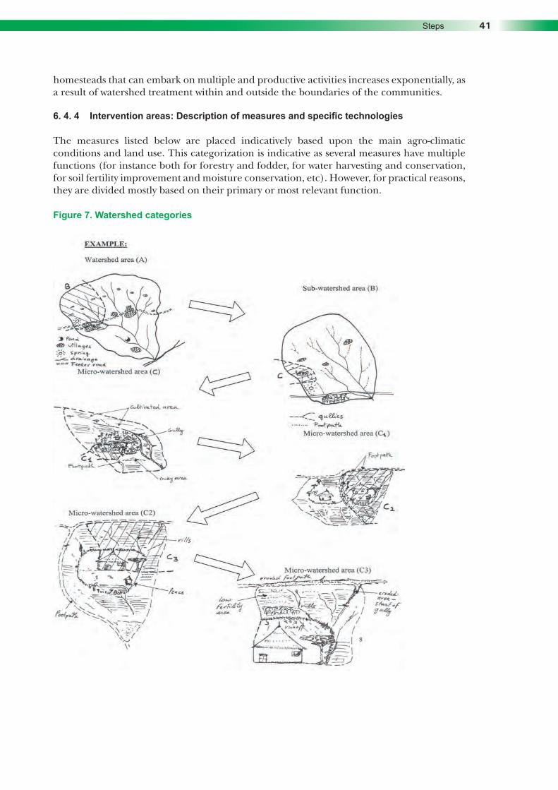
Community Based Participatory Watershed Development: A GuidelineCommunity Based Participatory Watershed Development: A GuidelineStepsCommunity Based Participatory Watershed Development: A Guideline 41Steps 41
homesteads that can embark on multiple and productive activities increases exponentially, as a result of watershed treatment within and outside the boundaries of the communities.
6. 4. 4 Intervention areas: Description of measures and specific technologies
The measures listed below are placed indicatively based upon the main agro-climatic conditions and land use. This categorization is indicative as several measures have multiple functions (for instance both for forestry and fodder, for water harvesting and conservation, for soil fertility improvement and moisture conservation, etc). However, for practical reasons, they are divided mostly based on their primary or most relevant function.
Figure 7. Watershed categories

Community Based Participatory Watershed Development: A Guideline42 Community Based Participatory Watershed Development: A Guideline42 Community Based Participatory Watershed Development: A GuidelineCommunity Based Participatory Watershed Development: A GuidelineCommunity Based Participatory Watershed Development: A GuidelineTab
le 1
. A
naly
sis
of p
ossi
ble
inte
ract
ions
bet
wee
n th
e di
ffer
ent
sub-
wat
ersh
eds
of t
he m
ain
wat
ersh
ed (se
e Fi
gure
5)
Ava
ilabl
e da
ta f
or t
he e
xam
ple
area
: Agr
oclim
atic
zon
e dr
y w
eyna
deg
a; 2
000
m a
sl; 7
00 m
m r
ainf
all/
year
; sor
ghum
, mai
ze a
nd t
eff
com
mon
cro
ps; d
roug
ht
recu
rren
t 3-5
yea
rs; f
ood
inse
curi
ty 2
-5 m
onth
s/ye
ar f
or 3
0% o
f ho
useh
olds
(H
Hs)
.
Leve
lD
escr
iptio
n of
wat
ersh
ed o
r su
b-w
ater
shed
In
tera
ctio
ns b
etw
een
sub-
wat
ersh
ed u
nits
Mea
sure
s su
gges
ted
to a
void
neg
ativ
e ef
fect
s an
d us
e ru
noff
effe
ctiv
ely
to im
prov
e pr
oduc
tivity
C3
Sect
ion
of h
omes
tead
sho
win
g th
e up
per f
ootp
ath,
the
erod
ed
culti
vate
d pl
ot, t
he d
ry fe
nce
and
part
of th
e ho
mes
tead
com
poun
d.
Mos
t of r
unof
f sco
urs
thro
ugh
the
foot
path
and
reac
hes
the
dry
fenc
e po
urin
g ad
ditio
nal
wat
er, i
nclu
ding
from
nei
ghbo
r co
mpo
unds
abo
ve a
nd la
tera
lly.
1. D
oubl
e or
trip
le ro
w o
f veg
etat
ive
fenc
e w
ith o
uter
par
t of d
roug
ht re
sist
ant/a
nim
al p
roof
mat
eria
ls
(eup
horb
ia, a
nd o
ther
s.) +
ser
ies
of s
mal
l wat
er c
olle
ctio
n pi
ts li
nked
one
to a
noth
er w
ith s
mal
l sto
ne
spillw
ay a
nd p
lant
ed w
ith fo
dder
/cas
h cr
ops
and
shad
e/tim
ber t
rees
eve
ry 3
met
ers.
2. F
oot p
ath
ston
e pa
ved
or w
ith re
gula
r sco
urs
(eve
ry 1
,5 m
) + li
ttle
dive
rsio
n in
to p
aved
wat
erw
ay li
nkin
g to
mic
ro-p
ond
with
in h
omes
tead
are
a (C
2) .
3. M
ulch
ing
of in
filtra
tion
pits
and
com
post
mak
ing.
4. O
ther
s.
C2
Sect
ion
of 1
hom
este
ad s
how
ing
mic
ro-w
ater
shed
of 3
00-5
00
m² s
urfa
ce le
adin
g to
the
low
er
porti
on o
f the
com
poun
d an
d th
e cu
ltiva
ted
land
adj
acen
t to
the
hom
este
ad.
Run
off f
rom
the
com
poun
d,
adja
cent
fiel
ds a
nd fo
otpa
th
reac
h th
e lo
wer
par
t of t
he
culti
vate
d la
nd n
ear t
he lo
wer
fe
nce
of th
e ho
mes
tead
.
1. M
icro
-pon
d co
nstru
ctio
n us
ing
loca
l mat
eria
ls (s
tone
face
d +
loca
l mor
tar,
bric
ks, a
nd th
e lik
e.).
Use
hi
gher
spe
cific
atio
ns if
cem
ent i
s av
aila
ble.
Silt
trap
ess
entia
l + fe
nce
to a
void
risk
s fo
r chi
ldre
n.
2. H
and-
dug
wel
l if w
ater
-tabl
e is
suf
ficie
ntly
hig
h (w
ithin
10
met
ers)
+ s
tone
/bar
rel r
ing,
pav
ed a
rea
and
smal
l can
al fo
r wat
er fl
ow to
irrig
ated
are
a.3.
Con
ditio
ning
and
sha
ping
are
a fo
r hor
ticul
tura
l pro
duct
ion
4. S
elec
tion
of c
rops
sui
tabl
e to
mar
kets
– m
ostly
non
-per
isha
ble
crop
s as
mar
ket i
s di
stan
t.
C1
o Tw
o ex
tend
ed h
omes
tead
s w
ith fo
otpa
th a
bove
the
clus
ter
devi
atin
g ex
cess
runo
ff in
to
culti
vate
d la
nd. H
omes
tead
are
a dr
aini
ng w
ater
into
the
low
er
boun
dary
and
cul
tivat
ed fi
elds
.o
Hom
e w
ith th
atch
ed ro
of, l
ive-
fenc
e on
ly w
ith fe
w e
upho
rbia
an
d so
me
euca
lyp-
tus
trees
. No
com
post
, few
live
stoc
k an
d on
e ox
.
Run
off f
rom
the
hom
e-st
ead
and
foot
path
dra
ins
into
a s
mal
l gu
lly th
at li
nks
to a
larg
er g
ully
at
the
low
er p
art o
f the
(C) c
lust
er,
affe
ctin
g th
e cu
ltiva
ted
land
of
the
clus
ter.
1. In
add
ition
, tre
atm
ent o
f 0.3
ha
of c
ultiv
ated
land
with
in fe
nced
are
a w
ith in
filtra
tion
bund
and
st
abiliz
atio
n w
ith d
iffer
ent g
rass
/legu
mes
/cas
h cr
ops
+ fru
it tre
es o
n sp
ecifi
c la
rge
ties
+ co
mpo
st a
nd
mul
ch.
2. S
ectio
n of
the
hom
este
ad a
rea
with
5 e
ye-b
row
bas
ins
for f
ruit
trees
and
5 m
ulti-
purp
ose
trenc
hes.
3. R
ow p
lant
ing
of c
rops
in c
ultiv
ated
land
+ ti
e rid
ges
on s
teep
er p
art (
test
ing)
+ z
ero-
graz
ing
for f
ew
lives
tock
(dem
onst
ratio
n).
C
o M
icro
-wat
ersh
ed in
clud
es a
cl
uste
r of 7
hom
este
ads
and
thei
r ad
jace
nt fi
elds
(app
rox.
11
ha),
mos
tly c
ultiv
ated
land
and
sm
all
rock
y ou
tcro
ps, s
hallo
w s
oil u
sed
as g
razi
ng a
rea
(tota
l 1 h
a).
o H
omes
tead
are
a th
reat
ened
by
near
by g
ully.
o Fo
otpa
ths
link
the
clus
ter t
o m
ain
villa
ge. M
ost h
omes
tead
s ha
ve s
ome
euca
lypt
us p
lant
atio
ns
arou
nd th
em. F
ew s
hade
tree
s.
Cul
tivat
ed la
nd m
ostly
not
fenc
ed,
but f
ence
d ne
ar h
omes
.
o R
unof
f cro
ss c
ultiv
ated
fiel
ds
and
foot
path
dra
ins
into
gul
ly
that
ext
ends
into
fiel
ds w
ithin
th
e cl
uste
r and
con
tribu
te to
the
larg
e gu
lly o
f add
ition
al fi
elds
be
low
(villa
ge).
o Fo
otpa
th b
ecom
es a
sm
all
gully
nea
r the
villa
ge a
s pe
r ru
noff
colle
cted
from
oth
er a
reas
.o
Run
off f
rom
sha
llow
soi
ls
and
rock
y ou
tcro
p us
ed fo
r gr
azin
g (a
bove
Cu)
affe
cts
field
s of
3 H
Hs
and
drai
ns a
lso
into
pa
thw
ay a
nd g
ully .
1. T
reat
men
t of c
ultiv
ated
land
with
soi
l and
sto
ne-fa
ced
soil
bund
s an
d st
one
bund
s. T
renc
hes
abov
e so
il bu
nds
only
on
slop
es >
8% a
nd b
unds
upg
rade
d us
ing
fany
a ju
u sy
stem
. Bun
ds s
tabi
lized
usi
ng m
ix
of A
caci
a sa
ligna
dire
ct s
owin
g (d
oubl
e ro
w),
gras
s an
d pi
geon
pea
s. S
unflo
wer
s pl
ante
d on
tren
ch o
r on
low
er b
ank
of b
und.
2.
All
HH
s to
mak
e co
mpo
st. C
ompo
st a
pplic
atio
n ne
eds
to c
once
ntra
te fi
rst 1
-2 y
ears
alo
ng 2
-3 m
eter
s of
la
nd a
bove
phy
sica
l stru
ctur
es (m
axim
um s
oil d
epth
and
hig
hest
wat
er h
arve
stin
g ef
fect
).
3. F
ootp
ath
to b
e co
mpl
etel
y st
one-
pav
ed a
nd a
way
from
sm
all g
ully.
Sm
all g
ully
trea
ted
with
che
ckda
ms
+ br
ush
woo
ds a
nd h
ead
cut s
tabi
lizat
ion
(sto
ne c
arpe
ting,
ripr
aps,
and
oth
ers)
.4.
Mic
ro-p
onds
and
/or h
and-
dug
wel
ls d
ug in
eve
ry H
Hs
or s
ome
used
join
tly b
y m
ore
HH
s to
resp
ect
dist
ance
bet
wee
n w
ell a
nd a
void
risk
of o
veru
sing
gro
und
wat
er
5. J
oint
cul
tivat
ed fi
elds
fenc
ed a
nd li
nked
to h
omes
tead
fenc
es.
6. G
ully
are
a co
nver
ted
into
fora
ge p
rodu
cing
are
a an
d lo
wer
par
t of g
ully
trea
ted
with
1 S
S da
m fo
r po
ores
t HH
mem
ber i
n th
e cl
uste
r.7.
Sha
llow
soi
l are
a us
ed fo
r gra
zing
trea
ted
with
sto
ne b
unds
and
infil
tratio
n pi
ts fo
r for
age
prod
uctio
n an
d m
ultip
urpo
se c
rops
in 3
0% o
f the
are
a (te
st).

Community Based Participatory Watershed Development: A GuidelineCommunity Based Participatory Watershed Development: A GuidelineStepsCommunity Based Participatory Watershed Development: A Guideline 43Steps 43
B
o Su
b-w
ater
shed
incl
udes
par
t of
villa
ge N
o. 2
(app
rox.
200
ha)
. H
illsid
es g
raze
d by
HH
s fro
m th
is
villa
ge o
nly.
o 1
Larg
e gu
lly d
isse
cts
the
area
and
exp
ands
into
adj
acen
t cu
ltiva
ted
area
s.o
Pres
ence
of h
omes
tead
cl
uste
rs (m
ostly
new
set
tlers
) on
stee
per p
arts
of t
he a
rea.
o O
ne s
prin
g av
aila
ble
serv
ing
appr
oxim
atel
y 30
% o
f the
HH
s do
mes
tic w
ater
.
o U
pper
par
t of s
ub-w
ater
shed
de
grad
ed (f
eeds
mai
n sp
ring
belo
w).
o Sp
ring
flow
low
in d
ry s
easo
n.
Gra
zing
land
dep
lete
d an
d no
t su
ffici
ent.
o La
rge
gullie
s st
art f
rom
up
per p
arts
and
cut
thro
ugh
the
diffe
rent
cul
tivat
ed fi
elds
, in
clud
ing
left
side
of c
lust
er (C
). o
New
set
tlers
cul
tivat
e ad
ditio
nal 1
0% o
f slo
ping
de
grad
ed a
reas
(>30
% s
lope
) ab
ove
villa
ge a
nd c
lust
er (C
). M
ain
feed
er c
ut in
thre
e se
ctio
ns
and
need
repa
ir.
1. T
reat
men
t of s
mal
l gul
lies
with
che
cks
+ st
abiliz
atio
n.2.
Tre
atm
ent o
f lar
ge g
ully
with
ser
ies
of S
S da
ms
and
conv
ersi
on in
to c
ultiv
ated
/irrig
ated
fiel
ds +
som
e ha
nd-d
ug w
ells
als
o po
ssib
le b
etw
een
SS d
ams.
3.
Ove
rnig
ht fl
ow fr
om s
prin
g st
ored
into
a re
lay
syst
em o
f mic
ro-p
onds
for w
omen
gro
ups
inco
me
gene
ratio
n ac
tiviti
es (I
GA)
+ li
fe fe
ncin
g ex
tend
ed to
as
man
y H
Hs
as p
ossi
ble.
4.
Clo
sure
of 5
0% o
f hills
ides
1st y
ear +
25%
2nd
yea
r and
25%
3rd y
ear +
tren
ches
and
eye
brow
s fo
r im
prov
ed c
losu
re a
nd re
plen
ishm
ent o
f spr
ing
flow
+ re
char
ge o
f wat
er le
vel i
n ha
nd-d
ug w
ells
. 5.
Rel
ay m
icro
-pon
ds +
cut
off d
rain
s at
the
foot
of p
ortio
n of
hills
ides
nea
r cul
tivat
ed fi
elds
for
supp
lem
enta
ry ir
rigat
ion
durin
g ra
iny
seas
on (u
pper
par
t of c
losu
re tr
eate
d w
ith z
ero
runo
ff tre
nche
s, lo
wer
pa
rt (2
0-30
met
er s
trip)
bef
ore
reac
hing
the
cuto
ff dr
ain
area
onl
y cl
osed
) + s
ilt tr
aps.
6. In
filtra
tion
pits
to fu
rther
rech
arge
wat
er-ta
bles
at b
reak
of s
lope
bet
wee
n hi
llsid
es a
nd c
ultiv
ated
fiel
ds.
7. M
icro
-pon
ds, S
S da
ms,
use
of s
prin
g �
prio
rity
to p
oore
sts
HH
s fir
st.
8. F
eede
r roa
d re
paire
d an
d ex
cess
wat
er g
uide
d in
to s
cour
line
s an
d dr
op s
truct
ures
feed
ing
into
mic
ro-
pond
s ne
ar c
ultiv
ated
fiel
ds o
r int
o gu
lly tr
eate
d w
ith la
rge
chec
ks.
9. C
ompo
st m
akin
g ex
pend
ed to
eve
ry H
Hs
+ in
trodu
ctio
n of
row
pla
ntin
g.
A
o W
ater
shed
incl
udes
(700
ha)
2
villa
ges
shar
ing
com
mun
al g
razi
ng
land
on
part
of h
illsid
es a
nd m
ajor
riv
er o
utle
t o
The
2 vi
llage
s in
clud
ed in
the
plan
. For
wid
er w
ater
shed
s tw
o pl
ans
(one
for e
ach
villa
ge) n
eed
to b
e de
velo
ped.
o
Thre
e m
ajor
dra
inag
e lin
es
divi
de v
illage
s an
d la
rge
porti
on o
f cu
ltiva
ted
land
s ar
e di
ssec
ted
by
larg
e an
d sm
all g
ullie
s.
o H
omes
tead
s pa
rtly
aggr
egat
ed
to th
e m
ain
two
villa
ges
and
partl
y in
sm
all 2
-5 h
omes
tead
s cl
uste
rs.
o O
ne m
ain
feed
er ro
ad c
ross
es
the
area
and
sev
eral
foot
pat
hs
link
the
two
villa
ges
and
the
little
cl
uste
rs o
f hom
este
ads.
o N
atur
al fo
rest
s ve
ry li
mite
d,
culti
vatio
n on
ste
ep s
lope
s co
mm
on, l
imite
d di
vers
ity o
f cro
ps
for m
arke
ts.
o Fi
rst l
arge
mar
ket 2
0 km
di
stan
ce fr
om v
illage
s.o
One
wat
er p
ond
and
1 sp
ring
avai
labl
e re
achi
ng a
ppro
x.50
% o
f H
Hs
– th
e re
st h
ave
to fe
tch
wat
er
from
mud
dy ri
ver (
only
6 m
onth
s flo
w) o
r lar
ger r
iver
12-
15 k
m
dist
ance
.
o Th
irty
perc
ent o
f gra
zing
la
nd u
sed
by th
e tw
o vi
llage
s en
croa
ched
on
both
sid
es
(pot
entia
l con
flict
).o
Dam
age
to m
ain
feed
er ro
ad
in v
ario
us p
oint
s.o
Maj
or w
ater
pon
d 40
% s
ilted
an
d w
ater
of v
ery
poor
qua
lity
– w
orks
onl
y 6
mon
ths/
year
. o
Larg
e un
prod
uctiv
e gu
llies
thre
aten
mos
t fiel
ds a
s pe
r cu
mul
ativ
e ru
noff
from
hills
ides
.o
Sprin
g flo
w re
duce
d ev
ery
year
. Dro
ught
yea
rs s
eem
to
incr
ease
num
ber o
f affe
cted
pe
ople
by
10-2
0% c
ompa
red
to
prev
ious
dro
ught
.o
Incr
ease
d nu
mbe
r of l
andl
ess
or fa
rmer
s w
ith s
mal
l plo
ts.
1. If
han
d-du
g w
ells
con
stru
ctio
n ex
pand
s ur
gent
nee
d to
trea
t hills
ides
with
tren
ches
and
eye
brow
s fo
r max
imum
wat
er re
tent
ion
and
infil
tratio
n. H
illsid
e te
rrace
s +
trenc
hes
on s
tony
are
as a
lso
poss
ible
. C
losu
res
treat
ed w
ith tr
ench
es n
eed
to b
e ha
ndle
d on
indi
vidu
al o
r sm
all g
roup
s ba
sis,
for m
ultip
urpo
se
use
and
rela
ted
to d
iffer
ent I
GAs
(com
post
mak
ers,
cas
h cr
ops
grow
ers,
bee
kee
pers
, bas
ket m
akin
g, fr
uit
tree
prod
ucer
s, a
nd o
ther
s. )
+ ce
rtific
atio
n.2.
Add
ition
al d
eep
wat
er p
ond
prov
ided
clo
sure
and
gul
ly tr
eatm
ent i
s ac
hiev
ed. L
arge
dou
ble
silt
trap
requ
ired.
3. T
reat
men
t of g
ully
net
wor
ks is
to c
ontin
ue, t
arge
ted
to a
ssis
t poo
rest
HH
s. S
S da
ms
or S
S bu
nds
poss
ible
.4.
Tre
atm
ent o
f cul
tivat
ed la
nds
with
phy
sica
l stru
ctur
es +
com
post
app
licat
ion
on in
filtra
tion
zone
+
stab
ilizat
ion
to e
xten
d in
eve
ry c
ultiv
ated
land
.
5. S
yste
ms
of re
lay
cuto
ff dr
ain
to fe
ed m
icro
-pon
ds c
lose
to c
ultiv
ated
fiel
ds a
lso
poss
ible
and
re
com
men
ded,
par
ticul
arly
at t
he s
lope
bre
aks.
6. M
icro
-pon
ds a
nd/o
r han
d-du
g w
ells
in h
omes
tead
s to
exp
and
and
asso
ciat
ed w
ith ro
w p
lant
ing,
in
trodu
ctio
n of
cas
h cr
ops
and
espe
cial
ly n
on-p
eris
habl
e hi
gh v
alue
cro
ps.
7. F
eede
r roa
d to
repa
ir an
d as
sist
in fe
edin
g ru
noff
into
fiel
ds (u
sing
dro
p st
rutu
res
and
ener
gy d
issi
patio
n sy
stem
s) o
r mic
ro-p
onds
. Roa
d si
de tr
ench
es a
lso
poss
ible
for s
hade
tree
pla
ntin
g.8.
Mic
ro-n
iche
dev
elop
men
t (se
e C
aruc
ci, V
. 20
00.)
near
non
-per
man
ent s
tream
pos
sibl
e fo
r sm
all s
cale
irr
igat
ion
durin
g ra
iny
seas
on a
nd p
rodu
ctiv
e la
nd re
clam
atio
n fo
r poo
rest
HH
s.
9. S
mal
l run
off-r
un-o
n sy
stem
s in
aba
ndon
ed la
nd a
lso
poss
ible
for f
odde
r pro
duct
ion
or lo
w-fe
rtilit
y de
man
ding
cro
ps.
10. Z
ai p
its in
deg
rade
d ge
ntle
slo
ping
(cru
sted
) lan
ds a
lso
reco
mm
ende
d at
larg
er s
cale
. 11
. Joi
nt w
ater
shed
man
agem
ent c
omm
ittee
s an
d w
ater
man
agem
ent c
omm
ittee
s to
be
crea
ted.
12. I
nfor
mat
ion
syst
em o
n m
arke
ts re
quire
d as
inte
gral
par
t of w
ater
har
vest
ing
syst
ems.

Community Based Participatory Watershed Development: A Guideline44 Community Based Participatory Watershed Development: A Guideline44 Community Based Participatory Watershed Development: A GuidelineCommunity Based Participatory Watershed Development: A GuidelineCommunity Based Participatory Watershed Development: A Guideline
Detailed information on the measures indicated by the main categories below and in the following pages is included in Section (B) of this Guideline in the form of infotechs. Infotechs have been developed for rapid and practical technical reference. Additional technical references are listed in Annex 5 of Part 2 (Technical Annexes).
Physical soil and water conservation (SWC) measures: Physical soil and water-conservation measures are those measures developed through soil cutting and earth moving to reshape the topography. They are mechanical barriers constructed across the direction of flow of rainwater to retard or retain the runoff and thereby reduce the soil and water losses. The important principles to be kept in view while planning physical control measures are:
Increasing the time of concentration of runoff thereby allowing more of it to be absorbed and held by the soil,
Intercepting a long slope into several short ones so as to maintain less than a critical velocity for the runoff water,
Protection against damage due to excessive runoff.
Usually such measures are not complete on their own and require the addition of a vegetative cover before becoming fully effective and permanent.
Selection and design of physical measures
While selecting and designing physical measures, the following factors should be taken into account.
Climatic conditions, especially rainfall and the need to retain or discharge excess rainfall (runoff)
Topography of the land, more specifically of slope steepness Conditions of the soil (erodability, texture, drainage, depth, stoniness and risks of mass
movement) The availability of an outlet or waterway for safety discharging runoff away from the land Farm size and the farming systems Availability of labour and cost Availability of construction materials Adequacy of existing agronomic or vegetative conservation measures. The DA and the CWT need to consult detail information kits about each measure and check its suitability based on specific site conditions, mainly slope, soil depth, vegetation cover, cropping patterns and erosion levels.
Water harvesting and runoff management for multiple uses and irrigation: Water harvesting is the collection and concentration of runoff for productive purposes such as production of crops, fodder, pasture or trees production, livestock and domestic water supply. It includes all methods of concentrating, diverting, collecting, storing and utilizing and managing runoff for productive uses.
Water harvesting works on the principle that where there is scarce rainfall, it is possible to improve the situation through proper use of the part of rainfall that results in runoff. This is especially true in arid and semi-arid areas where water is a limiting factor for agricultural activities or where the rainfall is erratic in its occurrence. It can be done through in-situ rain-water conservation or through runoff generation either within the field or from external catchments. The former involves the conservation of rainfall where it falls in the cropped area or pasture. The most common technology for this purpose is conservation tillage, which

Community Based Participatory Watershed Development: A GuidelineCommunity Based Participatory Watershed Development: A GuidelineStepsCommunity Based Participatory Watershed Development: A Guideline 45Steps 45
aims at maximizing the amount of soil moisture within the root zone. A number of agronomic practices such as mulching, ridging, manuring, and other small farm structures such as field ridges/bunds, contour bunds, bench terraces within cropped area and others, could fall under this category.
The latter (runoff-based water harvesting) entails generation of runoff either within the field or from external catchments and its subsequent application directly into the soil profile or though temporary storage for supplemental irrigation. Generation of runoff within the field takes place on the farmer’s field with subsequent concentration on either a single crop (especially fruit trees), a group of crops or row crops with alternating catchment and cropped area mainly along the contours. The part of the field that provides runoff to a cropped field is termed as micro-catchment. Examples of technologies that fall under this system are fanya juu terrace, contour bunds (stone, trash lines), micro-basins, semi-circular earth bunds, negarims, large trapezoidal bunds, infiltration trench/ditches, and the like.
The water harvesting systems with storage facilities for supplemental irrigation or water supply require external catchments from runoff. The storage systems offer the land user a tool for water-stress control or dry spell mitigation. They reduce risks of crop failure, but their level of investment is high as they require some know-how, especially of water management. Examples of technologies for this purpose are underground water tanks, small earth dams, ponds, and others.
Application systems involving direct runoff are characterized by runoff generation, diversion and spreading within the cropland, where the soil profile acts as the moisture storage reservoir. Such systems require the integration of different technologies ranging from diversion of runoff (diversion weirs or small dams) to small water spreading structures within a field, e.g. contour or graded bunds.
When preparing a watershed development plan and during the selection of the type of water harvesting systems and technologies, it is up to the development planner to decide which technology to select based on the priority needs and purpose of water to be harvested.
Each of the following water harvesting measures needs to be combined or directly linked to other measures such as conservation and gully control, re-vegetation, agronomic and soil-management measures. Furthermore, some of the measures have complex design that need to be followed accurately. Several measures need supplementary inputs to be implemented (cement, gutters, pipes, iron mesh, and others).
Flood control and drainage: This refers to controlling the flood from causing damage to community assets such as farmland, buildings, roads, and others. Experiences around in this country where flood from unprotected hilly areas causes damages to lower lying areas by depositing sediments on cropped land and causing temporary waterlogging problems, subsequently resulting in crop failure. More over, flood causes damage to roads by depositing of sediments of courser size and boulders and result in failure of the roads. There can be many other examples of damage caused by flood.
Drainage refers to elimination of unwanted water from the land surface (flash floods) or underground. Surface drainage is needed where water accumulates on the land surface during rainy seasons and causes waterlogging or when the accumulated water interferes with other activities. On the other hand, subsurface drainage is required where there is a rise in ground water-table. It is employed to lower the ground water-table by a certain depth and subsequently limit the ground water-table at this depth.

Community Based Participatory Watershed Development: A Guideline46 Community Based Participatory Watershed Development: A Guideline46 Community Based Participatory Watershed Development: A GuidelineCommunity Based Participatory Watershed Development: A GuidelineCommunity Based Participatory Watershed Development: A Guideline
While planning to control flood, priority should be given to prevention of flood occurrence. Planning for prevention is simpler and cheaper than controlling flood in progress. Prevention minimizes or protects all possible chances of flood formation by treating every spot of runoff generating areas. This requires either holding the runoff right on the place of occurrence and allowing it to infiltrate into the soil, or safely eliminating it through diversion systems. In addition, it requires protection of any chance of runoff concentration as much as possible. Practically, it is not always possible or advisable to protect runoff generation and concentration owing to two reasons. The first reason is that whatever treatments you made to the land, runoff formation is inevitable. The second reason is that runoff formation/generation should be seen as an opportunity, a resource that can be harvested and used in a productive way. Therefore, different alternatives of productive use of flood and different dimensions of how well the flood is exploited should be considered while planning flood-control schemes. The first priority should be given to what opportunities and limitations exist where water harvesting is of paramount importance. Flood-control schemes should be integrated with water harvesting schemes. Excess of what can be held should be safely eliminated.
Vertisols and soils with vertic properties (heavy clays) in high rainfall areas are usually associated with drainage problems. Wherever needed, drainage networks must be properly selected and properly placed. Furthermore, possibilities of using the water drained in other places should also be properly identified. The technologies for both surface and sub-surface drainage need to be carefully considered. These measures supplement and are closely integrated with several soil conservation, gully control and water harvesting activities. For instance, cut-off drains can be placed below area closures and protect cultivated areas with bunds, divert water away from gullies, feed water into ponds and micro-ponds (as relays, etc). Likewise, waterways are also linked with supplementary measures like check/drop/aprons to reduce water-flow velocity. Vertisols and soils with vertic properties (heavy clays) can be treated with BBM technology linked with outlet management (waterways) and improved agronomic practices.
Soil fertility management and biological soil conservation: These measures play a key role in supplementing and improving the performance of physical structures – each measure needs to fit the farming system and tested if not introduced yet. They play an essential role in natural resources conservation directly and indirectly by influencing both the soil characteristics and the vegetative cover factors. Combined with quality physical structures they enhance productivity per unit area.
Homestead technology: Homestead technology focuses mostly on improved farming and soil fertility management measures as well as biological measures. However, it also includes any possible type of physical structures, water harvesting and forestry and agroforestry measure, and others such as livestock rearing and income generation activities. The homestead technology is thus a combination of concentrated efforts that seek to exploit to the maximum the space around homes. From experience, homestead technology should be fully integrated within a watershed approach as a necessary condition for its fast expansion and adoption by land users.
Agro-forestry, forage development and forestry (community/group/private): A variety of measures is proposed in the Guideline, both in terms of support measures for planting, plant species and planting arrangements, and plant management requirements. Details on type of species and spacing/planting arrangements are provided in the Infotechs of Section (B) of Part 1.
Gully control: Gully erosion is a serious problem, especially in arid and semi-arid areas where vegetative cover is often poor. In Ethiopia, gully erosion is caused by excess runoff from untreated farmlands, hillsides, roads and urban areas. Gully control should be based on two principles:

Community Based Participatory Watershed Development: A GuidelineCommunity Based Participatory Watershed Development: A GuidelineStepsCommunity Based Participatory Watershed Development: A Guideline 47Steps 47
• determining the cause of the creation of the gully, and • taking counter measures which involve improving the management of the watershed
and reducing the quantity of runoff entering the gully, restoring the original hydraulic balance or creating new stable conditions which involve taking measures in the gully to reduce the erosive power of the water.
Gully control, as part of watershed development activities, should be participatory and main causes of the gully and its characteristics need to be carefully studied. Any structure to be constructed for the control should be combined with vegetative measures and stabilized gullies must be safely used for productive purposes. The treatment of gullies largely depends on treatment of upper parts of the watershed. Gullies can contribute to enhance local productivity by converting wastelands into productive units. Ultimately, gullies could become most fertile and productive areas resulting from sediment deposited and water harvesting effects generated by a combination of measures within and above the gully.
In the lists of gully control technologies, some vegetative measures and species of plants for this purpose are indicated. As mentioned earlier, gully control includes treatment with physical and biological measures.
Feeder roads: Feeder roads are an important element of any watershed development planning approach. Under most Ethiopian conditions, feeder roads need to cross fragile and often steep slopes, rugged terrains and depressions. Feeder roads can be undertaken by trained DAs supervised by wereda experts following specific technical criteria for design under various slopes and soils as well as local materials. Other measures: The tables provided in Annex 5, Part 2 and (Section B of Part 1) of this Guideline are not exhaustive but are sufficient enough to indicate to DAs and technical staff about what is possible to plan and implement at various levels of the watershed in different agro-ecologies. A number of supplementary measures are also included in the work norms manual (MoA, 2000) that strengthen and/or support some of the measures indicated above. For example, stone collection and stone fencing, mulching and manuring of plantation pits, tree and grass seed collection, and others. The supplementary measures are often the reason for success of other measures as they provide the means to apply reinforcements and/or additional fertility to planted areas.
6. 5 STEP 5. Getting the options and interventions discussed and approved by the general assembly
The development plan indicates what, where, when and how it would be implemented. At the same time, the technical feasibility of the recommended measures have also been discussed based on the various options, adopted and/or adapted to local conditions, agreed with the CWT.
At this stage your development plan would be at draft level. Calling a general assembly of the whole community to reach consensus on the measures proposed and to approve the plan.
6. 5. 1 Discussion with the community
The planning team representatives would present the plan by discussing each section of the plan to the community. On presentation the CWT should encourage people to express their opinions and raise questions by also keeping gender balance. Here some changes and more suggestions would come which were not thought through during the initial planning. Even some individuals and interested groups may change their mind or add more ideas

Community Based Participatory Watershed Development: A Guideline48 Community Based Participatory Watershed Development: A Guideline48 Community Based Participatory Watershed Development: A GuidelineCommunity Based Participatory Watershed Development: A GuidelineCommunity Based Participatory Watershed Development: A Guideline
and suggestions. In this regard, enough time should be taken to discuss and agree on those measures, in particular, to be implemented in the lands individually owned or used. Moreover, each realistic solution and recommendation should be considered in turn and fully discussed.
6. 5. 2 Discussion with the planning team from other communities
The CWT need to consult and agree with communities located upstream, downstream or adjacently about common measures based on watershed interactions. This step is essential as these measures often are the entry point for multiple benefits. In this regard, the role of the DA and of the Kebele level Watershed Team is very important to decide the sequence and priority of specific activities of mutual benefit for more than one community,
To complete this exercise, revise your plan according to the final agreement reached with the community. Describe each measure/intervention in detail including selection, technical design, inputs required, schedule of activities and possible benefits expected.
6. 6 STEP 6. Development map, inputs and action plan
6. 6. 1 Development map
The CWT must be able to locate on the ground where the various watershed development interventions are to be implemented. The development map is an essential instrument that shows the actual placement of sites of development interventions in type with respect to land-use types. This map will be used during implementation of the plan. Furthermore, the map is essential to the planner for determining the extent of the areas and the volume of inputs required. Points to be considered when preparing a development map:
1. The scale should be the same as that of the base map. 2. It should show compartments of the development blocks in accordance with phasing.3. Any major community asset and development works that have been previously implemented
should be transferred to the development map. 4. Proposed development works, including maintenance or rehabilitation of existing
measures should be shown.5. Symbols should be used to show the development interventions and other necessary
information.6. The map should be provided with standard legend so that the user can easily read and use
the map.
Typical examples of a Development Map, symbols for watershed base and development map are shown in Annex 3, Part 2.
An enlarged copy of the Development Map should be prepared and kept at the community and kebele level offices for monitoring and ownership building purposes. Once implementation starts the community and kebele can fill the parts of the plan completed.
6. 6. 2 Inputs
Once you complete preparation of the development map, the next work would be estimation of inputs required to implement the planned activities and prepare action plan, indicating the period of implementing each measure. The inputs include the labor and planting/working/construction materials. The volume of inputs required for implementing the plan

Community Based Participatory Watershed Development: A GuidelineCommunity Based Participatory Watershed Development: A GuidelineStepsCommunity Based Participatory Watershed Development: A Guideline 49Steps 49
is dependent upon a number of factors, and only a very general estimate may be obtained. The extent of the work (area), specification, degree of slope, soil texture, and condition (wet or dry), and the working pattern, tools of the workers, and planting materials are all factors that influence the labor and material inputs.
For convenience, both during planning and implementation, it is helpful to complete the input requirements by community. These plans can also indicate which inputs are required for joint or common work.
The table of inputs should indicate type of interventions/treatments, land-use type, quantities of work, inputs (labor, material, financial, etc) required and phases of implementation. In this regard, a format of table of inputs used by MoARD/BoARD in the WFP assisted projects can be adopted and/or modified. The format is attached in the Planning Module of Annex 9 of Part 2.
Planting materials are established in the nurseries. For smaller planning units (watershed), farmers should be encouraged to produce the planting materials on their own individual farms as a strategic approach. In this case, the wereda experts or the Wereda Agricultural and Rural Development office should help farmers in finding the sources of seeds for raising seedlings. For cluster or broader watersheds one or more nursery may be required for generating planting materials especially for providing the seedlings that can not be produced at individual farmers level in consultation with KWT and CWT. The nurseries established for this purpose should focus on filling the gap and concentrate on producing seedlings, which are possible to be produced at individual farmer’s level.
6. 6. 3 Action plan
The action plan should be carefully and accurately developed on the basis of what has been agreed upon with the community for the implementation of the proposed measures. It should show a multi-year plan with first year plan being prepared in detail quarterly and monthly.
For other years second, third, and more years are strategic projections, to be adjusted and/or modified after the first year implementation and results. Arrange your action plan or schedule in consultation with the community but also with wereda experts who may know more about external supports on resource supply and availability. Moreover, a plan of action should also embrace the training needs for land users (both men and women) and DAs.
6. 6. 4 Reporting
The development plan should be reported to the wreda. A format given in the Annex 9, Part 2 can be used as a reporting format for community-based watershed development plan. If the watershed development plan is in the form of a project, a standard project report format should be used for reporting the watershed development plan.
At this stage, a report can be completed which includes problem identification, socio-economic survey, biophysical assessment and base map, measures identified and development map, input tables and schedule for implementation. One copy of the report should be provided for wereda-level review and support. The Planning Format In Part 2, Annex 9 can serve as a report.

Community Based Participatory Watershed Development: A Guideline50 Community Based Participatory Watershed Development: A Guideline50 Community Based Participatory Watershed Development: A GuidelineCommunity Based Participatory Watershed Development: A GuidelineCommunity Based Participatory Watershed Development: A Guideline
T h e w o r k p l a n i s n o w r e a d y
f o r i m p l e m e n t a t i o n
6. 7 STEP 7. Implementation strategies
6. 7. 1 Implementation strategy
Preparation for implementation. Once completed, the DAs should send the plans to the wereda for final consolidation and approval. Then the WWT should forward a summary of the plans (maps and main input requirements) to the zone and/or to the region, where necessary.
In this regard, it is recommended that the time period to begin and complete the planning work should be well coordinated by the wereda experts for all DAs (remember Step 1). The WWT will facilitate the organization of technical backstopping from the wereda, zone, region, the aggregation and compilation of data generated from the planning work, the timely request of inputs to sectoral agencies and donors as applicable, and their possible allocation before the period of the year set for implementation. DAs and the local CWT (s) will play a major role in maintaining a high level of participation during implementation. They will coordinate the efforts provided by the community and those of single individuals or target groups.
Institutional organization and terms of reference
General roles and responsibilities for PWDP:
1. Regional, zonal (if applicable), wereda experts and DAs are responsible to propose and arrange training for land users before and during implementation based on local conditions and specific needs. Therefore, training proposals should be developed and forwarded to wereda level which will provide the technical support.
2. DAs and wereda experts are responsible to follow-up trials and development of on-farm participatory technology for innovative measures to be tested in specific areas.
3. DAs and wereda experts will play a major role in strengthening the communication between the various sector agencies operating in the area by involving their experts and using their resources whenever required; for instance, education and health experts, resources, NGOs and others.
4. DAs and land users will also discuss the possible modifications that may occur to the plan during implementation (Monitoring and Evaluation - see Step 8).

Community Based Participatory Watershed Development: A GuidelineCommunity Based Participatory Watershed Development: A GuidelineStepsCommunity Based Participatory Watershed Development: A Guideline 51Steps 51
6. 7. 2 Resource identification and mobilization
(1) Self-help contributions and empowerment: Work parties and solidarity efforts:
The community has a key role to play in the contribution of labor and support to the implementation of the plan. There are a number of activities that are within the reach of the land users to design and implement. Various forms of participatory mobilization and solidarity schemes following existing forms of mutual support can be employed. The edir and similar traditional social networks are some examples.
In rural Ethiopia, traditional work parties with varying degrees of sophistication and purpose carry out specific activities in a specific period of time. Some of these arrangements are known as: jigii (western Oromia), jighe (Gurage), and debo (most parts of Amhara). The arrangements often involve significant number of people even from relatively distant places. In Gurage areas, there is a type of work party called awule, which a term given to a full day’s work involving an average of 10 people. Enset planting and hoeing are the two major activities requiring this form of co-operation.
The other set of traditional work party usually involves a few close friends and/or relatives who come together to fence, split wood, help in transportation, construct soil bunds, harvest grass, hoe, plant enset, and the like, which are known as daaboo in Oromia, gaez in Gurage and wonfel in Amhara areas. It generally entails immediate labor reciprocity. The basic principle that draws people together in such an arrangement is the presumption that working close together increases per capita labor efficiency and ensures better output quality.
From the above, a few lessons could be learnt that have some relevance to implementation and management of watershed plans:
• Identify farming system-specific menu of activities which can be undertaken using self-help resources that would enhance household physical assets.
• Identify households on whose holdings NRM activities can be undertaken following watershed logic, can facilitate their organization into a number of wonfel groups, and can ensure timely accomplishment of the activity. Link the self-help activity to any other form of available support in different areas (highly food-insecure, for example).
• Work towards requiring Wonfel group members to contribute in kind to the task being carried out within their capacity and agreement.
• Identify eligible households where other assets are to be built using external support. Determine the quantity of the transfer that the group is eligible for and effect the payment on schedule.
• Facilitate the accomplishment of agricultural/NRM tasks in/around the homestead of disabled people following the spirit of wonfel.
Group formation, community and social organization: Proper establishment and construction of quality measures help much on sustainability but they are only half the job. The other half is proper management of assets. Proper management is not only necessary to sustain and improve measures but also to initiate their replication and expansion. Development initiatives will not be sustained unless beneficiaries make some form of resource commitment to support those initiatives. Watershed development and management should be thought as a contract where self-help and external support efforts translate into commitments to manage, protect and eventually improve assets once established are considered part of the agreement.

Community Based Participatory Watershed Development: A Guideline52 Community Based Participatory Watershed Development: A Guideline52 Community Based Participatory Watershed Development: A GuidelineCommunity Based Participatory Watershed Development: A GuidelineCommunity Based Participatory Watershed Development: A Guideline
Social organization built on traditional or new methods is also intended to promote initiatives and activities that enable improved social interactions between groups and people, highlight gender issues constructively as well as optimize sharing of benefits and enhance mutual mechanisms of solidarity.
Group formation for social organization and income generation initiatives is, on the other hand, meant to strengthen local capacities required to sustain community focused development, to improve the living conditions and income of rural households, the poor and disadvantaged in particular.
A long-lasting, collective responsibility for natural resources requires the construction of a common vision rooted in the values of farmers who live on the watershed and experts in the wereda line agencies. This can lead to adoption of new social norms and a refusal to allow land degradation to continue. This is also linked to gradually building an increased capacity of the watershed communities and the broader watershed continuums to build enough resilience to sustain themselves and exit from external assistance.
The CWT will form the groups that will implement the plan, generate community income and manage community assets. It will decide on the number of group membership following local norms.
(2) Linkage with existing forms of support (safety nets, food security, other projects). The assumption that households’ self-contribution is sufficient to build sufficient assets on their land holdings without support need to be verified based on local conditions. Some assets can be built using only local labor force contribution; however, this may not be sufficient for integrated and multiple assets on a large scale. Mass of assets sufficient to trigger efficiency and multiple productivity enhancement functions can only be achieved through economies of scale and integration between activities.
Large parts of Ethiopia have degraded and food-insecure areas. These require the implementation of multiple activities that pass the test of quality. Otherwise, the impact of a few activities would remain limited and not be able to catch up with the pace of overall problems.
As problems of households are multiple and interrelated, the solutions should also be multiple and integrated. Therefore, a broad network of watershed plans and activities, properly selected and designed based on people’s problems and priorities allow the vulnerable weredas and to plan based on food gaps, number of vulnerable people and resources available. This is very important because most of the food-deficit and drought-prone areas in Ethiopia, particularly cultivated areas, are also the ones affected by severe soil erosion, and therefore, high degradation rates. Consequently, the main focus should be on conservation and water harvesting aspects, both to increase the land productivity and to protect and improve infrastructure (roads, water reservoirs, and the like.).
Thus, the case for building a critical mass of assets to overcome food insecurity is important. The WWT, KWT and CWT would assess the different local conditions and determine the possible use of additional resources to treat degraded areas in various land uses. There are a number of government projects and programs assisted by organizations that can provide a significant contribution to achieve the objectives of community watershed development. For example, the Ethiopian Productive Safety Nets and other food security programs support interventions, the MERET project, NGOs activities on food security and disaster management, and the like. The resources made available through these programs and others can be efficiently used with PWDP.

Community Based Participatory Watershed Development: A GuidelineCommunity Based Participatory Watershed Development: A GuidelineStepsCommunity Based Participatory Watershed Development: A Guideline 53Steps 53
6.7.3 Organizational arrangement at watershed/community level
Community labor-based contracts and solidarity schemes. Based on the watershed plan prepared, the amount of labor requirements and type of materials are then estimated. Building on the traditional work parties, the labor component could be thought as a labor-based community watershed “contract”. The resources provided or to be provided on a self-help and/or other forms of assistance can be translated into person days. The total cumulative person days can then be taken up as a credit that the able-bodied target group should “repay” back to themselves or to the community in a participatory manner, or to specific groups (e.g. selected female-headed households and households headed by elders) they themselves prioritize during a given year in terms of assets building for watershed development.
Explore the options on how to best implement the watershed “contract” with the community and different target groups: This process can be all part of a simple but effective participatory planning exercise, with the precise objective to make best use of the “contract” the group sets for itself. The amount of labor days available can be used entirely for community works (one option) or split into a combination of different sets of activities. For example, a given number of the labor days can be dedicated to achieve community-based interventions while other days are set aside to build assets for needy individuals or to build their most productive lands/assets. Simple but highly powerful mechanisms such as the wonfel and similar working parties arrangements can be adapted to fulfill such contract and the preferred modality on how the target group will build such assets. There are countless possibilities that need to be seen within each context and determined based on local situations.
Most activities should be thought as a one-time event that cannot be re-constructed in the same land-use unit unless proven detrimental or resulting from major technical errors that justify their removal and/or replacement. In this regard, technical assistance is key and should be related to quality works and proper transfer of skills. An example on how to optimize use of self-help and additional support is provided in Annex 8 of Part 2.
Decision-making and role of women and most vulnerable households. Watershed development should strive to ameliorate the position of women in general and female-headed households in particular. This point is related to the above deliberations, but seizes the opportunity to elaborate on the issue of using a combination of self-help and other forms of assistance interventions to support women-headed households and other labor-poor households. The case is also made for people unable to work to build significant assets but who are able to manage them; for example, the elderly, the partially disabled, and others. Many women and the categories of people named retain considerable potential to manage assets with dedication and care. In many parts of the country, the old men on the farm are often regarded as the best “farm keepers”. Would it not be nice if they could spend the rest of their life with pride and hope as a result of assets built in their own farms?
On the other hand, the number of chronic, food-insecure women-headed households is considerable compared to the total number of food-insecure households. And it is not likely to move into other areas for opportunities as men do. In many weredas, women-headed households respond very well to opportunities given to them which require the ability to overcome hardships. Women groups or the whole target group could be organized to this effect and assist those women in building their asset base. Women have a high sense of protection, saving and market-oriented attitudes that should be nurtured. They should be given support to increase their participation in watershed development and NR management, including productivity intensification measures at homestead level.

Community Based Participatory Watershed Development: A Guideline54 Community Based Participatory Watershed Development: A Guideline54 Community Based Participatory Watershed Development: A GuidelineCommunity Based Participatory Watershed Development: A GuidelineCommunity Based Participatory Watershed Development: A Guideline
Linkages with land-use certification. The ongoing efforts on land-use certification in several regions is an excellent incentive to enable land users to value their land holding but also to encourage investments in degraded and marginal areas. The certification process should be closely linked with watershed development planning. As stated in Step 4 (see Note in Item 6.4.2), the responsibilities of households in managing their land should be related to the management of the measures implemented in such landholdings following watershed development logic and interventions. Specific arrangements at wereda and regional levels are needed to ensure that land certification is integrated with watershed development and avoid that interventions undertaken on private or communal areas are disconnected and of poor quality. For example, hillsides simply divided into plots and provided for land users on a private basis for planting and grass growth is not the best option for increasing productivity and to generate positive downstream effects. In this case, the area should first be treated with labor-intensive moisture physical conservation measures (often beyond the contribution of single households), which then will make it much more productive and generate higher income for the users who share it. Furthermore, such treatment will also support the whole community if water-tables are raised significantly. Land-use certificates will then be more effective and highly valued. This is one example of many that should be taken into consideration.
6. 7. 4 Training and experience sharing
Building the capacity of local communities and extension workers is an important component in watershed management. Different people will have different roles and responsibilities in watershed projects implementation and there is a need to train people involved in the watershed development program/project at various levels-villagers, CBOs, extension staff, and others.
The purpose is to achieve sustainable village/community-based development with integrated watershed management serving as a tool.
Training can enhance knowledge, attitude (problem solving, behaviour, and the like), skills (communication, technological, demonstrations, conceptual) and relationship (trust, respect, co-operation and team work)
How to assess training needs: The role that one is expected to play in watershed programs/projects often determine training needs. We need to determine roles and responsibilities of the stakeholders (wereda team, DA, kebele, innovative farmers, and others). What are the activities that the stakeholder was involved with during the specified time frame and what are the skills/capacities required to effectively and efficiently undertake these activities?
Core aspects of training and experience-sharing: (1) Extension staffs need to be trained and encouraged to develop their own training modules as per the needs of the watershed community; (2) identification and use of trainers and resource persons both from within and outside the project area will strengthen the process of capacity building; (3) exposure visits, interactive sessions and networking among stakeholders can play a major role in the capacity building of the grass root level workers; (4) participatory training methodologies encourage innovation; (5) accountability must be in-built within the capacity-building process; (6) linkage with research institutions help in providing practical solutions to specific problems encountered.

Community Based Participatory Watershed Development: A GuidelineCommunity Based Participatory Watershed Development: A GuidelineStepsCommunity Based Participatory Watershed Development: A Guideline 55Steps 55
6. 8 STEP 8. Participatory monitoring and evaluation
Being an organized method, by which information is documented and available to all, planning is also an essential part of the monitoring and evaluation (M&E) system. The planned list of activities, targets, technical designs, reasons for selection, maps, and others, should be considered as benchmarks, which allow field staff to compare achievements and their impact against original purposes.
Participatory monitoring and evaluation (PM&E) is different from conventional monitoring and evaluation in its focus on participation. An effective PM&E thus requires a participatory planning approach. Participatory development is critical for achieving sound resource management in any watershed development or natural resources management. People who participate, are investing time and effort in an activity from which they hope to benefit, will need to be part of a continuing process of investigating how things are going, whether changes are needed, whether expected results are still realistic, whether new alternatives have become available, and the like. P&ME is an essential tool for financiers, government, local leaders, beneficiaries and other stakeholders. Regular supervision, as part of a monitoring and evaluation exercise, should be made at all levels of implementing agencies of watershed development program.
Benefits of PM&E:
• Increases consensus on project goals, objectives and activities • Creates ownership over evaluation results • Increases cost-effectiveness of ME information • Provides timely and reliable information for decision making • Enhances learning by local stakeholders • Enhances skills and confidence of local people on management of development
projects • Utilizes local knowledge. A participatory monitoring and evaluation system with the following characteristics should be developed for effective implementation of watershed development:
• Simple to apply• Fully involves communities • Should be consistent with already existing government system • It should be universally applicable in all weredas • Promotes accountability • Should use existing data to the extent possible • Should assist in replanning and correction of failed interventions; should also assist in
introducing new innovative activities.
6. 8. 1 Participatory monitoring
Monitoring is the collection of raw data or information for evaluation purposes. The monitoring system to be established will provide regular information on the use of inputs, participation and achievement on activities. Monitoring is a management tool which facilitates continuous learning and provides quality information on which to base evaluation. Participatory monitoring is the systematic recording and periodic analysis of information that has been chosen and recorded by insiders with the help of outsiders. The main purpose of participatory monitoring is that it provides information during the life of the project, so that adjustments and/or modifications can be made if necessary.

Community Based Participatory Watershed Development: A Guideline56 Community Based Participatory Watershed Development: A Guideline56 Community Based Participatory Watershed Development: A GuidelineCommunity Based Participatory Watershed Development: A GuidelineCommunity Based Participatory Watershed Development: A Guideline
Monitoring, to be successful, has to be participatory. This means that each stakeholder is involved in identifying the indicators and in measuring them. Participation will ensure that those indicators will be chosen which are meaningful to them. This means that the community, the experts and other stakeholders should undertake the review of the indicators jointly. Decision to make any modifications in the project/program being implemented must also be taken jointly based on review.
Standard formats will be prepared to collect relevant data. Examples of data to be monitored regularly:
• Quantity of SWC measures (physical and biological) constructed/established • Quality of the SWC measures (physical and biological) constructed/established • Area of land treated with different measures • Improved seeds supplied • Participation in planning and selection of beneficiaries • Number of planting material produced by type • Number of trees planted • Area under irrigation • Participants by activity and gender segregated • Others of relevance.
A number of participatory monitoring tools are currently exercised for reporting and re-planning. Examples are the participatory evaluation profile by MoARD-WFP MERET and the participatory monitoring used by the Food Security Project MoARD-WB. The use of participatory monitoring is RESULT-BASED, to enable communities to assess changes against initial stage, learn from best practices and apply corrective measures as required. Furthermore, it also tracks level of participation and equity in decision-making.
6. 8. 2 Participatory evaluation
Evaluation is a process in which judgments on success and failures are made. Some evaluation can be made from regular result-based monitoring activities (process and outputs), but data can also be collected for evaluation purposes (outcomes and impact). Evaluation is where the learning occurs, questions answered, recommendations made and improvements suggested.
There are three types of evaluations: (1) Process evaluation; (2) Outcome evaluation; and (3) Impact assessment.
(1) Process evaluation measures the implementation of activities and how effectively this is done. It enables the stakeholders to develop a better understanding of the functioning of the program. In particular, it allows the stakeholders to understand the links between resource use, program activities, the intended and unintended immediate effects of those activities, the predetermined objectives, which are pursued, and the contribution of the program to some long-term vision.
Examples of activities to be evaluated include the process of participation in activities, how seedling production was organized, the process of handling pond construction, the type, number and quality of soil and water-conservation structures, and others. (2) Outcome evaluation measures the effect of the activities that have been undertaken, mainly the more immediate, tangible or observable changes. It enables the participants to apply the understanding, which they developed in the process evaluation to assess which of their goals are being achieved, and how well this is being done.

Community Based Participatory Watershed Development: A GuidelineCommunity Based Participatory Watershed Development: A GuidelineStepsCommunity Based Participatory Watershed Development: A Guideline 57Steps 57
Examples of outcomes are runoff level, availability of animal feed, woodlots established, crop production levels, stabilized structures, and others.
(3) Impact assessment measures the long-term widespread consequences of the interventions. Comparison is made between the situation at the beginning of interventions and the situation after few years of interventions. It is also made by comparing the intervention area with an area, which did not receive any intervention during the period under observation.
Examples of parameters to be measured include changes in income level, changes in poverty levels, changes in productivity of land, improvement in fuelwood supply, animal productivity, reduced food gap, improved resilience to climatic shocks, and others. The impact to be determined depends on the indicator outlined at the beginning of interventions. As the ultimate beneficiaries of all natural resources are people, it is always wise to see the impact on the livelihood of people. However, the impact on the natural resources base is also critical for watershed development activities and its impact on sustainable livelihoods.
6. 8. 3 Steps in participatory monitoring and evaluation (PME)
PME plan: Monitoring has to be done against a plan and expected results. In the context of watershed program, watershed development plan that is developed in a participatory manner will form the basis for developing a monitoring system. PME plan should be developed at the beginning of implementation of watershed development. The objectives and the roles of stakeholders should be clearly defined.
Formation of PME team: Though it is not always a full time job, PME requires consistent time inputs for regular data generation, analysis and evaluation. It is important that a small team consisting of community members and experts, which is responsible for the PME of watershed development, be established.
Orientation to team: Orientation should be provided to team members on the concept of PME. Determine information needs and develop indicators and key PME questions: Information related to the intended outcomes and changes, outputs and activities for PWDP. Indicators need to be set first and information needs and collection methods developed.
Changes can only be measured if appropriate indicators are set at the beginning of interventions. The indicators should be objectively verifiable meaning they can be assessed by any one and should come up with similar outcomes. These indicators should be precisely defined in terms of:
• when the change should be expected • where the changes are taking place • who is going to benefit at the end of the interventions • what has to be changed • how much change is expected.
For example, indicators such as “the living conditions of the people will be increased by 50%” are vague and unacceptable. The indicator did not define accurately all parameters indicated above. An example of a good indicator is “the income level of 75% of the households living in x watershed increased by 25% by year 2008". The indicator defined when (2008), where (x watershed), whose (75% of the households), what (income level) and how much (25%) change is expected because of the interventions.

Community Based Participatory Watershed Development: A Guideline58 Community Based Participatory Watershed Development: A Guideline
The indicators for a given watershed have to be determined based on the reality of the area. However, there are some universal indicators for watershed development. Effort should be made to select indicators that can be measured without so much investment in time and cost.
The possible interventions are listed below:
Energy supply Changes in income level Soil fertility improvement Changes in food productionAnimal productivity Soil loss from the watershedSoil loss from specific land uses Land under irrigation Number of woody plantsChemical and biological quality of soils Land productivity
Animal fodder supply Quality of life (income spent on heath and education, and others)Water yield and quality of water, access to water, and othersForage productionEmployment generatedArea protected/plantedReduction of food gapResilience to climatic shockAccess to markets and basic servicesOthers of relevance
Examples of indicators which can be used at result and impact levels
• Determine data sources and design data collection tools• Plan to analyze and use data for management decision-making• Implement and refine the PME system• Institutionalization of PME.
If such a process is not institutionalized, there is a danger of losing track of the program.
6. 8. 4 Reporting and documentation
Reporting is one important aspect of PME. Regular reporting system should also be designed to channel information to those involved in analysis and evaluation of the data. Currently, the BoARD and other line agencies have reporting systems, which can be adapted to the PME system. Documentation of impact assessments to be carried out at regular intervals is also essential.

59
REFERENCESThe following include major technical references available in the country and relevant to participatory watershed development, soil and water conservation, water harvesting, forestry and agroforestry, dryland farming, conservation tillage and others of relevance in complex landscapes and for natural resources development. The list includes considerable number of publications developed in Ethiopia and some based on international experience particularly important for Ethiopian conditions. Amongst others, this includes a number of FAO bulletins and field guidelines. The list is not exhaustive and stakeholders should add any publication or guideline of practical and scientific interest that would support this list.
Technical References
Arega Yirga. 2004. Hand notes 1-2-3 on spring development and farm pond construction, small-scale water harvesting, and methods for irrigation. World Food Program, Addis Ababa, Ethiopia.
Betru Nedessa. 1996. Biological conservation measures on grazing lands. (MoA/WFP-ETH/2488/III) Ministry of Agriculture / World Food Program, Addis Ababa, Ethiopia.
Betru Nedessa. 2004. Ecological, technical and socio-economic issues of area closure management – Case studies from four regional states (Tigray, Amhara, Oromya and SNNPR). MoArd / MERET, Addis Ababa, Ethiopia.
Buzuayehu Tefera and Tariku Alemu. 2004. Physical soil and water conservation measures. Ministry of Agriculture and Rural Development / Managing Environmental Resources to Enable Transition to More sustainable Livelihoods, Addis Ababa, Ethiopia.
Carr, A.and N. Sandli. 2001. Manual for participatory evaluation and performance. Profile. World
Food Program, Addis Ababa, Ethiopia.
Carucci, V. 2000. Guidelines on water harvesting and soil conservation for moisture deficit areas in Ethiopia: The productive use of water and soil. World Food Program, Addis Ababa, Ethiopia.
Carucci, V. 2001. Role of participatory monitoring as a mover for group formation, technology development and income generation opportunitiesWorld Food Program, Addis Ababa, Ethiopia.
Chadokar, P. 1991. Multipurpose plant species for soil and water conservation. (ETH/85/016) MoA, Addis Ababa, Ethiopia.
Chadokar, P.A. 2004. Homestead development -A micro-level approach to integrated watershed development. MoARD / WFP, Addis Ababa, Ethiopia.
Danano, D. 1996. Runoff management and erosion control measures in high rainfall areas. Ministry of Agriculture / World Food Program, Addis Ababa, Ethiopia.
Escobedo, J. 1988. Survey of soils for land classification. (ETH/85/016) MoA, Addis Ababa, Ethiopia.
Escobedo, J. 1988. Understanding soils in relation to SWC. (ETH/85/016), MoA, Addis Ababa, Ethiopia.
Escobedo, J. 1990. Land classification for use in SWC. (ETH/85/016) MoA, Addis Ababa, Ethiopia.
Escobedo, J. 1990. The use of aerial photographs. (ETH/85/016) MoA, Addis Ababa, Ethiopia.

Community Based Participatory Watershed Development: A Guideline60 Community Based Participatory Watershed Development: A Guideline
Gujral, R.S. 1984. Gully treatment and control. (ETH/81/003) MoA, Addis Ababa, Ethiopia.
Hudson, N. 1985. Soil Conservation. Batsford, UK.
ICRAF (International Center for Research in Agro-forestry). 1988. Agroforestry in dryland Africa. ICRAF, Nairobi, Kenya.
John, B.C. 1984. Design and construction of hillside drains. (ETH/81/003) MoA, Addis Ababa, Ethiopia.
John, B.C. 1984. Design and construction of stone and stone faced bunds. (ETH/81/003) Ministry of Agriculture, Addis Ababa, Ethiopia.
John, B.C. 1984. Design and construction of soil retention bunds. (ETH/81/003) MoA, Addis Ababa, Ethiopia.
John, B.C. and M. Styczen. 1984. Methodology for subwatershed development planning and implementation. SWC Department, MoA, Harar, Ethiopia;
Lakew Desta. 1993. Compilation on rainwater harvesting practices for crop production. Ministry of Agriculture, Addis Ababa, Ethiopia.
Leul Kahsay and Lakew Desta. 2004. Training manual on water harvesting structures. Ministry of Agriculture and Rural Development. Addis Ababa, Ethiopia.
Ministry of Agriculture (MoA). 2000. WARASA - Jan Sahabhagita. Guidelines for national watershed development project for rainfed areas. MoA, Department of Agriculture and Cooperation, Rainfed Farming Systems Division, New Delhi, India.
Ministry of Agriculture and Rural Development (MoARD). 2004. Generating income with small-scale livestock production practices on the homesteads. MoARD, Addis Abara, Ethiopia.
Ministry of Agriculture / World Food Program. 2000. Workshop Proceedings on soil conservation work norm revision. MoA / WFP, Addis Ababa, Ethiopia.
MoA (Ministry of Agriculture). 1986. Guidelines for development agents on soil and water conservation and community forestry. MoA, Addis Ababa, Ethiopia.
MoA (Ministry of Agriculture). 1993. Extension package training manuals on soil conservation, water harvesting. MoA, Addis Ababa, Ethiopia.
MoA-WFP (Ministry of Agriculture-World Food Program). 1999. Local level participatory planning approach. MoA-WFP, Addis Ababa, Ethiopia.
MoARD-MERET (Ministry of Agriculture and Rural Development - Managing Environmental Resources to Enable Transition to More sustainable Livelihoods. 2004. Report on study tour to China and Kenya. MOARD-MERET, Addis Ababa., Ethiopia.
MYRADA. 1997. Resources management in rainfed drylands – An information kit. MYRADA, India.
NPSU/MoA/WFP (National Project Support Unit / Ministry of Agriculture / World Food Program). 2002. Strategic directions and steps to enhance land rehabilitation, assets creation and livelihood improvement initiatives. NPSU/MoA/WFP, Addis Ababa, Ethiopia.
Paulos Dubale, Sahledhin Sertsu, Abiye Astatke, Abebe Kirub and Teklu Tesfaye. 2001. Vertisols Management Training manual. Ethiopian Agricultural Research Organization (EARO), Addis Ababa, Ethiopia.

61
Sayer, J., and B. Campbell. 2004. The Science of Sustainable Development. Cambridge University Press, Cambridge, UK. 268 pp.
SCS (Soil Conservation Society). 1989. Land husbandry: A framework for soil and water conservation, SCS, Berne, Switzerland.
Tekalign Mamo, Abiye Astatke, K L Srivastava and Asgelil Dibabe (eds). 1993. Improved management of Vertisols for sustainable crop–livestock production in the Ethiopian highlands: Synthesis report 1986–92. Technical Committee of the Joint Vertisol Project, Addis Ababa, Ethiopia.
Van der Borg, B. 1989. Women’s role in forest resource management: A reader. FAO Regional Wood Energy Development Program in Asia. Food and Agriiculture Organization of the United Nations, Bangkok, Thailand. 197 pp.
World Food Program. 2003. Notes on water harvesting: The productive and sustainable use of water and soil in complex landscapes. WFP, Addis Ababa, Ethiopia.
FAO Publications
Critchley, W. and K. Siegert. 1991. Water harvesting. FAO (Food and Agriculture Organization of the United Nations), Rome.
FAO (Food and Agriculture Organization of the United Nations). 1978. Forestry for local community development. No. 7. FAO, Rome.
FAO (Food and Agriculture Organization of the United Nations). 1983. Keeping the land alive: Soil erosion - its causes and cures. No. 50. FAO, Rome.
FAO (Food and Agriculture Organization of the United Nations). 1985. The ecological effects of
Eucalyptus. No. 59. FAO, Rome.
FAO (Food and Agriculture Organization of the United Nations). 1985. Tree growing by rural people No. 64. FAO, Rome.
FAO (Food and Agriculture Organization of the United Nations). 1985. FAO watershed management field manual - Slope treatment measures and practices. No. 13/3. FAO, Rome
FAO (Food and Agriculture Organization of the United Nations). 1986. FAO watershed management field manual - Gully control. No. 13/2. FAO, Rome.
FAO (Food and Agriculture Organization of the United Nations). 1986. Strategies, approaches and systems in integrated watershed management. No. 14. FAO, Rome.
FAO (Food and Agriculture Organization of the United Nations). 1987. Incentives for community involvement in conservation programmes. No. 12. FAO, Rome.
FAO (Food and Agriculture Organization of the United Nations). 1987. Soil management: Compost production and use in tropical and subtrop. environments, No. 56. FAO, Rome.
FAO (Food and Agriculture Organization of the United Nations). 1987. Soil and water conservation in semi-arid areas. No. 57. FAO, Rome.
FAO (Food and Agriculture Organization of the United Nations). 1988. FAO watershed management field manual - Landslide prevention measures. No. 13/4. FAO, Rome.
FAO (Food and Agriculture Organization of the United Nations). 1988. FAO watershed management field manual - Road design and construction in sensitive watersheds. No. 13/5. FAO, Rome.
References

Community Based Participatory Watershed Development: A Guideline62 Community Based Participatory Watershed Development: A Guideline
FAO (Food and Agriculture Organization of the United Nations). 1988. Tropical forage legumes. FAO, Rome.
FAO (Food and Agriculture Organization of the United Nations). 1989. Forestry and food security. 1. Household food security and forestry: an analysis of socio-economic issues.
No. 90. FAO, Rome.
FAO (Food and Agriculture Organization of the United Nations). 1989. Forestry and food security. 2.Community Forestry: participation assessment, monitoring and evaluation.
No. 90. FAO, Rome.
FAO (Food and Agriculture Organization of the United Nations). 1989. Forestry and food security. 3. Community Forestry: rapid appraisal. No. 90. FAO, Rome.
FAO (Food and Agriculture Organization of the United Nations). 1989. Arid zone Forestry. No. 20.
FAO, Rome.
FAO (Food and Agriculture Organization of the United Nations). 1990. Tropical grasses. FAO, Rome.
FAO (Food and Agriculture Organization of the United Nations). 1991. A study of the reasons for success or failure of soil conservation projects. No. 64. FAO, Rome.
FAO (Food and Agriculture Organization of the United Nations). 1993. Field measurement of soil erosion and runoff. No. 68. FAO, Rome.
FAO (Food and Agriculture Organization of the United Nations). 1996. Field measurement of soil erosion and runoff. No. 68. FAO, Rome.
Pearson, C.J., et al. 1995. Sustainable land cropping in relation to soil productivity. No. 72. FAO (Food and Agriculture Organization of the United Nations), Rome.
Roose, E. 1996. Land husbandry. No. 70. FAO (Food and Agriculture Organization of the United
Nations), Rome.
Others
Gete Zeleke. 2000. Landscape dynamics and soil erosion process modelling in the north-western Ethiopian highlands. African series A16. University of Berne, Berne, Switzerland.
Ministry of Agriculture and Rural Development (MoARD). 2003. The new coalition for food security programme. Volume 1. MoARD, Addis Ababa, Ethiopia.
Ministry of Agriculture and Rural Development (MoARD). 2004. The National Productive Safety Net Programme. MOARD, Addis Ababa, Ethiopia.
MoARD-FSD (Ministry of Agriculture and Rural Development – Food Security Division). 2002. Food security strategy. MoARD-FSD, Addis Ababa, Ethiopia.
Solomon Abate 1994. Land-use dynamics, soil degradation and potential for sustainable use in Metu area, Illubabor Region, Ethiopia. African series A13. University of Berne, Berne, Switzerland.


