County Acreage: Entry Year Compartment Compartment Review Presentation Forest Management Unit Crystal Falls 12112 2019 2,178 Dickinson Management Area: Cassidy Creek Legal Description: Identified Planning Goals: Soil and topography: Ownership Patterns, Development, and Land Use in and Around the Compartment: Unique Natural Features: Archeological, Historical, and Cultural Features: Special Management Designations or Considerations: Watershed and Fisheries Considerations: Wildlife Habitat Considerations: Mineral Resource and Development Concerns and/or Restrictions Vehicle Access: Survey Needs: Recreational Facilities and Opportunities: Fire Protection: Additional Compartment Information: This compartment falls within the Cassidy Creek Management Area whose featured species include; blackburnian warbler, northern goshawk, deer, wood duck and woodcock. Functional cover for wintering deer is very important is this portion of the conditional deer winter range. In additional mature forest habitat primarily conifer provides habitat critical for blackburnian warblers, and refuge trees for black bears. A complex of small openings was developed for deer, woodcock and various other wildlife species. Riparian habitat corridors provide habitat for woodducks. Aspen age class and stand size is a management goal in this compartment, as is encouragement of mesic conifers to provide cover for deer to access winter forage, grouse and snowshoe hare. Mature forest areas will also be retained to provide nesting and hunting need of northern goshawks. Lowland hardwood and conifer stands, swales and drainages are used extensively by many wildlife species and are particularly important for black bears. Revision Date: 2017-08-13 Stand Examiner: Eric Brolin 08/15/2017 8:50:38 AM - Page 1 of 2 SWARTZN3
Ownership Patterns, Development, and Land Use in and Around the Compartment:
Unique Natural Features:
Archeological, Historical, and Cultural Features:
Special Management Designations or Considerations:
Watershed and Fisheries Considerations:
Wildlife Habitat Considerations:
Mineral Resource and Development Concerns and/or Restrictions
Vehicle Access:
Survey Needs:
Recreational Facilities and Opportunities:
Fire Protection:
Additional Compartment Information:
This compartment falls within the Cassidy Creek Management Area whose featured species include; blackburnian warbler, northern goshawk, deer, wood duck and woodcock. Functional cover for wintering deer is very important is this portion of the conditional deer winter range. In additional mature forest habitat primarily conifer provides habitat critical for blackburnian warblers, and refuge trees for black bears. A complex of small openings was developed for deer, woodcock and various other wildlife species. Riparian habitat corridors provide habitat for woodducks. Aspen age class and stand size is a management goal in this compartment, as is encouragement of mesic conifers to provide cover for deer to access winter forage, grouse and snowshoe hare. Mature forest areas will also be retained to provide nesting and hunting need of northern goshawks. Lowland hardwood and conifer stands, swales and drainages are used extensively by many wildlife species and are particularly important for black bears.
Revision Date: 2017-08-13
Stand Examiner: Eric Brolin
08/15/2017 8:50:38 AM - Page 1 of 2 SWARTZN3
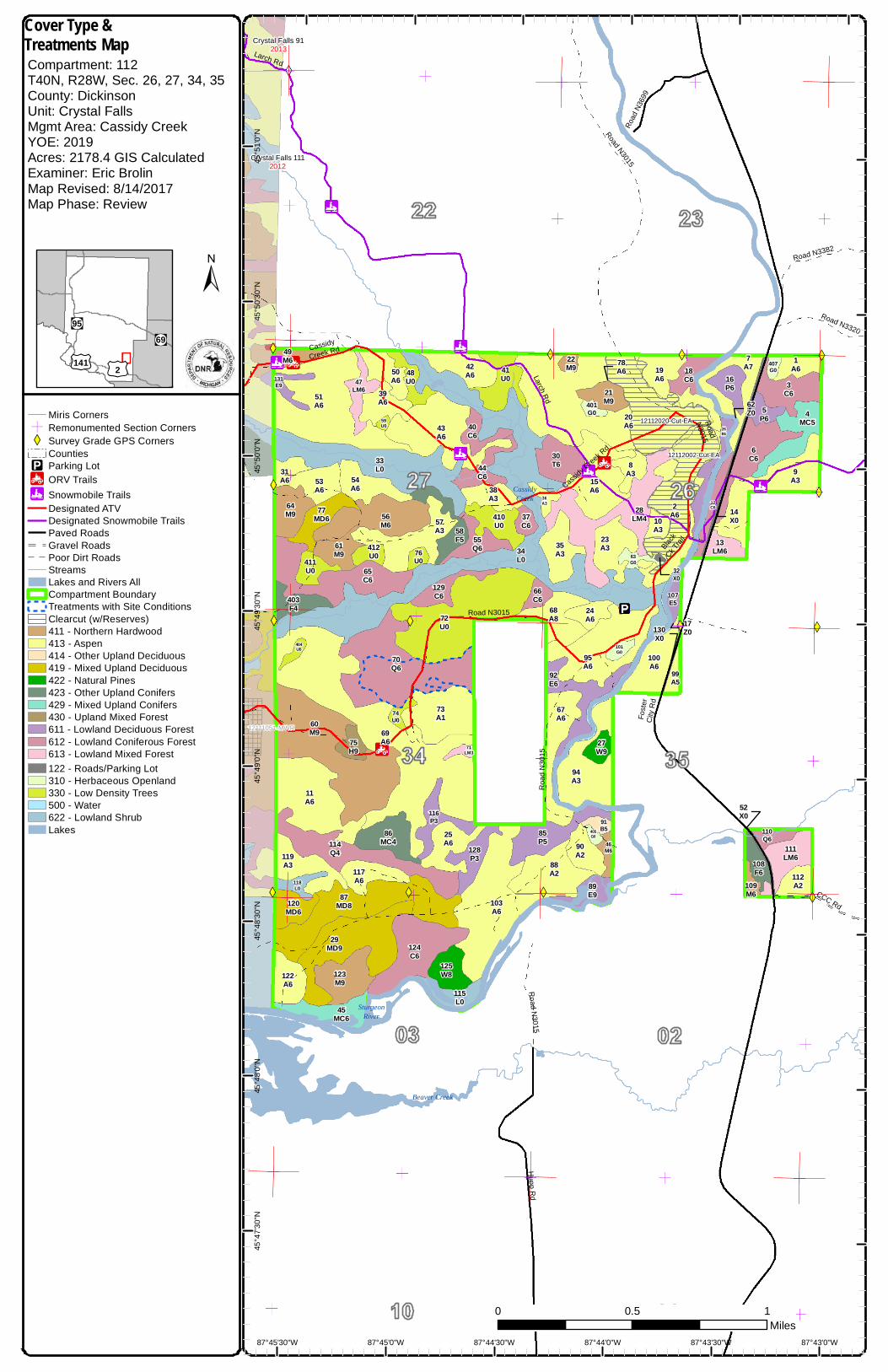
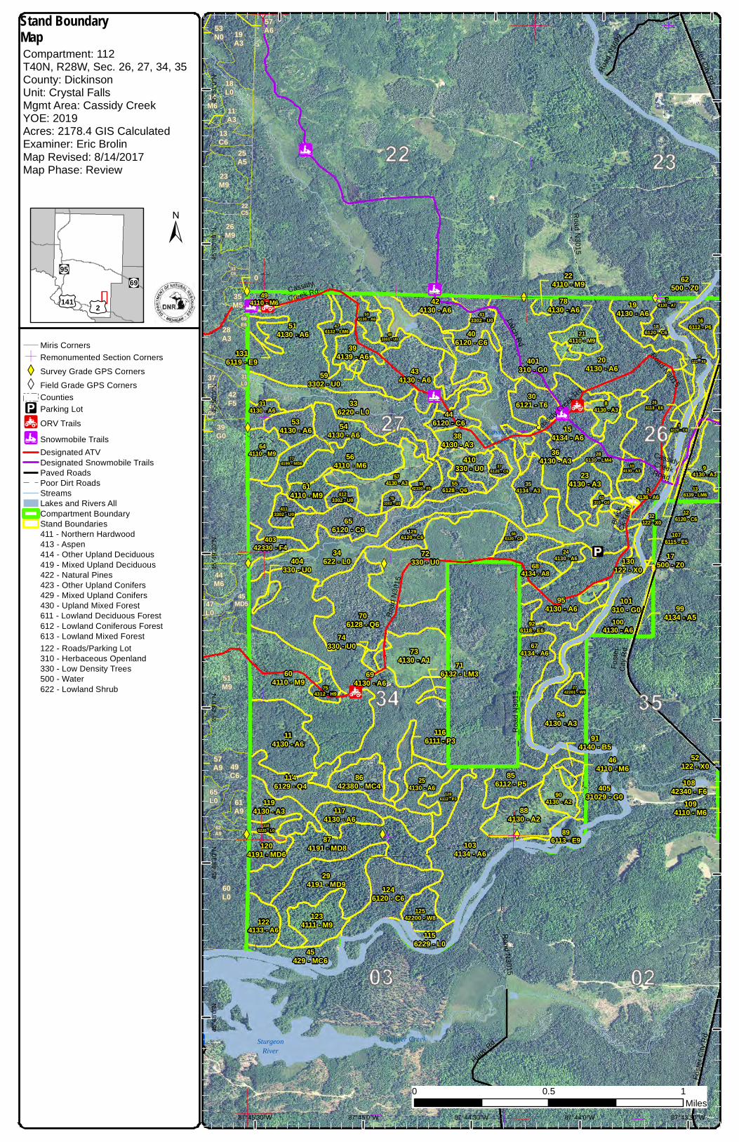
The following reports from the Inventory are attached: Total Acres by Cover Type and Age Class Cover Type by Harvest Method Proposed Treatments – No Limiting Factors Proposed Treatments – With Limiting Factors Stand Details (Forested and Nonforested) Dedicated and Proposed Special Conservation Areas Site Condition Details
The following information is displayed, where pertinent, on the attached compartment maps: Base feature information, stand boundaries, cover types, and numbers Proposed treatments Site condition boundaries Details on the road access system
5C: Delay treatment for age/size classdiversity or exceptional site quality2F: Too steep2G: Too wet (sensitive soils, does notinclude access issues)2H: Blocked by physical obstacle (e.g.upland stand in a lowland area)3J: Water quality / BMPs (stream, river,or lake)5D: Unproductive Forest Land5E: Long-Term RetentionStand BoundariesCold Water StreamsCold Water Lakes
"!(95"!(69
£¤141£¤2
±
Special Conservation Areas& Site Conditions MapCompartment: 112T40N, R28W, Sec. 26, 27, 34, 35County: DickinsonUnit: Crystal FallsMgmt Area: Cassidy CreekYOE: 2019Acres: 2178.4 GIS CalculatedExaminer: Eric BrolinMap Revised: 8/14/2017Map Phase: Review
CassidyCreek
Beaver Creek
SturgeonRiver
Road N3015
Cassidy
Creek R
d
Cassidy CreekRoad
Foste
r City
Rd
Road
N30
15
Black
Ck Tr
ail
Road
N30
15
Road
N369
9
Road N3320
CCC Rd
Road N3382
Road N3015
Hupp Rd
Larch Rd
Road N3015
5C - 18
5C - 35
2F - 31
2G - 27
2G - 17
2G - 20
2G - 20
2G - 20
2G - 33
2G - 21
5E - 29
3J - 11
3J - 11
3J - 11
3J - 14
3J - 6
5D - 32
5E - 34 5E - 25
3J - 7
3J - 16
3J - 28
3J - 9
3J - 26
2G - 30
2H - 10
3J - 4
3J - 15
3J - 24
3J - 12
2G - 8
2G - 5
2G - 22
2G - 3
306121 - T6
4123302 - U0
446120 - C6
214110 - M9
72330 - U0
14130 - A6
684134 - A8
244130 - A6
1286112 - P3
413302 - U0
896113 - E9
926118 - E6
694130 - A6
4429 - MC5
104130 - A3
1124133 - A2
1246120 - C6
954130 - A6
410330 - U0
294191 - MD9
286130 - LM4
904130 - A2
706128 - Q6
194130 - A6
424130 - A6
483303 - U0
1146129 - Q4
56112 - P6
136139 - LM6
564110 - M6
504130 - A6
12542200 - W8
874191 - MD8
1174130 - A6
734130 - A1
24136 - A6
166112 - P6
1106128 - Q6
574130 - A3
254130 - A6
34622 - L0
1296120 - C6
2742201 - W9
234130 - A3
84130 - A3
544130 - A6
336220 - L0
856112 - P5
1156229 - L0
376120 - C6
204130 - A643
4130 - A6
63310 - G0
514130 - A6
656120 - C6
94130 - A3
556128 - Q6
394139 - A6
884130 - A2
384130 - A3
8642380 - MC4
74130 - A7
36120 - C6
154134 - A6
5842330 - F5
1116132 - LM6
604110 - M9
1034134 - A6
354134 - A3
944130 - A3
186120 - C6
1004130 - A6
666120 - C6
66120 - C6
674134 - A6
763302 - U0
1094110 - M6
401310 - G0
476132 - LM6
1076115 - E5
74330 - U0
101310 - G0
62500 - Z0
464110 - M6
364130 - A3
407310 - G0
784130 - A6
114130 - A6
406120 - C6
1166111 - P3
224110 - M9
40531029 - G0
994134 - A5
17500 - Z0
754312 - H9
716132 - LM3
593302 - U0
14122 - X0
10842340 - F6
32122 - X0
614110 - M9
266118 - E6
45429 - MC6
130122 - X0
52122 - X0
1234111 - M9
914140 - B5
126120 - C6
87°43'0"W87°43'30"W87°44'0"W87°44'30"W87°45'0"W
45°5
1'0"N
45°5
0'30"N
45°5
0'0"N
45°4
9'30"N
45°4
9'0"N
45°4
8'30"N
45°4
8'0"N
0 10.5Miles
Miris CornersÓ Remonumented Section CornersXW Survey Grade GPS Corners
5C: Delay treatment for age/size classdiversity or exceptional site quality2F: Too steep2G: Too wet (sensitive soils, does notinclude access issues)2H: Blocked by physical obstacle (e.g.upland stand in a lowland area)3J: Water quality / BMPs (stream, river,or lake)5D: Unproductive Forest Land5E: Long-Term RetentionStand BoundariesCold Water StreamsCold Water Lakes
"!(95"!(69
£¤141£¤2
±
Special Conservation Areas& Site Conditions MapCompartment: 112T40N, R28W, Sec. 26, 27, 34, 35County: DickinsonUnit: Crystal FallsMgmt Area: Cassidy CreekYOE: 2019Acres: 2178.4 GIS CalculatedExaminer: Eric BrolinMap Revised: 8/14/2017Map Phase: Review
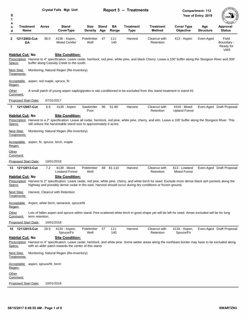
Report 1 – Total Acres by Cover Type and Age ClassCompartmentMgt. Unit
Mgt. Unit Report 3 -- Treatments Compartment:Year of Entry:S
tand
Approval Status
BA Range
Crystal Falls 1122019
Age Structure
12112002-Cut-EA
47Poletimber Well
aspen, red maple, spruce, fir
413 - AspenHarvest Clearcut with Retention
A small patch of young aspen sapling/poles is site conditioned to be excluded from this stand treatment in stand #2.
Harvest to 4" specification. Leave cedar, hemlock, red pine, white pine, and black Cherry. Leave a 100' buffer along the Sturgeon River and 300' buffer along Cassidy Creek to the south.
Harvest to a 2" specification. Leave all cedar, hemlock, red pine, white pine, cherry, and elm. Leave a 100' buffer along the Sturgeon River. This will reduce the harvestable stand size to approximately 6 acres.
Lots of fallen aspen and spruce within stand. Few scattered white birch in good shape yet will be left for seed. Areas excluded will be for long term retention.
Harvest to 2" specification. Leave cedar, red pine, white pine, cherry, and white birch for seed. Exclude more dense black ash pockets along the highway and possibly dense cedar in the east. Harvest should occur during dry conditions or frozen ground.
OtherComment:
PrescriptionSpecs:
13 6139 - Mixed Lowland Forest
Acceptable Regen:
Site Condition:
Draft Proposal81-110
Proposed Start Date: 10/01/2018
7.2
Harvest, Clearcut with RetentionNext Step Treatments:
Even-Aged
Habitat Cut: No
12112015-Cut 57Poletimber Well
aspen, spruce/fir, birch
4134 - Aspen, Spruce/Fir
Harvest Clearcut with Retention
Harvest to 4" specification. Leave cedar, hemlock, and white pine. Some wetter areas along the northeast border may have to be excluded along with an alder patch towards the center of this stand.
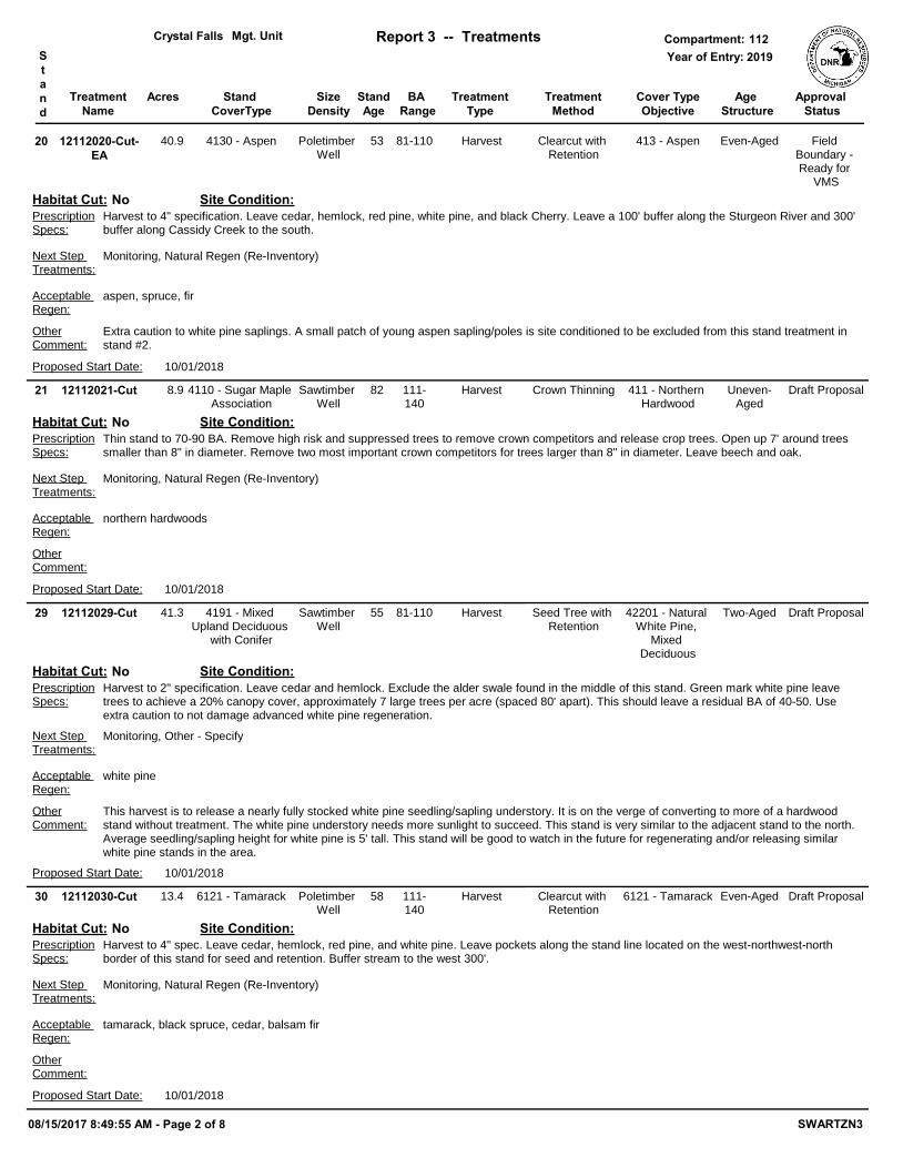
Mgt. Unit Report 3 -- Treatments Compartment:Year of Entry:S
tand
Approval Status
BA Range
Crystal Falls 1122019
Age Structure
12112020-Cut-EA
53Poletimber Well
aspen, spruce, fir
413 - AspenHarvest Clearcut with Retention
Extra caution to white pine saplings. A small patch of young aspen sapling/poles is site conditioned to be excluded from this stand treatment in stand #2.
Harvest to 4" specification. Leave cedar, hemlock, red pine, white pine, and black Cherry. Leave a 100' buffer along the Sturgeon River and 300' buffer along Cassidy Creek to the south.
Thin stand to 70-90 BA. Remove high risk and suppressed trees to remove crown competitors and release crop trees. Open up 7' around trees smaller than 8" in diameter. Remove two most important crown competitors for trees larger than 8" in diameter. Leave beech and oak.
This harvest is to release a nearly fully stocked white pine seedling/sapling understory. It is on the verge of converting to more of a hardwood stand without treatment. The white pine understory needs more sunlight to succeed. This stand is very similar to the adjacent stand to the north. Average seedling/sapling height for white pine is 5' tall. This stand will be good to watch in the future for regenerating and/or releasing similar white pine stands in the area.
Harvest to 2" specification. Leave cedar and hemlock. Exclude the alder swale found in the middle of this stand. Green mark white pine leave trees to achieve a 20% canopy cover, approximately 7 large trees per acre (spaced 80' apart). This should leave a residual BA of 40-50. Use extra caution to not damage advanced white pine regeneration.
OtherComment:
PrescriptionSpecs:
29 4191 - Mixed Upland Deciduous
with Conifer
Acceptable Regen:
Site Condition:
Draft Proposal81-110
Proposed Start Date: 10/01/2018
41.3
Monitoring, Other - SpecifyNext Step Treatments:
Two-Aged
Habitat Cut: No
12112030-Cut 58Poletimber Well
tamarack, black spruce, cedar, balsam fir
6121 - TamarackHarvest Clearcut with Retention
Harvest to 4" spec. Leave cedar, hemlock, red pine, and white pine. Leave pockets along the stand line located on the west-northwest-north border of this stand for seed and retention. Buffer stream to the west 300'.
Harvest to 2" specification. Leave red pine, white pine, and non-merchantable spruce and balsam fir. Leave a 300' buffer along the stream to the west of this stand.
Harvest this stand with the adjacent stand 39 but put a splitter line breaking the two up due to a measureable change in species composition.
Harvest to a 2" specification. Leave cedar, hemlock, red pine, white pine, cherry, and oak if present. Maintain a 300' buffer for the streams to the east and the south.
12112059-NF Nonstocked 3102 - GrassNonForestMgt Other - Specify
Wildlife will maintain this opening via mechanical or Rx burn.
OtherComment:
PrescriptionSpecs:
59 3302 - Low Density Conifer Trees
Acceptable Regen:
Site Condition:
ProposalUnspecified
Proposed Start Date: 10/01/2018
1.2
Next Step Treatments:
Habitat Cut: No
12112060-Cut 87Sawtimber Well
northern hardwoods
411 - Northern Hardwood
Harvest Crown Thinning
Thin stand to 70-90 BA. Remove high risk and suppressed trees to remove crown competitors and release crop trees. Open up 7' around trees smaller than 8" in diameter. Remove two most important crown competitors for trees larger than 8" in diameter. Clean up old canopy gaps to maintain a 30' - 40' diameter to establish regeneration. Leave cedar, hemlock, white pine, beech, and oak if present.
OtherComment:
PrescriptionSpecs:
60 4110 - Sugar Maple Association
Acceptable Regen:
Site Condition:
Draft Proposal111-140
Proposed Start Date: 10/01/2018
74.5
Next Step Treatments:
Uneven-Aged
Habitat Cut: No
12112068-Cut 72Sawtimber Medium
aspen, birch, spruce, fir
4137 - Aspen, Birch
Harvest Seed Tree with Retention
Harvest to 2" specification. Leave cedar, hemlock, and white pine. Leave 3 to 10 "healthy" paper birch per acre where possible for seed. Leave a 100' buffer along the stream to the north.
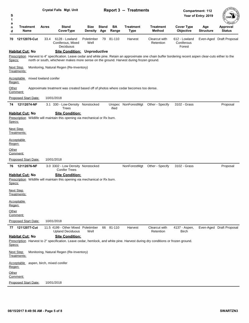
Mgt. Unit Report 3 -- Treatments Compartment:Year of Entry:S
tand
Approval Status
BA Range
Crystal Falls 1122019
Age Structure
12112070-Cut 79Poletimber Well
mixed lowland conifer
612 - Lowland Coniferous
Forest
Harvest Clearcut with Retention
Approximate treatment was created based off of photos where cedar becomes too dense.
Harvest to 4" specification. Leave cedar and white pine. Retain an approximate one chain buffer bordering recent aspen clear-cuts either to the north or south, whichever makes more sense on the ground. Harvest during frozen ground.
Mgt. Unit Report 3 -- Treatments Compartment:Year of Entry:S
tand
Approval Status
BA Range
Crystal Falls 1122019
Age Structure
12112091-Cut 66Poletimber Medium
white birch, spruce/fir, aspen
4193 - Birch, Aspen
Harvest Seed Tree with Retention
Harvest using 2" specification. Leave white pine. Leave 3-10 healthy paper birch per acre where possible for seed. Leave a 100' buffer along the Sturgeon River.
12112101-NF Nonstocked 3102 - GrassNonForestMgt Other - Specify
Wildlife will maintain this opening via mechanical or Rx burn.
OtherComment:
PrescriptionSpecs:
101 310 - Herbaceous Openland
Acceptable Regen:
Site Condition:
ProposalUnspecified
Proposed Start Date: 10/01/2018
3.0
Next Step Treatments:
Habitat Cut: No
12112111-Cut 49Poletimber Well
Aspen, tamarack, cherry, spruce/fir
613 - Lowland Mixed Forest
Harvest Clearcut with Retention
Areas excluded will be for long term retention.
Harvest to 2" specification. Retain dense cedar pocket in NE/E portion of stand, may be up to 1/3 of actual stand. Leave cedar and hemlock. Leave a 300' buffer along Lost Creek to the north. Harvest during dry conditions or frozen ground.
OtherComment:
PrescriptionSpecs:
111 6132 - Mixed Lowland Forest with
Cedar
Acceptable Regen:
Site Condition:
Draft Proposal51-80
Proposed Start Date: 10/01/2018
10.3
Harvest, Clearcut with RetentionNext Step Treatments:
Even-Aged
Habitat Cut: No
12112120-Cut 63Poletimber Well
aspen, spruce/fir, birch, maple
4319 - Mixed Upland Forest
Harvest Clearcut with Retention
Harvest to 4" specification. Leave cedar, hemlock, red pine, white pine, cherry, and oak if present.
Mgt. Unit Report 3 -- Treatments Compartment:Year of Entry:S
tand
Approval Status
BA Range
Crystal Falls 1122019
Age Structure
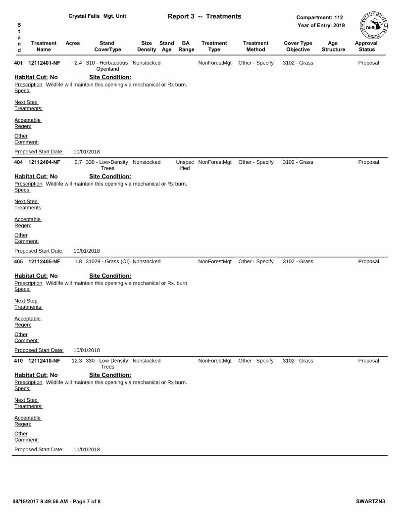
12112401-NF Nonstocked 3102 - GrassNonForestMgt Other - Specify
Wildlife will maintain this opening via mechanical or Rx burn.
OtherComment:
PrescriptionSpecs:
401 310 - Herbaceous Openland
Acceptable Regen:
Site Condition:
Proposal
Proposed Start Date: 10/01/2018
2.4
Next Step Treatments:
Habitat Cut: No
12112404-NF Nonstocked 3102 - GrassNonForestMgt Other - Specify
Wildlife will maintain this opening via mechanical or Rx burn.
OtherComment:
PrescriptionSpecs:
404 330 - Low-Density Trees
Acceptable Regen:
Site Condition:
ProposalUnspecified
Proposed Start Date: 10/01/2018
2.7
Next Step Treatments:
Habitat Cut: No
12112405-NF Nonstocked 3102 - GrassNonForestMgt Other - Specify
Wildlife will maintain this opening via mechanical or Rx. burn.
OtherComment:
PrescriptionSpecs:
405 31029 - Grass (OI)
Acceptable Regen:
Site Condition:
Proposal
Proposed Start Date: 10/01/2018
1.8
Next Step Treatments:
Habitat Cut: No
12112410-NF Nonstocked 3102 - GrassNonForestMgt Other - Specify
Wildlife will maintain this opening via mechanical or Rx burn.
OtherComment:
PrescriptionSpecs:
410 330 - Low-Density Trees
Acceptable Regen:
Site Condition:
Proposal
Proposed Start Date: 10/01/2018
12.3
Next Step Treatments:
Habitat Cut: No
08/15/2017 8:49:56 AM - Page 7 of 8 SWARTZN3
TreatmentName
Acres StandAge
Cover TypeObjective
SizeDensity
TreatmentType
TreatmentMethod
Stand CoverType
Mgt. Unit Report 3 -- Treatments Compartment:Year of Entry:S
tand
Approval Status
BA Range
Crystal Falls 1122019
Age Structure
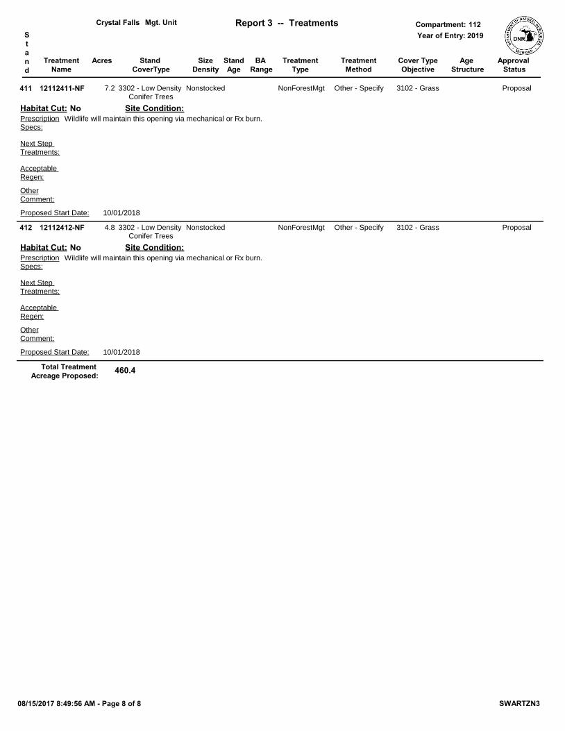
12112411-NF Nonstocked 3102 - GrassNonForestMgt Other - Specify
Wildlife will maintain this opening via mechanical or Rx burn.
OtherComment:
PrescriptionSpecs:
411 3302 - Low Density Conifer Trees
Acceptable Regen:
Site Condition:
Proposal
Proposed Start Date: 10/01/2018
7.2
Next Step Treatments:
Habitat Cut: No
12112412-NF Nonstocked 3102 - GrassNonForestMgt Other - Specify
Wildlife will maintain this opening via mechanical or Rx burn.
OtherComment:
PrescriptionSpecs:
412 3302 - Low Density Conifer Trees
Acceptable Regen:
Site Condition:
Proposal
Proposed Start Date: 10/01/2018
4.8
Next Step Treatments:
Habitat Cut: No
460.4Total Treatment Acreage Proposed:
08/15/2017 8:49:56 AM - Page 8 of 8 SWARTZN3
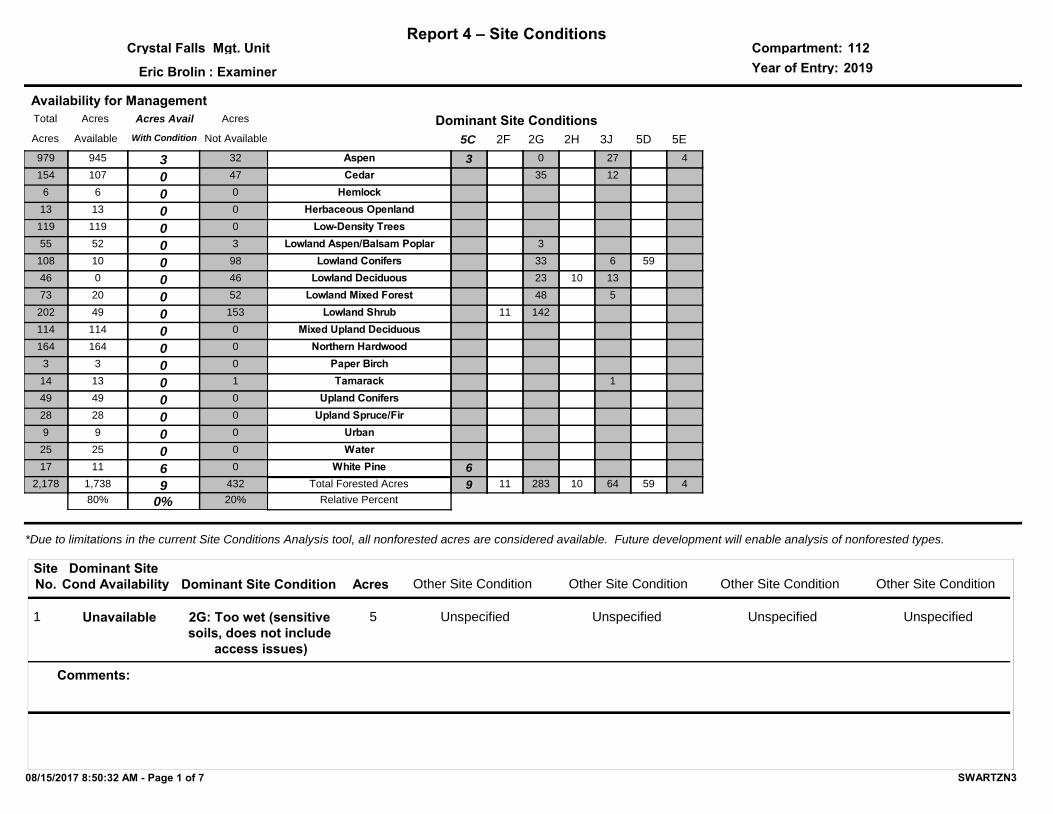
Report 4 – Site ConditionsCompartment:Mgt. UnitYear of Entry:: Examiner
Crystal Falls
Eric Brolin
1122019
*Due to limitations in the current Site Conditions Analysis tool, all nonforested acres are considered available. Future development will enable analysis of nonforested types.
Dominant Site Condition AcresSiteNo. Other Site Condition Other Site Condition Other Site Condition Other Site Condition
Dominant Site Cond Availability
1 2G: Too wet (sensitive soils, does not include
access issues)
Unspecified5 Unspecified Unspecified Unspecified
Comments:
Unavailable
5C
Dominant Site Conditions2G 2H 3J 5D 5E2F
4Aspen 3 0 27
Cedar 35 12
HemlockHerbaceous Openland
Low-Density TreesLowland Aspen/Balsam Poplar 3
Lowland Conifers 33 6 59
Lowland Deciduous 23 10 13
Lowland Mixed Forest 48 5
Lowland Shrub 11 142
Mixed Upland DeciduousNorthern Hardwood
Paper BirchTamarack 1
Upland ConifersUpland Spruce/Fir
UrbanWater
White Pine 6
49 11 283 10 64 59Total Forested Acres
Relative Percent
Availability for ManagementAcres Acres AvailTotal
Available With ConditionAcres
Acres
Not Available
945 3979 32
107 0154 47
6 06 0
13 013 0
119 0119 0
52 055 3
10 0108 98
0 046 46
20 073 52
49 0202 153
114 0114 0
164 0164 0
3 03 0
13 014 1
49 049 0
28 028 0
9 09 0
25 025 0
11 617 0
1,738 92,178
0%80%
432
20%
08/15/2017 8:50:32 AM - Page 1 of 7 SWARTZN3
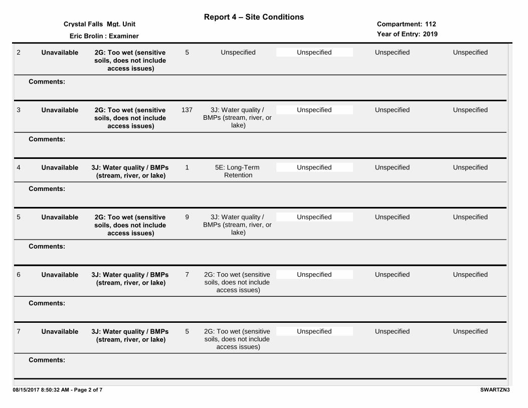
Report 4 – Site ConditionsCompartment:Mgt. UnitYear of Entry:: Examiner
Crystal Falls
Eric Brolin
1122019
2 2G: Too wet (sensitive soils, does not include
access issues)
Unspecified5 Unspecified Unspecified Unspecified
Comments:
Unavailable
3 2G: Too wet (sensitive soils, does not include
access issues)
3J: Water quality / BMPs (stream, river, or
lake)
137 Unspecified Unspecified Unspecified
Comments:
Unavailable
4 3J: Water quality / BMPs (stream, river, or lake)
5E: Long-Term Retention
1 Unspecified Unspecified Unspecified
Comments:
Unavailable
5 2G: Too wet (sensitive soils, does not include
access issues)
3J: Water quality / BMPs (stream, river, or
lake)
9 Unspecified Unspecified Unspecified
Comments:
Unavailable
6 3J: Water quality / BMPs (stream, river, or lake)
2G: Too wet (sensitive soils, does not include
access issues)
7 Unspecified Unspecified Unspecified
Comments:
Unavailable
7 3J: Water quality / BMPs (stream, river, or lake)
2G: Too wet (sensitive soils, does not include
access issues)
5 Unspecified Unspecified Unspecified
Comments:
Unavailable
08/15/2017 8:50:32 AM - Page 2 of 7 SWARTZN3
Report 4 – Site ConditionsCompartment:Mgt. UnitYear of Entry:: Examiner
Crystal Falls
Eric Brolin
1122019
8 2G: Too wet (sensitive soils, does not include
access issues)
3J: Water quality / BMPs (stream, river, or
lake)
18 Unspecified Unspecified Unspecified
Comments:
Unavailable
9 3J: Water quality / BMPs (stream, river, or lake)
5E: Long-Term Retention
1 Unspecified Unspecified Unspecified
Comments:
Unavailable
10 2H: Blocked by physical obstacle (e.g. upland
stand in a lowland area)
3J: Water quality / BMPs (stream, river, or
lake)
10 Unspecified Unspecified Unspecified
Comments:
Unavailable
11 3J: Water quality / BMPs (stream, river, or lake)
2G: Too wet (sensitive soils, does not include
access issues)
10
300' buffer along Lost Creek.
5E: Long-Term Retention
Unspecified Unspecified
Comments:
Unavailable
12 3J: Water quality / BMPs (stream, river, or lake)
5E: Long-Term Retention
9
100' buffer along Sturgeon River.
Unspecified Unspecified Unspecified
Comments:
Unavailable
14 3J: Water quality / BMPs (stream, river, or lake)
5E: Long-Term Retention
4
300' buffer
Unspecified Unspecified Unspecified
Comments:
Unavailable
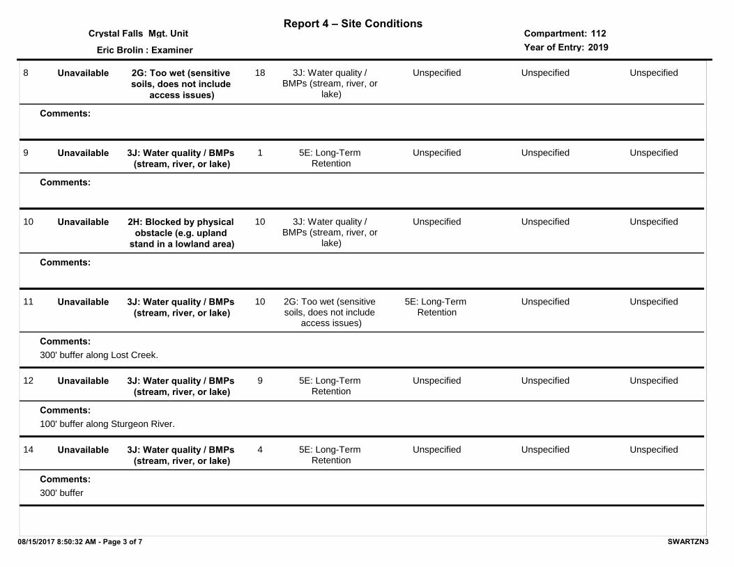
08/15/2017 8:50:32 AM - Page 3 of 7 SWARTZN3
Report 4 – Site ConditionsCompartment:Mgt. UnitYear of Entry:: Examiner
Crystal Falls
Eric Brolin
1122019
15 3J: Water quality / BMPs (stream, river, or lake)
Unspecified4
300' buffer
Unspecified Unspecified Unspecified
Comments:
Unavailable
16 3J: Water quality / BMPs (stream, river, or lake)
5E: Long-Term Retention
7
300' buffer
Unspecified Unspecified Unspecified
Comments:
Unavailable
17 2G: Too wet (sensitive soils, does not include
access issues)
Unspecified39
Lowland alder, conifer mix.
Unspecified Unspecified Unspecified
Comments:
Unavailable
18 5C: Delay treatment for age/size class diversity or
exceptional site quality
Unspecified3
This area is a clone of young aspen sapling/poles that should be excluded from a potential upcoming harvest.
Unspecified Unspecified Unspecified
Comments:
Available
20 2G: Too wet (sensitive soils, does not include
access issues)
Unspecified9 Unspecified Unspecified Unspecified
Comments:
Unavailable
21 2G: Too wet (sensitive soils, does not include
access issues)
3J: Water quality / BMPs (stream, river, or
lake)
7 Unspecified Unspecified Unspecified
Comments:
Unavailable
08/15/2017 8:50:32 AM - Page 4 of 7 SWARTZN3
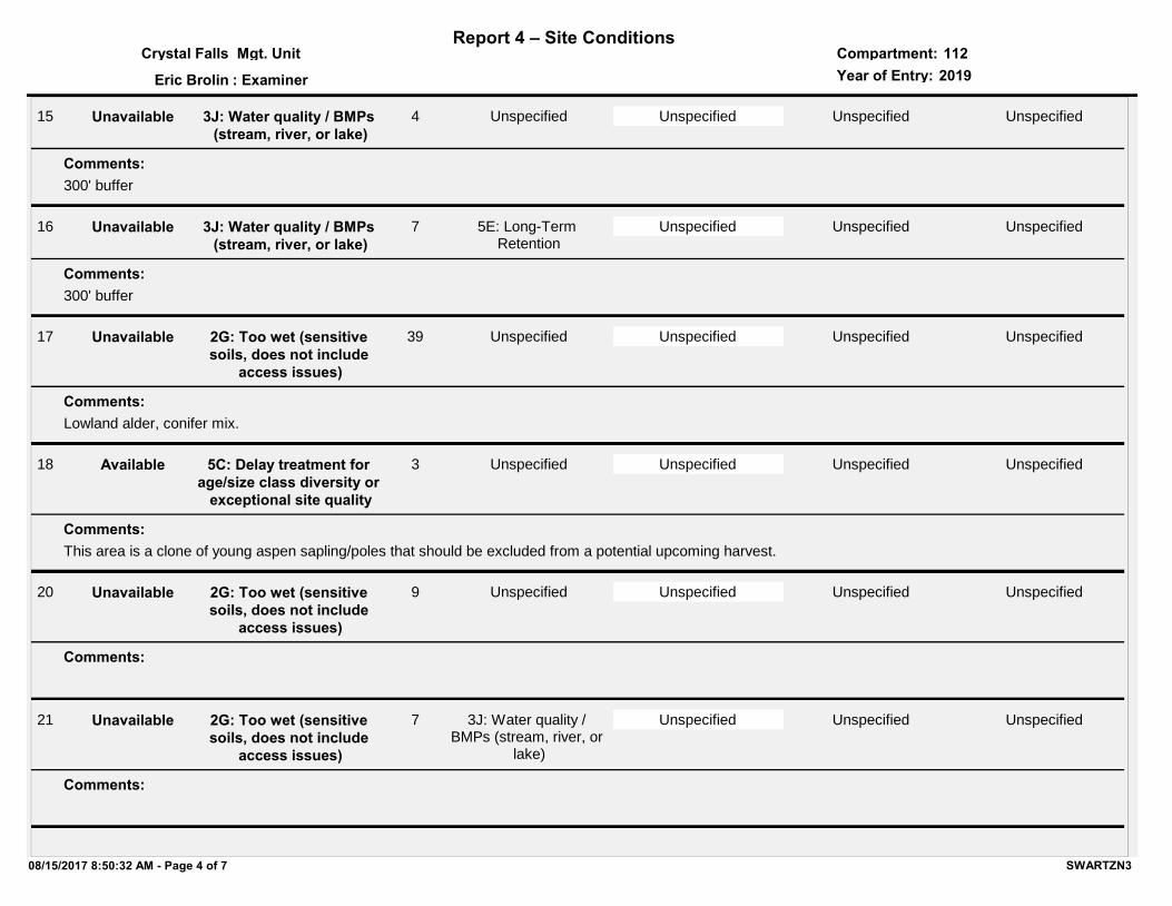
Report 4 – Site ConditionsCompartment:Mgt. UnitYear of Entry:: Examiner
Crystal Falls
Eric Brolin
1122019
22 2G: Too wet (sensitive soils, does not include
access issues)
3J: Water quality / BMPs (stream, river, or
lake)
10 Unspecified Unspecified Unspecified
Comments:
Unavailable
23 3J: Water quality / BMPs (stream, river, or lake)
5E: Long-Term Retention
1 Unspecified Unspecified Unspecified
Comments:
Unavailable
24 3J: Water quality / BMPs (stream, river, or lake)
26 3J: Water quality / BMPs (stream, river, or lake)
2G: Too wet (sensitive soils, does not include
access issues)
9 Unspecified Unspecified Unspecified
Comments:
Unavailable
27 2G: Too wet (sensitive soils, does not include
access issues)
3J: Water quality / BMPs (stream, river, or
lake)
9 Unspecified Unspecified Unspecified
Comments:
Unavailable
08/15/2017 8:50:32 AM - Page 5 of 7 SWARTZN3
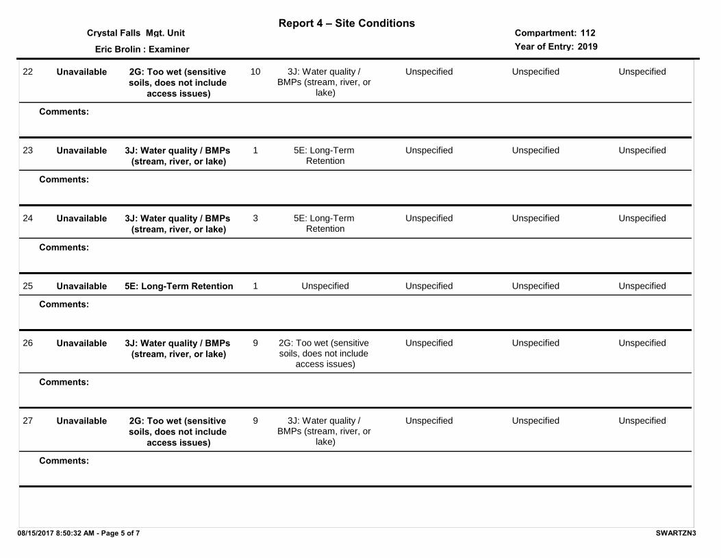
Report 4 – Site ConditionsCompartment:Mgt. UnitYear of Entry:: Examiner
Crystal Falls
Eric Brolin
1122019
28 3J: Water quality / BMPs (stream, river, or lake)
2G: Too wet (sensitive soils, does not include
access issues)
5 Unspecified Unspecified Unspecified
Comments:
Unavailable
29 5E: Long-Term Retention 3J: Water quality / BMPs (stream, river, or
lake)
2 Unspecified Unspecified Unspecified
Comments:
Unavailable
30 2G: Too wet (sensitive soils, does not include
access issues)
Unspecified33 Unspecified Unspecified Unspecified
Comments:
Unavailable
31 2F: Too steep 3J: Water quality / BMPs (stream, river, or
lake)
11 Unspecified Unspecified Unspecified
Comments:
Unavailable
32 5D: Unproductive Forest Land
2G: Too wet (sensitive soils, does not include
access issues)
59 Unspecified Unspecified Unspecified
Comments:
Unavailable
08/15/2017 8:50:32 AM - Page 6 of 7 SWARTZN3
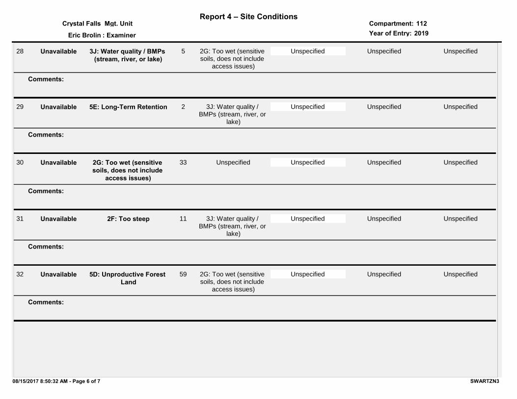
Report 4 – Site ConditionsCompartment:Mgt. UnitYear of Entry:: Examiner
Crystal Falls
Eric Brolin
1122019
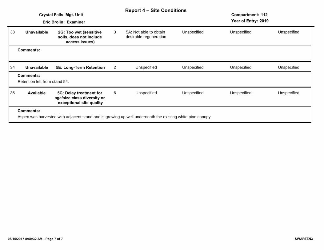
33 2G: Too wet (sensitive soils, does not include
access issues)
5A: Not able to obtain desirable regeneration
3 Unspecified Unspecified Unspecified
Comments:
Unavailable
34 5E: Long-Term Retention Unspecified2
Retention left from stand 54.
Unspecified Unspecified Unspecified
Comments:
Unavailable
35 5C: Delay treatment for age/size class diversity or
exceptional site quality
Unspecified6
Aspen was harvested with adjacent stand and is growing up well underneath the existing white pine canopy.
Unspecified Unspecified Unspecified
Comments:
Available
08/15/2017 8:50:32 AM - Page 7 of 7 SWARTZN3
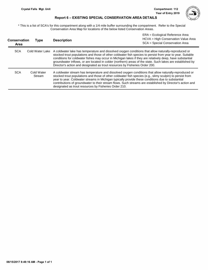
SCA Category Acres
Mgt. Unit
Report 5 – PROPOSED SPECIAL CONSERVATION AREA* (SCA) DETAILS
Compartment:
Recommendation
* This is a partial list of SCAs for this compartment. Not included are those areas identified under other Department initiatives (Natural Rivers, Deer Wintering Areas, etc.). Those will be identified in separate, future map and report products.
Year of Entry:
SCA Name Detail Type
#Type!
Comments
08/15/2017 8:49:19 AM - Page 1 of 1 SWARTZN3
Type
Mgt. Unit Compartment:
Description
* This is a list of SCA's for this compartment along with a 1/4 mile buffer surrounding the compartment. Refer to the Special Conservation Area Map for locations of the below listed Conservation Areas.
Report 6 – EXISTING SPECIAL CONSERVATION AREA DETAILS
Conservation Area SCA = Special Conservation Area
HCVA = High Conservation Value Area
ERA = Ecological Reference Area
Year of EntryCrystal Falls 112
2019
A coldwater lake has temperature and dissolved oxygen conditions that allow naturally-reproduced or stocked trout populations and those of other coldwater fish species to persist from year to year. Suitable conditions for coldwater fishes may occur in Michigan lakes if they are relatively deep, have substantial groundwater inflows, or are located in colder (northern) areas of the state. Such lakes are established by Director's action and designated as trout resources by Fisheries Order 200.
Cold Water LakeSCA
A coldwater stream has temperature and dissolved oxygen conditions that allow naturally-reproduced or stocked trout populations and those of other coldwater fish species (e.g., slimy sculpin) to persist from year to year. Coldwater streams in Michigan typically provide these conditions due to substantial contributions of groundwater to their stream flows. Such streams are established by Director's action and designated as trout resources by Fisheries Order 210.
Cold Water Stream
SCA
08/15/2017 8:49:16 AM - Page 1 of 1
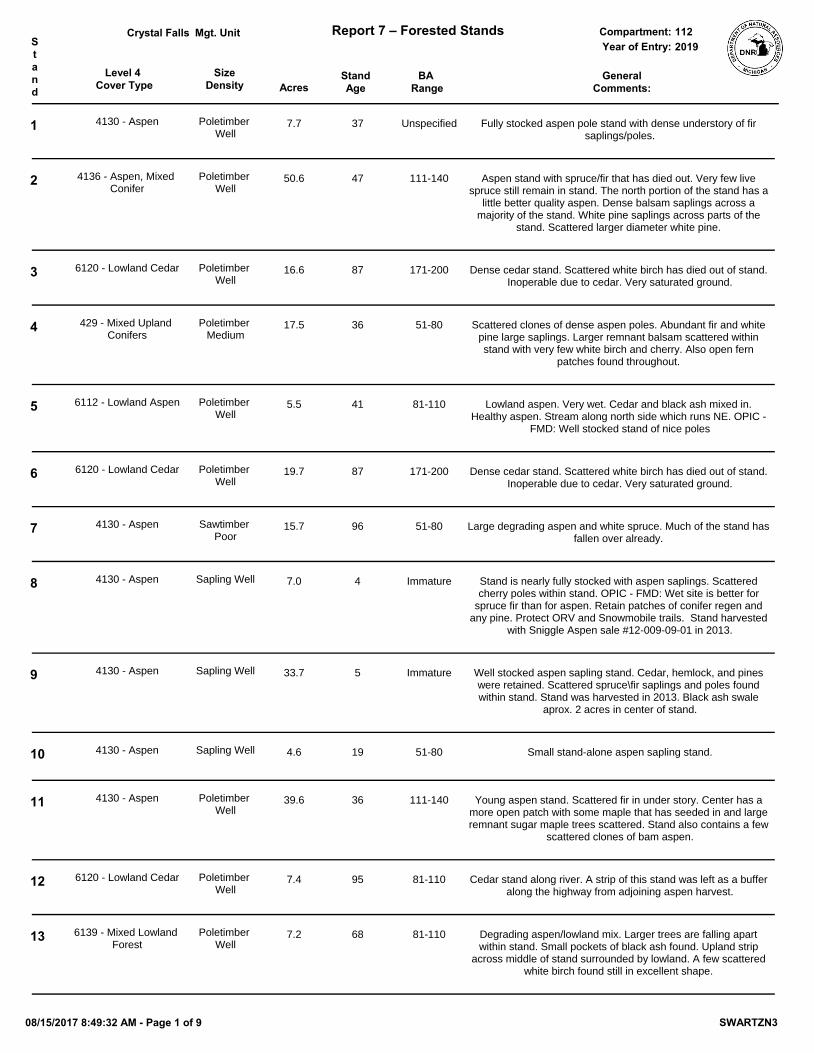
Level 4 Cover Type Acres
StandAge
SizeDensity
BA Range
Mgt. Unit Report 7 – Forested Stands Compartment:Stand
GeneralComments:
Year of Entry:Crystal Falls
2019112
1 4130 - Aspen Poletimber Well
7.7 37 Unspecified Fully stocked aspen pole stand with dense understory of fir saplings/poles.
2 4136 - Aspen, Mixed Conifer
Poletimber Well
50.6 47 111-140 Aspen stand with spruce/fir that has died out. Very few live spruce still remain in stand. The north portion of the stand has a
little better quality aspen. Dense balsam saplings across a majority of the stand. White pine saplings across parts of the
stand. Scattered larger diameter white pine.
3 6120 - Lowland Cedar Poletimber Well
16.6 87 171-200 Dense cedar stand. Scattered white birch has died out of stand. Inoperable due to cedar. Very saturated ground.
4 429 - Mixed Upland Conifers
Poletimber Medium
17.5 36 51-80 Scattered clones of dense aspen poles. Abundant fir and white pine large saplings. Larger remnant balsam scattered within stand with very few white birch and cherry. Also open fern
patches found throughout.
5 6112 - Lowland Aspen Poletimber Well
5.5 41 81-110 Lowland aspen. Very wet. Cedar and black ash mixed in. Healthy aspen. Stream along north side which runs NE. OPIC -
FMD: Well stocked stand of nice poles
6 6120 - Lowland Cedar Poletimber Well
19.7 87 171-200 Dense cedar stand. Scattered white birch has died out of stand. Inoperable due to cedar. Very saturated ground.
7 4130 - Aspen Sawtimber Poor
15.7 96 51-80 Large degrading aspen and white spruce. Much of the stand has fallen over already.
8 4130 - Aspen Sapling Well 7.0 4 Immature Stand is nearly fully stocked with aspen saplings. Scattered cherry poles within stand. OPIC - FMD: Wet site is better for
spruce fir than for aspen. Retain patches of conifer regen and any pine. Protect ORV and Snowmobile trails. Stand harvested
with Sniggle Aspen sale #12-009-09-01 in 2013.
9 4130 - Aspen Sapling Well 33.7 5 Immature Well stocked aspen sapling stand. Cedar, hemlock, and pines were retained. Scattered spruce\fir saplings and poles found within stand. Stand was harvested in 2013. Black ash swale
aprox. 2 acres in center of stand.
10 4130 - Aspen Sapling Well 4.6 19 51-80 Small stand-alone aspen sapling stand.
11 4130 - Aspen Poletimber Well
39.6 36 111-140 Young aspen stand. Scattered fir in under story. Center has a more open patch with some maple that has seeded in and large remnant sugar maple trees scattered. Stand also contains a few
scattered clones of bam aspen.
12 6120 - Lowland Cedar Poletimber Well
7.4 95 81-110 Cedar stand along river. A strip of this stand was left as a buffer along the highway from adjoining aspen harvest.
13 6139 - Mixed Lowland Forest
Poletimber Well
7.2 68 81-110 Degrading aspen/lowland mix. Larger trees are falling apart within stand. Small pockets of black ash found. Upland strip
across middle of stand surrounded by lowland. A few scattered white birch found still in excellent shape.
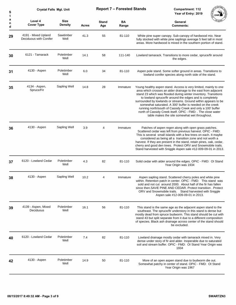
08/15/2017 8:49:32 AM - Page 1 of 9 SWARTZN3
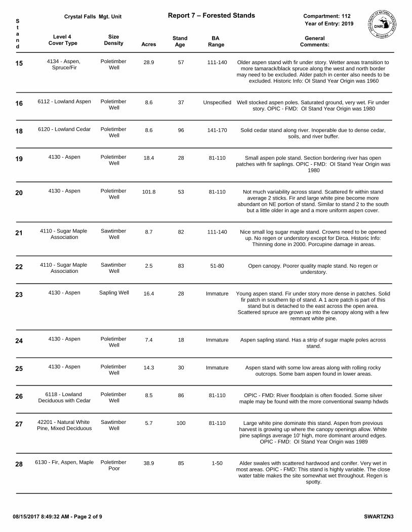
Level 4 Cover Type Acres
StandAge
SizeDensity
BA Range
Mgt. Unit Report 7 – Forested Stands Compartment:Stand
GeneralComments:
Year of Entry:Crystal Falls
2019112
15 4134 - Aspen, Spruce/Fir
Poletimber Well
28.9 57 111-140 Older aspen stand with fir under story. Wetter areas transition to more tamarack/black spruce along the west and north border
may need to be excluded. Alder patch in center also needs to be excluded. Historic Info: OI Stand Year Origin was 1960
16 6112 - Lowland Aspen Poletimber Well
8.6 37 Unspecified Well stocked aspen poles. Saturated ground, very wet. Fir under story. OPIC - FMD: OI Stand Year Origin was 1980
18 6120 - Lowland Cedar Poletimber Well
8.6 96 141-170 Solid cedar stand along river. Inoperable due to dense cedar, soils, and river buffer.
19 4130 - Aspen Poletimber Well
18.4 28 81-110 Small aspen pole stand. Section bordering river has open patches with fir saplings. OPIC - FMD: OI Stand Year Origin was
1980
20 4130 - Aspen Poletimber Well
101.8 53 81-110 Not much variability across stand. Scattered fir within stand average 2 sticks. Fir and large white pine become more
abundant on NE portion of stand. Similar to stand 2 to the south but a little older in age and a more uniform aspen cover.
21 4110 - Sugar Maple Association
Sawtimber Well
8.7 82 111-140 Nice small log sugar maple stand. Crowns need to be opened up. No regen or understory except for Dirca. Historic Info:
Thinning done in 2000. Porcupine damage in areas.
22 4110 - Sugar Maple Association
Sawtimber Well
2.5 83 51-80 Open canopy. Poorer quality maple stand. No regen or understory.
23 4130 - Aspen Sapling Well 16.4 28 Immature Young aspen stand. Fir under story more dense in patches. Solid fir patch in southern tip of stand. A 1 acre patch is part of this
stand but is detached to the east across the open area. Scattered spruce are grown up into the canopy along with a few
remnant white pine.
24 4130 - Aspen Poletimber Well
7.4 18 Immature Aspen sapling stand. Has a strip of sugar maple poles across stand.
25 4130 - Aspen Poletimber Well
14.3 30 Immature Aspen stand with some low areas along with rolling rocky outcrops. Some bam aspen found in lower areas.
26 6118 - Lowland Deciduous with Cedar
Poletimber Well
8.5 86 81-110 OPIC - FMD: River floodplain is often flooded. Some silver maple may be found with the more conventional swamp hdwds
27 42201 - Natural White Pine, Mixed Deciduous
Sawtimber Well
5.7 100 81-110 Large white pine dominate this stand. Aspen from previous harvest is growing up where the canopy openings allow. White pine saplings average 10' high, more dominant around edges.
OPIC - FMD: OI Stand Year Origin was 1989
28 6130 - Fir, Aspen, Maple Poletimber Poor
38.9 85 1-50 Alder swales with scattered hardwood and conifer. Very wet in most areas. OPIC - FMD: This stand is highly variable. The close water table makes the site somewhat wet throughout. Regen is
spotty.
08/15/2017 8:49:32 AM - Page 2 of 9 SWARTZN3
Level 4 Cover Type Acres
StandAge
SizeDensity
BA Range
Mgt. Unit Report 7 – Forested Stands Compartment:Stand
GeneralComments:
Year of Entry:Crystal Falls
2019112
29 4191 - Mixed Upland Deciduous with Conifer
Sawtimber Well
41.3 55 81-110 White pine super canopy. Sub-canopy of hardwood mix. Near fully stocked with white pine saplings average 5 feet tall in most areas. More hardwood is mixed in the southern portion of stand.
30 6121 - Tamarack Poletimber Well
14.1 58 111-140 Lowland tamarack. Transitions to more cedar, spruce/fir around the edges.
31 4130 - Aspen Poletimber Well
6.0 34 81-110 Aspen pole stand. Some softer ground in areas. Transitions to lowland conifer species along north side of the stand.
35 4134 - Aspen, Spruce/Fir
Sapling Well 14.8 28 Immature Young healthy aspen stand. Access is very limited, mainly to one area which crosses an alder drainage to the east from adjacent stand 23 which was flooded during winter inventory. Transitions
to lowland spruce/fir around the edges and is completely surrounded by lowlands or streams. Ground within appears to be
somewhat saturated. A 300' buffer is needed on the creek running north/south of Cassidy Creek and only a 100' buffer north of Cassidy Creek itself. OPIC - FMD: . The close water
table makes the site somewhat wet throughout.
36 4130 - Aspen Sapling Well 3.9 4 Immature Patches of aspen regen along with open grass patches. Scattered cedar was left from previous harvest. OPIC - FMD:
This is several small islands with a few trees on each. It maybe considered as being all a transition zone and not worth a
harvest. If they are present in the stand, retain pines, oak, cedar, cherry and good den trees. Protect ORV and Snowmobile trails. Stand harvested with Sniggle Aspen sale #12-009-09-01 in 2013.
37 6120 - Lowland Cedar Poletimber Well
4.3 82 81-110 Solid cedar with alder around the edges. OPIC - FMD: OI Stand Year Origin was 1934
38 4130 - Aspen Sapling Well 10.2 4 Immature Aspen sapling stand. Scattered cherry poles and white pine within. Retention patch in center. OPIC - FMD: This stand was
sold and not cut around 2000. About half of the fir has fallen since then.SAVE PINE AND CEDAR. Protect transition . Protect
ORV and Snowmobile trails. Stand harvested with Sniggle Aspen sale #12-009-09-01 in 2013.
39 4139 - Aspen, Mixed Deciduous
Poletimber Well
16.1 56 81-110 This stand is the same age as the adjacent aspen stand to the southeast. The spruce/fir understory in this stand is dense but
mostly dead from spruce budworm. This stand should be cut with stand 43 but split separate from it due to a different composition of species. Black ash drainage across center of the stand should
be excluded.
40 6120 - Lowland Cedar Poletimber Well
7.4 82 81-110 Lowland drainage mostly cedar with tamarack mixed in. Very dense under story of fir and alder. Inoperable due to saturated soil and stream buffer. OPIC - FMD: OI Stand Year Origin was
1934
42 4130 - Aspen Poletimber Well
14.9 50 81-110 More of an open aspen stand due to budworm die out. Somewhat patchy in center of stand. OPIC - FMD: OI Stand
Year Origin was 1967
08/15/2017 8:49:32 AM - Page 3 of 9 SWARTZN3
Level 4 Cover Type Acres
StandAge
SizeDensity
BA Range
Mgt. Unit Report 7 – Forested Stands Compartment:Stand
GeneralComments:
Year of Entry:Crystal Falls
2019112
43 4130 - Aspen Poletimber Well
37.7 56 51-80 Older aspen stand. Dense spruce/fir understory has mostly died out from budworm but is still standing. This stand should be cut
with adjacent stand 39 but split due to a different species composition. Historic Info: DENSE CONIFER UNDERSTORY.
44 6120 - Lowland Cedar Poletimber Well
9.6 82 81-110 Lowland drainage mostly cedar with tamarack mixed in. Very dense under story of fir and alder. Inoperable due to soils and stream buffer. OPIC - FMD: OI Stand Year Origin was 1934
45 429 - Mixed Upland Conifers
Poletimber Well
16.5 52 51-80 Scattered super canopy white pines. Co-dominant canopy of white pine, red maple, and dead white birch which is 52 years
old. More hemlock is mixed in the eastern half of the stand along with some difficult terrain in areas. Dense under story of white
pine approximately 30 years old. Could not find south west corner.
46 4110 - Sugar Maple Association
Poletimber Well
4.1 51 51-80 Small hardwood pole stand with some logs. Stocking level is not ready to be thinned yet.
47 6132 - Mixed Lowland Forest with Cedar
Poletimber Well
9.0 104 81-110 Lowland with cedar, spruce, black ash, and areas of alder. Very saturated ground. Bam and black ash is falling apart. Cedar is
larger and may be older than dominant age of stand.
49 4110 - Sugar Maple Association
Poletimber Well
6.6 82 81-110 Hardwood pole stand with few poorer quality logs. BA averaged 90, crowns still have room to grow. Survey corner present.
50 4130 - Aspen Poletimber Well
6.8 26 Immature Aspen sapling stand.
51 4130 - Aspen Poletimber Well
59.6 48 111-140 Healthy aspen stand. Abundant fir under story. Cedar drainage E/W across north end of stand, an old raised skid trail does
cross it for access from the north to the southern portion of stand if not in frozen conditions. Fairly gentle terrain does have some small rock ledges. Aspen more dense in south. Cedar and black
ash found within stand. Exclude dense cedar and black ash pockets.
53 4130 - Aspen Poletimber Well
11.8 64 111-140 Mature aspen stand. Scattered maple mixed in southern portion of stand. Dense fir under story in areas 2-3 sticks.
54 4130 - Aspen Poletimber Well
14.0 28 Immature Fully stocked aspen pole stand. Fir saplings found along stand transition. OPIC - FMD: OI Stand Year Origin was 1989
55 6128 - Lowland Coniferous, Mixed
Deciduous
Poletimber Well
10.5 78 81-110 This stand is more of a lowland drainage between streams to the north and south. Scattered large degrading aspen and
dead/degrading tamarack are scattered within. Large swales of alder heavy in areas. White birch mixed in southern portion.
56 4110 - Sugar Maple Association
Poletimber Well
28.0 83 81-110 No under story. Patches of ironwood regeneration. OPIC - FMD: If they are present in the stand, retain pines, oak, cedar, cherry
and good den trees. Protect ORV and Snowmobile trails. Stand harvested with Sniggle Aspen sale #12-009-09-01 in 2013.
08/15/2017 8:49:32 AM - Page 4 of 9 SWARTZN3
Level 4 Cover Type Acres
StandAge
SizeDensity
BA Range
Mgt. Unit Report 7 – Forested Stands Compartment:Stand
GeneralComments:
Year of Entry:Crystal Falls
2019112
57 4130 - Aspen Sapling Well 24.0 4 Immature Aspen sapling stand. Well stocked except for a few open patches. Scattered cherry and white pine were left. Stand harvested with Sniggle Aspen sale #12-009-09-01 in 2013.
58 42330 - Upland Fir Poletimber Medium
11.4 30 Immature Patchy fir stand with a little aspen mixed in. Most fir has barely 1-2 sticks.
60 4110 - Sugar Maple Association
Sawtimber Well
68.5 87 111-140 Hardwood log stand. No regen in under story except ironwood. A small wet area borders the denser hemlock area towards the center of the stand. White birch is found along the NE border.
OPIC - FMD: Thinning done in 2000.
61 4110 - Sugar Maple Association
Sawtimber Well
9.8 83 81-110 Northern hardwood log stand. Poorer log quality than adjacent stand 56. Some fir saplings scattered in understory.
64 4110 - Sugar Maple Association
Sawtimber Well
13.9 83 81-110 BA of 90. No under story besides Dirca. Few scattered balsam. OPIC - FMD: Thinned in 2000. Nice tall hardwood.
65 6120 - Lowland Cedar Poletimber Well
34.2 107 81-110 Mainly a solid cedar stand with black spruce and white pine speckled in. Turns to more alder and degrading/dead black ash
to the west.
66 6120 - Lowland Cedar Poletimber Well
4.7 88 141-170 Cedar stand along stream.
67 4134 - Aspen, Spruce/Fir
Poletimber Well
22.6 38 111-140 Three different drainages (alder/willow, black ash, tamarack) cut through this stand that will need to be excluded from future
harvest. Natural red pine regen between river and private where stand narrows. Black ash along river. Some older aged aspen is mixed in the northern portion of this stand. Older aspen was also
left along the northeast line. This stand should be ready for harvest in 2029. OPIC - FMD: The stand has a high component
of fir especially in the southern part. The aspen varies considerably in quality and stocking. The understory of hazel and cherry has been browsed back to pencil diameter size under this
stand in areas.
68 4134 - Aspen, Spruce/Fir
Sawtimber Medium
17.3 72 81-110 Stand has more white birch mixed in to the east side of stand and transitions heavy to aspen in the west 2/3 of stand. Fir under
story present, more dense in open areas of stand.
69 4130 - Aspen Poletimber Well
114.9 30 Immature Young aspen stand. Scattered fir in under story. Good future access road in north half comes from adjacent compartment, will
have to cross drainage stream from cedar patch. Access from south would be from the center road or the road that crosses over through private. Stand also contains scattered clones of
bam aspen. A couple of alder swales may need to be excluded in the north half of the stand stemming out from the lowland
conifer stand. A small ridge of white pine borders private land.
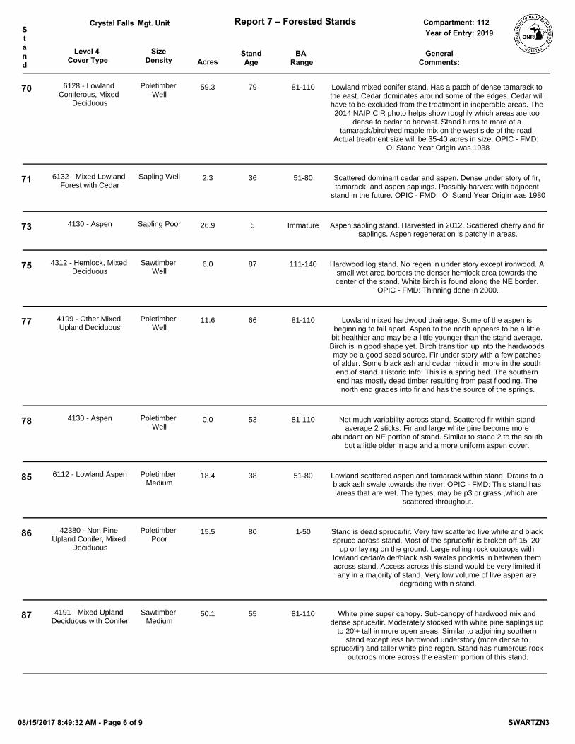
08/15/2017 8:49:32 AM - Page 5 of 9 SWARTZN3
Level 4 Cover Type Acres
StandAge
SizeDensity
BA Range
Mgt. Unit Report 7 – Forested Stands Compartment:Stand
GeneralComments:
Year of Entry:Crystal Falls
2019112
70 6128 - Lowland Coniferous, Mixed
Deciduous
Poletimber Well
59.3 79 81-110 Lowland mixed conifer stand. Has a patch of dense tamarack to the east. Cedar dominates around some of the edges. Cedar will have to be excluded from the treatment in inoperable areas. The 2014 NAIP CIR photo helps show roughly which areas are too
dense to cedar to harvest. Stand turns to more of a tamarack/birch/red maple mix on the west side of the road.
Actual treatment size will be 35-40 acres in size. OPIC - FMD: OI Stand Year Origin was 1938
71 6132 - Mixed Lowland Forest with Cedar
Sapling Well 2.3 36 51-80 Scattered dominant cedar and aspen. Dense under story of fir, tamarack, and aspen saplings. Possibly harvest with adjacent
stand in the future. OPIC - FMD: OI Stand Year Origin was 1980
73 4130 - Aspen Sapling Poor 26.9 5 Immature Aspen sapling stand. Harvested in 2012. Scattered cherry and fir saplings. Aspen regeneration is patchy in areas.
75 4312 - Hemlock, Mixed Deciduous
Sawtimber Well
6.0 87 111-140 Hardwood log stand. No regen in under story except ironwood. A small wet area borders the denser hemlock area towards the center of the stand. White birch is found along the NE border.
OPIC - FMD: Thinning done in 2000.
77 4199 - Other Mixed Upland Deciduous
Poletimber Well
11.6 66 81-110 Lowland mixed hardwood drainage. Some of the aspen is beginning to fall apart. Aspen to the north appears to be a little
bit healthier and may be a little younger than the stand average. Birch is in good shape yet. Birch transition up into the hardwoods may be a good seed source. Fir under story with a few patches of alder. Some black ash and cedar mixed in more in the south end of stand. Historic Info: This is a spring bed. The southern end has mostly dead timber resulting from past flooding. The
north end grades into fir and has the source of the springs.
78 4130 - Aspen Poletimber Well
0.0 53 81-110 Not much variability across stand. Scattered fir within stand average 2 sticks. Fir and large white pine become more
abundant on NE portion of stand. Similar to stand 2 to the south but a little older in age and a more uniform aspen cover.
85 6112 - Lowland Aspen Poletimber Medium
18.4 38 51-80 Lowland scattered aspen and tamarack within stand. Drains to a black ash swale towards the river. OPIC - FMD: This stand has areas that are wet. The types, may be p3 or grass ,which are
scattered throughout.
86 42380 - Non Pine Upland Conifer, Mixed
Deciduous
Poletimber Poor
15.5 80 1-50 Stand is dead spruce/fir. Very few scattered live white and black spruce across stand. Most of the spruce/fir is broken off 15'-20'
up or laying on the ground. Large rolling rock outcrops with lowland cedar/alder/black ash swales pockets in between them across stand. Access across this stand would be very limited if any in a majority of stand. Very low volume of live aspen are
degrading within stand.
87 4191 - Mixed Upland Deciduous with Conifer
Sawtimber Medium
50.1 55 81-110 White pine super canopy. Sub-canopy of hardwood mix and dense spruce/fir. Moderately stocked with white pine saplings up
to 20'+ tall in more open areas. Similar to adjoining southern stand except less hardwood understory (more dense to
spruce/fir) and taller white pine regen. Stand has numerous rock outcrops more across the eastern portion of this stand.
08/15/2017 8:49:32 AM - Page 6 of 9 SWARTZN3
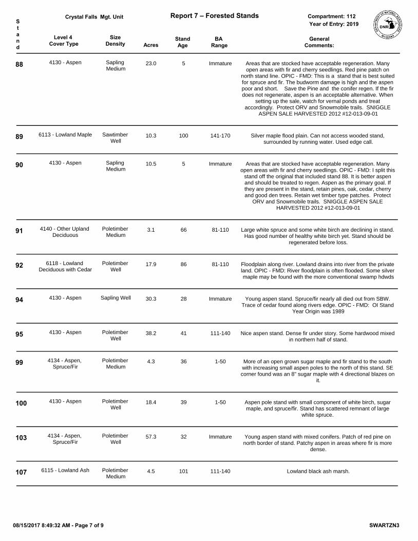
Level 4 Cover Type Acres
StandAge
SizeDensity
BA Range
Mgt. Unit Report 7 – Forested Stands Compartment:Stand
GeneralComments:
Year of Entry:Crystal Falls
2019112
88 4130 - Aspen Sapling Medium
23.0 5 Immature Areas that are stocked have acceptable regeneration. Many open areas with fir and cherry seedlings. Red pine patch on
north stand line. OPIC - FMD: This is a stand that is best suited for spruce and fir. The budworm damage is high and the aspen poor and short. Save the Pine and the conifer regen. If the fir does not regenerate, aspen is an acceptable alternative. When
setting up the sale, watch for vernal ponds and treat accordingly. Protect ORV and Snowmobile trails. SNIGGLE
ASPEN SALE HARVESTED 2012 #12-013-09-01
89 6113 - Lowland Maple Sawtimber Well
10.3 100 141-170 Silver maple flood plain. Can not access wooded stand, surrounded by running water. Used edge call.
90 4130 - Aspen Sapling Medium
10.5 5 Immature Areas that are stocked have acceptable regeneration. Many open areas with fir and cherry seedlings. OPIC - FMD: I split this
stand off the original that included stand 88. It is better aspen and should be treated to regen. Aspen as the primary goal. If they are present in the stand, retain pines, oak, cedar, cherry and good den trees. Retain wet timber type patches. Protect
ORV and Snowmobile trails. SNIGGLE ASPEN SALE HARVESTED 2012 #12-013-09-01
91 4140 - Other Upland Deciduous
Poletimber Medium
3.1 66 81-110 Large white spruce and some white birch are declining in stand. Has good number of healthy white birch yet. Stand should be
regenerated before loss.
92 6118 - Lowland Deciduous with Cedar
Poletimber Well
17.9 86 81-110 Floodplain along river. Lowland drains into river from the private land. OPIC - FMD: River floodplain is often flooded. Some silver maple may be found with the more conventional swamp hdwds
94 4130 - Aspen Sapling Well 30.3 28 Immature Young aspen stand. Spruce/fir nearly all died out from SBW. Trace of cedar found along rivers edge. OPIC - FMD: OI Stand
Year Origin was 1989
95 4130 - Aspen Poletimber Well
38.2 41 111-140 Nice aspen stand. Dense fir under story. Some hardwood mixed in northern half of stand.
99 4134 - Aspen, Spruce/Fir
Poletimber Medium
4.3 36 1-50 More of an open grown sugar maple and fir stand to the south with increasing small aspen poles to the north of this stand. SE corner found was an 8" sugar maple with 4 directional blazes on
it.
100 4130 - Aspen Poletimber Well
18.4 39 1-50 Aspen pole stand with small component of white birch, sugar maple, and spruce/fir. Stand has scattered remnant of large
white spruce.
103 4134 - Aspen, Spruce/Fir
Poletimber Well
57.3 32 Immature Young aspen stand with mixed conifers. Patch of red pine on north border of stand. Patchy aspen in areas where fir is more
dense.
107 6115 - Lowland Ash Poletimber Medium
4.5 101 111-140 Lowland black ash marsh.
08/15/2017 8:49:32 AM - Page 7 of 9 SWARTZN3
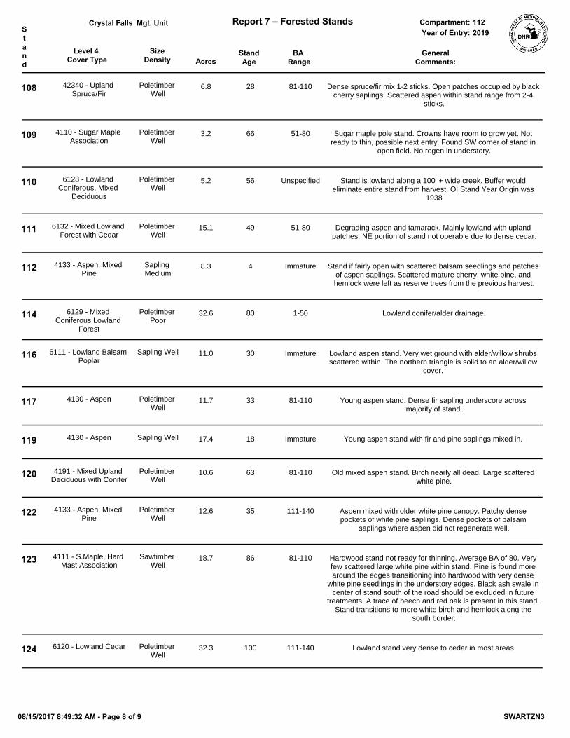
Level 4 Cover Type Acres
StandAge
SizeDensity
BA Range
Mgt. Unit Report 7 – Forested Stands Compartment:Stand
GeneralComments:
Year of Entry:Crystal Falls
2019112
108 42340 - Upland Spruce/Fir
Poletimber Well
6.8 28 81-110 Dense spruce/fir mix 1-2 sticks. Open patches occupied by black cherry saplings. Scattered aspen within stand range from 2-4
sticks.
109 4110 - Sugar Maple Association
Poletimber Well
3.2 66 51-80 Sugar maple pole stand. Crowns have room to grow yet. Not ready to thin, possible next entry. Found SW corner of stand in
open field. No regen in understory.
110 6128 - Lowland Coniferous, Mixed
Deciduous
Poletimber Well
5.2 56 Unspecified Stand is lowland along a 100' + wide creek. Buffer would eliminate entire stand from harvest. OI Stand Year Origin was
1938
111 6132 - Mixed Lowland Forest with Cedar
Poletimber Well
15.1 49 51-80 Degrading aspen and tamarack. Mainly lowland with upland patches. NE portion of stand not operable due to dense cedar.
112 4133 - Aspen, Mixed Pine
Sapling Medium
8.3 4 Immature Stand if fairly open with scattered balsam seedlings and patches of aspen saplings. Scattered mature cherry, white pine, and hemlock were left as reserve trees from the previous harvest.
114 6129 - Mixed Coniferous Lowland
Forest
Poletimber Poor
32.6 80 1-50 Lowland conifer/alder drainage.
116 6111 - Lowland Balsam Poplar
Sapling Well 11.0 30 Immature Lowland aspen stand. Very wet ground with alder/willow shrubs scattered within. The northern triangle is solid to an alder/willow
cover.
117 4130 - Aspen Poletimber Well
11.7 33 81-110 Young aspen stand. Dense fir sapling underscore across majority of stand.
119 4130 - Aspen Sapling Well 17.4 18 Immature Young aspen stand with fir and pine saplings mixed in.
120 4191 - Mixed Upland Deciduous with Conifer
Poletimber Well
10.6 63 81-110 Old mixed aspen stand. Birch nearly all dead. Large scattered white pine.
122 4133 - Aspen, Mixed Pine
Poletimber Well
12.6 35 111-140 Aspen mixed with older white pine canopy. Patchy dense pockets of white pine saplings. Dense pockets of balsam
saplings where aspen did not regenerate well.
123 4111 - S.Maple, Hard Mast Association
Sawtimber Well
18.7 86 81-110 Hardwood stand not ready for thinning. Average BA of 80. Very few scattered large white pine within stand. Pine is found more around the edges transitioning into hardwood with very dense
white pine seedlings in the understory edges. Black ash swale in center of stand south of the road should be excluded in future
treatments. A trace of beech and red oak is present in this stand. Stand transitions to more white birch and hemlock along the
south border.
124 6120 - Lowland Cedar Poletimber Well
32.3 100 111-140 Lowland stand very dense to cedar in most areas.
08/15/2017 8:49:32 AM - Page 8 of 9 SWARTZN3
Level 4 Cover Type Acres
StandAge
SizeDensity
BA Range
Mgt. Unit Report 7 – Forested Stands Compartment:Stand
GeneralComments:
Year of Entry:Crystal Falls
2019112
125 42200 - Natural White Pine
Sawtimber Medium
11.1 100 81-110 Large white pine stand. Wp averages 22". Under story is nearly fully stocked with wp saplings averaging 10'-15' tall. Crown
closure is too dense in majority of stand to release wp regeneration. Overstory appears to be 100+ years old. Under
story approximately 26 years old. Lots of wp regeneration along edges as well pushing into aspen stand.
128 6112 - Lowland Aspen Sapling Well 11.2 33 Immature Lowland aspen mixed with tamarack. OPIC - FMD: This stand has areas that are wet. The types, may be p3 or grass ,which are
scattered throughout.
129 6120 - Lowland Cedar Poletimber Well
9.3 79 111-140 Lowland conifer along stream.
131 6119 - Mixed Lowland Deciduous Forest
Sawtimber Well
5.0 106 81-110 Lowland fingers. Cedar in the west transitions to black ash.
403 42330 - Upland Fir Poletimber Poor
9.9 20 Immature Old opening grown in with fir poles. Mixed hardwood patches along edges. Mixed aspen saplings within fir and smaller poles along edges. Hard to determine an average age for this stand
due to so much variability.
08/15/2017 8:49:32 AM - Page 9 of 9 SWARTZN3
Cover Type Acres
Mgt. Unit Report 8 – Nonforested Stands Compartment:
Stand General Comments:
Year of Entry:
Managed Site
Crystal Falls 1122019
14 5.7 OPIC - FMD: North portion of highway 569122 - Road/Parking Lot No
17 15.1 OPIC - FMD: The Sturgeon River500 - Water No
32 0.6 ORV trailhead parking lot. OPIC - FMD: This is a newly established O.R.V. parking facility.
122 - Road/Parking Lot No
33 48.1 Lowland alder drainage.6220 - Alder/willow No
34 137.9 Alder drainage along stream.622 - Lowland Shrub No
41 14.9 Stand is all standing dead tamarack as far as the eye can see from the edges. Very few scattered live black spruce can be seen from the edges. Small patch of dense
cedar/black spruce along north border. OPIC - FMD: OI Stand Year Origin was 1920
3302 - Low Density Conifer Trees No
48 7.4 Lowland transition. Fir, cherry, ands aspen saplings scattered. OPIC - FMD: lowland around north pond
3303 - Mixed Low Density Trees No
52 1.9 OPIC - FMD: South portion of highway 569122 - Road/Parking Lot No
59 1.2 Opening with fir growing in.3302 - Low Density Conifer Trees No
62 10.1 OPIC - FMD: The Sturgeon River500 - Water No
63 3.6 Opening with scattered cherry and fir saplings along with some aspen poles.310 - Herbaceous Openland No
72 62.5 Excellent aspen regeneration. Lowland conifer strip in center of stand. OPIC - FMD: If they are present in the stand, retain pines, oak, cedar, cherry and good den trees.
Retain wet timber type patches. Protect ORV and Snowmobile trails. SNIGGLE ASPEN SALE HARVESTED 2012 #12-013-09-01
330 - Low-Density Trees
74 3.1 Grass opening. Scattered cherry and aspen seedlings and saplings. Fir and aspen poles also scattered within stand.
330 - Low-Density Trees No
76 3.0 Opening growing in with non merchantable fir. Scattered hardwood mixed in. OPIC - FMD: MAINTAIN OPENINGS WITH MECHANICAL MEANS.
3302 - Low Density Conifer Trees No
101 3.0 Opening with fir saplings scattered within.310 - Herbaceous Openland No
115 10.8 River floodplain. Silver maple along rivers edge.6229 - Mixed lowland shrub No
08/15/2017 8:49:40 AM - Page 1 of 2 SWARTZN3
Cover Type Acres
Mgt. Unit Report 8 – Nonforested Stands Compartment:
Stand General Comments:
Year of Entry:
Managed Site
Crystal Falls 1122019
118 5.2 Alder drainage.6220 - Alder/willow No
130 1.2 Highway122 - Road/Parking Lot No
401 2.4 Balsam around edges. OPIC - FMD: MAINTAIN OPENINGS WITH MECHANICAL MEANS.
310 - Herbaceous Openland No
404 2.7 Opening heavy to fir saplings in patches.330 - Low-Density Trees No
405 1.8 Fir and cherry saplings within. Aspen encroaching around edges. OPIC - FMD: MAINTAIN OPENINGS WITH MECHANICAL MEANS.
31029 - Grass (OI) No
407 2.3 OPIC - FMD: MAINTAIN OPENING WITH MECHANICAL MEANS.310 - Herbaceous Openland No
410 12.3 Opening with scattered cherry saplings and fir poles. OPIC - FMD: This stand may have gotten some herbicide in years past. The cherry is starting to encroach.
330 - Low-Density Trees No
411 7.2 Fir opening. Mixed aspen saplings along with other mixed hardwood poles. This opening may become manageable for timber in the near future.
3302 - Low Density Conifer Trees No
412 4.8 Opening becoming very grown in non merchantable fir. Can probably be considered forested next entry year as a stand or merged with an adjacent stand. OPIC - FMD: