GEODETA 2019 The 1st International Conference on Geodesy, Geomatics, and Land Administration 2019 Volume 2019 Conference Paper Determination of Vertical Deflection Based on Terestrial Gravity Disturbance Data (A Case Study in Semarang City) L M Sabri 1 , Bambang Sudarsono 1 , and Rina Dwi Indriana 2 1 Department of Geodetic Engineering, Faculty of Engineering, Universitas Diponegoro, Indonesia 2 Department of Geophysic, Faculty of Science and Mathematic, Universitas Diponegoro, Indonesia Abstract Vertical deflection can be determined by geometrical and physical measurement. In geometrical way, vertical deflection is obtained by comparing astronomical coordinate and geodetical coordinate. In physical way, vertical deflection can be computed from gravity measurement. In the past, vertical deflection was computed from gravity anomaly data. Gravity anomaly data measurement is difficult because it need reduction of gravity from surface of the earth to the geoid using orthometric height from spirit level measurement. In modern era, gravity anomaly data may be replaced by gravity disturbance data whose only required gravity and GNSS (Global Navigation Satellite System) measurement. This research aims to determine vertical deflection in Semarang City from terrestrial gravity disturbance data. The gravity data were measured in March of 2016. Formula of Vening Meinesz that usually used for vertical deflection was replaced by new formula that generated from derivation of function of Hotine. Applying gravity disturbance gave vertical deflection of east-west component that were vary from -1.2" to 12.2" while north-south component were vary from -4.2" to 4.2". Comparing vertical deflection as computed from terrestrial data to as computed from EGM2008 coefficients showed conformity in shape and values. It was concluded that derivation of function of Hotine could be applied for vertical deflection determination from gravity disturbance. Keywords: vertical deflection, gravity disturbance, Hotine Function, Vening Meinesz 1. Introduction Vertical deflection is deviation of actual plumbline from normal plumbline [1]. Actual plumbline is perpendicular to geoid while normal plumbline is perpendicular to ellipsoid. In the flat area. the deviation value can be ignored, while in mountainous area, the deflection values are large and must be considered as systematic error. Deflection vertical value is important for many geodesy applications [2]. Transforming astronomical coordinates into geodetic coordinates, transforming astronomical azimuth into geodetic How to cite this article: L M Sabri, Bambang Sudarsono, and Rina Dwi Indriana, (2019), ``Determination of Vertical Deflection Based on Terestrial Gravity Disturbance Data (A Case Study in Semarang City)'' in The 1st International Conference on Geodesy, Geomatics, and Land Administration 2019, KnE Engineering, pages 106--114. DOI 10.18502/keg.v4i3.5834 Page 106 Corresponding Author: L M Sabri [email protected]Received: 20 August 2019 Accepted: 24 November 2019 Published: 26 December 2019 Publishing services provided by Knowledge E L M Sabri et al. This article is distributed under the terms of the Creative Commons Attribution License, which permits unrestricted use and redistribution provided that the original author and source are credited. Selection and Peer-review under the responsibility of the GEODETA 2019 Conference Committee.
Transcript
GEODETA 2019The 1st International Conference on Geodesy, Geomatics, andLand Administration 2019Volume 2019
Conference Paper
Determination of Vertical Deflection Based onTerestrial Gravity Disturbance Data (A CaseStudy in Semarang City)L M Sabri1, Bambang Sudarsono1, and Rina Dwi Indriana2
1Department of Geodetic Engineering, Faculty of Engineering, Universitas Diponegoro, Indonesia2Department of Geophysic, Faculty of Science and Mathematic, Universitas Diponegoro,Indonesia
AbstractVertical deflection can be determined by geometrical and physical measurement. Ingeometrical way, vertical deflection is obtained by comparing astronomical coordinateand geodetical coordinate. In physical way, vertical deflection can be computedfrom gravity measurement. In the past, vertical deflection was computed from gravityanomaly data. Gravity anomaly data measurement is difficult because it need reductionof gravity from surface of the earth to the geoid using orthometric height from spiritlevel measurement. In modern era, gravity anomaly data may be replaced by gravitydisturbance data whose only required gravity and GNSS (Global Navigation SatelliteSystem) measurement. This research aims to determine vertical deflection in SemarangCity from terrestrial gravity disturbance data. The gravity data were measured in Marchof 2016. Formula of Vening Meinesz that usually used for vertical deflection wasreplaced by new formula that generated from derivation of function of Hotine. Applyinggravity disturbance gave vertical deflection of east-west component that were varyfrom -1.2" to 12.2" while north-south component were vary from -4.2" to 4.2". Comparingvertical deflection as computed from terrestrial data to as computed from EGM2008coefficients showed conformity in shape and values. It was concluded that derivationof function of Hotine could be applied for vertical deflection determination from gravitydisturbance.
Vertical deflection is deviation of actual plumbline from normal plumbline [1]. Actualplumbline is perpendicular to geoid while normal plumbline is perpendicular to ellipsoid.In the flat area. the deviation value can be ignored, while in mountainous area, thedeflection values are large and must be considered as systematic error. Deflectionvertical value is important for many geodesy applications [2]. Transforming astronomicalcoordinates into geodetic coordinates, transforming astronomical azimuth into geodetic
How to cite this article: L M Sabri, Bambang Sudarsono, and Rina Dwi Indriana, (2019), ``Determination of Vertical Deflection Based on TerestrialGravity Disturbance Data (A Case Study in Semarang City)'' in The 1st International Conference on Geodesy, Geomatics, and Land Administration2019, KnE Engineering, pages 106--114. DOI 10.18502/keg.v4i3.5834
azimuth, reducing horizontal and vertical angles to areference ellipsoid. Deflectionvertical value also can be used for predicting gravity and geoid [3]
Along with the widespread use of GNSS in determining the position of the horizontalcontrol network, the theodolite measurement is only applied to small areas and specificareas that cannot be measured with GNSS. Vertical defection is still useful in the case ofcombining the theodolite and GNSS measurement results [4]. In some cases, mergingthe theodolite measurement data produces different coordinates with the results ofthe GNSS measurement. The discrepancies occur mainly in areas that have significantvertical deflection.
At present, there are almost no studies on vertical deflection in Indonesia [5]. Gravitydata in large area is frequently used for geoid determination [6]. Gravity anomaly data isused to calculate geoids with the Stokes andMolodensky approach. Gravity disturbancedata is used to calculate geoid by Hotine approach [7]. Outside of Indonesia, gravitydisturbance data is not only used for geoid calculations but also for vertical deflectioncalculations.
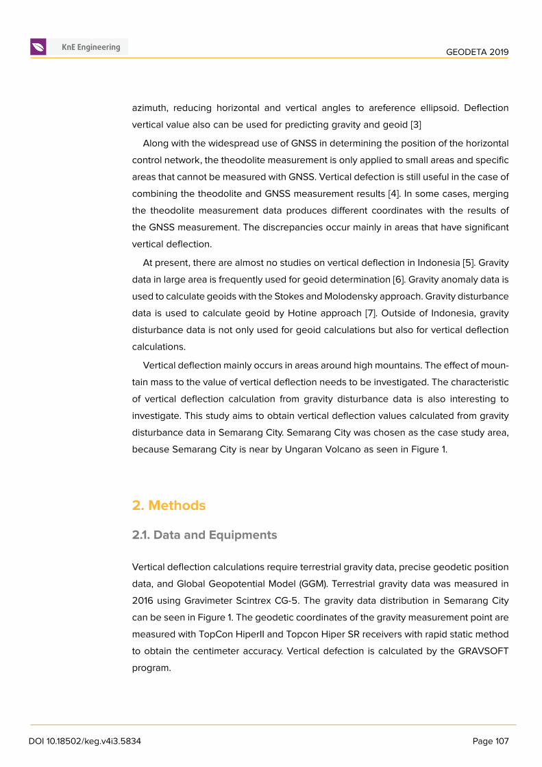
Vertical deflection mainly occurs in areas around high mountains. The effect of moun-tain mass to the value of vertical deflection needs to be investigated. The characteristicof vertical deflection calculation from gravity disturbance data is also interesting toinvestigate. This study aims to obtain vertical deflection values calculated from gravitydisturbance data in Semarang City. Semarang City was chosen as the case study area,because Semarang City is near by Ungaran Volcano as seen in Figure 1.
2. Methods
2.1. Data and Equipments
Vertical deflection calculations require terrestrial gravity data, precise geodetic positiondata, and Global Geopotential Model (GGM). Terrestrial gravity data was measured in2016 using Gravimeter Scintrex CG-5. The gravity data distribution in Semarang Citycan be seen in Figure 1. The geodetic coordinates of the gravity measurement point aremeasured with TopCon HiperII and Topcon Hiper SR receivers with rapid static methodto obtain the centimeter accuracy. Vertical defection is calculated by the GRAVSOFTprogram.
DOI 10.18502/keg.v4i3.5834 Page 107
GEODETA 2019
.
a b
Figure 1: Research area, topographical situation (a), terrestrial gravity disturbance data (b).
2.2. Computation of vertical deflection
Actual plumbline is a line that is perpendicular to the actual gravity equipotentialplane, whereas normal plumbline is a line that is perpendicular to the normal gravityequipotential plane. Geoid is one of the actual gravity equipotential fields, while thereference ellipsoid is one of the normal equipotential fields. Every point on the surfaceof the earth, inside the earth, and outside the earth has a normal and actual gravitationalpotential value. Normal and actual gravitational potential values at a point can bedifferent. The difference between the actual and normal potential values is called aspotential disturbance (T) as written below:
𝑇 = 𝑊 − 𝑈 (1)
where W is actual gravity potential and U is potential of normal gravity.
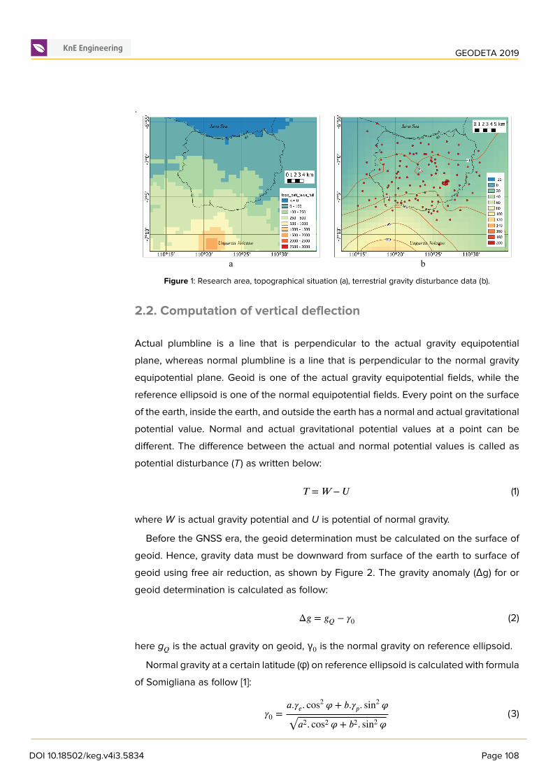
Before the GNSS era, the geoid determination must be calculated on the surface ofgeoid. Hence, gravity data must be downward from surface of the earth to surface ofgeoid using free air reduction, as shown by Figure 2. The gravity anomaly (Δg) for orgeoid determination is calculated as follow:
Δ𝑔 = 𝑔𝑄 − 𝛾0 (2)
here g𝑄 is the actual gravity on geoid, γ0 is the normal gravity on reference ellipsoid.
Normal gravity at a certain latitude (φ) on reference ellipsoid is calculated with formulaof Somigliana as follow [1]:
𝛾0 =𝑎.𝛾𝑒. cos2 𝜑 + 𝑏.𝛾𝑝. sin2 𝜑
√𝑎2. cos2 𝜑 + 𝑏2. sin2 𝜑(3)
DOI 10.18502/keg.v4i3.5834 Page 108
GEODETA 2019
where, γ𝑒 is the gravity at equator, γ𝑝 is the gravity at poles, a is semi-major axis ofthe reference ellipsoid, b is semi-minor axis of the reference ellipsoid. Normal gravityvalues on the surface of the earth (γ𝑃 ) can be calculated by following formula:
where m is a physical constant representing comparison of centrifugal force at equatorand gravity at equator, f is geometrical flattening of reference ellipsoid, h is a geodeticheight of observation point above reference ellipsoid.
First derivation of potential disturbance is gravity disturbance (Δg). Theoretically,gravity disturbance as direct derivation value must be more accurate than gravityanomaly (Δg) for geoid determination. Gravity disturbance (Δg) is calculated by thefollowing equation:
𝛿𝑔 = 𝑔𝑃 − 𝛾𝑃 (5)
where is g𝑃 is the actual gravity on arbitrary surface. For calculation of gravity distur-bance on the surface of the earth, the terrestrial gravity data do not need to be reducedto geoid, as shown in Figure 2.
a b
Figure 2: Actual and normal gravity data, on geoid (a), on surface of the earth (b).
Geoid undulation can be calculated from gravity anomaly data or gravity disturbancedata [8]. Calculations with gravity anomaly data are known as the Stokes or Molodenskyapproach and use the function of Stokes [1] as follow:
𝑆 (𝜓) = 1sin 𝜓
2+ 1 − 6. sin 𝜓2 − 5. cos 𝜓 − 3. cos 𝜓. ln (sin
𝜓2 + sin2 𝜓2 ) (6)
where S(ψ) is function of Stokes that computed using spherical distance (ψ) fromevaluation points to gridded gravity anomaly data. Geoid determination with gravity
DOI 10.18502/keg.v4i3.5834 Page 109
GEODETA 2019
disturbance data is called as the Hotine approach using the function of Hotine [1] asfollow:
𝐻 (𝜓) = 1sin 𝜓
2− ln(1+
1sin 𝜓
2 )(7)
The calculation of vertical deflection from gravity anomaly data traditionally applythe formula of Vening Meinesz, while the calculation of vertical deflection from gravitydisturbance data is not popular. The Vening Meinesz formula is the first derivative ofthe function of Stokes with respect to spherical distances as shown below:
𝜕𝑆 (𝜓)𝜕𝜓 = − cos 𝜓2
2sin2 𝜓2+ 8 sin 𝜓 − 6. cos 𝜓2 − 3.
1− sin 𝜓2
sin 𝜓 + 3. sin 𝜓. ln (sin𝜓2 + sin2 𝜓2 ) (8)
Applying similar technique, derivation of the Hotine function produces the followingequation:
𝜕𝐻 (𝜓)𝜕𝜓 = cos 𝜓2
2sin2 𝜓2 (−1+ sin 𝜓
21+ sin 𝜓
2 )(9)
One of the geoid calculation techniques that is often applied is R-C-R as abbreviationof Remove-Compute-Restore [9]. The principle of R-C-R is to calculate the geoid withthe small gravity anomaly data by reducing the long wave and short wave componentsin the terrestrial gravity data. The long wave component is represented by GGM, whileshortwave component is surrounding topography. Hypothetically, R-C-R can be appliedfor calculation of vertical deflection. The REMOVE part of R-C-R technique appliedfor computing residual gravity disturbance (Δg𝑅𝐸𝑆 ) is only to reduce terrestrial gravitydisturbance data (Δg𝑃 ) with gravity disturbance from EGM2008 (Δg𝐸𝐺𝑀2008) withoutreducing the topographic effect (Δg𝑡𝑜𝑝𝑜), as shown below:
𝛿𝑔𝑅𝐸𝑆 = 𝛿𝑔𝑝 − 𝛿𝑔𝐸𝐺𝑀2008 (10)
Residual gravity disturbances (Δg𝑅𝐸𝑆 ) at measurement points are then interpolatedto obtain continuous gridded residual gravity disturbance data (Δg𝐺𝑅𝐼𝐷) over calculationarea.the COMPUTE part of R-C-R technique is to apply gridded residual gravity distur-bance for computing residual vertical deflection in North-South (ξ𝑅𝐸𝑆 ) and the East-West(η𝑅𝐸𝑆 ) as follows:
𝜉𝑟𝑒𝑠 (𝜑, 𝜆) =1
4.𝜋.𝛾0 ∫2𝜋
𝜆′=0∫
𝜋/2𝜑′=−𝜋/2
𝛿𝑔𝐺𝑅𝐼𝐷 (𝜑′, 𝜆′) .𝜕𝐻 (𝜓)𝜕 (𝜓) . cos 𝛼.𝑑𝜑′.𝑑𝜆′ (11)
𝜂𝑟𝑒𝑠 (𝜑, 𝜆) =1
4.𝜋.𝛾0 ∫2𝜋
𝜆′=0∫
𝜋/2𝜑′=−𝜋/2
𝛿𝑔𝐺𝑅𝐼𝐷 (𝜑′, 𝜆′) .𝜕𝐻 (𝜓)𝜕 (𝜓) . sin 𝛼.𝑑𝜑′.𝑑𝜆′ (12)
DOI 10.18502/keg.v4i3.5834 Page 110
GEODETA 2019
where α is the azimuth from the evaluation point to the gridded points. North-South(ξ𝑅𝐸𝑆 ) and East-West (η𝑅𝐸𝑆 ) of the Vertical Deflection from EGM2008 n=2190 and m =2160 are calculated as follows:
𝜉𝐸𝐺𝑀2008 = −𝐺𝑀𝑟2𝛾
𝑀
∑𝑚=0(
cos𝑚𝜆𝑀
∑𝑚=0
(𝑎𝑟)
𝑛 ̄𝐶𝑛𝑚𝑃𝑛𝑚 (sin 𝜑) + sin𝑚𝜆𝑀
∑𝑚=0
(𝑎𝑟)
𝑛 ̄𝑆𝑛𝑚𝑃𝑛𝑚 (sin 𝜑))(13)
𝜂𝐸𝐺𝑀2008
= − 𝐺𝑀𝑟2𝛾 cos 𝜑
𝑀
∑𝑚=0
𝑚(cos𝑚𝜆
𝑚
∑𝑚=0
(𝑎𝑟)
𝑛 ̄𝑆𝑛𝑚𝑃𝑛𝑚 (sin 𝜑) − sin𝑚𝜆𝑀
∑𝑚=0
(𝑎𝑟)
𝑛 ̄𝐶𝑛𝑚𝑃𝑛𝑚 (sin 𝜑))(14)
where G is Newton gravitational constant, M is mass of the earth, R is radii of the earth,P𝑛,𝑚 is function of Legendre, while φ and λ is latitude and longitude of evaluation points.The value depends on degree (n) and order (m) of the function. The RESTORE part ofR-C-R technique for obtaining definitive vertical deflection is calculated by equationsbelow:
𝜉 = 𝜉𝑅𝐸𝑆 + 𝜉𝐺𝐺𝑀 (15)
𝜂 = 𝜂𝑅𝐸𝑆 + 𝜂𝐺𝐺𝑀 (16)
3. Results
Vertical defection was calculated using several modification of FORTRAN scripts in theGravsoft program. One modified part is replacing the Vening Meinesz function with thederivative function of the Hotine function in the STOKES program. Modifications aimto calculate vertical deflection from gravity disturbance data. The vertical deflectionof GGM is calculated based on the coefficient EGM2008 with n = 2190. In SemarangCity, the north-south component is graded from -4 arc second to 4 arc second fromnorthwest to southeast, while the east-west component is graded from -1 arc second to12 arc second from Northeast to Southwest direction, as shown in Figure 3. The resultsshow that Mount Ungaran has a significant effect on deflection of plumbline in thecity of Semarang.This study also calculates vertical deflection in two ways, namely theR-C-R method and the direct method. The direct method is the process of calculatingthe vertical deflection by directly using the gravity disturbance data with reducing thelong wave and short wave components. Calculations using the direct method produceda vertical deflection map that similar to the shape of a vertical deflection map from
DOI 10.18502/keg.v4i3.5834 Page 111
GEODETA 2019
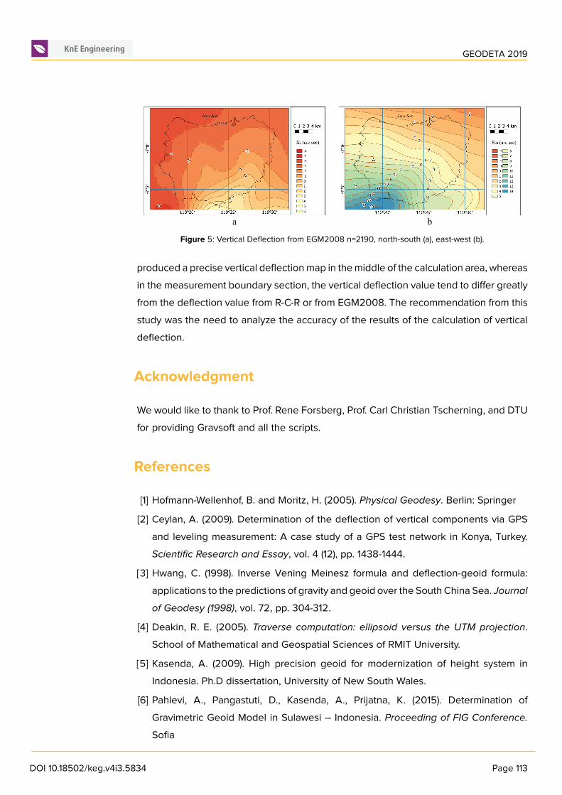
EGM2008, but with a smaller vertical deflection value. The north-south component isgraded from -1 arc second to 5 arc second from Northwest to Southeast, while theeast-west component is graded from 4 arc seconds to 14 arc second from Northeast toSouthwest, as shown in Figure 4.Calculations using the R-C-R method produce a verticaldeflection map that more or less conform to the shape of a vertical deflection map fromEGM2008, but with more detailed shape values. The north-south component is gradedfrom -5 arc second to 3 arc second from Northwest to Southeast, while the east-westcomponent is graded from -1 arc second to 14 arc second from Northeast to Southwest,as shown in Figure 5. Some hills and valleys in Semarang City significantly influencedthe amount of vertical deflection.
The derivation of function of Hotine introduced a new function that could be used tocalculate vertical deflection from gravity disturbance data. The vertical deflection of thegravity disturbance data on the surface had the same shape as the vertical deflectionof the EGM2008 data.The application of the R-C-R method for the calculation of verticaldeflection with gravity disturbance data also gave satisfying results. Direct calculations
produced a precise vertical deflectionmap in themiddle of the calculation area, whereasin the measurement boundary section, the vertical deflection value tend to differ greatlyfrom the deflection value from R-C-R or from EGM2008. The recommendation from thisstudy was the need to analyze the accuracy of the results of the calculation of verticaldeflection.
Acknowledgment
We would like to thank to Prof. Rene Forsberg, Prof. Carl Christian Tscherning, and DTUfor providing Gravsoft and all the scripts.
References
[1] Hofmann-Wellenhof, B. and Moritz, H. (2005). Physical Geodesy. Berlin: Springer
[2] Ceylan, A. (2009). Determination of the deflection of vertical components via GPSand leveling measurement: A case study of a GPS test network in Konya, Turkey.Scientific Research and Essay, vol. 4 (12), pp. 1438-1444.
[3] Hwang, C. (1998). Inverse Vening Meinesz formula and deflection-geoid formula:applications to the predictions of gravity and geoid over the South China Sea. Journalof Geodesy (1998), vol. 72, pp. 304-312.
[4] Deakin, R. E. (2005). Traverse computation: ellipsoid versus the UTM projection.School of Mathematical and Geospatial Sciences of RMIT University.
[5] Kasenda, A. (2009). High precision geoid for modernization of height system inIndonesia. Ph.D dissertation, University of New South Wales.
[6] Pahlevi, A., Pangastuti, D., Kasenda, A., Prijatna, K. (2015). Determination ofGravimetric Geoid Model in Sulawesi -- Indonesia. Proceeding of FIG Conference.
Sofia
DOI 10.18502/keg.v4i3.5834 Page 113
GEODETA 2019
[7] Sabri, L. M., Heliani, L. S., Sunantyo, T. A., Widjajanti, N. (2019). Geoid dterminationwith Hotine's Integral based on terrestrial gravity data in Semarang city. The 6𝑡ℎ
International Conference on Mathematics and Natural Sciences. Yogyakarta.
[8] Kirby, J. F. (2003). On the Combination of Gravity Anomalies andGravity Disturbancesfor Vertical deflection Determination in Western Australia. Journal of Geodesy. Vol.77, pp. 433-439.
[9] Sanso, F. and Sideris, M. (2013).Geoid Determination: Theory andMethods. Springer.