Saudi Aramco: Public Page 1 Conflict Detection at Proposed Well Location Using WebGIS Authors Hassan, Qaiser; Abdul Haleem, Syed; Hawi, Maan A Abstract There is a dependency on the various geological, geographical, and infrastructural datasets for the identification of the conflicts at the actual location of a proposed exploration well and along the route. Various aspects are evaluated against the proposed well location and missing one aspect could incur large costs and effort. Identifying these conflicts before sending a rig to a proposed well location can save huge costs and resources linked to rig and related logistics movement. Saudi Aramco’s upstream web-based geographical information system (WebGIS) integrates disparate datasets into a holistic interface. Having access to all the datasets required for finding conflicts against the proposed well location, WebGIS is also equipped with a Conflict Detection functionality which is automated using the power of ArcGIS geoprocessing services. ArcGIS geoprocessing service for conflict detection consists of geoprocessing task which initiate the geoprocessing models and ultimately evaluate all the proximity rules defined for all the disparate data types against the proposed well location. The system is flexible enough to accommodate more proximity rules. This process facilitates engineers and managers locating these conflicts before making a decision to move a rig. Conflicts are reported on the map as geographic features along with distance in meters measured from the proposed well location. This paper will provide a description of all the tools and methodologies developed for finding conflicts at well location and along the rig movement route. Keywords Conflict Detection, Proposed Well Location Conflicts, Rig Movement
Transcript
Saudi Aramco: Public Page 1
Conflict Detection at Proposed Well Location Using WebGIS
Authors
Hassan, Qaiser; Abdul Haleem, Syed; Hawi, Maan A
Abstract
There is a dependency on the various geological, geographical, and infrastructural datasets for the identification of the conflicts at the actual location of a proposed exploration well and along the route. Various aspects are evaluated against the proposed well location and missing one aspect could incur large costs and effort. Identifying these conflicts before sending a rig to a proposed well location can save huge costs and resources linked to rig and related logistics movement. Saudi Aramco’s upstream web-based geographical information system (WebGIS) integrates disparate datasets into a holistic interface. Having access to all the datasets required for finding conflicts against the proposed well location, WebGIS is also equipped with a Conflict Detection functionality which is automated using the power of ArcGIS geoprocessing services. ArcGIS geoprocessing service for conflict detection consists of geoprocessing task which initiate the geoprocessing models and ultimately evaluate all the proximity rules defined for all the disparate data types against the proposed well location. The system is flexible enough to accommodate more proximity rules. This process facilitates engineers and managers locating these conflicts before making a decision to move a rig. Conflicts are reported on the map as geographic features along with distance in meters measured from the proposed well location. This paper will provide a description of all the tools and methodologies developed for finding conflicts at well location and along the rig movement route.
Keywords
Conflict Detection, Proposed Well Location Conflicts, Rig Movement
Saudi Aramco: Public Page 2
Introduction
This paper will begin with the overview of the Saudi Aramco’s upstream web based GIS application (here after referred to as WebGIS), which provides integrated map-view of various scattered data sources available within different departments of exploration, production, and drilling. These datasets are key parameters for the identification of the conflicts at the proposed well location. Having access to all these data sources in WebGIS, decision makers can query data and overlay selected data which helps in devising new facts and ultimately helps in better decision making. In addition to various advanced level query and visualization tools, WebGIS is equipped with various analytical tools providing decision makers to do analytics using the available data which saves Saudi Aramco a lot of resources such as rig movement per kilometers and rig days. In the remaining part of the paper, one such a tool named Well Location Conflicts Detection will be discussed in details and its need and implementation will be explained. The paper will then conclude by summarizing the effectiveness achieved in terms of cost and resources before mobilizing the rigs and necessary logistics to a planned well location. WebGIS
WebGIS application and all its analytical tools are developed by the EXPEC Computer Center (ECC) of Saudi Aramco, using the Portal for ArcGIS from ESRI. WebGIS application objective is to enhance the exploration & production business processes and optimize the usage of shared resources. WebGIS application provides its users with integrated access to spatial and tabular data on hydrocarbon reservoirs, geology, geophysics, prospects, leads, seismic, drilling, infrastructure and satellite & aerial imagery. These various data types being accessed in the WebGIS, are managed and updated in relevant departments in order to ensure data is correct and up-to-date. The data is hosted on the company’s corporate database. WebGIS application follows Saudi Aramco’s corporate security model for data access, ensuring data security and confidentiality. WebGIS application facilitates enhanced decision making which ultimately contributes to cost savings and efficient utilization of resources. WebGIS Architecture
At the core of WebGIS architecture is ESRI’s geodatabase technology named SDE which is a spatial database storing the spatial data of various departments in exploration & production. All of these departments have their own schema in SDE where their relevant data is stored and managed. Permissions to access the data is granted by these relevant departments. WebGIS access the data in SDE using ArcGIS Server’s rest services which is the standard way of accessing the GIS data over the web and making them available to users. There is a cluster of three ArcGIS Servers serving rest based GIS services. First ArcGIS Server serves map and feature services. All the geospatial vector data is made available through WebGIS via this server. The second ArcGIS Server serves the
Saudi Aramco: Public Page 3
geoprocessing services, and third serves the image services. In order to access these services over the web, ESRI’s Web Adaptor is installed and configured with the cluster. Web Adaptor provides a single endpoint that distributes incoming requests to the cluster which then forwards the request to the relevant ArcGIS server and ultimately once received, sends back the requested data via a rest based service. Portal for ArcGIS creates a web map with all these GIS services and shares with only the intended users via groups.
Figure 1- WebGIS Architecture
WebGIS application was created using ESRI’s webapp builder which allows creating applications. Plenty of off-the-shelf application templates and widgets are available to readily use in webapp builder. WebGIS wascreated using “foldable theme” in the webapp builder and only required widgets were included. All the remaining required widgets were custom developed using ArcGIS API for Javascript and DOJO. Few javascript libraries were used for charting. WebGIS accesses the GIS data via the Portal for ArcGIS web map as highlighted in the figure 1. Some of the corporate data is available in the company’s corporate oracle database and is accessed via rest-full services in WebGIS. These rest-full
Saudi Aramco: Public Page 4
services are developed in java and deployed in weblogic server using spring framework.
Conflict Detection Widget
The drive to have such a widget was to identify the conflicts which could stop the well from drilling at the proposed well location before mobilizing the necessary logistics to that proposed well location. Mobilization of the rig and necessary logistic incurs huge cost, and if there is a detour then cost multiplies. Due to low oil prices it becomes inevitable to avoid extra costs and mobilize the rig and the necessary logistic in an optimal way.
With the consideration of efficient utilization of resources, this widget was developed. It leverages the power of the model builder and ArcGIS geoprocessing services. A model was designed in ArcGIS Model Builder as shown in the right side of the Figure 2.
Figure 2- Conflict Detection Model
In this model, a proposed well location or set of proposed well locations are evaluated as how distant these are from a set of spatial GIS layers. The distance rules are set separately for each type of GIS layers depending on the business requirement. If a proposed well location is within the proximity of any specific GIS
Saudi Aramco: Public Page 5
layer, it is considered that the proposed well location has a conflict with that specific GIS layer. The specific feature from that GIS layer with which proposed location is conflicting is copied to a new GIS layer called “Conflicted_Data”. The model loops through all GIS layers against the proposed well location and continues copying the conflicting features and once model finishes its processing, “Conflicted_Data” is populated with all the features which are in conflict with the proposed well locations. These GIS data layers against which the proximity is calculated are Aeronautical, Piplelines, Plants, Populated Places, Power Plants, Shipping Boundaries, Transportation, Water body, Wildlife, and existing producing Wells as shown in the left side of figure 2. The model can accommodate more layers depending on the future requirements.
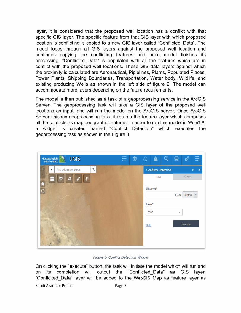
The model is then published as a task of a geoprocessing service in the ArcGIS Server. The geoprocessing task will take a GIS layer of the proposed well locations as input, and will run the model on the ArcGIS server. Once ArcGIS Server finishes geoprocessing task, it returns the feature layer which comprises all the conflicts as map geographic features. In order to run this model in WebGIS, a widget is created named “Conflict Detection” which executes the geoprocessing task as shown in the Figure 3.
Figure 3- Conflict Detection Widget
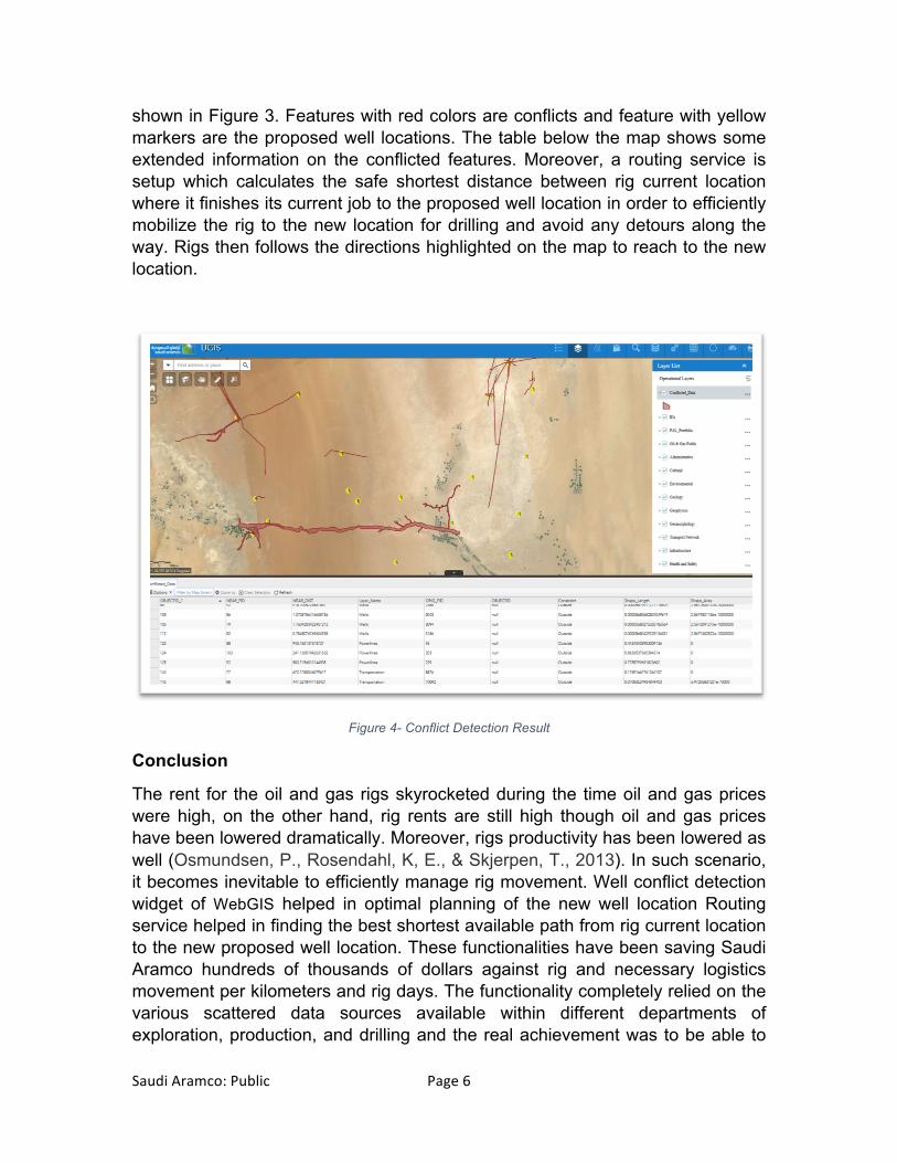
On clicking the “execute” button, the task will initiate the model which will run and on its completion will output the “Conflicted_Data” as GIS layer. “Conflcited_Data” layer will be added to the WebGIS Map as feature layer as
Saudi Aramco: Public Page 6
shown in Figure 3. Features with red colors are conflicts and feature with yellow markers are the proposed well locations. The table below the map shows some extended information on the conflicted features. Moreover, a routing service is setup which calculates the safe shortest distance between rig current location where it finishes its current job to the proposed well location in order to efficiently mobilize the rig to the new location for drilling and avoid any detours along the way. Rigs then follows the directions highlighted on the map to reach to the new location.
Figure 4- Conflict Detection Result
Conclusion
The rent for the oil and gas rigs skyrocketed during the time oil and gas prices were high, on the other hand, rig rents are still high though oil and gas prices have been lowered dramatically. Moreover, rigs productivity has been lowered as well (Osmundsen, P., Rosendahl, K, E., & Skjerpen, T., 2013). In such scenario, it becomes inevitable to efficiently manage rig movement. Well conflict detection widget of WebGIS helped in optimal planning of the new well location Routing service helped in finding the best shortest available path from rig current location to the new proposed well location. These functionalities have been saving Saudi Aramco hundreds of thousands of dollars against rig and necessary logistics movement per kilometers and rig days. The functionality completely relied on the various scattered data sources available within different departments of exploration, production, and drilling and the real achievement was to be able to
Saudi Aramco: Public Page 7
acquire the access to all these datasets in WebGIS, which are then fed into the model in order to evaluate against the proposed well location. It is expected to add more datasets into the model in the future.
References
ESRI ArcMap 10.3 Documentation, Proximity analysis. Retreived from http://desktop.arcgis.com/en/arcmap/10.3/analyze/commonly-used-tools/proximity-analysis.htm ESRI ArcMap 10.3 Documentation, What is Model Builder? Retreived from http://desktop.arcgis.com/en/arcmap/10.3/analyze/modelbuilder/what-is-modelbuilder.htm ESRI ArcGIS for Server, What is a geoprocessing service? Retreived from http://server.arcgis.com/en/server/latest/publish-services/linux/what-is-a-geoprocessing-service-.htm ESRI ArcGIS REST API (Sep, 2016), Route service with asynchronous execution. Retreived from http://resources.arcgis.com/en/help/arcgis-rest-api/#/Route_service_with_asynchronous_execution/02r300000275000000/ Osmundsen, Petter; Rosendahl, Knut Einar; Skjerpen, Terje (2013). Contract Structure and Rig Rates. ISSN 1559-792X.
Acknowledgements
The author would like to acknowledge the support of Saudi Aramco’s E&P management for the permission to publish this paper along with the support and assistance of many colleagues to mention few Kharashi, Waad Y., Ahmed, Muhammad Zeeshan., and Mudaris, Sami M. They have contributed to the ongoing success of the WebGIS application within E&P, Saudi Aramco.
Author Information
Qaiser Hassan is currently a GIS Analyst/ Developer working for the EXPEC Computer Center (ECC) of Saudi Aramco, Dhahran. He received his Master of Science degree in 2012 from The University of Leeds, UK in Geographical Information System. He is the developer behind the Saudi Aramco’s E&P WebGIS application.