12
COORDINATES & PROJECTIONS G001 Spherical coordinates ☼ Angles ☼ Latitude ☼ Longitude G103

COORDINATES & PROJECTIONS
G001
Sphericalcoordinates☼Angles☼ Latitude☼ Longitude
G103

Ellipsoids
☼Major axis☼Minor axis☼ Flattening ratio
G001
Geoids
☼Uneven surface
☼Bumps & dimples
G106

Geoidal height G060
Earth surfacesG058

Datums
☼Starting point for measuring Earth’s size☼Basis for grid systems☼Based on different ellipsoids☼NAD27☼NAD83 ( GRS80)☼WGS84
Comparing datumsG061
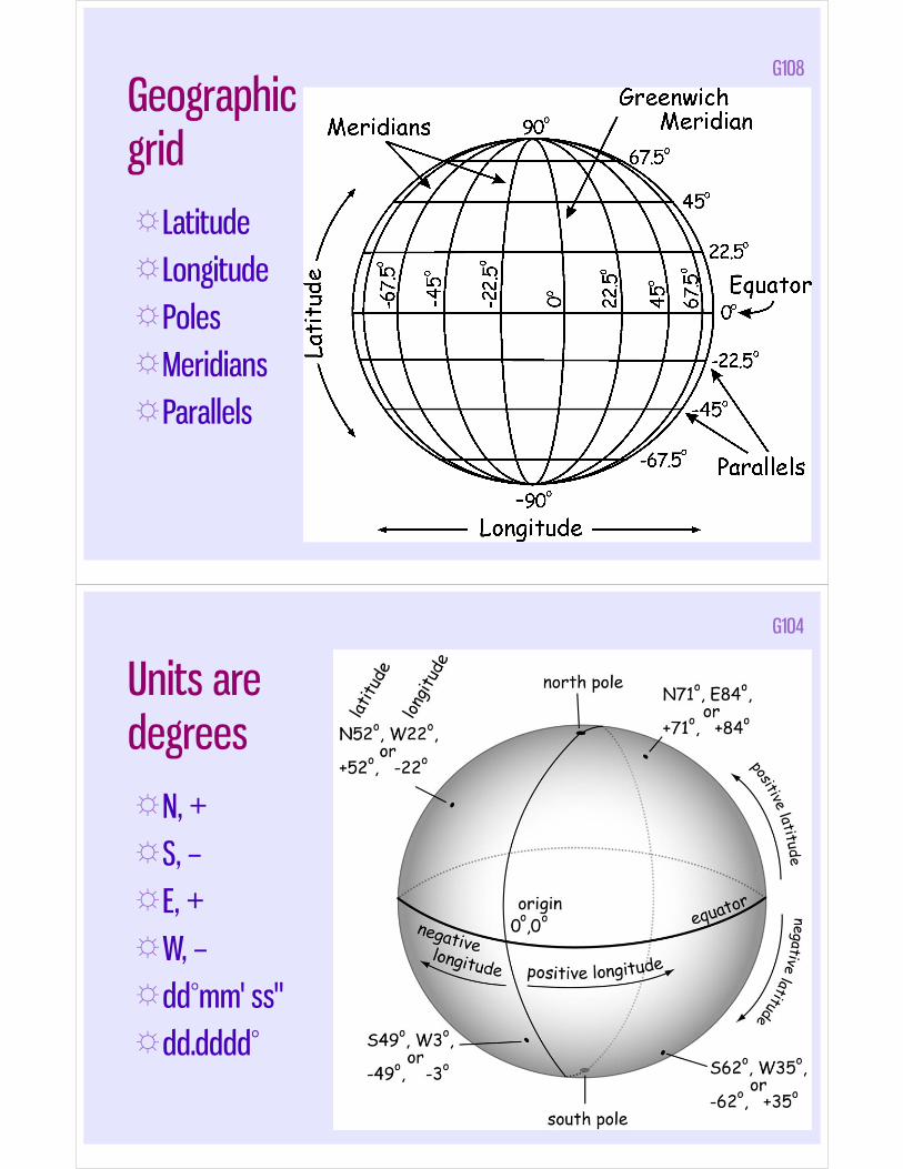
Geographicgrid☼ Latitude☼ Longitude☼Poles☼Meridians☼Parallels
G108
Units aredegrees☼N, +☼S, –☼ E, +☼W, –☼dd°mm' ss"☼dd.dddd°
G104

Making Earth flat
☼3 dimensions☼2 dimensions☼Projections
G057
Coordinate systems
☼Geographic: longitude, latitude
☼Cartesian (planar): x, y
☼ “read right up”
G102

Projection☼3D 2D☼ Ideals
Angles(shapes)
Distances
Directions
Areal sizes
☼Compromise: “best” depends on use☼http://www.radicalcartography.net/index.html?
projectionref
G401
Variables in projections
☼Class (cylindrical, conical or azimuthal)
☼Point of secancy (tangent or secant),
☼Aspect (normal, transverse or oblique)
☼Distortion property (equivalent, equidistant or conformal)

Classes of projectionsG053
Secancy of projectionsG054

Aspects of projections
G055
(Non-) distortion properties of projections
☼Conformal: angles, small areas
☼ Equivalent: area (but not shape)
☼ Equidistant:

Conformal projections (e.g. Mercator)☼N/S - E/W lines
always perpendicular
☼Areas distorted☼Distortion
increases with larger areas
☼Good for tracking motion or change in location
G051
Equal area ("equivalent") projections
☼Areas(length × width) accurate
☼Angles (shape) not accurate
G052

Equidistant projections
☼Constant scale
☼Uses “standard” parallels or points
☼Distances accurate (sometimes)
G056
Comparing projections G110

Suggested projections for given tasks/areas☼ Whole Earth: Robinson (pseudocylindrical) or Miller Cylindrical
☼ Hemispheres: Orthographic (azimuthal), Lambert Azimuthal Equal Area
☼ Continents: Lambert Conformal Conic (North America, Eurasia); Lambert Azimuthal Equal Area or Orthographic (South America, Africa); Orthographic (Australia, Antarctica)
☼ E-W Countries, Regions: Lambert Conformal Conic (US, Canada, Russia, China); Lambert Conformal Conic or Orthographic (Europe); Orthographic, Lambert Azimuthal Equal Area
☼ Polar Regions: Orthographic, Lambert Azimuthal Equal Area
☼ Oceans: Orthographic, Lambert Azimuthal Equal Area
☼ Smaller Countries or Regions: Orthographic
☼ N-S Countries, Oblique Regions: Transverse Mercator (long, thin countries aligned North-South such as Chile); Oblique Mercator (oblique regions like the Alaska panhandle)


![Interpolation via Barycentric Coordinates · • Moving least squares coordinates [Manson and Schaefer, 2010] • Cubic mean value coordinates [Li and Hu, 2013] • Poisson coordinates](https://static.documents.pub/doc/80x56/6062738927364e51e610e629/interpolation-via-barycentric-coordinates-a-moving-least-squares-coordinates-manson.jpg)


![Convergence of Wachspress coordinates: from polygons to ...jiri/papers/14KoBa.pdf · convex polygons are Wachspress coordinates [14], mean value coordinates [4], and harmonic coordinates](https://static.documents.pub/doc/80x56/5f6dfe23261f61015179236e/convergence-of-wachspress-coordinates-from-polygons-to-jiripapers-convex.jpg)


