European Forum for Geography and Statistics - EFGS 15.-17.11.2016, Paris Copernicus for Statistics Stephan Arnold Areal statistics, Federal Statistical Office Thomas Wiatr Remote sensing, Federal Agency for Cartography and Geodesy
Transcript
European Forum for Geography and Statistics - EFGS 15.-17.11.2016, Paris European Forum for Geography and Statistics - EFGS 15.-17.11.2016, Paris
Copernicus for Statistics
Stephan Arnold
Areal statistics, Federal Statistical Office
Thomas Wiatr
Remote sensing, Federal Agency for Cartography and Geodesy
European Forum for Geography and Statistics - EFGS 15.-17.11.2016, Paris
St. Arnold, Destatis: Copernicus for Statistics – Cop4Stat_2015plus
Content
Requirements and Setting
Eurostat´s LUCAS field survey
LUCAS Pilot study
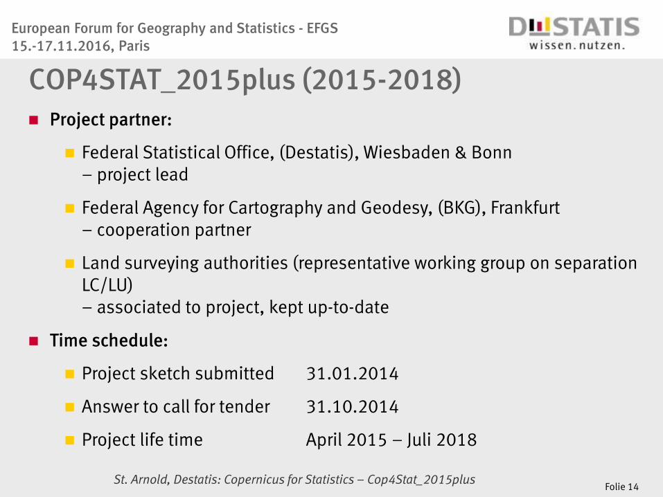
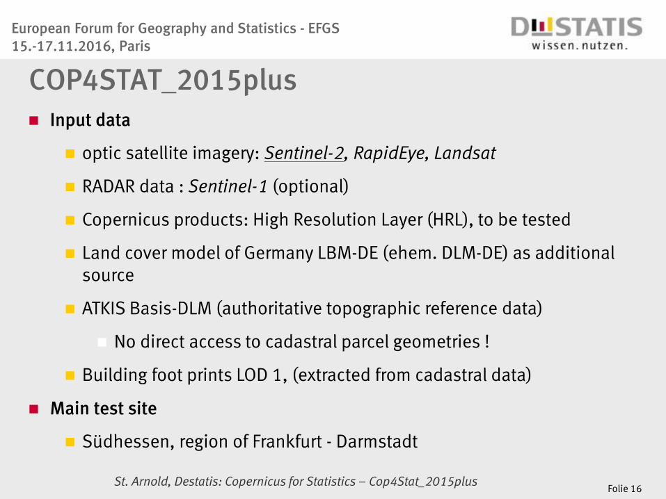
Cop4Stat_2015plus
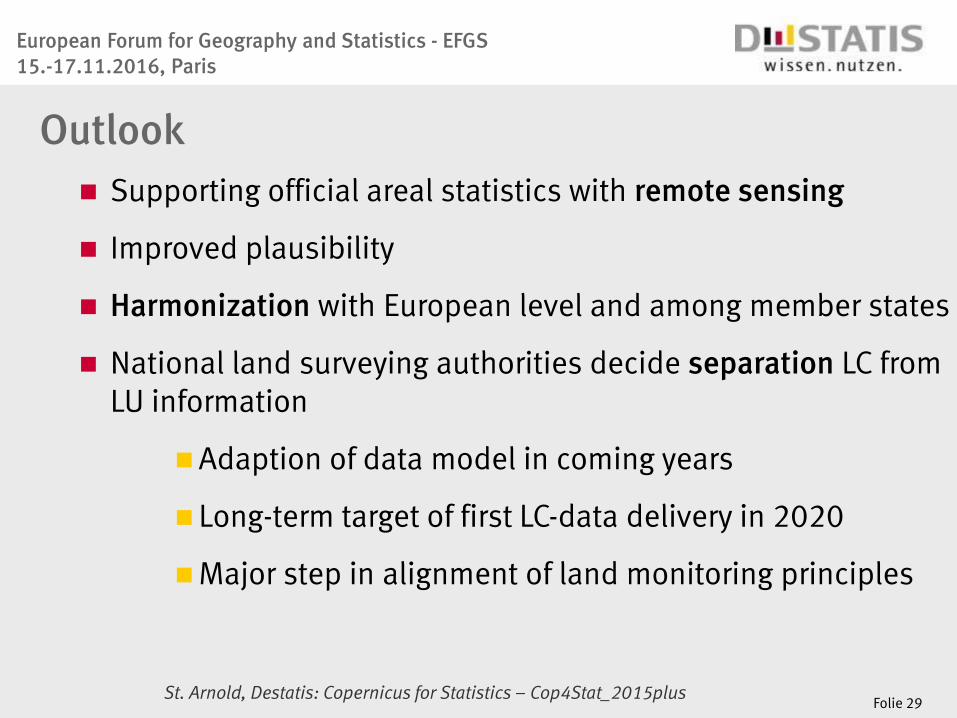
Outlook
Folie 2
European Forum for Geography and Statistics - EFGS 15.-17.11.2016, Paris
St. Arnold, Destatis: Copernicus for Statistics – Cop4Stat_2015plus
Requirements
Spatial decision making processes need robust information
bases
Harmonised statistics on Land cover and Land use
Unified mapping criteria
Comparable minimum mapping unit size
Common data capture time / interval
Comparable thematic content definitions
Folie 3
European Forum for Geography and Statistics - EFGS 15.-17.11.2016, Paris
St. Arnold, Destatis: Copernicus for Statistics – Cop4Stat_2015plus
Data flow from national to European level
CLC/
EEA
ATKIS ALB/
ALKIS FEtN
Stat
Eurostat European
Level
Länder-
Level
LBM-
DE
FEtN
Stat
National
Level Agrar
Stat
Copernicus
BWI
LUCAS | Forest Agrar |
Folie 4
Data source for official areal statistics (right side):
Cadastral Data (ALB/ALKIS)
Separated from topographic data sets (left side)
European Forum for Geography and Statistics - EFGS 15.-17.11.2016, Paris
St. Arnold, Destatis: Copernicus for Statistics – Cop4Stat_2015plus
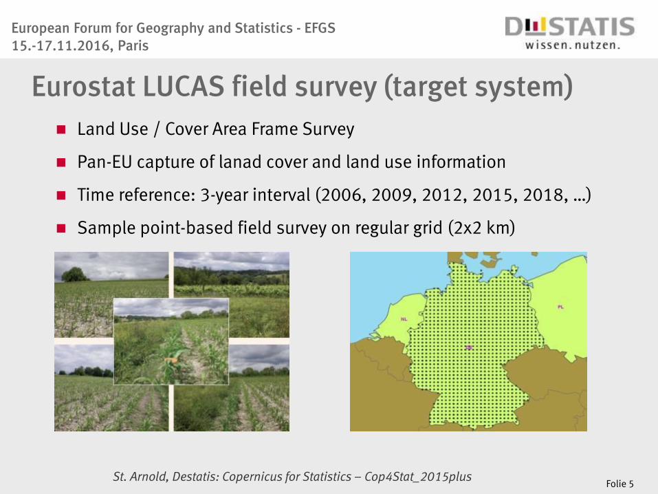
Eurostat LUCAS field survey (target system) Land Use / Cover Area Frame Survey
Pan-EU capture of lanad cover and land use information
Time reference: 3-year interval (2006, 2009, 2012, 2015, 2018, …)
Sample point-based field survey on regular grid (2x2 km)
Folie 5
European Forum for Geography and Statistics - EFGS 15.-17.11.2016, Paris
St. Arnold, Destatis: Copernicus for Statistics – Cop4Stat_2015plus
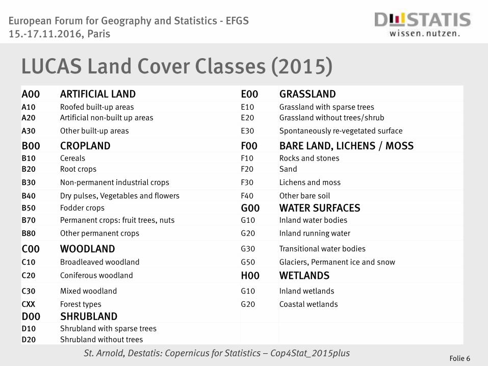
LUCAS Land Cover Classes (2015) A00 ARTIFICIAL LAND E00 GRASSLAND
A10 Roofed built-up areas E10 Grassland with sparse trees
A20 Artificial non-built up areas E20 Grassland without trees/shrub
A30 Other built-up areas E30 Spontaneously re-vegetated surface
B00 CROPLAND F00 BARE LAND, LICHENS / MOSS B10 Cereals F10 Rocks and stones
B20 Root crops F20 Sand
B30 Non-permanent industrial crops F30 Lichens and moss
B40 Dry pulses, Vegetables and flowers F40 Other bare soil
B50 Fodder crops G00 WATER SURFACES B70 Permanent crops: fruit trees, nuts G10 Inland water bodies
B80 Other permanent crops G20 Inland running water
C00 WOODLAND G30 Transitional water bodies
C10 Broadleaved woodland G50 Glaciers, Permanent ice and snow
C20 Coniferous woodland H00 WETLANDS
C30 Mixed woodland G10 Inland wetlands
CXX Forest types G20 Coastal wetlands
D00 SHRUBLAND D10 Shrubland with sparse trees
D20 Shrubland without trees
Folie 6
European Forum for Geography and Statistics - EFGS 15.-17.11.2016, Paris
St. Arnold, Destatis: Copernicus for Statistics – Cop4Stat_2015plus
U100 Primary sector U110 AGRICULTURE
U120 FORESTRY
U130 AQUACULTURE AND FISHING
U140 MINING AND QUARRYING
U150 OTHER PRIMARY PRODUCTION
U200 Secondary sector U210 ENERGY PRODUCTION
U220 INDUSTRY AND MANUFACTURING
U300 Tertiary sector, transport, utilities & residential U310 TRANSPORT, COMMUNICATION NETWORKS, STORAGE, PROTECTION WORKS
U320 WATER AND WASTE TREATMENT
U330 CONSTRUCTION
U340 COMMERCE, FINANCIAL, PROFESSIONAL AND INFORMATION SERVICES
U350 COMMUNITY SERVICES
U360 RECREATION, LEISURE, SPORT
U370 RESIDENTIAL
U400 Unused and abandoned areas
Folie 7
LUCAS Land Use Classes (2015)
European Forum for Geography and Statistics - EFGS 15.-17.11.2016, Paris
St. Arnold, Destatis: Copernicus for Statistics – Cop4Stat_2015plus
What has happened so far...
Pre-cursor project: LUCAS Pilot study
Folie 8
European Forum for Geography and Statistics - EFGS 15.-17.11.2016, Paris
St. Arnold, Destatis: Copernicus for Statistics – Cop4Stat_2015plus
Long-term goals
Semantic harmonisation between national and European
LC/LU statistics
Improvement of consistency between national sources
and Eurostat´s area estimates
Reduction of effort for LUCAS field survey, resp. avoid
redundant data capture in favor of additional thematic
focus
Integration of national initiatives in pan-European surveys
and estimation processes
LUCAS Pilot study (2013-2014)
Folie 9
European Forum for Geography and Statistics - EFGS 15.-17.11.2016, Paris
St. Arnold, Destatis: Copernicus for Statistics – Cop4Stat_2015plus
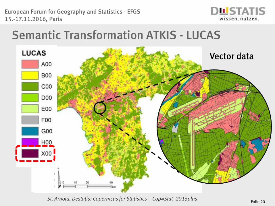
Workflow to derive target class area sizes
II. Semantic transformation
I. Area sizes admin zones
III. Join area sizes + semantic
matching
V. Analysis & Plausibility
IV. Target class area sums
VI. Target class total area sums
Folie 10
European Forum for Geography and Statistics - EFGS 15.-17.11.2016, Paris
St. Arnold, Destatis: Copernicus for Statistics – Cop4Stat_2015plus
European Level:
Target
ALB ALKIS BO National Level:
Source DLM-DE
LUCAS
STT (a) STT (b) STT (c) STT (d)
Semantic Transformation Table (STT)
Folie 11
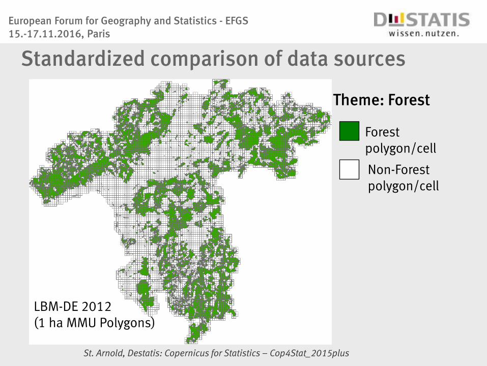
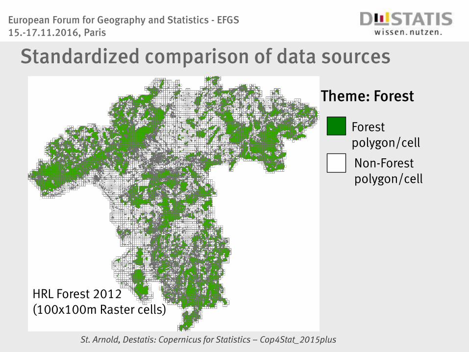
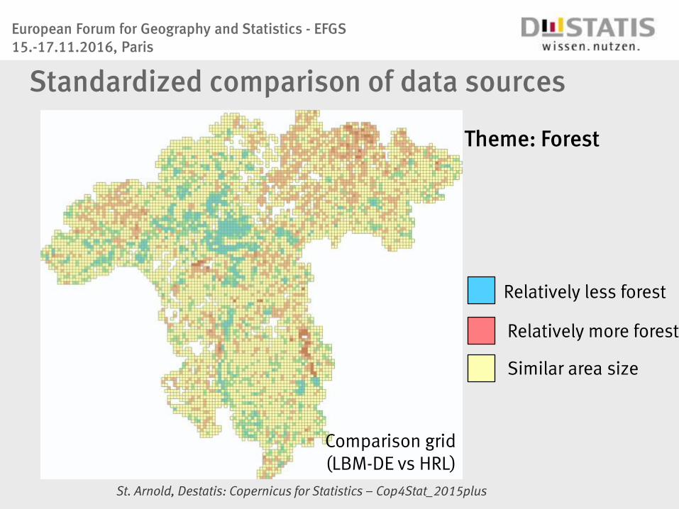
Matching table between feature types of national existing data sources
and European target classes
Different sources and their data collection methods
variation in results
European Forum for Geography and Statistics - EFGS 15.-17.11.2016, Paris
St. Arnold, Destatis: Copernicus for Statistics – Cop4Stat_2015plus