44
- Water Durham County Council August 2011 County Durham Surface Water Management Plan Final Report
- Water
Durham County Council August 2011
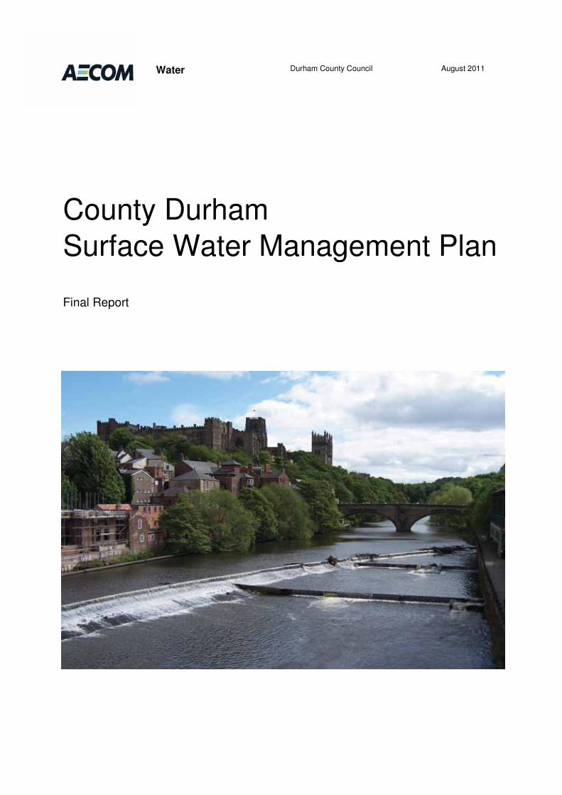
County Durham Surface Water Management Plan
Final Report
Prepared by: Alex Perryman Checked by: Christian Lomax Consultant Principal Consultant Approved by: Roy Lobley Associate Director
Rev No Comments Checked by Approved by
Date
0 Draft Final Report CSL RAL June 2011 1 Final Report CSL RAL August
2011 5th Floor, 2 City Walk, Leeds, LS11 9AR Telephone: 0113 391 6800 Website: http://www.aecom.com Job No 60155102.M012 Reference SWMP Date Created August 2011 This document has been prepared by AECOM Limited for the sole use of our client (the “Client”) and in accordance with generally accepted consultancy principles, the budget for fees and the terms of reference agreed between AECOM Limited and the Client. Any information provided by third parties and referred to herein has not been checked or verified by AECOM Limited, unless otherwise expressly stated in the document. No third party may rely upon this document without the prior and express written agreement of AECOM Limited.
Abbreviations ................................................................................................................................................................................... i�
Glossary ......................................................................................................................................................................................... iii�
1� Introduction ....................................................................................................................................................................... 1�1.1� What is a Surface Water Management Plan? ........................................................................................................ 1�1.2� County Durham SWMP Partnership ...................................................................................................................... 1�1.3� Scope of the County Durham SWMP .................................................................................................................... 4�1.4� Why Consider Water Quality? ............................................................................................................................... 5�1.5� Links with Other Studies ........................................................................................................................................ 5�1.6� Surface Water Principles ....................................................................................................................................... 6�
2� Summary of SWMP Analysis ............................................................................................................................................ 9�2.1� Introduction ............................................................................................................................................................ 9�2.2� Phase 1: Preparation ............................................................................................................................................. 9�2.3� Phase 2: Risk Assessment .................................................................................................................................... 9�2.4� Phase 3: Options ................................................................................................................................................. 12�2.5� Phase 4: Implementation & Review .................................................................................................................... 14�
3� Key Findings .................................................................................................................................................................... 16�3.1� Surface Water Flood Risk .................................................................................................................................... 16�3.2� Managing the Risk of Surface Water Flooding .................................................................................................... 17�3.3� Water Quality ....................................................................................................................................................... 18�3.4� Action Plans ......................................................................................................................................................... 19�3.5� Key Messages from SWRAs ............................................................................................................................... 23�
4� Next Steps ........................................................................................................................................................................ 28�4.1� Funding for Surface Water Management ............................................................................................................. 28�4.2� Requirements of the Flood & Water Management Act ......................................................................................... 30�
5� Summary .......................................................................................................................................................................... 34�5.1� Surface Water Risk .............................................................................................................................................. 34�5.2� Options ................................................................................................................................................................ 34�5.3� Actions ................................................................................................................................................................. 35�
List of Appendices Appendix A - County Durham’s Strategic Water Environment ........................................................................................................38�Appendix B - Risk Assessment .......................................................................................................................................................61�Appendix C – Options ...................................................................................................................................................................112�Appendix D – SWRA Action Plans ................................................................................................................................................171�
List of Tables Table 1.1: Roles & Responsibilities ..................................................................................................................................................3�Table 3.1: Development sites that provide opportunities to manage the risk of surface water flooding ..........................................18�Table 3.2: County Durham Action Plan ...........................................................................................................................................20�Table 3.3: Key Messages ...............................................................................................................................................................23�Table 4.1: Example of a Flood Incident Template...........................................................................................................................32�Table 5.1: Preferred Option ............................................................................................................................................................35�
List of Figures Figure 2.1: Prioritised SWRAs ........................................................................................................................................................11�Figure 2.2 – Development and Implementation of the County Durham SWMP ..............................................................................13�
Table of Contents
AECOM Surface Water Management Plan i
Capabilities on project: Water
AAD Average Annual Damage
AMP Asset Management Plan
CFMP Catchment Flood Management Plan
CSO Combined Sewer Overflow
Defra Department Environment, Food and Rural Affairs
ELR Employment Land Review
FRMP Flood Risk Management Plan
GES Good Ecological Status
GI Green Infrastructure
GIS Geographical Information System
GQA General Quality Assessment
IDP Infrastructure Delivery Plan
LDF Local Development Framework
MAGIC Multi-agency geographical information system for the countryside
MCA Multi Criteria Analysis
NVZ Nitrate Vulnerable Zone
OFWAT Economic Regulator for the Water and Sewerage Industry in England & Wales
PPS23 Planning Policy Statement 23–Planning and Development Control
PPS25 Planning Policy Guidance 25-Developement & Flood Risk
PFRA Preliminary Flood Risk Assessments
RBD River Basin District
RBMP River Basin Management Plan
SACs Special Area of Conservation
SFRA Strategic Flood Risk Assessment
SHLAA Strategic Housing Land Availability Assessment
SPA Special Protection Area
SPZ Source Protection Zone
SSSI Site of Special Scientific Interest
Abbreviations

AECOM Surface Water Management Plan ii
Capabilities on project: Water
SuDS Sustainable Drainage Systems
SWMP Surface Water Management Plan
SWRA Surface Water Risk Area
WCS Water Cycle Study
WFD Water Framework Directive
AECOM Surface Water Management Plan iii
Capabilities on project: Water
Core Strategy – A Development Plan Document setting out the spatial vision and strategic objectives of the planning framework for an area.
Department for Communities and Local Government - is the government department responsible for policy on local government, housing, urban regeneration, planning and fire and rescue. They have responsibility for all race equality and community cohesion related issues in England and for building regulations, fire safety and some housing issues in England and Wales. (http://www.communities.gov.uk/corporate/about/)
Department for Environment, Food and Rural Affairs (Defra) – Department that brings together the interests of farmers and the countryside; the environment and the rural economy; the food we eat, the air we breathe and the water we drink.
Employment Land Review (ELR) - provides an evidence base that will be used to inform the preparation of employment land policies and allocations in the Local Development Framework (LDF). The ELR ensures that sites and buildings that are importantto the future prosperity of an area are retained in employment use and to enable the release of sites that could sensibly be usedfor other purposes.
Environment Agency (EA) – The Environment Agency was established under the Environment Act 1995, and is a Non-Departmental Public Body of Defra. The Environment Agency is the leading public body for protecting and improving the environment in England and Wales today and for future generations. The organisation is responsible for wide ranging matters, including the management of all forms of flood risk, water resources, water quality, waste regulation, pollution control, inlandfisheries, recreation, conservation and navigation of inland waterways. It will also have a new strategic overview for all forms of inland flooding
Flood Risk Assessment (FRA) – a FRA is required under PPS25 at the planning application stage for new developments. An FRA will demonstrate how flood risk from all sources to the development itself and flood risk to others will be managed now andin the future (including climate change).
Floods and Water Management Act (2010) – Act of Parliament to clarify the legislative framework for managing surface water flood risk in England.
General Quality Assessment (GQA) Programme – the Environment Agency's method for classifying the water quality of rivers and canals is known as the General Quality Assessment scheme (GQA). It is designed to provide an accurate and consistent assessment of the state of water quality and changes in this state over time.
Green Infrastructure – a concept originating in the United States in the mid-1990s that highlights the importance of the natural environment in decisions about land use planning. In particular there is an emphasis on the "life support" functions provided by a network of natural ecosystems, with an emphasis on interconnectivity to support long term sustainability.
Growth Point – communities that are pursuing large-scale, sustainable housing growth through a partnership between local organisations and central government.
Interim Code of Practice for SuDS – A guidance document produced by CIRIA, which aims to facilitate the implementation of sustainable drainage in developments in England and Wales by providing model maintenance agreements and advice on their use. It provides a set of agreements between those public organisations with statutory or regulatory responsibilities relating toSuDS.
Local Development Framework (LDF) – a folder of local development documents that outlines how planning will be managed in the area.
Local Authority or Local Planning Authority (LA or LPA) – the Local Authority or Council that is empowered by law to exercise planning functions. Often the Local Borough or District Council, National Parks and the Broads Authority are also considered to be local planning authorities. County Councils are the authority for waste and minerals matters.
Glossary
AECOM Surface Water Management Plan iv
Capabilities on project: Water
Main River – Generally main rivers are larger streams or rivers, but can be smaller watercourses. Main Rivers are determined by Defra in England, and the Environment Agency has legal responsibility for them.
Ofwat – The Water Services Regulation Authority (Ofwat) is the body responsible for economic regulation of the privatised water and sewerage industry in England and Wales. Ofwat is primarily responsible for setting limits on the prices charged for water and sewerage services, taking into account proposed capital investment schemes (such as building new wastewater treatment works) and expected operational efficiency gains.
Ordinary watercourse - An ordinary watercourse is any other river, stream, ditch, cut, sluice, dyke or non-public sewer which is not a Main River. The Local Authority or Internal Drainage Board have powers for such watercourses.
Pitt Review - An independent review of the 2007 summer floods by Sir Michael Pitt, which provided recommendations to improve flood risk management in England.
Planning Policy Statements (PPS) and Planning Policy Guidance (PPG) – these documents set out the Government’s national policies on different aspect of planning. The policies in these statements apply throughout England and focus on procedural policy and the process of preparing local development documents.
Regional Spatial Strategy (RSS) – a broad development strategy for a region for a 15 to 20 year period prepared by the Regional Planning Body. The RSS informs the preparation of Local Development Documents (LDDs) and Local Transport Plans (LTPs).
Strategic Flood Risk Assessment (SFRA) – an assessment of flood risk from all sources which is used to inform the planning process of flood risk and provides information on future risk over a wide spatial area. It is also used as a planning tool to examinethe sustainability of the proposed development allocations. SFRAs form the basis of flood risk management in England and are a requirement of PPS25.
Supplementary Planning Documents (SPD) - supplementary planning documents can give further context and detail to local development plan policies. It is not part of the statutory development plan. Therefore, it does not have the same weight when local planning authorities are considering planning applications.
Surface Water Flooding - surface water flooding describes flooding from sewers, drains, groundwater, and runoff from land, small water courses and ditches that occurs as a result of heavy rainfall.
Surface Water Management Plan (SWMP) - is a plan which outlines the preferred surface water management strategy in a given location.
Sustainable Drainage Systems (SuDS) – Sustainable drainage systems (previously referred to as sustainable urban drainage systems): a sequence of source control, management practices and control structures designed to drain surface water in a more sustainable fashion than some conventional techniques (may also be referred to as SuDS or SDS).
Water Cycle Study (WCS) – The purpose of a water cycle strategy is to strategically plan the most sustainable water infrastructure in a timely manner, across all of the water cycle from water supply and water resources, flood risk and surface water drainage, and wastewater and biodiversity.
Water Framework Directive (WFD) – A European Community Directive (2000/60/EC) of the European Parliament and Council designed to integrate the way water bodies are managed across Europe. It requires all inland and coastal waters to reach “good status” by 2015 through a catchment-based system of River Basin Management Plans, incorporating a programme of measures to improve the status of all natural water bodies.
Water Resources - Water which is available for human use.
Water Supply – The provision of water to homes and industry using a pipe network.

Introduction
AECOM Surface Water Management Plan 1
Capabilities on project: Water
1.1 What is a Surface Water Management Plan?
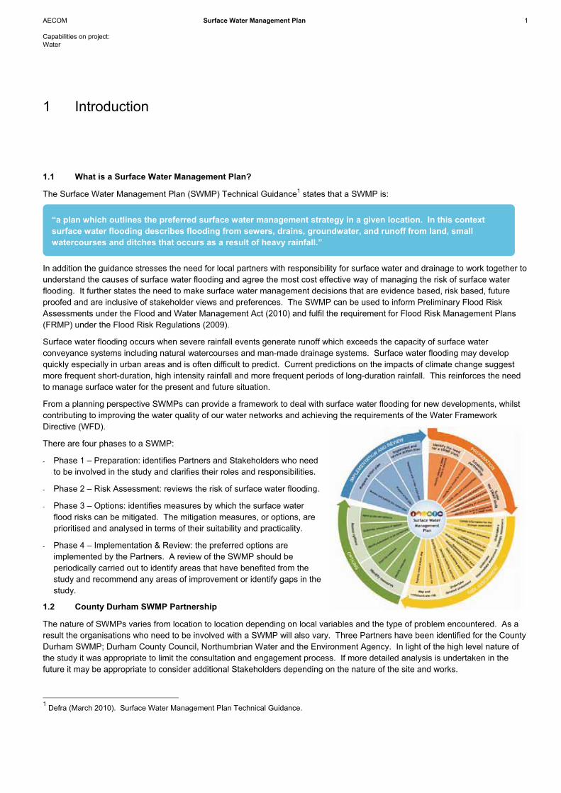
The Surface Water Management Plan (SWMP) Technical Guidance1 states that a SWMP is:
In addition the guidance stresses the need for local partners with responsibility for surface water and drainage to work together to understand the causes of surface water flooding and agree the most cost effective way of managing the risk of surface water flooding. It further states the need to make surface water management decisions that are evidence based, risk based, future proofed and are inclusive of stakeholder views and preferences. The SWMP can be used to inform Preliminary Flood Risk Assessments under the Flood and Water Management Act (2010) and fulfil the requirement for Flood Risk Management Plans (FRMP) under the Flood Risk Regulations (2009).
Surface water flooding occurs when severe rainfall events generate runoff which exceeds the capacity of surface water conveyance systems including natural watercourses and man-made drainage systems. Surface water flooding may develop quickly especially in urban areas and is often difficult to predict. Current predictions on the impacts of climate change suggestmore frequent short-duration, high intensity rainfall and more frequent periods of long-duration rainfall. This reinforces the need to manage surface water for the present and future situation.
From a planning perspective SWMPs can provide a framework to deal with surface water flooding for new developments, whilst contributing to improving the water quality of our water networks and achieving the requirements of the Water Framework Directive (WFD).
There are four phases to a SWMP:
- Phase 1 – Preparation: identifies Partners and Stakeholders who need to be involved in the study and clarifies their roles and responsibilities.
- Phase 2 – Risk Assessment: reviews the risk of surface water flooding.
- Phase 3 – Options: identifies measures by which the surface water flood risks can be mitigated. The mitigation measures, or options, are prioritised and analysed in terms of their suitability and practicality.
- Phase 4 – Implementation & Review: the preferred options are implemented by the Partners. A review of the SWMP should be periodically carried out to identify areas that have benefited from the study and recommend any areas of improvement or identify gaps in the study.
1.2 County Durham SWMP Partnership
The nature of SWMPs varies from location to location depending on local variables and the type of problem encountered. As a result the organisations who need to be involved with a SWMP will also vary. Three Partners have been identified for the CountyDurham SWMP; Durham County Council, Northumbrian Water and the Environment Agency. In light of the high level nature of the study it was appropriate to limit the consultation and engagement process. If more detailed analysis is undertaken in the future it may be appropriate to consider additional Stakeholders depending on the nature of the site and works.
1 Defra (March 2010). Surface Water Management Plan Technical Guidance.
1 Introduction
“a plan which outlines the preferred surface water management strategy in a given location. In this context surface water flooding describes flooding from sewers, drains, groundwater, and runoff from land, small watercourses and ditches that occurs as a result of heavy rainfall.”
AECOM Surface Water Management Plan 2
Capabilities on project: Water
Each of the three Partners has an important role to play concerning flood risk. The following sections outline their roles andresponsibilities and summarises how the outputs of the SWMP will be of use to each organisation.
1.2.1 Durham County Council
Durham County Council is responsible for planning and controlling development within their district, with due regard to the risk of flooding and has a number of permissive powers under the Land Drainage Act and Public Health Act to undertake drainage works in relation to watercourses. Local Authorities acting in their capacity as a highways authority have powers with regard to the drainage of highways.
Under the Flood and Water Management Act, County Councils or Unitary Authorities have been given the lead in managing all local floods and will become the approving and adopting body for all Sustainable Drainage Systems (SuDS). All drainage systems in new developments and redevelopments that include SuDS schemes will need to be approved by the County Council or Unitary Authority before construction can commence. Should the SuDS scheme serve more than one property, the County Council or Unitary Authority would subsequently adopt and maintain the scheme where constructed as approved. It will be important for schemes to be accompanied by maintenance plans to ensure that the effectiveness of schemes does not decrease over time.
Durham County Council is the Lead Partner and has the responsibility for the SWMP. Outputs from the SWMP will be used by the County Council to carry out other activities such as emergency planning, control drainage, review LDF land allocations, anddevelop investment programmes, at the same time as satisfying the requirements of the Flood and Water Management Act and contributing to the evidence base supporting the Durham Plan.
1.2.2 Environment Agency
The Environment Agency is an Executive Non-departmental Public Body responsible to the Secretary of State for Environment, Food and Rural Affairs (England) and an Assembly Sponsored Public Body responsible to the National Assembly for Wales. The organisation’s aims are to protect and improve the environment, and to promote sustainable development. The Environment Agency plays a central role in delivering the environmental priorities of central government and the Welsh Assembly Government through their functions and roles.
The Environment Agency has a general supervisory duty relating to all flood defence related matters under the Environment Act and the Flood and Water Management Act has given the Environment Agency an overview of all flood and coastal erosion risk management. The extent of the Environment Agency’s operational role greatly depends upon the designation of a watercourse as Main River. The power of the Environment Agency to maintain and improve existing works and construct new works is a permissive one.
The Environment Agency is an essential Partner in the SWMP. The outputs from the SWMP will be issued to the Environment Agency to review and assess existing and new emergency plans, communicate with local residents on flood risk issues, and finalise asset management plans (investment, operations and maintenance).
1.2.3 Northumbrian Water
Northumbrian Water is the supplier of water and sewerage services for County Durham comprising water resources distribution and collection, surface water drainage, wastewater collection and disposal. Having a total customer base of 2.6 million households, the water company has the responsibility (amongst others) for ensuring that its drainage network is maintained and improved to cope with surface water flooding. This is not an absolute responsibility, as sewerage undertaker’s funds are not unlimited and investment in sewers must be prioritised. There is broad agreement that this responsibility is limited to flooding arising from the 3.33 AEP (1 in 30 year return period) event. They also

AECOM Surface Water Management Plan 3
Capabilities on project: Water
have a duty to receive water from approved SuDS. Northumbrian Water will identify strategies in order to address issues and apply for funding from OFWAT to deliver the schemes.
Asset management and investment in water companies occurs in Asset Management Plan (AMP) periods. Each period has an investment programme to improve and maintain current assets and invest in new development areas. Northumbrian Water has recently commenced their next investment period, AMP5: 2010-2015, therefore the outputs from the SWMP will only be able to influence their priorities to a limited extent. However as the company makes progress during the AMP5 period, their asset improvement plan could be reviewed to include the recommendations of the SWMP.
Northumbrian Water is an essential partner in the SWMP. The outputs from the SWMP will be used by Northumbrian Water to prepare for emergencies, undertake their Drainage Area and Sewerage Management Plans, plan their investment and respond to climate and population change in addition to development pressures.
Table 1.1 sets out what each Partner is required to contribute to the SWMP and the benefits that will arise.
Table 1.1: Roles & Responsibilities
Partner Role How they inform the SWMP
What they get out of the SWMP
Durham County Council
Lead partner responsible for future development, surface water and that a partnership approach is adopted.
Provision of information concerning future development; locations, phasing and numbers and surface water drainage data.
The SWMP acts as a vital evidence base to the Durham Plan, showing surface water flooding has been considered during the strategic planning process. The study provides information and assurances that the Council’s growth and regeneration aspirations can be supplied with due regard for flood risk. The SWMP will input to the Infrastructure Delivery Plan which will also contribute towards the evidence base.
The SWMP will ensure a joined up approach between land owners, water infrastructure providers and planners during strategic growth and regeneration planning.
The SWMP will help to ensure that the natural water environment is protected and work with the Green Infrastructure Strategy (GI)2 to support the activity, health and well being of local people and wildlife through the provision of green space.
Northumbrian Water
Essential partner responsible for ensuring that its drainage network is maintained and improved to cope with surface water flooding.
Contribute to the identification and assessment of areas at risk of surface water flooding.
An appreciation and understanding of the local authorities growth aspirations, when development will come forward, where and the phasing.
The SWMP can inform long term planning, identifying where and when investment is required.
An opportunity to comment on the proposed growth to influence the location and timing of future development by supporting proposals or make
2 Durham County Council (June 2009). Green Infrastructure Communications Strategy

AECOM Surface Water Management Plan 4
Capabilities on project: Water
Partner Role How they inform the SWMP
What they get out of the SWMP
recommendations for changes.
Environment Agency
Essential partner responsible for flood risk, development control and water quality.
Provision of information and data concerning the water environment and its constraints and limitations.
Encourage sustainable development.
Participate in and prove partnership working.
Achieve efficiencies of working, support growth and ensure growth is sustainable with regard to the environment.
1.3 Scope of the County Durham SWMP
The average annual rainfall for County Durham is approximately 643mm, which is lower than the average rainfall for the north ofEngland however; the varied topography of the area along the River Wear and its tributaries has a major influence on surface water runoff and flow patterns. The impact of development over time has exerted an impact on the runoff patterns, rates and volumes, consequently stressing the drainage infrastructure and its ability to cope with future expansion in some areas. Therehave been reported cases of surface water flooding and property damage, which further reinforces the need for a SWMP which will provide a more holistic approach to addressing the surface water flood risk to existing and proposed development.
The SWMP covers the entire County and as such is a high level, strategic document which serves as a starting point for the Partners to address surface water flood risk. It should be noted that the SWMP ought to remain a living document, to be up dated as further data and information comes to light.
The primary purpose of the SWMP is to contribute robust evidence to support the Core Strategy. However it is much more than simply a planning document given its capacity to provide all three Partners with information concerning surface water risks acrossCounty Durham, and in recommending solutions to tackle key risk areas.
At a Partner Workshop the following four objectives were defined for the County Durham SWMP:
1. Guide limited resources to critical drainage areas of greatest need (existing development).
2. Ensure the level of future development does not exacerbate existing problems and identify opportunities for new development to provide benefits in terms of flood risk management.
3. Inform emergency planning and feed into Durham County Council’s Flood Plan.
4. Protect and improve water quality in accordance with the objectives of the WFD.
The four objectives reflect different aspects of surface water flooding. There will be a risk of surface water flooding facingexisting development / communities across County Durham and the SWMP will be able to identify potential options by which this risk might be managed. The Durham Plan will mean that significant levels of new development will occur in the future. To this end the SWMP is able to steer development away from areas at risk of flooding or identify measures by which the new development can help to alleviate or manage the existing surface water flood risk.
The summer floods of 2007, particularly in Hull, enforced the need for emergency planning to take due account of surface water and as part of the brief Durham County Council requested that opportunities for the management of urban water quality be investigated to fulfil improvements and compliance in ecology, water quality and habitats required under the WFD.

AECOM Surface Water Management Plan 5
Capabilities on project: Water
The SWMP is intended to be a ‘living’ document which is adapted to changes in the Council’s aspirations regarding site development and regeneration in the future, at the same time improving on experience over time. It should be noted that the SWMP is the starting point in addressing the issues pertaining to surface water flood risk and this document does not end the need to review or address surface water issues in the future.
1.4 Why Consider Water Quality?
Water is essential for life, and is vital for our health and wellbeing (potable supplies, disposal of waste water, recreation andamenity), for agriculture, aquatic environments and fisheries, industry and transportation. The water environment, through wetlands and floodplains, can also provide natural water storage and flood protection. Therefore, it is important that this resourceis protected and used sustainably and there are numerous European Directives and National Acts that have legislated to that effect, in addition to national and local planning policy. Annex A1 in Appendix A provides a review of this legislation. DurhamCounty Council is committed to the holistic management of the water environment.
Water quality can be affected by diffuse water pollution as a result of runoff washing pollutants (dissolved and / or particulate) from surfaces into watercourses, directly or via surface water sewers. Pollution can also occur where heavy or prolonged rainfall leads to surface flooding of a contaminated site (e.g. petrochemicals and heavy industry, landfill, a large construction site etc.). Finally, although not the focus of this study, other point source water quality effects can occur from spills from combined sewer overflows. Although strategic planning can assist with the locating of potentially polluting sites/developments, the mitigation of flooding impacts will require a combination of flow management and flood defence.
1.5 Links with Other Studies
In addition to the SWMP, Durham County Council is producing a raft of documents as part of their Local Development Framework (LDF) to ensure a sustainable future for County Durham. Two of these are directly relevant, and integral to, the SWMP. These are the Strategic Flood Risk Assessment (SFRA) and Water Cycle Study (WCS).
A Level 1 and 2 SFRA3 has been completed for County Durham which produced an assessment of surface water flood risk, classifying the risks as high, medium and low. This data-set formed the foundations for the SWMP and was integrated with otherdata-sets as part of the Risk Assessment phase of the SWMP.
The management of runoff from urban areas is essential if the effects of diffuse urban pollution are to be reduced and prevented,to help achieve the requirements of the WFD. In addition to setting out the strategic risk from flooding, the Level 1 Report alsoconsidered ways to mitigate flood risk, which included Sustainable Drainage Systems (SuDS). The SFRA provides a generic overview of the SuDS approach and maintenance requirements, before touching on the possible application of SuDS in County Durham (Annex C2, Appendix C).
The WCS is reviewing the ability of the water environment (including existing infrastructure) to support future development acrossCounty Durham. Large parts of County Durham are served by combined sewers which carry wastewater from households and industry, and surface water runoff. These combined sewer systems tend to be located in the older, historic parts of the County,whereas more recent development has implemented separate sewer systems.
The combined sewers and the associate Sewage Treatment Works have been identified as a potential constraint to future development. Northumbrian Water have identified the removal of surface water from these combined sewers as their preferred means of providing additional capacity within the sewers and at the Works to support future growth. It is unlikely that existingdevelopments served by combined sewers are going to be retro-fitted to separate the waste- and surface water, therefore re-development of brownfield land offers a means of providing this capacity. 3 Golder Associates (March 2010). Durham County Council, Strategic Flood Risk Assessment (SFRA) – Level 2.
AECOM Surface Water Management Plan 6
Capabilities on project: Water
The surface water removed from the combined sewers will need to be managed to ensure it does not pose a flood risk elsewhere. The SWMP has had due consideration for the need for surface water to avoid going into the sewer systems.
Another document relevant to the SWMP is the Green Infrastructure Strategy which will include a network of multifunctional green space and other relevant land and watercourses, which support the activity, health and well being of local people and wildlife. Future development and growth across County Durham has the potential to play a role in the expansion and reinforcement of the GI networks. The most obvious means of contributing to GI is through the provision of green spaces on theindividual development sites and through SuDS which can create water features, although the identification of deficiencies in existing water infrastructure that require intervention may also present opportunities to contribute towards GI.
Durham County Council are also producing a Preliminary Flood Risk Assessment (PFRA) which is a key document informing the preparation of future Local Flood Risk Management Strategies as required by the Flood and Water Management Act 2010. A PFRA aims to locate areas in which the risk of surface water and groundwater flooding is significant and warrants further examination through the production of maps and management plans.
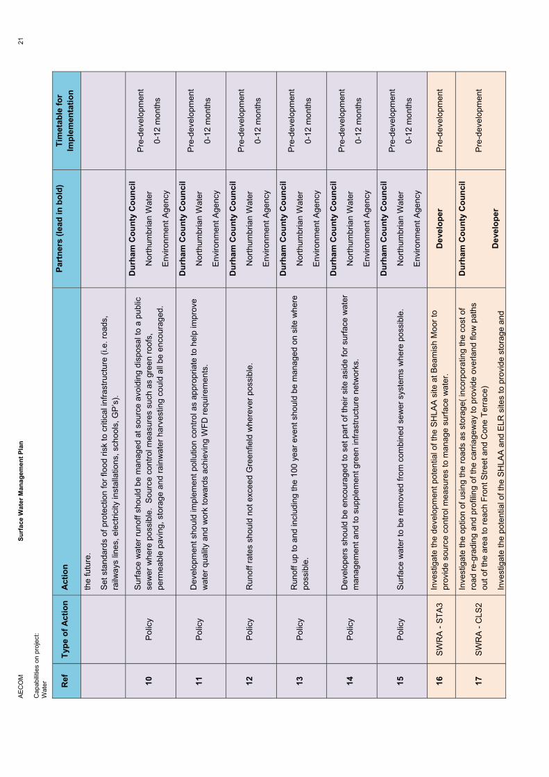
1.6 Surface Water Principles
In light of the work undertaken as part of the SWMP, the following surface water principles are proposed that Durham County Council should bear in mind when considering planning applications and consider the value of incorporating them into planning policies and / or local Supplementary Planning Documents.
As part of development:
� Surface water runoff to be managed at source (avoid disposal to public sewer systems wherever possible).
� Runoff rates should not exceed Greenfield wherever possible.
� Runoff up to and including the 100 year event should be managed on site where possible.
� Measures of source control should be actively encouraged.
� Measures that provide water quality improvements should be actively encouraged.
� Developers should be encouraged to set part of their site aside for surface water management, to contribute to flood risk management in the wider area and supplement green infrastructure networks.
� Surface water should be removed from combined sewer systems.
� Developers should be encouraged to maximise permeable surfaces.
AECOM Surface Water Management Plan 7
Capabilities on project: Water
As part of retro-fitting schemes:
� Durham County Council to consider the potential for surface water management when undertaking highways schemes such as regarding roads, to manage excess surface water runoff in the roads or channel it away from high risk areas.
� Encourage green roofs to be retro-fitted wherever possible, with sites using surface water as a resource rather than disposing of it.
� Home owners should be encouraged to reduce impermeable surfaces and implement resilience and resistance measures.

Summary of SWMP Analysis
AECOM Surface Water Management Plan 9
Capabilities on project: Water
2.1 Introduction
It was outlined in the previous chapter that there are four phases to the SWMP process. This chapter provides a concise summary of the work that was undertaken for County Durham. The reader is referred to the Appendices where more detailed, technical information can be found.
2.2 Phase 1: Preparation
For the Preparation phase the SWMP Partnership was established. Due to the nature of the study the Partners were restricted toDurham County Council, the Environment Agency and Northumbrian Water. The Partners are outlined in Section 1.2 of this report.
If the County Durham SWMP leads to further work being undertaken in a specific location, it will be appropriate for the Partnersto review the local circumstances to determine if additional Stakeholders need to be incorporated into the process through a more specific SWMP for that location.
2.3 Phase 2: Risk Assessment
The principal purpose of the Risk Assessment for County Durham was to strategically identify broad locations considered to be more or less vulnerable to surface water flooding. Given the geographical scale of the strategic assessment, it should be used to flag locations requiring further assessment and to help prioritise more detailed studies. As the strategic assessment operates at a large geographical scale, the SWMP guidance recommends that the analysis should be based on existing information or the use of simple analysis methods to improve existing information and make maximum use of existing data and information. Appendix B presents the Risk Assessment in more detail.
To begin with, all available data was collated together to establish what the strategic water environment looks like for County Durham. This baseline data concerning the water environment can be found in Appendix A. A gap analysis was carried out to identify missing information. The primary gaps in the information base relate to information from Northumbrian Water, who during the project was in the process of establishing a Data Sharing Protocol which would facilitate data sharing.
To gain an understanding of the sewer network, sewer maps were provided in PDF format by Durham County Council which was used to visually assess the network coverage. However, in order to be able to make informed decisions and undertake detailed analysis Northumbrian Water must play a more active role in the SWMP contributing information and ideas to the process.
Durham County Council’s dataset concerning known surface water incidents has gaps and inconsistencies within the attribute information. The attribute table looks to be an amalgamation of multiple tables with duplicate columns containing the same information. By restructuring the table and maintaining the accuracy of the information, this would allow easier analysis and presentation of the information. It would be beneficial to add a column that categorises the cause of the incidents so that thedata can be thematically mapped.
All GIS datasets should have associated metadata so as to understand what information the data contains and to clarify column headings or explain any information that is coded or graded. Attribute information that may be contained in datasets and usefulto a SWMP may not be realised because the metadata was not provided or contained null information. When metadata is provided it should contain enough detail so as not to require any further information or interpretation.
2.3.1 Surface Water Risk Areas
Based on the available data Surface Water Risk Areas (SWRAs) were defined in GIS using cluster analysis. Cluster analysis looks at the distribution of ‘priority’ datasets to look for correlations and patterns in the data so as to form a cluster, in this case a SWRA.
2 Summary of SWMP Analysis
AECOM Surface Water Management Plan 10
Capabilities on project: Water
The following priority datasets were used to define the SWRAs:
1. Known Surface Water Incidents
2. SFRA Surface Water modelling
3. Environment Agency Areas Susceptible to Surface Water Flooding*
4. Potential Development Sites (SHLAA and ELR data)
5. Critical Infrastructure (Schools, railway lines and major roads)
6. Environmental Designations
* The Flood Map for Surface Water was unavailable at the time of the analysis but was later used to verify the assessment.
These datasets inform areas where surface water flooding has or could cause a significant risk to people and property, or pose athreat to the degradation of one or more environmental designations. Clusters of known incidents of surface water flooding indicate areas where surface water currently poses a flood risk.
In total 139 SWRAs were created across County Durham the majority of which are located in the eastern part of the county, in oraround urban conurbations.
Having identified SWRAs across County Durham it was appropriate to rank them in terms of their importance. The prioritisation process sought to address known surface water problems and the largest numbers of people at risk of surface water flooding so that resources can be targeted in these areas, see Annex B1 of Appendix B. Of the 139 SWRAs identified across County Durham, thirteen sites were assessed in more detail as part of the Risk Assessment. This includes eleven sites that were rankedin the top ten (accounting for equal rankings), plus two additional sites in Chester-le-Street that whilst they fell lower down the priority ranking table are known surface water problem areas according to the Environment Agency’s environment priority documents. The thirteen prioritised SWRAs are illustrated in Figure 2.1.

AECOM Surface Water Management Plan 11
Capabilities on project: Water
Figure 2.1: Prioritised SWRAs
A summary sheet was prepared for each of the thirteen SWRAs, highlighting areas affected by flooding and the causes for the incidents, Annex B2 of Appendix B. These sheets were circulated to the Partners to communicate the findings of the Risk Assessment, to obtain feedback and further information concerning the SWRAs and to ascertain whether the SWRA should be considered further by the SWMP and carried forward to the Options stage. A Workshop attended by Durham County Council and the Environment Agency subsequently discussed each of the SWRAs to decide how they should be addressed by the SWMP. The key message coming out of the Workshop was that many of the known surface water flood incidents are being addressed by either Durham County Council or Northumbrian Water and the SWMP therefore ought to focus on the residual risks posed by exceedance events, i.e. areas identified by the SFRA modelling or the Environment Agency Areas Susceptible to Surface Water Flooding.
2.3.2 Future Development and the Risk of Surface Water Flooding
One of the objectives for the SWMP is to “Ensure the level of future development does not exacerbate existing problems and identify opportunities for new development to provide benefits in terms of flood risk management”. Durham County Council provided information concerning potential future development in the form of Strategic Housing Land Availability Assessment (SHLAA) and Employment Land Review (ELR) data-sets. As part of the Risk Assessment SWRAs have been identified based on the presence of SHLAA and ELR sites in close proximity to areas at risk of surface water flooding. Many of the potential development sites fall within or in close proximity to areas at risk of flooding. In light of this it will be essential that site specific Flood Risk Assessments (FRAs) are undertaken if the development comes forward to ensure that each development takes due account of the potential flood risk and does not place people at risk of flooding. Another important aspect for the Council to be aware of is where development sites present opportunities to manage and mitigate flood risk beyond the site boundary. Phase 3 of the SWMP identified potential development sites that could play a role in managing the risk of surface water flooding.
AECOM Surface Water Management Plan 12
Capabilities on project: Water
2.3.3 Emergency Planning
The third objective of the SWMP is to “Inform emergency planning and feed into Durham County Council’s Flood Plan”. The findings of this Risk Assessment should be disseminated within each of the Partner organisations to inform and update (multi-agency) flood plans / severe weather plans and Local Resilience Forum community risk registers. This might include informationon high flood risk areas, roads and access routes likely to be impassable, impacts on critical infrastructure or vulnerable people.
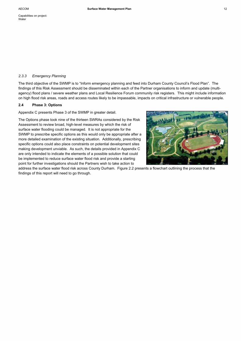
2.4 Phase 3: Options
Appendix C presents Phase 3 of the SWMP in greater detail.
The Options phase took nine of the thirteen SWRAs considered by the Risk Assessment to review broad, high-level measures by which the risk of surface water flooding could be managed. It is not appropriate for the SWMP to prescribe specific options as this would only be appropriate after a more detailed examination of the existing situation. Additionally, prescribing specific options could also place constraints on potential development sites making development unviable. As such, the details provided in Appendix C are only intended to indicate the elements of a possible solution that could be implemented to reduce surface water flood risk and provide a starting point for further investigations should the Partners wish to take action to address the surface water flood risk across County Durham. Figure 2.2 presents a flowchart outlining the process that the findings of this report will need to go through.

AECOM Surface Water Management Plan 13
Capabilities on project: Water
Figure 2.2 – Development and Implementation of the County Durham SWMP
The assessment process aims to short-list measures that will achieve multiple objectives in the context of site constraints andfuture development. In accordance with the guidance, a Multi-Criteria Assessment (MCA) screening exercise considered the relative merits of each measure to manage surface water against the following criteria:
- Technical Feasibility – is it easily implemented?- Relative Cost – how expensive is it in comparison to other measures?- Economic Viability – is it expensive to implement?- Social Impact and Acceptability – how will it impact on residents?- Environmental – how will it impact the environment?- Sustainability – is it a sustainable approach?
SWMP Options Potential measures to manage
surface water flood risk outlined.
SWMP Action PlanPreferred measures and potential
Options for SWRAs prioritised and actions for Partners
identified.
Detailed assessment by developers to determine Options to
be implemented.
Area developed incorporating Option(s) to manage the risk of
surface water flooding on site and in wider SWRA.
SHLAA / ELR sites come forward for development in a SWRA.
Cou
nty
Dur
ham
SW
MP
Re-
deve
lopm
ent
Detailed assessment by Partners to determine Options to be
implemented.
Area retro-fitted to incorporate Option(s) to manage the risk of
surface water flooding in SWRA.
Partner(s) identify funding to address risks through retro-fitting.
Retrofit
SWMP Action PlanReviewed by Partners in light of
works that have been undertaken.

AECOM Surface Water Management Plan 14
Capabilities on project: Water
Each management option is scored against each of the criteria set out above using a relative indicator, in line with the guidance:
U - not applicable or unacceptable outcome -2 - severely negative outcome -1 - moderately negative outcome 0 - neutral outcome +1 - moderately positive outcome +2 - strongly positive outcome
The measures with the lowest overall combined scores from the MCA were screened out to produce a short list of preferred options. The short-listed mitigation measures provide the starting point for a more detailed economic assessment should the Partners wish to take any of the SWRAs further and implement surface water management measures.
2.5 Phase 4: Implementation & Review
The final stage of the SWMP is the collation of the information from the first three phases and the production of an Action Plan(s) for managing surface water. Chapter 3 of this document sets out the Key Findings of the study and has developed an Action Plan for the Partners to implement as they seek to manage the risk of surface water flooding. Additionally an Action Plan has been developed for each of the nine SWRAs that were considered by the Options phase (Appendix D).
It will subsequently be up to the Partners to implement the Action Plans to manage and mitigate the risk of surface water flooding across County Durham. As lead Partner with will be Durham County Councils responsibility to monitor the implementation of the Action Plans.
The SWMP is a living document and it is recommended that the Partnership continues to work together after the completion of the SWMP to discuss the implementation of the proposed actions. The plans should be reviewed and updated on a regular basis, but there are circumstances which might trigger a review and/or an update sooner. These may include the occurrence of aflood incident or additional data becoming available, which may alter the understanding of risk within the study area or if theoutcome of investment decisions by Partners is different to the preferred option, which may require a revision to the Action Plan.

Key Findings
AECOM Surface Water Management Plan 16
Capabilities on project: Water
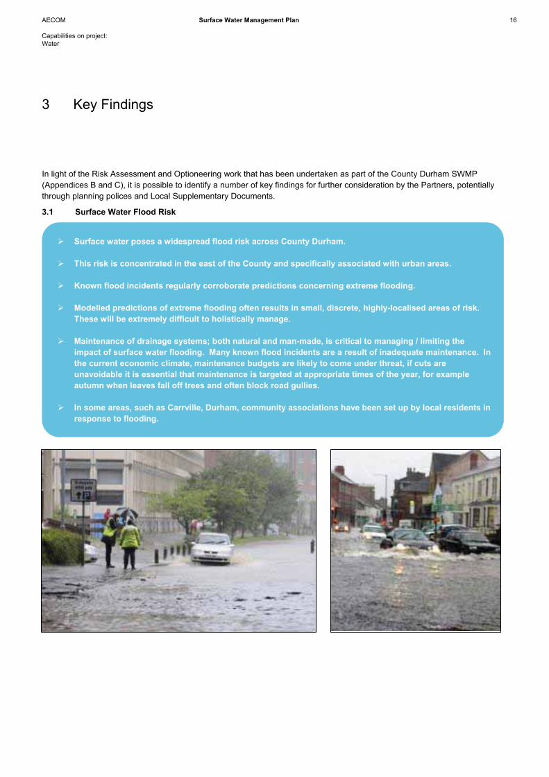
� Surface water poses a widespread flood risk across County Durham.
� This risk is concentrated in the east of the County and specifically associated with urban areas.
� Known flood incidents regularly corroborate predictions concerning extreme flooding.
� Modelled predictions of extreme flooding often results in small, discrete, highly-localised areas of risk. These will be extremely difficult to holistically manage.
� Maintenance of drainage systems; both natural and man-made, is critical to managing / limiting the impact of surface water flooding. Many known flood incidents are a result of inadequate maintenance. In the current economic climate, maintenance budgets are likely to come under threat, if cuts are unavoidable it is essential that maintenance is targeted at appropriate times of the year, for example autumn when leaves fall off trees and often block road gullies.
� In some areas, such as Carrville, Durham, community associations have been set up by local residents in response to flooding.
In light of the Risk Assessment and Optioneering work that has been undertaken as part of the County Durham SWMP (Appendices B and C), it is possible to identify a number of key findings for further consideration by the Partners, potentiallythrough planning polices and Local Supplementary Documents.
3.1 Surface Water Flood Risk
3 Key Findings

AECOM Surface Water Management Plan 17
Capabilities on project: Water
3.2 Managing the Risk of Surface Water Flooding
�
� Development presents the best opportunities to manage the risk of surface water flooding.
� Northumbrian Water wish to limit the volume of surface water entering combined sewer systems. Re-development that manages surface water on site will increase the capacity of the combined sewer networks thereby limiting the risk of sewers surcharging and causing flooding.
� Durham County Council should encourage developers to not only address runoff from their site but the potential benefits that can be achieved for the wider area.
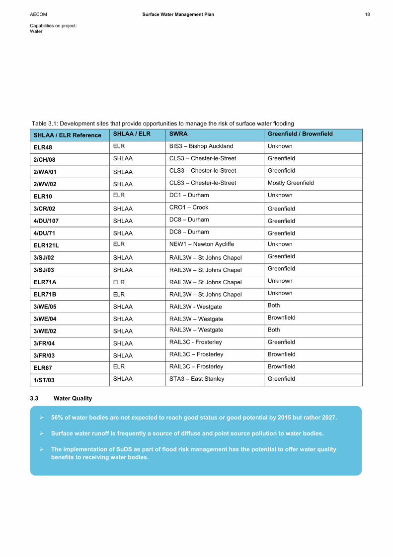
� Several development sites that provide opportunities to manage the risk of surface water flooding have been identified (Table 3.1)
� If development sites, situated in areas with a high risk of surface water flooding, are unlikely to come forward in the planning process, the Partners ought to consider using the sites themselves to provide surface water management, water quality benefits and green infrastructure opportunities, for example through the creation of wetlands.
� There are many areas where development does not offer opportunities to manage the risk of surface water flooding. In such circumstances the Partners will need to take action themselves, through the SWMP process, to manage the risk. This would usually be in the form of retro-fit schemes.
� The Partners can also encourage and support individuals / communities to take action to protect themselves from surface water flooding (see Section 4.1).
AECOM Surface Water Management Plan 18
Capabilities on project: Water
Table 3.1: Development sites that provide opportunities to manage the risk of surface water flooding
SHLAA / ELR Reference SHLAA / ELR SWRA Greenfield / Brownfield
ELR48 ELR BIS3 – Bishop Auckland Unknown
2/CH/08 SHLAA CLS3 – Chester-le-Street Greenfield
2/WA/01 SHLAA CLS3 – Chester-le-Street Greenfield
2/WV/02 SHLAA CLS3 – Chester-le-Street Mostly Greenfield
ELR10 ELR DC1 – Durham Unknown
3/CR/02 SHLAA CRO1 – Crook Greenfield
4/DU/107 SHLAA DC8 – Durham Greenfield
4/DU/71 SHLAA DC8 – Durham Greenfield
ELR121L ELR NEW1 – Newton Aycliffe Unknown
3/SJ/02 SHLAA RAIL3W – St Johns Chapel Greenfield
3/SJ/03 SHLAA RAIL3W – St Johns Chapel Greenfield
ELR71A ELR RAIL3W – St Johns Chapel Unknown
ELR71B ELR RAIL3W – St Johns Chapel Unknown
3/WE/05 SHLAA RAIL3W - Westgate Both
3/WE/04 SHLAA RAIL3W – Westgate Brownfield
3/WE/02 SHLAA RAIL3W – Westgate Both
3/FR/04 SHLAA RAIL3C - Frosterley Greenfield
3/FR/03 SHLAA RAIL3C – Frosterley Brownfield
ELR67 ELR RAIL3C – Frosterley Brownfield
1/ST/03 SHLAA STA3 – East Stanley Greenfield
3.3 Water Quality
�
� 56% of water bodies are not expected to reach good status or good potential by 2015 but rather 2027.
� Surface water runoff is frequently a source of diffuse and point source pollution to water bodies.
� The implementation of SuDS as part of flood risk management has the potential to offer water quality benefits to receiving water bodies.
AECOM Surface Water Management Plan 19
Capabilities on project: Water
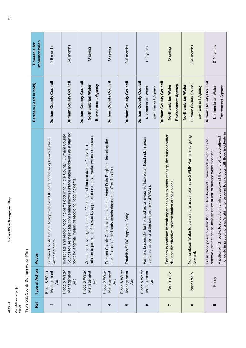
3.4 Action Plans
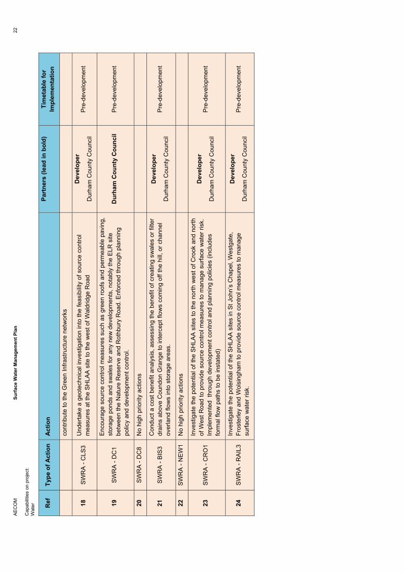
A generic Action Plan has been developed as part of Phase 4 of the SWMP for County Durham (Table 3.2). The Action Plan provides a list of actions by which the Partners (Durham County Council, Environment Agency and Northumbrian Water) can manage and mitigate surface water flooding across the County. IN addition to the county-wide Action Plan an individual Action Plan has been developed for each of the nine SWRAs considered by the Options phase (Appendix D). The high-priority actions which are essential to achieve SWMP objectives are outlined below.
AE
CO
M
Surf
ace
Wat
er M
anag
emen
t Pla
n20
Cap
abilit
ies
on p
roje
ct:
Wat
er
Tabl
e 3.
2: C
ount
y D
urha
m A
ctio
n P
lan
Ref
Ty
pe o
f Act
ion
Act
ion
Part
ners
(lea
d in
bol
d)
Tim
etab
le fo
r Im
plem
enta
tion
1Fl
ood
& W
ater
M
anag
emen
t A
ct
Dur
ham
Cou
nty
Cou
ncil
to im
prov
e th
eir G
IS d
ata
conc
erni
ng k
now
n su
rface
w
ater
inci
dent
s.
Dur
ham
Cou
nty
Cou
ncil
0-6
mon
ths
2Fl
ood
& W
ater
M
anag
emen
t A
ct
Inve
stig
ate
and
reco
rd fl
ood
inci
dent
s oc
curri
ng in
the
Cou
nty.
Dur
ham
Cou
nty
Cou
ncil
to u
se th
eir d
ata
conc
erni
ng k
now
n su
rface
wat
er in
cide
nts
as a
sta
rting
po
int f
or a
form
al m
eans
of r
ecor
ding
floo
d in
cide
nts.
D
urha
m C
ount
y C
ounc
il 0-
6 m
onth
s
3Fl
ood
& W
ater
M
anag
emen
t A
ct
Con
tinue
to in
vest
igat
e ca
uses
of f
lood
ing
and
the
stan
dard
s of
ser
vice
in
rela
tion
to p
robl
ems,
follo
wed
by
appr
opria
te re
med
ial w
orks
whe
re n
eces
sary
.
Dur
ham
Cou
nty
Cou
ncil
Nor
thum
bria
n W
ater
Envi
ronm
ent A
genc
y
Ong
oing
4Fl
ood
& W
ater
M
anag
emen
t A
ct
Dur
ham
Cou
nty
Cou
ncil
to m
aint
ain
thei
r Ass
et D
ata
Reg
iste
r. In
clud
ing
the
iden
tific
atio
n of
third
par
ty a
sset
s de
emed
to a
ffect
floo
ding
. D
urha
m C
ount
y C
ounc
il O
ngoi
ng
5Fl
ood
& W
ater
M
anag
emen
t A
ctE
stab
lish
SuD
S A
ppro
val B
ody
Dur
ham
Cou
nty
Cou
ncil
0-6
mon
ths
6Fl
ood
& W
ater
M
anag
emen
t A
ct
Par
tner
s to
con
side
r fur
ther
stu
dies
to re
view
sur
face
wat
er fl
ood
risk
in a
reas
id
entif
ied
as b
eing
at t
he g
reat
est r
isk
(SW
RA
s).
Dur
ham
Cou
nty
Cou
ncil
Nor
thum
bria
n W
ater
Env
ironm
ent A
genc
y
0-2
year
s
7P
artn
ersh
ip
Par
tner
s to
con
tinue
to w
ork
toge
ther
so
as to
bet
ter m
anag
e th
e su
rface
wat
er
risk
and
the
effe
ctiv
e im
plem
enta
tion
of th
e op
tions
.
Dur
ham
Cou
nty
Cou
ncil
Nor
thum
bria
n W
ater
Envi
ronm
ent A
genc
y
Ong
oing
8P
artn
ersh
ip
Nor
thum
bria
n W
ater
to p
lay
a m
ore
activ
e ro
le in
the
SW
MP
Par
tner
ship
goi
ng
forw
ard.
Nor
thum
bria
n W
ater
Dur
ham
Cou
nty
Cou
ncil
Env
ironm
ent A
genc
y
0-6
mon
ths
9P
olic
y
Put
in p
lace
pol
icie
s w
ithin
the
Loca
l Dev
elop
men
t Fra
mew
ork
whi
ch s
eek
to
rem
ove
/ pro
tect
crit
ical
infra
stru
ctur
e at
risk
of s
urfa
ce w
ater
floo
ding
.
A p
olic
y w
hich
see
ks to
relo
cate
this
infra
stru
ctur
e at
the
end
of it
s op
erat
iona
l lif
e w
ould
impr
ove
the
area
’s a
bilit
y to
resp
ond
to a
nd d
eal w
ith fl
ood
inci
dent
s in
Dur
ham
Cou
nty
Cou
ncil
Nor
thum
bria
n W
ater
Env
ironm
ent A
genc
y
0-10
yea
rs
AE
CO
M
Surf
ace
Wat
er M
anag
emen
t Pla
n21
Cap
abilit
ies
on p
roje
ct:
Wat
er
Ref
Ty
pe o
f Act
ion
Act
ion
Part
ners
(lea
d in
bol
d)
Tim
etab
le fo
r Im
plem
enta
tion
the
futu
re.
Set
sta
ndar
ds o
f pro
tect
ion
for f
lood
risk
to c
ritic
al in
frast
ruct
ure
(i.e.
road
s,
railw
ays
lines
, ele
ctric
ity in
stal
latio
ns, s
choo
ls, G
P’s
).
10
Pol
icy
Sur
face
wat
er ru
noff
shou
ld b
e m
anag
ed a
t sou
rce
avoi
ding
dis
posa
l to
a pu
blic
se
wer
whe
re p
ossi
ble.
Sou
rce
cont
rol m
easu
res
such
as
gree
n ro
ofs,
pe
rmea
ble
pavi
ng, s
tora
ge a
nd ra
inw
ater
har
vest
ing
coul
d al
l be
enco
urag
ed.
Dur
ham
Cou
nty
Cou
ncil
Nor
thum
bria
n W
ater
Env
ironm
ent A
genc
y
Pre
-dev
elop
men
t
0-12
mon
ths
11
Pol
icy
Dev
elop
men
t sho
uld
impl
emen
t pol
lutio
n co
ntro
l as
appr
opria
te to
hel
p im
prov
e w
ater
qua
lity
and
wor
k to
war
ds a
chie
ving
WFD
requ
irem
ents
.
Dur
ham
Cou
nty
Cou
ncil
Nor
thum
bria
n W
ater
Env
ironm
ent A
genc
y
Pre
-dev
elop
men
t
0-12
mon
ths
12
Pol
icy
Run
off r
ates
sho
uld
not e
xcee
d G
reen
field
whe
reve
r pos
sibl
e.
Dur
ham
Cou
nty
Cou
ncil
Nor
thum
bria
n W
ater
Env
ironm
ent A
genc
y
Pre
-dev
elop
men
t
0-12
mon
ths
13
Pol
icy
Run
off u
p to
and
incl
udin
g th
e 10
0 ye
ar e
vent
sho
uld
be m
anag
ed o
n si
te w
here
po
ssib
le.
Dur
ham
Cou
nty
Cou
ncil
Nor
thum
bria
n W
ater
Env
ironm
ent A
genc
y
Pre
-dev
elop
men
t
0-12
mon
ths
14
Pol
icy
Dev
elop
ers
shou
ld b
e en
cour
aged
to s
et p
art o
f the
ir si
te a
side
for s
urfa
ce w
ater
m
anag
emen
t and
to s
uppl
emen
t gre
en in
frast
ruct
ure
netw
orks
.
Dur
ham
Cou
nty
Cou
ncil
Nor
thum
bria
n W
ater
Env
ironm
ent A
genc
y
Pre
-dev
elop
men
t
0-12
mon
ths
15
Pol
icy
Sur
face
wat
er to
be
rem
oved
from
com
bine
d se
wer
sys
tem
s w
here
pos
sibl
e.
Dur
ham
Cou
nty
Cou
ncil
Nor
thum
bria
n W
ater
Env
ironm
ent A
genc
y
Pre
-dev
elop
men
t
0-12
mon
ths
16
SW
RA
- ST
A3
Inve
stig
ate
the
deve
lopm
ent p
oten
tial o
f the
SH
LAA
site
at B
eam
ish
Moo
r to
prov
ide
sour
ce c
ontro
l mea
sure
s to
man
age
surfa
ce w
ater
. D
evel
oper
P
re-d
evel
opm
ent
17
SW
RA
- C
LS2
Inve
stig
ate
the
optio
n of
usi
ng th
e ro
ads
as s
tora
ge( i
ncor
pora
ting
the
cost
of
road
re-g
radi
ng a
nd p
rofil
ing
of th
e ca
rriag
eway
to p
rovi
de o
verla
nd fl
ow p
aths
ou
t of t
he a
rea
to re
ach
Fron
t Stre
et a
nd C
one
Terra
ce)
Inve
stig
ate
the
pote
ntia
l of t
he S
HLA
A a
nd E
LR s
ites
to p
rovi
de s
tora
ge a
nd
Dur
ham
Cou
nty
Cou
ncil
Dev
elop
er
Pre
-dev
elop
men
t
AE
CO
M
Surf
ace
Wat
er M
anag
emen
t Pla
n22
Cap
abilit
ies
on p
roje
ct:
Wat
er
Ref
Ty
pe o
f Act
ion
Act
ion
Part
ners
(lea
d in
bol
d)
Tim
etab
le fo
r Im
plem
enta
tion
cont
ribut
e to
the
Gre
en In
frast
ruct
ure
netw
orks
18
SW
RA
- C
LS3
Und
erta
ke a
geo
tech
nica
l inv
estig
atio
n in
to th
e fe
asib
ility
of s
ourc
e co
ntro
l m
easu
res
at th
e S
HLA
A s
ite to
the
wes
t of W
aldr
idge
Roa
d
Dev
elop
er
Dur
ham
Cou
nty
Cou
ncil
Pre
-dev
elop
men
t
19
SW
RA
- D
C1
Enc
oura
ge s
ourc
e co
ntro
l mea
sure
s su
ch a
s gr
een
roof
s an
d pe
rmea
ble
pavi
ng,
stor
age
pond
s an
d sw
ales
for a
ny n
ew d
evel
opm
ents
, not
ably
the
ELR
site
be
twee
n th
e N
atur
e R
eser
ve a
nd R
othb
ury
Roa
d. E
nfor
ced
thro
ugh
plan
ning
po
licy
and
deve
lopm
ent c
ontro
l.
Dur
ham
Cou
nty
Cou
ncil
Pre
-dev
elop
men
t
20
SW
RA
- D
C8
No
high
prio
rity
actio
ns
21
SW
RA
- B
IS3
Con
duct
a c
ost b
enef
it an
alys
is, a
sses
sing
the
bene
fit o
f cre
atin
g sw
ales
or f
ilter
dr
ains
abo
ve C
ound
on G
rang
e to
inte
rcep
t flo
ws
com
ing
off t
he h
ill, o
r cha
nnel
ov
erla
nd fl
ows
into
sto
rage
are
as.
Dev
elop
er
Dur
ham
Cou
nty
Cou
ncil
Pre
-dev
elop
men
t
22
SW
RA
- N
EW
1 N
o hi
gh p
riorit
y ac
tions
23
SW
RA
- C
RO
1
Inve
stig
ate
the
pote
ntia
l of t
he S
HLA
A s
ites
to th
e no
rth w
est o
f Cro
ok a
nd n
orth
of
Wes
t Roa
d to
pro
vide
sou
rce
cont
rol m
easu
res
to m
anag
e su
rface
wat
er ri
sk.
Impl
emen
ted
thro
ugh
deve
lopm
ent c
ontro
l and
pla
nnin
g po
licie
s (in
clud
es
form
al fl
ow p
aths
to b
e in
stat
ed)
Dev
elop
er
Dur
ham
Cou
nty
Cou
ncil
Pre
-dev
elop
men
t
24
SW
RA
- R
AIL
3 In
vest
igat
e th
e po
tent
ial o
f the
SH
LAA
site
s in
St J
ohn’
s C
hape
l, W
estg
ate,
Fr
oste
rley
and
Wol
sing
ham
to p
rovi
de s
ourc
e co
ntro
l mea
sure
s to
man
age
surfa
ce w
ater
risk
.
Dev
elop
er
Dur
ham
Cou
nty
Cou
ncil
Pre
-dev
elop
men
t
AECOM Surface Water Management Plan 23
Capabilities on project: Water
3.5 Key Messages from SWRAs
Table 3.3 sets out the key messages that came out of the options phase for the nine SWRAs.
Table 3.3: Key Messages
SWRA Key Messages
STA3 STA3 has experienced 15 known surface water incidences relating to inadequate drainage capacity in the combined sewers. Issues with maintenance have resulted in blocked gullies and collapsed drains. The source of surface water in this area is primarily from the impermeable surfaces throughout the urbanised area. 93 properties fall within the Environment Agency’s Flood Map for Surface Water for the 200 year event. Annual Average Damages have been estimated at £95,000.
If developed, the SHLAA site to the east, on Beamish Moor provides an opportunity to manage surface water at source to benefit the wider area and prevent sewer systems downstream spilling. It is essential that soakaways, storage ponds or swales are considered on the SHLAA site to manage the runoff and could be combined with green roofs and rainwater harvesting systems.
West of Pelaw Avenue, the lack of open space and redevelopment opportunities means measures would need to be retro-fitted. The preferred measures are likely to be improving resilience and resistance or storage of water in the roads. Kerbing could be provided to contain and attenuate surface waters until the combined sewer system has capacity. Retro-fitting permeable pavements may provide some benefit. Similar measures are preferred at Cemetery Road, notably resilience measures and storage in the roads.
CLS2 35 properties fall within the Environment Agency’s Flood Map for Surface Water for the 200 year event. Annual Average Damages have been estimated at £45,000. The two key flood risk areas are Market Place and Hopgarth Gardens. Risk areas exist outside the SWRA at Avondale Terrace / Edward Street which links to flooding on Cone Terrace via Front Street.
At Avondale Terrace / Edward Street a significant flow path would be required to encourage water to drain onto Front Street and down towards Chester Burn. Road re-grading and landscaping could facilitate this. Interceptor grids could subsequently allow the water to drain into the culvert. Alternatively “street architecture” could be employed to channel surface water away. Redevelopment of SHLAA and ELR sites to the north may present opportunities to store water in ponds/wetlands. There are limited opportunities to implement measures other than local storage in roads or improved resilience and resistance of individual properties.
At Hopgarth Gardens, a playing field presents an opportunity to store water. In the Market Place there are several car parks and green areas which could be used for flood storage. Interceptor grids could be used to drain excess runoff into the watercourse.
CLS3 82 properties fall within the Environment Agency’s Flood Map for Surface Water for the 200 year event. Average Annual Damages have been estimated at £81,000. SHLAA sites are the preferred measure and it is essential that source control measures are considered if any SHLAA sites are brought forward for development.
There appears to be low spots creating overland flow paths through the Embleton Drive, Redesdale Road and Powburn Close areas. Runoff from the fields and the inundated highway drainage are believed to be the cause of several previous surface water incidents. The SHLAA site to the west of Waldridge Road should introduce source control measures such as green roofs, permeable paving, attenuation storage and rainwater harvesting. It may be possible to provide an overland flow route across the existing pavement surface. Alternatively storage of this water could be provided in Millennium Green.
At Cedar Street, source control methods such as green roofs and permeable paving, storage ponds and swales could capture runoff draining north, or the runoff could be diverted towards the allotments to the east of the residential area
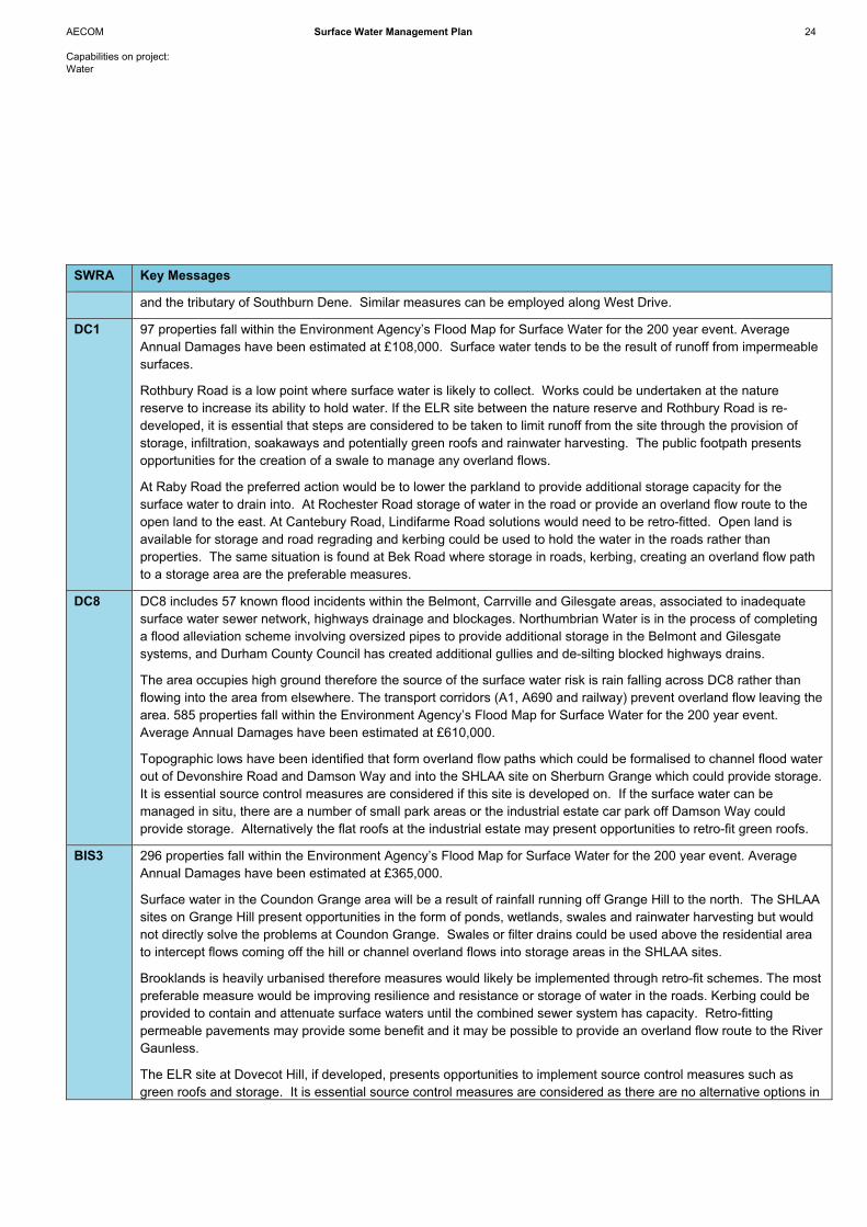
AECOM Surface Water Management Plan 24
Capabilities on project: Water
SWRA Key Messages
and the tributary of Southburn Dene. Similar measures can be employed along West Drive.
DC1 97 properties fall within the Environment Agency’s Flood Map for Surface Water for the 200 year event. Average Annual Damages have been estimated at £108,000. Surface water tends to be the result of runoff from impermeable surfaces.
Rothbury Road is a low point where surface water is likely to collect. Works could be undertaken at the nature reserve to increase its ability to hold water. If the ELR site between the nature reserve and Rothbury Road is re-developed, it is essential that steps are considered to be taken to limit runoff from the site through the provision of storage, infiltration, soakaways and potentially green roofs and rainwater harvesting. The public footpath presents opportunities for the creation of a swale to manage any overland flows.
At Raby Road the preferred action would be to lower the parkland to provide additional storage capacity for the surface water to drain into. At Rochester Road storage of water in the road or provide an overland flow route to the open land to the east. At Cantebury Road, Lindifarme Road solutions would need to be retro-fitted. Open land is available for storage and road regrading and kerbing could be used to hold the water in the roads rather than properties. The same situation is found at Bek Road where storage in roads, kerbing, creating an overland flow path to a storage area are the preferable measures.
DC8 DC8 includes 57 known flood incidents within the Belmont, Carrville and Gilesgate areas, associated to inadequate surface water sewer network, highways drainage and blockages. Northumbrian Water is in the process of completing a flood alleviation scheme involving oversized pipes to provide additional storage in the Belmont and Gilesgate systems, and Durham County Council has created additional gullies and de-silting blocked highways drains.
The area occupies high ground therefore the source of the surface water risk is rain falling across DC8 rather than flowing into the area from elsewhere. The transport corridors (A1, A690 and railway) prevent overland flow leaving the area. 585 properties fall within the Environment Agency’s Flood Map for Surface Water for the 200 year event. Average Annual Damages have been estimated at £610,000.
Topographic lows have been identified that form overland flow paths which could be formalised to channel flood water out of Devonshire Road and Damson Way and into the SHLAA site on Sherburn Grange which could provide storage. It is essential source control measures are considered if this site is developed on. If the surface water can be managed in situ, there are a number of small park areas or the industrial estate car park off Damson Way could provide storage. Alternatively the flat roofs at the industrial estate may present opportunities to retro-fit green roofs.
BIS3 296 properties fall within the Environment Agency’s Flood Map for Surface Water for the 200 year event. Average Annual Damages have been estimated at £365,000.
Surface water in the Coundon Grange area will be a result of rainfall running off Grange Hill to the north. The SHLAA sites on Grange Hill present opportunities in the form of ponds, wetlands, swales and rainwater harvesting but would not directly solve the problems at Coundon Grange. Swales or filter drains could be used above the residential area to intercept flows coming off the hill or channel overland flows into storage areas in the SHLAA sites.
Brooklands is heavily urbanised therefore measures would likely be implemented through retro-fit schemes. The most preferable measure would be improving resilience and resistance or storage of water in the roads. Kerbing could be provided to contain and attenuate surface waters until the combined sewer system has capacity. Retro-fitting permeable pavements may provide some benefit and it may be possible to provide an overland flow route to the River Gaunless.
The ELR site at Dovecot Hill, if developed, presents opportunities to implement source control measures such as green roofs and storage. It is essential source control measures are considered as there are no alternative options in

AECOM Surface Water Management Plan 25
Capabilities on project: Water
SWRA Key Messages
this area.
NEW1 The Burnhill Way area is a hotspot for surface water. The playing fields immediately to the north of Burnhill Way could be used for storage. Alternatively, creating storage in the roads is an option to prevent surface water flooding to properties. Kerbing could be provided to contain and attenuate surface waters until the sewer system has capacity. Given the highly urbanised setting, storage in roads can be implemented for the area immediately south of Woodham Burn. There is open floodplain alongside Woodham Burn which can be used to provide storage, if the water can be transferred from the urban setting to the river setting. This would require the formal overland flow paths to be instated.
The flat roof buildings on the industrial estate could retro-fit green roofs, however this is unlikely to be cost effective measure. It is essential that the ELR site, if developed, should implement source control measures wherever possible.
CRO1 560 properties fall within the Environment Agency’s Flood Map for Surface Water for the 200 year event. Average Annual Damages have been estimated at £626,000.
It is essential that the SHLAA site on Low and Middle Mown Meadows, if developed, should consider source control measures such as green roofs, storage basins and swales to provide benefits downstream. Similarly the SHLAA sites to the north of West Road also present opportunities to manage surface water runoff. This would likely require formal overland flow paths being created along the roads to facilitate drainage away from residential areas.
South End Villas is at surface water risk and it is proposed that the open green space at South End Villas is landscaped so as to provide storage during extreme events to limit water affecting properties. Additional potential opportunities would be to provide upstream storage in the playing fields to the north.
Due to a lack of open space at Whitfield Street, the only viable option would be to store water in the roads.
RAIL3 RAIL3 has experienced 26 known flood incidents the cause of which is a mix of highway issues, overland flow from local fields and overland flow after heavy rainfall from upland areas. Durham County Council engineers advised that Northumbrian Water has undertaken upsizing of the sewer system and removed Combined Sewer Overflows to alleviate the problems. The railway and the A689, B6278 and B6296 are at risk from flooding. 384 properties fall within the Environment Agency’s Flood Map for Surface Water for the 200 year event. Average Annual Damages have been estimated at £368,000.
If developed, it is essential that the SHLAA and ELR sites in St John’s Chapel and Westgate should consider implementing source control measures such as storage areas, swales, green roofs to help manage the risks of surface water flooding. Alternatively, the development proposed for north of Hood Street (St John’s Chapel) could be developed to accommodate a formal overland flow path on the western side or storage along the road near the caravan park. Removing a section of dismantled railway may reduce surface water ponding in the area. In Westgate there is the potential for storage along Front Street or formalising a flow path around the caravan park.
If developed, it is essential the three SHLAA sites in Frosterley or the SHLAA site to the south of the railway consider implementing source control measures. Storage along Front Street is a possibility and a culvert may be required under the active railway to alleviate the surface water risk in the area.
In Wolsingham it may be possible to channel overland flows from the risk area into SHLAA sites (storage). An alternative is to improve resilience and resistance or storage of water in roads along Leaze’s Lane, High Street, The Causeway and Riverdale. Kerbing could be used to contain and attenuate surface waters in these areas until the combined sewer system has capacity. There is also the ability to provide storage between Leaze’s Lane and the High Street to alleviate risk. There is an overland flow path running along the B6296. Two options would include

AECOM Surface Water Management Plan 26
Capabilities on project: Water
SWRA Key Messages
storage of water along the roadway until it feeds into the River Wear, or to utilise the SHLAA site to the east as storage in the form of a pond or wetland. The railway along Wolsingham is an active line and there is shallow flooding affecting the railway line. One measure could be the provision of a formal overland pathway in the form of a swale or filter drain to the River Wear.

Next Steps
AECOM Surface Water Management Plan 28
Capabilities on project: Water
4.1 Funding for Surface Water Management
The Environment Agency has calculated that one million people are vulnerable to surface water flooding with a further 2.8 million properties susceptible to surface water flooding alone. Average flood damage costs are currently in the region of £1 billion peryear, but these costs could rise to as much as £27 billion by 2080. At a time when the Government is calling for budget reductions, national government is unlikely to be a primary source of funding for measures by which the risk of surface water flooding can be managed. Given the national spending constraints, and due to the large and growing flood management problem, it is likely that local sources of funding will become increasingly important. The Pitt Review said that those that will benefit from flood defence might wish to contribute to costs: “The Review does not believe that it is unreasonable, therefore, for funding to come from sources other than Government, such as a local authorities, business, environmental organisations or localcommunity groups”.
The following section provides a discussion of potential means by which measures identified in the SWMP could be funded.
4.1.1 Local Authorities
Currently, local authorities receive an allocation from central government through the Revenue Support Grant, but this is not ring-fenced and does not have to be spent on flood risk. Alternatively, local authorities can use their own funds to tackle flood risk,choosing to follow the example of Gloucestershire County Council in raising additional council tax specifically to manage floodrisk.
Sources of local funding could include:
- Local authority spending (either from the revenue support grant or through a council tax levy);
- Voluntary contributions from local businesses or individuals; and,
- Community funding (such as though Business Improvement Districts or the Private Streetworks code)
Local authorities can apply for grant for capital investment from the Environment Agency to create new or improved flood risk andcoastal erosion management infrastructure.
Revenue and non-grant eligible expenditure by local authorities is supported by formula grant from Communities and Local Government (CLG), but it is not ringfenced for flood and coastal risk management. Individual authorities can decide how much tospend, subject to limits on overall budgets and the need for investment on other priorities.
Additional income can also be secured through the planning system and from contributions secured from major beneficiaries.
Local authorities and communities already have a range of options available to them to help pay for local schemes that do not meet national priorities but nevertheless deliver significant benefits to local communities. Such local funding mechanisms couldrange from the use of existing local authority prudential borrowing and wellbeing powers, the business improvement district (BID)model or even increases in council tax precepts, where these are affordable and in the best interest of local communities.
Other, new and alternative, funding sources are available from a range of organisations and beneficiaries. These include:
- Section 106 agreements (s106), local tariffs, supplementary planning documents and any future community infrastructure levy (CIL), subject to its introduction
- Local business rates including ’business rate supplements‘ and council taxes including specific precepts and ’special expenses‘, plus fees and charges, where appropriate and affordable
- Local activities that can achieve flooding and coastal erosion benefits as a secondary outcome to their primary purpose of securing community benefit and facilitating economic growth and sustainability. These activities would include those associated with the local environment, land management, highways management, community infrastructure management, recreation, tourism, wealth creation and regeneration plans.
4 Next Steps
AECOM Surface Water Management Plan 29
Capabilities on project: Water
4.1.2 Alternative Funding Sources – Business
In Hereford; the supermarket chain Asda contributed £2m as part of the planning conditions for a supermarket in the town, in addition to constructing 440m of flood defences. The total cost of the scheme was £7.5m and it provides protection to 196 properties including 25 listed buildings.
The Leeds City Flood Alleviation project will increase the level of protection to Leeds City centre but makes a relatively low contribution to reducing flood risk for households. However, the proposed project is likely to enable significant economic andfinancial benefits for the local and regional business, commercial and development/regeneration sectors. The Environment Agency considers that these benefits are sufficient to justify a contribution of at least £50m towards the £178m scheme’s totalcost. Discussions, consultations and negotiations are on-going between the Environment Agency and the City Council on how this value of contribution can be realised to secure the proposed benefits to the city.
4.1.3 Alternative Funding Sources – Community Self Help
The Hanneys Flood Group
Source: http://www.thehanneysfloodgroup.org.uk/
The villages of East and West Hanney, Oxfordshire were affected by flooding during 2007. Many residents felt that despite the unusual weather actions could have been taken to reduce the consequences of such flood events. The Hanneys Flood Group was set up to improve the ability of the community to accommodate similar events in the future. The Hanneys Flood Group consists of volunteers working for the benefit of the community and has members from the East Hanney and West Hanney Parish Council and Oxfordshire County Council and works closely with the Environment Agency, Oxfordshire Highways, Local Landowners, Vale of White horse District Council Emergency Response Officer and the Vale of White Horse District Council Land Drainage Engineer.
Volunteers cleared weeds from a local brook, increasing the brook’s capacity, and also constructed a flood defence bank and footpath. The Environment Agency provided soil, the hire of two mini-excavators and two dump trucks. The local authority paidfor coir rolls used to help stabilise the new bank.
Bucklebury Flood Alleviation Scheme
Source: www.floodalleviation.co.uk
A community-led partnership formed by Bucklebury residents, the Environment Agency and West Berkshire Council is the driving force behind a flood alleviation scheme for the village of Bucklebury, Berkshire. The villagers set up a Community Interest Company (CIC) after the floods of 2007, and took an active part in looking into how future flooding could be prevented.
Funded by the Regional Flood Defence Committee with contributions from the villagers and West Berkshire Council, the scheme will protect 25 homes and the village hall from future flooding. The overall cost of the scheme is £600,000; of which £65,000 hadbeen raised from residents alone, while grants from West Berkshire Council, Bucklebury Parish Council and the Thames Regional Flood Defence Committee would make up a further £550,000 towards the alleviation works. The flood alleviation scheme includes building flood bunds, digging a bypass channel and developing a new ford to divert flood flows around the village. It also includes works to ensure the flood risk is not increased downstream in Stanford Dingley. The CIC approached theEnvironment Agency and West Berkshire Council to discuss various strategies, and just over three years later, a new flood alleviation scheme was proposed for the village.
Appleby
Source: http://www.edenvalleymessenger.com/news/2009/november/appleby-flood-prevention-scheme-hailed-success
This scheme (and another in Sandside, South Lakeland) was jointly conceived and administrated by the Environment Agency and Eden District Council (South Lakeland District Council for Sandside). It formed part of the national Defra £500,000 Pilot
AECOM Surface Water Management Plan 30
Capabilities on project: Water
Flood Resilience project where local authorities and the Environment Agency were encouraged to work together in different ways to promote a resilience scheme. £90,000 and £80,000 of grant money was received by Eden and South Lakeland Councils respectively, directly from Defra. This arrangement meant that the Councils could use their grant distribution powers to fund individual property protection schemes.
The average amount of grant issued to the 46 properties that took part was approximately £1,300. The property owners were expected to fund any work in excess of the grant available for their particular property.
Approximately 26 of the properties that took part in the Appleby scheme benefited from their defences in the November 2009 flooding. They would have flooded if their resilience scheme funded defences had not been in place.
Bawdsey
Source: http://www.suffolkcoastal.gov.uk/news/thorpeness0211.htm
In 1997 a major storm led to the already vulnerable coastline at East Lane, Bawdsey in Suffolk to erode severely. This retreating coastline posed an immediate threat to three coastal properties, including a Grade I listed Martello Tower. Due to insufficientpriority, Suffolk Coastal District Council struggled to justify grant aid to fund a complete scheme at East Lane. This led to a series of emergency works along the District Council and Environment Agency frontages to limit the damage caused primarily from winter storms.
In 2007 a group of local landowners and residents formed East Lane Trust, a “not-for-profit” charitable organisation to raise £2.2m to implement a coastal protection and flood defence scheme for the 250m section of coast. The money was raised by selling plots of land in nearby villages. In 2007, the government granted special permission to allow 26 homes to be built on theplots which were not in the Local Plan as being available for residential development. The money raised was given to the DistrictCouncil to commission a sustainable coast protection scheme which was completed in summer 2009. It is thought to be the first privately funded coastal protection scheme since the enactment of the Coast Protection Act in 1949. The scheme highlights that,through effective co-operation between local communities and the responsible authorities, common goals can be achieved.
4.2 Requirements of the Flood & Water Management Act
The following describes two requirements of the Flood & Water Management Act that have been incorporated into the Action Plan.
4.2.1 Data Asset Register
The Flood and Water Management Act 2010, states that all Lead Local Flood Authorities must establish and maintain:
- a register of structures or features which, in the opinion of the authority, are likely to have a significant effect on flood risk in its area, and
- a record of information about each of those structures or features, including information about ownership and state of repair.
At this time it is not known what level of detail, or content, is required for an Asset Register since there is no guidance as to what constitutes a register and what needs to be included.
As part of the SWMP data collection exercise it is apparent that Durham County Council has several datasets that could form thebasis of an Asset Register although there are many areas where information concerning drainage is missing. It is expected thata great deal of relevant information is held within the Council and the experience of its staff that has not been formally documented.
Durham County Council have started production of an Asset Register and it has been suggested that it starts with the available data and initially seeks to expand it based on internal input whilst working towards gathering additional information from thirdparties before finally investing in going out to collect key data-sets relating to specific flood problems where these are not already known.
AECOM Surface Water Management Plan 31
Capabilities on project: Water
Durham County Council has already provided spreadsheets detailing culverts, bridges and other structures for County Durham. The culvert spreadsheet details 59 culverts and contains information on the culvert size, date built and name. The culvert spreadsheet also contains co-ordinates allowing the data to be plotted in GIS. The disadvantage is that it is a single co-ordinate,presumably for the culvert entrance/exit, therefore in the case of long culverts the exact route of the culvert is not known, although in many cases this will be easily plotted based on local engineering knowledge. The bridge dataset contains the bridgename, area and material; however no co-ordinates have been provided and therefore they cannot be plotted in GIS at present. Again for someone familiar with the dataset it would be a relatively quick exercise to spatially plot these bridges in GIS.
Whilst these are two extremely valuable datasets crucially they do not contain any information concerning the risk that the structure poses in terms of flood risk, the ownership and state of repair which is required as part of the Flood and Water Management Act.
Durham County Council have provided a gully dataset, however the data does not contain areas of known blockages, maintenance issues or works undertaken or required that would be useful for the SWMP. Metadata would be useful so as to understand what the information is showing, e.g. the IIT_DESCRI and IIT_X_SECT columns contain quantitative information that could be thematically mapped. However what the information represents is not clear and therefore cannot be accurately assessed.
Sewer asset data has presently not been supplied by Northumbrian Water. As a result no analysis of the data can be undertaken, or included as part of an Asset Register. It would be recommended that the sewer data be in a format compatible with GIS, and contain information regarding capacity issues or known drainage incidents so that the information can be analysedwith the priorities in this Scoping Report.
4.2.2 Investigate Flood Incidents
The Flood and Water Management Act also states that Lead Local Flood Authorities will; investigate flooding incidents in its area(where appropriate or necessary) to identify which authorities have relevant flood risk management functions and what they havedone or intend to do. The Lead Local Flood Authority will then be required to publish the results of any investigation, and notify any relevant authorities.
In order to do so, Durham County Council, in its capacity as Lead Local Flood Authority, will initially need to be made aware ofany reported flood incidents. Flooding could be reported to Durham County Council by members of the public, private organisations, the Environment Agency or Northumbrian Water. As such it would be appropriate for the County Council to maintain a register of flood incidents. It would also be practical for this to be integrated with the Asset Register so that assetsresponsible for flooding could be linked to the events.
In many instances, the flooding will not fall under the jurisdiction of the Environment Agency or Northumbrian Water therefore itwill fall to Durham County Council to investigate the matter. In such circumstances a quick response will be essential to ensure that details of the flood extent are accurately recorded (through site photographs and survey if appropriate) and eye witness accounts are documented before the passage of time has the effect of over- or under-exaggerating the events. Table 4.1 provides an example of how the information could be recorded.
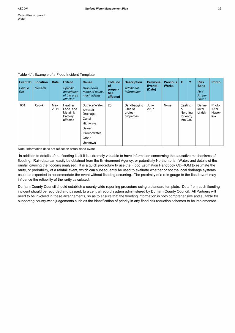
AECOM Surface Water Management Plan 32
Capabilities on project: Water
Table 4.1: Example of a Flood Incident Template
Event ID
UniqueRef
Location
General
Date Extent
Specificdescriptionof the area affected
Cause
Drop down menu of causal mechanisms
Total no. ofproper-tiesaffected
Description
AdditionalInformation
Previous Events (Date)
Previous Works
X Y RiskBand
Red Amber Green
Photo
001 Crook May 2011
HeatherLane and MetalinkFactory affected
Surface Water ArtificialDrainage CanalHighways SewerGroundwater Other Unknown
25 Sandbagging used to protectproperties
June2007
None Easting &Northingfor entry into GIS
Definelevelof risk
PhotoID or Hyper-link
Note: Information does not reflect an actual flood event
In addition to details of the flooding itself it is extremely valuable to have information concerning the causative mechanisms of flooding. Rain data can easily be obtained from the Environment Agency, or potentially Northumbrian Water, and details of the rainfall causing the flooding analysed. It is a quick procedure to use the Flood Estimation Handbook CD-ROM to estimate the rarity, or probability, of a rainfall event, which can subsequently be used to evaluate whether or not the local drainage systemscould be expected to accommodate the event without flooding occurring. The proximity of a rain gauge to the flood event may influence the reliability of the rarity calculated.
Durham County Council should establish a county-wide reporting procedure using a standard template. Data from each flooding incident should be recorded and passed, to a central record system administered by Durham County Council. All Partners will need to be involved in these arrangements, so as to ensure that the flooding information is both comprehensive and suitable forsupporting county-wide judgements such as the identification of priority in any flood risk reduction schemes to be implemented.

Summary
AECOM Surface Water Management Plan 34
Capabilities on project: Water
The SWMP is a high level, strategic document which serves as a starting point for the Partners to address surface water flood risk across County Durham and contribute robust evidence to support the Core Strategy. A holistic approach has been undertaken to address the surface water flood risk to existing and proposed development, assessing surface water flooding from sewers, drains, groundwater, and runoff from land and small watercourses that occur as a direct result of heavy rainfall.
The objectives of this SWMP are:
1. Guide limited resources to critical drainage areas of greatest need (existing development),
2. Ensure the level of future development does not exacerbate existing problems and identify opportunities for new development to provide benefits in terms of flood risk management,
3. Inform emergency planning and feed into Durham County Council’s Flood Plan and
4. Protect and improve water quality in accordance with the objectives of the WFD.
‘Guide limited resources to critical drainage areas of greatest need (existing development)’ and ‘Ensure the level of future development does not exacerbate existing problems and identify opportunities for new development to provide benefits in terms of flood risk management’
The Risk Assessment identified 139 SWRAs across the County, and prioritised the risk. As part of the Options phase, nine SWRAs were deemed the areas of greatest need, with measures identified by which the surface water risk can be mitigated, and analysed in terms of their suitability and practicality. Actions Plans have been developed by which the Partners can work together to manage the risks broadly on a county-wide basis and within the nine SWRAs.
Inform emergency planning and feed into Durham County Council’s Flood Plan
The findings of this Risk Assessment should be disseminated within each of the Partner organisations to inform and update (multi-agency) flood plans / severe weather plans and Local Resilience Forum community risk registers. This might include information on high flood risk areas, roads and access routes likely to be impassable, impacts on critical infrastructure or vulnerable people.
Protect and improve water quality in accordance with the objectives of the WFD
The SWMP is an opportunity to bring about co-ordinated improvements in water quality and has been considered as an integral part of this study. An overview of the strategic water environment in County Durham has been detailed so as to be able to understand the current water quality status and the role that the SWMP could potentially play to work towards achieving the WFD targets.
5.1 Surface Water Risk
Surface water poses a widespread risk across County Durham, concentrated in the urban areas to the east of the County. There are a number of known incidents which correlate well with the modelled Flood Map for Surface Water and Areas Susceptible to Surface Water Flooding. In some instances, associations have been set up by local communities in response to flooding.
Maintenance of man-made and natural drainage systems is critical to mitigating the surface water risk as many known incidents are due to inadequate maintenance.
5.2 Options
Preferred options have been identified for each SWRA, Table 5.1. Source control measures go hand-in-hand with planning polices and development control measures; please refer to C.4 of Appendix C for the shortlisted measures for each SWRA.
5 Summary

AECOM Surface Water Management Plan 35
Capabilities on project: Water
Table 5.1: Preferred Option
SWRA Preferred Option STA3 Green Roofs
Soakaways/Infiltration Planning Policies / Development Control
CLS2 Planning Policies / Development Control Improve Resilience and Resistance
CLS3 Planning Policies / Development Control
DC1 Planning Policies / Development Control
DC8 Planning Policies / Development Control
BIS3 Attenuation Storage Swales/Filter Drain Planning Policies / Development Control
NEW1 Flow/Storage on Roadway Improve Floodplain Storage Planning Policies / Development Control Improve Resilience and Resistance
CRO1 Planning Policies / Development Control
RAIL3 Planning Policies / Development Control
Development presents the best opportunities to manage the risk of surface water flooding. For the development sites that come forward to the planning process, Durham County Council should encourage developers to not only address surface water runoff from their site, typically by implementing source control measures, but to realise the potential benefits that can be achieved forthe wider area. These measures can be implemented through planning policies and development control. If development sites, situated in areas with a high risk of surface water flooding, are unlikely to come forward in the planning process, the Partnersought to consider using the sites themselves to provide surface water management, water quality benefits and green infrastructure opportunities, for example through the creation of wetlands. Where development sites do not offer opportunities to manage the surface water risk, Partners will need to take action themselves to manage the risk, such as retro-fit schemes. The Partners can also encourage and support individuals / communities to take action themselves.
Northumbrian Water wishes to limit the volume of surface water entering combined sewer systems. Re-development that manages surface water on site will increase the capacity of the combined sewer networks thereby limiting the risk of sewers surcharging and causing flooding.
5.3 Actions
An Action Plan has been produced at a county-wide scale and for each SWRA (Appendix D). The actions from the SWMP should be implemented by the Partners to manage surface water flooding, inform emergency planning, control drainage, review LDF land allocations, and develop investment programmes, at the same time as satisfying the requirements of the Flood and Water Management Act and contributing to the evidence base supporting the Durham Plan.
The SWMP is a ‘living’ document and it is vital the Partners to continue to work together after the completion of the SWMP to discuss the implementation of the proposed actions and to discuss progress of any further work or follow up actions which were identified in the preparation of the plans. Durham County Council should review the plans on a regular basis, but there are

AECOM Surface Water Management Plan 36
Capabilities on project: Water
circumstances which might trigger a review and/or an update sooner. These may include the occurrence of a flood incident or additional data becoming available, which may alter the understanding of risk within the study area or the outcome of investmentdecisions by Partners that is different to the preferred option, which may require a revision to the Action Plan.


