Page 1
An Equal Opportunity Employer
COUNTY OF PRINCE WILLIAM 5 County Complex Court, Prince William, Virginia 22192-9201 PLANNING
(703) 792-7615 FAX (703) 792-4401 OFFICE
Internet www.pwcgov.org
Christopher M. Price, AICP Director of Planning August 22, 2014
STAFF REPORT
Rezoning #PLN2014-00127, Stone Haven
(Brentsville Magisterial District)
Planning Commission Public Hearing Date: September 3, 2014
Staff Recommendation: Approval
I. Background is as follows:
A. Request - This is a request to rezone +/-864.2 acres from A-1, Agricultural, to PMR,
Planned Mixed Residential and PBD, Planned Business District. The proposal is to
permit development of up to 1,650 residential units consisting of single family
detached (SFD) and townhouse units and a maximum of 1,062,735 million square
feet of office/employment and commercial/retail development. The proposal will
rezone approximately 297.2 acres from A-1, Agricultural to PBD, Planned Business
District, and +/- 567 acres from A-1 to PMR, Planned Mixed Residential. This
request is associated with CPA #PLN2013-00186, Stone Haven, which if approved,
will change the Long Range Land Use designation of +/- 864 acres from SRL,
Suburban Residential Low, FEC, Flexible Use Employment Center, and ER,
Environmental Resource to adopt the Stone Haven Study land use map that includes
residential, employment, parks and open space, and transitional land use areas.
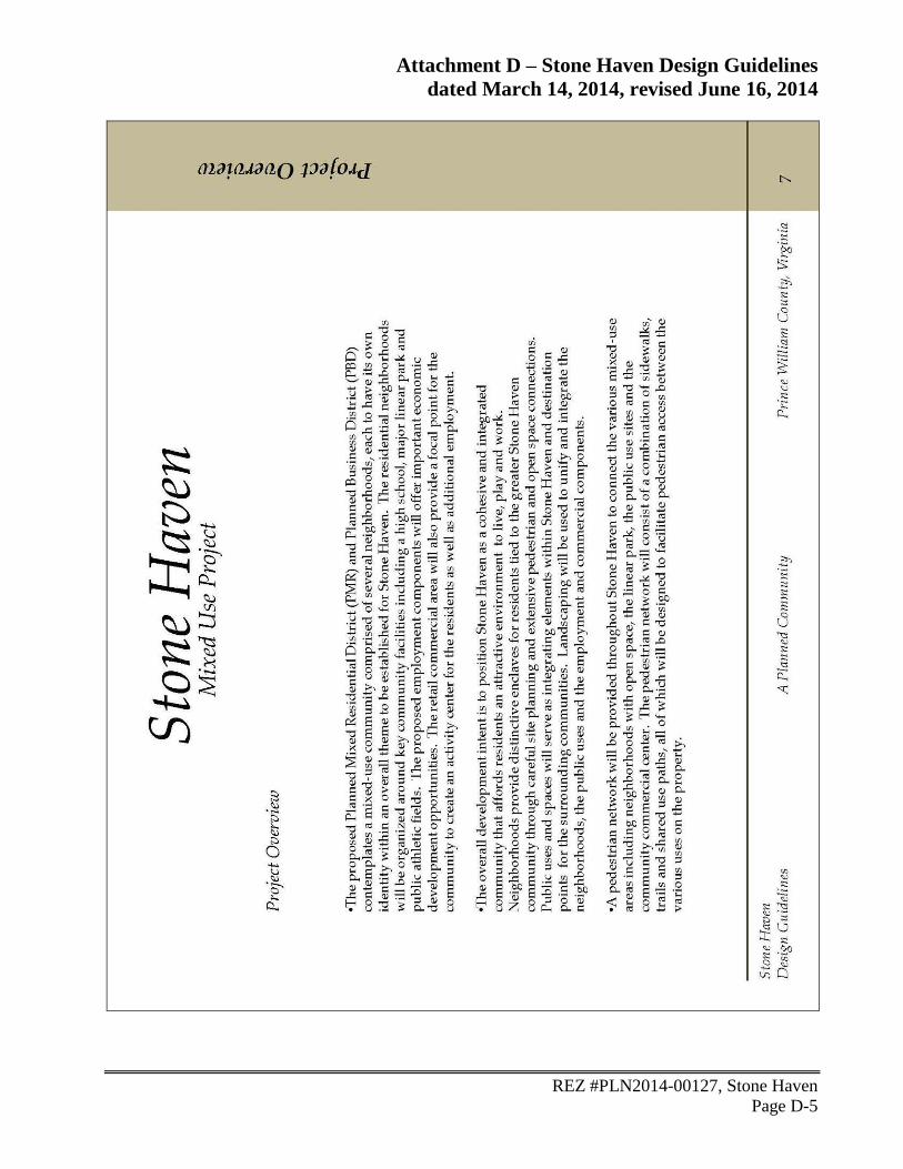
Stone Haven Proposed / Site Details
Project Area 864.2 acres &
23.4 acres (off-site area)
Number of Dwelling Units Maximum 1,650 SFD & townhouses
(minimum 50% SFD)
Density (residential landbays) +/-3.3 du/ac.
Residential landbay/acres +/-494.7
Community Amenities - Two community parks with trail network
- Two community centers (clubhouse,
pools, courts, tot lots)
-Nine neighborhood parks
(min. 12,000 SF each)
Page 2
REZ #PLN2014-00127, Stone Haven
August 22, 2014
Page 2
Nonresidential floor area 1,062,735 sq. ft.
Nonresidential landbay/acres +/-81.7
Neighborhood Commercial Center Up to 422,400 SF of office / retail
Transportation Improvements Two Comprehensive Plan roads, pedestrian
facilities, bus shelters, etc.
Land Dedicated:
School Site(s)
Parks
Public Use Facilities
Off-Site Facilities
Total land dedication
(Open Space & Public Use Sites)
+/-91.2 acres - High School
+/-166.5 Recreation/Linear Park
+/-30.1 acres - Active recreation or middle
school
+/-4.4 acres – Park-n-ride commuter
parking site &
+/-19 acres – Active recreation/Athletic
fields
+/-287.8 ac. & 23.4 ac. off-site =
+/-311.2 acres
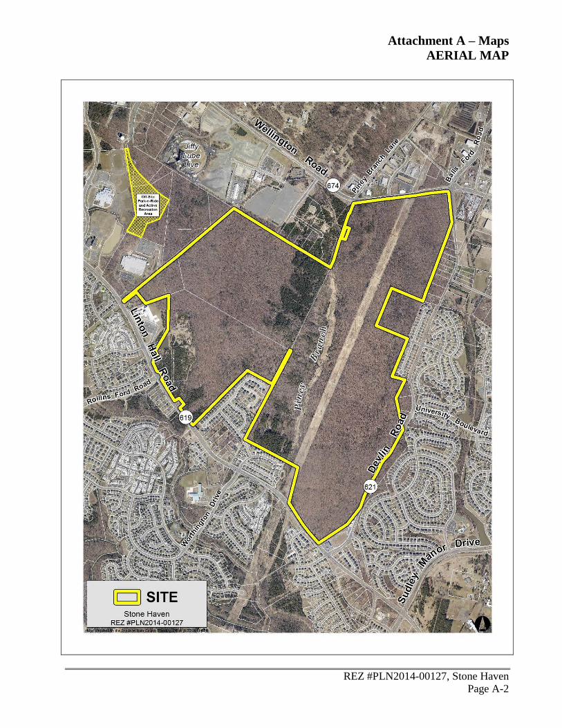
B. Site Location - The site is located on the south side of Wellington Rd., west of Devlin
Rd., and north and east of Linton Hall Rd (see maps in Attachment A). The site is
identified on County maps as GPINs 7496-17-4609, 7496-37-4872(pt), and 7496-35-
1841. The referenced off-site area is identified on County maps as GPINs 7497-10-
2413(pt), 7496-19-4118(pt) and 7496-29-2826(pt).
C. Comprehensive Plan - The site is designated SRL, Suburban Residential Low, FEC,
Flexible Use Employment Center, and ER, Environmental Resource. There is a
companion Comprehensive Plan Amendment (CPA #PLN2013-00186, Stone Haven)
to adopt the Stone Haven Study Land Use Map and associated text.
D. Zoning –The site is zoned A-1, Agricultural, in its entirety. The property is located in
the Airport Safety Overlay District (ASOD).
E. Surrounding Land Uses - The site is currently undeveloped except for an electric
transmission line traversing the site from north to south just east of Piney Branch.
Along the north end of the property, the adjacent land uses consist of heavy and light
industrial uses, office and vacant lots. The Jiffy Lube Live event center property is
located to the north of the site. Properties to the east of property largely consist of
single family detached residential development. On the northeast side of the
property, along Wellington Rd., there are a number of industrial and office/flex uses.
Also, the site for the future Devlin Road Elementary School is located on the east side
of the property adjacent to existing residential development. On the south side of the
property, the existing development is residential. There are two elementary schools
Page 3
REZ #PLN2014-00127, Stone Haven
August 22, 2014
Page 3
(Piney Branch and Bristow Run) in this area, but the majority of the development in
the area is single family detached and townhouse development. A small,
neighborhood-serving commercial property consisting of a pharmacy and a childcare
facility is located at the corner of Linton Hall Rd. and Devlin Rd. To the west, the
property is bordered by vacant industrial zoned properties and a datacenter use.
Further to the west, there are two religious institutions and the Gainesville Middle
School property.
II. Current Situation is as follows:
A. Planning Office Recommendation - The Planning Office recommends approval of the
Rezoning #PLN2014-00127, Stone Haven, subject to the proffers dated August 6,
2014, found in Attachment C. Staff recommends approval for the following reasons:
The proposed Stone Haven Land Use Plan Master Zoning Plan is intended to
implement the Stone Haven Study Land Use Map that was initiated by the Board
and developed through a citizen input process. Stakeholders concerns were
identified through the community planning process and addressed in the rezoning.
Residential, retail/commercial, office, office/flex and open space areas are located
on the property in conformance with the Stone Haven Study Land Use Map.
The proposal allows for compatible uses within the property and provides uses
consistent with existing adjacent uses.
The proposal includes the construction of two minor arterial road sections as
identified in the Comprehensive Plan. The construction of Rollins Ford Rd. and
University Blvd. through the property will provide key links and connections
within the area and for the region.
The proposal includes the dedication of two potential school sites. A high school
site will be dedicated as proffered, and a middle school site will be provided if
requested by the School Board and approved through a public facility review.
Open space will be provided at a minimum of 35% of the project area, including
both active and passive recreation areas to be dedicated the county.
Improvements associated with the construction of athletic fields are proffered.
The proffered Design Guidelines depict high quality architectural form and
provide overall community design principles for the project.
B. Planning Commission Public Hearing - A public hearing before the Planning
Commission has been advertised for September 3, 2014.
III. Issues in order of importance are as follows:
A. Comprehensive Plan
1. Long-Range Land Use - Is the proposed use consistent with those uses
intended by the Stone Haven Study Land Use Map?
Page 4
REZ #PLN2014-00127, Stone Haven
August 22, 2014
Page 4
2. Level of Service (LOS) - How does the proposal address the Policy Guide for
Monetary Contributions in effect July 1, 2006?
B. Community Input - Have members of the community raised any issues?
C. Other Jurisdictional Comments - Have other jurisdictions raised any issues?
D. Legal Uses of the Property - What uses are allowed on the property? How are legal
issues resulting from the Planning Commission action addressed?
E. Timing – When must the Planning Commission take action on this application?
IV. Alternatives beginning with the staff recommendation are as follows:
A. Recommend approval of Rezoning #PLN2014-00127, Stone Haven, subject to the
proffers dated August 6, 2014, found in Attachment C.
1. Comprehensive Plan Consistency Analysis:
a) Long-Range Land Use - The Stone Haven Land Use Plan Master
Zoning Plan is generally consistent with the Stone Haven Study Land
Use Map that was initiated by the Board and developed through a
citizen input process. The applicant has proposed a maximum of 1,650
residential units and 1,062,735 sq. ft. of nonresidential/employment
development. The landbays allow for uses consistent with the Stone
Haven Study and surrounding uses.
b) Level of Service (LOS) - The level of service impacts related to the
request would be mitigated by the proffered monetary contributions as
follows:
Category:
Monetary
Proffers
Single family -
875 units
Townhouse -
775 units Nonresidential –
1,062,735 SF
Total
Fire and
Rescue
$749 per unit =
$655,375
$720 per unit =
$558,000 $0.61/sq. ft. =
$648,268.35
$1,861,643.35
Libraries $610 per unit =
$533,750
$601.00 per unit
= $465,775
N/A $999,525.00
Housing $250 per unit =
$218,750
$250.00 per unit
= $193,750
N/A $412,500.00
Water Quality $75 per acre 864.2 acres N/A $64,815.00
Total $3,338,483.35
Page 5
REZ #PLN2014-00127, Stone Haven
August 22, 2014
Page 5
Category:
Nonmonetary
Proffers
2006 LOS
Single family
– 875 units
2006 LOS
Townhouse
– 775 units
2006 LOS
Total
Proffered Improvement
& Land Dedicated Estimated
Value of
Proffers
Parks and
Recreation
$3,972 per unit
= $3,475,500
$3,725 per
unit =
$2,886,875
$6,362,375 196.1 acre passive & active
recreation (trails & ball
fields)
19 acre active recreation
(off-site)
$34,735,744
Schools $14,462 per
unit =
$12,654,250
$11,685 per
unit =
$9,055,875
$21,710,125 91.2 acre high school site
& associated infrastructure $24,250,000
Transportation $17,926 per
unit =
$15,685,250
$15,196 per
unit =
$11,776,900
$27,462,150 Two Comprehensive Plan
roads, pedestrian facilities,
bus shelters, etc.
$28,922,662
Total $55,534,650.00 $87,908,406.00
Total Proffer
Value $87,908.406.00 + $3,338,483.35 = $91,246,889.35
Notes: Actual dedicated acreage amounts may be reduced for road dedication and construction.
Dominion transmission line easement traverses the property east of Piney Branch within Passive Recreation area.
RPA & Floodplain assessed at 50% developable land value.
2. Community Input - The application has been transmitted to adjacent property
owners within 200 feet. As of the date of this report, the Planning Office has
received three phone calls from citizens with general questions about the
proposal.
3. Other Jurisdictional Comments - The project area is outside the required
notification area of nearby jurisdictions.
4. Legal Uses of the Property – The property could be developed pursuant to the
proffers associated with this rezoning with uses permitted in the PMR & PBD
zoning districts. Legal issues resulting from Planning Commission action are
appropriately addressed by the County Attorney’s office.
5. Timing - The Planning Commission has until December 2, 2014, 90 days from
the first public hearing date, to take action on this proposal. Approval of the
rezoning would meet the 90-day requirement.
B. Recommend denial of Rezoning #PLN2014-00127, Stone Haven.
1. Comprehensive Plan
a) Long-Range Land Use - If the application is denied, the land use
designation of the site would remain SRL, Suburban Residential Low,
FEC, Flexible Use Employment Center, and ER, Environmental
Resource, and the zoning classification would remain A-1,
Agricultural.
Page 6
REZ #PLN2014-00127, Stone Haven
August 22, 2014
Page 6
b) Level of Service - Denial would not have any impact on the existing
level of service.
2. Community Input - Notice of the application has been transmitted to adjacent
property owners within 200 feet. As of the date of this report, the Planning
Office has received three phone calls from citizens with general questions
about the proposal.
3. Other Jurisdictional Comments - The project area is outside the required
notification area of nearby jurisdictions.
4. Legal Uses of the Property – The rezoning site could be developed with uses
permitted in the A-1 zoning district. Legal issues resulting from Planning
Commission action are appropriately addressed by the County Attorney’s
office.
5. Timing - The Planning Commission has until December 2, 2014, 90 days from
the first public hearing date, to take action on this proposal. Denial of the
rezoning would meet the 90-day requirement.
V. Recommendation is that the Planning Commission accept Alternative A and recommend
approval of Rezoning #PLN2014-00127, Stone Haven, subject to the proffers dated August
6, 2014.
Staff: Stephen L. Donohoe, X5282
Attachments
A. Area Maps
B. Staff Analysis
C. Proffer Statement and GDP
D. Stone Haven Design Guidelines
E. Off-Site Public Use Sites Exhibit
F. Amberleigh Station/Silver Leaf Buffer Exhibit
G. Environmental Constraints Analysis
H. Historical Commission Resolution
Page 7
Attachment A – Maps
VICINITY MAP
REZ #PLN2014-00127, Stone Haven
Page A-1
Page 8
Attachment A – Maps
AERIAL MAP
REZ #PLN2014-00127, Stone Haven
Page A-2
Page 9
Attachment A – Maps
EXISTING ZONING MAP
REZ #PLN2014-00127, Stone Haven
Page A-3
Page 10
Attachment A – Maps
LONG-RANGE LAND USE MAP
REZ #PLN2014-00127, Stone Haven
Page A-4
Page 11
Attachment B - Staff Analysis
REZ #PLN2014-00127, Stone Haven
Page B-1
Part I. Summary of Comprehensive Plan Consistency
Staff Recommendation: Approval
The following is a summary of staff’s analysis of this request to rezone +/-864.2 acres from A-1,
Agricultural, to PMR, Planned Mixed Residential and PBD, Planned Business District. The
proposal is to permit development 1,650 residential units consisting of single family detached and
townhouse units, a maximum of 1,062,735 million square feet of office/employment and
commercial/retail development. This analysis is based on the relevant Comprehensive Plan action
strategies, goals, and policies. A complete analysis is provided in Part II of this report.
Plan Consistency Reasons
Long-Range Land
Use
Yes The Stone Haven Land Use Plan Master Zoning Plan is
generally consistent with the Stone Haven Study Land Use
Map. The applicant has proposed a maximum of 1,650
residential units 1,062,735 sq. ft. of nonresidential
/employment development. Compatible with the
surrounding area, low density residential development is
proposed along Linton Hall Rd. The transitional area in the
middle of the property will consist of medium density
residential development and public facilities including a
high school site and athletic fields. Nonresidential landbays
are provided in the northern portion of the site nearer to
Wellington Rd., consistent with adjacent uses.
Community Design Yes The applicant has proffered to develop the site in substantial
conformance with the MZP. Development of property shall
be in conformance with the design concepts and details set
forth in the Stone Haven Design Guidelines for residential
and nonresidential development. Buffers and landscaped
areas shall be provided in conformance with the
Buffer/Streetscape Plan. The applicant shall provide a 50 ft.
landscape area along Linton Hall Rd. and construct a 4-6 ft.
tall berm along landbay J. A buffer with an average width
of 100 ft. along the adjacent residential communities of
Amberleigh Station and Silver Leaf is proffered. A network
of trails, sidewalks, and scenic community trails shall be
provided throughout the project. The pedestrian network
allows for connections within the property and provides
linkages to existing trails and sidewalks in the neighboring
communities.
Cultural Resources Yes A Phase I study has been completed for this site. Staff
recommended further archaeological work or avoidance for
a number of the cultural resource sites identified in the
Phase I study. The applicant has proffered accordingly.
Page 12
Attachment B - Staff Analysis
REZ #PLN2014-00127, Stone Haven
Page B-2
Environment Yes Approximately 35% of this site is proposed to be provided
as open space including areas of RPA, floodplain, perennial
and intermittent streams and tree preservation areas. A
water quality monitoring contribution is proffered. The
applicant shall prepare a stormwater management master
plan for the property.
Fire and Rescue Yes The applicant has proffered a monetary contribution to
mitigate LOS impacts on Fire and Rescue according to the
policy guidelines.
Housing Yes The applicant has proffered a monetary contribution to the
Housing Preservation and Development Fund.
Libraries Yes The applicant has proffered LOS mitigation for impacts on
library services according to the policy guidelines.
Parks, Open Space
and Trails
Yes The applicant has proffered to dedicate approximately 160
acres for use as open space/linear park/passive recreation
purposes including trails, boardwalks, wildlife management
structures, and observation decks. The applicant will also
dedicate +/-30 acres to be used for parks and recreation
purposes for the development of athletic fields. An
additional +/-19 acres, outside of the project area, will be
dedicated to the County, for the construction of off-site
athletic fields. In addition, the applicant shall construct
facilities on the athletic field sites up to a total cost of $3
million. The “Athletic Fields Facilities”, will include
rectangular fields, baseball fields and/or a field house with
associated parking with specific facilities, design and
location to be determined by the County.
Police Yes The Police Department has recommended the safety and
security measures that should be incorporated into the
design of the site. Continued cooperation with the Police
Department will reduce impact to police services.
Potable Water Yes As proffered, the applicant shall design and construct all on-
site and off-site public water facilities.
Sanitary Sewer Yes As proffered, the applicant shall design and construct all on-
site and off-site public sewer facilities.
Page 13
Attachment B - Staff Analysis
REZ #PLN2014-00127, Stone Haven
Page B-3
Schools Yes The applicant has proffered a high school site planned for
landbay F and a middle school site is being considered in
the area of landbay B. If determined at a future time,
landbay B (+/-30.1 acres), may be used for a middle school
subject to the public facility review process. The School
Board is satisfied with the proffered dedication of +/-91.2
acres (net of +/-85 acres after ROW dedication) for the high
school site.
Transportation Yes The applicant has proffered to construct two minor arterial
roads that traverse the property. The applicant has proposed
to construct a full section of University Blvd. (4-lane
divided road) from Devlin Rd., to Progress Ct., including
on-site and off-site construction. Likewise, the applicant
has proposed to build a full section of Rollins Ford Rd. (4-
lane divided road) from the intersection with Linton Hall
Rd. to the existing edge of Rollins Ford Rd. located off-site
on the property to the north. Aside from the intersections of
University Blvd. and Devlin Rd. and Rollins Ford Rd. and
Linton Hall Rd., there will be no direct access to the site
from Devlin Rd. or Linton Hall Rd. The applicant will
provide warranted signalization and has proffered the
construction of up to four bus shelters and a pedestrian
facility along Linton Hall Rd. +/-4.4 acres off-site will be
dedicated to the county for use as a park-n-ride commuter
parking facility. A traffic impact analysis (TIA) was
required for this application
Page 14
Attachment B - Staff Analysis
REZ #PLN2014-00127, Stone Haven
Page B-4
Part II. Comprehensive Plan Consistency Analysis
The following table summarizes the area characteristics (see maps in Attachment A):
Direction Land Use Long Range Future Land Use
Map Designation
Zoning
North Jiffy Lube Live Event Center,
Heavy and light industrial
uses, office & office-flex,
vacant lots
EI M/T, M-2,
M-1, B-1,
A-1
South Single family detached
dwellings, townhouses,
pharmacy, retail, child care
facility
SRL, PL, NC & ER R-4, R-4C,
R-6, PMR,
A-1 & B-2
East Single family detached
dwellings, industrial uses
(commercial storage,
warehousing, wholesaling,
etc.) & office/flex
SRL, FEC & ER R-4, M-2,
A-1
West Office/flex, data center,
religious institutions,
Gainesville Middle School &
vacant lots
FEC, EI & PL M-1, M/T,
O(M)
Long-Range Land Use Plan Analysis
Through wise land use planning, the County ensures that landowners are provided a reasonable use
of their land while the County is able to judiciously use its resources to provide the services for
residents and employers’ needs. The Long Range Land Use Plan sets out policies and action
strategies that further the County’s goal of concentrating population, jobs, and infrastructure within
vibrant, walkable, mixed-use centers serviced by transit. In addition to delineating land uses on the
Long Range Land Use Map, the plan includes smart growth principles that promote a countywide
pattern of land use that encourages fiscally sound development and achieves a high-quality living
environment; promotes distinct centers of commerce and centers of community; complements and
respects our cultural and natural resources, and preserves historic landscapes and site-specific
cultural resources; provides adequate recreational, park, open space and trail amenities that
contribute to a high quality of life for county residents; and revitalizes, protects, and preserves
existing neighborhoods.
Page 15
Attachment B - Staff Analysis
REZ #PLN2014-00127, Stone Haven
Page B-5
This site is located within the development area of the County and is classified SRL, Suburban
Residential Low, FEC, Flexible Use Employment Center, and ER, Environmental Resource. If the
companion CPA request is approved, the property will be subject to the Stone Haven Study plan
and accompanying Stone Haven Study map. The following table summarizes the uses and densities
intended within the SRL, FEC and ER designations and the proposed Stone Haven Study:
Existing Long Range Land Use Designation:
Long-Range Land Use
Plan Classification
Land Uses Intended
Suburban Residential
Low (SRL)
(Existing)
The purpose of the Suburban Residential Low classification is to
provide for housing opportunities at a low suburban density. The
housing type in this classification is single-family detached, but up to
25 percent of the total land area may be single-family attached. The
density range in SRL projects is 1-4 units per gross acre, less the ER-,
Environmental Resource-designated portion of a property. Cluster
housing and the use of the planned unit development concept may
occur, provided that such clustering and planned district development
furthers valuable environmental objectives as stated in EN-Policy 1
and EN-Policy 4 of the Environment Plan, the intent stated in the
Cultural Resources Plan and preserves valuable cultural resources
throughout the county.
Flexible Use
Employment Center
(FEC)
(Existing)
The purpose of the Flexible Use Employment Center classification is
to provide for areas of employment uses situated on individual sites
or in campus-style “parks.” Primary uses in the FEC classification
are light manufacturing, “start-up” businesses, small assembly
businesses, and office uses (including government offices,
particularly those for Prince William County agencies). Retail and/or
retail service uses shall be considered secondary uses and shall
represent no greater than 25 percent of the total FEC gross floor area
of the project. These retail/retail service uses shall be so located on a
site that their primary purpose is to support the needs of those
employed within that FEC project. Warehousing, wholesale, storage
and/or distribution uses shall also be considered secondary uses
within any FEC project. Outdoor storage shall also be considered a
secondary use and shall be limited to no more than 25 percent of the
land area of the FEC project. Within an FEC-designated project, the
more intense uses shall be located in the core of the area and the less
intense uses (excluding outdoor storage) at the periphery, to act as a
transition between the FEC project and adjacent areas designated or
developed for different uses. Office development in FEC areas is
encouraged to be in accordance with the Illustrative Guidelines for
Office Development, provided as a supplement to the Community
Design Plan chapter of the Comprehensive Plan and available from
the Planning Office.
Page 16
Attachment B - Staff Analysis
REZ #PLN2014-00127, Stone Haven
Page B-6
Environmental
Resource (ER)
(Existing)
This classification is explained in detail within the Environment Plan.
Therein are located goals, policies, action strategies, and other Plan
components designed to protect the sensitive nature of the identified
resources. Environmental Resources include all 100-year floodplains
as determined by the Federal Emergency Management Act (FEMA),
Flood Hazard Use Maps or natural 100-year floodplains as defined in
the Design and Construction Standards Manual, and Resource
Protection Areas (RPAs) as defined by the Chesapeake Bay
Preservation Act. In addition, areas shown in an environmental
constraints analysis submitted with a rezoning or special use permit
application with wetlands; 25 percent or greater slopes; areas with 15
percent or greater slopes in conjunction with soils that have severe
limitations; soils with a predominance of marine clays; public water
supply sources; and critically erodible shorelines and stream banks
are considered part of the Environmental Resource Designation.
Long Range Land Use Designation per BOCS initiated Comprehensive Plan Amendment
#PLN2013-00186, Stone Haven:
Stone Haven
Study
(Proposed)
Action Strategies
1. The proposed land uses should be in general conformance with the
Stone Haven Study Land Use Map (Figure 1). The following
designations are identified on the map:
a. Low-Density Residential – Areas with this designation
should be developed with residential uses generally
consistent with SRL and at a density similar to the
adjoining neighborhoods. Employment uses should be
excluded.
b. Low-Density Residential/Open Space – Areas with this
designation should be developed with residential uses
generally consistent with SRL and at a density similar to
the adjoining neighborhoods and open space uses.
Employment uses should be excluded.
c. Transitional – Areas with this designation should be
developed with higher intensity, well-integrated mix of
uses that would provide a transition from the low density
residential uses along Linton Hall Road and the industrial
employment uses along Wellington Road. Uses in this area
could include a mix of residential, commercial, office, open
space, and public facilities uses. Residential density should
Page 17
Attachment B - Staff Analysis
REZ #PLN2014-00127, Stone Haven
Page B-7
be generally consistent with the standards in the SRM
District.
d. Employment – Areas with this designation should be
developed with a mix of employment uses. Residential uses
should be excluded.
e. Parks and Open Space – Areas with this designation should
be preserved as open space and provide opportunities for
passive recreational opportunities.
f. Buffer/Tree Line – This designation indicates areas where
special attention should be given to significant tree
preservation and to providing appropriate buffers along
existing neighborhoods.
2. The proposed land uses should be compatible with adjacent land
uses. Residential development should not intrude into the
Wellington Road corridor and industrial development should not
intrude into the Linton Hall Road corridor.
3. Transitional use zones (which could include a mix of medium
density suburban residential, commercial, office, open space, and
public facilities uses) should be established to serve as a buffer
between low density suburban residential and non-residential uses
and to promote mixed use opportunities.
4. A substantial mix of employment opportunities should be
preserved on the site, particularly along Wellington Road; in
particular provision of industrial uses along Wellington Road
would provide continuity with the industrial nature of the corridor.
5. Concern regarding school impacts (particularly the need for a new
high school), transportation impacts, and the need for public
facilities (e.g. active recreation, community facilities, etc.) should
be addressed.
6. Special attention should be given to significant tree preservation
(particularly along Linton Hall Road) and to providing appropriate
buffers along existing neighborhoods.
7. A substantial contiguous open space area should be preserved
throughout the site utilizing the areas around and between the
Environmental Resource area along Piney Branch and the
Page 18
Attachment B - Staff Analysis
REZ #PLN2014-00127, Stone Haven
Page B-8
Dominion transmission line easement. Opportunities to connect
this open space with development areas within the project area and
to adjacent communities should be considered.
8. Direct access to Linton Hall Road should be minimized.
9. Pedestrian linkages should be provided throughout the
development.
10. A recreational open space corridor should be provided along Piney
Branch.
11. A substantial contribution toward the completion of Rollins Ford
Road and University Boulevard should be provided.
Stone Haven
Study Land Use
Map
Figure 1
(Proposed)
Page 19
Attachment B - Staff Analysis
REZ #PLN2014-00127, Stone Haven
Page B-9
Background:
In March of 2013, the Board initiated a comprehensive plan amendment review for the Stone Haven
property. The Board initiated amendment of the Comprehensive Plan for the property from SRL,
FEC, and ER, to designations consistent with the Stone Haven Study Land Use Map. The Board
initiated the Stone Haven CPA with the following policies and concepts to be addressed with
implementing rezoning request:
Concept Plan – Implement the concept plan developed with stakeholder input through a land
use study.
Land Use Compatibility – The proposed uses will provide a better transition between land uses
compared to the existing planned land use.
Parks and Open Space – The applicant is proposing to designate a substantial area for parks and
open space.
Reduced Employment Capacity – The proposed amendment may result in a loss of land
designated for planned industrial employment capacity.
Request:
This is a request to rezone +/-864.2 acres from A-1, Agricultural, to PMR, Planned Mixed
Residential and PBD, Planned Business District. The proposal is to permit development 1,650
residential units consisting of single family detached and townhouse units, and a maximum of
1,062,735 million square feet of office/employment and commercial/retail development. The
proposal will rezone approximately 297.2 acres from A-1, Agricultural to PBD, Planned Business
District, and +/- 567 acres from A-1 to PMR, Planned Mixed Residential.
Proposal’s Strengths
Consistency with the Stone Haven Study Land Use Map - Generally, the rezoning proposal has
located residential, retail/commercial, office, office/flex and open space areas on the property in
conformance with the Stone Haven Study Land Use Map developed with stakeholder input
through a land use study process.
Use Corridors – As shown on the Stone Haven Study Land Use Map, the project area along
Wellington Rd. will remain an employment area with landbays shown on the MZP to allow
office, office-flex, and light industrial development. Also consistent with the Stone Haven
Study Land Use Map, the landbays along Linton Hall Rd. are proposed for low density
residential development consistent with the surrounding development.
Zoning Consistency – The requested zoning districts, PMR, Planned Mixed Residential and
PBD, Planned Business District, are consistent with the Stone Haven Study. The PMR is
Page 20
Attachment B - Staff Analysis
REZ #PLN2014-00127, Stone Haven
Page B-10
located primarily on the southern half of the site consistent with the surrounding residential
development while the PBD zoning is planned for the area north of University Blvd.,
establishing nonresidential development potential along Wellington Rd. The proposed zoning
districts allow for the mix of residential and employment development envisioned in the Stone
Haven Land Use Plan.
Density – The maximum number of units constructed on the property shall not exceed 1,650.
The overall proposed density is 3.3 dwelling units per acre over the residential landbays (LB G,
I, J, L & M). This density is within the envisioned density range for typical suburban low
density residential development in the county.
Public Use Sites – The proposal includes a dedication of up to +/-287.8 acres (on-site) to be
used as open space and/or as public use sites. This includes landbays intended for passive and
active recreation, schools, and a linear park. A high school site is planned for landbay F and a
middle school site is being considered in the area of landbay B. In addition, the applicant has
proffered to dedicate +/-23.4 acres located off-site to be used for the construction of athletic
fields and a park-n-ride site.
Low Density/Open Space Area – The Study Map shows an area designated Low Density
Residential/Open Space. This element of the land use map is implemented in the MZP with
landbay J & H planned for low density residential development and parks and open space. The
planned density within landbay J is 2.6 dwelling units per acre and a buffer with an average
width of 100 ft. is proffered along existing residential development.
Transitional Area – As shown on the MZP, development in this area will include a mix of
residential unit types and densities in addition to a high school and public use sites. As
proffered, the unit type in this area will be townhouses, single family detached and 2 over 2
stacked townhouses units. The density within the transitional area is +/-4.2. du/ac., consistent
with suburban medium density residential development in the county.
Employment Area – Approximately 82 acres are shown on the MZP that are planned for
nonresidential development. The uses permitted are those allowed in the B-1, General
Business, O/F, Office Flex, and M-2, Light Industrial zoning districts.
Open Space Area – A large contiguous open space area is proffered to be dedicated to the
county in landbays C & K. In turn, the area’s environmental features will be preserved while
creating an opportunity for passive recreation/linear park system.
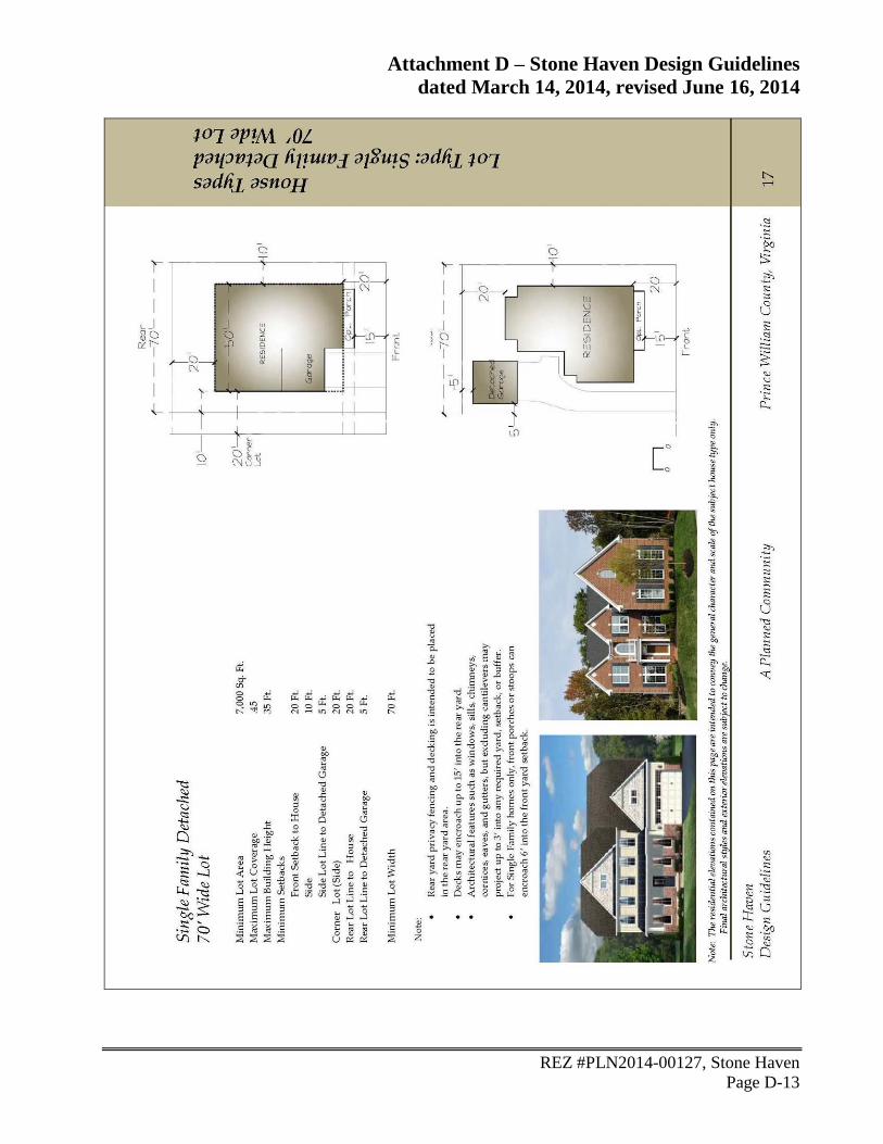
Lots Size - The applicant has proffered to a minimum lot size of 10,000 SF for lots adjacent to
the Amberleigh Station, Silver Leaf and Lanier Farms communities, similar to the lot sizes of
those communities.
Surrounding Use Conformance – Generally, the uses proposed in the landbays are compatible
with the surrounding existing uses. On the north end of the site near Wellington Rd, the
surrounding and planned uses are industrial and office/flex. On the southern end of the site
Page 21
Attachment B - Staff Analysis
REZ #PLN2014-00127, Stone Haven
Page B-11
along Linton Hall Rd., and to the east along Devlin Rd., the proposed residential development is
in keeping with the established residential character of those areas.
Proposal’s Weaknesses
Industrial Land – It should be noted, subject to the CPA, the county’s stock of land planned for
industrial development will decrease by approximately 240 acres. However, as indicated from
the Stone Haven Study, there was little support for office, industrial, or commercial
development along Linton Hall Rd.
On balance, this application is found to be consistent with the relevant components of the Long-
Range Land Use Plan.
Community Design Plan Analysis
An attractive, well-designed County will attract quality development, instill civic pride, improve the
visual character of the community and create a strong, positive image of Prince William County.
The Community Design Plan sets out policies and action strategies that further the County’s goals
of providing quality development and a quality living environment for residents, businesses and
visitors, and creating livable and attractive communities. The plan includes recommendations
relating to building design, site layout, circulation, signage, access to transit, landscaping and
streetscaping, community open spaces, natural and cultural amenities, stormwater management, and
the preservation of environmental features.
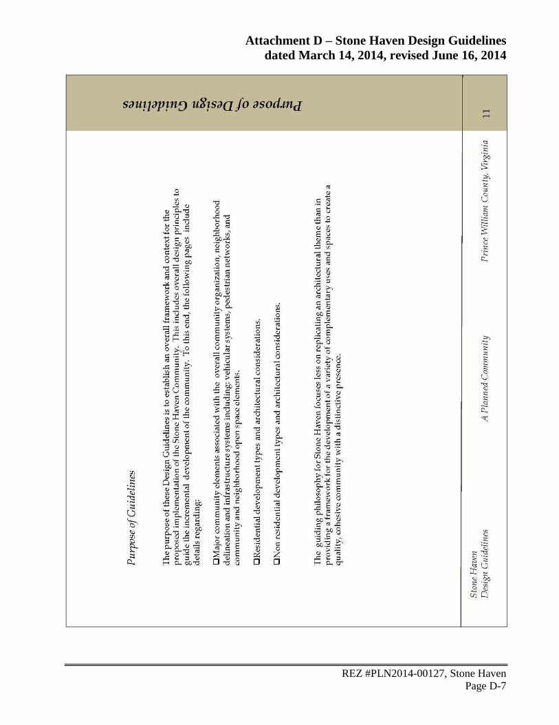
The development of Stone Haven shall be in conformance with the design concepts and details set
forth in the Stone Haven Design Guidelines. The plan includes illustrative design guidelines for
residential and nonresidential development throughout the property, outlining the various elements
and guiding principles for quality building architecture and providing examples of high quality
building and site design. In addition to building design, the guidelines include details for major
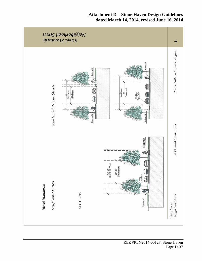
community elements including, neighborhood delineation, housing types, street hierarchy,
community amenities, and open space. The plan also includes illustrative gateway/entry/corridor
design guidelines that recommend streetscaping elements including, monumentation, landscaping,
signage, lighting, street furnishings, and pedestrian connections, that will be incorporated into
project’s gateways and corridors.
Proposal’s Strengths
Design Guidelines - The development of Stone Haven shall be in conformance with the design
concepts and details set forth in the Stone Haven Design Guidelines. The design guidelines
provide the framework for the intended quality of the development throughout the project.
Open Space – Open space shall be provided throughout the project in accordance with the Open
Space / Public Use Plan. Open space is provided in several ways including, natural open space
areas, tree save areas, and general open space areas. For the overall project area, the applicant’s
Page 22
Attachment B - Staff Analysis
REZ #PLN2014-00127, Stone Haven
Page B-12
open space tabulation shows approximately 41.9% of this site is proposed to remain as open
space. Although the minimum open space requirement for the property may reduce to 35% as
proffered, this still exceeds the minimum ordinance requirement of 30%. As shown, of the +/-
864 acres Stone Haven property, approximately 362 acres will be open space.
Buffers - Buffers and landscaped area shall be provided on the property in conformance with
the Buffer/Streetscape Plan provided by the applicant and referenced in the proffers. The
applicant shall provide a 50 ft. landscape area along Linton Hall Rd. and construct a 4-6 ft. tall
berm along landbay J. In response to community feedback expressing interest for buffers, the
applicant has committed to providing a buffer with an average width of 100 ft. along the
adjacent residential communities of Amberleigh Station and Silver Leaf. The buffer shall be
provided in conformance with the attached buffer exhibit entitled, Amberleigh Station and
Silver Leaf Buffer Exhibit.
Pedestrian Links/Trails – The applicant has provided a network of trails, sidewalks, and scenic
community trails throughout the project. The pedestrian network allows for connections within
the property and provides linkages to existing trails and sidewalks in the neighboring
communities. The details for the proffered improvements are as follows:
University Boulevard and Rollins Ford Road – As proffered and shown on the
Transportation and Pedestrian Network Plan and within the Design Guidelines, the applicant
will construct Class I trails and 5 ft. wide sidewalks associated with University Blvd. and
Rollins Ford Rd. throughout the property.
Linton Hall Road - As proffered and shown on the Transportation and Pedestrian Network
Plan and within the Design Guidelines, the applicant will construct a 5 foot wide sidewalk
along the property frontage with Linton Hall Rd. (landbays H, J & M). This sidewalk
construction will reduce the gaps along this portion of Linton Hall Rd. where sidewalks do
not exist while connecting to the existing sidewalk along Piney Branch Elementary and
along a portion of the Amberleigh Station neighborhood.
Wellington Road – As proffered and shown on the Transportation and Pedestrian Network
Plan, the applicant shall construct a Class I trail along a portion of the property frontage
with Wellington Rd. (landbay A).
Neighborhood Sidewalks & Trails – As proffered, the applicant will provide pedestrian
facilities on both sides of all subdivision streets within the residential neighborhoods.
Scenic Community Trails – As proffered and shown on the Transportation and Pedestrian
Network Plan and within the Design Guidelines, the applicant will provide trails throughout
the open space corridor consisting of landbays C & K that stretch from Wellington Rd. on
the north end of the site to the southern reach of the property near Linton Hall Rd. The
applicant will ensure that the connection of the scenic community trail is made with the
proposed sidewalk along Linton Hall Rd. This is an important connection in linking the
Stone Haven trail network to the surrounding community trails and county trail network.
Page 23
Attachment B - Staff Analysis
REZ #PLN2014-00127, Stone Haven
Page B-13
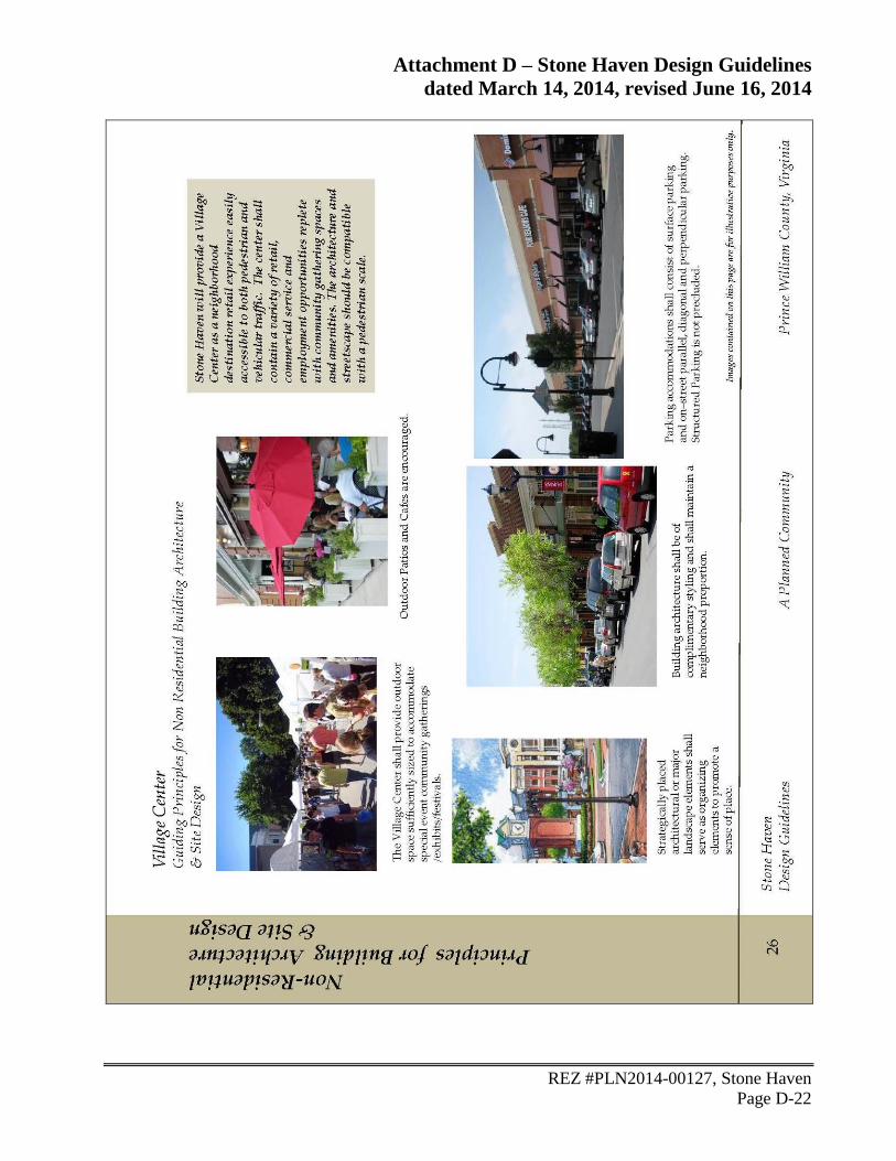
Village Center Commercial Development – Development within the Village Center shall be
provided in conformance with the proffers and design guidelines as follows:
Layout – The applicant intends to provide retail/commercial development using a compact,
street-oriented design. As proffered and shown on the Village Center layout, buildings
located within 100 ft. of Rollins Ford Rd. and University Blvd. shall be positioned to create
a building edge along the street. Street parking should be provided for internal roads with
the intent of providing attractive storefronts and good pedestrian access. A landscaped berm
shall be provided where parking areas are not screened from adjacent ROWs.
Architecture - As proffered, all buildings shall be constructed using 4-sided architecture
with plain concrete masonry units (CMU) prohibited for treatment of the front and rear of
buildings. Additionally, as shown in the design guidelines Village Center, architecture and
streetscape are intended to be complimentary and neighborhood proportional.
Bicycle Racks – As proffered, the applicant will provide bike racks in strategic locations
throughout the property.
Owners Associations – As proffered, throughout the development of Stone Haven, multiple
owners associations will be established to oversee the on-going maintenance of common areas
throughout the development.
Proposal’s Weaknesses
None identified.
On balance, this application is found to be consistent with the relevant components of the
Community Design Plan.
Cultural Resources Plan Analysis
Prince William County promotes the identification, evaluation, and protection of cultural resource
sites throughout the County, as well as the tourism opportunities these sites present. The Cultural
Resources Plan recommends identifying, preserving, and protecting Prince William County’s
significant historical, archaeological, architectural, and other cultural resources—including those
significant to the County’s minority communities—for the benefit of all of the County’s citizens
and visitors. To facilitate the identification and protection of known significant properties that have
cultural resource values worthy of preservation, the land use classification County Registered
Historic Site (CRHS) is used in the Comprehensive Plan. The plan includes areas of potentially
significant known but ill-defined or suspected pre-historic sites, Civil War sites, historic viewsheds,
landscapes or areas of potential impact to important historic sites, and encourages the identification,
preservation, protection, and maintenance of all cemeteries and/or gravesites located within the
County.
Page 24
Attachment B - Staff Analysis
REZ #PLN2014-00127, Stone Haven
Page B-14
Phase I archaeological studies are generally required at submission of rezoning and special use
permit applications where significant prehistoric or historic sites and cemeteries are known or
suspected. Phase II evaluations and treatment plans studies may also be required. Records research
is required of all applicants for rezoning, special use permit, comprehensive plan amendment, and
public facility review applications.
This project area was surveyed for archaeological resources in 2005 during the review process for
the Brentswood rezoning, PLN2005-00357. The report titled, A Phase I Cultural Resource Survey
of the Hunter Tract, Prince William County, Virginia, revised February 21, 2006 (Zawacki et al
2006), identified multiple archaeology sites within the rezoning area.
Proposal’s Strengths
Archaeological Study - A Phase I study has been completed for this site. The County has
provided recommendations for treatment of identified sites by requiring further archaeology
work in the form of a Phase II/III or complete avoidance. The applicant has proffered further
archaeology as recommended.
Cemetery – The applicant has proffered to preserve the cemetery in landbay J in place. At the
time of subdivision plan review, the applicant shall provide a cemetery delineation and shall
preserve the cemetery in accordance with the requirements set forth in the Zoning Ordinance.
Curation – The applicant has proffered to curate all cultural resource artifacts found on the site
with the County in accordance with current professional standards.
Proposal’s Weaknesses
None identified.
On balance, this application is found to be consistent with the relevant components of the Cultural
Resources Plan.
Environment Plan Analysis
Prince William County has a diverse natural environment, extending from sea level to mountain
crest. Sound environmental protection strategies will allow the natural environment to co-exist with
a vibrant, growing economy. The Environment Plan sets out policies and action strategies that
further the County’s goal of preserving, protecting and enhancing significant environmental
resources and features. The plan includes recommendations relating to the incorporation of
environmentally sensitive development techniques, improvement of air quality, identification of
problematic soil issues, preservation of native vegetation, enhancement of surface and groundwater
quality, limitations on impervious surfaces, and the protection of significant viewsheds.
Page 25
Attachment B - Staff Analysis
REZ #PLN2014-00127, Stone Haven
Page B-15
The applicant submitted an Environmental Constraint Analysis (ECA). The ECA includes
information of the mapped Resource Protection Area (RPA), wetland delineation, and on-site
Perennial Flow Determination (PFD). This site has ER (Environmental Resource) area, which
consisting of approximately 15% (130 acres) of the site, and includes RPA, 100-year floodplain,
and slopes 15% or greater. The site has an approved PFD (#13-00146) and an approved
Preservation Area Site Assessment (PASA) (#14-00112).
This 864 acre site is predominantly wooded. The site does contain perennial (tributary to Rocky
Branch) and intermittent streams on-site. Several forest cover types have been identified, including
mature hardwood forests. The applicant provided an Open Space and Public Use Plan that
identifies natural open space areas on the property. The applicant’s plan includes three landbays
(landbay C, K & H) that will be designated as P/OS, Parks and Open Space to be used for passive
recreation and a linear park. This area consists of approximately 160 acres of natural open space
that will remain undisturbed with the majority of the area being dedicated to the County as
permanent open space and linear park area. In addition, the applicant has identified tree save open
space areas that will remain substantially in their existing natural undisturbed condition. For these
identified areas, the applicant shall prepare a tree preservation plan to be submitted to the Prince
William County Watershed Division for review in association with each site plan submitted for the
property. The applicant is seeking a waiver of the minimum 30% open space requirement in the
PMR; however, staff supports the reduction because for the overall project area, the applicant is
providing 35% open space between the PMR and PBD zoned areas. The applicant shall survey two
areas that were identified as potential rare plant species habitat. If the survey determines that rare
plant species do exist in these areas, the applicant shall provide a management plan in consultation
with Watershed Management and the Virginia Department of Conservation and Recreation.
This site is located in Subwatersheds #244, 246 & 260, which flows into Rocky Branch in the
Broad Run watershed. Stormwater management will be addressed for each phase of development
as determined at site plan review.
Proposal’s Strengths
Open Space – For the overall project area, the applicant’s open space tabulation shows
approximately 41.9% of this site is proposed to remain as open space. Although the minimum
open space requirement for the property may reduce to 35%, this still exceeds the minimum
ordinance requirement of 30%.
Rare Plant Habitat - The applicant has proffered to survey two areas that were identified as
potential rare plant species habitat. If the survey determines that rare plant species do exist in
these areas, the applicant shall provide a management plan in consultation with Watershed
Management and the Virginia Department of Conservation and Recreation.
Streams – The streams throughout the property are generally being left undisturbed. The
perennial streams that exist in landbays C, K & H are designated as natural open space areas
that will be permanent open space. The applicant has proffered to provide a 50 foot buffer on
both sides of the intermittent stream that extends into landbay F. Landbay F is designated for
public use for the development of a high school.
Page 26
Attachment B - Staff Analysis
REZ #PLN2014-00127, Stone Haven
Page B-16
Water Quality – The applicant has proffered to make a monetary contribution in the sum of
$75.00 per acre to the Board of County Supervisors for the purpose of monitoring water quality,
stream restoration projects, and/or drainage improvements.
Tree Preservation – As proffered, the applicant is to prepare a tree preservation plan to be
submitted to the Prince William County Watershed Division for review in association with each
site plan submitted for the property.
Stormwater Management – As proffered, the applicant shall prepare a stormwater management
master plan for the property. Each site/subdivision plan shall incorporate the final design of the
stormwater management facilities that implement the SWM master plan.
Proposal’s Weaknesses
None identified.
On balance, this application is found to be consistent with the relevant components of the
Environment Plan.
Fire and Rescue Plan Analysis
Quality fire and rescue services provide a measure of security and safety that both residents and
businesses have come to expect from the County. The Fire and Rescue Plan sets out policies and
action strategies that further the County’s goal of protecting lives, property, and the environment
through timely, professional, humanitarian services essential to the health, safety, and well-being of
the community. The plan includes recommendations relating to siting criteria, appropriate levels of
service, and land use compatibility for fire and rescue facilities. The plan also includes
recommendations to supplement response time and reduce risk of injury or death to County
residents, establishment of educational programs, such as cardio-pulmonary resuscitation (CPR)
training, automatic external defibrillators (AED), and encourage installation of additional fire
protection systems—such as sprinklers, smoke detectors, and other architectural modifications.
The site is closest to the Linton Hall Fire and Rescue Station #25. It is estimated that there are
approximately 2,204 incidents per tactical unit at this station, which is outside of the recommended
standard of 2,000 incidents per unit. It is estimated that the majority of the site is located within the
recommended 4.0-minute response time for fire suppression and basic life support. It is also
estimated that the response time for this site would be within the recommended 8.0-minute response
time for advanced life support. The road construction associated with this proposal should decrease
the response time to points on the northern portion of the property. The Prince William County
Department of Fire and Rescue has reviewed the rezoning application and offered no further
comment on the request.
Page 27
Attachment B - Staff Analysis
REZ #PLN2014-00127, Stone Haven
Page B-17
Proposal’s Strengths
Level of Service - The applicant has proffered to provide monetary contributions for the
residential units and nonresidential development in accordance with the policy guidelines.
4.0 Minute Response Time – The majority of the site is within the recommended 4.0-minute
response time for fire suppression and basic life support.
8.0 Minute Response Time – The site is within the recommended 8.0-minute response time for
advanced life support.
Proposal’s Weaknesses
Station Workload – The number of incidents per tactical unit for the closest station exceeds the
recommended standard.
On balance, this application is found to be consistent with the relevant components of the Fire and
Rescue Plan.
Housing Plan Analysis
Prince William County is committed to clean, safe and attractive neighborhoods for all its residents,
and the elimination of neighborhood blight and substandard housing. The Housing Plan sets out
policies and action strategies that further the County’s goal of identifying locations and criteria for
the provision of diverse housing opportunities for all segments of our population and to promote
economic development. The Plan includes recommendations relating to neighborhood preservation
and improvement, affordable housing, special needs housing, and public/private partnerships to
address housing needs.
As recommended in the Comprehensive Plan, to assist in the need for affordable housing in Prince
William County, the applicant has proffered a monetary contribution of $250 per residential unit to
the Housing Preservation and Development Fund. The fund assists in developing housing options
for those in the County who cannot afford to reside in the community.
Proposal’s Strengths
Monetary Contribution - The applicant has proffered to provide a monetary contribution to the
Housing Preservation and Development Fund.
Proposal’s Weaknesses
None identified.
Page 28
Attachment B - Staff Analysis
REZ #PLN2014-00127, Stone Haven
Page B-18
On balance, this application is found to be consistent with the relevant components of the Housing
Plan.
Library Plan Analysis
Access to a variety of information is a valuable service provided by the County. The Library Plan
sets out policies and action strategies that further the County’s goal of providing adequate library
facilities and information resources to our residents. The Plan includes recommendations relating
to siting criteria, appropriate levels of service, and land use compatibility.
The library nearest the proposed project is the Bull Run Regional Library located at 8051 Ashton
Avenue in Manassas. It is estimated that the proposed development will generate a need for
additional library space and volumes of books and periodicals. Development as proposed will
generate a need for capital expenditures of $999,525 ($610 per detached dwelling x 875 units and
$601 per single family attached dwelling x 775 units). The applicant has proffered this amount.
Proposal’s Strengths
Level of Service - The applicant has proffered to provide monetary contributions for the
residential units in accordance with the policy guidelines. The Prince William County Public
Library System has reviewed the rezoning request and believes the application meets the LOS
standards.
Proposal’s Weaknesses
None identified.
On balance, this application is found to be consistent with the relevant components of the Library
Plan.
Parks and Open Space Plan Analysis
The quality of life for residents of Prince William County is linked closely to the development and
management of a well-maintained system of parks, trails, and open space. Prince William County
contains a diversity of park, open space, and trail resources. These parklands, open spaces, and
recreational facilities play a key role in shaping both the landscape and the quality of life of Prince
William County residents through the conservation of natural and cultural resources, protection of
environmental quality, and provision of recreational facilities. The Parks, Open Space and Trails
Plan sets out policies and action strategies that further the County’s goal of providing park lands
and recreational facilities of a quantity, variety, and quality appropriate to meet the needs of the
current and future residents of Prince William County. The plan includes recommendations to
preserve existing protected open space, maintain high quality open space, expand the amount of
protected open space within the County, and to plan and implement a comprehensive countywide
network of trails.
Page 29
Attachment B - Staff Analysis
REZ #PLN2014-00127, Stone Haven
Page B-19
The proposed residential development is near the following area parks and trails:
Type Name
Neighborhood None
Community Bridlewood – Rocky Branch Park (site)
Regional Prince William Golf Course
Linear and
Resource-Based
Braemar Linear Park
Trails Broad Run Recreational Corridor
Development of the site, as proposed, will generate a need for an additional 354.9 acres of parks
accessible to the general public (70 acres/1,000 population), an additional 76.05 acres of county
park land (15 acres/1,000 population). The applicant shall dedicate to the Prince William Board of
County Supervisors, at no cost to the County, approximately 160 acres of land, for the use as linear
park/open space/passive recreation purposes, trails, boardwalks, wildlife management structures,
observation decks, informative signs. The applicant will also dedicate at no cost of the County,
approximately 30 acres of land to be used for parks and recreation purposes for the development of
athletic fields. An additional +/-19 acres, outside of the project area, will be dedicated to the
County, for the construction of off-site athletic fields as referred to in the proffers. As proffered,
the applicant shall construct facilities on the athletic field sites up to a total cost of $3 million. The
“Athletic Fields Facilities”, will include rectangular fields, baseball fields and/or a field house with
associated parking withe specific facilities, design and location to be determined by the County in
consultation with the applicant.
Within the 160 acres to be dedicated and conveyed to the County for passive recreation purposes,
consisting of Land Bays C and K, the applicant shall construct a network of 6 foot wide scenic
community trails, consisting of approximately two (2) miles. A conceptual layout depicting the
general location of the open space trail network is shown on the Transportation Plan. A minimum
of six (6) trail connections into the adjoining land bays shall be provided, one of which shall be
provided to Land Bay B, where the on-site active recreation development will occur. In the
southern portion of the site in Land Bay K, the trail will extend southward either through Landbay
M or through off-site pedestrian access easements to provide for a connection to Linton Hall Road
and the sidewalk to be constructed along the Linton Hall Road frontage of Land Bay M. The
northern terminus of the trail in Land Bay C shall provide for a connection to Wellington Road
provided the shared use path has been constructed along Wellington Road by the time the design of
such trail is provided to the County for approval.
The applicant has proffered to provided two community recreation centers. The applicant shall
provide a primary and secondary recreation amenity area in the general locations shown on the
Master Zoning Plan. Collectively the amenities shall include, at a minimum, two (2) swimming
pools, a clubhouse with community meeting space/multi-purpose room, fitness room, four tennis
and/or multi-purpose courts and three tot lots. The tot lots and courts may be located at the
recreation amenity areas or at other location within community as determined by the applicant. The
two swimming pools shall include one which will be a minimum 6-lane, 25-meter pool, and a
Page 30
Attachment B - Staff Analysis
REZ #PLN2014-00127, Stone Haven
Page B-20
second, which will be either a 6-lane, 25-meter pool or similar sized leisure pool. A minimum of
nine (9) neighborhood parks shall be provided throughout the property. The parks may consist of
Tree Save Open Space Areas, as identified on the Open Space Plan, community greens, pocket
parks, provided each such park shall be a minimum area of 12,000 square feet.
Proposal’s Strengths
Level of Service - The applicant has proffered to dedicate 209 acres of land for active and
passive recreation purposes. This includes 160 acres for passive recreation including a network
of trails, 30 acres for active recreation (athletic field site) and 19 acres off-site for athletic fields.
The applicant has proffered up to $3 million of improvements for the athletic field sites. This is
in lieu of a level of service monetary contribution. The applicant’s proposed improvements are
expected to exceed the total of the typical monetary contribution consistent with the level of
service policy guidelines.
Trails – The Applicant has proposed to construct several trails throughout the development with
at least 6 connections throughout the development with one connecting to Land Bay B.
Community Amenities – The Applicant has proposed to construction two recreation amenity
areas with will include at a minimum two (2) swimming pools, one of which will be a minimum
6-lane, 25-meter swimming pool, a clubhouse with community meeting space/multi-purpose
room, fitness room, four tennis and/or multi-purpose courts and three tot lots, and nine (9)
neighborhood parks
Proposal’s Weaknesses
None identified.
On balance, this application is found to be consistent with the relevant components of the Parks,
Open Space and Trails Plan.
Police Plan Analysis
Residents and businesses expect a high level of police service for their community. This service
increases the sense of safety and protects community investments. The Police Plan is designed to
promote Prince William County’s public safety strategic goal to continue to be a safe community,
reduce criminal activity, and prevent personal injury and loss of life and property, as well as to
ensure effective and timely responses throughout the County. This plan encourages funding and
locating future police facilities to maximize public accessibility and police visibility as well as to
permit effective, timely response to citizen needs and concerns. The plan recommends educational
initiatives, such as Neighborhood and Business Watch, and Crime Prevention through
Environmental Design (CPTED), which encourages new development to be designed in a way that
enhances crime prevention. The plan also encourages effective and reliable public safety
communications linking emergency responders in the field with the Public Safety Communications
Center.
Page 31
Attachment B - Staff Analysis
REZ #PLN2014-00127, Stone Haven
Page B-21
Proposal’s Strengths
Safety and Security Measures - The Police Department has recommended the safety and
security measures that should be incorporated into the design of the site.
Proposal’s Weaknesses
None identified.
On balance, this application is found to be consistent with the relevant components of the Police
Plan.
Potable Water Plan Analysis
A safe, dependable drinking water source is a reasonable expectation of County residents and
businesses. The Potable Water Plan sets out policies and action strategies that further the County’s
goal of providing an economically and environmentally sound drinking water system. The plan
includes recommendations relating to system expansion, required connections to public water in the
development area, and the use of private wells or public water in the rural area.
The property is within the Prince William County Service Authority service area. Public water is
available to the property, but requires construction of off-site facilities. Existing water mains are
available along Rollins Ford Rd., Linton Hall Rd., Wellington Rd., and adjacent parcels. The
applicant shall design the water facilities shown on the Stone Haven Utility Plan to include, but not
limited to, the 30-inch water main along University Blvd. and the 16-inch and 18-inch mains along
Rollins Ford Rd. Additional water main construction may be required in order to provide required
fire protection hydrant coverage and fire flows.
Proposal’s Strengths
Water Connection - The applicant is required to comply with Zoning Ordinance Section 32-
250.74, which mandates connection of the site to public water service. The proffers require the
applicant to design and construct all on-site and off-site water utility improvements necessary to
develop the subject use.
Infrastructure Plan – The applicant has proffered the Stone Haven Utility Plan.
Proposal’s Weaknesses
None identified.
On balance, this application is found to be consistent with the relevant components of the Potable
Water Plan.
Page 32
Attachment B - Staff Analysis
REZ #PLN2014-00127, Stone Haven
Page B-22
Sanitary Sewer Plan Analysis
Appropriate wastewater and sanitary facilities provide needed public health and environmental
protections. The Sanitary Sewer Plan sets out policies and action strategies that further the
County’s goal of providing an economically and environmentally sound sanitary and stormwater
sewer system. The plan includes recommendations relating to system expansion, required
connections to public sewer in the development area, and the use of either private or public sewer
systems in locations classified as Semi-Rural Residential (SRR), as well as the rural area.
The property is within the Prince William County Service Authority area. Public sewer is available
to the property, but requires construction of off-site facilities. Existing gravity sewer connections
can be made at Linton Hall RD. and adjacent to Amberleigh Station within the Broad Run Sewer
Shed. The applicant shall design the sewer facilities shown on the Stone Haven Utility Plan to
include, but not limited to, the 24-inch gravity main and the removal of the Piney Branch pump
station along Piney Branch Rd. This will combine the Piney Branch Sewer Shed and Broad Run
Sewer Shed.
Proposal’s Strengths
Sewer Connection - The applicant is required to comply with Zoning Ordinance Section 32-
250.75, which mandates connection of the site to public sewer service. The proffers require the
applicant to design and construct all on-site and off-site sewer utility improvements necessary to
develop the subject use.
Infrastructure Plan – The applicant has proffered the Stone Haven Utility Plan.
Proposal’s Weaknesses
None identified.
On balance, this application is found to be consistent with the relevant components of the Sanitary
Sewer Plan.
Schools Plan Analysis
A high-quality education system serves not only the students and their families, but the entire
community by attracting employers who value educational opportunities for their employees. The
Schools Plan sets out policies and action strategies that further the County’s goal of providing
quality public education to our school-aged population. The Plan includes recommendations
relating to facility size and location, siting criteria, compatible uses, and community use of school
facilities.
Page 33
Attachment B - Staff Analysis
REZ #PLN2014-00127, Stone Haven
Page B-23
The Schools Plan establishes level of service (LOS) standards for schools Countywide, based on
available or project program capabilities. The Schools Plan recommends that proposed
developments offset impacts on County schools by providing land for future schools and/or
monetary contributions for construction of schools.
Based on annually updated county-wide student generation factors, the proposed change for the
dwelling units, shown on the plan, is projected to generate the following numbers of students.
School-by-school student generation rates can vary by plus or minus 50% in a specific
development:
875 SF(53%) 775 TH(47%) TOTAL
Elementary School, grades K-5 257 220 477
Middle School, grades 6-8 137 98 235
High School, grades 9-12 180 117 297
TOTAL: 574 435 1,009
In view of the residential development currently taking place within the county and the resulting
overcrowding of a number of schools, school assignments and boundaries are subject to change.
However, under the School Division’s 2013-14 districting, students living in this general area will
attend the following schools:
Type Name Current Enrollment
Elementary School Piney Branch Elementary 730 (79% Capacity)
Middle School Gainesville Middle 1,329 (107.8% Capacity)
High School Stonewall Jackson High 2,318 (108% Capacity)
Proposal’s Strengths
Level of Service – The School Board is satisfied with the proffered dedication of +/-85 acres for
a school site. As proffered, the applicant will dedicate 85 acres (Landbay F), at no cost to the
County, to the Board of County Supervisors and provide development preparation
improvements including extension of public water and sewer, provide necessary easements for
electrical service, and provide vehicular access to the site. It is the intent of the School Board to
construct a high school on this site.
Future Schools – Devlin Road Elementary School, located on the east side of the Stone Haven
property, is scheduled to open in September of 2015 and will help reduce overcrowding at the
elementary level. A middle school in the Linton Hall Road area is planned to open in
September 2018. As proffered, the School Board may use a portion of the site to develop this
planned middle school. The 12th
high school is currently under construction and is scheduled to
open in 2016. The 13th
high school, for which Landbay F is being dedicated for, has a planned
opening date of 2019. The 14th
high school is scheduled to open September 2021 in the mid-
county area.
High School Site – As proffered and shown on the plan, the applicant will dedicate and convey
fee simple to the Board of County Supervisors, approximately 85 acres to be used as a high
Page 34
Attachment B - Staff Analysis
REZ #PLN2014-00127, Stone Haven
Page B-24
school. Conveyance shall be tendered within 60 days from written request from the county
anytime 30 days after final rezoning.
Infrastructure – The applicant shall be responsible for extending public water and sewer,
conduit infrastructure and roads to the school.
Middle School Site – If determined at a future time, subject to the public facility review process,
landbay B may be used for a middle school. Landbay B is a +/-30.1 acre site that is shown on
the Stone Haven Land Use Plan as a public use site to be used for active recreation or a middle
school site, as determined by the county.
Proposal’s Weaknesses
None identified.
On balance, this application is found to be consistent with the relevant components of the Schools
Plan.
Transportation Plan Analysis
By providing a multi-modal approach to traffic circulation Prince William County promotes the
safe and efficient movement of goods and people throughout the County and surrounding
jurisdictions. The Transportation Plan sets out policies and action strategies that further the
County’s goal of creating and sustaining an environmentally friendly, multi-modal transportation
system that meets the demands for intra- and inter-county trips, is integrated with existing and
planned development, and provides a network of safe, efficient, and accessible modes of travel.
The plan includes recommendations addressing safety, minimizing conflicts with environmental
and cultural resources, maximizing cost effectiveness, increasing accessibility of all travel modes,
minimizing projected trip demand, and providing sufficient network capacity. Projects should
include strategies that result in a level of service (LOS) of “D” or better on all roadway corridors
and intersections, reduce traffic demand through transportation demand management strategies,
dedicate planned rights-of-way, provide and/or fund transit infrastructure, pedestrian and bicycle
pathways, and improved and coordinated access to transit facilities.
This rezoning presents an opportunity to construct two minor arterials that are identified in the
Thoroughfare Plan of the Comprehensive Plan in Rollins Ford Rd. and University Blvd. These
roads will provide key links and connections within the area and to the region. The applicant has
proposed to construct a full section of University Blvd. (4-lane divided road) from Devlin Rd., to
Progress Ct., including on-site and off-site construction. Likewise, the applicant has proposed to
build a full section of Rollins Ford Rd. (4-lane divided road) from the intersection with Linton Hall
Rd. to the existing edge of Rollins Ford Rd. located off-site on the property to the north. Aside from
the intersections of University Blvd. and Devlin Rd. and Rollins Ford Rd. and Linton Hall Rd.,
there will be no direct access to the site from Devlin Rd. or Linton Hall Rd. A traffic impact
analysis (TIA) was required for this application. The following table provides information
concerning the daily volumes and levels of services of roadways important to this development:
Page 35
Attachment B - Staff Analysis
REZ #PLN2014-00127, Stone Haven
Page B-25
Roadway Name Number of
Lanes
Current VDOT
Count
Existing Daily
LOS
Wellington Road (Rt. 674) 2 - 4 14,000 vpd D
Linton Hall Rd. (Rt. 619) 4 23,000 vpd B
Devlin Drive (Rt. 621) 2 7,300 vpd D
Limestone Dr. (Rt. 1040) 4 3,400 vpd B
Proposal’s Strengths Level of Service Improvements - The applicant has proffered to dedicate ROW, construction of
two comprehensive plan roads, off-site road improvements, pedestrian connections and bus
shelter construction. The cost of the transportation improvements are estimated to exceed the
standard per unit monetary contributions for residential units in accordance with the policy
guidelines.
Comprehensive Plan Roads – The applicant has proffered to provide the following road
improvements and include triggers that meet the approval of Planning and Transportation staff:
University Blvd. – The applicant shall dedicate up to 128 ft. of ROW, plus additional width
for turn lanes where necessary. In addition, the applicant shall provide the design and
construction of University Blvd. (4-lane divided road) from Devlin Rd., to Progress Ct.,
including off-site construction.
Rollins Ford Rd. – The applicant shall dedicate up to 128 ft. of ROW, plus additional width
for turn lanes where necessary. In addition, the applicant shall provide the design and
construction of Rollins Ford Rd. (4-lane divided road) from Linton Hall Rd., to the existing
section of Rollins Ford Rd. near Wellington Rd. on the north side of the property.
Wellington Rd. – Along the property’s frontage of Wellington Rd., the applicant shall
dedicate 64 feet from centerline, plus additional width for turn lanes. Along a portion of the
Wellington Rd. frontage, the applicant shall construct an additional eastbound lane with
right and left turn lanes at the intersection with Piney Branch Ln.
Devlin Rd. – Along the property’s frontage of Devlin Rd., the applicant shall dedicate 64
feet from centerline, plus additional width for turn lanes for future widening. The applicant
will also construct at the intersection of Devlin Rd. and University Blvd.
Piney Branch Ln. - The applicant shall dedicate 33 feet from centerline and construct to a
CI-1 standard from the intersection with Wellington Rd. to the entrance to the property.
Signalization – As proffered, any traffic signals that are warranted associated with intersections
along University Blvd. and Rollins Ford Rd. will be designed and installed by the applicant.
Page 36
Attachment B - Staff Analysis
REZ #PLN2014-00127, Stone Haven
Page B-26
Pedestrian Connections – The applicant will construct a trails and sidewalks associated with
Rollins Ford Rd. and University Blvd. Along Linton Hall Rd., the applicant will construct a 5
foot wide sidewalk across landbays H, J & M to reduce the gaps along this portion of Linton
Hall Rd. Across a portion of the Wellington Rd. frontage, the applicant shall construct a 10 ft.
trail.
Bus Shelter – The applicant has proffered to construct four (4) bus shelters on the property.
Park and Ride – The applicant has proffered to dedicate, if requested by the county, +/-4.4 acres
located ½ mile west of the property for use as a park-and-ride lot.
Bicycle Racks – As proffered, the applicant will provide bike racks in strategic locations
throughout the property.
Proposal’s Weaknesses
Devlin Rd. Improvements – The applicant has not committed to provide recommended
improvements to Devlin Rd. along the property’s frontage.
On balance, this application is found to be consistent with the relevant components of the
Transportation Plan.
Materially Relevant Issues
This section of the report is intended to identify issues raised during the review of the proposal,
which are not directly related to the policies, goals, or action strategies of the Comprehensive Plan,
but which are materially relevant to the County’s responsibilities in considering land use issues.
The materially relevant issues in this case are as follows:
Nearby Environmental Evaluation Site – The Environmental Protection Agency (EPA) has
evaluated GPIN#7497-62-6700 to address concerns regarding the potential for off-site
contamination through groundwater and surface water flow and determined that off-site
migration is not occurring. Off-site migration of constituents of particular concern (COPC) via
shallow groundwater is not a concern.
Page 37
Attachment B - Staff Analysis
REZ #PLN2014-00127, Stone Haven
Page B-27
Minimum Design Criteria
Staff and other agencies that have reviewed the proposal noted the following minimum design
criteria. The development proposal will be reviewed for compliance with all minimum standards at
the time that the applicant submits detailed site development information prior to the issuance of
construction permits. The listing of these issues is provided to ensure that these concerns are a part
of the development record. Such issues are more appropriately addressed during the site plan
review.
Landscaping - Landscaping/buffering/screening/tree canopy coverage shall meet minimum
requirements of the DCSM as well as the proposed Buffer/Streetscape Plan and proffers.
Agency Comments
The following agencies have reviewed the proposal and their comments have been summarized in
relevant Comprehensive Plan chapters of this report. Individual comments are in the case file in the
Planning Office:
County Archaeologist
DPW- Environmental Services
Fire and Rescue
Housing and Community Development
Library
Parks Authority
Planning Office, Case Manager and Zoning Administration
Police Department
PWC Historical Commission
PWC Service Authority
PWC Transportation
Schools
VDOT
Page 38
Attachment C
Proposed Proffers dated August 6, 2014
REZ #PLN2014-00127, Stone Haven
Page C-1
PROFFER STATEMENT
RE: REZ #PLN2014-00127, Stone Haven
Record Owner: Edith H. Rameika, Trustee
Property: GPINs 7496-17-4609, 7496-37-4872 (pt.), 7496-35-1841 and 7496-
64-4581
Brentsville Magisterial District
864.2 Acres A-1, Agricultural, to
297.2 Planned Business District (PBD)
567.0 Planned Mixed Residential District (PMR)
Date: August 6, 2014
The undersigned hereby proffers that the use and development of the subject Property shall be in
strict conformance with the following conditions. In the event the above referenced rezoning is not
granted as applied for by Applicant, these proffers shall be withdrawn and are null and void. The
headings of the proffers set forth below have been prepared for convenience or reference only and
shall not control or affect the meaning or be taken as an interpretation of any provision of the
proffers. Any improvements proffered herein below shall be provided at the time of development of
the portion of the site served by the improvement, unless otherwise specified. The terms
"Applicant" and "Developer" shall include all future owners and successors in interest.
"Final Rezoning", as the term is used herein, shall be defined as that zoning which is in effect on the
day following the last day upon which the Prince William Board of County Supervisors' decision
granting the rezoning may be contested in the appropriate court or, if contested, the day following
entry of a final court order affirming the decision of the Board of Supervisors which has not been
appealed, or if appealed, the day following which the decision has been affirmed on appeal.
References in this Proffer Statement to plans and exhibits shall include the following:
Master Zoning Plan – Stone Haven prepared by Dewberry Consultants LLC and dated
September 9, 2013, last revised July 18, 2014, consisting of the following sheets ("MZP"):
a. Land Use Plan (sheet 1 of 5) ("Land Use Plan")
b. Open Space/Public Use Plan (sheet 2 of 5) ("Open Space Plan")
c. Buffer/Streetscape Plan (sheet 3 of 5) ("Buffer Plan")
d. Transportation & Pedestrian Network Plan (sheet 4 of 5) ("Transportation Plan")
e. Utility Plan (sheet 5 of 5) ("Utility Plan")
Stone Haven Design Guidelines, prepared by Dewberry Consultants LLC and dated March
14, 2014, last revised June 16, 2014
Off-Site Public Use Sites Exhibit, prepared by Dewberry Consultants LLC and dated March
Page 39
Attachment C
Proposed Proffers dated August 6, 2014
REZ #PLN2014-00127, Stone Haven
Page C-2
14, 2014 ("Off-Site Public Use Sites Exhibit")
Amberleigh Station/Silver Leaf Buffer Exhibit, prepared by Dewberry Consultants LLC and
dated March 14, 2014 ("Amberleigh Buffer Plan")
USES AND SITE DEVELOPMENT
1. Development of the Property will be in substantial conformance with the Land Use Plan.
The exact boundaries and acreage of the Land Bays may be increased or decreased at the
time of site plan/subdivision, not to exceed ten percent (10%) of the gross area of the larger
Land Bay impacted by each such change
2. The maximum number of residential units constructed on the Property shall not exceed
1,650 units, of which at least fifty percent (50%) shall be single family detached units and
the balance shall be single family attached units, which may include a maximum of 164
two-over-two units.
3. For purposes of calculating density for final site/subdivision plans for the Property, the
maximum density as set forth on the Land Use Plan shall apply to the entire Land Bay,
including areas that may be dedicated for public street purposes, and shall not affect the
density calculation for any given building or parcel within a Land Bay.
4. Handicapped parking spaces shall be provided in connection with development of the
Property in accordance with the Prince William County Design and Construction Standards
Manual.
5. There shall be no individual driveway connections to residential lots on the Property from
Linton Hall Road or Devlin Road.
TRANSPORTATION
6. University Boulevard
a. Right of Way Dedication/Acquisition
(1) The Applicant shall reserve and dedicate, at no cost to Prince William
County or the Virginia Department of Transportation (VDOT), right of way
across the Property for the construction of a four lane divided roadway, up to
a maximum of one hundred twenty-eight feet (128') in width, plus additional
right of way as necessary for turn lanes, in the location as generally shown on
the Transportation Plan.
(2) The Applicant shall be responsible for the acquisition, or cost thereof, of off-
site right of way, including any easements required for utilities, utility
relocation, stormwater management and the like, in accordance with Proffer
Page 40
Attachment C
Proposed Proffers dated August 6, 2014
REZ #PLN2014-00127, Stone Haven
Page C-3
#12 below, as required for the construction of University Boulevard as a four
lane divided roadway from the eastern boundary of the Property to Devlin
Road, as said right of way is generally shown on the Transportation Plan.
(3) The Applicant shall be responsible for the acquisition, or cost thereof, of off-
site right of way, including any easements required for utilities, utility
relocation, stormwater management and the like, in accordance with Proffer
#12 below, as required for the construction of University Boulevard as a four
lane divided roadway from the western boundary of the Property to Progress
Court, as said right of way is generally shown on the Transportation Plan.
b. Design and Construction
(1) The Applicant shall provide the design and engineering for University
Boulevard as a 4-lane divided road from Devlin Road to Progress Court, as
generally shown on the Transportation Plan. The Applicant shall, prior to
or concurrently with the submission of the first final subdivision/site plan
for residential development on the Property, submit engineered design plans
for the entire length of the University Boulevard improvements (4-lane
divided road) as set forth herein to the Prince William County Department
of Transportation. In the event any off-site segment of said road is
designed or under design by others prior to the Applicant moving forward
with the design, the design of any such road segment shall not be the
responsibility of the Applicant. The Applicant reserves the right to phase
construction to allow a half section of University Boulevard initially, and
posting of associated bonds for a half section, with the ultimate section to
be constructed at a later time as set forth below.
(2) Within existing right of way or right of way to be acquired by the Applicant
as set forth above, the Applicant shall construct University Boulevard as a 2-
lane road (1/2 section of the 4-lane divided road) as the adjacent portion of
the Property is developed or as said road is needed to serve development on
the Property; provided, however, the Applicant shall complete the
construction of University Boulevard as a 2-lane road from Devlin Road to
Progress Court prior to the issuance of a building permit for the 501st
residential unit to be constructed on the Property.
(3) Prior to the issuance of a building permit for the 1,000th
residential unit to be
constructed on the Property, the Applicant shall, within existing right of way or
right of way to be acquired by the Applicant as set forth above, commence
construction of the 4-lane divided section of University Boulevard between
Devlin Road and Progress Court, with turn lanes as required at intersections,
subject to modifications set forth below in these proffers and/or as may be
approved by the Prince William County Department of Transportation and/or
VDOT. Said improvements shall be completed prior to the issuance of a
building permit for the 1,250th
residential unit to be constructed on the
Property. For purposes of this proffer, "completed" shall mean that the
Page 41
Attachment C
Proposed Proffers dated August 6, 2014
REZ #PLN2014-00127, Stone Haven
Page C-4
improvements are constructed in accordance with approved plans and open to
traffic, but not necessarily accepted into the State system for maintenance.
c. Signalization
At any time during build out of the Property, the Applicant shall be responsible for
the design and installation of all traffic signals required at intersections on University
Boulevard through the Property, subject to a warrant study, to be provided by the
Applicant, establishing the need and approval of said signal by VDOT. All signals
provided by the Applicant shall include preemptive and pedestrian equipment as
required by the County. Warrant studies shall be provided at the request of the
County and/or VDOT. For any of the intersections subject to this proffer where
signals have not been deemed warranted by VDOT and/or approved for installation
by the build out of the Property, no additional warrant studies will be required and
the Applicant shall have no further obligation to provide signalization on University
Boulevard.
7. Rollins Ford Road
a. Right of Way Dedication
The Applicant shall reserve and dedicate, at no cost to Prince William County or
VDOT, right of way across the Property for the construction of a four lane divided
roadway, up to a maximum of one hundred twenty-eight feet (128') in width, plus
additional right of way as necessary for turn lanes, in the location as generally shown
on the Transportation Plan.
b. Design and Construction
(1) The Applicant shall provide the design and engineering for Rollins Ford
Road as a 4-lane divided road from Linton Hall Road to the northern
boundary of the Property, as generally shown on the Transportation Plan.
The Applicant shall, prior to or concurrently with the submission of the first
final subdivision/site plan for residential development on the Property,
submit engineered design plans for the entire length of the Rollins Ford
Road improvements (4-lane divided road) as set forth herein to the Prince
William County Department of Transportation. The Applicant reserves the
right to phase construction to allow a half section of Rollins Ford Road
initially, and posting of associated bonds for a half section, with the
ultimate section to be constructed at a later time as set forth below.
(2) Within existing right of way or right of way to be dedicated pursuant to
subparagraph (1) above, the Applicant shall construct Rollins Ford Road as a
2-lane road (1/2 section of the 4-lane divided road) as the adjacent portion of
the Property is developed or as said road is needed to serve development on
the Property; provided, however, the Applicant shall complete the
construction of Rollins Ford Road as a 2-lane road from Linton Hall Road to
Page 42
Attachment C
Proposed Proffers dated August 6, 2014
REZ #PLN2014-00127, Stone Haven
Page C-5
University Boulevard prior to the issuance of a building permit for the 751st
residential unit constructed on the Property.
(3) Prior to the issuance of a building permit for the 1,000th
residential unit to be
constructed on the Property, the Applicant shall, within existing right of way or
right of way to be acquired by the Applicant as set forth above, commence
construction of the 4-lane divided section of Rollins Ford Road between
Linton Hall Road and the northern boundary of the Property, with turn lanes
as required at intersections, subject to modifications set forth below in these
proffers and/or as may be approved by the Prince William County
Department of Transportation and/or VDOT. Said improvements shall be
completed prior to the issuance of a building permit for the 1,250th
residential
unit to be constructed on the Property. For purposes of this proffer,
"completed" shall mean that the improvements are constructed in accordance
with approved plans and open to traffic, but not necessarily accepted into the
State system for maintenance. In the area between University Boulevard and
the northern boundary of the Property, "edge of pavement" striping shall be
allowed as approved by the Prince William County Department of
Transportation and VDOT in lieu of the median to accommodate the
transition to the off-site road segment to the north as referenced in
subparagraph (4) below.
(4) Within existing right of way and subject to the approval of the County and
VDOT, the Applicant shall construct Rollins Ford Road off-site from the
northern boundary of the Property to the existing section of Rollins Ford
Road located to the north, adjacent to the property identified with Prince
William County Geographic Parcel Identification Number 7496-48-9162, as
a modified CI-1, Category VI, road section, consistent with the existing road
section to the north. The Applicant shall commence construction of said off-
site Rollins Ford Road improvements prior to the issuance of a building
permit for the 1,000th
residential unit to be constructed on the Property and
complete construction of said improvement prior to the issuance of a building
permit for the 1,250th
residential unit to be constructed on the Property. For
purposes of this proffer, "completed" shall mean that the improvements are
constructed in accordance with approved plans and open to traffic, but not
necessarily accepted into the State system for maintenance.
c. Signalization
(1) At any time prior to the build out of the Property, the Applicant shall be
responsible for the design and installation of all traffic signals required at
intersections on Rollins Ford Road through the Property, subject to a warrant
study, to be provided by the Applicant, establishing the need and approval of
the signals by VDOT. All signals provided by the Applicant shall include
preemptive and pedestrian equipment as required by the County. Warrant
studies shall be provided at the request of the County and/or VDOT. For any
of the intersections subject to this proffer where signals have not been
Page 43
Attachment C
Proposed Proffers dated August 6, 2014
REZ #PLN2014-00127, Stone Haven
Page C-6
deemed warranted by VDOT and/or approved for installation by the build out
of the Property, no additional warrant studies will be required and the
Applicant shall have no further obligation to provide signalization on Rollins
Ford Road.
(2) The Applicant shall be responsible for any necessary modifications to the
existing traffic signal at the intersection of Rollins Ford Road and Linton
Hall Road as required at the time the connection is made and when the
ultimate improvements are constructed, if further modifications are required
at that time.
8. Wellington Road
a. The Applicant shall reserve and dedicate, at no cost to Prince William County or
VDOT, right of way across the Wellington Road frontage of the Property, up to a
maximum of sixty-four feet (64') from the existing centerline, plus additional right of
way as necessary for turn lanes at the entrance to the Property and at Piney Branch
Lane. Said dedication along the frontage of each respective Land Bay shall be made
at the time of and in connection with the first site plan filed in Land Bays A and D,
respectively.
b. If not constructed by others, within existing right of way or right of way to be
dedicated by the Applicant as set forth above, the Applicant shall construct an
additional eastbound through lane and ten foot (10') wide shared use trail from the
entrance to Land Bay A to Devlin Road and right and left turn lanes on Wellington
Road, as required by the County and VDOT, at the entrance to Land Bay A and at
Piney Branch Lane. Said turn lanes shall be constructed at the time the entrance to
Land Bay A is constructed and the improvements to Piney Branch Lane, as
identified in Proffer #11 below, are constructed, respectively. The eastbound
through lane and trail shall be constructed at the time of and in conjunction with the
first site plan for nonresidential development in Land Bay A.
c. The Applicant shall be responsible for the design and installation and/or modification
of a traffic signal if required at the Wellington Road entrance to the Property, subject
to a warrant study, to be provided by the Applicant at the time of and in connection
with the first site plan for nonresidential development in Land Bay A, or at any time
prior to the build out of Land Bay A, establishing the need and approval of the signal
by VDOT, said signal to include preemptive and pedestrian equipment as required by
the County.
d. Within existing right of way or right of way to be acquired by the Applicant, the
Applicant shall construct turn lanes on Wellington Road, as required, at the
intersection of Rollins Ford Road at the time the improvements to Rollins Ford Road
are provided as set forth in Proffer #7.b(4) above.
Page 44
Attachment C
Proposed Proffers dated August 6, 2014
REZ #PLN2014-00127, Stone Haven
Page C-7
9. Linton Hall Road
a. The Applicant shall reserve and dedicate, at no cost to Prince William County or
VDOT, right of way across the frontage of the Property as required to accommodate
a northbound right turn lane at the intersection of Rollins Ford Road.
b. Within existing right of way or right of way to be dedicated by the Applicant as set
forth above, the Applicant shall construct and/or modify a northbound right turn lane
and a southbound left turn lane, if required, at the intersection of Rollins Ford Road.
Said improvements shall be constructed at the time the Rollins Ford Road
connection is made to Linton Hall Road.
c. Within existing right of way or right of way to be dedicated by the Applicant, and
subject to the approval of the County and VDOT, the Applicant shall construct a five
foot (5') wide sidewalk along the Linton Hall Road frontage of the Property. Said
sidewalk along the frontage of Land Bay H shall be constructed at the time Rollins
Ford Road is connected to Linton Hall Road and the sidewalk along the frontage of
Land Bays J and M shall be constructed at the time the adjacent portion of the
Property is developed. The Applicant's obligation to construct the sidewalk along
the frontage of the existing stormwater management pond adjacent to Land Bay J
shall be subject to not having to modify or relocate said pond to accommodate the
sidewalk.
10. Devlin Road
a. The Applicant shall reserve and dedicate, at no cost to Prince William County or
VDOT, right of way across the Devlin Road frontage of the Property, up to a
maximum of sixty-four feet (64') from the existing centerline. Said dedication shall
be made at the time of and in connection with each subdivision plan filed for
property located adjacent to Devlin Road.
b. Within existing right of way or right of way to be acquired, the Applicant shall
construct right and left turn lanes on Devlin Road at the intersection of University
Boulevard, as required by the County and VDOT. Said improvements shall be
constructed at the time the University Boulevard connection is made to Devlin Road.
c. The Applicant shall be responsible for the design and installation of a traffic signal at
the intersection of University Boulevard and Devlin Road, if required at the time
University Boulevard is connected to Devlin Road, or any time prior to the build out
of the Property, subject to a warrant study to be provided by the Applicant
establishing the need and approval of the signal by VDOT, said signal to include
preemptive and pedestrian equipment as required by the County.
Page 45
Attachment C
Proposed Proffers dated August 6, 2014
REZ #PLN2014-00127, Stone Haven
Page C-8
11. Piney Branch Lane
a. The Applicant shall reserve and dedicate, at no cost to Prince William County or
VDOT, right of way across the frontage of the Property, from the intersection of
Piney Branch Lane with Wellington Road to the entrance to the Property on Piney
Branch Lane, up to a maximum of thirty-three feet (33') from the existing centerline
of the road.
b. Within existing right of way or right of way to be dedicated by the Applicant as set
forth above, the Applicant shall construct Piney Branch Lane from the intersection of
Piney Branch Lane with Wellington Road to the entrance to the Property. Said
improvements shall be constructed to a CI-1 standard subject to such modifications
as may be proposed by the Applicant at the time of final engineering and approved
by the Prince William County Department of Transportation and/or VDOT. Said
improvements shall be constructed at the time Land Bay D is developed and access
is provided to Piney Branch Lane.
c. The Applicant shall be responsible for the design and installation and/or
modification of a traffic signal at the intersection of Wellington Road and Piney
Branch Lane, if required at the time Land Bay D is developed, or any time prior to
the build out of the Land Bay D, subject to a warrant study to be provided by the
Applicant, establishing the need and approval of the signal by VDOT, said signal to
include preemptive and pedestrian equipment as required by the County.
12. Eminent Domain
In the event the Applicant is not able to acquire off-site right of way required in order to
provide the improvements identified in the above proffers for roads identified in the
Comprehensive Plan, including any easements required for utilities, utility relocation and
stormwater management for the road improvements, the Applicant shall request the County
to acquire the right of way and easements by means of its condemnation powers at
Applicant's expense. Applicant's request shall be in writing and shall comply in all respects
with the County's Eminent Domain Policy. Said request shall be made to the appropriate
County agency and shall be accompanied by the following:
a. The names of the record owners, the property addresses, tax map parcel numbers and
GPIN numbers for each landowner from whom such right of way and/or easements
are sought.
b. Plats, plans and profiles showing the necessary right of way and/or easements to be
acquired and showing the details of the proposed transportation improvements to be
located on each such property.
c Pursuant to Virginia Code § 25.1-417, a determination of the value of the Property
will be based on the following:
(i) If the assessed value is less than $25,000, then the value shall be determined
Page 46
Attachment C
Proposed Proffers dated August 6, 2014
REZ #PLN2014-00127, Stone Haven
Page C-9
by assessment records or other objective evidence; or
(ii) If the assessed value is greater than $25,000 an independent appraisal of the
value of the right of way and easements to be acquired, and any and all
damages to the residue of the involved property, said appraisal to be
performed by an appraiser licensed in Virginia and approved by the County.
d. A 60 year title search of each involved property.
e. Documentation demonstrating to the County's satisfaction Applicant's good faith,
best efforts to acquire the right of way and/or easements, at a cost of at least the
appraised value of the involved property interests.
f. A letter of credit acceptable to the County, cash or equivalent (from a financial
institution acceptable to the County) in an amount equal to the appraised value of the
property to be acquired, and all damages to the residue, together with an amount
representing the County's estimate of its cost of condemnation proceedings, in a
form permitting the County to draw upon the same as necessary to effectuate the
purposes hereof.
g. An Agreement signed by Applicant's representative and approved by the County
Attorney whereby Applicant agrees to pay all costs of the condemnation,
including expert witness fees, court costs, exhibit costs, court reporter fees,
attorney fees for the Office of the County Attorney, and all other costs associated
with the litigation, including appeals. The Agreement shall specifically provide
that in the event the property owner is awarded in the condemnation suit more
than the appraised value estimated by Applicant's appraiser, Applicant shall pay
to the County the amount of the award in excess of the amount represented by the
letter of credit or cash deposit within 15 days of the award.
In the event Prince William County does not acquire the right of way and/or easements in
accordance with the above, the Applicant shall be relieved of the obligation to provide the
improvement for which the right of way and/or easement is required.
13. In the event an intra-County bus system with scheduled routes, including stops at the
Property or at the park and ride lot referenced in Proffer #14 below, is established prior to
build out of the Property, the Applicant shall construct up to four (4) bus shelters (including
concrete bus shelter pads) on the Property or at the said park and ride lot, the location of said
shelters shall be determined in consultation with the Potomac and Rappahannock
Transportation Commission (PRTC). The Applicant's obligation to construct each bus
shelter shall be triggered upon receipt of a written request from the PRTC, or its successor,
at the time service is to be provided in the area. The bus shelters shall be of a design in
accordance with a PRTC bus shelter standard. In the event said bus shelters are not
constructed prior to build out of the Property, the Applicant shall make a monetary
contribution to the Prince William Board of County Supervisors in the amount of $30,000
for each shelter not provided by build out. Said contribution shall be used for transit related
services and facilities including, but not limited to, bus shelters, park and ride facilities, bus
Page 47
Attachment C
Proposed Proffers dated August 6, 2014
REZ #PLN2014-00127, Stone Haven
Page C-10
service, bicycle racks and VRE facilities.
14. If requested by the County, the Applicant shall dedicate, and convey in fee simple, to the
Prince William Board of County Supervisors, at no cost to the County, approximately 4.4
acres of land for use as a park-and-ride lot (construction by others), said site being located
as generally shown on the Public Use Sites Exhibit and identified as a "Park-n-Ride Site",
which is also identified as a portion of GPINs 7496-19-4118 and 7497-10-2413. The
Applicant shall tender a Special Warranty deed for the conveyance of the Park-n-Ride Site
at the time the adjacent Off-Site Athletic Fields Site is conveyed to the County.
15. Bicycle Racks
a. The Applicant shall provide bicycle racks, which can accommodate a minimum of
twenty (20) bicycles, in Land Bay E. The bicycle racks shall be provided with the
site plan that reflects a cumulative total of 50,000 square feet of gross floor area in
Land Bay E. The location and style of the bicycle racks shall be determined by the
Applicant at the time the applicable site plan is submitted and maintenance of the
bicycle racks shall be the responsibility of the Applicant or an association created
for the purpose of maintaining the common areas and facilities.
b. Subject to the approval of the Prince William County School Board, the Applicant
shall provide bicycle racks, which can accommodate a minimum of twenty (20)
bicycles, for use at the high school to be constructed in Land Bay F. The bicycle
racks shall be provided when requested by the School Board staff.
c. The Applicant shall provide bicycle racks, which can accommodate a minimum of
twenty (20) bicycles, to be used at the fields to be constructed in Land Bay B or the
Off-Site Athletic Fields Site or at the park and ride facility on the Park-n-Ride Site.
The bicycle racks shall be provided when requested by the County in conjunction
with the development of the applicable site. The style of the bicycle racks shall be
determined by the Applicant.
COMMUNITY DESIGN
16. Development on the Property shall be in conformance with the design concepts and details
set forth in the Design Guidelines. A Design Review Committee ("DRC") will be
established to implement the Design Guidelines and said committee shall consist of a
minimum of three members, which shall include a representative of the owner, and/or an
architect, and/or a landscape architect and/or an engineer. The DRC shall be responsible for
the review and approval of all plans for development on the Property to ensure that such
plans are in conformance with the design concepts and details set forth in the Design
Guidelines. Minor modifications to the Design Guidelines may be made at the time of final
site/subdivision plan. More substantial modifications to the Design Guidelines may be
approved by the DRC provided the overall concept and intent of the Design Guidelines is
met and subject to approval of the Planning Office as follows: Prior to final approval by the
DRC, each such modification to the Design Guidelines shall be forwarded to the Prince
William County Planning Director, or his designee, who shall have twenty (20) business
Page 48
Attachment C
Proposed Proffers dated August 6, 2014
REZ #PLN2014-00127, Stone Haven
Page C-11
days from receipt of such modification to notify the DRC in writing that he has determined
said modification to be substantially inconsistent with the Design Guidelines or zoning. The
Planning Director's written determination shall include specific references to those portions
of the Design Guidelines or conditions of the zoning which are the basis for such
determination. The DRC shall not approve any such substantive amendment found to be
inconsistent by the Planning Director. Failure of the Planning Director to provide such
written notice shall automatically mean that he has determined such amendment to be
substantially consistent with the Design Guidelines and the conditions of the zoning and the
DRC shall be entitled to either approve or not approve said amendment in its sole discretion.
In the event there is a conflict between the proffered conditions and the Design Guidelines,
the proffers shall control.
17. With reference to retail development in Land Bay E, the following parameters shall apply:
a. A coordinated architectural design theme shall be established utilizing building
materials, colors and common elements. Tenants shall be permitted to utilize accent
materials, colors and architectural features associated with their respective corporate
identities.
b. All buildings shall be constructed with four sided architecture (i.e., all elevations
shall contain similar materials). Materials for all exterior sides of all retail buildings
may include brick, concrete masonry units (CMU) brick, architectural block,
architectural pre-cast concrete, job-cast architectural concrete, real or simulated
wood stucco and/or glass, architectural metal or a combination thereof. Plain CMU
shall not be used for the front or rear facades of any buildings. Other similar
materials may be used as approved by the Planning Director, or his designee.
c. Mechanical equipment shall be screened with landscaping and/or walls or fences
constructed of materials that are compatible with the primary building material.
d. Buildings located adjacent to (i.e., within 100' of) public rights of way shall be
positioned to create a building edge along the street. In the event parking is located
between those building(s) and the adjacent public right of way, supplemental
plantings and/or a wall and/or a berm shall be provided in the landscape area to help
screen the parking from the adjacent roadways.
e. All dumpster and trash areas shall be screened utilizing materials compatible with
those utilized on the buildings served by such dumpsters.
18. Signage
a. Project identification signs shall be permitted at the primary entrances to the
Property. Said signs shall be incorporated into the entrance feature and shall be of a
design substantially as shown in the Design Guidelines or of an alternative design as
approved by the Planning Director, or his designee. The monument entry feature(s)
shall be landscaped and any lighting shall be low intensity and shall be shielded so
that it does not shine upward beyond the height of the entry feature.
Page 49
Attachment C
Proposed Proffers dated August 6, 2014
REZ #PLN2014-00127, Stone Haven
Page C-12
b. Neighborhood entry signs shall be permitted at the entrance to each residential
neighborhood and shall be of a design theme consistent with the project
identification signs substantially as shown in the Design Guidelines or of an
alternative design as approved by the Planning Director, or his designee.
c. Comprehensive Sign Plan. The Applicant shall develop a comprehensive sign plan
for the nonresidential development in Land Bay E. Said comprehensive sign plan
shall be in accordance with all applicable ordinances, unless otherwise approved by
the County, and shall be submitted to the Planning Director, or his designee, for
review and approval prior to the issuance of the first sign permit in Land Bay E.
d. All signs shall require sign permit approval in accordance with the requirements set
forth in Section 250 of the Zoning Ordinance.
19. The Applicant shall remove any graffiti from nonresidential development on the Property.
Graffiti shall be deemed any inscription or marking on walls, buildings or structures not
permitted by the sign regulations in Section 32-250.20 et seq of the Zoning Ordinance. Any
graffiti is to be reported to the Prince William County Police Department before removal.
20. Amberleigh Station/Silver Leaf Subdivisions
a. The Applicant shall provide a variable width buffer area having an average width of
one hundred feet (100') adjacent to the common property boundary with the
Amberleigh Station and Silver Leaf subdivisions, as said buffer area is generally
shown on the Amberleigh Buffer Plan. A minimum of fifty feet (50') within said
buffer area shall remain undisturbed except for supplemental plantings as may be
needed to provide an overall average planting standard of 320 plant units per 100
linear feet utilizing both the existing and supplemental plantings. Within the 50'
undisturbed portion of the buffer, the Applicant shall retain existing, good quality
vegetation but may remove noxious vegetation (such as poison ivy) or dead/dying
trees and vegetation. Portions of an existing access road may remain within the
buffer area (but shall be located outside the undisturbed buffer area) as necessary to
provide access to the existing stormwater management pond in the adjacent Silver
Leaf subdivision.
b. All residential lots in Land Bay J, as said land bay is identified on the Land Use
Plan, located immediately adjacent to the adjoining subdivisions of Amberleigh
Station and Silver Leaf shall be single family detached lots of a minimum size of
10,000 square feet.
21. Lanier Farms Subdivision
a. The Applicant shall provide a buffer area having a minimum width of fifty feet (50')
adjacent to the common Property boundary with the Lanier Farms subdivision, as
said buffer area is generally shown on the Open Space Plan. Said buffer shall be
planted in accordance with the Type C buffer planting standard in the DCSM.
Page 50
Attachment C
Proposed Proffers dated August 6, 2014
REZ #PLN2014-00127, Stone Haven
Page C-13
b. All residential lots in Land Bay G, as said land bay is identified on the Land Use
Plan, located immediately adjacent to the adjoining subdivision of Lanier Farm shall
be single family detached lots of a minimum size of 10,000 square feet.
22. The Applicant shall establish an association or multiple associations (residential and
nonresidential) charged with responsibility to oversee the on-going management and
maintenance of the Property, including landscaping and maintenance of common areas,
signage located in common areas, community recreational facilities, private streets and, if
appropriate, storm water management/BMP facilities installed by the Applicant if not
otherwise maintained by the County in accordance with adopted policies, and/or shall cause
all owners of parcels in Land Bays A, D and E to enter into or be subject to a recorded
reciprocal agreement among the owners which shall address these same responsibilities.
23. The residential units in Land Bay I constructed in the southwest and southeast quadrants of
the intersection of University Boulevard and Rollins Ford Road (in the area between the
intersection of these two roads and the first intersection in each direction along said roads)
that are located adjacent to University Boulevard or Rollins Ford Road shall orient the front
of units on either University Boulevard or Rollins Ford Road.
24. Street trees shall be planted along both sides of all public streets on the Property. Said street
trees shall be planted at a rate of one tree per fifty feet (50') and may be clustered at various
locations along the streets for purposes of providing adequate sight distance and to avoid
conflicts with utilities.
25. University Boulevard and Rollins Ford Road Buffers and Streetscape
Buffers and landscaping shall be provided along the University Boulevard and Rollins Ford
Road frontages of the Property, excluding the University Boulevard and Rollins Ford Road
frontages of Land Bays C and K which shall remain in their natural condition, in accordance
with the standards set forth in the Design Guidelines and the following:
a. The east side of Rollins Ford Road between Linton Hall Road and University
Boulevard and the south side of University Boulevard between the western boundary
of the Property and the intersection at the eastern boundary of Land Bay I, as shown
on the Land Use Plan, shall have a thirty foot (30') wide buffer located at the edge of
the dedicated right of way. Within said buffer area, plantings shall be provided at a
rate of 180 plant units per 100 linear feet (including the street trees to be located
within the adjacent right of way). In locations where a berm is provided within said
area, plantings may be reduced in accordance with the standard set forth in the
DCSM.
b. The west side of Rollins Ford Road between Linton Hall Road and University
Boulevard and the north side of University Boulevard between the eastern boundary
of the Property and the western boundary of Land Bay F shall have a thirty foot (30')
wide buffer located behind a fifteen foot (15') wide common shared utility easement
Page 51
Attachment C
Proposed Proffers dated August 6, 2014
REZ #PLN2014-00127, Stone Haven
Page C-14
at the edge of the dedicated right of way. Within said buffer area, plantings shall be
provided at a rate of 180 plant units per 100 linear feet (including the street trees to
be located within the adjacent right of way). In locations where a berm is provided
within said area, plantings may be reduced in accordance with the standard set forth
in the DCSM.
c. The University Boulevard and Rollins Ford Road frontages of Land Bay E shall have
a twenty foot (20') wide landscape strip located behind a fifteen foot (15') wide
common shared utility easement at the edge of the dedicated right of way. Within
said landscape strip, plantings shall be provided at a rate of 130 plant units per 100
linear feet (including the street trees to be located within the adjacent right of way).
26. A minimum fifty foot (50') wide buffer shall be provided along the Linton Hall Road
frontage of the Property, excluding the area located within Land Bay H which is designated
as open space on the Open Space Plan. The Applicant shall provide areas with 4'-6' berms
along the frontage of Land Bay J and, to the extent feasible in consultation with the County
Arborist, shall retain existing slopes along the frontage of Land Bay M. Said buffers shall
be planted in accordance with the Type C planting standard as set forth in the DCSM,
including the use of existing vegetation.
27. Buffers shall be provided at the perimeter of the Property, as shown on the Buffer Plan,
subject to such modifications as may be approved by the County at the time of final
site/subdivision plan.
PARKS AND RECREATION
28. If requested by the County, the Applicant shall dedicate, and convey in fee simple, to the
Prince William Board of County Supervisors, at no cost to the County, approximately 160
acres of land, subject to all matters of record, for use as a linear park/open space/passive
recreation purposes, trails, boardwalks, wildlife management structures, observation decks,
informative signs, subject to right of way and easements necessary for Wellington Road,
Rollins Ford Road and University Boulevard improvements and associated stormwater
management and utilities, said land to be located in Land Bays C, H and K as said Land
Bays are generally shown on the Land Use Plan. At the time a building permit is issued
for the 500th
residential unit on the Property, the Applicant shall tender a Special Warranty
deed for conveyance of the said property to the County.
29. If requested by the County and subject to obtaining approvals (as applicable) from Prince
William County, the Virginia Department of Environmental Quality (DEQ) and the U.S.
Army Corps of Engineers (COE), the Applicant shall construct an observation deck with a
minimum size of 100 square feet within Land Bay C or K, as determined by the Applicant in
consultation with the Department of Parks and Recreation, prior to the conveyance of the
applicable land bay to the County. Maintenance of the observation deck shall be the
responsibility of the fee owner of the property.
30. If requested by the County, the Applicant shall dedicate, and convey in fee simple, to the
Prince William Board of County Supervisors, at no cost to the County, approximately 30
Page 52
Attachment C
Proposed Proffers dated August 6, 2014
REZ #PLN2014-00127, Stone Haven
Page C-15
acres of land to be used for parks and recreation purposes or a middle school, said land to
be located in Land Bay B, as said Land Bay is generally shown on the Land Use Plan
("On-Site Athletic Fields Site").
31. If requested by the County, the Applicant shall dedicate, and convey in fee simple, to the
Prince William Board of County Supervisors, at no cost to the County, approximately 19
acres of land identified as Off-Site Athletic Fields Site, in the location as generally shown
on the Off-Site Public Use Sites Exhibit, said Off-Site Athletic Fields Site also being
identified as portions of GPINs 7496-19-4118, 7497-10-2413 and 7496-29-2826.
32. The Applicant shall construct facilities on the On-Site Athletic Fields Site and/or on the Off-
Site Athletic Fields Site up to a total cost of $3 Million ("Athletic Fields Facilities"), said
facilities to include rectangular fields, baseball fields and/or a field house with associated
required parking. The specific facilities, design and location shall be determined by the
County in consultation with the Applicant. Construction of the Athletic Fields Facilities
shall include all costs of all facilities, to include, but not limited to, the design, engineering,
clearing and grading, stormwater management and construction. The Applicant shall
provide documentation of the respective costs to the Planning Director and Parks and
Recreation Director as the costs are incurred. By the time a final subdivision plan is
submitted that reflects a cumulative 300 residential units on the Property, the Applicant shall
provide a written request to the County for a decision as to whether the Athletic Fields
Facilities will be located on the On-Site Athletic Field Site or the Off-Site Athletic Field
Site. Upon receipt of the County's decision, the Applicant will proceed with the design and
construction of the Athletic Fields Facilities in accordance with the following:
a. In the event the County selects the On-Site Athletic Fields Site (Land Bay B) for
construction of the Athletic Fields Facilities, the Applicant shall submit a site plan
for the agreed upon facilities at the time the final subdivision plan is submitted
which reflects the 501st cumulative residential unit on the Property, or such other
later time as directed by the County, subject to the Park Department having selected
the specific Athletic Fields Facilities to be constructed.
b. In the event the County selects the Off-Site Athletic Fields Site for construction of
the Athletic Fields Facilities, the Applicant shall submit a site plan for the agreed
upon facilities at the time the final subdivision plan is submitted which reflects the
501st cumulative residential unit on the Property, or such other later time as directed
by the County, subject to the Park Department having selected the specific Athletic
Fields Facilities to be constructed.
c. Upon County approval of the site plan for the Athletic Fields Facilities, the
Applicant shall commence construction of said facilities and thereafter pursue in
good faith and with due diligence completion of the Athletic Fields Facilities.
33. The timing on the conveyance of the On-Site Athletic Fields Site and Off-Site Athletic
Fields Site referenced in Proffers #30 and #31 above shall be based on the determination of
where the Athletic Field Facilities referenced in Proffer #32 above are located. The
Applicant shall tender a Special Warranty deed for conveyance to the County of the
Page 53
Attachment C
Proposed Proffers dated August 6, 2014
REZ #PLN2014-00127, Stone Haven
Page C-16
athletic field site on which the Athletic Field Facilities are located once the Athletic Field
Facilities are constructed and any bond posted with the County for such facilities has been
released. The Applicant shall tender a Special Warranty deed for conveyance to the
County of any athletic field site on which no Athletic Field Facilities are to be constructed
by the Applicant by the time a building permit is issued for the 500th
residential unit on the
Property (or at such earlier time as may be required by Proffer #52 below).
34. The Applicant shall provide a primary and secondary recreation amenity area for the
residential units on the Property, in the general locations shown on the MZP. Collectively,
the amenities shall include, at a minimum, two (2) swimming pools, a clubhouse with
community meeting space/multi-purpose room, fitness room, four tennis and/or multi-
purpose courts and three tot lots. The location of the amenities shall be determined by the
Applicant at the time the final site plan for each amenity area is submitted. The tot lots and
courts may be located at the recreation amenity areas or at other locations within the
community as determined by the Applicant. The two (2) swimming pools shall include one
which will be a minimum 6-lane, 25 meter pool and a second, which will be either a 6-lane,
25-meter pool or similar size leisure design pool. The tot lots shall include playground
equipment and a bench (or benches), with the final equipment design to be determined at
final site plan.
35. The Applicant shall make available memberships for use of the recreational amenities
referenced in Proffer #34 above to the residents of the Amberleigh Station, Silver Leaf and
Lanier Farms subdivisions (identified with Prince William Geographic Subdivision
Identification Numbers 7496-42-2652, 7496-42-2145, 7496-33-5084, 7496-34-9051, 7496-
23-8164, 7496-33-9296, 7496-85-8138, 7496-85-1274 and 7496-84-4647). Said
memberships shall be made available on an individual lot basis to all residents of these
subdivisions through the respective homeowners associations for a minimum two year
commitment at a time. There shall be no capital contribution for such memberships,
however the annual membership fee may be more than is paid by the residents of Stone
Haven (not to exceed 150% of the fee paid by Stone Haven residents), but will be
determined based only on that portion of the Stone Haven residents' owners association fee
associated with the recreational facility. The management and enforcement of this proffer
obligation shall be the sole responsibility of the owners association established for the
residential portion of the Property.
36. The Applicant shall provide a network of pedestrian facilities throughout the Property in
accordance with the following:
a. The primary pedestrian facilities on the Property shall be provided as generally
shown on the Transportation Plan and as further described in the Design Guidelines,
and shall be constructed at the time of and as a part of each respective final
subdivision/site plan.
b. Neighborhood sidewalks or trails shall be provided on both sides of all subdivision
streets within the residential neighborhoods on the Property, unless otherwise waived
or modified by the Prince William County Department of Transportation.
Page 54
Attachment C
Proposed Proffers dated August 6, 2014
REZ #PLN2014-00127, Stone Haven
Page C-17
c. A minimum ten foot (10') wide Class I shared use path shall be provided along one
side of University Boulevard and Rollins Ford Road within the dedicated right of
way as shown on the Transportation Plan. Construction of said trails shall occur at
the time the adjacent road is constructed.
d. A network of scenic community trails, consisting of approximately two (2) miles,
shall be provided within Land Bays C and K, subject to approval by the County and
issuance of any required local, state or federal permits. A conceptual layout
depicting the general location of the open space trail network is shown on the
Transportation Plan, with the final location to be determined based on more detailed
engineering and design. The final plan for the trail improvements shall be subject to
the review and approval of the County. Said trail network shall be subject to the
following requirements:
(1) Trails shall be a minimum of six feet (6') in width;
(2) Existing trails/paths may be utilized but a reasonable effort will be made to
locate the trails outside the limits of the existing 240' power line easement, as
generally shown on the Transportation Plan, with the exception of crossings
to provide trail connections into the land bays;
(3) Trails shall be natural surface to the extent reasonably possible;
(4) A minimum of six (6) trail connections into adjoining land bays shall be
provided, one of which shall be provided to Land Bay B;
(5) The southern terminus of the trail in Land Bay K shall be extended south
either through the Property or through off-site pedestrian access easements to
provide for a connection to Linton Hall Road and the sidewalk to be
constructed along the Linton Hall Road frontage of Land Bay M in
accordance with Proffer #9;
(6) The northern terminus of the trail in Land Bay C shall provide for a
connection to Wellington Road provided the shared use path has been
constructed along Wellington Road by the time the design of such trail is
provided to the County for approval; and
(7) The trails shall be provided by the time a building permit is issued for the
500th
residential unit on the Property and the deed is tendered to the County
for the conveyance of Land Bays C and K.
37. A minimum of nine (9) neighborhood parks shall be provided on the Property, the final
location of which shall be determined by the Applicant at the time of Preliminary Plan. Said
parks may consist of Tree Save Open Space Areas, as identified on the Open Space Plan,
community greens, pocket parks and the like, provided each such park shall be a minimum
area of 12,000 square feet.
Page 55
Attachment C
Proposed Proffers dated August 6, 2014
REZ #PLN2014-00127, Stone Haven
Page C-18
ENVIRONMENTAL
38. The Applicant shall make a monetary contribution to the Prince William Board of County
Supervisors in the amount of $75.00 per acre to conduct water quality monitoring, stream
restoration projects and/or drainage improvements. Said contribution shall be paid prior to
and as a condition of the approval of each respective final site plan, based on the total
acreage reflected on each site/subdivision plan.
39. Those areas identified on the Open Space Plan as Tree Save Open Space Areas shall be
located in common areas owned and controlled by the owners association and shall remain
substantially in their existing natural undisturbed condition except for the removal of
noxious vegetation (such as poison ivy) or dead/dying trees and vegetation, invasive and/or
exotic plant material and trash. A tree preservation plan for the trees located within each
said area and identified on the Open Space Plan shall be prepared by a certified arborist and
shall be submitted to the Prince William County Watershed Management Division for
review. The tree preservation plan shall be in accordance with the Prince William County
DCSM and shall be submitted for each such area with the first final plan impacting each
such area.
40 Those areas identified on the Open Space Plan as Natural Open Space Areas shall remain in
their natural undisturbed condition with the exception of clearing, grading and other land
disturbing activity required for the installation and maintenance of the gravity sanitary sewer
trunk line within Land Bays C and K as generally shown on the Utility Plan, pedestrian
trails, installation and maintenance of low impact development techniques as may be
approved by the County and supplemental planting as approved by the County. The
property owner shall have the right to prune and remove objectionable vegetation, such as
poison ivy, poison oak, etc. as well as damaged and/or diseased vegetation.
41. The Applicant shall utilize, to the extent reasonably feasible, low impact development
("LID") techniques in combination with traditional stormwater management techniques to
manage stormwater runoff. LID techniques may include, but shall not be limited to, bio-
retention facilities, grass swales, sheet flow to conserved open space, infiltration trenches
and permeable pavement. For purposes of ensuring coordination of final site/subdivision
plans with the LID techniques, the Applicant shall have a preliminary meeting with
representatives of the County (Department of Public Works, Watershed Management
Branch) prior to the submission of the first final site/subdivision plan to determine the
locations and specific techniques to be utilized, where feasible.
42. Prior to the approval of the first final site/subdivision plan for residential or nonresidential
development on the Property, the Applicant shall prepare and submit for County review and
approval a stormwater management master plan for the Property. Said plan shall show the
general locations and sizes of proposed facilities. Upon approval of the said stormwater
management master plan, each subsequent final site/subdivision plan shall incorporate the
final design of the stormwater management facilities that implement the approved master
plan for the drainage area covered by each such site/subdivision plan. For purposes of
ensuring coordination of final site/subdivision plans with the master stormwater
management plan, the Applicant shall have a preliminary meeting with representatives of
Page 56
Attachment C
Proposed Proffers dated August 6, 2014
REZ #PLN2014-00127, Stone Haven
Page C-19
the County (Department of Public Works, Watershed Management Branch) prior to the
submission of each final site/subdivision plan. The approved stormwater management
master plan may be amended, as needed, by mutual agreement between the Applicant and
the County.
43. The Applicant shall survey the areas identified in the memorandum to the Prince William
County Department of Public Works, Watershed Management Branch, prepared by Wetland
Studies and Solutions, Inc. and dated March 17, 2014 (being an approximately 1.5 acre area
located within Land Bay F and an approximately 11 acre area located within the power line
easement in Land Bay C) for purposes of determining whether the earleaf foxglove or stiff
goldenrod exist on the Property. The results of the survey (which shall be performed during
the appropriate time of the year) shall be provided to the Watershed Management Branch for
review prior to the conveyance of each parcel to the County as set forth in these proffers.
44. In the event the survey determines that the earleaf foxglove and/or stiff goldenrod are
located in Land Bay F and/or Land Bay C, the Applicant shall provide a management plan
for said plant species, which management plan may include transplantation to appropriate
habitat elsewhere on the Property, the development or management of other areas on the
Property as habitat for these species, or preservation of the plant species as determined
appropriate in consultation with the Prince William County Watershed Management Branch
and the Virginia Virginia Department of Conservation and Recreation staff.
45. The Applicant shall preserve the existing intermittent stream located in Land Bay F,
identified as Intermittent Stream Buffer Area on the Open Space Plan, except for
road/travelway crossings at the westernmost end of the stream and a crossing that may be
provided for a pedestrian connection between fields at the high school. A fifty foot (50')
wide buffer shall be provided on both sides of the stream. The property owner shall have
the right to prune and remove objectionable vegetation, such as poison ivy, poison oak, etc.
as well as damaged and/or diseased vegetation.
LIBRARIES
46. The Applicant shall make a monetary contribution to the Prince William Board of County
Supervisors in the amount of $610.00 per single family detached residential unit and
$601.00 per single family attached residential unit constructed on the Property to be used for
library purposes. Said contribution shall be paid prior to and as a condition of the issuance
of a building permit for each said unit constructed on the Property.
FIRE & RESCUE
47. The Applicant shall make a monetary contribution to the Prince William Board of County
Supervisors in the amount of $749.00 per single family detached residential unit and
$720.00 per single family attached residential unit constructed on the Property to be used for
fire and rescue purposes. Said contribution shall be paid prior to and as a condition of the
issuance of a building permit for each said residential unit constructed on the Property.
Page 57
Attachment C
Proposed Proffers dated August 6, 2014
REZ #PLN2014-00127, Stone Haven
Page C-20
48. The Applicant shall make a monetary contribution to the Prince William Board of County
Supervisors in the amount of $0.61 per square foot of nonresidential gfa, excluding parking
structures, to be used for fire and rescue purposes. Said contribution shall be paid prior to
and as a condition of the issuance of a building permit for each nonresidential building
constructed on the Property and the amount paid shall be based on the gfa reflected on each
building permit.
SCHOOLS
49. The Applicant shall dedicate, and convey in fee simple, to the Prince William Board of
County Supervisors, at no cost to the County, approximately 85 acres of land to the Prince
William Board of County Supervisors for use as a high school, said site being identified as
Land Bay F, as Land Bay F is generally shown on the Land Use Plan ("High School Site").
The Applicant may make minor changes to the proposed property lines of the High School
Site in consultation with the Prince William County School Division staff. The Applicant
shall tender a Special Warranty deed for conveyance of the High School Site in fee simple
to the County within sixty (60) days of receipt of a written request from the County any
time 30 days after Final Rezoning of the Property.
50. The Applicant shall provide, at no cost to the County or School Board, the following
improvements for the High School Site: (i) the extension of public water and sanitary
sewer to a point along the boundary of the High School Site to allow a connection of said
utilities (excluding connection costs/tap fees), (ii) any necessary easements to allow for the
extension of 3-phase electrical service to the high school (service connection to be
provided by others), and (iii) vehicular access to the High School Site (collectively, the
"High School Improvements"). The final vehicular access to the High School Site may be
provided via the extension of a 2-lane section of University Boulevard or Rollins Ford
Road to the entrances to the High School Site, as said entrances are shown on the
Transportation Plan.
51. Subject to the School Board confirmation that the high school is funded and the School
Board is in a position to move forward with the construction of the high school, and
subject to cooperation and coordination with the School Board, within nine (9) months of
Final Rezoning, the Applicant shall file one or more public improvement plan(s) that
include the High School Improvements, and shall pursue County and VDOT approval of
said plan(s) in good faith and with due diligence. Upon County and VDOT approval of the
public improvement plan(s), the Applicant shall commence construction of said
improvements and thereafter pursue in good faith and with due diligence completion of
said facilities.
52. In the event the County determines that Land Bay B is to be used for a middle school, the
Applicant shall tender a Special Warranty deed for conveyance of said property in fee
simple to the County within sixty (60) days of receipt of a written request from the County
any time 30 days after Final Rezoning of the Property. The Applicant may make minor
changes to the proposed property lines of said property in consultation with the Prince
William County School Division staff.
Page 58
Attachment C
Proposed Proffers dated August 6, 2014
REZ #PLN2014-00127, Stone Haven
Page C-21
53. Notwithstanding the above, any of the terms and conditions of the school site(s)
conveyance as set forth above may be modified with the agreement of the Applicant,
School Board and the Planning Director, or their respective designees.
AFFORDABLE HOUSING
54. The Applicant shall make a monetary contribution to the Prince William Board of County
Supervisors in the amount of $250.00 per residential unit constructed on the Property to be
used for the Housing Preservation and Development Fund. Said contribution shall be paid
prior to and as a condition of the issuance of a building permit for each unit constructed on
the Property.
WATER AND SEWER
55. The Property shall be served by public sanitary sewer and water and the Applicant shall be
responsible for the costs and construction of those on and off-site improvements required in
order to provide such service for the demand generated by the development on the Property.
CULTURAL RESOURCES
56. The existing cemetery on the Property shall be preserved in place. At the time a subdivision
plan is submitted for that portion of Land Bay J depicted with the cemetery, as shown on the
Land Use Plan, the Applicant shall provide a cemetery delineation and shall preserve the
cemetery in accordance with the requirements set forth in the Zoning Ordinance. However,
if the cemetery is located within the boundaries of Site 44PW1594, which is potentially
eligible to the national Register of Historic Places, the Applicant or qualified professional
archaeologist consultant shall consult with the County Archaeologist prior to the issuance of
the first land disturbance permit for any portion of the Property located within 300' of the
cemetery to prepare a scope of work that does not adversely affect the archaeology site.
57. In the event the findings of the Phase I studies submitted to the County indicate that further
investigation is warranted to justify a Phase II or Phase III investigation with reference to
specific locations and/or resources on the Property, the Applicant shall conduct such Phase
II and/or Phase III investigation in connection with such sites and resources to the extent
that they are located on the Property and located in an area proposed to be disturbed in
connection with development of the Property. Prior to the submission of the
site/subdivision plan that includes any such significant site, the Applicant shall retain a
qualified professional archeologist to conduct the Phase II evaluation and the scope of work
shall be approved by the Planning Director or his designee. All reports shall be submitted to
the County prior to the issuance of the first land disturbance permit in the area that includes
any such significant site.
58. A mitigation plan shall be prepared for each site that has been determined to be significant
as a result of a Phase II survey and is proposed to be disturbed in connection with
development of the Property. The mitigation plan shall be submitted to the County for
review and approval with the submission of the site/subdivision plan for any portion of the
Property that includes any such significant site. Mitigation measures may include Phase
Page 59
Attachment C
Proposed Proffers dated August 6, 2014
REZ #PLN2014-00127, Stone Haven
Page C-22
III data recovery. Data recovery shall be carried out by a qualified archeologist and shall
be approved by the Planning Director or his designee. All mitigation measures shall be
completed prior to the issuance of the first land disturbance permit for any area that
includes any such significant site.
59. Within one (1) year of "Final Rezoning", the Applicant shall curate with the County all
artifacts, field records, laboratory records, photographic records, and other records
recovered and produced as a result of the excavations undertaken in connection with the
Phase I, Phase II and Phase III investigations completed to date which the Applicant has in
its possession, including those artifacts recovered by Cultural Resources, Inc. in 2005 that
were returned to the Applicant. Artifacts and records generated from excavations after the
approval of this rezoning shall be curated with the County within three (3) months after
approval of the final report for the specific area or site. All artifacts and records submitted
for curation shall meet current professional standards and The Secretary of the Interior’s
Standards and Guidelines for Archeology and Historic Preservation. The Applicant shall
pay to the County a curation fee identical to VDHR’s curation fee at the time of delivery to
the County. Ownership of all records submitted for curation shall be transferred to the
County with a letter of gift.
60. Prior to the submission of the first site/subdivision plan for those portions of the Property
located within the study area limits as identified on the American Battlefield Protection
Program Maps for the Second Battle of Manassas and the Manassas Station Operations,
the Applicant shall submit a report to the County documenting the archival research on
military activity that may have occurred on each such portion of the Property related to the
respective battle, including a scope of work for metal detection, if applicable (to be
approved by the Planning Director or his designee). In the event the archeological
consultant recommends that metal detection is appropriate, the Applicant shall provide
metal detection for those area(s) recommended prior to the submission of the first
site/subdivision plan in each such area, as appropriate, and submit a report of the findings
to the County for review and approval. The County shall have 180 days from receipt of
the report to complete its review, after which time the report shall be considered approved
whereupon the Applicant shall have no further obligation with reference to this proffer.
61. The Applicant shall retain a qualified professional to write a popular history of the
Property focusing on the inhabitants of the Property during the late 19th
through the mid-
20th
centuries. The scope of work shall be approved by the Planning Director, or
designee. A draft of the popular history shall be submitted to the Planning Office for
review, comment, and approval, within one year of approval of the first residential final
site/subdivision plan for the Property. The County shall have 180 days from receipt of the
report to complete its review, after which time the report shall be considered approved
whereupon the Applicant shall have no further obligation with reference to this proffer.
All final products shall be made available to Prince William County for its use and
distribution.
62. If not disturbed in connection with the development of the Property, the Applicant/owner
and successors in title shall permit, for a period of ten (10) years from the date of Final
Rezoning, the County Archaeologist, or his designee, to conduct archaeological research on
Page 60
Attachment C
Proposed Proffers dated August 6, 2014
REZ #PLN2014-00127, Stone Haven
Page C-23
sites 44PW1588 (subject to the restrictions set forth in proffer #20.a), 44PW1589,
44PW1592, 44PW1594 and 44PW1597. Any research data and artifacts recovered from
such sites shall become the property of the County.
MISCELLANEOUS
63. In the event the monetary contributions set forth in the Proffer Statement are paid to the
Prince William County Board of County Supervisors ("Board") within eighteen (18) months
of the approval of this rezoning, as applied for by the Applicant, said contributions shall be
in the amounts as stated herein. Any monetary contributions set forth in this Proffer
Statement which are paid to the Board after eighteen (18) months following the approval of
this rezoning shall be adjusted in accordance with the Urban Consumer Price Index ("CPI-
U") published by the United States Department of Labor, such that at the time contributions
are paid they shall be adjusted by the percentage change in the CPI-U from that date
eighteen (18) months after the approval of this rezoning to the most recently available CP1-
U to the date the contributions are paid, subject to a cap of 6 percent (6%) per year,
noncompounded.
64. The Applicant reserves the right to retain (or obtain at no cost in the future) necessary
temporary and permanent grading, slope, construction, utility, signage, drainage, stormwater
management, access easements or such other development easements and public road right
of way on all public use parcels which are dedicated to Prince William County, provided
said easements and right of way do not in substance preclude development or use of the
property for the intended public purpose. Additionally, the Applicant may use Land Bay F
for temporary construction equipment storage and/or dirt stockpiling until such time that the
County and/or School Board notifies the Applicant that the first site disturbance permit is
issued for Land Bay F, at which time the Applicant shall remove any such items within a
reasonable period of time.
65. Acceptance and approval of this rezoning application by the Board of County
Supervisors authorizes the location and provision of those public uses and facilities
referenced on the MZP and/or in this Proffer Statement, the extension and construction
of water and sewer lines, any phone, electric, cable and gas facilities and facilities, trails
and roads necessary to serve this Property pursuant to the Virginia Code §15.2-2232
and the Prince William County Code §32-201.11 as being in substantial accord with
Prince William County's adopted Comprehensive Plan. The general area and location
for these uses and facilities, including the school and public use sites, are as shown on
the MZP and referenced in the proffers with the exact locations to be determined based
on final engineering and as approved by Prince William County. Acceptance of this
proffer constitutes approval of the public uses and facilities and their general locations
and thereby excepts said uses and facilities from further Comprehensive Plan
conformity review, except that the use of Land Bay B as a middle school shall not be
exempt from Comprehensive Plan conformity review and shall be subject to a further
review pursuant to the Virginia Code §15.2-2232 and the Prince William County Code
§32-201.11.
Page 61
Attachment C
Proposed Proffers dated August 6, 2014
REZ #PLN2014-00127, Stone Haven
Page C-24
WAIVERS/MODIFICATIONS
66. Waivers and modification
a. Modification of Sections 250.30, 250.31, 250.32, 306.12(4) and 404.04.5 of the
Zoning Ordinance and Sections 802.10, 802.11, 802.12 and 802.48 of the Prince
William County Design and Construction Standards Manual (DCSM) to waive all
internal buffers between uses within the Property and to waive/modify the Planned
Business District (PBD) perimeter buffer as shown on the Buffer Plan.
b. Modification of Section 306.20.2 of the Zoning Ordinance to allow less than thirty
percent (30%) of the total area of the Planned Mixed Residential (PMR) District to
be provided as open space, but achieve a minimum of thirty-five percent (35%) open
space overall on the Property (including both the Planned Mixed Residential and
Planned Business Districts).
c. Waiver of Section 306.21 of the Zoning Ordinance to allow the elimination of the
nonresidential secondary use requirement within the PMR District.
d. Pursuant to Section 700.25 of the Zoning Ordinance, modification of the PMR use
regulations to allow community operated clubhouses, swimming pools and other
recreational facilities on the Property for use of the residents of the development and
others residing outside the development without the need for a special use permit.
e. Modification of Section 306.12 of the Zoning Ordinance to allow the new housing
types and associated development standards as set forth in the Design Guidelines, the
unit types permitted in the PMR based on the respective land bay designations and/or
any other modified housing type as may be approved by the Zoning Administrator.
f. Pursuant to Section 306.12.3 of the Zoning Ordinance, allow 5' side yards for
housing types constructed on the Property, subject to the provisions set forth in
Section 306.12.3 of the Zoning Ordinance.
g. Pursuant to Section 250.23.1 of the Zoning Ordinance, modification of the sign
regulations to permit project identification and neighborhood identification signage
as set forth in Proffer #18 and the Design Guidelines.
Page 62
Attachment C – Master Zoning Plan – Land Use Plan
dated September 9, 2013, revised July 18, 2014
REZ #PLN2014-00127, Stone Haven
Page C-25
Page 63
Attachment C – MZP – Open Space / Public Use Plan
dated September 9, 2013, revised July 18, 2014
REZ #PLN2014-00127, Stone Haven
Page C-26
Page 64
Attachment C – MZP – Buffer / Streetscape Plan
dated September 9, 2013, revised July 18, 2014
REZ #PLN2014-00127, Stone Haven
Page C-27
Page 65
Attachment C – MZP - Transportation & Pedestrian Network Plan
dated September 9, 2013, revised July 18, 2014
REZ #PLN2014-00127, Stone Haven
Page C-28
Page 66
Attachment C – MZP - Utility Plan
dated September 9, 2013, revised July 18, 2014
REZ #PLN2014-00127, Stone Haven
Page C-29
Page 67
Attachment D – Stone Haven Design Guidelines
dated March 14, 2014, revised June 16, 2014
REZ #PLN2014-00127, Stone Haven
Page D-1
Page 68
Attachment D – Stone Haven Design Guidelines
dated March 14, 2014, revised June 16, 2014
REZ #PLN2014-00127, Stone Haven
Page D-2
Page 69
Attachment D – Stone Haven Design Guidelines
dated March 14, 2014, revised June 16, 2014
REZ #PLN2014-00127, Stone Haven
Page D-3
Page 70
Attachment D – Stone Haven Design Guidelines
dated March 14, 2014, revised June 16, 2014
REZ #PLN2014-00127, Stone Haven
Page D-4
Page 71
Attachment D – Stone Haven Design Guidelines
dated March 14, 2014, revised June 16, 2014
REZ #PLN2014-00127, Stone Haven
Page D-5
Page 72
Attachment D – Stone Haven Design Guidelines
dated March 14, 2014, revised June 16, 2014
REZ #PLN2014-00127, Stone Haven
Page D-6
Page 73
Attachment D – Stone Haven Design Guidelines
dated March 14, 2014, revised June 16, 2014
REZ #PLN2014-00127, Stone Haven
Page D-7
Page 74
Attachment D – Stone Haven Design Guidelines
dated March 14, 2014, revised June 16, 2014
REZ #PLN2014-00127, Stone Haven
Page D-8
Page 75
Attachment D – Stone Haven Design Guidelines
dated March 14, 2014, revised June 16, 2014
REZ #PLN2014-00127, Stone Haven
Page D-9
Page 76
Attachment D – Stone Haven Design Guidelines
dated March 14, 2014, revised June 16, 2014
REZ #PLN2014-00127, Stone Haven
Page D-10
Page 77
Attachment D – Stone Haven Design Guidelines
dated March 14, 2014, revised June 16, 2014
REZ #PLN2014-00127, Stone Haven
Page D-11
Page 78
Attachment D – Stone Haven Design Guidelines
dated March 14, 2014, revised June 16, 2014
REZ #PLN2014-00127, Stone Haven
Page D-12
Page 79
Attachment D – Stone Haven Design Guidelines
dated March 14, 2014, revised June 16, 2014
REZ #PLN2014-00127, Stone Haven
Page D-13
Page 80
Attachment D – Stone Haven Design Guidelines
dated March 14, 2014, revised June 16, 2014
REZ #PLN2014-00127, Stone Haven
Page D-14
Page 81
Attachment D – Stone Haven Design Guidelines
dated March 14, 2014, revised June 16, 2014
REZ #PLN2014-00127, Stone Haven
Page D-15
Page 82
Attachment D – Stone Haven Design Guidelines
dated March 14, 2014, revised June 16, 2014
REZ #PLN2014-00127, Stone Haven
Page D-16
Page 83
Attachment D – Stone Haven Design Guidelines
dated March 14, 2014, revised June 16, 2014
REZ #PLN2014-00127, Stone Haven
Page D-17
Page 84
Attachment D – Stone Haven Design Guidelines
dated March 14, 2014, revised June 16, 2014
REZ #PLN2014-00127, Stone Haven
Page D-18
Page 85
Attachment D – Stone Haven Design Guidelines
dated March 14, 2014, revised June 16, 2014
REZ #PLN2014-00127, Stone Haven
Page D-19
Page 86
Attachment D – Stone Haven Design Guidelines
dated March 14, 2014, revised June 16, 2014
REZ #PLN2014-00127, Stone Haven
Page D-20
Page 87
Attachment D – Stone Haven Design Guidelines
dated March 14, 2014, revised June 16, 2014
REZ #PLN2014-00127, Stone Haven
Page D-21
Page 88
Attachment D – Stone Haven Design Guidelines
dated March 14, 2014, revised June 16, 2014
REZ #PLN2014-00127, Stone Haven
Page D-22
Page 89
Attachment D – Stone Haven Design Guidelines
dated March 14, 2014, revised June 16, 2014
REZ #PLN2014-00127, Stone Haven
Page D-23
Page 90
Attachment D – Stone Haven Design Guidelines
dated March 14, 2014, revised June 16, 2014
REZ #PLN2014-00127, Stone Haven
Page D-24
Page 91
Attachment D – Stone Haven Design Guidelines
dated March 14, 2014, revised June 16, 2014
REZ #PLN2014-00127, Stone Haven
Page D-25
Page 92
Attachment D – Stone Haven Design Guidelines
dated March 14, 2014, revised June 16, 2014
REZ #PLN2014-00127, Stone Haven
Page D-26
Page 93
Attachment D – Stone Haven Design Guidelines
dated March 14, 2014, revised June 16, 2014
REZ #PLN2014-00127, Stone Haven
Page D-27
Page 94
Attachment D – Stone Haven Design Guidelines
dated March 14, 2014, revised June 16, 2014
REZ #PLN2014-00127, Stone Haven
Page D-28
Page 95
Attachment D – Stone Haven Design Guidelines
dated March 14, 2014, revised June 16, 2014
REZ #PLN2014-00127, Stone Haven
Page D-29
Page 96
Attachment D – Stone Haven Design Guidelines
dated March 14, 2014, revised June 16, 2014
REZ #PLN2014-00127, Stone Haven
Page D-30
Page 97
Attachment D – Stone Haven Design Guidelines
dated March 14, 2014, revised June 16, 2014
REZ #PLN2014-00127, Stone Haven
Page D-31
Page 98
Attachment D – Stone Haven Design Guidelines
dated March 14, 2014, revised June 16, 2014
REZ #PLN2014-00127, Stone Haven
Page D-32
Page 99
Attachment D – Stone Haven Design Guidelines
dated March 14, 2014, revised June 16, 2014
REZ #PLN2014-00127, Stone Haven
Page D-33
Page 100
Attachment D – Stone Haven Design Guidelines
dated March 14, 2014, revised June 16, 2014
REZ #PLN2014-00127, Stone Haven
Page D-34
Page 101
Attachment D – Stone Haven Design Guidelines
dated March 14, 2014, revised June 16, 2014
REZ #PLN2014-00127, Stone Haven
Page D-35
Page 102
Attachment D – Stone Haven Design Guidelines
dated March 14, 2014, revised June 16, 2014
REZ #PLN2014-00127, Stone Haven
Page D-36
Page 103
Attachment D – Stone Haven Design Guidelines
dated March 14, 2014, revised June 16, 2014
REZ #PLN2014-00127, Stone Haven
Page D-37
Page 104
Attachment D – Stone Haven Design Guidelines
dated March 14, 2014, revised June 16, 2014
REZ #PLN2014-00127, Stone Haven
Page D-38
Page 105
Attachment D – Stone Haven Design Guidelines
dated March 14, 2014, revised June 16, 2014
REZ #PLN2014-00127, Stone Haven
Page D-39
Page 106
Attachment D – Stone Haven Design Guidelines
dated March 14, 2014, revised June 16, 2014
REZ #PLN2014-00127, Stone Haven
Page D-40
Page 107
Attachment D – Stone Haven Design Guidelines
dated March 14, 2014, revised June 16, 2014
REZ #PLN2014-00127, Stone Haven
Page D-41
Page 108
Attachment D – Stone Haven Design Guidelines
dated March 14, 2014, revised June 16, 2014
REZ #PLN2014-00127, Stone Haven
Page D-42
Page 109
Attachment D – Stone Haven Design Guidelines
dated March 14, 2014, revised June 16, 2014
REZ #PLN2014-00127, Stone Haven
Page D-43
Page 110
Attachment D – Stone Haven Design Guidelines
dated March 14, 2014, revised June 16, 2014
REZ #PLN2014-00127, Stone Haven
Page D-44
Page 111
Attachment D – Stone Haven Design Guidelines
dated March 14, 2014, revised June 16, 2014
REZ #PLN2014-00127, Stone Haven
Page D-45
Page 112
Attachment D – Stone Haven Design Guidelines
dated March 14, 2014, revised June 16, 2014
REZ #PLN2014-00127, Stone Haven
Page D-46
Page 113
Attachment D – Stone Haven Design Guidelines
dated March 14, 2014, revised June 16, 2014
REZ #PLN2014-00127, Stone Haven
Page D-47
Page 114
Attachment D – Stone Haven Design Guidelines
dated March 14, 2014, revised June 16, 2014
REZ #PLN2014-00127, Stone Haven
Page D-48
Page 115
Attachment D – Stone Haven Design Guidelines
dated March 14, 2014, revised June 16, 2014
REZ #PLN2014-00127, Stone Haven
Page D-49
Page 116
Attachment D – Stone Haven Design Guidelines
dated March 14, 2014, revised June 16, 2014
REZ #PLN2014-00127, Stone Haven
Page D-50
Page 117
Attachment D – Stone Haven Design Guidelines
dated March 14, 2014, revised June 16, 2014
REZ #PLN2014-00127, Stone Haven
Page D-51
Page 118
Attachment D – Stone Haven Design Guidelines
dated March 14, 2014, revised June 16, 2014
REZ #PLN2014-00127, Stone Haven
Page D-52
Page 119
Attachment D – Stone Haven Design Guidelines
dated March 14, 2014, revised June 16, 2014
REZ #PLN2014-00127, Stone Haven
Page D-53
Page 120
Attachment D – Stone Haven Design Guidelines
dated March 14, 2014, revised June 16, 2014
REZ #PLN2014-00127, Stone Haven
Page D-54
Page 121
Attachment D – Stone Haven Design Guidelines
dated March 14, 2014, revised June 16, 2014
REZ #PLN2014-00127, Stone Haven
Page D-55
Page 122
Attachment D – Stone Haven Design Guidelines
dated March 14, 2014, revised June 16, 2014
REZ #PLN2014-00127, Stone Haven
Page D-56
Page 123
Attachment D – Stone Haven Design Guidelines
dated March 14, 2014, revised June 16, 2014
REZ #PLN2014-00127, Stone Haven
Page D-57
Page 124
Attachment E – Off-Site Public Use Sites Exhibit
dated March 14, 2014
REZ #PLN2014-00127, Stone Haven
Page E-1
Page 125
Attachment F
Amberleigh Buffer Plan
REZ #PLN2014-00127, Stone Haven
Page F-1
Page 126
Attachment G
Environmental Constraints Analysis
REZ #PLN2014-00127, Stone Haven
Page G-1
Page 127
Attachment G
Environmental Constraints Analysis
REZ #PLN2014-00127, Stone Haven
Page G-2
Page 128
Attachment H
Historical Commission Resolution
REZ #PLN2014-00127, Stone Haven
Page H-1
Page 129
Attachment H
Historical Commission Resolution
REZ #PLN2014-00127, Stone Haven
Page H-2
Page 130
Attachment H
Historical Commission Resolution
REZ #PLN2014-00127, Stone Haven
Page H-3