V INSTITUTE OF ADVANCED STUDIES V INSTITUTE OF ADVANCED STUDIES The V Institute General/ Local Enquiries Overseas Enquiries The V Institute of Advanced Studies V Geodesic Systems Near St. Aloysius HSS Fatima Road, Kollam 691013 Kerala, India Call: (0474)279 6065, Email: [email protected]Call: +91 93 870 960 65 / (9 am - 6 pm IST) Email: [email protected]Fatima Road, Kollam 691013 Kerala, India Call: +91 93 494 533 54, 938 76 300 37 +91 474 279 4037 Email: [email protected]Call: +91 93493 75020/ Email: [email protected]279 4037 93 876 300 37 Fatima Road, Kollam 691013, Kerala 93870 96065 For Product Enquiries Course Bulletin 2016 New Futures... New Opportunities Helping students build careers since 1941 The V Institute Building at Kollam, Kerala. Win at V Institute www.vinstitute1941.com
V Institute is anISO 9001:2008 certifiedinstitution
Welcome to the V Institute where
we offer technical education in a
wide range of innovative disciplines.
The courses offered at our Institute
were developed in response to
industry needs in exciting niche areas
of Land, GPS and Marine Surveying,
Quantity Surveying and a set of
basic courses recognised by the
.Government
Choosing a course is not an easy
task and we have put together this
brochure to assist you with your choice.
This brochure introduces to you the
courses we offer, outline what you
would be studying, and give you an
idea of what career opportunities exist
in the different areas of specialisation.
Our mission is to impart the best form
of technical skills development ,
supported by competent staff and well
equipped labs that would enable you
to build a future for yourselves.
Over the years, we have helped
thousands of students secure high
profile technical jobs within the country
as well as abroad.
We continue in our quest in adapting
to the needs of students and enabling
them to pursue their chosen careers
and a bright future.
We strive to maintain world-class
quality in everything we do.
Our facilities and our training
methodologies conform to the best
standards. We are an ISO 9000 certified
training institution.
Win at V Institute
V INSTITUTEOF ADVANCED STUDIES
The Institute prides itself
on the caring attitude of
the staff who give the
students the extra support
and attention they need
to succeed.
Since 1941, the Institute
has helped several
students secure jobs in
India and abroad earning
five-figure salaries in
various fields of activity.
Take a look at the alumni
page of this brochure to
know more about the
successful students who
have passed out of this
Institution.
The labs and classrooms are fitted with the latest training
tools and equipment from leaders in the trade. The Institute
is the only institution in Kerala with a software lab equipped
with a 10-user LisCAD, a10-user AutoPlotter and a 10-user
Road Estimator.
V Institute course offerings
include advanced surveying
using GPS, hydrographic
surveying, Quantity
Surveying, and a host of
Government recognised
courses such as the ITI and
KGCE Courses.
The Institute’s flexible,
interdisciplinary outlook
offers you the flexibility to
select the best combination
of courses that would help
you fulfil your career
objectives.
�
�
�
�
Placement assistance
Fees concession for
children of past students
Flexible timings and
duration for students who
need to complete courses
in restricted time-frames
Special packages for
individuals committed on
self-employment
WHY
CHOOSE
V INSTITUTE?
CHOOSE
A COURSE!
BUILD A
SUCCESSFUL
CAREER
1
A wide
range of
technical
courses
to choose
from
ISO certified
Quality
Training
Most
comprehensive
Survey Courses
in the country23
4V Institute is the only institutionin the country offering such acomprehensive range of Surveycourses including QuantitySurvey, GPS, and HydrographicSurvey.
A standing
of 75 years
delivering
excellence
in technical
education for
more than
100,000
students.
V Institute is an ISO 9001:2008certified institution
V Institute offers a wide range of
courses recognised by the Central and
State Governments in various technical
areas which have tremendous potential
in the job market. This chart will help
you find the right course that matches
your requirement.
In addition to these base courses, the
Institute also offers a set of advanced
job-oriented courses, which are ISO
certified.
� Diploma in Advanced Surveying usingTotal Station (Level I)
Diploma in DGPS
Diploma in Hydrographic Survey
Advanced SurveyTechnology (Crash Course)
�
�
�
�
�
�
�
�
�
Diploma in Advanced Surveying usingTotal Station (Level II)
Diploma in Advanced Surveying usingTotal Station (Level III)
(Level IV)
Diploma in Modern
Diploma in AutoCAD
Diploma in Quantity Survey(Level I)
Advanced Diploma in Quantity Survey(Level II)
Diploma in Building Technologywith AutoCAD
Page 5
Learn surveyingusing the latest DigitalTotal Station
Diploma in AdvancedSurveying using Total Station
Page 14
Advanced Diploma in
Modern Surveying Technology
ISO 9001:2008 CertifiedAdvanced Courses
Diploma in
Hydrographic Survey
Page 10
Learn Hydrographic Survey
Recognised by Department
of Technical Education,
Government of Kerala
Page 12
Diploma in Quantity Survey
Advanced Diploma in
Quantity Survey
ITI Courses
KGCE Courses
Advanced Courses
Helping students build careers since 1941
[ ]3[ ]2
Former Minister forLabour, Government ofKerala, Sri P K Gurudasan,handing over the ISOCertificate toSmt Aleykutty Mathew,Director, V Institute ofAdvanced Studies.
Affiliated to the National Council
for Vocational Training (NCVT),
Ministry of Labour & Employment,
Government of India.
Eligibility:
Duration:
SSLC or above
2 years
Draughtsman CivilElectricianSurveyor ( one year)
�
�
�
Eligibility:
Duration:
SSLC or above
2 years
Civil EngineeringElectrical EngineeringMechanical EngineeringAutomobile EngineeringRefrigeration & Air ConditioningEngineeringElectronics & CommunicationEngineering
ITI Surveyors/Diploma/B.Tech/Knowledge in Total Station
ITI, KGCE Chain Surveys would lead to a Professional Total Station Surveyor
would lead to a Professional GPS Surveyor
would lead to a Professional in Modern Surveying Technology
M16 Hydrographic
SurveyingIn hydrographic surveyinvestigations,observations of depth ofwater, water current andsea bed samplecollection are some ofthe key activitiesperformed. The results ofthese investigations arepresented in the form ofa hydrographic chart.These charts provide theinformation on depth ofwater at various points,contours showing spotheight, ocean current,analysis of sea bedsamples and similar data.
M4 Plane Table
SurveyPrinciples and useof a Plane Table forproducing an on-site drawing.
M7 Auto LevelPrinciples and useof an Auto Levelin determiningdifferences inheight betweentwo or morepoints, altitudeand elevation.
M10 Digital
TheodoliteDigital Theodoliteuses opto-electronic scanningto determineabsolute anglemeasurements.Students aretrained to measurehorizontal angle,vertical angle,percentage slopeand computevalues using theinstrument.
M12 AdvancedSurveying using GPS
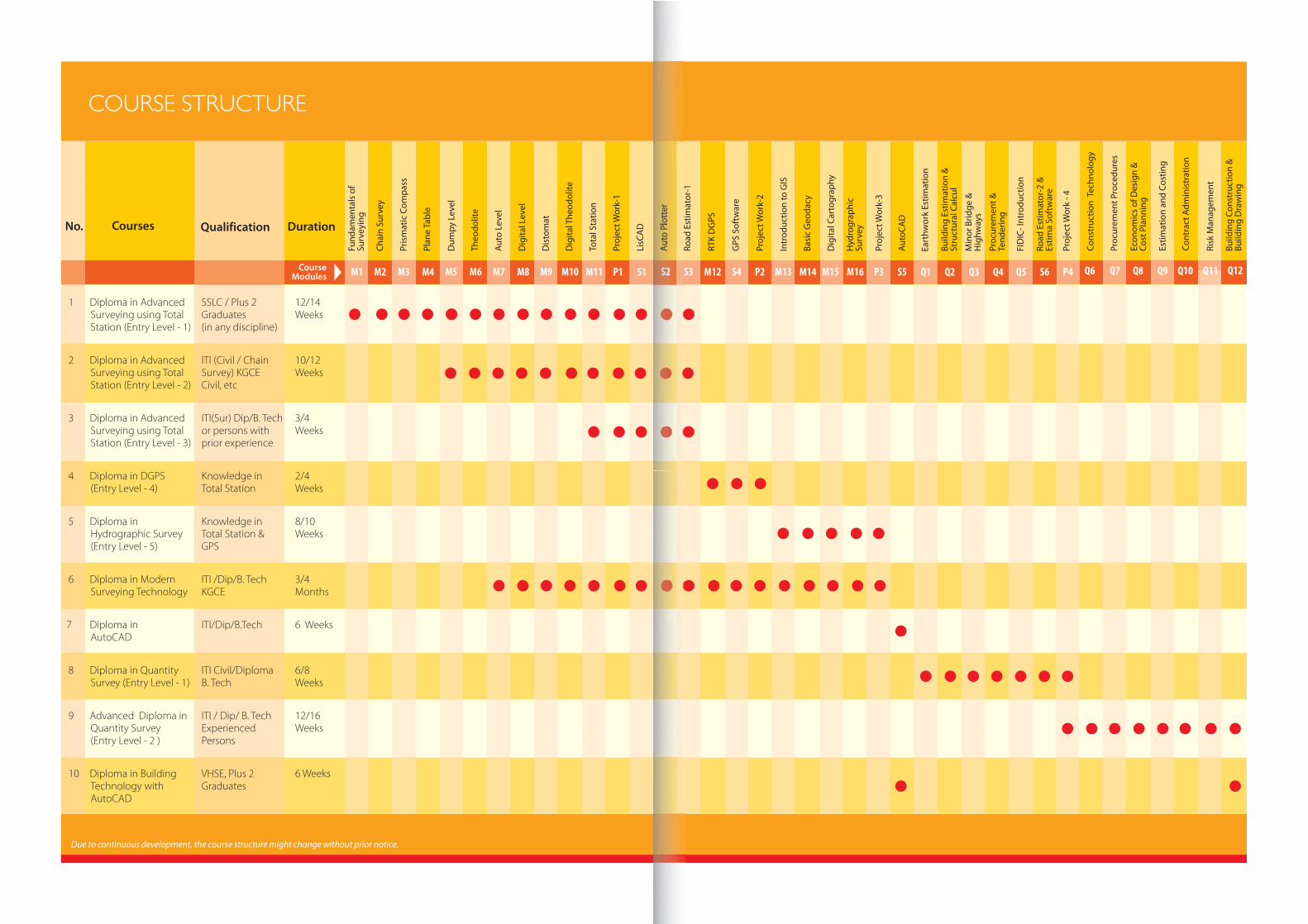
COURSE MODULES
Course PlanFor Whom Entry Levels
PROFESSIONAL COURSE IN
ADVANCED SURVEYING LEVEL 1, 2, 3, 4
This is one of the most popular courses offered at V Institute, which trains the student to becomea high quality professional surveyor equipped to handle state-of-the-art instruments and softwareapplications. The course is so structured as to enable the students to enter the course at differentlevels depending on the basic educational qualifications attained by them.
Surveying
using Conventional
Instruments
1-2 Weeks
M1, M2, M3, M4
SSLC/VHSE
Plus 2 or
Graduates
DGPS
Surveyor
ITI Diploma
Certificate holders
in Chain Survey
Level and
Theodolite Survey
2-3 Weeks
M5, M6, M7
Surveying using
Modern
Survey Instruments
2-3 Weeks
M8, M9, M10
Advance Survey
with Total Station
3 Weeks
M11
Advanced Satellite
Survey using
DGPS & Software
2-4 Weeks
M12, S4, P2
ITI Surveyors
Diploma, B.Tech
Experienced
Professionals
in India & abroad
ITI Surveyors
Diploma, B.Tech
Experienced
Professionals with
knowledge in
Total Station
Professionalin
Total StationSurvey
Downloading and
Processing using survey
softwares / Project work
1 week
S1, S2, S3, P1
Course Path
[ ]5[ ]4
M2 Chain SurveyLinear survey methods.Measurement with the aidof chain and cross-staff.Preparation of sketches.
M1 Fundamentals of
SurveyingPrinciples of land survey.Training in handling basicsurvey instruments.
M3 Using Prismatic
CompassPrinciples and use ofprismatic compass,cardinal directions,magnetic bearings,deviation of the northindicated by compasses,the scope and accuracyin compass surveying.
M5 Dumpy LevelPrinciples and use of aDumpy Level in surveyingand building to transfer,measure, and sethorizontal levels.
M6 TheodolitePrinciples and use of aTheodolite formeasuring bothhorizontal and verticalangles, in surveying andengineering work.
M8 Digital LevelA digital level is usedwhere multiple levellingsare needed. The staff anddistance readings aredisplayed digitally and sothe output is error-free.
M9 DistomatA distomat is used forelectronic distancemeasurement (EDM).Students are trained tomeasure distancesusing the Distomat aswell as the hand-heldlaser version which ismostly used for indoormeasurements.
M11 Total StationA Total Station consistsof a theodolite with abuilt-in distance meterthat can measure anglesand distances simul-taneously. Students aretrained on using theTotal Stations forfollowing applications:Surveying, area (plan),free station surveys, tiedistance, remote height,computations (COGO),longitudinal andtraverse profiles, contourmap, cut & fill volumes,staking out, crosssection, reference line,road programmes.
Compared to TotalStation, GPS surveyingoffers the advantagethat the points to bemeasured do not haveto be mutually visible.Students are given anover view of GPStechniques andadequate exposure inthe following areasusing GPS: Controlsurvey, static survey,mapping survey, stake-out, applied onnetwork RTK, electricalwire survey, and roadsurvey.
S1 LisCADLisCAD is a software forthe Engineer andSurveyor. Data fromvirtually any surveyinginstrument can beimported and turned intofinished plans easily usingLisCAD.The data base isdesigned to specificallysupport surveying andengineering tasks.
S2 Auto Plotter
S3 Road Estimator
Auto Plotter converts theentire field data collectedby the surveyor to afinished map or drawing.
Road Estimator is aspecialty softwaredesigned for Surveyorsand Engineers for thecomputation ofearthwork on cut and fillsituations in a new roadalignment, quickly andeasily. Computation ofother items such as WBM,and Black-topping canalso be made using theRoad Estimator software.
1
1
1
2
2
22
3
3
33
3
4
44
V INSTITUTEOF ADVANCED STUDIES
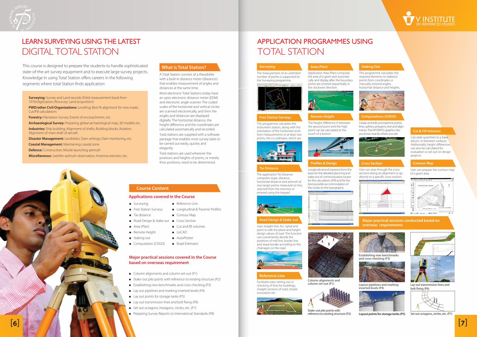
�
�
�
�
�
�
�
�
Surveying
Free Station Surveys
Tie distance
Road Design & Stake out
Area (Plan)
Remote Height
Staking out
Computation (COGO)
Course Content
Applications covered in the Course
Major practical sessions covered in the Course
based on overseas requirement
The measurement of an unlimitednumber of points is supported bythe Surveying programme.
Surveying
This programme calculates therequired elements to stakeoutpoints from coordinates ormanually entered angles,horizontal distance and heights.
User can prepare the contour mapof a given area.
User can step through the crosssections along an alignment or godirectly to a specific cross section.
Uses straight line, Arc, Spiral andpoint to edit the plane and heightdesign values of road. This functioncan conveniently decide thepositions of mid line, border lineand slope border according to thechainages on the road.
Facilitates easy setting out orchecking of lines for buildings,straight sections of road, simpleexcavation etc.
Calculate quantities to a basedatum, or between surfaces.Additionally, height differencescan also be calculated forevaluation or set-out on designprojects.
Create and edit and examine points,lines, splines, polygons, text and align-ments. The WYSIWYG graphics letsyou know exactly where you are.
Application Area (Plan) computesthe area of a given plot automati-cally and display after the boundarypoints are entered sequentially inthe clockwise direction.
Longitudinal and traverses form thebasis for the detailed planning andstake out of communication routesfor the calculation of fill and for thebest possible accommodation ofthe routes to the topography.
The height difference H betweenthe ground point and the highpoint can be calculated at thetouch of a button.
The application Tie Distancecomputes slope, distance,horizontal distance and azimuth oftwo target points measured on line,selected from the memory orentered using the keypad.
This programme calculates theinstrument station, along with theorientation of the horizontal circle,from measurements to at least twopoints, the co-ordinates, which are
Area (Plan)
Profiles & Design
Remote HeightFree Station Surveys
Contour Map
Cut & Fill Volumes
Staking Out
Tie Distance
Road Design & Stake-out
Computations (COGO)
Cross Section
Major practical sessions conducted based onoverseas requirements
Reference Line
[ ]7
LEARN SURVEYING USING THE LATEST
DIGITAL TOTAL STATION
This course is designed to prepare the students to handle sophisticated
state-of-the-art survey equipment and to execute large survey projects.
Knowledge in using Total Station offers careers in the following
segments where total Station finds application:
A Total Station consists of a theodolite
with a built-in distance meter (distancer)
that enables measurement of angles and
distances at the same time.
Most electronic Total Stations today have
an opto-electronic distance meter (EDM)
and electronic angle scanner. The coded
scales of the horizontal and vertical circles
are scanned electronically, and then the
angles and distances are displayed
digitally. The horizontal distance, the
height difference and the coordinates are
calculated automatically and recorded.
Total stations are supplied with a software
package that enables most survey tasks to
be carried out easily, quickly and
elegantly.
Total stations are used wherever the
positions and heights of points, or merely
their positions, need to be determined.
Surveying:
PWD/other Civil Organizations:
Forestry:
Archaeological Survey:
Industries:
Disaster Management:
Coastal Management:
Defence:
Miscellaneous:
Survey and Land records (Field measurement book from1970/digitization; Resurvey; Land acquisition)
Levelling; Best fit alignment for new roads;Cut/Fill calculations
Plantation Survey; Extent of encroachment, etc.
Preparing global archaeological map, 3D models etc.
Ship building; Alignment of shafts; Building blocks; Aviation;Alignment of main shaft of aircraft
Landslides; Dam settings; Dam monitoring, etc.
Maintaining coastal zone
Construction; Missile launching azimuth
Satellite-azimuth observation; Antenna erection, etc.
What is Total Station?
APPLICATION PROGRAMMES USING
TOTAL STATION
�
�
�
�
�
�
�
�
Reference Line
Longitudinal & Traverse Profiles
Contour Map
Cross Section
Cut and fill volumes
LisCAD
AutoPlotter
Road Estimator
�
�
�
�
�
�
�
�
Column alignments and column set-out (P1)
Stake-out pile points with reference to existing structure (P2)
Establishing new benchmarks and cross checking (P3)
Lay out pipelines and marking inverted levels (P4)
Lay out points for storage tanks (P5)
Lay out transmission lines and bolt fixing (P6)
Set out octagons, hexagons, circles, etc. (P7)
Preparing Survey Reports to International Standards (P8)
Column alignments andcolumn set-out (P1)
Stake-out pile points withreference to existing structure (P2)
Establishing new benchmarksand cross checking (P3)
Layout pipelines and markinginverted levels (P4)
Layout points for storage tanks (P5) Set out octagons, circles, etc. (P7)
Lay out transmission lines and
bolt fixing (P6)
[ ]6
V INSTITUTEOF ADVANCED STUDIES
This course is designed to familiarize and provide a hands-on experience
to the students on GPS-based surveying techniques. The course covers
the following theory portions and extensive practical sessions.
TheoryIntroduction to GPS; GPS System Overview; Working principle of GPS; Satellite ranging
and Position Calculation; GPS errors and their corrections; Differential Global Positioning
Kinematic Surveys; Real Time Kinematic Surveys; Processing of GPS survey data; Plotting
of GPS survey data.
GPS stands for Global PositioningSystem. GPS is a satellite-basedlocating and navigating utility thatdetermines a user's precise latitude,longitude and altitude by trackingsignals from satellites. Depending onthe type of receiver and certain otherconditions, it is possible to achievereal-time position accuracies withinmeters or even centimetres, withposition calculations several timesper second.
is an enhancementto Global Positioning System thatuses a network of fixed, ground-based reference stations to broadcastthe difference between the positionsindicated by the satellite systems andthe known fixed positions.
DGPS is a fast growingtechnologically sophisticated field,with potential applications in manyindustries. The most common civilianapplications are in land, air andmarine navigation, and surveying.More recent applications includeaircraft precision approach, robotics,IVHS (Intelligent Vehicle HighwaySystems), construction, resourceextraction, and geographicinformation systems (GIS).
Differential Global Positioning
System (DGPS)
What is GPS?
LEARN DGPS USING THE LATEST
RTK SYSTEM
�
�
�
�
�
�
The relatively high positioningaccuracies, from tens of metresdown to the millimetre level.
The capability of determiningvelocity and time, to an accuracycommensurate with position.
The signals are available to usersanywhere on the globe: in the air,on the ground, or at sea.
Its is a positioning system with nouser charges, and uses relativelylow cost hardware.
The position information isavailable in three dimensions, thatis, vertical as well as horizontalinformation is provided.
It is an all-weather system,available 24 hours a day.
PracticalsReceiver set up; Configuration of the receiver;
Configuration of the terminal; Satellite tracking;
Different parameters setting and Data storing;
Localisation of WGS 84 Coordinates;
Establishing stations and TBMs with reference
to Survey of India BM (Control Points); Altitude;
Stake out of the measured points and offsets;
Self survey mode (absolute positioning); Static
Surveys and rapid static surveys; Kinematic and
RTK surveys; Post processing of surveyed data
and exporting the data to AutoCAD;
Topographic surveys using RTK mode and
establishing control points using static mode;
Precautions to be taken while using GPS
receivers.
APPLICATION PROGRAMMES USING GPS
There are several methods used in DGPS Surveying such as Real-time KinematicSurvey(RTK), Static Survey and Rapid Static Survey. Of the three, the most accurate and
efficient system is the RTK. Real Time Kinematic Survey
The
GPS based survey courses offered at V Institute uses the RTK Survey System.
Static Survey:
is a method that can offerpositional accuracy in real time ±2cm. RTK requires dual frequency receivers, with a radio
link between base station & rover and they both must tuned to the same frequency.
This was the first method of GPS Surveying used in the field and continues to bethe primary technique today. It is widely used for control and geodetic survey .It involves longobservation time( 1-2 hours observation) depending on number of visible satellites.
Rapid Static Survey: This method is used to measure base line and determine position up tocm accuracy with short observation time of about (5-20 minute observation time)Theobservation time depends on the length of base line and number of visible satellites. In rapidStatic surveys ,a reference point is chosen and one or more rovers operate with respect to it .thismethod is used for detailing the existing network, establishing control points etc..It is similar toStatic methods, but consists of short ended site occupation time.
�
�
Advantages of DGPS
Stake out curve
Sky Plot
Stake out line
Stake out line
Typical Output derived
from DGPS Surveying
DIFFERENT METHODS USED IN
DGPS SURVEYING
[ ]9[ ]8
V INSTITUTEOF ADVANCED STUDIES
This course is intended for candidates working in hydrographic
surveying in the marine oil and gas industry, coastal and port
development, hydrographic services, and offshore construction to
upgrade their skills, and to those The
course provides the students practical knowledge and hands-on
training in the application of techniques of hydrographic surveying
and develops the essential skills required to carry out the various
operational tasks in hydrography.
seeking careers in these areas.
In just one year, an undergraduate student without any technical
background is trained in Geoinformatics (from fundamentals to the
most advanced Total Station & Real Time Kinematic DGPS Survey) and
Hydrographic (Marine) Survey /Quantity Survey to become a
competent professional for jobs in India and abroad with a high
earning potential.
History and importance of hydrographic surveying; tides and water currents;
coast lining; positioning (horizontal and vertical controls); laws of sea; sonar
theory and acoustic sensor fundamentals; echo sounder and sounding
methods; sea-floor classification and feature detection; topographic
surveying; dredging; survey planning; survey data processing; and final chart
preparation; DTM and DEM; electronic navigational charts, and raster
navigational charts, volume
calculation from hydrographic survey charts; volume
calculation for dredging; topographic information;
bathymetric information; project work.
Course Content
It is the process of gathering informationabout water bodies such as rivers, lakes,seas and oceans. The purpose ofcollecting the information is to enable safenavigation of vessels such as ships and forthe construction of marine structures likeports, harbours, light houses andinstallation of structures for oil exploration,drilling, cable communication, etc.
In hydrographic survey investigations,observations of depth of water, watercurrent and sea bed sample collection aresome of the key activities performed. Theresults of these investigations arepresented in the form of a hydrographicchart. These charts provide theinformation on depth of water at variouspoints, contours showing spot height,ocean current, analysis of sea bed samplesand similar data.
Hydrographic survey investigations,require the following equipment:
Echosounders to determine the depth ofwater at any given location usingultrasound waves.
GPS Receivers to determine accurately thepositron of sea bed features using theNAVSTAR Global Positioning System.
Automatic Tide Gauge and a LaptopComputer to run a Hydrographic
Survey software application andprocessing the collected data.
What is Hydrographic
Survey?
Total Station Quantity Survey
Hydrographic Survey GPS Survey
How is Hydrographic
Survey conducted?
Hydrographic Survey
equipment & methodology
LEARN
HYDROGRAPHIC SURVEY
Course PlanFor Whom Entry Levels
Students should complete Levels to (as described on Page 5) before they can qualify to take this course
5
[ ]11[ ]10
LIVE PROJECTS
The curriculum provides extensive opportunities for the students to acquire practical knowledge and hands-ontraining through live projects arranged by the Institute.
Advanced Hydrographic Surveyusing Single BeamEchosounders, DGPS,Data Acquisition & Processing Software
Project Work
(6-8 Weeks)M13, M14, M15, M16, P3
Professionalin
HydrographicSurvey
ITI SurveyorsDiploma, B.TechExperiencedProfessionals withKnowledge inTotal Station
V INSTITUTEOF ADVANCED STUDIES
PROFESSIONAL COURSE IN
QUANTITY SURVEYING (LEVEL 1)
ADVANCED COURSE IN
QUANTITY SURVEYING (LEVEL 2)
Contract administrationProcurement & Tendering
Q4Estimation and Costing (Q9)
Value Engineering, Value Management
According to a report of the Associated Chambers of Commerce &Industry of India (ASSOCHAM), construction is projected to become$120-billion industry. Consequently there is a employment potentialof over 90 million skilled people in various professions related tobuilding construction and engineering. India is identified as a richsource of talent in these sectors.
It is in this context that V Institute has launched these courses to meetthe projected needs of this booming industry.
We invite the young men and women of this country to trainthemselves in these areas and be prepared to fill the miilions ofopportunities that would open up in a short period of time.
All construction projects have acost and a budget. The projectbecomes efficient and profitablewhen the costs are managedefficiently.
It is in the management of thecost and budget that the role ofthe Quantity Surveyor becomesrelevant and vital. From themoment a plan is drawn until theconstruction project has beencompleted, a quantity surveyor islikely to be involved in a legal,technical and financial capacity. Hemanages and control costs inconstruction projects which mayinvolve use of a range ofmanagement procedures andtechnical tools to achieve this goal.He prepares standardisedschedule of quantities of variousworks involved, constructionmaterials needed and labour forcerequired for accomplishing theprojects. This enables themanagement to put the works ontender, pick up the builder whobid lowest price and to prepare billof quantities and cost oncompletion.
The technique of measuringquantities from drawings, sketchesand specification prepared byarchitects and engineers for thepreparation of Tender/Contractdocuments is known as taking off.The quantities so taken are used toprepare bills of quantities whichusually are in accordance with apublished standard method ofmeasurement (SMM).
With a qualification in quantitysurveying, career possibilitiesinclude contracting or privatequantity surveying, buildingsurveying, constructionmanagement or consultancy,accountancy and financial servicesmanagement or estatemanagement.
International opportunities mayalso be possible within the field.
Some career possibilities
This course is designed for students who hve already completed the basic coursein Quantity Survey. The course includes all essential aspects of quantity surveying andcovers the following topics:
Who is a Quantity
Surveyor?
Course Plan Course PlanFor Whom For WhomEntry Level Entry Level
B Tech*
B Tech
Quantity SurveyLevel 1
Diploma in
Quantity Survey
Advanced Diplomain Quantity Survey
(12 weeks)
Building estimation including structuralcalculations of columns, beams, slabs, etc.
Q2
Construction Technology (Q6)Building Services, Piling
Economics of Design and Cost Planning (Q8)Design issues, factors that influence the cost of building,introduction to value management, managing pluralism,
contract documentation and specifications,life cycle costing.
FIDICIntroduction, contracts, contractors, forms, etc.
Q5
Contract Administration (Q10)Contract administration and quality control, changing
the contract, contract administration and time.
Project Work
P4
Project Work
P4
Software ApplicationsEstima, Road Estimator and MS Excel
S6
Risk Management (Q11)Risk and certainty in estimating and tendering.
1 2
[ ]13[ ]12
* Diploma holders and BTech studentswith back papers to complete are admittedbased on merit.
* Diploma holders and BTech studentswith back papers to complete are admittedbased on merit.
�
�
�
�
�
�
Construction Technology, Building Services, Piling
Procurement Procedures: Construction procurement, contractor selection.
Economics of Design and Cost Planning: Design issues, factors that influence the cost ofbuilding, introduction to value management , contract documentation and specifications,life cycle costing.
Estimation and costing: Value engineering, value management.
Contract administration: Contract administration and quality control, changing the contract,contract administration and time.
Risk Management: Risk and certainty in estimating and tendering.
V INSTITUTEOF ADVANCED STUDIES
AutoCADProfessional
PROFESSIONAL COURSE IN
MODERN SURVEYING TECHNOLOGY
PROFESSIONAL COURSE IN
BUILDING TECHNOLOGY with AutoCAD
THE INSTITUTE’S
CAPABILITIESThis is a comprehensive course intended for candidates aspiring for a position in the Surveying industry. Thecourse covers all aspects of surveying including new technologies and hands-on training and expertise in state-of-the-art survey equipment and gadgets. In a matter of three to four months, an undergraduate studentwithout any technical background is trained in Geoinformatics (from fundamentals to the most advanced TotalStation & Real Time Kinematic DGPS Survey) and Hydrographic Survey to become a competent professional forjobs in India and abroad with a high earning potential.
ITI/ Diploma/
BTech
Course PlanFor Whom Entry Levels
ITI CivilKGCE
ITI DiplomaB.Tech
Knowledge in TotalStation/ ExperiencedProfessionals
Knowledge in TotalStation/ GPS
SSLC/VHSEPlus 2 or Graduates
ITI DiplomaB.Tech
1
1
2
2
3
4
Auto Level, Digital Level,Digital Theodolite
(1-2 Weeks)M7, M8, M9, M10
Building Construction & Building Drawing
Q12
Total Station, Processing software(LisCAD, AutoPlotter, Road Estimator)
Introduction to AutoCAD, Project work
(2-4 Weeks)M11, S1, S2, S3,P1
AutoCAD
(6 Weeks)S5
Real Time Kinematic (RTK) DGPS,GPS, Processing Software, Project Work
(1-2 Weeks)M12, S4, P2
Hydrographic Surveyusing Echosounder and RTK GPS
Project Work (4 Weeks)
M13, M14, M15, M16, P3
�
�
�
State-of-the-art computer lab
Experienced and dedicated faculty
Proven course methodology
[ ]15[ ]14
Diploma in Building Technologywith AutoCAD
Professional inGPS Survey
Professional inTotal Station Survey
Professional inModern Surveying Technology
Professional inHydrographic Survey
CRASHCOURSE
Professionally made application software have changed the way surveys and engineering processes are
conducted today. They have made the work of surveying extremely efficient and have vastly widened the
scope of the profession. V Institute is one of the first institutions to adopt the use of these applications in spite
of its prohibitive cost and availability. But it has paid dividends in the form of creating a large talent pool of
professional quality young men and women most of whom have secured highly paid jobs in India and abroad,
particularly in the Gulf countries.
The computer lab at V institute is the only one in Kerala that has a 10-user
licensed version of LisCAD, the most popular Surveying and Engineering
software, installed for imparting training to the students.
Estima is another application software used in the industry for
computing estimates by Quantity Surveyors. V Institute is now authorised
to sell Estima in India as their distributors.
AutoCAD, AutoPlotter, Autodesk 3DSMax and Road Estimator are the other
applications software which have been installed in the V Institute lab to provide
hands-on training to the students.
V Institute, after years of fine-tuning, have perfected a course methodology that has proven itself to be one of the most
effective in technical training. The students spend extensive hours of hands-on training and field activity that they are fully
conversant on all aspects of the subject to take on a challenging occupation when they complete the course at V Institute.
The faculty at V Institute comprise outstanding professionals who are committed to their task of imparting training to the
students. They have years of experience in handling the various instruments as well as the nuances of the application
software used for the training. Many of them are practising professional who share their time and experience with the
students moulding them to quality professionals.
State-of-the-art Computer Lab
Course Methodology
Experienced faculty
Diploma in Advanced / Plus 2 12/14Surveying using Total WeeksStation (Entry Level - 1) (in any discipline)
Diploma in AdvancedSurveying using Total Survey) KGCE WeeksStation (Entry Level - 2) Civil, etc
Diploma in Advanced ITI(Sur) Dip/B. Tech 3/4Surveying using Total WeeksStation (Entry Level - 3) prior experience
Diploma in D(Entry Level - 4) Total Station Weeks
Diploma in Knowledge in 8/10Hydrographic Survey Total Station & Weeks(Entry Level - 5) GPS
Diploma in Modern ITI /Dip/B. Tech 3/4Surveying Technology KGCE Months
Diploma in ITI/Dip/B.Tech 6 WeeksAutoCAD
Diploma in Quantity ITI Civil/Diploma 6/8Survey (Entry Level - 1) B. Tech Weeks
Advanced Diploma in ITI / Dip/ B. Tech 12/16Quantity Survey Weeks(Entry Level - 2 ) Persons
10 Diploma in Building VHSE, Plus 2 6 WeeksTechnology with GraduatesAutoCAD
1 SSLCGraduates
2 ITI (Civil / Chain 10/12
3or persons with
4 GPS Knowledge in 2/4
5
6
7
8
9Experienced
Q12
V INSTITUTEOF ADVANCED STUDIES
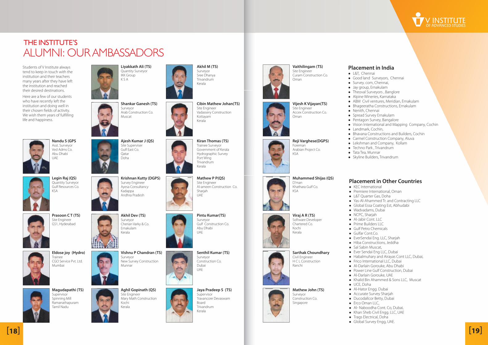
THE INSTITUTE’S
ALUMNI: OUR AMBASSADORS
Nandu S (GPSAsst. SurveyorVed Adms Co.Abu DhabiUAE
Jaya Pradeep S (TS)SupervisorTravancore DevaswamBoardTrivandrumKerala
Vaithilingam (TS)Site EngineerCuram Construction Co.Oman
Vijesh K Vijayan(TS)Site EngineerAccex Construction Co.Oman
Reji Varghese(DGPS)ForemanArabian Project Co.KSA
Muhammed Shijas (QS)D'manKhathara Gulf Co.KSA
Viraj A R (TS)Software DeveloperChartered Co.KochiKerala
Sarthak ChoundharyCivil EngineerH C L ConstructionRanchi
Mathew John (TS)SurveyorConstruction Co.Singapore
[ ]19[ ]18
Students of V Institute alwaystend to keep in touch with theinstitution and their teachersmany years after they have leftthe institution and reachedtheir desired destinations.
Here are a few of our studentswho have recently left theinstitution and doing well intheir chosen fields of activity.We wish them years of fulfillinglife and happiness.
Placement in India�
�
�
�
�
�
�
�
�
�
�
�
�
�
�
�
�
�
�
L&T, ChennaiGood land Surveyors, ChennaiSurvey. com, Chennai,Jay group, ErnakulamTheoval Surveyors , BangloreAlpine Wineries, KarnatakaABM Civil ventures, Meridian, ErnakulamBhageeratha Constructions, ErnakulamNenith, ChennaiSpread Survey ErnakulamPentagon Survey, BangaloreVision International and Mapping Company, CochinLandmark, Cochin,Bhavana Constructions and Builders, CochinCarmel Construction Company, AluvaLekshman and Company, KollamTechno Park , TrivandrumTata Tea, MunnarSkyline Builders, Trivandrum
Placement in Other Countries�
�
�
�
�
�
�
�
�
�
�
�
�
�
�
�
�
�
�
�
�
�
�
�
�
�
�
�
�
�
KEC InternationalPremiere International, OmanL&T Quarter Gas, DohaYas-Al-Ahammed Tr. and Contracting LLCGlobal Essa Coating Est, AbhudabiWadvadams, DubaiNCPC, SharjahAl-Jabir Cont. LLCPrime Builders LLCGulf Petro ChemicalsGulfar Cont.Co.EverSendai Eng. LLC, SharjahHiba Constructions, JeddhaSal Sabin Muscat,Ever Sendai Eng LLC, DubaiHabalmuhary and Airayas Cont LLC, Dubai,Frico International LLC, DubaiAl-Darlain Gorouke, Abu DhabiPower Line Gulf Construction, DubaiAl-Darlain Gorouke, UAEKhalid Bin Ahammed & Sons LLC, MuscatUCE, DohaAl-Hator Engg. DubaiAccurate Survey SharjahDucodallcor Betty, DubaiErco Oman LLC,Al- Naboodha Cont. Co, Dubai,Khan Sheb Civil Engg. LLC, UAETrags Electrical, DohaGlobal Survey Engg, UAE.
SURVEYINGINSTRUMENTSThe world class South Instruments and Systems are nowavailable in India through V Geodesic Systems & Services,Kollam, a sister concern of V Institute.
The range of products available throughinclude GPS Systems, Total Stations,
Digital Theodolite, Auto Level, Collimator, Laser Level,Prism Systems and Accessories.
V GeodesicSystems & Services
First Collimatorsetup in Kerala forCalibration ofTotal StationSurvey instruments need to be
continuously calibrated to
ensure accuracy and reliability of
their readings. This has to be
performed by experts with the
help of the appropriate
instruments and techniques.
V Survey Instruments and
Systems have a team of experts
well trained to handle the
calibration and servicing of any
models of Total Stations,
Corporate Training
Job Work
Trained manpower
� Total Station
Digital Theodolite
LisCAD Training
One-day Training on theapplication of Total Station andGPS
Estima Software
AutoCAD Training
Land Survey, Area, Cut &FillVolume Contour, Profile & CrossSection using Total Station andDigital Level
Prepare plans using AutoCAD &estimates using Estima Software
For projects in India and abroad.
�
�
�
�
�
�
�
Helping students
build careers
since 1941
Total Station
�
�
�
�
Solid body, handy edm, high accuracy
Absolute encoding, initialization not needed
Complete application programs menu customization
Internal memory more than 100,000 points
Auto Level
�
�
Excellent sealed structure for using in any weather
Exclusive closed magnetic field, magetically-dampened
compensator
Friction-braked rotation and endless horizontal drive
l
GPS
�
�
�
�
�
C
B
omplete cable free design
uilt-in transmitting radio
Advanced technology of data link
Optimized 3-proof design
Powerful application software
Prisms and Accessories
� Single & Triple Prisms, Prism Poles & Bipods, Ranging Poles &
Tripods, Prism Boxes.
Digital Theodolite
�
�
Easy-to-use keypad
Complete functions
Other Services
INFUSING
INDUSTRY-READINESS
In keeping with the tradition of the Institution which is
completing 75 years on a mission to nurture technical skills in
young men and women and to fulfill a vital need for the
country’s development in the form of skilled human resources,
we infuse industry-readiness in the students once they
complete the courses.
The Institute engages the students in live projects where they
can try out the knowledge they have acquired in their chosen
discipline on real-life situations under the guidance of expert
trainers. The students get to acquire hands-on experience and
find expression to their native talents.
Several corporates have come forward in support of this
programme where they can coach the potential candidates
outside of their establishments and bring them in when the
need arises, ready to be put straight on the job.
This would make the
transition from education to employment rather smooth.