CMPDI/PFR/NALCO/2016-17/NOV-16/44/00 PRE-FEASIBILITY REPORT FOR UTKAL D & E OPEN CAST COAL MINE PROJECT (CAPACITY 4.0 MTY) NATIONAL ALUMINIUM COMPANY LIMITED November 2016 CONSULTANT Accreditation Number: NABET/EIA/01/12/002 Dt. Jan 31, 2012. Central Mine Planning & Design Institute Limited (A Subsidiary of Coal India Ltd.) Regional Institute-VII, Samantpuri, P.O: RRL, Bhubaneswar-751013 (Odisha)
Transcript
CMPDI/PFR/NALCO/2016-17/NOV-16/44/00
PRE-FEASIBILITY REPORT
FOR
UTKAL D & E OPEN CAST COAL MINE PROJECT
(CAPACITY 4.0 MTY)
NATIONAL ALUMINIUM COMPANY LIMITED
November 2016
CONSULTANT
Accreditation Number: NABET/EIA/01/12/002 Dt. Jan 31, 2012.
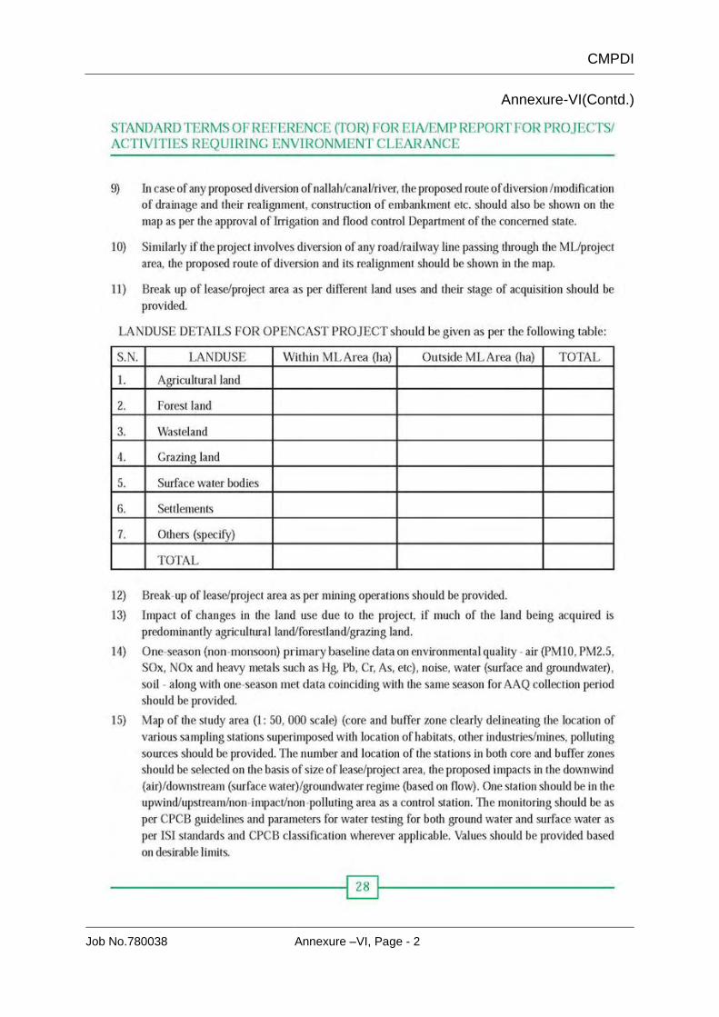
Central Mine Planning & Design Institute Limited (A Subsidiary of Coal India Ltd.)
1. Introduction 1 - 2 2. Details of earlier approval 2 - 3 3. Need/Justification for the project 3 - 3 4. Location and Communication 4 - 4 5. Topography, Drainage and Climate 4 - 5 6. Geology 5 - 107. Choice of Mining method 10 - 118. Mine Boundary 11 - 119. Mineable reserve & Mine Life 12 - 1210. Geo-Mining Characteristics 12 - 1211. Mining Technology 12 - 1412. Coal Wining and OB removal 14 - 14
13. Coal Production, OB removal programme and dumping schedule 15 - 17
14. Land Requirement 17 - 1815. Manpower 18 1816. Water Demand And Supply Arrangement 18 - 1817. Infrastructure facility/ civil construction 18 - 1918. Pumping and Drainage 19 - 1919. Power Supply 19 - 1920. Coal Handling And Dispatch Arrangement 20 - 2121. Workshop and Store 21 - 2122. Major Diversion or Shifting 21 - 2123. Environmental Management 21 - 2424. Safety Management And Conservation 24 - 2525. Rehabilitation and Resettlement 25 - 2526. Rain Water harvesting 25 - 26
CMPDI
Job No.780037
LIST OF ANNEXURES Sl.No. Particulars Annexure No.
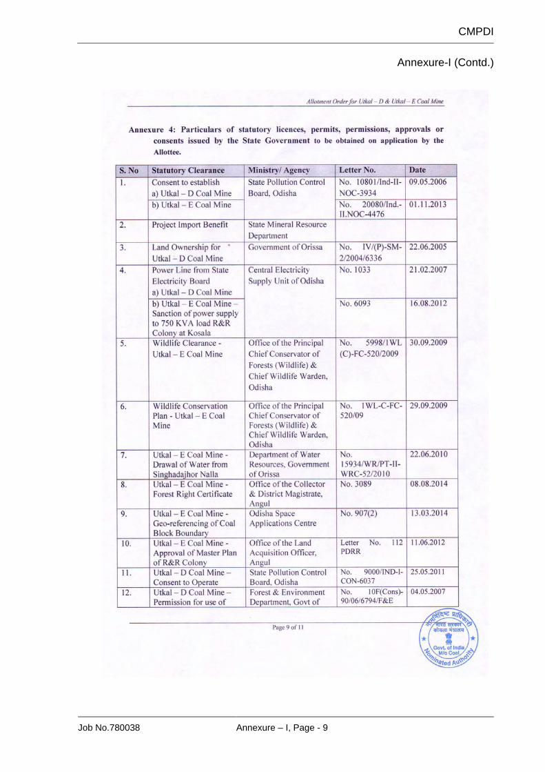
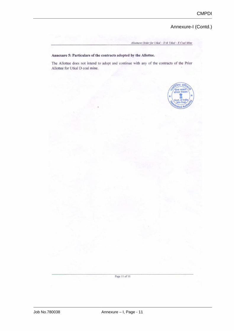
1. Copy of Block allotment letter of MoC I 2. Copy of earlier EC letter of Utkal D Coal Mine II 3. Copy of earlier EC letter of Utkal E Coal Mine III
4. Copy of Stage I FC letter of 137.02 Ha for Utkal D Coal Mine IV
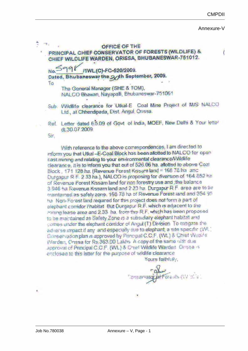
5. Copy of Wild Life Clearance letter for Utkal E Coal Mine V
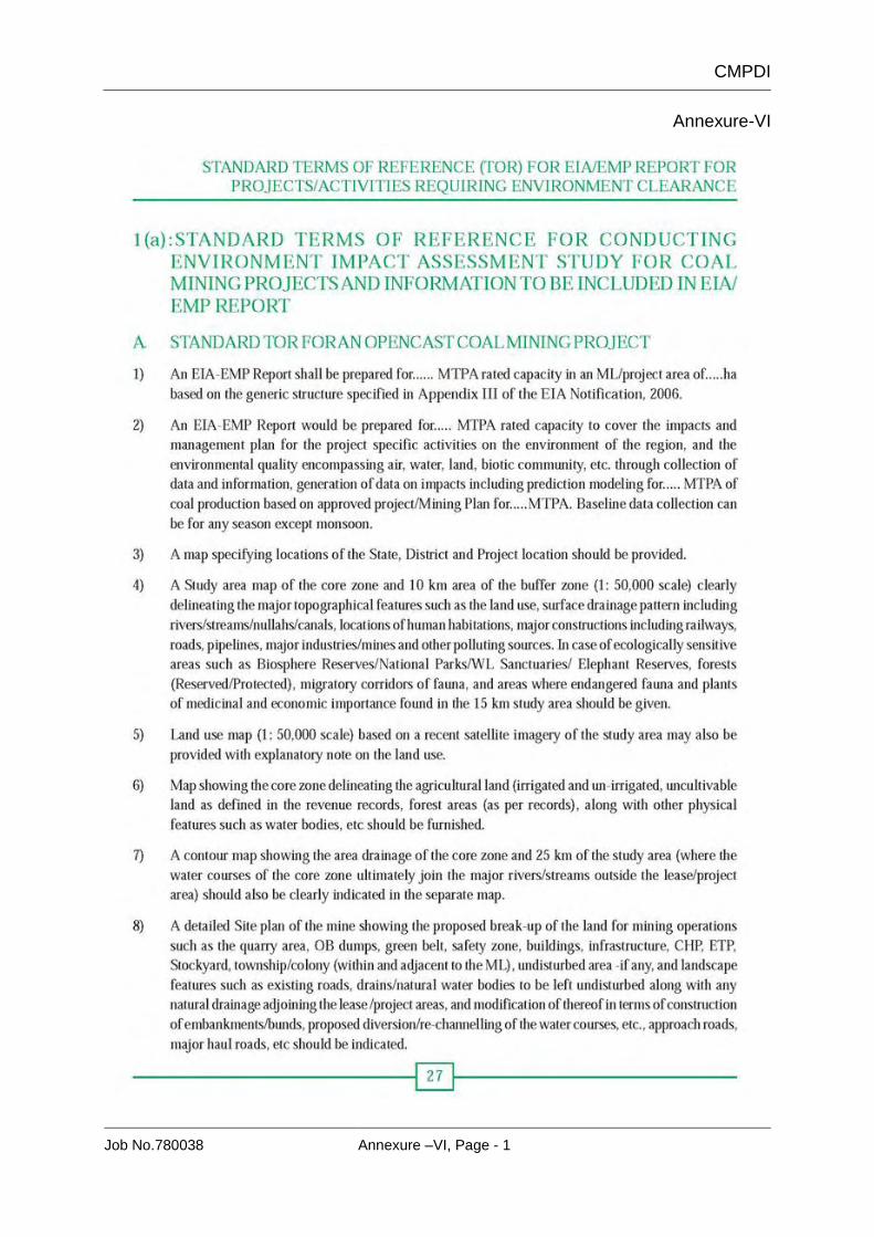
6. Standard TOR for EIA/EMP Report for Project / Activities Required Environmental Clearance VI
LIST OF PLATES Sl.No. Particulars Plate No.
1. Location Plan I A & I B 2. Surface Layout Plan Showing Infrastructure II 3. Study area showing 10 Km Buffer zone III 4. Drainage Map showing the 10 Km Buffer zone IV 5. Geological Plan V 6. Mine Closure Plan VI
CMPDI
Job No.780037 Pre-feasibility Report, Page - 1
PRE-FEASIBILITY REPORT FOR
UTKAL D & E OPEN CAST COAL MINE (CAPACITY 4.0 MTY)
1. INTRODUCTION
The National Aluminium Company (NALCO) is a Navratna Central Public
Sector Enterprise (CPSE) under Ministry of Mines, Govt. of India. It was
established on 7th January, 1981, with its registered office at Bhubaneswar. The
company is a group ‘A’ CPSE having integrated and diversified operations in
mining, metal and power with sales turnover of Rs.7771 crore in financial year
2014-15. Presently Govt. of India holds 80.93% equity of NALCO.
NALCO is the first company in Aluminium sector in the country to venture into
international market in a big way with London Metal Exchange (LME)
registration since May, 1989. The company is listed at National Stock Exchange
(NSE) since 1999. All the manufacturing units and the port facility of the
company are certified to ISO 9001, ISO 14001 and OHSAS 18001
Management Systems and Integrated Management System operates at these
units. The energy intensive manufacturing units i.e., Smelter, CPP & Alumina
Refinery are also certified to ISO 5001 standard for energy management
system. Besides, all the manufacturing units and corporate office are also
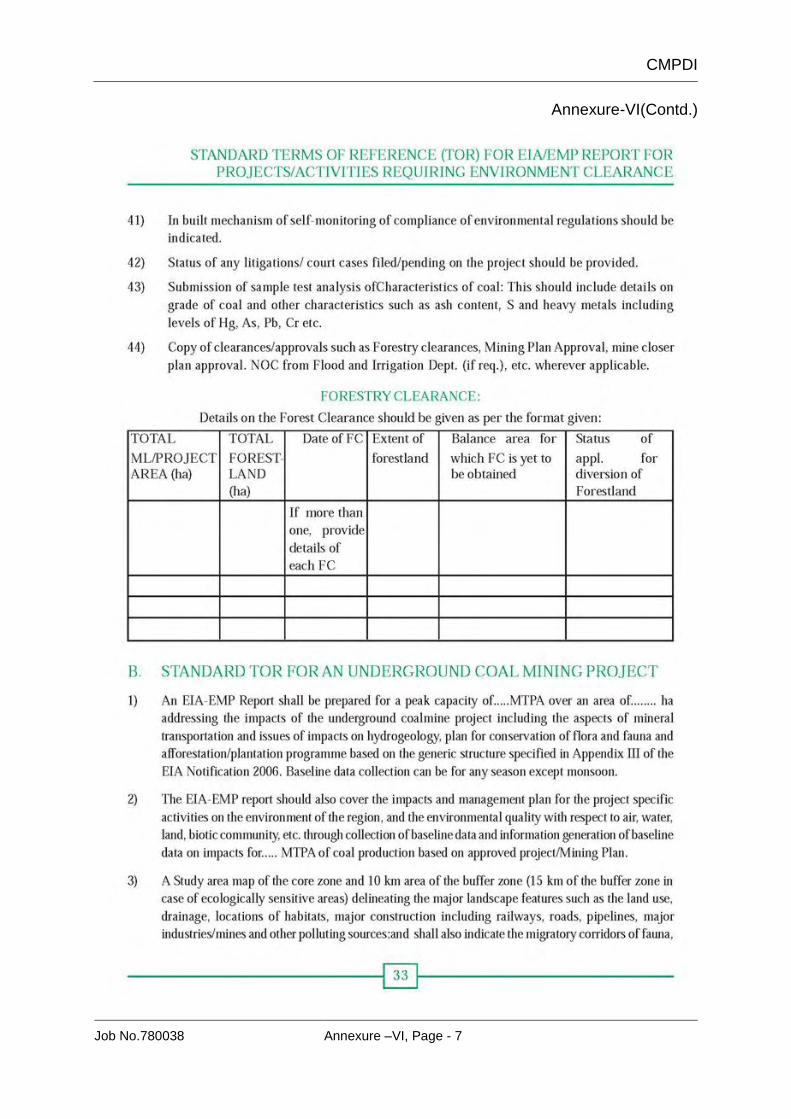
certified to SA 8000.
PHYSICAL PERFORMANCE
Sl. No. Unit Capacity 1 Bauxite Mines 6.3 Mty 2 Alumina Refinery-4 streams 2.1 Mty 3 Aluminium Smelter-4 pot lines 4.6 Mty 4 Captive Power Plant-120MWx10 1200 MW 5 Port facility 0.912 Mty 6 Wind Power Plants 98 MW 7 Rooftop Solar System 260 KWp 8 Nuclear Power 1400 MW
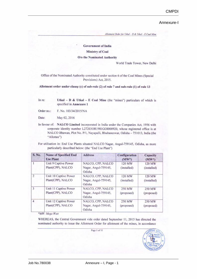
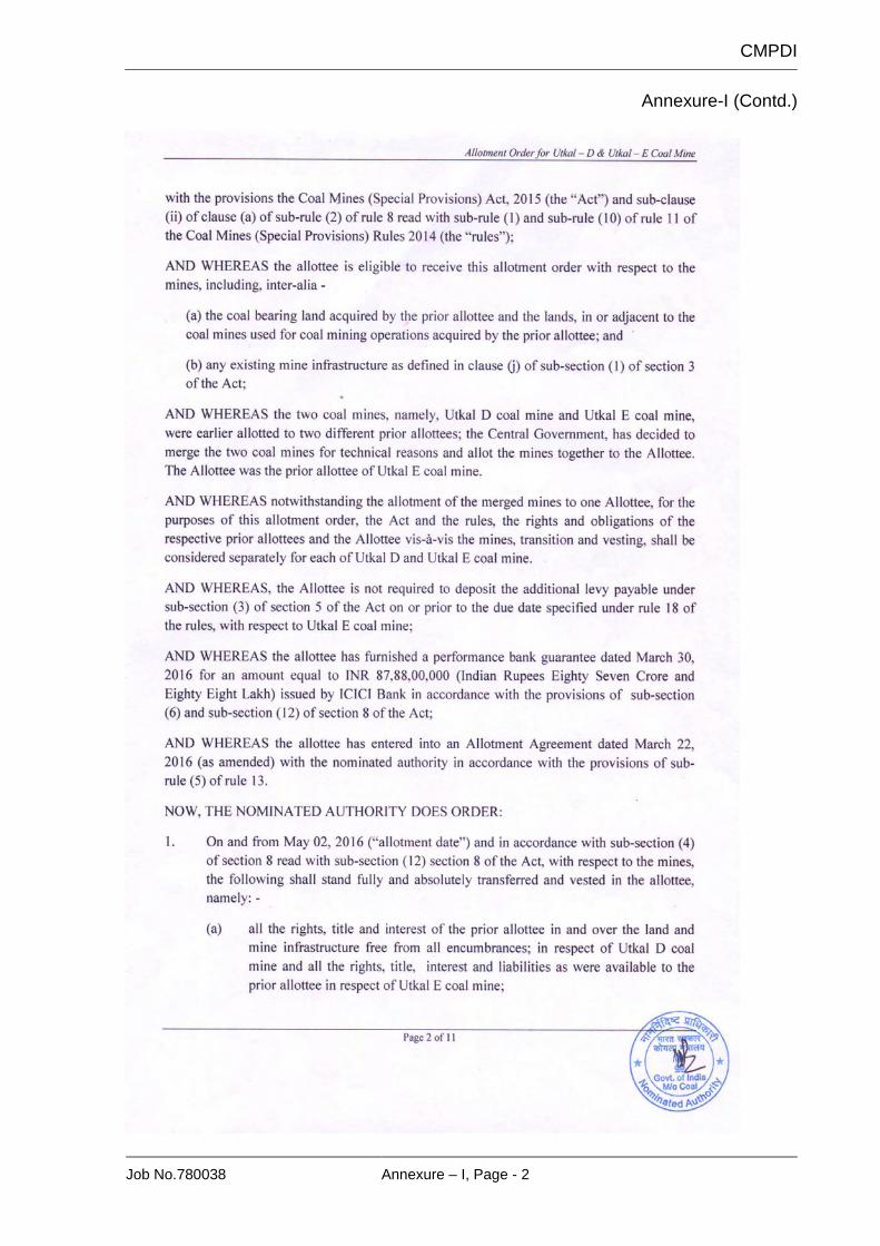
The Utkal-D&E Coal Block has been allotted to National Aluminum Company
Limited by MoC vide allotment no. F.No.103/34/2015/NA dated 2nd May, 2016 for
9th, 10th, 11th, & 12th units of CPP. (Annexure-I)
CMPDI
Job No.780037 Pre-feasibility Report, Page - 2
Utkal-D and Utkal-E blocks area are located in the south central part of Talcher
coalfield, Odisha. The coalfield spans over an area of about 1860 sq.km and lies
in between latitudes 20o53’00” & 21o12’00” North and longitudes 84o20’00” &
85o23’00”. Utkal-D is the eastern half of newly formed Utkal-D&E coal block and
Utkal-E is the western half approximately.
2. DETAILS OF EARLIER APPROVAL
Ministry of Coal, Government of India vide letter number
47011/1(1)/2001/CPAM/CA dated 27.01.2004 allocated Utkal-D block to M/s
Orissa Mining Corporation Ltd (OMC) for commercial coal mining under the
revised coal mining policy. Subsequently, OMC submitted Mining Plan (Revised)
for Utkal-D coal block (2.0 Mty) vide letter dated 13635/OMC/04 dated
26.07.2004. The Mining Plan was approved by Ministry of Coal vide letter
number 47011/1(1)/2001-CPAM/CA dated 07.04.2005.
M/s NALCO was allocated Utkal-E coal block by Department of Coal, Ministry of
Coal & Mines, Government of India vide letter number 47011/7(60)/93-
CPA/CPAM/CA dated 27.08.2004 for captive use in its power plants. NALCO
submitted Mining Plan (Revised) in June, 2006 (2.0 Mty). The Mining Plan was
approved by Ministry of Coal vide letter number 47011/7(60)/93-
CPA/CPAM//CA_I dated 31.07.2006.
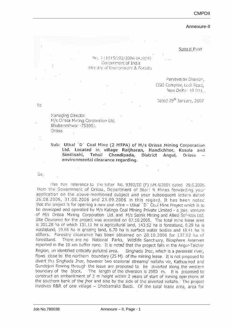
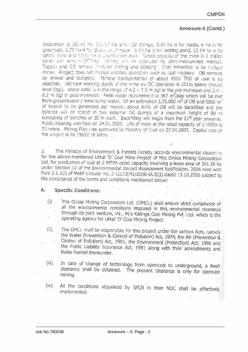
Env. Clearance for Utkal ’D’ Coal Mine Project (2.0 Mty) was obtained vide
MoEF’s letter No.J/11015/203/2006-IA.II(M) dated 29th January ,2007 for a total
mining lease area of 301.28 Ha.(Annexure-II)
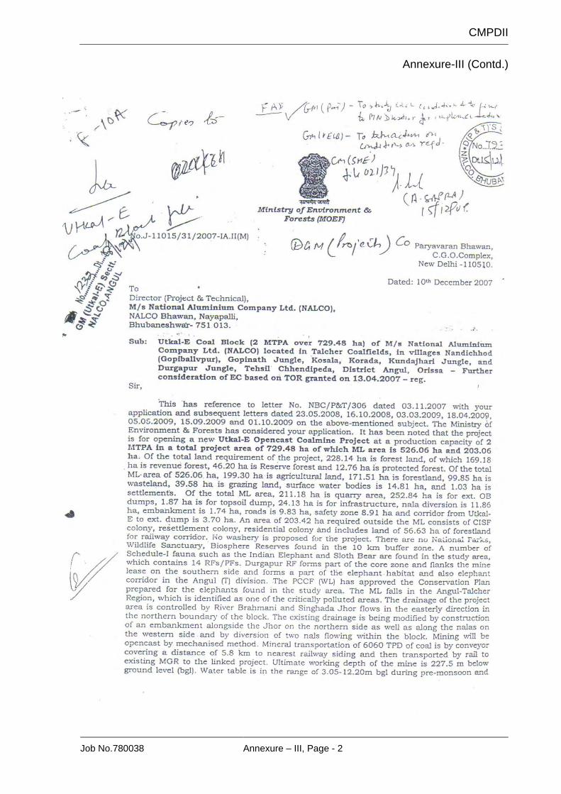
Env. Clearance for Utkal ’E’ Opencast Coal Project (2.0 Mty) was obtained vide
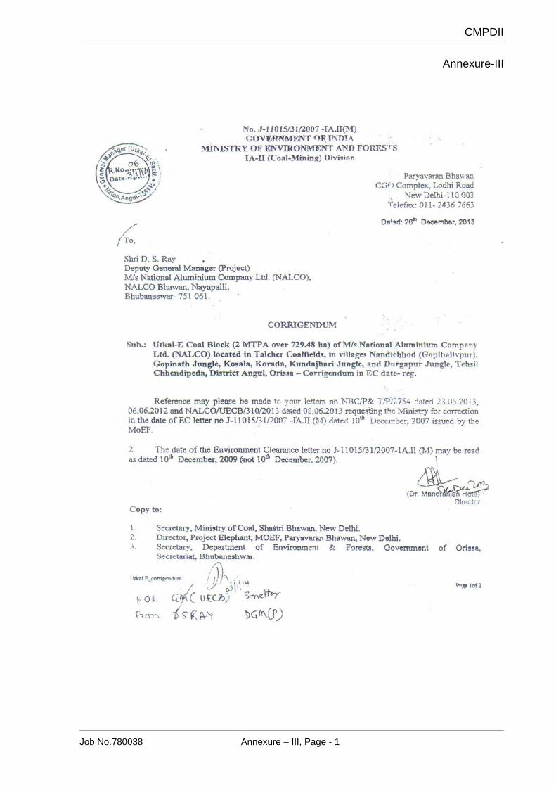
MoEF’s letter No.J/11015/31/2007-IA.II(M) dated 10th December ,2009 for a total
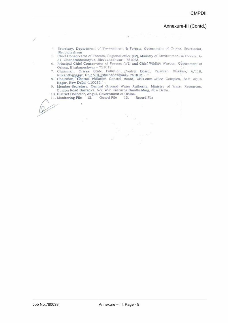
project area of 729.48 Ha (Mining Lease area -526.06 Ha).(Annexure-III)
As per directive of Ministry of Coal vide letter number 55011-01-2009-CPAM
dated 08.09.2009, 11.01.2012, 25.04.2012 and 07.01.2013, owners of all coal
mines are required to submit Mine Closure Plan as per guidelines and get it
approved, both for operating and yet-to-start mines where Mining Plan is
approved. There is no approved Mine Closure Plan for Utkal-D block. NALCO
submitted Mining Plan (Revision-1) and Mine Closure Plan for Utkal-E coal block
in July 2014. The report was being updated as per observations of Standing
CMPDI
Job No.780037 Pre-feasibility Report, Page - 3
Committee when all 204 coal blocks allocated were cancelled under order of
Honorable Supreme Court dated 24.09.2014.
After that Utkal-D&E Coal Block was allotted to National Aluminum Company
Limited for captive use by Ministry of Coal, Govt. of India.
3. NEED / JUSTIFICATION FOR THE PROJECT
Aluminium smelter plant of Nalco is situated at Angul in Odisha. The captive
power plant with an installed capacity of 1200MW (10x120 MW) is also located
near the smelter plant at Angul, around 35 Km from Utkal-D&E coal block.
Further 2 units of 250MW captive power plants are under consideration, for
which a feasibility report has been prepared by Tata Consulting Engineers
Limited, Kolkata in March, 2009.
Out of the 10 existing units of the CPP, Nalco has long term coal linkage for 8
units (Units 1 to 8) and tapering coal linkage for units 9 and 10 from MCL mines.
For calculation of coal requirement, reference has been taken from
“Annexure VII-Consumption Norm” of the “Scheme Document for Captive Power
Plant Sub-sector” issued by Coal India Limited.
GCV of ROM coal from Utkal-D&E coal mine is expected to be 3559 kcal/kg, i.e.,
average grade of coal shall be of G-13 grade, falling in grade range of 3400-
3700 kcal/kg.
As per document under reference above, coal consumption for power plant of
capacity between 100 MW to less than 200 MW for G-13 coal is 5727 metric
tonne/MW/Year.
For power plant units of 250 MW and above for G-13 coal, consumption norm is
5201 metric tonne/MW/Year.
Coal requirement for units 9 & 10 (120 MW each): 240 MW x 5727= 13,74,480
metric tonne per year.
Coal requirement for units 11 & 12 (250 MW each): 500 MW x 5201= 26,00,500
metric tonne per year.
Total requirement = 39,74,980 metric tonne/year or 3.975 million metric tonne
per year, rounded off to 4.00 Mt/yr.
In the light of above, opening of the proposed project is justified for early supply
of coal to CPP units 9 & 10 as these are starved of coal.
CMPDI
Job No.780037 Pre-feasibility Report, Page - 4
4. LOCATION AND COMMUNICATION (PLATE IA, IB & III)
Utkal-D & E block is situated in the south-central part of the Talcher Coalfield.
Some particulars are given below:
Coalfield Talcher Coalfield Company Tahsil
NALCO Chhendipada
District Angul Latitudes 20°56’33˝ to 20°58’58” N Longitudes 84o55’49” to 84o57’18” E Toposheet No.
Special Toposheet no.
73 D/13 (RF 1:50,000)
L2 & A2 ( RF 1:10,000)
The Durgapur-Raijharan forest road passes at a distance of about 100 m south
of south-east corner of the block. This is a narrow morrum road joining State
Highway-63, 2.1 km north-east at Raijharan village. State Highway-63 is all
weather widened and strengthened road connecting Tahsil town Chhendipada to
District HQ Angul. National Highway 55 (Bhubaneswar-Sambalpur) at Angul is
20 km from Raijharan village. Chhendipada Tahsil HQ is around 21 km north-
west of the block on State Highway-63. Nearest rail head is Angul at a distance
of about 26 km on Sambalpur-Talcher-Bhubaneswar rail line of East Coast
Railway. Angul is well connected with State capital Bhubaneswar by rail and
road which is at a distance of about 170 km. Bhubaneswar has international
airport.
5. TOPOGRAPHY, DRAINAGE AND CLIMATE (PLATE-IV & V)
The Utkal-D&E coal block exhibits a gentle undulating topography with general
slope down towards north. The minimum & maximum elevations above mean
sea level of the block are 135m (near borehole CMTU-294) towards north near
Singhada Jhor stream and 185m (near borehole CMTU-94) towards south
respectively. Surface soil is generally sandy containing quartz pebbles and
boulders. Southern part of the blocks are represented mainly by rough, rigid and
hilly terrain and is under forest cover whereas central and northern parts are
CMPDI
Job No.780037 Pre-feasibility Report, Page - 5
being utilized for agricultural purposes. Patches of forest and open shrubs also
occur along seasonal streams & Singhada jhor.
Drainage of the blocks is mainly controlled by easterly flowing Singhada jhor
which forms the northern boundary of the block and maintains the base flow
even during the dry summer. Gundijeri nala and Katau nala traversing the area
drain into Singhada jhor which ultimately meets the Brahmani River towards
north-east of the area. There are a few ponds in the block area and mainly used
for domestic & irrigation purposes.
The minimum HFL is 131.866m and maximum HFL is 147.71m. Wherever the
surface level is less than 1.5m below HFL, embankment will be constructed.
Climate: This area experiences warm & humid tropical to sub-tropical climate
and temperature ranges from 6.7oC (during winter) to 46.7oC (during summer
season). Annual rainfall varies from 932mm to 1588mm (average being
1270mm). Humidity varies from 25% to 88%. Annual mean wind speed is
3.24km/hour. Wind direction is mainly east during pre-monsoon season and
during post-monsoon period it changes towards north-west and north-east.
6. GEOLOGY
“Geological Report on coal exploration Utkal-D block, Talcher coalfield, District-
Angul, Orissa”-December, 2002 was prepared by CMPDI, RI-VII [At Sachivalaya
Marg, Unit-3, Bhubaneswar (Odisha)] and “Geological Report on coal
exploration Utkal-E block, Talcher coalfield, district Angul, Orissa” – April, 2005
was prepared by CMPDI, RI-VI [At & P.O: Jayant, Dist.: Sidhi (M.P)].
Area of the Block: Combined Utkal-D&E block cover an area of 8.68 sq.km.
The block is nearly rectangular in shape having about 4.5 km length in north-
south direction and approximately 2.4 km width in east-west direction.
Status of Exploration: The exploration in the combined block was carried out
in different phases by MECL and CMPDIL. 122 boreholes spreading over 8.68
sq. km. area and involving 19676.10 meter of drilling have been drilled in the
block under reference. The borehole density of the block comes to 14
boreholes/sq. km. Data of nearby boreholes of adjacent blocks have also
been considered for geological interpretation & modeling.
CMPDI
Job No.780037 Pre-feasibility Report, Page - 6
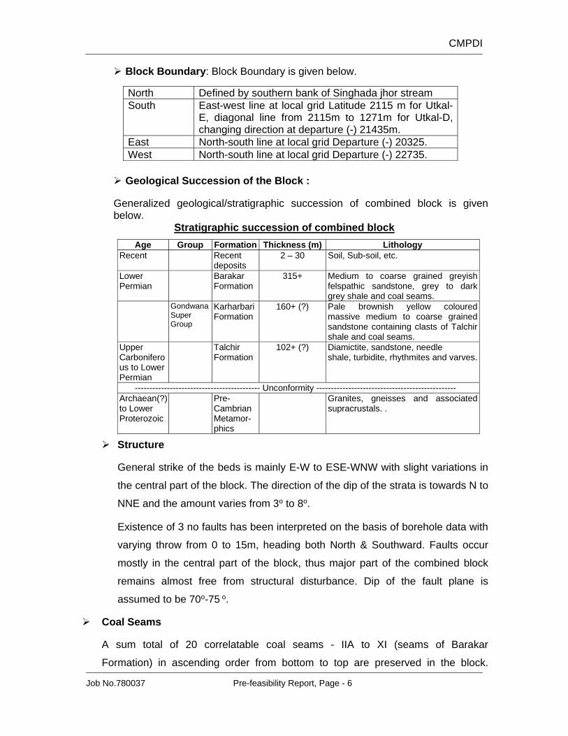
Block Boundary: Block Boundary is given below.
North Defined by southern bank of Singhada jhor stream South East-west line at local grid Latitude 2115 m for Utkal-
E, diagonal line from 2115m to 1271m for Utkal-D, changing direction at departure (-) 21435m.
East North-south line at local grid Departure (-) 20325. West North-south line at local grid Departure (-) 22735.
Geological Succession of the Block :
Generalized geological/stratigraphic succession of combined block is given below.
Stratigraphic succession of combined block
Age Group Formation Thickness (m) Lithology Recent Recent
deposits 2 – 30 Soil, Sub-soil, etc.
Lower Permian
Barakar Formation
315+ Medium to coarse grained greyish felspathic sandstone, grey to dark grey shale and coal seams.
Gondwana Super Group
Karharbari Formation
160+ (?) Pale brownish yellow coloured massive medium to coarse grained sandstone containing clasts of Talchir shale and coal seams.
Upper Carboniferous to Lower Permian
Talchir Formation
102+ (?) Diamictite, sandstone, needle shale, turbidite, rhythmites and varves.
------------------------------------------- Unconformity ------------------------------------------------ Archaean(?) to Lower Proterozoic
Pre-Cambrian Metamor-phics
Granites, gneisses and associated supracrustals. .
Structure
General strike of the beds is mainly E-W to ESE-WNW with slight variations in
the central part of the block. The direction of the dip of the strata is towards N to
NNE and the amount varies from 3o to 8o.
Existence of 3 no faults has been interpreted on the basis of borehole data with
varying throw from 0 to 15m, heading both North & Southward. Faults occur
mostly in the central part of the block, thus major part of the combined block
remains almost free from structural disturbance. Dip of the fault plane is
assumed to be 70o-75 o.
Coal Seams
A sum total of 20 correlatable coal seams - IIA to XI (seams of Barakar
Formation) in ascending order from bottom to top are preserved in the block.
CMPDI
Job No.780037 Pre-feasibility Report, Page - 7
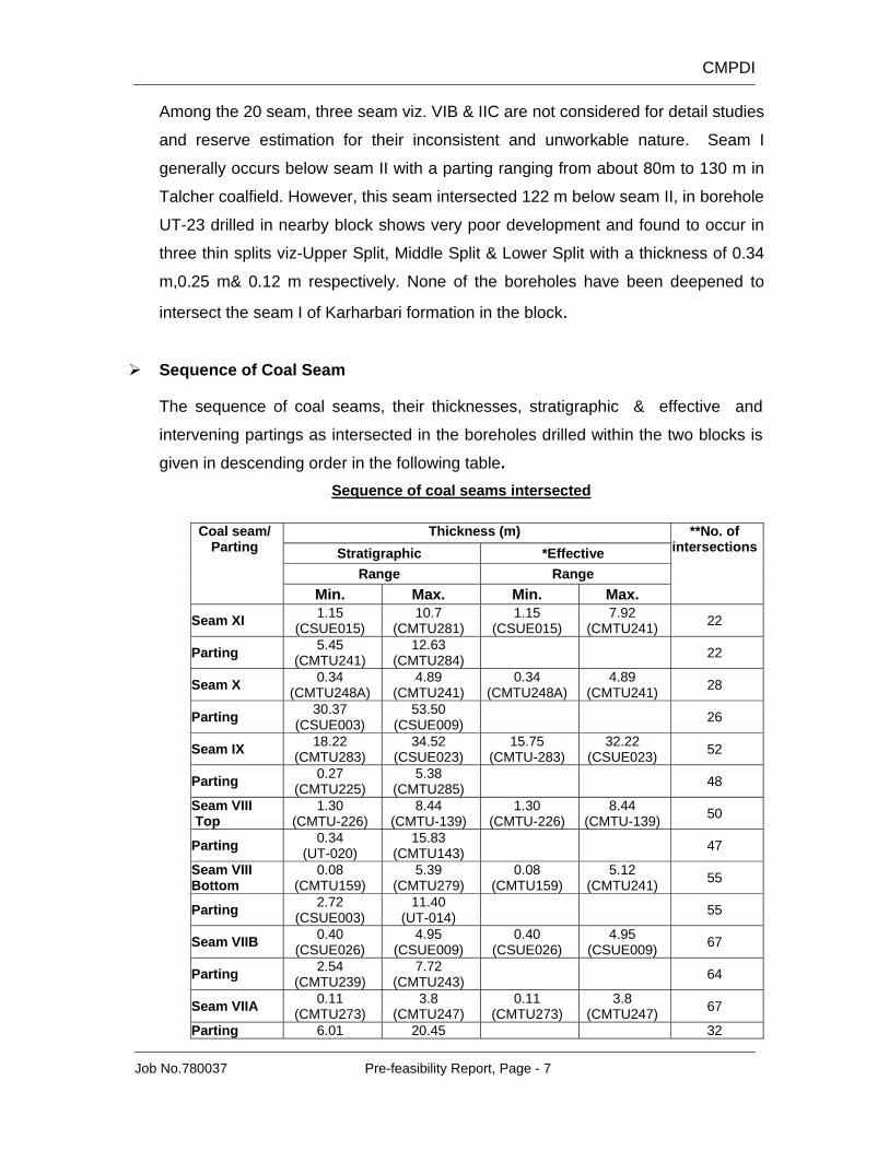
Among the 20 seam, three seam viz. VIB & IIC are not considered for detail studies
and reserve estimation for their inconsistent and unworkable nature. Seam I
generally occurs below seam II with a parting ranging from about 80m to 130 m in
Talcher coalfield. However, this seam intersected 122 m below seam II, in borehole
UT-23 drilled in nearby block shows very poor development and found to occur in
three thin splits viz-Upper Split, Middle Split & Lower Split with a thickness of 0.34
m,0.25 m& 0.12 m respectively. None of the boreholes have been deepened to
intersect the seam I of Karharbari formation in the block.
Sequence of Coal Seam
The sequence of coal seams, their thicknesses, stratigraphic & effective and
intervening partings as intersected in the boreholes drilled within the two blocks is
given in descending order in the following table. Sequence of coal seams intersected
Coal seam/ Parting
Thickness (m) **No. of intersections Stratigraphic *Effective
Range Range Min. Max. Min. Max.
Seam XI 1.15 (CSUE015)
10.7 (CMTU281)
1.15 (CSUE015)
7.92 (CMTU241) 22
Parting 5.45 (CMTU241)
12.63 (CMTU284)
22
Seam X 0.34 (CMTU248A)
4.89 (CMTU241)
0.34 (CMTU248A)
4.89 (CMTU241) 28
Parting 30.37 (CSUE003)
53.50 (CSUE009)
26
Seam IX 18.22 (CMTU283)
34.52 (CSUE023)
15.75 (CMTU-283)
32.22 (CSUE023) 52
Parting 0.27 (CMTU225)
5.38 (CMTU285)
48
Seam VIII Top
1.30 (CMTU-226)
8.44 (CMTU-139)
1.30 (CMTU-226)
8.44 (CMTU-139) 50
Parting 0.34 (UT-020)
15.83 (CMTU143)
47
Seam VIII Bottom
0.08 (CMTU159)
5.39 (CMTU279)
0.08 (CMTU159)
5.12 (CMTU241) 55
Parting 2.72 (CSUE003)
11.40 (UT-014)
55
Seam VIIB 0.40 (CSUE026)
4.95 (CSUE009)
0.40 (CSUE026)
4.95 (CSUE009) 67
Parting 2.54 (CMTU239)
7.72 (CMTU243)
64
Seam VIIA 0.11 (CMTU273)
3.8 (CMTU247)
0.11 (CMTU273)
3.8 (CMTU247) 67
Parting 6.01 20.45 32
CMPDI
Job No.780037 Pre-feasibility Report, Page - 8
Coal seam/ Parting
Thickness (m) **No. of intersections Stratigraphic *Effective
Range Range Min. Max. Min. Max.
(CMTU223) (CSUE023)
Seam VIB 0.15 (CSUE003)
1.2 (CMTU284)
0.15 (CSUE003)
1.2 (CMTU284) 32
Parting 3.62 (CMTU279)
26.79 (CMTU226)
31
Seam VB 0.20 (CMTU138)
9.65 (CMTU294)
0.24 (CMTU104)
6.22 (CMTU241) 76
Parting 0.37 (CMTU141)
11.05 (CMTU277)
76
Seam VA 0.15 (CSUE024)
4.87 (CMTU243)
0.15 (CSUE024)
4.87 (CMTU243) 83
Parting 1.73 (CMTU143)
10.82 (CMTU281)
70
Seam IVB 0.12 (UT016)
4.93 (CMTU271)
0.12 (UT016)
4.93 (CMTU271) 73
Parting 3.17 (CMTU248A)
12.11 (CMTU106)
69
Seam IIIE Top
0.22 (CMTU097)
4.90 (CSUE023)
0.22 (CMTU097)
4.90 (CSUE023) 84
Parting 0.12 (CMTU275)
8.19 (CMTU097)
80
Seam IIIE Bottom
0.05 (CMTU098)
7.47 (CMTU282)
0.05 (CMTU098)
7.47 (CMTU282) 84
Parting 0.17 (CMTU282)
21.82 (CMTU063)
80
Seam IIID 0.25 (CSUE023)
10.90 (CSUE023)
0.25 (CSUE023)
10.90 (CSUE023) 92
Parting 0.19 (CMTU241)
8.65 (CMTU087)
76
Seam IIIA Top
0.11 (UT011)
3.45 (CMTU279)
0.11 (UT011)
3.45 (CMTU279) 79
Parting 0.25 (CMTU225)
7.02 (CMTU145)
64
Seam IIIA Bottom
0.13 (CMTU286)
4.60 (CSUE006)
0.15 (CSUE007)
4.60 (CSUE006) 77
Parting 0.40 (CSUE023)
12.40 (CSUE007)
55
Seam IIE 0.10 (CMTU087)
8.04 (CMTU241)
0.15 (CSUE007)
8.04 (CMTU241) 61
Parting 26.25 (CSUE020)
46.9 (CMTU086)
37
Seam IIC 0.05 (CMTU091)
0.85 (CMTU279)
0.05 (CMTU091)
0.85 (CMTU279) 37
Parting 3.36 (CSUE023)
32.38 (CMTU286)
35
Seam IIB 0.05 (CMTU090)
3.22 (CSUE023)
0.05 (CMTU090)
3.22 (CSUE023) 55
Parting 0.23 (UT014)
17.14 (CMTU147)
44
Seam IIA 0.10 (CMTU101)
3.84 (CMTU284)
0.10 (CMTU101)
3.84 (CMTU284) 48
*Excluding dirt bands of 1 m and above in thickness. ** Intersecting full coal seam/ parting thickness/Carbshale.
CMPDI
Job No.780037 Pre-feasibility Report, Page - 9
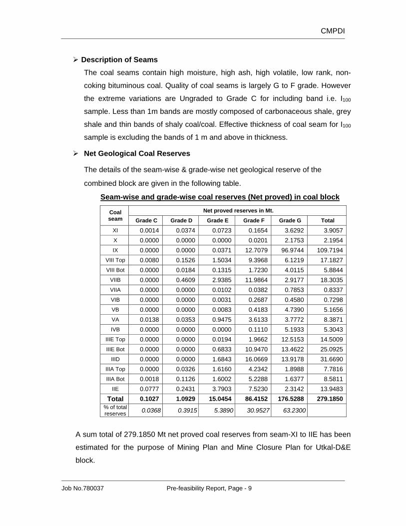
Description of Seams The coal seams contain high moisture, high ash, high volatile, low rank, non-
coking bituminous coal. Quality of coal seams is largely G to F grade. However
the extreme variations are Ungraded to Grade C for including band i.e. I100
sample. Less than 1m bands are mostly composed of carbonaceous shale, grey
shale and thin bands of shaly coal/coal. Effective thickness of coal seam for I100
sample is excluding the bands of 1 m and above in thickness.
Net Geological Coal Reserves
The details of the seam-wise & grade-wise net geological reserve of the
combined block are given in the following table.
Seam-wise and grade-wise coal reserves (Net proved) in coal block
Coal seam
Net proved reserves in Mt. Grade C Grade D Grade E Grade F Grade G Total
% of total reserves 0.0368 0.3915 5.3890 30.9527 63.2300
A sum total of 279.1850 Mt net proved coal reserves from seam-XI to IIE has been
estimated for the purpose of Mining Plan and Mine Closure Plan for Utkal-D&E
block.
CMPDI
Job No.780037 Pre-feasibility Report, Page - 10
Seam-wise and grade-wise net geological reserve within block area is 271.98 Mt
with 10% geological loss. Corresponding waste volume is 766.40 Mcum. Vertical
stripping ratio in the coal block is 2.80 cum/t.
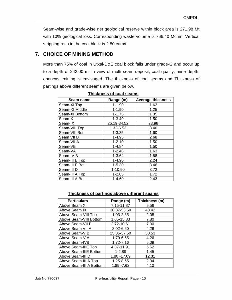
7. CHOICE OF MINING METHOD
More than 75% of coal in Utkal-D&E coal block falls under grade-G and occur up
to a depth of 242.00 m. In view of multi seam deposit, coal quality, mine depth,
opencast mining is envisaged. The thickness of coal seams and Thickness of
partings above different seams are given below.
Thickness of coal seams
Seam name Range (m) Average thickness Seam-XI Top 1-1.90 1.63Seam-XI Middle 1-1.90 1.25Seam-XI Bottom 1-1.75 1.35Seam-X 1-3.40 1.50Seam-IX 25.19-34.52 23.98Seam-VIII Top 1.32-6.53 3.40Seam-VIII Bot. 1-3.35 1.60Seam VII B 1-4.95 2.68Seam-VII A 1-2.10 1.50Seam-VB 1-4.84 1.50Seam-VA 1-2.48 1.63Seam-IV B 1-3.64 1.58Seam-III E Top 1-4.90 2.24Seam-III E Bot. 1-5.30 3.46Seam-III D 1-10.90 3.72Seam-III A Top 1-2.05 1.72Seam-III A Bot. 1-4.60 2.43
Thickness of partings above different seams
Particulars Range (m) Thickness (m) Above Seam X 7.15-11.87 9.56Above Seam IX 30.37-53.50 43.42Above Seam-VIII Top 1.03-2.85 2.08Above Seam-VIII Bottom 1.05-15.83 7.80Above Seam-VII B 2.72-10.61 7.00Above Seam VII A 3.02-6.60 4.28Above Seam-V B 25.35-37.50 30.53Above Seam-V A 1.79-6.65 4.26Above Seam-IVB 1.72-7.16 5.09Above Seam-IIIE Top 4.37-11.91 5.62Above Seam-IIIE Bottom 1-2.89 1.45Above Seam-III D 1.80 -17.09 12.31Above Seam-III A Top 1.25-8.65 2.94Above Seam-III A Bottom 1.85 -7.62 4.10
CMPDI
Job No.780037 Pre-feasibility Report, Page - 11
Lower seams are thinner when they are nearer to surface, still at a depth
between 100m and 65m. It is perceived that by open cast mining method,
production from upper seams and lower seams can be mixed in a manner to
sustain the mine economically.
By underground mining, annual production of 4.0 Mty is difficult to achieve.
Total extraction may not exceed 40% of available coal.
8. MINE BOUNDARY
The details of adopted mine boundaries are given below:
• MINE FLOOR
Floor of seam IIE (eastern part) and IIID (western part) has generally been
considered as the mine floor. However, in the north-western part, seam III A Bottom has been taken as mine floor.
• SURFACE BOUNDARIES
NORTH: Quarry surface boundary is drawn after provision of embankment, 5
m away from southern bank of Singhada Jhor and 5 m safety width
from toe of the embankment. General width of barrier on surface
from Singhada Jhor is 30m.
EAST: Quarry surface boundary is 35m away from block boundary where
nala diversion is proposed and 7.5 m away from the block boundary
where nala diversion is not required. This barrier will accommodate
service road, power line and fencing.
SOUTH: Quarry surface boundary is surface projection of quarry slope to
fully excavate seam VII-B and extending down to seam II-E or III-D.
WEST : About 30m barrier is kept to accommodate nala diversion, statutory
barrier & safety distance.
Quarry slope is about 37 degrees on an average. Horizontal roads of same
level of 21m width have been provided all along the quarry slope. Level of the
top most road is 140m and are provided at 30m vertical intervals down to
quarry bottom. Slope of 30m height between subsequent level roads is 60
degrees. This angle is achieved with 10m high benches at 70 degree angle
and 3m berm in between.
CMPDI
Job No.780037 Pre-feasibility Report, Page - 12
9. MINEABLE RESERVE & MINE LIFE
• Net Geological Reserve is estimated as 167.92 Mt within mine
boundary
• The mineable coal is estimated as 159.52 Mt with corresponding
overburden of 396.59 Mcum. The overall stripping ratio works
out to 2.49 cum/t.
• The mine life works out to 43 years at the target capacity of 4.0 Mty with
4 years of build-up and 2 years of tapering of production in initial and
closing years of mining activity.
10. GEO-MINING CHARACTERISTICS :
Sl. No. Particulars Unit Value 1. Quarry floor area Ha 227.36 2. Quarry surface area Ha 394.51 3. Mineable reserve Mt 159.52 4. Overburden Mcum 396.59 5. Stripping ratio cum/t 2.49 6. No. of seams/sections* No. 15 7. Capacity Mty 4.00 8. Life Years 43 9. Average seam gradient Degrees 5.86
10. Strike length (along floor) Maximum m 2097 Minimum m 1913
11. Strike length (along surface) Maximum m 2451 Minimum m 2541
12. Quarry depth Maximum m 242.0 Minimum m 99.50
13. Quarry perimeter m 8347 14. Dip-rise length
Along floor m 1159 Along surface m 1593
* including bottom and top sections of seams
11. MINING TECHNOLOGY Selection of Technology: For opencast mining any of the following or a
combination are generally adopted.
i) Bucket-wheel excavation system
ii) Dragline system
iii) Shovel-dumper system
CMPDI
Job No.780037 Pre-feasibility Report, Page - 13
iv) Surface Miner-pay loader-truck system
For coal deposit in Utkal-D&E coal block, Bucket-wheel system is not suitable
due to multi-seam deposit, abrasive sandstone strata and narrow width.
Further, Dragline cannot be applied to any parting strata which can be directly
side cast (backfilled).
Shovel-dumper system is very flexible and also offers convenient mining
operations to deal with sudden occurrence of unworkable and poor quality
zones and offers flexibility for easy up-gradation. The technology is well-known
and advantageous to get skilled manpower.
Surface Miner excavation has been proved to be a successful technology in
coal sector from 1999 for winning coal. There are many advantages in this
technology, of avoiding drilling, blasting, crushing in coal and related
environmental hazards, improvement in grade of ROM coal by removing thin
bands etc.
So, a mix type of excavator combination is proposed for this mine. Surface
miner will be worked for extraction of coal. It will work in windrowing method,
depositing cut coal behind. Loaders will heap and load into the tipping trucks,
to be carried to the surface. Shovel-dumper system is proposed for excavation
of overburden.
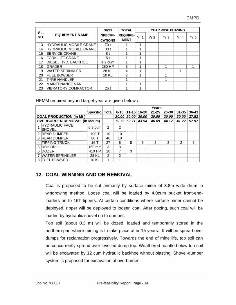
Requirement of HEMM : The requirement of HEMM upto target year and beyond target year is given below.
STATEMENT SHOWING THE REQUIREMENT OF HEMM WITH PHASING
SL. NO. EQUIPMENT NAME
SIZE/ TOTAL YEAR WISE PHASING SPECIFI- REQUIRE- Yr 1 Yr 2 Yr 3 Yr 4 Yr 5 CATIONS MENT
1 HYDRAULIC BACKHOE 12 cum 3 1 2 2 HYDRAULIC FACE SHOVEL 6.3 cum 1 1 3 REAR DUMPER 100 T 63 8 4 25 26 4 REAR DUMPER 60 T 13 9 4 5 SURFACE MINER 3.8 m wide 2 1 1 6 LOADER 4 cum 4 1 1 2 7 TIPPING TRUCK 16 T 34 6 4 4 12 8 8 RBH DIESEL DRILL 250 mm 5 1 1 2 1 9 RBH DRILL 160 mm 2 1 1 10 DOZER 410 HP 10 2 2 2 2 2 11 RIPPER 2 1 1 12 WHEEL DOZER 300 HP 2 1 1
CMPDI
Job No.780037 Pre-feasibility Report, Page - 14
SL. NO. EQUIPMENT NAME
SIZE/ TOTAL YEAR WISE PHASING SPECIFI- REQUIRE- Yr 1 Yr 2 Yr 3 Yr 4 Yr 5 CATIONS MENT
13 HYDRAULIC MOBILE CRANE 70 t 1 1 14 HYDRAULIC MOBILE CRANE 30 t 1 1 15 SERVICE CRANE 8 t 1 1 16 FORK LIFT CRANE 5 t 1 1 17 DIESEL HYD. BACKHOE 1.2 cum 1 1 18 GRADER 280 HP 3 1 1 1 19 WATER SPRINKLER 28 KL 4 1 1 1 1 20 FUEL BOWSER 10 KL 2 1 1 21 TYRE HANDLER 1 1 22 MAINTENANCE VAN 1 1 23 VIBRATORY COMPACTOR 25 t 1 1
HEMM required beyond target year are given below : Years Specific. Total 6-10 11-15 16-20 21-25 26-30 31-35 36-43 COAL PRODUCTION (in Mt ) 20.00 20.00 20.00 20.00 20.00 20.00 27.52 OVERBURDEN REMOVAL (in Mcum) 79.73 52.71 43.54 46.69 44.17 41.22 57.97
1 HYDRAULIC FACE SHOVEL 6.3 cum 2 2
2 REAR DUMPER 100 T 10 10 3 REAR DUMPER 60 T 46 10 4 TIPPING TRUCK 16 T 27 8 5 3 3 3 2 3 5 RBH DRILL 160 mm 3 3 6 DOZER 410 HP 10 7 3 7 WATER SPRINKLER 28 KL 2 2 8 FUEL BOWSER 10 KL 1 1
12. COAL WINNING AND OB REMOVAL
Coal is proposed to be cut primarily by surface miner of 3.8m wide drum in
windrowing method. Loose coal will be loaded by 4.0cum bucket front-end-
loaders on to 16T tippers. At certain conditions where surface miner cannot be
deployed, ripper will be deployed to loosen coal. After dozing, such coal will be
loaded by hydraulic shovel on to dumper.
Top soil (about 0.3 m) will be dozed, loaded and temporarily stored in the
northern part where mining is to take place after 15 years. It will be spread over
dumps for reclamation progressively. Towards the end of mine life, top soil can
be concurrently spread over levelled dump top. Weathered mantle below top soil
will be excavated by 12 cum hydraulic backhoe without blasting. Shovel-dumper
system is proposed for excavation of overburden.
CMPDI
Job No.780037 Pre-feasibility Report, Page - 15
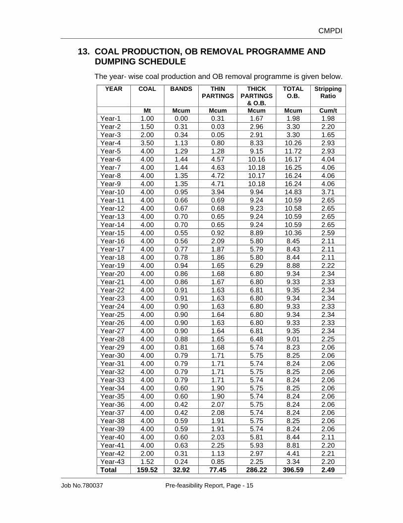
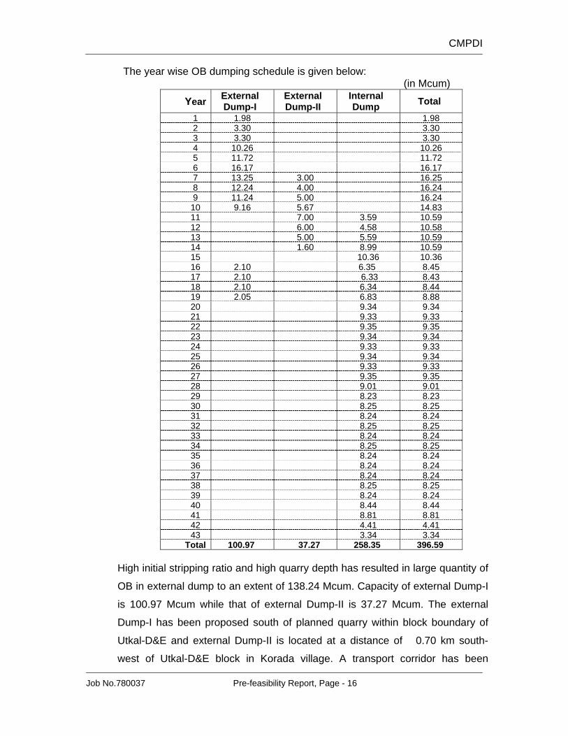
13. COAL PRODUCTION, OB REMOVAL PROGRAMME AND DUMPING SCHEDULE
The year- wise coal production and OB removal programme is given below. YEAR COAL BANDS THIN
Total 100.97 37.27 258.35 396.59 High initial stripping ratio and high quarry depth has resulted in large quantity of
OB in external dump to an extent of 138.24 Mcum. Capacity of external Dump-I
is 100.97 Mcum while that of external Dump-II is 37.27 Mcum. The external
Dump-I has been proposed south of planned quarry within block boundary of
Utkal-D&E and external Dump-II is located at a distance of 0.70 km south-
west of Utkal-D&E block in Korada village. A transport corridor has been
CMPDI
Job No.780037 Pre-feasibility Report, Page - 17
provided between western block boundary and external Dump-I to access
external Dump-II.
In order to prove non-existence of coal at the site of external Dump-II, three
boreholes were drilled through Directorate of Geology, Govt. of Orissa. No coal
has been reported from any borehole drilled to an average depth of 140 m
Balance overburden of 258.35 Mcum will be accommodated in internal dump.
It is proposed to backfill overburden only on western side and keep eastern
batter free for liquidation (between Utkal-D&E and Utkal-C blocks).
14. LAND REQUIREMENT
The total land requirement of the proposed project is 842.96 Ha.
The details of land requirement is given below.
Sl.No. Particulars Land in (Ha)
1. Forest 325.11 2. Non-forest 517.85 Mining lease area 842.96 Outside mining lease area
3 Residential Colony, R & R Site 42.25
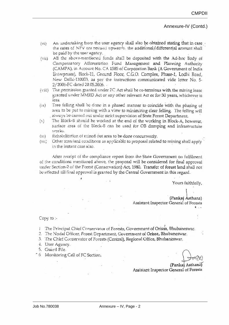
Total land 885.21 Note: Stage I forest clearance for 137.02 Ha for Utkal D Coal Mine was obtained vide letter no.F.No.8-99/2006-FC dtd. 20-10-2006. (Annexure IV)
Total 1538.27 No separate residential colony is proposed. Manpower will be accommodated in existing colony of NALCO Nagar, Angul. Source: Water of Singhadajhor Nalla will be used for the first five years for drinking and industrial purposes. After that Mine pit water will be used.
17. INFRASTRUCTURE FACILITY / CIVIL CONSTRUCTION
Following infrastructure has been envisaged for smooth operation of the mine-
a. Electrical sub-station
b. Pit Office
c. Canteen
d. Dumper and Dozer Parking
e. HEMM Workshop
f. HEMM Store
g. E&M Workshop
h. E&M Store
i. Coal Receiving Hopper
j. Reclaim Feeder with Spreading arrangement in Coal Stock
k. Weigh Bridges
CMPDI
Job No.780037 Pre-feasibility Report, Page - 19
l. Dispensary
m. Project Office
n. Approach Road
o. Conveyor with Drive Houses and Transfer Houses
18. PUMPING AND DRAINAGE
The following facilities would be provided for proper drainage:
The garland drains shall be developed in advance for each mine stage such
that water is collected in these garland drains and discharged properly outside
the pit.
Working faces would be laid such that the water from the working areas will
flow into the sump by gravity from where it would be pumped out to surface
drains.
Face pumps of 38 lps with 50m head would be provided to keep working
faces dry upto 3rd Year.
Slurry pumps would be provided to deal with slurry formed during rainy
season.
Main pumps with 80lps and 250m head would be provided upto 10th year to
drain out the mine water.
Other main pumps with higher capacity and head would be provided after 10th
year.
19. POWER SUPPLY
The project will receive power at 33 kV from CESCO through double circuit
overhead line. The 33 kV power shall be tapped at a suitable point approved by
CESCO near the project from the 33 kV CESCO Jharpada-Chhendipada
overhead line. The above 33 kV overhead line is passing near the project. The
proposed 33/6.6 kV Substation shall be constructed near the South Eastern
Side of mine entry.
CMPDI
Job No.780037 Pre-feasibility Report, Page - 20
20. COAL HANDLING & DISPATCH ARRANGEMENT The coal handling plant has been planned to handle 4.00 Mty of coal. Around
100% of the coal is to be produced by blast free technology. The coal handling
plant shall have the following facilities
To dispatch the initial production by road transportation by tippers shall
be adopted.
At a later stage, Blast free coal brought by tippers/dump trucks from the
quarry shall be unloaded on reclaim feeder complex. The unloaded coal
shall be channelized by Dozers or by Pay loaders to feed the reclaim
feeders. The channelized coal will be reclaimed by two numbers of
reclaim feeders of (0-1000) TPH of variable capacity each from the stock
pile. Out of two numbers reclaim feeder, either one will work or both will
work depending upon the requirement. The reclaimed coal will be
delivered to belt conveyor C1.
Series of conventional conveyors C1, C2 and C3 of 1400 mm belt width
of 1200 TPH each will be installed to carry (-) 100 mm coal from reclaim
feeder complex up to 4000 tonne SILO (RLS) for wagon loading.
For loading to wagons, one number of SILO 4000 tonne with two pre-
weigh hoppers with telescopic chute shall be provided.
Other facilities like Dust control (Plain water (PWDS) and Dry fog (DFDS)
types), Industrial and drinking water supply, Firefighting and Plant
cleaning, Belt weigher, Electric and Mechanical hoists, Tramp iron
magnet (ILMS) and Metal detector, Automatic mechanical sampling
system, In motion rail weigh bridges etc. will be also envisaged.
Proposed tentative location of rapid loading system will be on rail line proposed
by RITES and conceived by IDCO as common road & rail corridor.
Prior to establishment of common road and rail corridors, coal is proposed to be
transported by 14 tonne trucks to CPP of NALCO through existing Forest Road
and State Highway-63. After common corridors are established, the coal will be
transported by series of conveyors (C1, C2 & C3) up to Rapid Loading System
on IDCO rail corridor. Finally, the coal will be loaded into wagons of full rake for
onward transportation to CPP of NALCO.
CMPDI
Job No.780037 Pre-feasibility Report, Page - 21
Power at 6.6 kV for CHP is proposed to be received from the 33/6.6 kV project
substation. It is proposed to establish required number of 6.6 kV substation at a
suitable location near CHP to cater to the power requirement for different
equipment of CHP.
21. WORKSHOP AND STORE The workshop and project store shall be located adjacent to the same
compound for faster availability of spares required by the work shop.
The workshop will have two separate sections i.e. HEMM section and E&M
section to look after the maintenance of HEMM and other P&M.
Provision for a closed shed is made for the project stores. Separate provision
for a store yard of adequate area is also made for loading/unloading, truck
movement etc.
Store racking system, weigh scale, fork lift truck have also been provided in the
stores which shall be located adjacent to the workshop complex for quick
issuing of materials to the workshops.
22. MAJOR DIVERSION OR SHIFTING
Two seasonal streams namely Gundijeri Nala and Katau Nala are to be
diverted by east and west respectively, as they are passing across the block
from south-west to north-east.
Length of stream diversion in East – 3.06 km Length of stream diversion in West -- 3.42 km
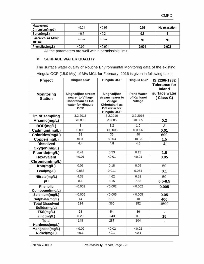
23. ENVIRONMENTAL MANAGEMENT
The proposed project is a new project. The baseline data will be generated at
the time of preparation of EIA-EMP. However for existing environmental
scenario the routine environmental monitoring data of nearby Hingula OCP
(15.0 Mty) of M/s MCL has been considered which is nearly at a arial distance
of 6.0 km.
23.1 AIR QUALITY The average values of Routine Environmental Monitoring data of the existing
Hingula OCP (15.0 Mty) of M/s MCL for SPM, RPM, SO2 and NOX during the
period January-March, 2016 are given in following table.
CMPDI
Job No.780037 Pre-feasibility Report, Page - 22
Summary of Air Quality Data (Values in µg/m3)
It has been observed that all the values are well within permissible limit.
23.2 WATER QUALITY
DRINKING WATER QUALITY
The drinking water quality of Routine Environmental Monitoring data of the
existing Hingula OCP (15.0 Mty) of M/s MCL for the month of March, 2016 is
given in following table:
Project Hingula OCP Hingula OCP
Monitoring Station Kumunda Village Bore well water