PORSEC – Pan Ocean Remote Sensing Conference Association – Since 1990 Bulletin vol. 11-3 1 Dear Members of the PORSEC Association, In this bulletin, we bid farewell to our founding editor of the Bulletin, Kristina Katsaros, and welcome our new incoming co-editor, Nimit Kumar. Kristina started the PORSEC newsletter in 2005, and then introduced the bulletin of the PORSEC association, with 3 issues per year, in 2007, as the main mean of communication to the PORSEC community in between PORSECs. We are very grateful to Kristina for all her efforts on behalf of the PORSEC association, and wish her the best in retirement. We feature a special farewell letter from Kristina. All our bulletins and newsletters are archived and accessible at porsec.nwra.com/bulletins/ As announced in our last bulletin (11.1-2), the dates and venue of PORSEC2018 and the preceding capacity building capacity building tutorial course have been set, and we have a short report on progress in preparation. We also call for conveners of session for PORSEC 2018, who will also serve on the program committee. If you are interested in convening a session and serving on the committee, please contact PORSEC Vice- President Abderrahim Bentamy (Abderrahim.Bentamy (at) ifremer.fr). Please mark your calendars and plan to attend and bring students and early career scientists to PORSEC2018. In this issue, we have two featured articles: One by our incoming co-editor, Nimit Kumar, describing The Indian National Centre for Ocean Information Services (INCOIS), which hosted PORSEC2012 in Kochi, and another by Abderrahim Bentamy about a new Multi-Sensor (Scatterometers and Radiometers) Blended High- Resolution Sea Surface Winds over the Global Ocean database. In our early career scientists (ECS) column this issue, we call the attention of our ECS to a new opportunity. We will resume featuring early career scientists’ stories in our next issues, and call for contributions to this section: Please refer to the introduction of this section in Bulletin 10.1 and contact Executive Secretary, Nico Caltabiano (caltabiano (at) gmail.com), who acts as a contact and editor of this section, if you wish to contribute. In this issue, we also provide updates on the special IJRS journal issue following PORSEC2016 from our publications committee, on membership from our membership, education and outreach coordinator (Stephanie King), and news from China from Gang Pan. We wish you all a happy and successful 2018. Co-Editors: Kristina Katsaros (departing), Nimit Kumar (incoming) and Gad Levy Katsaros (at) whidbet.net; nimitkumar.j (at) incois.gov.in; gad (at) porsec.nwra.com *we use “at” in the email addresses herein to avoid phishing
Transcript
PORSEC – Pan Ocean Remote Sensing Conference Association – Since 1990 Bulletin vol. 11-31
Dear Members of the PORSEC Association,
In this bulletin, we bid farewell to our founding editor of the Bulletin, Kristina Katsaros, and welcome our new incoming co-editor, Nimit Kumar. Kristina started the PORSEC newsletter in 2005, and then introduced the bulletin of the PORSEC association, with 3 issues per year, in 2007, as the main mean of communication to the PORSEC community in between PORSECs. We are very grateful to Kristina for all her efforts on behalf of the PORSEC association, and wish her the best in retirement. We feature a special farewell letter from Kristina. All our bulletins and newsletters are archived and accessible at porsec.nwra.com/bulletins/ As announced in our last bulletin (11.1-2), the dates and venue of PORSEC2018 and the preceding capacity building capacity building tutorial course have been set, and we have a short report on progress in preparation. We also call for conveners of session for PORSEC 2018, who will also serve on the program committee. If you are interested in convening a session and serving on the committee, please contact PORSEC Vice-President Abderrahim Bentamy (Abderrahim.Bentamy (at) ifremer.fr). Please mark your calendars and plan to attend and bring students and early career scientists to PORSEC2018. In this issue, we have two featured articles: One by our incoming co-editor, Nimit Kumar, describing The Indian National Centre for Ocean Information Services (INCOIS), which hosted PORSEC2012 in Kochi, and another by Abderrahim Bentamy about a new Multi-Sensor (Scatterometers and Radiometers) Blended High-Resolution Sea Surface Winds over the Global Ocean database. In our early career scientists (ECS) column this issue, we call the attention of our ECS to a new opportunity. We will resume featuring early career scientists’ stories in our next issues, and call for contributions to this section: Please refer to the introduction of this section in Bulletin 10.1 and contact Executive Secretary, Nico Caltabiano (caltabiano (at) gmail.com), who acts as a contact and editor of this section, if you wish to contribute. In this issue, we also provide updates on the special IJRS journal issue following PORSEC2016 from our publications committee, on membership from our membership, education and outreach coordinator (Stephanie King), and news from China from Gang Pan. We wish you all a happy and successful 2018.
Co-Editors: Kristina Katsaros (departing), Nimit Kumar (incoming) and Gad Levy Katsaros (at) whidbet.net; nimitkumar.j (at) incois.gov.in; gad (at) porsec.nwra.com
*we use “at” in the email addresses herein to avoid phishing
PORSEC – Pan Ocean Remote Sensing Conference Association – Since 1990 Bulletin vol. 11-32
Wishes from Kristina Katsaros
Dear PORSEC Members and Friends,
I have enjoyed the community of PORSEC colleagues for about 20 years at both conferences and tutorial sessions. When I became president in 2006 we started the Bulletin of the PORSEC Association, so this is now the 11th volume (year) with 3 issues per volume/year.
Recently Nimit Kumar accepted to become co-editor with Gad Levy and we are so pleased that he is taking over for me, as I take my leave.
You can read about Nimit’s home institution in this issue. So, this is my "Swan Song" from the co-editorship. I thank all of you for your contributions, Gad Levy and our production editor, Susanne Ohrvik, for the good collaboration over the years. It has been rewarding to be involved in this manner with such a wonderful international organization as our PORSEC Association
Best wishes for the Bulletin and the PORSEC Association that it will continue in this special and wonderful collegial manner over the years to come!
Yours truly, Kristina B. Katsaros
Indian National Centre for Ocean Information Services (INCOIS) The Indian National Centre for Ocean Information Services (INCOIS) is an autonomous institute under the Ministry of Earth Sciences of the Government of India and has been identified as a nodal agency for providing timely and reliable ocean information and advisory services to a vast array of users and stakeholders. INCOIS is also a recognized National Oceanographic Data Centre (NODC), UNESCO recognized Regional Tsunami Service Provider (RTSP) and ARGO Regional Data Center. Three of the INCOIS services – Potential Fishing Zones (PFZ), Ocean State Forecast (OSF) and Tsunami Early Warning (TEWS) - are ISO-certified services. Many of the INCOIS services actively uses satellite remote sensing data to generate fishery advisories, bloom indices, coral bleaching alerts and so on. In this article, some of these services are discussed in detail. You may learn more about INCOIS by visiting www.incois.gov.in. 1. Marine Fishery Advisory Services (MFAS)
PORSEC – Pan Ocean Remote Sensing Conference Association – Since 1990 Bulletin vol. 11-33
Indian marine capture fishery is a typical multi-species tropical fishery. The first major rise in annual marine fish production occurred in the 1960s with the introduction of mechanization to the fleet. However, fishery remained mostly an individual affair and to date, it has not yet taken any significant corporate shape. This has inhibited the fleet from venturing away from the shore in many parts of the country until early 1990s, when primary studies towards locating resources with the help of satellites started. Fishery research organizations, with the help of Indian Space Research Organization (ISRO) laboratories conducted such primary studies with encouraging results. These efforts were utilizing data from the NASA, NOAA and ESA satellites such as the MetOp series for Sea Surface Temperature (SST) and MODIS & SeaWiFS for chlorophyll concentration.
Productivity of oceans depends on nutrient availability in the sun-lit upper waters, known as the euphotic zone. Oceanographic phenomena such as upwelling help contribute to much of this requirement, by entraining nutrients above the mixed layer depth and in turn, allowing phytoplankton to sustain a food-web with the help of photosynthesis. The stronger the upwelling, the deeper the upper mixed layer of oceanic water column. This allows colder nutrient-rich waters to surface, lowering SST. Thus, SST provides a clear signature for detecting upwelling zones with the help of remote-sensing data. Productive waters may initially attract only planktivorous fishes, but eventually also to bigger fishes, which prey upon them. This is the very reason for why and how SST was first harnessed as a tool of fishery resource predictions. Commercially important species, such as Tuna, are known to have temperature specificity as reflected in a positive correlation of specific temperature ranges with better hooking rates. Ocean-color missions have enhanced our understanding of ecosystem-level interactions in the oceans. Cooler SST signature with higher concentrations of chlorophyll relative to the surrounding waters indicates upwelling-induced productivity and has been correlated with higher Catch per Unit Effort (CPUE)
At the end of the 1990s, India launched its first satellite for the study of oceans – IRS-P4, known as Oceansat-1. Oceansat-1, with Ocean Color Monitor (OCM) sensor onboard, started providing chlorophyll concentration data. This was followed by the initiation of Potential Fishing Zone (PFZ) advisory program, as a free service to the Indian fisher community within Indian EEZ (Exclusive Economic Zone). Initially, this service used SST data from NOAA series of satellites. Eventually, data from more satellites, such as MODIS and MetOP, were also incorporated. The service initiated as a one-day delay product that was made available twice-weekly, and is now being provided in Near-Real Time (NRT) mode on daily basis. Today, the Indian Marine Fishery Advisory Services (MFAS) is a unique program with decade-plus long experience and a data-archive, reaching thousands of the Indian fishermen on daily basis. Controlled validation experiments that employed identical fishing boats to compare fish catch from PFZ area to that from a non-PFZ area were undertaken. Such experiments, carried out in the past decade, have shown mostly positive and encouraging results. Similarly, from fishermen feedback, PFZ advisories are found to be beneficial in obtaining more profit by reducing search time (and fuel consumption) for the fish-shoals. This, in turn, helps lowering India's carbon footprint by cutting carbon emissions per unit mass of fishes caught. While the ISO-certified PFZ service caters only to the operational Indian fisheries community; it contributes positively to the capacity building of the Indian Ocean-rim (IOR) countries by regularly providing training to researchers from these countries.
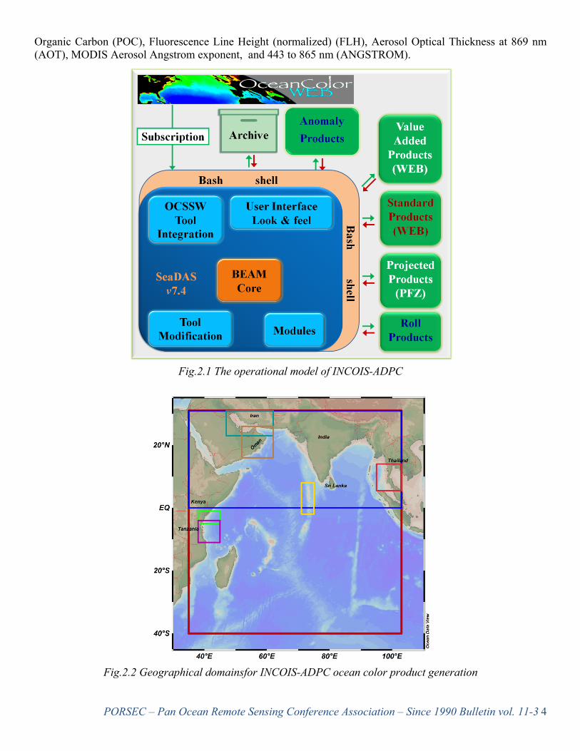
2. Ocean Color ADPC As a part of the Chlorophyll Global Integrated Network (ChloroGIN) Project, endorsed by the Global Ocean Observing System (GOOS) in the Indian Ocean (IOGOOS), INCOIS is providing ocean color data products to users at near real-time (NRT), meant for research as well as operational activities. The Ocean Color Application Team (OCAT) at INCOIS has setup an Automatic Data Processing Chain (ADPC) for acquisition, processing, and dissemination of ocean color data products from MODIS-Aqua. Currently, ADPC is generating products using MODIS-Aqua data and uses both the Ocean Color processor (OCSSW) and Graph Processing Toolkit (GPT) of SeaDASv7.4 for this job. The L3Mapped NetCDF4 files are being generated by processing, binning and mapping of the L1A_LAC files acquired from GSFC-NASA ocean color data website (Fig.2.1). The data products that are presently generated are Chlorophyll Concentration (CHL), Chlorophyll Concentration using Shanmugam,2011 algorithm (CHL_ABI), Sea Surface Temperature (SST), Diffuse Attenuation Coefficient at 490 nm (KD_490), Color Dissolved Organic Matter (CDOM), Particulate Inorganic Carbon (PIC), Particulate
PORSEC – Pan Ocean Remote Sensing Conference Association – Since 1990 Bulletin vol. 11-34
Organic Carbon (POC), Fluorescence Line Height (normalized) (FLH), Aerosol Optical Thickness at 869 nm (AOT), MODIS Aerosol Angstrom exponent, and 443 to 865 nm (ANGSTROM).
Fig.2.1 The operational model of INCOIS-ADPC
Fig.2.2 Geographical domainsfor INCOIS-ADPC ocean color product generation
PORSEC – Pan Ocean Remote Sensing Conference Association – Since 1990 Bulletin vol. 11-35
Moreover, Photosynthetically Available Radiation (PAR), Instantaneous Photosynthetically Available Radiation (iPAR), Phytoplankton Class using Dwivedi,2015 algorithm (PHYTO), Total Suspended Matter (TSM),Bloom Indices using Ahn and Shanmugam,2006 (BI). Quasi-true color composite (BRS) for the entire region are also being generated. The BI, TSM, PHYTO are value added products, where as the rest are standard products. ADPC also generates 3, 7 and 30 day roll product for the standard products. 30 day anomaly product is also being generated for CHL, CHL_ABI and SST with 1, 3, 5 and 7 day lag. These standard and value added products are being provided at NRT to IOGOOS Member States: India, Sri Lanka, Iran, Kenya, Maldives, Oman, Tanzania and Thailand. The operation Data products are being generated both for the entire Indian Ocean region as well as for 7 regions of interest (Fig.2.2). Though standard products of both 1km and 4km spatial resolution are being generated, only 1Km resolution products are being disseminated through the web. The value added products are generated with 4km of spatial resolution. The Potential Fishing Zone (PFZ) advisory of INCOIS is fed with the data generated by the ADPC. The current processing chain is capable of delivering CHL, SST and KD_490, both daily and as 3 day rolling products by 11:30 Hrs. IST of the next day. All the Standard and Value added products are available by 14:00 Hrs. IST, whereas all the roll and anomaly products are available by 17:30 Hrs IST of the next day. Other than the Standard and Value added products, mapped absorption (a, aph, adg using GIOP model), backscattering (bb, bbp using GIOP model) and radiance (RRS, Lw, nLw) products are also being generated for in-house use of INCOIS and are available upon request. ADPC is also being incorporated with VIIRS data processing, but it is in standby mode for now. In VIIRS version of ADPC AOT is available at 862 nm instead of 869 nm and CDOM, FLH & PHYTO are unavailable. 3. INCOIS Live Access Server (I-LAS) Researchers and students interested in obtaining data and information concerning to oceanography or the marine environment in general are often forced to navigate through a number of bewildering websites. They also often face the problem with different data formats and data delivery mechanisms to get the information they need. In order to eliminate this tedious process of search and download, the Data and information Management Group (DMG) at Indian National Centre for Ocean Information Services (INCOIS) had come up with a thought to provide most of the data pertaining to Indian Ocean, needed by the researchers, at one place. This notion had resulted in setting up of INCOIS Live Access Server (I-LAS), which acts as a one stop shop for geo-spatial data. The Live Access Server (LAS) is a highly configurable web server designed to provide flexible access to geo-referenced scientific data. It can present distributed data sets as a unified virtual data base through the use of DODS networking. Ferret is the default visualization application used by LAS, though other applications can also be used. In its original form, a user is presented with an web-interface where he/she can select the data set(s) of interest, parameters, the desired spatio-temporal region of interest, and an output product is generated within no time delay (Hankin et al., 1998). The I-LAS provides free access to full suite of satellite-derived data products viz., sea surface temperature (SST), surface chlorophyll, surface wind products and number of products derived from objectively analyzed in-situ data. Further model analysis products from GODAS-MOM are also made available. Additionally climatological data sets from World Ocean Atlas 2009 are also made available for inter-comparison and generation of anomalies. Various functionalities for on the fly visualization and downloading of data are in built in to the LAS along with OpenDAP data sharing. Some examples of data usage from the LAS are also presented. It is observed that INCOIS LAS is being extensively used by various users and statistics of data usage is monitored on a regular basis and 100% uptime is maintained. References: Hankin S., J. Davison, J. Callahan, D.E. Harrison, K. O'Brien, 1998, "A configurable web server for gridded data: a framework for collaboration," in 14th , International Conference on interactive information and Processing Systems for Meteorology, Oceanography, and Hydrology, AMS, pp. 417 - 418, 1998.
PORSEC – Pan Ocean Remote Sensing Conference Association – Since 1990 Bulletin vol. 11-36
(a)
(b)
(c)
(d)
Figure 3.1. The INCOIS-LAS user interface page with various functionalities. (a) Standard user interface of I-LAS. (b) Zooming facility used to enhance to the region of interest. (c) Various plotting functions available with LAS. (d) Options to enhance the plot visualization.
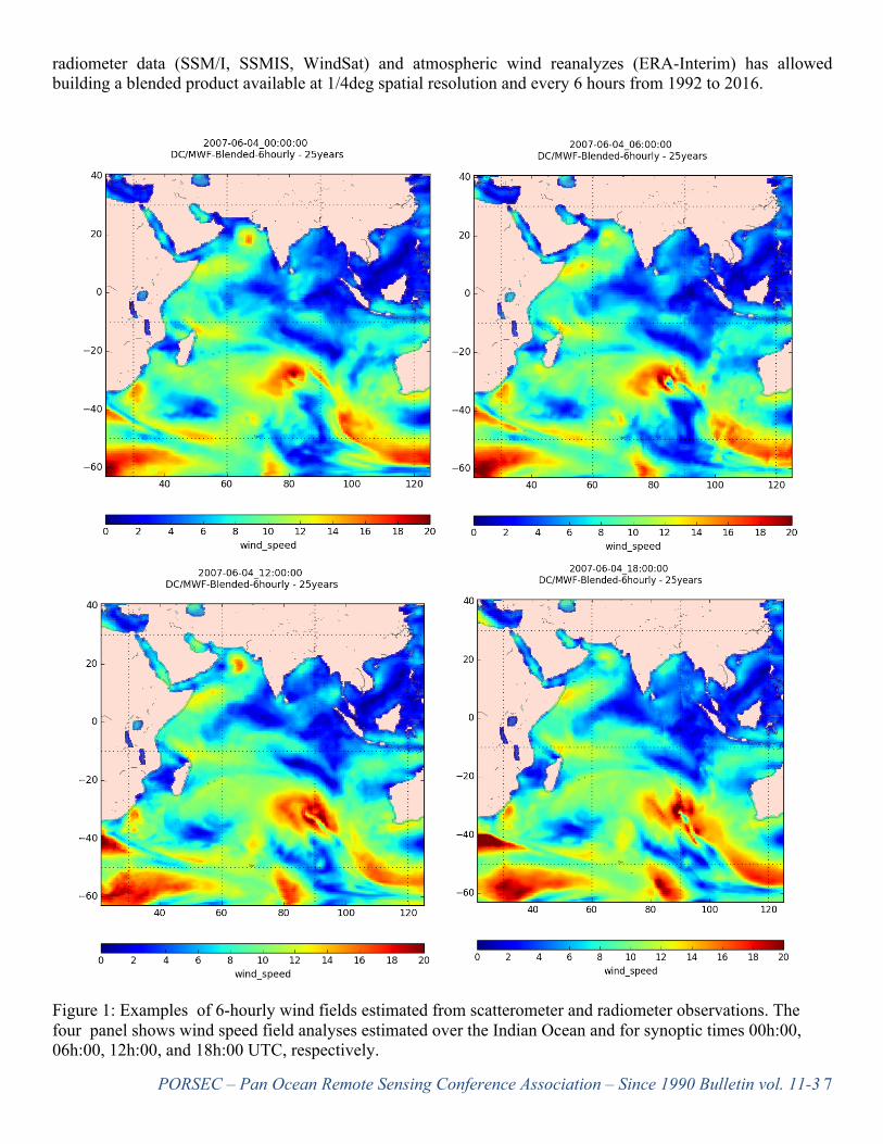
Multi-Sensor (Scatterometers and Radiometers) Blended High-Resolution Sea Surface Winds over the Global Ocean New global ocean high space and time resolution sea surface wind analyses are calculated based on the use of various remotely sensed wind observations. The wind retrievals (equivalent neutral wind velocities at 10m) from scatterometer missions since 1992 have been used to build up 25 years atmospheric climate series. A spatial and temporal objective-analysis method based on the Kriging interpolation method has been applied to provide continuous surface wind speed and direction estimates over the global ocean on a regular (in space and time) grid. The associated parameters, such as wind stress amplitude and components, wind vector and stress divergence, and wind vector and stress curls, are also provided. The use of ancillary data sources such as
PORSEC – Pan Ocean Remote Sensing Conference Association – Since 1990 Bulletin vol. 11-37
radiometer data (SSM/I, SSMIS, WindSat) and atmospheric wind reanalyzes (ERA-Interim) has allowed building a blended product available at 1/4deg spatial resolution and every 6 hours from 1992 to 2016.
Figure 1: Examples of 6-hourly wind fields estimated from scatterometer and radiometer observations. The four panel shows wind speed field analyses estimated over the Indian Ocean and for synoptic times 00h:00, 06h:00, 12h:00, and 18h:00 UTC, respectively.
PORSEC – Pan Ocean Remote Sensing Conference Association – Since 1990 Bulletin vol. 11-38
The remotely sensed data are provided by IFREMER (ERS-1 and ERS-2), NASA/JPL (QuikSCAT), EUMETSAT OSI SAF (ASCAT-A, ASCAT-B), from Remote Sensing System (SSM/I SSMIS, and WindSat). The NWP re-analysis is ERA Interim from ECMWF. The objective method used for 6-hourly wind field calculation is an extension of the method previously used to estimate daily wind fields from wind observations retrieved only from one scatterometer (ASCAT or QuikSCAT) (ftp://ftp.ifremer.fr/ifremer/cersat/products/gridded/MWF/). The details of the method are provided in Bentamy et al (2012).It is also used for the determination of L4 wind fields products performed within E.U. Copernicus project (http://marine.copernicus.eu/). All satellite swath data occurring within 3 hours of the 6-hourly ECMWF wind analysis times (00h:00, 06h:00, 12h:00, 18h:00 UTC) are selected. Scatterometer and radiometer observations occurring between 9 hours and 3 hours before and after ERA Interim time are dynamically interpolated at analysis time ±3hours. The resulting blended wind fields are estimated over global ice-free ocean with a 0.25° spatial resolution in both longitude and latitude and at standardsynoptic times (00h:00, 06h:00, 12h:00, 18h:00 UTC) . The accuracy of the resulting wind analyses is determined trough comprehensive comparisons with 6-hourly averaged winds derived from moored buoy measurements (Desbiolles et al, 2017). Buoy and satellite wind estimates compare well with root mean square difference lower than 1.20m/s and 20° for wind speed and direction. Full Datasets are available on ftp://ig1fdaf:[email protected]/IFREMER_LOPS_blended_wind/longterm_analysis/ Files are in netcdf 4 format. The following variables are available: wind speed, zonal and meridional wind components, wind stress and the associated components, wind vector and wind stress divergence and curl. Errors related to sampling scheme impact are also provided.
References: Bentamy A., D. Coizé- Fillon, 2012 :Gridded surface wind fields from Metop/ASCAT measurements . International Journal Of Remote Sensing , 33(6), 1729-1754 Desbiolles F., A. Bentamy, B. Blanke, C. Roy, A. Mestas-Nunez, S. A. Grodsky , S. Herbette, G. Cambon, C. Maes, 2017 : Two Decades [1992-2012] of Surface Wind Analyses based on Satellite Scatterometer Observations . Journal Of Marine Systems , 168, 38-56
An Early Career Scientist Opportunity!
Two Travel Awards (800 Swiss Francs each) will be granted to postdoctoral researchers or PhD students to attend conferences in 2018, by the open access Journal “Remote Sensing”. The applications for these awards will be accepted until 28 February 2018.
Please find additional details and apply at: http://www.mdpi.com/journal/remotesensing/awards and submit the required documents to: [email protected]
Report from PORSEC Publications Committee International Journal of Remote Sensing, PORSEC-2016 Special Issue Status Report: The International Journal of Remote Sensing (IjRS) special issue “Enabling earth observations in support of global, coastal, ocean and climate change research and monitoring” featuring a selection of peer reviewed research papers presented at the 13th Biennial Pan Ocean Remote Sensing Conference (PORSEC) in November 2016 is nearly complete. IJRS now publishes accepted papers on Taylor & Francis Online upon acceptance. At this time 15 papers have been accepted, out of which 11 have already been published online. Four additional papers are in advance or final review or revision stage. The special issue guest editors are Stefano Vignudelli, Jim Gower, and Gad Levy.
PORSEC – Pan Ocean Remote Sensing Conference Association – Since 1990 Bulletin vol. 11-39
Announcement: PORSEC-2018 to be held in Jeju Island, S. Korea: Korea Institute of Ocean Science and Technology (KIOST) will be hosting PORSEC 2018, the fourteenth biennial conference, on Jeju Island, South Korea November (4-7) 2018, with a capacity building tutorial October 30 to November 3, 2018 .
The Chair of the Local Organizing Committee (LOC) is Dr. Young Je Park. A couple of virtual meetings between members of the PORSEC association executive and the LOC have taken place and a site visit is planned for early 2018. LOC is setting up the conference webpage that will be linked to PORSEC association webpage.
Both the tutorial and the conference will be held on Jeju Island, where visa is not required by citizens of most countries for stays of up to 30 days. The capacity building tutorial will be held at KIOST branch in Jeju Island. Shuttle will be provided to venue from hotel that will be used to accommodate tutorial participants (15km from venue). The main Conference will be held at the International Convention Center (ICC). Several hotels, with different price ranges, are available near the venue.
Remote Sensing news for PORSEC community Oct 26, China to freely share data from carbon satellites
China will freely share data from its first carbon monitoring satellite – TanSat - with international users. A Chinese official made the remarks at the China Day event during the Group on Earth Observations (GEO) week 2017, in Washington, D.C. TanSat, launched last December, is China's first satellite to monitor greenhouse gas emissions, and is of great importance to a full understanding of the global carbon cycle process and its impact on global climate change. The satellite's in-orbit test has been completed with all performance indicators meeting the design requirements, with the precision of carbon concentration monitoring being below four ppm (parts per million). The China Meteorological Administration (CMA) has developed a carbon satellite data sharing policy, and level 1A, 1B, 2 and 3 data will be freely open to users worldwide. The data and products from TanSat will be released through Fengyun satellite data center website and the national integrated Earth observation data sharing platform in quasi real-time. "We have a key carbon initiative and we would love to see China more engaged in that," Barbara Ryan, secretariat director of GEO, an intergovernmental organization, told reporters at the event. "I think your satellite is going to be a key contribution, and particularly with your broad open data policies that will help enormously, really give us better estimates of how the Earth climate is changing," Ryan said.
PORSEC – Pan Ocean Remote Sensing Conference Association – Since 1990 Bulletin vol. 11-310
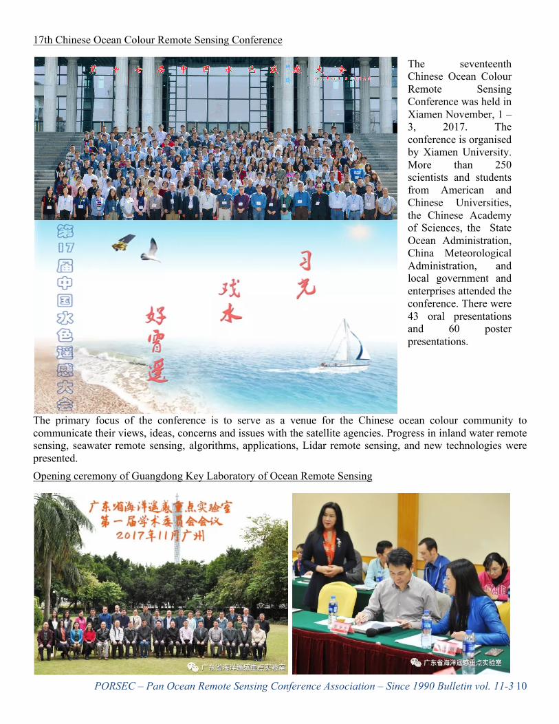
17th Chinese Ocean Colour Remote Sensing Conference
The seventeenth Chinese Ocean Colour Remote Sensing Conference was held in Xiamen November, 1 – 3, 2017. The conference is organised by Xiamen University. More than 250 scientists and students from American and Chinese Universities, the Chinese Academy of Sciences, the State Ocean Administration, China Meteorological Administration, and local government and enterprises attended the conference. There were 43 oral presentations and 60 poster presentations.
The primary focus of the conference is to serve as a venue for the Chinese ocean colour community to communicate their views, ideas, concerns and issues with the satellite agencies. Progress in inland water remote sensing, seawater remote sensing, algorithms, applications, Lidar remote sensing, and new technologies were presented. Opening ceremony of Guangdong Key Laboratory of Ocean Remote Sensing
PORSEC – Pan Ocean Remote Sensing Conference Association – Since 1990 Bulletin vol. 11-311
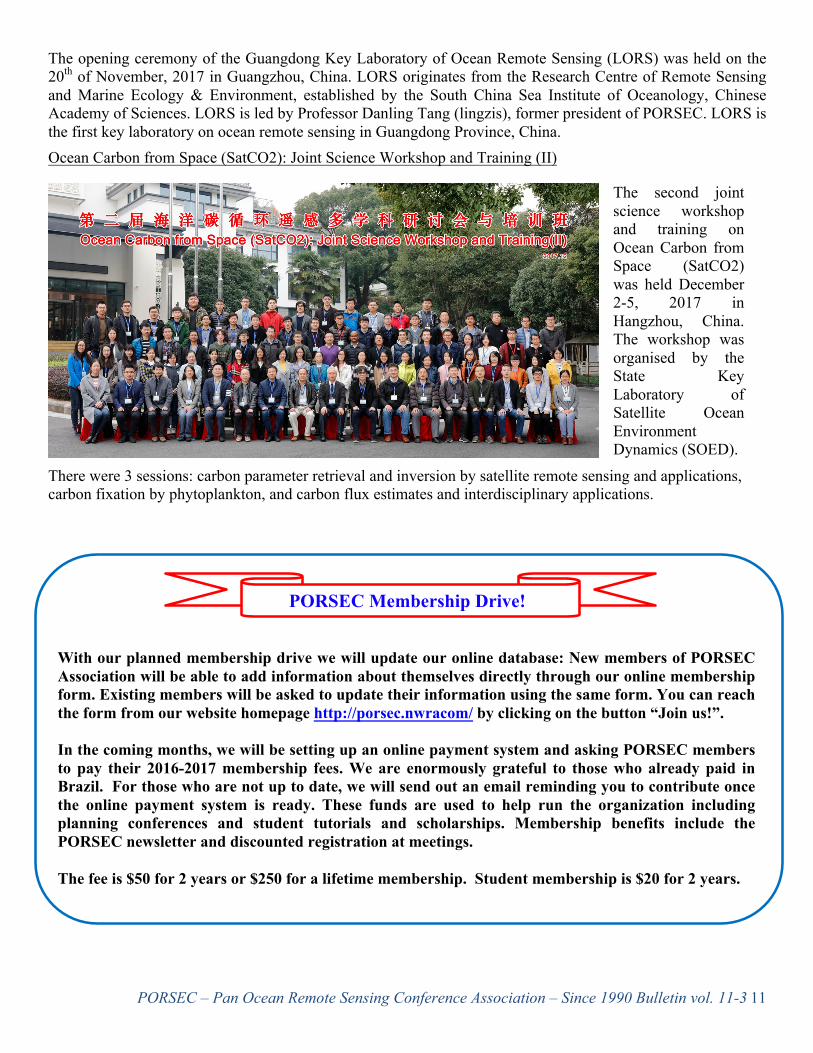
The opening ceremony of the Guangdong Key Laboratory of Ocean Remote Sensing (LORS) was held on the 20th of November, 2017 in Guangzhou, China. LORS originates from the Research Centre of Remote Sensing and Marine Ecology & Environment, established by the South China Sea Institute of Oceanology, Chinese Academy of Sciences. LORS is led by Professor Danling Tang (lingzis), former president of PORSEC. LORS is the first key laboratory on ocean remote sensing in Guangdong Province, China. Ocean Carbon from Space (SatCO2): Joint Science Workshop and Training (II)
The second joint science workshop and training on Ocean Carbon from Space (SatCO2) was held December 2-5, 2017 in Hangzhou, China. The workshop was organised by the State Key Laboratory of Satellite Ocean Environment Dynamics (SOED).
There were 3 sessions: carbon parameter retrieval and inversion by satellite remote sensing and applications, carbon fixation by phytoplankton, and carbon flux estimates and interdisciplinary applications.
PORSEC Membership Drive!
With our planned membership drive we will update our online database: New members of PORSEC Association will be able to add information about themselves directly through our online membership form. Existing members will be asked to update their information using the same form. You can reach the form from our website homepage http://porsec.nwracom/ by clicking on the button “Join us!”.
In the coming months, we will be setting up an online payment system and asking PORSEC members to pay their 2016-2017 membership fees. We are enormously grateful to those who already paid in Brazil. For those who are not up to date, we will send out an email reminding you to contribute once the online payment system is ready. These funds are used to help run the organization including planning conferences and student tutorials and scholarships. Membership benefits include the PORSEC newsletter and discounted registration at meetings.
The fee is $50 for 2 years or $250 for a lifetime membership. Student membership is $20 for 2 years.


![NetCDF-4 Performance Report - The HDF Group · NetCDF-4 Performance Report Choonghwan Lee ... Introduction NetCDF-4 [1] ... netcdf4 large netcdf3 large netcdf4 small](https://static.documents.pub/doc/80x56/5b509b227f8b9a5a6f8ed256/netcdf-4-performance-report-the-hdf-group-netcdf-4-performance-report-choonghwan.jpg)


