1 Department of Economic and Social Affairs Commission on Sustainable Development Eighth Session 24 April - 5 May 2000, New York REPORT OF THE WORKSHOP ON LAND TENURE AND CADASTRAL INFRASTRUCTURES FOR SUSTAINABLE DEVELOPMENT BACKGROUND PAPER NO. 3 Prepared by the International Federation of Surveyors DESA/DSD/2000/3
Transcript
1
Department of Economic and Social Affairs
Commission on Sustainable Development Eighth Session
24 April - 5 May 2000, New York
REPORT OF THE WORKSHOP ON
LAND TENURE AND CADASTRAL INFRASTRUCTURES FOR
SUSTAINABLE DEVELOPMENT
BACKGROUND PAPER NO. 3
Prepared by the
International Federation of Surveyors
DESA/DSD/2000/3
2
REPORT OF THE WORKSHOP ON
LAND TENURE AND CADASTRAL
INFRASTRUCTURES FOR SUSTAINABLE
DEVELOPMENT
18th - 22nd October 1999
Bathurst, Australia
Final Edition
The Bathurst Declaration, the position papers prepared as background reading for the Bathurst Workshop then presented at the
International Conference in Melbourne and the full program, summaries and proceedings of the Melbourne Conference are available on the WWW at:
http://www.geom.unimelb.edu.au/UNConf99/
For further information on the organisation and outcomes of the Bathurst
Workshop contact the co-organisers: Prof Don Grant, AM Surveyor-General’s Department PO Box 143 Bathurst NSW 2795 Australia Phone +61 (0)2 6332 8206 Fax +61 (0)2 6332 2320 [email protected]
Prof Ian Williamson, FTSE Department of Geomatics The University of Melbourne Victoria 3010 Australia Phone +61 (0)3 9344 4431 Fax +61 (0)3 9347 4128 [email protected]
3
UNITED NATIONS INTERNATIONAL FEDERATION OF SURVEYORS
Workshop on Land Tenure and Cadastral Infrastructures
for Sustainable Development
Bathurst Australia 18-22 October 1999
Table of Contents iii Foreword v
Part One: The Bathurst Declaration on Land Administration for Sustainable Development
1. Executive Summary 1
2. Introduction 3
3. The Workshop Findings 6
4. Recommendations 8
Part Two: The Workshop
1. The Dynamic Humankind-Land Relationship 11
2. The Role of Land in Sustainable Development 14
3. Food, Water and Land 16
4. Land Tenure and Land Administration 20
5. The Interface between Markets, Land Registration, Spatial Planning and Valuation 26
6. Re-engineering Land Administration Systems 29
Part Three: Appendices
I. List of Delegates 31
II. Workshop Methodology 35
III. List of Technical Papers 38
IV. Glossary of Terms 49
4
FOREWORD
On behalf of the delegates at the Bathurst Workshop on Land Tenure and Cadastral Infrastructures for Sustainable Development we wish to thank the United Nations Department of Economic and Social Affairs (DESA), Statistics Division, New York, for its financial support and encouragement in organising this event which has resulted in the Bathurst Declaration on Land Administration for Sustainable Development.
We are also grateful for the participation of the:
• United Nations (UN) Department of Economic and Social Affairs, Division for Sustainable Development, New York;
• United Nations Centre for Human Settlements (Habitat), Nairobi; • United Nations Food and Agricultural Organisation (FAO), Rome; • United Nations Economic Commission for Africa (UNECA), Addis Ababa; • World Bank, Washington DC; • Meeting of Officials of Land Administration (MOLA) under the direction of the United
Nations Economic Commission for Europe (UNECE); and the • Permanent Committee for GIS Infrastructure for Asia and the Pacific (PCGIAP) which was
created by the United Nation Regional Cartographic Conference (UNRCC) for Asia and the Pacific.
We would also like to acknowledge the support and participation of our colleagues in the International Federation of Surveyors (FIG) and particularly Commission 7 (Cadastre and Land Management) of the FIG. Without their commitment and enthusiasm over the last couple of years, the development of the Bathurst Declaration would not have been possible.
Our sincere thanks also go to the industry sponsors and the many people in the New South Wales Government who have supported the Workshop both financially and in kind over the last couple of years.
Finally, and most importantly, our gratitude and thanks go to all the delegates who travelled from around the world to attend the Workshop and who participated so actively and enthusiastically. We are delighted with the results of their efforts and we have no doubt that the Bathurst Declaration will make a valuable contribution to the administration of land, our most scarce resource.
Professor Don Grant Professor Ian Williamson Workshop Co-organiser Workshop Co-organiser Australian Delegate Director FIG-UN Liaison Commission 7, FIG Bathurst New South Wales, Australia 22nd October 1999
5
PART ONE
THE BATHURST DECLARATION ON LAND ADMINISTRATION FOR SUSTAINABLE DEVELOPMENT
1. EXECUTIVE SUMMARY
Almost all societies are currently undergoing rapid change brought about by a diverse range of factors that include growing population pressures on the land, especially in urban areas. The world's population has already reached six billion people. The poor are becoming increasingly concentrated in slums and squatter settlements in our ever-expanding cities. The gender inequities in access to economic and social opportunities are becoming more evident. Within 30 years, two-thirds of the world's population will live in cities. Fresh water availability is now approaching crisis point. At present consumption levels, two-thirds of the world’s population will live in water-stressed conditions by the year 2025. The challenge is not only to meet world population needs for food, shelter and quality of life, but also to ensure that future generations can also have their needs met. Insecure property rights inhibit use and investment in rural and urban land. They hinder good governance and the emergence of engaged civil society. Uncoordinated development, poor planning and management of land and its use, and the increasing vulnerability of populations to disaster and environmental degradation all compound the difficulties of meeting this challenge. Without effective access to property, economies are unable to progress and the goal of sustainable development cannot be realised. However, the world is changing. Growing awareness of the issues, better understanding of the consequences of actions, and greater capacity to secure and use relevant information are helping to bring about the necessary changes. These issues are forcing the re-engineering of land administration systems to ensure that they support sustainable development and efficient land markets. Land administration frameworks will be forced to respond rapidly to these unprecedented changes. The joint United Nations and International Federation of Surveyors Bathurst Workshop1 on Land Tenure and Cadastral Infrastructures for Sustainable Development has responded to this challenge. Land administration institutions and infrastructures will have to evolve and adapt their often inadequate and narrow focus to meet a wide range of new needs and technology, and a continually changing institutional environment. They also need to adapt continually to complex emerging humankind-land relationships at the same time as changing relationships between people and governments. These conditions should lead to improved systems of governance. The Bathurst Workshop examined the major issues relevant to strengthening land policies, institutions and infrastructures and, in particular identified the following: • future humankind/land relationships; • the role of land in sustainable development; • food, water and land policies;
1 Held in Bathurst, Australia from 18-22 October 1999
6
• land tenure and land administration systems; • how land markets, land registration, spatial planning and valuation interact; and • re-engineering land administration systems. For each of these key areas, the Workshop reviewed the existing situation within the rapidly changing land administration environment. It investigated and provided recommendations as to how land tenures, land administration institutions and infrastructures and cadastral systems should evolve to enable the challenges of change in the 21st century to be met. The Bathurst Declaration on Land Administration for Sustainable Development calls for a commitment to provide effective legal security of tenure and access to property for all men and women, including indigenous peoples and those living in poverty or other disadvantaged groups. It identifies the need for the promotion of institutional reforms to facilitate sustainable development and for investing in the necessary land administration infrastructure. This gives people full and equal access to land-related economic opportunities. Most significantly, the Declaration justifies and calls for a commitment on the part of the international community and governments to halve the number of people around the world who do not have effective access to secure property rights in land by the Year 2010. To realise this commitment, the Workshop proposes a set of recommendations. The policy and institutional reform recommendations must ensure that there is a balanced and integrated approach to addressing all tenure relationships in both urban and rural society. Full and active participation by local communities in formulating and implementing the reforms is recommended. The need to develop land administration infrastructures that effectively address the constantly evolving requirements of the community is critical. Finally, information technology is seen as playing an increasingly important role in developing the necessary infrastructure and in providing effective citizen access to it. Sustainable development is not attainable without sound land administration.
Good Land Information
Better Land Policy
Better Land Administration
and Management
Better Land Use
3
2. INTRODUCTION
Humanity stands at a defining moment in history. We are confronted with a perpetuation of disparities between and within nations, a worsening of poverty, hunger, ill health and illiteracy, and the continuing deterioration of the ecosystems on which we depend for our well being. However, integration of environment and development concerns and greater attention to them will lead to the fulfilment of basic needs, improved living standards for all, better protected and managed ecosystems and a safer, more prosperous future. No nation can achieve this on its own: but together we can - in a global partnership for sustainable development. Preamble to Agenda 21: Programme for Action for Sustainable Development.
Ever since its founding, the United Nations has recognised the fundamental relationship between people and land. Today, every Member Nation of the United Nations is facing major challenges in dealing with its land and land-based resources. The effective management of these is a key to the achievement of sustainable development. The overall goal of sustainable development is an equitably distributed level of economic and social well-being that can be sustained over many generations while maintaining the quality of the environment. This calls for the elimination of poverty and deprivation and it requires the conservation and enhancement of the resource base. Land not only contributes to wealth and economic development. It is part of the social and political fabric that sustains all communities. Additionally, land represents a fundamental component of eco-systems. Managing the relationship between land and people inevitably and universally raises emotions and is at the heart of many cultural sensitivities. It is of crucial importance that the issues raised by land management and administration are openly and sensitively addressed. Almost all societies are currently undergoing rapid change brought about by a diverse range of factors that include growing population pressures on the land, especially in urban areas. The world's population has already reached six billion people. The challenge is not only to meet their needs for food, shelter and quality of life but also to ensure that future generations also have their needs met. As it is, human-induced degradation of the soil has already affected 20% of the world’s susceptible dry lands and put the livelihoods of one billion people at risk. The poor are increasingly concentrated in slums and squatter settlements in our ever-expanding cities. Forty to sixty per cent of the occupation of cities in developing countries is informal with people having no secure tenure. The proportion of people making their living from land is declining. In 1970, two-thirds of the world's population lived in rural areas; today it is only half, while within 30 years two-thirds of the world's population will live in cities providing a serious challenge to achieving sustainability. Already more than half of the world’s population lives within 60 kilometres of the coastline, one-third of which is at high risk from degradation brought about by human activity. Fresh water availability is approaching crisis point.
4
At present consumption levels, two-thirds of the world’s population will live in water-stressed conditions by the year 2025. In every continent, there are people whose customary rights to land and natural resources have been ignored. There is also a need to provide women with equal access rights to land recognising women account for half the world's total population but only own 1% of the world's wealth. In many nations, legislation accords women with equal rights whilst in other nations legislation and customs may declare otherwise. Overall the most serious problems facing the relationship between land and people include: • degradation of land due to unsustainable land use practices; • lack of land for suitable urban development; • lack of security of tenure (which in many societies impacts most severely on
women and children); • inequitable access to land by indigenous peoples and minority groups; • access to land by women; • increasing vulnerability to disaster; • destruction of bio-diversity; • lack of adequate planning and of effective land administration; • tensions between environmental conservation and development; and • impact of market forces on traditional economies and tenures. Fortunately, there has been a growing awareness of these issues and as a result the world is changing. Nations are now generally more conscious of the fact that the actions of individuals can have global consequences. This awareness has arisen as a result of the greater availability of information. This in turn has re-ignited the debate about how land can best be administered for the good, not only of individual landowners and users, but also for the community as a whole. The imperative to re-examine land administration systems in the context of sustainable development is now overwhelming. The world’s nations have committed themselves to a global agenda addressing a range of matters pertaining to sustainable development. Amongst them are the problems identified above. These problems are addressed through major international conferences such as the Conference on Environment and Development held in Rio de Janeiro in 1992 whose Agenda 21 has been re-affirmed in the subsequent international fora such as the Social Conference in Copenhagen, the Population Conference in Cairo, the Women’s Conference in Beijing, the HABITAT II Conference held in Istanbul in 1995 that resulted in the Habitat Agenda, and the World Food Summit in Rome in 1996 resulting in the Food for All Campaign. In order to review the contribution of land administration and land tenure to these international issues, the UN and the FIG agreed to cooperate on a number of initiatives. As a result of a resolution at the United Nations Regional Cartographic Conference for Asia and the Pacific in Beijing in 1994, a joint UN-FIG meeting of experts on cadastral reform was held in Bogor, Indonesia in 1996.
5
The Bogor meeting resulted in the Bogor Declaration on Cadastral Reform which recognised that although each country has different needs and is at a different state in the development of the relationship between its people and their land, there is much benefit in exchanging ideas and experiences. By examining solutions in other countries one can achieve a better understanding of the problems in one’s own region. (See http://sunspot.sli.unimelb.edu.au/fig7/Bogor/BogorDeclaration.html). Arising from the Bogor Declaration, a resolution was passed at the 14th United Nations Regional Cartographic Conference for Asia and the Pacific, held in Bangkok in 1997. It urged the United Nations, in collaboration with the International Federation of Surveyors (FIG), to hold a Global Workshop on Land Tenure and Cadastral Infrastructures in support of Sustainable Development. The proposed workshop was also referred to in Resolutions of the United Nations Regional Cartographic Conference for the Americas held in New York in 1997. These Resolutions resulted in the Workshop on Land Tenure and Cadastral Infrastructures for Sustainable Development held in Bathurst, Australia from 17-23 October 1999. It was followed by an open International Conference in Melbourne at which the Bathurst Declaration was presented. The United Nations Department for Economic and Social Affairs together with FIG participated in both events. The Workshop brought together 40 international land administration experts from 23 countries representing all continents to develop the Declaration in a series of workshops and plenary sessions. Firstly, they addressed the changing relationship of humankind to land. The Workshop then considered the relationship of land with sustainable development, and the consequent relationship of land tenure to land administration. The changing nature of land and its critical role in sustainable development was confirmed by a strong recognition of the inter-dependency of land, water and food. As background for discussion, 25 position papers were commissioned from these experts. In considering the changing nature of humankind to land the Workshop then explored the relationship between land markets, land registration, spatial planning and valuation. Recognising that new land administration and cadastral arrangements would be required in the future to support these changes, the Workshop investigated the re-engineering of land administration systems and concluded with a discussion of recommendations and an implementation strategy. This process resulted in the Bathurst Declaration that built upon, updated and broadened the previous Bogor Declaration. The principal findings of the Bathurst Declaration are summarised below. Part Two of this document summarises the Workshop and, together with the position papers, was the basis on which the recommendations have been developed. Part Three includes the list of Workshop delegates, the methodology, the list of position papers and operational definitions used by the Workshop.
6
3. THE WORKSHOP FINDINGS The Workshop took note of several of the major economic, social, technological and environmental challenges leading into the new millennium: rapid urbanisation; environmental degradation; the changing role of government in society; widening economic inequity and an increase in poverty and food shortages; and the economic and social challenges associated with increasing globalisation. The availability of reliable information about land and its resources emerged as a vital issue in managing these challenges. If relevant and good decisions are to be made by public authorities, private resource users or community bodies, they must be based on sound information about the land and environment in order to contribute to sustainable development. This in turn requires the articulation of principles for the development and operation of land information and cadastral systems, as well as land registration systems, which give effect to the principle of sustainable development. The property rights in land do not in principle carry with them a right to neglect or destroy the land. The concept of property (including ownership and other proprietary interests) embraces social and environmental responsibility as well as relevant rights to benefit from the property. The registration of property in land is thus simultaneously a record of who is presumed to bear this responsibility and who is presumed to enjoy the benefit of relevant rights. The extent of responsibility is to be assessed by understanding the social and environmental location of the land in the light of available information and is subject to express laws and practices of the appropriate jurisdiction. Laws should, as far as possib le, be interpreted to express the international concept of sustainability. Nations should be encouraged to review these laws to ensure that the concept of sustainability is integrated into all basic rights, responsibilities, procedures and transactions. Effective land administration is essential to meet these challenges. In this context, property may be viewed as the rights and responsibilities that individuals and groups of individuals have to access, use, develop and transfer land and related resources (such as water, forests and soils). Land administration may be built around the concept of individual and shared, communal, commercial and private rights. The focus may be on leasehold tenures or so-called freehold tenures. What is important is that the rights and responsibilities are formally recognised and secured. Lack of secure property rights in the land will inhibit investments in housing, sustainable food production and access to credit, hinder good governance and the emergence of civic societies, reinforce social exclusion and poverty, undermine long term planning, and distort prices of land and services. Without effective access to land and property, market economies are unable to evolve and the goals of sustainable development cannot be realised. In recognition of the fundamental role of property and access to land in responding to the challenges of sustainable development, the Bathurst Workshop delegates addressed the urgent need to strengthen the policies, institutions and infrastructure necessary for effective access to land and property. Beyond this, the Bathurst Workshop called on the international community to support an ambitious, long-term
7
program of positive action in order to significantly reduce the numbers of people around the world who do not have secure access to land and property rights. The Workshop fully realised that there is no hope of success unless a comprehensive and rigorous action agenda is formulated and implemented. An agenda must be practical, achievable and assessable. The preparation of such an agenda will require extensive work on the part of the international community (and will build on such initiatives as the Habitat Global Campaign for Secure Tenure) and will need to consider a wide variety of policy, institutional and structural issues. Any action agenda will first need to address the policy issues associated with building and sustaining effective land administration. Core principles must be articulated that promote equal access to property for all people while respecting the sensitivity to local needs and requirements. Policies must be formulated that ensure that the processes for formalising and subsequently transferring property rights are as simple and efficient as possible. From the outset, the policy agenda must ensure that there is a balanced and integrated approach to addressing the requirements of both urban and rural society, to dealing both with land and other resources (including water, forests and soils). Every effort should be made to encourage the full and active participation of local communities in formulating and implementing the policy agenda. Of special importance will be the need to construct land administration institutions that effectively address the constantly evolving requirements of the community. Land administration institutions, in this context, mean the “rules of the game”. These include the laws and regulations necessary for creating property rights (and the associated restrictions and requirements imposed by the state or the community), for registering and subsequently transferring them, for resolving disputes, for taxation purposes, and the equitable resumption of these rights. They must be responsive to local requirements and conditions, and be capable of evolving over time to deal with different needs and priorities. As well, these institutions must be open and transparent. These ambitious goals will not be achieved unless there is a commitment to designing and implementing effective land administration infrastructures. These may be described as the organisations, standards, processes, information and dissemination systems and technologies required to support the allocation, transfer, dealing and use of land. One of the major challenges will be to build an infrastructure that is sufficiently robust to, amongst other things, effectively support the goal of enhancing security and access to credit, while at the same time being sufficiently simple and efficient so as to promote and sustain widespread participation. The processes for formalising property rights will necessarily involve significant community participation whilst the subsequent registration and transfer process will have to be capable of an evolving response to changing community requirements. Information technology will play an increasingly important role both in constructing the necessary infrastructure and in providing effective citizen access to information. Finally, there must be total commitment to the maintenance and upgrading of the land administration infrastructure. Following are the recommendations resulting from the Bathurst Workshop and the Bathurst Declaration.
8
4. RECOMMENDATIONS
Given that more than half the people in most developing countries currently do not have access to secure property rights in land and given the concerns about the sustainability of development around the globe and the growing urban crisis, the Bathurst Workshop recommends a global commitment to: 1. Providing effective legal security of tenure and access to property for all men and
women, including indigenous peoples, those living in poverty and other disadvantaged groups;
2. Promoting the land administration reforms essential for sustainable development
and facilitating full and equal access for men and women to land-related economic opportunities, such as credit and natural resources;
3. Investing in the necessary land administration infrastructure and in the
dissemination of land information required to achieve these reforms; 4. Halving the number of people around the world who do not have effective access
to secure property rights in land by the Year 2010. The Workshop in confirming the Bogor Declaration, extending the professional debate on desirable land administration and recognising that the community of nations have committed themselves to the various United Nations Global Plans of Action arising out of the UN Summits over the last decade, recommends the following: 5. Encourage nations, international organisations, Non-Government Organisations
(NGO)s, policy makers, administrators and other interested parties to adopt and promote the Bathurst Declaration in support of sustainable development.
6. Encourage all those involved in land administration to recognise the relationships
and inter-dependence between different aspects of land and property. In particular there is need for functional cooperation and coordination between surveying and mapping, the cadastre, valuation, physical planning, land reform, land consolidation and land registration institutions.
7. Encourage the flow of information relating to land and property between different
government agencies and between these agencies and the public. Whilst access to data, its collection, custody and updating should be facilitated at a local level, the overall land information infrastructure should be recognised as belonging to a national uniform service to promote sharing within and between nations.
8. Improve security of tenure, access to land and to land administration systems
through policy, institutional reforms and appropriate tools with special attention paid to gender, indigenous populations, the poor and other disadvantaged groups. In many nations, this will entail particular efforts in areas under customary or informal tenure and in urban areas where population growth is fast and deficiencies are most prevalent.
9
9. Recognise that good land administration can be achieved incrementally using relatively simple, inexpensive, user-driven systems that deliver what is most needed for sustainable development.
10. Recognise that the unacceptable rise in the incidents of violent dispute over
property rights can be reduced through good land tenure institutions that are founded on quality land information data. Good land information underpins good governance. Where conflict arises, there must be inexpensive land dispute resolution mechanisms in place that are readily accessible to all parties concerned.
11. Encourage national and local government bodies to document and manage their
own land and property assets. 12. Recognise that land markets operate within a range of land tenures of which
freehold is but one. It is important to facilitate the efficient operation of land markets through appropriate regulatory frameworks that address environmental and social concerns.
13. In order to increase knowledge of the global situation of land administration and
land tenure, the United Nations undertake a study of global land administration issues such as the range of tenure issues, gender, urban agglomeration, land disputes, problems and indicators with a view to producing a global atlas and related documentation. Much of the needed data are already available in different UN databases.
14. Recognising the difficulties in interpretation of the many land administration
related terms, develop a readily accessible thesaurus, translated into appropriate languages, to facilitate a better understanding of the terminology used. Further, on the basis of selected criteria, use this to prepare examples of best practice in the field of land administration. This can be done using work already completed by FIG and FAO.
15. In view of the crucial importance of human resources in the management of land,
ensure that there is sustained education and training in land administration. In particular, international agencies should seek to develop multi-disciplinary, multi-national training courses in land administration and make these available at the local level through the use of modern information technology.
16. International and national agencies, NGOs and other interested parties to arrange
workshops and conduct studies with regard to such matters as the quality of access to land and information, gender issues, customary law and indigenous rights, land tenure systems, interaction between land and water rights, maritime cadastres, and the management of land administration systems.
17. In order to coordinate foreign assistance, countries seeking help should play a
more active role in the coordination of aid and prepare a country profile analysis, describing the status of land administration and the need for improvements. Based on this the countries should then prepare a master plan to which all land administration, initiatives and projects should adhere.
10
18. In order to ensure sustainable development of territorial oceans claimed under UNCLOS (United Nations Convention on the Law of the Sea), the United Nations emphasise the need for claimant countries to develop their capability to support effective marine resource administration through the national spatial data infrastructure.
19. Undertake analyses and develop performance indicators that can monitor the
effectiveness of land administration and land tenure systems in relation to sustainable development and poverty alleviation.
20. That the Workshop and FIG strongly support the “Global Campaign for Secure
Tenure” undertaken within the implementation of the Habitat Agenda, presently launched by the UNCHS (Habitat), and commit to promoting activities in terms of this campaign in future FIG programs.
11
PART TWO THE WORKSHOP
As stated in the Introduction, the individual workshops and plenary sessions were organised around specific themes that were considered important as a basis for the discussion leading to the development of the Declaration and Recommendations. Prior to the Workshop, 25 technical papers were prepared by the land administration experts on these themes and distributed as background reading. The following record of the discussion from the Workshop should be read in conjunction with these position papers in order to appreciate and understand the development of the Declaration and Recommendations.
1. THE DYNAMIC HUMANKIND-LAND RELATIONSHIP The following is a synopsis of a stimulating and vigorous discussion on a topic very much at the centre of current land administration developments. As a preamble, it is important to state that the relationship of man and woman to land has historically differed. Today, access to land and property by women is acknowledged as the most critical factor in promoting equality in gender relations. As we approach the next millennium, it is clear that: • the humankind-land relationship is dynamic; • global economic, social and technological factors, the need for sustainable
development of land, and macro as well as micro economic reform are having a substantial impact on land administration systems; and
• most land administration systems today are not adequate to cope with the increasingly complex range of rights, restrictions and responsibilities in relation to land, which are influenced by such factors as water, indigenous land use, noise and pollution.
Humankind has always had close association with the land that is, of course, enduring and the basis of food, shelter and livelihood. These associations manifest themselves in many forms, depending on the epoch, the purpose, the people and the demands made on natural resources. At the same time, the humankind-land relationship has always had dynamic components. Human history and the variety and complexity of current societies provide evidence of these dynamic associations. For instance, at the beginning of the present century, almost all societies were: • rural and based on agriculture; • experiencing little or relatively modest urban growth; • characterised by significant cultural differences between life in cities (suburbia)
and rural communities; • organised around social units based on kinship; • focussed on local rather than global issues; and • dealing with land, water and other natural resources as essentially a matter for
family, kinship unit concern (eg. inheritance, marriage and so forth) rather than a resource that could be sold and traded.
The structures of many societies have changed dramatically during the past century and, as a consequence, their association with land has also changed dramatically.
12
Change is occurring at a rate faster than any time in history – and there are no signs that it will abate. During the past century: • there has been an exponential increase in population numbers and significant
changes to regional demographic patterns; • there has been a change from predominantly rural societies to urban and peri-
urban societies; • the concept of rule of law rather than by person has been introduced everywhere; • women’s roles in society have been recognised more formally both in law and in
the workplace; • the cultural, economic and other distinctions separating rural and urban societies
have steadily become more and more blurred; • sustainability has emerged as a global issue because our use of the environment,
the biosphere and geosphere, has reached a crisis point; and • communications and information technology (IT) have made the globe,
potentially, a virtual neighbourhood. These trends are general. There is still plenty of room for different cultural traditions to address these processes from their own perspective. Thus, it cannot be assumed that all states are at equal stages of change. Nor is it wise to assume that all states will proceed through all the same stages of change and development. Social change and the consequent adjustments in aspects of the humankind-land relationship are reflected in a shifting balance between public interest and private rights. It is important to note that this evolution of public interests is leading to an attitude that community concerns can be paramount to individual property rights as well as an increased recognition of societal values. Such considerations emphasise restrictions and responsibilities of land and natural resource use. In fact, some indigenous groups would stress that they have maintained the sustainable reciprocal relationship with the land and that modern land administration is coming back full circle to an age-old wisdom. Cultural knowledge is still deeply rooted in many local groups. Indeed, land information systems and land registration practices should be revised to enable appropriate recognition be given to customary tenure of indigenous people especially in relation to areas of land, water and other natural resources. The current, narrow focus of many land administration systems is insufficient to meet the challenges posed. To ensure that land administration and management decisions are made in an informed way, consistent with sustainable development, land information systems must integrate a wider range of data, information and knowledge. Continued development and change in public land related systems will be progressively more populated with data sets that arise from public pressure, rather than the fiscal imperatives which exploit existing government repositories. Considerable informed debate would determine whether these new data sets (eg road traffic, pollution levels and cultural rights) should be recorded in a cadastre or integrated with the cadastre using appropriate information technologies. This begs the question of how to ensure the decentralisation and de-concentrations of information, systems and resources. In response to these dynamic changes there will be differing roles for individuals, government bodies and agencies at all levels as well as governmental systems. On the one hand, governments will have to take on the role
13
of an “umpire” in resolving competing land, water and natural resource use demands. On the other hand, public participation in the debate on land and natural resource access and allocation is vital in resolving such important issues in a democratic manner. This process should be the basis for the policies that set the rules for the umpire and players. In this sense, governmental information systems will have to continue their present trend to become increasingly open and public – to the point that they emerge as the societal knowledge bank upon which public decisions are made. It will be important that these systems, though public and open, are community based and implemented. They must become participatory from the highest level of government to the closest-knit community level. This will be an imperative because of the complexity of decision making required. Local foci will re-emerge so systems can be implemented locally. Imposed or centrally generated policies which are irrelevant at the local level will be ignored. Experience has shown that once real needs are understood, and this consultative process can be lengthy, communities can adopt sustainable resource management faster and more efficiently than governments can bring it about through force and regulation. Notwithstanding the fact that local groups can be a vital force in achieving sustainable development, as was noted above, governments have an important role as “umpire”, moderator, and a purveyor of constitutionally and legislatively ensured process as well as vital corporate knowledge. By using the information available to them, governments need to anticipate economic, social, environmental, demographic and other trends and regulate land use in coordinated ways that support security of tenure and sustainable development. The assembled experts noted that the challenge to this ideal democratic model is the risk that nothing may happen due to the participatory nature of a democratic process. Instead of results it can lead to endless cycles of discussion with no substantive decisions being made. These public decisions impact on private lives and people’s dealings and uses of land and hence encourage delaying tactics. Arising out of the discussion on this vision of social process is the conclusion that the search for a sustainable use of resources may be neither so obvious nor so easily realised. The discussion finished on the observation that current land information and land administration systems need to be re-engineered or must continually evolve to cope with the increasing complexity of the humankind-land relationship. This will be a necessary, but not sufficient, factor in promoting sustainable development and existence.
14
2. THE ROLE OF LAND IN SUSTAINABLE DEVELOPMENT There are many interpretations of sustainable development, many of which focus almost exclusively on an environmental context. Although environmental protection is an important issue in sustainability, economic and social inputs are equally important. As stated in the Brundtland Commission report of 1987, policies should be developed and have proper regard to economic and social sustainability. Aspects of both of these are inter-linked through, and closely related to, land tenure and cadastral infrastructures. Experience shows that sustainable development requires an integrated approach. Such an integrated approach to sustainability assumes a string of linked requirements for effective implementation. It requires mature institutional infrastructures at central and local levels, effective interaction between central and local levels of government, and the decentralisation of decision-making powers to the local level. There is also a need for participation from civil society in formulating, implementing and monitoring at local levels. There are obviously global and transboundary environmental issues that need to be addressed at international and national levels. Simultaneously, it is also generally agreed that the search for solutions to unsustainable practices should be concentrated at the local level. An integrated approach to sustainability also ensures that land issues will be examined across the board, rather than ignoring, for example, rural from urban land issues or vice versa. Whatever the policy and approach adopted, and at whatever level of government or other structure it is vested, the implementation of these policies requires the effective empowerment of a civic society and recognition of the need to adhere to principles of good governance and transparency. These in turn require access to adequate, reliable information for monitoring, for control systems and for any prescribed enforcement measures. They also increasingly require the development, understanding and resourcing of appropriate market based incentives to secure the good of the environment. Whether these are in terms of monitoring, specific management agreements, incentives or allocation of tradable rights, many are likely to be appropriate subjects for consideration from a land tenure and cadastral infrastructure perspective. Increasing public awareness, developing appropriate institutions and advancing their maturity are critical to the achievement of the aims of securing sustainable development and for the recognition of the role of land in this context. Achieving these requires appropriate investment into education and information in land related areas. There are different approaches to sustainability and different countries are in different positions on the path towards development, be they in a position to leapfrog some of the stages or pursue different paths. Different countries also have different access to resources and skills. However, in the context of land and sustainable development, there remain areas of common ground that are of relevance to all countries.
15
As a general statement, better defined real property rights will lead to more efficient and more sustainable use of land resources. Improvements in the definition of those rights will be achieved through improvements in the land tenure system and in the provision of information on those rights through more effective cadastral infrastructures. These are, therefore, important aspects of achieving sustainable development. Land is an asset that has many actual and potential functions, but in particular it has two key features from a sustainable development perspective: • Land, as a scarce and fragile resource, is an object for environmental protection.
Achieving this protection is a function of the application of appropriate policies principally at a local level. Measures to accomplish this include regulatory or restrictive provisions such as conservation orders and zoning and planning provisions. They may also include the development and creation of new markets in environmental rights that make the provision of environmental goods a paying proposition. This leads to the enrichment of existing conventional land markets with environmental rights.
• Land is equally an asset for economic and social development. As an object with
secure land rights it has the capacity to underwrite and accelerate economic development through the treatment of land rights as marketable commodities. Its capacity for wealth generation, for attracting and locating investment, and for opening up opportunities for the development of the financial sector is critical to sustainable economic and social development. On the other hand, for many communities the “commodification” of the land may not support sustainable development or, alternatively, the concept of treating land rights as a commercial commodity may be unacceptable. Such communities may regard sustainable development as an integral part of the social structure.
These two key features form the basic elements of land in relation to sustainable development and frequently generate the basic conflicts or tensions that require resolution to achieve sustainable development. Resolving these inherent tensions and conflicts requires appropriate awareness and understanding of land tenure systems through relevant education and information. It also requires appropriate land information systems to enable informed decision-making.
16
3. FOOD, WATER AND LAND The essential key issue to which all other aspects are secondary is future food production - threatened by a growing scarcity of both land and water. It has been estimated that between 750 and 800 million people suffer from serious food deficits daily, and that several hundred million of the planet’s citizens do not have access to potable water. With regard to food, agriculture already utilises 70 to 75% of the available water resources. An estimated 25,000 people die each day due to water quality issues and yet, plans to improve food production to counterbalance local food deficits will require even greater amounts of water diverted to irrigation. Additionally, the growth of urban centres has increased the demand for water for residential and industrial purposes. Associated with the urbanising trend is the phenomenon that an increasing majority of these cities and their populations are living in coastal zones. Today, we are witnessing a steady deterioration of the available coastal marine resources that are important sources of food and employment. There is also the recognition that in many parts of the world, water needs to be directed toward restoring environments that have had, for example, local water tables invaded by sea water, or where fresh water aquifers have been polluted and other similar serious conditions. Despite these existing deficits, almost all of the land and water resources available for food production have already been put to use. Bringing new land and water into use is possible, but increasingly expensive, and is likely to impact on the environment. Research has already begun to focus on water-saving agricultural practices and on recycling and reclamation of water and land resources. Thus, it is evident that land administration specialists will be called upon to provide both policy advice and technical inputs to deal with the problem of allocating scarce land and water resources in a fair and equitable manner in the coming decades. The sheer magnitude of the multiplier effect between finite availability of food, water and land will require a much more holistic approach than we are accustomed to today. Almost all of the land sciences have been developed in a situation of land and water abundance. Thus, each has carved out its own niche. In the past, the water resource specialists did not have to talk to the plant breeders and neither of them needed to consult, with any great frequency, the land administrator. The challenge will be to find ways to coordinate existing and sometimes competing disciplines. Another challenge will be to develop even more integrated resource tenure systems. That is, land tenure systems will be asked to provide a regulatory procedure for determining access to a much broader range of resources than was traditionally the case. Certainly water will become an increasingly important component, but so will many other rights not now included in a traditional land registration. This will require the supporting cadastre to become more multi-purpose and a component of a larger land information system. The engine driving this process is already evident. There is public concern over the long-term sustainability of the environment and peoples livelihoods. People have already begun to experience the frustration of water shortages and water quality and have started to make their concerns known to policy makers. It is a situation where an
17
informed public will be forced to make some very hard decisions and will legitimately turn to the land administration experts for guidance and appropriate tools. The most powerful set of tools the experts can offer an involved public are the data infrastructure techniques. By being able to tailor the data in our land information systems to the appropriate scale for the level of analysis and debate, the public is able to make increasingly informed decisions. The important thing is to have a land information system that combines the data of a multi-purpose cadastre with other data sets as appropriate. In this way we can help societies avoid the mistake of assuming that by passing the responsibility for decision making to the ever-more local jurisdiction we are somehow creating democracy. Good governance requires the acceptance of the appropriate responsibility at each policy level, whether national, regional or local. The planning input from the local community is vital to both good planning and good governance, but policy decisions still have to be made by the appropriate government body. Decision makers often lack access to data in a form that allows them to make the kinds of policy choices that the public is demanding. The land administration experts are able to provide ever-richer sources of integrated databases in a format that can be tailored for the items or issues under discussion. The land administration specialist cannot help but observe how much human energy, wealth and suffering are associated in the present period over the inability for peaceful negotiation and mediation of conflicting natural resource use. The senseless brutality and destruction associated with our contemporary inter-ethnic, civil and religious wars have not only shocked the international community into actually paying attention, but have underscored the importance of land tenure institutions in the negotiation and mediation to fairly and peacefully resolve land use conflicts and competition over associated natural resources. It is evident to all, that where we have well-functioning land tenure institutions, land related conflicts are substantially reduced. Good resource tenure pays for itself many times over! Our data infrastructure tools, many still relatively new but improving each year, provide invaluable means to set the facts before the competing parties. They can initiate the institutional processes of determining who has access to which resources for how long, in which quantity and quality and for which purposes. These new tools challenge even the professions to effectively apply them to the variety of demands made on finite resources that are ever more in short supply and, therefore, conflict prone. In the future, it will be an area of growing responsibility for the land administration expert. An important additional role for land tenure administration specialists will be in assisting with the development of participatory and democratic decisions on land resource policy as well as in institutional resolution of conflicting interests. This requires the fine-tuning of land tenure institutions with those of the food-production specialists, the conservation community, financial institutions and environmental scientists. Land tenure administration does make a difference and the appropriate balance between the rights of users and public interests will become an increasingly important task. One area where this is evident is in the refinement of water registries, mineral registries and registries of other partial interests. It is argued that with proper design
18
and administration, creating a partial interest in a natural resource such as water will lead to increasing efficiency of use. If the water allocation “owned” by a person has a market value, then it is argued that inefficient water consumption/use has a very real cost that is a disincentive. Recent work in irrigation schemes that have instituted such water registries supports this interpretation. However, there is much work to be done to develop the actual instrumentality for the broad application of this model. As demands for greater efficiencies in resource use grow, our registries and cadastral systems will increase their evolution towards total resource registries. The basis for this administrative tool will be the land information database. The need for increasing the resource scope of our cadastres and registries is supported by development in the other earth sciences. Today, water resource replenishment and management is ideally analysed on the basis of an entire watershed. This places new demands on our land administration skills and techniques. Almost any large watershed will not only involve multiple agro-ecological/economic zones, but also administrative jurisdictions. The Nile basin for example, involves nine nation states and many internal administrative districts and ecological zones that range from mountain forests to deserts. Water use at one part of the system has an effect on other areas that is often subtle. Previous experiments relied upon satellite imagery for the measurement of highlands rainfall for prediction of subsequent downstream water flow. This approach has developed into one of the most important land administration tools for planners and land users alike. Land administrators have had to conceptualise a whole new role for themselves and for their database. The actions of users upstream have always been the very direct concern of users downstream, but the administrative tools needed were not available. Land administration specialists in this basin have had to become experts in cross-boundary water rights and have to negotiate and mediate at a previously inconceivable level. Once the entire basin is taken as the unit of coordinated administration, it is often necessary to make adjustments in the existing land use practices and land tenure in order to increase efficient use of resources. Farm restructuring programs, industrial relocation plans and similar land administration tasks are increasingly becoming a part of our work. The public is demanding not only quantity, but quality, of resources. For example, pesticide runoff and industrial waste are understandably less tolerated by downstream users. Therefore, it is expected that land administration staff and experts identify appropriate solutions. While the focus up to this point has been on freshwater resources, land administrators are increasingly being called upon to address what is happening to coastal resources. This is only a natural evolution when we examine four related developments: • coastal maritime resources are a very valuable source of food and employment; • coastal zones have tended to attract a disproportionate quantity of investment and
development and, hence, are increasingly densely populated; • downstream wastewater, pollution and other contaminants from land and water
use are increasingly threatening the ecological survival of maritime environments; and the
• extension of national territorial boundaries to include Territorial Oceans under the UNCLOS (United Nations Convention on the Law of the Sea).
19
In an increasing number of jurisdictions we are beginning to see that land administration functions extend their territorial responsibilities even further into coastal waters. Under the process set in motion by the UNCLOS (United Nations Convention on the Law of the Seas) nations are establishing claims for significant extension of their national boundaries to include Territorial Oceans. This has tremendous potential for addressing sustainability issues in marine and other ocean resource management. There is a very real need to ensure that these resources are entered into the national land information systems. Administrative jurisdictions in coastal areas will find themselves with whole new responsibilities. For example, fishing rights in coastal waters have become just another responsibility of local administrators and the means of demarcating the fishing zones make these a natural extension of existing land information systems and resource sensitive multipurpose cadastres. It is ironic that growing ecological concern has re-aligned modern thinking to that of the indigenous populations who could not conceive of their territory in terms of the separation of water and other resources from the land, anymore than they saw “trees as distinct from their roots”. The land administrator and land information specialist will be progressively more involved in sustainable land and water use allocation policy and enforcement. The public insistence on good environmental law and enforcement requires accurate data on what is where and where is what, in order to identify points of contamination and pollution as well as natural disasters. In order to accomplish this and the other “new” responsibilities of contemporary land administration, the land information system based on the cadastre will have to combine with data structures in other agencies. Some of these may be in entirely different jurisdictions. Successful land administration will require the assumption of a very heavy, and often thankless, coordination responsibility. The comfortable theories of regional zoning planners of a few years ago have been swept aside by reality. Land is no longer predominantly single-use, but has become multi-purpose in both space and time dimensions. Urban space is used for production of high-value vegetables using hydroponic techniques where water, instead of soil, carries the nutrients. Meanwhile, farming land is increasingly being converted for residential and recreational purposes by the city dwellers, who are getting their vegetables and meat from industrial facilities. In conclusion, the challenges facing modern land administration have never been greater in regard to the dynamic relationship between the land and water base upon which food production depends.
20
4. LAND TENURE AND LAND ADMINISTRATION Introduction Land tenure means the mode by which rights to land are held. The tenure can exist through customs and traditions, legal development of case law (common law) or statute. Land administration will typically include the registration of land tenure, land valuation and land use planning. Also, in customary and informal areas, there are land administration functions carried out according to customs or informal rules. The primary focus of this section is the registration of land tenure, although it also includes discussion on rules and restrictions for land use given by public law, for instance planning and building regulations, environment protection and for management of agriculture and forest land. Land administration is the process of determining, recording and disseminating information about the ownership, value and use of land when implementing land management policy. It also aims to manage land in a jurisdiction by providing security of tenure, a suitable environment for the land market and for public land management in general. The Workshop vision is to develop a land administration system that will provide security of tenure and access to land for all people and to promote sustainable land use. Land tenure may be registered in a land registration system or a cadastre. The principles for land registration are different in different countries. For instance, whether the registration produces a title or not, whether there are demands on legal involvement of notaries, whether there are demands on cadastral surveying and mapping, or whether there are demands on land use planning and valuation. It is important to understand that land registration can occur for purely public land management purposes without any specific legal implications. It can also occur without any survey and mapping, although there are significant difficulties if there is no spatial infrastructure supporting land tenure. The traditional approach to land tenure and land administration is well recorded and is something with which most delegates are familiar. However, today the land administration profession is facing the challenge to extend land registration systems to areas that have not usually been included in land registration systems. These include areas under customary tenure or under informal tenure arrangements. The motivation for this extension is to provide better security of tenure and sustainable land use for a greater part of the global population. The Workshop considered that both informal land tenure and customary tenure should be addressed in order to both record the recent experiences of the delegates and to describe the current and evolving implications of both forms of tenure. In addition, the subject of women’s access to land, having been the subject of recent consideration within Commission 7, was discussed within the general context of land administration.
21
Informal land tenure Informal land tenure usually occurs in urban areas where there is an insufficient supply of land for housing. Such informal tenures represent an occupation of state or municipally owned land, of privately owned land or of land with unclear ownership or without any specific land use. Informal land tenure can also occur in rural areas as a result of the development of land use, which can also occur without any specific planning or legal action by a government or a land owner. Often, informal tenure is considered to be illegal in that it is not recognised either by customary or by statutory law. As a result, existing land registration systems need to be developed to reflect these changing demands and priorities in society. The UNCHS (Habitat Agenda) has recommended that informal tenure in areas for settlement should be legalised and formalised. This recommendation should be implemented with caution for other types of informal tenure, for instance, in forest or agricultural areas. A number of conditions should be fulfilled before informal tenure is formalised. Firstly, the formalisation of informal tenure and the more general question to provide human shelter depends on the availability of suitable land for settlement. It is a responsibility of the government (local or central) to facilitate the delivery of land for appropriate formalisation of existing housing areas as well as development of new housing areas. Secondly, the demand for formal land tenure should come from the people in the area. The people should be convinced that the formalisation will provide benefits that are greater than the inevitable costs. Alternatively, government (central or local), in consultation with the people in the relevant area, may want to formalise the tenure in order to improve the land management. Thirdly, the government (local) should satisfy itself through simple land use planning, that the area is appropriate for its intended purpose, and that the legal requirements for formalisation can be met. The formalisation process may include: • recognition of the informal tenure through legislation. For instance, to indicate if
occupancy of an area during a period longer than a certain period of time can be recognised as a specific right, which cannot be revoked without compensation. This measure will provide a reasonable security of tenure for a low cost;
• registration of the tenure without definition of the boundary of the individual plots. This measure will provide better conditions for the development of a formal land market if the registration can be kept up-to date. This measure should be complemented with a survey of the perimeter of the area in which the formalisation will take place. The survey of the perimeter will make it possible to include the total area as such in the formal land registration system;
• registration of the tenure with a cadastral survey of the boundaries of individual plots. This measure will provide better security of tenure, especially in connection with a mortgage system. The cadastral survey can be undertaken with a variety of modern or cheap methods, including interpretation of orthophotos, tape measurements, total stations or GPS, depending on available technical and economic resources and the demand on mapping;
22
• land registries in areas subject to upgrading which should include a local presence, for instance a local office, through which information can be made accessible for the inhabitants and through which information for updating of the registry can be collected;
• participation of the people whose informal rights are to be upgraded; and • the establishment of an association where all recognised land users are members
and which can take the responsibility for the construction and maintenance of any joint facilities which will improve the living conditions in the area.
Customary tenure Customary tenure is in principle a legal tenure system based on customary law. It is formal in the sense that it may be consistent with oral or written law. One result of such customary tenure systems is that women may have less access to land and security of tenure than men in areas where customary and informal tenure exists. Customary tenure prevails in many parts of the world. Often, customary tenure is connected to land use by minority ethnic groups. Indigenous people’s rights, responsibilities and restrictions are derived from the customary law of those people and may be regarded as sui generis, or unique, when compared with other legally recognised rights, responsibilities and restrictions in relation to land and waters. Such customary tenure may include: • communal rather than individual rights; • a range of land ownership and land use rights; • spiritual and intellectual components; and • exclusive rights and responsibilities, or, sharing by two or more groups in relation
to some areas of land or water. Such customary tenures may overlap and coexist with other forms of land tenure or overriding interests; and may be inalienable other than in accordance with customary law. Steps should be taken to identify the areas of lands and waters which indigenous people traditionally occupy or to which they have traditionally had access for their subsistence and traditional activities. Adequate procedures should be established within the national legal system to resolve land claims by the indigenous peoples concerned. Where indigenous people have customary tenure in relation to areas of land or water, appropriate systems should be developed and maintained for recording information about customary rights, responsibilities and transactions. That information may be recorded on a land information system or a land register, or both. The information should include: • an adequate description of the areas of land and water (whether by reference to a
general boundary or otherwise) that accords with customary concepts of the area under customary tenure;
• accepted land-related transactions;
23
• a summary of the customary tenure rights, responsibilities and restrictions in relation to each area of land and water; and
• a description of each group of people who have customary tenure rights, responsibilities and restrictions in relation to each area of land or water.
Recorded information should recognise that within the customary law of some groups, certain types of information may be sensitive, secret or sacred. Where such information is recorded with the consent of those groups, it may need to be kept in a separate part of the land information system or land register. The purposes of recording the information include: to assist in the recognition of the customary tenure of indigenous peoples; and to assist other land holders, land users and people involved in land management, land administration and land reform to make decisions and take action having regard to that customary tenure. As a general practice, information about customary tenure recorded on a land information system or land register should be publicly available. Restrictions on access to information should be imposed only in relation to information that should not be made publicly available because of the cultural or customary concerns of the relevant group. Generally, it is desirable to include customary land tenure in the land administration system, so as to provide for economic development, for increased security of tenure for non-members of a specific group and for sustainable land management. The registration will also improve possibilities for protection of traditions and culture. Before customary land tenure is recorded there must be a demand from the people in the area. The people must be convinced that recording will provide net benefits. Alternatively, the government (central or local) may want to formalise the tenure in order to improve the land management. The documentation process may include: • the accommodation of the customary system within the existing land registration
system through adaptation of the existing system to the specific requirements of the customary tenure system. If this is not possible, a special information system can be established for the customary rights;
• development of legislation that acknowledges the customary rights systems;
• since the need of registration will vary with the demand on such registration, the system needs to allow a sporadic approach to registration. The sporadic registration must however be designed carefully, to incorporate all interests in the land in question in the process and to ensure that the established boundaries are agreed among the neighbouring land users;
• special attention needs to be given to measures to counteract discrimination of women’s access and security of tenure;
• land registration in customary areas will create the opportunity for a land market. Special concern needs to be applied in order to counteract land speculation;
• land registration and regulations for market development will increase possibilities for corruption through the introduction of decisions to be made by
24
civil servants who are not adequately paid. The system needs to be designed to avoid these malpractices;
• land registration of customary rights will include different rights that coexist on the same area. It might also include rights that cannot be localised on a map. Some sacred places will continue to be secret after land registration. The system must be designed in such a way that it can include both of these circumstances;
• the land administration in customary right areas should, in principle, respect the internal decision-making procedures unless they are contradictory to national regulations regarding human rights and sustainable land policy issues; and
• land registration of customary land tenure should be established only with the participation of the involved land users.
Women’s access to land Women comprise more than 50% of the world’s population but they own less than 1% of the world’s wealth. The Habitat Agenda recognises this fact and recommends that the governments of the world remove all possible obstacles that may hamper equitable access to land and ensure that rights of women and men related to land and property are protected under the law. This Declaration is committed to the implementation of these recommendations in the area of land administration. According to the Beijing Declaration, women should have equal right to inherit, buy, possess, use and sell property. The land administration process can contribute to the achievement of this recommendation, among others, through: • registration of rights to land for all and the enforcement of these rights; • the recognition that customary rights that contradict constitutional rights of
equality between man and woman are void;
• creating awareness among the officials in the land administration system that women are disadvantaged in a non-acceptable manner and that their situation can be strengthened through registered rights;
• the dissemination of information about legal rights and create awareness among the clients of the land administration system about the situation mentioned above;
• gender-sensitive land administration systems. As an example, this means that the system should be able to produce statistics on the distribution of titles to men and women and all parties involved in any co-ownership;
• the legal system which should give both men and women equal rights to property and should include demands on mutual consents of the parties for a transaction of the property to a third party;
• simple and transparent administrative procedures which will allow the involvement of women in land administration processes;
• the specifications for land administration projects which should include a stipulation that the project be designed in a way that will promote women’s access to land on equal conditions as men; and
• basic property rights granted by land title deeds registered under women’s personal names which constitute a guarantee for women’s equal access to secure loan and credit.
25
Expansion of existing systems to reflect changing priorities in society Existing land registration systems are different in their conceptions, aims and implementations. Some do provide useful information for both public land management and for security of property rights. Others are concentrated on security of private rights only. Some systems are restricted by special demands on legal investigations by a notary or by specific demands on a cadastral survey of parcel boundaries conducted by a professional surveyor. The evolving priorities in society call for the following considerations: • land registration systems need to be expanded in order to provide information for
land market activities, for public and private land management and for customary and informal tenures, in order to support sustainable development;
• the laws concerned with information in the land registration system may need to be adapted to current technological developments, for instance, in order to facilitate electronic conveyancing;
• the statutory survey requirements on the location of pegs, boundaries and parcels need to be adapted to more flexible circumstances depending on the character of the information and the use of the information for different purposes. For instance, the location can be given in many different ways, not only through coordinates on boundary points but also through a variety of methods which include coordinates on buildings and centroid coordinates. The spatial dimension could be called a sustainable geo-reference; and
• land administration systems need to be re-engineered to accommodate other forms of information which may not be parcel based. This will facilitate the collection of information on a range of tenure types such as informal settlements, occupancy claims, indigenous and customary rights, water rights and overlapping rights. It will also allow improved management of rural areas and large scale regularisation of informal settlements. This issue is further elaborated in Section 6.
26
5. THE INTERFACE BETWEEN MARKETS, LAND REGISTRATION, SPATIAL PLANNING AND VALUATION
Land markets provide a mechanism for the allocation of ownership and use rights in what is typically the most valuable single class of asset in an economy. At the same time land use and sometimes land ownership frequently have influences on other aspects of society’s economic and non-economic interests. The general trend towards market economies, for example, often adversely affects women who do not get equal opportunities to use land and property as a commodity. There is therefore a need for regulations based on environmental, social, cultural and political considerations that provide a framework for the activities of the land market. Land markets are made up of a constantly developing portfolio of legal interests and transaction types, including both direct and derivative interests. This portfolio of transaction types includes sale, rental, sharecropping, and licences, together with associated derivative transactions including mortgages and mortgage markets, and other real estate interests. Some of these transaction types are typically registrable in those jurisdictions that have formal registration institutions, including sales, mortgages, some leases, and some third party interests. Many are not, including particularly those “less” formal interests such as shorter term leases or rental agreements, sharecropping agreements and licences, derivative interests operating “upstream” of the registrable interests such as the secondary mortgage market, and some customary rights. The general rationale for land markets is that, under appropriate institutional frameworks, they will tend systematically to move land towards the most economically efficient ownership and use. This is broadly accepted as a desirable function, particularly given that land is typically the most valuable single class of asset in an economy. The range of types of interests and transactions in land is typically related to the level of sophistication of the related functions in the economy, particularly in the context of the financial services and related professional sectors. It is driven by the capacity of the economy to add value by treating an increasing number of rights in land as marketable commodities (the "commodification" of land). With the established and accelerating fact of globalisation of capital markets, the capacity for commodification of land is an increasingly important factor driving the land market, potentially contributing to national economic performance and increasing land asset values. Globalisation is forcing the pace of change in this area, with increasing demands for harmonisation or standardisation to enable more effective comparisons by investors and more accurate assessments of relative risks between competing investments. International accounting standards and international valuation standards have been developing as a result of this over the past 20 years. For investment opportunities to compete on an equal footing in the future, this is likely to spread to the features of national land registration, information and legal systems. There are several key requirements for a properly functioning market. At its most basic these include an appropriate legal framework aimed at minimising risk and uncertainty over issues of ownership and use. The value of interests in land is closely related to the level of risk and uncertainty attached to any given interest. Common
27
and important areas of the legal framework dealing with this include both registration of interests in land and spatial land use planning. Where this, and the broader economic framework does not adequately and transparently provide certainty, purchasers of land will be in a high risk situation and will expect high returns on their investment. Unregulated markets may result in undesirable externalities. The corollary of the market facilitating the acquisition of land ownership and land use rights by more efficient users is that those who are less efficient due to distortions in other markets, particularly the poor, may lose their access to land through the normal operation of the market. Different approaches have been experimented with to try and tackle this problem, including direct controls on market prices, whether for sale or rent, and overriding the security of tenure of certain owners. These approaches have in many cases resulted in significant distortions in the market and undesirable side effects across the whole market. More targeted approaches, such as the provision of public housing, may be more effective and less economically disruptive. Equally, in many countries the environment does not feature significantly as an economic good and cannot compete with other economic uses, effectively resulting in its degradation. More targeted approaches in this area, such as provision of incentive schemes for safeguarding environmental goods and the development of markets in environmental assets need to be considered as well as direct measures such as zoning and regulated use. Land registration and the provision of related information as the basis of land transactions underpin the more efficient operation of the land market by two main mechanisms. Particularly where the system provides an appropriate guarantee, land registration and similar ownership information systems will provide greater security for those interested in transacting on that property. This will reduce the risk and would be expected as a result to increase the value relative to unregistered land. The other mechanism that registration provides for transactions in the market is to reduce the costs in both time and money by simplifying the legal and other procedures. Again this could be expected to increase the value of registered land by reducing the friction in the market. Spatial planning may encompass a very wide range of activities and of potential interventions. It may range from a bare minimum of simple zoning of uses on environmental and public health grounds to a complex allocation of specific detailed planned land use. It may in some jurisdictions be linked to land taxation systems to encourage certain uses in certain areas. The more complex, detailed and prescriptive the planning system, the more costly it is to enforce, and the more is the potential for undesirable side effects. There are sound arguments supporting the move towards greater local responsibility in this field, and the development of more effective planning processes based on improved access to information and application of the principles of good governance. Spatial planning’s role in relation to the land market is therefore also, according to the specific nature of planning in force, to reduce the uncertainty of purchasers and users of land resources about the use of their own and nearby land. This may be expected to increase confidence of owners and to result in higher values. The other typical impact of spatial planning is to restrict the supply of land for specified uses in relation to the demand, and again thereby to increase its value artificially. The planned use of any given area of land, and of those areas of
28
land that potentially may impact on it, subject to the degree of certainty inherent in the legal framework and implementation practice of the particular planning system, will all be relevant inputs into the valuation of land. Valuation is a process by which estimates of value are generated in response to a range of statutory and market based requirements. Valuations of rights in land, whether personal or professional, are the driving force in the functioning of the real estate market. Depending on the nature of the valuation there will be requirements for value or cost related information, together with information about the land in question and its potential, as the basis for estimates of value. Land markets are one vital source of this raw information. Registration and cadastral systems may provide some of this information in a reliable form. An integrated perspective of the interface between markets, land registration, spatial planning and valuation indicates that society, through processes of good governance enabled by access to appropriate and reliable information, sets minimum requirements in terms of environmental standards and expectations, and of social tolerances. Within these boundaries different societies develop different solutions to support and enable private and public access to land and other resources through a framework of land registration, spatial planning and valuation. These interact to facilitate, to a greater or lesser extent, the functioning of the land market. Thus the effectiveness of access to land and other resources is a function of the quality of this framework. These minimum requirements and the nature of the framework are shaped by the political forces and realities in any given jurisdiction. The minimum requirements are increasingly referenced to international standards of acceptability, and the nature and complexity of the framework are increasingly driven by international market forces working towards harmonisation and standardisation.
29
6. RE-ENGINEERING LAND ADMINISTRATION SYSTEMS Many land administration systems need to be re-engineered. Efficient and effective land information infrastructures are required to meet the information demands for successful implementation of sustainable development. Since this requires a balance between the environment and economic and social tensions, a wide range of information is needed together with mechanisms for accessing and integrating data. Sustainable development needs to be underpinned with relevant information on the humankind-land relationship, including data concerned with customary tenure for indigenous peoples, informal tenure relationships and statutory tenure. The extent of the challenge to capture, process, maintain, analyse, integrate and distribute land related information varies from country to country. The land registry component of a land administration system may vary from the simple recording of tenure towards complex registration of guaranteed titles. The geometric component may vary from a simple list of georeferences to complex spatially enabled land information systems. As such, decision makers need to choose an appropriate level of sophistication, noting that much of the information that is required will need to be geospatially referenced. It is recommended that governments be encouraged to re-engineer their land administration systems so that they better serve the needs of all levels in society. Land administration systems need to be more service oriented and to meet the requirements of a greater variety of users. In re-engineering systems, attention needs to be paid to an increasing complexity of legal rights, restrictions and responsibilities and to educating the public about the opportunities created by the greater availability of data. Land administration systems are increasingly required to handle vast amounts of data as a consequence of which, the understanding and use of information and communication technology (ICT) is becoming a necessity. However, there is a considerable risk that ICT may become the driver rather than a tool serving user needs. The installation of hardware and software systems should be based upon a careful analysis of current and future information flows and the need to maintain land and property records. When information systems are conceptually well designed they will become a critically important component of spatial data infrastructures. Where analogue data sets are still the primary source for land administration data, the use of cross-references will allow data from various sources to be combined and integrated. In all systems, the use of standards is very important to facilitate open access and easy exchange of data (interoperability). The existence of spatial data infrastructures presents attractive possibilities for data sharing, distributed databases and ease of access. A key element in spatial data infrastructure development is the continuous commitment to the maintenance of these databases. Modern data acquisition technology is making data capture easier and cheaper, resulting in more efficient land surveys. This is important since mapping and updating are costly activities. Global positioning system technology is already making land surveying field activities cheaper, as has been the case with aerial
30
photography, while the use of high-resolutio n satellite images may be an appropriate option for future land resource mapping. In many countries, there is growing cooperation in land administration between the public and private sectors. Private sector land surveyors, often operating under licence, play an important role in undertaking many cadastral field surveys. The public sector provides the establishment and maintenance of the core data sets while the private sector is an important user of the data. Partnership between the public and private sectors is important for the continual improvement of land administration systems. Clear management systems and institutional arrangements are necessary to efficiently administer land related data sets and to ensure continuing financial support. There is a need for accountability and transparency to ensure the availability, accessibility and quality of basic data sets. In the context of developing countries, moving away from a sole focus on the cadastre as the only source of information and having other information to be part of the land administration infrastructure will allow: • improved administration of rural areas. Many developing countries do not have
formal cadastre parcels and, therefore, there is little recorded information available to manage the rural areas. By expanding the conventional cadastral infrastructure to include other types of information, the opportunities for sustainable development will be increased;
• regularisation of informal settlements and the management of these areas over time. The boundaries of occupation are usually not recorded in the formal cadastre, hence there is no readily available information about the areas of informal settlement other than the overall land ownership. This makes it difficult to upgrade informal settlements;
• an increase in the amount of information available. There is a critical shortage of land information for decision makers in developing countries. In expanding the conventional land administration infrastructure, cheaper forms of technology can be used;
• improved conflict management over land. Previously the only formal information available to land owners was cadastral information. With an expanded land administration infrastructure it will be possible to supply land information to all parties involved in land disputes. This should directly improve sustainable development; and
• diversification of tenure types. A range of new tenure types that are not parcel based could be facilitated by an expanded land administration infrastructure, such as informal settlement occupancy claims, indigenous and customary rights, water rights, and overlapping rights.
In updating existing systems there needs to be a focus on user requirements and a re-formulation of strategic goals for land administration organisations. Users demand transparency, efficiency, speed, equitable access, data quality, interoperability, and value for money and service. In meeting these demands, most existing systems will need to be re-engineered.
31
PART THREE APPENDICES
Appendix I: List of Delegates, Organisations and Countries Prof George Benwell Academic Director of Research University of Otago PO Box 56 Dunedin New Zealand [email protected]
Mrs Agneta Ericsson Chief County Surveyor National Land Survey Box 1342 S801 138 Gävle Sweden [email protected]
Mr Santiago Borrero Director General Instituto Geographico Agustin Codazzi Ministerio de Hacienda y Credito Publico Carrera 30 No. 48-51 Santafe de Bogota, DC Colombia [email protected]
Dr Dozie Ezigbalike Department of Civil Engineering University of Botswana Private Bag 0061 Gaborone Botswana [email protected]
Prof Peter Dale OBE President International Federation of Surveyors The Mount, The Avenue, Barr Girvan KA26 9TX, Ayrshire Scotland [email protected]
Dr Gershon Feder Research Manager – Rural Development Development Research Group The World Bank 1818 H Street, N.W. Rm. MC3-553 Washington, DC 20433, U.S.A. [email protected]
Ms JoAnne DiSano Director, Division for Sustainable Development Department of Economic and Social Affairs United Nations Two UN Plaza, DC2-2220 New York, N.Y. 10017, U.S.A. [email protected]
Dr Clarissa Fourie School of Civil Engineering, Surveying and Construction University of Natal King George V Avenue Durban 4001 Republic of South Africa [email protected]
Prof Stig Enemark Department of Development and Planning Aalborg University Fibigerstraede 11, DK-9220 Aalborg Denmark [email protected]
Prof Don Grant AM Land Information Centre PO Box 143 Bathurst NSW 2795 Australia [email protected]
32
Prof Dr Andrzej Hopfer Head, Department of Regional Planning Olsztyn University 10-724 Olsztyn-Kortowo ul. Prawochenskiego 15 Poland [email protected]
Mr John Mobbs Executive Officer Public Sector Mapping Agencies Australia C/o Land Information Centre Bathurst, NSW 2795 Australia [email protected]
Ms Mary Iatau PO Box 484 Mt Hagen, WHP Papua New Guinea [email protected]
Prof Ir Paul van der Molen O.I.C.R.F. Head Office, Dutch National Cadastre Land information & Land consolidation PO Box 9046 NL-7300 GH Apeldoorn The Netherlands [email protected]
Dipl Ing Jürg Kaufmann im Hauffeld CH-8455 Rudlingen Switzerland [email protected]
Dr. Paul Munro-Faure Chairperson, FIG Commission 7 Land and Property Economics Ltd. Chestnut House, Haresfield Stonehouse, Glos. GL10 3EQ U.K. [email protected]
Dr Sylvie Lacroux Coordinator, Land & Tenure Unit United Nations Centre for Human Settlements (Habitat) PO Box 30030, Nairobi Kenya [email protected]
Mr Graeme Neate President National Native Title Tribunal GPO Box 9973 Brisbane Qld 4001 [email protected]
Prof John McLaughlin Vice President (Research & International Cooperation) University of New Brunswick PO Box 4400 Fredericton Canada NB E3B 5A3 [email protected]
Mr Orlando Nino-Fluck Senior Cartographic officer Development Information Services Division (DISD) United Nations Economic Commission for Africa P.O. Box 3001 Addis Ababa Ethiopia [email protected]
33
Ms Elizabeth O’Keeffe Executive Director Land Victoria Level 11, 8 Nicholson Street East Melbourne 3002 Australia Elizabeth.O'[email protected]
Ms Karen de Plater Research Officer Land Information Centre Bathurst, NSW 2795 Australia [email protected]
Mr Helge Onsrud Senior Adviser, Land Administration Statens Kartverk PO Box 8120 Dep Oslo Norway [email protected]
Ms Mele Rakai Department of Geodesy & Geomatic Engineering University of New Brunswick PO Box 4400 Fredericton Canada NB E3B 5A3 [email protected]
Mr András Ossko Deputy Director, Survey Department Budapest Land Office 19 Sas u. 1051 Budapest Hungary [email protected]
Dr James C Riddell Chief, Land Tenure Service Food and Agriculture Organization of the United Nations Rm B-513, Via delle Terme di Caracalla 00100 Rome, Italy [email protected]
Mr Tommy Österberg Technical Director Swedesurvey S-801 82 Gavle Sweden [email protected]
Dr Bill Robertson 3 Eskdale Road Papakowhai PO Box 50735 Porirua New Zealand [email protected]
Prof John Parker Registrar of Geographic Names Land Victoria Level 2, 456 Lonsdale Street Melbourne 3000 Australia [email protected]
Mr Qhobela Cyprian Selebalo Chief Surveyor Department of Lands, Surveys and Physical Planning Ministry of Local Government PO Box 876, Maseru Lesotho [email protected]
34
Prof Hans Sevatdal Department of Land Use & Landscape Planning Agricultural University of Norway PO Box 5029 N-1432 AAS Norway [email protected]
Ms Lisa Ting Lawyer, PhD candidate Department of Geomatics The University of Melbourne Victoria 3010 Australia [email protected]
Dr Murray Raff Coordinator -Environmental & Planning Law Faculty of Law The University of Melbourne Victoria 3010 [email protected]
Ms Jude Wallace 13 Mary Street St. Kilda Vic 3182 Australia [email protected]
Dipl Ing Daniel Steudler Federal Office of Topography Seftigenstrasse 264, CH-3084 Wabern Switzerland [email protected]
Prof Ian Williamson FTSE Department of Geomatics The University of Melbourne Parkville Victoria 3010 Australia [email protected]
Mr Muhammad Salim Sulaiman Adviser Ministry of Water, Construction, Energy, Lands and Environment PO Box 238 Zanzibar Tanzania [email protected]
Prof Kai Yang Deputy Director General State Bureau of Surveying & Mapping 9 Sanlihe Road Baiwanzhuang, Beijing 100830 China [email protected]
35
Appendix II: Workshop Methodology Theme The theme for the Workshop: “Land Tenure and Cadastral Infrastructures for Sustainable Development” was developed to complement the progress made by the Bogor Declaration. The Workshop broadened the focus to include the role of land administration in serving the changing humankind-land relationship and recognise the imperative to achieve sustainable development. The title of the Declaration was accordingly changed to the Bathurst Declaration on Land Administration for Sustainable Development. Delegates Delegates were chosen for their expertise and established record of achievement in their respective areas. Invitations were extended to experts from, or with expertise in, a range of developing and developed countries. They came from a variety of backgrounds including surveyors, lawyers, planners, information technologists, government administrators, academics and representatives from the private sector. Topics Initially, the outline of the Bathurst Declaration was formulated and then the draft of key topics distributed for comment to all delegates eight months in advance of the Workshop. These were the basis of the Workshop. Each participant was asked to prepare a paper on a recommended topic based on the Workshop themes. This was designed to ensure that relevant and topical materials would be available as a resource for all delegates to read in preparation for the Workshop. Chairs and rapporteurs were allocated to workshops based on their expertise. Each topic was discussed in small workshop groups. During this time issues were identified and discussed, implications for the future were assessed and recommendations were formulated. There were specific workshops on implementation. The findings from the small group workshops were then presented at plenary sessions to allow delegates an opportunity to discuss each of the topics. This process assisted the rapporteurs to develop the ideas from their respective workshops and to draft the wording of the particular section of the Bathurst Declaration. The drafts from the workshops were circulated for comment and modification. A compiling team was tasked to compile the pre-drafted sections of the Bathurst Declaration. This team ensured consistency of both content and style. This draft declaration was presented for discussion by small review groups, followed by a plenary session. The feedback was used to refine the penultimate declaration which was circulated to participants for further comment. At a further plenary session, the final draft of the declaration was discussed and endorsed. The Bathurst Declaration was presented at the conclusion of the Workshop and was then officially launched at the following three-day Conference on Land Tenure and Cadastral Infrastructures for Sustainable Development held in Melbourne, Australia. The following Flow Diagram illustrates the procedures followed during the Workshop.
36
EVOLUTION OF THE BATHURST DECLARATION
DATE TIME SUBJECT METHOD OUTPUT Mon – Wed Preamble Writing Team Document 1 Working
Group
Mon 18th 9.00-10.30am Vision Working
Group Plenary Document 2
Working
Group
Mon 18th 4.00-6.00pm The dynamic humankind-land relationship Working
Group
Plenary Document 3 & 4
Mon 18th 4.00-6.00pm The role of land in sustainable development Working Group
Tues 19th 9.00-10.30am+ Food, water and land Working
Group
Plenary Document 5 & 6
Tues 19th 9.00-10.30am+ Tenure systems and land administration Working Group
37
Tues 19th 3.30-5.30pm+
The interface between markets, land registration,
spatial planning and valuation Working
Group
Plenary Document 7 & 8
Tues 19th 3.30-5.30pm+ Re-engineering cadastral infrastructures Working Group
Working
Group
Wed 20th 9.45- 11.30am Recommendations for implementation Plenary Document 9 Working
Thurs 21st 10.30-12.30pm Review Group Review Group Review Group Thurs 21st 1.30-3.00pm
Plenary Thurs 21st 3.30-5.30pm
Compilation Team
FINAL DRAFT
Thurs 21st 8.00-10.00pm
FINAL DRAFT Individual Review
THE DECLARATIO
N Fri 22nd 11.30-12.30pm
THE DECLARATION Presentation ENDORSED DECLARATIO
N
39
Appendix III: List of Technical Papers prepared for the Bathurst Workshop The Economic and Social Justification for Cadastral Reform: The Latin American experience Santiago Borrero Director General Agustin Codazzi Geography Institute of Colombia COLOMBIA ABSTRACT As a contribution to policy formulation concerning cadastral infrastructures for sustainable development in the developing world, this paper focuses on three aspects arising out of the Latin American experience: (i) the current cadastral situation in the region and mainstream trends; (ii) the case of Colombia, the largest and oldest national multipurpose cadastre in Latin America, and (iii) a reference to lessons learned from two recent experiences, linking the role of cadastre databases to the phases of immediate attention, planning, and recovery after large-scale natural disasters occur in developing economies. Keywords and phrases: sustainable development, cadastral reform, land titling Is Technology a Blessing or a Curse in Land Administration? Peter Dale Professor of Land Information Management University College London UK ABSTRACT This paper looks at the use of technology in the acquisition, storage, processing, and communication of cadastral data. If cadastral systems are to service the broader interests of society and support sustainable development then it will be important to address the core issues of the information society, including the protection of intellectual property rights and the privacy of the individual. Computerisation is not only changing how cadastral systems operate but also how and by whom the data are used. The most significant development will however be in the ways that value is added to the data through new forms of analysis. Keywords and phrases: Automation, Cadastral Surveys, Computerisation, Data Analysis, Electronic Commerce, Privacy, Tenure, Use and Value Sustainable Development as a Global Trend JoAnne DiSano Director, Division for Sustainable Development Department of Economic and Social Affairs UNITED NATIONS ABSTRACT The overall goal of sustainable development is an equitably distributed level of economic wellbeing that can be sustained over many generations while maintaining the services and quality of the environment. Sustainable development thus has several dimensions. First, it implies intra and inter-generational equity. Second, it calls for the elimination of poverty and deprivation. Third, it requires the conservation and enhancement of the resource base. Fourth, it implies a broadening of the concept of development so that
40
it covers not only economic growth but also social and cultural development. Fifth, it requires the unification of economics and environment in decision-making at all levels (Brundtland 1987). Hence, as noted in the UN’s Agenda for Development, “Economic development, social development, and environmental protection are interdependent and mutually reinforcing components of sustainable development”. Keywords and phrases: sustainable development: environment Cadastres, Land Information Systems and Planning - is Decentralisation a Significant Key to Sustainable Development? Stig Enemark Hans Sevatdal Professor and Reader in Land Management Professor of Department of Land Use and Department of Development and Planning Landscape Planning Aalborg University Agricultural University of Norway DENMARK NORWAY ABSTRACT The paper presents an overall framework for understanding the role of the cadastre in facilitating an efficient land market as well as an effective land-use administration. The Nordic way in this area is illustrated and some recent developments in the use of multi-purpose cadastres as support for land-use management are presented. Finally, the paper deals with the issue of decentralisation and the impact of central vs local government in efficient land-use planning in support of sustainable development. Keywords and phrases: Cadastral Systems; Land Administration; Land Use Planning; Decentralisation; Sustainability Women’s Access to Land Agneta Ericsson Chief County Surveyor National Land Survey of Sweden SWEDEN ABSTRACT The aim of this paper is to describe some key issues in the context of women’s access to land, with special attention to women in developing countries and to Female Headed Households. Another objective of this paper is to explain why this is a sensitive issue and to show some good practices from different countries. Keywords and phrases: Access to land; Female Headed Households; Customary law; Dissemination of information; illiterate, matrimonial property, joint ownership. African Experience of Tenure Reform and Cadastres: A Place in the Global Sun? Chukwudozie Ezigbalike Qhobela Cyprian Selebalo Senior Lecturer Chief Surveyor Department of Civil Engineering Lands, Survey & Physical Planning Faculty of Engineering and Technology Ministry of Local Government University of Botswana KINGDOM OF LESOTHO BOTSWANA
41
ABSTRACT Governments in Africa have intervened to change the land tenure system for various reasons. Some of the reforms which took place in colonial times deprived the African populations of their land. At independence, reforms have been initiated to correct these injustices. Apart from such reforms motivated by the need to redress past injustices, there are other reasons for reform. The most common reason is to create a favourable environment for agricultural development and economic activity. This paper discusses some of these reform measures, examining the reasons behind them and suggests the way forward. Keywords and phrases: Land tenure reform, Africa Land Administration Reform: Economic Rationale and Social Considerations Gershon Feder Research Manager – Rural Development Development Research Group The World Bank ABSTRACT Systems for the administration of land issues are a common public service at the local or national level in most states of the world. Such organizations have evolved or have been established at different times in different societies, but their emergence in such diverse situations suggests that they fulfil an essential public service function which is quite uniform. The economic and social rationale that underlies the evolution and emergence of formal land administration systems is essentially universal, once certain levels of economic, social and political complexity have been reached. The paper outlines the economic rationale for local administration systems, pertaining to (i) the incentives for investment brought about by enhanced tenure security, (ii) the more efficient operation of land markets due to reduced uncertainty regarding ownership, and (iii) the facilitation of improved credit markets through better collateral options. The paper then outlines potential risks of negative social outcomes related to unfair advantages that may be exploited by wealthier and better informed individuals. The paper concludes with a derivation of implications for public policy and the design of reforms in land administration systems. Keywords and phrases: land admin reform, land markets, security Cadastre and Land Information Systems for Decision-Makers in the Developing World Clarissa Fourie Orlando Nino-Fluck Senior Lecturer - Surveying Program Senior Cartographic Officer School of Civil Engineering, Surveying Development Information Services Division and Construction United Nations Economic Commission for Africa University of Natal ETHIOPIA SOUTH AFRICA ABSTRACT Land Information Management Systems (LIM systems) for many African countries should be designed without a cadastral layer, as most countries have only about 1 percent cadastral coverage and the average GDP per capita of the continent is USD665. Joining LIM systems with cadastral systems has prevented the technical innovation required for the development of practical land information systems for poverty alleviation in Africa. Rather, a national spatial framework should be set up with visualization as its core component Such a framework could be used by a wide range of decision-makers, including non-
42
specialists. Linking mechanisms could be used so that the existing cadastre could be a sub-system of the LIM system, but not dominate it. Keywords and phrases: Africa, land information for decision-makers, inadequacy of cadastre, poverty alleviation, equity, new technical approaches, identifiers, reference frameworks, visualization, informal settlement Lessons from South East Asian Cadastral Reform, Land Titling and Land Administration Projects in Supporting Sustainable Development in the Next Millennium Chris Grant Manager - International Projects BHP Engineering AUSTRALIA ABSTRACT The literature paints a fairly common scenario for developing countries. It is one in which land is an increasingly scarce resource; where distribution is perceived to be unequal; where compensation for land required for infrastructure is unfair; where revenue through taxes is low and disproportionately shared; where land transactions are expensive and bureaucratic and where the levels of disputes concerning land are on the increase. Land titling projects are a response to this scenario. Because of the long term nature of projects, the high cost and the critical consequences of failure there is a need to understand the context in which they are implemented and the factors which contribute to their success. Keywords and phrases: sustainable development, cadastral reform, land titling Spatial Data Infrastructures: The Vision for the Future and the Role of Government in Underpinning Future Land Administration Systems. Donald M Grant Surveyor-General of New South Wales Land Information Centre AUSTRALIA ABSTRACT An information-starved society is limited in its social and economic development. It follows that a society which is not geographically aware or “spatially enabled” is deprived of the ability to effectively plan. The need for accurate spatial information for planning and monitoring of present activities and ensuring sustainable future development has led to the concept and development of spatial data infrastructures. Spatial planning, made possible through a spatial data infrastructure, is a device for bringing, or augmenting order to the cultural landscape. In adopting this approach the institutional envelope in which the land administration agencies and co-ordination initiatives reside is being reshaped by the sharing of responsibilities between the private and public sectors and the re-engineering of the bureaucracy. Key words and phrases: spatial data infrastructures; land administration; land tenure; Bathurst Declaration; government; public sector; economic reforms; cadastre; FIG.
43
Future Cadastres: Implications for Future Land Administration Systems - Bringing the World Together? Jürg Kaufmann Cadastre and IT Consultant; Chair - Working Group 7.1 FIG Kaufmann Consulting SWITZERLAND ABSTRACT 'Study cadastral reform procedures as applied in developed countries, take into consideration automation of the cadastre and the role of the cadastre as part of a larger land information system, evaluate trends in this field and produce a vision of where cadastral systems will be in the next 20 years, show the means by which these changes will be achieved and describe the technology to be used in implementing these changes'. This was the task given to Working Group 7.1 of FIG in 1994 during the Melbourne FIG Congress. The result is the publication 'Cadastre 2014; A Vision for a Future Cadastral System'. Starting from the actual cadastral systems dedicated to support the registration of land property, the ongoing cadastral reforms have been analyzed. Two aspects initialized the reforms. On one hand, the existing cadastral systems in view of the needs of societies, have deficits and on the other hand, the possibilities of information technology promise to fulfill cadastral work much more effective and efficient. A quickly growing world population leads to increasing utilization of natural resources and impacts on environment. The absolute control over his parcel the landowner used to have, is increasingly restricted by public regulations enacted in the interest of the society. The localization and the implementation of these regulations are not always fulfilled with the necessary care. The documentation is insufficient and not open to the public. This implies the danger of arbitrariness. Cadastre 2014 will be the tool to handle the aspects of land appropriate. It creates a model of the entire legal situation of land. Regulations affecting land define normally boundaries demarcating the area where a right or restriction applies. Cadastre 2014 defines these areas as land objects. Future cadastral systems will be public inventories of data concerning all legal land objects in a country, based on a survey of their boundaries. Similar procedures as in the traditional cadastral systems are applied to provide legal security for the handling of regulations based on public law. It is self-evident, that such modern cadastral systems can only be managed with the help of information technology. Data in a modern cadastral system are to be arranged in a structure corresponding to the structure of the jurisdiction of a certain country, so that the cadastre can adapt to the development of the legislation. Reliable data provided by modern cadastral systems will strongly support sustainable development. All countries are to resolve problems of the same kind in the domain of natural resource management and environment protection, the different national legislations are developing in a similar way. Modern cadastral systems, embedded in the respective jurisdiction will therefore become comparable and this will help to bring the world together. Keywords and phrases: land administration, future cadastral systems, Cadastre 2014 Contribution of UNCHS (Habitat) to the UN-FIG International Conference on Land Tenure and Cadastral Infrastructures for Sustainable Development Sylvie Lacroux Co-ordinator, Land and Tenure Unit
44
United Nations Centre for Human Settlements (HABITAT) ABSTRACT Land tenure systems and cadastral infrastructures are essential components of sustainable development. These two components in an age of computerisation and globalisation are usually seen as universal technical instruments regulating the allocation, possession and use of land. Our purpose would be to argue that there are not such simple, technical and universal instruments but a complex product of social and economic development which should respond to the universal goal of sustainable development. Land Administration and Globalization John McLaughlin Vice-President (Research & International Cooperation) Professor, Department of Geodesy & Geomatic Engineering University of New Brunswick CANADA ABSTRACT Globalization is being driven by global economic integration, the spread of technology and the democratization of information. In the process it is fundamentally altering the way we think about economic, social and cultural development. This paper reviews what is meant by globalization from a variety of perspectives and then briefly examines the impact it is having on the land administration field. "The collective power of people to shape the future is greater now than ever before, and the need to exercise it is more compelling. Mobilizing that power to make life in the 21st century more democratic, more secure and more sustainable is the foremost challenge of this generation." Commission on Global Governance, 1998 Keywords and phrases: land administration, global economy, global society Infrastructure Reforms: the Role of Markets and Land Valuation Systems – Agenda for Change? Paul Munro-Faure Chair - Commission 7 (Cadastre and Land Management), International Federation of Surveyors Consultant, Land & Property Economics Ltd UK ABSTRACT This paper is presented as a discussion paper and takes as its aim the requirement to focus attention on the key issues in its defined area of interest and to facilitate proposal and prioritisation of areas for future development. The paper is not prepared as an academic paper. It is based on experience in the developed, developing and transitional economies. Mapping Landscapes of the Mind: A Cadastral Conundrum in the Native Title era Graeme Neate President, National Native Title Tribunal AUSTRALIA
45
ABSTRACT When the Crown progressively assumed sovereignty over different parts of Australia, groups of Aboriginal and Torres Strait Islander peoples had their own laws and customs which made them traditional owners of different parts of the land. Despite more than two centuries of colonisation, traditional links to land have survived and are exercised in some places. Through the prism of their cultural heritage, traditional owners of the land see geological features and items of vegetation as instances of Dreamtime activity. The stories, the songs, the ceremonies and the language are embedded in the land but are maintained in the minds of successive generations of traditional owners. The features of the landscape can be observed by all, but their meaning and significance is known to the few. In that sense, the traditional estates of indigenous groups are landscapes of the mind. The legal recognition of indigenous peoples’ rights and interests in land, and laws providing for the recognition and protection of areas of particular significance to indigenous Australians, have generated the need to precisely describe the location and extent of indigenous interests in land. That requirement gives rise to numerous issues about how indigenous peoples’ rights are to be recorded and how competing land use disputes are to be resolved. Surveyors need to understand that: the rights and interests of indigenous people in their traditional country will not necessarily accord with conventional legal notions of property; in some areas two or more groups of people may have mutually recognised traditional rights and interests; in some areas the boundaries of traditional estates may be clearly defined by reference to natural features, but elsewhere the boundaries are imprecise, permeable and periodically negotiable. It may not be possible to plot traditional estates or significant sites by conventional cartographic means, or record them cadastrally. Rather than attempt to record such estates and sites by using cadastral boundaries, it may be better to note, by references to areas mapped for other purposes, which group has (either alone or with others) which traditional rights and interests. Keywords and phrases: Native Title Law, Indigenous people, Bogor Declaration
46
The UN ECE (MOLA) Initiatives for Europe and their Potential Impact on International Land Administration Helge Onsrud Senior Adviser - Norwegian Mapping Authority; Chairman of Meeting of Officials on Land Administration, Economic Commission for Europe, United Nations NORWAY ABSTRACT The UN Economic Commission for Europe (ECE) established in 1996 the Meeting of Officials on Land Administration (MOLA), to facilitate co-operation between land administration institutions in Europe. In this respect land administration includes primarily the following five issues; cadastre, land registration, land consolidation, land valuation and land information systems. MOLA is a meeting place for representatives of land administration institutions, and priority is on assisting countries in transition in implementing sustainable land administration. MOLA issues technical guidelines, arranges workshops etc. MOLA has a particular focus on the needs of countries in transition that are undertaking major projects to establish legislation, systems and organisations for land administration. But also countries in West-Europe are currently modernising their legislation and registers, which makes MOLA relevant to all European countries. MOLA follows the collapse of the socialistic regimes in Central and East Europe. Recognising the importance of private and secured ownership in land as a foundation for the introduction of market economy in the related countries, it was obviously relevant for the ECE to embark on an activity on land administration. Keywords and phrases: land registration, land consolidation and land information systems Eastern Europe's lessons from the Past and Aspirations for the Future: Running to catch-up or blazing a New Path? András Osskó Andrzej Hopfer Head of Survey Department Head and Professor, Department of Regional Planning Budapest Land Office Olsztyn University of Agriculture and Technology HUNGARY POLAND ABSTRACT The Central- and Eastern European countries in the former communist block have very different historical political backgrounds and very different situations in cadastral and land registration systems concerning the stage of development during the socialist period. Since the fall of communism the CEE countries have been in transition towards the market economy. There was a very strong need for establishing or modernizing the cadastre and land registration systems and organizations, in order to develop an active land market supporting the sustainable development. In the transition period, countries have learned and experienced a lot during the implementation of cadastre and land registration projects. The question is to catch up with Western European land administration systems or to achieve a new unique approach.
47
It's quite obvious that a new approach to choose the multipurpose, unified land registration system is advantageous. According to experience, countries in transition that have single authorities for land administration have proceeded projects more quickly for establishing an active land market. Keywords and phrases: CEEC Central and Eastern European Country
48
Land Tenure and Land Administration for Social and Economic Development in (Western) Europe Paul van der Molen Tommy Österberg Director Technical Director Cadastre and Public Registers Agency Swedesurvey THE NETHERLANDS SWEDEN ABSTRACT Land Tenure and Land Administration in Western Europe contribute to sustainable social and economic development. However improvements are needed in legislation (completeness), strategic aims, financial regime, accessibility and speeding up procedures. In the next century the land administration institutions should anticipate more government intervention in private property, more public private co-operation, advanced application of ICT and encouraging and providing the core of a GI-infrastructure. The system will cover its costs and allow long term financial planning. Within EU a first step in harmonisation will be taken. Keywords and phrases: future developments in land tenure and land administration in Western Europe Integration of Environmental Considerations into Legal Decision Making at the Domestic Level Murray Raff Coordinator – Environmental & Planning Law The University of Melbourne AUSTRALIA ABSTRACT The internationally recognised need to integrate ecological considerations into all levels of decision making calls for three important revisions of the domestic legal systems of industrialised and industrialising nations - 1. Constitutional protection of environmental rights 2. Re-evaluation and codification of civil law to institutionalise civil mechanisms for environmental protection 3. Legal recognition of social and environmental responsibilities which pervade title to land. That these revisions are compatible with western democratic social and economic organisation is demonstrated by practical examples in jurisdictions where similar revisions already have been implemented. Such revisions will have the most marked effect on land law and, specifically, land title registration systems. The initiatives are completely compatible with technical innovations in electronic cadastral database construction, and indeed carry further the opportunities that these developments offer. Keywords and phrases: constitutional reform; civil rights; environmental rights; ecologically sustainable development (ESD); common law; codification; property rights; Torrens system; environmental responsibility
49
The Importance of Coordinated Land Administration in the Next Millennium Jim Riddell David Palmer Land Tenure Service Food and Agriculture Organisation of the United Nations
ABSTRACT Any attempt at foretelling the future, even when trying to look through the “crystal ball” of an United Nations Organization is merely to record our attempts to reduce just a little the ambiguity of a rapidly changing world. Not only is the temptation great at the end of a century to make all kinds of bold statements, but at the end of a millennium, it is irresistible. With all the usual caveats in mind, however, it is also a certain responsibility to attempt to identify the trends and their direction from the perspective of more than 175 countries in the FAO family. All the Member Nations of FAO are involved in changing, adapting or creating systems for better land tenure regularisation and administration. These efforts reflect the need for addressing the age old questions to which land tenure institutions must respond. Who has rights to how much of a given land resource, for how long and for which purposes. Keywords and phrases: Food and Agriculture Organisation (FAO) of the United Nations, land tenure regularisation, land resource management The Marine Resource: Administration Infrastructure Requirements Bill Robertson George Benwell Chris Hoogsteden Land Administration Consultant Professor of Information Science Professor NEW ZEALAND Academic Director of ResearchDepartment of Surveying University of Otago University of Otago NEW ZEALAND NEW ZEALAND ABSTRACT As discussed in our previous paper the United Nations Convention of the Law of the Sea (UNCLOS) provides a protocol for claiming new territorial areas extending over a nations adjacent continental shelf. This raises a wide range of new governance issues for the future. In the case of New Zealand, a deadline of August 2006 adds an urgency to both identifying the extent of these new territorial areas and for preparing for the administration of this new ocean territory. Understandably the advancing deadline has lead to a preoccupation with the definition of the boundaries of the new sea and ocean area. However, early attention is also needed regarding the planning of the administrative infrastructure to enable NZ to effectively govern extensive ocean areas amounting to more than 20 times the land area of New Zealand. Not only do nations need to demonstrate responsibility in defining these new areas but it is desirable that they demonstrate a capability and an intent to administer these new areas in the terms of sustainable development obligations. Responsibilities arise from the national constitutional and legal framework and from existing international conventions. The opportunities are immense as the vast resources and space added as sovereign territory become available for national use and development. However, there are also major challenges to the nations involved and to the community of the United Nations. The concept of administering such large maritime areas is new and there are no traditional overarching models of marine territory administration to follow. In addition the capability to achieve effective administration will be influenced strongly by the maritime environment, character and conditions. The land and sea components have major influences on the processes and characteristics of each other’s environment. This is particularly so at the interface of the shoreline and the coastal zone. Thus, strong interrelationships and co-ordination is indicated but the form
50
of this commonality needs careful consideration and planning. These will impose major adaptation and innovation in relation to the application of comparable land based systems. Existing land administration systems, practices and infrastructures offer relevant learning but they will need significant modification to accommodate marine circumstances and to enable integrated administration of an integrated land and sea interface. An imperative is to relate with those land administration practices which have proved effective on land and can be sufficiently adapted to serve an effective role in the offshore environment. There are many single purpose and local systems designed for the administration or management of specific parts of the maritime area. These provide useful information and learning in the development of overarching spatial infrastructure elements for administering these extensive and highly dynamic new territorial areas. It is in this challenging new context that our paper considers issues of governance related to marine resources management. We see one of the key governance requirements as the need to register, record and monitor, marine resource rights and responsibilities, and to contemplate the development of suitable marine cadastral and information systems infrastructure to serve the wide range of applications likely in the years ahead. Keywords and phrases: sustainable development, marine resource Sustainable Water and Land Management – an Australian Approach to a Key Global Issue Michael Taylor Don Blackmore Secretary Chief Executive Department of Natural Resources and Environment Murray-Darling Basin Commission State of Victoria AUSTRALIA AUSTRALIA ABSTRACT Water resource management in many parts of the world is fast approaching a crisis point. A key issue for all land and water administrators is unlocking a management approach that will balance the needs for the environment with the demand for new regional growth in sustainable irrigation and manufacturing development. This paper provides an insight into an integrated approach to land and resource management by the Murray-Darling Basin Commission unlocking community participation to address land degradation, increased salinity levels and rising water tables. It highlights a multi-disciplined approach to land and water resource management in the Murray Darling Basin and outlines a market approach to water resource management from a Victorian perspective. Land Administration and Cadastral Trends: The Impact of the Changing Humankind-Land Relationship and Major Global Drivers Lisa Ting Ian Williamson PhD candidate Professor of Surveying and Land Information Department of Geomatics Department of Geomatics The University of Melbourne The University of Melbourne AUSTRALIA AUSTRALIA
51
ABSTRACT This paper is the first part of a two-part series that overviews past trends in the dynamic humankind-land relationship and considers what current trends and global drivers could mean for future land administration and cadastral systems. The aim of this paper is to discuss some of the current forces of change on the humankind/land relationship and why an increasingly integrated approach to land administration and management is imperative. An overview of the past forces of change on land administration is discussed to demonstrate the dynamic nature of the humankind/land relationship. Particular attention is given to major global drivers such as sustainable development, globalisation, micro-economic reform and the information technology revolution. The potential impact of these current forces (particularly sustainable development), on the institutional, legal, political and technological frameworks of a nation, is discussed. New Zealand, which has undergone considerable micro-economic and legislative reforms since the mid-1980s, is used as an illustration of trends and the imperative for a more integrated approach to land administration across those frameworks. Keywords and phrases: humankind/land relationship; land administration; sustainable development; micro-economic reform; globalisation; information technology revolution; New Zealand. A Methodology to Review Torrens Systems and their Relevance to Changing Societies from a Legal Perspective Jude Wallace Lawyer AUSTRALIA ABSTRACT The traditional ways of thinking about land registration systems have been constrained by their legal and administrative contexts. These restraints are no longer omnipresent. The concept of a land registration system as a mere recording process of private land interests is being tested by a barrage of changes and influences. The problem now is to make the systems do their basic job better, and at the same time to make them responsive to the broader social and economic needs. In seeking to extend the horizon, a basic framework for a Torrens system is articulated in the context of its relationship with land rights and land markets and the relationship between the state and individuals. The core functions of the Torrens system and its insurance component are reworked to assist a multi-disciplinary approach to the future. The contribution of a secure land registration system to markets in primary property commodities and complex property commodities is examined. Keywords and phrases: title insurance, core land registration functions, primary property commodities, complex property commodities Land Administration and Cadastral Trends - A Framework for Re-Engineering Ian Williamson Lisa Ting Professor of Surveying and Land Information PhD candidate Department of Geomatics Department of Geomatics The University of Melbourne The University of Melbourne AUSTRALIA AUSTRALIA ABSTRACT
52
This paper is the second of two papers which look at the changing humankind-land relationship over the centuries, the resulting land administration and cadastral responses to this change and future trends. The first paper examines land administration and cadastral trends in the context of global drivers of sustainable development, the changing humankind-land relationship, globalisation, micro-economic reform and technology. It sets the scene for a new world order in land administration which takes a more integrated approach rather than the historic fragmented approach. This paper reviews the need for a new land administration vision and examines change management of land administration and cadastral systems in the context of the global drivers. This results in the development of a framework for re-engineering land administration systems. After discussing a land administration vision the paper reviews trends and issues in the context of this framework. Keywords and phrases: Land administration, cadastre, cadastral reform, vision, spatial data infrastructures, spatial information management, GIS, WWW, IT, spatial hierarchy
53
Appendix IV - Glossary of Terms TT Abstract of title: a chronological statement of the documents and events under which a person is entitled to property. Adjudication: the process whereby the ownership and rights in land are officially determined. Adverse possession: the occupation of land inconsistent with the rights of the owner. Alienation: usually relates to the transfer of property by the Crown to another. Allodial title: freehold under Roman law. Appraisal: estimating the value (often the market value) of property. Assessment: determining the tax level for a property based upon its valuation. Attribute: data associated with a spatial or non-spatial entity. Boundary: either the physical objects marking the limits of a property or an imaginary line or surface marking the division between two estates. Also used to describe the division between features with different administrative, legal, land-use, topographic, etc., characteristics. Browser: a program (software) that is used to access formatted resources via the Internet. Cadastral index map: a map showing the legal parcel framework including legal parcel boundaries, land parcel identifier, administrative boundaries, boundaries and dimensions of land parcels, sometimes reference to underlying cadastral survey plans, road reserves and administrative names. Cadastral map: a map showing the boundaries of land parcels, often buildings on land, the parcel identifier, sometimes references to boundary corner monumentation. Cadastral maps may also show limited topographic features. Cadastral surveying: the surveying and mapping of land parcel boundaries in support of a country’s land administration or land registration system. Cadastre: a register of land information or more specifically according to the FIG definition: a cadastre is normally a parcel-based, and up-to-date land information system containing a record of interests in land (e.g. rights, restrictions and responsibilities). It usually includes a geometric description of land parcels linked to other records describing the nature of the interests, the ownership or control of those interests, and often the value of the parcel and its improvements. It may be established for fiscal purposes (e.g. valuation and equitable taxation), legal purposes (conveyancing), to assist in the management of land and land use (e.g. for planning and other administrative purposes), and enables sustainable development and environmental protection. Caution or caveat: an entry in the public registers preventing certain actions being taken without notice to the person registering the caution or caveat. Collateral: security additional to the principal security. T In this glossary, terms are defined for the limited purposes of this document.
54
Commodification: the treatment of rights in land as marketable commodities Common law: generally restricted to English common law systems, this law was originally administered by common law courts and was based on the commonly accepted customs and precedent, as distinct from statute law and local customary law. Compulsory purchase: see “resumption” and “expropriation”. Condominium: the co-ownership of property. Consolidation: the amalgamation of land parcels into units of a different size, shape and location. In some jurisdictions, it refers to the planning and redistribution of land into units of more economic and rational size, shape and location. Conveyance: the transfer of rights in land. See also “land transfer”. Crown land: a term used in some countries to refer to land owned by the state. Customary law: unwritten law established by long usage. Customary tenure: the holding of land in accordance with customary law. Data cus todian: the entity charged with ensuring appropriate care and maintenance of information. Deed: a legal document evidencing legal rights and obligations. Demarcation: the marking-out of the boundaries of each land parcel on the ground. Digital Cadastral Database (DCDB): term used extensively in Australia to describe the state-wide digital cadastral map. Digital mapping: the processes of acquiring, transforming, manipulating and presenting spatial data held in digital form. Digital Terrain Model (DTM): a numerical model of the Earth’s surface. Easement: a right enjoyed by the owner of one lot of land (the dominant tenement) over that of another (the servient tenement); for instance a right of access or for the passage of water or electricity. Expropriation/Eminent Domain: the right of government to take private property for public purposes and subject to proper recompense. Estate: the quality of an interest in property (both real and personal). The term is also used in relation to physical elements of land as well as the legal and financial interests. Fixed boundary: the legal boundary of a land parcel where the precise line has been agreed and recorded. Fragmentation: the division of land units too small for rational exploitation, usually as a result of the system of inheritance. The process may lead to a multiplicity of parcels for one owner or a multiplicity of owners of one parcel.
55
Freehold: a free tenure, distinct from leasehold, in which the owner has the maximum rights permissible within the tenure system. Fundamental spatial data sets: spatial data for which there is a justified need for national consistency by multiple users in order for those users to meet their objectives. A fundamental dataset may comprise a number of compatible databases maintained by custodians in several jurisdictions. General boundary: a boundary for which the precise line on the ground has not been determined. Geodesy: the scientific study of the size and shape of the Earth and the determination of positions upon it. Geodetic framework or network: a spatial framework of points the position of which has been precisely determined on the surface of the Earth. The geodetic network is a basis for topographic, environmental and cadastral surveying and mapping. Geode tic survey: the process of precisely determining the spatial position of points on the Earth’s surface. Geographic Information System (GIS): a computer system for capturing, managing, integrating, analysing and displaying data which are spatially referenced to the Earth. Global Positioning System (GPS): a system for fixing positions on the surface of the earth using radio-emitting satellites. Global Spatial Data Infrastructure (GSDI): the policies, organisational remits, data, technologies, standards, delivery mechanisms, and financial and human resources necessary to ensure that those working at the global and regional scale are not impeded in meeting their objectives. Grant: a general word to describe the transfer of property (See also: Grant) Harmonisation: the means of ensuring a common understanding of land related information which exists within and between the components of land administration systems. Hypertext Markup Language (HTML): the coding language used to create documents for use on the World Wide Web. Hypothec: a charge on property as security for payment, the property remaining in the possession of the debtor. Information: any data processed, organised or classified into categories to serve a useful purpose. It can be presented in voice, digital, printed, pictorial, image, graphical or numerical formats. Interests: rights in land derived from a particular title for a specific purpose, such as an easement permitting a neighbouring land drainage or access, or a mortgage. Internet: an international network of dispersed local and regional computer networks used predominantly for sharing information and resources. Intranet: a private network inside a company or organisation that uses the same kinds of software that one would find on the public Internet, but that is only for internal use. Land: the surface of the Earth, the materials beneath, the air above and all things fixed to the soil.
56
Land administration: the processes of determining, recording and disseminating information about the tenure, value and use of land when implementing land management policies. Land information system (LIS): a system for acquiring, processing, storing and distributing information about land. Land management: the activities associated with the management of land as a resource from both an environmental and an economic perspective towards sustainable development. Land parcel: an area of land under homogeneous property rights and unique ownership. Land reform: the various processes involved in altering the pattern of land tenure and land use of a specified area. Land register: a public inventory used to record the existence of deeds or title documents. Land registration: the process of recording rights in land either in the form of registration of deeds or the registration of title to land. Land tenure: the manner of holding rights in and occupying land. Land title: the evidence of a person’s rights to land, ownership, certificate of ownership. Land transfer: the transfer of rights in land. Land value: the worth of a property, determined in a variety of ways which gives rise to different estimates of the value. Leasehold: land held under a lease, which is a contract by which the right of exclusive possession of land is granted by a landlord (the lessor) to a tenant (the lessee) for an agreed amount of consideration (usually money) for an agreed period of time. Local Spatial Data Infrastructure (LSDI): See “Spatial Data Infrastructure”. Lot: a land parcel. Market value: the most probable sale price of a real-estate property in terms of money, assuming a competitive and open market. Metadata: is a structured summary of information that describes the data (data about data). Metes and bounds: a property description by reference to the bearings and lengths of the boundary lines (metes) together with the names of adjoining properties (bounds). Modem: a “MOdulator-DEModulator”, a device for the inter-conversion of digital and analogue signals to allow data transmission over telephone lines. Mortgage: an interest in land created by a written instrument providing security for the performance of a duty or the payment of a debt. Multi-purpose cadastre: a record of interests in land, encompassing both the nature and extent of these interests. An interest or property right in land may be narrowly construed as a legal right capable of
57
ownership or more broadly interpreted as any uniquely recognised relationship among people with regard to use of the land. National Spatial Data Infrastructure (NSDI): See “Spatial Data Infrastructure”. Ortho-photo/image map: a map that looks like an aerial photograph or satellite image but which is geometrically accurate. Overriding interest: a legal interest in land that has legal force even though not recorded in the public land registers; also called a statutory interest. Prescription: the gaining of a right by reason of a lapse of time. Private conveyancing: the transfer of rights in land without any public record of the transfer. Property: everything that is or may be subject to ownership. A distinction is made between personal property (such as physical objects), intellectual property, and real property (by which is meant the ownership of rights in land and things attached permanently to the land). Provisional title: a registered title that should in due course become an absolute title provided that no objections are registered within a prescribed period, or that certain conditions are met. Real estate: land-related property. Real property: land and any things attached to the land including buildings, apartments and other constructions and natural objects such as trees, and in some jurisdictions, minerals. Regional Spatial Data Infrastructure (RSDI): see “Spatial Data Infrastructure”. Registration of deeds: a system whereby a register of documents is maintained relating to the transfer of rights in land. Registration of title: a system whereby a register of ownership of land is maintained based upon the parcel rather than the owner or the deeds of transfer. Reserve: land set aside for specific use. Restrictive covenant: an agreement whereby one landowner agrees to restrict certain ways in which the land might be used for the benefit of another. Resumption: see “expropriation”. Servitude: an easement. Spatial data/information: data/information relating to the land, sea or air that can be referenced to a position on the earth’s surface. It is also the key to planning, sustainable management and development of our natural resources at local, national, regional and global levels. Spatial referencing: the association of an entity with its absolute or relative location. Sporadic adjudication: the determination of rights in land here and there, now and then. Stamp duty: tax on the transfer of property.
58
Spatial Data Infrastructure (SDI): a term that describes the fundamental spatial datasets, the standards that enable them to be integrated, the distribution network to provide access to them, the policies and administrative principles that ensure compatibility between jurisdictions and agencies, and the people including user, provider and value adder who are interested at a certain level of area that starts at a local level and proceeds through state, national and regional levels to global level. This has resulted in the development of the SDI concept at these levels. Statute of limitations: a statute that limits the period during which a claim, for instance for the restoration of rights in land, can be pursued. Strata title: title to land which is necessarily divided horizontally, such as in high-rise buildings or for mining rights. Subdivision: the process of dividing a land parcel into smaller parcels. Systematic adjudication: the determination of rights in land on a regular and systematic basis, for example within all of one area at one time. Tenure: the way in which the rights, restrictions and responsibilities that people have with respect to the land are held. The cadastre may record different forms of land tenure such as ownership, leasehold, and different types of common, communal or customary land tenure. Title deeds: documents giving evidence of title to land. Title plan: a plan especially drawn to show the extent of rights and restrictions of land parcels. Uniform Resource Location (URL): the standard way to give the address of any World Wide Web resource. World Wide Web (WWW): the WWW is a system that allows users to access resources stored on computers world-wide via the Internet. (WWW is frequently used incorrectly when referring to "The Internet").


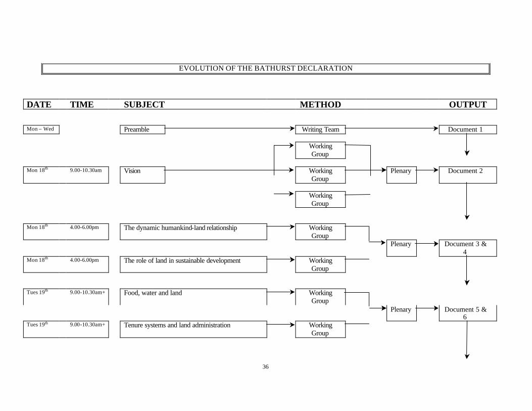

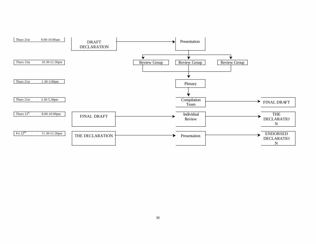


![THE SOCIETIES ACT [SUBSIDIARY LEGISLATION] INDEX TO ...moha.go.tz/sites/default/files/Socities Rules.pdf · Association) Order. G.N. No. 88 of 1973 The Societies (Declaration of Unlawful](https://static.documents.pub/doc/80x56/5f45f972bf00ed4425429d96/the-societies-act-subsidiary-legislation-index-to-mohagotzsitesdefaultfilessocities.jpg)


