59
DESIS Product Specification Doc. ID PAV-DLR-ICD-003 Issue 1.0 Date 2019-06-04 Page 0 of 59 DESIS Product Specification Doc. ID PAV-DLR-ICD-003 Issue 1.0 Date 2019-06-04 Class Unclassified

DESIS Product Specification
Doc. ID PAV-DLR-ICD-003
Issue 1.0
Date 2019-06-04
Page 0 of 59
DESIS Product Specification
Doc. ID PAV-DLR-ICD-003
Issue 1.0
Date 2019-06-04
Class Unclassified

DESIS Product Specification Doc. ID PAV-DLR-ICD-003
Issue 1.0
Date 2019-06-04
Unclassified – Project Internal Page 1 of 59
Document based on EOC-Document-Template, Issue 1.0
DESIS Product Specification Doc. ID PAV-DLR-ICD-003
Issue 1.0
Date 2019-06-04
Unclassified – Project Internal Page 2 of 59
Document based on EOC-Document-Template, Issue 1.0
SIGNATURES
Emiliano Carmona Prepared
Name / Organisation
Rupert Müller Reviewed
Name / Organisation
Rupert Müller Approved
Name / Organisation

DESIS Product Specification Doc. ID PAV-DLR-ICD-003
Issue 1.0
Date 2019-06-04
Unclassified – Project Internal Page 3 of 59
Document based on EOC-Document-Template, Issue 1.0
DOCUMENT PREPARATION
The document on hand was prepared with contributions from personnel as listed below.
Raquel, de los Reyes MF-PBA
(First Name, Last Name)
Daniele, Dietrich DFD-INF
(First Name, Last Name)
Valentin, Ziel DFD-LAX
(First Name, Last Name)
Janja, Avbelj MF-PBA
(First Name, Last Name)
Kevin, Alonso MF-PBA
(First Name, Last Name)
Mirco,Tegler DFD-NBS
(First Name, Last Name)
Rupert, Müller MF-PBA
(First Name, Last Name)
Martin, Bachmann DFD-LAX
(First Name, Last Name)
Emiliano, Carmona MF-PBA
(First Name, Last Name)

DESIS Product Specification Doc. ID PAV-DLR-ICD-003
Issue 1.0
Date 2019-06-04
Unclassified – Project Internal Page 4 of 59
Document based on EOC-Document-Template, Issue 1.0
DISTRIBUTION LIST
The DESIS-PAV documents are stored in the corresponding folder of the DESIS-PAV Teamsite
https://teamsites-extranet.dlr.de/eoc/muses/SitePages/Home.aspx
The document is accessible by all participants of the the DESIS-PAV project as well as the personnel having site permissions. This document may be further distributed by the DESIS-PAV project management as necessary.

DESIS Product Specification Doc. ID PAV-DLR-ICD-003
Issue 1.0
Date 2019-06-04
Unclassified – Project Internal Page 5 of 59
Document based on EOC-Document-Template, Issue 1.0
CHANGE RECORD
Issue Date Chapter Change
1.0 04.06.2019 all Initial Version; derived from Data Product Specification PAV-DLR-ICD-002 V1.1

DESIS Product Specification Doc. ID PAV-DLR-ICD-003
Issue 1.0
Date 2019-06-04
Unclassified – Project Internal Page 6 of 59
Document based on EOC-Document-Template, Issue 1.0
CONTENTS
1. Introduction .......................................................................................................................................... 8 1.1 Purpose ............................................................................................................................................... 8 1.2 Scope .................................................................................................................................................. 8
2. References .......................................................................................................................................... 9 2.1 Applicable Documents ......................................................................................................................... 9 2.2 Reference Documents ......................................................................................................................... 9
3. Terms and Abbreviations .................................................................................................................. 10
4. DESIS Data Products ........................................................................................................................ 11 4.1 Data product files .............................................................................................................................. 11 4.1.1 DESIS user L1B/L1C/L2A product files ............................................................................................. 11 4.2 Filename and Directory Structure ..................................................................................................... 13 4.2.1 DESIS User L1B, L1C, L2A product directories and filenames ........................................................ 13 4.2.2 User Product L1B, L1C, L2A Image .................................................................................................. 14 4.2.3 Product L1B, L1C, L2A Quicklook-image .......................................................................................... 14 4.2.4 Product L1B, L1C, L2A Quality-quicklook ......................................................................................... 14 4.2.5 Product Metadata L1B, L1C, L2A ..................................................................................................... 17 4.2.6 Product History L1B, L1C, L2A ......................................................................................................... 17
5. Reference Information for L1B, L1C, L2A Product Metadata ........................................................... 19 5.1 Metadata Cards ................................................................................................................................. 19 5.2 Example of Metadata file ................................................................................................................... 42 5.3 Explanations ...................................................................................................................................... 50 5.3.1 wavelengthCenterOfBand & wavelengthWidthOfBand ..................................................................... 50 5.3.2 calAngles ........................................................................................................................................... 51 5.3.3 boundingPolygon ............................................................................................................................... 51 5.3.4 sceneIncidentAngle and sceneAzimuthAngle ................................................................................... 52
6. Reference Information for L1B, L1C, L2A Product History ............................................................... 53 6.1 History Cards Description .................................................................................................................. 53 6.2 Example of History file ....................................................................................................................... 55

DESIS Product Specification Doc. ID PAV-DLR-ICD-003
Issue 1.0
Date 2019-06-04
Unclassified – Project Internal Page 7 of 59
Document based on EOC-Document-Template, Issue 1.0
LIST OF FIGURES
Figure 4-1 L1B, L1C, L2A Product file components. In the figure LXX stands for one of the processing levels L1B, L1C and L2A. The product file shown with a dashed line is only available for L1B data products. ......................................................................................................................... 11
Figure 5-1 Ilustration of center wavelength and FWHM .............................................................................. 51
Figure 5-2 Definition of object sided angles of the interior orientation ........................................................ 51
Figure 5-3 Example of an image bounding polygon with ascending ISS orbit direction ............................. 52
Figure 5-4 Definition of scene angles .......................................................................................................... 52
LIST OF TABLES
Table 2-1 Reference Documents ................................................................................................................... 9
Table 4-1 List of files part of an L1B, L1C or L2A Data Product. In the table LXX stands for one of the processing levels L1B, L1C and L2A. The green shaded row denotes a file delivered only in L2A data products ................................................................................................................... 12
Table 4-2 Description of the different fields in the name of a data product and associated files ................ 13
Table 4-3 Directory name and filenames of L1B/L1C/L2A Earth Product component files (LXX denotes one of these 3 posibilities). The file in the in the green shaded row is delivered only for L2A data products. ......................................................................................................................... 13
Table 4-4 Description of the bits in the bit mask used in quicklook file "QL_QUALITY" of L1B .................. 14
Table 4-5 Interpretation of the mask values in quality file “QL_QUALITY” of L1B products ....................... 15
Table 4-6 Interpretation of the mask values in quality file “QL_QUALITY” of L1C products ....................... 15
Table 4-7 Quality layers of the L2A quality quicklook file-2 ("QL_QUALITY-2") ........................................ 16
Table 5-1 Metadata for L1B, L1C, and L2A products .................................................................................. 41

DESIS Product Specification Doc. ID PAV-DLR-ICD-003
Issue 1.0
Date 2019-06-04
Unclassified – Project Internal Page 8 of 59
Document based on EOC-Document-Template, Issue 1.0
1. Introduction
1.1 Purpose
This document defines the data files, data formats and data specifications of DESIS data products delivered to the user. The purpose of the document is to specify in detail the information about all data delivered to an user. This document is an excerpt from the DLR Ground Segment internal Products Specification Document PAV-DLR-ICD-002.
1.2 Scope
This document covers in detail the content, format and naming of the DESIS data products which are delivered to the scientific user via the DIMS system. These are
L1B at-sensor-radiance product
L1C orthorectified (geo-located) L1B product
L2A bottom-of-atmosphere reflectance L1C product
This document contains 6 sections:
Chapters 1-3. These are the usual ECSS prompted introductory chapters.
Chapter 4: DESIS Data Products. This chapter covers in the contents, data formats and naming conventions used for all DESIS data products in the GS.
Chapter 5: Reference Information for L1B, L1C, L2A Metadata. This Chapter details all metadata cards acompanying the L1B, L1C and L2A data products which are delivered to the user. Examples and Explanations are given
Chapter 6: Reference information for L1B, L1C, L2A Product History. This Chapter details all metadata cards acompanying all DESIS data products (L1B, L1C, L2A).

DESIS Product Specification Doc. ID PAV-DLR-ICD-003
Issue 1.0
Date 2019-06-04
Unclassified – Project Internal Page 9 of 59
Document based on EOC-Document-Template, Issue 1.0
2. References
2.1 Applicable Documents
The following documents contain provisions which, through reference in the document on hand, become applicable to the extent specified herein.
AppIicability ID and Document Title Document ID Issue or Date
[AD01] Glossary and Abbreviations PAV-DLR-TN-005 1.0
[AD02] ATBD L1A, L1B, L1C, L2A Processors PAV-DLR-TN-004 1.2
2.2 Reference Documents
Standards listed below have been used (in the sense of tailoring) to prepare the document on hand. Documents which are recognized best practices are listed for the purpose of information.
Reference ID and Document Title Document ID Issue or Date
Table 2-1 Reference Documents

DESIS Product Specification Doc. ID PAV-DLR-ICD-003
Issue 1.0
Date 2019-06-04
Unclassified – Project Internal Page 10 of 59
Document based on EOC-Document-Template, Issue 1.0
3. Terms and Abbreviations
Terms, definitions, and abbreviations for the DESIS-PAV ground segment are collected in [AD01].

DESIS Product Specification Doc. ID PAV-DLR-ICD-003
Issue 1.0
Date 2019-06-04
Unclassified – Project Internal Page 11 of 59
Document based on EOC-Document-Template, Issue 1.0
4. DESIS Data Products
This section introduces the data products generated by the DESIS-PAV Ground Segment (GS).
User products are DESIS data products that are delivered to the user (on user request). These products are the L1B processed data, the L1C processed data and the L2A processed data.
The following subsections describe the different aspects of the DESIS data products. Section 4.1 introduces the DESIS product files and their components. Section 4.2 describes the filename convention and directory structure of the DESIS product files.
4.1 Data product files
We distinguish two type of data products. The internal L1A products stored in DIMS and not distributed to DESIS users and the user L1B/L1C/L2A products generated and delivered to DESIS users according to their request.
4.1.1 DESIS user L1B/L1C/L2A product files
A user L1B/L1C/L2A data product is a data product processed by the corresponding processor(s) that, under request, is delivered to the user. Any L1B, L1C or L2A Product file consists of the components shown in Figure 4-1. The Product file is generated from the L1A Earth Internal product (case of L1B prod-uct) or the previous user product (L1B or L1C) in the DESIS processing chain. The requested data product is delivered to the user as a single zip file. The zip file contains the product components in the form of in-dividual files accessible by the user after unzipping the product file. For each tile within an Earth datatake a L1B, L1C or L2A product file is generated at the processing level requested by the user.
DESIS L1B/L1C/L2A Product
DESIS.HSI.LXX-SPECTRAL-IMAGE
DESIS.HSI.LXX-QLDESIS.HSI.LXX-
METADATADESIS.HSI.LXX.HISTORY
Spectral Image QL-Image
QL-Quality
Metadata History
Product Type
Product Component
Product File
QL-Quality-2
Figure 4-1 L1B, L1C, L2A Product file components. In the figure LXX stands for one of the processing levels L1B, L1C and L2A. The product file shown with a dashed line is only available for L1B data products.
The list of files associated to each product component of the L1B, L1C, and L2A Earth Product is shown in Table 4-1. In addition to the files depicted in Table 4-1 List of files part of an L1B, L1C or L2A Data Product. In the table LXX stands for one of the processing levels L1B, L1C and L2A. The green shaded

DESIS Product Specification Doc. ID PAV-DLR-ICD-003
Issue 1.0
Date 2019-06-04
Unclassified – Project Internal Page 12 of 59
Document based on EOC-Document-Template, Issue 1.0
row denotes a file delivered only in L2A data products, internal log files are also generated by each processor executed. The log files are not delivered to the user.
Name Description File Name File Format
File Size
DESIS.HSI.LXX-SPECTRAL-IMAGE
Measurement data from Earth datatake
DESIS-HSI-LXX -DTnnnnnnnnnn_nnn-<Date> T<Time>-V0100-SPECTRAL_IMAGE.geotiff
Geotiff 500 MBytes
DESIS.HSI.LXX-QL
Image Quicklook DESIS-HSI-LXX -DTnnnnnnnnnn_nnn-<Date> T<Time>-V0100- QL_IMAGE.geotiff
Geotiff 6 MBytes
Data Quality Quicklook DESIS-HSI-LXX -DTnnnnnnnnnn_nnn-<Date> T<Time>-V0100- QL_QUALITY.geotif
Geotiff Variable (see 4.2.4)
Data Quality Quicklook-2 DESIS-HSI-LXX -DTnnnnnnnnnn_nnn-<Date> T<Time>-V0100- QL_QUALITY-2.geotif
Geotiff Variable (see 4.2.4)
DESIS.HSI.LXX-METADATA
Metadata provided by the processors executed
DESIS-HSI-LXX -DTnnnnnnnnnn_nnn-<Date> T<Time>-V0100-METADATA.xml
XML < 1MByte
DESIS.HSI.LXX-HISTORY
History file for all processors executed
DESIS-HSI-LXX -DTnnnnnnnnnn_nnn-<Date> T<Time>-V0100-HISTORY.xml
XML <1 MByte
Table 4-1 List of files part of an L1B, L1C or L2A Data Product. In the table LXX stands for one of the processing levels L1B, L1C and L2A. The green shaded row denotes a file delivered only in L2A data products
DESIS Product Specification Doc. ID PAV-DLR-ICD-003
Issue 1.0
Date 2019-06-04
Unclassified – Project Internal Page 13 of 59
Document based on EOC-Document-Template, Issue 1.0
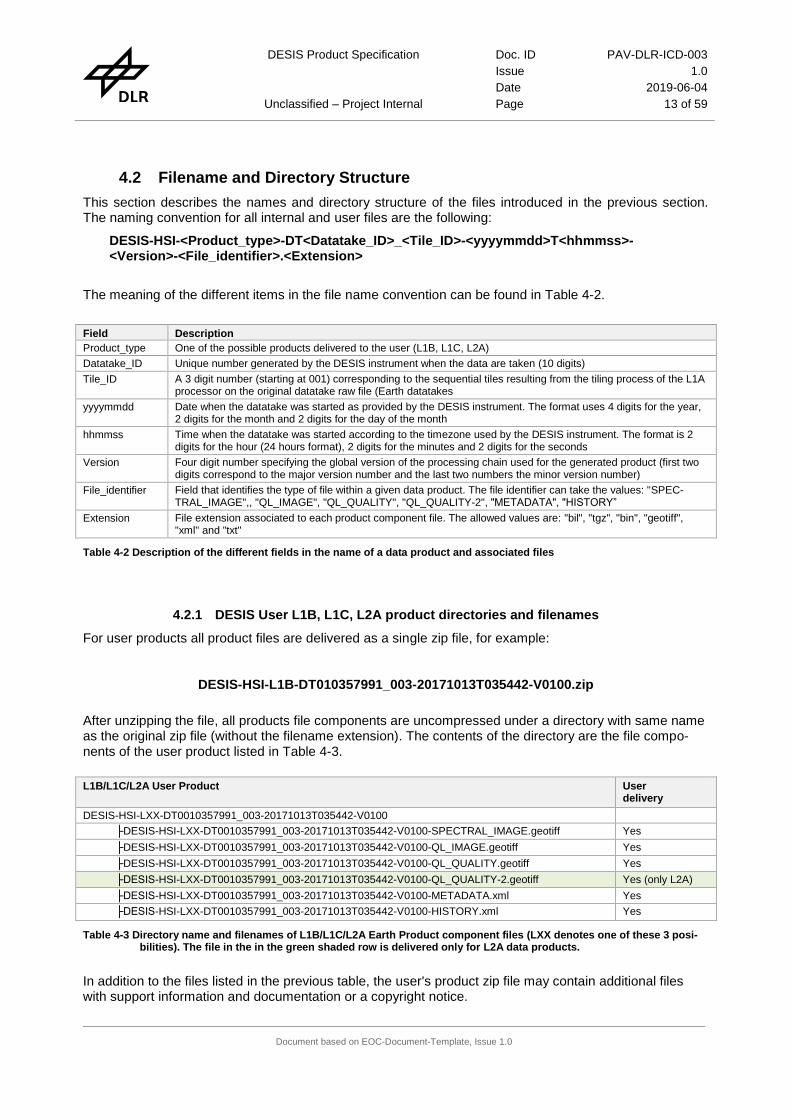
4.2 Filename and Directory Structure
This section describes the names and directory structure of the files introduced in the previous section. The naming convention for all internal and user files are the following:
DESIS-HSI-<Product_type>-DT<Datatake_ID>_<Tile_ID>-<yyyymmdd>T<hhmmss>-<Version>-<File_identifier>.<Extension>
The meaning of the different items in the file name convention can be found in Table 4-2.
Field Description
Product_type One of the possible products delivered to the user (L1B, L1C, L2A)
Datatake_ID Unique number generated by the DESIS instrument when the data are taken (10 digits)
Tile_ID A 3 digit number (starting at 001) corresponding to the sequential tiles resulting from the tiling process of the L1A processor on the original datatake raw file (Earth datatakes
yyyymmdd Date when the datatake was started as provided by the DESIS instrument. The format uses 4 digits for the year, 2 digits for the month and 2 digits for the day of the month
hhmmss Time when the datatake was started according to the timezone used by the DESIS instrument. The format is 2 digits for the hour (24 hours format), 2 digits for the minutes and 2 digits for the seconds
Version Four digit number specifying the global version of the processing chain used for the generated product (first two digits correspond to the major version number and the last two numbers the minor version number)
File_identifier Field that identifies the type of file within a given data product. The file identifier can take the values: "SPEC-TRAL_IMAGE",, "QL_IMAGE", "QL_QUALITY", "QL_QUALITY-2", "METADATA", "HISTORY”
Extension File extension associated to each product component file. The allowed values are: "bil", "tgz", "bin", "geotiff", "xml" and "txt"
Table 4-2 Description of the different fields in the name of a data product and associated files
4.2.1 DESIS User L1B, L1C, L2A product directories and filenames
For user products all product files are delivered as a single zip file, for example:
DESIS-HSI-L1B-DT010357991_003-20171013T035442-V0100.zip
After unzipping the file, all products file components are uncompressed under a directory with same name as the original zip file (without the filename extension). The contents of the directory are the file compo-nents of the user product listed in Table 4-3.
L1B/L1C/L2A User Product User delivery
DESIS-HSI-LXX-DT0010357991_003-20171013T035442-V0100
├DESIS-HSI-LXX-DT0010357991_003-20171013T035442-V0100-SPECTRAL_IMAGE.geotiff Yes
├DESIS-HSI-LXX-DT0010357991_003-20171013T035442-V0100-QL_IMAGE.geotiff Yes
├DESIS-HSI-LXX-DT0010357991_003-20171013T035442-V0100-QL_QUALITY.geotiff Yes
├DESIS-HSI-LXX-DT0010357991_003-20171013T035442-V0100-QL_QUALITY-2.geotiff Yes (only L2A)
├DESIS-HSI-LXX-DT0010357991_003-20171013T035442-V0100-METADATA.xml Yes
├DESIS-HSI-LXX-DT0010357991_003-20171013T035442-V0100-HISTORY.xml Yes
Table 4-3 Directory name and filenames of L1B/L1C/L2A Earth Product component files (LXX denotes one of these 3 posi-bilities). The file in the in the green shaded row is delivered only for L2A data products.
In addition to the files listed in the previous table, the user's product zip file may contain additional files with support information and documentation or a copyright notice.

DESIS Product Specification Doc. ID PAV-DLR-ICD-003
Issue 1.0
Date 2019-06-04
Unclassified – Project Internal Page 14 of 59
Document based on EOC-Document-Template, Issue 1.0
4.2.2 User Product L1B, L1C, L2A Image
The product Image file is a binary file in geotiff format. The data from each spectral channel are stored in 16 bit unsigned integer format using one image layer per band. The image size is 1024×1024 pixels for L1B data products. After L1C processor the image is geolocated and the size is different from the original 1024×1024 pixel size. The number of channels in the image corresponds to the number of bands in the original DESIS data. L2A processor image product has the BOA reflectances with the same size, projection and number of bands as L1C.
4.2.3 Product L1B, L1C, L2A Quicklook-image
The quicklook image file is a geotiff file with the same size as the data image and three 8-bit channels. Values from the original image are transformed to 8-bit pixel values and radiometrically adjusted for optimal display. For the quicklook generation the following channels will be used: 500nm (blue), 650 nm (red), and 850nm (infrared).
The quicklook image in L1B data products is generated by the L1A processor. The quicklook image of L1C and L2A products is generated by the L1C processor or the L2A processor using the georeferenced main image data.
4.2.4 Product L1B, L1C, L2A Quality-quicklook
Quality layers are generated during each processing task and added to the quality-quicklook file in order to complement the output image with pixel-level quality information of the output product. The Quicklook-quality information is delivered in one or more geotiff image files with different number of layers. The num-ber of layers, format and description of the content changes for each processing stage.
L1B Data Product:
After the execution of the L1B processor, a quality quicklook file is generated, which is an image in geotiff format that defines the location of the degraded quality pixels.
The quality file ("QL_QUALITY") contains Nbands 8 bit layers with a size of 1024×1024 pixels. The value 1024 comes from the number of spatial pixels and the number of lines (frames) included in the image tile. The value Nbands corresponds to the number of bands used in the datatake and it is 235 when no binning is used to acquire the data. Each layer of the QL_QUALITY file corresponds to one of the acquisition bands and contains information about the quality of the image pixels in that band encoded as a 8-bit mask. All the pixels flagged with any of the monitored quality indicators, see [AD02], will be set to 1. Quality analysis is performed right after radiometric correction. Therefore, in order to ensure the fidelity of the quality cube to the final L1B spectral image, it is necessary that Smile and Rolling shutter corrections are applied on it. The performed pixel interpolations might extend the effect of the flagged pixels, in which case, surrounding pixels might be also flagged. The association from pixel problems to mask bits is given inTable 4-4. Not used bits will provide the opportunity to implement in the future more complex degraded quality pixel definition policies.
Bit 7 Bit 6 Bit 5 Bit 4 Bit 3 Bit 2 Bit 1 Bit 0
Not Used Unreliable Calinration
Manufaturing
defects No data
Low
Radiance
High
Radiance Suspicious Dead
Table 4-4 Description of the bits in the bit mask used in quicklook file "QL_QUALITY" of L1B
Table 4-4 shows how to interpret the values contained in the quality file “QL_QUALITY”.

DESIS Product Specification Doc. ID PAV-DLR-ICD-003
Issue 1.0
Date 2019-06-04
Unclassified – Project Internal Page 15 of 59
Document based on EOC-Document-Template, Issue 1.0
Layer Value definition Remark
Layer-1
(8 bits) Pixel quality mask, the value of a pixel in position "i-j" in layer "1" indicates:
− 0 : Pixel in line "i", row "j" in band "1" of the image tile is marked as good
− 1 : Pixel in line "i", row "j" in band "1" of the image tile has degraded quality
Only the first bit is used.
… … …
Layer-Nbands
(8 bits) Pixel quality mask, the value of a pixel in position "i-j" in layer "Nbands" indicates:
− 0 : Pixel in line "i", row "j" in band "Nbands" of the image tile is marked as good
− 1 : Pixel in line "i", row "j" in band "Nbands" of the image tile has degraded quality
Only the first bit is used.
Table 4-5 Interpretation of the mask values in quality file “QL_QUALITY” of L1B products
More details on the method used to derive the values written in the quality layers of the L1B data products can be found in .[AD02].
L1C Data Product:
The quality quicklook of L1C data products consists of one file in geotiff format. This file, "QL_QUALITY", contains the same information as the "QL_QUALITY" file of L1B product, previously described, but resampled to the new grid resulting from the orthorectification process of the L1C product. The resampling is done using by building a logical OR operation of the bit patterns of the nearest neighbours.. In this case the mask of a pixel can't be directly interpreted as a pixel affected by the problems reported in the mask, but as a pixel resulting from the interpolation of pixels affected by the problems reported in the mask. The mask is provided as an indication of the pixel reliability.
The interpretation of the values in the masks of QL_QUALITY is shown in Table 4-6.
Layer Value definition Remark
Layer-1
(8 bits) Pixel quality mask, the value of a pixel in position "i-j" in layer "1" indicates:
− 0 : L1C resampled pixel in line "i", row "j" in band "1" of the image tile is marked as good
− 1 : L1C resampled pixel in line "i", row "j" in band "1" of the image tile is affected by pix-els with degraded quality
Only the first bit is used.
… … …
Layer-Nbands
(8 bits) Pixel quality mask, the value of a pixel in position "i-j" in layer "Nbands" indicates:
− 0 : L1C resampled pixel in line "i", row "j" in band "Nbands" of the image tile is marked as good
− 1 : L1C resampled pixel in line "i", row "j" in band "Nbands" of the image tile is affected by pixels with degraded quality
Only the first bit is used.
Table 4-6 Interpretation of the mask values in quality file “QL_QUALITY” of L1C products
L2A Data Product:
L2A data products have two geotiff files as part of the quality quicklook. The first one is a copy of the "QL-QUALITY-1" file from the L1C product and it is already described in Table 4-7.
DESIS Product Specification Doc. ID PAV-DLR-ICD-003
Issue 1.0
Date 2019-06-04
Unclassified – Project Internal Page 16 of 59
Document based on EOC-Document-Template, Issue 1.0
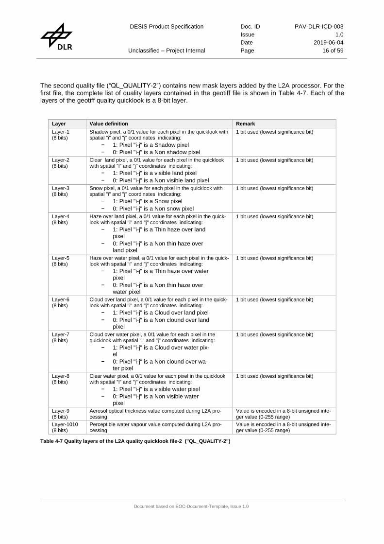
The second quality file (“QL_QUALITY-2”) contains new mask layers added by the L2A processor. For the first file, the complete list of quality layers contained in the geotiff file is shown in Table 4-7. Each of the layers of the geotiff quality quicklook is a 8-bit layer.
Layer Value definition Remark
Layer-1 (8 bits)
Shadow pixel, a 0/1 value for each pixel in the quicklook with spatial "i" and "j" coordinates indicating:
− 1: Pixel "i-j" is a Shadow pixel
− 0: Pixel "i-j" is a Non shadow pixel
1 bit used (lowest significance bit)
Layer-2 (8 bits)
Clear land pixel, a 0/1 value for each pixel in the quicklook with spatial "i" and "j" coordinates indicating:
− 1: Pixel "i-j" is a visible land pixel
− 0: Pixel "i-j" is a Non visible land pixel
1 bit used (lowest significance bit)
Layer-3 (8 bits)
Snow pixel, a 0/1 value for each pixel in the quicklook with spatial "i" and "j" coordinates indicating:
− 1: Pixel "i-j" is a Snow pixel
− 0: Pixel "i-j" is a Non snow pixel
1 bit used (lowest significance bit)
Layer-4 (8 bits)
Haze over land pixel, a 0/1 value for each pixel in the quick-look with spatial "i" and "j" coordinates indicating:
− 1: Pixel "i-j" is a Thin haze over land pixel
− 0: Pixel "i-j" is a Non thin haze over land pixel
1 bit used (lowest significance bit)
Layer-5 (8 bits)
Haze over water pixel, a 0/1 value for each pixel in the quick-look with spatial "i" and "j" coordinates indicating:
− 1: Pixel "i-j" is a Thin haze over water pixel
− 0: Pixel "i-j" is a Non thin haze over water pixel
1 bit used (lowest significance bit)
Layer-6 (8 bits)
Cloud over land pixel, a 0/1 value for each pixel in the quick-look with spatial "i" and "j" coordinates indicating:
− 1: Pixel "i-j" is a Cloud over land pixel
− 0: Pixel "i-j" is a Non clound over land pixel
1 bit used (lowest significance bit)
Layer-7 (8 bits)
Cloud over water pixel, a 0/1 value for each pixel in the quicklook with spatial "i" and "j" coordinates indicating:
− 1: Pixel "i-j" is a Cloud over water pix-el
− 0: Pixel "i-j" is a Non clound over wa-ter pixel
1 bit used (lowest significance bit)
Layer-8 (8 bits)
Clear water pixel, a 0/1 value for each pixel in the quicklook with spatial "i" and "j" coordinates indicating:
− 1: Pixel "i-j" is a visible water pixel
− 0: Pixel "i-j" is a Non visible water pixel
1 bit used (lowest significance bit)
Layer-9 (8 bits)
Aerosol optical thickness value computed during L2A pro-cessing
Value is encoded in a 8-bit unsigned inte-ger value (0-255 range)
Layer-1010 (8 bits)
Perceptible water vapour value computed during L2A pro-cessing
Value is encoded in a 8-bit unsigned inte-ger value (0-255 range)
Table 4-7 Quality layers of the L2A quality quicklook file-2 ("QL_QUALITY-2")
DESIS Product Specification Doc. ID PAV-DLR-ICD-003
Issue 1.0
Date 2019-06-04
Unclassified – Project Internal Page 17 of 59
Document based on EOC-Document-Template, Issue 1.0
4.2.5 Product Metadata L1B, L1C, L2A
The Product Metadata is part of every data product of the L1B, L1C and L2A processors. It is written using XML format and it contains information on file metadata, job processing and product specific parameters. The structure of the Product Metadata file consists of 5 information blocks:
File Metadata information, containing general information about the metadata file itself and copyright notice
Processing parameters (only L1B, L1C, L2A products), containing general information about the processing parameters of the product (e.g. product format, type, resampling, map projection)
Base parameters, containing basic information about the data (e.g. location, time, processing level)Specific parameters, containing DESIS mission specific parameters
Product specific parameters (only L1B, L1C, L2A products), containing parameters which are specific of a particular product level
For L1B, L1C and L2A data products (see section 5.1)contains the full description of all fields in the metadata file, section 5.2 contains a sample product metadata file and section 5.3 explains in detail some of these metadata values.
4.2.6 Product History L1B, L1C, L2A
The Product History file is a file acompanying every L1B, L1C or L2A data product and it contains infor-mation about the executed processing steps and the items that were used to produce the data product. The file is written in XML format and contains a nested structure where each data product description con-tains the description of the data products used for its generation.
Section 6.1 contains the full description of all fields in the Product History file and section 6.2 a sample Product History file.

DESIS Product Specification
Doc. ID PAV-DLR-ICD-003
Issue 1.0
Date 2019-06-04
Page 18 of 59
DESIS Product Specification
Doc. ID PAV-DLR-ICD-003
Issue 1.0
Date 2019-06-04
Page 19 of 59
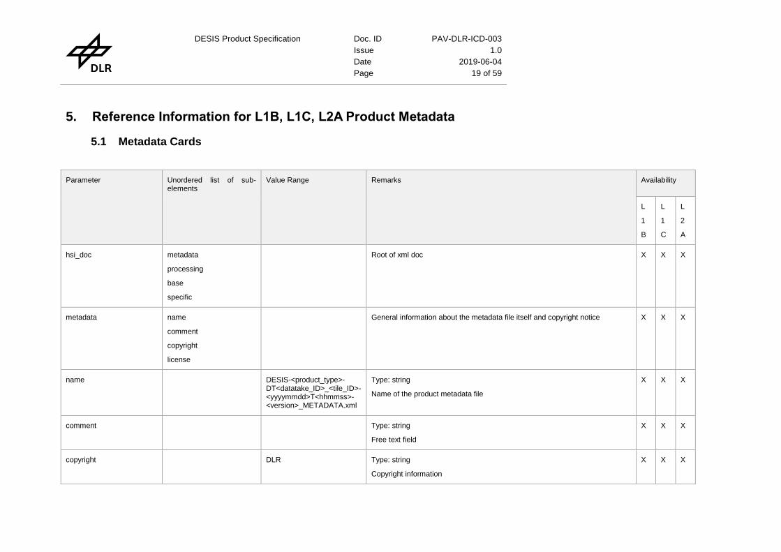
5. Reference Information for L1B, L1C, L2A Product Metadata
5.1 Metadata Cards
Parameter Unordered list of sub-elements
Value Range Remarks Availability
L
1
B
L
1
C
L
2
A
hsi_doc metadata
processing
base
specific
Root of xml doc X X X
metadata name
comment
copyright
license
General information about the metadata file itself and copyright notice X X X
name DESIS-<product_type>-DT<datatake_ID>_<tile_ID>-<yyyymmdd>T<hhmmss>-<version>_METADATA.xml
Type: string
Name of the product metadata file
X X X
comment Type: string
Free text field
X X X
copyright DLR Type: string
Copyright information
X X X

DESIS Product Specification Doc. ID PAV-DLR-ICD-003
Issue 1.0
Date 2019-06-04
Unclassified – Project Internal Page 20 of 59
Document based on EOC-Document-Template, Issue 1.0
Parameter Unordered list of sub-elements
Value Range Remarks Availability
license DLR internal usage Type: string
Constant value
X X X
processing coRegistration
mapProjection
imageResampling
backgroundValue
versionDEM
versionREF
terrainCorrection
ozoneValue
productType
test
General information about the processing parameters to generate the product (e.g. product format, type, resampling, map projection)
X X X
coRegistration {Yes, No, none} Type: string
In case of rolling shutter the L1B product can be resampled in order to achieve co-registration of the channels.
None is used if no active selection is performed
X X X
mapProjection {UTM_Zone_of_Center, UTM_Zone_of_Center(-1), UTM_Zone_of_Center(+1), Geographic, none}
Type: string
none if not selected (e.g. for L1B product)
X X X
imageResampling {Nearest_Neighbour, Bilinear_Interpolation, Cubic_Convolution, none}
Type: string
none if not selected (e.g. for L1B product)
X X X
DESIS Product Specification Doc. ID PAV-DLR-ICD-003
Issue 1.0
Date 2019-06-04
Unclassified – Project Internal Page 21 of 59
Document based on EOC-Document-Template, Issue 1.0
Parameter Unordered list of sub-elements
Value Range Remarks Availability
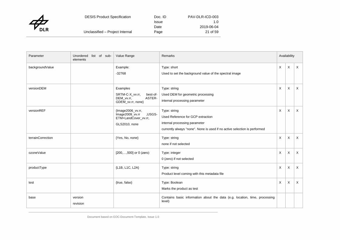
backgroundValue Example:
-32768
Type: short
Used to set the background value of the spectral image
X X X
versionDEM Examples
SRTM-C-X_vv.rr, best-of-DEM_vv.rr, ASTER-GDEM_vv.rr, none}
Type: string
Used DEM for geometric processing
internal processing parameter
X X X
versionREF {Image2006_vv.rr, Image2009_vv.rr ,USGS-ETM+LandCover_vv.rr,
GLS2010, none
Type: string
Used Reference for GCP extraction
internal processing parameter
currently always "none". None is used if no active selection is performed
X X X
terrainCorrection {Yes, No, none} Type: string
none if not selected
X X X
ozoneValue [200,…,500] or 0 (zero) Type: integer
0 (zero) if not selected
X X X
productType {L1B, L1C, L2A} Type: string
Product level coming with this metadata file
X X X
test {true, false} Type: Boolean
Marks the product as test
X X X
base version
revision
Contains basic information about the data (e.g. location, time, processing level)

DESIS Product Specification Doc. ID PAV-DLR-ICD-003
Issue 1.0
Date 2019-06-04
Unclassified – Project Internal Page 22 of 59
Document based on EOC-Document-Template, Issue 1.0
Parameter Unordered list of sub-elements
Value Range Remarks Availability
l1aVesrion
sphere
size
level
format
spatialCoverage
altitudeCoverage
temporalCoverage
version {nn.nn} Type: string
Global Version of the processing chain
X X X
revision {nn.nn} Type: string
Version of the processor being executed
X X X
l1aVersion {nn.nn} Type: string
Version of the L1A processor, which produced the L1A product stored in the database
X X X
sphere {earth, none} Type: string
Should be always "earth" for DESIS products.
None is used for future expansion.
X X X
size [0,…,-] Type: non-negative integer
Size of product in GiB of the unzipped product
X X X
level {L1B,L1C,L2A} Type: string
Product Level
X X X

DESIS Product Specification Doc. ID PAV-DLR-ICD-003
Issue 1.0
Date 2019-06-04
Unclassified – Project Internal Page 23 of 59
Document based on EOC-Document-Template, Issue 1.0
Parameter Unordered list of sub-elements
Value Range Remarks Availability
format {GeoTIFF} Type: string
Image Format of product
X X X
spatialCoverage boundingPolygon Contains information on the spatial coverage of the product w.r.t. the WGS84 geodatic datum.
X X X
boundingPolygon point The bounding polygon is a list of points starting with the most starboard pixel of the first scanline and followed by a counter-clockwise sequence of four points, whereas the last point is identical with the first point. See Figure 5-3
X X X
point frame
latitude
longitude
Type: string (for frame)
The frame can be element from {center, point_1, point_2, point_3, point_4, point_5}
Type: double (for latitude and longitude)
longitude can be [-180° west of Greenwich,…,+180 east of Greenwich]
latitude can be [-90° south of equator,…,+90° north of equator]
X X X
altitudeCoverage Type: double
Mean platform height above WGS84 ellipsoid during data acquisition given in kilometer
X X X
temporalCoverage startTime
endTime
Contains the time of the first scanline acquistion and the last scanline acquistion given in UTC
X X X
startTime
endTime
2017-04-15 T01:45:11.123456Z
Type: DateTime
startTime: time of first scanline in UTC (e.g. 2017-04-15T01:45:11.123456Z)
endTime: time of last scanline in UTC (e.g. 2017-04-15T01:46:05.123456Z)
for an acquistion with rolling shutter the time is related to first channel of the
X X X

DESIS Product Specification Doc. ID PAV-DLR-ICD-003
Issue 1.0
Date 2019-06-04
Unclassified – Project Internal Page 24 of 59
Document based on EOC-Document-Template, Issue 1.0
Parameter Unordered list of sub-elements
Value Range Remarks Availability
image
specific mission
satelliteID
sensor
sensorMaxBands
acquisitionMode
requestID
datatakeID
imageID
tileID
numberOfTiles
numberOfBands
bandCharacterisation
pixelSize
widthOfScene
heightOfScene
missionPhase
orbitDirection
orbitType
processingDateTime
processingCenter
processingNode
processible
X X X

DESIS Product Specification Doc. ID PAV-DLR-ICD-003
Issue 1.0
Date 2019-06-04
Unclassified – Project Internal Page 25 of 59
Document based on EOC-Document-Template, Issue 1.0
Parameter Unordered list of sub-elements
Value Range Remarks Availability
qualityFlag
meanGroundElevation
meanSlope
meanWaterVapour
qualityWV
stripingBanding
generalArtifacts
defectivePixels
smileIndication
orthoRMSE_x
orthoRMSE_y
orthoRe
meanVisibility
qualityVIS meanAerosolOpticalThickness
percentageHazequalityHaze
percentageClouds
qualityCloud
percentageCloudShadow
qualityCloudShadow
percentageTopoShadow
qualityTopoShadow

DESIS Product Specification Doc. ID PAV-DLR-ICD-003
Issue 1.0
Date 2019-06-04
Unclassified – Project Internal Page 26 of 59
Document based on EOC-Document-Template, Issue 1.0
Parameter Unordered list of sub-elements
Value Range Remarks Availability
aerosolType
season
sunAzimuthAngle
sunZenithAngle
sceneAzimuthAngle
sceneIncidenceAngle
qualitySZA
sceneAzimuthAngle
qualityIndicator
auxDataVersion
lowGainFactor
highGainFactor
configFPA
pointingMirrorAngle
boresightAngles
interiorOrientation
orbit
attitude
mission DESIS Type: string
Mission name is constant
X X X
satelliteID ISS Type: string
satelliteID is constant
X X X

DESIS Product Specification Doc. ID PAV-DLR-ICD-003
Issue 1.0
Date 2019-06-04
Unclassified – Project Internal Page 27 of 59
Document based on EOC-Document-Template, Issue 1.0
Parameter Unordered list of sub-elements
Value Range Remarks Availability
sensor HSI Type: string
Sensor is constant
X X X
sensorMaxBands [0-235] Type:integer
Ideally constant as 235 along all the mission.
X X X
acquisitionMode {image_strip_mode, image_stereo_mode}
Type: string
Defines the acquistion mode. The image_strip_mode is the normal earth imaging mode, whereas the image_stereo_mode is an experimental mode with up to 3 images of the same ground target area in one datatake for stereo and BRDF evaluations.
X X X
requestID Type: string
Unique request identifier generated by TBE
X X X
datatakeID [0000000001,…,9999999999]
Type: string (10 digits)
Unique datatake ID. Example: 1234567890
X X X
imageID [0010000001,…,9909999999]
Type: string (13 digits)
The unique imageID is composed of the datatakeID and the tileID by
imageID = string(datatakeID)+string(tileID)
Example: 1234567890003
X X X
tileID [001,…,999] Type: string (3 digits)
Tile number within a datatake increasing timely starting from 001. Example: 003
X X X
numberOfTiles [1,…999] Type: integer X X X

DESIS Product Specification Doc. ID PAV-DLR-ICD-003
Issue 1.0
Date 2019-06-04
Unclassified – Project Internal Page 28 of 59
Document based on EOC-Document-Template, Issue 1.0
Parameter Unordered list of sub-elements
Value Range Remarks Availability
Total number of tiles of the datatake
numberOfBands [1,…,235] Type: integer
Number of spectral channels of the tile
X X X
bandCharacterisation band
band bandNumber
wavelengthCenterOfBand
wavelengthWidthOfBand
response
wavelength
gainOfBand
offsetOfBand
deadPixels
suspiciousPixel
Contains information valid for each spectral band of the image X X X
bandNumber [1,…,235] Type: integer
Sequence of increasing spectral band numbers corresponding to increasing wavelengths as stored sequential in the image data cube
X X X
wavelengthCenterOfBand [350,…,1050] Type: double
Center wavelength in [nm] of spectral band. See Figure 5-1
X X X
wavelengthWidthOfBand [0,…,20] Type: double
FWHM in [nm] of band. See Figure 5-1
X X X
response Type: double X X X

DESIS Product Specification Doc. ID PAV-DLR-ICD-003
Issue 1.0
Date 2019-06-04
Unclassified – Project Internal Page 29 of 59
Document based on EOC-Document-Template, Issue 1.0
Parameter Unordered list of sub-elements
Value Range Remarks Availability
Tabulated spectral response values
wavelength Tabulated wavelength for the response values X X X
gainOfBand
offsetOfBand
[0,…,-] Type: double
For L1B and L1C products
From the pixel values (DN = digital number) in the specific band the Top-of-Atmosphere Radiance given in [mW/cm2/sr/µm] can be calculated by
L=OffsetOfBand+GainOfBand*DN
For L2A products
From the pixel values (DN = digital number) in the specific band the reflectance with a value between 0 and 1.0 can be calculated by
L=OffsetOfBand+GainOfBand*DN
X X X
deadPixels [0,…,100] Type: double
Percentage of dead pixels in the band derived from calibration.
X X X
suspiciousPixel [0,…,100] Type: double
Percentage of suspicious pixels in the band derived from data screening
X X X
pixelSize [30,..,50]
Type: float
This element has an attribute (unit = m for meter in case of not Geographic Map Projection and unit = d for decimal degree in case of Geographic Map Projection) which defines the resolution of the pixel. For L1B products this is an approximate value.
X X X
widthOfScene 1024 (default) Type: integer
Number of spectral pixels in a scanline (across direction)
X X X
heightOfScene 1024 (default) Type: integer X X X

DESIS Product Specification Doc. ID PAV-DLR-ICD-003
Issue 1.0
Date 2019-06-04
Unclassified – Project Internal Page 30 of 59
Document based on EOC-Document-Template, Issue 1.0
Parameter Unordered list of sub-elements
Value Range Remarks Availability
Number of pixels in alongtrack direction
missionPhase {pre-launch, leop, commissioning, routine}
Type: string
Phase where the datatake is acquired
X X X
orbitDirection {ASCENDING, DESCENDING}
Type: string
Ascending or descending mean orbit direction within an image tile
X X X
orbitType {predicted, precision} Type: string
Defines the orbit type
X X X
processingDateTime 2013-04-15 T01:45:11.123456Z
Type: dateTime
Processing date and time in UTC
X X X
processingCenter {NZ, OP,TBE} Type: string
Name of processing center
OP = DLR@Oberpfaffenhofen and
NZ = DLR@Neustrelitz
TBE = Teledyne Brown Engineering
X X X
processingNode Type: string
Provided by command ‘hostname’
X X X
processible {-1,0,1} Type: integer
Specifies if a data set was processible =0 or not =1 or suspicious 1
X X X
terrain meanGroundElevation
meanSlope
X X
DESIS Product Specification Doc. ID PAV-DLR-ICD-003
Issue 1.0
Date 2019-06-04
Unclassified – Project Internal Page 31 of 59
Document based on EOC-Document-Template, Issue 1.0
Parameter Unordered list of sub-elements
Value Range Remarks Availability
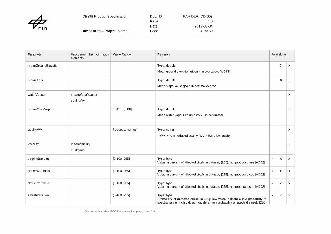
meanGroundElevation Type: double
Mean ground elevation given in meter above WGS84
X X
meanSlope Type: double
Mean slope value given in decimal degree
X X
waterVapour meanWaterVapour
qualityWV
X
meanWaterVapour [0.01,…,6.00] Type: double
Mean water vapour column (WV) in centimeter.
X
qualityWV {reduced, normal} Type: string
If WV > 4cm: reduced quality, WV > 5cm: low quality
X
visibility meanVisibility
qualityVIS
X
stripingBanding {0-100, 255} Type: byte Value in percent of affected pixels in dataset; {255}: not produced see [AD02]
x x x
generalArtifacts {0-100, 255} Type: byte Value in percent of affected pixels in dataset; {255}: not produced see [AD02]
x x x
defectivePixels {0-100, 255} Type: byte Value in percent of affected pixels in dataset; {255}: not produced see [AD02]
x x x
smileIndication {0-100, 255} Type: byte Probability of detected smile. {0-100}: low vales indicate a low probability for spectral smile, high values indicate a high probability of spectral smile}; {255}:
x x x

DESIS Product Specification Doc. ID PAV-DLR-ICD-003
Issue 1.0
Date 2019-06-04
Unclassified – Project Internal Page 32 of 59
Document based on EOC-Document-Template, Issue 1.0
Parameter Unordered list of sub-elements
Value Range Remarks Availability
not produced see [AD02]
orthoRMSE_x [0,…,-] or -1 Type: double
Linear RMSE in x direction (west-east) in meter
-1 if no matching is performed.
The value is a worst case estimation, because
- the outlier detection within the sensor model is not performed
- the tie points with lower quality measure are used (the best ones are used for the GCPs)
X X
orthoRMSE_y [0,…,-] or -1 Type: double
Linear RMSE in y-direction (north-south) in meter
-1 if no matching performed
The value is a worst case estimation, because
- the outlier detection within the sensor model is not performed
- the tie points with lower quality measure are used (the best ones are used for the GCPs)
X X
numPointsGCP [0,…,-] Type: integer
Number of GCP to improve sensor model
X X
numPointsICP [0,…,-] Type: integer
Number of ICP used to derive orthoRMSE
X X
matchingMethod {LLSQ, BRISK, SIFT,none} Type: string X X

DESIS Product Specification Doc. ID PAV-DLR-ICD-003
Issue 1.0
Date 2019-06-04
Unclassified – Project Internal Page 33 of 59
Document based on EOC-Document-Template, Issue 1.0
Parameter Unordered list of sub-elements
Value Range Remarks Availability
Image matching method that produced the GCP/ICP point set
LLSQ: Local Least Squares
BRISK: Binary Robust Invariant Scalable Keypoints
SIFT: Scale-invariant feature transform
Note: In case matching is “none” the L2A processing switches off the parameter “terrain correction” automatically
percentageCloudShadow [0,…100] Type: double
Percentage of cloud shadow in the image
X
qualityCloudShadow {reduced, normal} Type: string
If percent of cloud shadow >10%: reduced quality
X
topoShadow percentageTopoShadow
qualityTopoShadow
X
percentageTopoShadow [0,…100] Type: double
Persentage of topographic shadow in the image
X
qualityTopoShadow {reduced, normal} Type: string
If percent of topographic shadows > 10%: reduced quality
X
meanAerosolOpticalThickness
[0,…,1.0] Type: double
Mean aerosol optical thickness at 550 nm
X
aerosolType {rural, urban, maritime, desert}
Type: string
Aerosol type used for atmospheric correction
X
season {summer, winter} Type: srtring X

DESIS Product Specification Doc. ID PAV-DLR-ICD-003
Issue 1.0
Date 2019-06-04
Unclassified – Project Internal Page 34 of 59
Document based on EOC-Document-Template, Issue 1.0
Parameter Unordered list of sub-elements
Value Range Remarks Availability
Season used type for atmospheric correction
sunAzimuthAngle Type: double
The value is derived at the scene center and counted positive from north clockwise. The value is given in decimal degree.
X X X
sunZenithAngle [0,…90] Type: double
The value is derived w.r.t. WGS84 at the center of scene. The value is given in decimal degree.
X X X
sceneAzimuthAngle [0,…,360] Type: double
The value is derived from the mean path w.r.t. north direction and counted positive clockwise. The value is given in decimal degree. (see 5.3.4)
X X X
sceneIncidenceAngle [0,…,90] Type: double
The angle between normal at the scene center and the lock direction of the sensor. The value is given in decimal degree. (see 5.3.4)
X X X
qualitySZA {reduced, low, normal} Type: string
If SZA >55: reduced quality, SZA > 65: low quality
X
qualityIndicator screeningStatus
screeningResult
darkBeforeQuality
darkAfterQuality
Type: structure; required
Includes the screening results of housekeeping parameters in the virtual channel and the quality of the dark current measurements
X X X
screeningStatus {-1,0,1} Type: integer; required
Screening result status can be a WARNING (-1), an ERROR (0), or FAULTLESS (1)
X X X

DESIS Product Specification Doc. ID PAV-DLR-ICD-003
Issue 1.0
Date 2019-06-04
Unclassified – Project Internal Page 35 of 59
Document based on EOC-Document-Template, Issue 1.0
Parameter Unordered list of sub-elements
Value Range Remarks Availability
screeningResult parameter Type: structure; required, one or more sets
Container for one tested housekeeping parameter in the virtual channel
X X X
parameter status
name
type
description
info
value
units
Type: structure
Information about a tested physical or (device or command) status parameter, includes description of properties and test results
X X X
status {-1, 0, 1} Type: integer; required
Test status: WARNING = -1, ERROR = 0, FAULTLESS = 1
X X X
name Type: string; required
Unique name code of the parameter
X X X
type {temperature, voltage, current, power, status}
Type: string; required
Predefined parameter type description, list can be extended
X X X
description Type: string; optional
Human readable parameter description as free text
X X X
info Type: string; optional
Information in case of failure or limit violation
X X X

DESIS Product Specification Doc. ID PAV-DLR-ICD-003
Issue 1.0
Date 2019-06-04
Unclassified – Project Internal Page 36 of 59
Document based on EOC-Document-Template, Issue 1.0
Parameter Unordered list of sub-elements
Value Range Remarks Availability
value Type: string; required
one value or a list of values, separated by comma or space
X X X
units Type: string; optional
Physical unit of <value> or ‘1’
X X X
darkBeforeQuality available
status
Type: structure; required
Contains screening results of dark current measurements before datatake
X X X
available {yes, no} Type: string; required
Dark current measurement before earth data take exists (yes) or not (no)
X X X
status {-1, 0, 1} Type: integer; required
Test status: WARNING = -1, ERROR = 0, FAULTLESS = 1
X X X
darkAfterQuality available
status
Type: structure; required
Contains screening results of dark current measurements after datatake
X X X
available {yes, no} Type: string; required
Dark current measurement after earth data take exists (yes) or not (no)
X X X
status {-1, 0, 1} Type: integer; required
Test status: WARNING = -1, ERROR = 0, FAULTLESS = 1
X X X
lowGainFactor {1,2} Type:integer
Gain setting of the sensor for low gain
X X X
highGainFactor {5,10} Type:integer
Gain setting of the sensor for high gain
X X X

DESIS Product Specification Doc. ID PAV-DLR-ICD-003
Issue 1.0
Date 2019-06-04
Unclassified – Project Internal Page 37 of 59
Document based on EOC-Document-Template, Issue 1.0
Parameter Unordered list of sub-elements
Value Range Remarks Availability
configFPA {rolling_shutter, global_shutter}
Type: string
Shutter mode of the focal plane array
X X X
pointingMirrorAngle [-7.5,…,7.5] Type: double
Angle of the pointing mirror measured in decimal degree. Forward looking is positive and backward looking is negative. The angle is given in decimal degree.
In case of fail save the angle -0.0 is written and different geometric calibration tables will be used according to the mounting of the second fixed mirror. The value “-0.0” should be checked on a string basis.
X X X
deltaOmegaFM [-180,…,180] Fixed mirror mounting angle X (see [AD02] for the definition of the calibrated angle). The angle is given in decimal degree.
X
deltaPhiFM [-180,…,180] fixed mirror mounting angle Z (see [AD02] for the definition of the calibrated angle). The angle is given in decimal degree.
X
betaFM [-180,…180] fixed mirror mounting angle Y (see [AD02] for the definition of the calibrated angle). The angle is given in decimal degree.
X
deltaOmegaPOI [-180,…180] POI mounting angle X (see [AD02] for the definition of the calibrated angle). The angle is given in decimal degree.
X
deltaPhiPOI [-180,…180] POI mounting angle Z (see [AD02] for the definition of the calibrated angle). The angle is given in decimal degree.
X
betaPOI [-180,…180] POI mounting angle Y (see [AD02] for the definition of the calibrated angle). The angle is given in decimal degree.
X
boresightAngles rotX
rotY
rotZ
Contains information on sensor mounting angles.The boresight angles define the rotation of the sensor coordinate frame to the coordinate frame of the attitude measurment system (Startracker, Gyro)
X

DESIS Product Specification Doc. ID PAV-DLR-ICD-003
Issue 1.0
Date 2019-06-04
Unclassified – Project Internal Page 38 of 59
Document based on EOC-Document-Template, Issue 1.0
Parameter Unordered list of sub-elements
Value Range Remarks Availability
rotX
rotY
rotZ
Type: double
Sensor mounting angles. The angles are given in decimal degree.
X
interiorOrientation band
Contains information on the calibrated object sided look angles X
band bandNumber
calAngles
X
bandNumber [0,1,…235] Type: integer
Number of the band for which the calibration value is valid
If bandNumber=0 only one calAngles structure is defined and the measurment values are valid for each band, which means no keystone is present.
X
calAngles pixelNumber
phiX
phiY
Contains information on the object sided look angles at specific pixel positions. The angles are given in decimal degree.
See 5.3.2
X
pixelNumber
phiX
phiY
Type: integer for pixelNumber
Type: double for phiX and phiY
For each pixel in the band the two object sided look angles are given. The angles are given in decimal degree.
See Figure 5-2 Definition of object sided angles of the interior orientation
X
orbit leapSeconds
origin
stateVector
Contains information for geometric processing
X

DESIS Product Specification Doc. ID PAV-DLR-ICD-003
Issue 1.0
Date 2019-06-04
Unclassified – Project Internal Page 39 of 59
Document based on EOC-Document-Template, Issue 1.0
Parameter Unordered list of sub-elements
Value Range Remarks Availability
leapSeconds [0,…,-] Type: integer
Leap seconds between GPS time and UTC time
X
origin Type: string
Origin of data stream (e,g. BAD)
X
stateVector timeUTC
timeGPS
point
Contains information on satellite position and velocity X
timeUTC Type: dateTime
UTC time of position / velocity
X
timeGPS Type: double
GPS time of position / velocity with microsecond resolution
X
point location
velocity
Contains location and velocity of the satellite X
location X
Y
Z
Contains position of the satellite
Origin: Mass center of Earth defined by WGS84
X points to Greenwich
Z points to Earth rotation axes
Y complements right handed Cartesian frame
X
X [-,-] Type: double X

DESIS Product Specification Doc. ID PAV-DLR-ICD-003
Issue 1.0
Date 2019-06-04
Unclassified – Project Internal Page 40 of 59
Document based on EOC-Document-Template, Issue 1.0
Parameter Unordered list of sub-elements
Value Range Remarks Availability
Y
Z
Position of satellite w.r.t. WGS84 frame. The position is given in meter.
velocity X
Y
Z
Contains velocity of satellite X
X
Y
Z
[-,-] Type: double
Velocity of satellite w.r.t. WGS84 frame. The velocity is given in meter per second.
X
attitude referenceFrame
leapSeconds
origin
stateVector
Contains information on the attitude X
referenceFrame {ECR,ECI,ORBIT} Type: string
Defines the coordinate frame against the attitude is measured
X
leapSeconds [0,…,-] Type: integer
Leap seconds between GPS time and UTC
X
origin Type: string
Origin of data stream
X
stateVector timeUTC
timeGPS
angle
Contains the list of MUSES attitude values X
DESIS Product Specification Doc. ID PAV-DLR-ICD-003
Issue 1.0
Date 2019-06-04
Unclassified – Project Internal Page 41 of 59
Document based on EOC-Document-Template, Issue 1.0
Parameter Unordered list of sub-elements
Value Range Remarks Availability
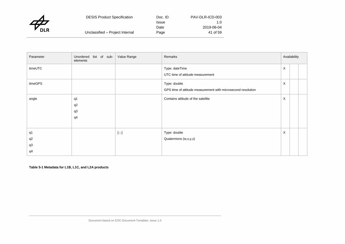
timeUTC Type: dateTime
UTC time of attitude measurement
X
timeGPS Type: double
GPS time of attitude measurement with microsecond resolution
X
angle q1
q2
q3
q4
Contains attitude of the satellite X
q1
q2
q3
q4
[-,-] Type: double
Quaternions (w,x,y,z)
X
Table 5-1 Metadata for L1B, L1C, and L2A products

DESIS Product Specification
Doc. ID PAV-DLR-ICD-003
Issue 1.0
Date 2019-06-04
Page 42 of 59
5.2 Example of Metadata file
The following example contains all metadata cards and is not a real example for a specific product (see Availability column in section 8.1). This example shows the metadata for a L2A product
<?xml version="1.0" encoding="UTF-8"?> <hsi_doc xmlns:xsi="http://www.w3.org/2001/XMLSchema-instance" xsi:noNamespaceSchemaLocation="DESIS_schema_L2A_02.xsd"> <metadata> <name>DESIS-HSI-L2A-DT2019010803_001-20190108T103952-V0201-METADATA.xml</name> <comment>DESIS_Hyperspectral_Image_atmospheric_corrected_data</comment> <copyright>DLR</copyright> <license>DLR_internal_usage</license> </metadata> <processing> <coRegistration>none</coRegistration> <mapProjection>UTM_Zone_of_Scene_Center</mapProjection> <imageResampling>Bilinear_Interpolation</imageResampling> <backgroundValue>-32768</backgroundValue> <swBinning>false</swBinning> <versionDEM>ASTGTM2</versionDEM> <versionREF>GMB</versionREF> <terrainCorrection>Yes</terrainCorrection> <ozoneValue>330</ozoneValue> <productType>L2A</productType> <test>true</test> </processing> <base> <version>02.01</version> <l1aVersion>02.00</l1aVersion> <sphere>earth</sphere> <size>534</size> <level>L2A</level> <format>TIF</format> <spatialCoverage> <boundingPolygon> <point> <frame>point_1</frame> <latitude>14.8650599</latitude> <longitude>-24.2342545</longitude> </point> <point> <frame>point_2</frame> <latitude>15.2795625</latitude> <longitude>-24.2288903</longitude> </point> <point> <frame>point_3</frame> <latitude>15.2839530</latitude> <longitude>-24.6096293</longitude> </point> <point> <frame>point_4</frame> <latitude>14.8693260</latitude> <longitude>-24.6142583</longitude> </point> <point> <frame>point_5</frame> <latitude>14.8650599</latitude> <longitude>-24.2342545</longitude> </point> <point> <frame>center</frame>

DESIS Product Specification Doc. ID PAV-DLR-ICD-003
Issue 1.0
Date 2019-06-04
Unclassified – Project Internal Page 43 of 59
Document based on EOC-Document-Template, Issue 1.0
<latitude>15.074475</latitude> <longitude>-24.421758</longitude> </point> </boundingPolygon> </spatialCoverage> <altitudeCoverage>405902.1</altitudeCoverage> <temporalCoverage> <startTime>2019-01-08T10:41:39.780712Z</startTime> <endTime>2019-01-08T10:41:44.126172Z</endTime> </temporalCoverage> </base> <specific> <mission>DESIS</mission> <satelliteID>ISS</satelliteID> <sensor>HSI</sensor> <sensorMaxBands>235</sensorMaxBands> <acquisitionMode>image_strip_mode</acquisitionMode> <requestID>0000</requestID> <datatakeID>2019010803</datatakeID> <imageID>2019010803001</imageID> <tileID>001</tileID> <numberOfTiles>2</numberOfTiles> <numberOfBands>235</numberOfBands> <bandCharacterisation> <band> <bandNumber>1</bandNumber> <wavelengthCenterOfBand>402.0</wavelengthCenterOfBand> <wavelengthWidthOfBand>2.4</wavelengthWidthOfBand> <response>5.54e-05, 8.13e-05, 1.18e-04, 1.69e-04, 2.40e-04, 3.36e-04, 4.66e-04, 6.38e-04, 8.65e-04, 1.16e-03, 1.53e-03, 2.01e-03, 2.60e-03, 3.33e-03, 4.22e-03, 5.28e-03, 6.54e-03, 8.02e-03, 9.71e-03, 1.16e-02, 1.38e-02, 1.62e-02, 1.88e-02, 2.15e-02, 2.45e-02, 2.75e-02, 3.06e-02, 3.38e-02, 3.70e-02, 4.01e-02, 4.33e-02, 4.66e-02, 5.08e-02, 6.34e-02, 5.18e-02, 4.73e-02, 4.38e-02, 4.07e-02, 3.75e-02, 3.43e-02, 3.12e-02, 2.81e-02, 2.50e-02, 2.20e-02, 1.92e-02, 1.66e-02, 1.42e-02, 1.20e-02, 1.00e-02, 8.30e-03, 6.79e-03, 5.49e-03, 4.39e-03, 3.48e-03, 2.72e-03, 2.10e-03, 1.61e-03, 1.22e-03, 9.11e-04, 6.74e-04, 4.93e-04, 3.56e-04, 2.55e-04, 1.80e-04, 1.26e-04, 8.68e-05, 5.93e-05, 4.00e-05, 2.67e-05, 1.76e-05, 1.15e-05</response> <wavelengths>395.00, 395.20, 395.40, 395.60, 395.80, 396.00, 396.20, 396.40, 396.60, 396.80, 397.00, 397.20, 397.40, 397.60, 397.80, 398.00, 398.20, 398.40, 398.60, 398.80, 399.00, 399.20, 399.40, 399.60, 399.80, 400.00, 400.20, 400.40, 400.60, 400.80, 401.00, 401.20, 401.40, 401.60, 401.80, 402.00, 402.20, 402.40, 402.60, 402.80, 403.00, 403.20, 403.40, 403.60, 403.80, 404.00, 404.20, 404.40, 404.60, 404.80, 405.00, 405.20, 405.40, 405.60, 405.80, 406.00, 406.20, 406.40, 406.60, 406.80, 407.00, 407.20, 407.40, 407.60, 407.80, 408.00, 408.20, 408.40, 408.60, 408.80, 409.00</wavelengths> <gainOfBand>0.0001</gainOfBand> <offsetOfBand>0.0</offsetOfBand> <deadPixels>29.0</deadPixels> <suspiciousPixel>29.0</suspiciousPixel> </band> <band> <bandNumber>2</bandNumber> <wavelengthCenterOfBand>404.3</wavelengthCenterOfBand> <wavelengthWidthOfBand>3.6</wavelengthWidthOfBand> <response>1.31e-05, 2.08e-05, 3.27e-05, 5.07e-05, 7.75e-05, 1.17e-04, 1.74e-04, 2.56e-04, 3.71e-04, 5.30e-04, 7.48e-04, 1.04e-03, 1.43e-03, 1.94e-03, 2.59e-03, 3.42e-03, 4.44e-03, 5.71e-03, 7.23e-03, 9.03e-03, 1.11e-02, 1.35e-02, 1.62e-02, 1.92e-02, 2.24e-02, 2.58e-02, 2.93e-02, 3.28e-02, 3.61e-02, 3.93e-02, 4.21e-02, 4.45e-02, 4.63e-02, 4.75e-02, 4.80e-02, 4.78e-02, 4.69e-02, 4.53e-02, 4.32e-02, 4.06e-02, 3.76e-02, 3.43e-02, 3.08e-02, 2.74e-02, 2.39e-02, 2.06e-02, 1.75e-02, 1.47e-02, 1.22e-02, 9.93e-03, 8.00e-03, 6.35e-03, 4.98e-03, 3.85e-03, 2.94e-03, 2.21e-03, 1.64e-03, 1.20e-03, 8.69e-04, 6.19e-04, 4.36e-04, 3.03e-04, 2.07e-04,

DESIS Product Specification Doc. ID PAV-DLR-ICD-003
Issue 1.0
Date 2019-06-04
Unclassified – Project Internal Page 44 of 59
Document based on EOC-Document-Template, Issue 1.0
1.40e-04, 9.33e-05, 6.14e-05, 3.98e-05, 2.55e-05, 1.61e-05, 1.00e-05</response> <wavelengths>397.40, 397.60, 397.80, 398.00, 398.20, 398.40, 398.60, 398.80, 399.00, 399.20, 399.40, 399.60, 399.80, 400.00, 400.20, 400.40, 400.60, 400.80, 401.00, 401.20, 401.40, 401.60, 401.80, 402.00, 402.20, 402.40, 402.60, 402.80, 403.00, 403.20, 403.40, 403.60, 403.80, 404.00, 404.20, 404.40, 404.60, 404.80, 405.00, 405.20, 405.40, 405.60, 405.80, 406.00, 406.20, 406.40, 406.60, 406.80, 407.00, 407.20, 407.40, 407.60, 407.80, 408.00, 408.20, 408.40, 408.60, 408.80, 409.00, 409.20, 409.40, 409.60, 409.80, 410.00, 410.20, 410.40, 410.60, 410.80, 411.00, 411.20</wavelengths> <gainOfBand>0.0001</gainOfBand> <offsetOfBand>0.0</offsetOfBand> <deadPixels>23.24</deadPixels> <suspiciousPixel>23.24</suspiciousPixel> </band> <band> <bandNumber>3</bandNumber> <wavelengthCenterOfBand>406.8</wavelengthCenterOfBand> <wavelengthWidthOfBand>3.8</wavelengthWidthOfBand> <response>1.07e-05, 1.33e-05, 1.71e-05, 2.27e-05, 3.08e-05, 4.26e-05, 5.97e-05, 8.45e-05, 1.20e-04, 1.71e-04, 2.42e-04, 3.42e-04, 4.80e-04, 6.68e-04, 9.21e-04, 1.26e-03, 1.70e-03, 2.27e-03, 2.99e-03, 3.90e-03, 5.02e-03, 6.38e-03, 8.01e-03, 9.91e-03, 1.21e-02, 1.46e-02, 1.74e-02, 2.04e-02, 2.36e-02, 2.69e-02, 3.03e-02, 3.36e-02, 3.68e-02, 3.97e-02, 4.22e-02, 4.43e-02, 4.59e-02, 4.68e-02, 4.71e-02, 4.67e-02, 4.57e-02, 4.41e-02, 4.20e-02, 3.94e-02, 3.64e-02, 3.32e-02, 2.99e-02, 2.65e-02, 2.32e-02, 2.00e-02, 1.70e-02, 1.43e-02, 1.18e-02, 9.67e-03, 7.80e-03, 6.21e-03, 4.88e-03, 3.78e-03, 2.90e-03, 2.19e-03, 1.64e-03, 1.21e-03, 8.87e-04, 6.42e-04, 4.61e-04, 3.28e-04, 2.32e-04, 1.64e-04, 1.15e-04, 8.10e-05, 5.73e-05, 4.09e-05, 2.96e-05, 2.19e-05, 1.66e-05, 1.30e-05, 1.04e-05</response> <wavelengths>399.20, 399.40, 399.60, 399.80, 400.00, 400.20, 400.40, 400.60, 400.80, 401.00, 401.20, 401.40, 401.60, 401.80, 402.00, 402.20, 402.40, 402.60, 402.80, 403.00, 403.20, 403.40, 403.60, 403.80, 404.00, 404.20, 404.40, 404.60, 404.80, 405.00, 405.20, 405.40, 405.60, 405.80, 406.00, 406.20, 406.40, 406.60, 406.80, 407.00, 407.20, 407.40, 407.60, 407.80, 408.00, 408.20, 408.40, 408.60, 408.80, 409.00, 409.20, 409.40, 409.60, 409.80, 410.00, 410.20, 410.40, 410.60, 410.80, 411.00, 411.20, 411.40, 411.60, 411.80, 412.00, 412.20, 412.40, 412.60, 412.80, 413.00, 413.20, 413.40, 413.60, 413.80, 414.00, 414.20, 414.40</wavelengths> <gainOfBand>0.0001</gainOfBand> <offsetOfBand>0.0</offsetOfBand> <deadPixels>15.04</deadPixels> <suspiciousPixel>15.04</suspiciousPixel> </band> …….. <band> <bandNumber>232</bandNumber> <wavelengthCenterOfBand>993.1</wavelengthCenterOfBand> <wavelengthWidthOfBand>3.0</wavelengthWidthOfBand> <response>1.19e-05, 2.17e-05, 3.87e-05, 6.74e-05, 1.15e-04, 1.92e-04, 3.13e-04, 5.00e-04, 7.82e-04, 1.20e-03, 1.79e-03, 2.62e-03, 3.75e-03, 5.26e-03, 7.21e-03, 9.66e-03, 1.27e-02, 1.63e-02, 2.04e-02, 2.51e-02, 3.02e-02, 3.54e-02, 4.07e-02, 4.58e-02, 5.04e-02, 5.42e-02, 5.71e-02, 5.88e-02, 5.92e-02, 5.83e-02, 5.62e-02, 5.30e-02, 4.89e-02, 4.41e-02, 3.89e-02, 3.36e-02, 2.83e-02, 2.34e-02, 1.89e-02, 1.50e-02, 1.16e-02, 8.74e-03, 6.47e-03, 4.68e-03, 3.32e-03, 2.30e-03, 1.56e-03, 1.03e-03, 6.70e-04, 4.25e-04, 2.64e-04, 1.61e-04, 9.55e-05, 5.56e-05, 3.17e-05, 1.77e-05</response> <wavelengths>987.60, 987.80, 988.00, 988.20, 988.40, 988.60, 988.80, 989.00, 989.20, 989.40, 989.60, 989.80, 990.00, 990.20, 990.40, 990.60, 990.80, 991.00, 991.20, 991.40, 991.60, 991.80, 992.00, 992.20, 992.40, 992.60, 992.80, 993.00, 993.20, 993.40, 993.60, 993.80, 994.00, 994.20, 994.40, 994.60, 994.80, 995.00, 995.20, 995.40, 995.60, 995.80, 996.00, 996.20, 996.40, 996.60, 996.80, 997.00, 997.20, 997.40, 997.60, 997.80, 998.00, 998.20, 998.40, 998.60</wavelengths>

DESIS Product Specification Doc. ID PAV-DLR-ICD-003
Issue 1.0
Date 2019-06-04
Unclassified – Project Internal Page 45 of 59
Document based on EOC-Document-Template, Issue 1.0
<gainOfBand>0.0001</gainOfBand> <offsetOfBand>0.0</offsetOfBand> <deadPixels>0.0</deadPixels> <suspiciousPixel>0.0</suspiciousPixel> </band> <band> <bandNumber>233</bandNumber> <wavelengthCenterOfBand>995.6</wavelengthCenterOfBand> <wavelengthWidthOfBand>3.4</wavelengthWidthOfBand> <response>1.17e-05, 1.88e-05, 3.01e-05, 4.75e-05, 7.42e-05, 1.15e-04, 1.75e-04, 2.63e-04, 3.90e-04, 5.72e-04, 8.26e-04, 1.18e-03, 1.65e-03, 2.29e-03, 3.12e-03, 4.19e-03, 5.53e-03, 7.20e-03, 9.22e-03, 1.16e-02, 1.44e-02, 1.76e-02, 2.11e-02, 2.49e-02, 2.89e-02, 3.30e-02, 3.70e-02, 4.08e-02, 4.43e-02, 4.73e-02, 4.96e-02, 5.11e-02, 5.18e-02, 5.16e-02, 5.06e-02, 4.87e-02, 4.62e-02, 4.30e-02, 3.94e-02, 3.54e-02, 3.14e-02, 2.73e-02, 2.34e-02, 1.97e-02, 1.63e-02, 1.33e-02, 1.06e-02, 8.38e-03, 6.50e-03, 4.97e-03, 3.73e-03, 2.77e-03, 2.02e-03, 1.45e-03, 1.03e-03, 7.16e-04, 4.93e-04, 3.34e-04, 2.24e-04, 1.48e-04, 9.67e-05, 6.24e-05, 3.98e-05, 2.51e-05, 1.56e-05</response> <wavelengths>989.20, 989.40, 989.60, 989.80, 990.00, 990.20, 990.40, 990.60, 990.80, 991.00, 991.20, 991.40, 991.60, 991.80, 992.00, 992.20, 992.40, 992.60, 992.80, 993.00, 993.20, 993.40, 993.60, 993.80, 994.00, 994.20, 994.40, 994.60, 994.80, 995.00, 995.20, 995.40, 995.60, 995.80, 996.00, 996.20, 996.40, 996.60, 996.80, 997.00, 997.20, 997.40, 997.60, 997.80, 998.00, 998.20, 998.40, 998.60, 998.80, 999.00, 999.20, 999.40, 999.60, 999.80, 1000.00, 1000.20, 1000.40, 1000.60, 1000.80, 1001.00, 1001.20, 1001.40, 1001.60, 1001.80, 1002.00</wavelengths> <gainOfBand>0.0001</gainOfBand> <offsetOfBand>0.0</offsetOfBand> <deadPixels>0.0</deadPixels> <suspiciousPixel>0.0</suspiciousPixel> </band> <band> <bandNumber>234</bandNumber> <wavelengthCenterOfBand>998.0</wavelengthCenterOfBand> <wavelengthWidthOfBand>3.2</wavelengthWidthOfBand> <response>1.22e-05, 2.05e-05, 3.40e-05, 5.54e-05, 8.89e-05, 1.40e-04, 2.18e-04, 3.33e-04, 5.01e-04, 7.41e-04, 1.08e-03, 1.54e-03, 2.17e-03, 3.01e-03, 4.10e-03, 5.50e-03, 7.24e-03, 9.37e-03, 1.19e-02, 1.49e-02, 1.83e-02, 2.21e-02, 2.62e-02, 3.05e-02, 3.49e-02, 3.92e-02, 4.33e-02, 4.69e-02, 4.99e-02, 5.21e-02, 5.34e-02, 5.38e-02, 5.32e-02, 5.16e-02, 4.92e-02, 4.60e-02, 4.23e-02, 3.82e-02, 3.38e-02, 2.94e-02, 2.52e-02, 2.11e-02, 1.74e-02, 1.41e-02, 1.13e-02, 8.81e-03, 6.78e-03, 5.12e-03, 3.81e-03, 2.79e-03, 2.00e-03, 1.42e-03, 9.85e-04, 6.74e-04, 4.54e-04, 3.01e-04, 1.96e-04, 1.26e-04, 7.93e-05, 4.93e-05, 3.01e-05, 1.81e-05, 1.07e-05</response> <wavelengths>991.80, 992.00, 992.20, 992.40, 992.60, 992.80, 993.00, 993.20, 993.40, 993.60, 993.80, 994.00, 994.20, 994.40, 994.60, 994.80, 995.00, 995.20, 995.40, 995.60, 995.80, 996.00, 996.20, 996.40, 996.60, 996.80, 997.00, 997.20, 997.40, 997.60, 997.80, 998.00, 998.20, 998.40, 998.60, 998.80, 999.00, 999.20, 999.40, 999.60, 999.80, 1000.00, 1000.20, 1000.40, 1000.60, 1000.80, 1001.00, 1001.20, 1001.40, 1001.60, 1001.80, 1002.00, 1002.20, 1002.40, 1002.60, 1002.80, 1003.00, 1003.20, 1003.40, 1003.60, 1003.80, 1004.00, 1004.20</wavelengths> <gainOfBand>0.0001</gainOfBand> <offsetOfBand>0.0</offsetOfBand> <deadPixels>0.0</deadPixels> <suspiciousPixel>0.0</suspiciousPixel> </band> <band> <bandNumber>235</bandNumber> <wavelengthCenterOfBand>999.6</wavelengthCenterOfBand> <wavelengthWidthOfBand>3.2</wavelengthWidthOfBand> <response>1.50e-05, 2.61e-05, 4.48e-05, 7.54e-05, 1.24e-04, 2.01e-04, 3.20e-04, 4.98e-04, 7.60e-04, 1.14e-03, 1.67e-03, 2.41e-03, 3.40e-03, 4.70e-03, 6.38e-03, 8.48e-03, 1.11e-02, 1.41e-02, 1.77e-02, 2.18e-02, 2.62e-02,

DESIS Product Specification Doc. ID PAV-DLR-ICD-003
Issue 1.0
Date 2019-06-04
Unclassified – Project Internal Page 46 of 59
Document based on EOC-Document-Template, Issue 1.0
3.09e-02, 3.58e-02, 4.06e-02, 4.51e-02, 4.91e-02, 5.24e-02, 5.48e-02, 5.62e-02, 5.65e-02, 5.57e-02, 5.37e-02, 5.09e-02, 4.72e-02, 4.29e-02, 3.82e-02, 3.33e-02, 2.85e-02, 2.39e-02, 1.97e-02, 1.59e-02, 1.25e-02, 9.71e-03, 7.37e-03, 5.49e-03, 4.00e-03, 2.86e-03, 2.01e-03, 1.38e-03, 9.32e-04, 6.17e-04, 4.00e-04, 2.54e-04</response> <wavelengths>994.40, 994.60, 994.80, 995.00, 995.20, 995.40, 995.60, 995.80, 996.00, 996.20, 996.40, 996.60, 996.80, 997.00, 997.20, 997.40, 997.60, 997.80, 998.00, 998.20, 998.40, 998.60, 998.80, 999.00, 999.20, 999.40, 999.60, 999.80, 1000.00, 1000.20, 1000.40, 1000.60, 1000.80, 1001.00, 1001.20, 1001.40, 1001.60, 1001.80, 1002.00, 1002.20, 1002.40, 1002.60, 1002.80, 1003.00, 1003.20, 1003.40, 1003.60, 1003.80, 1004.00, 1004.20, 1004.40, 1004.60, 1004.80</wavelengths> <gainOfBand>0.0001</gainOfBand> <offsetOfBand>0.0</offsetOfBand> <deadPixels>0.0</deadPixels> <suspiciousPixel>0.0</suspiciousPixel> </band> </bandCharacterisation> <pixelSize unit="m">30.000000000000000</pixelSize> <widthOfScene>1364</widthOfScene> <heightOfScene>1530</heightOfScene> <missionPhase>commissioning</missionPhase> <orbitDirection>DESCENDING</orbitDirection> <orbitType>precision</orbitType> <processingDateTime>2019-04-16T05:34:31.390788Z</processingDateTime> <processingCenter>OP</processingCenter> <processingNode>desis</processingNode> <processible>1</processible> <terrain> <meanGroundElevation>104.8336</meanGroundElevation> <meanSlope>2.0416</meanSlope> </terrain> <waterVapour> <meanWaterVapour>1.18875746172</meanWaterVapour> <qualityWV>normal</qualityWV> </waterVapour> <stripingBanding>0</stripingBanding> <generalArtifacts>0</generalArtifacts> <defectivePixels>0</defectivePixels> <smileIndicator>0</smileIndicator> <orthoRMSE_x>16.604686</orthoRMSE_x> <orthoRMSE_y>20.385746</orthoRMSE_y> <numPointsGCP>46</numPointsGCP> <numPointsICP>192</numPointsICP> <matchingMethod>BRISK</matchingMethod> <visibility> <meanVisibility>14.67</meanVisibility> <qualityVIS>normal</qualityVIS> </visibility> <haze> <percentageHaze>0.0</percentageHaze> <qualityHaze>normal</qualityHaze> </haze> <clouds> <percentageClouds>0.0</percentageClouds> <qualityClouds>normal</qualityClouds> </clouds> <cloudShadow> <percentageCloudShadow>4.84267450934</percentageCloudShadow> <qualityCloudShadow>normal</qualityCloudShadow> </cloudShadow> <topoShadow> <percentageTopoShadow>0.600966960735</percentageTopoShadow> <qualityTopoShadow>normal</qualityTopoShadow> </topoShadow>

DESIS Product Specification Doc. ID PAV-DLR-ICD-003
Issue 1.0
Date 2019-06-04
Unclassified – Project Internal Page 47 of 59
Document based on EOC-Document-Template, Issue 1.0
<meanAerosolOpticalThickness>0.443901680316</meanAerosolOpticalThickness> <aerosolType>rural</aerosolType> <season>summer</season> <sunAzimuthAngle>128.607541</sunAzimuthAngle> <sunZenithAngle>58.582703</sunZenithAngle> <sceneAzimuthAngle>142.118986</sceneAzimuthAngle> <sceneIncidenceAngle>1.47</sceneIncidenceAngle> <lowGainFactor>2</lowGainFactor> <highGainFactor>10</highGainFactor> <configFPA>rolling_shutter</configFPA> <pointingMirrorAngle>0.295002</pointingMirrorAngle> <qualitySZA>reduced</qualitySZA> <qualityIndicator> <screeningStatus>1</screeningStatus> <screeningResult> <parameter> <status>1</status> <name>CRC Check File Fixed Header</name> <type>status</type> <description/> <info/> <value>1</value> <units/> </parameter> <parameter> <status>1</status> <name>CRC Check File Mode Header</name> <type>status</type> <description/> <info/> <value>1</value> <units/> </parameter> <parameter> <status>1</status> <name>CRC Check Session Fixed Header</name> <type>status</type> <description/> <info/> <value>1</value> <units/> </parameter> <parameter> <status>1</status> <name>CRC Check Session Mode Header</name> <type>status</type> <description/> <info/> <value>1</value> <units/> </parameter> <parameter> <status>1</status> <name>CRC Check Frame Mass Memory Top</name> <type>status</type> <description/> <info/> <value>1</value> <units/> </parameter> <parameter> <status>1</status> <name>CRC Check Frame Mass Memory Bottom</name> <type>status</type> <description/>

DESIS Product Specification Doc. ID PAV-DLR-ICD-003
Issue 1.0
Date 2019-06-04
Unclassified – Project Internal Page 48 of 59
Document based on EOC-Document-Template, Issue 1.0
<info/> <value>1</value> <units/> </parameter> <parameter> <status>1</status> <name>ICU Temperature 0 - POI Box</name> <type>temperature</type> <description>The temperature in all frames shall be in full-performance range (ICUVL.xThermalPower.pxADCData[0].u32iADCValue).</description> <info/> <value>16.206</value> <units/> </parameter> <parameter> <status>1</status> <name>ICU Temperature 1 - ICU Box</name> <type>temperature</type> <description>The temperature in all frames shall be in full-performance range (ICUVL.xThermalPower.pxADCData[1].u32iADCValue).</description> <info/> <value>28.6464</value> <units/> </parameter> <parameter> <status>1</status> <name>ICU Temperature 2 - POI Motor</name> <type>temperature</type> <description>The temperature in all frames shall be in full-performance range (ICUVL.xThermalPower.pxADCData[2].u32iADCValue).</description> <info/> <value>3.56528</value> <units/> </parameter> <parameter> <status>1</status> <name>ICU Temperature 3 - PCHU box</name> <type>temperature</type> <description>The temperature in all frames shall be in full-performance range (ICUVL.xThermalPower.pxADCData[3].u32iADCValue).</description> <info/> <value>21.5426</value> <units/> </parameter> <parameter> <status>1</status> <name>ICU Temperature 4 - Radiator SA</name> <type>temperature</type> <description>The temperature in all frames shall be in full-performance range (ICUVL.xThermalPower.pxADCData[4].u32iADCValue).</description> <info/> <value>2.45516</value> <units/> </parameter> <parameter> <status>1</status> <name>ICU Temperature 5 - FEE Box</name> <type>temperature</type> <description>The temperature in all frames shall be in full-performance range (ICUVL.xThermalPower.pxADCData[5].u32iADCValue).</description> <info/> <value>10.6137</value> <units/> </parameter> <parameter>
DESIS Product Specification Doc. ID PAV-DLR-ICD-003
Issue 1.0
Date 2019-06-04
Unclassified – Project Internal Page 49 of 59
Document based on EOC-Document-Template, Issue 1.0
<status>1</status> <name>ICU Temperature 6 - SA TEC</name> <type>temperature</type> <description>The temperature in all frames shall be in full-performance range (ICUVL.xThermalPower.pxADCData[6].u32iADCValue).</description> <info/> <value>15.0861</value> <units/> </parameter> <parameter> <status>1</status> <name>ICU Temperature 7 - Fix Mirror 2</name> <type>temperature</type> <description>The temperature in all frames shall be in full-performance range (ICUVL.xThermalPower.pxADCData[7].u32iADCValue).</description> <info/> <value>4.87971</value> <units/> </parameter> <parameter> <status>1</status> <name>ICU Temperature 8 - Fix Mirror 1</name> <type>temperature</type> <description>The temperature in all frames shall be in full-performance range (ICUVL.xThermalPower.pxADCData[8].u32iADCValue).</description> <info/> <value>3.96868</value> <units/> </parameter> <parameter> <status>1</status> <name>ICU Temperature 9 - TMA structure </name> <type>temperature</type> <description>The temperature in all frames shall be in full-performance range (ICUVL.xThermalPower.pxADCData[9].u32iADCValue).</description> <info/> <value>16.5144</value> <units/> </parameter> <parameter> <status>1</status> <name>ICU Temperature 10 - TMA structure </name> <type>temperature</type> <description>The temperature in all frames shall be in full-performance range (ICUVL.xThermalPower.pxADCData[10].u32iADCValue).</description> <info/> <value>14.9122</value> <units/> </parameter> <parameter> <status>1</status> <name>ICU Temperature 11 - instrument panel </name> <type>temperature</type> <description>The temperature in all frames shall be in full-performance range (ICUVL.xThermalPower.pxADCData[11].u32iADCValue).</description> <info/> <value>19.1579</value> <units/> </parameter> <parameter> <status>1</status> <name>ICU Temperature 12 - Offner mirror </name> <type>temperature</type> <description>The temperature in all frames shall be in full-performance range (ICUVL.xThermalPower.pxADCData[12].u32iADCValue).</description>

DESIS Product Specification Doc. ID PAV-DLR-ICD-003
Issue 1.0
Date 2019-06-04
Unclassified – Project Internal Page 50 of 59
Document based on EOC-Document-Template, Issue 1.0
<info/> <value>16.8144</value> <units/> </parameter> <parameter> <status>1</status> <name>ICU Temperature 13 - Offner structure </name> <type>temperature</type> <description>The temperature in all frames shall be in full-performance range (ICUVL.xThermalPower.pxADCData[13].u32iADCValue).</description> <info/> <value>17.1448</value> <units/> </parameter> <parameter> <status>1</status> <name>ICU Temperature 14 - LED 1 </name> <type>temperature</type> <description>The temperature in all frames shall be in full-performance range (ICUVL.xThermalPower.pxADCData[14].u32iADCValue).</description> <info/> <value>30.4694</value> <units/> </parameter> <parameter> <status>1</status> <name>ICU Temperature 15 - LED 2 </name> <type>temperature</type> <description>The temperature in all frames shall be in full-performance range (ICUVL.xThermalPower.pxADCData[15].u32iADCValue).</description> <info/> <value>29.5364</value> <units/> </parameter> </screeningResult> <darkBeforeQuality> <available>true</available> <status>1</status> </darkBeforeQuality> <darkAfterQuality> <available>true</available> <status>1</status> </darkAfterQuality> </qualityIndicator> </specific> </hsi_doc>
5.3 Explanations
5.3.1 wavelengthCenterOfBand & wavelengthWidthOfBand
The center of a spectral band (wavelengthCenterOfBand) and the width of a spectral band (wave-lengthWidthOfBand) is illustrated in Figure 5-1

DESIS Product Specification Doc. ID PAV-DLR-ICD-003
Issue 1.0
Date 2019-06-04
Unclassified – Project Internal Page 51 of 59
Document based on EOC-Document-Template, Issue 1.0
5.3.2 calAngles
The geometric calibration angles are illustrated in Figure 5-2
Figure 5-2 Definition of object sided angles of the interior orientation
5.3.3 boundingPolygon
YHSI across track
XHSI along track
ZHSI
Ψy
Ψx
Projection center
wavelength
Spec
tral re
spo
nse
wavelengthWidthOfBand FWHM
wavelengthCenterOfBand
1.0
0.5
Figure 5-1 Ilustration of center wavelength and FWHM

DESIS Product Specification Doc. ID PAV-DLR-ICD-003
Issue 1.0
Date 2019-06-04
Unclassified – Project Internal Page 52 of 59
Document based on EOC-Document-Template, Issue 1.0
The bounding polygon is illustrated in Figure 5-3
5.3.4 sceneIncidentAngle and sceneAzimuthAngle
The sceneIncidentAngle and the sceneAzimuthAngle is calculated using a sphere model of the Earth. The definitions of these two angles are illustrated in
Figure 5-4 Definition of scene angles
west east
1
2
3
4
5
Flight direction
starboard
port
Figure 5-3 Example of an image bounding polygon with ascending ISS orbit direction

DESIS Product Specification
Doc. ID PAV-DLR-ICD-003
Issue 1.0
Date 2019-06-04
Page 53 of 59
6. Reference Information for L1B, L1C, L2A Product History
6.1 History Cards Description
Parameter Unordered list of sub-elements
Data Type Value Range Description Mandatory
base - mission
- instrument
- source
- destination
- productType
- productParameter
- productFile
- productOperations
- status
- remark
Root parameter Define a history block within the history file, enclosing all history pa-rameters within a deeper level for every data product. The parameter <base> must exist at least once and it can occur multiple times
Yes
base/mission (none) String of maximum 256 characters
DESIS Identify mission that produced the data. It is a fixed string Yes
base/instrument (none) String of maximum 256 characters
01 Identify the DESIS instrument that produced the data Yes
base/source - name
- revision
- time
Root parameter Identify a block in the XML file describing the source of the data prod-uct or data component which was needed to produce a data product
Yes
base/source/name (none) String of maximum 256 characters
- TBE
- Ground Data System XX
- Data and Information Management System XX
- Processing System XX
Name of the source program/system that generated the product Yes
base/source/version (none) String of maximum 256 characters
VV.VV Version of the source program/system that generated the product Yes
base/source/time (none) DateTime YYYY-MM-DD HH:MM:SS Timestamp for source data creation Yes
base/destination - name Root parameter Identify a block in the XML file describing the destination of the data No

DESIS Product Specification Doc. ID PAV-DLR-ICD-003
Issue 1.0
Date 2019-06-04
Unclassified – Project Internal Page 54 of 59
Document based on EOC-Document-Template, Issue 1.0
Parameter Unordered list of sub-elements
Data Type Value Range Description Mandatory
- version
- time
product
base/destination/name
String of maximum 256 characters
- Ground Data System XX
- Data and Information Management System XX
- Processing System XX
- User XX
Name of the destination program/system that receives the product No
base/destination/version
(none) String of maximum 256 characters
VV.VV Version of the source program/system that receives the product No
base/destination/time
(none) DateTime YYYY-MM-DD HH:MM:SS Timestamp for destination data creation No
base/productType (none) String of maximum 65536 characters
Describes the type of product exchanged Yes
base/productParameter
(none) Specifies the parameters used to generate the product Yes
base/productFile - name
- hash
Root parameter Specifies details about the product file exchanged Yes
base/productFile/name
String of maximum 256 characters
Specifies the product file name Yes
base/productFile/hash
- algorithm
- value
Root parameter Optional hash value computed for the product file using one of the available hash algorithms
No
base/productFile/hash/algorithm
(none) String of maximum 256 characters
CRC32, SHA256 Algorithm used to compute the hash value of the data product file No
base/productFile/hash/value
(none) String of maximum 256 characters
Hash value computed for the product file using the algorithm given by base/productFile/hash/name
No
base/productOperations
(none) String of maximum 65536 characters
Operations performed by the source for the exchanged product No
base/status (none) String of maximum 256 characters
ERROR, WARNING, FAULTLESS
Specifies the output status flag after execution of the process Yes
base/remark (none) String of maximum Includes possible remarks relevant for the data product that shall be No

DESIS Product Specification Doc. ID PAV-DLR-ICD-003
Issue 1.0
Date 2019-06-04
Unclassified – Project Internal Page 55 of 59
Document based on EOC-Document-Template, Issue 1.0
Parameter Unordered list of sub-elements
Data Type Value Range Description Mandatory
65536 characters part of the product history
6.2 Example of History file
<base>
<mission>DESIS</mission>
<instrument>01</instrument>
<source>
<name>DESIS L1A Processor</name>
<revision>01.02</ revision >
<time>2017-11-25 13:57:11</time>
</source>
<destination>
<name>DESIS L1B Processor</name>
<revision>01.03</revision>
</destination>
<productType>Level 1B Earth</productType>
<productParameter>tile 001 of datatake 10003219 at 2017-11-13 07:21:03</productParameter>
<productFile>
<name>DESIS-HSI-LXX-DT0010357991_003-20171013T035442-V0100-METADATA.xml</name>
<hash>
DESIS Product Specification Doc. ID PAV-DLR-ICD-003
Issue 1.0
Date 2019-06-04
Unclassified – Project Internal Page 56 of 59
Document based on EOC-Document-Template, Issue 1.0
<algorithm>CRC32</algorithm>
<value> accf8b33</value>
</hash>
</productFile>
<productFile>
<name> DESIS-HSI-LXX-DT0010357991_003-20171013T035442-V0100-SPECTRAL_IMAGE.geotiff </name>
<hash>
<algorithm> SHA256 </algorithm>
<value>2a94a200762a30cc332703c4ef4b1c6af40e76e1a9214e3bfc6d2049878f6c9e</value>
</hash>
</productFile>
<productFile>
<name> DESIS-HSI-LXX-DT0010357991_003-20171013T035442-V0100-HISTORY.xml </name>
</productFile>
<status>FAULTLESS</status>
<base>
<mission>DESIS</mission>
<instrument>01</instrument>
<source>
<name>TBE</name>
<revision>01.00</revision>
<time>2017-11-14 21:58:35</time>
</source>
<destination>
<name>L1A Processor</name>
<revision>01.02</revision>
<time>2017-11-14 01:58:11</time>
DESIS Product Specification Doc. ID PAV-DLR-ICD-003
Issue 1.0
Date 2019-06-04
Unclassified – Project Internal Page 57 of 59
Document based on EOC-Document-Template, Issue 1.0
</destination>
<productType>Level 1A Earth</productType>
<productParameter> tile 001 of datatake 0010357991 at 2017-11-13 07:21:03</productParameter>
. . .
<status>FAULTLESS</status>
</base>
</base>

DESIS Product Specification
Doc. ID PAV-DLR-ICD-003
Issue 1.0
Date 2019-06-04
Page 58 of 59


