Page 1
Detailed Project Report – Pallom – Kottayam - IWMP III
Kerala State Land Use Board & Pallom Block Panchayath Page 1
Soil, water and biomass are vital natural resources for human survival. The
growing population in the world and increasing demand are placing tremendous
pressure on these resources, which results in fast depletion of these resources in many
countries posing serious problems to agriculture sustainability, livelihood opportunities
and vulnerable communities. Soil, water and biomass conservation including micro-scale
water resource development is the foundation of any watershed development
programme. The Watershed approach represents the principle carrier for transfer of
rainfed agriculture. A watershed is a geographic area that drains to a common point,
which makes it an ideal planning unit for conservation of soil, water and biomass; and
encourage the sustainable development of the area by empowering people at the local
level to manage their own resources. Watershed development provides immense scope
for effective integration of various sectoral programs, primarily based on a “ridge to
valley” approach. Integrated watershed management is a prerequisite not only for land,
water, and biomass management of degraded areas but also for improving the livelihood
of farmers as well as for conservation of areas so that biodiversity is protected for future
generations.
Food security and social security are the two vital linkages of stability and
wellbeing of man-kind. Anyone who has concern for the ‘mother earth’ and ‘future
generation’ cannot be a silent spectator to the excessive greediness of certain human
beings for mere economic motives at the cost of our food and social security. Increasing
biotic pressure, absence of appropriate technology, lack of strong policy and public
participation coupled with the lack of proper understanding of environmental inter-
linkages etc. have led to progressive decline of natural resources and environment.
Sustainable development has been the key objective of development strategies since
1970s.
The increasing human and livestock population is continuously exerting pressure
on the natural resource base for land, food, fuel and fodder. Due to ever increasing
extension of agricultural land towards the marginal and steep hill slopes, deforestation,
erosion and many such ill-effects on local environment have been on the rise. Faced with
immediate survival needs, local people often have no alternative and are being involved
in extracting more natural resources. The forests have been ruthlessly over-exploited by
both the legal and illegal encroachments. Consequently, forest depletion has accentuated
further soil erosion, decline in land productivity and mounting dearth of fuel, fodder and
water resources. People who sustain their livelihood on the utilization of such fragile
environment and natural resources have over exploited these resources over a period of
time and they have further eroded the resource base on which they must subsist.
Among the various environmental issues, accelerated rate of soil erosion, massive
deforestation, productivity decline, drying up of large number of springs, climatic
changes etc. have stood as the main threats to the environment. All these go a long way
Page 2
Detailed Project Report – Pallom – Kottayam - IWMP III
Kerala State Land Use Board & Pallom Block Panchayath Page 2
towards influencing the conditions of development. Thus human interference has caused
a decrease in forest land ratio. Many efforts have been made in order to maintain the
productivity of land resources after the initiation of the five year plan in the country. The
output of such resources has also increased by many folds, but in practice most of the
people in mountain and hill regions still suffer from malnutrition. In short, backwardness
of a region is not caused by lack of resources but by the problem of resource development
and management.
High level of coordination strongly associated with high quality of
communication is necessary between the various stakeholders involved in participatory
natural resource management. Forward and backward linkages between the various
organisations (such as PRI, transferred institution, NHG, watershed committee etc.) has
to be assured for achieving the coordination towards the common goal. Separate strategy
has to be worked out to participate different strata of society incorporating diverse
interests and various hydrological units including private land, water resources, drainage
line, government land, etc. The new opportunities for natural resource management
emerging during the 12th plan need to be seized and provided with socio political
impetus in the above line for watershed management to take root in the state.
The Integrated Watershed Management Programme (IWMP) is planned with an
aim of integrated sustainable eco-friendly development of the rural areas of the country.
The objective of the Integrated Watershed Management Programme (IWMP) is to attach
locally available natural resources in an optimum manner to achieve the overall goal of
sustainable development in the area. These objectives can be realized by conserving,
protecting and restoring the ecological balance by developing natural resources and by
preventing soil erosion, degradation of top soil cover, regeneration of natural vegetation,
rain water harvesting and recharging of the ground water table. The programme also
gives specific importance to the productivity enhancement of agriculture/ horticulture/
animal husbandry activities and innovative sustainable livelihood development of the
community. The activities for resource development and usage will be planned to
promote farming and allied activities to promote local livelihoods while ensuring
resource conservation and regeneration.
Sustainable development of an economy depends on many factors. Especially the
critical sector like agriculture plays a key role not only for the development but also for
livelihood security. India is no exception to this phenomenon. The progress in
agricultural sector in India during the past 60 years has been significant by changing the
food shortage situation to the surplus state.
However, the increasing population, development of other sectors and the
liberalized trade policies pose greater challenge to agricultural sector. This situation
becomes more complex when the resources especially land and water, available for
agricultural sector is shrinking day by day due to its competing uses.
Page 3
Detailed Project Report – Pallom – Kottayam - IWMP III
Kerala State Land Use Board & Pallom Block Panchayath Page 3
Watershed Development Programmes - Kerala experience
Watershed development programmes are being implemented in Kerala for the last
three decades or more by central and state agencies and a host of Non-Governmental
Organisations. The Western Ghat Development Programme (WGDP) was the beginning
point as far as the state was considered. This is followed by the Integrated Wasteland
Development programme, Hariyali and now the Integrated Watershed Management
Programme (IWMP) implemented through the Rural Development Department.
Departments like the Agricultural Department, Land Use Board & Soil Survey
Department are also engaged in watershed development activities. Various NGOs also
are in the field taking up projects funded by central and state agencies. The concept
regarding watershed development has undergone considerable change during this
period. The treatments carried out by the different agencies differed at conceptual and
implementation levels. This has generated a lot of debate regarding the effectiveness of
the development programmes being implemented.
Watershed development programmes were aimed at land and water management,
emphasis being on enhancing water availability. The ridge to valley treatment mainly
includes civil engineering works like gully plugging, contour bunding, terracing
construction of water percolation pits etc. These were aimed at enhancing water
availability and improving the ground water recharging as well as reducing soil erosion.
To further enhance water retention & improve the biomass cover, tree planting including
social forestry activities were resorted to. All these activities were expected to support
agricultural activities. More area was brought under cultivation and agricultural
productivity and agricultural production increased subsequently.
Relevance of Watershed Management in Kerala
The relevance of watershed management in Kerala is established for the following
reasons.
1. Steep slopes.
90% of the geographical area of the State comes under the midland and hilly
regions with steep slopes making the area more prone to erosion hazards.
2. Unscientific agricultural practices.
The increase in density of population has resulted in people migrating to the hilly
and forest areas resulting in drastic changes in the agricultural setup and land use of the
State. The unscientific land use, change in cropping pattern, deforestation, etc due to the
encroachment hastened deterioration of the natural resources.
3. Intense rainfall confined to relatively lesser number of days.
Even though the State receives more than 3000mm of annual rainfall, the
rainwater is not conserved or utilized effectively because of the improper water
conservation and rain water harvesting measures. The per capita availability of water in
the State is far below than the States of Rajasthan, Gujarat,etc
4. Degradation of upper catchments
Page 4
Detailed Project Report – Pallom – Kottayam - IWMP III
Kerala State Land Use Board & Pallom Block Panchayath Page 4
Degradation of upper catchments due to human interference resulting in drying
up of river and siltation of reservoirs.
5. Rapid land use change
Rapid land use change due to deforestation, plantation crops and setting up of
human habitations.
6. Fast running and short rivers
Most of the rivers of the State originate from the Western Ghats. Because of the
steepness of the hill slopes and minimal horizontal distance to the sea, rainwater flows
rapidly to the sea as soon as it reaches the ground.
7. Unscientific human interventions
Sand mining,destabilization of hill slopes,filling of wetlands and marshes for
commercial and industrial purposes, conversion of paddy lands for cultivation of other
cash crops and nonagricultural purposes are the common human interventions
encountered in the State leading to instability of the natural ecosystem
8. Degradation of forest resources.
The forest area lying adjacent to human settlements are being subjected to rapid
degradation due to human interventions.
9. Flood and drought
Though Kerala is receiving more than 3000 mm rainfall the State is facing
intermittent drought and flood due to unscientific land utilization and soil and water
conservation practices.
10. Soil Erosion
About 9.5lakh ha of land is prone to severe erosion in the State. Annually around
15 tons of soil is lost from 1ha of such land. At the same time the formation of one inch of
soil require around 1000 years.
11. Ground water scenario of the state.
Because of the over exploitation of the ground water resources, 5 blocks have
been classified as over exploited, 15 blocks as critical and 30 blocks as semi critical.
Besides this deterioration, critical levels of iron, NO3 and fluoride has been noticed in
some places.
Principles of Watershed Management
Sound watershed management means controlling floods and reducing land
degradation as well as improving livelihood of farmers. The main principles of watershed
management are given below:
1. Utilizing the land according to its carrying capacity.
2. Maintaining adequate vegetative cover particularly during the rainy season
3. Conserving maximum possible rainwater at the place where it falls
4. Draining out excess water with a safe velocity to avoid soil erosion and diverting
it to storage tanks for future use
Page 5
Detailed Project Report – Pallom – Kottayam - IWMP III
Kerala State Land Use Board & Pallom Block Panchayath Page 5
5. Preventing gully formation and checking at suitable intervals to control soil
erosion and recharge groundwater
6. Maximizing productivity per unit area, per unit time, per unit of water
7. Increasing cropping intensity and land equivalent ratio through intercropping
and sequential cropping
8. Safe utilization of marginal lands through alternative land use systems
9. Ensuring sustainability of the ecosystem benefiting the man-animal-plant-land-
water complex in the watershed
10. Maximizing the combined income from the interrelated· and dynamic crop-
livestock-tree-labour complex over the years
11. Stabilizing total income and cutting down risks during aberrant weather
situations,
12. Improving infrastructural facilities with regard to storage, transportation, and
marketing,systematic and proper delineation of the watersheds,
13. Emphasizing locals initiatives and acknowledging larger public interest,
14. Taking long-term approach to use the best available scientific information and
15. Formulation of action plans based on an ecosystem approach.
Even after withdrawal of economic resources, technical expertise and
infrastructure if the program survives, then it is sustainable. Hence it is important to note
that People’s participation right from pre-planning stage along with local level people’s
institution is required.
Need and scope for watershed development
A large portion of the rainfed areas (65 per cent of arable land) in India is
characterized by low productivity, high risk and uncertainty, low level of technological
change and vulnerability to degradation of natural resources. The rainfed region houses a
sizable number of unemployed, poverty ridden and undernourished population. The
majority of the population in the region is depending on agriculture.
Water is critical for rainfed areas. Not because of scarcity per se but lack of proper
management that accelerates shortages.
Broadly, the rain fed areas are confronted with two major technical and water-
related problems:
(i) heavy and intense rainfall and surface run-off during the monsoons leading to
soil erosion and siltation or pollution of water bodies in downstream, and
(ii) severe drought in the summer season leading to acute scarcity of water for
post-rainy season crops.
These two extreme eventualities need to be managed for enhancing agricultural
productivity, augmenting income and preventing degradation of soil and water
resources. The watershed programme was initiated with the basic premise to overcome
such anomalies in the country. It was viewed as the keyprogramme, which could meet
the emerging and complex challenges of rainfed areas: deplorable poverty, huge
Page 6
Detailed Project Report – Pallom – Kottayam - IWMP III
Kerala State Land Use Board & Pallom Block Panchayath Page 6
unemployment and acute degradation of natural resources. The programme was
reckoned as a catalyst to bring the second-generation green revolution in the rainfed
areas. The programme was expected to benefit the poor marginal farmers and bridge the
gap between irrigated and rainfed areas.
The Integrated Watershed Management Programme (IWMP) was taken up to
reduce the severity of drought especially in dry lands and bring them under productive
use through soil conservation and other water resource development activities such as
construction of major and minor check dams, percolation ponds, renovation of tanks,
farm ponds, developing agro forestry, plantation, horticulture, tree plantation, home-
stead plantation etc.
The main objectives of the IWMP are
(i) to promote the overall economic development and improvement of the
socioeconomic conditions of rural poor people in the programme areas
through optimum utilisation of resources,
(ii) generation of employment and
(iii) Augmentation of other income generating activities.
Further, it also aims at encouraging restoration of ecological balance in the village
through simple, easy and affordable technological and sustained community action
(peoples' participation).
All these would result in overall uplift of poor and disadvantaged sections of the
community.
Watershed approach to IWMP
The watershed approach has conventionally aimed at treating degraded lands
with the help of low cost and locally accessed technologies such as in-situ soil and
moisture conservation measures, afforestation etc. and through a participatory approach
that seeks to secure close involvement of the user-communities.
The broad objective was the promotion of overall economic development and
improvement of the socio-economic conditions of the resource poor sections of people
inhabiting the programme areas. Many projects designed within this approach, at
different points of time, were taken up by the Government of India. The Drought Prone
Area Programme (DPAP) and the Desert DevelopmentProgramme (DDP) were brought
into the watershed mode in 1987. The Integrated Wasteland Development Programme
also aimed atthe development of wastelands on watershed basis. Other major
programmes now being implemented through this approach are the'National Watershed
Development Project for Rainfed Areas' (NWDPRA) and the 'Watershed Development in
Shifting CultivationAreas' (WDSCA) of the Ministry of Agriculture (MoA). While the
focus of these programmes may have differed, the common theme that underpinned their
structure has been the basic objective of land and water resource management for
sustainable development of natural resources and community empowerment.Prof.
HanumantaRao Committee, constituted by the Ministry of Rural Development (MoRD)
Page 7
Detailed Project Report – Pallom – Kottayam - IWMP III
Kerala State Land Use Board & Pallom Block Panchayath Page 7
studied the implementation and impact of the Drought Prone Area Programme and
Desert Development Programme all over the country and recommended a common set of
operational guidelines, objectives, strategies and expenditure norms of watershed
development projects integrating the futures of these programmes under the Ministry of
Rural Development (MoRD). Accordingly, the guidelines of Watershed Development
were framed and brought into force with effect from 1st April 1995 and subsequently
reformulated the guideline by 2001. Currently the common guidelines were issued by the
Government of India to implement the programme. Now separate agency has been
identified at the State level as well as at the district level to effectively implement and
monitor the programme.
However, the concept of Watershed Association and Watershed Committee at the
village level was retained for implementing the projects under these programmes. The
Ministry of Rural Development is committed to empower Panchayati Raj Institutions
(PRIs) and has been impressing upon the State Governments to devolve necessary
financial and administrative powers to the PRIs for self-governance particularly in
planning, implementation and management of economic development activities in rural
areas. WatershedDevelopment has been included in the list of subjects to be devolved to
the PRIs. The institutional frameworks of WatershedAssociation and Watershed
Committees for the implementation of Watershed Development Programmes are being
perceived as parallel bodies, with very little coordination between them and the Gram
Panchayats / Grama Sabhas. With the devolution of necessary powers, the Gram
Panchayats / Grama Sabha are expected to perform far better than the Watershed
Associations / Committees sincethey are:
i. equipped with statutory rights and mandate for natural resource planning,
ii. have potential to plan according to people’s wishes and integrate watershed
management into wider development activities,
iii. have capacity to draw on the services of the departments in an integrated manner
and press for political pressure on line departments at higher levels,
iv. potentially equipped with the powers to impose local taxes or user charges, and
v. Committed to “reservations” for representation of women and weaker section as
per the Constitutional provisions.
Thus, it is necessary to bring in suitable modifications and amendments to the
existing institutional framework forimplementation of Watershed Development
Programmes so that the Ministry of Rural Development can fulfill its constitutional
obligation of empowering PRIs. With this objective, the Prime Minister of India launched
a new initiative called HARIYALI on 27thJanuary 2003, which seeks to empower the PRIs
both administratively and financially in the implementation of the Watershed
Development Programmes of the Ministry of Rural Development. Accordingly, the
Ministry has modified the existing provisions and brought out Guidelines for the new
initiative. These Guidelines are called the Guidelines for Hariyali and are applicable to
Integrated Wastelands Development Programme, Drought Prone Areas Programme and
Page 8
Detailed Project Report – Pallom – Kottayam - IWMP III
Kerala State Land Use Board & Pallom Block Panchayath Page 8
Desert Development Programme and any otherProgrammes notified by the Government
of India. Now the common guidelines were followed for implementation of the
programmesunder IWMP since 2008.
The programme has been designed in such a way that it encourages peoples’
participation in all the stages of project implementation. The programme activities
therefore have to be evaluated at different stages in order to have clear understanding
about the status of implementation and the impact on soil-moisture conservation by
undertaking the works viz., contour bunding, landlevelling, summer ploughing; drainage
line treatment activities such as construction of major and minor check dams, retaining
wall and gully control measures; water resource development measures through
percolation pond, renovation of tank, cattle pond and farm pond, afforestation and
pasture development through developing social forestry, avenue plantation, fruit
plantation, fodder development etc; and other activities such as coir pith compost
training, sericulture, homestead plantation, formation of self help groups and other
community organizational activities etc.
Key features of IWMP
It is in this context that in co-ordination with the Planning Commission, an
initiative has been taken for Watershed Development Project in order to have a unified
perspective by all Ministries. Hence common guidelines were formulated under IWMP,
applicable to all Watershed Development Projects in all Departments. These guidelines
broadly indicate a fresh frame work for the next generation watershed programmes.
The key features of this new unified approach in broadly outlined as follows:
i. Delegating power to States
ii. Dedicated Institutions
iii. Financial Assistance to Dedicated Institutions
iv. Specified Duration of Programme
v. Livelihood Orientation
vi. Cluster Approach
vii. Scientific Planning
viii. Capacity Building
ix. Multitier Approach
Guiding Principles of IWMP
The common guidelines for watershed development projects are based on the
following principles:
I. Equity and Gender Sensitivity: Watershed Development Projects should be
considered as levers inclusiveness. Project Implementing Agencies (PIAs), must
facilitate the equity processes such as a) enhanced livelihood opportunities for the
poor through investment in their assets and improvements in productivity and
income, b) improving access of the poor, especially women to the benefits, c)
Page 9
Detailed Project Report – Pallom – Kottayam - IWMP III
Kerala State Land Use Board & Pallom Block Panchayath Page 9
enhancing role of women in decision making processes and their representation in
the institutional arrangements and d) ensuring access to usufruct rights from the
common property resources for the resource poor.
II. Decentralization: Project management would improve with decentralization,
delegation and professionalism. Establishing suitable institutional arrangements
within the overall framework of the Panchayati Raj Institutions (PRIs), and the
operational flexibility in norms to suit varying local conditions will enhance
decentralization. Empowered committees with delegation to rationalize the
policies, continuity in administrative support and timely release of funds are the
other instruments for effective decentralization.
III. Facilitating Agencies: Social mobilization, community organization, building
capacities of communities in planning and implementation, ensuring equity
arrangements, etc need intensive facilitation. Competent organizations including
voluntary organizations with professional teams having necessary skills and
expertise would be selected through a rigorous process and may be provided
financial support to perform the above specific functions.
IV. Centrality of Community Participation: Involvement of primary stakeholders is
at the centre of planning, budgeting, implementation and management of
watershed projects. Community organizations may be closely associated with and
accountable to Gram Sabhas in project activities.
V. Capacity Building and Technology Inputs:Considerable stress would be given
on capacity building as a crucial component for achieving the desired results. This
would be a continuous process enabling functionaries to enhance their knowledge
and skills and develop the correct orientation and perspectives thereby becoming
more effective in performing their roles and responsibilities. With current trends
and advances information technology and remote sensing, it is possible to acquire
detailed information about the various field level characteristics of any area or
region. Thus, the endeavour would be to build in strong technology inputs into
the new vision of watershed programmes.
VI. Monitoring, Evaluation and Learning: A participatory, outcome and impact-
oriented and user-focused monitoring, evaluation and learning system would be
put in place to obtain feedback and undertake improvements in planning, project
design and implementation.
VII. Organizational Restructuring : Establishing appropriate technical and
professional support structures at national, state, district and project levels and
developing effective functional partnerships among project authorities,
implementing agencies and support organizations would play a vital role.
Page 10
Detailed Project Report – Pallom – Kottayam - IWMP III
Kerala State Land Use Board & Pallom Block Panchayath Page 10
In order to implement effectively, under the umbrella of State Level Nodal
Agency (SLNA) various institutional mechanisms are formed. They are:
i. Watershed Cell cum Data Center (WCDC)
ii. Project Implementation Agency (PIA)
iii. Watershed Development Team (WDT)
iv. Watershed Committee (WC)
v. Neighbourhood Groups (NHGs)
vi. Self Help Groups (SHGs)
vii. User Groups (UGs)
Major activities of Watershed Development Programme are sequenced into well-
defined three phases. The three phases are:
i. Preparatory Phase
ii. Works Phase
iii. Withdrawal Phase
Preparatory Phase
The major objectives of this phase are to build appropriate mechanisms for
adoption of participatory approach and empowerment of local institutions (WC, SHG,
and UG). WDT will assume a facilitating role during this phase. In this phase, the main
activities will include:
a. Taking up entry point activities to establish credibility of the Watershed
Development Team (WDT) and create with the village community. The entry
point activities, inter-alia, will include
i. Works based on urgent needs of the local communities such as revival o f
common natural resources, drinking water, development of local energy
potential, augmenting ground water potential etc.
ii. Repair, restoration and upgradation of existing common property assets
and structures (such as village tanks) may be undertaken to obtain
optimum and sustained benefits from previous public investment and
traditional water harvesting structures.
iii. Productivity enhancement of existing farming systems could also be an
activity that helps in community mobilization and building rapport.
b. Initiating the development of Village level institution such as Watershed
Committee (WCs), Self-Help Group (SHGs) and User Group (UGs) and capacity
building of different stakeholders on institutional and work related aspects.
c. Environment building, awareness generation, undertaking of intensive IEC
activities, creating involvement and participatory responses.
d. Baseline surveys needed for preparation of Detailed Project Report (DPR),
selection of sites and beneficiaries. Every effort must be made to collect gender-
disaggregated data to adequately reflect the situation and priorities of women.
Page 11
Detailed Project Report – Pallom – Kottayam - IWMP III
Kerala State Land Use Board & Pallom Block Panchayath Page 11
e. Hydro-geological survey of the watershed to map out zones of potential ground
water recharge, storage and sustainable ground water utilization.
f. Building up a network of technical support agencies.
g. Preparation of the DPR, including activities to be carried out, selection of
beneficiaries and work-sites and design and costing of all works, ensuring that the
interests, perceptions and priorities of women, dalits, adivasis and landless are
adequately reflected in the DPR
h. Working out detailed resource-use agreement (for surface water, ground water
and common/ forest land usufructs) among User Group members in a
participatory manner based on principles of equity and sustainability.
i. Participatory monitoring of progress and processes.
Watershed Works Phase
This phase is the heart of the programme in which the DPR will be implemented.
Some of the important activities to be included in this phase are:
a. Ridge Area Treatment: All activities required to restore the health of the
catchment area by reducing the volume and velocity of surface runoff, including
regeneration of vegetative cover in forest and common land, afforestation,
staggered trenching, contour and graded bunding, bench terracing etc.
b. Drainage line treatment with a combination of vegetative and engineering
structures, such as earthen checks, brushwood checks, gully plugs, loose boulder
checks, gabion structures, underground dykes etc.
c. Development of water harvesting structures such as low-cost farm ponds, nalla
bunds, check-dams, percolation tanks and ground water recharge through wells,
bore wells and other measures.
d. Nursery raising for fodder, fuel, timber and horticultural species. As per as
possible local species may be given priority.
e. Land development including in-situ soil and moisture conservation and drainage
management measures like field bunds, contour and graded bunds fortified with
plantation, bench terracing in hilly terrain etc.
f. Crop demonstrations for popularizing new corps/varieties, water saving
technologies such as drip irrigation or innovation management practices. As far as
possible varieties based on the local germplasm may be promoted.
g. Pasture development, sericulture, bee keeping, back yard poultry, small ruminant,
other livestocks and micro-enterprises.
h. Veterinary services for livestock and other livestock improvement measures.
i. Fisheries development in village ponds/tanks, farm ponds etc.
j. Promotion and propagation of non-conventional energy saving devices, energy
conservation measures, bio fuel plantations etc.
Page 12
Detailed Project Report – Pallom – Kottayam - IWMP III
Kerala State Land Use Board & Pallom Block Panchayath Page 12
Consolidation and Withdrawal Phase
In this phase the resources augmented and economic plans developed in Phase II
are made the foundation to create new nature- based, sustainable livelihoods and raise
productivity levels. The main objectives under this phase are:
a. Consolidation and completion of various works.
b. Building the capacity of the community based organizations to carry out the new
agenda items during post project period.
c. Sustainable management of (developed) natural resources and
d. Up-scaling of successful experiences regarding farm production systems/off farm
livelihoods.
An indicative list of various activities during this phase is given below:
i. Consolidation of various works
a. Preparation of project completion report with details about status of each
interventions;
b. Documentation of successful experiences as well as lessons learnt for future use.
ii. Management of developed natural resources
a. Improving the sustainability of various interventions under the project;
b. Formal allocation of users right over common property resources (CPRs);
c. Collection of user charges for CPRs;
d. Repair, maintenance and protection of CPRs;
e. Sustainable utilization of developed natural resources;
f. Involvement of gram panchayat/corresponding institutions (as a governance
body) in addressing the above aspects.
iii. Intensification of farm production/systems/off-farm livelihoods
a. Up scaling of successful experiences related to above aspects through revolving
fund under the project as well as credit technical support from external
institutions;
b. Promotion of agro-processing, marketing arrangement of produce and similar off
– farm and informal sector enterprises.
c. Farmers may also be encouraged to develop non pesticidal management, low cost
organic inputs, seed farms and links with wider markets to fetch competitive
price.
iv. Project Management related aspects
a. Participatory planning, implementation and monitoring of activities to be carried
out during consolidation phase;
b. Terminal evaluation of project as per the expected outcomes.
Page 13
Detailed Project Report – Pallom – Kottayam - IWMP III
Kerala State Land Use Board & Pallom Block Panchayath Page 13
DETAILED PROJECT REPORT
A Detailed Project Report (DPR) describe what a Watershed Project will try to
achieve over a tenure of watershed project of 4 to 7 years and how it intends to achieve it.
DPR is containing the general features of the watershed project, contain an analysis of the
current situations of watershed project area and particularly needs of the community
with respect to land and water and existing potential in the project area.
Pallom watershed project (Kottayam/IWMP-III/2012-13) of Pallom block of
Kottayam district is proposed for four years duration (2013-14 to 2017-18).
Objectives of DPR
PIA decided the following objectives for the DPR.
• To prepare a Simple, Logical, Community Friendly and Comprehensive Detail
Project Report following community base participatory approaches involving all
segments of communities and stakeholders.
• To develop a livelihood plan through livelihood analysis for optimum utilization
of scarce available resources viz. natural, physical, human and financial and
analysis of vulnerability in the project.
• To develop a detailed plan for improving agricultural and livestock productivity
and to strengthen the micro enterprises in the project area.
• To develop a management grid for convergence with other department and their
authorities for pool out the financial resources in the project area.
Methodology adopted
The following methodology adopted for the preparation of DPR.
1. Rapport building in the project area– PIA members and TSO devoted sincere
efforts in the project area to understand the communities. TSO described about
the project to the stakeholders. Through different levels of discussions and field
visit, TSO understood the communities, their culture, socio economic status and
project area. These efforts helped to establish a rapport in the project area.
2. Organized Village Meetings – PIA and TSO organized several meetings at village
level and gram Panchayat levels to make aware the communities about the
watershed project. Elected representatives and senior officers from the PIA also
attended the meetings to motivate the community and develop faith in the project
3. Base Line Survey - TSO conducted the household survey in the project area with
support of volunteers. The data collected were related to socio-economic status of
project area. Secondary data were collected from the records and reports available
with line departments.
4. Participatory Rural Appraisal (PRA) – This is the second most important tool for
primary data collection. TSO carried out PRA in the every project village of the
Page 14
Detailed Project Report – Pallom – Kottayam - IWMP III
Kerala State Land Use Board & Pallom Block Panchayath Page 14
project area to ensure the participation and develop of ownership of project
community with the watershed project.
5. Develop thematic layers of watershed - TSO developed the thematic layers of the
watershed by using GIS and remote sensing technology. These maps help to
understand the basic characteristics of the watershed area. The details are given in
the coming chapters.
6. Desk Research - A systematic and focused desk research and internet assisted
search for relevant documents, reports and appraisals were reviewed during
preparation of DPR.
7. Processing and Analysis of Data - All the collected information from the primary
and secondary sources, desk reviews were analyzed and calibrated. The findings
of the analysis data have been used for developing vision document, strategy and
action plan of the project
8. Writing of DPR - A comprehensive report was prepared by the TSO following the
prescribed DPR template issued by State Level Nodal Agency.
9. Sharing the plan in the Grama Sabha – PIA share the action plan of the
concerned grama panchayat in the respective Gram Sabha.
10. Approval – After approval of Grama Sabha, it will be submitted to Block
Panchayat, District Panchayat and State Level Nodal Agency for approval at
different tiers.
Page 15
Detailed Project Report – Pallom – Kottayam - IWMP III
Kerala State Land Use Board & Pallom Block Panchayath Page 15
KOTTAYAM DISTRICT
The Kottayam district is popularly known as land of latex and letters. This is one
of the leading places in the country for production of rubber and most of the Malayalam
dailies and weekly magazines are published from here only. Kottayam is the first town to
acquire cent percent literacy in the State and first English school in the State was started
here. The district is famous for the largest inland water body in the State ie., Vembanad
lake.
The district of Kottayam is situated between the Western Ghats and the
Vembanad lake and extends between 9° 15' N to 10° 21' N latitude and 76° 22' to 77° 25' E
longitude. The district is bounded by Ernakulam district on the north, Idukki district on
the east and north-east, Alapuzha district on the west and south-west, and Kollam on the
south. The Muvattupuzha, the Manimala and the Meenachil rivers are the important
rivers flowing through this district. The district is bounded on the east by the rugged
high hills of Western Ghats and on the west by the Vembanad lake, the largest backwater
in the State. This lake is used for fishing, inland navigation and for collecting lime shell.
Kottayam is a landlocked district and it has no sea coast. The district has two revenue
divisions viz. Kottayam and Pala. Vaikom, Kottayam, Changanassery, Meenachil and
Kanjirapally are the taluks in the district. There are four municipalities, 11 development
blocks and 73 panchayats.
Geographical description
The district has a tropical humid climate with an oppressive hot season in the
plains and plenty of rainfall throughout. The hot season from March to May, is followed
by the south-west monsoon from June to September. October and November contribute
the post monsoon or retreating monsoon season, when day temperature increases
gradually and the heat is nearly as intense as in summer. Rains are early in January. The
district has a mean annual temperature of 28° C and an average rainfall of 3175 mm.
Physiography
Based on the physical features, the districts can be divided into three regions.
They are the lowland, midland and highland. Kanjirapally taluk and portion of the
Meenachil taluk are the highland region, western portion of the Meenachil taluk and the
eastern parts of Kottayam, Changanassery and Vaikom taluk falls in the midland region
and the western portion of Kottayam, Changanassery and Vaikom taluks falls in the
lowland region.
In the mountainous tracts of the highland region close to the high ranges in Idukki
district, there are thick evergreen tropical forests. There are several rubber plantations in
this region. The land in the midland is highly fertile and rich in luxuriant vegetation. In
certain parts of the lowland region in the district paddy fields are located about a meter
below the mean sea level
Page 16
Detailed Project Report – Pallom – Kottayam - IWMP III
Kerala State Land Use Board & Pallom Block Panchayath Page 16
Geology
The main rock type in the district belongs to the charnockites and khondalite
group of the pre-cambian metamorphics. The charnockite group predominates in the
district, and includes hypersthene-diopside gneisses and granulites, grandiferrous
hpersthene hornblenbe granulates and their migmatite equivalents. The khondalite
group includes granite-biotite gneisses and granite silminite genisses and granulates.
Graphite is seen associated with khondalite group of rock. A few bands of magnetite
quartz are also seen associated with the above group. Cordierite gneisseis seen
developed from both charnockite and khondalite groups of rock along a certain zone
passing through Vadavathur trending in a NW-SE direction. The crystalline rocks of this
district generally trend in NW-SE direction and have suffered repeated periods of folding
and deformation.
A system of dolorite dyke and one major gabbrodyke represent the basic
intrusion. They generally trend in NW-SE direction. The sedimentaries are represented
by small patches of tertiaries seen towards the eastern fringes of Vembanad lake and the
recent alluvium developed along the low lying western portion of the district.
Laterisation is prevalent in the western margin of the district.
Mineral resources
Graphite is found in association with the khondalite group of rocks at
Aranikunnu, Velavur, Idanad, Kallambakka, Vazhur, Puvarni, Idamala, Chelavu and
near Idayar. Limeshell is found near Thannermukkom. Tile clay is seen towards the
western portion of the district in the plain fringes of the Vembanad lake.
Rivers, Irrigation and Drainage
The major rivers in the district are the Meenachil river, the Muvathupuzha river
and the Manimala river. The Meenachil river flows through Meenachil, Vaikom and
Kottayam taluks. The total catchment area of Meenachil river is 1272 sq kmand is formed
by several streams originating from the Western Ghats in Idukki district. The Poonjar
river join at Erratupetta, the Chittar river join at Kondur and the Payapparathodu join at
Lalam. Finally the river confluences with Vembanad lake. The Muvattupuzha river
originates from Idduki district flowing mostly through Vaikom taluk and joins with
Vembanad lake. The Manimala river flows through Kanjirapally and Chanaganacherry
taluks. The Chittar joins it on its course further down the west as it flow towards
Alappuzha district. There is no major irrigation projects in this district, however, the
Meenachil medium irrigation project is having a net ayacut of 9960 hectares and a
catchment area of 155 sq .km. The minor irrigation is by tanks, dug wells and bore wells
etc
Vegetative cover
Agriculture forms the livelihood of the majority in the district. It is also the main
factor influencing the economy. Food crops as well as cash crops are cultivated here. The
district contributes a significant share of the food crops in the State and a large share of
the cash crops. Paddy and tapioca are the main food crops, while rubber, coconut and
pepper are the main cash crops. Annual crops like banana and pineapple, seasonal crops
Page 17
Detailed Project Report – Pallom – Kottayam - IWMP III
Kerala State Land Use Board & Pallom Block Panchayath Page 17
like ginger, tubers, vegetables and wide range of perennial crops like jack, mango, etc. are
grown.
Soil
The lowland soils are imperfectly drained hydromorphic soils, which are
developed from riverine and lacustine sediments and alluvia-colluvial deposits. The
depth varies from 75 cm to more than 150 cm. Soils are very dark grayish brown to black
with silty clay loam to clay texture. The midland soils are well drained laterite soils have
a depth of less than 100 cm having dark reddish brown to red with gravelly clay loam to
gravely clay texture. The midland soils are well drained with depth more than 75 cm
developed from gneissic rock. Soils are yellowish red to reddish brown with gravelly
loam to gravelly clay loam texture. Upland soils are well drained with depth less than
75 cm developed from gneissic rock. Soils are black to dark reddish brown with sandy
clay loam to clay loam texture. Rock out crops are common feature. The soils in the
highland region are well drained with depth more than 150 cm, developed from gneissic
rock. Soils are very dark brown to strong brown with gravelly sandy loam to gravelly
clay loam texture.
Predominant occupation of the people
It is predominantly an agricultural district and majority of the work force is
engaged in agriculture. In this district, the working population constitutes total main
workers (557415), cultivators (42074), agricultural laborers (44137), household industry
workers (11924) and other workers (459280).
Per capita income
The per capita income at current prices in the district for the year 2010-2011 is Rs.
89583. The district ranks second in the State.
Page 18
Detailed Project Report – Pallom – Kottayam - IWMP III
Kerala State Land Use Board & Pallom Block Panchayath Page 18
MEENACHIL WATERSHED (12M)
Location and Extent
The Meenachil watershed lies between 90 25’ to 90 55’ North latitudes and 760 20’ to
760 55’ East longitudes and is located in the Alappuzha and Kottayam districts and along
the Western boundary of Idukki district of Kerala State. It is bounded by Vaikom and
Meenachil taluks of Kottayam district and Thodupuzha taluk of Idukki district in the
North, Changanassery and Kanjirapally taluks of Kottayam district and Kuttanad taluk of
Alappuzha district in the South, Peerumedu and Thodupuzha taluks of Idukki district in
the East and Shertallai taluk of Alappuzha district in the West. The watershed has a total
area of 1208.11 sq.km. covering 52 villages spread over 59 panchayats, 18 blocks and three
districts.
Physiography
Elevation: The Meenachil River is formed by several streams originating from the
Western Ghats. The Kadapuzha Ar originates from Annakunnumudi at an elevation of
+922m and Pazhavattikudi at an elevation of +1117m above MSL. Tikovil Ar originates
from Kurusu malai at an elevation of 105m and Marmalai at an elevation of 1011m above
MSL. The Poonjar river originates from Kolahalamedu at an elevation of +1156m and the
Chit Ar originates from Anangampadi at an elevation of +530m above MSL. The river
finally flows to the Vembanad lake. The general elevation ranges from 77m to 1156m in
the upper region, 8m to 68m in the middle region and less than 2m in the lower region.
Aspect: The main river originates in the North-Eastern part of the watershed. The
Kadapuzha river flows in a Southerly direction and is joined by the Konipad thodu to
form the Kalathukadavu Ar. The Tikovil Ar also joins it at Cheripad. The Southerly
direction of flow is continued till Erattupetta. Here it receives the Poonjar river and flows
in a westerly direction. At Erattupetta the main river takes a sharp turn and flows
towards West till Kondur. At Kondur it is joined by the Chit Ar. Then the river flows in
a westerly direction and reaches Pala. At Pala, another important tributary, the
Payyappara thodu joins the main river. Then the river traces a South-Westerly course till
it reaches Kottayam. Then the river splits up into numerous inter-connecting water
courses and finally join the Vembanad lake through a series of criss-cross channels.
Landforms: The broad landforms include high and medium hills and isolated hillocks at
the upper region, narrow valleys, lateritic mounds and mid-land laterites at the middle
region and swamps, marshes and reclaimed lands at the lower region of the watershed.
Shape
The watershed is almost square shaped with a length width ratio of 1:1.
Drainage
The major river draining through this watershed is the Meenachil Ar, which has a
length of 78km. This river is formed by several streams originating from the Western
Ghats. The river takes a westerly direction and joins the Vembanad lake. The tributaries
of the river are Konipad thodu, Chit Ar, Poonjar river, Payyappara thodu, Kala Ar,
Page 19
Detailed Project Report – Pallom – Kottayam - IWMP III
Kerala State Land Use Board & Pallom Block Panchayath Page 19
Vazhikadavu Ar, Muttom thodu, Tikovil Ar, Kollampallil thodu, Vengattu thodu,
Kalathukadavu Ar, Kadapuzha, Pacha thodu, Parayil thodu, Kudamurutti thodu,
Ponnuzhukum thodu, Mannani thodu, Tenanganai thodu, Pannagam thodu, Elikulam
thodu, Kuruttu thodu, Nettalur thodu, Poralu thodu, Valiya thodu, Vettikkal Ar,
Koduvan Ar, Kakka thodu, Tanikal thodu, Vellur thodu, Mannurchira thodu, Puttuchira
thodu, Kottachira thodu, Minadam Ar, Puttan thodu, Chengalam Ar, Kavan Ar, Pennar
thodu and Kaippuzha Ar. The drainage pattern appears to be dendritc.
Soils
Soils of the watershed vary in their depth, texture, internal drainage and degree of
erosion.
Water Resources
Surface water resources: The major river of this watershed is the Meenachil Ar which is
perennial in nature. The river has a total annual yield of 2349Mm3 and annual utilizable
annual yield of 1110Mm3. The river has 38 tributaries including major and minor ones.
Ground water resources: The area falls in the category of ‘white’ which means that only
less than 65 per cent of the ground water is utilized. There is no restriction for further
development. In the lower region, the water table is shallow to moderately deep.
The upper region of the watershed is suitable for domestic wells. The middle and
lower regions of the watershed are suitable for large diameter dug wells and medium
capacity tube wells respectively.
Watershed Delineation
The Meenachil watershed is divided into 47 sub-watershed and 114 micro
watersheds. Of these, 8 micro watersheds falling under 2 subwatersheds falls under the
project area.
Special Problems
1. Melukavu, Moonilavu, Poonjar, Poonjar Thekkekara, Teekoy and Thelanad villages
in Meenachil taluk and Maakara, Peringalam, Kurinji, Koonnar, Kaipally,
Adukkom, Adivaram, Vellani, Kallom, Mavadi, Kurinjiplavu and Vellattussery
villages of Kanjirapally taluk have shown indications of land slips/landslides.
2. The wasteland in the lower region of the watershed is water-logged.
3. The area is subjected to stream bank erosion along the river courses. The severity of
the stream bank erosion is observed in the middle and lower regions.
4. Aryad, Champakulam and Veliyanad blocks of the Alappuzha district, Vaikom,
Kaduthuruthy, Ettumanoor and Pallom block of Kottayam district are in the
Kuttanad tract of problem area zone. The main problems in this area are ;
a) Low productivity from the paddy crop.
b) High cost of cultivation due to the necessity of annual maintenance of
embankments of paddy plots.
c) Salinity problems.
d) Inundation of crop in flood waters.
Page 20
Detailed Project Report – Pallom – Kottayam - IWMP III
Kerala State Land Use Board & Pallom Block Panchayath Page 20
PALLOM BLOCK
Pallom Block Panchayath is situated in Kottayam Taluk and has an area of 121.76
Sq. Km. (5.53% of total area of the district). There are 5 Grama Panchayaths viz.
Ayarkunnam, Vijayapuram, Kurichi, Puthupally and Panachikkad and 6 Villages viz.
Ayarkunnam, Muttambalam, Vijayapuram, Kurichi, Puthupally and Panachikkad under
the jurisdiction of the block. The block panchayat has 13 block divisions. The block has a
secretary (Block Development Officer), Joint Block Development Officers, Extension
Officer and supporting staff at its office to perform the day to day activities.
The total population of the block as per 2011 censes is 173693 of which 84966 are
males and 88727 are females. The population density is 1426 and sex ratio is 1044. The
literacy ratio of this block is 89.77 percentages. Kottayam is the nearest major town which
is situated 10 km from block headquarters.
The physiography of the block includes low hills with isolated hillocks, laterite
mounds and valleys. The eastern part of the block is under reserve forest.
The Kottayam – Kumili road passes through the eastern part of the block. The
block has excellent transport network and is well connected to all parts of the district
including state capital. The block does not find any place in the railway map.
Agriculture is the primary occupation of the people of the block. Cultivable
landsare classified as wet, dry, garden and plantations. Rubber is the major planation
crop in the block. Coconut, Banana, Vegetables are also cultivated. The major river
draining through the block is the Meenachil River.
Page 21
Detailed Project Report – Pallom – Kottayam - IWMP III
Kerala State Land Use Board & Pallom Block Panchayath Page 21
Table.3.1 Demographic details of Pallom Block
Name of
Panchayath/Block
Area (in
Sq. Km)
No. of
House
Holds
Density of
population
(Sq. Km.)
Total Population Scheduled Castes Scheduled Tribes
Male Female Total Male Female Total Male Female Total
Ayarkunnam 30.70 8509 1125 17251 17304 34555 1390 1409 2799 68 46 114
Vijayapuram 29.70 7842 1038 14907 15931 30838 1281 1288 2569 52 58 110
Kurichi 16.22 8812 2208 17502 18313 35815 2236 2392 4628 124 131 255
Puthuppally 22.40 7688 1329 14367 15417 29784 634 669 1303 117 133 250
Panachikkad 22.74 10780 1877 20939 21762 42701 1363 1409 2772 152 153 305
Pallom 121.76 43631 1426 84966 88727 173693 6904 7167 14071 513 521 1034
Page 22
Detailed Project Report – Pallom – Kottayam - IWMP III
Kerala State Land Use Board & Pallom Block Panchayath Page 22
GRAMA PANCHAYATS FALLING IN THE PROJECT AREA
Parts of seven Grama Panchayats coming under two Block panchayats fall in the
project area. The details are given in Table 3.2
Table 3.2 Grama Panchayats falling in the project area
No. Panchayat
Total
Geographical
Area (TGA)
IWMP
project area
% TGA
under
IWMP
% Area
under
IWMP
Pallom Block
1 Ayarkunnam 2814.87 867.95 30.83 16.22
2 Vijayapuram 1586.09 1243.09 78.37 23.24
3 Puthuppally 2269.02 288.40 12.71 5.39
4 Panachikkad 2332.29 1568.62 67.26 29.32
Pampady Block
1 Manarcad 1736.55 1089.28 62.73 20.36
2 Pampady 3091.11 208.70 6.75 3.90
3 Kooroppada 2733.20 83.47 3.05 1.56
Total 16563.13 5349.52 32.30 100.00
Page 23
Detailed Project Report – Pallom – Kottayam - IWMP III
Kerala State Land Use Board & Pallom Block Panchayath Page 23
CRITERIA FOR SELECTION OF WATERSHED
The Department of Land Resources follows the following criteria as provided in
Para 48 and 64 to 66 of the CommonGuidelines, 2008 for approving the selection of
watersheds under the strategic and perspective plans of the States and allocation of
budget amongst the States.
i. Area of the State
ii. Population of the State
iii. The State must have its monitoring system in place and online monitoring must
be operable.
iv. States which formulate larger schemes consisting of contiguous Watersheds upto
an area of 25,000 hectares will be given priority.
v. Percentage of rainfed area to total cultivated area.
vi. Area of the project should not be covered under assured irrigation.
vii. Largest number of weaker section groups benefited - SCs/STs, women, landless
labourers etc.
viii. Acuteness of drinking water scarcity
ix. Extent of over exploitation of ground water resources
x. Preponderance of wastelands/degraded lands.
xi. Contiguity to another watershed that has already been developed/treated.
xii. Willingness of village community to make voluntary contributions, enforce
equitable social regulations for sharing of common property resources, make
equitable distribution of benefits, create arrangements for the operation and
maintenance of the assets created.
xiii. Proportion of Scheduled Castes/Scheduled Tribes.
xiv. Productivity potential of the land.
xv. Unspent balance
xvi. Outstanding utilization certificates.
xvii. Percentages of completed projects out of total projects.
Page 24
Detailed Project Report – Pallom – Kottayam - IWMP III
Kerala State Land Use Board & Pallom Block Panchayath Page 24
Table 4.1 Criteria for selection of watershed
Sl.
No.
Criteria Maximum
score
Ranges & scores
i Poverty index (% of
poor to population)
10 Above 80 % (10) 80 to 50 % (7.5) 50 to 20 % (5) Below 20 % (2.5)
ii % of SC/ ST population 10 More than 40 % (10) 20 to 40 % (5) Less than 20 % (3)
iii Actual wages 5 Actual wages are
significantly lower
than minimum wages
(5)
Actual wages are
equal to or higher
than minimum wages
(0)
iv % of small and
marginal farmers
10 More than 80 % (10) 50 to 80 % (5) Less than 50 % (3)
v Ground water status 5 Over exploited (5) Critical (3) Sub critical (2) Safe (0)
vi Moisture index/
DPAP/ DDP Block
15 -66.7 & below (15)
DDP Block
-33.3 to -66.6 (10)
DPAP Block
0 to -33.2 (0)
Non DPAP/ DDP
Block
vii Area under rain-fed
agriculture
15 More than 90 % (15) 80 to 90 % (10) 70 to 80% (5) Above 70 % (Reject)
viii Drinking water 10 No source (10) Problematic village
(7.5)
Partially covered (5) Fully covered (0)
ix Degraded land 15 High – above 20 %
(15)
Medium – 10 to 20 %
(10)
Low- less than 10 %
of TGA (5)
Page 25
Detailed Project Report – Pallom – Kottayam - IWMP III
Kerala State Land Use Board & Pallom Block Panchayath Page 25
x Productivity potential
of the land
15 Lands with low
production & where
productivity can be
significantly
enhanced with
reasonable efforts (15)
Lands with moderate
production & where
productivity can be
enhanced with
reasonable efforts (10)
Lands with high
production & where
productivity can be
marginally enhanced
with reasonable
efforts (5)
xi Contiguity to another
watershed that has
already been
developed/ treated
10 Contiguous to
previously treated
watershed &
contiguity within the
microwatersheds in
the project (10)
Contiguity within the
microwatersheds in
the project but non
contiguous to
previously treated
watershed (5)
Neither contiguous to
previously treated
watershed nor
contiguity within the
microwatersheds in
the project (0)
xii Cluster approach in the
plains (more than one
contiguous micro-
watersheds in the
project)
15 Above 6 micro-
watersheds in cluster
(15)
4 to 6
microwatersheds in
cluster (10)
2 to 4
microwatersheds in
cluster (5)
Cluster approach in the
hills (more than one
contiguous micro-
watersheds in the
project)
Above 5 micro-
watersheds in cluster
(15)
3 to 5
microwatersheds in
cluster (10)
2 to 3
microwatersheds in
cluster (5)
Page 26
Detailed Project Report – Pallom – Kottayam - IWMP III
Kerala State Land Use Board & Pallom Block Panchayath Page 26
xviii. Initially, the funds will be allocated among the States as per criteria. However,
from January onwards the remaining funds will be allocated on first-come-first-
serve basis except for the mandatory funds for the North-East.
Watershed Development Programme is prioritized on the basis of thirteen
parameters namely Poverty Index, Percentage of SC/ST, Actual wages, Percentage of
small and marginal farmers, Ground water status, Moisture Index, Area under rainfed
agriculture, Drinking water situation in the area, Percentage of the degraded land,
Productivity potential of the land, Continuity of another watershed that has already
developed/treated, Cluster approach for plain or for hilly terrain. Based on these thirteen
parameters, a composite ranking was given to IWMP-IIIWatershed project as given in
table below.
Weightage of the project
Criteria Weightage
1 Poverty index (% of poor to population) 5
2 % of SC/ ST population 3
3 Actual wages 0
4 % of small and marginal farmers 10
5 Ground water status 0
6 Moisture index/
DPAP/ DDP Block
0
7 Area under rain-fed agriculture 10
8 Drinking water 5
9 Degraded land 5
10 Productivity potential of the land 12
11 Contiguity to another watershed that has
already been developed/ treated
5
12 Cluster approach in the plains (more than one
contiguous micro-watersheds in the project)
10
Total 65
The area is prone to frequent floods and waterlogging. Drinking water is a major
problem in this project area. In a broader view, the soil of this region is suitable for
agriculture crops and cash crops. But due to lack of water harvesting structures and
proper irrigation and drainage facilities, agriculture itself has become a constraint and the
production potential has considerably gone low. The majority of the soil is deep to very
deep and hence good for agricultural production. However production of the land can
be significantly brought up with the help of better management practices and availability
of timely irrigation and use of organic and inorganic fertilizer. Cluster approach was
Page 27
Detailed Project Report – Pallom – Kottayam - IWMP III
Kerala State Land Use Board & Pallom Block Panchayath Page 27
followed taking into consideration 8 micro-watersheds covering a total treatable area of
5100 Ha.
Watershed information
Table 4.3.General Features of Pallom Watershed Project
Name of Project Pallom Watershed
Name of Program IWMP-3
Location 90 31’20.6”N-90 37’50.8” North Latitude and
760 31’ 17”E -760 38’ 9”East Longitude
Type of project Plain
District Kottayam
Blocks Pallom & Pampady
Gram Panchayats 7 – Panachikkad, Vijayapuram, Manarkad,
Ayarkunnam, Puthupally, Kooropada and
Pampady
Villages 8 – Panachikkad, Muttambalam, Vijayapuram,
Manarkad, Ayarkunnam, Puthupally,
Kooropada and Pamapady
No. of micro watersheds 8 –12M38a (Thiruvanchoor-Nagambadam),
12M38b (Mannarthodu-Maalam-
Areeparambu), 12M38d (Maalam), 12M38f
(Nedumtharakavu), 12M39a (Mundakapadam),
12M39n (Kalathil kadavu), 12M39o (Parakkal
kadavu) & 12M39p (Ereyil kadav)
Total Watershed Committees 8
Total Project Area 5349.52 Ha
Total Treatable Area 5100.00 Ha
Agro climate zone Malayoram
Major crops Paddy, Coconut, Rubber, Banana &Vegetables
Major slope range 3-5 %
Major streams First and second order
River Basin Meenachil
Major soil series Kalimala series which occurs in gentle to
moderate slope (3-10%), with a solum thickness
of 100 to 150 cm, brown to yellowish red in
colour, very strongly acid and having a surface
texture of gravelly sandy clay loam to gravelly
sandy clay moderately well drained,
moderate water erosion, moderately managed
soils.
Page 28
Detailed Project Report – Pallom – Kottayam - IWMP III
Kerala State Land Use Board & Pallom Block Panchayath Page 28
Rainfall 2641.3 mm
Marginal farmers more than 60%
Major option of livelihoods Agriculture, Animal husbandry, Wage
employment
Water table 2.9 to 10.2 meters
Depth of well 5.0 to 12.8 meters
Source of drinking water Open well, Bore well, Hand pump
Quality of drinking water Good
Irrigation source Open well and surface water bodies
Cattle Cow, Buffalo and Goat
Nearest town Kottayam
Financial details
Sanctioned Area 5100.00 Ha
Total Sanctioned Cost 612.00 Lakhs
Proposed budget on Works 459.00 Lakhs
Proposed budget on NRM 342.72 Lakhs
Proposed budget on Livelihood
Enhancement
55.08 Lakhs
Proposed budget on
Productivity Enhancement
61.20 Lakhs
Cost per Ha (IWMP project ) 12000 per Ha
From Project Cost 612.00 Lakhs
From Convergence
Project Implementation Age ncy
Name of PIA Pallom Block Panchayath
Coordinating Person in PIA Secretary, Block Panchayath
Address Pallom Block Office
Vadavathoor, Kottayam
Budget
The distribution of budget for Pallom IWMP -III for the various components as
per IWMP guidelines is given below:
No. Budget component % age Amount in Rs.
1. Administrative cost 10 61,20,000
2. Monitoring 1 6,12,000
3. Evaluation 1 6,12,000
Preparatory phase
4. Entry point activities 4 24,48,000
5. Institution and capacity building 5 30,60,000
Page 29
Detailed Project Report – Pallom – Kottayam - IWMP III
Kerala State Land Use Board & Pallom Block Panchayath Page 29
6. Detailed Project Report 1 6,12,000
Watershed works phase
7. Watershed development works 56 3,42,72,000
8. Livelihood activities for asset less 9 55,08,000
9. Production system and micro enterprises 10 61,20,000
10. Consolidation phase 3 18,36,000
100 6,12,00,000
Page 30
Detailed Project Report – Pallom – Kottayam - IWMP III
Kerala State Land Use Board & Pallom Block Panchayath Page 30
METHODOLOGY
Watershed Development Strategy
Watershed is a geo-hydrological and biological unit draining through a common
point called outlet. It is a dynamic system of living and non-living things. It simply
described as development of physical and biological elements for sustainable and self-
reliant interdependence. It is obvious that watershed development is the development of
all the constituents of a watershed. Such a development can be achieved through a
complete understanding of a system and sub-system of the watershed. Hence, the
exploration of all the elements of a watershed becomes an important component of
watershed planning so as to efficiently address the needs of all the dependants.
Soil and water conservation remains the core activity. Soil conservation mainly
means conserving and protecting the soil from wind or water erosion. It also means
improving the microbial activities in the soil and making it "live". Water conservation will
be achieved through both engineering and biological measures. In addition to soil and
water conservation, watershed development project ought to address several issues for
achieving sustainable development. Adoption of the following strategies can ensure
sustainable watershed development. Scientific planning with participatory approach is
only and one method to make the programme successful.
Watershed management as a strategy has been adopted by Government of India
especially in the rainfed regions of semi-arid tropics. These regions are characterized by
low and undependable rain, low soil fertility, poor infrastructure development, low
literacy and high rate of migration. Several studies have identified that there is a great
need for a systematic and scientific approach to deal with watershed development. The
common guidelines generate a fresh and flexible framework for the new generation
watershed development.
Scientific Planning
i) Cluster Approach
This envisages a broader vision of Geo-hydrological unit which involves treating
a cluster of micro-watershed. The IWMP-3 Project consists of eight micro- watersheds
namely 12M38a, 12M38b, 12M38d, 12M38f, 12M39a, 12M39n, 12M39o & 12M39p
as their respective codes. The project falls in part of 7 GramaPanchayats under two Block
Panchayats.
ii) Transect Walk
Transect walk is a kind of exploratory walk, under taken by the team with the
villagers to collect information on the soil type, land use pattern, cropping pattern,
existing resource etc.,
In order to identify the areas to be treated, proposed work sites and assess the
feasibility, the experts carried out a reconnaissance survey through transect walk. The
Page 31
Detailed Project Report – Pallom – Kottayam - IWMP III
Kerala State Land Use Board & Pallom Block Panchayath Page 31
sites were marked and the different treatment measures required for the treatment of the
area were also recommended. During the exploratory walk the present status of the
watershed is observed along with their problems. The ground water level is observed and
analyzed by the team during the summerand winter. The transect walk also enables in
understanding the plantation crops and vegetables grown in the watershed area.
Livestock populations are also accounted. Various pending and unsolved problems are
located and are given prior importance as EPA.
iii) Base line Survey/ Household survey:
To scientifically plan and phase a watershed development programme, detailed
baseline survey has to be conducted. This acts as a benchmark for any intervention
during and post implementation of any development programme. A detailed baseline
survey was undertaken which involved household census survey, Bio-physical survey
and Village level data collection. Household census survey includes a detailed
questionnaire which was been filled by visiting each and every household in the village.
To understand the family dynamics of watershed community, household survey often
play a key role in the process of planning. Community based information is assessed
through PRA, which gives the family based information. Census survey is adopted to
collect the data in this project.
Door to Door baseline survey was carried out through the Neighbour Hood
Groups using structured questionnaire. The questionnaire covered the following areas.
• Demographic Information
• Socio Economic Information
• Agriculture / Horticulture Activities and its marketing
• Animal Husbandry activities and its marketing
• Fodder production and Availability
• Assets (domestic and agricultural)
• Land ownership,
• Land use
• Irrigation (water availability)
• Crops and productions
• Common Property Resources and Its usage
Bio-physical survey was undertaken to identify various natural resources
available in the village. It included the soil typology, wells in the area, crop taken in the
field, cropping pattern, fertilizers used and various sources of irrigation in the field.
Secondary data: The secondary data was obtained through Census reports (2011) and
Panchayat Level Statistics (2010). Data pertaining to social profile is also collected
through Census reports. Secondary data related to different kinds of capital assets were
collected from different departments of Government such as Village Office,
KrishiBhavan, Primary Health Center, District Rural Development Agency initiative-
SGSY Programme office, Kudumbasreeworking on poverty alleviation, GramaPanchayat,
other NGO’s and development societies etc. Climatic information like annual rainfall
Page 32
Detailed Project Report – Pallom – Kottayam - IWMP III
Kerala State Land Use Board & Pallom Block Panchayath Page 32
with monthly distribution of five year and temperature is collected from the Indian
Meteorological Department. The Resources Maps prepared by Kerala State Land Use
Board provides the details of land use/land cover, drains, transport network, assets and
other water resources. The Detailed Soil Survey report prepared by Soil and Land Use
Survey of India, Bangalore Region, Government of India was used to understand the soil
classification, texture, depth, erosion and land capability.
Technical/ Field to field Survey: To know the present land use/land cover and slope, field
to field survey was also carried out in the project area with the involvement of the local
people. It also includes the numbers of water harvesting structure in the area, crop taken
in the field, cropping pattern, fertilizer used and various sources of irrigation in the field.
For the ridge –valley planning the field to field survey is carried on to demarcate the
terrain in the cadastral map.
While implementing the project it is necessary that the treatments are carried out
starting form ridge and progressing towards the valley. This approach is followed with
the following objectives
• protect the upper reaches to avoid erosion and reduce runoff
• avoid siltation of structures in the middle and lower catchments
• ensure the cost effectiveness of structures in the valley and
• Improve overall efficacy of the measures.
iv) Participatory Rural Appraisal (PRA)
Watershed Development is a good way to generate more employment, to promote
the economic development of the village Community and optimum utilization of the
Watershed’s natural resources like land, water, vegetation etc., which will mitigate the
adverse effects of drought and prevent further ecological degradation.
Participatory approach towards Watershed Development would help in tackling
all the problems ecologically, socially and economically on a sustained basis through
larger people’s participation. PRA not only does ease the implementation of the project,
but also helps in bringing an equitable and sustainable development. People’s
participation in Watershed Development and Management programmes is crucial for
their successful and cost effective implementation.
Participatory Rural Appraisal (PRA) is a way of enabling local people to analyze
their living conditions, to share the outcomes and to plan their activities under this
project.
Need for PRA
• Sustained change and the need for accurate and timely information.
• It advocates that the people themselves are solution agents for their problems
• It cuts down the “Normal Professional Bias” and anti-poverty bias towards
people
• Reduces down the normal time consuming long methods of survey, which
consumes the much needed resources and that gives results after a long time.
• The method is cost effective accurate and timely.
Page 33
Detailed Project Report – Pallom – Kottayam - IWMP III
Kerala State Land Use Board & Pallom Block Panchayath Page 33
Objectives of PRA
• To use farmers criteria, choices and understand the local environments with clear
local priorities.
• To learn farmer’s indigenous technologies.
• To achieve triangulations by using different methods and involving various
people
• To check and recheck the findings.
• To develop self-critical analysis and indirect contact with local needs and
communities.
Purpose of PRA
• To collect first hand information about the village community.
• To interact with the village community to understand their perspectives,
perceptions and priorities.
• To know their needs and unfelt needs.
• To diagnose the important problems and a common understanding of the village
community’s priorities.
• To find out commonly acceptable and accessible solutions and to arrive at a
common outline of an action plan for Watershed Development Programme.
The past experience of watershed has given tremendous input to focus on creating
accountability of the stakeholders towards the programme. This has created an emphasis
to include all the stakeholder communities and their local and Indigenous Technological
Knowledge (ITK) while planning for any activity. Participatory approach provides a new
path for planning, implementing, and monitoring and post- withdrawal activities with a
complete accountability of the stakeholders. Various PRA techniques like resource
mapping, social mapping, and season calendars were used to understand the physical
and social orientation of the village in general and watershed in specific. These tools put
the villagers in ease than the complicated questionnaires. Various tools like Matrix
ranking were used to identify various local vegetations, Fodder crops, various
institutions and their significance in the life of the farmers.
v) Focus Group Discussion
Kerala State Land Use Board has carried out the FGD with farmers and women in
order to understand various issues related to their day to day life. PRA tools such as time
line, daily activity chart, details of SHG’s, details of common property resources, seasonal
health problems, child education, problems of agriculture and seasonal charts were
discussed. In this discussion women were encouraged to speak about their problem. The
women who drew these charts described the differences between the rainy and dry
season patterns. In the dry season, it took longer to get water from the well and collecting
firewood to stockpile for the rainy season. When the rains come, things are much busier
and the women's days are much longer because of all the work to be done in the fields.
Page 34
Detailed Project Report – Pallom – Kottayam - IWMP III
Kerala State Land Use Board & Pallom Block Panchayath Page 34
Problems Identification
After analysis of all the information collected during PRA exercise, field to field
survey and Focus Group Discussions, the main problems identified includes the
following:
• Heavy occurance of flood during monsoon
• Problem in drinking water facilities
• Low production due to practices of traditional method of cultivation
• Low milk production due to local/ non-descript breed and less availability of
fodder
• Low economic condition due to low production
• Soil erosion from farm land
• Less cultivation of vegetables
• Lack of value addition practices
• Less availability of fodder
• Migration
• Urban sprawling
• Waste disposal
vi) Use of GIS and Remote Sensing for planning
Remote sensing and GIS plays an important role in the study of natural resources
and helps in planning water resources development. One of the greatest advantages of
using remote sensing data for hydrological investigations and monitoring is its ability to
generate information in spatial and temporal domain, which is very crucial for successful
analysis, prediction and validation. Use of various high science tools has been promoted
at various stages of watershed development.
Prioritization: Geographical Information System (GIS) has been used for prioritization
process. Various layer maps were created like Geo-morphological, Soil, BPL Population,
SC/ST population, Ground water Status, Drinking water situation and Slope percent.
These were all given proper weightage and this helped in prioritization of various
watershed areas.
Planning: An action plan matrix was formulated by taking into account various features
like the slope percent, soil depth, soil texture, soil erosion in the area for wasteland, forest
land and agricultural land. Global Positioning System (GPS) was used to identify each
and every water conservation structures available in the project area. This was used to
create a map. Contour Map of vertical interval of 20 meter at a scale of 1:50000 was used
for identifying various location specific recommendations for soil and water conservation
structures.
Hydrological modeling: Hydrology modeling technique was been used for locating
drainage, stream length, flow direction, sink, and flow accumulation. This model overlaid
over cadastral map help to calculate the catchment area of each structures like the check
dam etc. This has helped to remove the human error which generally occurs while
calculating the catchment area of a check dam.
Page 35
Detailed Project Report – Pallom – Kottayam - IWMP III
Kerala State Land Use Board & Pallom Block Panchayath Page 35
Table no. 5.1: Details of Scientific Planning and Inputs in IWMP projects
S.
No.
Scientific criteria/ inputs used Scientific Criteria
Used
(A) Planning
Cluster approach Yes
Whether technical back-stopping for the project
has been arranged? If yes, mention the name of
the Institute
Yes
Kerala State Land Use
Board
Baseline survey Yes
Hydro-geological survey Yes
Contour mapping Yes
Participatory Net Planning (PNP) Yes
Remote sensing data-especially soil/ crop/ run-off
cover
Yes
Ridge to Valley treatment Yes
Online IT connectivity between
(1) Project and DRDA cell/ZP Yes
(2) DRDA and SLNA Yes
(3) SLNA and DoLR Yes
Availability of GIS layers
1. Cadastral map Yes
2. Village boundaries Yes
3. Drainage Yes
4. Soil (Soil nutrient status) Yes
5. Land use Yes
6. Ground water status Yes
7. Watershed boundaries Yes
8. Activity Yes
Crop simulation models No
Integrated coupled analyzer/ near infrared visible
spectroscopy/ medium spectroscopy for high
speed soil nutrient analysis
No
Normalized difference vegetation index (NDVI) No
Weather Station
(B) Inputs
1. Bio-pesticides No
2. Organic manures Yes
3. Vermicompost Yes
4. Bio-fertilizer No
5. Water saving devices Yes
Page 36
Detailed Project Report – Pallom – Kottayam - IWMP III
Kerala State Land Use Board & Pallom Block Panchayath Page 36
6. Mechanized tools/ implements Yes
7. Bio-fencing Yes
8. Nutrient budgeting No
9. Automatic water level recorders & sediment
samplers
No
Usage of Data
The data, primary as well as secondary, which was obtained from the various
authentic sources, was used in formulation of the local needs of the population and also
to plan the interventions required for the optimum utilization of the available resources
in the watershed area. The due emphasis was given to plan the activities to fill in the
existing gaps and to address the weak indicators.
Preparation of Action Plan and Approval from Watershed Grama Sabha
Data were analysed and based on the identified needs and problems in the
watershed area, a draft action plan was prepared and placed before the concerned Grama
Sabha for approval. After detailed deliberations and incorporation of relevant
suggestions into the plan, the action plan was got approved from the concerned
Watershed Grama Sabha.
Page 37
Detailed Project Report – Pallom – Kottayam - IWMP III
Kerala State Land Use Board & Pallom Block Panchayath Page 37
SWOT ANALYSIS
SWOT analysis is a strategic planning method used to evaluate the Strengths,
Weaknesses/Limitations, Opportunities, and Threats involved in the implementation of a
project. It involves specifying the objective of the project and identifying the internal and
external factors that are favorable and unfavorable to achieve the objectives of the project.
Setting the objective should be done after the SWOT analysis has been performed. This
would allow achievable goals or objectives to be set for the organization.
• Strengths: characteristics of the project team that give it an advantage over others
• Weaknesses (or Limitations): are characteristics that place the team at a
disadvantage relative to others
• Opportunities: external chances to improve performance (e.g. make greater
profits) in the environment
• Threats: external elements in the environment that could cause trouble for the
project
Identification of SWOTs is essential because subsequent steps in the process of
planning for achievement of the selected objective may be derived from the SWOTs.
A SWOT analysis was done for the PIA and the result is as follows:
Strengths:
(1) Strong linkages with line departments for technical guidance.
(2) Scientific planning with the help of Kerala State Land Use Board.
(3) State level and District level committees for monitoring, coordination & Co-
operation.
(4) Previous knowledge of convergence with various line departments
(5) Prior acquaintance of officers with the villagers of selected project area, hence ease
in implementation of project.
(6) Well informed farmers and general public
(7) Most of the project area is near to the PIA’s office.
Weakness:
(1) Inadequate infrastructural facilities
(2) Various schemes are being implemented by the PIA with limited human
resources.
(3) Shortage of reputed training centres for capacity building at village level to ensure
the proper implementation of the project.
Opportunities:
(1) A number of different other development schemes of the government are
running; so, there can be horizontal integration and convergence of programmes.
(2) Neighbourhood Groups, User groups and Self Help Groups
(3) Better financial provision under IWMP, better quality of work can be expected
Page 38
Detailed Project Report – Pallom – Kottayam - IWMP III
Kerala State Land Use Board & Pallom Block Panchayath Page 38
(4) Usage of new ICT tools like GIS, GPS and MIS integration of the project with the
State Level Data Cell for online monitoring and evaluation.
(5) Can easily identify and resolve the problems of the area
(6) Transparency in Accounting System
Threats:
(1) As there is heavy rainfall and frequent floods in the project area, the activities
planned to be taken up may yield limited impact.
(2) Overloaded work may mislead the watershed project or may divert the vision at
the time of implementation of the projects of IWMP
(3) Rapid urbanization due to proximity to the town
(4) Irregularities in fund flow can derail the smooth functioning.
(5) Political interference can dissatisfy the team to work properly.
In addition to this separate SWOT analysis was carried for the different area of
intervention for identifying the internal and external factors that are favorable and
unfavorable to achieve the objectives of the project. The details are presented in the
micro watershed action plans.
The Pallom project area has low productivity because of the following reasons:
i) Occurance of flood during monsoons
Since majority of the area lies below 20 m above MSL, during the monsoon
seasons, the Meenachil River, Meenanthala Ar and Kodoor Ar overflows resulting in
frequent floods. The wetlands in the area are submerged in water for most part of the
year due to poor drainage facilities. Hence annual and perennial crops cannot be
successfully cultivated in these lands. Crop loss due to unseasonal or heavy monsoon
appeared to be a recurrent phenomenon. Coupled with poor infrastructure in the
padasekharams, lack of sufficient labour force & insufficient mechanization the misery of
the farmers worsened day by day.
ii) Full dependence on monsoon:
The project area is dependent on monsoon. Water is an essential input in
agriculture. Due to the absence of proper irrigation facility, 90% of the total cultivated
area depends on the uncertain monsoon. Therefore, the success or failure of the monsoon
determines the success or failure of agriculture production. The rainfall is unreliable due
to two factors: untimely and inadequate.
iii) Low use of fertilizer per unit cropped area:
Farmers do not use sufficient fertilizer due to lack of water, scarcity of fertilizer in
market and insufficient money for fertilizer. Many a times they don’t get fertilizer at the
right time.
iv) Traditional farming methods:
This also leads to low productivity. There is a lot of ignorance about the use of
new farming methods and technologies such as multiple cropping. They are use of FYM
Page 39
Detailed Project Report – Pallom – Kottayam - IWMP III
Kerala State Land Use Board & Pallom Block Panchayath Page 39
and other input in a proper way; that is why they don’t get 90% output. So these factors
contribute to low productivity.
v) Lack of adequate farm machinery:
Even today a large number of farmers in Pallom use wooden ploughs and
bullocks. They don’t have adequate machinery like seed drill. So, old machineries take
more time in tillage practices.
vi) Lack of finances for farmers:
In the project area, most of the farmers are marginal and small. They do not have
enough money to buy good quality seeds, machinery and other inputs.
vii) Lack of good quality seeds and fertilizers:
Good quality seed, fertilizer and pesticide are the important factors in agriculture
productivity. The use of good quality seeds leading to higher productivity. In the project
areathere are two limitations in the use of fertilizer. First these fertilizers are most useful
in irrigated condition. But in the project area, 90 per cent of land depends on rainfall.
Secondly these fertilizers are not properly used.
viii) Lack of other facilities such as storage and marketing:
4-8% of agriculture products damage after harvesting due to scarcity of proper
storage and proper market for sale. So he sells to local traders at the low prices. Farmers
mainly have a limitation in obtaining proper means of transportation. And second
problem is farmers don’t have proper storage facilities.
ix) Urbanisation and problem of waste management:
Rapid urbanisation has posed daunting challenges due to insufficient investment
in basic services such as water supply, sanitation, transport and power and civic
administration. This has resulted in environmental and social problems. The problem of
waste disposal is a major issue and this is becoming a threat to health of people of that
area.
x) Uncontrolled mining of sand and clay from paddy fields:
Uncontrolled mining of paddy lands for sand and clay has restricted the
cultivation of paddy and the lands are left fallow for many years.
Project Implementation
The Block Panchayat having the major area under the programme is selected as
the Project Implementing Agency (PIA) by the State Level Nodal Agency (SLNA) for
Integrated Watershed Management Programme (IWMP) in Kerala. The PIAs are
responsible for implementation of watershed project. In Kottayam district, for the IWMP
– III, the Pallom Block Panchayat is selected as the Project Implementing Agency. The
office of PIA is located at Vadavathoor, in Vijayapuram Grama Panchayat.
The Project Implementing Agency (PIA) provides necessary technical guidance to
the Grama Panchayat for preparation of development plans for the watershed through
Participatory Rural Appraisal (PRA) exercise, undertake community organization and
training for the village communities, supervise watershed development activities, inspect
Page 40
Detailed Project Report – Pallom – Kottayam - IWMP III
Kerala State Land Use Board & Pallom Block Panchayath Page 40
and authenticate project accounts, encourage adoption of low cost technologies and build
upon indigenous technical knowledge, monitor and review the overall project
implementation and set up institutional arrangements for post-project operation and
maintenance and further development of the assets created during the project period.
The PIA, after careful scrutiny, shall submit the Action Plan for Watershed
Development Project for approval of the DRDA and SLNA. The PIA shall submit the
periodical progress report to WCDC. The PIA shall also arrange physical, financial and
social audit of the work undertaken. It will facilitate the mobilization of additional
financial resources from other government programmes, such as MGNREGS, State
Horticulture Mission, VFPCK, Tribal Welfare Schemes, Artificial Ground Water
Recharging, Greening India, etc.
Co-ordination
The full responsibility of overseeing the watershed programme within the district
will lie with the WCDC which will work in close collaboration with the District Planning
Committee (DPC). The DPC will provide full governance support to the programme. The
DPC will approve the perspective and annual action plans relating to watersheds projects
in the district. DPC will integrate the watershed development plans with over all district
plans and also oversee its implementation. DWDU will help the DPC in providing
oversight and ensuring regular monitoring and evaluation of the programme. The
District Panchayat will have an important role of governance in matters relating to the co-
ordination of various sectoral schemes with watershed development projects, review of
progress, settling disputes etc.
Page 41
Detailed Project Report – Pallom – Kottayam - IWMP III
Kerala State Land Use Board & Pallom Block Panchayath Page 41
BIO PHYSICAL RESOURCES
LOCATION OF THE PROJECT
Pallom (IWMP-III) project area is mainly located in Kottayam Taluk of Kottayam
district of Kerala State. The project is a cluster of eight micro watersheds viz. 12M38a
(Thiruvanchoor-Nagambadam), 12M38b (Mannarthodu-Maalam-Areeparambu), 12M38d
(Maalam), 12M38f (Nedumtharakavu), 12M39a (Mundakapadam), 12M39n (Kalathil
kadavu), 12M39o (Parakkal kadavu) & 12M39p (Ereyil kadav). The total project area
comes to 5349.52 Ha of which an area of 5100 Ha is proposed to be treated under
Integrated Watershed Management Programme (IWMP).
Table- 7.1.1 Details of Watershed code, name and area
No Code of
watershed Name of watershed
Treatable
Area in ha Percentage
1 12M38a Thiruvanchoor-Nagambadam 903.16 17.71
2 12M38b Mannarthodu-Maalam-Areeparambu 1056.06 20.71
3 12M38d Maalam 623.70 12.23
4 12M38f Nedumtharakavu 343.65 6.74
5 12M39a Mundakapadam 370.96 7.27
6 12M39n Kalathil kadavu 1111.87 21.80
7 12M39o Parakkal kadavu 283.85 5.57
8 12M39p Ereyil kadav 406.75 7.98
Total 5100.00 100.00
The project area falls in 7 GramaPanchayats viz. Panachikkad, Vijayapuram,
Manarkad, Ayarkunnam, Puthupally, Kooropada and Pampady coming under two Block
Panchayats viz. Pallom and Pampady. The Project area is located between 90 31’20.6”N -
90 37’50.8”North Latitude and 760 31’ 17”E - 760 38’ 9”East Longitude.
Table-7.1.2 Details of Watersheds, GramaPanchayaths and area
No. Watershed
code
Name of Grama
Panchayat
Name of Block
Panchayat
Total Area
(ha)
Treatable
Area (ha)
1 12M38a
Ayarkunnam Pallom 199.15 174.46
Manarkad Pampady 297.42 288.67
Vijayapuram Pallom 463.46 440.03
2 12M38b
Ayarkunnam Pallom 668.80 628.87
Manarkad Pampady 268.27 254.64
Kooropada Pampady 83.47 79.17
Pampady Pampady 94.16 93.38
3 12M38b Manarkad Pampady 523.59 519.77
Pampady Pampady 114.54 103.93
Page 42
Detailed Project Report – Pallom – Kottayam - IWMP III
Kerala State Land Use Board & Pallom Block Panchayath Page 42
4 12M38f Vijayapuram Pallom 347.23 343.65
5 12M39a Vijayapuram Pallom 432.40 370.96
6 12M39n Panachikkad Pallom 1124.40 1111.87
7 12M39o Puthupally Pallom 288.40 283.85
8 12M39p Panachikkad Pallom 444.22 406.75
Total Project Area 5349.52 5100.00
The major town near to the project area is Kottayam which lies in the State
Highway and connects with other major towns of the State. The project area lies in the
sides of the Meenachil River. The livelihood of the people is primarily based on
agriculture, animal husbandry, wage labour, rearing cows and buffaloes for milk
production.
PHYSIOGRAPHY
The project area can be divided into two physiographical regions viz, Lowlands
and Midlands. The midland region lying between the Western Ghats and the lowland is
made up of small and tiny hills and valleys. This is an area of intense agricultural activity.
The region is rich in crops like coconut, rubber, tapioca, vegetables, banana, spices etc.
The lowlands are the valley fills located in the project area. The uplands are seen towards
the east and north eastern parts of the project area and is ideal for the major cash crop
plantation viz. rubber. The elevation of the project area ranges from 0 to 120 m above
MSL and the highest elevation of 120 m above MSL is located in the Mannarthodu-
Maalam-Areeparambu Watershed (12M38b). The lowest elevation is 0-20 m which is
located in the paddy fields. The area in general has got a undulating topography and
moderate relief features.
CLIMATE
The project area has a humid tropical climate.
Rainfall
Rainfall is the major source of ground water recharge and rainfall pattern plays an
important role on the water levels in the phreatic aquifer and also indirectly to the deeper
leaky and confined aquifers. The rainfall data for Kottayam district from Indian
Meteorological Department, during the year 2012 is analyzed.
Annual rainfall distribution
The annual rainfall received for the year 2012 is 2217.8. The district received 63
percent of the rainfall (1397.7 mm) during the south west monsoon, and 537.1 mm of
rainfall during north east monsoon period. The monthly annual rainfall distribution
during 2012 is given in table below.
Table No. 7.3.1- Monthly annual rainfall for 2012
Month Rainfall (mm) Month Rainfall (mm)
Jan 30.8 July 352.8
Page 43
Detailed Project Report – Pallom – Kottayam - IWMP III
Kerala State Land Use Board & Pallom Block Panchayath Page 43
Feb 14.8 Aug 483.7
Mar 66.5 Sep 223.1
Apr 284.3 Oct 262.5
May 80.9 Nov 156.9
June 338.1 Dec 4.3
Total annual rainfall 2217.8
Average Rainfall Vs Actual Rainfall
The actual rainfall during different seasons has been compared with the normal
rainfall of the season to find out the variations of the rainfall. The seasonal and their
percentage departure from normal rainfall is given in table 7.3.3.
Table No. 7.3.2 Seasonal rainfall and their percentage departure from average rainfall
Season Period Seasonal Average % Dep
Winter January- March 112.1 100.5 11
Summer April- May 329.2 434.5 -24
South West Monsoon June- September 1397.7 2121.9 -34
North East Monsoon October-December 423.7 573.6 -26
Winter period:- During the month of January to March 2012, the district receives a surplus
of rainfall than the average. The percentage departure from average rainfall was 11 %.
Hot weather period:- During the month of April-May 2012, the departure of pre-monsoon
rainfall recorded is -24% ie deficient type of rainfall during the season.
South West Monsoon period:- During the south west monsoon season from June to
September 2012, the departure of rainfall recorded in the district is -34%. The district
recorded deficient type of rainfall during the season.
North East Monsoon period:-During the north east monsoon period from October to
December 2012, the district receives a a deficict rainfall with a departure of -26%.
Page 44
Detailed Project Report – Pallom – Kottayam - IWMP III
Kerala State Land Use Board & Pallom Block Panchayath Page 44
Table No. 7.3.3 Distribution of Rainfall and Departure from Long Period Averages (Normal RF) of Last 5 Years
Month January February March April May June
Year RF % Dep. RF % Dep. RF % Dep RF % Dep. RF % Dep. RF % Dep
2008 0.0 -100 49.4 76 253.7 321 202.8 19 50.4 -85 341.6 -47
2009 7.5 -66 1.8 -94 78.6 30 69.9 -59 204.9 -38 460.0 -28
2010 9.6 -56 1.4 -95 96.7 60 201.5 18 354.1 7 664.7 4
2011 35.3 172 63.4 155 59.1 40 177.6 30 266.3 -6 860.0 32
2012 30.8 137 14.8 -41 66.5 57 284.3 109 80.9 -71 338.1 -48
Month July August September October November December
Year RF % Dep. RF % Dep. RF % Dep RF % Dep. RF % Dep. RF % Dep
2008 554.4 -13 268.6 -35 370.5 32 284.0 -18 103.8 -54 53.6 -8
2009 553.1 -13 225.6 -45 280.8 0 188.6 -45 278.7 25 86.4 49
2010 568.9 -11 294.4 -28 366.9 31 559.4 62 456.0 104 97.9 69
2011 563.1 -9 453.6 18 381.5 41 180.2 -43 178.0 0 98.2 139
2012 352.8 -40 483.7 25 223.1 -18 262.5 -17 156.9 -12 4.3 -90
(Source: Indian Meteorological Department)
Page 45
Detailed Project Report – Pallom – Kottayam - IWMP III
Kerala State Land Use Board & Pallom Block Panchayath Page 45
Temperature
The mean maximum temperature is 34 °C (Feb - April) and the mean minimum
temperature is 21 °C (December – January). Humidity is high and rises to about 90
percent during the south west monsoon. The monthly mean daily temperature is given
below.
Table No. 7.3.4 Monthly mean maximum and minimum temperature
Month Mean temperature(0C)
Maximum Minimum
January 32.8 21.1
February 34.1 22.3
March 34.1 24.1
April 34.2 23.8
May 33.3 25.2
June 31.4 23.6
July 30.7 23.4
August 29.9 23.2
September 31.0 23.4
October 32.3 23.4
November 32.3 23.0
December 33.3 22.0
Page 46
Detailed Project Report – Pallom – Kottayam - IWMP III
Kerala State Land Use Board & Pallom Block Panchayath Page 46
RELIEF
The relief of the project area ranges from mean sea level to 120 m above MSL. The
majority of the area falls in the relief category of 0 to 20 m above MSL which occurs in an
area of 3740.22 ha (69.92 %). An area of 1183.64 ha is located in the relief category of 20 to
40 m above MSL. A very small area of 0.50 ha in Mannarthodu-Maalam-Areeparambu
micro watershed is above 100 m above MSL. The table showing the relief class, area and
percentage are given below:
Table No. 7.4.1 Relief class, description, area and percentage
No. Relief Class Area in Ha Percentage
1 0-20 m above MSL 3740.22 69.92
2 20-40 m above MSL 1183.64 22.13
3 40-60 m above MSL 344.79 6.45
4 60-80 m above MSL 64.19 1.20
5 80-100 m above MSL 16.18 0.30
6 100-120 m above MSL 0.50 0.01
Total area 5349.52 100.00
Treatable area 5100.00
SLOPE
Slope has a scale connotation. It refers to the ground surface configuration for
scale that exceeds about 10 m and range upward to the landscape as a whole. Slope has
gradient, complexity, length and aspect.
Slope gradient is the inclination of the surface of the land from the horizontal. It is
generally measured with a hand level. The difference inelevation between two points is
expressed as percentage of the distance between these points. If the difference in
elevation is 1 m over a horizontal distance of 100 m, slope gradient is 1%. A slope of 450 is
a slope of 100%, because the difference in elevation between two points 100 m apart
horizontally is 100 m on a 450 slope.
Slope complexity refers to the surface form on the scale of mapping. Slope
complexity has an important influence on the amount and rate of run-off and on
sedimentation associated with run-off.
Slope aspect is the direction towards which the surface of the land faces. The
direction is expressed as an angle between 0 degree and 360 degrees (measured clockwise
from true north) or as a compass point such as east or north- north west. Slope aspects
may affect soil temperature, evapo-transipration and winds received.
Generally with increase in slope of the land, soil is subjected to erosion and the
intensity of the erosion depends upon slope percentage. Steep slopes are prone to
landslides.
The table showing the slope class, description, area and percentage are given
below:
Page 47
Detailed Project Report – Pallom – Kottayam - IWMP III
Kerala State Land Use Board & Pallom Block Panchayath Page 47
Table No. 7.5.1 Slope class, description, area and percentage
No. Slope Class Description Area in Ha Percentage
1 0-3 percent Very gentle slope 1472.72 27.53
2 3-5 percent Gentle slope 1715.60 32.07
3 5-10 percent Moderately sloping 549.98 10.28
4 10-15 percent Strongly sloping 534.66 9.99
5 15-35 percent Moderately steep to steep 906.31 16.94
6 > 35 percent Very steep 45.30 0.85
7 Waterbodies Waterbodies 124.95 2.34
Total 5349.52 100.00
Treatable area 5100.00
Majority of the area (1715.60 ha, 32.07 % of TGA) comes under the gentle slope
class of 3-5 %. This is the major slope class in half of the micro watersheds (4 nos.). The
second major category is very gentle slope with 0-3 % slope. This occurs is 1472.72 ha
(27.53 % of TGA). This is the major slope class in three micro watersheds. An area of
906.31 ha (16.94 % of TGA is having moderately steep to steep slope with 15-35% slope,
which requires proper management and conservation measures.
The table showing distribution of slope in eight micro watersheds is given below:
Table No.7.5.2: Distribution of slope classes in watersheds
No. Particulars 12M38a 12M38b 12M38d 12M38f 12M39a
1 0-3 percent 245.17 96.75 124.85 1.05 204.97
2 3-5 percent 588.90 405.78 199.30 232.19 103.56
3 5-10 percent 1.71 32.22
4 10-15 percent 263.88 22.61
5 15-35 percent 55.70 316.08 289.36 64.11 115.18
6 > 35 percent 9.42 35.88
7 Waterbodies 59.13 2.01 14.00 8.69
Total area 960.03 1114.71 638.13 347.23 432.40
Treatable area 903.16 1056.06 623.70 343.65 370.96
No. Particulars 12M39n 12M39o 12M39p Total
1 0-3 percent 446.76 106.73 246.44 1472.72
2 3-5 percent 55.25 130.62 1715.60
3 5-10 percent 404.27 15.80 95.98 549.98
4 10-15 percent 185.14 63.03 534.66
5 15-35 percent 19.37 21.69 24.82 906.31
6 > 35 percent 45.30
7 Waterbodies 13.61 13.56 13.95 124.95
Total area 1124.40 288.40 444.22 5349.52
Treatable area 1111.87 283.85 406.75 5100.00
Page 48
Detailed Project Report – Pallom – Kottayam - IWMP III
Kerala State Land Use Board & Pallom Block Panchayath Page 48
GEOLOGY
The major geological formation of the project area is Archean formation. This
comprises of charnockite group of rocks, basic rocks and migmatite complex. Majority of
the project area falls under charnockite group of rocks. Charnockite was defined as
hyperstene granite; composed of hyperstene, microcline, quartz and accessory iron ores
associated with granulites rocks. Migmatite complex are distributed along the northern
and north eastern ridge of the project area. Migmatities are intermediate between
metamorphic rocks and igneous rocks formed during prograde metamorphism where
partial melting occurs in preexisting rocks. This migmatite shows irregular banding much
recrystallisation, typical of metamorphic gneisses that have been taken on igneous
character through partial melting, contains quartz, feldspar, hornblende and micas. Basic
rocks are seen as irregular patches in the eastern side of project area. Basic rocks are
igneous rocks that are comparatively low in silica and rich in magnesium and calcium
seen as intrusives. The table showing the geology, area and percentage are given below
Charnockite group of rocks comprises 61.14% of total project area i.e. about
3270.95 ha. This is the major category in five micro watersheds. The second major
category mapped in the area is sand and silt. This category extends over an area of 953.78
ha (17.83 % of TGA) and is the major category in 12M39a and 12M39o. 643.41 ha of
project area are under Migmatitic complex.
Table showing distribution of geological units in the eight micro watersheds are given
below:
Table No. 7.6.1 Distribution of geological units in watersheds
Sl. No. Particulars 12M38a 12M38b 12M38d 12M38f 12M39a
1 Charnockite 606.10 823.85 570.55 131.43 73.79
2 Migmatite 294.80 201.80 146.81
3 Basic rocks 153.76
4 Khondalite 137.10 65.57
5 Sand & Silt 203.11
6 Waterbodies 59.13 2.01 14.00 8.69
Total area 960.03 1114.71 638.13 347.23 432.40
Treatable area 903.16 1056.06 623.70 343.65 370.96
Sl. No. Particulars 12M39n 12M39o 12M39p Total
1 Charnockite 760.48 11.22 293.53 3270.95
2 Migmatite 643.41
3 Basic rocks 153.76
4 Khondalite 202.67
5 Sand & Silt 350.31 263.62 136.74 953.78
6 Waterbodies 13.61 13.56 13.95 124.95
Total area 1124.40 288.40 444.22 5349.52
Treatable area 1111.87 283.85 406.75 5100.00
Page 49
Detailed Project Report – Pallom – Kottayam - IWMP III
Kerala State Land Use Board & Pallom Block Panchayath Page 49
GEOMORPHOLOGY
There are six geomorphological units mapped in the project area. The major
geomorphological unit of the project area is lower plateau which is an area of high land
usually consisting of relatively flat terrain. An area of 3625.47 ha (67.77 % of TGA) is
mapped under this category. The second major category of the project area is valley fill.
An area of 1462.75 ha (27.34 % of TGA) comes under this category. Valley fills occupy the
lowest reaches in topography with nearly level slope. The valley fill deposits are derived
from weathering and deposited by the action of water at the floor of valleys. The various
geomorphological units identified in the project area and their spatial extent is given
Tables 7.6.1 and 7.6.2
Table No. 7.6.1: Geomorphologicalunitsdescription, area and percentage
Sl. No. Geomorphological unit Area (in ha) Percentage (%)
1 Valley fill 1462.75 27.34
2 Channel bar (Flood Plain) 13.79 0.26
3 Point bar (Flood Plain) 23.00 0.43
4 Lower Plateau 3625.47 67.77
5 Linear ridge 18.95 0.35
6 Residual mount 80.61 1.51
7 Water body 124.95 2.34
Total area 5349.52 100.00
Treatable area 5100.00
The table showing the distribution of geomorphology in the eight watersheds are
given below:
Table No. 7.6.2: Distribution of geomorphological units in watersheds
No. Particulars 12M38a 12M38b 12M38d 12M38f 12M39a
1 Valley fill 200.18 132.12 129.77 104.07 159.25
2 Channel bar (Flood Plain) 13.79
3 Point bar (Flood Plain 23.00
4 Lower Plateau 647.96 949.46 466.83 218.22 264.46
5 Linear ridge 18.95
6 Residual mount 15.97 14.18 39.52 10.94
7 Water body 59.13 2.01 14.00 8.69
Total area 960.03 1114.71 638.13 347.23 432.40
Treatable area 903.16 1056.06 623.70 343.65 370.96
No. Particulars 12M39n 12M39o 12M39p Total
1 Valley fill 350.26 156.89 230.21 1462.75
2 Channel bar (Flood Plain) 13.79
3 Point bar (Flood Plain) 23.00
Page 50
Detailed Project Report – Pallom – Kottayam - IWMP III
Kerala State Land Use Board & Pallom Block Panchayath Page 50
4 Lower Plateau 760.53 117.95 200.06 3625.47
5 Linear ridge 18.95
6 Residual mount 80.61
7 Water body 13.61 13.56 13.95 124.95
Total area 1124.40 288.40 444.22 5349.52
Treatable area 1111.87 283.85 406.75 5100.00
LANDUSE
The major land use category mapped in the project area is mixed crops. Mixed
crops are the typical homestead cultivation of Kerala wherein the different crop species
are grown together that cannot be spatially mapped separately. This is mapped in an area
of 2250.46 ha (42.07 % of TGA). The second major land use category in the project area is
rubber plantation. It covers an area of 1335.51 ha (24.97 % of TGA). In the valley portion
of the watershed 291.47 ha comes under paddy cultivation. An area of 160.09 ha paddy
land is converted to garden land to cultivate other horticulture crops. 582.75 ha of paddy
lands have been left as cultivable wasteland which can be brought to paddy cultivation
by providing necessary labour and irrigation facilities. The table showing the land use
and area.
Table No. 7.7.1: Distribution of landuse, area and percentage
Sl. No. Particulars Total Percentage
1 Built up Land 138.45 2.59
2 Paddy - Viruppu 47.77 0.89
3 Paddy - Mundakan 35.49 0.66
4 Paddy - Puncha 191.38 3.58
5 Paddy - Viruppu + Mundakan 4.73 0.09
6 Paddy - Mundakan + Puncha 12.10 0.23
7 Paddy converted to Builtup land 19.72 0.37
8 Paddy converted to Arecanut 4.67 0.09
9 Paddy converted to Coconut 11.18 0.21
10 Paddy converted to Banana 4.24 0.08
11 Paddy converted to Mixed crops 75.22 1.41
12 Paddy converted to Mixed trees 3.15 0.06
13 Paddy converted to Vegetables 3.45 0.06
14 Paddy converted to Tapioca 2.83 0.05
15 Paddy converted to Rubber 35.63 0.67
16 Paddy - Cultivable Waste Land 582.75 10.89
17 Arecanut 29.22 0.55
18 Banana 15.17 0.28
19 Coconut 20.79 0.39
20 Tapioca 1.30 0.02
Page 51
Detailed Project Report – Pallom – Kottayam - IWMP III
Kerala State Land Use Board & Pallom Block Panchayath Page 51
21 Tubercrops 17.27 0.32
22 Vegetables 6.50 0.12
23 Vanilla 1.30 0.02
24 Mixed crops 2250.46 42.07
25 Mixed trees 242.21 4.53
26 Plantation Rubber 1335.51 24.97
27 Plantation Rubber + Arecanut 11.53 0.22
28 Plantation Cashew 1.53 0.03
29 Plantation Teak 6.57 0.12
30 Play ground 1.83 0.03
31 Railway line 9.09 0.17
32 Road 34.47 0.64
33 Quarry - Rock 5.97 0.11
34 Quarry - Clay 1.40 0.03
35 Quarry - Laterite 3.54 0.07
36 Quarry - Sand 2.25 0.04
37 Quarry - Abondoned 1.43 0.03
38 Cemetery 2.98 0.06
39 Cultivable Waste Land 35.53 0.66
40 Marshy land 8.61 0.16
41 Waste land 5.35 0.10
42 Waterbody 124.95 2.34
Total area 5349.52 100.00
Treatable area 5100.00
SOILS
Soil is the basic natural resource that supports all life on earth’s surface. Its
thickness varies from a few centimeters to a few meters on earth’s surface, but takes
millions of years for its formation. Knowledge of soils is fundamental to well being of the
present generation and the prosperity to come.
Soil survey is the study and mapping of soil as they occur in nature. This involves
the systematic examination, description, identification, classification, correlation and
finally mapping the geographic distribution of different soil, in the landscape. Thus soil
surveys provide basic information on soils for planning development programmes.
A soil survey describes the characteristics of the soils, classifies them, plots the
boundaries of the soils on an appropriate base map and makes predictions about the
behavior of the soils. This information collected in a soil survey helps in the development
of optimum land use plans and evaluates and predicts the effects of land use on the
environment.
Page 52
Detailed Project Report – Pallom – Kottayam - IWMP III
Kerala State Land Use Board & Pallom Block Panchayath Page 52
Major Soils
As part of the detailed soil survey conducted by Soil and Land Use Survey of
India (SLUSI), Governemnt of India, 7 series were identified and mapped in the project
area viz. Kollad, Vadavathoor, Meenachil, Thiruvanchoor, Kooroppada, Pannimattom &
Kalimala.
Meenachil soils are alluvial, in origin and are found along the banks of rivers and
flood plains. Low land series viz. Kollad & Vadavathoor are colluvio - alluvial in origin.
The soils seen in the made up paddy fields are classified as Miscellaneous land type as
they have no uniform character. The major upland soil series is Kalimala which is
distributed in an area of 1485.93 ha (28.72 %) followed by Meenachil (1019.18 ha, 18.76 %
of TGA) amd Thiruvanchoor series (1143.01 ha, 20.58 % of TGA). The Meenachil soil
series are developed from riverine alluvium. It occurs in terraced to nearly level to level
(0-1%) and very gently to gently sloping (1-5%) lands. The soils are brown to dark
brown, very deep, coarse loamy to sandy textured, well drained with none to slight water
erosion. These are well managed soils. These soils have good fertility and moderately
slow permeability. Kalimala soils are soils with a solum thickness of 100 to 150cm is
brown to yellowish red in colour, very strongly acidic and have a gravelly fine loamy
surface texture. These soils are developed in Laterite. Pebbles and stones are found
distributed in the sub surface region. These soils are well drained with moderate to
moderately slow permeability. These are moderately managed soils with 20 to 30 %
gravels on surface. These soils have medium fertility & moderate to good water holding
capacity. These soils occur in rolling topography with normal to excessive relief and the
soils are generally gravelly. Optimum soil conservation measures and proper soil
management with judicious application of fertilizers with irrigation will enhance crop
production. Thiruvanchoor series
The lowland soils series identified and mapped are Kollad & Vadavathoor. The
upland soil series identified and mapped in the project area are Meenachil,
Thiruvanchoor, Kooroppada, Pannimattom & Kalimala.
The occurrence of soil series and their extent are listed below.
Table No. 7.8.1: Distribution of soil series
Sl.
No
Name of Soil
Series Characteristics Area (ha) %
1 Kollad
Coastal Alluvium, Nearly level to very
gentle slope (0-3%), brown to dark
brown, very deep, fine loamy textured
to claye textured, imperfectly drained,
none to slight water erosion, well
managed soils
777.09 14.65
2 Vadavathoor Gneiss, Gently to moderate sloping (0-
3%) terraced to nearly level to level, 243.14 4.78
Page 53
Detailed Project Report – Pallom – Kottayam - IWMP III
Kerala State Land Use Board & Pallom Block Panchayath Page 53
reddish brown to dark reddish brown,
deep to very deep, fine loamy textured,
imperfectly drained, none to slight
water erosion, well managed soils
3 Meenachil
Alluvium, nearly level to very gentle
slope (0-3%), brown to dark brown, very
deep, coarse loamy to sandy textured,
well drained, none to slight water
erosion, well managed soils.
1019.18 18.76
4 Thiruvanchoor
Alluvium, very gently to gently sloping
(1-5%) dark brown to very dark grayish
brown, very deep, fine loamy to fine
textured, moderately well drained ,
none to slight water erosion, well
managed soils.
1143.01 20.58
5 Kooroppada
Gneiss, Strongly sloping to moderately
steep (10-25%) yellowish red to dark
reddish brown, deep to very deep, fine
loamy to gravelly fine loamy textured,
excessively drained, moderate water
erosion, moderately managed soils with
5-10% rock out exposure and 5-10
stoniness.
139.84 2.74
6 Pannimattom
Laterite, strongly sloping to moderately
steep (10-25%), reddish yellow to
yellowish red, deep to very deep,
gravelly fine loamy textured,
excessively drained, moderate water
erosion, moderately managed soils with
20-30% gravels on surface.
381.31 7.38
7 Kalimala
Laterite, Gentle to moderate slope (3-
10%), brown to yellowish red, deep to
very deep, fine loamy to gravelly fine
loamy textured, well drained,
moderate water erosion, moderately
managed soils.
1485.93 28.72
8 Miscellaneous 35.07 0.69
9 River 124.95 1.71
Total area 5349.52 100.00
Treatable area 5100.00
Source: Soil & Land Use Survey of India, Govt. of India
Page 54
Detailed Project Report – Pallom – Kottayam - IWMP III
Kerala State Land Use Board & Pallom Block Panchayath Page 54
Note: M stands for Miscellaneous soils that have no uniform character
SOIL CHARACTERISTICS
Soil Depth
The physical properties of the soil largely determine how best it can be made
suitable for growing a particular crop, different species or types of crops. Some of the
important soil properties are water holding capacity, permeability to water, aeration,
plasticity, nutrient supplying ability, etc. they are influenced by the size, proportion,
arrangement and mineral composition of the soil particles. The proportion of the four
major components of the soil- inorganic or mineral particles, organic material, water and
air vary substantially from place to place and with depth. So soil depth is an important
parameter for agriculture development and according to the depth, the soils have been
classified into:
1. Very Shallow - less than 25 cm
2. Shallow - 25-50 cm
3. Moderately shallow - 50-75 cm
4. Moderately deep - 75-100 cm
5. Deep - 100- 150 cm
6. Very deep - more than 150 cm
The table showing the distribution of soil depth in the eight micro watersheds are
given below:
Table No. 7.8.2: Distribution of soil depth in watersheds
No. Soil Depth 12M38a 12M38b 12M38d 12M38f 12M39a
1 Deep 78.58 523.98 266.39 96.05 115.61
2 Very deep 822.32 573.80 351.58 237.18 308.10
3 Miscellenous 16.92 18.15
4 Waterbodies 59.13 2.01 14.00 8.69
Total area 960.03 1114.70 638.13 347.23 432.40
Treatable area 903.16 1056.06 623.70 343.65 370.96
No. Soil Depth 12M39n 12M39o 12M39p Total
1 Deep 581.21 113.23 204.66 1979.71
2 Very deep 529.59 161.61 225.60 3209.78
3 Miscellaneous 35.07
4 Waterbodies 13.61 13.56 13.95 124.95
Total area 1124.41 288.40 444.21 5349.52
Treatable area 1111.87 283.85 406.75 5100.00
Source: Soil & Land Use Survey of India, Govt. of India
Note: M stands for Miscellaneous soils that have no uniform character
Out of the total area, nearly half of the project area is having very deep soils. It occurs
in an area of 3209.78 ha (60 % of TGA). An area of 1979.71 ha (37.01 % of TGA) is having
deep soils with a depth varying from 100 to 150 cms.
Page 55
Detailed Project Report – Pallom – Kottayam - IWMP III
Kerala State Land Use Board & Pallom Block Panchayath Page 55
Surface Soil Texture
A number of soil factors, the important of which are soil texture, moisture content
and temperature modify delivery of ions to plant root surface by diffusion and mass
flow. The finer the texture of the soil, the less rapid will be the movement of the soil
texture and diffusion of ions through the water. Also, ions diffusing through soil
moisture in clay soil are much more likely to be attracted to adsorption sites than on
sandy soil.
The important textural classifications of soil are (1) sandy, (2) loamy, (3) clayey.
Sandy soils are very permeable and well drained; but are less water retentive and hence
need more frequent irrigation for successful crop growth. The clayey soils can hold more
moisture, but they have high wilting percentage. They are also subjected to water logging
resulting in poor aeration and drainage. The moderately fine texture soils, the loams are
the most suitable soils for crop growth, since they have the advantage of both sand and
clay.
The various surface soil textures identified in the project area and their spatial
extent is given below:
Table No. 7.8.3: Distribution of surface soil texture
No. Texture Area in Ha Percentage
1 Clay 463.19 8.66
2 Clay loam 2644.95 49.44
3 Gravelly clay loam 381.31 7.13
4 Sandy clay 557.04 10.41
5 Sandy clay loam 1143.01 21.37
6 Miscellenous 35.07 0.66
7 Waterbodies 124.95 2.34
Total area 5349.52 100.00
Treatable area 5100.00
Source: Soil & Land Use Survey of India, Govt. of India
Note: M stands for Miscellaneous soils that have no uniform character
The major soil texture of the project area constitutes that of clay loam texture
which covers an area of 2644.95 ha (49.44 % of TGA). Sandy clay loam soils occur in
1143.01 ha (21.37 % of TGA). These surface soil textures cover the major area in all the
eight watersheds. Five different soil textures are identified and mapped.
The table showing the distribution of surface soil texture in the eight watersheds are
given below:
Page 56
Detailed Project Report – Pallom – Kottayam - IWMP III
Kerala State Land Use Board & Pallom Block Panchayath Page 56
Table No. 7.8.3: Distribution of surface soil texture in watersheds
No. Surface soil texture 12M38a 12M38b 12M38d 12M38f 12M39a
1 Clay 128.01 56.06 59.07 65.47
2 Clay loam 183.78 964.47 469.79 101.09 169.04
3 Gravelly clay loam 25.36 77.25 89.11 33.74
4 Sandy clay 102.13
5 Sandy clay loam 563.75 166.67 118.80
6 Miscellenous 16.92 18.15
7 Waterbodies 59.13 2.01 14.00 8.69
Total area 960.03 1114.70 638.13 347.23 432.40
Treatable area 903.16 1056.06 623.70 343.65 370.96
No. Surface soil texture 12M39n 12M39o 12M39p Total
1 Clay 154.58 463.19
2 Clay loam 506.40 113.23 137.15 2644.95
3 Gravelly clay loam 88.33 67.52 381.31
4 Sandy clay 259.39 195.52 557.04
5 Sandy clay loam 256.68 7.03 30.08 1143.01
6 Miscellenous 35.07
7 Waterbodies 13.61 13.56 13.95 124.95
Total area 1124.41 288.40 444.22 5349.52
Treatable area 1111.87 283.85 406.75 5100.00
Source: Soil & Land Use Survey of India, Govt. of India
Note: M stands for Miscellaneous soils that have no uniform character
Soil Erosion
Soil erosion is the process of detachment and displacement of soil particles from
land surface. This mainly occurs by natural erosion or the geologic erosion and
accelerated as soil erosion. The accelerated erosion is caused by the unscientific
cultivation practices, heavy grazing and destruction of tree cover. The major factors
influencing erosion are the rainfall, wind, type of soil, slope of the land, ground cover/
land use pattern and human factors.
Three major erosion classes are mapped in the project area
1 – none to slight
2 –slight
3 –moderate
The majority of the area is under slight erosion class. An area of 3073.04 ha (57.45
% of TGA) is under this class. An area of 1096.22 ha (20.49 % of TGA) is under moderate
erosion class. The remaining area of 1020.23 ha is under none to slight erosion class,
which is under the low lying fields in the project area.
Page 57
Detailed Project Report – Pallom – Kottayam - IWMP III
Kerala State Land Use Board & Pallom Block Panchayath Page 57
The table showing the distribution of soil erosion in the eight watersheds are given
below:
Table No. 7.8.4: Distribution of soil erosion in watersheds
No. Soil erosion 12M38a 12M38b 12M38d 12M38f 12M39a
1 None to slight erosion 128.01 56.06 59.07 65.47 102.13
2 Slight erosion 694.31 550.07 423.23 171.71 205.98
3 Moderate erosion 78.58 491.66 135.66 96.05 115.60
4 Miscellaneous 16.92 18.15
5 Waterbodies 59.13 2.01 14.00 8.69
Total area 960.03 1114.71 638.12 347.23 432.40
Treatable area 903.16 1056.06 623.70 343.65 370.96
No. Soil erosion 12M39n 12M39o 12M39p Total
1 None to slight erosion 259.39 154.58 195.52 1020.23
2 Slight erosion 682.01 120.26 225.47 3073.04
3 Moderate erosion 169.40 9.27 1096.22
4 Miscellaneous 35.07
5 Waterbodies 13.61 13.56 13.95 124.95
Total area 1124.41 288.40 444.21 5349.52
Treatable area 1111.87 283.85 406.75 5100.00
Source: Soil & Land Use Survey of India, Govt. of India
Note: M stands for Miscellaneous soils that have no uniform character
LAND CAPABILITY
Land capability classification is an interpretative grouping of soils mainly based
on the inherent soil characteristics, external land features and environment factors that
limit the use of land. Information on first two aspects are provided by standard detailed
soil survey. The internal characteristics include the nature of parent material, colour,
texture, structure of soil, depth, soil erosion, etc. and the external land features includes
the slope, erosion, drainage, etc.
The classification of soil units into capability grouping enables one to get a picture
of the hazards of the soil to various factors which cause soil damage, deterioration or
lowering in fertility and its potential for production. A soil with a capacity to grow a
large variety of crops and giving high yields will naturally qualify to be grouped in a
better class. Thus the soils are mainly classified into 8 capability class and of which 2
classes and their association falls in the project area.
Class Description
II Good cultivable land
III Moderately good cultivable land
IV Fairly good cultivable land suited for occasional or limited cultivation
These classes based on their limitations have the following sub-class association
Page 58
Detailed Project Report – Pallom – Kottayam - IWMP III
Kerala State Land Use Board & Pallom Block Panchayath Page 58
c - climate limitation
e - erosion and run- off
s - soil limitations
w - wetness, high water table, flooding, drainage, etc.
Class I land is the best devoid to any limitation for intensive cultivation of all
climatically adopted crops. Class II to VII lands has progressively increasing hazards or
limitation. The sub classes provide information about the kind of problem involved.
Climatic limitation (uneven rainfall distribution and high temperature) being common to
the area has not been indicated along with the land capability class.
The table showing the distribution of land capability in the eight watersheds are
given below:
Table No. 7.9.1: Distribution of land capability classes in watersheds
No. Land capability 12M38a 12M38b 12M38d 12M38f 12M39a
1 IIw 128.01 56.06 59.07 65.47 102.13
2 IIIw 16.92 18.15
3 IIIe 563.75 166.67 118.80
4 IIIes 183.78 824.63 469.79 101.09 169.04
5 IVes 25.36 217.09 89.11 33.74
6 Waterbodies 59.13 2.01 14.00 8.69
Total area 960.03 1114.70 638.13 347.23 432.40
Treatable area 903.16 1056.06 623.70 343.65 370.96
No. Land capability 12M39n 12M39o 12M39p Total
1 IIw 259.39 154.58 195.52 1020.23
2 IIIw 35.07
3 IIIe 256.68 7.03 30.08 1143.01
4 IIIes 506.40 113.23 137.15 2505.11
5 IVes 88.33 67.52 521.15
6 Waterbodies 13.61 13.56 13.95 124.95
Total area 1124.41 288.40 444.22 5349.52
Treatable area 1111.87 283.85 406.75 5100.00
Source: Soil & Land Use Survey of India, Govt. of India
The major land capability associations are:
IIw: An area 1020.23 ha (19.01 % of TGA) comes under this class. These are good
cultivable lands with deep to very deep soils occurring on nearly level to very gently
sloping lands subject to drainage problem. Excess water is the major limiting factor which
limits the choice of crop. Paddy is most suited for the soil.
IIIe: An area of 1143.01 ha (21.37 % of TGA) comes under the class. These are moderately
good cultivable land which are subjected to slight and moderate erosion hazards. The
Page 59
Detailed Project Report – Pallom – Kottayam - IWMP III
Kerala State Land Use Board & Pallom Block Panchayath Page 59
soils are on moderate slopes subject to water erosion and sandy soils subject to wind
erosion. These are problems due to moderate depth and gravelliness. These lands are
suited for coconut, arecanut, banana, tapioca, vegetables, etc.
IIIw: An area of 35.07 ha is mapped under this class. The built up paddy lands
(miscellaneous land type) is included in this class. These are moderately good cultivable
lands with deep to very deep soils occurring on gently sloping lands subject to slight to
moderate erosion. Spice trees, arecanut, coconut, betel vine, banana, vegetables etc. are
the crops suited to the type of land.
IIIes: An area of 2505.11 ha (46.83 % of TGA) comes under this capability class. These are
moderately good cultivable lands having deep to very deep soils. These soils occur on
modarately sloping to steep lands subject to moderate erosion hazards and soil limitation.
These lands are suitable for the cultivation of coconut, banana, pepper, rubber, pineapple,
fruit trees etc.
IVes: An area of 521.15 ha comes under this capability class. These are fairly good
cultivable lands having moderately deep gravelly soils. These soils occur on strongly
sloping to steep lands subject to moderate erosion hazards and soil limitation. These
lands are suitable for the cultivation of coconut, banana, pepper, rubber, pineapple, fruit
trees etc.
GROUND WATER
Groundwater has been the mainstay for meeting the domestic needs of more than
80% of rural and 50% of urban population besides, fulfilling the irrigation needs of
around 50% of irrigated agriculture. The ease and simplicity of its extraction has played
an important role in its development. Recently the problems of decline in water table,
contamination of groundwater, seawater intrusion etc. are being reported at many places.
The ground water potential of Kerala is very low as compared to that of many
other states in the country. The estimated ground water balance is 5590 Mm³. Dug wells
are the major ground water extraction structure in Kerala. The dug wells have a
maximum depth of about 10 to 15 meters and have a diameter of about 1 to 2 meters in
coastal region and 2 to 6 meters in the midland and high land. The open well density in
Kerala is perhaps the highest in the country – 200 wells per sq.km in the coastal region,
150 wells per sq.km in the midland and 70 wells per sq.km in the high land. The ground
water withdrawal is estimated as 980 Mm³ and the State Ground Water Department
calculate the effective recharge as 8134 sq Mm³.The ground water level is receding
drastically during the summer months and drying up of wells are common features of the
ground water levels in many parts of Kerala. The ground water replenishment and hence
the levels also depends on the geo-morphological, physical and chemical properties of the
soil in general, The depth of water level in Kerala state varies from few cm bgl to 56 M bgl
and most of the area fall under 0-20 M bgl. The depth of the water level in the weathered
crystalline of midland areas in Kerala varies from 3- 16 M bgl. The midland area sustains
medium capacity dugwells. Borewells tapping deeper fractured aquifer are feasible along
Page 60
Detailed Project Report – Pallom – Kottayam - IWMP III
Kerala State Land Use Board & Pallom Block Panchayath Page 60
potential features in the midland and hill ranges. Potential fractures are seen down to 240
M and the most productive zone is between 60 M and 175 M. The discharge of borewells
range between 3,600 Iph and 1,25,000 Iph. In laterites, which is the most widely
distributed lithological area in the state having a thickness from a 3 M to 30 M, the depth
of water level ranges from less than a meter to 25 M.bgl. Lateries form potential aquifer
along valleys and can sustain wells with yields in the range of 0.5 M³ to 6 M³ per day.
Along the coastal plains, the ground water occurs at depth ranging from less than a meter
to 6 M.bgl. Filter point wells are feasible wherever the saturated availability indicate that
ground water depths are farthest for laterite regions and shallowest for coastal alluvium
during all times of the year. The availability of the groundwater level between the post
and pre monsoon levels varies widely. The water level fluctuations in the post monsoon
and pre monsoon vary between coastal alluvium, river alluvium and valley fills.
The details of the ground water resource, ground water resource potential and
observation wells in the study area are given below:
Table No. 7.10.1 :Ground water resource of Pallom Block
(As per GEC – 1997) on 31st March 2004
1 Domestic 2004 9.46
2 Domestic 2009 11.02
3 Industrial 2004 0.25
4 Industrial 2009 0.61
5 Total Annual GW recharge (MCM) 77.74
6 Natural discharge during non-monsoon season (MCM) 7.77
7 Net annual GW availability (MCM) (5-6) 69.97
8 Existing gross ground water draft for irrigation (MCM) 7.77
9 Existing gross ground water draft for domestic &
Industrial water supply (MCM)
9.71
10 Existing gross ground water draft for all uses (MCM) (8+9) 17.48
11 Allocation for domestic and industrial water supply upto
next 25 years (MCM)
11.63
12 Requirement for domestic and industrial water supply
upto next 25 years (MCM)
13.18
13 Net GW availability for future irrigation development
(MCM) (7-8-11)
50.57
14 Stage of GW Development in % (10/7 x 100) 24.98
15 Category safe
Ground Water Resource Potential of Pallom Block
as on 31st March, 2004 in MCM
1 Command/Non command (NC) NC
2 Recharge from Rainfall during Monsoon season 42.32
Page 61
Detailed Project Report – Pallom – Kottayam - IWMP III
Kerala State Land Use Board & Pallom Block Panchayath Page 61
3 Recharge from other sources during monsoon season Nil
4 Recharge from Rainfall during non-monsoon season 20.42
5 Recharge from other sources during non-monsoon season 15.00
6 Total Annual Ground Water Recharge 77.74
7 Natural Discharge during non-monsoon season 7.77
8 Net Annual Ground Water Availability 69.97
Observation wells
The details regarding the location of observation wells, depth of well and water
table are given below:
Table 7.10.2: Distribution of observation wells in the watershed area
No. Watershed
code
Longitude Latitude Depth of well
(m)
Depth of
water table
1 12M38a 76°35’18” 9°37’ 21” 6.4 5
2 12M38b 76°36’19” 9°37’ 04” 5.8 3.7
3 12M38b 76°36’07” 9°36’ 28” 5.0 2.9
4 12M38d 76°35’06” 9°35’ 32” 7.6 6.2
5 12M39a 76°33’04” 9°35’ 11” 10.3 7.3
6 12M39n 76°33’00” 9°33’ 24” 14.9 9.3
7 12M39n 76°32’15” 9°31’ 45” 12.0 8.6
8 12M39n 76°33’26” 9°31’ 28” 9.0 6.6
9 12M39o 76°33’38” 9°33’ 00” 8.4 6.2
Page 62
Detailed Project Report – Pallom – Kottayam - IWMP III
Kerala State Land Use Board & Pallom Block Panchayath Page 62
INTERGRATED WATERSHED MANAGEMENT PROGRAMME - PALLOM (IWMP-III)
PALLOM BLOCK PANCHAYATH, KOTTAYAM
FUNDING PATTERN - Master Plan for 4 Years
(Amount in Rupees)
Year Adminiatration Monito
ring
Evalua
tion
Entry
Point
Activity
Institu
tion &
Capacity
Building
DPR
Preparation
Natural
Resource
Management
Activities
Livelihood
Activities
Production
System &
Micro
Enterprises
Consoli
dation
Phase
Total
IWMP
Project
Fund
1 st 1224000 122400 61200 2448000 1224000 612000 3393847 550250 687000 0 10322697
% 2 0.2 0.1 4 2 1 5.55 8.99 1.12 16.87
2 nd 1530000 153000 153000 0 1224000 0 12908383 1512000 1710000 0 19190383
% 2.5 0.25 0.25 2 21.09 24.70 2.79 31.36
3 rd 1530000 153000 153000 0 612000 0 12469974 1716000 2240000 0 18873974
% 2.5 0.25 0.25 1 20.38 28.04 3.66 30.84
4 th 1836000 183600 244800 0 0 0 5526308 1647600 1680000 1836000 12954308
% 3 0.3 0.4 9.03 26.92 2.75 3 21.17
Total 6120000 612000 612000 2448000 3060000 612000 34272000 5425850 6120000 1836000 61200000
% 10 1 1 4 5 1 56 9 10 3 100
Table No. 8.1
Page 63
Detailed Project Report – Pallom – Kottayam - IWMP III
Kerala State Land Use Board & Pallom Block Panchayath Page 63
INTERGRATED WATERSHED MANAGEMENT PROGRAMME - PALLOM (IWMP-III)
PALLOM BLOCK PANCHAYATH, KOTTAYAM
NATURAL RESOURCE MANAGEMENT ACTIVITIES - Master Plan for 4 Years
(Amount in Rupees)
Sl. No Name of Watershed Year wise IWMP Fund Convergence WDF Total
1
12M38a -
Thiruvanchoor-
Nagambadam
First Year 538689 4284329 53868 4823018
Second Year 2189645 6821046 218965 9010691
Third Year 2299122 2928667 229913 5227789
Fourth Year 1043000 1152000 104300 2195000
2
12M38b -
Mannarthodu-
Maalam-Areeparambu
First Year 779000 1894825 77900 2673825
Second Year 2604671 5680992 260467 8285663
Third Year 2575981 3601742 257598 6177723
Fourth Year 1146008 820800 114601 1966808
3 12M38d –
Maalam
First Year 360000 472175 36000 832175
Second Year 1588727 2598480 158872 4187207
Third Year 1430731 2036863 143073 3467594
Fourth Year 811668 793000 81167 1604668
4 12M38f -
Nedumtharakavu
First Year 188855 1319000 18886 1507855
Second Year 951690 2927495 95169 3879185
Table No. 8.2
Page 64
Detailed Project Report – Pallom – Kottayam - IWMP III
Kerala State Land Use Board & Pallom Block Panchayath Page 64
Third Year 838964 2823525 83896 3662489
Fourth Year 338600 490000 33860 828600
5 12M39a –
Mundakapadam
First Year 230700 686175 23070 916875
Second Year 952015 2611625 95202 3563640
Third Year 891115 3049242 89112 3940357
Fourth Year 420000 641000 42000 1061000
6 12M39n –
Kalathil kadavu
First Year 728339 3894251 72834 4622590
Second Year 2821403 21674394 282140 24495797
Third Year 2819496 18742174 281950 21561670
Fourth Year 1105790 2799490 110579 3905280
7 12M39o –
Parakkal kadavu
First Year 237776 2341909 23778 2579685
Second Year 708128 8184844 70813 8892972
Third Year 649591 7921894 64959 8571485
Fourth Year 312466 1660354 31247 1972820
8 12M39p –
Ereyil kadav
First Year 330488 2687287 33049 3017775
Second Year 1092104 4964061 109210 6056165
Third Year 964974 3084736 96497 4049710
Fourth Year 348776 1995134 34878 2343910
Page 65
Detailed Project Report – Pallom – Kottayam - IWMP III
Kerala State Land Use Board & Pallom Block Panchayath Page 65
INTERGRATED WATERSHED MANAGEMENT PROGRAMME - PALLOM (IWMP-III)
PALLOM BLOCK PANCHAYATH, KOTTAYAM
LIVELIHOODS FOR LANDLESS/ ASSETLESS - Master Plan for 4 Years
(Amount in Rupees)
No Name of Watershed Year wise IWMP Fund Beneficiary contributions Total
1
12M38a -
Thiruvanchoor-
Nagambadam
First Year 98250 56250 154500
Second Year 240000 60000 300000
Third Year 272000 68000 340000
Fourth Year 285000 285000 570000
2
12M38b -
Mannarthodu-Maalam-
Areeparambu
First Year 113250 71250 184500
Second Year 332000 83000 415000
Third Year 348000 87000 435000
Fourth Year 328000 528000 856000
3 12M38d –
Maalam
First Year 66500 38500 105000
Second Year 184000 46000 230000
Third Year 216000 54000 270000
Fourth Year 191100 191100 346200
4 12M38f -
Nedumtharakavu
First Year 38000 20500 58500
Second Year 96000 24000 120000
Table No. 8.3
Page 66
Detailed Project Report – Pallom – Kottayam - IWMP III
Kerala State Land Use Board & Pallom Block Panchayath Page 66
Third Year 128000 32000 160000
Fourth Year 140000 140000 280000
5 12M39a –
Mundakapadam
First Year 40250 22750 63000
Second Year 108000 27000 135000
Third Year 128000 32000 160000
Fourth Year 105000 105000 210000
6 12M39n –
Kalathil kadavu
First Year 119500 63500 183000
Second Year 356000 89000 445000
Third Year 364000 91000 455000
Fourth Year 367500 367500 735000
7 12M39o –
Parakkal kadavu
First Year 31000 17000 48000
Second Year 84000 21000 105000
Third Year 104000 26000 130000
Fourth Year 94500 94500 189000
8 12M39p –
Ereyil kadav
First Year 43500 22500 66000
Second Year 112000 28000 140000
Third Year 156000 39000 195000
Fourth Year 136500 136500 273000
Page 67
Detailed Project Report – Pallom – Kottayam - IWMP III
Kerala State Land Use Board & Pallom Block Panchayath Page 67
INTERGRATED WATERSHED MANAGEMENT PROGRAMME - PALLOM (IWMP-III)
PALLOM BLOCK PANCHAYATH, KOTTAYAM
PRODUCTION SYSTEM & MICRO ENTERPRISES - Master Plan for 4 Years
(Amount in Rupees)
No. Name of Watershed Year wise IWMP Fund Convergence WDF Total
1
12M38a -
Thiruvanchoor-
Nagambadam
First Year 138750 138750 24975 225000
Second Year 365000 465000 65700 830000
Third Year 430000 639000 77400 1069000
Fourth Year 160000 276000 28800 436000
2
12M38b -
Mannarthodu-Maalam-
Areeparambu
First Year 142500 142500 25650 285000
Second Year 355000 529000 63900 884000
Third Year 450000 549500 81000 999500
Fourth Year 415000 433500 74700 848500
3 12M38d –
Maalam
First Year 90000 90000 16200 180000
Second Year 165000 243000 29700 408000
Third Year 255000 393000 45900 648000
Fourth Year 220000 208000 39600 428000
4 12M38f -
Nedumtharakavu
First Year 56250 56250 10125 112500
Second Year 160000 204000 28800 364000
Table No. 8.4
Page 68
Detailed Project Report – Pallom – Kottayam - IWMP III
Kerala State Land Use Board & Pallom Block Panchayath Page 68
Third Year 150000 200000 27000 350000
Fourth Year 160000 224000 28800 384000
5 12M39a –
Mundakapadam
First Year 48750 48750 8775 97500
Second Year 125000 165000 22500 290000
Third Year 135000 180000 24300 315000
Fourth Year 140000 192000 25200 332000
6 12M39n –
Kalathil kadavu
First Year 135000 111000 24300 246000
Second Year 240000 396000 43200 636000
Third Year 510000 664000 91800 1174000
Fourth Year 450000 520000 81000 970000
7 12M39o –
Parakkal kadavu
First Year 37500 25500 6750 63000
Second Year 150000 210000 27000 360000
Third Year 100000 144000 18000 244000
Fourth Year 45000 60000 8100 105000
8 12M39p –
Ereyil kadav
First Year 38250 38250 6885 76500
Second Year 150000 180000 27000 330000
Third Year 210000 280000 37800 490000
Fourth Year 90000 120000 16200 210000
Page 69
Detailed Project Report – Pallom – Kottayam - IWMP III
Kerala State Land Use Board & Pallom Block Panchayath Page 69
INSTITUTION BUILDING
The watershed development project has great potential and scope to empower socially
disadvantaged sections of the community. Considering the needs and priorities of these
sections, special activities were designed to reduce their drudgery. This was involved in a skills
upgradation programme. People's organizations hold the key in ensuring the right integration
between sustainable development and social equity. Such organizations have representations
from socially backward communities and women with separate special interest groups. Within
group interactions across group interactions and representation in village level institutions
provide a platform for the disadvantaged groups to become a part of mainstream
development. It is also important to note that it was properly ensured that these groups obtain
equal opportunities to access the resources developed at the community level.
In order to implement effectively, under the umbrella of State Level Nodal Agency
(SLNA) various institutional mechanisms are formed. They are:
viii. Watershed Cell cum Data Center (WCDC)
ix. Project Implementation Agency (PIA)
x. Watershed Development Team (WDT)
xi. Watershed Committee (WC)
xii. Neighbourhood Groups
xiii. Self Help Groups (SHGs)
xiv. User Groups (UGs)
i) State Level Nodal Agency
A dedicated State Level Nodal Agency (SLNA) is constituted by the State Government
with Agricultural Production Commissioner as the Chairman and Rural Development
Commissioner as the Vice Chairman. SLNA is having an independent bank account. The
SLNA sanction watershed projects for the State on the basis of approved state perspective and
strategic plan as per procedure in vogue and oversee all watershed projects in the state within
the parameters set out in these Guidelines.
ii)Watershed Cell cum Data Center (WCDC)
In district, a separate dedicated unit, called the Watershed Cell cum Data Center
(WCDC) is established, which oversees the implementation of watershed programme in the
district. WCDC has a separate independent account for this purpose. WCDC function in close
co-ordination with the District Planning Committee. WCDCis a separate unit with full time
Project Manager and 3 to 4 subject matter specialists on Agriculture/ Water Management /
SocialMobilisation/ Management & Accounts appointed on the basis of their qualification and
expertise on contract/deputation/transfer etc.
Page 70
Detailed Project Report – Pallom – Kottayam - IWMP III
Kerala State Land Use Board & Pallom Block Panchayath Page 70
iii) Project Implementing Agency (PIA)
The Block Panchayat having the major area under the programme is selected as the
Project Implementing Agency (PIA) by the State Level Nodal Agency (SLNA) for Integrated
Watershed Management Programme (IWMP) in Kerala. The PIAs are responsible for
implementation of watershed project. In Kottayam district, for the IWMP – III, the Pallom
Block Panchayat is being selected as the Project Implementing Agency.
The Project Implementing Agency (PIA) provides necessary technical guidance to the
Grama Panchayat for preparation of development plans for thewatershed through
Participatory Rural Appraisal (PRA) exercise, undertakecommunity organization and training
for the village communities, supervisewatershed development activities, inspect and
authenticate project accounts,encourage adoption of low cost technologies and build upon
indigenous technical knowledge, monitor and review the overall project implementation and
set up institutional arrangements for post-project operation and maintenanceand further
development of the assets created during the project period.
The PIA, after careful scrutiny, submits the Action Plan for Watershed Development
Project for approval of the DWDU/DRDA and other arrangements.The PIA will also submit
the periodical progress report to DWDU. The PIA shall also arrange physical, financial and
social audit of the work undertaken. It will facilitate the mobilization of additional financial
resources from other government programmes, such as MGNREGS, BRGF, SGRY, National
Horticulture Mission, Tribal Welfare Schemes, Artificial Ground Water Recharging, Greening
India, etc.
iv) Watershed Development Team (WDT)
Watershed Development Team is an integral part of the PIA and is set up by the PIA as
per the directions of SLNA. WDT has seven members, broadly with knowledge and experience
in agriculture, soil science, water management, social mobilization and institutional building.
WDT functions in close collaboration with the team of experts at the district and state level.
The expenses towards the salaries of the WDT members are charged from the administrative
support to the PIA. WDT guides the Watershed Committee (WC) in the formulation of the
watershed action plan. WDT assists Gram Panchayat / Gram Sabha in constitution of the
Watershed Committee and their functioning. WDT also assist in organizing and nurturing
User Groups and Self-Help Groups. WDT undertakes engineering surveys, prepare
engineering drawings and cost estimates for any structures to be built. Monitoring, checking,
assessing, undertaking physical verification andmeasurements of the work done are also done
by WDT.
v) Watershed Committee
It is a committee that is constituted by Grama Sabha to implement the watershed
project with technical support of WDT in the micro watershed area. This committee is
Page 71
Detailed Project Report – Pallom – Kottayam - IWMP III
Kerala State Land Use Board & Pallom Block Panchayath Page 71
registered as a sub group of the Grama Panchayat. The Grama Sabha of the Panchayat selects
the chairman of the watershed committee with the secretary who will be an employee
nominated by the Grama Panchayat, preferably the Village Extension Officer. The Watershed
Committee (WC) will comprise of at least 9 members, half of the members shall be
representatives of SHGs and User Groups, SC/ST community, women and landless persons in
the village. One member of the WDT shall also be represented in the Watershed Committee
(WC). Where the Panchayat covers more than one village, they would constitute a separate
subcommittee for each village to manage the watershed development project in the concerned
village. Where a watershed project covers more than one Gram Panchayat, separate
committees will be constituted for each Gram Panchayat.
The Watershed Committee was formed in all the eight micro watersheds of IWMP-III
project area. The IWMP-III is a cluster of 7 Grama Panchayatscoming under 2 Block
Panchayats. 8 Watershed Committees are formed at Panchayats keeping all parameter of
Watershed Committee keeping the gender sensitive issues intact. Watershed Committee
members are briefed about the project objectives and a workshop is also conducted in this
regard at every Panchayat.
The watershed committee has a pivotal role to play during and after the project
implementation period. The Watershed Committee has a separate bank account to receive
funds for watershed projects and will utilize the same for undertaking its activities.
vi) Neighbour Hood Groups
Neighbour Hood Groups are formed in every micro watershed combining 40 to 50
households living as clusters. The overall planning, coordination, management and
maintenance of the activities pertaining to the area are implemented through this Group. These
families are further subdivided into clusters of 7-8 houses and a person is selected to represent
this cluster in the Neighbour Hood Committee ensuring the proper representation on different
sections. The details of wards, households and NHGs in the project area are given below:
Table No. 9.6.1: Details of Panchayat, wards and NHGs
No. Name of Panchayat number of
wards in full
number of
wards in part
number of
NHGs
1 12M38a - Thiruvanchoor-Nagambadam
a Ayarkunnam 2 2 24
b Vijayapuram 5 - 35
c Manarkad 2 1 26
2 12M38b - Mannarthodu-Maalam-Areeparambu
a Ayarkunnam 4 2 33
b Manarkad 1 2 16
Page 72
Detailed Project Report – Pallom – Kottayam - IWMP III
Kerala State Land Use Board & Pallom Block Panchayath Page 72
c Kooropada
2 3
d Pampady
3 20
3 12M38d – Maalam
a Manarkad 5 4 39
b Pampady 2 18
4 12M38f - Nedumtharakavu
a Vijayapuram 4 2 39
5 12M39a – Mundakapadam
a Vijayapuram 3 5 45
6 12M39n – Kalathil kadavu
a Panachikkad 12 4 124
7 12M39o – Parakkal kadavu
a Puthupally 2 1 13
8 12M39p – Ereyil kadav
a Panachikkad 4 1 38
vii) Self Help Groups
Self Help Groups are self-motivated, small homogenous groups organized together
through highly successful of credit and thrift activities. Self Help Group initiative especially for
women helps touplift their livelihood. The Watershed Committee shall constitute SHGs in the
watershed area with the help of WDT from amongst poor, small and marginal farmer
households, landless/asset less poor agricultural labourers, women, shepherds and SC/ST
persons. These Groups shall be homogenous groups having common identity and interest who
are dependent on the watershed area for their livelihood. Each Self Help Group will be
provided with a revolving fund of an amount to be decided by the Nodal Ministry
SHG initiative in this project was being organized by having a focused group
discussion between various homogenous communities of women based on their livelihood
separately. Each group discussed their basic problems with their facilitators. The major
problems identified are:
a) Lack of proper credit facilities due to low intervention of formal financial credit
institution.
b) Excessive exploitation of weaker section by money lenders
c) Lack of attitude for saving among poor people due to complex and rigid conventional
financial institution structures.
d) Lack of small micro-loans without collaterals and high interest rates.
e) Lack of knowledge on credit, thrift activity and banking.
Page 73
Detailed Project Report – Pallom – Kottayam - IWMP III
Kerala State Land Use Board & Pallom Block Panchayath Page 73
With a view point of these problems it was planned to organize these women to into a
group consisting of 5 to 20 in each groups. It was planned to have some capacity building
training regarding SHG activities. It was also proposed to have some livelihood activities
which will promote women empowerment. This included Bakery units, Garments making,
Mushroom Production, and Vermi compost activities with forward and backward linkage.
This will ultimately lead into better human development in the village.
viii)User Groups
User Groups are normally formed to manage an activity or asset created under the
programme on a long term basis. The Watershed Committee (WC) shall constitute User
Groups in the watershed area with the help of WDT. These shall be homogenous groups of
persons most affected by each work/ activity and shall include those having land holdings
within the watershed areas. Each User Group shall consist of those who are likely to derive
direct benefits from a particular watershed work or activity. The Watershed Committee (WC)
with the help of the WDT shall facilitate resource-use agreements among the User Groups
based on the principles of equity and sustainability. These agreements must be worked out
before the concerned work is undertaken. It must be regarded as a pre-condition for that
activity. The User Groups will be responsible for the operation and maintenance of all the
assets created under the project in close collaboration with the Gram Panchayat and the Gram
Sabha. The user group collects user charges from their members, oversee the works and
manage the benefits
Some of the points which were considered while forming a user group in the villages of
the IWMP-III project are:
a) In case of, Land Leveling, Farm Bundling, Roof Well Recharge, Kitchen Garden,
Demonstration Plot, Contour Trench, Ring Bund, Soil Bund, Staggered Trenches, etc. all
the beneficiaries of the individual and community activities who are involved are made
user group members.
b) In case of a check dam or Gully Plug, all the beneficiaries of the individual check dam
where involved as user group members.
Focused group discussion will be conducted to between the user groups to discuss the
above conditions and to select potential members. It was decided that each group would
formulate certain internal rules and have a feeling of ownership with community spirit.
Membership was on voluntary and democratic.
The following types of User Groups were planned to be formed in the villages of the
Pallom IWMP-III watershed
No Name of User Group Major Task
1 Animal Husbandry Bringing of new AH technology
Page 74
Detailed Project Report – Pallom – Kottayam - IWMP III
Kerala State Land Use Board & Pallom Block Panchayath Page 74
Management of New Cattle and their
improvement
2 Agriculture Self sufficiency in vegetables
Increasing area under cultivation
3 Land Leveling Equitable sharing of soil management
4 Farm bund Equitable sharing of natural resources
Assuring conduct of proper work
5 Gully Plug Equitable sharing of soil and water management
Development of community land for fodder
development
6 Well Recharge Equitable sharing of Water Management to
improve ground water table
7 Check Dam Equitable sharing of Water Management to
improve ground water table and enhance water
Storage Capacity
8 Plantation Develop wasteland area and production of bio
fuel.
9 Horticulture Increase Livelihood
10 Kitchen Garden Increase Livelihood & poison free vegetables
11 Mushroom Increase Livelihood
12 Bee keeping Increase Livelihood
13 Demonstration Plot Demo to Village People on Modern Agriculture
system and High Production
14 Fodder Bank &
Cultivation
Bringing of More Fodder available in Village for
village animal and their improvement.
15 Floriculture Improve and purpose of livelihood
16 Vegetable Farming Improve modern technology and purpose of
livelihood
17 Fishery Improve modern technology and purpose of
livelihood
Page 75
Detailed Project Report – Pallom – Kottayam - IWMP III
Kerala State Land Use Board & Pallom Block Panchayath Page 75
CAPACITY BUILDING
Capacity building is a conceptual approach to development that focuses on
understanding the obstacles that inhibit people, Local Self Governments and various stake
holds working in the project area. This also aims at realizing their developmental goals while
enhancing the abilities that will allow them to achieve measurable and sustainable results.
Capacity building was aimed in strengthening the skills, competencies and abilities of people
and communities in developing societies in order to overcome the causes of their exclusion and
suffering. It was to guide their internal development and activities. A series of trainings,
awareness programmes, user group discussions and brain storming sessions were organized
at different levels.
The following awareness seminars/trainings were conducted as part of the Capacity
Building for the different stakeholders of the project area.
Block Level Co-ordination Committee
Kerala State Land Use Board is entrusted as Technical Support Organisation for
Preparing Detailed Project Report for IWMP, Pallom. As part of Capacity Building, multi-level
training was given to the people’s representatives of the Blocks & Panchayaths included in
IWMP (Integrated Watershed Management Programme), Pallom. A meeting of Block Level
Co-ordination Committee was organised on 28-05-2013 at Block Panchayath Hall, Pallom by
Kerala State Land Use Board in collaboration with Pallom Block Panchayath. The Programme
was organised with an inaugural session followed by technical session. Smt. P. Marykutty
IAS, Land Use Commissioner, Kerala State Land Use Board inaugurated the meeting.
Presidential address was delivered by Smt. Letha Kumari Salimon, Block Panchayath
President, Pallom. Participants included officials of line departments and people’s
representatives of Pallom & Pampady Block Panchayath under this project. A. Nizamudeen,
Deputy Director (Soil Survey), Kerala State Land Use Board delivered a talk to create an
awareness about the programme Integrated Watershed Development Programme. The topics
presented include concepts of Watershed Planning, salient features of IWMP, convergence of
IWMP, etc.
Awareness Seminar
To create awareness on Watershed Based Local Planning, a one day seminar on 11-06-
2013 was organised at Pallom Block Panchayath Hall by Kerala State Land Use Board in
collaboration with Pallam Block Panchayath. The awareness seminar was inaugurated by
Pallom Block President Smt. Letha Kumari Salimon. Pallom & Pampady Block Panchayath
Page 76
Detailed Project Report – Pallom – Kottayam - IWMP III
Kerala State Land Use Board & Pallom Block Panchayath Page 76
members, Grama Panchayath Presidents and Ward members of Panachikad, Puthupalli,
Vijayapuram, Manarkad, Pampady, Ayarkunnam, and Koororpada Grama Panchayaths
participated in the seminar. The inaugural session was followed by a technical session
handled by Shri. A. Nizamudeen, Deputy Director, Kerala State Land Use Board and was
attended by the officials of the line departments like Agriculture, LSGD, Fisheries, Animal
Husbandry etc from all the above Panchayaths. Topics viz. the concept of Watershed Planning
and Development, Integrated Watershed Management Programme, role of different tiers of
Local Self Government Institutions and Neighbourhood Groups in watershed planning were
included in the seminar which ended with an user interactive discussion.
Block Level training on Drainage Line Treatment
One day training was organised at project area to discuss the various interventions to
be undertaken on the drainage line and surface water resources. The training was organised
on 05-08-2013 at Block Panchayath Hall and was attended by the people’s representatives,
office bearers of Neighbourhood groups, Padashekhara Samithis, MGNREGS, etc coming
under the IWMP project area. The objective of the training was to identify the different
agronomic and engineering interventions needed for the protection and conservation of drains
and surface water bodies. The training was organised with an inaugural session followed by
technical session and group discussion. The training was inaugurated by Smt. Letha Kumari
Salimon, Block Panchayat President, Pallom Block Panchayath. Shri. Baiju Cherukkotiyil,
Vijayapuram Grama Panchayath President, Shri. K.C. Mathai, Ayarkunnam Panchayath
President, Smt. Girija Thulaseedharan, Acting President, Panachikad Grama Panchayath, Shri.
Babu.K. Kora, Mannarkadu Grama Panchayath were also present. Smt. Yasmin.L.Rasheed,
Assistant Director, Kerala State Land Use Board explained the concept of watershed Planning
and Interventions on Drainage Line. Grama Panchayath President along with the ward
members, NHG representatives and Padashekara samithi members discussed about the
interventions to be implemented in their area and concerned Grama Panchayath Presidents
presented the brief of the group discussion. In the general discussion the participants of the
seminar were members of District/Block/Grama Panchayaths, CDS Chairpersons, LSGD
Engineers/Overseers, and Officials of development departments in the project area. One
hundred and twenty participants attended the meeting.
Orientation Seminars
Panchayth Level Committee was formed in all panchayths and half day orientation
seminars were organized in the Grama Panchayats to create awareness on the need of
Watershed level planning in local level development and planning. The programme was
conducted with an inaugural session followed by technical presentations. The orientation
Page 77
Detailed Project Report – Pallom – Kottayam - IWMP III
Kerala State Land Use Board & Pallom Block Panchayath Page 77
seminars were formally inaugurated by the concerned Grama Panchayat Presidents. The
lectures delivered includes concept of watershed planning, salient features of Integrated
Watershed Mnagement Programme and possible interventions for watershed conservation,
development and management. The participants of the seminar includes people's
representatives of Block & Grama Panchayats, officials of line departments, ADS chairpersons,
progressive farmers, MGNREGS labour group, NGO's Social Groups etc.
Focus Group Discussions
Focus Group Discussions were organized at Grama Panchayat Level to understand the
concepts of development and suggestions from the people's representatives, line departments,
progressive farmers and beneficiaries regarding the different types of interventions - soil and
water conservation, livelihood, production system and micro enterprises - to be undertaken in
this project. One day workshop was conducted with an inaugural session followed by an
introductory remark explaining the purpose and elaborated the key list of attributes to be
discussed. Groups were formed at ward level and two hours was allotted for the group
discussion. The technical officers of Kerala State Land Use Board facilitated the groups to deal
tactfully with the outspoken group members, keep the discussion on track and to make sure
that every participant was involved in the group discussion. After the group discussion, each
ward member or his representative has presented the outcome of the discussion. The
participants of the focus group discussion includes the Presidents and Secretaries of the
Neighbour Hood Groups, People's representatives, ADS chairpersons and MGNREGS labour
groups and progressive farmers.
Suggestions received from Drainage Line Treatment discussions, Focus Group
Discussions were codified and this was further discussed with officials and elected
representatives of Block and Grama Panchayats. Based on such series of discussions, the Entry
Point Activities to be taken up in the project area were finalized
Activities for Coming Years
It is proposed to carry out the following institutional based training and capacity
building programmes in the first three years of the project period in order to equip various
stakeholders to successfully participate and implement the project:
First Year:
1. Technical Trainings for Entry Point Activities
2. Orientation for Watershed Development Team and Watershed Development
Committee Members and Panchayat Officials
3. Orientation course on Fund Management for Watershed Development Teams and
Watershed Committees
Page 78
Detailed Project Report – Pallom – Kottayam - IWMP III
Kerala State Land Use Board & Pallom Block Panchayath Page 78
Second &ThirdYear:
1. Orientation programme on Group Management and Livelihood Activities with special
focus on Nursery Raising, Kitchen Garden, Fisheries, Dairy Development, Mushroom
cultivation, Bee Keeping, Vermi compost, Integrated Nutrient Management (INM), etc.
2. Orientation programme on water conservation, water literacy and well recharging.
3. Orientation for members of User Groups (UGs) and Self Help Groups (SHGs)
4. Orientation of Watershed Development Team (WDT) and Watershed Development
Committees on Monitoring and Evaluation of the Project with special focus on RTI,
Social Audit and Transparency
Capacity Building Plan
One of the key features of the watershed developmentis the capacity building support.
It is a crucial component to achieve the desired results from watershed development projects.
Five percent of the total project cost (Rs. 30.60 Lakhs) has been earmarked for institution and
capacity building. The funds available for different micro watersheds as per the IWMP
guidelines are as follows:
No. Name of micro watershed Amount in Rs.
1 Thiruvanchoor-Nagambadam 5,41,896
2 Mannarthodu-Maalam-Areeparambu 6,33,636
3 Maalam 3,74,220
4 Nedumtharakavu 2,06,190
5 Mundakapadam 2,22,576
6 Kalathil kadavu 6,67,122
7 Parakkal kadavu 1,70,310
8 Ereyil kadav 2,44,050
Total 30,60,000
A series of awareness and trainingprogrammes were organized as part of the detailed
project report preparation and entry point activities.
The remaining activities planned during the first, second, third and fourth year of the
implementation area as follows:
Participants Topics for Training
Watershed Development Team,
Watershed Committee and
Elected Representatives
Community organization in participatory
preparation of DPR
Fund management
CPR management
Participatory M & E
Post – project management
Page 79
Detailed Project Report – Pallom – Kottayam - IWMP III
Kerala State Land Use Board & Pallom Block Panchayath Page 79
Benefit sharing
Coordination and convergence with other
allied several development activities
Watershed Committee Members
and Neighbour Hood Group
Office bearers
Awareness on participatory WDP
Organizing groups
Conducting meetings
Recording the proceedings
Office management
Accounting procedures
Book keeping
Assisting SHGs and UGs in identifying proper
items for DPR
Effective payments, etc.,
Neighbour Hood Groups
Self Help Groups
Orientation on IWMP
Nursery Management
Homestead Vegetable garden
Vermi-composting
Mushroom cultivation
Apiculture
Green fodder production
Livestock rearing – cow, goat, rabbit
Livelihood activities – composting, nursery
raising, carpet making, soap making, etc.
Skill up gradation in Marketing
Benefit sharing
User Groups Natural Resources Management
CPR management
Post project management of assets created
Fund management
Benefit sharing
The training plans suggested for the watershed area are given in the session viz.
Training Plan.
Page 80
Detailed Project Report – Pallom – Kottayam - IWMP III
Kerala State Land Use Board & Pallom Block Panchayath Page 80
ENTRY POINT ACTIVITIES
Entry point activities are necessary to bring the community members towards the
project and to bring about a positive air in the project area. Entry Point Activities are part of
community mobilization process to get more and more participation of the community in the
watershed planning and to meet a part of community needs. Entry Point Activities are those
interventions identified by the community as felt needs, during the initial awareness.
EPA activities are taken up under watershed projects to build a rapport with the village
community to make them to feel the presence at the beginning of the project; generally, certain
important works which are in urgent demand of the local community are taken up. A Group
Discussion was conducted with watershed Development Committee regarding the EPA
activity. It was conveyed to the WC that a particular amount was allotted for EPA activity for
each of their villages, which was 4 per cent of total allocated budget. The villagers discussed
various activities which they felt is important but after a brief discussion it was conveyed to
them that only those activities can be taken, which revive the common natural resources. It was
also taken into priority that there should be an instrument of convergence which will result in
sustainability of activities.
According to the Common Guidelines of Integrated Watershed Management
Programme (IWMP), 4 per cent of the total project cost is earmarked for Entry Point Activities.
A total amount of Rs. 24.48 lakhs is available for EPA and the details showing the watershed
code, name of watershed, area and amount is given below:
No Code of
watershed
Name of watershed Treatable
Area in ha
Amount (Rs.)
1 12M38a Thiruvanchoor-Nagambadam 903.16 4,33,517
2 12M38b Mannarthodu-Maalam-
Areeparambu 1056.06 5,06,909
3 12M38d Maalam 623.70 2,99,376
4 12M38f Nedumtharakavu 343.65 1,64,952
5 12M39a Mundakapadam 370.96 1,78,061
6 12M39n Kalathil kadavu 1111.87 5,33,698
7 12M39o Parakkal kadavu 283.85 1,36,248
8 12M39p Ereyil kadav 406.75 1,95,240
Total 5100.00 24,48,000
Page 81
Detailed Project Report – Pallom – Kottayam - IWMP III
Kerala State Land Use Board & Pallom Block Panchayath Page 81
A series of workshop, trainings and user group discussion were carried out in the
project area to finalise the Entry Point Activities to be undertaken. The Suggestions derived
were discussed in the Panchayat Level Watershed Committees (PLWCC) of each Grama
Panchayat falling in the project area. With the approval of the PLWCC, it was decided to carry
out the following Entry Point Activities in the project area such as strengthening of bunds of
paddy fields, establishment of biogas plants, construction of the rain water harvesting
structures, mini rural drinking water schemes, renovation of ponds, culvert and drains,
medicinal garden, vegetable garden, side wall construction of quarries and pisciculture.
Page 82
Detailed Project Report – Pallom – Kottayam - IWMP III
Kerala State Land Use Board & Pallom Block Panchayath Page 82
The details of the entry point activities are given below:
Sl.
No Name of Watershed
Watershed
Code
Name of Grama
Panchayath Name of Activity Location
1
Thiruvanchoor-
Nagambadem
12M38a
Ayarkunnam Vegetable cultivation 50 cents
Children’s Home,
Ayarkunnam
Survey No. 408
Ayarkunnam Bio-Gas
Children’s Home,
Ayarkunnam
Survey No. 408
Manarkkad
Widening the Peringhazha
thodu for Tourism
Development and improve
agricultural activity.
Construction of bund,
motofacility for pumbing
water.Combined project of
three panchayaths.
Ward No 1&2
Manarkkad, Vijayapuram,
Ayarkunnam
Vijayapuram Sneha theeram Park-
Landscaping and hard scaping
Ward no.1, survey no.111.
In the bank of Meenachil
river
2
Mannan thodu-
Maalam-Aryparambu 12M38b
Manarkkad
Biogas plant-Rajeev Gandhi
Laksham Veedu Colony
Pipe Compost
Rain water pits, vegetables
Mount Mary Public School
Ward No 5
Sur.No.440
Ward No 5
Kooroppada Grow bags, vegetables
Page 83
Detailed Project Report – Pallom – Kottayam - IWMP III
Kerala State Land Use Board & Pallom Block Panchayath Page 83
Pampady Grow bags, vegetables
Ayarkunnam Grow bag ,Vegetable
cultivation Ayarkunnam
3 Maalam 12 M38d
Manarkkad
Roof top Rain Water
Harvesting, Rain water pits
Rock Quarry-Side wall
construction, Net covering
Length-130 cm
Water level- 3m to 4.3m
Ward No.8
Sur.No 393
Ward No.10
Sur.No374
Ward No.2
Sur.No45
Ward No.2
Sur.No.24,25
Pampady
Side wall construction of Karil
padasekharam
Length-78 cm,
Height-2.20m
Two public wells renovation
work
4 Nedumtharakavu 12M38f
Vijayapuram
Renovation of existing
Pallikkunnu pond for drinking
water project
Ward 17,
Survey no. 270/4
Pallikkunnu
Restoration of abandoned
drinking water project
Ward 16,
Survey no. 281
ESI hospital
5 Mundakapadam 12M39a Vijayapuram Public Well renovation Ward 12
Survey no.57
Page 84
Detailed Project Report – Pallom – Kottayam - IWMP III
Kerala State Land Use Board & Pallom Block Panchayath Page 84
6 Kalathikkadav 12M39n Panachikkad
Strengthening of outer bunds
of paddy area.
Thokalampadam
Padasekharam
Rainwater Harvesting
Structure
Survey No. 183, in
Ayurveda Hospital
Strengthening of outer bunds
of paddy area.
Extension of Paddy Area
Kallunkal Kadavu
7 Parakkalkadavu 12M39o Puthuppally
Strengthening of outer bunds
of paddy area.
Survey No. 255,407,252 to
242
Cleaning of 3Culverts and
smoothening of water course
Extension of Paddy Area
Malayakeri
Thekkumbagham
padasekharam
Malayakeri
Thekkumbagham
padasekharam
Vegetable cultivation Erikkatt Padasekharam
Medicinal Plants Garden/
Vegetable Garden
437,Next to puthuppally
Church
8 Ereyilkadavu 12M39p Panachikkad
Strengthening of outer bunds
of paddy area. Erelkadavu Padasekharam
Pond Rejuvenation
Pisciculture
Kuthirakulam Pond
Kuthirakulam Pond
Drinking Water Scheme. Kaduvakulam SC
Colony,Survey No.321
Page 85
Detailed Project Report – Pallom – Kottayam - IWMP III
Kerala State Land Use Board & Pallom Block Panchayath Page 85
Pre-Intervention and Expected Post Intervention Status by the Entry Point Activities.
The details of the various entry point activities with the pre intervention status and the
expected post intervention status is given below:
No Activity Present Status Post - Intervention Status
1 Rain Water
Harvesting structures
Watershed area has
been experiencing
drinking water
scarcity with
condition worsening
in some regions
Harvested water can be
recycled and used for many
purposes such as drinking,
irrigation, livestock etc.
2 Biogas plant
Watershed area
facing many
unhygienic issues
due to poor waste
management system
Benefits of production of
energy, transformation of
organic waste to high quality
facilities, improvement to
hygiene conditions
3 Strengthening of
bunds
Paddy cultivable
waste lands present
Extension of paddy area
4 Well recharging Water scarcity during
summer months
Water available throughout the
year
5 Mini Drinking Water
Scheme
Shortage of Drinking
water
Provide safe potable drinking
water to habitation.
6 Renovation of ponds
and drains
Ponds and drains
remains deposited by
wastes and garbage
and facing problem
of sitting, reduction
in depth etc.
Increasing availability of water,
productivity can be increased
by utilizing water for
agricultural purpose.
The location details, technical details and detailed estimates of the various Entry
Point Activities suggested were submitted as a separate report to PIA.
Page 86
Detailed Project Report – Pallom – Kottayam - IWMP III
Kerala State Land Use Board & Pallom Block Panchayath Page 86
Page 87
Detailed Project Report – Pallom – Kottayam - IWMP III
Kerala State Land Use Board & Pallom Block Panchayath Page 87
WATERSHED DEVELOPMENT WORKS
Watershed work phase is the core component of the project. This includes creating
permanent structures as required by the slope, geology and topography, starting from
ridge to valley, to conserve rain water at point of its incidence. Tapping the water
resources at right place at right time will increase the effectiveness of this project. The
objective being reclamation of natural resources and creating sustainability to assets
created under this project. A multi-tier ridge to valley sequence approach was adopted
towards implementation of watershed development projects. A net budget of 56 percent
is allotted for this work.
NATURAL RESOURCES MANAGEMENT
The physical treatments are to be carried on during the watershed development
work phase. While implementing the project, it is necessary that the treatments are
carried out starting form ridge and progressing towards the valley. This approach is
followed with the following objectives:
a) Protect the upper reaches to avoid erosion and reduce runoff
b) Avoid siltation of structures in the middle and lower catchments.
c) Ensure the cost effectiveness of structures in the valley and
d) Improve overall efficacy of the measures.
Works phase is the heart of the programme in which the DPR will be
implemented. Some of the important activities included in this phase are:
a. Ridge Area Treatment : All activities required to restore the health of the
catchment area by reducing the volume and velocity of surface runoff, including
regeneration of vegetative cover in forest and common land, afforestation,
staggered trenching, contour and graded bunding, bench terracing etc.
b. Drainage line treatment with a combination of vegetative and engineering
structures, such as earthen checks, brushwood checks, gully plugs, loose boulder
checks, gabion structures, underground dykes etc.
c. Development of water harvesting structures such as low-cost farm ponds, nalla
bunds, check-dams, percolation tanks and ground water recharge through wells,
bore wells and other measures.
d. Nursery raising for fodder, fuel, timber and horticultural species. As far as
possible local species may be given priority.
e. Land development including in-situ soil and moisture conservation and drainage
management measures like field bunds, contour and graded bunds fortified with
plantation, bench terracing in hilly terrain etc.
f. Crop demonstrations for popularizing new crops/varieties, water saving
technologies such as drip irrigation or innovative management practices. As far as
possible varieties based on the local germplasm may be promoted.
Page 88
Detailed Project Report – Pallom – Kottayam - IWMP III
Kerala State Land Use Board & Pallom Block Panchayath Page 88
g. Pasture development, sericulture, bee keeping, back yard poultry, small ruminant,
other livestock and micro-enterprises.
h. Veterinary services for livestock and other livestock improvement measures.
i. Fisheries development in village ponds/tanks, farm ponds etc.
j. Promotion and propagation of non-conventional energy saving devices, energy
conservation measures, bio fuel plantation etc.
Soil and Water Conservation Works
Mainly the watershed development works are divided into three stages such as
ridge area treatments, Slope treatment, Plains or flat level (Area treatment) and Drainage
line treatments. Different treatments are planned for each micro watershed considering
the geographic and socio economic condition of that specific area. The details are briefly
described below:
A. Ridge Area Treatment Plans:
It is very important to treat the ridge as this is where the major water resources
originate. This involves mainly hilly region. For the ridge area treatment of watersheds,
following structures are been proposed after interaction between the watershed
committee, Neighbour Hood Groups, GramaPanchayats, Block Panchayat and other field
staff of line departments and WDT engineer.
a) Graded Bunding
b) Gully Plug
c) Contour Trenches
d) Staggered Trenches
e) Earthen Bunds
a. Graded Bunding:
“Graded bunds or graded terraces or channel terraces are the bunds or terraces
laid along a pre-determined longitudinal grade very near the contour but not exactly
along contour”.
The graded bunds, commonly used are
comparable to the narrow base terraces. They
are used for the safe disposal of excess runoff in
high rainfall areas and regions where the soil is
relatively impervious [clay]. Farming operations
are not done on bunds or bund channels.
Function:
1. These terraces act primarily as drainage
channel to regulate and conduct runoff at non erosive velocity.
2. To make the runoff water to trickle rather than to rush out.
b. Gully Plug:
The portion where the stream begins, the structure is constructed by arranging
loose boulder perpendicular to the flow of water is called gully plug.
Page 89
Detailed Project Report – Pallom – Kottayam - IWMP III
Kerala State Land Use Board & Pallom Block Panchayath Page 89
Benefits:
1. Prevents soil erosion and reduces the flow
of water.
2. Very useful in moisture conservation and
reduces the desiltation of the streams.
c. Contour trenching:
It is a simple, and a low-cost method of
checking the velocity ofrunoff in the ridge area of
any watershed. A contour trench is a trench dug
along acontour line. A contour line is a line which joins together points of the
sameelevation. Digging a trench along such a line increases the chances of retainingrunoff
for a longer period of time within the trench. It is also true that if trencheswere not
alongthe contour, such digging could actually increase the possibility ofsoil erosion.
Objectives:
• Slowing down the velocity of runoff
• Checking soil erosion, and
• Improving local soil moisture profile
Contour trenches are constructed in the
ridge area of a watershed. Rainwater,which falls
in this area, flows unchecked carrying with it
eroded soil into the levelportion of the watershed
referred to as the "valley". This eroded soil gets
depositedas silt in the reservoirs and ponds,
thereby reducing their life. Thus, any waterharvesting work undertaken in the valley will
become meaningless unlessappropriate measures such as contour trenching are
undertaken to control runoffand soil erosion on the ridge. Contour trenches serve to
collect the rainwater thatfalls in the ridge area. This way the soil moisture profile in the
area adjacent to thetrench gets improved. Along with the water, the eroded fertile topsoil
also getsdeposited in the trench. It is, therefore, necessary to combine trench
constructionwith plantation.
d. Staggered trenches
In medium rainfall areas with highly dissected topography, Staggered Contour
Trenches (SCT)are adopted. The length of the trenches is kept short around 2-3 m and the
spacing between the rows may vary from 3-5
m. The chances of breaches of SCT are less as
compared to Continuous Contour Trenches.
Over time, experience of watershed
programs has shown that it is better to
stagger the digging of contour trenches. This
is because it has been found that invariably
errors have been made in contouring over
Page 90
Detailed Project Report – Pallom – Kottayam - IWMP III
Kerala State Land Use Board & Pallom Block Panchayath Page 90
long distances. If the contour trench is not level and by mistake sloped, then water starts
to flow from the high point to the low point, cutting a path and in-creasing soil erosion.
Therefore, instead of making trenches continuously, they should bemade in a staggered,
discontinuous manner.
Objectives:
• Slowing down the velocity of runoff
• Checking soil erosion, and
• Improving local soil moisture profile
e. Contour earthen bunds
Contour bunding is a simple and low-cost method of checking the velocity of
runoff in the ridge area of any watershed. A contour bund is a bund constructed along a
contour line. A contour line is a line, which joins together points of the same elevation.
Making a bund along such a line increases the chances of retaining runoff for a longer
period of time within the bund.
Objectives:
• Slowing down the velocity of runoff
• Checking soil erosion
• Improving local soil moisture profile
Contour bunds are constructed on the ridge area of a watershed. Rainwater, which
falls in this area, flows unchecked carrying with it eroded soil into the flatter portion of
the watershed - the "valley". This silt gets deposited into the reservoirs and ponds,
thereby reducing their life. Thus, any water harvesting work undertaken in the valley,
will become meaningless unless appropriate
measures such as contour trenching and
bunding are undertaken to control runoff and
soil erosion on "the ridge. Like contour
trenches, bunds also collect the rainwater that
falls in the ridge area. This way the soil
moisture profile in the area adjacent to the bund
is improved. Along with the water, eroded
fertile topsoil also gets deposited in the bund. It is, therefore, important to combine
contour bunding with appropriate vegetative measures.
B. Land Development
The second tier treatment is the slope treatment. This is generally done on
agricultural land or waste land. This generally includes water conservation or surface
water storage structures. This being highly labour intensive, will involve more of manual
labour; so, funds from Mahatma Gandhi National Rural Employment Guarantee Scheme
(MGNREGS) can be taken. Following structures are been proposed in these areas
a. Land Leveling/Bench Terracing
b. Plantation
c. Earthen Bund
Page 91
Detailed Project Report – Pallom – Kottayam - IWMP III
Kerala State Land Use Board & Pallom Block Panchayath Page 91
Land leveling: Bench terracing means construction of nearly level steps like fields along
contoursusually by half cutting and half filling procedure. It is an earthen embankment
or a ridge andchannel, constructed across the slope at a suitable location to intercept
surface runoff water. It may be constructed with an acceptable grade to an outlet or with
a level channel and ridge.By adopting bench terracing, both degree and length of slope
are reduced which help in soilmoisture conservation for enhanced crop production.
Bench terracing is recommended forslopes from 10 to 30%.
Plantation: Several agronomical measures are adopted, supplementing the mechanical
measures in the treated lands. These measures include: -
a. Contour Farming - planting on contours.
b. Mulching using various techniques that will increase the water retention capacity
of the soil, for instance mixing straw and breaking clods. Mulching is particularly
helpful in vegetable cultivation, where assured soil moisture is a necessity.
c. Use of dense growing crops/ cover crops, for instance cowpea, pulses, paddy.
These will reduce splash erosion.
d. Mixed cropping
e. Intercropping or strip cropping, alternating either blocks or strips with different
crops.
f. Use of organic manure or green manuring with legumes, such as cowpea,
dhaincha, pulses.This improves water-holding capacity.
Earthen Bunds: Field bunding is one of the important structures which check the runoff
of water from the farm level. Often farm area left without proper bunding, water freely
flows out of the farm and scope for percolation is almost negligible. Hence farm bunding
plays an important role in conservation of moisture at farm level. As the multi-tier
approach ridge to valley, drainage line treatment and land development farm bund fall in
the third agenda.
C. Plains or Flat Level Treatment:
This is generally done in the fields of the farmers where they are raising very high
labour intensive crops. This generally includesfield bunding, cropping pattern alteration,
etc. The prime aim is to conserve the rain in the field. In this area stone bunding is not
feasible due to unavailability of stone in the local area. So in the plain or flat level
treatment, the four things are proposed as under.
1. Farm Bund
2. Centripetal terracing
3. Rain water harvesting pits
4. Afforestation/ Plantation
D. Water conservation Structures and activity:
The activities are generally taken in the bottom area/ valley region of the
watershed area. The structures will help in the storage of the water which increases the
soil moisture and water table of the area. Land can be irrigated through these structures.
The proposed structures are as follows:
Page 92
Detailed Project Report – Pallom – Kottayam - IWMP III
Kerala State Land Use Board & Pallom Block Panchayath Page 92
1. Rain (Roof)Water Harvesting
2. Farm ponds/Irrigation wells
3. Check Dam
4. Well Recharge
Rainwater harvesting from rooftop catchments
Rooftop Rain Water Harvesting is the technique through which rain water is
captured from the roof catchments and stored in reservoirs. Harvested rain water can be
stored in sub-surface ground water reservoir by adopting artificial recharge techniques to
meet the household needs through storage in tanks. The main objective of rooftop rain
water harvesting is to make water available for future use. Capturing and storing rain
water for use is particularly important in
dryland, hilly, urban and coastal areas.
There are several reasons for harvesting
rainwater today including: low-cost
irrigation, domestic water supply, water and
soil conservation, aquifer recharge, and
flood control. It is also desirable to use rain
because of the high quality and softness of
the water and the relative absence of
contaminates such as disinfection
byproducts (chlorinated hydrocarbons), endocrine disrupting compounds (antibiotics
and hormones), heavy metals, agricultural chemicals and chlorine resistant microbes that
are increasingly appearing in our ground and tap water. Rainwater collection systems are
cost effective and easy to maintain by the average homeowner and are easier to install
and use than wells or surface ponds.
Well recharge
The broad aim of the programme is to improve the
water quantity and quality levels of homestead open dug
wells and small homestead ponds. This will contribute to
enhanced health and welfare of the community through
improved access to drinking water. The reduction of public
spending on Tanker Water Distribution to the water stressed
regions which is common during summer is also envisaged
as a broader goal of the programme.
The specific objectives of the programme are
(i) recharge ground water
(ii) improved drinking water availability across the year
(iii) significantly reduce the impact of drought and consequent public spending on
supply of drinking water in tankers to the water stressed regions
(iv) Improved agricultural production and productivity.
Page 93
Detailed Project Report – Pallom – Kottayam - IWMP III
Kerala State Land Use Board & Pallom Block Panchayath Page 93
The programme would also envisage strengthening of the decentralization
programme and the PRIs, in discharging their basic mandate in water sector through
community efforts that are cost effective and sustainable.
Biogas plants
The term 'biogas' is commonly used to refer to a gas which has been produced by
the biological breakdown of organic matter in the absence of oxygen. The gases methane,
hydrogen and carbon monoxide can be
combusted or oxidized with oxygen and the
resultant energy release allows biogas to be
used as a fuel. Biogas is a commonly used bio
fuel around the world and is generated
through the process of anaerobic digestion or
the fermentation of biodegradable materials
such as biomass, manure, sewage, municipal
waste, rubbish dumps, septic tanks, green
waste and energy crops. This type of biogas comprises primarily methane and carbon
dioxide.
Biogas has a wide variety of uses and can be used as a relatively low-cost fuel for
the generation of energy and heating purposes, such as cooking. For example, basically
any facilities which need power are able to use biogas to run engines, or to generate
either mechanical or electrical power. Biogas can be compressed, similar to natural gas,
and is able to be used to power motor vehicles. It is possible to concentrate the methane
within biogas to the same quality standards as fossil fuel derived natural gas to produce
biomethane. If concentrated and compressed this biogas can then be used in vehicle
transportation.
MINI DRINKING WATER SUPPLY SCHEMES
In spite of heavy annual rainfall, and numerous rivers and ponds, the State of
Kerala is paradoxically situated among the country's lowest per capita ground water
availing state. Water plays an important role in the welfare of societies through its
widespread linkages. Water needs are complexly linked with the daily life and its scarcity
can be an obstacle to economic growth. The important aspects in this regard are (i) the
availability of water for production and income generation; (ii) water for domestic needs,
which have a significant role in maintaining human health; and (iii) sustainable
environmental management. Among the water users in different sectors, consumption by
households has very specific influence on human well-being. Even though the household
consumption constitutes only eight per cent of the total water usage, the value of water
for household purposes is reckoned much higher than the value of it for industrial use
and farming.
Page 94
Detailed Project Report – Pallom – Kottayam - IWMP III
Kerala State Land Use Board & Pallom Block Panchayath Page 94
Hence, providing potable water to all sections of the society becomes one of the
major concerns of the governments. The problem of financing the water service may be
one of the contributing factors for institutional change. In this context, privatization or
market based profit dominated approach to water
supply service has emerged as a policy suggestion to
tackle the problem. However, privatization of an
essential service of water is not politically and socially
viable. Further market strategies and privatization tend
to raise inequalities. Another approach, aiming both
economic and environmental sustainability includes
decentralized development with co-operation of NGOs
and local communities. Community management of
drinking water has recently emerged as an alternative.
Declining water table has a consequence on the
family managed drinking water supply. In this background, conservation of the exiting
water resources and its efficient management becomes the priority issue at policy level.
Providing rural drinking water supply is one of important functions of the
Panchayat system. Wherever the water supply is lower than the norms laid down by
Government, augmentation of water supply is to be taken up. Drinking water has to be
provided within 1/2 km of the habitation.
It is proposed to start sixnumbers ofmini rural drinking water supply schemes in
the project area, of which two has been started under the EPA.
CROP DEMONSTRATIONS
The agricultural system is characterized by low productivity, shift towards less
labour intensive crops and increasing marginalization of agricultural income in the
household economies. These deplorable conditions form the backdrop to the local
initiative for agricultural rejuvenation.
At present the agricultural activities in the area are mainly aimed to meet the local
needs and only small amount of
vegetables are sent to outside market
for sale. The farmers rely on old
techniques and patterns for agricultural
production. The area has wider scope
for the use of modern techniques and
improved tillage practices. As banana
and vegetables are the key horticulture
produce in the area, it is proposed to
bring more area under these crops. To popularize these crops, crop demonstrations were
taken under the Entry Point Activities. It is proposed to give 5 banana seedlings to all
households and to introduce organic vegetable cultivation in 50 cents per Neighbourhood
Page 95
Detailed Project Report – Pallom – Kottayam - IWMP III
Kerala State Land Use Board & Pallom Block Panchayath Page 95
Group. As crop diversification is also essential for economic sustainability, it is proposed
to introduce water melon, jasmine and floriculture. The plants of money fetching
horticulture plants like mango, rambutan, mangosteen, guava, etc. will also be supplied
to the households to improve the economic condition of the farmers.
The activities aimed at irrigation will enhance the productivity and will irrigate
more area which paves way to bring more area under agriculture/horticulture
production.The villagers expressed much enthusiasm towards expanding their
horticulture activities.Moreover the watershed area holds good potential for horticulture
activities. Hence it is important to promote and expand horticulture activities in the area.
Avenue plantation
Afforestation is the process of establishing a forest on land that is not a forest, or
has not been a forest for a long time by planting trees or their seeds. Trees could be
planted along the roads, which could check the erosion in the depression of the roadside.
Advantages:
• It helps meet the world's increasing demands for timber and forest products
• Soil erosion is avoided as trees prevent rapid run off after heavy rainfall.
• Jobs are provided.
• Trees provide oxygen
• The beauty of the landscape is
preserved
• Trees absorb carbon dioxide and help
cut down the danger of global
warming
• Trees help prevent heavy storms
Alarmed over the massive degradation of its lush green cover, it is proposed to
launch an ambitious social forestry project aimed at instilling a love for nature in the
student community, and other inhabitants. The programme will have three elements -
'Our Trees' for school students, ‘Puzhayoram’ for those who live in the reaches of major
drains in the area including the banks of Pallom River and 'Vazhiyoram' (roadside tree
shades) for other inhabitants of the area. Under the 'Our Tree' programme, students from
Classes 5 will plant fruit trees in their school premises and take good care of it and
manage them for five years. Necessary arrangements will be sought to provide grace
marks according to how well they take care of the plants. Under ‘Puzhayoram’ seedlings
of bamboo, reeds and other suitable plants will be planted along the sides of the major
drains ensuring the side wall protection. Under 'Vazhiyoram', other inhabitants will
plant trees along the sides of major roads. The persons who plant trees alongside the road
sides will be responsible for taking care of them too. The Project Implementation Agency
will be working in tandem with the Public Works Department to implement the project.
The Social Forestry division of Kerala Forest Department will provide saplings of around
25 varieties of trees including teak, jackfruit, anjili, bamboo, reeds and gooseberry that
would be planted as part of the programme.
Page 96
Detailed Project Report – Pallom – Kottayam - IWMP III
Kerala State Land Use Board & Pallom Block Panchayath Page 96
It is proposed to bring all the educational institutions in the project area under
thisscheme.
Budget
The distribution of budget under the natural resources management activities for
different micro watersheds as per IWMP guidelines is given below:
No. Name of micro watershed Amount in Rs.
1 Thiruvanchoor-Nagambadam 60,69,235
2 Mannarthodu-Maalam-Areeparambu 70,96,723
3 Maalam 41,91,264
4 Nedumtharakavu 23,09,328
5 Mundakapadam 24,92,851
6 Kalathil kadavu 74,71,766
7 Parakkal kadavu 19,07,472
8 Ereyil kadav 27,33,360
Total 3,42,72,000
Page 97
Detailed Project Report – Pallom – Kottayam - IWMP III
Kerala State Land Use Board & Pallom Block Panchayath Page 97
Major interventions suggested
The major interventions suggested under the watershed development works are
the following:
1 Medicinal plants garden in public institutions
2 Vegetable garden in schools
3 Extension of paddy cultivation
4 Cultivation of horticultural crops in wastelands
5 Cultivation of fodder crops
6 Floriculture
7 Avenue tree planting
8 Pineapple cultivation
9 Banana cultivation
10 Fruit tree planting
11 INM in pepper (in mixed cropped area)
12 INM in coconut
13 Crop demonstration - vegetable (pandal type)
14 Crop demonstration - vegetable (non-pandal type)
15 Crop demonstration - horticultural crops
16 Vegetable grow bags
17 Intercropping in coconut gardens
18 Distribution of organic fertilizers
19 Desiltation of drains
20 Desiltation of ponds
21 Centripetal terracing
22 Vettiver planting
23 Earthen bunds/strengthening of existing earthen bunds
24 Strip terracing
25 Chal restoration/vachal clearing
26 Mulching
27 Agrostological measures
28 Cover crops in rubber plantation
29 Bio fencing
30 Brush wood bunding
31 Geo textiles
32 Outer bund strengthening of paddy fields
33 Planting of bamboo seedlings
34 Embankment protection of drains
35 Stone pitched contour bunding
36 Side wall protection of drains (engineering)
37 Side wall protection of ponds (vegetative)
Page 98
Detailed Project Report – Pallom – Kottayam - IWMP III
Kerala State Land Use Board & Pallom Block Panchayath Page 98
38 Construction of shutters
39 Repair of existing shutters
40 Construction of new ponds
41 Rain water harvesting structures
42 Moisture Collection Pits
43 Renovation of public wells
44 Well recharging
45 Silpaulin tanks
46 Mini drinking water scheme
47 Biogas
48 Pipe compost
49 Vermicompost
50 Solid Waste Management unit
Page 99
Detailed Project Report – Pallom – Kottayam - IWMP III
Kerala State Land Use Board & Pallom Block Panchayath Page 99
LIVELIHOOD ACTIVITIES FOR THE LANDLESS/ASSET LESS HOUSEHOLDS
One of the key features of the watershed development includes focused priority
on livelihood activities for landless/asset less persons. Nine percent of the total project
cost has been assigned to support the livelihood activities for landless/asset less
households. This component aims to maximize the utilization of potential generated by
watershed activities and creation of sustainable livelihoods and enhanced incomes for
households within the watershed area. This will facilitate inclusiveness through
enhanced livelihood opportunities for the poor through investment into assets,
improvements in productivity and income, and access of the poor to common resources
and benefits and augment the livelihood strategy at household level.
Guiding Principles
Livelihood improvement initiative emphasizes on natural resource based
activities and conforms to principles of equity, gender sensitivity and transparency. It
strives to:-
a. Enhance livelihood opportunities for the poor through investment into asset
creation and improvement in productivity and income.
b. Improve access of the marginalized communities, including SC/ST,
landless/assetless people, women, etc., to the benefits.
c. Select the beneficiaries in a transparent manner.
Livelihood guidelines for landless/ assetless households aims at improved household
income, participation and division of labour, access to information, knowledge,
appropriate technologies and resources.
Planning and Implementation
The most important aspect is the inclusion of ‘micro level livelihood planning’ as
an empowerment tool for the marginalized communities. This planning helps in
understanding existing livelihood assets/capitals in a highly participatory manner to
augment the existing livelihood platform.
Planning
i. An awareness drive was undertaken at Panchayat level for communication &
sensitization of the target beneficiaries.
ii. A “Livelihood Action Plan” (LAP) was prepared for availing the funds under the
livelihood component.
iii. The livelihood action plan was prepared by analyzing the socio-economic
conditions and existing livelihood capitals of the watershed, during the situation
analysis by means of PRA and focus group discussion, in order to facilitate
collection of information to feed into the livelihood action planning process.
Page 100
Detailed Project Report – Pallom – Kottayam - IWMP III
Kerala State Land Use Board & Pallom Block Panchayath Page 100
Livelihood action plan contains schedule of activities, interventions, no. of SHGs
to be assisted and expected outcome.
iv. To promote convergence, the PIA has worked in close association with other
employment generating programmes such as MGNREGS, NRLM, Kudumbasree,
VFPCK, NHM, etc.
Mode of Operation
i. The livelihood action plan will be implemented through Self Help Groups and/or
their federation. However financial support to enterprising individuals was also
be considered subject to a maximum of 10% of the funds under the livelihood
component.
ii. Livelihood activities will be carried out either through the existing SHGs having
good performance or new SHGs formed with a group of 5-20 persons.
iii. SHGs selected for implementing livelihood action plan will be homogeneous in-
terms of their existing livelihood capitals, common interest and need.
iv. SHGs can undertake any permissible activity jointly as a group or the group may
decide to support individual(s) for the activities under the umbrella of the main
SHG. In case of individual support under the SHGs, the individuals will be
accountable to the main SHG for finances and performance.
v. The financial support to enterprising individuals who prepare and submit a viable
livelihood proposal, will be considered by Watershed Cell cum Data Centre
(WCDC) on the recommendation of the Watershed Committee (WC). The plan has
to be approved by the WCDC before extending financial support. However,
support to individuals should not exceed a maximum of 10 % of funds under the
livelihood component.
Funding pattern
The funding pattern under the livelihood components will be as follows
1 Seed money for Enterprising Individuals 10 percent
2 Seed money for SHGs 60 percent
3 Funding for Major Livelihood activities 30 percent
Capacity Building for Beneficiaries
The capacity building needs of the marginalized communities, including SC/ST,
landless/asset less people, women, etc is also be included in the livelihood action plan
prepared after the livelihood analysis. The capacity building aims at skill enhancement
and not just knowledge and information. The expenditure for the training for livelihood
component will be met from 5% of the budget component of the project cost earmarked
for institution and capacity building.
Page 101
Detailed Project Report – Pallom – Kottayam - IWMP III
Kerala State Land Use Board & Pallom Block Panchayath Page 101
Budget
The distribution of budget under the livelihood activities for the landless/asset
less households for different micro watersheds as per IWMP guidelines is given below:
No. Name of micro watershed Amount in Rs.
1 Thiruvanchoor-Nagambadam 9,75,413
2 Mannarthodu-Maalam-Areeparambu 11,40,545
3 Maalam 6,73,596
4 Nedumtharakavu 3,71,142
5 Mundakapadam 4,00,637
6 Kalathil kadavu 12,00,820
7 Parakkal kadavu 3,06,558
8 Ereyil kadav 4,39,290
Total 55,08,000
Major interventions suggested
The major interventions suggested under the livelihood activities for the
landless/asset less households are the following:
A Enterprising individuals (10 %)
1 Malabari Goat rearing
2 Backyard Poultry
B Revolving fund to SHGs (60 %)
1 Vegetable Cultivation
2 Paper carry bag unit
3 Honey bee
4 Mushroom
5 Bush Jasmine
6 Lease land nendran cultivation
7 Ornament making unit
8 Rabbit rearing
9 Paper plate unit
10 Tailoring unit
11 Grow bag units
12 Soap making
13 Handicrafts
C Major livelihood activities (30 %)
1 Goat farm
2 Rabbit farm
3 Poultry unit
Page 102
Detailed Project Report – Pallom – Kottayam - IWMP III
Kerala State Land Use Board & Pallom Block Panchayath Page 102
4 Diary farm
5 Live stock support (1 milch cow and 2 goats)
6 Mechanisation support to livestock farmers
7 Pisciculture
8 Nursery making
Page 103
Detailed Project Report – Pallom – Kottayam - IWMP III
Kerala State Land Use Board & Pallom Block Panchayath Page 103
MICROENTERPRISES AND PRODUCTION SYSTEM
One of the important components in the watershed development activities under
IWMP includes support to production/farming system based livelihood activities and
enterprises. Ten percent of the total project cost is assigned to support the production
system and microenterprises for land owning households. This component aims to
diversify and maximize the production and productivity of agriculture system as a whole
and targets the land holders with cascading benefits to landless agriculture labour, leased
-in farmers and share -croppers.
The objective is to
a) Promote diversified production/farming systems based livelihood activities/
interventions, and.
b) Encourage farmers to adopt and up-scale successful experiences of proven
technologies, integrated farming systems and improved farming practises for
livelihood augmentation.
Planning and Implementation
a. The status of natural resources potential was analysed to determine the befitting
production system and microenterprises based livelihoods conducive to the socio
economic situation and existing livelihood capitals of the watershed village(s) in a
participatory manner, at village level under each micro-watershed during the
group discussions and user interactive workshops organised as part of the DPR
preparation of the project.
b. An action plan was prepared for production system and microenterprises based
livelihood activities such as aquaculture, horticulture, agriculture, agro-forestry,
animal husbandry, microenterprise, agro- processing, value addition, marketing
etc for the project area.
c. To ensure convergence with other production system and microenterprises
schemes, the PIA should work in close association with other schemes such as
MGNREGS, NRLM,VFPCK, Kudumbasree, NHM, RKVY, NFSM, etc.
d. Production system and microenterprises action plan contains location/farmer
centric schedule of activities and interventions and these are delineated on the
map.
Mode of Operation and Eligibility for Availing the Production System Funds:
a. Individual land holders/owners can avail the benefits of production system on
their private land. The small and marginal farming households, women headed
farming households, SC & ST farmers will be given preference based on the
wealth ranking exercise conducted during PRA. Those households whose land is
Page 104
Detailed Project Report – Pallom – Kottayam - IWMP III
Kerala State Land Use Board & Pallom Block Panchayath Page 104
in close proximity to the developed natural resources may be preferred to make
full use of natural resource potential.
b. Selection of beneficiaries will be done by PIA, in consultation with WC.
c. Beneficiaries having common interest will be organised into User Groups to pool
and manage their resources as well as manage aggregating their produce for
effective disposal and marketing, besides maintaining their natural resource base.
This may also provide a means for deciding resource use arrangements based on
equity and sustainability.
d. The funds were earmarked for cost intensive farming system based livelihood
activities/interventions such as aquaculture, agriculture, horticulture, agro-
forestry, animal husbandry, agro-processing, value addition, etc.
e. The beneficiary contribution of farmers will be 20 percent for general category and
10 percent for SC/ST.
Capacity Building for Beneficiaries
The capacity building needs of the marginalized communities, including SC/ST,
landless/asset less people, women, etc is also be included in the action plan prepared for
production systems and micro enterprises. The capacity building aims at skill
enhancement and not just knowledge and information. The expenditure for the training
for production systems and micro enterprises will be met from 5% of the budget
component of the project cost earmarked for institution and capacity building.
Budget
The distribution of budget under the livelihood activities for the landless/asset
less households for different micro watersheds as per IWMP guidelines is given below:
No. Name of micro watershed Amount in Rs.
1 Thiruvanchoor-Nagambadam 10,83,792
2 Mannarthodu-Maalam-Areeparambu 12,67,272
3 Maalam 7,48,440
4 Nedumtharakavu 4,12,380
5 Mundakapadam 4,45,152
6 Kalathil kadavu 13,34,244
7 Parakkal kadavu 3,40,620
8 Ereyil kadav 4,88,100
Total 61,20,000
Major interventions suggested
The major interventions suggested under the Production System and
Microenterprises based livelihood activities are the following:
Page 105
Detailed Project Report – Pallom – Kottayam - IWMP III
Kerala State Land Use Board & Pallom Block Panchayath Page 105
Micro enterprises & Production system
1 Ordinary Compost
2 Nendran Banana Cultivation
3 Backyard Poultry
4 Vermi Compost
5 Cow rearing:providing animals
6 Soap making
7 Candle making unit
Page 106
Detailed Project Report – Pallom – Kottayam - IWMP III
Kerala State Land Use Board & Pallom Block Panchayath Page 106
Page 107
Detailed Project Report – Pallom – Kottayam - IWMP III
Kerala State Land Use Board & Pallom Block Panchayath Page 107
MICRO WATERSHED BASED ACTION PLAN
THIRUVANCHOOR - NAGAMBADEM Micro Watershed (12M38a)
Thiruvanchoor - Nagambadem is the third largest microwatershed in this cluster
having an area of 903.16 Ha (17.70 percent of the cluster). This micro watershed is spread
over in Vijayapuram, Ayarkunnam and Manarkad Grama Panchayats. Majority of the
area, ie. 48.72% of total micro watershed area is in Vijayapuram Grama Panchayat. 32%
of the micro watershed area falls in Manarkad Grama Panchayat and the remaining 19%
of micro watershed area is located in Ayarkunnam Grama Panchayat. The Meenachil
River flows through the northern portion of the microwatershed. The total project area is
960.03 ha of which 903.16 ha is the treatable area under the project
General Description
Name of micro watershed : Thiruvanchoor - Nagambadem
Micro watershed code : 12M38a
River basin : Meenachil
District : Kottayam
Block Panchayath : Pallom and Pampady
GramaPanchayath : Vijayapuram, Manarkad, Ayarkunnam
Villages : Ayarkunnam , Viyayapuram , Manarkad
Latitude : 9036’ 9.7” to 9037’47.4” North
Longitude : 76032’ 37.7” to 76035’ 32.9” East
Wards : Vijayapuram 1, 2, 3, 4, 19 full
Ayarkunnam 14, 15 full, 16,17 part
Manarkad 1, 2 full, 3 part
Total project area : 960.03 Ha
Total treatbale area : 903.16 Ha
% area in the IWMP cluster : 17.70 %
Methodology
In line with the guidelines of IWMP, as suggested by Government of India, the
following methodology was adopted for NRM planning and resource mapping.
1. Prepared the cadastral maps pertaining to the project area.
2. Overlaid the micro watershed boundaries over cadastral maps and corrected the
boundaries through ground truth verification
3. Project Fellows were appointed as animators. The animators assisted the People’s
representatives in the formation of Neighbour Hood Groups. They act as master
trainers and collected primary and secondary field data. The animators worked as
the interface between LSGI and NHGs
4. Training Coordinators were engaged at project level for organizing the series of
trainings at Block and Grama Panchayat levels.
5. Overseers were engaged for taking field estimates of the proposed activities.
Page 108
Detailed Project Report – Pallom – Kottayam - IWMP III
Kerala State Land Use Board & Pallom Block Panchayath Page 108
6. Induction training was given for the project staff on PRA techniques, concept of
maps and Resource Mapping.
7. Printed posters, banners and notices for providing wide publicity regarding the
programme.
8. Two block level seminars were conducted for People’s representatives of
District/Block/GramaPanchayats, line departments, Kudumbasree, and other
functionaries.
9. This was followed by orientation seminars at GramaPanchayats.
10. Conducted transect walk with ward members and ADS.
11. During the transect walk, major drains, gullies and drainage lines are identified
and marked in the cadastral map.
12. NHGs were formed at grass root level comprising of 40 to 50 neighbouring
households.
13. Panchayat Level Watershed Committees were convened at Grama Panchayats for
finalizing the modalities of work.
14. Trainer’s training for base line survey were conducted for two facilitators from
each Neighbour Hood Group
15. Predefined questionnaire was prepared for data collection from each household.
16. A block level seminar was organized on drainage line treatment. Followed by
Technical presentations, group discussions were held at Grama Panchayat level to
draw out the requirements. The suggestions were presented by concerned Grama
Panchayat Presidents.
17. Various resources like different water bodies, wells and farm ponds are identified
and marked in the cadastral map with the help of the facilitators selected from the
NHGs.
18. Focus Group Discussions were organised at Panchayat level for ward members &
ADS Chairpersons, Presidents & Secretaries of NHGs, Padashekhara Samithi,
Kera Samithi, Kudumbasree, MGNREGS, Officials of Agriculture, Veterinary&
Soil Conservation Departments. Followed by technical sessions, group
discussions at ward level were held and suggestions were presented by Grama
Panchayat members.
19. The land resource maps already prepared were updated using high resolution
satellite imagery and these interpreted maps were corrected with the help of
NHGs and accordingly present land use map is prepared using different notions
and symbols.
20. Thematic maps on geology and geomorphology were interpreted from the high
resolution satellite imagery and were corrected through ground truth verification.
21. Panchayat Level Watershed Committees were convened at Grama Panchayats
and the list of entry point activities suggested were discussed and finalized.
22. Trainer’s training for taking people’s estimates and consolidation of project
proposals. This was organized at Grama Panchayat and NHG level. Elected
Page 109
Detailed Project Report – Pallom – Kottayam - IWMP III
Kerala State Land Use Board & Pallom Block Panchayath Page 109
representatives, ADS Chairpersons, Officer bearers of NHGs, MGNREGS officials,
etc. attended this training. The information gathered on soil and water
conservation activities to be taken up through MGNREGS and other schemes and
list of agricultural/veterinary/fisheries activates to be taken up were finalized.
The list of drains/ponds/wells to be rejuvenated/renovated and the details of
group activities/livelihood activities to be taken up in each NHG were also
finalized. The livelihood action plan and the activities under production system
were also consolidated.
23. The suggestions were split for four years and four separate annual plans were also
prepared.
24. Finally a proposed land use map, area treatment map and drainage line treatment
map were so prepared which is treated as the strategic action plan on Natural
Resources Management perspective for the micro watershed during the entire
project period.
25. Major activities included in the watershed project are.
• Soil and moisture conservation measures like centripetal terracing, earthen
and stone pitched contour bunding, outerbund strengthening, water logging
prevension, vegetative barriers etc.
• Rain water harvesting activities like farm ponds, sil paulin tanks, check dams
etc.
• Enhancement of paddy cultivaton through area expansion in cultivable paddy
fallows.
• Well recharging and rain water harvesting structures like roof water
harvesting and rain water collection pits.
• Scientific waste management practices like vermi compost,biogas, pipe
compost and solid waste management units.
• Protection of water sources like streams, ponds, drains etc.
• Crop improvement practices and crop demonstrations.
• Planting and sowing of multipurpose trees, shrubs, grasses, legumes and
pasture land development.
• Encouragement of self sufficiency in vegetable production through vegetable
gardens and grow bags.
• Encouraging natural regeneration including fodder cultivation.
• Promotion of agro-forestry and horticulture
• Capacity building and creation of a greater degree of awareness among the
participants.
• Encouraging people’s participation with the involvement of NHGs.
• Livelihood activities for asset less people
• Production system and Micro enterprises
Page 110
Detailed Project Report – Pallom – Kottayam - IWMP III
Kerala State Land Use Board & Pallom Block Panchayath Page 110
SWOT Analysis 12M38a
Sl.No. Area Strengths Weakness Opportunities Threats
1 Agriculture 109.37 hectare under paddy
cultivation raising two crops.
7.99 hectare of paddy
land converted for
banana and other mixed
crops. Lack of skilled
labour for transplanting,
harvesting paddy.
14.23 hectare cultivable fallow
paddy land and lease farmers.
One skilled labour group for
mechanized farming.
Uncultivable
submerged fallow
after clay mining.
2 Horticulture 446.62 Ha of the total area of
watershed under coconut
based farming system with
intercrops such as arecanut
plantain, nutmeg tuber crops
ginger turmeric and pepper.
Lack of skilled labour for
plant protection,
harvesting coconut,
arecanut, staking
nendran banana, insitu
budding of nutmeg,
tapping of rubber
Scope for intercropping in
nendran banana with chilli,
area expansion for plantain
varieties, rejuvenation of
pepper. Skilled labour group
for insitu budding nutmeg,
plant protection, tapping,
coconut climbing, totray
method of raising vegetable
seedling.
Page 111
Detailed Project Report – Pallom – Kottayam - IWMP III
Kerala State Land Use Board & Pallom Block Panchayath Page 111
3 Animal
Husbandry
Cattle rearing as major lively
hood by many small and
marginal farmers. Backyard
poultry taken up as
subsistent farming by
majority of inhabitants.
Accessibility to milk
collection centres
Lack of availability of
fodder. Lack of sufficient
infrastructure for rearing
cattle in a scientific
manner
Cattle rearing major lively
hood by many women. Scope
for increasing backyard
poultry as part of production
system. Scope for cultivation
of fodder as intercrop in
coconut garden and common
lands.
Cattle rearing
cannot be taken up
as group
enterprise due to
lack of sufficient
space for
construction of the
shed.
4 Natural
Resources
94.18% of area of watershed
lie below 20m MSLand
belongs to the category of
geomorphology lower
plateau where the slope is
gentle and soil is deep and
texture is clayey.
The topography is
lowland and slope is
gentle. In the valley
portion, breach of bunds,
flooding
Area treatment with suitable
soil and water conservation
measures such as contour
bunding and terracing in
medium slopes, mulching,
cover cropping, water
harvesting measures such as
staggered trenches and pits.
Embankment protection of
river by vegetative measures.
As part of drainage line
treatment, strengthening of
field bunds (VARAMBU)
Stream bank protection of
thodu,desiltation and
restoration of field channels.
Sand mining from
river adversely
affecting the water
table and water
quality. Clay
mining from
fertile paddy field
has left paddy
field as
uncultivable waste
land impairing the
natural drainage
and increasing the
chance of flooding.
Page 112
Detailed Project Report – Pallom – Kottayam - IWMP III
Kerala State Land Use Board & Pallom Block Panchayath Page 112
Biophysical Resources
Relief
The relief of the watershed ranges from MSL up to 60 m above MSL. Majority of
the area falls in the relief category of 0–20m above MSL which covers an area of 904.16 ha
(94.18%). The details of the relief with spatial extent in the watershed area are given in
the table.
Sl.No. Particulars Area (Ha)
1 0-20 904.16
2 20-40 42.21
3 40-60 13.66
4 Total 960.03
Slope
The watershed area falls in five slope classes. The majority of area is having gentle
slope of 3 to 5 % slope. This category spreads over an area of 588.90 ha (61.34 %). 245.17
ha area of watershed is having nearly level to very gentle slope of 0-3% slope. The details
of the slope with spatial extent in the watershed are given in the table below.
Sl.No. Slope Description Area (Ha)
1 0-3 percent Nearly level to very gentle slope 245.17
2 3-5 percent Gentle slope 588.90
3 5-10 percent Moderately sloping 1.71
4 15-35 percent Moderately steep to steep 55.70
5 > 35 percent Very steep 9.42
6 Waterbodies Waterbodies 59.13
Total 960.03
Drains
The Meenachil River, flowing through the western and south western boundary
of the watershed is the major drain of this watershed. Meenanthara Ar flows through the
southern portion. The details of the drains and ponds in the watershed area are given in
table.
Sl.No. Name of Drain
1 Purakkad-vallaakuzhi thodu
2 Meenachil Ar
3 Chuliyil thodu
4 Chathanpadam thodu
5 Ikkaramali thodu
6 Chenikuzhi thodu
7 Munduthodu
8 Elavapadam Thodu
10 Velloor thodu
Page 113
Detailed Project Report – Pallom – Kottayam - IWMP III
Kerala State Land Use Board & Pallom Block Panchayath Page 113
11 Chettithodu
12 Patholthodu
13 Karikkottumoola thodu
Ponds
Sl.No. Name of Pond
1 Maravathuchira
2 Arimbanachira
3 Thiruvanchoor Kulam
4 Elavapadam Kulam
5 Purakkad Kulam
6 Nagambadam Kulam
7 Nattassery Kulam
8 Naalpamattom Kulam
Landuse
Agriculture is one of the prime activities in the watershed area. The major landuse
category mapped in the watershed area is mixed crops which are the typical homestead
cultivation of Kerala where in the different horticultural crop species are grown together
that cannot be spatially mapped separately. In this watershed mixed crops mainly
includes coconut based farming intercropped with arecanut, banana and nutmeg along
with other crop species. It occurs in an area of 446.62 ha (46.52 %). The second major
category is rubber. This is mapped in an area of 171.46 ha (17.86 %). An area of 109.37 ha
is under paddy cultivation and an area of 7.99 ha of paddy lands is converted to garden
land and cultivated with other crops. An area of 14.37 ha is mapped as cultivable
wasteland which can be brought to paddy cultivation by providing necessary labour and
other facilities. An area of 9.56 ha is mapped as cultivable wasteland which can be
brought under horticulture. The details of the landuse categories with spatial extent are
given in table.
Sl.No. Particulars Area (Ha) Percentage (%)
1 Built up Land 14.69 1.53
2 Paddy - Viruppu 34.23 3.57
3 Paddy - Mundakan 1.01 0.11
4 Paddy - Puncha 74.13 7.72
5 Paddy converted to Arecanut 0.47 0.05
6 Paddy converted to Coconut 2.03 0.21
7 Paddy converted to Mixed crops 2.29 0.24
8 Paddy converted to Tapioca 2.32 0.24
9 Paddy converted to Rubber 0.88 0.09
10 Paddy - Cultivable Waste Land 14.23 1.48
11 Arecanut 2.65 0.28
12 Banana 2.73 0.28
Page 114
Detailed Project Report – Pallom – Kottayam - IWMP III
Kerala State Land Use Board & Pallom Block Panchayath Page 114
13 Coconut 5.76 0.60
14 Tubercrops 4.17 0.43
15 Vegetables 4.76 0.50
16 Mixed crops 446.62 46.52
17 Mixed trees 75.80 7.90
18 Plantation Rubber 171.46 17.86
19 Plantation Cashew 0.50 0.05
20 Plantation Teak 0.30 0.03
21 Play ground 1.83 0.19
22 Road 15.26 1.59
23 Quarry - Rock 1.07 0.11
24 Quarry - Clay 1.12 0.12
25 Quarry - Laterite 0.22 0.02
26 Quarry - Sand 0.55 0.06
27 Cemetery 0.36 0.04
28 Cultivable Waste Land 9.56 1.00
29 Marshy land 5.35 0.56
30 Waste land 4.55 0.47
31 Waterbody 59.13 6.16
Total 960.03 100.00
Geology
The major geological unit in the watershed is Charnockite group of rocks
extending to an area of 606.10 ha (63.13 %). The remaining area of 294.80 ha comes under
the Migmatite complex. The details of geological units with spatial extent in the
watershed are given in the table.
Sl.No. Particulars Area (Ha)
1 Charnockite 606.10
2 Migmatite 294.80
3 Waterbody 59.13
Total 960.03
Geomorphology
There are five geomorphological units in the watershed area of which 647.96 ha
(67.49 %) area falls under the category lower plateau (lateritic). 200.18 ha (20.85 %) is
mapped under valley fill. The details of geomorphology in the watershed area with
spatial extent are given in the table.
Sl.No. Particulars Area (Ha)
1 Valley fill 200.18
2 Channel bar (Flood Plain) 13.79
Page 115
Detailed Project Report – Pallom – Kottayam - IWMP III
Kerala State Land Use Board & Pallom Block Panchayath Page 115
3 Point bar (Flood Plain) 23.00
4 Lower Plateau 647.96
5 Residual mount 15.97
6 Water body 59.13
Total 960.03
Soils
The major soil series mapped in the watershed area is Meenachil series having a
solumn thickness of 150 cm with very dark brown to pale brown colour. The river bank
area is mapped under Meenachil series which is alluvial in origin.The soil is very strongly
acid and has a surface texture of sandy clay loam to sandy clay. This is distributed in an
area of 563.75 ha (58.72 %). Soils in more than 80 perecent of the watershed area is having
very deep soils with a depth of more than 150 cm and 8.19 % of the area (78.58 ha) is
having deep to very deep soils with a depth of 100-150 cm. The major surface soil textures
in the watershed area constitutes that of sandy clay loam (563.75 ha) and clay loam
(183.78 ha). Nearly 10 % of the watershed area is prone to severe soil erosion which calls
for proper soil and water conservation measures in the area.
Capacity Building/Trainings
Extensive training programmes and user interaction meetings were organized for
the stake holders as part of the preparation of detailed project report. The details are
given below:
No. Training Participants
1. Block level awareness
training
Elected representatives of three tier
2. Block level orientation
training
Elected representatives and ADS
chairpersons
3. Training on Base line survey Two facilitators from NHG.
4. Training on Drainage line
treatment
Elected representatives and one facilitator
from NHG.
5. Focus Group Discussion Elected representatives, Presidents and
Secretaries of the NHGs, ADS
chairpersons and MGNREGS labour
groups and progressive farmers
6. Entry point activity
finalization
Elected representatives, Vice Presidents
and Joint Secretaries from NHG, ADS
chairpersons and MGNREGS labour
groups.
Page 116
Detailed Project Report – Pallom – Kottayam - IWMP III
Kerala State Land Use Board & Pallom Block Panchayath Page 116
Watershed Committee
Watershed Committee is constituted by Grama Sabha to implement the watershed
project with technical support of WDT in the panchayat. Watershed committees are
formed following the parameters of watershed committee, keeping the gender sensitive
issues intact. Watershed committee members are briefed about the project objectives and
a workshop is also conducted in this regard at every panchayat. The watershed
committee has a pivotal role to play during and after the project implementation period.
The details of the Watershed Committee for Thiruvanchoor - Nagambadem
watershed is given below:
Table No. 13.6. Details of the Watershed Committee of Thiruvanchoor - Nagambadem
watershed
Sl. No. Name Ph. number
1 Sri. Baiju Cherukotayil (Panchayath President) 9495735235
2 Sri. Anoop ( VEO)
3 Smt. Bindhu Jayachandran (member, ward No.1) 9400570231
4 Sri. V.S.Appukkuttan (member,ward No.2) 9447212534
5 Sri. Sunil chacko (member ,ward No.2)
6 Smt. Girija Thulasidharan (member,wardNo.3)
7 Sri. Anne Maman (member,ward No.22)
8 Smt. Mariamma Joy (SHG member, Ward No: 1)
9 Sri. V.K.Gopinathan (SHG member, Ward No: 2)
10 Sri. K.C.Gopalan (SHG member, Ward No: 3)
11 Smt. Gracy Raju (SHG member, Ward No: 1)
12 Smt. Sushmma Prasad (SHG member, Ward No: 23)
13 Sri. Arun Raj (SHG member, Ward No: 22)
14 Smt. Indhu.K.Thomas (WDT member)
15 Sri. Santhosh (SC Representative, Ward No: 2) 9349430196
16 Sri. Raveendran (ST Representative, Ward No: 3)
17 Smt. Sarasamma Krishnan (Lady representative, Ward No: 2) 9961746003
18 Sri. Pradeep C.S (Landless Representative, Ward No: 1)
Neighbour Hood Groups
Neighbour Hood Groups are constituted in the watershed area combining 40 to 50
adjacent households which are living in a cluster. These are further subdivided into
seven sub groups and one person from each subgroup is selected to the Neighbour Hood
Group Committee. These seven members formed a Neighbour hood Group Committee
with a President, Vice President, Secretary, Joint Secretary and Treasurer. Of these
Treasurer and one Committee member is women. The ward members and ADS
Chairpersons of the wards are Ex-officio members in all the NHG Committees. These
Page 117
Detailed Project Report – Pallom – Kottayam - IWMP III
Kerala State Land Use Board & Pallom Block Panchayath Page 117
Committees are registered with the concerned Grama Panchayat. The Presidents and
Secretaries of the NHG Committees are members of the Watershed Committee.
The details of the NHG Committees in Thiruvanchoor - Nagambadem watershed
is as follows:
Sl. No. Panchayat Ward NHGNo.
1 Ayarkunnam Ward 14 7
2 Ayarkunnam Ward 15 8
3 Ayarkunnam Ward 16 4
4 Ayarkunnam Ward 17 5
5 Manaracadu Ward 01 8
6 Manaracadu Ward 02 9
7 Manaracadu Ward 03 9
8 Vijayapuram Ward 01 8
9 Vijayapuram Ward 02 8
10 Vijayapuram Ward 03 5
11 Vijayapuram Ward 04 6
12 Vijayapuram Ward 19 8
Self Help Groups
In addition to this, the existing Self Help Groups formed under the Kudumbasree
Mission and other SHGs which are performing at a satisfactory level will be promoted to
take various programmes under the Livelihood activities and Production Systems and
Micro enterprises. If required, additional SHGs will also be formed in the watershed area
in the coming years.
Activities proposed
Based on the series of discussions held with the different stakeholders the
following activities are suggested for the micro watershed.
Vijayapuram Grama Panchayath
Side Wall Protection
No. Name of Thodu Survey No.
1 Purakkad-vallaakuzhi thodu 125, 133, 134, 136
2. Meenachil Ar 3, 2, 23, 24, 25, 36, 37, 38, 40, 41
Side wall Repair
No. Name of Thodu Survey No.
1 Ikkaramali thodu 118, 141, 145, 142, 143
Desiltation of Drains
No. Name of Thodu
1 Purakkad-vallaakuzhi thodu
2 Ikkaramali thodu
3 Chenikuzhi thodu
Page 118
Detailed Project Report – Pallom – Kottayam - IWMP III
Kerala State Land Use Board & Pallom Block Panchayath Page 118
Side Varambu Earthening of Thodu
No. Name of Thodu Survey No.
2 Chenikuzhi thodu 15, 21, 23
Brush Wood Bunding
No. Name of Thodu Survey No.
1 Purakkad-vallaakuzhi thodu 125,133, 134, 136
3 Chhenikuzhi thodu 15,21,23
Embankment Protection
No. Name of Thodu Survey No.
1 Meenanthala Ar 102,101,77, 98, 181,106
Pond Desiltation
No. Name of Pond Survey No.
1 Purakkad 142
2 Nagambadam 136
3 Nattassery 124
4 Naalpamattom 81
Side Varambu Earthening of pond
No. Name of Pond
1 Purakkad
2 Nagambadam
3 Nattassery
4 Naalpamattom
Other NRM works
No. Activity Location
1. New Pond Ward 4
2. New Well Survey no. 58
3. Waste treatment plant Kosamattom colony in ward no.2
4. Avenue Planting 116,112,113,100,72,63,82,59,43,34,26,19,505,508,510
5. Rainpits Survey no.13, 12, 8, 7 ,5, 4, 3, 39, 60 ,20 ,18, 385,
381, 382, 29, 27, 36, 150, 159, 165, 161, 183, 162,
159, 174, 154, 166, 173, 186, 178, 107, 98, 148, 163,
179, 164,122
6. Earthen bunds Survey no. 374, 379, 49, 68, 76, 102, 47, 50, 67, 30,
378, 48, 57, 70, 103, 384, 103, 188, 148, 150, 166,
169, 170, 173, 185, 186, 187, 181, 180
7. Public well Cleaning 4 no.s
8. Crop demonstration of
vegetable
Survey no. 125 , 133, 131, 132, 135, 141, 119
9. Fodder Cultivation Survey no. 132, 130, 129, 126, 127, 122, 120, 121,
119, 123, 118, 152, 151, 153, 154, 165, 164, 163, 166,
Page 119
Detailed Project Report – Pallom – Kottayam - IWMP III
Kerala State Land Use Board & Pallom Block Panchayath Page 119
170, 162
10. Centripetal terracing Survey no. 162, 164 , 165, 374, 375, 378 ,379, 132,
130, 129, 126, 127, 122, 120, 121, 119, 123, 118, 152,
151, 153, 154, 165, 164, 163, 166, 170, 162
11. Planting Bamboo seedlings Survey no. 135, 136, 137 , 138, 132, 131, 130, 129,
128, 143, 144, 149, 167, 168, 171, 188, 187, 186, 104,
60, 376, 373, 425, 426
12. Planting Horticultural
crops
184, 81, 82, 71, 67, 68, 66, 58, 57, 52, 45, 46, 47, 379,
380, 381, 384
13. Strengthening of river side 24, 25, 36, 37, 38, 40, 41, 62, 61, 73, 82, 83, 111, 121,
127, 128, 129
14. Strip terracing 30, 3, 4, 6, 7, 8, 9, 24, 412, 416 and 417
15. Live fencing 92, 91, 88, 85, 81, 70, 71, 67, 66, 68, 57, 58, 56, 52,
51, 45, 381, 380, 384, 385, 31, 30
16. Conservation of Kavu 126, 130
17. Pond cleaning & renovation 152
18. Fruits trees planting 131, 132, 135, 133, 125, 140, 124, 123, 141, 119, 142,
152, 165, 164, 169
19. Brush wood check dam 377
Ayarkunnam Grama Panchayat
Side Wall Protection
No. Name of Thodu Survey No.
1 Munduthodu 418, 419, 415, 420
2 Elavapadam Thodu 530, 531, 528, 529, 534, 527,
525, 524, 508, 507, 517
3 Chettithodu 374, 386, 387, 392, 391
Side Varambu Earthening of Pond
No. Name of Pond
1 Maravathuchira
2 Arimbanachira
3 Thiruvanchoor Kulam
4 Elavapadam Kulam
Desiltation of Ponds
No. Name of Pond
1 Maravathuchira
Other NRM works
No. Activity Location
2 Rainwater harvesting
struture
PEM HSS(50 Cents), Govt LPS Thiruvanchiyoor
Page 120
Detailed Project Report – Pallom – Kottayam - IWMP III
Kerala State Land Use Board & Pallom Block Panchayath Page 120
3 New Well 545, 530, 494, 501, 547, 535, 552, 560, 471
4 Rainpits Sy No: 532, 593, 534, 563, 547, 593, 545, 593, 491, 494,
552, 530, 500, 560, 495, 491, 414, 486, 487, 474, 478,
472, 413, 411, 511,512, 514
5 MedicinalGarden PEM HSS(50 Cents) & Govt LPS Thiruvanchiyoor
6 Vegetable Garden St Clair’s Convent (50Cent)
7 Centripetal terracing for
coconut
Sy No:- 535, 486, 503, 529, 502, 512, 537, 534, 493,
535, 506, 561, 537, 530, 547, 493, 494
8 Stone Pitched
Bunding&Terracing
Sy No:- 477, 476, 471, 470, 419, 417,412, 407, 406, 583,
584, 570, 577, 574, 575, 576, 585
9 Composting Sy No:- 560, 535, 501, 545, 561, 494, 557, 552, 563
10 Earthern bunds 486, 487, 474, 478, 472, 413, 411, 511, 512, 514, 515
Manarkad Grama Panchayat
Side Wall Protection
No. Name of Thodu Survey No.
1 Velloor thodu to vadavathoor pump house 478-223
3 Pakkeri thodu 48-215
Desiltation of Drains
No. Name of Thodu
1 Velloor thodu to vadavathoor pump house
2 Pakkeri thodu
Pond Desiltation
No. Survey No.
1 453/2
2 455/1
3 216
4 477
Other NRM works
No. Activity Location
4 New Well Survey no. 458, 21, 58, 59, 56, 50, 79, 76, 69, 68, 67, 585,
576, 575
5 Avenue Planting Survey no. 395, 399, 352, 351, 348, 346
6 Well recharging Survey no. 217, 205, 20, 204, 206, 344, 346, 350, 355,
349, 353, 386, 397
7 Rainpits Survey no.394, 392, 399, 406, 8, 29, 22
8 Paddy cultivation Survey no. 418, 419, 420, 421, 422, 423, 447, 475, 472,
452, 453, 454, 224, 46, 48, 45, 49, 41, 36, 38, 201, 206,
207, 210, 208, 209, 215, 213, 211, 212, 210, 197, 77, 75,
74, 73. 605, 603, 606, 596, 595, 594, 591, 588, 589
Page 121
Detailed Project Report – Pallom – Kottayam - IWMP III
Kerala State Land Use Board & Pallom Block Panchayath Page 121
9 Centripetal Teracing Survey no. 402, 395, 455, 457, 476, 220, 63, 57, 202, 25,
26, 572, 20, 22, 223, 18, 31, 458, 16
10 Vegetable Cultivation Survey no.403, 395, 409, 397, 412, 413, 450, 462, 4, 3,
2, 24, 25, 22, 20, 18, 11, 14, 218, 219, 220, 224, 225, 226
11 Temporary Shutter
System
Near Vadavathur Padashekaram
12 Stone pitched
bunding
355, 358, 344, 346, 353, 349, 375, 376, 602, 577, 583, 584,
570, 574, 576, 585, 20, 12, 15
13 Earthern bunds 581, 580, 579, 568, 569, 571, 572, 573, 589, 11, 14, 15, 17,
30, 29, 28, 25, 24
Budget
The distribution of budget for Thiruvanchoor - Nagambadem micro watershed for
the various components as per IWMP guidelines is given below:
Table No. 13.9. Budget for Thiruvanchoor - Nagambadem micro watershed
No. Budget component % age Amount in Rs.
1. Administrative cost 10 10,83,792
2. Monitoring 1 1,08,379
3. Evaluation 1 1,08,379
Preparatory phase
4. Entry point activities 4 4,33,517
5. Institution and capacity building 5 5,41,896
6. Detailed Project Report 1 1,08,379
Watershed works phase
7. Natural Resources Conservation works 56 60,69,235
8. Livelihood activities for asset less 9 9,75,413
9. Production system and micro enterprises 10 10,83,792
10. Consolidation phase 3 3,25,138
Total 100 1,08,37,920
Page 122
Detailed Project Report – Pallom – Kottayam - IWMP III
Kerala State Land Use Board & Pallom Block Panchayath Page 122
Thiruvanchoor - Nagambadem Watershed (12M38a) - Action Plan
Table No. 13.10.1 - Sector-I- Natural Resources Conservation and Management - Ist Year Plan
No. Vijayapuram Grama Panchayat Unit Rate Volume IWMP Convergence WDF Total
1 Avenue planting no. 160 1000 160000 160000
2 Banana cultivation 10 cent 16800 7 117600 11760 117600
3 Crop demonstration of vegetables 25 cent 7500 4 30000 3000 30000
4 Cultivation of horticultural crops 25cent 7850 5 39250 3925 39250
5 Intercropping in coconut plantations 10 cent 5500 10 55000 5500 55000
6 Earthern bunds rm 27 6000 162000 162000
7 Centripetal terrracing with mulching no. 46 2800 128800 128800
8 Live fencing rm 24.5 6000 147000 147000
9 Sidewall protection of drains (vegetative) m 548 650 356200 356200
10 Desiltation of drains 10m3 485.85 1000 485850 485850
11 Side varambu earthening of drains m 234 2000 468000 468000
12 Embankment protection of river 500m 4500 4 18000 18000
13 Planting bamboo seedlings no. 34.65 2500 86625 86625
14 Desiltation of ponds 10m3 649 500 324500 324500
15 Moisture collection pits no. 30 100 3000 3000
16 Pipe compost no. 900 75 10125 57375 1012 67500
251975 2397350 25197 2649325
No. Ayarkunnam Grama Panchayat Unit Rate Volume IWMP Convergence WDF Total
1 Medicinal plants at school 5 cent 4279 1 4279 4279
2 Crop demonstration of vegetables 25 cent 7500 1 7500 750 7500
3 Banana cultivation 10 cent 16800 2 33600 3360 33600
Page 123
Detailed Project Report – Pallom – Kottayam - IWMP III
Kerala State Land Use Board & Pallom Block Panchayath Page 123
4 Earthern bunds rm 27 2000 54000 54000
5 Live fencing rm 24.5 1500 36750 36750
6 Centripetal terracing with mulching no. 46 200 9200 9200
7 Side varambu earthening of ponds 10m3 2317 100 231700 231700
8 Desiltation of ponds 10m3 649 250 162250 162250
9 Well recharging no. 5500 10 55000 5500 55000
10 Moisture collection pits no. 30 125 3750 3750
11 Compost pits(3.6x1.5x0.9m) no. 8000 50 400000 400000
96100 901929 9610 998029
No. Manarkad Grama Panchayat Unit Rate Volume IWMP Convergence WDF Total
1 Avenue planting no. 160 500 80000 80000
2 Paddy cultivation in fallow lands ha 63538 3 190614 19061 190614
3 Earthern bunds rm 27 4000 108000 108000
4 Live fencing rm 24.5 2500 61250 61250
5 Centripetal terracing with mulching no. 46 250 11500 11500
6 Desiltation of drains 10m3 485.85 1000 485850 485850
7 Side varambu earthening of drains m 234 300 70200 70200
8 Desiltation of ponds 10m3 649 250 162250 162250
9 Moisture collection pits no. 30 200 6000 6000
190614 985050 19061 1175664
Page 124
Detailed Project Report – Pallom – Kottayam - IWMP III
Kerala State Land Use Board & Pallom Block Panchayath Page 124
Thiruvanchoor - Nagambadem Watershed (12M38a) - Action Plan
Table No. 13.10.2 - Sector-I- Natural Resources Conservation and Management –IInd Year Plan
No. Vijayapuram Grama Panchayat Unit Rate Volume IWMP Convergence WDF Total
1 Avenue planting no. 160 1000 160000 160000
2 Banana cultivation 10 cent 16800 7 117600 117600 11760 235200
3 Crop demonstration of vegetables 25 cent 7500 4 30000 30000 3000 60000
4 Cultivation of horticultural crops 25cent 7850 5 39250 39250 3925 78500
5 Intercropping in coconut plantations 10 cent 5500 20 110000 110000 11000 220000
6 Earthern bunds rm 27 6000 162000 162000
7 Centripetal terrracing with mulching no. 46 2800 128800 128800
8 Live fencing rm 24.5 6000 147000 147000
9 Sidewall protection of drains (enginering) m2 2400 300 288000 432000 28800 720000
10 Sidewall protection of drains (vegetative) m 548 650 356200 356200
11 Sidewall repair of drains (engineering) m2 1800 150 270000 27000 270000
12 Desiltation of drains 10m3 485.85 1000 485850 485850
13 Side varambu earthening of drains m 234 3000 702000 702000
14 Embankment protection of river 500m 4500 4 18000 18000
15 Planting bamboo seedlings no. 34.65 2500 86625 86625
16 Desiltation of ponds 10m3 649 500 324500 324500
17 Construction of new pond no. 332867 1 332867 332867
18 Well recharging no. 5500 30 165000 16500 165000
19 Construction of new well no. 30000 3 90000 9000 90000
20 Renovation of public wells no. 24000 2 48000 4800 48000
21 Moisture collection pits no. 30 100 3000 3000
Page 125
Detailed Project Report – Pallom – Kottayam - IWMP III
Kerala State Land Use Board & Pallom Block Panchayath Page 125
22 Biogas(0.5m3) no. 8500 8 17000 51000 1700 68000
23 Pipe compost no. 900 75 10125 57375 1012 67500
1184975 3744067 118498 4929042
No. Ayarkunnam Grama Panchayat Unit Rate Volume IWMP Convergence WDF Total
1 Medicinal plants at school 5 cent 4279 1 4279 4279
2 Banana cultivation 10 cent 16800 3 50400 5040 50400
3 Earthern bunds rm 27 3000 81000 81000
4 Live fencing rm 24.5 3000 73500 73500
5 Centripetal terracing with mulching no. 46 200 9200 9200
6 Stone pitched contour bunding m2 143.52 500 71760 7176 71760
7 Side wall protection of drains (engineering) m2 2400 100 96000 144000 9600 240000
8 Side varambu earthening of ponds 10m3 2317 100 231700 231700
9 Desiltation of ponds 10m3 649 250 162250 162250
10 Well recharging no. 5500 20 110000 11000 110000
11 Rain water harvesting structure at PEM HSS no. 330000 1 330000 330000
12 Moisture collection pits no. 30 125 3750 3750
13 Biogas(0.5m3) no. 8500 12 25500 76500 2550 102000
14 Compost pits(3.6x1.5x0.9m) no. 8000 50 400000 400000
353660 1516179 35366 1869839
No. Manarkad Grama Panchayat Unit Rate Volume IWMP Convergence WDF Total
1 Avenue planting no. 160 1000 160000 160000
2 Vegetable cultivation (pandal) 25cents 15000 3 45000 4500 45000
3 Earthern bunds rm 27 4000 108000 108000
Page 126
Detailed Project Report – Pallom – Kottayam - IWMP III
Kerala State Land Use Board & Pallom Block Panchayath Page 126
4 Live fencing rm 24.5 2500 61250 61250
5 Centripetal terracing with mulching no. 46 250 11500 11500
6 Stone pitched contour bunding m2 143.52 500 71760 7176 71760
7 Side wall protection of drains (engineering) m2 2400 300 288000 432000 28800 720000
8 Desiltation of drains 10m3 485.85 1000 485850 485850
9 Side varambu earthening of drains m 234 300 70200 70200
10 Desiltation of ponds 10m3 649 250 162250 162250
11 Construction of new well no. 30000 2 60000 6000 60000
12 Well recharging no. 5500 30 165000 16500 165000
13 Moisture collection pits no. 30 200 6000 6000
14 Biogas(0.5m3) no. 8500 10 21250 63750 2125 85000
651010 1560800 65101 2211810
Thiruvanchoor - Nagambadem Watershed (12M38a) - Action Plan
Table No. 13.10.3 - Sector-I- Natural Resources Conservation and Management –IIIrdYear Plan
No. Vijayapuram Grama Panchayat Unit Rate Volume IWMP Convergence WDF Total
1 Banana cultivation 10 cent 16800 7 117600 117600 11760 235200
2 Crop demonstration of vegetables 25 cent 7500 4 30000 30000 3000 60000
3 Cultivation of horticultural crops 25cent 7850 5 39250 39250 3925 78500
4 Intercropping in coconut plantations 10 cent 5500 20 110000 110000 11000 220000
5 Sidewall protection of drains (engineering) m2 2400 300 288000 432000 28800 720000
6 Sidewall repair of drains (engineering) m2 1800 150 270000 27000 270000
7 Side varambu earthening of drains m 234 3000 702000 702000
8 Embankment protection of river 500m 4500 5.6 25200 25200
Page 127
Detailed Project Report – Pallom – Kottayam - IWMP III
Kerala State Land Use Board & Pallom Block Panchayath Page 127
9 Well recharging no. 5500 30 165000 16500 165000
10 Renovation of public wells no. 24000 2 48000 4800 48000
11 Biogas(0.5m3) no. 8500 7 14875 44625 1487.5 59500
1082725 1500675 108273 2583400
No. Ayarkunnam Grama Panchayat Unit Rate Volume IWMP Convergence WDF Total
1 Banana cultivation 10 cent 16800 3 50400 5040 50400
2 Earthern bunds rm 27 3000 81000 81000
3 Live fencing rm 24.5 3000 73500 73500
4 Stone pitched contour bunding m2 143.52 500 71760 7176 71760
5 Side wall protection of drains (engineering) m2 2400 200 192000 288000 19200 480000
6 Well recharging no. 5500 10 55000 5500 55000
7 RWH structure at Govt. LPS Thiruvanchoor no. 50000 1 50000 5000 50000
8 Construction of well no. 25000 3 75000 7500 75000
9 Biogas(0.5m3) no. 8500 10 21250 63750 2125 85000
515410 506250 51541 1021660
No. Manarkad Grama Panchayat Unit Rate Volume IWMP Convergence WDF Total
1 Vegetable cultivation (pandal) 25cents 15000 3 45000 4500 45000
2 Live fencing rm 24.5 2500 61250 61250
3 Stone pitched contour bunding m2 143.52 600 86112 8611 86112
4 Side wall protection of drains (engineering) m2 2400 300 288000 432000 28800 720000
5 Construction of new pond no. 332867 1 332867 332867
6 Construction of new well no. 30000 2 60000 6000 60000
7 Well recharging no. 5500 30 165000 16500 165000
Page 128
Detailed Project Report – Pallom – Kottayam - IWMP III
Kerala State Land Use Board & Pallom Block Panchayath Page 128
8 Biogas(0.5m3) no. 8500 15 31875 95625 3187 127500
9 Temporary shutter system in Vadavathoor
padashekharam
no. 25000 1 25000 2500 25000
700987 921742 70099 1622729
Thiruvanchoor - Nagambadem Watershed (12M38a) - Action Plan
Table No. 13.10.4 - Sector-I- Natural Resources Conservation and Management –IVth Year Plan
No. Vijayapuram Grama Panchayat Unit Rate Volume IWMP Convergence WDF Total
1 Sidewall protection of drains (enginering) m2 2400 300 288000 432000 28800 720000
2 Well recharging no. 5500 30 165000 16500 165000
453000 432000 45300 885000
No. Ayarkunnam Grama Panchayat Unit Rate Volume IWMP Convergence WDF Total
1 Side wall protection of drains (engineering) m2 2400 200 192000 288000 19200 480000
192000 288000 19200 480000
No Manarcaud Grama Panchayat Unit Rate Volume IWMP Convergence WDF Total
1 Side wall protection of drains (engineering) m2 2400 300 288000 432000 28800 720000
2 Well recharging no. 5500 20 110000 11000 110000
398000 432000 39800 830000
Page 129
Detailed Project Report – Pallom – Kottayam - IWMP III
Kerala State Land Use Board & Pallom Block Panchayath Page 129
Thiruvanchoor - Nagambadem Watershed (12M38a) - Action Plan
Table No. 13.11.1 - Sector-II- Livelihood Support system for landless/ assetless - Ist Year Plan
Sl.
No
Name of Activity Unit Unit
Cost
Target IWMP Fund Beneficiary
Contribution
Total
A Enterprising individuals (10 %)
Ayarkunnam
1 Malabari Goat rearing No. 10500 2 14000 7000 21000
2 Backyard Poultry No. 1500 6 4500 4500 9000
Manarkad
1 Malabari Goat rearing No. 10500 4 28000 14000 42000
2 Backyard Poultry No. 1500 6 4500 4500 9000
Vijayapuram
1 Malabari Goat rearing No. 10500 6 42000 21000 63000
2 Backyard Poultry No. 1500 7 5250 5250 10500
Total 98250 56250 154500
Thiruvanchoor - Nagambadem Watershed (12M38a) - Action Plan
Table No. 13.11.2 - Sector-II- Livelihood Support system for landless/ assetless- IInd Year Plan
Sl.
No
Name of Activity Unit
Cost
Target IWMP Fund Beneficiary
Contribution
Total
Revolving fund to SHGs (60%)
Ayarkunnam
1 Vegetable Cultivation
Paper carry bag unit
Honey bee
25000 1 20000 5000 25000
2 10000 1 8000 2000 10000
3 20000 1 16000 4000 20000
Page 130
Detailed Project Report – Pallom – Kottayam - IWMP III
Kerala State Land Use Board & Pallom Block Panchayath Page 130
4 Mushroom 15000 1 12000 3000 15000
Manarkad
1 Vegetable Cultivation
Paper carry bag unit
Honey bee
Mushroom
25000 1 20000 5000 25000
2 10000 1 8000 2000 10000
3 20000 1 16000 4000 20000
4 15000 1 12000 3000 15000
Vijayapuram
1 Vegetable Cultivation
Bush Jasmine
Honey bee
Lease land nendran cultivation
Mushroom
2 25000 1 20000 5000 25000
3 20000 2 32000 8000 40000
4 15000 3 36000 9000 45000
5 10000 5 40000 10000 50000
Total 240000 60000 300000
Thiruvanchoor - Nagambadem Watershed (12M38a) - Action Plan
Table No. 13.11.3 - Sector-II- Livelihood Support system for landless/ assetless- IIIrd Year Plan
Sl.
No
Name of Activity Unit
Cost
Target IWMP Fund Beneficiary
Contribution
Total
Revolving fund to SHGs (60%)
Ayarkunnam
1 Vegetable Cultivation
Paper carry bag unit
Honey bee
Mushroom
25000 1 20000 5000 25000
2 10000 1 8000 2000 10000
3 20000 1 16000 4000 20000
4 15000 1 12000 3000 15000
Page 131
Detailed Project Report – Pallom – Kottayam - IWMP III
Kerala State Land Use Board & Pallom Block Panchayath Page 131
Manarkad
1 Vegetable Cultivation
Paper carry bag unit
Honey bee
Mushroom
25000 1 20000 5000 25000
2 10000 1 8000 2000 10000
3 20000 1 16000 4000 20000
4 15000 1 12000 3000 15000
Vijayapuram
1 Vegetable Cultivation
Bush Jasmine
Honey bee
Lease land nendran cultivation
Mushroom
2 25000 2 40000 10000 50000
3 20000 2 32000 8000 40000
4 15000 4 48000 12000 60000
5 10000 5 40000 10000 50000
Total 272000 68000 340000
Thiruvanchoor - Nagambadem Watershed (12M38a) - Action Plan
Table No. 13.11.4 - Sector-II- Livelihood Support system for landless/ assetless- IVth Year Plan
Sl.
No
Name of Activity Unit Unit
Cost
Target IWMP Fund Beneficiary
Contribution
Total
C Major livelihood activities (30 %)
Ayarkunnam
1 Malabari Goat rearing No. 105000 1 52500 52500 105000
Manarkad
1 Malabari Goat rearing No. 105000 1 52500 52500 105000
2 Rabbit rearing No. 8000 10 40000 40000 80000
Page 132
Detailed Project Report – Pallom – Kottayam - IWMP III
Kerala State Land Use Board & Pallom Block Panchayath Page 132
Vijayapuram
1 Poultry No. 280000 1 140000 140000 280000
Total 285000 285000 570000
Thiruvanchoor - Nagambadem Watershed (12M38a) - Action Plan
Table No. 13.12.1 - Sector-III- Production system and Microenterprises - Ist Year Plan
Sl. No Name of Activity Unit Unit Cost Target IWMP Fund Convergence WDF Total
Ayarkunnam
1 Backyard Poultry Nos. 1500 50 37500 37500 6750 75000
Manarkad
1 Backyard Poultry Nos. 1500 60 45000 45000 8100 75000
Vijayapuram
1 Backyard Poultry Nos. 1500 75 56250 56250 10125 75000
Total 138750 138750 24975 225000
Note: 20 percent of the beneficiaries will be SC/ST. Contribution to WDF is 20 % for General and 10 % for SC/ST
Thiruvanchoor - Nagambadem Watershed (12M38a) - Action Plan
Table No. 13.12.2 - Sector-III- Production system and Microenterprises –IInd Year Plan
Sl. No Name of Activity Unit Unit Cost Target IWMP Fund Convergence WDF Total
Ayarkunam
1 Ordinary Compost No.s 8000 6 30000 18000 5400 48000
2 Nendran Banana Cultivation No.s 34000 4 40000 96000 7200 136000
Manarkad
0 0
1 Ordinary Compost No.s 8000 4 30000 18000 5400 48000
2 Vermi Compost No.s 18000 5 50000 40000 9000 90000
3 Nendran Banana Cultivation No.s 34000 4 40000 96000 7200 136000
Page 133
Detailed Project Report – Pallom – Kottayam - IWMP III
Kerala State Land Use Board & Pallom Block Panchayath Page 133
Vijayapuram
0 0
1 Ordinary Compost No.s 8000 7 35000 21000 6300 56000
2 Vermi Compost No.s 18000 10 100000 80000 18000 180000
3 Nendran Banana Cultivation No.s 34000 4 40000 96000 7200 136000
Total
365000 465000 65700 830000
Note: 20 percent of the beneficiaries will be SC/ST. Contribution to WDF is 20 % for General and 10 % for SC/ST
Thiruvanchoor - Nagambadem Watershed (12M38a) - Action Plan
Table No. 13.12.3 - Sector-III- Production system and Microenterprises –IIIrd Year Plan
Sl.
No
Name of Activity Unit Unit Cost Target IWMP Fund Convergence WDF Total
Ayarkunnam
1 Ordinary Compost No.s 8000 6 30000 18000 5400 48000
2 Nendran Banana Cultivation No.s 34000 4 40000 96000 7200 136000
Manarkad
1 Ordinary Compost No.s 8000 4 20000 12000 3600 32000
2 Nendran Banana Cultivation No.s 34000 4 40000 96000 7200 136000
3 Cow rearing No.s 35000 5 75000 100000 13500 175000
Vijayapuram
1 Ordinary Compost No.s 8000 7 35000 21000 6300 56000
2 Nendran Banana Cultivation No.s 34000 4 40000 96000 7200 136000
3 Cow rearing No.s 35000 10 150000 200000 27000 350000
Total 430000 639000 77400 1069000
Note: 20 percent of the beneficiaries will be SC/ST. Contribution to WDF is 20 % for General and 10 % for SC/ST
Page 134
Detailed Project Report – Pallom – Kottayam - IWMP III
Kerala State Land Use Board & Pallom Block Panchayath Page 134
Thiruvanchoor - Nagambadem Watershed (12M38a)-Action Plan
Table No. 13.12.4 - Sector-III- Production system and Microenterprises –IVth Year Plan
Sl.
No
Name of Activity Unit Unit Cost Target IWMP Fund Convergence WDF Total
Ayarkunnam
1 Ordinary Compost No.s 8000 4 20000 12000 3600 32000
2 Nendran Banana Cultivation No.s 34000 2 20000 48000 3600 68000
Manarkad
1 Ordinary Compost No.s 8000 2 10000 6000 1800 16000
2 Nendran Banana Cultivation No.s 34000 4 40000 96000 7200 136000
Vijayapuram
1 Ordinary Compost No.s 8000 6 30000 18000 5400 48000
2 Nendran Banana Cultivation No.s 34000 4 40000 96000 7200 136000
Total 160000 276000 28800 436000
Note: 20 percent of the beneficiaries will be SC/ST. Contribution to WDF is 20 % for General and 10 % for SC/ST
Page 135
Detailed Project Report – Pallom – Kottayam - IWMP III
Kerala State Land Use Board & Pallom Block Panchayath Page 135
MICRO WATERSHED BASED ACTION PLAN
MANNARTHODU – MAALAM – ARYPARAMBU MICRO WATERSHED (12M38b)
Mannarthodu – Maalam – Aryparambu micro watershed is the second largest
micro watershed in the IWMP cluster (IWMP-III) with an area of 1056.06 ha (20.70 % of
total geographical area). The major portions of the micro watershed are located in
Ayarkunnam Grama Panchayat (59.54 % of micro watershed area) and Manarcad Grama
Panchayat (24.11 % of micro watershed area). The remaining areas are spread over
Kooropada and PampadyGrama Panchayats. The Meenachil River flows through the
boundary of the watershed. The total project area is 1114.71 Ha of which 1056.06 Ha is the
total treatable are under the project.
General Description
Name of micro watershed : Mannarthodu – Maalam – Aryparambu
Micro watershed code : 12M38b
River basin : Meenachil
District : Kottayam
Block Panchayath : Pallom and Pampady
GramaPanchayath : Ayarkunnam, Manarcad, Kooropada, Pampady
Villages : Ayarkunnam, Manarcad, Kooropada, Pampady
Latitude : 9035’18.6” to 9037’50.8” North
Longitude : 76035’19.6” to 76038’9” East
Wards : Ayarkunnam 12, 11, 9, 10 (full), 8, 7 (part)
Manarcad 5 (full), 6, 7 (part)
Kooropada 1,17 (Part)
Pampady 1,2,3 (Part)
Total project area : 1114.71 Ha
Total treatable area : 1056.06 ha
% of area in the IWMP cluster : 20.70 %
Methodology
In line with the guidelines of IWMP, as suggested by Government of India, the
following methodology was adopted for NRM planning and resource mapping.
1. Prepared the cadastral maps pertaining to the project area.
2. Overlaid the micro watershed boundaries over cadastral maps and corrected the
boundaries through ground truth verification
3. Project Fellows were appointed as animators. The animators assisted the People’s
representatives in the formation of Neighbour Hood Groups. They act as master
trainers and collected primary and secondary field data. The animators worked as
the interface between LSGI and NHGs
4. Training Coordinators were engaged at project level for organizing the series of
trainings at Block and Grama Panchayat levels.
Page 136
Detailed Project Report – Pallom – Kottayam - IWMP III
Kerala State Land Use Board & Pallom Block Panchayath Page 136
5. Overseers were engaged for taking field estimates of the proposed activities.
6. Induction training was given for the project staff on PRA techniques, concept of
maps and Resource Mapping.
7. Printed posters, banners and notices for providing wide publicity regarding the
programme.
8. Two block level seminars were conducted for People’s representatives of
District/Block/GramaPanchayats, line departments, Kudumbasree, and other
functionaries.
9. This was followed by orientation seminars at GramaPanchayats.
10. Conducted transect walk with ward members and ADS.
11. During the transect walk, major drains, gullies and drainage lines are identified
and marked in the cadastral map.
12. NHGs were formed at grass root level comprising of 40 to 50 neighbouring
households.
13. Panchayat Level Watershed Committees were convened at Grama Panchayats for
finalizing the modalities of work.
14. Trainer’s training for base line survey were conducted for two facilitators from
each Neighbour Hood Group
15. Predefined questionnaire was prepared for data collection from each household.
16. A block level seminar was organized on drainage line treatment. Followed by
Technical presentations, group discussions were held at Grama Panchayat level to
draw out the requirements. The suggestions were presented by concerned Grama
Panchayat Presidents.
17. Various resources like different water bodies, wells and farm ponds are identified
and marked in the cadastral map with the help of the facilitators selected from the
NHGs.
18. Focus Group Discussions were organised at Panchayat level for ward members &
ADS Chairpersons, Presidents & Secretaries of NHGs, Padashekhara Samithi,
Kera Samithi, Kudumbasree, MGNREGS, Officials of Agriculture, Veterinary&
Soil Conservation Departments. Followed by technical sessions, group
discussions at ward level were held and suggestions were presented by Grama
Panchayat members.
19. The land resource maps already prepared were updated using high resolution
satellite imagery and these interpreted maps were corrected with the help of
NHGs and accordingly present land use map is prepared using different notions
and symbols.
20. Thematic maps on geology and geomorphology were interpreted from the high
resolution satellite imagery and were corrected through ground truth verification.
21. Panchayat Level Watershed Committees were convened at Grama Panchayats
and the list of entry point activities suggested were discussed and finalized.
Page 137
Detailed Project Report – Pallom – Kottayam - IWMP III
Kerala State Land Use Board & Pallom Block Panchayath Page 137
22. Trainer’s training for taking people’s estimates and consolidation of project
proposals. This was organized at Grama Panchayat and NHG level. Elected
representatives, ADS Chairpersons, Officer bearers of NHGs, MGNREGS officials,
etc. attended this training. The information gathered on soil and water
conservation activities to be taken up through MGNREGS and other schemes and
list of agricultural/veterinary/fisheries activates to be taken up were finalized.
The list of drains/ponds/wells to be rejuvenated/renovated and the details of
group activities/livelihood activities to be taken up in each NHG were also
finalized. The livelihood action plan and the activities under production system
were also consolidated.
23. The suggestions were split for four years and four separate annual plans were also
prepared.
24. Finally a proposed land use map, area treatment map and drainage line treatment
map were so prepared which is treated as the strategic action plan on Natural
Resources Management perspective for the micro watershed during the entire
project period.
26. Major activities included in the watershed project are.
• Soil and moisture conservation measures like centripetal terracing, earthen
and stone pitched contour bunding, outerbund strengthening, water logging
prevension, vegetative barriers etc.
• Rain water harvesting activities like farm ponds, sil paulin tanks, check dams
etc.
• Enhancement of paddy cultivaton through area expansion in cultivable paddy
fallows.
• Well recharging and rain water harvesting structures like roof water
harvesting and rain water collection pits.
• Scientific waste management practices like vermi compost,biogas, pipe
compost and solid waste management units.
• Protection of water sources like streams, ponds, drains etc.
• Crop improvement practices and crop demonstrations.
• Planting and sowing of multipurpose trees, shrubs, grasses, legumes and
pasture land development.
• Encouragement of self sufficiency in vegetable production through vegetable
gardens and grow bags.
• Encouraging natural regeneration including fodder cultivation.
• Promotion of agro-forestry and horticulture
• Capacity building and creation of a greater degree of awareness among the
participants.
• Encouraging people’s participation with the involvement of NHGs.
• Livelihood activities for asset less people
• Production system and Micro enterprises
Page 138
Detailed Project Report – Pallom – Kottayam - IWMP III
Kerala State Land Use Board & Pallom Block Panchayath Page 138
SWOT Analysis 12M38b
Sl.No. Area Strengths Weakness Opportunities Threats
1
Agriculture 39.92 hectare under paddy
cultivation raising two crops.
29.69 hectare of paddy
land converted for
banana,arecanut,rubber
and other mixed crops.
Lack of skilled labour
for transplanting,
harvesting paddy.
1.69 hectare cultivable fallow
paddy land and lease farmers.
One skilled labour group for
mechanized farming.
uncultivable submerged
fallow after clay mining
occurs.
2
Horticulture 30% of the total area of
watershed under coconut based
farming system with intercrops
such as arecanut plantain,
nutmeg tuber crops ginger
turmeric and pepper.
Lack of skilled labour
for plant protection,
harvesting coconut,
arecanut, staking
nendran banana, insitu
budding of nutmeg,
tapping of rubber
Scope for intercropping
nendran banana, area
expansion for plantain varieties,
rejuvenation of pepper. Skilled
labour group for insitu budding
nutmeg, plant protection,
tapping, coconut climbing,
totray method of raising
vegetable seedling.
Page 139
Detailed Project Report – Pallom – Kottayam - IWMP III
Kerala State Land Use Board & Pallom Block Panchayath Page 139
3
Animal
Husbandry
Cattle rearing as major lively
hood by many small and
marginal farmers. Backyard
poultry taken up as subsistent
farming by majority of
inhabitants. Accessibility to
milk collection centres
Lack of availability of
fodder. Lack of
sufficient infrastructure
for rearing cattle in a
scientific manner
Cattle rearing major lively hood
by many women. Scope for
increasing backyard poultry as
part of production system.
Scope for cultivation of fodder
as intercrop in coconut garden
and common lands.
Cattle rearing cannot be
taken up as group
enterprise due to lack of
sufficient space for
construction of the shed.
4
Natural
Resources
561.66 ha of area of watershed
lie below 20m MSLand belongs
to the category of
geomorphology lower plateau
where the slope is gentle and
soil is deep and texture is
clayey.
30% of area of
watershed, the
topography is
undulating and slope
moderate. Subject to
erosion hazards. In the
valley portion, breach of
bunds, flooding
Area treatment with suitable
soil and water conservation
measures such as contour
bunding and terracing in
medium slopes, mulching,
cover cropping, water
harvesting measures such as
staggered trenches and pits.
Embankment protection of river
by vegetative measures.
As part of drainage line
treatment, strengthening of
field bunds (VARAMBU)
Stream bank protection of
thodu,desiltation and
restoration of field channels.
Sand mining from river
adversely affecting the
water table and water
quality. Clay mining
from fertile paddy field
has left paddy field as
uncultivable waste land
impairing the natural
drainage and increasing
the chance of flooding.
Page 140
Detailed Project Report – Pallom – Kottayam - IWMP III
Kerala State Land Use Board & Pallom Block Panchayath Page 140
Biophysical Resources
Relief
The relief of the micro watershed ranges from MSL upto 100 m above msl.
Majority of the area falls in the relief category of 0–20m above MSL which covers an area
of 561.66 ha (50.39%). An area of 330.17 ha falls in the category of 20 to 40 m above MSL.
A small area of 16.68 ha is located above 80 m above MSL. The details of the relief with
spatial extent in the watershed area are given in the table.
Sl. No. Relief Area (Ha)
1 0-20 above MSL 561.66
2 20-40 above MSL 330.17
3 40-60 above MSL 167.22
4 60-80 above MSL 38.98
5 80-100 above MSL 16.18
6 100-120 above MSL 0.50
Total 1114.71
Slope
The watershed area is divided into five categories of slope classes. The majority of
area is under gentle slope areas having 3-5% slope. This category spreads over an area of
405.78 ha (36.40 %). An area of 316.08 ha (28.36 %) is under moderately steep to steep
class having 15 – 35 percent slope. The details of the slope with spatial extent in the
watershed are given in the table.
Sl. No. Slope Description Area (Ha)
1 0-3 percent Very gentle slope 96.75
2 3-5 percent Gentle slope 405.78
3 5-10 percent Moderately sloping 32.22
4 10-15 percent Strongly sloping 263.88
5 15-35 percent Moderately steep to steep 316.08
Total 1114.71
Drains
The Meenachil River is flowing through the western and north boundary of the
watershed. Meenanthala Ar flows through the south boundary of the watershed. The
details of the drains and ponds in the watershed area are given in table.
Sl. No. Name of Drain
1 Kuttuvettikkal Chirapalam Thodu
2 Kattuvetti Ettupara Chirapalam Thodu
3 Thundiyilpadi Orappani Chirapalam Thodu
4 Chirappalam Thodu (Mannuur Thodu)
5 Meenachil –Meenanthala River
Page 141
Detailed Project Report – Pallom – Kottayam - IWMP III
Kerala State Land Use Board & Pallom Block Panchayath Page 141
6 Velloor thodu
7 Muriyankal
8 Puthukulam-poothiri thodu
9 Poothiri-kannankunnu thodu
10 Kannankunnu-kattuvetti thodu
Ponds
Sl.No Name of Pond
1 Kuttuvettikkal Kulam
2 Malathu Padasekhara Chira
Landuse
Agriculture is one of the prime activities in the watershed area. The major landuse
category in the micro watershed area is under Plantation Rubber. This is mapped in an
area of 554.38 Ha (49.73 %). The second major landuse category mapped in the watershed
area is mixed crops which are the typical homestead cultivation of Kerala wherein the
different horticultural crop species are grown together that cannot be spatially mapped
separately. In this watershed mixed crops mainly includes coconut based farming
intercropped with arecanut, banana and nutmeg along with other crop species. It occurs
in an area of 332.60 Ha (29.84 %). An area of 39.92 ha is under paddy cultivation and an
area of 35.30 Ha of paddy lands were converted to garden land to cultivable other
horticulture crops. An area of 1.69 Ha is mapped as cultivable wasteland which can be
brought to paddy cultivation by providing necessary labour and other facilities. The
details of the landuse categories with spatial extent are given in table.
Sl.No. Particulars Area (Ha) Percentage (%)
1 Built up Land 6.14 0.55
2 Paddy - Viruppu 13.25 1.19
3 Paddy - Mundakan 9.58 0.86
4 Paddy - Puncha 0.26 0.02
5 Paddy - Viruppu + Mundakan 4.73 0.42
6 Paddy - Mundakan + Puncha 12.10 1.09
7 Paddy converted to Arecanut 3.85 0.35
8 Paddy converted to Coconut 0.15 0.01
9 Paddy converted to Banana 3.50 0.31
10 Paddy converted to Mixed crops 19.04 1.71
11 Paddy converted to Mixed trees 3.15 0.28
12 Paddy converted to Rubber 5.61 0.50
13 Paddy - Cultivable Waste Land 1.69 0.15
14 Arecanut 18.91 1.70
15 Banana 1.33 0.12
16 Coconut 4.50 0.40
Page 142
Detailed Project Report – Pallom – Kottayam - IWMP III
Kerala State Land Use Board & Pallom Block Panchayath Page 142
17 Tubercrops 7.36 0.66
18 Mixed crops 332.60 29.84
19 Mixed trees 94.59 8.49
20 Plantation Rubber 554.38 49.73
21 Plantation Rubber + Arecanut 11.53 1.03
22 Road 4.72 0.42
23 Quarry - Rock 0.73 0.07
24 Cemetery 0.66 0.06
25 Cultivable Waste Land 0.08 0.01
26 Marshy land 0.27 0.02
Total 1114.71 100.00
Geology
The major geological units in the watershed are Charnockite group of rocks
extending to an area of 823.85 (73.91 %). Khondalite (137.10 ha) and basic rocks (153.76
ha) also exist in the watershed. The details of geological units with spatial extent in the
watershed are given in the table.
Sl. No. Particulars Area (Ha)
1 Charnockite 823.85
2 Basic rocks 153.76
3 Khondalite 137.10
Total 1114.71
Geomorphology
There are four geomorphological units in the watershed area of which 949.46 ha
(85.18 %) area falls under the category lower plateau (lateritic). An area of 132.12 ha (11.85
%) is mapped under valley fill. The details of geomorphology in the watershed area with
spatial extent are given in the table.
Sl. No. Particulars Area (Ha)
1 Valley fill 132.12
2 Lower Plateau 949.46
3 Residual mount 14.18
4 Linear ridges 18.95
Total 1114.71
Soils
The major soil series mapped in the watershed area is Thiruvanchoor series which
occurs in very gently to gently sloping (1-5%) lands with dark brown to very dark grayish
brown colour having very deep depth with fine loamy to fine texture. The soils are
moderately well drained with none to slight water erosion. These are well managed
Page 143
Detailed Project Report – Pallom – Kottayam - IWMP III
Kerala State Land Use Board & Pallom Block Panchayath Page 143
soils. The soils of the watershed area have a surface texture of clay to gravelly clay loam.
This major textural class of clay loam is distributed in an area of 964.47 ha. Soils in more
than 50 % of the watershed area (573.80 ha) is very deep with a depth of more than 150
cm. An area of 523.98 ha is having deep soils with a depth of 100- 150 cm. Nearly 50 % of
the watershed area is prone to moderate to severe soil erosion which calls for proper soil
and water conservation measures in the area.
Capacity Building/Trainings
Extensive training programmes and user interaction meetings were organized for
the stake holders as part of the preparation of detailed project report. The details are
given below:
No. Training Participants
1. Block level awareness
training
Elected representatives of three tier
2. Block level orientation
training
Elected representatives and ADS
chairpersons
3. Training on Base line survey Two facilitators from NHG.
4. Training on Drainage line
treatment
Elected representatives and one
facilitator from NHG.
5. Focus Group Discussion Elected representatives, Presidents
and Secretaries of the NHGs, ADS
chairpersons and MGNREGS labour
groups and progressive farmers
6. Entry point activity
finalization
Elected representatives, Vice
Presidents and Joint Secretaries from
NHG, ADS chairpersons and
MGNREGS labour groups.
Watershed Committee
Watershed Committee is constituted by Grama Sabha to implement the watershed
project with technical support of WDT in the panchayat. Watershed committees are
formed following the parameters of watershed committee, keeping the gender sensitive
issues intact. Watershed committee members are briefed about the project objectives and
a workshop is also conducted in this regard at every panchayat. The watershed
committee has a pivotal role to play during and after the project implementation period.
The details of the Watershed Committee for Mannarthodu – Maalam –
Aryparambu watershed is given below:
Sl. No. Name Phone number
1 Sri. Johnykutty Mammen (Panchayath President) 9496044700
2 Sri.Anil ( VEO) 9495329510
Page 144
Detailed Project Report – Pallom – Kottayam - IWMP III
Kerala State Land Use Board & Pallom Block Panchayath Page 144
3 Smt. Mini mol K (member, ward No.12)
4 Sri.Jonnykutty Mammen (member,ward No.11) 9496044700
5 Smt.Mairamma Georgekutty (member ,ward No.9) 9447156514
6 Sri.K.C.Mathai(member,wardNo.10) 9400702763
7 Smt.Manju Manoj (member,ward No.8) 9961005878
8 Smt.Shani Rejimon(Member, Ward No.13) 9495866055
9 Sri.Issac Thomas (SHG member, Ward No: 8)
10 Sri.Georgekutty Sacharia (SHG member, Ward No: 9) 0481-2543414
11 Sri.James M.T (SHG member, Ward No: 10) 9496114073
12 Sri.Rajan Ponnus (SHG member, Ward No: 11)
13 Sri.E.G.Satheeshan (SHG member, Ward No: 12)
14 Sri.V.C.Scaria (SHG member, Ward No: 13) 9446202575
15 Smt.Moly Rajan (User group Representative,Ward No.10) 9495994908
16 Smt. Indhu.K.Thomas (WDT member)
17 Smt.Sulochana Rajan (SC Representative, Ward No: 8) 9562198331
18 Sri.Sarala NedumparambilKarottu (ST Representative,
Ward No: 9)
19 Smt.Jaya Paul(Lady representative, Ward No: 12) 9539744409
20 Smt.Jaya Ajikumar(Lady representative, Ward No: 10) 9947660432
21 Sri.Kora Mathew (Landless Representative, Ward No: 1) 8281571599
Neighbour Hood Groups
Neighbour hood Groups are constituted in the watershed area combining 40 to 50
adjacent households which are living in a cluster. These are further subdivided into
seven sub groups and one person from each subgroup is selected to the Neighbour hood
Group Committee. These seven members formed a Neighbour hood Group Committee
with a President, Vice President, Secretary, Joint Secretary and Treasurer. Of these
Treasurer and one Committee member is women. The ward members and ADS
Chairpersons of the wards are Ex-officio members in all the NHG Committees. These
Committees are registered with the concerned Grama Panchayat. The Presidents and
Secretaries of the NHG Committees are members of the Watershed Committee.
The details of the NHG Committees in Mannarthodu – Maalam – Aryparambu
watershed is as follows:
Table No. 14.7- NHG Committees in Mannarthodu – Maalam – Aryparambu
watershed
Sl. No. Panchayat Ward No. of NHG
1 Ayarkunnam Ward 09 7
2 Ayarkunnam Ward 10 10
3 Ayarkunnam Ward 11 6
4 Ayarkunnam Ward 12 8
Page 145
Detailed Project Report – Pallom – Kottayam - IWMP III
Kerala State Land Use Board & Pallom Block Panchayath Page 145
5 Ayarkunnam Ward 8(part) 2
6 Manarkad Ward 5 9
7 Manarkad Ward 6(part) 5
8 Manarkad Ward 7(part) 2
9 Kooropada Ward 1(part) 2
10 Kooropada Ward 17(part) 1
11 Pampady Ward 1(part) 6
12 Pampady Ward 2(part) 12
13 Pampady Ward 3(part) 2
Self Help Groups
In addition to this, the existing Self Help Groups formed under the Kudumbasree
Mission and other SHGs which are performing at a satisfactory level will be promoted to
take various programmes under the Livelihood activities and Production Systems and
Micro enterprises. If required, additional SHGs will also be formed in the watershed area
in the coming years.
Activities proposed
Based on the series of discussions held with the different stakeholders the
following activities are suggested for the micro watershed.
Table No. 14.8 – Activities suggested
Ayarkunnam Grama Panchayath
Side Wall Protection
Sl. No. Name of Thodu
1 Kuttuvettikkal Chirapalam Thodu
2. Kattuvetti Ettupara Chirapalam Thodu
3 Thundiyilpadi Orappani Chirapalam Thodu
4. Chirappalam Thodu (Mannuur Thodu)
Desiltation of drains
Sl. No. Name of Thodu
1 Chirapalam Thodu
Brush wood bunding
Sl. No. Name of Thodu Survey No.
1 Chirapalam Thodu 421, 423
Desiltation of ponds
Sl. No. Name of Pond
1 Kuttuvettikkal Kulam
2 Malathu Padasekhara Chira
Side Varambu Earthening of pond
Sl. No. Name of Pond
1 Kuttuvettikkal Kulam
Page 146
Detailed Project Report – Pallom – Kottayam - IWMP III
Kerala State Land Use Board & Pallom Block Panchayath Page 146
2 Malathu Padasekhara Chira
VCB Repair
Sl.No. Name of Thodu Survey No.
1 Chirapalam Thodu 415
Other NRM works
No. Activity Location
1. Rainpits Survey no. 442, 439, 438, 432, 437, 430, 429, 428, 447,
426, 422, 448, 449, 276, 419, 433, 290, 291, 283, 284, 315,
309, 296, 298, 300, 410, 391, 382, 409, 401, 402, 404, 380,
386, 390, 381, 379, 375, 305, 304, 306, 308, 309, 139, 192
2. Vegetable Garden CMS LPS Amayanuur
3. Centripetal terracing for
coconut
Survey no. 265, 40, 39, 38, 42, 45, 46, 51, 55, 452, 451,
450, 449, 448, 447, 446, 450, 459, 461, 462, 467, 460, 445,
444, 437, 436, 442, 272, 273, 270, 269, 397, 411, 412, 299,
413, 415, 414, 417, 281, 304, 347
4. Composting Survey no. 422, 427, 432, 375, 379, 383, 426, 433, 438,
377, 380, 400, 419, 428, 439, 378, 403, 385
5. Stone pitched contour
bund
Survey no. 65, 66, 67, 69, 70, 78, 77, 498, 493, 492, 486,
489, 490, 134, 133, 137, 145, 144, 146, 147, 143, 155, 156,
157, 158, 115, 159, 119, 121, 122, 110, 129, 131, 132,
108, 107, 90, 89, 201, 133, 65, 64
6. Check Dam Survey no. 425, 478
7. River Integration Meenachil –Meenanthara Sy No:- 357
Manarkad Grama Panchayat
Side Wall Protection of thodu
Sl.No. Name of Thodu Survey No.
1. Vellur thodu 265-54
Side Varambu Earthening of pond
Sl. No. Name of Pond Survey No.
1 Parakulam 463/13
Other NRM works
No. Activity Location
1. New Pond Survey no.132,440
2. New Well Survey no.547, 432, 443, 444, 411, 406, 131, 129, 122, 124,
123, 119, 121, 114, 135, 137, 144, 145, 146, 512, 555, 517,
522, 545, 445, 460, 415, 419, 406, 364, 382
3. Well recharging Survey no. 445, 460, 450, 447, 439, 437, 440, 442, 412, 364,
362, 271, 272, 266, 260, 264, 268, 12, 45, 42, 39, 40, 41, 59,
11, 10, 64, 66, 70, 90, 110, 132, 107, 130, 125, 120, 136, 135,
Page 147
Detailed Project Report – Pallom – Kottayam - IWMP III
Kerala State Land Use Board & Pallom Block Panchayath Page 147
120, 138, 140, 141, 143, 77, 74, 72, 75, 78, 73, 463, 292, 484,
462, 463, 523, 525, 535, 520, 475, 482, 471, 534, 461, 434,
430, 435, 432, 449, 428, 441,
4. Seed & Fertilizer
support
Survey no. 460, 445, 461, 458, 453, 446, 444, 437, 440, 431,
436, 447, 449, 450, 459, 467, 458, 453, 455
5. Vegetable grow bag Survey no. 463, 484, 482, 471, 545, 449, 428, 406, 534, 419,
364, 382
6. Temporary Shutter
System
Near Vadavathur Padashekaram
Pampady Grama Panchayat
Side wall protection of thodu
Sl. No. Name of Thodu
1 Vellur thodu
Other NRM works
No. Activity Location
1. New Well Survey no. 269, 268, 271, 286, 256, 289, 45, 260, 11, 259,
257
2. Well recharging Survey no. 271, 272, 266, 260, 264, 268, 12, 45, 42, 39,
40,41, 59, 11, 10, 64, 66, 70, 77, 74, 72, 75, 78, 73
Koroopada Grama Panchayat
Side wall protection
Sl.No. Name of Thodu Survey No.
1 Arakkal parambu 132, 114
2. Muriyankal thodu 141, 140
Desilitation of thodu
Sl.No. Name of Thodu
1 Mathacherry thodu
2 Arakkal parambu
3 Muriyankal thodu
4 Puthukulam Poothiri thodu
5 Poothiri Kannan kunnu thodu
6 Kannankunnu kattuketti thodu
Other NRM works
Sl. No. Activity Location
1. Vegetable cultivation 139, 143, 141, 125, 126, 129, 119
2. New Well 115, 131, 129, 122, 124, 123, 119, 121, 114,
135, 137, 144, 145, 146
3. Well recharging 90, 110, 132, 107, 130, 125, 120, 136, 135,
Page 148
Detailed Project Report – Pallom – Kottayam - IWMP III
Kerala State Land Use Board & Pallom Block Panchayath Page 148
120, 138, 140, 141, 143,
4. New Pond 132
Budget
The distribution of budget for Mannarthodu – Maalam – Aryparambu micro
watershed for the various components as per IWMP guidelines is given below:
No. Budget component % age Amount in Rs.
1. Administrative cost 10 12,67,272
2. Monitoring 1 1,26,727
3. Evaluation 1 1,26,727
Preparatory phase
4. Entry point activities 4 506909
5. Institution and capacity building 5 633636
6. Detailed Project Report 1 126727
Watershed works phase
7. Natural Resources Conservation works 56 7096723
8. Livelihood activities for asset less 9 1140545
9. Production system and micro
enterprises
10
1267272
10. Consolidation phase 3 380182
100 12672720
Page 149
Detailed Project Report – Pallom – Kottayam - IWMP III
Kerala State Land Use Board & Pallom Block Panchayath Page 149
Mannarthodu – Maalam – Aryparambu Watershed (12M38b) - Action Plan
Table No. 14.10.1 - Sector-I- Natural Resources Conservation and Management - Ist Year Plan
No. Ayarkunnam Grama Panchayat Unit Rate Volume IWMP Convergence WDF Total
1 Banana cultivation 10 cent 16800 1 16800 16800
2 Vegetable garden in CMS LPS Amayanur 25 cent 7500 1 7500 750 7500
3 Earthern bunds rm 27 2000 54000 54000
4 Centripetal terracing with mulching no. 46 200 9200 9200
5 Live fencing rm 25 1000 24500 24500
6 Vegetable grow bags no. 1200 400 480000 48000 480000
7 Desiltation of drains 10m3 486 1500 728775 728775
8 Desiltation of ponds 10m3 649 250 162250 162250
9 Compost pits no. 8000 50 400000 400000
487500 995525 48750 1483025
No. Manarkad Grama Panchayat Unit Rate Volume IWMP Convergence WDF Total
1 Vegetable grow bags no. 1200 50 60000 6000 60000
2 Earthern bunds rm 27 2000 54000 54000
3 Centripetal terracing with mulching no. 46 200 9200 9200
4 Desiltation of drains 10m3 486 250 121463 121463
5 Desiltation of ponds 10m3 649 250 162250 162250
6 Well recharging no. 5500 20 110000 11000 110000
170000 346913 17000 516913
No. Pampady Grama Panchayat Unit Rate Volume IWMP Convergence WDF Total
1 Earthern bunds rm 27 2000 54000 54000
Page 150
Detailed Project Report – Pallom – Kottayam - IWMP III
Kerala State Land Use Board & Pallom Block Panchayath Page 150
2 Distribution of organic fertilizers no. 1800 50 90000 9000 90000
3 Desiltation of drains 10m3 486 500 242925 242925
90000 296925 9000 386925
No. Kooroppada Grama Panchayat Unit Rate Volume IWMP Convergence WDF Total
1 Crop demonstration of pineapple 20 cent 4000 1 4000 400 4000
2 Avenue tree planting no. 160 500 80000 80000
3 Earthern bunds rm 27 2000 54000 54000
4 Desiltation of drains 10m3 486 250 121463 121463
5 Well recharging no. 5500 5 27500 2750 27500
31500 255463 3150 286963
Mannarthodu – Maalam – Aryparambu Watershed (12M38b) - Action Plan
Table No. 14.10.2 -Sector-I- Natural Resources Conservation and Management –IInd Year Plan
No. Ayarkunnam Grama Panchayat Unit Rate Volume IWMP Convergence WDF Total
1 Crop demonstration in vegetables(non-pandal) 25 cent 7500 2 15000 1500 15000
2 Cultivation of horticultural crops 25 cent 7850 2 15700 1570 15700
3 Banana cultivation 10 cent 16800 2 33600 33600
4 Earthern bunds rm 27 4000 108000 108000
5 Centripetal terracing with mulching no. 46 200 9200 9200
6 Live fencing rm 25 2000 49000 49000
7 Stone pitched contour bunding m2 144 1000 143520 14352 143520
8 Sidewall protection of drains (engineering) m2 2400 700 672000 1008000 67200 1680000
9 Desiltation of drains 10m3 486 1500 728775 728775
10 Sidewall protection of drains (brushwood
bunding)
m 548 1000 548000 548000
Page 151
Detailed Project Report – Pallom – Kottayam - IWMP III
Kerala State Land Use Board & Pallom Block Panchayath Page 151
11 VCB Repair in chirapalam thodu no. 183329 1 183329 18333 183329
12 Construction of check dam no. 100000 1 100000 10000 100000
13 Desiltation of ponds 10m3 649 250 162250 162250
14 Side varambu earthening of ponds 10m3 2317 250 579250 579250
15 Moisture Collection Pits no. 30 200 6000 6000
16 Well recharging no. 5500 50 275000 27500 275000
17 Biogas(0.5m3) no. 8500 50 106250 318750 10625 425000
18 Compost pits no. 8000 100 800000 800000
1510799 3550825 151080 5061624
No. Manarkad Grama Panchayat Unit Rate Volume IWMP Convergence WDF Total
1 Crop demonstration in vegetables(non-pandal) 25 cent 7500 2 15000 1500 15000
2 Earthern bunds rm 27 2000 54000 54000
3 Centripetal terracing with mulching no. 46 200 9200 9200
4 Live fencing rm 25 2000 49000 49000
5 Distribution of organic fertilizers no. 1800 50 90000 9000 90000
6 Stone pitched contour bunding m2 144 600 86112 8611 86112
7 Sidewall protection of drains (engineering) m2 2400 250 240000 360000 24000 600000
8 Desiltation of drains 10m3 486 250 121463 121463
9 Side varambu earthening of ponds 10m3 2317 50 115850 115850
10 Desiltation of ponds 10m3 649 250 162250 162250
11 Construction of new pond no. 332867 1 332867 332867
12 Construction of new well no. 30000 4 120000 12000 120000
13 Well recharging no. 5500 20 110000 11000 110000
661112 1204630 66111 1865742
Page 152
Detailed Project Report – Pallom – Kottayam - IWMP III
Kerala State Land Use Board & Pallom Block Panchayath Page 152
No. Pampady Grama Panchayat Unit Rate Volume IWMP Convergence WDF Total
1 Crop demonstration of watermelon 25 cent 7500 1 7500 7500 750 15000
2 Earthern bunds rm 27 2000 54000 54000
3 Centripetal terracing with mulching no. 46 200 9200 9200
4 Live fencing rm 25 1000 24500 24500
5 Stone pitched contour bunding m2 144 500 71760 7176 71760
6 Desiltation of drains 10m3 486 500 242925 242925
7 Desiltation of ponds 10m3 649 250 162250 162250
8 Construction of new well no. 30000 2 60000 6000 60000
9 Well recharging no. 5500 20 110000 11000 110000
249260 500375 24926 749635
No. Kooroppada Grama Panchayat Unit Rate Volume IWMP Convergence WDF Total
1 Vegetable cultivation(pandal) 25 cent 15000 2 30000 3000 30000
2 Earthern bunds rm 27 3000 81000 81000
3 Centripetal terracing with mulching no. 46 200 9200 9200
4 Live fencing rm 25 1000 24500 24500
5 Sidewall protection of drains (engineering) m2 2400 100 96000 144000 9600 240000
6 Desiltation of drains 10m3 486 250 121463 121463
7 Construction of new well no. 30000 1 30000 3000 30000
8 Well recharging no. 5500 5 27500 2750 27500
9 Construction of new pond no. 45000 1 45000 45000
183500 425163 18350 608663
Page 153
Detailed Project Report – Pallom – Kottayam - IWMP III
Kerala State Land Use Board & Pallom Block Panchayath Page 153
Mannarthodu – Maalam – Aryparambu Watershed (12M38b) - Action Plan
Table No. 14.10.3 -Sector-I- Natural Resources Conservation and Management –IIIrdYear Plan
No. Ayarkunnam Grama Panchayat Unit Rate Volume IWMP Convergence WDF Total
1 Crop demonstration in vegetables(non-pandal) 25 cent 7500 2 15000 1500 15000
2 Banana cultivation 10 cent 16800 2 33600 33600
3 Earthern bunds rm 27 4000 108000 108000
4 Live fencing rm 24.5 2000 49000 49000
5 Stone pitched contour bunding m2 143.52 3000 430560 43056 430560
6 Sidewall protection of drains (engineering) m2 2400 700 672000 1008000 67200 1680000
7 Sidewall protection of drains (brushwood
bunding)
m 548 1000 548000 548000
8 Construction of check dam no. 100000 1 100000 10000 100000
9 Side varambu earthening of ponds 10m3 2317 250 579250 579250
10 Moisture Collection Pits no. 30 200 6000 6000
11 Well recharging no. 5500 50 275000 27500 275000
12 Biogas(0.5m3) no. 8500 25 53125 159375 5312 212500
13 Compost pits no. 8000 100 800000 800000
1545685 2491225 154569 4036910
No. Manarkad Grama Panchayat Unit Rate Volume IWMP Convergence WDF Total
1 Planting of horticutlural crops 25 cent 7850 2 15700 1570 15700
2 Earthern bunds rm 27 2000 54000 54000
3 Live fencing rm 24.5 2000 49000 49000
4 Stone pitched contour bunding m2 143.52 800 114816 11482 114816
5 Sidewall protection of drains (engineering) m2 2400 250 240000 360000 24000 600000
Page 154
Detailed Project Report – Pallom – Kottayam - IWMP III
Kerala State Land Use Board & Pallom Block Panchayath Page 154
6 Side varambu earthening of ponds 10m3 2317 50 115850 115850
7 Construction of new pond no. 332867 1 332867 332867
8 Construction of new well no. 30000 5 150000 15000 150000
9 Well recharging no. 5500 15 82500 8250 82500
603016 911717 60302 1514733
No. Pampady Grama Panchayat Unit Rate Volume IWMP Convergence WDF Total
1 Crop demonstration of watermelon 25 cent 7500 1 7500 750 7500
2 Live fencing rm 24.5 2000 49000 49000
3 Stone pitched contour bunding m2 143.52 250 35880 3588 35880
4 Construction of new well no. 30000 4 120000 12000 120000
5 Well recharging no. 5500 12 66000 6600 66000
229380 49000 22938 278380
No. Kooroppada Grama Panchayat Unit Rate Volume IWMP Convergence WDF Total
1 Planting of hoticultural crops 25 cent 7850 2 15700 1570 15700
2 Live fencing rm 24.5 2000 49000 49000
3 Sidewall protection of drains (engineering) m2 2400 70 67200 100800 6720 168000
4 Construction of new well no. 30000 2 60000 6000 60000
5 Well recharging no. 5500 10 55000 5500 55000
197900 149800 19790 347700
Page 155
Detailed Project Report – Pallom – Kottayam - IWMP III
Kerala State Land Use Board & Pallom Block Panchayath Page 155
Mannarthodu – Maalam – Aryparambu Watershed (12M38b) - Action Plan
Table No. 14.10.4 -Sector-I- Natural Resources Conservation and Management –IVth Year Plan
No. Ayarkunnam Grama Panchayat Unit Rate Volume IWMP Convergence WDF Total
1 Stone pitched contour bunding m2 143.52 1000 143520 14352 143520
2 Sidewall protection of drains (enginering) m2 2400 420 403200 604800 40320 1008000
3 Well recharging no. 5500 25 137500 13750 137500
684220 604800 68422 1289020
No. Manarkad Grama Panchayat Unit Rate Volume IWMP Convergence WDF Total
1 Stone pitched contour bunding m2 143.52 400 57408 5740.8 57408
2 Sidewall protection of drains (enginering) m2 2400 150 144000 216000 14400 360000
3 Well recharging no. 5500 15 82500 8250 82500
283908 216000 28390.8 499908
No. Pampady Grama Panchayat Unit Rate Volume IWMP Convergence WDF Total
1 Stone pitched contour bunding m2 143.52 250 35880 3588 35880
2 Construction of new well no. 30000 2 60000 6000 60000
95880 9588 95880
No. Kooroppada Grama Panchayat Unit Rate Volume IWMP Convergence WDF Total
1 Construction of new well no. 30000 2 60000 6000 60000
2 Well recharging no. 5500 4 22000 2200 22000
82000 8200 82000
Page 156
Detailed Project Report – Pallom – Kottayam - IWMP III
Kerala State Land Use Board & Pallom Block Panchayath Page 156
Mannarthodu – Maalam – Aryparambu Watershed (12M38b) - Action Plan
Table No. 14.11.1 -Sector-II- Livelihood Support system for landless/ asset less – 1st Year Plan
Sl.
No
Name of Activity Unit Unit
Cost
Target IWMP Fund Beneficiary
Contribution
Total
A Enterprising individuals (10 %)
Ayarkunnam
1 Malabari Goat rearing No. 10500 8 56000 28000 84000
2 Backyard Poultry No. 1500 15 11250 11250 22500
Manarkad
1 Malabari Goat rearing No. 10500 3 21000 10500 31500
2 Backyard Poultry No. 1500 8 6000 6000 12000
Pampady
1 Malabari Goat rearing No. 10500 1 7000 3500 10500
2 Backyard Poultry No. 1500 5 3750 3750 7500
Kooroppada
1 Backyard Poultry No. 1500 11 8250 8250 16500
Total 113250 71250 184500
Page 157
Detailed Project Report – Pallom – Kottayam - IWMP III
Kerala State Land Use Board & Pallom Block Panchayath Page 157
Mannarthodu – Maalam – Aryparambu Watershed (12M38b) - Action Plan
Table No. 14.11.2 -Sector-II- Livelihood Support system for landless/ asset less - IInd Year Plan
Sl.
No
Name of Activity Unit
Cost
Target IWMP Fund Beneficiary
Contribution
Total
B Revolving fund to SHGs (60 %)
Ayarkunnam
1 Vegetable Cultivation
Ornament making unit
Rabbit rearing
Honey bee
Paper plate unit
25000 2 40000 10000 50000
2 20000 4 64000 16000 80000
3 15000 4 48000 12000 60000
4 10000 5 40000 10000 50000
5
Manarkad
1 Vegetable Cultivation
Bush Jasmine
Honey bee
Mushroom
25000 1 20000 5000 25000
2 20000 1 16000 4000 20000
3 15000 3 36000 9000 45000
4
Kooroppada
1 Honey bee
Mushroom
20000 1 16000 4000 20000
2 15000 1 12000 3000 15000
Pampady
1 Vegetable Cultivation
Honey bee
Carry bag unit
Mushroom
2 20000 1 16000 4000 20000
3 15000 2 24000 6000 30000
4
Total 332000 83000 415000
Page 158
Detailed Project Report – Pallom – Kottayam - IWMP III
Kerala State Land Use Board & Pallom Block Panchayath Page 158
Mannarthodu – Maalam – Aryparambu Watershed (12M38b) - Action Plan
Table No. 14.11.3 -Sector-II- Livelihood Support system for landless/ asset less - IIIrd Year Plan
Sl.
No
Name of Activity Unit
Cost
Target IWMP Fund Beneficiary
Contribution
Total
B Revolving fund to SHGs (60 %)
Ayarkunnam
1 Vegetable Cultivation
Ornament making unit
Rabbit rearing
Honey bee
Paper plate unit
25000 3 60000 15000 75000
2 20000 4 64000 16000 80000
3 15000 4 48000 12000 60000
4 10000 5 40000 10000 50000
5
Manarkad
1 Vegetable Cultivation
Bush Jasmine
Honey bee
Mushroom
25000 1 20000 5000 25000
2 20000 2 32000 8000 40000
3 15000 3 36000 9000 45000
4
Kooroppada
1 Honey bee
Mushroom
15000 2 24000 6000 30000
2
Pampady
1 Honey bee
Mushroom
2 15000 2 24000 6000 30000
Total 348000 87000 435000
Page 159
Detailed Project Report – Pallom – Kottayam - IWMP III
Kerala State Land Use Board & Pallom Block Panchayath Page 159
Mannarthodu – Maalam – Aryparambu Watershed (12M38b) - Action Plan
Table No. 14.11.4 -Sector-II- Livelihood Support system for landless/ assetless- IVth Year Plan
Sl.
No
Name of Activity Unit Unit
Cost
Target IWMP Fund Beneficiary
Contribution
Total
C Major livelihood activities (30 %)
Ayarkunnam
1 Cow rearing 600000 1 200000 400000 600000
Manarkad
1 Rabbit rearing 8000 5 28000 28000
2
Live stock support
(1 milch cow and 2 goats) 50000 2 50000 50000
Kooroppada
1 Mechanisation support to
livestock farmers
50000 1 25000 25000 50000
Pampady
1
Live stock support
(1 milch cow and 2 goats) 50000 1 25000 25000 50000
Total 328000 528000 856000
Mannarthodu – Maalam – Aryparambu Watershed (12M38b) - Action Plan
Table No. 14.12.1 -Sector-III- Production system and Microenterprises - Ist Year Plan
Sl. No Name of Activity Unit Unit Cost Target IWMP Fund Convergence WDF Total
Ayarkunnam
1 Backyard Poultry Nos. 1500 75 56250 56250 10125 112500
Page 160
Detailed Project Report – Pallom – Kottayam - IWMP III
Kerala State Land Use Board & Pallom Block Panchayath Page 160
Manarkad
1 Backyard Poultry Nos. 1500 60 45000 45000 8100 90000
Kooroppada
1 Backyard Poultry Nos. 1500 35 26250 26250 4725 52500
Pampady
1 Backyard Poultry Nos. 1500 20 15000 15000 2700 30000
Total 190 142500 142500 25650 285000
Note: 20 percent of the beneficiaries will be SC/ST. Contribution to WDF is 20 % for General and 10 % for SC/ST
Mannarthodu – Maalam – Aryparambu Watershed (12M38b) - Action Plan
Table No. 14.12.2 -Sector-III- Production system and Microenterprises –IInd Year Plan
Sl. No Name of Activity Unit Unit Cost Target IWMP Fund Convergence WDF Total
Ayarkunnam
1 Ordinary Compost Nos. 8000 12 60000 36000 10800 96000
2 Nendran Banana Cultivation Nos. 34000 10 100000 240000 18000 340000
Manarkad
1 Ordinary Compost Nos. 8000 10 50000 30000 9000 80000
2 Nendran Banana Cultivation Nos. 34000 6 60000 144000 10800 204000
Kooroppada
1 Vermi Compost Nos. 18000 5 50000 40000 9000 90000
Pampady
1 Ordinary Compost Nos. 8000 5 25000 15000 4500 40000
2 Nendran Banana Cultivation Nos. 34000 1 10000 24000 1800 34000
Total 49 355000 529000 63900 884000
Note: 20 percent of the beneficiaries will be SC/ST. Contribution to WDF is 20 % for General and 10 % for SC/ST
Page 161
Detailed Project Report – Pallom – Kottayam - IWMP III
Kerala State Land Use Board & Pallom Block Panchayath Page 161
Mannarthodu – Maalam – Aryparambu Watershed (12M38b) - Action Plan
Table No. 14.12.3 -Sector-III- Production system and Microenterprises –IIIrd Year Plan
Sl. No Name of Activity Unit Unit Cost Target IWMP Fund Convergence WDF Total
Ayarkunnam
1 Soap making Nos. 25000 10 150000 100000 27000 250000
2 Candle making unit Nos. 21300 15 150000 169500 27000 319500
Manarkad
1 Vermi Compost Nos. 18000 5 50000 40000 9000 90000
2 Nendran Banana Cultivation Nos. 34000 6 60000 144000 10800 204000
Kooroppada
2 Nendran Banana Cultivation Nos. 34000 1 10000 24000 1800 34000
Pampady
1 Nendran Banana Cultivation Nos. 34000 3 30000 72000 5400 102000
Total 40 450000 549500 81000 999500
Note: 20 percent of the beneficiaries will be SC/ST. Contribution to WDF is 20 % for General and 10 % for SC/ST
Mannarthodu – Maalam – Aryparambu Watershed (12M38b) - Action Plan
Table No. 14.12.4 -Sector-III- Production system and Microenterprises –IVth Year Plan
Sl. No Name of Activity Unit Unit Cost Target IWMP Fund Convergence WDF Total
Ayarkunnam
1 Soap making Nos. 25000 10 150000 100000 27000 250000
2 Candle making unit Nos. 21300 15 150000 169500 27000 319500
Manarkad
1 Cow rearing Nos. 35000 5 75000 100000 13500 175000
Page 162
Detailed Project Report – Pallom – Kottayam - IWMP III
Kerala State Land Use Board & Pallom Block Panchayath Page 162
Kooroppada
1 Nendran Banana Cultivation Nos. 34000 1 10000 24000 1800 34000
Pampady
1 Cow rearing Nos. 35000 2 30000 40000 5400 70000
Total
33 415000 433500 74700 848500
Note: 20 percent of the beneficiaries will be SC/ST. Contribution to WDF is 20 % for General and 10 % for SC/ST
Page 163
Detailed Project Report – Pallom – Kottayam - IWMP III
Kerala State Land Use Board & Pallom Block Panchayath Page 163
MICRO WATERSHED BASED ACTION PLAN
MAALAM MICRO WATERSHED (12M38d)
Maalam micro watershed is a micro watershed in the IWMP cluster (IWMP-III)
with a total treatable area of 623.71 ha (12.22 % of total geographical area). This micro
watershed is located mainly in ward 3, 4, 8, 9, 10 (full) 11,12,16,17 (part) of Manarkkad
panchayat, ward 1, 2 (part) of Pampady panchayat respectively. This micro watershed
bounded by Velloor thodu and Kuzhakkattuchira thodu and with the tributaries of
Meenachil Ar. The total area of the micro watershed comes to 638.13 Ha of which the
total treatable area is 623.71 Ha.
General Description
Name of micro watershed : Maalam
Micro watershed code : 12M38d
River basin : Meenachil
District : Kottayam
Block Panchayath : Pampady
GramaPanchayaths : Manarkad, Pampady
Villages : Manarkad,Pampady
Latitude : 9035’15.6” to 9036’54.6” North
Longitude : 76034’21.8” to 76036’ 29”East
Wards : 3,4,8,9,10 (full), 11,12,16,17 (part) of Manarkkad
1,2 (part) of Pamapady
Total area : 638.13 Ha
Total treatable area : 623.71 Ha
% of area in the IWMP cluster : 12.22 %
Methodology
In line with the guidelines of IWMP, as suggested by Government of India, the
following methodology was adopted for NRM planning and resource mapping.
1. Prepared the cadastral maps pertaining to the project area.
2. Overlaid the micro watershed boundaries over cadastral maps and corrected the
boundaries through ground truth verification
3. Project Fellows were appointed as animators. The animators assisted the People’s
representatives in the formation of Neighbour Hood Groups. They act as master
trainers and collected primary and secondary field data. The animators worked as
the interface between LSGI and NHGs
4. Training Coordinators were engaged at project level for organizing the series of
trainings at Block and Grama Panchayat levels.
5. Overseers were engaged for taking field estimates of the proposed activities.
Page 164
Detailed Project Report – Pallom – Kottayam - IWMP III
Kerala State Land Use Board & Pallom Block Panchayath Page 164
6. Induction training was given for the project staff on PRA techniques, concept of
maps and Resource Mapping.
7. Printed posters, banners and notices for providing wide publicity regarding the
programme.
8. Two block level seminars were conducted for People’s representatives of
District/Block/GramaPanchayats, line departments, Kudumbasree, and other
functionaries.
9. This was followed by orientation seminars at GramaPanchayats.
10. Conducted transect walk with ward members and ADS.
11. During the transect walk, major drains, gullies and drainage lines are identified
and marked in the cadastral map.
12. NHGs were formed at grass root level comprising of 40 to 50 neighbouring
households.
13. Panchayat Level Watershed Committees were convened at Grama Panchayats for
finalizing the modalities of work.
14. Trainer’s training for base line survey were conducted for two facilitators from
each Neighbour Hood Group
15. Predefined questionnaire was prepared for data collection from each household.
16. A block level seminar was organized on drainage line treatment. Followed by
Technical presentations, group discussions were held at Grama Panchayat level to
draw out the requirements. The suggestions were presented by concerned Grama
Panchayat Presidents.
17. Various resources like different water bodies, wells and farm ponds are identified
and marked in the cadastral map with the help of the facilitators selected from the
NHGs.
18. Focus Group Discussions were organised at Panchayat level for ward members &
ADS Chairpersons, Presidents & Secretaries of NHGs, Padashekhara Samithi,
Kera Samithi, Kudumbasree, MGNREGS, Officials of Agriculture, Veterinary&
Soil Conservation Departments. Followed by technical sessions, group
discussions at ward level were held and suggestions were presented by Grama
Panchayat members.
19. The land resource maps already prepared were updated using high resolution
satellite imagery and these interpreted maps were corrected with the help of
NHGs and accordingly present land use map is prepared using different notions
and symbols.
20. Thematic maps on geology and geomorphology were interpreted from the high
resolution satellite imagery and were corrected through ground truth verification.
21. Panchayat Level Watershed Committees were convened at Grama Panchayats
and the list of entry point activities suggested were discussed and finalized.
22. Trainer’s training for taking people’s estimates and consolidation of project
proposals. This was organized at Grama Panchayat and NHG level. Elected
Page 165
Detailed Project Report – Pallom – Kottayam - IWMP III
Kerala State Land Use Board & Pallom Block Panchayath Page 165
representatives, ADS Chairpersons, Officer bearers of NHGs, MGNREGS officials,
etc. attended this training. The information gathered on soil and water
conservation activities to be taken up through MGNREGS and other schemes and
list of agricultural/veterinary/fisheries activates to be taken up were finalized.
The list of drains/ponds/wells to be rejuvenated/renovated and the details of
group activities/livelihood activities to be taken up in each NHG were also
finalized. The livelihood action plan and the activities under production system
were also consolidated.
23. The suggestions were split for four years and four separate annual plans were also
prepared.
24. Finally a proposed land use map, area treatment map and drainage line treatment
map were so prepared which is treated as the strategic action plan on Natural
Resources Management perspective for the micro watershed during the entire
project period.
25. Major activities included in the watershed project are.
• Soil and moisture conservation measures like centripetal terracing, earthen
and stone pitched contour bunding, outerbund strengthening, water logging
prevension, vegetative barriers etc.
• Rain water harvesting activities like farm ponds, sil paulin tanks, check dams
etc.
• Enhancement of paddy cultivaton through area expansion in cultivable paddy
fallows.
• Well recharging and rain water harvesting structures like roof water
harvesting and rain water collection pits.
• Scientific waste management practices like vermi compost,biogas, pipe
compost and solid waste management units.
• Protection of water sources like streams, ponds, drains etc.
• Crop improvement practices and crop demonstrations.
• Planting and sowing of multipurpose trees, shrubs, grasses, legumes and
pasture land development.
• Encouragement of self sufficiency in vegetable production through vegetable
gardens and grow bags.
• Encouraging natural regeneration including fodder cultivation.
• Promotion of agro-forestry and horticulture
• Capacity building and creation of a greater degree of awareness among the
participants.
• Encouraging people’s participation with the involvement of NHGs.
• Livelihood activities for asset less people
• Production system and Micro enterprises
Page 166
Detailed Project Report – Pallom – Kottayam - IWMP III
Kerala State Land Use Board & Pallom Block Panchayath Page 166
SWOT Analysis 12M38d
Sl. No. Area Strengths Weakness Opportunities Threats
1 Agriculture 68.86 hectareis under paddy
cultivation.
40.65 hectare of paddy
land converted for banana
and other mixed crops.
Lack of skilled labour for
transplanting, harvesting
paddy.
8.50 hectare cultivable fallow
paddy land and lease farmers.
One skilled labour group for
mechanized farming.
Submerged
fallow after
clay mining.
2 Horticulture 39.10% of the total area of
watershed under coconut
based farming system with
intercrops such as arecanut
plantain, nutmeg tuber crops
ginger turmeric and pepper.
Lack of skilled labour for
plant protection,
harvesting coconut,
arecanut, staking nendran
banana, insitu budding of
nutmeg, tapping of
rubber
Scope for area expansion for
plantain varieties, rejuvenation
of pepper. Skilled labour group
for insitu budding nutmeg,
plant protection, tapping,
coconut climbing, totray method
of raising vegetable seedling.
3 Animal
Husbandry
Cattle rearing as major lively
hood by many small and
marginal farmers. Backyard
poultry taken up as subsistent
farming by majority of
inhabitants. Accessibility to
milk collection centres
Lack of availability of
fodder. Lack of sufficient
infrastructure for rearing
cattle in a scientific
manner
Cattle rearing major lively hood
by many women. Scope for
increasing backyard poultry as
part of production system.
Scope for cultivation of fodder
as intercrop in coconut garden
and common lands.
Cattle rearing
cannot be
taken up as
group
enterprise due
to lack of
sufficient space
forconstruction
of the shed.
Page 167
Detailed Project Report – Pallom – Kottayam - IWMP III
Kerala State Land Use Board & Pallom Block Panchayath Page 167
4 Natural
Resources
56% of area of watershed lie
below 20m MSLand belongs
to the category of
geomorphology lower
plateau.
The topography is
undulating and slope
moderate. Subject to
erosion hazards. In the
valley portion, breach of
bunds, flooding
Area treatment with suitable soil
and water conservation
measures such as contour
bunding and terracing in
medium slopes, mulching, cover
cropping, water harvesting
measures such as staggered
trenches and pits. Embankment
protection of river by vegetative
measures.
As part of drainage line
treatment, strengthening of field
bunds (VARAMBU)
Stream bank protection of
thodu,desiltation and
restoration of field channels.
Sand mining
from river
adversely
affecting the
water table and
water quality.
Clay mining
from fertile
paddy field has
left paddy field
as uncultivable
waste land
impairing the
natural
drainage and
increasing the
chance of
flooding.
Page 168
Detailed Project Report – Pallom – Kottayam - IWMP III
Kerala State Land Use Board & Pallom Block Panchayath Page 168
Biophysical Resources
Relief
The relief of the watershed ranges up to 80 m above msl. Majority of the land falls
in the relief category of 0–20m above MSL which covers an area of 358.21 ha (56.13%). An
area of 174.08 ha is located 20-40m from msl. The details of the relief with spatial extent in
the watershed area are given in the table.
Sl.No. Relief Area(ha)
1. 0-20 m above MSL 358.21
2. 20-40 m above MSL 174.08
3. 40-60 m above MSL 96.01
4. 60-80 m above MSL 9.83
Total 638.13
Slope
The watershed area is divided into four categories of slope classes. The majority of
area is under moderately steep to steeply sloping having 15-35% slope. This category
spreads over an area of 289.36 ha (45.34 %). 199.30 ha area of watershed is having gently
sloping area with a slope percentage of 3-5. The details of the slope with spatial extent in
the watershed are given in the table
Sl.No. Slope Description Area(ha)
1 0-3 percent Very gentle slope 124.85
2 3-5 percent Gentle slope 199.30
3 10-15 percent Strongly sloping 22.61
4 15-35 percent Moderately steep to steep 289.36
Waterbodies Waterbodies 2.01
Total 638.13
Drains
The northern boundary of ward 3, 8, 4 adjoins the Velloor thodu having a length
of 2500 m and a width of 30 m flowing from Eastern side to west, Kuzhakkettu chira
thodu surrounds the wards 16, 17, 11, 12 of Manarkkad panchayat having 1000 m length.
The details of the drains and ponds in the watershed area are given in table.
Sl. No. Name of Drain
1 Vellor thodu
2 Mannamlodithodu
3 Varupuzha thodu
4 Kavumpady - Vattemalapadi
5 Muthirakunnel Karivannur thodu
6 Kakarivelilthodu
7 Palamuri – Edakottu thodu
8 Thembraval Elamkulathupadi thodu
9 Muthirakunnel padi-karimpannoor padi thodu
Page 169
Detailed Project Report – Pallom – Kottayam - IWMP III
Kerala State Land Use Board & Pallom Block Panchayath Page 169
Ponds
Sl.No. Name of Pond
1 Shreyam Pond
2 Thuruthipadikulam
3 Parakulam
4 Perumannur kulam
Landuse
Agriculture is one of the prime activities in the watershed area. The major landuse
category mapped in the watershed area is mixed crops which are the typical homestead
cultivation of Kerala where in the different horticultural crop species are grown together
that cannot be spatially mapped separately. In this watershed mixed crops mainly
includes coconut based farming intercropped with arecanut, banana and nutmeg along
with other crop species. It occurs in an area of 249.51 Ha (39.10 %). The second major
category is plantation rubber. This is mapped in an area of 193.70 Ha (30.35 %). An area
of 40.65 Ha (6.37 %) paddy land is converted to garden land to cultivable other
horticulture crops. An area of 8.50 Ha is mapped as paddy - cultivable wasteland which
can be brought to paddy cultivation by providing necessary labour and other facilities.
An area of 2.70 Ha is mapped as cultivable wasteland which can be brought under
horticulture. The details of the landuse categories with spatial extent are given in table.
Sl.No. Particulars Area(ha) Percentage (%)
1 Built up Land 24.64 3.86
2 Paddy - Viruppu 0.29 0.05
3 Paddy - Mundakan 17.19 2.69
4 Paddy - Puncha 51.38 8.05
5 Paddy converted to Builtup land 1.33 0.21
6 Paddy converted to Coconut 3.15 0.49
7 Paddy converted to Banana 0.32 0.05
8 Paddy converted to Mixed crops 21.69 3.40
9 Paddy converted to Rubber 14.16 2.22
10 Paddy - Cultivable Waste Land 8.50 1.33
11 Arecanut 5.21 0.82
12 Banana 8.99 1.41
13 Coconut 5.77 0.90
14 Tubercrops 3.55 0.56
15 Mixed crops 249.51 39.10
16 Mixed trees 18.14 2.84
17 Plantation Rubber 193.70 30.35
18 Plantation Cashew 0.43 0.07
19 Plantation Teak 1.00 0.16
Page 170
Detailed Project Report – Pallom – Kottayam - IWMP III
Kerala State Land Use Board & Pallom Block Panchayath Page 170
20 Road 3.68 0.58
21 Quarry - Rock 0.12 0.02
22 Quarry - Abondoned 0.67 0.10
23 Cultivable Waste Land 2.70 0.42
24 Waterbody 2.01 0.31
Total 638.13 100.00
Geology
The major geological unit in the watershed consists of Charnockite group of rocks
extending over an area of 570.55 ha (89.41%). Khondalite group of rocks (65.57 ha) also
exists in the watershed. The details of geological units with spatial extent in the
watershed are given in the table.
Sl. No. Particulars Area(ha)
1 Charnockite 570.55
2 Khondalite 65.57
3 Waterbodies 2.10
Total 638.13
Geomorphology
There are three geomorphological units mapped in the watershed area of which
446.83 ha (85.18%) area falls under the category lower plateau (lateritic). An area of 129.77
ha (11.85 %) is mapped under valley fill. The details of geomorphological units in the
watershed area with spatial extent are given in the table.
Sl. No. Particulars Area(ha)
1. Valley fill 129.77
2. Lower Plateau 466.83
3. Residual mount 39.52
4. Waterbodies 2.10
Total 638.13
Soils
The major soil series mapped in the watershed area is Thiruvanchoor series
having a solumn thickness of more than 150 cm with very dark brown to pale brown
colour. The soil is very strongly acid and has a surface texture of gravelly sandy clay
loam to gravelly sandy clay. This is distributed in an area of 292.51 ha (45.84 %). An area
of 177.28 ha is mapped under Kalimala series which is fine textured and acidic in nature.
Soils in more than half of the watershed area (355.18 ha, 55.10 % of TGA) is having very
deep soils with a depth of more than 150 cm and 41.75 % of the area (266.39 ha) is having
deep soils with a depth of 100- 150 cm. The major surface soil textures in the watershed
area constitutes that of clay loam (469.79 ha) and gravelly clay loam (89.11 ha). Nearly 50
% of the watershed area is having slight erosion and nearly 25 % is having moderate to
Page 171
Detailed Project Report – Pallom – Kottayam - IWMP III
Kerala State Land Use Board & Pallom Block Panchayath Page 171
severe soil erosion which calls for proper soil and water conservation measures in the
area.
Capacity Building/Trainings
Extensive training programmes and user interaction meetings were organized for
the stake holders as part of the preparation of detailed project report. The details are
given below:
No. Training Participants
1. Block level awareness training Elected representatives of three tier
2. Block level orientation training Elected representatives and ADS
chairpersons
3. Training on Base line survey Two facilitators from NHG.
4. Training on Drainage line
treatment
Elected representatives and one
facilitator from NHG.
5. Focus Group Discussion Elected representatives, Presidents
and Secretaries of the NHGs, ADS
chairpersons and MGNREGS labour
groups and progressive farmers
6. Entry point activity finalization Elected representatives, Vice
Presidents and Joint Secretaries from
NHG, ADS chairpersons and
MGNREGS labour groups.
Watershed Committee
Watershed Committee is constituted by Gram Sabha to implement the watershed
project with technical support of WDT in the panchayat. Watershed committees are
formed followingthe parameters of watershed committee, keeping the gender sensitive
issues intact. Watershed committee members are briefed about the project objectives and
a workshop is also conducted in this regard at every panchayat. The watershed
committee has a pivotal role to play during and after the project implementation period.
The details of the Watershed Committee for Maalam watershed is given below:
Table No. 15.6 Details of the Watershed Committee for Maalam watershed
Sl. No. Name Phone number
1 Sri. Babu.K.Kora (Panchayath President) 9447227489
2 Sri.Bishnu Maya ( VEO) 9895239593
3 Sri.T.V.Narayana Sharma (member, ward No.4) 9562356959
4 Smt.Lizy Babichan (member,ward No.9) 9745461160
5 Smt.Giji Manarkad (member ,ward No.8) 9447286735
6 Sri.Sacharia Kurian(member,wardNo.10) 9447082915
7 Sri.Job Kuriyakose (member,ward No.3) 9447785173
Page 172
Detailed Project Report – Pallom – Kottayam - IWMP III
Kerala State Land Use Board & Pallom Block Panchayath Page 172
8 Smt.Suja Kuriyakose(Member, Ward No.11) 9495234017
9 Smt.Selin.V.Joseph ( Member, Ward No: 12) 9495992858
10 Smt.Susi Thomas(Member, Ward No:16) 9495313967
11 Sri.George Thommi(Member, Ward No:17) 9446964843
12 Smt.Saali Kuruvila (SHG member, Ward No: 4) 8182519951
13 Sri.Mathew Mani (SHG member, Ward No: 9) 9447857556
14 Sri.T.J.Nanu (SHG member, Ward No: 10) 0481-2379308
15 Sri.Sabu Maylakadan (SHG member, Ward No: 3) 9447269526
16 Smt.Thankamma Mathew(SHG Member, Ward No:11) 9249226441
17 Sri.Sajimon.K(SHG Member, Ward No:12) 9847560860
18 Sri.SannyThekekuttu( SHG Member, Ward No:16)
19 Sri.Saju Muppathiyil(SHG Members, Ward No:17) 944124812
20 K.V.Kuriakose (User group Representative,Ward No.) 9747318929
21 Smt. Indhu.K.Thomas (WDT member)
22 Smt.Rajamma Suresh(SC Representative, Ward No:)
23 Sri.Usha.S.Nair(Lady representative, Ward No: ) 9048419207
24 Smt.Raichal Abraham(Lady representative, Ward No: ) 9947357069
25 Smt.Saramma(Landless Representative, Ward No: )
Neighbour hood Groups
Neighbour hood Groups are constituted in the watershed area combining 40 to 50
adjacent households which are living in a cluster. These are further subdivided into
seven sub groups and one person from each subgroup is selected to the Neighbour hood
Group Committee. These seven members formed a Neighbour hood Group Committee
with a President, Vice President, Secretary, Joint Secretary and Treasurer. Of these
Treasurer and one Committee member is women. The ward members and ADS
Chairpersons of the wards are Ex-officio members in all the NHG Committees. These
Committees are registered with the concerned Grama Panchayat. The Presidents and
Secretaries of the NHG Committees are members of the Watershed Committee.
The details of the NHG Committees in Maalam watershed is as follows:
Table No. 15.7- Details ofNHG Committees in Maalam watershed
Sl. No. Panchayat Ward NHG No.
1 Manarcad Ward 04 7
2 Manarcad Ward 08 8
3 Manarcad Ward 09 7
4 Manarcad Ward 03 9
5 Manarcad Ward 11(part) 2
6 Manarcad Ward 12(part) 1
7 Manarcad Ward 16(part) 1
8 Manarcad Ward 17(part) 4
Page 173
Detailed Project Report – Pallom – Kottayam - IWMP III
Kerala State Land Use Board & Pallom Block Panchayath Page 173
9 Pampady Ward 01(part) 6
10 Pampady Ward 02(part) 12
Self Help Groups
In addition to this, the existing Self Help Groups formed under the Kudumbasree
Mission and other SHGs which are performing at a satisfactory level will be promoted to
take various programmes under the Livelihood activities and Production Systems and
Micro enterprises. If required, additional SHGs will also be formed in the watershed area
in the coming years.
Activities proposed
Based on the series of discussions held with the different stakeholders the
following activities are suggested for the micro watershed.
Manarkad Grama Panchayat
Desiltation of thodu
Sl.No. Name of Thodu
1 Muthirakunnelpadi
2 Thembraval Elamkulathupadi
3 Palamuri Edakode thodu
4 Kakarivelilthodu
5 Vellur thodu
6 Thuruthipadi Varupuzhathodu
7 Kulathupurathu thodu
Embankment Protection of thodu
Sl.No. Name of Thodu
1. Muthirakunnelpadi
2. Thembraval Elamkulathupadi
3. Palamuri Edakodethodu
4. Kizhakedathupadi Kavumpadi thodu
5. Vellur thodu
6. Thuruthipadi Varupuzhathodu
7. Kulathupurathu thodu
Desiltation of Pond
Sl.No. Name of Pond Survey No.
1 Perumannor Pond 297
2 Thuruthipadi Pond 106
Public Well Cleaning
Sl.No. Public Well Survey No.
1 Public Well 297
Page 174
Detailed Project Report – Pallom – Kottayam - IWMP III
Kerala State Land Use Board & Pallom Block Panchayath Page 174
Other NRM works
No. Activity Location
1. New Well Survey no. 169, 179, 175, 397, 403, 402, 396, 397, 398, 388,
363, 392, 148, 147, 166, 164, 158, 162, 157, 149, 137, 288,
286, 374, 293, 373, 336, 291, 333, 332, 331, 337, 349, 350,
354, 352, 563, 573, 570, 257, 244, 233, 241, 262, 258, 380,
487, 489, 482
550
2. Well recharging Survey no. 168, 171, 170, 97, 180, 177, 100, , 99, 114, 119,
111, 132, 104, 129, 98, 113, 124, 403, 402, 396, 406, 397, 388,
379, 393, 363, 387, 137, 138, 143, 252, 153, 158, 162, 161,
162, 164, 156, 291, 295, 300, 299, 298, 302, 295, 336, 308,
303, 325, 329, 324, 549, 558, 235, 500, 483, 243, 549, 550,
500, 233, 257, 487
3. Water tank Survey no. 308
4. Earthern bund Survey no. 550, 549, 558, 557, 257, 267, 291, 295, 300, 286,
287, 289, 277, 372, 371, 377, 376, 378, 381, 382, 383, 386,
392, 391, 393
5. Stone pitched
bunding
140, 165, 164, 163, 161, 160, 159, 141, 137, 138, 139, 166, 98,
199, 171, 172, 398, 395, 397, 405, 379, 380, 362, 363, 335,
373, 334, 353, 352, 350, 351, 338, 339, 303, 308, 328
Pampady Grama Panchayth
Other NRM works
No. Activity Location
1. Well recharging Survey no. 59, 58, 51, 56, 45, 42, 46, 55, 36, 33, 32, 39, 33, 37, 24
2. Rainpits Survey no.59, 58, 51, 56, 45, 42, 46, 55, 36, 33, 32, 39, 33, 37, 24
Budget
The distribution of budget for Maalam micro watershed for the various
components as per IWMP guidelines is given below:
No. Budget component % age Amount in Rs.
1. Administrative cost 10 7,48,440
2. Monitoring 1 74,844
3. Evaluation 1 74,844
Preparatory phase
4. Entry point activities 4 2,99,376
5. Institution and capacity building 5 3,74,220
6. Detailed Project Report 1 74,844
Watershed works phase
7. Natural Resources Conservation 56 41,91,264
Page 175
Detailed Project Report – Pallom – Kottayam - IWMP III
Kerala State Land Use Board & Pallom Block Panchayath Page 175
works
8. Livelihood activities for asset less 9 6,73,596
9. Production system and micro
enterprises
10 7,48,440
10. Consolidation phase 3 2,24,532
Total 100 74,84,400
Page 176
Detailed Project Report – Pallom – Kottayam - IWMP III
Kerala State Land Use Board & Pallom Block Panchayath Page 176
Maalam Watershed (12M38d) - Action Plan
Table No. 15.10.1 -Sector-I- Natural Resources Conservation and Management - Ist Year Plan
No. Manarkad Grama Panchayat Unit Rate Volume IWMP Convergence WDF Total
1 Vegetable grow bags no. 1200 75 90000 9000 90000
2 Earthern bunds rm 27 2000 54000 54000
3 Live fencing rm 24.5 2500 61250 61250
4 Centripetal terracing with mulching no. 46 300 13800 13800
5 Desiltation of drains 10m3 485.85 500 242925 242925
6 Cleaning of public well no. 20000 2 40000 4000 40000
7 Well recharging no. 5500 20 110000 11000 110000
8 Construction of new well no. 30000 2 60000 6000 60000
300000 371975 30000 671975
No. Pampady Grama Panchayat Unit Rate Volume IWMP Convergence WDF Total
1 Strengthening of earthen bunds rm 27 1500 40500 40500
2 Live fencing rm 24.5 2000 49000 49000
3 Centripetal terracing with mulching no. 46 200 9200 9200
4 Construction of new well no. 30000 2 60000 6000 60000
5 Moisture Collection Pits no. 30 50 1500 1500
60000 100200 6000 160200
Page 177
Detailed Project Report – Pallom – Kottayam - IWMP III
Kerala State Land Use Board & Pallom Block Panchayath Page 177
Maalam Watershed (12M38d) - Action Plan
Table No. 15.10.2 -Sector-I- Natural Resources Conservation and Management –IInd Year Plan
No. Manarkad Grama Panchayat Unit Rate Volume IWMP Convergence WDF Total
1 Tuber cultivation 10 cent 5500 2 11000 1100 11000
2 Crop demonstration in vegetables 25 cent 7500 3 22500 2250 22500
3 Vegetable grow bags no. 1200 75 90000 9000 90000
4 INM in coconut ha 3100 2 6200 620 6200
5 Strip terracing m 101 500 50500 50500
6 Earthern bunds rm 27 4000 108000 108000
7 Live fencing rm 24.5 2500 61250 61250
8 Centripetal terracing with mulching no. 46 300 13800 13800
9 Stone pitched contour bunding m2 143.52 950 136344 13634 136344
10 Sidewall protection of drains (engineering) m2 2400 750 720000 1080000 72000 1800000
11 Desiltation of drains 10m3 485.85 750 364388 364387.5
12 Well recharging no. 5500 40 220000 22000 220000
13 Construction of new well no. 30000 6 180000 18000 180000
14 Construction of pond no. 332867 1 332867 332867
15 Pipe compost no. 900 50 6750 38250 675 45000
1392794 2049055 139279 3441849
No. Pampady Grama Panchayat Unit Rate Volume IWMP Convergence WDF Total
1 Vegetable cultivation (non-pandal) 25 cent 7500 2 15000 1500 15000
2 Vegetable cultivation (pandal) 25 cent 15000 2 30000 3000 30000
3 Crop demonstration in pineapple 20 cent 4000 1 4000 400 4000
4 Strengthening of earthen bunds rm 27 1500 40500 40500
Page 178
Detailed Project Report – Pallom – Kottayam - IWMP III
Kerala State Land Use Board & Pallom Block Panchayath Page 178
5 Live fencing rm 24.5 2000 49000 49000
6 Centripetal terracing with mulching no. 46 200 9200 9200
7 Stone pitched contour bunding m2 143.52 400 57408 5741 57408
8 Brush wood bunding m 548 500 274000 274000
9 Desiltation of ponds 10m3 649 250 162250 162250
10 Construction of new well no. 30000 2 60000 6000 60000
11 Well recharging no. 5500 5 27500 2750 27500
12 Moisture Collection Pits no. 30 100 3000 3000
13 Pipe compost no. 900 15 2025 11475 202 13500
195933 549425 19593 745358
Maalam Watershed (12M38d) - Action Plan
Table No. 15.10.3 -Sector-I- Natural Resources Conservation and Management –IIIrdYear Plan
No. Manarkad Grama Panchayat Unit Rate Volume IWMP Convergence WDF Total
1 Tuber cultivation 10 cent 5500 3 16500 1650 16500
2 Crop demonstration in vegetables 25 cent 7500 3 22500 2250 22500
3 Strip terracing m 101 500 50500 50500
4 Earthern bunds rm 27 4000 108000 108000
5 Live fencing rm 25 2500 61250 61250
6 Stone pitched contour bunding m2 144 950 136344 13634 136344
7 Sidewall protection of drains (engineering) m2 2400 750 720000 1080000 72000 1800000
8 Desiltation of drains 10m3 486 750 364388 364388
9 Well recharging no. 5500 30 165000 16500 165000
10 Construction of new well no. 30000 6 180000 18000 180000
11 Pipe compost no. 900 50 6750 38250 675 45000
1247094 1702388 124709 2949482
Page 179
Detailed Project Report – Pallom – Kottayam - IWMP III
Kerala State Land Use Board & Pallom Block Panchayath Page 179
No. Pampady Grama Panchayat Unit Rate Volume IWMP Convergence WDF Total
1 Vegetable cultivation (non-pandal) 25 cent 7500 2 15000 1500 15000
2 Vegetable cultivation (pandal) 25 cent 15000 3 45000 4500 45000
3 Crop demonstration in pineapple 20 cent 4000 2 8000 800 8000
4 Live fencing rm 25 2000 49000 49000
5 Stone pitched contour bunding m2 144 600 86112 8611 86112
6 Brush wood bunding m 548 500 274000 274000
7 Well recharging no. 5500 5 27500 2750 27500
8 Pipe compost no. 900 15 2025 11475 203 13500
183637 334475 18364 518112
Maalam Watershed (12M38d) - Action Plan
Table No. 15.10.4 -Sector-I- Natural Resources Conservation and Management –IVth Year Plan
No. Manarkad Grama Panchayat Unit Rate Volume IWMP Convergence WDF Total
1 Crop demonstration in vegetables 25 cent 7500 3 22500 22500 2250 45000
2 Strip terracing m 101 500 50500 50500
3 Stone pitched contour bunding m2 143.52 400 57408 5740.8 57408
4 Sidewall protection of drains (engineering) m2 2400 500 480000 720000 48000 1200000
5 Construction of new well no. 30000 6 180000 18000 180000
739908 793000 73991 1532908
No. Pampady Grama Panchayat Unit Rate Volume IWMP Convergence WDF Total
1 Stone pitched contour bunding m2 143.52 500 71760 7176 71760
71760 0 7176 71760
Page 180
Detailed Project Report – Pallom – Kottayam - IWMP III
Kerala State Land Use Board & Pallom Block Panchayath Page 180
Maalam Watershed (12M38d) - Action Plan
Table No. 15.11.1 -Sector-II- Livelihood Support system for landless/ assetless - Ist Year Plan
Sl.
No
Name of Activity Unit Unit
Cost
Target IWMP Fund Beneficiary
Contribution
Total
A Enterprising individuals (10 %)
Manarkad
1 Malabari Goat rearing No. 10500 7 49000 24500 73500
2 Backyard Poultry No. 1500 8 6000 6000 12000
Pampady
1 Malabari Goat rearing No. 10500 1 7000 3500 10500
2 Backyard Poultry No. 1500 6 4500 4500 9000
Total 66500 38500 105000
Maalam Watershed (12M38d) - Action Plan
Table No. 15.11.2 -Sector-II- Livelihood Support system for landless/ assetless- IInd Year Plan
Sl.
No
Name of Activity Unit Unit
Cost
Target IWMP Fund Beneficiary
Contribution
Total
B Revolving fund to SHGs (60 %)
Manarkad
1 Vegetable Cultivation
Bush Jasmine
Honey bee
Ornament making
Paper plate
Mushroom
2 25000 1 20000 5000 25000
3 20000 3 48000 12000 60000
4 15000 4 48000 12000 60000
5 10000 5 40000 10000 50000
6
Page 181
Detailed Project Report – Pallom – Kottayam - IWMP III
Kerala State Land Use Board & Pallom Block Panchayath Page 181
Pampady
1 Vegetable Cultivation
Honey bee
Mushroom
2 20000 1 16000 4000 20000
3 15000 1 12000 3000 15000
Total 184000 46000 230000
Maalam Watershed (12M38d) - Action Plan
Table No. 15.11.3 -Sector-II- Livelihood Support system for landless/ assetless- IIIrd Year Plan
Sl.
No
Name of Activity Unit Unit
Cost
Target IWMP Fund Beneficiary
Contribution
Total
B Revolving fund to SHGs (60 %)
Manarkad
1 Vegetable Cultivation
Bush Jasmine
Honey bee
Ornament making
Paper plate
Mushroom
2 25000 2 40000 10000 50000
3 20000 3 48000 12000 60000
4 15000 4 48000 12000 60000
5 10000 5 40000 10000 50000
6
Pampady
1 Vegetable Cultivation
Honey bee
Mushroom
2 20000 1 16000 4000 20000
3 15000 2 24000 6000 30000
Total 216000 54000 270000
Page 182
Detailed Project Report – Pallom – Kottayam - IWMP III
Kerala State Land Use Board & Pallom Block Panchayath Page 182
Maalam Watershed (12M38d) - Action Plan
Table No. 15.11.4 -Sector-II- Livelihood Support system for landless/ assetless- IVth Year Plan
Sl.
No
Name of Activity Unit Unit
Cost
Target IWMP Fund Beneficiary
Contribution
Total
C Major livelihood activities (30 %)
Manarkad
1 Malabari Goat rearing Nos. 105000 1 52500 52500 105000
2 Cow rearing Nos. 22500 4 63000 63000 90000
3 Pisciculture Nos. 84000 1 42000 42000 84000
Pampady
1 Rabbit rearing Nos. 11200 6 33600 33600 67200
Total 191100 191100 346200
Maalam Watershed (12M38d) - Action Plan
Table No. 15.12.1 -Sector-III- Production system and Microenterprises - Ist Year Plan
Sl. No Name of Activity Unit Unit Cost Target IWMP Fund Convergence WDF Total
Manarkad
1 Backyard Poultry Nos. 1500 100 75000 75000 13500 150000
Pampady
1 Backyard Poultry Nos. 1500 20 15000 15000 2700 30000
Total 120 90000 90000 16200 180000
Note: 20 percent of the beneficiaries will be SC/ST. Contribution to WDF is 20 % for General and 10 % for SC/ST
Page 183
Detailed Project Report – Pallom – Kottayam - IWMP III
Kerala State Land Use Board & Pallom Block Panchayath Page 183
Maalam Watershed (12M38d) - Action Plan
Table No. 15.12.2 -Sector-III- Production system and Microenterprises –IInd Year Plan
Sl. No Name of Activity Unit Unit Cost Target IWMP Fund Convergence WDF Total
Manarkad
1 Ordinary Compost Nos. 8000 15 75000 45000 13500 120000
2 Nendran Banana Cultivation Nos. 34000 6 60000 144000 10800 204000
Pampady
1 Ordinary Compost Nos. 8000 2 10000 6000 1800 16000
2 Nendran Banana Cultivation Nos. 34000 2 20000 48000 3600 68000
Total 25 165000 243000 29700 408000
Note: 20 percent of the beneficiaries will be SC/ST. Contribution to WDF is 20 % for General and 10 % for SC/ST
Maalam Watershed (12M38d) - Action Plan
Table No. 15.12.3 -Sector-III- Production system and Microenterprises –IIIrd Year Plan
Sl. No Name of Activity Unit Unit Cost Target IWMP Fund Convergence WDF Total
Manarkad
1 Cow rearing Nos. 35000 10 150000 200000 27000 350000
2 Nendran Banana Cultivation Nos. 34000 6 60000 144000 10800 204000
Pampady
1 Ordinary Compost Nos. 8000 3 15000 9000 2700 24000
2 Cow rearing Nos. 35000 2 30000 40000 5400 70000
Total 21 255000 393000 45900 648000
Note: 20 percent of the beneficiaries will be SC/ST. Contribution to WDF is 20 % for General and 10 % for SC/ST
Page 184
Detailed Project Report – Pallom – Kottayam - IWMP III
Kerala State Land Use Board & Pallom Block Panchayath Page 184
Maalam Watershed (12M38d) - Action Plan
Table No. 15.12.4 -Sector-III- Production system and Microenterprises –IVth Year Plan
Sl. No Name of Activity Unit Unit Cost Target IWMP Fund Convergence WDF Total
Manarkad
1 Vermi Compost Nos. 18000 20 200000 160000 36000 360000
Pampady
1 Nendran Banana Cultivation Nos. 34000 2 20000 48000 3600 68000
Total 22 220000 208000 39600 428000
Note: 20 percent of the beneficiaries will be SC/ST. Contribution to WDF is 20 % for General and 10 % for SC/ST
Page 185
Detailed Project Report – Pallom – Kottayam - IWMP III
Kerala State Land Use Board & Pallom Block Panchayath Page 185
MICRO WATERSHED BASED ACTION PLAN
NEDUMTHARAKKAVU MICRO WATERSHED (12M38f)
Nedumtharakkavu micro watershed is located along the southern banks of
Meenthala River with a total treatable area of 343.65 ha (6.70 % of the IWMP cluster) This
micro watershed is located in southern portion of the Vijayapuram GramaPanchayath
covering parts of six wards. The Meenthala River flows through the northern boundary
of the watershed. The total area of the micro watershed is 347.23 ha of which 343.65 ha is
the total treatable area.
General Description
Name of micro watershed : Nedumtharakkavu
Micro watershed code : 12M38f
River basin : Meenachil
District : Kottayam
Block Panchayath : Pallom
GramaPanchayath : Vijayapuram
Villages : Vijayapuram
Latitude : 9035’11.4” to 9036’21.8” North
Longitude : 76032’49.8”to 76034’11.1” East
Wards : Vijayapuram Panchayat –15, 16, 17, 18 (full)
and 5, 6 (part)
Total area : 347.23 ha
Total Area : 343.65 ha
% of area in the IWMP cluster : 6.70 %
Methodology
In line with the guidelines of IWMP, as suggested by Government of India, the
following methodology was adopted for NRM planning and resource mapping.
1. Prepared the cadastral maps pertaining to the project area.
2. Overlaid the micro watershed boundaries over cadastral maps and corrected the
boundaries through ground truth verification
3. Project Fellows were appointed as animators. The animators assisted the People’s
representatives in the formation of Neighbour Hood Groups. They act as master
trainers and collected primary and secondary field data. The animators worked as
the interface between LSGI and NHGs
4. Training Coordinators were engaged at project level for organizing the series of
trainings at Block and Grama Panchayat levels.
5. Overseers were engaged for taking field estimates of the proposed activities.
Page 186
Detailed Project Report – Pallom – Kottayam - IWMP III
Kerala State Land Use Board & Pallom Block Panchayath Page 186
6. Induction training was given for the project staff on PRA techniques, concept of
maps and Resource Mapping.
7. Printed posters, banners and notices for providing wide publicity regarding the
programme.
8. Two block level seminars were conducted for People’s representatives of
District/Block/GramaPanchayats, line departments, Kudumbasree, and other
functionaries.
9. This was followed by orientation seminars at GramaPanchayats.
10. Conducted transect walk with ward members and ADS.
11. During the transect walk, major drains, gullies and drainage lines are identified
and marked in the cadastral map.
12. NHGs were formed at grass root level comprising of 40 to 50 neighbouring
households.
13. Panchayat Level Watershed Committees were convened at Grama Panchayats for
finalizing the modalities of work.
14. Trainer’s training for base line survey were conducted for two facilitators from
each Neighbour Hood Group
15. Predefined questionnaire was prepared for data collection from each household.
16. A block level seminar was organized on drainage line treatment. Followed by
Technical presentations, group discussions were held at Grama Panchayat level to
draw out the requirements. The suggestions were presented by concerned Grama
Panchayat Presidents.
17. Various resources like different water bodies, wells and farm ponds are identified
and marked in the cadastral map with the help of the facilitators selected from the
NHGs.
18. Focus Group Discussions were organised at Panchayat level for ward members &
ADS Chairpersons, Presidents & Secretaries of NHGs, Padashekhara Samithi, Kera
Samithi, Kudumbasree, MGNREGS, Officials of Agriculture, Veterinary& Soil
Conservation Departments. Followed by technical sessions, group discussions at
ward level were held and suggestions were presented by Grama Panchayat
members.
19. The land resource maps already prepared were updated using high resolution
satellite imagery and these interpreted maps were corrected with the help of NHGs
and accordingly present land use map is prepared using different notions and
symbols.
20. Thematic maps on geology and geomorphology were interpreted from the high
resolution satellite imagery and were corrected through ground truth verification.
21. Panchayat Level Watershed Committees were convened at Grama Panchayats and
the list of entry point activities suggested were discussed and finalized.
22. Trainer’s training for taking people’s estimates and consolidation of project
proposals. This was organized at Grama Panchayat and NHG level. Elected
Page 187
Detailed Project Report – Pallom – Kottayam - IWMP III
Kerala State Land Use Board & Pallom Block Panchayath Page 187
representatives, ADS Chairpersons, Officer bearers of NHGs, MGNREGS officials,
etc. attended this training. The information gathered on soil and water
conservation activities to be taken up through MGNREGS and other schemes and
list of agricultural/veterinary/fisheries activates to be taken up were finalized. The
list of drains/ponds/wells to be rejuvenated/renovated and the details of group
activities/livelihood activities to be taken up in each NHG were also finalized. The
livelihood action plan and the activities under production system were also
consolidated.
23. The suggestions were split for four years and four separate annual plans were also
prepared.
24. Finally a proposed land use map, area treatment map and drainage line treatment
map were so prepared which is treated as the strategic action plan on Natural
Resources Management perspective for the micro watershed during the entire
project period.
25. Major activities included in the watershed project are.
• Soil and moisture conservation measures like centripetal terracing, earthen
and stone pitched contour bunding, outerbund strengthening, water logging
prevension, vegetative barriers etc.
• Rain water harvesting activities like farm ponds, sil paulin tanks, check dams
etc.
• Enhancement of paddy cultivaton through area expansion in cultivable paddy
fallows.
• Well recharging and rain water harvesting structures like roof water
harvesting and rain water collection pits.
• Scientific waste management practices like vermi compost,biogas, pipe
compost and solid waste management units.
• Protection of water sources like streams, ponds, drains etc.
• Crop improvement practices and crop demonstrations.
• Planting and sowing of multipurpose trees, shrubs, grasses, legumes and
pasture land development.
• Encouragement of self sufficiency in vegetable production through vegetable
gardens and grow bags.
• Encouraging natural regeneration including fodder cultivation.
• Promotion of agro-forestry and horticulture
• Capacity building and creation of a greater degree of awareness among the
participants.
• Encouraging people’s participation with the involvement of NHGs.
• Livelihood activities for asset less people
• Production system and Micro enterprises
Page 188
Detailed Project Report – Pallom – Kottayam - IWMP III
Kerala State Land Use Board & Pallom Block Panchayath Page 188
SWOT Analysis 12M38f
Sl.No. Area Strengths Weakness Opportunities Threats
1 Agriculture 17.8 hectare of paddy
land converted for
banana and other
mixed crops. Lack of
skilled labour for
transplanting,
harvesting paddy.
25.24 hectare cultivable
fallow paddy land and lease
farmers. One skilled labour
group for mechanized
farming.
Submerged fallow
after clay mining.
2 Horticulture 47% of the total area of
watershed under coconut
based farming system
with intercrops such as
arecanut plantain, nutmeg
tuber crops ginger
turmeric and pepper.
Lack of skilled labour
for plant protection,
harvesting coconut,
arecanut, staking
nendran banana, insitu
budding of nutmeg,
tapping of rubber
Scope for area expansion for
plantain varieties,
rejuvenation of pepper.
Skilled labour group for
insitu budding nutmeg,
plant protection, tapping,
coconut climbing, totray
method of raising vegetable
seedling.
3 Animal
Husbandry
Cattle rearing as major
lively hood by many small
and marginal farmers.
Backyard poultry taken up
as subsistent farming by
majority of inhabitants.
Lack of availability of
fodder. Lack of
sufficient infrastructure
for rearing cattle in a
scientific manner
Cattle rearing major lively
hood by many women.
Scope for increasing
backyard poultry as part of
production system. Scope
for cultivation of fodder as
Cattle rearing cannot
be taken up as group
enterprise due to lack
of sufficient space for
construction of the
shed.
Page 189
Detailed Project Report – Pallom – Kottayam - IWMP III
Kerala State Land Use Board & Pallom Block Panchayath Page 189
Accessibility to milk
collection centres
intercrop in coconut garden
and common lands.
4 Natural
Resources
66% of area of watershed
lie below 20m MSLand
belongs to the category of
geomorphology lower
plateau where the slope is
gentle and soil is deep and
texture is clayey.
30% of area of
watershed, the
topography is
undulating and slope
moderate. Subject to
erosion hazards. In the
valley portion, breach
of bunds, flooding
Area treatment with suitable
soil and water conservation
measures such as contour
bunding and terracing in
medium slopes, mulching,
cover cropping, water
harvesting measures such as
staggered trenches and pits.
Embankment protection of
river by vegetative
measures.As part of
drainage line treatment,
strengthening of field bunds
(VARAMBU). Stream bank
protection of thodu,
desiltation and restoration
of field channels.
Sand mining from
river adversely
affecting the water
table and water
quality. Clay mining
from fertile paddy
field has left paddy
field as uncultivable
waste land impairing
the natural drainage
and increasing the
chance of flooding.
Page 190
Detailed Project Report – Pallom – Kottayam - IWMP III
Kerala State Land Use Board & Pallom Block Panchayath Page 190
Biophysical Resources
Relief
The relief of the watershed ranges from MSL up to 80 m above MSL. Majority of
the watershed area falls in the relief category of 0 – 20 m above MSL which covers an area
of 231.06 ha (66.54 %). An area of 86.92 ha is located 20 - 40 m above MSL. The details of
the relief with spatial extent in the micro watershed area are given in the table.
Sl. No. Relief(m) Area(ha)
1 0-20 m above MSL 231.06
2 20-40 m above MSL 86.92
3 40-60 m above MSL 17.55
4 60-80 m above MSL 11.70
Total 347.23
Slope
The watershed area is divided into four categories of slope classes. The majority of
area is under gentlly sloping areas having a slope percentage of 3 – 5. This category is
speread over an area of 232.29 ha (66.87 %). The slope category viz. moderately steep to
steep, having 15-35% slope spreads over an area of 64.11 ha (18.46 %). 35.88 ha area of
watershed is having very steep slope. The details of the slope with spatial extent in the
watershed are given in the table.
Sl. No. Slope Description Area(ha)
1 0-3 percent Very gentle slope 1.05
2 3-5 percent Gentle slope 232.19
3 15-35 percent Moderately steep to steep 64.11
4 > 35 percent Very steep 35.88
5 Waterbodies Waterbodies 14.00
Total 347.23
Drains
Meenanthara Ar flows through the northern boundary of the watershed. The
details of the drains and ponds in the watershed area are given in table.
Sl. No. Name of Drain
1. Njarakkal Karani thodu
2. Parapuzha Nedumpuncha thodu
3. Vattaveli poovelithodu
4. KollakombuThodu
5. Nedumtharakadavu thodu
6. Chembola thodu
Page 191
Detailed Project Report – Pallom – Kottayam - IWMP III
Kerala State Land Use Board & Pallom Block Panchayath Page 191
Ponds
Sl.No. Name of Ponds
1. Pallikunnu Pond
2. Unnikunnukulam
3. Chembolakulam
4. Thekkumgal kulam
Landuse
Agriculture is one of the prime activities in the watershed area. The major landuse
category mapped in the watershed area is mixed crops which are the typical homestead
cultivation of Kerala where in the different horticultural crop species are grown together
that cannot be spatially mapped separately. In this watershed mixed crops mainly
includes coconut based farming intercropped with arecanut, banana and nutmeg along
with other crop species. It occurs in an area of 163.95 Ha (47.22%). The second major
category is plantation rubber. This is mapped in an area of 65.63 Ha (18.90%). An area of
17.88 ha of paddyland is converted to garden land to cultivable other horticulture crops.
An area of 25.24 Ha is mapped as paddy - cultivable wasteland which can be brought to
paddy cultivation by providing necessary labour and irrigation facilities. An area of 3.89
Ha is mapped as cultivable wasteland which can be brought under horticulture. The
details of the landuse categories with spatial extent are given in table.
Sl.No. Particulars Area (ha) Percentage
1 Built up Land 40.37 11.63
2 Paddy converted to Builtup land 7.08 2.04
3 Paddy converted to Arecanut 0.35 0.10
4 Paddy converted to Mixed crops 8.58 2.47
5 Paddy converted to Vegetables 1.87 0.54
6 Paddy - Cultivable Waste Land 25.24 7.27
7 Mixed crops 163.95 47.22
8 Mixed trees 9.72 2.80
9 Plantation Rubber 65.63 18.90
10 Road 3.02 0.87
11 Quarry - Sand 1.70 0.49
12 Cemetery 0.12 0.03
13 Cultivable Waste Land 3.89 1.12
14 Marshy land 1.53 0.44
15 Waste land 0.18 0.05
16 Waterbody 14.00 4.03
Total 347.23 100.00
Page 192
Detailed Project Report – Pallom – Kottayam - IWMP III
Kerala State Land Use Board & Pallom Block Panchayath Page 192
Geology
The major geological unit in the watershed is the Migmatite complex which
spreads over an area of 201.80 ha (58.12 % of TGA). The remaining area is under the
Charnockite group of rocks extending to an area of 131.43 ha. (37.85 % of TGA). The
details of geology with spatial extent in the watershed are given in the table.
Sl. No. Particulars Area (Ha)
1 Charnockite 131.43
2 Migmatite 201.80
3 Water body 14.00
Total 347.23
Geomorphology
There are three geomorphological units in the watershed area of which 218.22 ha
(62.84%) area falls under the category lower plateau (lateritic). An area of 104.07 (29.97%)
is mapped under valley fill. The details of geomorphology in the watershed area with
spatial extent are given in the table.
Sl. No. Particulars Area (Ha)
1. Valley fill 104.07
2. Lower Plateau 218.22
3. Residual mounts 10.94
4. Water body 14.00
Total 347.23
Soils
The major soil series mapped in the watershed area is Meenachil series having a
solumn thickness of more than 150 cm with very dark brown to pale brown colour. The
soil is very strongly acid and has a surface texture of sandy clay loam to sandy clay. This
is distributed in an area of 166.67 ha (48 %). The river bank area is mapped under this
series which is alluvial in origin. Soils in more than half of the watershed area (68%) are
very deep soils with a depth of more than 150 cm and 27.66 % of the area (96.05 ha) is
having deep soils with a depth of 100-150 cm. The major surface soil textures in the
watershed area constitutes that of sandy clay loam (166.67 ha) and clay loam (101.09 ha).
Nearly 50 % of the watershed area is having slight erosion and 27.66 % of the micro
watershed area is having moderate to severe soil erosion which calls for proper soil and
water conservation measures in the area.
Capacity Building/Trainings
Extensive training programmes and user interaction meetings were organized for
the stake holders as part of the preparation of detailed project report. The details are
given below:
Page 193
Detailed Project Report – Pallom – Kottayam - IWMP III
Kerala State Land Use Board & Pallom Block Panchayath Page 193
No. Training Participants
1. Block level awareness training Elected representatives of three tier
2. Block level orientation training Elected representatives and ADS
chairpersons
3. Training on Base line survey Two facilitators from NHG.
4. Training on Drainage line
treatment
Elected representatives and one
facilitator from NHG.
5. Focus Group Discussion Elected representatives, Presidents
and Secretaries of the NHGs, ADS
chairpersons and MGNREGS
labour groups and progressive
farmers
6. Entry point activity finalization Elected representatives, Vice
Presidents and Joint Secretaries
from NHG, ADS chairpersons and
MGNREGS labour groups.
Watershed Committee
Watershed Committee is constituted by Grama Sabha to implement the watershed
project with technical support of WDT in the panchayat. Watershed committees are
formed following the parameters of watershed committee, keeping the gender sensitive
issues intact. Watershed committee members are briefed about the project objectives and
a workshop is also conducted in this regard at every panchayat. The watershed
committee has a pivotal role to play during and after the project implementation period.
The details of the Watershed Committee for Nedumtharakkavu watershed is
given below:
No. Name Phone number
1 Sri. Baiju Cherukottayil (Panchayath President) - Chairman 9495735235
2 Sri. Anoop ( VEO) – Convener 9645316768
3 Sri. Vinod Vattaveli (member, ward No.15) 9995295040
4 Sri. Jacob John (member, ward No.16) 9947274399
5 Smt.Sisi Bobi (member ,ward No.17) 9447409576
6 Sri.Roy John Edayathara (member,wardNo.18) 9447721337
7 Smt. K.K.Padmakumari (member, ward No.5) 9400875297
8 Smt.Jaya Shaji (Member, ward No:6) 9446788691
9 Sri.K.V.Kuriachan (SHG member Ward No: 7 ) 9349503174
10 Sri.Reji Punnackal (SHG member, Ward No: 17) 9747489554
11 Sri.K.G.Presannan (SHG member , Ward No: 18)
14 Sri.Somankutty (SHG Member, Ward No: 5) 8281636851
Page 194
Detailed Project Report – Pallom – Kottayam - IWMP III
Kerala State Land Use Board & Pallom Block Panchayath Page 194
15 Smt.Santhamma Vasu (SHG Member Ward No: 16)
16 Smt. Saali Joseph (SHG Member, Ward No: 6)
17 Smt. Reena Jose (User group, Ward No: 15) 8086733775
18 Smt. Indhu.K.Thomas (WDT member)
19 Smt. Sobhana Sivan ( SC Representative)
20 Smt.Ponnamma Raveendran (SC Representative) 9744170564
21 Smt.Suma Kuzhiyil (ST Representative)
22 Smt.Bindu Kuzhiyil (ST Representative)
21 Smt. Pushpavally Lal (Lady Representative, Ward No:) 9387686107
22 Smt.Ivi Iype (Lady Representative, Ward No:) 9605032219
23 Smt. Manju Rajesh (Landless Representative)
24 Sri.Mani(Landless Representative) 8086733775
Neighbour hood Groups
Neighbour hood Groups are constituted in the watershed area combining 40 to 50
adjacent households which are living in a cluster. These are further subdivided into
seven sub groups and one person from each subgroup is selected to the Neighbour hood
Group Committee. These seven members formed a Neighbour hood Group Committee
with a President, Vice President, Secretary, Joint Secretary and Treasurer. Of these
Treasurer and one Committee member is lady. The ward members and ADS
Chairpersons of the wards are Ex-officio members in all the NHG Committees. These
Committees are registered with the concerned Grama Panchayat. The Presidents and
Secretaries of the NHG Committees are members of the Watershed Committee.
The details of the NHG Committees in Nedumtharakkavu watershed is as
follows:
Sl. No. Panchayat Ward NHG No.
1 Vijayapuram Ward 15 8
2 Vijayapuram Ward 16 6
3 Vijayapuram Ward 17 10
4 Vijayapuram Ward 18 7
5 Vijayapuram Ward 05(part) 1
6 Vijayapuram Ward 06(part) 4
Self Help Groups
In addition to this, the existing Self Help Groups formed under the Kudumbasree
Mission and other SHGs which are performing at a satisfactory level, will be promoted to
take various programmes under the Livelihood activities and Production Systems and
Page 195
Detailed Project Report – Pallom – Kottayam - IWMP III
Kerala State Land Use Board & Pallom Block Panchayath Page 195
Micro enterprises. If required, additional SHGs will also be formed in the watershed area
in the coming years.
Activities proposed
Based on the series of discussions held with the different stakeholders the
following activities are suggested for the micro watershed.
Vijayapuram Grama Panchayat
Side Wall Protection
Sl. No. Name of Thodu
1 Karani – Njarackal thodu
2 Kollakombu thodu
Desiltation of drains
Sl. No. Name of Thodu
1 Karani – Njarackal thodu
2 Parapuzha Nedumpuncha thodu
3 Vattaveli Pooveli thodu
4 Kollakombu thodu
Desiltation of ponds
Sl. No. Name of Pond Survey No.
1 Unnikunnu Kulam 230
2. Pallikunnu Kulam 264
3 Chembola Kulam 286
4 Thekkumkal Kulam 260
Side Varambu Earthening of pond
Sl.No. Name of Pond
1 Kuttuvettikkal Kulam
2 Malathu Padasekhara Chira
Other NRM works
No. Activity Location
1. New Pond Survey no. 225, 249
2. Rainwater harvesting struture St. Mary’s Njarakkal School
3. Rainpits Survey no. 211, 212, 213, 313, 317, 190,
191, 192, 193, 200, 199, 202, 217, 216, 223,
232, 233, 238, 243
4. Medicinal Garden ESI hospital
5. Vegetable Garden Survey no. 245, 252, 308, 278, 276, 333
6. Centripetal terracing for coconut Survey no. 259, 260, 294 , 295, 298, 286,
Page 196
Detailed Project Report – Pallom – Kottayam - IWMP III
Kerala State Land Use Board & Pallom Block Panchayath Page 196
287, 288, 205, 204, 203, 199, 198, 200, 193,
192, 191, 190, 217, 216, 223, 224, 232, 233,
237, 243, 238, 240, 241, 243, 250, 249, 248,
231, 267, 290, 268, 275, 273, 271, 282, 364,
280, 319
7. Brush wood check dam Survey no. 247
8. Geo Textiles sides of Parapuzha Nedumpuncha
thodu, Maganam Padasekharam Bund
9. Crop demonstration for vegetables Survey no. 225, 226, 295, 230
10. Outer bund strengthening of paddy
field
Chembola kadath kadavu bund, Survey
no. 229, 222, 234, 236
11. Paddy Cultivation Extension Both sides of Karani Njarakkal thodu,
Survey No. 247, 242, 263, 229, 230, 244,
236, 234, 220, 221, 222
12. Horticultural crops Survey no. 217, 255, 257, 259, 270
13. Planting Vetiuer Survey no. 246, 24 7, 263, 229, 230, 236,
222
14. Bamboo seedlings Survey no. 236, 245, 246, 188, 189, 186,
187, 104, 99, 271, 272, 69, 368
15. Staggered trenches Survey no. 282, 362. 191, 200, 203 211,
273, 274, 515, 270, 267, 271, 275, 280
16. Fodder grass Survey no. 333, 275, 276, 277, 257, 269,
281, 271, 282, 251, 256, 260, 259, 269, 264,
262, 293, 291, 294, 297, 295, 284, 338
17. Avenue trees Survey no. 512, 308, 332, 334, 336, 337
18. Terracing Survey no. 294, 295, 297, 296, 293, 289,
281, 286, 298
19. Pineapple cultivation Survey no. 273, 255, 257, 269, 259, 268
20. Renovation of water tank ESI hospital
21. Strip terracing Survey no. 507, 510 ,516, 251, 256, 260,
258, 269, 277, 293, 294, 295, 297, 284, 320,
364, 338, 361, 281, 516, 507, 510, 515, 516
Budget
The distribution of budget for Nedumtharakkavu micro watershed for the various
components as per IWMP guidelines is given below:
No. Budget component % age Amount in Rs.
1. Administrative cost 10 4,12,380
2. Monitoring 1 41,238
Page 197
Detailed Project Report – Pallom – Kottayam - IWMP III
Kerala State Land Use Board & Pallom Block Panchayath Page 197
3. Evaluation 1 41,238
Preparatory phase
4. Entry point activities 4 1,64,952
5. Institution and capacity building 5 2,06,190
6. Detailed Project Report 1 41,238
Watershed works phase
7. Natural Resources Conservation works 56 23,09,328
8. Livelihood activities for asset less 9 3,71,142
9. Production system and micro enterprises 10 4,12,380
10. Consolidation phase 3 1,23,714
Total 100 41,23,800
Page 198
Detailed Project Report – Pallom – Kottayam - IWMP III
Kerala State Land Use Board & Pallom Block Panchayath Page 198
Nedumtharakkavu Watershed (12M38f) - Action Plan
Table No. 16.10.1 –Sector-I- Natural Resources Conservation and Management - Ist Year Plan
No. Vijayapuram Grama Panchayat Unit Rate Volume IWMP Convergence WDF Total
1 Medicinal garden in ESI hospital 5 cent 4279 1 4279 428 4279
2 Crop demonstration of vegetables 25 cent 7500 2 15000 1500 15000
3 Outer bund strengthening of paddy fields 300 m 437 1000 437000 437000
4 Extension of paddy cultivation ha 63538 2 127076 12708 127076
5 Avenue tree planting no. 160 500 80000 80000
6 Fodder cultivation 10 cent 5000 2 10000 10000
7 Centripetal terracing with mulching no. 46 750 34500 34500
8 Live fencing rm 24.5 1000 24500 24500
9 Strengthening of earthen bunds rm 27 2000 54000 54000
10 Terracing m 101 1500 151500 151500
11 Biogas plant(0.5m3) no. 8500 20 42500 127500 4250 170000
12 Compost pits(3.6x1.5x0.9m) no. 8000 50 400000 400000
188855 1319000 18886 1507855
Nedumtharakkavu Watershed (12M38f) - Action Plan
Table No. 16.10.2 –Sector-I- Natural Resources Conservation and Management –IInd Year Plan
No. Vijayapuram Grama Panchayat Unit Rate Volume IWMP Convergence WDF Total
1 Vegetable garden 25 cent 7500 2 15000 1500 15000
2 Crop demonstration of vegetables 25 cent 7500 4 30000 3000 30000
3 Outer bund strengthening of paddy fields 300 m 437 1500 655500 655500
4 Extension of paddy cultivation ha 63538 5 317690 31769 317690
5 Cultivation of horticultural crops 25 cent 7850 5 39250 3925 39250
Page 199
Detailed Project Report – Pallom – Kottayam - IWMP III
Kerala State Land Use Board & Pallom Block Panchayath Page 199
6 Avenue tree planting no. 160 1000 160000 160000
7 Pineapple cultivation 20 cent 4000 2 8000 800 8000
8 Fodder cultivation 10 cent 5000 4 20000 20000
9 Centripetal terracing with mulching no. 46 750 34500 34500
10 Live fencing rm 24.5 1000 24500 24500
11 Strengthening of earthen bunds rm 27 5000 135000 135000
12 Terracing m 101 2000 202000 202000
13 Sidewall protection of drains (engineering) m2 2400 175 168000 252000 16800 420000
14 Desiltation of drains 10m3 485.85 1000 485850 485850
15 Brush wood check dam in sy no.226 no. 1645 1 1645 1645
16 Planting of bamboo seedlings no. 34.65 1000 34650 34650
17 Desiltation of ponds 10m3 649 250 162250 162250
18 Side varambu earthening of ponds 10m3 2317 50 115850 115850
19 Construction of new pond no. 45000 1 45000 45000
20 Moisture collection pits no. 30 250 7500 7500
21 Well recharging no. 5500 20 110000 11000 110000
22 Renovation of water tank in ESI Hospital no. 200000 1 200000 20000 200000
23 Biogas plant(0.5m3) no. 8500 30 63750 191250 6375 255000
24 Compost pits(3.6x1.5x0.9m) no. 8000 50 400000 400000
951690 2927495 95169 3879185
Nedumtharakkavu Watershed (12M38f) - Action Plan
Table No. 16.10.3 –Sector-I- Natural Resources Conservation and Management –IIIrdYear Plan
No. Vijayapuram Grama Panchayat Unit Rate Volume IWMP Convergence WDF Total
1 Vegetable garden 25 cent 7500 3 22500 2250 22500
Page 200
Detailed Project Report – Pallom – Kottayam - IWMP III
Kerala State Land Use Board & Pallom Block Panchayath Page 200
2 Crop demonstration of vegetables 25 cent 7500 4 30000 3000 30000
3 Outer bund strengthening of paddy fields 300 m 437 1500 655500 655500
4 Extension of paddy cultivation ha 63538 3 190614 19061 190614
5 Cultivation of horticultural crops 25 cent 7850 5 39250 3925 39250
6 Pineapple cultivation 20 cent 4000 3 12000 1200 12000
7 Fodder cultivation 10 cent 5000 4 20000 20000
8 Strengthening of earthen bunds rm 27 5000 135000 135000
9 Terracing m 101 2000 202000 202000
10 Sidewall protection of drains (engineering) m2 2400 300 288000 432000 28800 720000
11 Desiltation of drains 10m3 485.85 1500 728775 728775
12 Geotextile protection m2 191 100 19100 1910 19100
13 Vettiver planting rm 35 500 17500 1750 17500
14 Planting of bamboo seedlings no. 34.65 1000 34650 34650
15 Desiltation of ponds 10m3 649 250 162250 162250
16 Side varambu earthening of ponds 10m3 2317 50 115850 115850
17 Rain water harvesting structure in
St.Mary's Njarackal School
no. 330000 1 330000 330000
18 Moisture collection pits no. 30 250 7500 7500
19 Well recharging no. 5500 40 220000 22000 220000
838964 2823525 83896 3662489
Nedumtharakkavu Watershed (12M38f) - Action Plan
Table No. 16.10.4 –Sector-I- Natural Resources Conservation and Management –IVth Year Plan
No. Vijayapuram Grama Panchayat Unit Rate Volume IWMP Convergence WDF Total
1 Terracing m 101 2000 202000 202000
Page 201
Detailed Project Report – Pallom – Kottayam - IWMP III
Kerala State Land Use Board & Pallom Block Panchayath Page 201
2 Sidewall protection of drains (engineering) m2 2400 200 192000 288000 19200 480000
3 Geo textile protection m2 191 100 19100 1910 19100
4 Vettiver planting rm 35 500 17500 1750 17500
5 Well recharging no. 5500 20 110000 11000 110000
338600 490000 33860 828600
Nedumtharakkavu Watershed (12M38f) - Action Plan
Table No. 16.11.1 –Sector-II- Livelihood Support system for landless/ assetless - Ist Year Plan
Sl.
No
Name of Activity Unit Unit Cost Target IWMP Fund Beneficiary
Contribution
Total
A Enterprising individuals (10 %)
1 Malabari Goat rearing No. 10500 5 35000 17500 52500
2 Backyard Poultry No. 1500 4 3000 3000 6000
Total 38000 20500 58500
Nedumtharakkavu Watershed (12M38f) - Action Plan
Table No. 16.11.2 –Sector-II- Livelihood Support system for landless/ assetless- IInd Year Plan
Sl.
No
Name of Activity Unit Unit
Cost
Target IWMP Fund Beneficiary
Contribution
Total
B Revolving fund to SHGs (60 %)
1 Vegetable Cultivation
Bush Jasmine
Honey bee
2 25000 1 20000 5000 25000
3 20000 2 32000 8000 40000
Page 202
Detailed Project Report – Pallom – Kottayam - IWMP III
Kerala State Land Use Board & Pallom Block Panchayath Page 202
4 Lease land nendran cultivation
Mushroom
15000 1 12000 3000 15000
5 10000 4 32000 8000 40000
Total 96000 24000 120000
Nedumtharakkavu Watershed (12M38f) - Action Plan
Table No. 16.11.3 –Sector-II- Livelihood Support system for landless/ assetless- IIIrd Year Plan
Sl.
No
Name of Activity Unit Unit
Cost
Target IWMP Fund Beneficiary
Contribution
Total
B Revolving fund to SHGs (60 %)
1 Vegetable Cultivation
Bush Jasmine
Honey bee
Lease land nendran cultivation
Mushroom
2 25000 2 40000 10000 50000
3 20000 2 32000 8000 40000
4 15000 2 24000 6000 30000
5 10000 4 32000 8000 40000
Total 128000 32000 160000
Nedumtharakkavu Watershed (12M38f) - Action Plan
Table No. 16.11.4 –Sector-II- Livelihood Support system for landless/ assetless- IVth Year Plan
Sl.
No
Name of Activity Unit Unit
Cost
Target IWMP Fund Beneficiary
Contribution
Total
C Major livelihood activities (30 %)
1 Poultry farm Nos. 280000 1 140000 140000 280000
Total 140000 140000 280000
Page 203
Detailed Project Report – Pallom – Kottayam - IWMP III
Kerala State Land Use Board & Pallom Block Panchayath Page 203
Nedumtharakkavu Watershed (12M38f) - Action Plan
Table No. 16.12.1 –Sector-III- Production system and Microenterprises - Ist Year Plan
Sl. No Name of Activity Unit Unit Cost Target IWMP Fund Convergence WDF Total
1 Backyard Poultry Nos. 1500 75 56250 56250 10125 112500
Total 75 56250 56250 10125 112500
Note: 20 percent of the beneficiaries will be SC/ST. Contribution to WDF is 20 % for General and 10 % for SC/ST
Nedumtharakkavu Watershed (12M38f) - Action Plan
Table No. 16.12.2 –Sector-III- Production system and Microenterprises –IInd Year Plan
Sl. No Name of Activity Unit Unit Cost Target IWMP Fund Convergence WDF Total
1 Ordinary Compost Nos. 8000 20 100000 60000 18000 160000
2 Nendran Banana Cultivation Nos. 34000 6 60000 144000 10800 204000
Total 26 160000 204000 28800 364000
Note: 20 percent of the beneficiaries will be SC/ST. Contribution to WDF is 20 % for General and 10 % for SC/ST
Nedumtharakkavu Watershed (12M38f) - Action Plan
Table No. 16.12.3 –Sector-III- Production system and Microenterprises –IIIrd Year Plan
Sl. No Name of Activity Unit Unit Cost Target IWMP Fund Convergence WDF Total
1 Cow rearing Nos. 35000 10 150000 200000 27000 350000
Total 10 150000 200000 27000 350000
Note: 20 percent of the beneficiaries will be SC/ST. Contribution to WDF is 20 % for General and 10 % for SC/ST
Page 204
Detailed Project Report – Pallom – Kottayam - IWMP III
Kerala State Land Use Board & Pallom Block Panchayath Page 204
Nedumtharakkavu Watershed (12M38f) - Action Plan
Table No. 16.12.3 –Sector-III- Production system and Microenterprises –IVth Year Plan
Sl. No Name of Activity Unit Unit Cost Target IWMP Fund Convergence WDF Total
1 Vermi Compost Nos. 18000 10 100000 80000 18000 180000
2 Nendran Banana Cultivation Nos. 34000 6 60000 144000 10800 204000
Total 16 160000 224000 28800 384000
Note: 20 percent of the beneficiaries will be SC/ST. Contribution to WDF is 20 % for General and 10 % for SC/ST
Page 205
Detailed Project Report – Pallom – Kottayam - IWMP III
Kerala State Land Use Board & Pallom Block Panchayath Page 205
MICRO WATERSHED BASED ACTION PLAN
MUNDAKAPADAM MICRO WATERSHED (12M39a)
Mundakapadam micro watershed is located along the eastern banks of Kodoor Ar
with a total treatable area of 370.96 ha (7.20 % of the IWMP cluster). This micro
watershed is located in western portion of the Vijayapuram GramaPanchayath covering
parts of seven wards. The total project area comes to 432.40 ha of which 370.96 ha is the
total treatable area.
General Description
Name of micro watershed : Mundakapadam
Micro watershed code : 12M39a
River basin : Meenachil
District : Kottayam
Block Panchayath : Pallom
GramaPanchayath : Vijayapuram
Villages : Muttambalam , Vijayapuram
Latitude : 9033’33.3” to 9035’28.1” North
Longitude : 76032’40.8” to 76033’ 57.2” East
Wards : Vijayapuram 10,12,14 full
7,8,9,11,13 part
Total area : 432.40 ha
Total treatable area : 370.96 ha
% of area in the IWMP cluster : 7.20 %
Methodology
In line with the guidelines of IWMP, as suggested by Government of India, the
following methodology was adopted for NRM planning and resource mapping.
1. Prepared the cadastral maps pertaining to the project area.
2. Overlaid the micro watershed boundaries over cadastral maps and corrected the
boundaries through ground truth verification
3. Project Fellows were appointed as animators. The animators assisted the People’s
representatives in the formation of Neighbour Hood Groups. They act as master
trainers and collected primary and secondary field data. The animators worked as
the interface between LSGI and NHGs
4. Training Coordinators were engaged at project level for organizing the series of
trainings at Block and Grama Panchayat levels.
5. Overseers were engaged for taking field estimates of the proposed activities.
6. Induction training was given for the project staff on PRA techniques, concept of
maps and Resource Mapping.
Page 206
Detailed Project Report – Pallom – Kottayam - IWMP III
Kerala State Land Use Board & Pallom Block Panchayath Page 206
7. Printed posters, banners and notices for providing wide publicity regarding the
programme.
8. Two block level seminars were conducted for People’s representatives of
District/Block/GramaPanchayats, line departments, Kudumbasree, and other
functionaries.
9. This was followed by orientation seminars at GramaPanchayats.
10. Conducted transect walk with ward members and ADS.
11. During the transect walk, major drains, gullies and drainage lines are identified
and marked in the cadastral map.
12. NHGs were formed at grass root level comprising of 40 to 50 neighbouring
households.
13. Panchayat Level Watershed Committees were convened at Grama Panchayats for
finalizing the modalities of work.
14. Trainer’s training for base line survey were conducted for two facilitators from
each Neighbour Hood Group
15. Predefined questionnaire was prepared for data collection from each household.
16. A block level seminar was organized on drainage line treatment. Followed by
Technical presentations, group discussions were held at Grama Panchayat level to
draw out the requirements. The suggestions were presented by concerned Grama
Panchayat Presidents.
17. Various resources like different water bodies, wells and farm ponds are identified
and marked in the cadastral map with the help of the facilitators selected from the
NHGs.
18. Focus Group Discussions were organised at Panchayat level for ward members &
ADS Chairpersons, Presidents & Secretaries of NHGs, Padashekhara Samithi, Kera
Samithi, Kudumbasree, MGNREGS, Officials of Agriculture, Veterinary& Soil
Conservation Departments. Followed by technical sessions, group discussions at
ward level were held and suggestions were presented by Grama Panchayat
members.
19. The land resource maps already prepared were updated using high resolution
satellite imagery and these interpreted maps were corrected with the help of NHGs
and accordingly present land use map is prepared using different notions and
symbols.
20. Thematic maps on geology and geomorphology were interpreted from the high
resolution satellite imagery and were corrected through ground truth verification.
21. Panchayat Level Watershed Committees were convened at Grama Panchayats and
the list of entry point activities suggested were discussed and finalized.
22. Trainer’s training for taking people’s estimates and consolidation of project
proposals. This was organized at Grama Panchayat and NHG level. Elected
representatives, ADS Chairpersons, Officer bearers of NHGs, MGNREGS officials,
etc. attended this training. The information gathered on soil and water
Page 207
Detailed Project Report – Pallom – Kottayam - IWMP III
Kerala State Land Use Board & Pallom Block Panchayath Page 207
conservation activities to be taken up through MGNREGS and other schemes and
list of agricultural/veterinary/fisheries activates to be taken up were finalized. The
list of drains/ponds/wells to be rejuvenated/renovated and the details of group
activities/livelihood activities to be taken up in each NHG were also finalized. The
livelihood action plan and the activities under production system were also
consolidated.
23. The suggestions were split for four years and four separate annual plans were also
prepared.
24. Finally a proposed land use map, area treatment map and drainage line treatment
map were so prepared which is treated as the strategic action plan on Natural
Resources Management perspective for the micro watershed during the entire
project period.
25. Major activities included in the watershed project are.
• Soil and moisture conservation measures like centripetal terracing, earthen
and stone pitched contour bunding, outerbund strengthening, water logging
prevension, vegetative barriers etc.
• Rain water harvesting activities like farm ponds, sil paulin tanks, check dams
etc.
• Enhancement of paddy cultivaton through area expansion in cultivable paddy
fallows.
• Well recharging and rain water harvesting structures like roof water
harvesting and rain water collection pits.
• Scientific waste management practices like vermi compost,biogas, pipe
compost and solid waste management units.
• Protection of water sources like streams, ponds, drains etc.
• Crop improvement practices and crop demonstrations.
• Planting and sowing of multipurpose trees, shrubs, grasses, legumes and
pasture land development.
• Encouragement of self sufficiency in vegetable production through vegetable
gardens and grow bags.
• Encouraging natural regeneration including fodder cultivation.
• Promotion of agro-forestry and horticulture
• Capacity building and creation of a greater degree of awareness among the
participants.
• Encouraging people’s participation with the involvement of NHGs.
• Livelihood activities for asset less people
• Production system and Micro enterprises
Page 208
Detailed Project Report – Pallom – Kottayam - IWMP III
Kerala State Land Use Board & Pallom Block Panchayath Page 208
SWOT Analysis 12M39a
Sl.No. Area Strengths Weakness Opportunities Threats
1 Agriculture 11.10 hectare of paddy
land converted for
banana and other
mixed crops. Lack of
skilled labour for
transplanting and
harvesting paddy.
80.12 hectare cultivable fallow
paddy land and lease farmers.
One skilled labour group for
mechanized farming.
Uncultivable submerged
fallow after clay mining.
2 Horticulture 54.17% of the total area of
watershed under coconut
based farming system with
intercrops such as arecanut
plantain, nutmeg tuber
crops ginger turmeric and
pepper.
Lack of skilled labour
for plant protection,
harvesting coconut,
arecanut, staking
nendran banana, insitu
budding of nutmeg,
tapping of rubber
Scope for area expansion for
plantain varieties, rejuvenation
of pepper. Skilled labour group
for insitu budding nutmeg,
plant protection, tapping,
coconut climbing, totray
method of raising vegetable
seedling.
3 Animal
Husbandry
Cattle rearing as major
lively hood by many small
and marginal farmers.
Backyard poultry taken up
as subsistent farming by
majority of inhabitants.
Accessibility to milk
Lack of availability of
fodder. Lack of
sufficient infrastructure
for rearing cattle in a
scientific manner
Cattle rearing major lively
hood by many women. Scope
for increasing backyard poultry
as part of production system.
Scope for cultivation of fodder
as intercrop in coconut garden
and common lands.
Cattle rearing cannot be
taken up as group
enterprise due to lack of
sufficient space for
construction of the shed.
Page 209
Detailed Project Report – Pallom – Kottayam - IWMP III
Kerala State Land Use Board & Pallom Block Panchayath Page 209
collection centres
4 Natural
Resources
76% of area of watershed lie
below 20m MSLand belongs
to the category of
geomorphology lower
plateau where the slope is
gentle and soil is deep and
texture is clayey.
30% of area of
watershed, the
topography is
undulating and slope
moderate. Subject to
erosion hazards. In the
valley portion, breach
of bunds, flooding
Area treatment with suitable
soil and water conservation
measures such as contour
bunding and terracing in
medium slopes, mulching,
cover cropping, water
harvesting measures such as
staggered trenches and pits.
Embankment protection of
river by vegetative measures.
As part of drainage line
treatment, strengthening of
field bunds (VARAMBU)
Stream bank protection of
thodu,desiltation and
restoration of field channels.
Sand mining from river
adversely affecting the
water table and water
quality. Clay mining
from fertile paddy field
has left of paddy field as
uncultivable waste land
impairing the natural
drainage and increasing
the chance of flooding.
Page 210
Detailed Project Report – Pallom – Kottayam - IWMP III
Kerala State Land Use Board & Pallom Block Panchayath Page 210
Biophysical Resources
Relief
The relief of the watershed ranges from MSL up to 80 m above MSL. Majority of
the watershed area falls in the relief category of 0–20m above MSL which covers an area
of 329.99 ha (76.31 %). An area of 72.15 ha is lying in the range of 20 to 40 m above MSL.
The details of the relief with spatial extent in the watershed area are given in the table.
Sl. No. Relief(m) Area(ha)
1 0-20 m above MSL 329.99
2 20-40 m above MSL 72.15
3 40-60 m above MSL 26.58
4 60-80 m above MSL 3.68
Total 432.40
Slope
The watershed area is divided into three categories of slope classes. The majority
of watershed area falls in nearly level to very gentle slope class of 0-3 perecent. This
category spreads over an area of 204.97 ha (47.40 %). An area of 115.18 ha (26.64 %) falls
in moderately steep to steep slope class of 15 – 35 percent. The details of the slope with
spatial extent in the watershed are given in the table below.
Sl. No. Slope Description Area(ha)
1 0-3 percent Very gentle slope 204.97
2 3-5 percent Gentle slope 103.56
3 15-35 percent Moderately steep to steep 115.18
4 Waterbodies Waterbodies 8.69
Total 432.40
Drains
Kodoor Ar flows through the western side and south western side of the
watershed. The details of the drains and ponds in the watershed area are given in table.
Sl.No. Name of Drain Panchayat
1. Enjikalathuruth palam thodu Vijayapuram
2. Kodoraruthodu Vijayapuram
3. Puthusserithodu Vijayapuram
4. Kanjikuzhi thodu Vijayapuram
5. Makroni thodu Vijayapuram
Ponds
Sl.No. Name of Ponds Panchayat
1. Manganam Bhagavathy temple pond Vijayapuram
2. Kolathuparambu kulam Vijayapuram
Page 211
Detailed Project Report – Pallom – Kottayam - IWMP III
Kerala State Land Use Board & Pallom Block Panchayath Page 211
Landuse
Agriculture is one of the prime activities in the watershed area. The major landuse
category mapped in the watershed area is mixed crops which are the typical homestead
cultivation of Kerala where in the different horticultural crop species are grown together
that cannot be spatially mapped separately. In this watershed mixed crops mainly
includes coconut based farming intercropped with arecanut, banana and nutmeg along
with other crop species. It occurs in an area of 234.23Ha (54.17%). An area of 20.63 paddy
land is converted to garden land to built up. An area of 80.12 Ha is mapped as cultivable
wasteland which can be brought to paddy cultivation by providing necessary labour and
other facilities. An area of 3.31 Ha is mapped as cultivable wasteland which can be
brought under horticulture. The details of the landuse categories with spatial extent are
given in table.
Sl. No. Particulars Area (ha) Percentage (%)
1 Built up Land 27.81 6.43
2 Paddy converted to Builtup land 9.53 2.20
3 Paddy converted to Coconut 4.69 1.08
4 Paddy converted to Banana 0.42 0.10
5 Paddy converted to Mixed crops 5.99 1.39
6 Paddy - Cultivable Waste Land 80.12 18.53
7 Mixed crops 234.23 54.17
8 Mixed trees 0.47 0.11
9 Plantation Rubber 46.55 10.77
10 Plantation Cashew 0.60 0.14
11 Plantation Teak 1.06 0.25
12 Road 6.05 1.40
13 Quarry - Rock 0.25 0.06
14 Quarry - Clay 0.28 0.06
15 Quarry - Abondoned 0.76 0.18
16 Cemetery 0.13 0.03
17 Cultivable Waste Land 3.31 0.77
18 Marshy land 1.46 0.34
19 Waterbody 8.69 2.01
Total 432.40 100.00
Geology
The major geological unit in the watershed consists of sand and silt extending to
an area of 203.11 ha (46.97 %). Migmatite complex exists in an area of 146.81 ha (33.95 %).
The remaining area of the micro watershed is under the charnockite group. The details of
geology with spatial extent in the watershed are given in the table.
Page 212
Detailed Project Report – Pallom – Kottayam - IWMP III
Kerala State Land Use Board & Pallom Block Panchayath Page 212
Sl. No. Particulars Area(ha)
1 Charnockite 73.79
2 Migmatite 146.81
3 Sand & Silt 203.11
4 Waterbodies 8.69
Total 432.40
Geomorphology
There are two geomorphological units mapped in the watershed area of which
264.46 ha (61.12 %) area falls under the category lower plateau (lateritic). 159.25 Ha (36.80
%) is mapped under valley fill. The details of geomorphological units in the watershed
area with spatial extent are given in the table.
Sl. No. Particulars Area(ha)
1 Valley fill 159.25
2 Lower Plateau 264.46
3 Water body 8.69
Total 432.40
Soils
The major soil series mapped in the watershed area is Meenachil series having a
solumn thickness of more than 150 cm with very dark brown to pale brown colour. The
soil is very strongly acid and has a surface texture of sandy clay loam to sandy clay. This
is distributed in an area of 118.80 ha (27.47 %). The river bank area is mapped under this
series which is alluvial in origin. An area of 102.13 ha is mapped under Kollad series.
Soils in more than half of the watershed area (71.25 %) are very deep soils with a depth of
more than 150 cm and 16.74 % of the watershed area (115.61 ha) is having deep soils with
a depth of 100-150 cm. The major surface soil textures in the watershed area constitutes
that of clay loam (169.04 ha) and sandy clay loam (118.80 ha). Nearly 50 % of the
watershed area is having moderate erosion and 26.72 % of the TGA is prone to severe soil
erosion which calls for proper soil and water conservation measures in the area.
Capacity Building/Trainings
Extensive training programmes and user interaction meetings were organized for
the stake holders as part of the preparation of detailed project report. The details are
given below:
No. Training Participants
1. Block level awareness training Elected representatives of three tier
2. Block level orientation training Elected representatives and ADS
chairpersons
3. Training on Base line survey Two facilitators from NHG.
Page 213
Detailed Project Report – Pallom – Kottayam - IWMP III
Kerala State Land Use Board & Pallom Block Panchayath Page 213
4. Training on Drainage line
treatment
Elected representatives and one
facilitator from NHG.
5. Focus Group Discussion Elected representatives, Presidents
and Secretaries of the NHGs, ADS
chairpersons and MGNREGS
labour groups and progressive
farmers
6. Entry point activity finalization Elected representatives, Vice
Presidents and Joint Secretaries
from NHG, ADS chairpersons and
MGNREGS labour groups.
Watershed Committee
Watershed Committee is constituted by Grama Sabha to implement the watershed
project with technical support of WDT in the panchayat. Watershed committees are
formed following the parameters of watershed committee, keeping the gender sensitive
issues intact. Watershed committee members are briefed about the project objectives and
a workshop is also conducted in this regard at every panchayat. The watershed
committee has a pivotal role to play during and after the project implementation period.
The details of the Watershed Committee for Mundakapadam watershed is given
below:
Sl. No. Name Ph. number
1 Sri. Baiju Cherukottayil (Panchayath President) - chairman 9495735235
2 Sri. Anoop ( VEO) – Convener 9645316768
3 Smt. Sathi Devi (member, ward No.10) 9961641080
4 Sri. Mathai Thomas (member, ward No.12) 9446320268
5 Sri. Vinod P. Kurian (member ,ward No.14) 9526703706
6 Smt. Saramma Thomas (member,wardNo.7) 9447114713
7 Smt. Jessy John (member, ward No.8) 9495670293
8 Sri. Baiju Cherukottayil (Member, ward No:9) 9495735235
9 Smt. V.R. Somini (Member, Ward No: 11) 9447095415
10 Sri. N. Jeevakumar (Member, Ward No: 13) 9447041764
11 Smt. Jayasree Omanakuttan (SHG member Ward No: 10 ) 9496801316
12 Smt. Saramma Antony (SHG member, Ward No: 12) 9249222740
13 Smt. Indira Jaichal (SHG member , Ward No: 14)
14 Smt. Mini Vinod (SHG Member, Ward No: 7) 9497667804
15 Smt. Elsamma Joy (SHG Member Ward No: 8) 7736602880
16 Smt. Shyni Surendran (SHG Member, Ward No: 11) 9961032267
17 Smt. Udayamma Lalu (SHG Member, Ward No: 13)
18 Smt. Indhu.K.Thomas (WDT member)
Page 214
Detailed Project Report – Pallom – Kottayam - IWMP III
Kerala State Land Use Board & Pallom Block Panchayath Page 214
19 Smt. Sheeba ( SC Representative) 9526718739
20 Smt. Saramma Kurian (Lady Representative) 9495108146
21 Smt. Rafi Afsal (Lady Representative, Ward No: 7)
22 Sri. Vijayan (Landless Representative) 9249338282
Neighbour hood Groups
Neighbour hood Groups are constituted in the watershed area combining 40 to 50
adjacent households which are living in a cluster. These are further subdivided into
seven sub groups and one person from each subgroup is selected to the Neighbour hood
Group Committee. These seven members formed a Neighbour hood Group Committee
with a President, Vice President, Secretary, Joint Secretary and Treasurer. Of these
Treasurer and one Committee member is lady. The ward members and ADS
Chairpersons of the wards are Ex-officio members in all the NHG Committees. These
Committees are registered with the concerned Grama Panchayat. The Presidents and
Secretaries of the NHG Committees are members of the Watershed Committee.
The details of the NHG Committees in Mundakapadam watershed is as follows:
Table No. 17.7 -Details of the NHG Committees in Mundakapadam watershed
Sl. No. Panchayat Ward NHG No.
1 Vijayapuram Ward 10 9
2 Vijayapuram Ward 12 10
3 Vijayapuram Ward 14 7
4 Vijayapuram Ward 07 1
5 Vijayapuram Ward 08 2
6 Vijayapuram Ward 09 1
7 Vijayapuram Ward 11 9
8 Vijayapuram Ward 13 5
Self Help Groups
In addition to this, the existing Self Help Groups formed under the Kudumbasree
Mission and other SHGs which are performing at a satisfactory level, will be promoted to
take various programmes under the Livelihood activities and Production Systems and
Micro enterprises. If required, additional SHGs will also be formed in the watershed area
in the coming years.
Activities proposed
Based on the series of discussions held with the different stakeholders the
following activities are suggested for the micro watershed.
Page 215
Detailed Project Report – Pallom – Kottayam - IWMP III
Kerala State Land Use Board & Pallom Block Panchayath Page 215
Vijayapuram Panchayat
Side Wall Protection
Sl. No. Name of Thodu
1 Enchikala thuruth palam - Kodurar thodu
2 Puthussery thodu
3 Kanjikuzhi thodu
4 Macroni thodu
5 Kodurar
Desiltation of drains
Sl. No. Name of Thodu
1 Enchikala thuruth palam - Kodurar thodu
2 Puthussery thodu
3 Kanjikuzhi thodu
4 Macroni thodu
5 Kodoraru
6 Vadekkenadapalm thodu
Desiltation of ponds
Sl. No. Name of Pond Survey No.
1 Ward 10- Manganam Bhagavathi Kavu 110
2 Ward 7 – Kolathu parambu kulam 49
Side Varambu Earthening of pond
Sl. No. Name of Pond Survey No.
1 Ward 10 – Manganam Bhagavathi Kavu 110
2 Ward 7 – Kolathu parambu Kulam 49
Other NRM works
No Activity Location
2 Rainwater harvesting
struture
Churavelikunnu
3 Rainpits Survey no. 88 ,118., 186, 242, 48, 239, 51, 139,
134, 132, 121, 131, 194, 78, 79, 53, 52, 29, 47, 42,
33, 39
4 Vegetable Garden Mar Bacelious Public School
5 Centripetal terracing for
coconut
Survey no. 132, 121, 134, 186, 58, 205, 193, 4, 10,
9, 14, 15, 16, 17, 20, 29, 30, 33, 42, 47
6 New Well Ward 10 – Maganam NSS ,
Ward 14 – Survey no. 11
9 Cleaning of public well Churavelikunnu
11 Avenue trees Survey no. 179, 137, 136,135, 133, 120, 119, 86,
85, 84, 2, 5, 36, 37, 38, 43, 44, 45, 245
15 Bamboo seedlings Survey no. 98, 99, 106, 125, 126, 127, 140, 141,
153, 155, 154
Page 216
Detailed Project Report – Pallom – Kottayam - IWMP III
Kerala State Land Use Board & Pallom Block Panchayath Page 216
16 Bund strengthening Survey no. 100, 99, 98, 97, 96, 95, 93, 92 ,91, 90,
115, 106, 123, 124, 125, 126, 127
20 Brush wood check dam Survey no. 201, 71, 23, 75
23 Strip terracing Survey no. 243, 240, 231, 49, 61, 68, 48, 238, 239,
234, 233, 228, 55, 68, 61, 69, 208, 209, 210,
205,203, 214, 215, 216
Budget
The distribution of budget for Mundakapadam micro watershed for the various
components as per IWMP guidelines is given below:
No. Budget component % age Amount in Rs.
1. Administrative cost 10 4,45,152
2. Monitoring 1 44,515
3. Evaluation 1 44,515
Preparatory phase
4. Entry point activities 4 1,78,060
5. Institution and capacity building 5 2,22,576
6. Detailed Project Report 1 44,515
Watershed works phase
7. Natural Resources Conservation works 56 24,92,851
8. Livelihood activities for asset less 9 4,00,636
9. Production system and micro enterprises 10 44,515
10. Consolidation phase 3 1,33,545
Total 100 44,51,520
Page 217
Detailed Project Report – Pallom – Kottayam - IWMP III
Kerala State Land Use Board & Pallom Block Panchayath Page 217
Mundakapadam Watershed (12M39a) - Action Plan
Table No. 17.10.1 –Sector-I- Natural Resources Conservation and Management - Ist Year Plan
No. Vijayapuram Grama Panchayat Unit Rate Volume IWMP Convergence WDF Total
1 Avenue tree planting no. 160 500 80000 80000
2 Crop demonstration of vegetables 25 cent 7500 2 15000 1500 15000
3 Cultivation of fodder grass 10 cent 5000 2 10000 1000 10000
4 Cultivation of horticultural crops 25 cent 7850 2 15700 1570 15700
5 Centripetal terracing for coconut no. 46 1000 46000 46000
6 Strip terracing m 101 1000 101000 101000
7 Strengthening of earthen bunds rm 27 2000 54000 54000
8 Desiltation of drains 10m3 485.85 500 242925 242925
9 Desiltation of ponds 10m3 649 250 162250 162250
10 Well recharging no. 5500 20 110000 11000 110000
11 Renovation of public well in
Churavelikunnu
no. 20000 1 20000 2000 20000
12 Construction of new well no. 30000 2 60000 6000 60000
230700 686175 23070 916875
Mundakapadam Watershed (12M39a) - Action Plan
Table No. 17.10.2 –Sector-I- Natural Resources Conservation and Management –IInd Year Plan
No. Vijayapuram Grama Panchayat Unit Rate Volume IWMP Convergence WDF Total
1 Vegetable garden 25 cent 7500 2 15000 1500 15000
2 Avenue tree planting no. 160 500 80000 80000
3 Crop demonstration of vegetables 25 cent 7500 3 22500 2250 22500
4 Cultivation of fodder grass 10 cent 5000 4 20000 2000 20000
Page 218
Detailed Project Report – Pallom – Kottayam - IWMP III
Kerala State Land Use Board & Pallom Block Panchayath Page 218
5 Cultivation of horticultural crops 25 cent 7850 4 31400 3140 31400
6 Intercropping in coconut gardens 10 cent 5500 2 11000 1100 11000
7 Centripetal terracing for coconut no. 46 1500 69000 69000
8 Strip terracing m 101 2000 202000 202000
9 Strengthening of earthen bunds rm 27 4000 108000 108000
10 Side wall protection of drains (engineering) m2 2400 250 240000 360000 24000 600000
11 Desiltation of drains 10m3 485.85 1000 485850 485850
12 Geo textile protection m2 191 200 38200 3820 38200
13 Planting of bamboo seedlings no. 34.65 1000 34650 34650
14 Brush wood check dam no. 1645 2 3290 329 3290
15 Vettiver planting rm 35 500 17500 1750 17500
16 Desiltation of ponds 10m3 649 500 324500 324500
17 Side varambu earthening of ponds 10m3 2317 250 579250 579250
18 Rain water harvesting structure in
Churavilakkunnu
no. 330000 1 330000 33000 330000
19 Moisture Collection Pits no. 30 300 9000 9000
20 Well recharging no. 5500 20 110000 11000 110000
21 Construction of new well no. 30000 2 60000 6000 60000
22 Biogas plant (0.5m3) m3 8500 25 53125 159375 5313 212500
23 Compost pits (3.6x1.5x0.9m) no. 8000 25 200000 200000
952015 2611625 95202 3563640
Page 219
Detailed Project Report – Pallom – Kottayam - IWMP III
Kerala State Land Use Board & Pallom Block Panchayath Page 219
Mundakapadam Watershed (12M39a) - Action Plan
Table No. 17.10.3 –Sector-I- Natural Resources Conservation and Management –IIIrdYear Plan
No. Vijayapuram Grama Panchayat Unit Rate Volume IWMP Convergence WDF Total
1 Vegetable garden 25 cent 7500 3 22500 2250 22500
2 Cultivation of fodder grass 10 cent 5000 4 20000 2000 20000
3 Cultivation of horticultural crops 25 cent 7850 4 31400 3140 31400
4 Intercropping in coconut gardens 10 cent 5500 4 22000 2200 22000
5 Strip terracing m 101 2000 202000 202000
6 Strengthening of earthen bunds rm 27 4000 108000 108000
7 Side wall protection of drains (engineering) m2 2400 400 384000 576000 38400 960000
8 Desiltation of drains 10m3 485.85 1000 485850 485850
9 Geo textile protection m2 191 300 57300 5730 57300
10 Planting of bamboo seedlings no. 34.65 1000 34650 34650
11 Brush wood check dam no. 1645 2 3290 329 3290
12 Vettiver planting rm 35 500 17500 1750 17500
13 Desiltation of ponds 10m3 649 250 162250 162250
14 Side varambu earthening of ponds 10m3 2317 250 579250 579250
15 Construction of new pond no. 332867 1 332867 332867
16 Moisture Collection Pits no. 30 300 9000 9000
17 Well recharging no. 5500 40 220000 22000 220000
18 Construction of new well no. 30000 2 60000 6000 60000
19 Biogas plant (0.5m3) m3 8500 25 53125 159375 5313 212500
20 Compost pits (3.6x1.5x0.9m) no. 8000 50 400000 400000
891115 3049242 89112 3940357
Page 220
Detailed Project Report – Pallom – Kottayam - IWMP III
Kerala State Land Use Board & Pallom Block Panchayath Page 220
Mundakapadam Watershed (12M39a) - Action Plan
Table No. 17.10.4 –Sector-I- Natural Resources Conservation and Management –IVth Year Plan
No. Vijayapuram Grama Panchayat Unit Rate Volume IWMP Convergence WDF Total
1 Intercropping in coconut gardens 10 cent 5500 4 22000 2200 22000
2 Side wall protection of drains (engineering) m2 2400 300 288000 432000 28800 720000
3 Moisture Collection Pits no. 30 300 9000 9000
4 Well recharging no. 5500 20 110000 11000 110000
5 Compost pits (3.6x1.5x0.9m) no. 8000 25 200000 200000
420000 641000 42000 1061000
Mundakapadam Watershed (12M39a) - Action Plan
Table No. 17.11.1 –Sector-II- Livelihood Support system for landless/ assetless - Ist Year Plan
Sl.
No
Name of Activity Unit Unit Cost Target IWMP Fund Beneficiary
Contribution
Total
A Enterprising individuals (10 %)
1 Malabari Goat rearing No. 10500 5 35000 17500 52500
2 Backyard Poultry No. 1500 7 5250 5250 10500
Total 40250 22750 63000
Page 221
Detailed Project Report – Pallom – Kottayam - IWMP III
Kerala State Land Use Board & Pallom Block Panchayath Page 221
Mundakapadam Watershed (12M39a) - Action Plan
Table No. 17.11.2 –Sector-II- Livelihood Support system for landless/ assetless- IInd Year Plan
Sl.
No
Name of Activity Unit Unit
Cost
Target IWMP Fund Beneficiary
Contribution
Total
B Revolving fund to SHGs (60 %)
1 Vegetable Cultivation
Bush Jasmine
Honey bee
Lease land nendran cultivation
Mushroom
2 25000 1 20000 5000 25000
3 20000 2 32000 8000 40000
4 15000 2 24000 6000 30000
5 10000 4 32000 8000 40000
Total 108000 27000 135000
Mundakapadam Watershed (12M39a) - Action Plan
Table No. 17.11.3 –Sector-II- Livelihood Support system for landless/ assetless- IIIrd Year Plan
Sl.
No
Name of Activity Unit Unit
Cost
Target IWMP Fund Beneficiary
Contribution
Total
B Revolving fund to SHGs (60 %)
1 Vegetable Cultivation
Bush Jasmine
Honey bee
Lease land nendran cultivation
Mushroom
2 25000 2 40000 10000 50000
3 20000 2 32000 8000 40000
4 15000 2 24000 6000 30000
5 10000 4 32000 8000 40000
Total 128000 32000 160000
Page 222
Detailed Project Report – Pallom – Kottayam - IWMP III
Kerala State Land Use Board & Pallom Block Panchayath Page 222
Mundakapadam Watershed (12M39a) - Action Plan
Table No. 17.11.4 –Sector-II- Livelihood Support system for landless/ assetless- IVth Year Plan
Sl.
No
Name of Activity Unit Unit
Cost
Target IWMP Fund Beneficiary
Contribution
Total
C Major livelihood activities (30 %)
1 Malabari Goat rearing No.s 105000 2 105000 105000 210000
Total 105000 105000 210000
Mundakapadam Watershed (12M39a) - Action Plan
Table No. 17.12.1 –Sector-III- Production system and Microenterprises - Ist Year Plan
Sl. No Name of Activity Unit Unit Cost Target IWMP Fund Convergence WDF Total
1 Backyard Poultry Nos. 1500 65 48750 48750 8775 97500
Total 65 48750 48750 8775 97500
Note: 20 percent of the beneficiaries will be SC/ST. Contribution to WDF is 20 % for General and 10 % for SC/ST
Mundakapadam Watershed (12M39a) - Action Plan
Table No. 17.12.2 –Sector-III- Production system and Microenterprises –IInd Year Plan
Sl. No Name of Activity Unit Unit Cost Target IWMP Fund Convergence WDF Total
1 Ordinary Compost Nos. 8000 15 75000 45000 13500 120000
2 Nendran Banana Cultivation Nos. 34000 5 50000 120000 9000 170000
Total
20 125000 165000 22500 290000
Note: 20 percent of the beneficiaries will be SC/ST. Contribution to WDF is 20 % for General and 10 % for SC/ST
Page 223
Detailed Project Report – Pallom – Kottayam - IWMP III
Kerala State Land Use Board & Pallom Block Panchayath Page 223
Mundakapadam Watershed (12M39a) - Action Plan
Table No. 17.12.3 –Sector-III- Production system and Microenterprises –IIIrd Year Plan
Sl. No Name of Activity Unit Unit Cost Target IWMP Fund Convergence WDF Total
1 Cow rearing Nos. 35000 9 135000 180000 24300 315000
Total 9 135000 180000 24300 315000
Note: 20 percent of the beneficiaries will be SC/ST. Contribution to WDF is 20 % for General and 10 % for SC/ST
Mundakapadam Watershed (12M39a) - Action Plan
Table No. 17.12.3 –Sector-III- Production system and Microenterprises –IVth Year Plan
Sl. No Name of Activity Unit Unit Cost Target IWMP Fund Convergence WDF Total
1 Vermi Compost Nos. 18000 9 90000 72000 16200 162000
2 Nendran Banana Cultivation Nos. 34000 5 50000 120000 9000 170000
Total
14 140000 192000 25200 332000
Note: 20 percent of the beneficiaries will be SC/ST. Contribution to WDF is 20 % for General and 10 % for SC/ST
Page 224
Detailed Project Report – Pallom – Kottayam - IWMP III
Kerala State Land Use Board & Pallom Block Panchayath Page 224
Page 225
Detailed Project Report – Pallom – Kottayam - IWMP III
Kerala State Land Use Board & Pallom Block Panchayath Page 225
MICRO WATERSHED BASED ACTION PLAN
KALATHIKADAVU MICRO WATERSHED (12M39n)
Kalathikadavu micro watershed is the largest micro watershed in the IWMP
cluster (IWMP-III) with a total treatable area of 1111.87 ha (21.80 % of total geographical
area). This micro watershed is spread over 15 wards in Panachikkad Grama Panchayat of
Pallom block. The total project area comes to 1124.40 ha of which the total treatable area
is 1111.87 ha.
General Description
Name of micro watershed : Kalathikadavu
Micro watershed code : 12M39n
River basin : Meenachil
District : Kottayam
Block Panchayath : Pallom
GramaPanchayath : Panachikkad
Villages : Nattakam, Panachikkad
Latitude : 9031’20.6” to 9033’40.8” North
Longitude : 76031’16.9 to 76033’45.1 East
Wards : Panachikkad Panchayat - 2, 3, 4, 5, 6, 7,
8, 9, 17, 18, 19, 20,(full) and
10, 11 ,21, 22 (part)
Total area “ 1124.40 ha
Total treatable area : 1111.87 ha
% of area in the IWMP cluster : 21.80 %
Methodology
In line with the guidelines of IWMP, as suggested by Government of India, the
following methodology was adopted for NRM planning and resource mapping.
1. Prepared the cadastral maps pertaining to the project area.
2. Overlaid the micro watershed boundaries over cadastral maps and corrected the
boundaries through ground truth verification
3. Project Fellows were appointed as animators. The animators assisted the People’s
representatives in the formation of Neighbour Hood Groups. They act as master
trainers and collected primary and secondary field data. The animators worked as
the interface between LSGI and NHGs
4. Training Coordinators were engaged at project level for organizing the series of
trainings at Block and Grama Panchayat levels.
5. Overseers were engaged for taking field estimates of the proposed activities.
6. Induction training was given for the project staff on PRA techniques, concept of
maps and Resource Mapping.
Page 226
Detailed Project Report – Pallom – Kottayam - IWMP III
Kerala State Land Use Board & Pallom Block Panchayath Page 226
7. Printed posters, banners and notices for providing wide publicity regarding the
programme.
8. Two block level seminars were conducted for People’s representatives of
District/Block/GramaPanchayats, line departments, Kudumbasree, and other
functionaries.
9. This was followed by orientation seminars at GramaPanchayats.
10. Conducted transect walk with ward members and ADS.
11. During the transect walk, major drains, gullies and drainage lines are identified
and marked in the cadastral map.
12. NHGs were formed at grass root level comprising of 40 to 50 neighbouring
households.
13. Panchayat Level Watershed Committees were convened at Grama Panchayats for
finalizing the modalities of work.
14. Trainer’s training for base line survey were conducted for two facilitators from
each Neighbour Hood Group
15. Predefined questionnaire was prepared for data collection from each household.
16. A block level seminar was organized on drainage line treatment. Followed by
Technical presentations, group discussions were held at Grama Panchayat level to
draw out the requirements. The suggestions were presented by concerned Grama
Panchayat Presidents.
17. Various resources like different water bodies, wells and farm ponds are identified
and marked in the cadastral map with the help of the facilitators selected from the
NHGs.
18. Focus Group Discussions were organised at Panchayat level for ward members &
ADS Chairpersons, Presidents & Secretaries of NHGs, Padashekhara Samithi, Kera
Samithi, Kudumbasree, MGNREGS, Officials of Agriculture, Veterinary& Soil
Conservation Departments. Followed by technical sessions, group discussions at
ward level were held and suggestions were presented by Grama Panchayat
members.
19. The land resource maps already prepared were updated using high resolution
satellite imagery and these interpreted maps were corrected with the help of NHGs
and accordingly present land use map is prepared using different notions and
symbols.
20. Thematic maps on geology and geomorphology were interpreted from the high
resolution satellite imagery and were corrected through ground truth verification.
21. Panchayat Level Watershed Committees were convened at Grama Panchayats and
the list of entry point activities suggested were discussed and finalized.
22. Trainer’s training for taking people’s estimates and consolidation of project
proposals. This was organized at Grama Panchayat and NHG level. Elected
representatives, ADS Chairpersons, Officer bearers of NHGs, MGNREGS officials,
etc. attended this training. The information gathered on soil and water
Page 227
Detailed Project Report – Pallom – Kottayam - IWMP III
Kerala State Land Use Board & Pallom Block Panchayath Page 227
conservation activities to be taken up through MGNREGS and other schemes and
list of agricultural/veterinary/fisheries activates to be taken up were finalized. The
list of drains/ponds/wells to be rejuvenated/renovated and the details of group
activities/livelihood activities to be taken up in each NHG were also finalized. The
livelihood action plan and the activities under production system were also
consolidated.
23. The suggestions were split for four years and four separate annual plans were also
prepared.
24. Finally a proposed land use map, area treatment map and drainage line treatment
map were so prepared which is treated as the strategic action plan on Natural
Resources Management perspective for the micro watershed during the entire
project period.
25. Major activities included in the watershed project are.
• Soil and moisture conservation measures like centripetal terracing, earthen
and stone pitched contour bunding, outerbund strengthening, water logging
prevension, vegetative barriers etc.
• Rain water harvesting activities like farm ponds, sil paulin tanks, check dams
etc.
• Enhancement of paddy cultivaton through area expansion in cultivable paddy
fallows.
• Well recharging and rain water harvesting structures like roof water
harvesting and rain water collection pits.
• Scientific waste management practices like vermi compost,biogas, pipe
compost and solid waste management units.
• Protection of water sources like streams, ponds, drains etc.
• Crop improvement practices and crop demonstrations.
• Planting and sowing of multipurpose trees, shrubs, grasses, legumes and
pasture land development.
• Encouragement of self sufficiency in vegetable production through vegetable
gardens and grow bags.
• Encouraging natural regeneration including fodder cultivation.
• Promotion of agro-forestry and horticulture
• Capacity building and creation of a greater degree of awareness among the
participants.
• Encouraging people’s participation with the involvement of NHGs.
• Livelihood activities for asset less people
• Production system and Micro enterprises
Page 228
Detailed Project Report – Pallom – Kottayam - IWMP III
Kerala State Land Use Board & Pallom Block Panchayath Page 228
SWOT Analysis 12M39n
No. Area Strengths Weakness Opportunities Threats
1 Agriculture 25.92 hectare under paddy
cultivation.
Lack of skilled labour
for transplanting,
harvesting paddy. Weak
outer bunds and non
functional field channels
180.24 hectare cultivable
fallow paddy land and lease
farmers. One skilled labour
group for mechanized
farming.
Uncultivable submerged
fallow after clay mining.
2 Horticulture 52.78% of the total area of
watershed under coconut
based farming system with
intercrops such as arecanut
plantain, nutmeg tuber
crops ginger turmeric and
pepper.
Lack of skilled labour
for plant protection,
harvesting coconut,
arecanut, staking
nendran banana, insitu
budding of nutmeg,
tapping of rubber
Possibility of enhancing
vegetable cultivation through
Kudumbasree units. Skilled
labour group for insitu
budding nutmeg, plant
protection, tapping, coconut
climbing, totray method of
raising vegetable seedling.
3 Animal
Husbandry
Cattle rearing as major
lively hood by many small
and marginal farmers.
Backyard poultry taken up
as subsistent farming by
majority of inhabitants.
Accessibility to milk
collection centres
Lack of availability of
fodder. Lack of
sufficient infrastructure
for rearing cattle in a
scientific manner
Cattle rearing major lively
hood. Scope for increasing
backyard poultry as part of
production system. Scope for
cultivation of fodder as
intercrop in coconut garden
and common lands.
Cattle rearing cannot be
taken up as group
enterprise due to lack of
sufficient space for
construction of the shed.
4 Natural 761.04 ha of watershed lie 5 to 10% of area of Area treatment with suitable Sand mining from river
Page 229
Detailed Project Report – Pallom – Kottayam - IWMP III
Kerala State Land Use Board & Pallom Block Panchayath Page 229
Resources below 20m MSLand
belongs to the category of
geomorphology lower
plateau where the slope is
gentle and soil is deep and
texture is clayey.
watershed, the
topography is
undulating and slope
moderate. Subject to
erosion hazards. In the
valley portion, breach of
bunds, flooding
soil and water conservation
measures such as contour
bunding and terracing in
medium slopes, mulching,
cover cropping, water
harvesting measures such as
staggered trenches and pits.
Embankment protection of
river by vegetative measures.
As part of drainage line
treatment, strengthening of
field bunds (VARAMBU)
Stream bank protection of
thodu, desiltation and
restoration of field channels.
adversely affecting the
water table and water
quality. Clay mining
from fertile paddy field
has left paddy field as
uncultivable waste land
impairing the natural
drainage and increasing
the chance of flooding.
Page 230
Detailed Project Report – Pallom – Kottayam - IWMP III
Kerala State Land Use Board & Pallom Block Panchayath Page 230
Biophysical Resources
Relief
The relief of the watershed ranges from MSL upto 60 m above MSL. Majority of
the microwatershed area falls in the relief category of 0 – 20 m above MSL which covers
an area of 761.04 ha (67.68 %).An area of 350.90 ha is located 20 – 40 m above MSL. The
details of the relief with spatial extent in the watershed area are given in the table.
Sl. No. Relief(m) Area(ha)
1 0-20 m above MSL 761.04
2 20-40 m above MSL 350.90
3 40-60 m above MSL 12.46
Total 1124.40
Slope
The watershed area is divided into five categories of slope classes. The majority of
area is under nearly level to vvery gentle slope, having 0-3 % slope. This category spreads
over an area of 446.76 ha (39.73 %). An area of 404.27 ha (35.95 %) in the micro watershed
is having moderately sloping lands having 5 – 10 percent slope. An area of 19.37 ha is
having modertately steep to very steep lands which requires proper soil and water
conservation. The details of the slope categories with spatial extent in the watershed are
given in the table.
Sl. No. Slope Description Area(ha)
1 0-3 percent Very gentle slope 446.76
2 3-5 percent Gentle slope 55.25
3 5-10 percent Moderately sloping 404.27
4 10-15 percent Strongly sloping 185.14
5 15-35 percent Moderately steep to steep 19.37
6 Waterbodies Waterbodies 13.61
Total 1124.40
Drains
The tributary of the Meenachil River flows through the eastern boundary of the
watershed. It is the major drain of this watershed. The details of the drains and ponds in
the watershed area are given in table.
SI.No. Name of Thodu
1. Perincherry thodu
2. Kanjirakkod Sasthavali thodu
3. Kodurar
4. Pavanakkulam thodu
5. Perincherrykunnu thodu
6. Pannimattom-Kummannur Thodu
7. Kammannur thodu
8. Kallumkal Kadavu - Pachira thodu
Page 231
Detailed Project Report – Pallom – Kottayam - IWMP III
Kerala State Land Use Board & Pallom Block Panchayath Page 231
9. Kulachankal - vettikkal Ar
10. Chodhiyar Ar thodu
11. Murikkumpakkal thodu
12. Thumpichirathodu
13. Pachirathodu
14. Kollattu Vadakkumpuram thodu
15. Kolachangal Vettikkal Thodu
16. Arikuthode, Murikkumpokkal thodu
17. Kaduvakkulam-Channanikkad Thode
18. Mahvishnu temple thodu
19. Kallunkal Kadavu Veeppanadi thodu
20. Kanjakkad njamakkad thodu
21. Kallumkal Kadavu thodu
22. Pallathrakadavu thodu
23. Ambattukadavu thodu
Ponds
SI. No. Name of Pond 1 Pavanakulam
2 Plaparmpu Kadavu
3 Channanikkad Mulanthanam
5 Perumbthazhakulam
6 Kuthirakulam Pannimattam
7 Chadiyathukulam
8 Puliyathuparakulam
9 Ambattukadavu Parakuzhi
Landuse
Agriculture is one of the prime activities in the watershed area. The major landuse
category mapped in the watershed area is mixed crops which are the typical homestead
cultivation of Kerala where in the different horticultural crop species are grown together
that cannot be spatially mapped separately. In this watershed mixed crops mainly
includes coconut based farming intercropped with arecanut, banana and nutmeg along
with other crop species. It occurs in an area of 593.42 Ha (52.78 %). The second major
category is plantation rubber which is along the valley portions of the watershed. This is
mapped in an area of 207.16 Ha (18.42 %). An area of 25.92 ha is under paddy cultivation
and an area of 15.67 ha (1.39 %) of paddy land is converted to garden land to cultivable
other horticulture crops. An area of 180.24 Ha of paddy land us left as cultivable
wasteland which can be brought to paddy cultivation by providing necessary labour and
other facilities. An area of 15.42 Ha is mapped as cultivable wasteland which can be
brought under horticulture. The details of the landuse categories with spatial extent are
given in table.
Page 232
Detailed Project Report – Pallom – Kottayam - IWMP III
Kerala State Land Use Board & Pallom Block Panchayath Page 232
Sl. No. Particulars Area(ha) Percentage (%)
1 Built up Land 21.74 1.93
2 Paddy - Puncha 25.92 2.31
3 Paddy converted to Builtup land 1.78 0.16
4 Paddy converted to Mixed crops 8.60 0.76
5 Paddy converted to Vegetables 1.58 0.14
6 Paddy converted to Tapioca 0.51 0.05
7 Paddy converted to Rubber 3.20 0.28
8 Paddy - Cultivable Waste Land 180.24 16.03
9 Arecanut 2.45 0.22
10 Banana 2.12 0.19
11 Coconut 1.22 0.11
12 Tapioca 1.30 0.12
13 Tubercrops 2.19 0.19
14 Vegetables 1.74 0.15
15 Vanilla 1.30 0.12
16 Mixed crops 593.42 52.78
17 Mixed trees 22.03 1.96
18 Plantation Rubber 207.16 18.42
19 Plantation Teak 1.04 0.09
20 Railway line 6.50 0.58
21 Road 0.23 0.02
22 Quarry - Rock 3.80 0.34
23 Quarry - Laterite 3.32 0.30
24 Cemetery 1.71 0.15
25 Cultivable Waste Land 15.42 1.37
26 Waste land 0.27 0.02
27 Waterbody 13.61 1.21
Total 1124.40 100.00
Geology
The major geological unit in the micro watershed area is Charnockite group of
rocks extending to an area of 760.48 ha (67.63%). Sand and silt covers an area of 350.31ha
also exist in the watershed. The details of geology with spatial extent in the watershed are
given in the table.
Sl. No. Particulars Area(ha)
1 Charnockite 760.48
2 Sand & Silt 350.31
3 Waterbodies 13.61
Total 1124.40
Page 233
Detailed Project Report – Pallom – Kottayam - IWMP III
Kerala State Land Use Board & Pallom Block Panchayath Page 233
Geomorphology
There are two geomorphological units in the watershed area of which 760.53 ha
(67.64%) area falls under the category lower plateau (lateritic). An area of 350.26 (31.15%)
is mapped under valley fill. The details of geomorphology in the watershed area with
spatial extent are given in the table.
Sl. No. Particulars Area(ha)
1 Valley fill 350.26
2 Lower Plateau 760.53
3 Water body 13.61
Total 1124.40
Soils
The major soil series mapped in the watershed area is Kalimala series which
occurs in gentle to moderate slope (3-10%), having brown to yellowish red colour. These
soils are deep to very deep, fine loamy to gravelly fine loamy textured. These are
moderately managed soils which are well drained with moderate water erosion. This is
distributed in an area of 492.87 ha (43.83 %). The river bank area is mapped under
Meenachil series (256.68 ha) which is alluvial in origin. The major wetland series is Paddy
which is mapped in an area of 259.39 ha. Soils in nearly half of the watershed area (581.21
ha) are deep soils with a depth of 100-150 cm and the remaining area (529.59 ha) is having
very deep soils with a depth of 100- 150 cm. The major surface soil textures in the
watershed area constitutes that of clay loam (506.40 ha, 45.04% of TGA), sandy clay
(259.39 ha) and sandy clay loam. Nearly 170 ha of the watershed area is prone to severe
soil erosion which calls for proper soil and water conservation measures in the area.
Capacity Building/Trainings
Extensive training programmes and user interaction meetings were organized for
the stake holders as part of the preparation of detailed project report. The details are
given below:
No. Training Participants
1. Block level awareness training Elected representatives of three tier
2. Block level orientation training Elected representatives and ADS
chairpersons
3. Training on Base line survey Two facilitators from NHG.
4. Training on Drainage line
treatment
Elected representatives and one
facilitator from NHG.
5. Focus Group Discussion Elected representatives, Presidents
and Secretaries of the NHGs, ADS
chairpersons and MGNREGS labour
groups and progressive farmers
Page 234
Detailed Project Report – Pallom – Kottayam - IWMP III
Kerala State Land Use Board & Pallom Block Panchayath Page 234
6. Entry point activity finalization Elected representatives, Vice
Presidents and Joint Secretaries from
NHG, ADS chairpersons and
MGNREGS labour groups.
Watershed Committee
Watershed Committee is constituted by Gram Sabha to implement the watershed
project with technical support of WDT in the panchayat. Watershed committees are
formed followingthe parameters of watershed committee, keeping the gender sensitive
issues intact. Watershed committee members are briefed about the project objectives and
a workshop is also conducted in this regard at every panchayat. The watershed
committee has a pivotal role to play during and after the project implementation period.
The details of Watershed Committee for Kalathikadavu watershed is given below:
Table No. 18.6 -Details of Watershed Committee for Kalathikadavu watershed
No. Name Ph. number
1 Sri. Jeena Jecob (Panchayath President) - Chairman
2 Smt.Sanuma Kumari T.S ( VEO) – Convener
3 Smt.P.K.Rajasekharan Nair (member, ward No.5) 9446295984
4 Sri. Binu P.B (member, ward No.6) 9847913253
5 Sri.Boby Scaria (member ,ward No.7) 9497226405
6 Sri.P.K.Mohanan (member,wardNo.8) 9605605161
7 Smt.Suma Mukundan (member, ward No.9) 9544491610
8 Sri.E.R.Sunil Kumar (Member, ward No:10) 9947609607
9 Smt.Jessy Chacko (member Ward No: 11 ) 9497667600
10 Smt.Shalini Prabhash ( member, Ward No: 17) 9495446193
11 Sri.E.K.Vijayumar(member, Ward No: 18) 9447426660
12 Sri.C.M.Sali(member, Ward No: 19) 9446967334
13 Smt.Sheena Lalachan(member, Ward No: 20) 9946206787
14 Smt.Vasanthy Salim(member, Ward No: 21) 8129001191
15 Smt.Annie Mammen(member, Ward No: 22) 9496135364
16 Sri.Sunil Chacko(member, Ward No: 2) 944781363
17 Smt.Girija Thulasidharan(member, Ward No: 3) 9020451400
18 Smt.Jayasree Rajappan (SHG member , Ward No: 8) 9747628843
19 Smt.Salma Sabu (SHG Member, Ward No: 8) 9403591420
20 Smt.Santhamma Kumari Ajith (SHG Member Ward No: 10) 8606331367
21 Sri.Binu Sasikumar (SHG Member, Ward No: 6) 0481-2330396
22 Sri.T.T.Thomas (SHG Member, Ward No: 22) 9446774448
23 Sri.Babu Thomas(SHG Members, Ward No.22) 9048608793
24 Smt. Indhu.K.Thomas (WDT member)
25 Sri.Raveendran ( SC Representative, Ward No.22) 9747491658
Page 235
Detailed Project Report – Pallom – Kottayam - IWMP III
Kerala State Land Use Board & Pallom Block Panchayath Page 235
26 Smt.Thulasi Bai (ST Representative, Ward 8)
27 Smt.Sreelekha Anilkumar (Lady Representative, Ward No: 18) 808692722
28 Smt.Anila Sunil (Landless Representative)
Neighbour hood Groups
Neighbour hood Groups are constituted in the watershed area combining 40 to 50
adjacent households which are living in a cluster. These are further subdivided into
seven sub groups and one person from each subgroup is selected to the Neighbour hood
Group Committee. These seven members formed a Neighbour hood Group Committee
with a President, Vice President, Secretary, Joint Secretary and Treasurer. Of these
Treasurer and one Committee member is lady. The ward members and ADS
Chairpersons of the wards are Ex-officio members in all the NHG Committees. These
Committees are registered with the concerned Grama Panchayat. The Presidents and
Secretaries of the NHG Committees are members of the Watershed Committee.
The details of the NHG Committees in Kalathikadavu watershed is as follows:
Table No. 18.7 -Details of the NHG Committees in Kalathikadavu watershed
Sl. No. Panchayat Ward NHG No.
1 Panachikkad Ward 02 10
2 Panachikkad Ward 03 7
3 Panachikkad Ward 04 7
4 Panachikkad Ward 05 9
5 Panachikkad Ward 06 8
6 Panachikkad Ward 07 8
7 Panachikkad Ward 08 9
8 Panachikkad Ward 09 8
9 Panachikkad Ward 17 9
10 Panachikkad Ward 18 9
11 Panachikkad Ward 19 7
12 Panachikkad Ward 20 8
13 Panachikkad Ward 10 7
14 Panachikkad Ward 11 3
15 Panachikkad Ward 21 7
16 Panachikkad Ward 22 8
Self Help Groups
In addition to this, the existing Self Help Groups formed under the Kudumbasree
Mission and other SHGs which are performing at a satisfactory level will be promoted to
take various programmes under the Livelihood activities and Production Systems and
Micro enterprises. If required, additional SHGs will also be formed in the watershed area
in the coming years.
Page 236
Detailed Project Report – Pallom – Kottayam - IWMP III
Kerala State Land Use Board & Pallom Block Panchayath Page 236
Activities proposed
Based on the series of discussions held with the different stakeholders the
following activities are suggested for the micro watershed.
Table No. 18.8 -Details of activities proposed
Panachikkad Grama Panchayat
Desiltation of drains
No. Name of Thodu
1. Kanjirakkod Sasthavali
2. Kodurar
3. Perincherrykunnu
4. Pannimattom-Kummannur Thodu
5. Kallumkal Kadavu-Pachira thodu
6. Kulachankal - vettikkal Aru drain
7. Chodhiyara thodu
8. Murikkumpakkal thodu
9. Thumpichirathodu
10. Pachirathodu
11. Kolachangal Vettikkal Thode
12. Arikuthode, Murikkumpokkal thode
13. Kaduvakkulam-Channanikkad Thode
14. Kallunkal Kadavu Veeppanadi drain
15. Kanjakkad njamakkad thodu
16. Sasthamveli
17. Ambattukadavu thodu
Vegetative Protection of drains
Sl. No. Location
1 Survey no. 454, 453, 442, 431, 427, 425, 403, 405, 401
2 Survey no. 618, 617, 614, 612, 129, 105
3 Survey no. 570, 565, 600, 618, 612
4 Survey no. 235, 234, 267, 233, 222
5 Survey no. 29, 68, 69, 44, 56, 55, 39, 3, 40, 37, 61
6 Survey no. 563, 564, 571
Side Wall Protection of drains
Sl. No. Location
1. Pachira thode – Survey no. 618, 617, 614, 612, 129, 105
2. Kammannur thode – Survey no. 31, 33, 32, 21, 50
3. Vayanasala Junction
4. Kaniyamala – Survey no. 553
5. Kallumkal Kadavu - Pachira moola
Chal Restoration (Vaachal Clearing)
Page 237
Detailed Project Report – Pallom – Kottayam - IWMP III
Kerala State Land Use Board & Pallom Block Panchayath Page 237
Sl. No. Location
1. Ambattukadavu – Survey no. 213, 215, 230, 231, 232, 233, 234, 235
2. Kolladu Padasekharam (15000km/2)
3. Ennasseri Velluvakkal Padasekharam – Survey no. 276, 278, 279, 280, 281,
289, 292, 293, 294, 296
4. Pachirathode – Survey no. 606
5. Arikuthode, Murikkumpokkal thode
6. Ambattukadvu-Karothukadavu road
Earthen Bunds
Sl. No. Location
1 Ayurveda Hospital – Survey no. 183
2 Perincherrikunnu – Survey no. 178, 179
3 Laksham Veed Colony – Survey no. 139, 140
4 Thenpurakkal – Survey no. 650, 649
5 Karimattam – Survey no. 644, 645
6 Survey no. 664, 669, 670, 632, 635, 626, 634, 643, 637
7 Malamel Kavu – Survey no. 424, 425, 427
8 Kallunkal Kavu – Survey no. 404, 403, 425, 427, 431, 406
9 Survey no. 606, 97, 107, 610, 607, 557, 103
10 Panachikkad temple, Veluthururthi – Survey no. 216, 207, 229, 212, 211,
210
11 Ambattukadavu – Survey no. 213, 215, 230, 231, 232, 233, 234, 235
12 Velluthuruthi – Survey no. 387, 289, 295
13 Survey no. 552, 553, 118, 111
14 Channanikkad – Survey no. 563, 565, 571, 559
15 Survey no. 15, 544, 543, 546, 1, 535
Outer Bunds of paddy feilds
Sl. No. Location
1 Kallumkal Kadavu Padasekharam – Survey no. 624, 412, 411, 410, 415, 117,
420, 418
2 kulachankal - vettikkal Aru drain
3 Ward - 9
4 Tholampadam - Ambattukadavu – Survey no. 231, 232, 233
5 Kollattu Vadakkumpuram, Kizhakkumpuram, Malippadam
6 Survey no. 302, 303, 296
7 Survey no. 180, 235, 234, 233, 232, 681, 675, 672, 673, 213, 215, 230, 231
8 Survey no. 521, 520, 517, 575, 581, 584, 587, 590, 593, 596, 418
9 Survey no. 441, 437, 432, 433, 421, 420
10 Survey no. 272, 271, 20, 11, 33, 31, 549, 529, 559
11 Survey no. 192, 221, 222, 223, 224
Page 238
Detailed Project Report – Pallom – Kottayam - IWMP III
Kerala State Land Use Board & Pallom Block Panchayath Page 238
12 Thokalampadam Padasekharam Survey no. 630, 671, 673, 672, 675, 681 –
Side Varambu Earthening
Sl. No. Location
1 Survey no. 189/7-2
2 Pachira thode – Survey no. 618, 617, 614, 612, 129, 105
3 Kammannur thode - Survey no. 31, 33, 32, 21, 50
6 Kallumkal Kadavu - Pachira moola
Stream Bank Protection – banmboo planting
Sl. No. Location
1 Survey no. 192,221,222,223,224,225,385,386,387,388,408,409,410
2 Survey no. 625,628,629,630,675,681,213,215,230,231,232,276
3 urvey no. 154, 183171, 172, 173, 154, 176, 183
4 Survey no. 293,292,291,629,628,627, 596
5 Survey no. 278,279,280,290,305,306
Brushwood Bunding
Sl. No. Location
1 Pavanakkulam – Survey no. 189/7-2
2 Thumbichira thode – Survey no. 415,420,421,433,432,437,441
Gully Plugging
Sl. No. Location
1 Kammannur thode - Survey no.115
2 Kallumkal Kadavu - Pachira thode - Survey no. 563,564,565,571
3 Survey no. 532,528
Geo textiles
Sl. No. Location
1 Survey no. 202
2 Kodurar – Survey no. 621,622,623,625,628,629,630,671,672
3 Pachira thode – Survey no. 618,617,614,612,129,105
4 Kallumkal Kadavu - Pachira thode – Survey no. 563,564,565,571
5 Channanikkad-Survey no. 70,73,79,77,41,40,39, 112,38
6 Survey no. 15,544,543,546,1, 535
7 Pachirathode - 606 - SC Colony
Pond Desiltation
Sl. No. Name of Pond
1 Pavanakulam
2 Plaparmpu Kadavu
3 Channanikkad Mulanthanam
4 Channanikkad
5 Perumbthazhakulam
Page 239
Detailed Project Report – Pallom – Kottayam - IWMP III
Kerala State Land Use Board & Pallom Block Panchayath Page 239
6 Kuthirakulam Pannimattam
7 Chadiyathukulam
8 Puliyathuparakulam
9 Ambattukadavu Parakuzhi
Earthern bunds
Sl. No. Location
1 Survey no. 136, 162,163,204,187,202,197,198,196,125,148,140, 154,161,
2 Survey no. 602, 557, 606, 613, 610, 611, 128, 127, 108, 101, 97, 556, 606, 558
3 Survey no. 3, 7-6, 5-3, 8-3, 8-4, 8, 7-4-3, 5-1, 6, 1-10, 7-4, 7-2,
4 Survey no. 2-1, 2,9,5, 79/5-2,5-4,5-1-2,5-2-1,5-1, 80/14, 23, 15, 24, 23, 15, 5,
81/19, 1-2-3,3,1,1-3,
5 Survey no. 111/18-2,3-3,21,24,22,16-23,3-5, 112/5-4, 6-3, 7-2-3, 113/7,4, 116/4-
11-1, 118/1, 119/7-1, 1-1,
6 Survey no. 9,10,551/10,17,1-3,550/5,4,552/11-4,15-4-1,18-1,1-3,551/1-3,17,10,
553/6, 562/18-1
7 Survey no. 546, 535, 543, 5, 4, 9, 347, 1, 169
Rain Water Harvesting
Sl. No. Location
1 Survey no. 168-2,169-3,197-1,161-2,143-2,336-3, 327-3,323-2
2 Survey no. 25
3 Panachikkad NSS UP School – Survey no. 205
4 Survey no. 269-4,270-3,299-5,325-4,320-11,327-12,319-5,313-12,287-10
5 Survey no. 544/20-2,1/5-1,1/13,3/19,543/16,5/5
6 Survey no. 256- Govt. LPS Velluthuruthi(Ward – 9)
7 Survey no. 505-Pachira LP School
8 Govt. LPS Channanikkad
9 Govt. HS, Kollad
Rain Pits
Sl. No. Location
1 Survey no. 323-3, 326-6, 324-2, 341-5, 329-4, 336-2, 125-4, 148-5, 197-8, 169-5
2 Survey no. 241-10, 239, 218, 220, 242, 244, 253, 230, 224, 221, 243, 237, 219,
209, 250
3 Survey no. 627-3, 626, 676, 249, 261, 247
4 Velluruthi temple – Survey no. 286, 287, 298, 322, 316, 317, 313, 265, 270,
284
5 Survey no. 48, 27, 29, 39, 22, 3, 53, 36, 41
6 Survey no. 20, 30, 40, 39, 44, 57, 61, 67, 68, 65, 27, 3, 29, 54
7 Survey no. 81-13, 80-15, 85-14, 116-16, 552-18, 113-14, 79-17, 120-20, 553-8,
83-10, 117-2
8 Survey no. 539-10, 535-5, 544-4,1-8,2-9,4-10, 546-12, 9-7, 531-9
Page 240
Detailed Project Report – Pallom – Kottayam - IWMP III
Kerala State Land Use Board & Pallom Block Panchayath Page 240
Crop Intensification
Sl. No. Location
1 Survey no. 179/5, 206, 146, 140, 305
2 Survey no. 180, 181, 162
3 Pachiramoola - Survey no. 620, 621, 622, 623, 625, 629, 628, 630, 671, 672,
673, 663
4 Survey no. 422, 425, 408, 438, 454
5 Survey no. 613, 125, 108,107,101,97
6 Kollattu Vadakkumpuram, Kizhakkumpuram, Malippadam
Centripetal terrace
Sl. No. Location
1 Survey no. 147-6, 148, 143-10, 165, 201-7, 203-8, 197-10, 168-12, 357-10, 341-
15, 327-10, 334-16
2 Survey no. 176-10, 172-8, 189-5, 186-10, 159-15, 160-20, 175-10, 162-30, 171-
5,
197-20, 179-10, 165-10, 164-10
3 Survey no. 647/9-11, 646/10, 135
4 Survey no. 602,616,557,615,610,125,127,107,97
5 Survey no. 559-10,552-12,116-20,61-25,566-25,110-30,111-23,117-20,551-
10,117-10
6 Survey no. 4-10,260-15,546-20,548-25,539-22,5-10,4-25,9-35,1-30,540-25,535-
28
Public Land – Horticulture
SI.No. Location
1 Boat Jetty Kavala – Survey no. 159
2 Kollanvala - Survey no. 163
3 Kaduvakkulam Junction - Survey no. 330
4 Chulakkavala Junction - Survey no. 322
5 Nalkkavala Junction
6 Nellikkal Junction - Survey no. 164
7 Ayurveda Hospital Junction - Survey no. 169
8 Survey no. 658
9 Survey no. 639,630,624
10 Panachikkad - Survey no. 216
11 Parakkulam - Survey no. 254
12 Ottakkanjiram
13 Kaniyamala Junction - Survey no. 553,Mahavishnu Temple- Survey no. 61,
Vayanasala Junction , Saippu Junction- Survey no. 545
14 Pannimattam-Paruthumpara - Survey no. 261,268
Page 241
Detailed Project Report – Pallom – Kottayam - IWMP III
Kerala State Land Use Board & Pallom Block Panchayath Page 241
15 Ellimoodu-Kaniyamala - Survey no. 168,1, 5
Vegetable Cultivation
Sl. No. Location
1 Survey no. 167, 166, 205, 206, 148, 140, 143 149, 160, 335, 337, 322, 327, 326
2 Survey no. 181,180,236
3 Survey no. 630, 632, 622, 629, 671
4 Survey no. 613, 125, 108, 107, 101, 97
5 Survey no. 567, 127, 616, 107, 97, 125, 607
6 Survey no. 212, 216, 231, 233, 234, 220, 242, 239, 249, 261, 230, 241, 252
7 Survey no. Parakkulam LP School - Survey no. 254
8 Survey no. 283, 295, 319, 270, 321, 326
9 Survey no. 29, 68, 69, 44, 56, 55, 39, 3, 40, 61
10 hannanikkadavu - Survey no. 114, 115, 563, 565, 571, 79, 553, 559, 85, 88, 73,
90, 113
11 Survey no. 534, 532, 529, 549, 20
12 Survey no. 5, 3, 4, 543, 1, 546, 9, 547, 531, 12
13 Poovanthuruth Govt. School - Survey no. 225, 385, 224
Paddy Rejuvenation
Sl. No. Location
1 Survey no. 181-180
2 Survey no. 134, 132, 130, 547, 546
3 Pachiramoola - Survey no. 570, 601, 600, 599, 618, 617, 614, 612, 100
4 Ambattukadavu - Survey no. 213, 215, 230, 231, 232, 233, 234, 235
5 Vella Vathukkal - Survey no. 280, 290, 291, 279, 278, 289, 294, 292, 282, 281,
293, 276, 191
8 Channanikkad - Survey no. 563, 550, 115, 565, 571
9 Kallumkal Kadavu - Pachira thode - Survey no. 532
10 Pannimattom - Survey no. 20, 11, 549, 529, 520, 532
11 Kallumkal Kadavu Padasekharam - Survey no. 624, 412, 411, 410, 415420,
418
12 Tholampadam Padasekharam
13 Etticharamoola
14 Kolladu Vadakke
15 Malipadam
16 Chamakkari - Purathekkari
17 Alambekkari
18 Ambattukadavu-Thokalambalam Padasekharam - Survey no. 231, 232, 233
19 Ennasseri Velluvakkal Padasekharam - Survey no. 276, 278, 279, 280, 281,
289, 292, 293, 294, 296
20 Pachiramoola-Kalumkukadavu Padasekharam
Page 242
Detailed Project Report – Pallom – Kottayam - IWMP III
Kerala State Land Use Board & Pallom Block Panchayath Page 242
21 Survey no. 179, 180, 183
22 Survey no. 181-180
23 Kallunkal Kavu - Survey no. 453, 441, 437, 432, 433, 421, 420, 415, 412, 418,
596, 593
24 Survey no. 193, 192, 221, 222, 223, 224, 225
Crop Demonstration
Sl. No. Crops
1 Curry Leaf cultivation
2 Betel vine
3 Coleus rotundifolius
4 Rambutan
5 Garcinia Seedings
6 Pineapple Cultivation
7 Bush Jasmine Cultivation
Stone Pitched Contour Bunds
Sl. No. Location
1 Survey no. 448, 447, 444, 446, 449, 443, 441, 329, 330, 335
2 Survey no. 336, 340, 322, 321, 317, 316, 314, 311
3 Survey no. 327, 323, 258, 328, 442, 445, 452, 270
4 Survey no. 271, 263, 264, 218, 219, 217, 204, 205
5 Survey no. 220, 224, 209, 208, 223, 242
Other NRM projects
No. Activity Location (Survey Nos)
1 Public Well Cleaning
Survey no. 626, 217, 255
Survey no. 295-1 , 323-2, 328, 258, 270
Survey no. 68/6
Survey no. 77/7-5, 78/3, 80/24, 551/15-4-1, 562/10, 119/1-
1, 11/21, 22
2 Well Digging
Survey no. 422, 404, 427
Survey no. 602, 556, 615, 125
Survey no. 260-1
Survey no. 80/14
3 New Pond Digging 675-1
551/1
150
406-5, 422-3, 434-2, 595-3
25, 15
112-1, 79-2, 88-4, 120-3, 559-2, 561-3, 566-4, 122-5
5 Drinking Water 468, 466, 490, 500, 501, 495, 506, 509
Kaduvakkulam area
Page 243
Detailed Project Report – Pallom – Kottayam - IWMP III
Kerala State Land Use Board & Pallom Block Panchayath Page 243
6 Agrostological
Measures
169
15, 544, 543, 546, 1,535
7 Banana Cultivation 168/100, 250-50, 147/30, 162-25, 196-20, 140-40, 125-10,
337-10, 335-25, 327-30, 329-30
181, 192, 198, 176, 174, 160
198, 193, 159, 162
175/8-300, 650/2-100, 644/3-1, 6, 1-100,646/11-125,
650/15, 16-100, 645/4-1, 4-2, 150, 650/11-50, 151/7-125
639-6, 633-100, 630-80, 659-30, 669-65
554, 609
299, 283, 270
110-50, 55-30560-100, 81-80, 119-40, 110-120, 116-80,
559-30
20-50, 7-100, 8-100, 532-200
8 Solid waste
management
Kaduvakkulam Factory
Chozhiyakkad - 634
9 Recharge of Wells
Panachikkad NSS UP School - 205
Chingamanam Paruthapara road - 68/6
77, 551, 562, 73, 88, 89,77, 79, 116, 112, 81, 100, 85, 82,
553, 559, 561, 82
10 Coconut – Crop
Improvement
634-10, 670-20, 641-30, 643-25, 664-20, 631-15, 658-20,
662-25
119/9-25
4-10,260-15, 546-20, 548-25, 539-22, 5-10, 4-25, 9-35, 1-30,
540-25, 535-28
11 Pepper Crop
Improvement
191/1-1, 189, 179, 197
639, 664, 635, 640, 643
425, 406, 592, 442
73, 88, 116, 112, 562, 553, 117
654, 651, 657, 144, 155, 156
13 Pineapple cultivation Survey no. 444 – Cultivation of Pineapple in the
cultivable wasteland.
14 Tuber crops Survey no. 556 – CWL to tuber crops
Survey no. 70, , 73, 88, 89, 90 – Utilization of interspace
using tuber crops like tapiaco, yam, colacassia.
15 Medicinal plants
Ayurveda Hospital - 183
Family verifyer Centre – 183
Panachikkad - 60 Students
Panachikkad NSS UP School - 205
Survey no. 490-organic medicinal plants garden
Page 244
Detailed Project Report – Pallom – Kottayam - IWMP III
Kerala State Land Use Board & Pallom Block Panchayath Page 244
Plapprambu Colony - 168
139
605
Pachirathode - 606
17 Ground Water
Recharging
Survey no. 79, ,116,112, 100,85,82,553
18 Avenue Trees
Kanikkamandapam Kallumkadavu Palam Road
Paruthumpara Kallumkadavu Road
Ellukali L.P. School Road
Shap Kavala Thumba Colony Road –
Survey no. 55, 59, 58
Njamakkattu Kadavu Road
Kollad Panachikkad Road
Survey no. 125, 123, 101, 82, 120
19 Check Dam
Pannimattom-Kummannur Thodu - 31,33,32,21,50
Kammannur Thodu -553
20 Terracing
Kodurar - 621,622,623,625,628,629,630,671,672
Pachira thode - 618,617,614,612,129,105
Kallumkal Kadavu - Pachira thode - 563,564,565,571
Channanikkad-70,73,79,77,41,40,39,80,112,38
21 Mulching 36,31,30,29,22,3,48,51,53,58, 55, 56,54,44,77,39,40,89
22 Fodder 20,11,549,529,532, 9,512,535
23 Intercropping
82,83, 85,100,77,40,41,39,37,113,120, 552,559 spice crops
like pepper nutmeg and clove
Survey no. 536, 539, 535, 540, 543, 544, 251, 247, 12, 9,
546, 547, 531
Survey no. 506, 576, 577, 578, 579, 497, 461, 451, 457,
463, 465
Survey No. 377, 380, 379 – Cultivation of fruit crops
Survey No.450 .567, 568 – Vegetable Cultivation
Survey No. 123, 124, 108, 107, 127 interspace can be
utilized banana cultivation using varieties like
Palaynkoden and Njalipooven .
Survey No. 48, 51, 53, 58, 64 –vegetables.
Survey No. 54, 55, 47, 44, 67, 66, 65 – Banana
Cultivation
Survey No.444, 329, 441, 327, 328, 258 - Near nellikkal
extension of are under vegetables.
Survey No.211, 212, 216, 219, 229, 218 – Crop
intensification – banana, tuber, vegetables in the
Page 245
Detailed Project Report – Pallom – Kottayam - IWMP III
Kerala State Land Use Board & Pallom Block Panchayath Page 245
interspaces.
Survey No.258, 328, 326, 327, 323 – banana.
24
Side Varambu
Earthening
Channanikkad
Perumbthazhakulam
Kuthirakulam Pannimattam
Chadiyathukulam
26 Social Forestry S. No. 546, 544, 74, 12 in railway area
Budget
The distribution of budget for Kalathikadavu micro watershed for the various
components as per IWMP guidelines is given below:
Table No. 18.9 - Budget for Kalathikadavu micro watershed
No. Budget component % age Amount in Rs.
1. Administrative cost 10 13,34,244
2. Monitoring 1 1,33,424
3. Evaluation 1 1,33,424
Preparatory phase
4. Entry point activities 4 5,33,697
5. Institution and capacity building 5 6,67,122
6. Detailed Project Report 1 1,33,424
Watershed works phase
7. Natural Resources Conservation works 56 74,71,766
8. Livelihood activities for asset less 9 12,00,819
9. Production system and micro
enterprises
10
13,34,244
10. Consolidation phase 3 4,00,273
Total 100 1,33,42,440
Page 246
Detailed Project Report – Pallom – Kottayam - IWMP III
Kerala State Land Use Board & Pallom Block Panchayath Page 246
Kalathikadavu Watershed (12M39n) - Action Plan
Table No. 18.10.1 -Sector-I- Natural Resources Conservation and Management - Ist Year Plan
No. Panachikkad Grama Panchayat Unit Rate Volume IWMP Convergence WDF Total
1 Vegetable garden in schools 25 cent 7500 4 30000 3000 30000
2 Extension of paddy cultivation ha 63538 10 190614 444766 19061 635380
3 Avenue tree planting no. 160 2000 320000 320000
4 Vegetable grow bags (15 nos/unit) no. 1200 100 60000 60000 6000 120000
5 Desiltation of drains 10m3 485.85 1000 485850 485850
6 Desiltation of ponds 10m3 649 500 324500 324500
7 Centripetal terracing no. 46 1000 46000 46000
8 Earthen bunds rm 27 3000 81000 81000
9 Strip terracing m 101 2000 202000 202000
10 Chal restoration/vachal clearing 10m3 898 500 224500 224500 22450 449000
11 Mulching no. 28 1000 28000 28000
12 Geo textiles m2 191 100 19100 1910 19100
13 Outer bund strengthening of paddy fields 300 m 437 1500 655500 655500
14 Side wall protection of ponds 10m3 2317 250 579250 579250
15 Moisture Collection Pits no. 30 250 7500 7500
16 Well recharging no. 5500 50 137500 137500 13750 275000
17 Biogas (0.5m3) m3 8500 25 53125 159375 5313 212500
18 Pipe compost no. 900 100 13500 76500 1350 90000
19 Vermi compost 6201 10 62010 62010
Total 13399 728339 3894251 72834 4622590
Page 247
Detailed Project Report – Pallom – Kottayam - IWMP III
Kerala State Land Use Board & Pallom Block Panchayath Page 247
Kalathikadavu Watershed (12M39n) - Action Plan
Table No. 18.10.2 -Sector-I- Natural Resources Conservation and Management –IInd Year Plan
No. Panachikkad Grama Panchayat Unit Rate Volume IWMP Convergence WDF Total
1 Medicinal garden in public institutions 5 cent 4279 3 12837 1284 12837
2 Extension of paddy cultivation ha 63538 40 762456 1779064 76246 2541520
3 Cultivation of horticultural crops in
wastelands
25 cent 7850 4 31400 3140 31400
4 Cultivation of fodder crops 10 cent 5000 4 20000 2000 20000
5 Floriculture 5 cent 5500 5 27500 2750 27500
6 Avenue tree planting no. 160 3000 480000 480000
7 Pineapple cultivation 20 cent 4000 3 12000 1200 12000
8 Banana cultivation 10 cent 16800 5 42000 42000 4200 84000
9 Fruit tree planting 25 cent 7850 4 31400 31400
10 INM in pepper(in mixed cropped area) ha 6200 15 93000 9300 93000
11 INM in coconut ha 3100 1 3100 310 3100
12 Crop demonstration - vegetable (pandal type) 25 cent 15000 4 30000 30000 3000 60000
13 Crop demonstration - vegetable (non-pandal
type)
25 cent 7500 4 30000 3000 30000
14 Crop demonstration - horticultural crops no. 10000 4 40000 4000 40000
15 Vegetable grow bags (15 nos/unit) no. 1200 100 60000 60000 6000 120000
16 Intercropping in coconut gardens 10 cent 5500 50 275000 275000
17 Desiltation of drains 10m3 485.85 2000 971700 971700
18 Desiltation of ponds 10m3 649 500 324500 324500
19 Centripetal terracing no. 46 3000 138000 138000
20 Vettiver planting rm 35 250 8750 875 8750
Page 248
Detailed Project Report – Pallom – Kottayam - IWMP III
Kerala State Land Use Board & Pallom Block Panchayath Page 248
21 Earthen bunds rm 27 3000 81000 81000
22 Strip terracing m 101 2000 202000 202000
23 Chal restoration/vachal clearing 10m3 898 500 224500 224500 22450 449000
24 Mulching no. 28 3000 84000 84000
25 Agrostological measures 100m 710 2000 1420000 1420000
26 Bio fencing rm 24.5 400 9800 9800
27 Brush wood bunding m 548 250 137000 137000
28 Geo textiles m2 191 100 19100 1910 19100
29 Outer bund strengthening of paddy fields 300 m 437 1000 437000 437000
30 Planting of bamboo seedlings no. 34.65 1000 34650 34650
31 Embankment protection of drains 500 m 4500 2000 9000000 9000000
32 Stone pitched contour bunding m2 143.52 1000 71760 71760 7176 143520
33 Side wall protection of drains (engineering) m2 2400 750 720000 1080000 72000 1800000
34 Side wall protection of ponds 10m3 2317 500 1158500 1158500
35 Construction of shutters no. 45000 4 90000 90000 9000 180000
36 Repair of existing shutters no. 25000 2 50000 5000 50000
37 Construction of new ponds no. 45000 1 45000 45000
38 Rain water harvesting structure no. 330000 1 330000 330000
39 Moisture Collection Pits no. 30 250 7500 7500
40 Renovation of public wells no. 24000 4 96000 9600 96000
41 Well recharging no. 5500 50 137500 137500 13750 275000
42 Silpaulin tanks no. 3120 25 78000 78000
43 Biogas (0.5m3) m3 8500 100 212500 637500 21250 850000
44 Pipe compost no. 900 200 27000 153000 2700 180000
45 Vermi compost 6201 20 124020 124020
Page 249
Detailed Project Report – Pallom – Kottayam - IWMP III
Kerala State Land Use Board & Pallom Block Panchayath Page 249
46 Solid Waste Management unit 2000000 1 2000000 2000000
Total 2821403 21674394 282140 24495797
Kalathikadavu Watershed (12M39n) - Action Plan
Table No. 18.10.3 -Sector-I- Natural Resources Conservation and Management –IIIrdYear Plan
No. Panachikkadd Grama Panchayat Unit Rate Volume IWMP Convergence WDF Total
1 Extension of paddy cultivation ha 63538 40 762456 1779064 76246 2541520
2 Cultivation of horticultural crops in
wastelands
25 cent 7850 4 31400 3140 31400
3 Cultivation of fodder crops 10 cent 5000 4 20000 2000 20000
4 Floriculture 5 cent 5500 5 27500 2750 27500
5 Avenue tree planting no. 160 3000 480000 480000
6 Pineapple cultivation 20 cent 4000 4 16000 1600 16000
7 Banana cultivation 10 cent 16800 5 42000 42000 4200 84000
8 Fruit tree planting 25 cent 7850 4 31400 31400
9 INM in pepper(in mixed cropped area) ha 6200 10 62000 6200 62000
10 Crop demonstration - vegetable (pandal type) 25 cent 15000 8 60000 60000 6000 120000
11 Crop demonstration - vegetable (non-pandal
type)
25 cent 7500 8 60000 6000 60000
12 Crop demonstration - horticultural crops no. 10000 4 40000 4000 40000
13 Intercropping in coconut gardens 10 cent 5500 50 275000 275000
14 Desiltation of drains 10m3 485.85 2000 971700 971700
15 Desiltation of ponds 10m3 649 500 324500 324500
16 Centripetal terracing no. 46 3000 138000 138000
17 Vettiver planting rm 35 500 17500 1750 17500
Page 250
Detailed Project Report – Pallom – Kottayam - IWMP III
Kerala State Land Use Board & Pallom Block Panchayath Page 250
18 Earthen bunds rm 27 3000 81000 81000
19 Mulching no. 28 3000 84000 84000
20 Agrostological measures 100m 710 2000 1420000 1420000
21 Bio fencing rm 24.5 400 9800 9800
22 Brush wood bunding m 548 300 164400 164400
23 Outer bund strengthening of paddy fields 300 m 437 1000 437000 437000
24 Planting of bamboo seedlings no. 34.65 1000 34650 34650
25 Embankment protection of drains 500 m 4500 2000 9000000 9000000
26 Stone pitched contour bunding m2 143.52 1500 107640 107640 10764 215280
27 Side wall protection of drains (engineering) m2 2400 1000 960000 1440000 96000 2400000
28 Construction of shutters no. 45000 4 90000 90000 9000 180000
29 Repair of existing shutters no. 25000 2 50000 5000 50000
30 Construction of new ponds no. 45000 1 45000 45000
31 Rain water harvesting structure no. 330000 1 330000 330000
32 Renovation of public wells no. 24000 4 96000 9600 96000
33 Well recharging no. 5500 50 137500 137500 13750 275000
34 Silpaulin tanks no. 3120 25 78000 78000
35 Mini drinking water scheme no. 267000 1 267000 267000
36 Biogas (0.5m3) m3 8500 100 212500 637500 21250 850000
37 Pipe compost no. 900 200 27000 153000 2700 180000
38 Vermi compost 6201 20 124020 124020
Total 2819496 18742174 281950 21561670
Page 251
Detailed Project Report – Pallom – Kottayam - IWMP III
Kerala State Land Use Board & Pallom Block Panchayath Page 251
Kalathikadavu Watershed (12M39n) - Action Plan
Table No. 18.10.4 -Sector-I- Natural Resources Conservation and Management –IVth Year Plan
No. Panachikkadd Grama Panchayat Unit Rate Volume IWMP Convergence WDF Total
1 Cultivation of horticultural crops in wastelands 25 cent 7850 4 31400 3140 31400
2 Cultivation of fodder crops 10 cent 5000 2 10000 1000 10000
3 Avenue tree planting no. 160 2000 320000 320000
4 Pineapple cultivation 20 cent 4000 3 12000 1200 12000
5 Crop demonstration - vegetable (pandal type) 25 cent 15000 8 60000 60000 6000 120000
6 Crop demonstration - vegetable (non-pandal
type)
25 cent 7500 8 60000 6000 60000
7 Centripetal terracing no. 46 3000 138000 138000
8 Vettiver planting rm 35 250 8750 875 8750
9 Earthen bunds rm 27 3000 81000 81000
10 Mulching no. 28 3000 84000 84000
11 Bio fencing rm 24.5 400 9800 9800
12 Brush wood bunding m 548 300 164400 164400
13 Planting of bamboo seedlings no. 34.65 1000 34650 34650
14 Stone pitched contour bunding m2 143.52 1500 107640 107640 10764 215280
15 Side wall protection of drains (engineering) m2 2400 750 720000 1080000 72000 1800000
16 Construction of new ponds no. 45000 1 45000 45000
17 Rain water harvesting structure no. 330000 1 330000 330000
18 Renovation of public wells no. 24000 4 96000 9600 96000
19 Silpaulin tanks no. 3120 25 78000 78000
20 Mini drinking water scheme no. 267000 1 267000 267000
Total 1105790 2799490 110579 3905280
Page 252
Detailed Project Report – Pallom – Kottayam - IWMP III
Kerala State Land Use Board & Pallom Block Panchayath Page 252
Kalathikadavu Watershed (12M39n) - Action Plan
Table No. 18.11.1 -Sector-II- Livelihood Support system for landless/ assetless - Ist Year Plan
Sl.
No
Name of Activity Unit Unit Cost Target IWMP Fund Beneficiary
Contribution
Total
A Enterprising individuals (10 %)
1 Malabari Goat rearing No. 10500 16 112000 56000 168000
2 Backyard Poultry No. 1500 10 7500 7500 15000
Total 119500 63500 183000
Kalathikadavu Watershed (12M39n) - Action Plan
Table No. 18.11.2 -Sector-II- Livelihood Support system for landless/ assetless- IInd Year Plan
Sl.
No
Name of Activity Unit Unit
Cost
Target IWMP Fund Beneficiary
Contribution
Total
B Revolving fund to SHGs (60 %)
1 Vegetable Cultivation
Bush Jasmine
Honey bee
Lease land nendran cultivation
Soap making
Mushroom
2 25000 4 80000 20000 100000
3 20000 5 80000 20000 100000
4 15000 5 60000 15000 75000
5 10000 17 136000 34000 170000
6
Total 356000 89000 445000
Page 253
Detailed Project Report – Pallom – Kottayam - IWMP III
Kerala State Land Use Board & Pallom Block Panchayath Page 253
Kalathikadavu Watershed (12M39n) - Action Plan
Table No. 18.11.3 -Sector-II- Livelihood Support system for landless/ assetless- IIIrd Year Plan
Sl.
No
Name of Activity Unit Unit
Cost
Target IWMP Fund Beneficiary
Contribution
Total
B Revolving fund to SHGs (60 %)
1 Vegetable Cultivation
Bush Jasmine
Honey bee
Lease land nendran cultivation
Soap making
Mushroom
2 25000 4 80000 20000 100000
3 20000 5 80000 20000 100000
4 15000 5 60000 15000 75000
5 10000 18 144000 36000 180000
6
Total 364000 91000 455000
Kalathikadavu Watershed (12M39n) - Action Plan
Table No. 18.11.4 -Sector-II- Livelihood Support system for landless/ assetless- IVth Year Plan
Sl.
No
Name of Activity Unit Unit
Cost
Target IWMP Fund Beneficiary
Contribution
Total
C Major livelihood activities (30 %)
1 Malabari Goat rearing 15no.s 105000 3 157500 157500 315000
2 Pisciculture 3500no.s 84000 5 210000 210000 420000
Total 367500 367500 735000
Page 254
Detailed Project Report – Pallom – Kottayam - IWMP III
Kerala State Land Use Board & Pallom Block Panchayath Page 254
Kalathikadavu Watershed (12M39n) - Action Plan
Table No. 18.12.1 -Sector-III- Production system and Microenterprises - Ist Year Plan
Sl.
No
Name of Activity Unit Unit Cost Target IWMP Fund Convergence WDF Total
1 Backyard Poultry Nos. 1500 100 75000 75000 13500 150000
2 Ordinary Compost Nos. 8000 12 60000 36000 10800 96000
Total
112 135000 111000 24300 246000
Note: 20 percent of the beneficiaries will be SC/ST. Contribution to WDF is 20 % for General and 10 % for SC/ST
Kalathikadavu Watershed (12M39n) - Action Plan
Table No. 18.11.2 -Sector-III- Production system and Microenterprises –IInd Year Plan
Sl. No Name of Activity Unit Unit Cost Target IWMP Fund Convergence WDF Total
1 Ordinary Compost Nos. 8000 20 100000 60000 18000 160000
2 Nendran Banana Cultivation Nos. 34000 14 140000 336000 25200 476000
Total
34 240000 396000 43200 636000
Note: 20 percent of the beneficiaries will be SC/ST. Contribution to WDF is 20 % for General and 10 % for SC/ST
Kalathikadavu Watershed (12M39n) - Action Plan
Table No. 18.12.3 -Sector-III- Production system and Microenterprises –IIIrd Year Plan
Sl. No Name of Activity Unit Unit Cost Target IWMP Fund Convergence WDF Total
1 Vermi Compost Nos. 18000 15 150000 120000 27000 270000
2 Cow rearing Nos. 35000 20 300000 400000 54000 700000
3 Nendran Banana Cultivation Nos. 34000 6 60000 144000 10800 204000
Total 41 510000 664000 91800 1174000
Note: 20 percent of the beneficiaries will be SC/ST. Contribution to WDF is 20 % for General and 10 % for SC/ST
Page 255
Detailed Project Report – Pallom – Kottayam - IWMP III
Kerala State Land Use Board & Pallom Block Panchayath Page 255
Kalathikadavu Watershed (12M39n) - Action Plan
Table No. 18.12.4 -Sector-III- Production system and Microenterprises –IVth Year Plan
Sl. No Name of Activity Unit Unit Cost Target IWMP Fund Convergence WDF Total
1 Vermi Compost Nos. 18000 15 150000 120000 27000 270000
2 Cow rearing Nos. 35000 20 300000 400000 54000 700000
Total
35 450000 520000 81000 970000
Note: 20 percent of the beneficiaries will be SC/ST. Contribution to WDF is 20 % for General and 10 % for SC/ST
Page 256
Detailed Project Report – Pallom – Kottayam - IWMP III
Kerala State Land Use Board & Pallom Block Panchayath Page 256
Page 257
Detailed Project Report – Pallom – Kottayam - IWMP III
Kerala State Land Use Board & Pallom Block Panchayath Page 257
MICRO WATERSHED BASED ACTION PLAN
PARAKKALKADAVU MICRO WATERSHED (12M39o)
Parakkalkadavu micro watershed is the smallest micro watershed in the IWMP
cluster (IWMP-III) with a total treatable area of 283.85 ha (5.56 % of total geographical
area). This micro watershed is spread over three wards in Puthupally Grama Panchayat
of Pallom block. The total project area comes to 288.40 ha of which the total treatablea
area is 283.85 ha.
General Description
Name of micro watershed : Parakkalkadavu
Micro watershed code : 12M39o
River basin : Meenachil
District : Kottayam
Block Panchayath : Pallom
GramaPanchayath : Puthupally
Villages : Puthupally
Latitude : 9032’20.9” to 9033’32.9” North
Longitude : 76032’54”to 76034’ 12.8” East
Wards : Puthupally Panchayat –14,15 (full)
and 16 (part)
Total area : 288.40 ha
Total treatable area : 283.85 ha
% of area in the IWMP cluster : 5.56%
Methodology
In line with the guidelines of IWMP, as suggested by Government of India, the
following methodology was adopted for NRM planning and resource mapping.
1. Prepared the cadastral maps pertaining to the project area.
2. Overlaid the micro watershed boundaries over cadastral maps and corrected the
boundaries through ground truth verification
3. Project Fellows were appointed as animators. The animators assisted the People’s
representatives in the formation of Neighbour Hood Groups. They act as master
trainers and collected primary and secondary field data. The animators worked as
the interface between LSGI and NHGs
4. Training Coordinators were engaged at project level for organizing the series of
trainings at Block and Grama Panchayat levels.
5. Overseers were engaged for taking field estimates of the proposed activities.
6. Induction training was given for the project staff on PRA techniques, concept of
maps and Resource Mapping.
Page 258
Detailed Project Report – Pallom – Kottayam - IWMP III
Kerala State Land Use Board & Pallom Block Panchayath Page 258
7. Printed posters, banners and notices for providing wide publicity regarding the
programme.
8. Two block level seminars were conducted for People’s representatives of
District/Block/GramaPanchayats, line departments, Kudumbasree, and other
functionaries.
9. This was followed by orientation seminars at GramaPanchayats.
10. Conducted transect walk with ward members and ADS.
11. During the transect walk, major drains, gullies and drainage lines are identified
and marked in the cadastral map.
12. NHGs were formed at grass root level comprising of 40 to 50 neighbouring
households.
13. Panchayat Level Watershed Committees were convened at Grama Panchayats for
finalizing the modalities of work.
14. Trainer’s training for base line survey were conducted for two facilitators from
each Neighbour Hood Group
15. Predefined questionnaire was prepared for data collection from each household.
16. A block level seminar was organized on drainage line treatment. Followed by
Technical presentations, group discussions were held at Grama Panchayat level to
draw out the requirements. The suggestions were presented by concerned Grama
Panchayat Presidents.
17. Various resources like different water bodies, wells and farm ponds are identified
and marked in the cadastral map with the help of the facilitators selected from the
NHGs.
18. Focus Group Discussions were organised at Panchayat level for ward members &
ADS Chairpersons, Presidents & Secretaries of NHGs, Padashekhara Samithi,
Kera Samithi, Kudumbasree, MGNREGS, Officials of Agriculture, Veterinary&
Soil Conservation Departments. Followed by technical sessions, group
discussions at ward level were held and suggestions were presented by Grama
Panchayat members.
19. The land resource maps already prepared were updated using high resolution
satellite imagery and these interpreted maps were corrected with the help of
NHGs and accordingly present land use map is prepared using different notions
and symbols.
20. Thematic maps on geology and geomorphology were interpreted from the high
resolution satellite imagery and were corrected through ground truth verification.
21. Panchayat Level Watershed Committees were convened at Grama Panchayats
and the list of entry point activities suggested were discussed and finalized.
22. Trainer’s training for taking people’s estimates and consolidation of project
proposals. This was organized at Grama Panchayat and NHG level. Elected
representatives, ADS Chairpersons, Officer bearers of NHGs, MGNREGS officials,
etc. attended this training. The information gathered on soil and water
Page 259
Detailed Project Report – Pallom – Kottayam - IWMP III
Kerala State Land Use Board & Pallom Block Panchayath Page 259
conservation activities to be taken up through MGNREGS and other schemes and
list of agricultural/veterinary/fisheries activates to be taken up were finalized.
The list of drains/ponds/wells to be rejuvenated/renovated and the details of
group activities/livelihood activities to be taken up in each NHG were also
finalized. The livelihood action plan and the activities under production system
were also consolidated.
23. The suggestions were split for four years and four separate annual plans were also
prepared.
24. Finally a proposed land use map, area treatment map and drainage line treatment
map were so prepared which is treated as the strategic action plan on Natural
Resources Management perspective for the micro watershed during the entire
project period.
25. Major activities included in the watershed project are.
• Soil and moisture conservation measures like centripetal terracing, earthen
and stone pitched contour bunding, outerbund strengthening, water logging
prevension, vegetative barriers etc.
• Rain water harvesting activities like farm ponds, sil paulin tanks, check dams
etc.
• Enhancement of paddy cultivaton through area expansion in cultivable paddy
fallows.
• Well recharging and rain water harvesting structures like roof water
harvesting and rain water collection pits.
• Scientific waste management practices like vermi compost,biogas, pipe
compost and solid waste management units.
• Protection of water sources like streams, ponds, drains etc.
• Crop improvement practices and crop demonstrations.
• Planting and sowing of multipurpose trees, shrubs, grasses, legumes and
pasture land development.
• Encouragement of self sufficiency in vegetable production through vegetable
gardens and grow bags.
• Encouraging natural regeneration including fodder cultivation.
• Promotion of agro-forestry and horticulture
• Capacity building and creation of a greater degree of awareness among the
participants.
• Encouraging people’s participation with the involvement of NHGs.
• Livelihood activities for asset less people
• Production system and Micro enterprises
Page 260
Detailed Project Report – Pallom – Kottayam - IWMP III
Kerala State Land Use Board & Pallom Block Panchayath Page 260
SWOT Analysis 12M39o
Sl.No. Area Strength Weakness Opportunities Threat
1
Agriculture 39.69 hectare under paddy
– puncha cultivation .
Paddy land converted
for banana and other
mixed crops. Lack of
skilled labour for
transplanting,
harvesting paddy.
80.74 hectare cultivable
fallow paddy land and lease
farmers. Well organized
pada sekhara samidees.
Water logging due to
non functional
vaachals
2
Horticulture The major area of
watershed under coconut
based farming system with
intercrops such as arecanut
plantain, nutmeg tuber
crops ginger turmeric and
pepper. Already a
vegetable growing tract.
Lack of skilled labour
for plant protection,
harvesting coconut,
arecanut, staking
nendran banana, insitu
budding of nutmeg,
tapping of rubber
Scope for intercropping
with vegetables, expansion
for plantain varieties,
rejuvenation of pepper.
Skilled labour group for
insitu budding nutmeg,
plant protection, tapping,
coconut climbing, totray
method of raising vegetable
seedling.
3
Animal Husbandry. Cattle rearing as major
liveli hood by many small
and marginal farmers.
Backyard poultry taken up
as subsistent farming by
majority of inhabitants.
Lack of availability of
fodder. Lack of
sufficient infrastructure
for rearing cattle in a
scientific manner.
Cattle rearing major lively
hood. Scope for increasing
backyard poultry as part of
production system. Scope
for cultivation of fodder as
intercrop in coconut garden
Cattle rearing cannot
be taken up as group
enterprise due to
lack of sufficient
space for
construction of the
Page 261
Detailed Project Report – Pallom – Kottayam - IWMP III
Kerala State Land Use Board & Pallom Block Panchayath Page 261
Accessibility to milk
collection centres.
and common lands. shed.
4
Natural Resources 87.50% of area of
watershed lie below 20m
MSLand belongs to the
category of
geomorphology vallyfill
where the slope is gentle
and soil is deep and
texture is clayey.
In the valley portion,
breach of bunds,
flooding
Area treatment with
suitable soil and water
conservation measures such
as contour bunding and
terracing in medium slopes,
mulching, cover cropping,
water harvesting measures
such as staggered trenches
and pits. Embankment
protection of river by
vegetative measures.
As part of drainage line
treatment, strengthening of
field bunds (VARAMBU)
Stream bank protection of
thodu,desiltation and
restoration of field channels.
Water logging due to
non functional
vaachals.
Page 262
Detailed Project Report – Pallom – Kottayam - IWMP III
Kerala State Land Use Board & Pallom Block Panchayath Page 262
Biophysical Resources
Relief
The relief of the watershed ranges from MSL upto 60 m above MSL. Majority of
the microwatershed area falls in the relief category of 0–20m above MSL which covers an
area of 255.01 ha (88.42 %). An area of 29.85 ha is located 20- 40 m above MSL. The
details of the relief with spatial extent in the watershed area are given in the table.
Sl.No. Relief (m) Area (ha)
1 0-20 m above MSL 255.01
2 20-40 m above MSL 29.85
3 40-60 m above MSL 3.54
Total 288.40
Slope
The micro watershed area is divided into four categories of slope classes. The
majority of area is under gentle slope having 3-5% slope. This category spreads over an
area of 130.62 ha (45.29%). 106.73 ha (37.01 %) area of this micro watershed is having
nearly level to very gentle slope. The details of the slope with spatial extent in the
watershed are given in the table.
Sl. No. Particulars Description Area(ha)
1 0-3 percent Very gentle slope 106.73
2 3-5 percent Gentle slope 130.62
3 5-10 percent Moderately sloping 15.80
4 15-35 percent Moderately steep to steep 21.69
5 Water bodies Water bodies 13.56
Total 288.40
Drains
Vadasseri Poyka Neerchal (850m), Ambattukadavu Neerchal (1800m),
Kannakulangara Neerchal (1425m) and Pullithode-Pattukulam Neerchal (800m) are the
major drains flowing through the watershed. The details of the drains and ponds in the
watershed area are given in table.
Sl. No. Name of Thodu
1. Vadasseri Poyka Neerchal(850m)
2. Ambattukadavu Neerchal (1800m)
3. Kannakulangara Neerchal(1425m)
4. Pullithode-Pattukulam Neerchal(800m)
5. Venmalil Neerchal(1250m)
6. Poozhikolil chal (800m)
7. Kodurar(1250m) 288-294,321-294,309-295,297-301,290-91
8. 335 - Kannankulangara - Eravinelloor
9. Parakkalkadavuthode -
10. Ottathekkil - Eramallur thode - 437
Page 263
Detailed Project Report – Pallom – Kottayam - IWMP III
Kerala State Land Use Board & Pallom Block Panchayath Page 263
11. Vettuvallikadavu Manalumbhagam Chira thode -
12. Nallakkulam Padam Thode
13. Kottarathilkadavu-Eramalloor
14. Kotturam-Ottathaikkal
15. Eravinalloor Kalunk
16. Kaithod Vaypukara Chira
Ponds
Sl. No. Name of Pond
1 Parakkulam
2 Kothakulangara Kshethra Kulam
3 Theeruthi pond
4 Paykkal pond
5 Pothukulam
9 Thamarasseri Parambu
10 Mecheril Raman Nair Pond
11 Mattathil Madhu Pond
Landuse
Agriculture is one of the prime activities in the watershed area. The major land
use category mapped in the watershed area is mixed crops. Mixed crops are the typical
homestead cultivation of Kerala where in the different horticultural crop species are
grown together that cannot be spatially mapped separately. In this watershed mixed
crops mainly includes coconut based farming intercropped with arecanut, banana and
nutmeg along with other crop species. It occurs in an area of 65.93 Ha (22.86%). An area
of 80.74 ha of paddy lands are left as cultivable waste land which is along the valley
portions of the watershed. This is mapped in an area of 80.74 Ha(28 %). An area of 45.70
ha is under paddy lands and an area of 19.19 ha paddy lands are converted to garden
land to cultivable other horticulture crops. An area of 108.51 Ha mapped as cultivable
wasteland can be brought to paddy cultivation by providing necessary labour and
irrigation facilities. The details of the landuse categories with spatial extent are given in
table.
Sl. No. Particulars Area(ha) Percentage (%)
1 Paddy - Mundakan 7.71 2.67
2 Paddy - Puncha 39.69 13.76
3 Paddy converted to Mixed crops 7.41 2.57
4 Paddy converted to Rubber 11.78 4.08
5 Paddy - Cultivable Waste Land 80.74 28.00
6 Coconut 3.54 1.23
7 Mixed crops 65.93 22.86
8 Mixed trees 17.75 6.15
Page 264
Detailed Project Report – Pallom – Kottayam - IWMP III
Kerala State Land Use Board & Pallom Block Panchayath Page 264
9 Plantation Rubber 36.77 12.75
10 Plantation Teak 3.17 1.10
11 Waste land 0.35 0.12
12 Waterbody 13.56 4.70
Total 288.40 100.00
Geology
The major geological unit in the micor watershed is Sand & Silt extending to an
area of 263.62 ha (91.41 % of TGA). Charnockite also exist in the watershed and it is seen
in an area od 11.22 ha. The details of geological units with spatial extent in the micor
watershed are given in the table.
Sl. No. Particulars Area (Ha)
1 Charnockite 11.22
2 Sand & Silt 263.62
3 Waterbody 13.56
Total 283.85
Geomorphology
There are three geomorphological units in the watershed area of which 117.94 ha
(41.55 %) area falls under the category lower plateau (lateritic). An area of 156.34(55.07%)
is mapped under valley fill. The details of geomorphology in the watershed area with
spatial extent are given in the table.
Sl. No. Particulars Area (Ha)
1 Valley fill 156.89
2 Lower Plateau 117.95
3 Water body 13.56
Total 283.85
Soils
The major soil series mapped in the watershed area is Paddy series having a
solumn thickness of more than 150 cm. These soils are developed from coastal alluvium
and occur in nearly level to very gentle slope (0-3%) having brown to dark brown colour.
The soils are very deep, fine loamy textured to clay textured, imperfectly drained, none
to slight water erosion, well managed soils. This is distributed in an area of 154.58 ha
(53.60 %). The major upland series is Kalimala which is mapped in an area of 113.23 ha.
Soils in more than half of the watershed area (56.04 %) are very deep soils with a depth of
moe than 150 cm and 39.26 % of the area (113.23 ha) is having deep soils with a depth of
100 - 150 cm. The major surface soil textures in the watershed area constitutes that of clay
loam (113.23 ha) and clay (154.58 ha). Nearly 40 % of the watershed area is prone to
Page 265
Detailed Project Report – Pallom – Kottayam - IWMP III
Kerala State Land Use Board & Pallom Block Panchayath Page 265
severe soil erosion which calls for proper soil and water conservation measures in the
area.
Capacity Building/Trainings
Extensive training programmes and user interaction meetings were organized for
the stake holders as part of the preparation of detailed project report. The details are
given below:
No. Training Participants
1. Block level awareness training Elected representatives of three tier
2. Block level orientation training Elected representatives and ADS
chairpersons
3. Training on Base line survey Two facilitators from NHG.
4. Training on Drainage line
treatment
Elected representatives and one
facilitator from NHG.
5. Focus Group Discussion Elected representatives, Presidents
and Secretaries of the NHGs, ADS
chairpersons and MGNREGS labour
groups and progressive farmers
6. Entry point activity finalization Elected representatives, Vice
Presidents and Joint Secretaries from
NHG, ADS chairpersons and
MGNREGS labour groups.
Watershed Committee
Watershed Committee is constituted by Gram Sabha to implement the watershed
project with technical support of WDT in the panchayat. Watershed committees are
formed followingthe parameters of watershed committee, keeping the gender sensitive
issues intact. Watershed committee members are briefed about the project objectives and
a workshop is also conducted in this regard at every panchayat. The watershed
committee has a pivotal role to play during and after the project implementation period.
The details of Watershed Committee for Parakkalkadavu watershed is given
below:
Table No. 17.6 -Details of Watershed Committee for Parakkalkadavu watershed
Sl. No: Name Phone No:
1. Smt. Sasikala Devi (Puthupally Panchayath President) 9496044700
2. Sri. Arun (VEO) 9946669859
3. Sri.P. Sunil kumar (Member ward 15) 9447827183
4. Sri. Abraham Chacko (Member ward 14) 9846816971
5. Smt. Valsamma Mani ( Member ward 16) 9605841609
6. Sri. Mathew P.V. (SHG Member) Ward 15 8089180724
Page 266
Detailed Project Report – Pallom – Kottayam - IWMP III
Kerala State Land Use Board & Pallom Block Panchayath Page 266
7. Sri. K. A. Gopalakrishnan (SHG Member) Ward 15 9495 111667
8. Sri. Prasannan N.R. (SHG Member) Ward 14 9446757801
9. Sri. Scariakutty (SHG Member) Ward 14 9447847208
10. Smt. Alice John (SHG Member) Ward 16 9526889124
11. Smt. Ponnamma Nandanan (SHG Member) Ward 16
12. Smt. Indhu K. Thomas ( WDT Member)
13. Sri. Suresh Babu (SC Representative) Ward 15 9747981358
14. Sri. Rahul M.R. (ST Representative)Ward 15
15. Smt. Kunjumol( Lady Representative) 9656770438
16. Sri. Biju John (Landless Representative) 9526889124
Neighbour hood Groups
Neighbour hood Groups are constituted in the watershed area combining 40 to 50
adjacent households which are living in a cluster. These are further subdivided into
seven sub groups and one person from each subgroup is selected to the Neighbour hood
Group Committee. These seven members formed a Neighbour hood Group Committee
with a President, Vice President, Secretary, Joint Secretary and Treasurer. Of these
Treasurer and one Committee member is lady. The ward members and ADS
Chairpersons of the wards are Ex-officio members in all the NHG Committees. These
Committees are registered with the concerned Grama Panchayat. The Presidents and
Secretaries of the NHG Committees are members of the Watershed Committee.
The details of the NHG Committees in Parakkalkadavu watershed is as follows:
Table No. 17.7 -Details of the NHG Committees in Parakkalkadavu watershed
Sl. No. Panchayat Ward NHG No.
1 Puthupally Ward 14 3
2 Puthupally Ward 15 7
3 Puthupally Ward 16 3
Self Help Groups
In addition to this, the existing Self Help Groups formed under the Kudumbasree
Mission and other SHGs which are performing at a satisfactory level will be promoted to
take various programmes under the Livelihood activities and Production Systems and
Micro enterprises. If required, additional SHGs will also be formed in the watershed area
in the coming years.
Activities proposed
Based on the series of discussions held with the different stakeholders the
following activities are suggested for the micro watershed.
Table No. 19.8 -Details of activities proposed
Page 267
Detailed Project Report – Pallom – Kottayam - IWMP III
Kerala State Land Use Board & Pallom Block Panchayath Page 267
Puthupally Grama Panchayat
Desiltation of Drains
Sl.No. Name of Thodu
1 Vadasseri Poyka Neerchal(850m)
2 Ambattukadavu Neerchal (1800m)
3 Kannakulangara Neerchal(1425m)
3 Pullithode-Pattukulam Neerchal(800m)
4 Venmalil Neerchal(1250m)
5 Poozhikolil chal (800m)
6 Kodurar
7 335 - Kannankulangara - Eravinelloor
8 Parakkalkadavuthode -
9 Ottathekkil - Eramallur thode - 437
10 Vettuvallikadavu Manalumbhagam Chira thode -
11 Nallakkulam Padam Thode
12 Kottarathilkadavu-Eramalloor
13 Kotturam-Ottathaikkal
14 Eravinalloor Kalunk
15 Kaithod Vaypukara Chira
Vegetative Protection
Sl. No. Location
1 Parakkalkadavuthode -
2 Ottathekkil - Eramallur thode - 437
3 Vettuvallikadavu Manalumbhagam Chira thode -
4 Nallakkulam Padam Thode
5 Kottarathilkadavu-Eramalloor
6 Eravinalloor Kalunk-Kaithod Vaypukara Chira
7 Kannamkulangara - Eravinelloor
8 Kotturam-Ottathaikkal
9 Eravinalloor Kalunk-Kaithod Vaypukara Chira
10 Parakkalkadavuthode -
11 Ottathekkil - Eramallur thode - 437
12 Vettuvallikadavu Manalumbhagam Chira thode -
Side Wall Protection
Sl. No. Location
1 Vettuvallikadavu Manalumbhagam Chira thode -
2 Nallakkulam Padam Thode
3 Kottarathilkadavu-Eramalloor
4 Eravinalloor Kalunk-Kaithod Vaypukara Chira
5 Thevarkkara-Puthuvally
Page 268
Detailed Project Report – Pallom – Kottayam - IWMP III
Kerala State Land Use Board & Pallom Block Panchayath Page 268
6 Kannamkulangara - Eravinelloor
7 Kotturam-Ottathaikkal
8 Eravinalloor Kalunk-Kaithod Vaypukara Chira
9 Ozhikkattukadavu-Thevarkari
Chal Restoration (Vaachal Clearing)
Sl. No. Location
1 Kottarathil Kadavu- Survey no. 419, 418, 416
2 Malayakeri Thekkumbhagam Padam – Survey no. 443, 442, 440,
439, 436, 431, 429, 432, 433, 434
3 Paddy field near Kodurar - Erikkattu Padasekharam - Survey no.
418, 419, 416
4 Eravinelloor - Kannankulangara vaachal
5 Moolakonam Padasekharam (200m) - Survey no. 285, 289, 290
6 Parakkalkadvau near bridge (3m)
7 Survey no. 269
8 Eramalloor - Parakkal kadavu vaachal near transformer - Survey no.
269, 281
9 Survey no. 437-50m length, Survey no. 438-30 m length
10 Survey no. 241/26, 27, 13, 7, 26
11 Kuzhithadam Padasekharam vaachal - between Survey no. 245 &-
246 & 250, 247&248, 250&250, 254&253
12 Kottarathilkadavu - Chemmarapally road - vaachal clearing near
Puthupally Eramalloor culvert
13 Survey no. 438 - Vaachal clearing and culvert repair
14 Parakkal Kadavu Kaithode
15 Kannamkulangara - Eravinelloor
16 Thekkadath region
17 Kottarathilkadavu-Ervineloor
18 Thevarkkara-Puthuvally
19 VettuvalaAlikkadavu-Malekkari Vachal
20 Thaikkodathi Kadavi-Abi Kalunk
Earthen bunds
Sl. No. Location
1 Puthpally padasekharam
2 Eravinelloor Padasekaram
3 Mulakonam Padasekharam
4 Kuzhithadam Padaasekharam
5 Thekkumbhagam pad asekharam
Survey no. 309, 339, 321, 322, 323
Survey no. 350, 304
Page 269
Detailed Project Report – Pallom – Kottayam - IWMP III
Kerala State Land Use Board & Pallom Block Panchayath Page 269
Survey no. 235, 239, 245, 246, 247, 24,8
Paddy Rejevenation
Sl. No. Location
1 Malayakeri Thekkumbhagam Padam – Sy. nos 443, 442, 440, 439,
436, 431, 429, 432, 433, 434
2 Thevarkari Padam – Sy. nos 410, 413, 414, 407, 406, 404, 401 Single
crop to Double crop
3 Moolakonam Padam – Sy. nos 285, 286, 289, 290, 291, 321
4 Kuzhithadam Padama – Survey no. 242, 243, 244, 246, 247, 245, 252,
250, 249, 248
5 Survey no. 304, 305, 339, 309
6 Survey no. 236, 235, 233
7 Eravineloor Mulasekharam (Mulakonam) Padasekharam
8 Puthupally Padasekharam
Outer Bunds
Sl. No. Location
1. Survey no. 269,255,254
2. Survey no. 252,245,244,243,241 – Kuzhithadam Padam
3. Survey no. 297, 296, 293, 292, 291,300, 301-Moolakkonam
4. Survey no. 290, 289, 285, 84 Moolakkonam –Upper stretch
5. Eramallor kizhakkum bhagam
6. Survey no. 443, 437, 436, 419,
7. Survey no. 233, 23,5 236
Stream Bank Protection
Sl. No. Location
1 Survey no. 236,235,233,443,437,436, 416,412
2 Survey no. 410, 413, 407, 404, 401, 400, 398,397, 394, 306, 30,5 304,
303
3 Survey no. 30,0 301, 297, 296, 293, 292, 291, 290, 289, 285
4 Survey no. 284, 283, 282, 254, 252, 244, 243, 242, 241, 240
Brushwood Bunding
Sl. No. Location
1 Moolakonam Padasekharam (200m) - 285,289,290
2 Parakkalkadvau near bridge (3m)
3 Survey no. 292, 293
4 Survey no. 404, 407
5 Survey no. 411, 412
6 Survey no., 436
Page 270
Detailed Project Report – Pallom – Kottayam - IWMP III
Kerala State Land Use Board & Pallom Block Panchayath Page 270
Gully Plugging
Sl. No. Location
1 Ottathekkil - Eramallur thode - 437
2 Vettuvallikadavu Manalumbhagam Chira thode -
3 Nallakkulam Padam Thode
4 Kottarathilkadavu-Eramalloor
Geo textiles
Sl. No. Location
1 Kampakamthattu
2 Parakkal kadavu
3 Kalluvarikunnu
4 Kalimala kunnu
5 Laksham veed
6 St.Thomas School
7 Kannamkulangara - Eravinelloor
Pond Desiltation
Sl.No. Name of Pond
1 Parakkulam
2 Kothakulangara Kshethra Kulam
3 Theeruthi
4 Paykkal
5 Pothukulam
9 Thamarasseri Parambu
Edachal Renevation
Sl. No. Location
1 Puthpally padasekharam
2 Eravinelloor Pada
3 Mulakonam Pad
4 Kuzhithadam Pada
5 Thekkumbhagam
6 Thekkadath
7 Survey no. 443, 442, 440, 430, 431, 429
8 Survey no. 439, 436, 437, 439, 443
9 Survey no. 418, 419, 416, 417
10 Survey no. 254, 269
Stone Pitched Bunds
Sl. No. Location
1 Survey no. 328, 329, 330, 331,332
2 Survey no. 339, 272, 264, 265
Page 271
Detailed Project Report – Pallom – Kottayam - IWMP III
Kerala State Land Use Board & Pallom Block Panchayath Page 271
Rain Water Harvesting
Sl. No. Location
1 Parakkal Kadavu
2 Kallurikunnu
3 Kalimala kunnu
Rain Pits
Sl. No. Location
1 Pulimoottil Parambu
2 Thamarasseri Parambu
3 Survey no. 233
4 Survey no. 340 316 313
6 Survey no. 303,319,321,322
7 Survey no. 233 ,234
8 Survey no. 284,283
Minor FruitTree Planting
Sl. No. Location
1 Survey no. 322,276,270,268
2 Survey no. 258,250, 234, 230
3 Survey no. 312,311, 336,337,342
4 Survey no. 340,341,342, 290,283,321
5 Survey no. 322,276,270,268
7 Survey no. 312,311, 336,337,342
8 Survey no. 340,341,342,290,283,321
9 Survey no. 322,276,270,268
Centripetal terrace
Sl. No. Location
1 Survey no. 340, 34,1 34, 2, 313, 374, 283
2 Survey no. 350, 304
3 Survey no. 303, 321, 322
4 Survey no. 323, 324, 284, 283
5 Survey no. 282
6 Survey no. 312, 316, 313
7 Survey no. 339, 340, 341, 342
10 Survey no. 235, 239, 245, 246, 247, 248
Crop demonstration
Sl. No. Crop
1 Garcinia Seedings
2 Betel Vine
3 Nelli, Njavel, -
4 Clove, nutmeg
Page 272
Detailed Project Report – Pallom – Kottayam - IWMP III
Kerala State Land Use Board & Pallom Block Panchayath Page 272
5 Rambutan
6 Agathi cultivation
7 Anthurium
8 Orchid
9 Heliconia
Other NRM works
No. Activity Location
1 Public Well Cleaning Laksham veedu colony
2 New Pond Digging Thamarasseri Parambu Pond
Karothukadav
4 Drinking Water
Kampakamthattu
Parakkal kadavu
Kalluvarikunnu
Kalimala kunnu
Laksham veed
St.Thomas School
Thamarasseri Parambu,
Pulimoottil Parambu
Kannamkulangara - Eravinelloor
5 Agrostological measures Kannamkulangara - Eravinelloor - Vetiver
6 Banana cultivation
Survey no.304, 303, 319, 321,
Survey no. 322 ,323, 324, 329, 284, 283,
Survey no. 282, 312, 314, 316
Survey no. 239, 245, 246, 247, 248
7 Pipe compost Survey no. 272, 324, 339, 276, 423, 238, 271, 426
8 Recharge of wells Thamarasseri Parambu,
Pulimoottil Parambu
9 Coconut - crop
improvement
Survey no. 316. 315. 313. 312. 310. 311
Survey no. 241, 240, 239, 237, 238, 234, 250, 258,
267, 263, 239, 245, 246, 247, 248
10 Pepper crop
improvement Survey no. 425, 424, 423, 422, 339, 238
11 Vegetable cultivation
Survey no. 496, 495, 499, 494, 418, 419, 420, 416,
322, 323, 324, 326, 329, 284, 283, 282, 368, 367,
364, 312 to 316
Sy. Nos. 239, 235, 250, 230, 229, 263, 266, 267,
265, 271
12 Pineapple Cultivation Survey no. 264, 322, 320, 575, 329, 274, 339, 272,
227, 228, 225, 224, 422
14 Intercropping Laksham veed Colony (ward 15) 20
households Kuzhithadam
Page 273
Detailed Project Report – Pallom – Kottayam - IWMP III
Kerala State Land Use Board & Pallom Block Panchayath Page 273
15 Waste land development Survey no. 263, 264, 265
16 Flori culture Survey no. 440, 441, 439, 436
17 Shutters Survey no. 337, 311
18 Medicinal plants 3 nos in Laksham veedu colony
19 Public well Thuruthi colony
21 Avenue Tree Planting
Survey no. 258, 250, 234, 325, 312, 311, 336,
337, 342, 340, 341, 342, 290, 283, 321
Parakkalkadvau near bridge (3m)
269, 280, 279, 281, 278
Eramalloor - Parakkal kadavu vaachal near
transformer - 269, 281, 277
22 Check Dam Survey no. 416 ,419, 418
23 Vegetable Cultivation
Survey no. 339. 316. 315. 313. 312. 310. 311,
241, 240, 239, 237, 238, 234, 250, 258,
267, 266, 263, 239, 245, 246, 247, 248
425, 424, 423, 422, 339, 238
24 Mulching Survey no. 316. 315. 314. 313. 312. 310. 311,
25 Fodder All upland survey numbers
26 Grow bags All upland survey numbers
Budget
The distribution of budget for Parakkalkadavu micro watershed for the various
components as per IWMP guidelines is given below:
Table No. 17.9 - Budget for Parakkalkadavu micro watershed
No. Budget component % age Amount in Rs.
1. Administrative cost 10 3,40,620
2. Monitoring 1 34,062
3. Evaluation 1 34,062
Preparatory phase
4. Entry point activities 4 1,36,248
5. Institution and capacity building 5 1,70,310
6. Detailed Project Report 1 34,062
Watershed works phase
7. Natural Resources Conservation works 56 19,07,472
8. Livelihood activities for asset less 9 3,06,558
9. Production system and micro
enterprises
10
3,40,620
10. Consolidation phase 3 1,02,186
Total 100 34,06,200
Page 274
Detailed Project Report – Pallom – Kottayam - IWMP III
Kerala State Land Use Board & Pallom Block Panchayath Page 274
Parakkalkadavu Watershed (12M39o) - Action Plan
Table No. 19.10.1 -Sector-I- Natural Resources Conservation and Management - Ist Year Plan
Puthupally Grama Panchayat Unit Rate Volume IWMP Convergence WDF Total
1 Extension of paddy cultivation ha 63538 10 127076 508304 12708 635380
2 Avenue tree planting no 160 500 80000 80000
3 Banana cultivation 10cent 16800 5 84000 84000
4 Vegetable grow bags no 1200 150 45000 135000 4500 180000
5 Desiltation of drains 10m3 485.85 1300 631605 631605
6 Desiltation of ponds 10 m3 649 250 162250 162250
7 Centripetal terracing no 46 1000 46000 46000
8 Earthen bunds rm 27 1000 27000 27000
9 Geotextiles m2 191 200 38200 3820 38200
10 Side wall protection of ponds 10m3 2317 250 579250 579250
11 Moisture Collection Pits no 30 200 6000 6000
12 Well recharging no 5500 20 27500 82500 2750 110000
237776 2341909 23778 2579685
Parakkalkadavu Watershed (12M39o) - Action Plan
Table No. 19.10.2 -Sector-I- Natural Resources Conservation and Management –IInd Year Plan
No. Puthupally Grama Panchayat Unit Rate Volume IWMP Convergence WDF Total
1 Medicinal garden in public institutions 5 cent 4279 3 12837 12834 12837
2 Vegetable garden in schools 25 cent 7500 1 7500 750 7500
3 Extension of paddy cultivation ha 63538 10 127076 508304 12708 635380
4 Cultivation of fodder crops 10 cent 5000 5 25000 25000
5 Avenue tree planting no 160 500 80000 80000
Page 275
Detailed Project Report – Pallom – Kottayam - IWMP III
Kerala State Land Use Board & Pallom Block Panchayath Page 275
6 Tuber crop cultivation 10 cent 5500 10 55000 55000
7 Banana cultivation 10cent 16800 10 168000 168000
8 Fruit tree planting 25 cent 7850 2 15700 15700
9 Crop demonstration - vegetable (pandal type) 25 cent 15000 5 37500 37500 3750 75000
10 Crop demonstration - vegetable (non-pandal
type)
25 cent 7500 5 18750 18750 1875 37500
11 Crop demonstration - horticultural crops no 10000 25 250000 250000
12 Vegetable grow bags no 1200 300 90000 270000 9000 360000
13 Intercropping in coconut gardens 10 cent 5500 25 137500 137500
14 Desiltation of drains 10m3 485.85 1500 728775 728775
15 Desiltation of ponds 10 m3 649 250 162250 162250
16 Centripetal terracing no 46 1500 69000 69000
17 Vettiver planting rm 35 1500 52500 52500
18 Earthen bunds rm 27 1000 27000 27000
19 Chal restoration/vachal clearing 10m3 898 750 168375 505125 16838 673500
20 Mulching no 28 1000 28000 28000
21 Agrostological measures 10m 710 1000 710000 710000
22 Cover crops in rubber plantation 50 cent 450 10 4500 4500
23 Construction of edachal 100m 1093 500 546500 546500
24 Brush wood bunding m 548 500 274000 274000
25 Geotextiles m2 191 200 38200 3820 38200
26 Outer bund strengthening of paddy fields 300m 437 900 393300 393300
27 Planting of bamboo seedlings no 34.65 600 20790 20790
28 Embankment protection of drains 500m 4500 250 1125000 1125000
29 Side wall protection of drains (engineering) m2 2400 200 480000 480000
Page 276
Detailed Project Report – Pallom – Kottayam - IWMP III
Kerala State Land Use Board & Pallom Block Panchayath Page 276
30 Construction of shutters no 45000 4 45000 135000 4500 180000
31 Repair of existing shutters no 25000 6 37500 112500 3750 150000
32 Construction of new ponds no 45000 1 22500 22500 2250 45000
33 Rain water harvesting structure no 330000 1 330000 330000
34 Moisture Collection Pits no 30 200 6000 6000
35 Renovation of public wells no 24000 2 48000 48000
36 Well recharging no 5500 20 27500 82500 2750 110000
37 Silpaulin tanks no 3120 2 6240 624 6240
38 Mini drinking water scheme no 267000 2 534000 534000
39 Biogas (0.5 m3) no 8500 30 63750 191250 6375 255000
40 Pipe compost no 900 40 5400 30600 540 36000
708128 8184844 70813 8892972
Parakkalkadavu Watershed (12M39o) - Action Plan
Table No. 19.10.3 -Sector-I- Natural Resources Conservation and Management –IIIrdYear Plan
No. Puthupally Grama Panchayat Unit Rate Volume IWMP Convergence WDF Total
1 Extension of paddy cultivation ha 63538 10 127076 508304 12708 635380
2 Cultivation of fodder crops 10 cent 5000 5 25000 25000
3 Avenue tree planting no 160 500 80000 80000
4 Tuber crop cultivation 10 cent 5500 10 55000 55000
5 Banana cultivation 10cent 16800 5 84000 84000
6 Fruit tree planting 25 cent 7850 2 15700 15700
7 Crop demonstration - vegetable (pandal type) 25 cent 15000 5 37500 37500 3750 75000
8 Crop demonstration - vegetable (non-pandal) 25 cent 7500 5 18750 18750 1875 37500
9 Crop demonstration - horticultural crops no 10000 25 250000 250000
Page 277
Detailed Project Report – Pallom – Kottayam - IWMP III
Kerala State Land Use Board & Pallom Block Panchayath Page 277
10 Vegetable grow bags no 1200 300 90000 270000 9000 360000
11 Intercropping in coconut gardens 10 cent 5500 25 137500 137500
12 Desiltation of drains 10m3 485.85 1500 728775 728775
13 Vettiver planting rm 35 1000 35000 35000
14 Chal restoration/vachal clearing 10m3 898 750 168375 505125 16838 673500
15 Mulching no 28 1000 28000 28000
16 Agrostological measures 10m 710 1000 710000 710000
17 Cover crops in rubber plantation 50 cent 450 10 4500 4500
18 Construction of edachal 100m 1093 500 546500 546500
19 Brush wood bunding m 548 600 328800 328800
20 Outer bund strengthening of paddy fields 300m 437 900 393300 393300
21 Planting of bamboo seedlings no 34.65 600 20790 20790
22 Embankment protection of drains 500m 4500 250 1125000 1125000
23 Side wall protection of drains (engineering) m2 2400 200 480000 480000
24 Construction of shutters no 45000 4 45000 135000 4500 180000
25 Repair of existing shutters no 25000 6 37500 112500 3750 150000
26 Construction of new ponds no 45000 1 22500 22500 2250 45000
27 Rain water harvesting structure no 330000 1 330000 330000
28 Renovation of public wells no 24000 4 96000 96000
29 Well recharging no 5500 20 27500 82500 2750 110000
30 Silpaulin tanks no 3120 2 6240 624 6240
31 Mini drinking water scheme no 267000 2 534000 534000
32 Biogas (0.5 m3) no 8500 30 63750 191250 6375 255000
33 Pipe compost no 900 40 5400 30600 540 36000
649591 7921894 64959 8571485
Page 278
Detailed Project Report – Pallom – Kottayam - IWMP III
Kerala State Land Use Board & Pallom Block Panchayath Page 278
Parakkalkadavu Watershed (12M39o) - Action Plan
Table No. 19.10.4 -Sector-I- Natural Resources Conservation and Management –IVth Year Plan
No. Puthupally Grama Panchayat Unit Rate Volume IWMP Convergence WDF Total
1 Extension of paddy cultivation ha 63538 10 127076 508304 12708 635380
2 Tuber crop cultivation 10 cent 5500 20 110000 0 110000
3 Banana cultivation 10cent 16800 5 84000 0 84000
4 Fruit tree planting 25 cent 7850 2 15700 0 15700
5 Crop demonstration - vegetable (pandal type) 25 cent 15000 5 37500 37500 3750 75000
6 Crop demonstration - vegetable (non-pandal
type)
25 cent 7500 5 18750 18750 1875 37500
7 Crop demonstration - horticultural crops no 10000 25 250000 0 250000
8 Vegetable grow bags no 1200 300 90000 270000 9000 360000
9 Intercropping in coconut gardens 10 cent 5500 25 137500 0 137500
10 Vettiver planting rm 35 1000 35000 0 35000
11 Mulching no 28 1000 0 28000 0 28000
12 Cover crops in rubber plantation 50 cent 450 10 0 4500 0 4500
13 Renovation of public wells no 24000 2 48000 0 48000
14 Well recharging no 5500 20 27500 82500 2750 110000
15 Silpaulin tanks no 3120 2 6240 624 6240
16 Pipe compost no 900 40 5400 30600 540 36000
312466 1660354 31247 1972820
Page 279
Detailed Project Report – Pallom – Kottayam - IWMP III
Kerala State Land Use Board & Pallom Block Panchayath Page 279
Parakkalkadavu Watershed (12M39o) - Action Plan
Table No. 19.11.1 -Sector-II- Livelihood Support system for landless/ assetless - Ist Year Plan
Sl.
No
Name of Activity Unit Unit Cost Target IWMP Fund Beneficiary
Contribution
Total
A Enterprising individuals (10 %)
1 Malabari Goat rearing No. 10500 4 28000 14000 42000
2 Backyard Poultry No. 1500 4 3000 3000 6000
Total 31000 17000 48000
Parakkalkadavu Watershed (12M39o) - Action Plan
Table No. 19.11.2 -Sector-II- Livelihood Support system for landless/ assetless- IInd Year Plan
Sl.
No
Name of Activity Unit Unit
Cost
Target IWMP Fund Beneficiary
Contribution
Total
B Revolving fund to SHGs (60 %)
1 Vegetable Cultivation
Bush Jasmine
Lease land nendran cultivation
Mushroom
25000 2 40000 10000 50000
2 20000 1 16000 4000 20000
3 15000 1 12000 3000 15000
4 10000 2 16000 4000 20000
Total 84000 21000 105000
Page 280
Detailed Project Report – Pallom – Kottayam - IWMP III
Kerala State Land Use Board & Pallom Block Panchayath Page 280
Parakkalkadavu Watershed (12M39o) - Action Plan
Table No. 19.11.3 -Sector-II- Livelihood Support system for landless/ assetless- IIIrd Year Plan
Sl.
No
Name of Activity Unit Unit
Cost
Target IWMP Fund Beneficiary
Contribution
Total
B Revolving fund to SHGs (60 %)
1 Vegetable Cultivation
Bush Jasmine
Lease land nendran cultivation
Mushroom
25000 2 40000 10000 50000
2 20000 1 16000 4000 20000
3 15000 2 24000 6000 30000
4 10000 3 24000 6000 30000
Total 104000 26000 130000
Parakkalkadavu Watershed (12M39o) - Action Plan
Table No. 19.11.4 -Sector-II- Livelihood Support system for landless/ assetless- IVth Year Plan
Sl.
No
Name of Activity Unit Unit
Cost
Target IWMP Fund Beneficiary
Contribution
Total
C Major livelihood activities (30 %)
1 Malabari Goat rearing Nos. 105000 1 52500 52500 105000
2 Pisciculture Nos. 84000 1 42000 42000 84000
Total 94500 94500 189000
Page 281
Detailed Project Report – Pallom – Kottayam - IWMP III
Kerala State Land Use Board & Pallom Block Panchayath Page 281
Parakkalkadavu Watershed (12M39o) - Action Plan
Table No. 19.12.1 -Sector-III- Production system and Microenterprises - Ist Year Plan
Sl.
No
Name of Activity Unit Unit Cost Target IWMP Fund Convergence WDF Total
1 Backyard Poultry Nos. 1500 10 7500 7500 1350 15000
2 Ordinary Compost Nos. 8000 6 30000 18000 5400 48000
Total 16 37500 25500 6750 63000
Note: 20 percent of the beneficiaries will be SC/ST. Contribution to WDF is 20 % for General and 10 % for SC/ST
Parakkalkadavu Watershed (12M39o) - Action Plan
Table No. 19.11.2 -Sector-III- Production system and Microenterprises –IInd Year Plan
Sl. No Name of Activity Unit Unit Cost Target IWMP Fund Convergence WDF Total
1 Ordinary Compost Nos. 8000 6 30000 18000 5400 48000
2 Nendran Banana Cultivation Nos. 34000 6 60000 144000 10800 204000
3 Vermi Compost Nos. 18000 6 60000 48000 10800 108000
Total
18 150000 210000 27000 360000
Note: 20 percent of the beneficiaries will be SC/ST. Contribution to WDF is 20 % for General and 10 % for SC/ST
Parakkalkadavu Watershed (12M39o) - Action Plan
Table No. 19.12.3 -Sector-III- Production system and Microenterprises –IIIrd Year Plan
Sl. No Name of Activity Unit Unit Cost Target IWMP Fund Convergence WDF Total
1 Nendran Banana Cultivation No.s 34000 3 30000 72000 5400 102000
2 Vermi Compost No.s 18000 4 40000 32000 7200 72000
3 Cow rearing No.s 35000 2 30000 40000 5400 70000
Total 9 100000 144000 18000 244000
Note: 20 percent of the beneficiaries will be SC/ST. Contribution to WDF is 20 % for General and 10 % for SC/ST
Page 282
Detailed Project Report – Pallom – Kottayam - IWMP III
Kerala State Land Use Board & Pallom Block Panchayath Page 282
Parakkalkadavu Watershed (12M39o) - Action Plan
Table No. 19.12.4 -Sector-III- Production system and Microenterprises –IVth Year Plan
Sl.
No
Name of Activity Unit Unit Cost Target IWMP Fund Convergence WDF Total
5 Cow rearing No.s 35000 3 45000 60000 8100 105000
Total 3 45000 60000 8100 105000
Note: 20 percent of the beneficiaries will be SC/ST. Contribution to WDF is 20 % for General and 10 % for SC/ST
Page 283
Detailed Project Report – Pallom – Kottayam - IWMP III
Kerala State Land Use Board & Pallom Block Panchayath Page 283
MICRO WATERSHED BASED ACTION PLAN
ERAYILKADAVU MICRO WATERSHED (12M39p)
Erayilkadavumicro watershed is fifth largest micro watershed in the IWMP
cluster (IWMP-III) with a total treatable area of 406.75 ha (7.97% of total geographical
area). This micro watershed is spread over five wards in Panachikkad Grama Panchayath
of Pallom Block Panchayath. The total project area comes to 444.22 ha of which the total
treatable area is 406.75 ha
General Description
Name of micro watershed : Erayilkadavu
Micro watershed code : 12M39p
River basin : Meenachil
District : Kottayam
Block Panchayath : Pallom
GramaPanchayath : Panachikad
Villages : Nattakom, Panachikad
Latitude : 9033’9.7” to 9034’11” North
Longitude : 76031’45.5”to 76033’ 25.5” East
Wards : Panachikkad Panchayat – 1, 2, 3, 23 (full) and
22 (part)
Total area : 444.22 ha
Total treatable area : 406.75 ha
% of area in the IWMP cluster : 7.97 %
Methodology
In line with the guidelines of IWMP, as suggested by Government of India, the
following methodology was adopted for NRM planning and resource mapping.
1. Prepared the cadastral maps pertaining to the project area.
2. Overlaid the micro watershed boundaries over cadastral maps and corrected the
boundaries through ground truth verification
3. Project Fellows were appointed as animators. The animators assisted the People’s
representatives in the formation of Neighbour Hood Groups. They act as master
trainers and collected primary and secondary field data. The animators worked as
the interface between LSGI and NHGs
4. Training Coordinators were engaged at project level for organizing the series of
trainings at Block and Grama Panchayat levels.
5. Overseers were engaged for taking field estimates of the proposed activities.
6. Induction training was given for the project staff on PRA techniques, concept of
maps and Resource Mapping.
Page 284
Detailed Project Report – Pallom – Kottayam - IWMP III
Kerala State Land Use Board & Pallom Block Panchayath Page 284
7. Printed posters, banners and notices for providing wide publicity regarding the
programme.
8. Two block level seminars were conducted for People’s representatives of
District/Block/GramaPanchayats, line departments, Kudumbasree, and other
functionaries.
9. This was followed by orientation seminars at GramaPanchayats.
10. Conducted transect walk with ward members and ADS.
11. During the transect walk, major drains, gullies and drainage lines are identified
and marked in the cadastral map.
12. NHGs were formed at grass root level comprising of 40 to 50 neighbouring
households.
13. Panchayat Level Watershed Committees were convened at Grama Panchayats for
finalizing the modalities of work.
14. Trainer’s training for base line survey were conducted for two facilitators from
each Neighbour Hood Group
15. Predefined questionnaire was prepared for data collection from each household.
16. A block level seminar was organized on drainage line treatment. Followed by
Technical presentations, group discussions were held at Grama Panchayat level to
draw out the requirements. The suggestions were presented by concerned Grama
Panchayat Presidents.
17. Various resources like different water bodies, wells and farm ponds are identified
and marked in the cadastral map with the help of the facilitators selected from the
NHGs.
18. Focus Group Discussions were organised at Panchayat level for ward members &
ADS Chairpersons, Presidents & Secretaries of NHGs, Padashekhara Samithi,
Kera Samithi, Kudumbasree, MGNREGS, Officials of Agriculture, Veterinary&
Soil Conservation Departments. Followed by technical sessions, group
discussions at ward level were held and suggestions were presented by Grama
Panchayat members.
19. The land resource maps already prepared were updated using high resolution
satellite imagery and these interpreted maps were corrected with the help of
NHGs and accordingly present land use map is prepared using different notions
and symbols.
20. Thematic maps on geology and geomorphology were interpreted from the high
resolution satellite imagery and were corrected through ground truth verification.
21. Panchayat Level Watershed Committees were convened at Grama Panchayats
and the list of entry point activities suggested were discussed and finalized.
22. Trainer’s training for taking people’s estimates and consolidation of project
proposals. This was organized at Grama Panchayat and NHG level. Elected
representatives, ADS Chairpersons, Officer bearers of NHGs, MGNREGS officials,
etc. attended this training. The information gathered on soil and water
Page 285
Detailed Project Report – Pallom – Kottayam - IWMP III
Kerala State Land Use Board & Pallom Block Panchayath Page 285
conservation activities to be taken up through MGNREGS and other schemes and
list of agricultural/veterinary/fisheries activates to be taken up were finalized.
The list of drains/ponds/wells to be rejuvenated/renovated and the details of
group activities/livelihood activities to be taken up in each NHG were also
finalized. The livelihood action plan and the activities under production system
were also consolidated.
23. The suggestions were split for four years and four separate annual plans were also
prepared.
24. Finally a proposed land use map, area treatment map and drainage line treatment
map were so prepared which is treated as the strategic action plan on Natural
Resources Management perspective for the micro watershed during the entire
project period.
25. Major activities included in the watershed project are.
• Soil and moisture conservation measures like centripetal terracing, earthen
and stone pitched contour bunding, outerbund strengthening, water logging
prevension, vegetative barriers etc.
• Rain water harvesting activities like farm ponds, sil paulin tanks, check dams
etc.
• Enhancement of paddy cultivaton through area expansion in cultivable paddy
fallows.
• Well recharging and rain water harvesting structures like roof water
harvesting and rain water collection pits.
• Scientific waste management practices like vermi compost,biogas, pipe
compost and solid waste management units.
• Protection of water sources like streams, ponds, drains etc.
• Crop improvement practices and crop demonstrations.
• Planting and sowing of multipurpose trees, shrubs, grasses, legumes and
pasture land development.
• Encouragement of self sufficiency in vegetable production through vegetable
gardens and grow bags.
• Encouraging natural regeneration including fodder cultivation.
• Promotion of agro-forestry and horticulture
• Capacity building and creation of a greater degree of awareness among the
participants.
• Encouraging people’s participation with the involvement of NHGs.
• Livelihood activities for asset less people
• Production system and Micro enterprises
Page 286
Detailed Project Report – Pallom – Kottayam - IWMP III
Kerala State Land Use Board & Pallom Block Panchayath Page 286
SWOT Analysis 12M39p
No. Area Strengths Weakness Opportunities Threat s
1 Agriculture
191.99 ha of paddy
cultivable waste lands
poses the scope of
increasing paddy
cultivation in the
watershed area
2.64 hectare of paddy
land converted for
banana and other mixed
crops. Lack of skilled
labour for transplanting,
harvesting paddy.
Active padasekhara samithees
interested in taking up paddy
cultivation in the cultivable
fallows.
Water intrusion due to
weak outer bunds
2 Horticulture
40% of the total area of
watershed under coconut
based farming system
with intercrops such as
arecanut plantain, nutmeg
tuber crops ginger
turmeric and pepper.
Lack of skilled labour for
plant protection,
harvesting coconut,
arecanut, staking
nendran banana, insitu
budding of nutmeg,
tapping of rubber
Area expansion for plantain
varieties and rejuvenation of
pepper. Skilled labour group
for insitu budding nutmeg,
plant protection, tapping,
coconut climbing.
More horti culture
lands under the
preasure of conversion
to human dwellings
3 Animal
Husbandry
Cattle rearing as major
lively hood by many
small and marginal
farmers. Backyard poultry
taken up as subsistent
farming by majority of
inhabitants. Accessibility
to milk collection centres
Lack of availability of
fodder. Lack of sufficient
infrastructure for rearing
cattle in a scientific
manner.
Cattle rearing major lively
hood by many women. Scope
for increasing backyard
poultry as part of production
system. Scope for cultivation
of fodder as intercrop in
coconut garden and common
lands.
Cattle rearing cannot
be taken up as group
enterprise due to lack
of sufficient space for
construction of the
shed.
Page 287
Detailed Project Report – Pallom – Kottayam - IWMP III
Kerala State Land Use Board & Pallom Block Panchayath Page 287
4 Natural
Resources
70% of area of watershed
lie below 20m MSLand
belongs to the category of
geomorphology valleyfill
where the slope is gentle
and soil is deep and
texture is clayey.
30% of area of watershed,
the topography is
undulating and slope
moderate. Subject to
erosion hazards. In the
valley portion, breach of
bunds, flooding
Area treatment with suitable
soil and water conservation
measures such as contour
bunding and terracing in
medium slopes, mulching,
cover cropping, water
harvesting measures such as
staggered trenches and pits.
Embankment protection of
river by vegetative measures.
As part of drainage line
treatment, strengthening of
field bunds (VARAMBU)
Stream bank protection of
thodu, desiltation and
restoration of field channels.
Sand mining from river
adversely affecting the
water table and water
quality.
Page 288
Detailed Project Report – Pallom – Kottayam - IWMP III
Kerala State Land Use Board & Pallom Block Panchayath Page 288
Biophysical Resources
Relief
The relief of the watershed ranges from MSL up to 60 m above MSL. Majority of
the land falls in the relief category of 0 – 20 m above MSL which covers an area of 339.09
ha (76.33 %). An area of 97.36 ha is located in the range of 20 - 40 m above MSL. The
details of the relief with spatial extent in the watershed area are given in the table.
Sl. No. Relief (M) Area (Ha)
1 0-20 m above MSL 339.09
2 20-40 m above MSL 97.36
3 40-60 m above MSL 7.77
Total 444.22
Slope
The watershed area is divided into four categories of slope classes. The majority of
area is having nearly level to very gentle slope with 0-3 % slope. This category spreads
over an area of 246.44 ha (55.48%). 95.98 Ha area of this microwatershed is having
moderately sloping lands with 5 to 10 percent slope. The details of the slope with spatial
extent in the watershed are given in the table.
Sl. No. Slope Description Area (Ha)
1 0-3 percent Very gentle slope 246.44
2 5-10 percent Moderately sloping 95.98
3 10-15 percent Strongly sloping 63.03
4 15-35 percent Moderately steep to steep 24.82
5 Waterbodies Waterbodies 13.95
Total 444.22
Drains
The Meenachil River, flowing through the northern boundary of the watershed, is
the major drain of this watershed. The details of the drains and ponds in the watershed
area are given in table.
Sl. No. Name of Thodu
1 Idungadi Thodu
2 Pudukkulamchira Thodu
3 Kaithakkadu parakkulam Thodu
4 Kadanchira Thodu
5 Ereyil kadavu thodu
6 Kuruvikkadu Thodu
10 Kallunkal kadav - Pachira thode
11 Punnakkal Thodu
12 Pathil Thodu
Page 289
Detailed Project Report – Pallom – Kottayam - IWMP III
Kerala State Land Use Board & Pallom Block Panchayath Page 289
13 Kaithakade Thodu
14 Kulachankal thodu
19 Pakkilchira thode -
Ponds
Sl. No. Name of Pond
1 Kadanchira parakkulam
2 Kaithakkadu parakkulam
3 Idungadi parakkulam
4 Keedankutti parakkulam
5 Kochakkara parakkulam
6 Plappara parakkulam
Landuse
Agriculture is one of the prime activities in the watershed area. The major landuse
category mapped in the watershed area is mixed crops which are the typical homestead
cultivation of Kerala where in the different horticultural crop species are grown together
that cannot be spatially mapped separately. In this watershed, mixed crops mainly
includes coconut based farming intercropped with arecanut, banana and nutmeg along
with other crop species. It occurs in an area of 164.20 Ha (43.22%). The second major
category is under rubber which occurs in an area of 59.86 ha. An area of 191.99 ha of
paddy land is left as cultivablw wasteland due to the problems of labour and drainage
issues. This can be brought under cultivation with the convergence of activities. Very
small area of paddy land is converted to garden land to cultivable other horticulture
crops.. An area of 0.57 Ha is mapped as cultivable wasteland which can be brought under
horticulture. The details of the landuse categories with spatial extent are given in table.
Sl. No. Particulars Area (Ha) Percentage (%)
1 Built up Land 3.06 0.69
2 Paddy converted to Coconut 1.16 0.26
3 Paddy converted to Mixed crops 1.62 0.36
4 Paddy - Cultivable Waste Land 191.99 43.22
5 Mixed crops 164.20 36.96
6 Mixed trees 3.71 0.84
7 Plantation Rubber 59.86 13.48
8 Railway line 2.59 0.58
9 Road 1.51 0.34
10 Cultivable Waste Land 0.57 0.13
11 Waterbody 13.95 3.14
Total 444.22 100.00
Page 290
Detailed Project Report – Pallom – Kottayam - IWMP III
Kerala State Land Use Board & Pallom Block Panchayath Page 290
Geology
The major geological unit in the micro watershed area is Charnockite group of
rocks extending to an area of 293.53 ha (66.08%). Sand & Silt also exist in the watershed.
An area of 136.74 ha (30.78 %) is mapped under this unit. The details of geological with
spatial extent in the watershed are given in the table.
Sl. No. Particulars Area (Ha)
1 Charnockite 293.53
2 Sand & Silt 136.74
3 Waterbodies 13.95
Total 444.22
Geomorphology
There are two geomorphological units in the watershed area of which 200.06 ha
(45.04 %) area falls under the category lower plateau (lateritic). An area of 230.21 (51.82
%) is mapped under valley fill. The details of geomorphology in the watershed area with
spatial extent are given in the table.
Sl. No. Particulars Area (Ha)
1 Valley fill 230.21
2 Lower Plateau 200.06
3 Water bodies 13.95
Total 444.22
Soils
The major soil series mapped in the watershed area is Paddy series. It is a
wetland series which is alluvial in origin having very deep soils with medium textured
and imperfectly drained soils. The soils are acidic in nature having dark reddish brown
colour with sandy clay loam texture. This occurs in an area of 195.52 ha. This is followed
by Kalimala series having a solumn thickness of 150 cm with very dark brown to pale
brown colour. The soil is very strongly acid and has a surface texture of sandy clay loam
to gravelly sandy clay. This is distributed in an area of 137.15 ha (30.87 %). Soils in nearly
half of the watershed area (225.60 ha) are very deep soils with a depth of more than 150
cm and 46.07 % of the area (204.66 ha) is having deep soils with a depth of 100- 150 cm.
The major surface soil textures in the watershed area constitutes that of sandy clay (195.52
ha) and gravelly loam (542.78 ha) and clay loam (137.15 ha). Nearly 50 % of the watershed
area is prone to slight soil erosion and nearly 10 ha of the watershed area is affected by
moderate to severe erosion which calls for proper soil and water conservation measures
in the area.
Capacity Building/Trainings
Extensive training programmes and user interaction meetings were organized for
the stake holders as part of the preparation of detailed project report. The details are
given below:
Page 291
Detailed Project Report – Pallom – Kottayam - IWMP III
Kerala State Land Use Board & Pallom Block Panchayath Page 291
No. Training Participants
1. Block level awareness training Elected representatives of three tier
2. Block level orientation training Elected representatives and ADS
chairpersons
3. Training on Base line survey Two facilitators from NHG.
4. Training on Drainage line
treatment
Elected representatives and one
facilitator from NHG.
5. Focus Group Discussion Elected representatives, Presidents
and Secretaries of the NHGs, ADS
chairpersons and MGNREGS labour
groups and progressive farmers
6. Entry point activity finalization Elected representatives, Vice
Presidents and Joint Secretaries from
NHG, ADS chairpersons and
MGNREGS labour groups.
Watershed Committee
Watershed Committee is constituted by Gram Sabha to implement the watershed
project with technical support of WDT in the panchayat. Watershed committees are
formed followingthe parameters of watershed committee, keeping the gender sensitive
issues intact. Watershed committee members are briefed about the project objectives and
a workshop is also conducted in this regard at every panchayat. The watershed
committee has a pivotal role to play during and after the project implementation period.
The details of the Watershed Committee for Erayilkadavu watershed is given
below:
Table No. 20.6 – Details of the Watershed Committee
Sl. No. Name Ph.number
1 Smt. Jeena Jacob (Panchayath President) 9526330034
2 Smt. Rema ( VEO) 9447236955
3 Smt. Mini Ittikunju (member, ward No.1) 9400740741
4 Sri. E. T. Abraham (member,ward No.23) 9744399479
5 Sri. Sunil chacko (member ,ward No.2) 9447781363
6 Smt. Girija Thulasidharan (member,wardNo.3) 9020451400
7 Sri. Anne Maman (member,ward No.22) 9496135364
8 Smt. Mariamma Joy (SHG member, Ward No: 1) 2340790
9 Sri. V.K.Gopinathan (SHG member, Ward No: 2) 9447719340
10 Sri. K.C.Gopalan (SHG member, Ward No: 3) 9400841139
11 Smt. Gracy Raju (SHG member, Ward No: 1) 2342773
12 Smt. Sushmma Prasad (SHG member, Ward No: 23) 9744996043
13 Sri. Arun Raj (SHG member, Ward No: 22)
Page 292
Detailed Project Report – Pallom – Kottayam - IWMP III
Kerala State Land Use Board & Pallom Block Panchayath Page 292
14 Smt. Indhu.K.Thomas (WDT member)
15 Sri. Santhosh (SC Representative, Ward No: 2) 9349430196
16 Sri. Raveendran (ST Representative, Ward No: 3)
17 Smt. Sarasamma Krishnan (Lady representative, Ward No: 2) 9961746003
Neighbour hood Groups
Neighbour hood Groups are constituted in the watershed area combining 40 to 50
adjacent households which are living in a cluster. These are further subdivided into
seven sub groups and one person from each subgroup is selected to the Neighbour hood
Group Committee. These seven members formed a Neighbour hood Group Committee
with a President, Vice President, Secretary, Joint Secretary and Treasurer. Of these
Treasurer and one Committee member is lady. The ward members and ADS
Chairpersons of the wards are Ex-officio members in all the NHG Committees. These
Committees are registered with the concerned Grama Panchayat. The Presidents and
Secretaries of the NHG Committees are members of the Watershed Committee.
The details of the NHG Committees in Erayilkadavu watershed is as follows:
Table No. 20.7 –Details of the NHG Committees
Sl. No. Panchayat Ward NHG No.
1 Panachikkad Ward 01 8
2 Panachikkad Ward 02 10
3 Panachikkad Ward 03 7
4 Panachikkad Ward 23 5
5 Panachikkad Ward 22 (Part) 8
Self Help Groups
In addition to this, the existing Self Help Groups formed under the Kudumbasree
Mission and other SHGs which are performing at a satisfactory level will be promoted to
take various programmes under the Livelihood activities and Production Systems and
Micro enterprises. If required, additional SHGs will also be formed in the watershed area
in the coming years.
Activities proposed
Based on the series of discussions held with the different stakeholders the
following activities are suggested for the micro watershed.
Table No. 20.8 – Details of activities suggested
Panachikkad Grama Panchayat
Desiltation of drains
Sl. No. Name of Thodu
1 Idungadi Thodu
2 Pudukkulamchira Thodu
Page 293
Detailed Project Report – Pallom – Kottayam - IWMP III
Kerala State Land Use Board & Pallom Block Panchayath Page 293
3 Kaithakkadu parakkulam Thodu
4 Kadanchira Thodu
5 Ereyil kadavu thodu
6 Kuruvikkadu Thodu
7 Kulachankal thodu
11 Punnakkal Thodu
12 Pathil Thodu
13 Kaithakade Thodu
19 Pakkilchira thode -
Vegetative Protection
SI. No. Location
1 Kuruvikkadu thodu- Sy. Nos. 87, 94, 93
2 Sy. Nos. 101, 104, 253, 246, 254, 255
3 Parambil thodu - Sy. Nos. 244, 250, 120, 103, 239, 238, 354
4 Punnakkal thode
8 Edungadi thode
9 Kallunkal kadave
10 Kodurar - Sy. Nos. 225, 224, 223, 222, 221, 192, 191, 190, 184
11 Meenachil river - Sy. Nos. 1, 18, 20, 21, 22, 23, 24, 40, 41, 42, 53, 54, 55,
56, 82, 97, 99, 100, 101, adjacent to Eriyilkadavu
12 Sy. Nos. 11, 12,13, 14,15, 16, 17, 18,19,54, 53, 52, 44
13 Sy. Nos. 82, 84, 85, 87, 88, 91, 90, 89, 92, 93, 94, 97, 99, 104, 118, 258, 257,
256, 283, 284
Side Wall Protection
Sl. No. Location
1 Kuruvikkadu thodu- Sy. Nos. 87, 94, 93
2 Kadanchira thode - Sy. Nos. 104, 118, 253, 254, 283, 348, 339 - 196m.
3 Punnakkal thode – Sy. Nos. 275 to 97
4 Kodurar – Sy. Nos. 225, 224, 223, 222, 221,192, 191, 190, 184
Chal Restoration (Vaachal Clearing)
SI. No. Location
1 Pathil thodu- Sy. Nos. 91, 89, 86, 92, 94, 38 ,22, 16, 15, 12, 24
2 Near Poovanthuruthu SNDP School
Earthen Bunds
Sl. No. Location
1 Sy. Nos. 106/5-5-1, 6-2, 111/8, 112/1, 274/3,7, 273/2,8, 272/6-7, 109/5,
110/4, 11/5,4, 107/3,2-4, 106/1, 95/5 - Kunnampally
2 Sy. Nos. 338, 339, 348, 283, 256, 255, 257, 258, 117, 118
3 Sy. Nos. 90,91,87,85,84,82 on both sides of Punnakkal Thodu
4 Survey no. 123, 120, 217, 125, 142, 143, 140, 146
Page 294
Detailed Project Report – Pallom – Kottayam - IWMP III
Kerala State Land Use Board & Pallom Block Panchayath Page 294
5 Survey no. 152, 153, 154, 149, 252, 251, 249, 248
6 Survey no. 151, 152, 156, 157, 36, 46, 49, 47, 48, 50, 60, 63
7 Survey no. 62, 74, 75, 76 ,78 ,80, 71, 79, 72, 73, 57, 58, 56, 55, 51
Outer Bunds
No. Location
1 Survey no. 43/3,3-1, 53/4-1.76 Ha, 39/1,3,, 40/2,3-2 - 1.64 Ha, 38/5-1, 41/5 -
1.2 Ha, 40/5, 42/2,4 - 1.52 Ha
2 Survey no. 41/5, 5-1, 45/2-1 - 1.64 Ha, 42/2, 44/4, 44/2 - 1.62 Ha, 42/4, 40/5,
39/11, 42/2 - 1.6 Ha
5 Between Survey no. 20,21,22,23,24,12 and 11,13,15,16,19
6 Survey no. 18,17,14,3
7 Survey no. 54,53,52,44
8 Survey no.
82,84,85,87,88,91,90,89,92,93,94,97,99,104,118,258,257,256,283,284
9 Survey no. 138,139,145,167,170
Side Varambu Earthening of Thodu
No Location
Earthening- 82,84,85 -Kaithod near Kodurar—deepening upto 1.50 cm
Stream Bank Protection
No. Location
1 Survey no. 1,18,19,20,21,22,23,24,40,41,42,53,54,56,82,97,99
2 Survey no. 100,101,132,134,135,136,137,138,170,171,172,173,174,175,176,179
3 Survey no. 182,183,184,18,187,189,190,191
Brushwood Bunding
No. Location
1. Kadanchira Thodu – Survey no. 297, 27
2. Ereyil kadavu thod- Survey no. 18,16
3. Punnakkal thodu Survey no. 82, 84, 85, 87, 90, 91
Gully Plugging
No. Location
1 Punnakkal Thodu - Survey no. 275 to 97
2 Pathil Thodu – Survey no. 89
3 Kaithakode Thodu - Survey no. 86
Geo textiles
No. Location
1 Survey no. 290/19,51/5,59/8-4,7,3-1,5&111,114-geo textiles
2 Survey no. 47, 8,48, 51,81
3 Punnakal-moothedem
4 71, 77, 78, 282, 283, 89,284,90,287,8,48,51,36, 55,107,95,81,57,74,86,
12,60,62,82,58,59,51
Page 295
Detailed Project Report – Pallom – Kottayam - IWMP III
Kerala State Land Use Board & Pallom Block Panchayath Page 295
5 Shappupadi - Mulayidem Road - S. Nos. 103,119,104,105,107,95,79,74,73
6 Thrikkayil temple – Survey no. 262, 265, 266, 261, 259
7 Kunnampally area – Survey no. 269, 270, 281
8 Velluruthi Ambala region –Survey no. 287
Pond Desiltation
Edachal Clearing
Sl. No. Location
1 Kulachankal thodu –Survey no.
19,20,16,21,22,23,24,13,12,11,38,45,44,53
2 pathil thodu-Survey no. 91,89,86,92,94,38,22,16,15,12,24
3 Kochukara region
4 Kallunkal kavu-Pachira thode
5 Savakkotta Padam
Stone Pitched Bunds
Sl. No. Location
1 Stone pitched bunds - near punnakal-moothedem
2 Survey no.197, 202, 198, 209, 162, 235, 236, 237, 356, 288, 289, 279, 290,
292, 293, 294
Rain Water Harvesting
Sl. No. Location
1 Survey no. 290/19,51/5,59/8-4,7, 3-1,5&111,114 - Punnakkal Chungam,
Muledam, Kunnampally
2 Survey no. 47,50,60,,8,48,60,51,81
4 Nanniyad CMS LPS - 350 Students
5 Survey no. 183- Ayurveda Hospital
Rain Pits
Sl. No. Location
1 Survey no. 47, 60, 48,60,51,81
2 Survey no. 106/5,5-1,107/4-3,3, 2-4, 274/7,3, 273/8, 272/6-7, 109/5, 110/4,
114/4,5, 91/3
3 Survey no. 288-10, 295-15, 287-10, 270-20, 280-25, 286-15, 266-10, 261-12,
287-5, 114-15
4 Punnakkal Chungam region
Sl. No. Name of Pond
2 Kaithakkadu parakkulam Thodu
3 Idungadi parakkulam
4 Keedankutti parakkulam-
5 Kochakkara parakkulam -
6 Plappara parakkulam
Page 296
Detailed Project Report – Pallom – Kottayam - IWMP III
Kerala State Land Use Board & Pallom Block Panchayath Page 296
5 Survey no. 280, 281, 261, 270
6 Ward 11
Fruit crop planting
Sl. No. Location
1 Survey no. 262,265,266,261,259
2 Shappupadi - Mulayidem Road - S. Nos. 103,119,104,105,107,95,79,74,73
3 Punnakkal Chunkam Junction - S. Nso. 61
4 Punnakkal Chunkam Kadath - S. Nos. 55
6 Kaduvakkulam Junction
9 Nellikkal Kavala - Parakkulam Road
Centripetal terrace
SI. No. Location
1 Survey no. 260/1-6, 10-2, 269/10-1, 5-1, 11-2, 285/11, 268, 284, 287
Other NRM projects
No. Activity Location
1 Public Well Cleaning 73/9, 73, 183, 52, 52
2 Well Digging 57/7,112/6,107/1&/5,95/12,71/7,282/25,90/6,290/10-
12&3/18
3 New Pond Digging 49/3 and 52/2
4 Biogas 290/2,63/2-1
5 Drinking Water Survey no. 47, 60,48,60,51,81
SC Colony Kaduvakkulam
6 Agrostological
measures
71,77,78,282,452,283,89,284,90,287, 48,51,36,
55,107,95,81,57,74,86,12,60,62,082,058,059,51
Ward 11
7 Banana cultivation 288-50, 294-30, 320-25, 285-25, 260-40, 259-50,
114-40
237, 122
209
8 Pipe compost 11,12
9 Recharge of wells Survey no. 294 - CSI Church Areas- Ward 23
Survey no. 500
INM in Coconut 102-10, 103-15, 120-22, 121-16, 252-30, 249-25
11 INM in Pepper 108, 106, 63, 79, 80, 76, 71, 72, 273, 277
12 Vegetable cultivation Pannimattam Padam and 137,138,144,139
13 Strip terracing Survey no. 280,281,261,270
45,52,54,86,82,92,93,94
Kadanchira thode S. No. 253, 283, 104, 348 -
Page 297
Detailed Project Report – Pallom – Kottayam - IWMP III
Kerala State Land Use Board & Pallom Block Panchayath Page 297
14 Waste land
development
adjacent paddy field
Kollad Vadakkupuram - 225,224,221,222,194
15
Flori culture
Survey no. 80,63,72,106,274
Survey no. 253, 118, 104, 101, 254
59, 106, 113
Survey no. 71/2,5, 6-1, 7-2, 7, 77/6-10, 2-9, 282/24,
14-4, 284,6, 89/4-1, 90/6 - Toilet
16 Kadathu development Survey no. 55
17
Medicinal plants
St. Andrews LPS - 244
Survey no. 209 and Kollad Govt. LP School
18 Public well 268 - Near Kunnampally Ration Shop
19
Avenue trees
Punnakkal Chunkam Junction - S. No. 61
Punnakkal Chunkam Kadath - S. No. 55
Velluruthi Ambala road
Kollam Kavala - 215
Pallikkunnu - 216
Kollad-Puthupallu road - 298-96
Shappum padi-Mooledam Road
20 Check dam Kadanchira thode
21
Terracing
Thrikkayil temple - 262, 265, 266, 261, 259
Kunnampally area - 269, 270, 281
22 Mulching Survey no. 260/1-6, 10-2, 269/10-1, 5-1, 11-2, 285/11,
268, 284, 287
23 Waste disposal and
management Survey no. 128
24 Side Varambu
Earthening
Survey no. 82, 83, 84, 85
25 Fruit Tree Planting
Ward 22 Kollad Road Survey no. 312 to 345
459, 451,458,455 – Along roads
Ward 22 Moolamattom Thikkayil road Survey no.
303 to 286
Divan Kavala Kallayil Kadavu road
Puliyil Kadavu Puliyil Roads
Kollad Puthupally Road – Ward 1
Budget
The distribution of budget for Erayilkadavu micro watershed for the various
components as per IWMP guidelines is given below:
Page 298
Detailed Project Report – Pallom – Kottayam - IWMP III
Kerala State Land Use Board & Pallom Block Panchayath Page 298
Table No. 20.9 – Budget for Erayilkadavu micro watershed
No. Budget component % age Amount in Rs.
1. Administrative cost 10 4,88,100
2. Monitoring 1 48,810
3. Evaluation 1 48,810
Preparatory phase
4. Entry point activities 4 1,95,240
5. Institution and capacity building 5 2,44,050
6. Detailed Project Report 1 48,810
Watershed works phase
7. Natural Resources Conservation works 56 27,33,360
8. Livelihood activities for asset less 9 4,39,290
9. Production system and micro
enterprises
10
4,88,100
10. Consolidation phase 3 1,46,430
100 48,81,000
Page 299
Detailed Project Report – Pallom – Kottayam - IWMP III
Kerala State Land Use Board & Pallom Block Panchayath Page 299
Erayilkadavu Watershed (12M39p) - Action Plan
Table No. 20.10.1 –Sector-I- Natural Resources Conservation and Management - Ist Year Plan
Panachikkad Grama Panchayat Unit Rate Volume IWMP Convergence WDF Total
1 Vegetable garden in schools 25 cent 7500 1 7500 750 7500
2 Extension of paddy cultivation ha 63538 5 63538 254152 6354 317690
3 Cultivation of fodder crops 10 cent 5000 1 5000 500 5000
4 Banana cultivation 10 cent 16800 2 33600 33600
5 Vegetable grow bags no. 1200 100 60000 60000 6000 120000
6 Desiltation of drains 10m3 485.85 500 242925 242925
7 Centripetal terracing no. 46 1000 46000 46000
8 Earthen bunds rm 27 2500 67500 67500
9 Chal restoration/vachal clearing 10m3 898 100 44900 44900 4490 89800
10 Mulching no. 28 500 14000 14000
11 Embankment protection of drains 500m 4500 250 1125000 1125000
12 Side wall protection of ponds 10m3 2317 250 579250 579250
13 Moisture Collection Pits no. 30 250 7500 7500
14 Renovation of public wells no. 24000 2 48000 4800 48000
15 Well recharging no. 5500 10 55000 5500 55000
16 Biogas m3 8500 20 42500 127500 4250 170000
17 Pipe compost no. 900 30 4050 22950 405 27000
18 Vermi compost (3.6*1*.75)m no. 6201 10 62010 62010
330488 2687287 33049 3017775
Page 300
Detailed Project Report – Pallom – Kottayam - IWMP III
Kerala State Land Use Board & Pallom Block Panchayath Page 300
Erayilkadavu Watershed (12M39p) - Action Plan
Table No. 20.10.2 –Sector-I- Natural Resources Conservation and Management –IInd Year Plan
No. Panachikkad Grama Panchayat Unit Rate Volume IWMP Convergence WDF Total
1 Medicinal garden in public institutions 5cent 4279 2 8558 856 8558
2 Vegetable garden in schools 25 cent 7500 2 15000 1500 15000
3 Extension of paddy cultivation ha 63538 15 190614 762456 19061 953070
4 Cultivation of horticultural crops in
wastelands
25 cent 7850 1 7850 785 7850
5 Cultivation of fodder crops 10 cent 5000 1 5000 500 5000
6 Floriculture 5 cent 5500 2 11000 1100 11000
7 Banana cultivation 10 cent 16800 2 33600 33600
8 Fruit tree planting no. 160 500 80000 80000
9 INM in pepper ha 6200 5 31000 31000
10 INM in coconut ha 3100 5 15500 15500
11 Crop demonstration - vegetable (pandal type) 25 cent 15000 2 15000 15000 1500 30000
12 Crop demonstration - vegetable (non-pandal) 25 cent 7500 2 15000 1500 15000
13 Crop demonstration - horticultural crops no. 10000 3 30000 30000
14 Vegetable grow bags no. 1200 150 90000 90000 9000 180000
15 Intercropping in coconut gardens 10 cent 5500 10 55000 55000
16 Desiltation of drains 10m3 485.85 1000 485850 485850
17 Desiltation of ponds 10 m3 649 250 162250 162250
18 Centripetal terracing no. 46 1000 46000 46000
19 Vettiver planting rm 35 400 14000 1400 14000
20 Earthen bunds rm 27 2000 54000 54000
21 Chal restoration/vachal clearing 10m3 898 200 89800 89800 8980 179600
Page 301
Detailed Project Report – Pallom – Kottayam - IWMP III
Kerala State Land Use Board & Pallom Block Panchayath Page 301
22 Mulching no. 28 1500 42000 42000
23 Gully plugs no. 4411 2 8822 882 8822
24 Agrostological measures 100m 710 100 71000 71000
25 Bio fencing rm 24.5 100 2450 2450
26 Kadav Development no. 50000 1 50000 50000
27 Brush wood bunding m 548 300 164400 164400
28 Geo textiles m2 191 200 38200 3820 38200
29 Outer bund strengthening of paddy fields 300m 437 400 174800 174800
30 Planting of bamboo seedlings no. 34.65 500 17325 17325
31 Embankment protection of drains 500m 4500 250 1125000 1125000
32 Stone pitched contour bunding m2 143.52 500 71760 7176 71760
33 Side wall protection of drains (engineering) m2 2400 150 144000 216000 14400 360000
34 Repair of existing shutters no. 25000 2 25000 25000 2500 50000
35 Construction of new ponds no. 45000 2 90000 90000
36 Rain water harvesting structure no. 330000 1 330000 330000
37 Moisture Collection Pits no. 30 250 7500 7500
38 Renovation of public wells no. 24000 3 72000 7200 72000
39 Construction of wells no. 30000 3 90000 9000 90000
40 Well recharging no. 5500 20 110000 11000 110000
41 Silpaulin tanks no. 3120 5 15600 15600
42 Mini drinking water scheme no. 267000 1 267000 267000
43 Biogas m3 8500 30 63750 191250 6375 255000
44 Pipe compost no. 900 50 6750 38250 675 45000
45 Vermi compost (3.6*1*.75)m no. 6201 30 186030 186030
1092104 4964061 109210 6056165
Page 302
Detailed Project Report – Pallom – Kottayam - IWMP III
Kerala State Land Use Board & Pallom Block Panchayath Page 302
Erayilkadavu Watershed (12M39p) - Action Plan
Table No. 20.10.3 –Sector-I- Natural Resources Conservation and Management –IIIrdYear Plan
No. Panachikkad Grama Panchayat Unit Rate Volume IWMP Convergence WDF Total
1 Extension of paddy cultivation ha 63538 20 254152 1016608 25415 1270760
2 Cultivation of fodder crops 10 cent 5000 1 5000 500 5000
3 Floriculture 5 cent 5500 2 11000 1100 11000
4 Banana cultivation 10 cent 16800 2 33600 33600
5 Fruit tree planting no. 160 500 80000 80000
6 INM in pepper ha 6200 5 31000 31000
7 INM in coconut ha 3100 10 31000 31000
8 Crop demonstration - vegetable (pandal type) 25 cent 15000 3 22500 22500 2250 45000
9 Crop demonstration - vegetable (non-pandal) 25 cent 7500 3 22500 2250 22500
10 Crop demonstration - horticultural crops no. 10000 4 40000 40000
11 Intercropping in coconut gardens 10 cent 5500 10 55000 55000
12 Desiltation of drains 10m3 485.85 600 291510 291510
13 Centripetal terracing no. 46 2000 92000 92000
14 Vettiver planting rm 35 400 14000 1400 14000
15 Earthen bunds rm 27 2000 54000 54000
16 Chal restoration/vachal clearing 10m3 898 200 89800 89800 8980 179600
17 Gully plugs no. 4411 2 8822 882 8822
18 Agrostological measures 100m 710 100 71000 71000
19 Bio fencing rm 24.5 125 3063 3063
20 Kadav Development no. 50000 1 50000 50000
21 Brush wood bunding m 548 300 164400 164400
22 Geo textiles m2 191 200 38200 3820 38200
Page 303
Detailed Project Report – Pallom – Kottayam - IWMP III
Kerala State Land Use Board & Pallom Block Panchayath Page 303
23 Outer bund strengthening of paddy fields 300m 437 400 174800 174800
24 Planting of bamboo seedlings no. 34.65 500 17325 17325
25 Side wall protection of drains (engineering) m2 2400 150 144000 216000 14400 360000
26 Repair of existing shutters no. 25000 6 75000 75000 7500 150000
27 Construction of new ponds no. 45000 1 45000 45000
28 Renovation of public wells no. 24000 3 72000 7200 72000
29 Well recharging no. 5500 25 137500 13750 137500
30 Silpaulin tanks no. 3120 5 15600 15600
31 Biogas m3 8500 30 63750 191250 6375 255000
32 Pipe compost no. 900 50 6750 38250 675 45000
33 Vermi compost (3.6*1*.75)m no. 6201 30 186030 186030
964974 3084736 96497 4049710
Erayilkadavu Watershed (12M39p) - Action Plan
Table No. 20.10.4 –Sector-I- Natural Resources Conservation and Management –IVth Year Plan
No. Panachikkad Grama Panchayat Unit Rate Volume IWMP Convergence WDF Total
1 Extension of paddy cultivation ha 63538 10 127076 508304 12708 635380
2 Banana cultivation 10 cent 16800 2 33600 33600
3 Fruit tree planting no. 160 500 80000 80000
4 INM in coconut ha 3100 10 31000 31000
5 Crop demonstration - horticultural crops no. 10000 3 30000 30000
6 Intercropping in coconut gardens 10 cent 5500 10 55000 55000
7 Vettiver planting rm 35 400 14000 1400 14000
8 Agrostological measures 100m 710 100 71000 71000
9 Outer bund strengthening of paddy fields 300m 437 400 174800 174800
Page 304
Detailed Project Report – Pallom – Kottayam - IWMP III
Kerala State Land Use Board & Pallom Block Panchayath Page 304
10 Repair of existing shutters no. 25000 2 25000 25000 2500 50000
11 Construction of new ponds no. 45000 1 45000 45000
12 Rain water harvesting structure no. 330000 1 330000 330000
13 Well recharging no. 5500 25 137500 13750 137500
14 Silpaulin tanks no. 3120 5 15600 15600
15 Mini drinking water scheme no. 267000 1 267000 267000
16 Biogas m3 8500 20 42500 127500 4250 170000
17 Pipe compost no. 900 20 2700 15300 270 18000
18 Vermi compost (3.6*1*.75)m no. 6201 30 186030 186030
348776 1995134 34878 2343910
Erayilkadavu Watershed (12M39p) - Action Plan
Table No. 20.11.1 –Sector-II- Livelihood Support system for landless/ assetless - Ist Year Plan
Sl.
No
Name of Activity Unit Unit Cost Target IWMP Fund Beneficiary
Contribution
Total
A Enterprising individuals (10 %)
1 Malabari Goat rearing No. 10500 6 42000 21000 63000
2 Backyard Poultry No. 1500 2 1500 1500 3000
Total 43500 22500 66000
Page 305
Detailed Project Report – Pallom – Kottayam - IWMP III
Kerala State Land Use Board & Pallom Block Panchayath Page 305
Erayilkadavu Watershed (12M39p) - Action Plan
Table No. 20.11.2 –Sector-II- Livelihood Support system for landless/ assetless- IInd Year Plan
Sl.
No
Name of Activity Unit Unit
Cost
Target IWMP Fund Beneficiary
Contribution
Total
B Revolving fund to SHGs (60 %)
1 Vegetable Cultivation
Honey bee
Lease land nendran cultivation
Tailoring
Handicraft
2 25000 1 20000 5000 25000
3 20000 2 32000 8000 40000
4 15000 3 36000 9000 45000
5 10000 3 24000 6000 30000
Total 112000 28000 140000
Erayilkadavu Watershed (12M39p) - Action Plan
Table No. 20.11.3 –Sector-II- Livelihood Support system for landless/ assetless- IIIrd Year Plan
Sl.
No
Name of Activity Unit Unit
Cost
Target IWMP Fund Beneficiary
Contribution
Total
B Revolving fund to SHGs (60 %)
1 Vegetable Cultivation
Honey bee
Lease land nendran cultivation
Tailoring
Handicraft
2 25000 2 40000 10000 50000
3 20000 3 48000 12000 60000
4 15000 3 36000 9000 45000
5 10000 4 32000 8000 40000
Total 156000 39000 195000
Page 306
Detailed Project Report – Pallom – Kottayam - IWMP III
Kerala State Land Use Board & Pallom Block Panchayath Page 306
Erayilkadavu Watershed (12M39p) - Action Plan
Table No. 20.11.4 –Sector-II- Livelihood Support system for landless/ assetless- IVth Year Plan
Sl.
No
Name of Activity Unit Unit
Cost
Target IWMP Fund Beneficiary
Contribution
Total
C Major livelihood activities (30 %)
1 Malabari Goat rearing No.s 105000 1 52500 52500 105000
2 Pisciculture No.s 84000 2 84000 84000 168000
136500 136500 273000
Erayilkadavu Watershed (12M39p) - Action Plan
Table No. 20.12.1 –Sector-III- Production system and Microenterprises - Ist Year Plan
Sl. No Name of Activity Unit Unit Cost Target IWMP Fund Convergence WDF Total
1 Backyard Poultry Nos. 1500 51 38250 38250 6885 76500
Total 51 38250 38250 6885 76500
Note: 20 percent of the beneficiaries will be SC/ST. Contribution to WDF is 20 % for General and 10 % for SC/ST
Erayilkadavu Watershed (12M39p) - Action Plan
Table No. 20.12.2 –Sector-III- Production system and Microenterprises –IInd Year Plan
Sl. No Name of Activity Unit Unit Cost Target IWMP Fund Convergence WDF Total
1 Ordinary Compost Nos. 8000 20 100000 60000 18000 160000
2 Nendran Banana Cultivation Nos. 34000 5 50000 120000 9000 170000
Total 25 150000 180000 27000 330000
Note: 20 percent of the beneficiaries will be SC/ST. Contribution to WDF is 20 % for General and 10 % for SC/ST
Page 307
Detailed Project Report – Pallom – Kottayam - IWMP III
Kerala State Land Use Board & Pallom Block Panchayath Page 307
Erayilkadavu Watershed (12M39p) - Action Plan
Table No. 20.12.3 –Sector-III- Production system and Microenterprises –IIIrd Year Plan
Sl. No Name of Activity Unit Unit Cost Target IWMP Fund Convergence WDF Total
1 Vermi Compost Nos. 18000 10 100000 80000 18000 180000
2 Nendran Banana Cultivation Nos. 34000 5 50000 120000 9000 170000
3 Cow rearing Nos. 35000 4 60000 80000 10800 140000
Total 19 210000 280000 37800 490000
Note: 20 percent of the beneficiaries will be SC/ST. Contribution to WDF is 20 % for General and 10 % for SC/ST
Erayilkadavu Watershed (12M39p) - Action Plan
Table No. 20.12.4 –Sector-III- Production system and Microenterprises –IVth Year Plan
Sl. No Name of Activity Unit Unit Cost Target IWMP Fund Convergence WDF Total
1 Cow rearing Nos. 35000 6 90000 120000 16200 210000
Total 6 90000 120000 16200 210000
Note: 20 percent of the beneficiaries will be SC/ST. Contribution to WDF is 20 % for General and 10 % for SC/ST
Page 308
Detailed Project Report – Pallom – Kottayam - IWMP III
Kerala State Land Use Board & Pallom Block Panchayath Page 308
Page 309
Detailed Project Report – Pallom – Kottayam - IWMP III
Kerala State Land Use Board & Pallom Block Panchayath Page 309
Watershedworks is the important component of the Integrated Watershed
Management Programme. 56 % of the total project cost is allocated for the execution of
these works. This is the core component of the IWMP watershed project. Now, watershed
project is looked as holistic approach for development of village, so all component is
covered in the watershed project. Two types of soil and water conservation works are
covered under this component. It can be classified into
1. Physical measures
2. Vegetative/Agronomic measures
In addition to this, several energy conservation measures such as tapping solar
energy, biogas, etc. are also included in this component.
Soil and water conservation workscomponents are again divided into three sub
components viz.
A. Arable land development- The proposed works for treatment of private
cultivable land is covered under arable land treatment. Centripetal terracing, rain
water harvesting pits, roof water harvesting, recharging of wells, renovation of
existing ponds and construction of new ponds/dug wells, check dams, earthen
bunds, strip terracing and stone pitched contour bunding are taken up under this.
B. Non arable land development – the proposed works for treatment of non-arable
land or common waste land or non-cultivable area is covered under this
component. Pasture land development through fodder cultivation and staggered
trenches are taken up under this component.
C. Drainage line treatment- The works proposed in the drainage line (streams) of
the project area is called drainage line treatment. Stream bank protection, Geo
textiles, Gully plugging and masonry check dams are taken up under this.
The key purposes of the various measures are
a. To check the erosive velocity of water to reduce the soil erosion in project area
b. To conserve the water for more time in the project area to promote the recharge
phenomena (to increase the time of concenteration).
c. To cover the area by vegetation, agro forestry and plantation to develop
ecofriendly environment
d. To reduce the erosion and conserve insitu moisture in the field
Arable Land Treatment- Ten types of measures have been identified through following
participatory approaches and discussion with community for arable land development.
CENTRIPETAL TERRACING
1 Earth work excavation in ordinary soil and depositing
on bank with in initial lead and lift for forming the
circular trench including neat banking etc. complete.
3.14 x (1.52-0.502) x 0.15 = 0.942
Say 0.942m3 @ Rs. 485.85/10m3 46/No
Page 310
Detailed Project Report – Pallom – Kottayam - IWMP III
Kerala State Land Use Board & Pallom Block Panchayath Page 310
Centripetal Terracing Rain water Harvesting Pit
RAIN WATER HARVESTING PITS
Rainwater may be charged into the groundwater aquifers through any suitable
structures like dug wells, bore wells, recharge trenches and recharge pits. Various
recharge structures are possible - some which promote the percolation of water through
soil strata at shallower depth (e.g., recharge trenches, permeable pavements) whereas
others conduct water to greater depths from where it joins the groundwater (e.g. recharge
wells). At many locations, existing structures like wells, pits and tanks can be modified as
recharge structures, eliminating the need to construct any structures afresh. Here are a
few commonly used recharging methods
Rain water harvesting pits may be of any shape and size. They are generally
constructed 1 to 2 m. in length, 0.65 - 0.75 mwide and 0.5 - 0.75 m deep.
DETAILED ESTIMATE OF BIT TRENCHES
Sl.
No Description of Work No
L
(m)
B
(m)
H
(m)
Qty
(m3)
Amoun
t (Rs.)
1 Earth work Excavation in mix soil
and depositing on bank with initial
lead for foundation of Bit trenches
0.43 m3 @ 692/10m3 Say @ Rs. 30 / E
1 1.2 0.6 0.6 0.43m3 30
RECHARGING OF OPEN WELLS
The State Water Policy published in 2008 highlights the following issues in the
water sector seeking a quantum jump in the water management scenario of the state
focusing on open dug wells.
1. Protecting open wells and ground water sources from chemical and
bacteriological contamination.
2. Lack of perspective planning in water resources sector at the local level.
3. Inadequate technical support for integrated water resources planning at the local
level.
4. Increasing tendency to replace traditional water sources and systems with piped
water supply in Kerala.
5. Poor efficiency of water user and management regimes.
Page 311
Detailed Project Report – Pallom – Kottayam - IWMP III
Kerala State Land Use Board & Pallom Block Panchayath Page 311
6. Decreasing summer flow in the rivers and increasing salinity intrusion.
Considering the problems mentioned above, various agencies in Kerala have
experimented the techniques suggested by Central Ground Water Board, New Delhi such
as open well recharging through roof water harvesting and in situ rain water harvesting
by way of percolation pits, trenches etc. The roof water is diverted to homestead dug
wells using rain gutters and pipes (PVC) with filtration. This benefited the households in
two ways. Homestead wells near the coastal belts which
were facing saline intrusion, started availing fresh water
in all seasons soon after the injection of roof rain water to
their wells. Wells became perennials in the plain and
high lands after roof rain water recharging programme.
It is evinced from the successful experiments
from various Districts and odd attempts of NGOs, World
Bank Aided Jalanidhi Schemes in various locations in the
State, that open well recharging through roof water
harvesting is a powerful tool for combating drought in
the State. And therefore, the Programme Implementation Agency wish to popularize the
well recharge programme throughout the project area to reach the water security for all
by reviving their traditional water resources i.e., homestead open dug wells.
Where to be implemented: Areas where the ground water is over exploited will be given
top preference. The experience from various projects shows that ‘where there is demand
for open well recharging and preference for open well water’ it is the suitable sites of
identification for implementing the scheme. If the beneficiaries are indifferent to well
recharge scheme on wrong conception, it is less likely to be successful. And therefore,
awareness building is highly required for the programme. Places where the availability of
piped drinking water supply exists, it is quite often seen that beneficiary tend to give less
priority for roof harvested open well water.
Aims and Objectives
The broad aim of the programme is to improve the water quantity and quality
levels of homestead open dug wells and small homestead ponds. This will contribute to
enhanced health and welfare of the community through improved access to drinking
water. The reduction of public spending on Tanker Water Distribution to the water
stressed regions which is common during summer is also envisaged as a broader goal of
the programme.
The specific objectives of the programme are
(v) recharge ground water
(vi) improved drinking water availability across the year
(vii) significantly reduce the impact of drought and consequent public spending on
supply of drinking water in tankers to the water stressed regions
(viii) Improved agricultural production and productivity.
Page 312
Detailed Project Report – Pallom – Kottayam - IWMP III
Kerala State Land Use Board & Pallom Block Panchayath Page 312
The programme would also envisage strengthening of the decentralization
programme and the PRIs, in discharging their basic mandate in water sector through
community efforts that are cost effective and sustainable.
To narrow down the prime objective, the well recharge programme intends to
recharge 2000 numbers of seasonal and quality affected wells across the project area
within 4 years (2012-2016). This will benefit not only these 2000 numbers of wells in the
area but also the nearby wells of each well aquifer which will get recharged since the
ground water table is common to all.
Approach and strategy
The strategy of implementation of the programme is as follows.
Community Driven: The Programme is tailored to trigger the community strengths, social
capital, traditional wisdom and focus on “Investing in Common Future”
Participatory Approach: As water is everybody’s business, the programme envisages
partnership, collaboration and synergy of all stakeholders, private, public and NGOs.
Demand Driven: The programme is bottom up and demand driven. There exists
tremendous pent up demand in service level (quantity), quality and such demand is
converted into willingness to make cost effective and minor investments to reap rich
dividends.
LSGI Centric: Water is a mandate of the Local Self Government Institutions. The
programme supports them effectively discharge their mandate by harnessing community
initiatives and leveraging investments at their disposal for common benefit. Ground
water is our common pool resource and investments made are undoubtedly for public
welfare. This also entails vital responsibility on the LSGIs, in participatory
planning/management and effective regulation of ground water usage.
Process Oriented: The programme encourages innovation and diversity. Grama
Panchayaths will have the freedom to follow their own implementation arrangements.
Critical to the programme is the thrust on the menu of technical choices open to the
households and regions according to their capacity and need. Informed choice of the
household is facilitated by trained technical task teams/resource teams at Grama
Panchayat level.
Cost Effective: Considering the overall impact on quantity of water harvested in volume,
these would be the most cost effective way, possible by employing local material and
labour available.
Campaign Mode: As the basic approach is participatory and demand driven, the success
of the programme is possible only through the campaign mode in generating awareness,
demand and sustained enthusiasm. This is expected through a Panchayat level campaign
comprising direct contact programme and media.
The Cost of a Unit
As per the experiences of Open Well Recharging scheme in the state, it is
estimated that Rs. 5000/- is the minimum cost of an individual homestead open dug
wells. Accordingly it will cost Rs. 1 crore to recharge 2000 wells in the project area.
Page 313
Detailed Project Report – Pallom – Kottayam - IWMP III
Kerala State Land Use Board & Pallom Block Panchayath Page 313
Estimate for One Well Recharging Structure
No Description Nos. Length Rate Amount
1. 160 mm PVC Gutter Pipe 15 m 100 1500
2. 160 mm PVC Dropper 1 60 60
3. 160 mm PVC Stopper 1 56 56
4. 160 mm GI Clamp 15 36 540
5. 63 mm 4 KG PVC Pipe 15 m 80 1200
6. 63 mm PVC Bend 5 25 125
7. 63 mm PVC Tee 4 30 120
8. 63 mm Elbow 2 25 50
9. 63 mm PVC MTA 2 35 70
10. 63 mm PVC Tread Endcap 1 25 25
11. 63 mm PVC Air Cowl 1 15 15
12. 63 mm PVC FTA 1 30 30
13. 63 mm x 50 mm PVC Reducer 2 25 50
14. 63 mm Steel Clamp 6 4 24
15. Plumbing Labour Charge &
Supervision charge
3 Man
days 325 975
16. Miscellaneous Items 150
17. Beneficiary Contribution
(Well & Roof Cleaning) 500
Total 5500
(Rupees five thousand and five hundred only)
The programme also offers an array of cost effective choices for the community,
mainly based on traditional methods and proven choices as follows:
No Technology choice Specification Indicative
Cost in Rs.
1. Roof top harvest with
Sand filter
PVC Gutters are fixed to collect
water from roof and water is
diverted to the filter using a PVC
pipe. The filter consists of sand,
metal and charcoal
5500.00
2. Roof top harvest with
ordinary Nylon filter
for Tiled and Asbestos
sheet houses
Water is harvested from the roof and
is diverted to the well through a
Nylon or cloth filter using a PVC
pipe.
3500.00
3 Rooftop harvesting
without filter for
concrete roofed houses
Water harvested from the roof top is
directly fed into the well
2000.00
4 Surface run off catch Using a bund, trench or pit 500.00
Page 314
Detailed Project Report – Pallom – Kottayam - IWMP III
Kerala State Land Use Board & Pallom Block Panchayath Page 314
through pits and
trenches
(*) Additional Rs. 1000 may have to be added for polyethylene sheets for
thatched roofs
Recharge pits may be of any shape and size. They are generally constructed 1 to 2
m. wide and 2 - 3 m deep. The pits are filled with boulders (5-20 cm), gravels (5-10mm)
and coarse sand (1.5- 2mm) in graded form. Boulders at the bottom, gravels in between
and coarse sand at the top so that the silt content that will come with runoff water will be
deposited on the top of the coarse sand layer and can easily be removed.
The programme is well and household centric and therefore, the onus and
responsibility for maintenance will remain with the owners themselves. Bulk of the
investment can be leveraged through own contributions of the households. The
semiskilled work of plumbing and diverting rainwater into the wells can be taken up
under the MGNREGS, by training women in the rural areas to undertake this work. The
utilization under MGNREGS can be tremendously improved by including Open well
recharge under this watershed scheme.
RENOVATION OF PONDS
FARM POND
This structure is constructed where topography of the project area does not lend
itself to embankment construction, dugout or excavated pond can be constructed. This is
relatively flat area. Since dugout pond can be constructed to expose a minimum water
surface area in proportion to volume so they are advantageous where evaporation losses
are high and water is scarce. However in context to project area, the farm pond is
proposed in the flat land to conserve the rainwater as much as possible in the field. Sites
proposed for farm pond are the place which is at highest natural depression of the field.
If site is demanding, then diversion ditch would construct to divert the flow of water
towards farm pond. The shape of the farm pond is rectangular and size of the pond
depend on the land holding of the farmer, demand of water of farmer, soil type, rainfall
pattern and catchment area for proposed
farm pond.
For many years, farmers have been
building ponds for irrigation and
livestock. More will be needed in the
future. The demand for water has
increased tremendously in recent years,
and ponds are one of the most reliable and
economical sources of water. Ponds are
now serving a variety of purposes,
including water for livestock,irrigation, fish production, orchard spraying, wildlife
habitat, recreation, and landscape improvement. Harvesting of the water in pond, lakes,
Page 315
Detailed Project Report – Pallom – Kottayam - IWMP III
Kerala State Land Use Board & Pallom Block Panchayath Page 315
wells, tanks and reservoirs helps to preserve this water so that it can be put to varied uses
later on. One of the most effective ways of water management is through pond.
The required storage capacity of a pond used for irrigation depends on these
interrelated factors:
1. water requirements of the crops to be irrigated,
2. effective rainfall expected during the growing season,
3. application efficiency of the irrigation method,
4. losses due to evaporation and seepage, and
5. The expected inflow to the pond.
Types of Ponds
Depending on the source of water and their location with respect to the land
surface, farm ponds are grouped into four types. These are
(1) Dugout ponds
(2) Surface ponds
(3) Spring or Creek fed ponds and
(4) Off-stream storage ponds.
Dugout Ponds: are excavated at the site and the soil obtained by excavation is formed as
embankment around the pond. The pond could either be fed by surface runoff or
groundwater wherever aquifers are available. In case of dugout ponds, if the stored water
is to be used for irrigation, the water has to be pumped out. Pond is made by digging a
pit or dugout in a nearly level area. Because the water capacity is obtained almost entirely
by digging, excavated ponds are used where only a small supply of water is needed.
Some ponds are built in gently to moderately sloping areas and the capacity is obtained
both by excavating and by building Adam. Excavated ponds are the simplest to build in
relatively flat terrain. Because their capacity is obtained almost solely by excavation, their
practical size is limited. The ease with which they can be constructed, their compactness,
their relative safety from flood flow damage, and their low maintenance requirements
make them popular in the State.
Surface water ponds: Is the most common type of farm ponds. These are partly excavated
and an embankment is constructed to retain the water. Generally it is made by building
an embankment or dam across a stream or watercourse where the stream valley is
depressed enough to permit storing 6 feet or more of water. The land slope may range
from gentle to steep.
Spring or creek fed ponds: are those where a spring or a creek is the source of water
supply to the pond. Construction of these ponds, therefore, depends upon the availability
of natural springs or creeks.
Off-stream storage ponds: are constructed by the side of streams which flow only
seasonally. The idea is to store the water obtained from the seasonal flow in the streams.
Suitable arrangements need to be made for conveying the water from the stream to the
storage ponds. If an excavated pond is to be fed by surface runoff, enough impervious
soil at the site is essential to avoid excess seepage losses. The most desirable sites are
Page 316
Detailed Project Report – Pallom – Kottayam - IWMP III
Kerala State Land Use Board & Pallom Block Panchayath Page 316
where fine texturedclay and silty clay extend well below the proposed pond depth.
Although excavated ponds can be built to almost any shape desired, a rectangle is
commonly used in relatively flat terrain.
Traits of a Good Pond Site
A good pond site should possess the following traits
(1) It should be a narrow gorge with a fan shaped valley above: so that a small
amount of earthwork gives a large capacity
(2) The capacity catchment area ratio should be such that the pond can fill up in
about 2-3months of rainfall. The capacity should not be too small to be choked up
with sediments very soon.
(3) The main factors in deciding the location of a farm pond are soil type, natural
flow of water (runoff water), possibilities of siltation and the topography. It must
be ensured that all the water from field and also water from catchment area can
be diverted into the pond (i.e. point in depression). It is necessary to make a test
pit to understand the strata.
(4) It can be undertaken in any field (individual or common land) from where
farmer can easily provide water to crops, nursery, animals, and vegetable crop or
fishery.
(5) Junction of two tributary, depressions and other sites of easily available fill
material and favorable geology should be preferred.
(6) The site should not have excessive seepage losses.
(7) The catchment area should be put under conservation practices.
Sl.
No. Items No. L B H Qty Amount
1 Earth work excavation in ordinary
soil for foundation and depositing on
banks with initial lead and left etc
complete for
foundation. 1 4.6 4.6 1 21.16
Say 21.16m3 @ 940/10m3 1989.00
2 Earth work excavation in hard soil
for foundation and depositing on
banks with initial lead and lift etc
complete 2 4.6 0.8 0.5 3.68
2 3 0.8 0.5 2.40
6.08
Say 6.08m3 @ 1737/10m3 1056.00
3 Dry rubble masonry using hard
granite blasted rubble including cost
and conveyance of all materials and
all labour charges etc for foundation
Page 317
Detailed Project Report – Pallom – Kottayam - IWMP III
Kerala State Land Use Board & Pallom Block Panchayath Page 317
and super structure.
For Foundation 2 4.6 0.8 0.5 3.68
2 3 0.8 0.5 2.40
For Super Structure 2 4.6 0.625 1.5 8.625
2 3 0.625 1.5 5.625
20.33
Say 20.33 m3 @ 1359/m3 27628.00
4 Radom rubble masonry in cement
mortar 1:8 for superstructure
including cost and conveyance of all
materials and all labour charges etc
complete 2 4.6 0.525 0.5 2.42
2 3 0.525 0.5 1.58
4.00
Say 4.00m3 @ 2573/m3 10292.00
5 Plastering with cement mortar 1:4, 15
mm thick one coat for top of the
sidewall 2 4.6 0.55 0 5.06
2 3 0.55 0 3.30
8.36
Say 8.36m2 @ 1753/10m2 1466.00
6 Filling with contractors own earth
suitable for filling including all
charges etc complete 2 4.6 3 0.5 13.80
2 3 3 0.5 9.00
22.80
Deduct cut earth 20.52
Net 2.28
Say 2.28 m3 @ 2363/10m3 539.00
8 Taxes and Unforeseen items 2030.00
Total 45,000.00
EARTHEN BUND
This is the most popular soil conservation structure in the country and it is
practiced at large scale all over India. Farm bunds are constructed on agricultural land
with the aim of arresting soil erosion and improving the soil moisture profile. Ideally,
bunds on farms should be made on the contour line. It would lie along the boundary of
the field. Land holding in the project area is very small and it is not possible or feasible to
construct contour bund or graded bund in the field. The earthen bund is divided into
three types on the basis of the slope of the land and size of field. It would help to
Page 318
Detailed Project Report – Pallom – Kottayam - IWMP III
Kerala State Land Use Board & Pallom Block Panchayath Page 318
conserve the water in the field and maintain insitu moisture in the field. The erosion of
the field is reduced. The waste weir in the field helps to safely disposal of the excess
water from the field.
Control Soil Erosion
After falling on the ground, rainwater
carries off with it precious top soil. Due to
this action of rainwater, rills are formed in
fields, which soon become small drains. It
must be remembered that every year in our
country 6.6 billion tonnes of top soil and 5-8
million tonnes of nutrients are lost due to soil erosion. India is losing soil 30 to 40 times
faster than the natural replenishment rate. We should also keep in mind that it takes over
ten thousand years to form a cm thick layer of fertile soil. It is estimated that if these soil
losses are prevented the productivity of agricultural can rise by 30-40%. By dividing the
field into several units, bunds control the volume and velocity of runoff in each such unit.
The water in the field and the soil it is carrying are stopped at each bund. Thus, by not
allowing water a long stretch of free flow, bunds break the momentum of water.
Planning
A plan for farm bunding can never be made for one field alone. Because, in a field
water flows from the fields above it and flows out to the fields below it. Thus, it is
important to plan for the entire stretch between the up lying fields to the drainage line as
a single unit. Therefore, it is crucial to involve all farmers in the village in the planning
process. They must be informed about the proposed plan and its objectives. Only with
their complete participation bunding should be finalized. Even so, it may happen that
farmers in the up lying fields may not agree to get their fields bunded. In such a case, if
bunding has to be done on low lying fields, a diversion channel will have to be dug for
the exit of water coming in from the fields above.
Spacing
The distance between bunds must be 30-80 m. This decision depends on the slope
of the field. That is, the greater the slope, the lesser the distance. The lesser the slope, the
greater will be the distance. In highly sloping land, water will run off very fast. Thus it
will have to stop more frequently.
DETAILED ESTIMATE OF EARTHERN BUND
Description of Work Amount
100 Rm earthwork excavations for earthen
bund with 20cm, width 100 m, height 2:1
slopes dug from the top uphill side of land
forming graded channel with 75 cm from
top of the bund etc. or complete.
Man days required for 100 Rm
One man complete 6.096 Rm /day
15.40 man days for 100 Rm
Page 319
Detailed Project Report – Pallom – Kottayam - IWMP III
Kerala State Land Use Board & Pallom Block Panchayath Page 319
Amount required for completing 100 Rm
earthen bund @ Rs. 180/ day
15.40 x 180 = 2772Say Rs.
2700/ 100 Rm
STRIP TERRACING/BENCH TERRACING
Bench terracing means construction of nearly level steps like fields along contours
usually by half cutting and half filling procedure. It is an earthen embankment or a ridge
and channel, constructed across the slope at a suitable location to intercept surface runoff
water. It may be constructed with an acceptable grade to an outlet or with a level channel
and ridge. By adopting bench terracing, both degree and length of slope are reduced
which help in soil moisture conservation for enhanced crop production. Bench terracing
is recommended for slopes from 10 to 30%.
Functions of Terracing in the Conservation Programme
1. One of the best mechanical measures
2. Properly located, constructed and
maintained terraces
3. Reduce runoff and soil losses.
4. Prevent the formation of rills and gullies
5. Assist in reclaiming badly eroded gullied
fields by intercepting the runoff before it
becomes concentrated and attains an eroding velocity
6. To be effective, they must be used in combination with other practices, such as
stubble mulching, contouring and strip cropping.
7. Over a period of years, better crops may be expected on terraced land because of
the soil and moisture they conserve.
Limitations
Terraces can be constructed on practically all soils except those are too stony,
sandy or shallow to permit practical and economical construction and maintenance. It is
not advisable to terrace some lands where the slope of the land is either too slight or
excessive, or the topography is extremely irregular. The steepness of the land is one of the
factors that determine the practicability of terraces. As the slope increases, soil loss from
erosion increases. However, the cost of construction and maintenance of terraces and the
difficulty of farming them also increase with the degree of slope to the point that these
factors may eventually outweigh the benefits derived.
Types of Bench Terraces
Of the different types of bench terraces, the most suitable to the project area is Bench
Terraces Sloping Outward. Such terraces are adopted in low rainfall areas with
permeable soil. For these terraces a shoulder bund is essential to provide the stability to
the outer edge of terrace. Bench terraces sloping outward are also known as orchard type
bench terrace.
Design of Bench Terraces
The following factors have direct bearing on design of bench terraces
Page 320
Detailed Project Report – Pallom – Kottayam - IWMP III
Kerala State Land Use Board & Pallom Block Panchayath Page 320
1. Soil depth and uniform spreading of top soil
2. Slope of land
3. Rainfall amount
4. Farming practices and proposed crops to be grown
5. Basic design parameters
6. Terrace spacing
7. Terrace grade along the width & length
8. Terrace cross section
Terrace spacing
Terrace spacing is the vertical distance between two successive bench terraces. It
is equal to the double the depth of cut. It depends on the soil depth and land slope. The
width of terrace should be such that it enables convenient and economic agriculture
operations.
DETAILED ESTIMATE OF STRIP TERRACING FOR RUBBER
Sl. NoDescription of Work No
L
(m)
B
(m)
D
(m)
Qty.
(m3) Amount
1 Earth work Excavation in
ordinary soil of cutting the earth
for making strip terrace for
rubber
1.125 m3 @ 898/ 10 m3
1 0.5 1.5 1.5 1.125m3 101
Say@ Rs. 61.27/ No
STONE PITCHED CONTOUR BUND
This measure involves construction of horizontal lines of stone pitched contour
bunds across the sloping land surface.
Contour bunding is practiced to intercept
the runoff flowing down the slope by an
embankment with either open or closed
ends to conserve moisture as well as to
reduce erosion. The land treatment in
between the bunds is desirable for uniform
conservation of moisture. The practice of
contour bunding is found to increase crop
yield by about 15-20 per cent.
Objectives
1. To increase the time of concentration of rainwater where it falls and thereby
allowing rainwater to percolate into the soil
2. Converting a long slope into several ones so as to minimize velocity and thereby
reducing the erosion by runoff water
3. To divert runoff for water harvesting purposes
Page 321
Detailed Project Report – Pallom – Kottayam - IWMP III
Kerala State Land Use Board & Pallom Block Panchayath Page 321
The term contour bunding used in India is same as “level terraces” and “ridge type
terraces”. The bund acts as barrier to the flow of water and at the same time impound
water to build up soil moisture storage. The spacing of bunds is so arranged that the
flowing water is intercepted before it attains the erosive velocity. The vertical interval
between the two bunds is determined by the following formula:
Ramser’s formula
V.I. = 0.3 (S/3 + 2) Where,S = Degree of slope in percent V.I. = Vertical interval between
two bunds,
The spacing is increased by 25% in highly permeable soils and decreased by 15
percent in poorly permeable soils. It is always desirable to remove local ridges and
depressions before building contour bunds.
Contour Bunds: DO's and DONT's
i. Always provide a berm (distance from excavated portion to bund) of minimum 30
cm.
ii. Always provide a settlement allowance of 10-15% depending on soil type.
iii. Exit must be provided in sloping land and in impermeable soils, depending on
site conditions.
iv. In impermeable soils increase the cross section area of bunds.
v. Do not start the lay-out of bunds from the shorter section. Always begin from the
longest section within the largest area of uniform slope.
vi. Do not make bunds on slopes higher than 10%. On relatively high slopes do not
make bunds closer than 30 m.
vii. On low slopes do not make bunds farther than 60 m.
viii. Do not construct bunds where there is already dense vegetation.
ix. Do not excavate if roots of a tree are encountered
x. Do not excavate soil continuously in permeable soils.
DETAILED ESTIMATE FOR STONE PITCHED CONTOUR BUND
Description of Work Rate Amount
Contour bunding with dry rubble,
granite, or jungle stone laying and filling
the uphill portion with uniform slope
earth packing etc. complete pitching the
stone with a slope of 1:3 to 1:5, 1 m
height and top width 50 cm. (using 15
cm, 20cm thick quarried stone) Man
days required for 100 m2 1man complete
1.67225 m2/day
1 man x 140 m2
1.67225 m2
59.799 man days for
100 m2
Amount required for completing 100 m2
contour bund @ Rs. 240/ day
59.799 x 240= 14351.76
Say Rs. 143.52/ m2
Page 322
Kerala State Land Use Board & Pallom Block Panchayath
LIVE FENCING
The farmer’s fields often face the threat of wild animals and grazing. To
overcome these problems temporary or
permanent fences are made using different
plants. Plant grown as live bio fences
strong soil bindingcapacity and are
enough to strengthen the boundaries of
crop fields. These fences not only protect
the fields but also play an important role in
the conservation of some plants. The
presence of thorns, spines, prickles, stinging hairs and profuse branching makes the bio
fences strong and highly effective.
sight of cattle, there by preventing grazing.
tirucalli, Hibiscus spp., Jatropha spp
preferred due to their unpalatability to cattle.
Lantana camara, Mucuna pruriens
impenetrable thickets. Bamboos,
erosion. Bambusa arundinace, Bombax ceiba
Vitex spp. act as wind breakers and also increase the firmness of the fences. Ornamental
plants are often planted along these fences to impart attraction to
areas these were supplemented with many fruit yielding climbers to make them
economically important.
Sl. No. Description
1 3 No’s of Green cutting of glyricedia, muringa or any other
Easily available vegetative cutting 1 m length having
approximate 3 to 5 cm dia. required to plant at a spacing of 20
cm between to two cutting including conveyance from source
to side.
Green cutting
2 Reapers required for cross fencing Stabilization of plants
Cutting
3 Coring yarn for tying reapers and planted cuttings
Cuttings
4 Labour charges for planting the cuttings at a depth of 20 cm
and filling the holes with earth completing and cross typing
the green cutting etc. complete.
Total
Rs. 24.50/Rm
Detailed Project Report – Pallom – Kottayam
Block Panchayath
The farmer’s fields often face the threat of wild animals and grazing. To
overcome these problems temporary or
permanent fences are made using different
bio fences have
and are efficient
trengthen the boundaries of
fields. These fences not only protect
the fields but also play an important role in
the conservation of some plants. The
presence of thorns, spines, prickles, stinging hairs and profuse branching makes the bio
g and highly effective. The plants with thick foliage cause obstruction to
sight of cattle, there by preventing grazing. Adhadoda zeylanica, Duranta erecta
spp., Justicia gendarussa, Pedilanthus tithymaloides
preferred due to their unpalatability to cattle. Acacia caesia, A.torta, Caesalpinia mimosoides
, Pandanusspp. make their presence as they form
impenetrable thickets. Bamboos, Cacti, Jatropha spp. andPandanus spp. prev
Bombax ceiba, Pandanus spp., Terminalia travancorensis
spp. act as wind breakers and also increase the firmness of the fences. Ornamental
plants are often planted along these fences to impart attraction to eyes while in some
areas these were supplemented with many fruit yielding climbers to make them
Description Qty. Rate Amount
of Green cutting of glyricedia, muringa or any other
Easily available vegetative cutting 1 m length having
approximate 3 to 5 cm dia. required to plant at a spacing of 20
cm between to two cutting including conveyance from source
LS 5 Nos 3.00/E
Reapers required for cross fencing Stabilization of plants
LS 2 Nos 1.50/Rm
Coring yarn for tying reapers and planted cuttings
LS 0.05 kg 30/Kg
Labour charges for planting the cuttings at a depth of 20 cm
and filling the holes with earth completing and cross typing
complete.
0.04 125/Rm
Total
Rs. 24.50/Rm
Kottayam - IWMP III
Page 322
The farmer’s fields often face the threat of wild animals and grazing. To
presence of thorns, spines, prickles, stinging hairs and profuse branching makes the bio
cause obstruction to
Duranta erecta, Euphorbia
Pedilanthus tithymaloides are
Caesalpinia mimosoides,
spp. make their presence as they form
spp. prevent soil
Terminalia travancorensis and
spp. act as wind breakers and also increase the firmness of the fences. Ornamental
eyes while in some
areas these were supplemented with many fruit yielding climbers to make them
Amount
15.00
3.00
1.50
5.00
5.00
24.50
Page 323
Detailed Project Report – Pallom – Kottayam - IWMP III
Kerala State Land Use Board & Pallom Block Panchayath Page 323
Drainage Line Treatment – This is the most important component of the works.
However, in project area, deep drainage lines are found only in few villages due to
comparatively gentle slope. WDT carried out the technical survey L section of the
important drainage line and identified the important sites for the side wall protection and
masonry check dams.
Details for every individual site has been carried out and design and estimate
prepared accordingly.
No. Item Dimension Quantity Rate Amount
1 Desiltation thodu 100 x 3 x 0.30 90 m3 485.85 /10 m3 43.7265/Rm
2 Side varambu
earthening both sides 100 x 1.5 x1.5 101 m3 2317/10 m3 234.60/Rm
3 Smoothering of weeds 2 x 100 x 2 400 m2 328/100 m2 13.12/Rm
4
Embankment
protection (River
vegetation)
500 m
(250 No ) 250 No 18/No 4500
5
Embankment
protection (Thodu
vegetation)
100 m (2 x 50
No) 100 No 18/No 1800
6 BrushWood Bunding
using sand bags 1 m length - - 547.99
7 Thodu widening 100 x 2 x 1.50 300 m3 898/10 m3 269.40/Rm
8 New thodu 100 x 1 x 1 100 m3 898/10 m3 89.80/Rm
9 Thodu Restoration 100 x 1 x 1 100 m3 692/10 m3 69.20/Rm
10 Thodu deepening 100 x 2 x 1 200 m3 898/10 m3 179.60/Rm
11 Geo texteils (Thodu) 2 x100 x 2 400 m2 191 /m2 764.00/Rm
12 Brush wood dam 3 x 1.5 x .75 - - 1643.97
13 Temporary Check
Dam using sand bag 3 m length 900 bags 25/bag 22500
14 Desiltation of Pond (in
between 150 - 300 ) 50 x50 x 1 2500 m3 649/10 m3 162250
15 Smoothering of weeds
(pond) 50 x50 2500 m2 328/m2 8200
16 Bio fencing 50 + 50 100 m 24.50/Rm 2450
17 Geo textiles (pond) 2 (50 + 50)x2.50 500 m2 191/m2 95500
18 Edachal (Rennovation) 1 x 1 x 1 1m3 898/10 m3 89.8/Rm
19 Irrigation
chanel(Desiltation) 1 x.60 x .60 . 36 m3 485.85 /10 m3 17.49/Rm
Page 324
Detailed Project Report – Pallom – Kottayam - IWMP III
Kerala State Land Use Board & Pallom Block Panchayath Page 324
STREAM BANK PROTECTION
Stream channel erosion consists of both stream bed and stream bank erosion.
Stream bed erosion occurs as flows cut into the bottom of the channel, making it deeper.
This erosion process will continue
until the channel reaches a stable
slope. The resulting slope is
dependent on the channel materials
and flow properties. As the stream
bed erodes, and the channel
deepens, the sides of the channel
become unstable and slough off,
resulting in stream bank erosion.
Stream bank erosion can also occur as soft materials are eroded from the stream bank or
at bends in the channel. This type of stream bank erosion results meandering waterways.
One significant cause of both steam bed and stream bank erosion is due to the increased
frequency and duration of runoff events that are a result of urban development.
It is often necessary in areas where development has occurred in the upstream
watershed and full channel flow occurs several times a year. Stream bank protection can
be vegetative, structural or a combined method where live plant material is incorporated
into a structure (bioengineering). Vegetative protection is least costly and the most
compatible with natural stream characteristics. Additional protection is required when
hydrologic conditions have been greatly altered. Because each reach of channel is unique,
measures for stream bank protection should be installed according to a plan developed
for the specific site and watershed.
Structural Protection
Structural protection should be provided in locations where velocities exceed 6
feet per second, along bends, in highly erodible soils and in steep channel slopes.
Common materials include riprap, gabions, fabric formed revetments and reinforced
concrete. The upstreamand downstream ends of the structural protection should begin
and end along stable reaches of the stream.
Reinforced concrete may be used to stabilize the stream bed or the stream bank.
Reinforced concrete retaining walls provide good erosion protection for stream banks.
Anchor the foundation for these structures to a stable, non-erodible base material such as
bedrock. Place filter fabric or a granular filter between stream bank material and the
retaining wall or bulkhead. Construct water stops at all joints in concrete retaining walls.
Construct the top of the retaining wall or bulkhead up to the design water surface
elevation plus freeboard, and vegetate the rest of the stream bank
Page 325
Detailed Project Report – Pallom – Kottayam - IWMP III
Kerala State Land Use Board & Pallom Block Panchayath Page 325
DETAILED ESTIMATE FOR RETAINING WALL TYPE A 1.5M HEIGHT
NEW
No Description Measurements
Quantity Rate unit Amount No Length breadth height
1 Earth cutting in ordinary soil
for retainingwall average
bredth.85+.10/2 1 1.0 0.475 1.5 0.71
m3 0.71 940.30 10m3 67.00
2 Earthwork excavation in
ordinary soil and depositing on
bank with initial lead up to 50m
and lift up to 1.50m including
breaking clods watering
ramming and sectioning of spoil
bank etc. complete.in or under
water 1 1.0 0.95 0.5 0.48
m3 0.48 1922.06 10m3 101.30
3 Dry Rubble masonry for
retaining walls 1 1.0 0.95 0.5 0.48
average bredth.75+.45/2 1 1.0 0.6 1.5 0.90
1.38 1358.93 M3 1968.53
4 CC 1:4:8 over DRM,75mm
thick plastered with CM,
1:3,12mm with flush coat
over the retaining wall 1 1.0 0.5
0.5
M2 0.5 5270.00 10M2 263.50
total
2400.32
say Rs 2400 /m
2400
Biological measures
It is also important to adopt biological measures for stream bank protection so
Page 326
Detailed Project Report – Pallom – Kottayam - IWMP III
Kerala State Land Use Board & Pallom Block Panchayath Page 326
that it facilitates recharge, in-stream habitat restoration and enriches the overall
ecosystem.
Riparian Habitat
Riparian vegetation should be allowed to grow and regenerate on both the banks,
throughout the stretch of the stream. Indigenous grasses and plants may be selected for
creating vegetation cover along the banks. Depending upon whether plantation is below
or above the line of submergence, appropriate aquatic and non-aquatic species may be
selected. The vegetation created will absorb floods, protect agriculture, build up
hypothetic zone to increase soil moisture holdings capacity and provide habitat to
invertebrates and higher animals.
Live Hedge
A barrier created by planting grass, shrubs and trees across the rills to stop soil
erosion is called live hedges. It is done at a location where the gully/rill originates.
Following points should be kept in mind while designing and constructing live hedges.
Construction
Clean the site first. Excavation up to 0.15 to 0.23m depth needed. Then plant two
lines of grasses like vetiver or any other local soil binding grass. On the downstream of
the grass line, plant one line of shrubs such as pandanusor agave.
Functions
1. To check soil erosion.
2. To reduce runoff velocity
3. To control further deepening of gullies
GEOTEXTILE PROTECTION
Coir is a 100% organic naturally occurring fiber, from a renewable source obtained
from coconut [Cocosnucifera] husk. Naturally resistant to rot, moulds and moisture, it is
not treated with any chemicals during its spinning process for converting it into a yarn.
Hard and strongest among all natural fibers, it can be spun and woven into different
types of mattings and mats. Geotextiles made out of coir are ideally suited for low cost
applications because coir is available in abundance. Only 36% of available coconut husks
in India are used for extraction of
coir. Therefore there is enough
scope to enhance its application.
Coir fibers resemble the wood fibres
in terms of physical properties and
chemical composition.
Coir geotextiles are found to
provide protection against soil
erosion to the various types of
slopes that has been demonstrated
and documented by the Coir Board. The ability of coir fibres to absorb water and to
Page 327
Detailed Project Report – Pallom – Kottayam - IWMP III
Kerala State Land Use Board & Pallom Block Panchayath Page 327
degrade with time is its prime properties, which give it an edge over synthetic geotextiles
for erosion control purposes
It was reported that when natural coir was exposed to water continuously for 167
days, in order to simulate the traction effect while flooding, it had almost no damage.
Studies were carried out on change in tensile strength of woven coir geotextiles by
immersion in water and embedding in saturated kaolinite clay. It was found that even
after 6 months, the strength of woven coir geotextiles was not affected in both the cases
except increase in elongation at failure, which was due to water absorption by coir yarn
resulting in increased elasticity.
Considering the above difficulties, it was considered to utilize the coir geotextiles
to provide protection to the stream banks and allow vegetation to become established for
providing sustainable protection against soil erosion.
DETAILED ESTIMATE FOR GEOTEXTILE PROTECTION
1 Leveling of ground to fixed slope lay removing plants and
shrubs on both sides of the streams
1.00 Male/Female/day @ Rs. 164 164.00
2 0.25 mm x 0.025 m fixing geotex on both sides of the
stream making of Bamboo nails
4 nos per square meter for 10 m2
4 x 10 = 40 x 0.25 = 10.00
weight age = 2.00
12.00
Cost of Bamboo = 12 x 95
4 x 7.50
38.00
3 Labour cost of making Bamboo nails @ 4 nails per 1m2 or
10m2/40nails @ Rs. 164/day for 1.2 Male/Female
197.00
4 Planting of Locally Available grass on geotex and watering
for 30 days.
Rs. 164/per days/person for 1.6 male/female
262.40
5 Cost of trench construction 0.45 x 0.30 m of the upper and
lower portion of both sides of the stream to fix geotex.
4 x 0.45 x 0.30 = 0.54m3 @ 485.85/10m3
26.23
6 Fixing of geotex (740 GSM) on the side walls of the stream
using Bamboo Nails
Cost of 10 m2 geotex = 10 x 50/m2
Labour charge for 0.66/male/female @ Rs. 164
500.00
108.24
7 Watering replacing charges for about 30 days till the grass
takes roots on the geotex it is estimated that 10 m2 shall for
watered/hour therefore
the cost @ 164/ day for 30 days = 164/8 x 30 = 615
615.00
Grand Total 1910.97/10m2
Say @ Rs. 191/m2
Page 328
Detailed Project Report – Pallom – Kottayam - IWMP III
Kerala State Land Use Board & Pallom Block Panchayath Page 328
CHECK DAM
It is an impermeable structure
constructed across the drainage line
having gentle slope and is feasible both
in hard rock as well as alluvial
formations for storage of water. The side
of the dam where water is stored is
called the upstream side and other side
and other side of the dam is called
downstream side. The water stored in
these structures is mostly confined to
stream course and the height is normally less than 3 m for watershed projects. These are
designed based on stream width and excess water is allowed to flow over the wall. In
order to avoid scouring from excess run off, water cushions are provided at downstream
side. To harness the maximum run off in the stream, series of such check dams can be
constructed to have recharge on regional scale. While constructing a series of check dams
on along stream course, the spacing between two check dams should be beyond their
water spread. The height of the check dam should be such that even during the highest
flood, water does not spill over the banks. During the site selection for water harvesting
structures under the watershed programmes, the cement masonry structures are usually
preferred over the earthen structures. Watershed projects also focus on aspects that
provide employment to the rural community but the construction of the cement masonry
structure involves a very small component of un-skilled labour cost. The proportion of
wage cost and non-wage cost for the construction of the masonry structure is in the
proportion of 40:60. Hence, these structures should be planned only on such sites that are
not favorable for the construction of earthen structures.
Uses of check dam:
The stored water may be used may be used for a variety of purposes that may be
irrigation, drinking, electricity generation, and flood control etc.
Site Characteristic and Design Guidelines for Check Dams
Site of a dam is selected on the basis of its catchment area and the total amount of
runoff generated from the catchment.
1. The total catchment of the stream is between 500 to 1000
2. The width of drain bed should be at least 5 meters and the depth should not
be less than 1 metre
3. The banks of the drain should be high and firm
4. Width of the drain at the site should be narrow and the slope of the drain bed
should be gentle.
5. The site should be approachable for an easy transportation of construction
materials.
Page 329
Detailed Project Report – Pallom – Kottayam - IWMP III
Kerala State Land Use Board & Pallom Block Panchayath Page 329
DETAILED ESTIMATE FOR CHECKDAM (BLASTED RUBBLE)
Sl.
No. Items No. L B H Qty Amount
1 Earth work excavation in
ordinary soil for foundation
and depositing on banks
with initial lead and left etc.
Sidewall 2 40 0.7 0.5 28.00
1 2.3 0.5 0.5 0.57
28.57
Say 28.57m3 @ 940/10m3 2686.00
2 Cement Concrete 1:4:8
using 40 mm broken stone
for bed concrete including
cost and conveyance etc
complete 1 2.3 0.5 0.2 0.23
Say 0.23@ 4244/m3 976.00
3 Graded cement concrete
1:3:6 using 60% of 40 mm
and 40% of 20 mm broken
stone for 1 2.3 0.4 0.8 0.74
Say 0.74m3 @ 5072/m3 3753
4 Dry rubble masonry using
hard granite blasted rubble
including cost and
conveyance of all material
and all labour charges etc
for side wall. 2�40.00�0.60 + 0.55
2�0.50 = 23
Say 23.00m3 @ 1359/10m3 31257
5 Radom rubble masonry 1:8
using hard granite blasted
rubble including cost and
conveyance for side wall 2�40.00�0.55 + 0.50
2�0.50 = 21
Say 21.00m3 @ 2573/m3 54033
6 Plastering with cement
mortar 1:4, 15 mm thick one
coat for side wall and
Thadayana 1 x 2.30 x 0.40 = .92
2 x 40.00 x 0.50 = 40
40.92
Say 41.00m2 @ 1753/m2 7187.00
8 Taxes and Unforeseen items 108.00
Total 100000.00
Page 330
Detailed Project Report – Pallom – Kottayam - IWMP III
Kerala State Land Use Board & Pallom Block Panchayath Page 330
ROOF WATER HARVESTING
Rain water harvesting is the accumulating and storing of rainwater for reuse
before it reaches the aquifer. It has been used to provide drinking water, water
for livestock, water for irrigation, as well as other typical uses. The method of rain water
harvesting has been into practice since ancient times. It is as far the best possible way to
conserve water and awaken the society towards the importance of water. The method is
simple and cost effective too. It is especially beneficial in the areas, which faces the
scarcity of water.
During the monsoons, lots of water
goes waste into the gutters. And this
is when Rain water Harvesting
proves to be the most effective way
to conserve water. We can collect the
rain water into the tanks and prevent
it from flowing into drains and being
wasted. It is practiced on a large scale in metropolitan cities. Rain water harvesting
comprises of storage of water and water recharging through the technical
process. Communities in the face of adversity have revived or created new water
harvesting systems. They have made check dams, johads, and other structures to harvest
every drop of drain. Some of them have even harvested rooftop runoffs. In many places
these efforts have withstood the effects of recurring drought.
Rainwater harvesting from rooftop catchments
Rooftop Rain Water Harvesting is the technique through which rain water is
captured from the roof catchments and stored in reservoirs. Harvested rain water can be
stored in sub-surface ground water reservoir by adopting artificial recharge techniques to
meet the household needs through storage in tanks. The main objective of rooftop rain
water harvesting is to make water available for future use. Capturing and storing rain
water for use is particularly important in dry land, hilly, urban and coastal areas.
Rainwater harvesting usually involves collecting water from cleaner surfaces, such as
roofs. There are several reasons for harvesting rainwater today including: low-cost
irrigation, domestic water supply, water and soil conservation, aquifer recharge, and
flood control. It is also desirable to use rain because of the high quality and softness of the
water and the relative absence of contaminates such as disinfection byproducts
(chlorinated hydrocarbons), endocrine disrupting compounds (antibiotics and
hormones), heavy metals, agricultural chemicals and chlorine resistant microbes that are
increasingly appearing in our ground and tap water. Rainwater collection systems are
cost effective and easy to maintain by the average homeowner and are easier to install
and use than wells or surface ponds.
Technical Description
A rainwater harvesting system consists of three basic elements: a collection area, a
conveyance system, and storage facilities. The collection area in most cases is the roof of a
Page 331
Detailed Project Report – Pallom – Kottayam - IWMP III
Kerala State Land Use Board & Pallom Block Panchayath Page 331
house or a building. The effective roof area and the material used in constructing the roof
influence the efficiency of collection and the water quality.
A conveyance system usually consists of gutters or pipes that deliver rainwater
falling on the rooftop to cisterns or other storage vessels. Both drainpipes and roof
surfaces should be constructed of chemically inert materials such as wood, plastic,
aluminum, or fiberglass, in order to avoid adverse effects on water quality.
The water ultimately is stored in a storage tank or cistern, which should also be
constructed of an inert material. Reinforced concrete, fiberglass, or stainless steel are
suitable materials. Storage tanks may be constructed as part of the building, or may be
built as a separate unit located some distance away from the building.
A rainwater harvesting system comprises components of various stages -
transporting rainwater through pipes or drains, filtration, and storage in tanks for reuse
or recharge. The common components of a rainwater harvesting system involved in these
stages are illustrated here.
1. Catchments: The catchment of a water harvesting system is the surface which
directly receives the rainfall and provides water to the system. It can be a paved
area like a terrace or courtyard of a building, or an unpaved area like a lawn or
open ground. A roof made of reinforced cement concrete (RCC), galvanised iron
or corrugated sheets can also be used for water harvesting.
2. Coarse mesh at the roof to prevent the passage of debris
3. Gutters: Channels all around the edge of a sloping roof to collect and transport
rainwater to the storage tank. Gutters can be semi-circular or rectangular and
could be made using:
� Locally available material such as plain galvanised iron sheet (20 to 22 gauge),
folded to required shapes.
� Semi-circular gutters of PVC material can be readily prepared by cutting those
pipes into two equal semi-circular channels.
� Bamboo or betel trunks cut vertically in half.
The size of the gutter should be according to the flow during the highest
intensity rain. It is advisable to make them 10 to 15 per cent oversize.
Gutters need to be supported so they do not sag or fall off when loaded
with water. The way in which gutters are fixed depends on the construction of the
house; it is possible to fix iron or timber brackets into the walls, but for houses
having wider eaves, some method of attachment to the rafters is necessary.
4. Conduits: Conduits are pipelines or drains that carry rainwater from the
catchment or rooftop area to the harvesting system. Conduits can be of any
material like polyvinyl chloride (PVC) or galvanized iron (GI), materials that are
commonly available.
5. First-flushing: A first flush device is a valve that ensures that runoff from the first
spell of rain is flushed out and does not enter the system. This needs to be done
Page 332
Detailed Project Report – Pallom – Kottayam - IWMP III
Kerala State Land Use Board & Pallom Block Panchayath Page 332
since the first spell of rain carries a relatively larger amount of pollutants from the
air and catchment surface
6. Filter: The filter is used to remove suspended pollutants from rainwater collected
over roof. A filter unit is a chamber filled with filtering media such as fibre, coarse
sand and gravel layers to remove debris and dirt from water before it enters the
storage tank or recharge structure. Charcoal can be added for additional filtration.
i) Charcoal water filter: A simple charcoal filter can be made in a drum or an
earthen pot. The filter is made of gravel, sand and charcoal, all of which are
easily available.
ii) Sand filters: Sand filters have commonly available sand as filter media. Sand
filters are easy and inexpensive to construct. These filters can be employed for
treatment of water to effectively remove turbidity (suspended particles like silt
and clay), colour and microorganisms.
In a simple sand filter that can be constructed domestically, the top
layer comprises coarse sand followed by a 5-10 mm layer of gravel followed
by another 5-25 cm layer of gravel and boulders.
7. Storage facility: There are various options available for the construction of these
tanks with respect to the shape, size and the material of construction.
Shape: Cylindrical, rectangular and square.
Material of construction: Reinforced cement concrete, (RCC), ferrocement,
masonry, plastic (polyethylene) or metal (galvanised iron) sheets are commonly
used.
Position of tank: Depending on space availability these tanks could be
constructed above ground, partly underground or fully underground. Some
maintenance measures like cleaning and disinfection are required to ensure the
quality of water stored in the container.
8. Maintenance
• Before collecting water the roof, gutters and tank should be cleaned
• Let the first 2-3 rains flow out through the first flush system
• Remember to clean the tank once in a year
• Replace the filtering agents every year
• Keep the tank and surroundings clean and hygienic
• Apply white cement on the tank every year
• Make sure that sunlight does not pass through the manhole to prevent algae
growth
• Remember to preserve water and use it judiciously
Advantages
• Rainwater harvesting provides a source of water at the point where it is needed. It
is owner operated and managed.
• It provides an essential reserve in times of emergency and/or breakdown of public
water supply systems, particularly during natural disasters.
Page 333
Detailed Project Report – Pallom – Kottayam - IWMP III
Kerala State Land Use Board & Pallom Block Panchayath Page 333
• The construction of a rooftop rainwater catchment system is simple, and local
people can easily be trained to build one, minimizing its cost.
• The technology is flexible. The systems can be built to meet almost any
requirements. Poor households can start with a single small tank and add more
when they can afford them.
• It can improve the engineering of building foundations when cisterns are built as
part of the substructure of the buildings, as in the case of mandatory cisterns.
• The physical and chemical properties of rainwater may be superior to those of
groundwater or surface waters that may have been subjected to pollution,
sometimes from unknown sources.
• Running costs are low.
• Construction, operation, and maintenance are not labor-intensive.
ESTIMATE FOR FERRO CEMENT WATER TANK, Capacity – 1,00,000 Litres
No. Description of Works Qty Unit Rate Amount
1 Clearing the Tank Site 93.2449 C.um 2.25 209.80
2 Excavation in hard soil for
foundation
55.4711 C.um 211.50 11732.14
3 RCC 1:4:8 using 20 mm broken
stone below base slab
3.6725 C.um 5007.68 18390.90
4 Steel reinforcement for floor
concrete and pillar
4.4877 Qtl 6057.48 27183.90
5 Floor concreting in R.C.C. 1:11/2:3
using 20 mm broken stone
including form work and excluding
reinforcement
6.5948 C.um 6783.64 44737.08
6 R.C.C. 1:11/2:3 using 20 mm broken
stone for central pillar with
formwork but excluding
reinforcement
0.1052 C.um 12179.63 1281.83
7 Making steel cage for wall dome
and filter chamber with 8 mm & 6
mm bars including supply of
material and labour
4.1535 Qtl 9357.48 38866.35
8 Supply and winding with 1 layer of
10 gauge, 50 mm x 50 mm welded
mesh over the steel cage including
material and labour
60.3087 Sq.m 246.55 14869.12
9 Supplying and winding with three
layers of 24 guage, 12.5 x 12.5 mm
Gl chicken mesh around the
cylindrical steel cage, including
material and labour
63.2535 Sq.m 173.10 10949.17
10 Supplying and winding with two
layers of 24 guage, 12.5 x 12.5 mm
Gl chicken mesh for dome and filer
53.1674 Sq.m 150.60 8007.01
Page 334
Detailed Project Report – Pallom – Kottayam - IWMP III
Kerala State Land Use Board & Pallom Block Panchayath Page 334
chamber including material and
labour
11 Plastering with C M 1:2.5, 24 mm
thick each on both sides of tankwall
applied in layers and finished
smooth with cement flushing coat
including material and labour
106.017 Sq.m 398.61 42260.21
12 Plastering with CM 1:3, 15 mm
thick each on both sides of dome
and filter chamber applied in layers
and finished smooth with cement
flushing coast including material
and labour
105.047 Sq.m 230.11 24172.71
13 Plastering tank floor by applying
one coat of neat cement slurry and
then with CM 1:3, 15 mm thick,
mixed with water proofing
compound and finished with
cement flushing coat.
50.1729 Sq.m 246.08 12346.55
14 Cement washing 2 coats 105.532 Sq.m 44.40 1171.11
15 Providing roof water collection and
conveyance system, filter, material,
first flush and drainage system
including material and labour
LS 15000.00
16 Supplying and erecting of 1 HP
Pump, OH tank and pumping main
including materials, electrification
and labour
LS 20000.00
17 Scaffolding, Water, Cleaning,
Writing etc.
LS 4983.00
Sub Total 296161
Design Estimate and implementation charges @2.5% 7404
Total 303565
Service tax @ 12.36% of labour part 11256
KVAT @ 4% 12143
KWWE @ 4% 3036
Total 330000
Note : Quantities have been rounded off to four digits. Amount is arrived by computer by
multiplying the actual quantity (without rounding of) with rate and hence a slight difference may
be observed if the rounded of quality is used for multiplication
HOUSEHOLD LEVEL BIOGAS PLANT
The term 'biogas' is commonly used to refer to a gas which has been produced by
the biological breakdown of organic matter in the absence of oxygen. The gases methane,
hydrogen and carbon monoxide can be combusted or oxidized with oxygen and the
resultant energy release allows biogas to be used as a fuel. Biogas is a commonly used bio
Page 335
Detailed Project Report – Pallom – Kottayam - IWMP III
Kerala State Land Use Board & Pallom Block Panchayath Page 335
fuel around the world and is generated through the process of anaerobic digestion or the
fermentation of biodegradable materials such as biomass, manure, sewage, municipal
waste, rubbish dumps, septic tanks, green waste and energy crops. This type of biogas
comprises primarily methane and carbon dioxide. The actual composition of biogas will
vary depending upon the origin of the anaerobic digestion process – i.e. the feedstock.
An air-tight tank transforms the biomass waste into methane producing
renewable energy which can then be used for heating, electricity, and many other
operations that use any variation of an internal combustion engine. One particular type
of biogas is known as 'landfill gas'
(LFG) or 'digester gas'. LFG is
produced by wet organic waste
decomposing under anaerobic
conditions in a landfill. In the same
way that a compost heap works, the
waste is covered and then
compressed by the weight of the new
material that is deposited on top.
This material prevents the oxygen
from escaping and encourages the
anaerobic microbes to thrive. The gas slowly builds up and is released into the
atmosphere if the landfill site has not been engineered to capture the gas.
Use of biogas.
Biogas has a wide variety of uses and can be used as a relatively low-cost fuel for
the generation of energy and heating purposes, such as cooking. For example, basically
any facilities which need power are able to use biogas to run engines, or to generate
either mechanical or electrical power. Biogas can be compressed, similar to natural gas,
and is able to be used to power motor vehicles. Biogas is a renewable fuel, so it qualifies
for renewable energy subsidies in some parts of the world. It is possible to concentrate
the methane within biogas to the same quality standards as fossil fuel derived natural gas
to produce bio methane. If concentrated and compressed this biogas can then be used in
vehicle transportation.
Benefits
When biogas is used, many advantages arise.
• Generate enough electricity
• Reduce global climate change.
Advantages of biogas
• Use as a renewable fuel
• No additional greenhouse gas emissions (it removes and then releases the same
amount of carbon dioxide)
• Waste is disposed of at the same time and in the same operation
Page 336
Detailed Project Report – Pallom – Kottayam - IWMP III
Kerala State Land Use Board & Pallom Block Panchayath Page 336
• Consumes methane that might otherwise leak into the atmosphere and increase
the greenhouse effect
It is proposed to install a bio gas plant in Public Market, Kallara of KallaraGrama
Panchayat with the technical and financial assistance of Clean Kerala Mission,
Government of Kerala and Agency for Non-Conventional Energy and Rural Technology
(ANERT), Government of Kerala.
A. Household level (Prefabricated – Low Cost Type) Biogas Plant
Infrastructure & Specifications
1. Treatment capacity – 2.5 kg of solid waste per day
2. Volume of digester including gas holder – 0.50 m3
3. PVC tank with circular shape as digester and gas holder
4. Inlet device with PVC pipe of diameter 110 mm
5. Inlet chamber with a plastic mug having circular shapeand with a lid.
6. Outlet devise with PVC pipe of 63 mm
7. A plastic can of 10 liter capacity to be used for collecting slurry/effluent for safe
disposal. It toilet waste is also treated in biogas plant, slurry from biogas plant to
be treated in septic tank soak arrangement.
8. Rubber hose of 25 mm (3/4 inch) diameter for conveyance of biogas for use with
maximum length of 10 m.
9. Stove with single burner.
10. Control valve for regulating gas.
Standards
1. Minimum waste retention time of 40 days
2. All PVC pipe of class 4 kg/cm2
3. Rubber hose, stove and control valve with ISI mark.
4. Particle size of waste not to exceed 20 mm
Unit Cost
Rs. 8,500/-
O & M Protocols
1. Start up by adding 25 kg of cow dung with equal quantity of water
2. Waste feeding after chopping and mixed with water in the ration 1:1
3. Daily feeding of easily degradable waste in slurry form or solid waste mixed with
equal quantity of water (rice water of other kitchen waste water used for washing
of rice, vegetables, meat etc. is preferable) Clean the inlet chamber after each feed
and keep.
4. Limit the maximum quantity of daily feeding of waste.
5. Daily removal of slurry in plastic cans and disposal as manure/disposal in to
septic tank and soak pit arrangement.
6. Prohibited to feed the wastes of slow degrading nature like straw, soil egg shells,
fibrous materials like banana leaves, coconut shells, coconut coir, pseudo stem etc.
disinfectants like phenyl, Dettoletc. are also prohibited.
Page 337
Detailed Project Report – Pallom – Kottayam - IWMP III
Kerala State Land Use Board & Pallom Block Panchayath Page 337
7. Mix the substrate or rotate the drum at least weekly for preventing scum
formation.
B. Household level floating dome type biogas plant 1m3 capacity
Infrastructure & Specifications
1. Treatment capacity – 7.5 kg of solid waste per day
2. Volume of digester (including gas holder) – 1 m3
3. Digester – PVC tank circular shape.
4. Gas holder dome PVC/Fiber Reinforced Plastic (FRP).
5. Central support of GI pipe of 40 mm (medium class), fixed to a steel frame work
to act as guide for the dome to move up and down.
6. Inlet device with PVC pipe of diameter 110 mm.
7. Inlet chamber with plastic container, having circular shape of 30 cm diameter and
with a lid.
8. Outlet devise with PVC pipe of 63 mm diameter.
9. A plastic can of 10 liter capacity to be used for collecting slurry/effluent for safe
disposal. It toilet waste is also treated in biogas plant, slurry from biogas plant to
be treated in septic tank soak arrangement.
10. Rubber hose of 25 mm (3/4 inch) diameter for conveyance of biogas for use with
maximum length of 10 m.
11. Stove with single burner.
12. Control valve for regulating gas.
Standards
1. Minimum waste retention time of 40 days
2. All PVC pipe of class 4 kg/cm2
3. Medium class GI pipe for central support
4. Rubber hose, stove and control valve with ISI mark.
5. Particle size of waste not to exceed 20 mm
Unit Cost
Rs. 10,000/- (without septic tank and soak pit)
O & M Protocols
1. Start up by adding 50 kg of cow dung with equal quantity of water
2. Waste feeding after chopping and mixed with water or part of waste water in the
ratio of 1:1.
3. Daily feeding of easily degradable waste in slurry form or solid waste mixed with
equal quantity of water. Rice water, other waste water used washing of rice,
vegetables or meat in the kitchen be used in place of water.
4. Limit the maximum quantity of daily feeding of waste to 7.5 kg/day. A plastic can
to be used for collecting slurry/effluent for safe disposal. It toilet waste is also
treated in biogas plant, slurry from biogas plant to be treated in a septic tank soak
pit arrangement.
Page 338
Detailed Project Report – Pallom – Kottayam - IWMP III
Kerala State Land Use Board & Pallom Block Panchayath Page 338
5. Clean the inlet chamber after each feed and keep it closed.
6. Prohibited to feed the wastes of slow degrading nature like straw, soil, egg shells,
fibrous materials like banana leaves, coconut shells, coconut coir, pseudo stem etc.
Feeding toxic substances like fungicides, insecticides, pesticides, detergents and
disinfectant like phenyl, Dettol etc. are also prohibited.
7. Mix the substrate or rotate the drum at least weekly for preventing scum
formation.
Maintenance Cost
Rs. 500/- annum per unit.
ORDINARY COMPOST [NADEP Composting]
Methodology:
Quantity of agricultural waste required = 1100 – 1200 Kg
Quantity of cowdung required = 150 Kg
Process involves digging a pit of above dimension and a series of layers of
agricultural waste, cowdung and soil are successively heaped upon each other within it.
About 100 Kg waste is placed at the bottom of the dugout pit in a layer about 6 inches
high. 4 Kg of cowdung mixed in 120 litres of water is applied on top of this layer.
(Quantity of water is adjusted to keep the waste below sufficiently moist). Above this a
second layer of cleaned and silted soil (roughly half the weight of agricultural waste
used, about 50Kg) is spread, on which a little water is sprinkled. In this manner
successive layers are heaped until the waste is approximately 45 cm above the pit. The
layering can be broken up to allow time for the freshly heaped waste to settle down. After
the waste has settled down the top of the pit is sealed with a thick layer of cowdung and
a plastering of about 3 inches thick with soil and cowdung. The pit should be protected
from rain by providing a temporary roofing and ridges all around to pit to prevent rain
water from percolating directly in to the pit. The compost will be ready to use after 4 – 5
months.
Expense for laying a pit of dimension [3.6 x 1.5 x 0.9m]
Sl. No. Item Quantity Rate Amount
1 Procuring/ Transportation of
agricultural waste
I MT 1000
2 Cowdung 150Kg 2.50/Kg 375
3 Clearing of site for taking pit [5
x 5m]
25m2 377/Man 94.25 Say
100
4 Earth work excavation in hard
soil for pit
4.86m3 2064.07/10 m3 1003 Say
1000
5 Processing of waste, cowdung
for layering
4 Women 300/Women 1200
6 Collecting and preparing top ½ Man & 300/Woman 500
Page 339
Detailed Project Report – Pallom – Kottayam - IWMP III
Kerala State Land Use Board & Pallom Block Panchayath Page 339
soil for layering 1 Woman 400/Man
7 Layering, sealing of pit 4 men, 6
women
400/Man
300/Women
3400
8 Temporary roofing 500
Grand Total 8075
Say Rs. 8000/-
SACRED GROVES: A Platform for Biodiversity Conservation
One of the critical issues on the national
and global agenda is the need to preserve
biodiversity for future generations while trying
to understand and document the indigenous
knowledge of resource management practices.
Some prominent live examples of traditional
and cultural forms of biodiversity conservation
still exist and are in practice, which include
sacred groves, sacred species and sacred
landscapes. Sacred groves are the religious
practice of conserving biodiversity with strong
beliefs, customs and taboos and are treasure
house of rare and endemic species. Everything
within these groves is under the protection of the reigning deity of the grove and the
removal of any material, even dead wood or twig is a taboo. Such groves still exist in
many parts of the world and represent relict vegetation of the locality, preserved in its
original form with minimal disturbance.
The concept of sacred groves is still relevant and exists today. India has the
highest concentration of sacred groves in the world. Estimates suggest that there might be
between 1,00,000 and 1,50,000 sacred groves around the country and named differently in
different parts of India such as Kovil kadu in Kanyakumari, Dev bhumi in Uttarakhand,
Kavu in Kerala, Ummanglai in Manipur, etc. The existence of such undisturbed pockets is
mostly due to certain taboos, strong beliefs, supplemented by mystic folklores.
Services of sacred groves
Biodiversity in sacred groves: The sacred grove is kept in a comparatively undisturbed
condition, due to faith and regard of local people and the belief that the sylvan deities
would be offended, if trees are cut, flowers and fruits are plucked. The vegetation
composing the sacred groves is very different from that of the surrounding areas of the
region.
Rare and endemics plant species from sacred groves: A number of studies have emphasized
that many sacred groves are repositories of rare species. Kunsteria keralensis, a climbling
legume, reported from a sacred grove in southern Kerala, is confined to that sacred grove.
Page 340
Detailed Project Report – Pallom – Kottayam - IWMP III
Kerala State Land Use Board & Pallom Block Panchayath Page 340
Belpharistermma membranifolia, Buchanania lanceolata and Syzygium travuncorium are rare
species found only in some sacred groves of Keralawhich are not found elsewhere.
Micro-climatic habitats: Several group exhibit remarkable microhabitat-specific nature
which can be attributed to the local environmental conditions and sacred groves provide
excellent micro-climatic conditions for the luxuriant growth of those plant species which
are not present in the surrounding areas at the same altitude.
Conservation of water resources: Larger sacred groves also have their own micro-climate
which increases nutrient recycling, recharge of aquifers and act as a primary source of
perennial streams.
Providing livelihood: Most of the sacred groves besides maintaining biodiversity provide a
livelihood to the community they belong to. The local communities and the care takers of
the groves have developed a rotation system of getting forest products by which all the
families receive benefits during different time. Tree cutting is prohibited and only felled
trees are taken away by the natives.
Threats to sacred groves
There are several key threats that have led to the degradation of groves in India,
these are:
Developmental projects: Some of the sacred groves that fell under government-vested
lands, were destroyed when townships grew. Rails, roads and highways have also taken
their toll of many sacred groves. Others disappeared under mining and industrial
operations. Still others were flooded by big dam projects. Such developmental projects
have contributed greatly to the diminishing of the flora and fauna of these sacred groves.
Collection of biomass and medicinal plants: Collection of biomass like fodder, fuel and other
edible plants are frequently done by local communities for their survival and daily needs
and grazing of animals is major concern to the biodiversity of sacred groves. Ruthless
destruction and overexploitation of medicinal plants which are abundantly found in the
sacred groves is another factor for degradation of biodiversity within the grove.
Shift in belief system: Shift of beliefs systems have also led to a weakening of the
conservation of sacred groves. In some cases, Hinduism has subsumed the sacred groves
that were established for older folk deities. Moreover, in many countries local traditions
are being challenged by westernized culture, which results in the loss of sacred groves
and their cultural importance for future generations of local people. Diminishing
traditional beliefs due to modernization is another factor which affects their conservation.
Conservation measures:
Sacred groves are managed by local communities since ancient time and
protection through religious norms and taboo is excellent approach to protect these
patches of virgin forests, however, in the absence of effective conservation management
these sacred groves are facing challenges to hold the original plant diversity they have.
Sacred groves serve as repositories of genetic diversity and are provided with
comprehensive and rich ecological niche. Creating awareness among the inhabitants
about the importance of invaluable genetic diversity and sustainable use of resources can
Page 341
Detailed Project Report – Pallom – Kottayam - IWMP III
Kerala State Land Use Board & Pallom Block Panchayath Page 341
lead to a secure future of these conserved patches. Government and international
conservation agencies should support traditional institutions of sacred grove
management, whether at family, community or even regional level. For effective
conservation, it is important to respect community values behind such impressive
conservation.
PADDY CULTIVATION
Paddy cultivation [1 Ha]
A. Machinery hire charges
Sl.No. Description Rate Amount
1 For land preparation, 2 rounds of tractor
(20 hrs)
Rs. 400/hr 8000
2 For transplanting, use of transplanter Rs. 3000/acre 7500
Sub Total 15500
B. Material Cost
Sl.No. Item Rate Quantity Amount
1 Paddy seed Rs. 25/Kg 80Kg 2000
2 Lime Rs. 9/ Kg 350Kg 3150
3
Organic manures
a) Cow dung Rs. 2/Kg 2000Kg 4000
7600
b) Neem cake Rs. 18/Kg 200Kg 3600
4
Fertilizers
a) Urea Rs. 5.90/Kg 150Kg 885
b) Rajphos Rs. 7.40/Kg 175Kg 1295 3188
c) Muriate of potash Rs. 16.80/Kg 60Kg 1008
5 Cost of plant protection
chemicals
600
Sub Total 16538
C. Labour cost
Sl.No. Description Labour
required
Rate Amount
1 Formation of field
bunds (Varamb)
2.5 men Rs. 400/Man 900
2 Pulling over of weeds 5 Women Rs. 300/
Women
1500
3 Application of lime,
organic manure
1 man and 2
women
1000
Page 342
Detailed Project Report – Pallom – Kottayam - IWMP III
Kerala State Land Use Board & Pallom Block Panchayath Page 342
4 Application of fertilizer 1 man and 1
woman
700
5 Weeding 20 Women 6000
6 Application of plant
protection chemicals
2 men and 2
women
1400
7 Harvesting, threshing
and winnowing
2 men and 40
women
20000
Sub Total 31500
Grand Total (A+B+C) 63538
Say Rs. 63500/- (25 cents = 6353.8 Say Rs. 6400/-)
VEGETABLE CULTIVATION
The vegetable crops have been well advocated in solving the problem of food
security. They are rich source of minerals,
vitamins, fibre and contain a fair amount of
protein as well as carbohydrates. In
addition to local market demand vegetables
have the potential for both domestic and
export market. Although India is the
second largest producer of vegetables next
only to China in World, the productivity of
different vegetables in our country is
comparatively lower than the World’s
average productivity. Again the per capita availability of vegetable (210g/head/day) is
still behind the recommended quantity (285g /head /day). Our demand by 2020 will be
around 250 million tonnes. Thus due to the rapid growth of the population with
reduction in land, in order to feed the population, the only solution is the vertical
expansion or by increasing the productivity per unit area per unit time as the potential
available land and water resources and of technology still remain unexploited. Our
strategy should be to produce more vegetables from less land, less water with less
pesticides and with less detrimental to soil and environment as well. Organic vegetable
cultivation offers one of the most sustainable farming systems with recurring benefits to
only long-term soil health but provides a lasting stability in production by importing
better resistance against various biotic and a biotic stresses.
Latent needs of Organic Farming of Vegetable crops in India
1. Most of the vegetable crops are eaten fresh or used for health care; hence any
contamination (chemical residue) may lead to various kinds of health hazards
2. In India majority of the vegetable growers are poor, small and marginal farmers
3. Decrease in land productivity due to ever increasing use of chemical fertilizers
Page 343
Detailed Project Report – Pallom – Kottayam - IWMP III
Kerala State Land Use Board & Pallom Block Panchayath Page 343
4. There are not many scientific breakthroughs in improving quality and production
of vegetable crops
5. The ever-increasing cost of production in chemical farming including investments
in manufacturing fertilizers, pesticides, irrigation etc. despite massive government
subsidies is a major cause of concern, which is very low in organic farming.
6. High environment pollution
7. Due to globalization which affects every industry, there is a need to compete with
the best in the World. This urges us to give adequate weightages to Organic
farming of vegetable crops
8. Organic Farming of vegetable crops generates income through International
exports or by saving production costs.
9. Organic Farming also enables to secure a place for India in International markets
by producing high value vegetable crops.
10. Excessive use of chemical fertilizers as well as pesticides not only increases the
cost of production but also poses threat to the environment quality, ecological
stability and sustainability of production. We have gained quantity but at expense
of quality.
11. In developing countries like India, especially in low input traditional system,
properly managed organic farming system can increase the crop productivity and
restore the natural base.
12. The decision to go for Organic Farming seems partly financial, partly out of
concern for the environment and partly because it made sense to threat the land
and animal as well without chemicals.
Objectives of Organic Farming in Vegetable crops
1. To produce food of high nutritional quality in sufficient quantity
2. To encourage biological cycles within farming systems by involving the use of
microorganisms, soil flora & fauna, plants and animals
3. To maintain and increase the long term fertility of soil and biodiversity
4. To use renewable resources in locally organized production systems
5. To work with a close system with regard to organic matter and nutrient elements
6. To avoid all forms of pollution that may results from Agricultural techniques
With the above objectives and for meeting the vegetable requirements of the
households, two types of activities are proposed under promotion of vegetable
production, viz.
1. Terrace vegetable gardening
2. Homestead vegetable kitchen gardens
3. Commercial vegetable cultivation
GROW BAGS
An urban homestead farming venture in the project area aims at promoting
organic vegetable cultivation so as to produce farm fresh vegetables in terraces to make
Page 344
Detailed Project Report – Pallom – Kottayam - IWMP III
Kerala State Land Use Board & Pallom Block Panchayath Page 344
each household self-sufficient in vegetable production. This also helps to utilize the
recycled household waste efficiently for cultivation of crop through vermi- composting
Advantages:
The advantages are as follows.
1. We can produce all the vegetables required for the home and need not depend on
the market vegetables. Self-sufficiency in vegetables means not only the saving of
the money but also
endurance of proper
health which again means
saving of the hard earned
money.
2. We can have fresh
vegetables. From the
nutritional point of view
fresh vegetables are
necessary for maintaining proper health. Many a time the vegetables sold in the
market are not fresh as they have to be transported over long distances from one
part of the country to the other.
3. There is less danger of consuming pesticides and other agrochemicals through the
vegetables bought from the market. Most of the vegetables sold in the market are
containing the poisonous substances from the pesticides whereas homemade
vegetables will be free from such chemicals.
4. We can have the leafy, root and fruit vegetables in a balanced and required
proportion as per requirement of the ICMR recommendation. When we depend
on the market at times we do not get all these three kinds of vegetables
throughout the year anyone of them may be too costly.
5. We can have a useful and a profitable hobby in cultivating the vegetables. After
the usual work in the offices and institutions etc. doing some work in the terrace
garden is very helpful to get the mind refreshed and the body exercised.
6. We can easily recycle all the household and kitchen waste into manure and use
them for growing vegetables. Normally these wastes are thrown around the
house or on the road polluting very badly the environment and encouraging
breeding of mosquitoes and flies.
7. We can also use all the liquid waste from the house such as bath room and
scullery water for growing the vegetables, provided too much soap or detergents
is not used.
8. A good roof garden enhances the beauty of the house. Vegetables grown in an
orderly manner, standing in each bed at various stages of growth is as beautiful as
any ornamental garden.
9. It gives a chance for all the family members to get involved in a common
household engagement.
Page 345
Detailed Project Report – Pallom – Kottayam - IWMP III
Kerala State Land Use Board & Pallom Block Panchayath Page 345
10. In summer the roof vegetable garden helps in keeping the house cool and
comfortable. Growing vegetables on the roof will drastically reduce the chance of
the terrace getting heated up.
11. This is one of the best ways of converting otherwise wasted human labour and
time into economically useful items.
Homestead Vegetable Kitchen Gardens
Our State is depending heavily on its neighboring states like Tamil Nadu,
Karnataka, Andhra Pradesh for meeting the vegetable requirement. The annual vegetable
production of our State is only 7 Lakhs MT, (i.e.) 40% of the total requirement of 18 lakhs
MT. Efforts are to be made for
increasing Vegetable production in
the State through massive social
movement by starting Kitchen
garden in all the households. As part
of improving production system, it
is decided to distribute vegetable
seed kits to all households of the
project area to promote & popularize
vegetable cultivation in homesteads,
with a view to increase vegetable
production and to make available pesticide free, good quality vegetable to the people of
the project area.
Objectives
1. To increase production of vegetable in the project area.
2. Promote cultivation of vegetable in homesteads to attain self sufficiency
3. Increase the availability of good quality, non – toxic vegetables
4. Awareness creation among public regarding the importance of organic vegetable
cultivation.
5. Participation of the society as a whole like Kudumbasree, Janasree, Resident
Association, School Students and NGOs in vegetable cultivation.
Programme
As part of the programme, 20,000 vegetable seed kits will be distributed to
homesteads. PIA/WC will procure vegetable seeds of good quality from the departmental
farms & VFPCK and prepare vegetable seed kits containing seeds of 4-5 types of
vegetable commonly cultivated like Bhindi, Amaranthus, Cowpea, Chilly, Bitter
gourd,Snake gourd etc. in homesteads, costing Rs. 10/- including packing. The seed
packets should be super scribed “IWMP Pallom - Homestead Vegetable Gardens”. The
Agricultural Officer of the Krishi Bhavans will select, finalize the beneficiary list in
consultation with the NHGs and distribute the seed kits, free of cost. Training
programmes will to be conducted as part of comprehensive vegetable development
Page 346
Detailed Project Report – Pallom – Kottayam - IWMP III
Kerala State Land Use Board & Pallom Block Panchayath Page 346
programme and ATMA Programmes for creating awareness and vegetable production
skill among the people. Necessary technical Support for setting up homestead vegetable
gardens should be given by Krishi Bhavan officials. Filed visits are to be conducted
byKrishiBhavan staff to address field problems. The launching of the programme should
be arranged in a campaign mode involving local leadership.
Commercial vegetable cultivation
Area = 0.50 ha (125 cents)
Details of crops and area
No. Crop Area
1 Bitter guard 0.05 ha
2 Snake guard 0.05 ha
3 Pumpkin 0.05 ha
4 Ash guard 0.05 ha
5 Cowpea 0.05 ha
6 Amaranthus 0.05 ha
7 Chilly 0.05 ha
8 Lady’s finger 0.05 ha
9 Tomato 0.05 ha
10 Brinjal 0.05 ha
Total 0.50 ha
Estimated cost of cultivation
1 Land preparation and planting – 10 man days 1640.00
2 Pot watering – 14 man days 2296.00
3 Application of plant protection chemicals, other
inputs, intercultural applications upto harvesting
– 20 man days
3280.00
Total cost of unskilled labour (MGNREGS) 7216.00
Material cost
4 Seed 1500.00
5 Green manure 1000.00
6 Cowdung (1 ton) 1500.00
7 Fertilizer
Urea – 75 kg 600.00
Muriate of Potash – 150 kg 900.00
Rajphos – 150 kg 750.00 2250.00
8 Trichoderma – 2 kg 200.00
9 Neem cake – 25 kg 2500.00
10 Ground nut cake – 150 kg 4000.00
11 Pseudomonas – 3 kg 300.00
12 Other plant protection materials 1000.00
Page 347
Detailed Project Report – Pallom – Kottayam - IWMP III
Kerala State Land Use Board & Pallom Block Panchayath Page 347
13 Pandal materials (0.10 ha)
Poles (125 nos.) 3125.00
Iron rope – 12.5 kg 625.00
Coir/plastic rope – 3 kg 600.00
Skilled labour – 3 nos. @ Rs. 350 1050.00 5400.00
Total material cost 19650.00
Total cost of cultivation 26866.00
BANANA CULTIVATION
Banana prefers tropical humid lowlands and is grown from the sea level to 1000
m above MSL. It can also be grown at elevations up to 1200 m, but at higher elevations
growth is poor. Optimum temperature is 27oC. Soils with good fertility and assured
supply of moisture are best suited.
Season
Rain fed crop: April-May
Irrigated crop: August-September
Adjust planting season depending upon local conditions. Avoid periods of heavy
monsoon and severe summer for planting. Adjust the time of planting so as to avoid high
temperature and drought at the time of emergence of bunches (7-8 months after
planting).
Climate & Soil: Tropical humid climate, Well-drained soils with good fertility
Seed rate:
Seed Treatment: Remove the roots and
outer skin of the rhizomes. Dip them in
a solution of Chlorpyriphos @ 2.5 ml/l
for 20mts. Drain the solution. The
rhizomes are to be smeared with
cowdung solution and ash and dried
in the sun for about 3-4 days and
stored in shade up to 15 days
protecting from rain before planting.
Spacing: Pit size 50 x 50 x 50 cm
Variety Spacing, m Suckers/ha
Poovan 2.1 x 2.1 2260
Chenkadali 2.1 x 2.1 2260
Palayankodan 2.1 x 2.1 2260
Monthan 2.1 x 2.1 2260
Nendran 2.0 x 2.0 2500
Grosmichael 2.4 x 2.4 1730
Robusta,Monsmarie,Dwarf Cavandish 2.4 x 1.8 2310
Page 348
Detailed Project Report – Pallom – Kottayam - IWMP III
Kerala State Land Use Board & Pallom Block Panchayath Page 348
Tissue culture banana 2.0 x 2.0 2500
Nutrient management: In order to adjust the acidity in the soil, apply lime at the rate of
500g to 1 kg. Apply Organic manure @10 kg/plant, NPK - 190:115:300g/plant
Tissue culture Nendran banana: Apply Organic manure @20 kg/plantNPK- 300:115:450
g/plant in 6 splits.
Crop Management:
• During summer months, irrigate once in three days.
• Ensure good drainage and prevent water logging.
• Mulching the basin with crop waste or waste quality paddy straw, especially for
the rain fed crop will reduce the moisture loss through evaporation. It will have
an additional benefit of reducing the weed growth as well as improving the
organic matter content, and thereby considerably improving bunch yield.
• Sow the seeds of green manure crops at the time of planting, cut and incorporate
just before flowering.
• Remove male inflorescence and small fingers in lower hands
• Wrap bunch one month after the emergence
• Provide propping after bunch emergence.
• Remove all suckers that are formed before the bunch emergence
Harvesting: Cut gently with a sharp knife, the bunches should not be kept on sand.
Grade and pack.
Yield: 20- 35 t/ha
Unit cost: In the present model, the unit cost for production for 240 plants works out to
Rs. 16,800/-. The details of the project cost are presented below:
Sl. No. Item of investment Amount (Rs.)
1 Seed cost 10.00
2 Pit 10.00
3 Organic Manure 13.00
4 Pesticide 8.00
5 Support 5.00
6 Labour Charge 24.00
Total 70.00/ plant
@ Rs. 70 x 240 plants/unit 16,800
VERMICOMPOSTING
Vermi-technology is a process by which all types of biodegradable wastes such as
farm wastes, kitchen wastes, market wastes, bio wastes of agro-based industries, livestock
wastes etc. are converted to nutrient rich vermin compost by using earthworms as
biological agents. Vermicompost contains major and minor nutrients in plant-available
forms, enzymes, vitamins and plant growth hormones.
Species suitable: Eudrillus eugineae has been identified as the best species of earthworm
for vermi-technology under Kerala conditions.
Page 349
Detailed Project Report – Pallom – Kottayam - IWMP III
Kerala State Land Use Board & Pallom Block Panchayath Page 349
Vermi composting of farm wastes
Pits of size 2.5 m length, 1 m breadth and 0.3 m depth are taken in thatched sheds
with sides left open. The bottom and
sides of the pit are made hard by
compacting with a wooden mallet. At
the bottom of the pit, a layer of coconut
husk is spread with the concave side
upward to ensure drainage of excess
water and for proper aeration. The husk
is moistened and above this, bio waste
mixed with cowdung in the ratio of 8:1
is spread up to a height of 30 cm above
the ground level and water is sprinkled daily. After the partial decomposition of wastes
for 7 to 10 days, the worms are introduced @ 500 to 1000 numbers per pit. The pit is
covered with coconut fronds. Moisture is maintained at 40 to 50 per cent. When the
compost is ready, it is removed from the pit along with the worms and heaped in shade
with ample light. The worms will move to bottom of the heap. After one or two days the
compost from the top of the heap is removed. Put back the un-decomposed residues and
worms to the pit for further composting as described above. The vermicompost produced
has an average nutrient status of 1.5%, N, 0.4% P2O5 and 1.8% K2O with pH ranging
from 7.0 to 8.0. The nutrient level will vary with the type of material used for composting.
Precautions
1. The composting area should be provided with sufficient shade to protect from
direct sunlight.
2. Adequate moisture level should be maintained by sprinkling water whenever
necessary.
3. Take preventive measures to ward off predatory birds, ants or rats.
Depending on the extent of weathering of leaves used for composting, 70 per cent of
the material will be composted within a period of 60-75 days. At this stage, watering
should be stopped to facilitate separation of worms from the compost. Compost can be
collected from the top layers, which can be sieved and dried under shade. Earthworms
aggregated at the bottom layers can be collected and used for further vermicomposting.
Vermicomposting from coconut leaves
Weathered coconut leaves can be converted into good quality vermicompost in a
period of three months with help of earthworm, Eudrillus sp. On an average, 6-8 tonnes
of leaves will be available from a well-managed coconut garden, which will yield 4-5
tonnes of vermi compost with about 1.2, 0.1 and 0.5% N, P2O5, K2O respectively.
Vermicomposting of household wastes
A wooden box of 45 x 30 x 45 cm or an earthen/plastic container with broad base
and drainage holes should be taken. Keep a plastic sheet with small holes at the bottom of
the box. Add a layer of soil of 3 cm depth and a layer of coconut fibre of 5 cm depth
Page 350
Detailed Project Report – Pallom – Kottayam - IWMP III
Kerala State Land Use Board & Pallom Block Panchayath Page 350
above it for draining of excess moisture. Add a thin layer of compost and worms above it.
About 250 worms are sufficient for the box. Spread daily vegetable wastes in layers.
Cover the top of the box with a piece of sac to provide dim light inside the box. When the
box is full, keep the box without disturbance for a week. When the compost is ready,
keep the box outside in the open for 2-3 hours so that the worms come down to the lower
fibre layer. Remove compost from the top, dry and sieve. The vermi compost produced
has an average nutrient status of 1.8 % N, 1.9 % P2O5 and 1.6 % K2O, but composition
will vary with the substrate used.
Project Cost
The project cost for vermi composting works out to Rs. 18000/-. The details are
given below:
For one tank
Sl. No. Description Amount
1
Earth work excavation in ordinary soil for foundation
1x 9.40 x 1.45 x 0.30 = 1.26m3
Say 1.26 m3@ Rs. 370/10 m3 46.62
2 R.R. Masonry in CM 1:6 for foundation and basement
Foundation – 1 x 9.40 x 0.65 x 0.30 = 1.26 m3
Basement – 1 x 10.30 x 0.45 x 0.15 = 0.69
Say 1.95 m3@ Rs. 688/m3 1341.60
3 Hollow brick in CM 1:6 with best quality of concrete block
1x 9.40 x 0.10x 0.80 =0.77m3
Say 0.77 m3@ Rs. 1642/m3 1264.34
4 Plastering with CM 1:4, 12 mm tank one coat floated hand and
toweled smooth
Wall – 2 x 9.70 x 1.00 = 19.40 m3
Floor – 1.40 x 3.60 = 0.69
Say 34.44 m3@ Rs. 800/10m3 1955.20
5 Construction of drain channel
1 x 9.80 x 0.10 = 0.98
Say 0.98 m2 @ Rs. 208/10 m2 203.84
6 Cost for 1 kg Earthworm - 500/kg 500.00
7 Flooring with CM 1:4:8, 75 mm thick over plastering
1 x 3.8 x 1.4 x 0.05 = 0.26 m3
Say 0.26 m3@ Rs. 2089/m3 543.14
8 Pointing the basement
1x 9.40 x 0.15 =1.41m3
Say 1.41 m2@ Rs. 800/10m3 46.67
9 Cost for Roof 300.00
Total 6201.41
MUSHROOM CULTIVATION
Mushrooms, also called ‘white vegetables’ or ‘boneless vegetarian meat’ contain
ample amounts of proteins, vitamins and fibre apart from having certain medicinal
Page 351
Detailed Project Report – Pallom – Kottayam - IWMP III
Kerala State Land Use Board & Pallom Block Panchayath Page 351
properties. Mushroom contains 20-35% protein (dry weight) which is higher than those of
vegetables and fruits and is of superior quality. Mushrooms are now getting significant
importance due to their nutritional and medicinal value and today their cultivation is
being done in about 100 countries. At present world production is estimated to be around
5 million tonnes and is ever increasing. Though 20 mushroom varieties are domesticated
about half a dozen varieties viz; button, shitake, oyster, wood ear and paddy straw
mushrooms contribute major share of the total world production.
Mushroom offers prospects for converting lignocellulosic residues from
agricultural fields, forests, etc. into protein rich biomass. Such processing of agro waste
not only reduces environmental pollution but the byproduct of mushroom cultivation is
also a good source of manure, animal feed and soil conditioner.
Cultivation of paddy-straw mushroom (Volvariella volvacea)
The paddy straw mushroom can be successfully cultivated in the plains of Kerala
throughout the year where the temperature ranges between 28-32ºC. The straw beds can
be laid out in sheds, veranda of buildings and
during summer under shades of trees. Beds
should not be kept under direct sunlight.
Prepare a raised platform of 1 m long and 0.5
m broad with wooden planks or bricks. Ten to
fifteen kg of well-dried and hand-threshed
straw is required to raise a single standard bed.
For spawning this bed, two bottles of spawn
and about 100 to 150 g of red gram powder are
needed. First the straw is made into twists of about 5 to 8 m long and 20-25 cm diameter.
The twists are tied into small bundles and are kept immersed in clean water in tanks for
about 6 to 12 hours. After this, the bundles are taken out and kept aside for some time to
drain the excess water. The bundles are untied and the straightened twists are placed
length-wise over the platform in a zigzag fashion. The twists are placed as close as
possible. Keep another layer over the first layer crosswise. These two layers form the first
layer to be spawned. Break open the spawn bottles and carefully divide the spawn into
small bits of 2-2.5 cm thick. Place these bits of spawn all along the periphery of the bed,
about 5-8 cm away from the edge and 10 cm apart. Sprinkle a teaspoon full of coarsely
powdered red gram powder before and after spawning the first layer. Build the next
layer with one row of twist as done before and spawn it. Make successive layers until the
straw twists are finished. After placing the last of twists, press the bed thoroughly from
the top in order to drain excess water. Make the bed as compact as possible and cover
with a transparent polythene sheet to maintain the temperature and relative humidity
within the bed. Place another wooden plank over the bed and keep 4-5 bricks above the
plank to get more compactness. Keep the bed undisturbed for 6-7 days. Slowly remove
the sheet and observe the moisture level of the straw. If the moisture is excess remove the
sheets for half an hour and then cover it again as before. Small white round pinheads
Page 352
Detailed Project Report – Pallom – Kottayam - IWMP III
Kerala State Land Use Board & Pallom Block Panchayath Page 352
appear all along the sides of the bed after 7 days and mature into button and egg stage on
9th day. Harvest the mature sporocarps in eggs stage. About 2-3 kg of mushrooms can be
harvested from 10 kg of straw. Cropping lasts for 2-3 days. After the harvest, the spent
straw can be sun-dried and used as cattle feed.
Instead of twists, the beds can be laid out using small bundles of straw each
weighing about one kg. Place four such bundles of straw side by side over the platform
with loose ends towards the same direction. Over this, place another four bundles, the
loose ends towards the opposite direction. These eight bundles form one layer, which is
to be spawned as in the case of twists.
Cropping and yield: Matured and fully opened sporocarps are harvested by placing the
thumb and forefinger near the base of the fruiting body and twisted in clockwise
direction to get detached from the mycelium. An average yield of 500-700 g can be
harvested from 1 kg of straw. The spent straw can be used as enriched cattle feed.
Yield ranges from about 100-200% of the dry weight of the substrate and depends
on the substrate combination as well as the way in which the substrate has been managed
during the fruiting season. The richer the combination and the whiter and denser the
mycelium, the greater will be the mushroom yield.
To increase yield, the most common supplement used is urea or organic fertilizer
dissolved in water (100 gm in 100 liters water). Using a plastic mist sprayer, the solution
is sprayed on the surface immediately before fruiting.
Marketing: Mushroom has a good overseas market in which the present contribution of
India is negligible. In the domestic market the availability of mushroom is limited to cities
and big towns only. Mushrooms can be marketed either fresh or after dehydration. There
is huge international demand for dried mushroom and the farmers can get better returns
by tapping these sources.
Unit cost: In the present model, the unit cost for production of 100 kg of oyster
mushroom per cycle works out to Rs.3700/-. The details of the project cost and techno
economic parameters are presented below:
Under production sector, a unit of ten beds will be given to a beneficiary at an
unit cost of Rs. 350.00
BEEKEEPING (APICULTURE)
True honeybees belong to the family Apidae subfamily Apinae and genus Apis.
They are social insects living in colonies. A
colony consists of a queen, several thousand
workers and a few hundred drones. There is
division of labour and specialization in the
performance of various functions. They
build nests (combs) with wax, which is
secreted from the wax glands of worker
bees. The bees use their cells to rear thin
brood and store food. Honey is stored in the upper part of the comb; beneath it are rows
Page 353
Detailed Project Report – Pallom – Kottayam - IWMP III
Kerala State Land Use Board & Pallom Block Panchayath Page 353
of pollen storage cells, worker brood cells and drone brood cells in that order. Some Apis
species build single comb in open, while others build multiple combs on dark cavities.
Species of honeybees
There are four species of honeybees in India. They are rock bee, little bee, Indian bee and
European bee. In addition to the above, another species is also present in Kerala known
as stingless bees. They are not truly stingless, but sting is poorly developed. They make
nests in the ground, hollows of trees, bamboo, rocks or cracks of walls. Honey and brood
cells are separate in the nest. They are efficient pollinators.
Indian bee (Apis cerana indica)
This is the domesticated hive bee in Kerala. A colony consists of a queen, 20,000 to
30,000 workers and a few drones. This species is with gentle temperament and responds
to smoking. Lack of flora leads to absconding and also has a strong tendency for
swarming. It yields 8-10 kg of honey per colony per year.
Bee-box:ISI Type-A box is recommended for the state of Kerala. A division board may be
added to the bee box for adjusting the internal space depending on the strength of the
colony. It can also be procured from beekeepers. Wild feral colonies can be hived.
Beekeepers in different regions use local hives made of low cost wood. The wood should
not have a strong smell. Kail (Pinus excelsa), teak (Tectona grandis), toon (Toona ciliata)
anjili (Artocarpus hirsutus), punna (Calophyllum inophyllum) are some of the suitable
woods. The hives should be preferably painted white on outside to protect the timber
from weathering.
Hiving wild colony: It is done during evening hours. Smoke the colony slightly, cut out
the combs one by one and tie to the brood frames with plantain fibre. Arrange them in
the box.
Location of beehives: The apiary must be located in well-drained open area, preferably
near orchards, with profuse source of nectar, pollen and water. Windbreaks may be
provided by planting shrubs, flowering plants and also creepers like antigonon. Shade
must also be provided. Ant wells are fixed around the hive stand. The colonies must be
directed towards east, with slight changes in the directions of the bee box as a protection
from rain and sun. Keep the colonies away from the reach of cattle, other animal, busy
roads and streetlights.
Management of colonies: Inspect the beehives at least once in a week during brood
rearing / honey-flow seasons preferably during the morning hours. Bright, warm and
calm days are suitable. If sunrays fall directly on the beehive spread cloth or a towel over
the same. Look for freshly laid eggs to ensure that the colonies are healthy. Clean the hive
in the following sequence, the roof, super/supers, brood chambers and floorboard.
Observe the colonies regularly for the presence of healthy queen, brood development,
storage of honey and pollen, presence of queen cells, bee strength and growth of drones.
Look for the infestation by any of the following bee enemies.
Wax moth (Galleria mellonella): Remove all the larvae and silken webbings from the
combs, corners and crevices of bee box.
Page 354
Detailed Project Report – Pallom – Kottayam - IWMP III
Kerala State Land Use Board & Pallom Block Panchayath Page 354
Wax beetles (Platybolium sp.): Collect and destroy the adult beetles.
Mites: Clean the frame and floorboard with cotton swabs moistened with freshly made
potassium permanganate solution. Repeat until no mites are seen on the floorboard.
Diseases: The dead larvae due to Thai sac brood virus (TSBV) in the comb cells may be
removed and destroyed.
Management during lean season: Remove the supers and arrange the available healthy
broods compactly in the brood chamber. Provide division board, if necessary. Destroy
queen cells and drone cells, if noted. Provide sugar syrup (1:1) @ 200 g sugar per colony
per week for Indian bees. Feed all the colonies in the apiary at the same time to avoid
robbing.
Management during honey flow season: Keep the colony in sufficient strength before
honey-flow season. Congestion in the hive must be avoided and surplus honeybees are
drawn to supers. Provide maximum space between the first super and the brood chamber
and not above the first super. Place queen excluder sheets in between brood and super
chamber to confine the queen to brood chamber. Examine the colony once in a week and
frames full of honey should be removed to the sides of the super and such frames can be
raised from brood to super chamber. The frames, which are three-fourth filled with honey
or pollen and one-fourth with sealed brood should be taken out of brood chamber and in
its place empty combs or frames with foundation is added. The frame with comb
foundation should be placed next to the brood nest. The combs, which are completely
sealed, or two-third capped may be taken out for extraction of honey and returned to
supers after honey extraction. This helps the colonies to activate the bees to collect and
store more honey. Two or three such extractions are possible during a surplus flow.
Extraction of uncapped honey will result in fermentation. Honey extraction, after the
flow is over, should be avoided to save the bee colonies from robbing. Care should be
taken to retain sufficient combs with honey in the brood chamber or reduce the lean
period.
Migratory bee keeping: The moving of bee colonies from one place to another to capture
increased nectar flow of a particular flora is called migratory beekeeping. Copious flow of
extra floral nectar available on rubber trees during January-April is exploited by shifting
bee colonies to these plantations during this period.
Similar practice is done in cashew plantations and in other orchards too. Maintaining bee
colonies in orchards will increase the yield, since pollination is more efficient in such
orchards.
Shifting of colonies is done after sun set. Colonies should be prepared as follows. Extract
available honey and fasten all the weak combs to frames with plantain fibres. Secure the
frames to the chamber with packing. Close the bee entrance with cotton. Then secure the
bee-box (floorboard, brood chamber, supers and roof) firmly with strong threads. Do not
tilt or topple beehives while stacking them in the conveyance or during transit. Avoid
strong jerks and shocks while transporting.
Page 355
Detailed Project Report – Pallom – Kottayam - IWMP III
Kerala State Land Use Board & Pallom Block Panchayath Page 355
Set up the beehives as described above at the new site. Inspect the condition of combs
and tighten loose threads, if any. This inspection should be done only in dim light. Next
morning remove the cotton plug at bee entrance. Later provide comb foundation sheets,
if necessary and provide sufficient space for storage of honey.
Extraction of honey: Honey is extracted only from super combs using honey extractor.
The sealing of cells on combs is removed with sharp knife before placing in the extractor.
Extractor should be worked slowly at the beginning and at about 150 rpm at the end for
about 1 to 2 minutes. Then the sides of the frames are reversed and the extractor is again
worked. Extracted honey is filtered through muslin cloth. Providing a bee escape
between the brood and super on the day prior to honey extraction keeps the bees away
from the super. Remove the escape soon after honey extraction.
Processing of honey: Heat the honey to 45oC by keeping it in a water bath. Sieve it to
remove wax particles, debris, dust and pollen. Again heat it to a temperature of 65oC in
water bath and maintain it for 10 minutes. Then cool and filter it in 80-mesh muslin and
store in glass, porcelain, earthenware, enamelware or stainless steel containers. Bulk
storing can be made in mild steel containers lined with bee wax.
Unit cost: In the present model, the unit cost for installing 3 boxes of bee colony works
out to Rs. 7,000/-. The details of the project cost are presented below:
Expenditure for 3 boxes per family
Sl.No. Item Nos Rate Amount
1 ISI bee boxes with bees and
hive stand [ 5 frames]
3 Rs. 1600/One 4800
2 Honey extractor 1 Rs. 1500/One 1500
3 Smoker 1 Rs. 200/One 200
4 Bee knife 1 Rs. 100/One 100
5 Queen cage 1 Rs. 50/One 50
6 Queen gate 1 Rs. 200/One 200
7 Bee veil 1 Rs. 100/One 100
8 Bee capturing nest 1 Rs. 100/One 100
Grand Total 7050
Say Rs. 7000/-
Expenditure for a group of 5 families - @ Rs. 7000/family - Rs. 35000/-
IWMP assistance as revolving fund - Rs. 25000/group
Beneficiary contribution - Rs. 10000/group ie, Rs. 2000/family
CULTIVATION OF TUBER CROPS
Under production sector, a unit of ten cents will be given to a group at a unit cost
of Rs. 5,500.00
Sl. No. Item Amount (Rs.)
1 Planting materials 500
Page 356
Detailed Project Report – Pallom – Kottayam - IWMP III
Kerala State Land Use Board & Pallom Block Panchayath Page 356
2 Fertilizers 200
3 Land preparation 4,000
4 Other expenses 800
Grant Total 5,500
INTEGRATED NUTRIENT MANAGEMENT (INM)
This involves judicious blend of organic, inorganic fertilizers and biofertilisers in
providing all the vital nutrients required for plant growth.
INM in coconut
a.1). Application of green manure
No Components Qnty Rate Amount/Ha
1 Green manure crops
(even cowpea)
200
No 100g per palm @ Rs.65/kg 1300
Total cost 1300
IWMP assistance (80% of
cost) 1040
Beneficiary contribution 260
Minimum plot size : 25 cents/plant population of 20 palms
a.2). Application of lime
Total cost for INM Coconut = Rs.3100/ha
IWMP assistance (80% of cost) = Rs.2500/ha
Beneficiary contribution = Rs.600/ha
Rehabilitation of pepper gardens
a.) Pepper cuttings
No Components Qnty Description Amount/Ha
1 Pepper
cuttings
600
nos
15 additionals for a plot of 25
standards, 600 nos /ha @ Rs.
2/one
1200
Total cost 1200
IWMP assistance (80% of cost) 1000
Beneficiary contribution 200
Minimum plot size : for plots with at least 25 standards
No Components Qnty Rate Amount/Ha
1 Lime 200 No 1kg per palm @ Rs.9/kg 1800
Total cost 1800
IWMP assistance (80% of
cost) 1440
Beneficiary contribution 360
Minimum plot size : 25 cents/plant population of 20 palms
Page 357
Detailed Project Report – Pallom – Kottayam - IWMP III
Kerala State Land Use Board & Pallom Block Panchayath Page 357
b). Application of Trichoderma mix
Sl. No Components Qnty Description Amount/Ha
1 Trichoderma
Mix
1000
standar
ds
For 100 kg mixture (1kg
Trichoderma, 90 kg dried cow
dung, 10 kg Neemcake ). Dose:-
2.5 kg mixture per standards.
Trichoderma 25 kg /ha @ Rs.70/
kg with Rs.1750 . Cost of
cowdung and neemcake
rounded to Rs. 3250
1750 + 3250 =
5000
Total cost 5000
IWMP assistance (80% of cost) 4000
Beneficiary contribution 1000
Minimum plot size : for plots with at least 25 standards
Total cost for Pepper Rejuvenation (1+2) = Rs.6200/ha
IWMP assistance (80% of cost) = Rs.5000/ha
Beneficiary contribution = Rs.1200/ha
COW REARING
Dairy farming is a profitable business. It provides an excellent opportunity for
self-employment of unemployed youth. Dairying is an important source of subsidiary
income to small/marginal farmers and agricultural labourers. There is immense scope of
dairy farming in our country. The increasing cost of feed ingredients and its seasonal
variability can be reduced by undertaking fodder cultivation. The manure from animals
provides a good source of organic matter for improving soil fertility and crop yields. The
gobar gas from the dung is used as fuel for domestic purposes as also for running engines
for drawing water from well. The surplus fodder and agricultural by-products are
gainfully utilized for feeding the animals. Almost all draught power for farm operations
and transportation is supplied by bullocks. Since agriculture is mostly seasonal, there is a
possibility of finding employment throughout the year for many persons through dairy
farming. Thus, dairy also provides employment throughout the year. The main
beneficiaries of dairy programmes are
small/marginal farmers and landless
labourers
Before starting a dairy farm, the
entrepreneurs/ farmers are advised to
undergo training on dairy farming. They
can contact Local Animal Husbandry
Department staffs/Veterinary
College/Agriculture University etc. for the
purpose. They should also visit progressive
Page 358
Detailed Project Report – Pallom – Kottayam - IWMP III
Kerala State Land Use Board & Pallom Block Panchayath Page 358
dairy farmers and government/ agricultural university dairy farm in the locality. They
must check the following points before starting a dairy farm.
1. Availability of good quality dairy breed cows in nearby livestock market
2. Nearness of the Farm to Veterinary Hospital, Artificial Insemination
Center/livestock Aid Centers, MPCS
3. Marketing facility of milk and milk product in non MPCS area
4. Availability of concentrates, fodder& medicine in that locality.
This project is based on following assumption:-
• Freshly calved crossbred/indigenous descriptive (dairy Breed) cows in 1st or 2nd
lactation will be purchased.
• Availability of 0.75 to one acre of irrigated land is prerequisite for the project, in
absence of irrigated land provision of well and pump set has to be included in the
project report.
• Cost of labour has not been taken into consideration since full time labour is not
required for the small unit. Family labour will be utilized for maintenance of the
dairy farm.
• Cow dung produced will be utilized as Manure for fodder cultivation.
• Cost of rearing calves not considered as it will be repealed by their sale
• In case of death of cow, new cow will be purchased from insurance claim money.
The scheme will be successful on the above guidelines if run by the dairy farmer
on scientific lines.
Housing for cows
Floor – it should be Pucca, smooth strong concrete cemented, impervious to moisture,
and have slope 1 in 60 towards gutter. Plinth should be 2ft. higher than ground.
Walls-3ft. high lengthwise brick or wall on sides, End wall should be solid made of
bricks.
Roof– it should be 14-16ft. high at the center and 8-9 ft. high on the side wall .there should
be hang over 3ft beyond wall to prevent rain water entering cow shade. Roof may be of
asbestos, or tile. Thatched roof can replace asbestos in low cost housing.
Programme
The aim is to provide one cow to the breeding stock for cow rearing. The scheme
aims to provide one cow to the beneficiaries already rearing cow/ new ones. An
assistance of Rs.15,750/- will be given for the procurement of one cow.
Selection of beneficiaries will be by constituting of a selection committee and 10 %
from SC/ST Beneficiaries. Interested farmers will be trained and their track records
maintained. The beneficiaries will be selected by a selection committee with President of
that local body, Chairman standing committee and local Veterinary surgeon as members.
Applications will be invited by giving wide publicity. BPL families will be
considered for selection and in their absence beneficiaries from APL will also be
considered. 30% will be allotted to women beneficiaries and 10 % beneficiaries will be
from SC/ST families.
Page 359
Detailed Project Report – Pallom – Kottayam - IWMP III
Kerala State Land Use Board & Pallom Block Panchayath Page 359
Component Beneficiary
Contribution
Assistance Total
Cost of two calves ( 2 x 7500) 15000.00 15000.00
Construction of temporary shed 6750.00 6750.00
Transportation cost 750.00 750.00
Feeding cost Will be met by the beneficiary
Total 6750.00 +
feeding cost
15750.00 22,500.00
Major livelihood activities
The scheme aims to provide a unit of six cows to the beneficiaries consisting of 3 –
5 members. An assistance of Rs.2,00,000/- will be given.
NATURE FRESH MINI DIARY UNIT
Sl.No. Item Amount (Rs.)
1 Shed construction with automatic chamber 1,50,000
2 Cost of cow @ Rs. 30000 x 6 Nos 1,80,000
3 Feed (7 kg per cow per day) 1,80,000
4 Rubber mat, dung scrapper, wheel barrow 24,000
5 Drinking water facility with syntax tank 10,000
6 Milking machine 45,000
7 Insurance 7,800
8 Treat spray, Masttistik kit, bucket, cup etc. 3500.00
Grant Total 6,00,000.00
GOAT REARING
Goat is a multi-functional animal and plays a significant role in the economy and
nutrition of landless, small and marginal farmers in the country. Goat rearing is an
enterprise which has been practiced by a large section of population in rural areas. Goats
can efficiently survive on available shrubs and trees in adverse harsh environment in low
fertility lands where no other crop can
be grown. In pastoral and agricultural
subsistence societies in India, goats are
kept as a source of additional income
and as an insurance against disaster.
Goats are also used in ceremonial
feastings and for the payment of social
dues. In addition to this, goat has
religious and ritualistic importance in
many societies. The advantages of goat rearing are :
i) The initial investment needed for Goat farming is low.
ii) Due to small body size and docile nature, housing requirements and
management problems with goats are less.
iii) Goats are friendly animals and enjoy being with the people.
Page 360
Detailed Project Report – Pallom – Kottayam - IWMP III
Kerala State Land Use Board & Pallom Block Panchayath Page 360
iv) Goats are prolific breeders and achieve sexual maturity at the age of 10-12
months. Gestation period in goats is short and at the age of 16-17 months it
starts giving milk. Twinning is very common and triplets and quadruplets are
rare.
v) In drought prone areas risk of goat farming is very much less as compared to
other livestock species.
vi) Unlike large animals in commercial farm conditions both male and female
goats have equal value.
vii) Goats are ideal for mixed species grazing. The animal can thrive well on wide
variety of thorny bushes, weeds, crop residues, agricultural by-products
unsuitable for human consumption.
viii) Under proper management, goats can improve and maintain grazing land and
reduce bush encroachment (biological control) without causing harm to the
environment.
ix) No religious taboo against goat slaughter and meat consumption prevalent in
the country.
x) Slaughter and dressing operation and meat disposal can be carried without
much environmental problems.
xi) The goat meat is more lean (low cholesterol) and relatively good for people
who prefer low energy diet especially in summer and sometimes goat meat
(chevon) is preferred over mutton because of its "chewability"
xii) Goat milk is easy to digest than cow milk because of small fat globules and is
naturally homogenized. Goat milk is said to play a role in improving appetite
and digestive efficiency. Goat milk is non-allergic as compared to cow milk
and it has anti-fungal and anti-bacterial properties and can be used for
treating urogenital diseases of fungal origin.
xiii) Goats are 2.5 times more economical than sheep on free range grazing under
semi-arid conditions.
xiv) Goat creates employment to the rural poor besides effectively utilizing unpaid
family labour. There is ample scope for establishing cottage industries based
on goat meat and milk products and value addition to skin and fibre.
xv) Goat is termed as walking refrigerator for the storage of milk and can be
milked number of times in a day.
Package of Common Management Practices Recommended for Goat rearing
Modern and well established scientific principles, practices and skills should be used to
obtain maximum economic benefits from goat rearing. Some of the recommended
practices are given here under:
Housing management:
a. Construct shed on dry and properly raised ground.
b. Avoid water-logging, marshy areas.
Page 361
Detailed Project Report – Pallom – Kottayam - IWMP III
Kerala State Land Use Board & Pallom Block Panchayath Page 361
c. In low lying and heavy rainfall areas the floors should be preferably
elevated.
d. The floor may be made of wood.
e. The shed should be 10 ft. high and should have good ventilation.
f. Bucks should be housed in individual pens.
g. Does can be housed in group’s upto 60 per pen.
h. Provide proper shade and cool drinking water in summer.
i. Dispose of dung and urine properly.
j. Give adequate space for the animals.
k. Avoid over stocking or crowding
Selection of breeding stock and its management:
1. Purchase the stock from a reliable breeders or from nearest livestock market.
2. Animals in good health and having good physical features must be purchased in
consultation with Veterinarian/ Bank's technical officer.
3. Purchase animals which are ready to breed and in prime stage of production.
4. Identify the newly purchased animals by suitable identification mark.
5. Vaccinate the newly purchased animals against the diseases
6. Keep the newly purchased animals under observation for about 15 days and then
mix with the general flock.
7. Unproductive animals should be culled promptly and should be replaced by the
newly purchased animals or farm born one
8. Animals are to be bred at the interval of 8-9 months for maximum productivity.
9. Cull the old animals at the age of 6 years and above.
10. Avoid the kidding during peak periods of summer and winter.
Feeding management:
1. Ensure Bushes/shrubs for browsing of animals
2. As an alternative to above, supply of cultivated fodder from own farm or from
surrounding farms may be ensured.
3. Offer roughages. As a thumb rule 2/3rds of the energy requirements should be
met through roughages. Half of the roughages should be leguminous green
fodders and rest half should be grasses/tender tree leaves.
4. In the absence of good quality green fodders, concentrates must be considered to
replace them.
5. Kids should be fed colostrum upto 5 days of age. Later on they can be put on Kid
starter rations.
6. Green leguminous fodders should be offered adlib to kids from 15 days onwards.
7. Provide salt and water to kids at all times
8. Additional concentrates should be given to bucks and does during breeding
season.
9. Care should be taken to meet the nutrient requirements as recommended
Page 362
Detailed Project Report – Pallom – Kottayam - IWMP III
Kerala State Land Use Board & Pallom Block Panchayath Page 362
Marketing:
The marketable products of goat farming includes the fattened kids, manure,
culled animals. Marketing avenues for the above products are slaughter houses and
individual meat consuming customers and agriculture farms. Therefore availability of
either slaughtering facilities or traders who will purchase live animals should be ensured
to convert the fatteners into wholesome meat and meat products. Further, demand for
manure from nearby agriculture farms must also be ensured.
Propagation of Malabari Goat
The aim is to support small breeding units in selected areas so as to propagate
Malabari breeds among farmers. Propagation of Malabari goat by adding 2 does to the
breeding stock for backyard goat rearing. The scheme aims to provide 2 does to the
beneficiaries already rearing goats/ new ones. An assistance of Rs.7,350/- will be given for
the procurement of 2 does.
Selection of beneficiaries will be by constituting of a selection committee and 10 %
from SC/ST Beneficiaries. Interested farmers will be trained and their track records
maintained. The beneficiaries will be selected by organizing a selection committee will
President of that local body, Chairman standing committee and local Veterinary surgeon
as members.
Applications will be invited by giving wide publicity. BPL families will be
considered for selection and in their absence beneficiaries from APL will also be
considered. 30% will be allotted to women beneficiaries and 10 % beneficiaries will be
from SC/ST families.
No. Cost Beneficiary Assistance given
1 Cost of animals
(3500 x 2=7,000)
3,500x 2 = 7,000/-
2 Construction of temporary shed
@ Rs 60 per sq.ft x 40 sq.ft
Rs 3150
3 Transportation cost Rs. 350/-
4 Feeding cost Will be met by the beneficiary
Total Rs 3450 + feeding
cost
Rs 7000/-
Major livelihood activities
The scheme aims to provide a unit of 15 goats to the beneficiaries consisting of 3 –
5 members. An assistance of Rs. 52,500/- will be given.
No. Particulars Amount
1 Cost of animal(3500 x 15) 52,500
2 Construction of shed 45,000
3 Transportation cost 2,500
4 Feeding cost Will be met by the beneficiary
5 Insurance (200 x 25) 5,000
Total 1,05,000
Page 363
Detailed Project Report – Pallom – Kottayam - IWMP III
Kerala State Land Use Board & Pallom Block Panchayath Page 363
Mode of implementation
The scheme will be implemented through veterinary institutions of the concerned
local body. The subsidy can be either loan linked one or without bank loan.
RABBIT REARING
The aim is to propagate and increase
production of fat free meat under livestock.
Ten females and two males will be supplied
to each beneficiary at 70 % cost. 12 animals of
3-4 months old will be supplied free of cost.
The beneficiary has to fabricate hutches for
the rabbit (cages) with locally available
wood/ bamboo to house the 12 number of
rabbits and its progenies.
Component Beneficiary
Contribution
Assistance Total
1.Rabbits of 3-4months old Rs 250 x 10
nos
2500.00 2500.00
2.Cost of hutches locally made of wood,
wire mesh etc. 2ft x 2 ft x2ft – 10 nos +2
colony cages @ Rs 400 per cage
3300.00 1500.00 4800.00
3. Feeders and waterers 600.00 600.00
4. Miscellaneous, transportation etc. 100.00 100.00
4000.00 4000.00 8000.00
In addition to this the farmer has to meet the feeding cost.
BACKYARD POULTRY
Poultry are one of the most popular types of livestock, particularly among poorer
families. They can also be a route out of poverty for farmers who are ready to expand
their production and adopt improved systems for feeding and protecting the health of
their birds.Though poultry development
in the State has taken a quantum leap in
the last three decades, the growth has
been mainly restricted to commercial
poultry. Rural backyard poultry, though
still contributing nearly 30% to the
national egg production, is the most
neglected one. This is in spite of the fact
that their poultry eggs and meat fetch a
much higher price than that from commercial poultry. 70% of the poultry products and
eggs are consumed in urban and semi urban areas and the rural consumption is quite
Page 364
Detailed Project Report – Pallom – Kottayam - IWMP III
Kerala State Land Use Board & Pallom Block Panchayath Page 364
low. The major limiting factor in the way of increasing consumption of egg and poultry
meat in rural area is poor availability.
Backyard poultry requiring hardly any infrastructure set-up is a potent tool for
upliftment of the poorest of the poor. Besides income generation, rural backyard poultry
provides nutrition supplementation in the form of valuable animal protein and
empowers women. Thus there is a need to take up specific rural poultry production
programs, to meet the requirements of the rural consumers while constituting a source of
subsistence income as a subsidiary occupation by taking up colored bird units ranging
from 5 to 10 birds per family in their backyards. Such units require very little hand
feeding and can give a fairly handsome return with bare minimum night shelter.
Component Total Assistance
1.Birds of 60-70 days old. Rs 75 x 10 nos 750.00 IWMP
2.Construction of shed/cage 750.00 MGNREG
S
1500.00
Major livelihood activities
The scheme aims to provide a unit of 500 birds to the beneficiaries consisting of 3
– 5 members. An assistance of Rs. 1,40,000/- will be given.
Sl. No. Item of investment and unit size Amount (Rs.)
1 Cost of birds @ Rs. 80 x 600 48,000.00
2 Shed 600 sq. ft 1,80,000.00
3 Equipment (Feeding instruments) @ Rs. 40 x 500 birds 20,000.00
5 Feed cost @ Rs. 60 x 500 birds 30,000.00
6 Medicine 2000.00
Total 2,80,000.00
SUPPORT TO WOMEN SELF GROUPS ON FOOD SECURITY INITIATIVES
OBJECTIVES
• Supply 1 milch cow and 2 goats to each beneficiary of a SHG (formed for this
purpose)
• Cluster 5 members as a SHG/ unit to promote cluster farming
• Enhance milk and meat production.
• Ensure income and employment generation among women
BENEFICIARIES
• 5 Women will function as a SHG for this purpose
• This will be considered as a basic activity group/unit within a Panchayat.
• Trainings and all other technical assistances will be given to these SHG groups
• Beneficiaries who can raise beneficiary contribution themselves need not avail
bank loan
Page 365
Detailed Project Report – Pallom – Kottayam - IWMP III
Kerala State Land Use Board & Pallom Block Panchayath Page 365
ASSISTANCE / SUBSIDY
• 50% of the project cost
ACTIVITIES
a. The NHGs shall invite application after wide publicity.
b. WC will select beneficiaries from the applicants.
c. Beneficiaries will form group/unit of 5 each for the purpose of this project
d. Each beneficiary will be supplied with the one milch cow and 2 goats.
e. The NHG will arrange loan(if required) to beneficiaries
f. Purchase of cows by a committee constituted by WC for the purpose
g. The purchase committee will consist of
• Veterinary Surgeon
• Representative of LSG
• One beneficiary
h. All the cows and goats should be insured under existing scheme
i. The selected beneficiaries may be trained in the latest trends of dairying and goat
rearing by the Veterinarian of the Panchayat.
j. The beneficiary should be provided with a milch cow in not more than second
lactation and 2 milch goats
k. The cows purchased should have good dairy characters and the minimum milk
yield in early lactation should not be less than 15 litres.
l. The beneficiary should rear the calves as replacement stock for his farm for future
expansion programmes.
Financial summary
No. Item Assistance
(Rs)
Beneficiary
/Bank Loan(Rs)
Total
Cost(Rs)
1 Cost of milch cow 15000 15000 30000
2 Transportation cost 1000 1000 2000
3 Cost of 2 she goats 3500 3500 7000
4 Insurance cost Under existing scheme
5 Renovation of cattle
shed
5500 5500 11000
Total 25000 25000 50000
MECHANIZATION SUPPORT TO LIVESTOCK FARMERS
Objectives
• Optimize milk production through mechanization.
• Minimize environmental pollution through effective waste disposal.
• Reduce cost of production through better labor management.
Beneficiaries
• Farmers having five or more milch animals.
Assistance
Page 366
Detailed Project Report – Pallom – Kottayam - IWMP III
Kerala State Land Use Board & Pallom Block Panchayath Page 366
• Limited to Rs 25000.
Methodology:
a. Farmers having five or more milch cows
b. Beneficiaries will be selected by a committee consisting of President of the
Watershed Committee, Veterinary Surgeon and a member of LSG
c. Selected beneficiary will be given orientation training on dairy farming.
d. Veterinary Surgeon will ensure that adequate machinery was purchased by the
beneficiary.
e. The farmers may purchase and install any of the items listed in this project based
on his need.
Activities
Mechanization of various farm activities – Providing rubber mat, automatic
drinker, chaff cutter, wheel barrow ,hand shower with pump, skin scrapper, hand shower
with pump, fan, milking pails, milking machine, pump sets, building up of irrigation
facilities, bio-gas plant, slurry pump, etc.
Outcome
1. Mechanization and modernization of the existing dairy farms will improve labour
efficiency
2. Increase in milk production through better scientific management practices
3. Reduction in environment pollution through ensuring proper waste disposal.
Economics
The beneficiary shall ensure that modern equipment’s are installed in his farm.
The assistance is limited to Rs 25,000 per beneficiary.
LIVELIHOOD ACTIVITIES AND MICRO ENTERPRISES
SOAP MAKING (2500 Piece)
Sl. No. Item Quantity Amount (Rs.)
1 Raw Materials like Caustic
Soda, Talcum oil, perfume,
colour etc.
19,000.00
2 Mould, tray, Plastic, Bucket etc. 1 6,000.00
Total 25,000.00
CANDLE MAKING UNIT (100 Piece)
Sl. No. Item Quantity Amount (Rs.)
1 Paraffin Wax 1 kg 107
2 Thread 1 Bundle 450
3 Citric Acid 1 kg 50
4 Steric Acid 1 kg 100
5 Colour 1 liter 100
6 Coconut Oil 1 70
7 Mould 1 2500
8 Aluminum Vessel 1 300
Page 367
Detailed Project Report – Pallom – Kottayam - IWMP III
Kerala State Land Use Board & Pallom Block Panchayath Page 367
9 Ratta 1 6
10 Knife 1 20
11 Plastic tank 1 500
12 Aluminum Cup 1 15
13 Packet 100 50
Total 4268
@ Rs. 4268/100 packets x 5 units 21340
Rounded off to : 21300
Page 368
Detailed Project Report – Pallom – Kottayam - IWMP III
Kerala State Land Use Board & Pallom Block Panchayath Page 368
CONVERGENCE
The Mahatma Gandhi National Rural Employment Guarantee Act (MGNREGA),
notified on September 7, 2005, marked a paradigm shift from the previous wage
employment programme with its rights-based approach that makes the Government
legally accountable for providing employment to those who demand it. The act aims at
enhancing livelihood security households in rural areas of the country by providing at
least one hundred days of guaranteed wage employment in a financial year to every
household whose adult members volunteer to do unskilled manual work.
Such inter sectorial convergence becomes instrumental towards.
• Establishing synergy among different government programme in planning
and implementation to optimize use of public investments.
• Enhancing economic opportunities.
• Strengthening democratic processes.
• Mitigating the effects of Climate change
• Creating conditions for sustainable development.
One of the significant areas for convergence is the watershed management
programme of the Development of Land Resource (DoLR) in the Ministry of Rural
Development (MoRD).
Convergence is an evolving process and while broad principles can be laid out at
the centre, the actual contours of convergence will be determined by the resources at the
Central, State, District and the project level. Also, to identify the possibilities of
convergence, it may be necessary to make a beginning with select programmes, so that
the experience of implementation may further inform and refine strategies for
convergence.
Convergence between MGNREGS and Watershed Programmes
Under MGNREGA almost all the activities required for watershed development
are permitted. Convergence between NREGA and watershed Programme of DoLR will
be mutually beneficial for rainfed areas.
Non-Negotiable for works executed under MGNREGS:
• Only Job Card holders to be employed for MGNREGS component.
• Muster rolls will be maintained on work site, with copies in the Gram
Panchayat and to be electronically maintained on nrega.nic.in
• Wage payments will be through no-frills accounts in banks/post offices.
Need for convergence:
Since more than 50% of activities related to Watershed development are
conversed under MGNREGA, there is need for convergence to meet gap in funds
requirements under IWMP. Detailed survey had been conducted in Watershed villages
and it has emerged that there is need for more funds to augment and strengthen the
activities under IWMP. Out of 6 sub watersheds, all sub watersheds need more funds to
meet the gap. Therefore, some of the works have been converged with MGNREGA. The
Page 369
Detailed Project Report – Pallom – Kottayam - IWMP III
Kerala State Land Use Board & Pallom Block Panchayath Page 369
labour component would be met out of funds made available under MGNREGA. The
details of such fund requirements from MGNREGA are given in the lists for estimates for
each sub watershed. However for ready reference, the summary is given in following
table:
GAPS IN FUNDS REQUIREMENT –WATERSHED WISE
Sl.
No.
Name of micro
watershed
Total Cost
requirement
for works
Total Funds
available
under
IWMP for
works
Gap in
Funds
requirement
for works
Convergence
with
MGNREGA
1 Thiruvanchoor
Nagambadem
21256498 6070456 15186042 4401660
2 Mannarthodu –
Maalam –
Aryparambu
19104019 7105660 11998359 5331033
3 Maalam 10091644 4191126 5900518 1941690
4 Nedumtharakavu 9878129 2318109 7560020 3580970
5 Mundakapadam 9481872 2493830 6988042 1951585
6 Kalathil kadavu 54585337 7475028 47110309 32059250
7 Parakkal kadavu 22016962 1907961 20109001 11006015
8 Erayilkadavu 15467560 2736342 12731218 13383773
Total 161882021 34298512 127583509 73655976
In addition to the convergence with MGNREGS, the following activities are also
included in this DPR through convergence with other departments.
Sl. No. Activity Convergence
1 Extension of paddy cultivation 20 % from IWMP & 80% from Agriculture
Department
2 INM in pepper Agriculture Department
3 Crop demonstration - vegetable
(pandal type)
50 % from IWMP & 50% from VFPCK
4 Vegetable grow bags 50 % from IWMP & 50% from SHM
5 Kadav Development PWD/Irrigation Department
6 Side wall protection of drains
(engineering)
40 % from IWMP & 60% from
Irrigation/Soil Conservation
7 Stone pitched contour bumding 50 % from IWMP & 50% from Soil
Conservation
8 Construction/Repair of existing
shutters
50 % from IWMP & 50 % from Soil
Conservation & Minor Irrigation
9 Rain water harvesting structure IWMP & Jalanidhi
Page 370
Detailed Project Report – Pallom – Kottayam - IWMP III
Kerala State Land Use Board & Pallom Block Panchayath Page 370
10 Mini drinking water scheme IWMP & Jalanidhi
11 Biogas Clean Kerala Mission
12 Pipe compost Clean Kerala Mission
13 Vermicompost Clean Kerala Mission
Page 371
Detailed Project Report – Pallom – Kottayam - IWMP III
Kerala State Land Use Board & Pallom Block Panchayath Page 371
TRANING PLAN
The proposed training plan aims in strengthening the skills, competencies and
abilities of people and communities in developing societies in order to overcome the
causes of their exclusion and suffering. This will help to guide their internal development
and activities. It is proposed to carry out the following institutional based training and
capacity building programmes during the project period in order to equip various
stakeholders for successful participation and implementation of the project
Programme No. 1
Title of the Programme Orientation Programme on Participatory Watershed
Development
Training Objectives To orient the participants on different dimensions of
participatory watershed management
Coverage/ topic • Features and process of watershed programme
• Institutional and financial arrangements
• Managerial skills
• Coordination and linkages with Line-department
and LSGIs
• Convergence of programmes
• Implementation process
Training Methodology • Interactive sessions
• Group exercises
• Task Analysis
• Panel discussions
Target Groups Members of District Level Coordination Committee
Duration 2 days
No. of expected participants 15 participants
Implementing Agency SLNA
Expected Outcome Ensure smooth implementation of the project with
full participation and coordination of line
departments and LSGIs
Programme No. 2
Title of the Programme Orientation &Capacity building on conceptual,
technical and Managerial aspects
Training Objectives To familiarize the participants about various
dimensions of participatory watershed development
Coverage/ topic • Fundamentals of watershed
• Participatory approach in watershed
Page 372
Detailed Project Report – Pallom – Kottayam - IWMP III
Kerala State Land Use Board & Pallom Block Panchayath Page 372
management
• Roles and responsibilities
• Institutional and financial arrangements
• Coordination and linkages Convergence of
programmes
• GIS, MIS training
Training Methodology • Lecture - cum - discussion
• Group exercises
• Case Analysis
• Group discussions
• Field visit
Target Groups Members of WCDC
Duration 4 days
No. of expected participants 3 persons
Implementing Agency SLNA
Expected outcome Ensure smooth implementation of the project
Programme No. 3
Title of the Programme Orientation & capacity building on IWMP
Training Objectives To orient the participants on different dimensions of
participatory watershed management
Coverage/ topic • Fundamentals of watershed
• Participatory approach in watershed
management
• Roles and responsibilities
• Institutional and financial arrangements
• Coordination, linkages Convergence of
programmes
Training Methodology • Lecture - cum - discussion
• Group exercises
• Case Analysis
• Group discussions
Target Groups District, Block and Grama Panchayat level
department officials
Duration 1 day
No. of expected participants 120 persons (40 x 3 batch)
Implementing Agency PAU
Expected outcome Ensure smooth implementation of the project with
full participation and coordination of line
departments and LSGIs
Page 373
Detailed Project Report – Pallom – Kottayam - IWMP III
Kerala State Land Use Board & Pallom Block Panchayath Page 373
Programme No. 4
Title of the Programme Orientation & capacity building on conceptual,
technical and Managerial aspects
Training Objectives To familiarize the participants about various
dimensions of participatory watershed development
Coverage/ topic • Fundamentals of watershed
• Participatory approach in watershed
management
• Roles and responsibilities
• Institutional and financial arrangements
• Coordination, linkages Convergence of
programmes
• Documentation
• Community organization
Training Methodology • Lecture - cum - discussion
• Group exercises
• Case Analysis
• Group discussions
Target Groups Block presidents, GP Presidents, Block and Grama
Panchayat members, BLWC, PLWC
Duration 1 day
No. of expected participants 120 persons (40 x 3 batch)
Implementing Agency PAU
Expected outcome Ensure smooth implementation of the project with
full participation and coordination
Programme No. 5
Title of the Programme Empowering people’s representatives for IWMP
Training Objectives The need for watershed based development
programs, concepts involved in watershed
development, IWMP its objectives, steps involved in
the implementation of the program, financial
management etc.
Coverage/topic • To create awareness among the peoples
representatives regarding the need for watershed
based development programs.
• Concepts of IWMP
• Projects involved in the programs
• Scope of the project.
• Role and responsibilities.
Page 374
Detailed Project Report – Pallom – Kottayam - IWMP III
Kerala State Land Use Board & Pallom Block Panchayath Page 374
• Financial management.
Training Methodology • Lecture - cum - discussion
• Group exercises
Target Groups District, Block and Grama Panchayath members
Duration 2 days
No. of participants 100
Implementing Agency PIA
Expected outcome Ensure smooth implementation of the projects,
interfere with issues if any while implementation,
financial transparency, and ensure peoples
participation.
Programme No. 6
Title of the Programme Orientation &Capacity building on conceptual,
technical, non-technical and Managerial aspects
Training Objectives To empower the technical knowledge regarding
watershed development
Coverage/ topic • Measurement and valuation
• Fundamentals of watershed
• Roles and responsibilities
• GIS & MIS
• Documentation
• Community organization
Training Methodology • Lecture - cum - discussion
• Group exercises
• Case Analysis
• Group discussions
• Field visit
Target Groups WDT members , Watershed Committee members
Duration 3 days
No. of expected participants 90 persons (30 x 3 batch)
Implementing Agency SLNA
Expected outcome Ensure smooth implementation of the project by
empowering on technical knowhow.
Programme No. 7
Title of the Programme Orientation & capacity building on conceptual and
Managerial aspects
Training Objectives To familiarize the participants about various
dimensions of participatory watershed development
Page 375
Detailed Project Report – Pallom – Kottayam - IWMP III
Kerala State Land Use Board & Pallom Block Panchayath Page 375
Coverage/ topic • Participatory approach in watershed
management
• Fundamentals of watershed
• Roles and responsibilities
• Institutional and financial arrangements
• Coordination and linkages Convergence of
programmes
Training Methodology • Lecture - cum - discussion
• Group exercises
• Case Analysis
• Group discussions
Target Groups BDO/J.BDO, HSC, UDC
Duration 2 days
No. of expected participants 30 persons
Implementing Agency SLNA
Expected outcome Ensure smooth implementation of the project
Programme No. 8
Title of the Programme Participatory approach in Planning and
implementation of IWMP
Training Objectives To orient the participants on different dimensions of
participatory watershed management
Coverage/ topic • Fundamentals of watershed
• Participatory approach in watershed
management
• Roles and responsibilities
• Institutional and financial arrangements
• Coordination, linkages Convergence of
programmes
Training Methodology Lecture - cum – interactive sessions
Target Groups NHGs
Duration 1 day
No. of expected participants 20,000 participants (50x 400 batch)
Implementing Agency PIA
Expected outcome Ensure full participation of users for the smooth
implementation of the project
Programme No. 9
Title of the Programme Concept of watershed management, roles and
responsibilities.
Page 376
Detailed Project Report – Pallom – Kottayam - IWMP III
Kerala State Land Use Board & Pallom Block Panchayath Page 376
Rationale Impart awareness among the watershed committees
regarding the concept of watershed management,
roles and responsibilities, operational guidelines,
financial management etc.
Training Objectives • To create awareness among the WCs regarding
the concept of watershed management.
• To define the roles and responsibilities of WC.
• Financial management of the project.
• Management of WDF.
Training Methodology • Interactive sessions
• Group exercises
• Task Analysis
• Panel discussions
Target Groups WCs
Duration 2 days
No. of participants 90 participants (30 x 3 batch)
Implementing Agency PIA
Expected outcome Empowerment of WCs for effective implementation
of the project and proper maintenance of commonly
created asset.
Programme No. 10
Title of the Programme Operational Strategies and financial management
of implementation of watershed projects in IWMP
Training Objectives To orient the participants on operational strategies
and financial management in participatory
watershed management
Coverage/ topic • Leadership
• Implementation
• Management
• Roles and responsibilities
• Fundamentals of watershed
• Participatory approach in watershed
management
• Institutional and financial arrangements
• Coordination, linkages Convergence of
programmes
Training Methodology • Lecture - cum - discussion
• Group exercises
• Case Analysis
Page 377
Detailed Project Report – Pallom – Kottayam - IWMP III
Kerala State Land Use Board & Pallom Block Panchayath Page 377
• Group discussions
Target Groups Watershed Committee Members
Duration 3 days
No. of expected participants 90 participants (30 x 3 batch)
Implementing Agency PIA
Expected outcome Empowerment of WCs on operational Strategies and
financial management for effective implementation
of the project and proper maintenance of records.
Programme No. 11
Title of the Programme Operational guidelines for Watershed Committees
in IWMP
Training Objectives To orient the participants on operational guidelines
for Watershed Committees in IWMP
Coverage/ topic • Leadership
• Institutional and financial arrangements
• Conducting meetings
• Recording the proceedings
• Office management
• Accounting procedures
• Book keeping
Training Methodology • Lecture - cum - discussion
• Group exercises
• Case Analysis
• Group discussions
Target Groups Watershed Committee Members
Duration 1 day
No. of expected participants 90 participants (30 x 3 batch)
Implementing Agency PIA
Expected outcome Empowerment of WCs on operational guidelines in
IWMPfor effective implementation of the project and
proper maintenance of records.
Programme No. 12
Title of the Programme Awareness programme on production system and
Micro Enterprises (PS & M) and livelihood support
system (LSS)
Training Objectives The watershed community must be made aware of
the various PS & M and LSS programmes envisaged
in the project, group formation, credit support
Page 378
Detailed Project Report – Pallom – Kottayam - IWMP III
Kerala State Land Use Board & Pallom Block Panchayath Page 378
through banks, Accounting procedures etc.
Coverage/topic • Various PS & M.
• Generating additional income from such activities.
• Self sustainability.
• Women empowerment.
Training Methodology • Lecture - cum - discussion
• Group exercises
• Case Analysis
• Group discussions
Target Groups SHGs : rearing cattle, fodder cultivation, Pisiculture,
Apiculture, Horticulture, Mushroom cultivation,
Food processing etc.
Duration 1 day
No. of participants 10000 participants (50 x 200 batches)
Implementing Agency PIA
Expected outcome Increase the standard of living through increase in
percapita income, attain self sustainability etc.
Programme No. 13
Title of the Programme Develop action plan for PS&M and LSS
Training Objectives More than 50% of the communities are often land
less agri labourers. For attain self sustainability LSS
is the main option.
Coverage/topic • Various LSS activities envisaged in the project.
• Operational guidelines
• Action plan for each watershed depending upon
their suitability.
Training Methodology • Interactive sessions
• Group exercises
• Task Analysis
• Panel discussions
Target Groups Members of District, Block and Grama Panchayat
members, Watershed Committees
Duration 1 day
No. of participants 10
Implementing Agency PIA
Expected outcome A need based location specific, economically feasible
and communally acceptable action plan.
Programme No. 14
Page 379
Detailed Project Report – Pallom – Kottayam - IWMP III
Kerala State Land Use Board & Pallom Block Panchayath Page 379
Title of the Programme Planning and implementation of projects related to
creation of common assets.
Training Objectives To create awareness among UGs regarding the mode
of creation of common assets.
Coverage/topic • Responsibility of UGs
• Establishing common assets.
• Mode of operation in establishing common
assets.
• Financial procedures involved.
Training Methodology • Interactive sessions
• Group exercises
• Task Analysis
• Panel discussions
Target Groups UGs
Duration 1 day
No. of participants 1-2 persons from each UG
Implementing Agency PIA
Expected outcome Empower the UGs to take up the responsibility of
creating common assets as well as their future
maintenance.
Programme No. 15
Title of the Programme Training of Trainers (ToT) in IWMP
Training Objectives To build a team of faculties for imparting training,
monitoring and evaluation
Coverage/topic • Fundamentals of watershed
• Leadership
• Managerial skills
• Effective communication
• Implementation
• Management
• Roles and responsibilities
• Monitoring and evaluation.
Training Methodology • Lecture – cum - discussions
• Interactive sessions
• Group exercises
• Task Analysis
• Role play
• Panel discussions
Page 380
Detailed Project Report – Pallom – Kottayam - IWMP III
Kerala State Land Use Board & Pallom Block Panchayath Page 380
Target Groups Officials from various departments and extension
faculty members, One facilitator from each NHG.
Duration 2 day
No. of participants 400 (20 x 20 batch)
Implementing Agency PIA
Expected outcome A well trained faculty team who are capable of
disseminating the concept of watershed and other
activities related to watershed management.
Programme No. 16
Title of the Programme Exposure visit
Training Objectives To visit other states to understand different
methodology used in watershed management
Coverage/ topic • Methodology
• Techniques
• People participation
• Implementation
• Documentation
Training Methodology • Field visit
Target Groups Block presidents, GP Presidents, Block and Grama
Panchayat members, Watershed Committee
Duration 3 days
No. of expected participants 150 participants (50 x 3 batch)
Implementing Agency PIA
Expected outcome Understanding various innovative and cost effective
techniques adopted in watershed management
Skill Development Training Programmes
Title of the Programme 1. Agriculture
2. Horticulture
3. Animal Husbandry
4. Pisci Culture
5. Rain water harvesting
6. Well recharging
7. Soil and Water conservation methods
8. Livelihood
9. Entrepreneurship development
Training Objectives To provide skills and techniques of various
activities
Coverage/ topic • Organic Vegetable cultivation
Page 381
Detailed Project Report – Pallom – Kottayam - IWMP III
Kerala State Land Use Board & Pallom Block Panchayath Page 381
• Organic Banana cultivation
• Post-harvest technologies
• Cow rearing
• Goat rearing
• Fodder cultivation
• Pisci culture
• Different types of rain water harvesting
• Recharging of open wells
• Mushroom cultivation
• Beekeeping
• Biogas
• Cottage industries
• Trading of products
• Value addition
Training Methodology • Lecture - cum - discussion
• Demonstration
• Video Film show
Duration 1 – 2 days
Target Groups Selected Beneficiaries
No. of expected participants 10,000 (200 trainings x 50 persons in each batch)
Implementing Agency PIA
Expected outcome Acquire necessary skills. A need based location
specific, economically feasible and communally
acceptable action plan.
Page 382
Detailed Project Report – Pallom – Kottayam - IWMP III
Kerala State Land Use Board & Pallom Block Panchayath Page 382
LIST OF TRAINING INSTITUTES FOR CAPACITY BUILDING
Sl.
No.
Name of
Institute/Organization
Full Address Type of Institute/
Organization
Area of Specialization
1 State Institute of Rural
Development (SIRD)
Director
SIRD, ETC. P.O. Kottarakkara
Kollam District, Pin 691531
Government Rural Development
2 Kerala Institute of Local
Administration (KILA)
Director,
KILA, Mulankunnathukavu P.O.,
Thrissur District. Pin 680581
Government Decentralized Administration
3 Centre for Earth Science
Studies (CESS)
Director
CESS, Akkulam, Kottayam
Government Resource Mapping and planning
4 Centre of Water Resources
Development and
Management (CWRDM)
Director,
CWRDM, Kunnamangalam
Kozhikode
Government Water resources management watershed
management
5 Kerala Agricultural
University (KAU) and its
various research station.
Vice Chancellor
KAU
Vellanikkara, Thrissur
Government Crop management, improved varieties,
innovative technologies, Economic planning
etc.
6 NARP Research Stations of
various Zones
Director
Regional Agronomic Research
Station (RARS)
Vellayani, Kayamkulam
Government Location specific crop management, Adoption
of improved and innovative technologies for
crop improvement suited to each locality.
7 Mahatma Gandhi
University (M G
University)
Vice Chancellor
MG University
Kottayam
Government GIS Environmental impacts, Eco preservation.
Page 383
Detailed Project Report – Pallom – Kottayam - IWMP III
Kerala State Land Use Board & Pallom Block Panchayath Page 383
Sl.
No.
Name of
Institute/Organization
Full Address Type of Institute/
Organization
Area of Specialization
8 Tropical Botanical Garden
and Research Institute
(TBGRI)
Director
TBGRI, Palode,
Kottayam
Government Bio diversity Eco restoration
9 Social Conservation
Training Institute under
the soil conservation dept.
Additional Director of soil
Conservation,
Kottayam
Government Various soil and water conservation
techniques, watershed management etc.
10 Krihi Vijnan Kendras
(KVK)
Director
KVK
All Districts
Government Modern Agricultural practices.
11 Extension Training Centre
(ETC)
Principal
ETC, Kottarakkara,
Kollam
Government Participatory Planning, Extension techniques,
PRA, RRA, Poverty alleviation, Watershed
management etc.
12 Land Use Board (LUB) Commissioner
LUB, Vikas Bhavan,
Kottayam
Government Resource Mapping, Watershed Management,
GIS etc.
13 Institute of Management
in Government (IMG)
Director
IMG
Trivandrum
Government Administration
14 Socio Economic Unit
Foundation (SEUF)
Director
SEUF
Kottayam
NGO Sanitation and Gender Development.
Page 384
Detailed Project Report – Pallom – Kottayam - IWMP III
Kerala State Land Use Board & Pallom Block Panchayath Page 384
EXPECTED OUTCOMES
This project is a need based project which aims to increase the individual income,
to generate self-employment and to increase the agricultural productivity in the villages
of Pallom, Nedumangad, Chirayinkeezhu and Pothencode blocks under the IWMP. This
project will be focused on multi approach activities which create an employment
opportunity in their native villages for sustaining their income and check the migration,
which became a key to defeat the present problems. Project will not only focus on create
employment opportunity but also focus on the sustainable use of natural resources by
using latest appropriate technology and strengthening the local leaders through capacity
building and training, which ultimately ensure the sustainable livelihood of the people of
the project area. The details of expected outcomes are given below.
Employment
One of the prominent features of watershed program is to create self sustenance to
stake holder in terms of livelihood and increase in employment opportunities is one of
the benchmark that can unravel the effect of watershed. Watershed creates employment
opportunities during the work phase for labour intensive activities like construction of
gully plug, earthen dam, farm bund, check dam, check wall and through the asset created
under watershed program have a direct impact on agriculture and natural resource
development. Livelihood for self-employed, wage labour and income generating
activities have ample scope for employment generation. As the net employment
increases, the per capita income of agriculture, animal husbandry and other allied
activities will also increase.
Expected Migration Checked
Watershed development works can generate new opportunities in local area
through the physical treatments of the watershed activities and increase the production of
agriculture produces through adopting updated/ new techniques. The number of
seasons under cultivation will increase as sufficient ground water level is available to the
farmers in the winter and summer season. The farmers will be able to take second and
third crop in their agriculture land. Hence the watershed development increased
demands for labour. This will lead to decrease in the number of seasonal migration from
the area.
Ground water table
In the presence scenario the ground water level of open wells varies from 10 meter
to 16 meter, from village to village. The groundwater has gone down due to rapid
urbanization and maximum ground water harvesting without any sustainable measure.
The watershed activities like roof water harvesting, well recharging, rain water
harvesting pits, staggered trenches, etc. will help in ground water recharging under this
project and it is expected that the ground water level will come up and reach at 8 to 12
meter.
Page 385
Detailed Project Report – Pallom – Kottayam - IWMP III
Kerala State Land Use Board & Pallom Block Panchayath Page 385
Drinking water
The villages in the project area totally depend upon hand pump and open well for
drinking and other domestic activities. The availability of water is only for 10 months at
maximum. The activities of watershed and the linkage with the Jalanidhi will increase the
ground water table so that the expected status of drinking water will increase.
Comparative status of drinking water between pre-project and expected post project are
furnished as under.
Expected Crop Yield.
Due to additional availability of water, farmers of the project area will be able to
take more crops in their available land. Even after taking rainy season and post-rainy
season crops into consideration, they will get a good price for vegetables in summer also.
The productivity will also increase due to the use of updated techniques.
Horticulture
The watershed area holds good potential for horticultural activities. It is expected
that due to increase in horticulture plantation area, the production will go up fetching
more money in the hands of the farmers which will add to the other allied economic
activities. It is also proposed to diversify horticulture activity by bringing more area
under money fetching horticulture plants like Rambutan, etc. The expansion of
horticulture in the area will directly increase the income levels of all the household
engaged in the horticulture activities. There will be significant increase in the area
covered under horticulture.
Livestock
Milch-animals include cow and buffalo in the project area. Productivity of the cow
is 3 liters per day whereas the buffalo give 4 liters of milk per day. Advanced breeds like
Jersey and other improved species will be promoted in the watershed area in order to
enhance the milk production. The introduction of the nature fresh model is expected to
increase the quality and quantity of milk production. Due to the various interventions,
the productivity will be increased to 5 and 6 liters respectively.
Quality and quantity of fodder
With the distribution of good quality fodder seeds and fodder plants to all
households involved in livestock activities, the farmers will be able to produce the
required fodder intheir own lands and attain self-sufficiency in fodder. This will ensure
fodder throughout the year encouraging the farmers to take up animal husbandry
activities on a broader scale to improve their living conditions. .
EXPECTED OUTCOMES OF THE PROJECT
Sectors Expected outcomes Indicators
Agriculture
improved irrigation Increment in gross irrigated area
Enhancement in agriculture
production
Increment in quantity of
agriculture produces.
Page 386
Detailed Project Report – Pallom – Kottayam - IWMP III
Kerala State Land Use Board & Pallom Block Panchayath Page 386
Good organic farming Number of functional vermi
compost units
Horticulture Enhancement in crop
production
Rise in quantity produced
Natural resources
Pasture land development Increment in pasture land area
Improvement in water
resources
Physical existence of the water
bodies.
Animal
husbandry
Dairy development Number of dairy farming units
Improved bee keeping
practices
Number of farmers with
commercial production of honey
Micro enterprises
Improvement in women’s
status
Increment in income of women
and their institutions (SHGs)
Nursery Rising Physical existence of new
nurseries
Honey and fruit processing
and unit
Well-functioning honey and
fruit processing units
Better market facility Number of well-functioning
vegetable and fruit collection
centers, milk and honey
preservation units
DTP centres Physical existence of DTP
centres
Development of
BPL families
Improvement in economic
status of BPL HHs
Increment in the income of BPL
families.
Improvement in social status BPL families will have
ownership over the generated
resources.
PRE-INTERVENTION AND EXPECTED POST INTERVENTION STATUS
Sectors Present Status Post Intervention Status
Agriculture Agricultural products are
being practiced as a major
livelihood option for the
watershed population
Sharp increase in the area under
agriculture cultivation and increase
the socio-economic status of the
population in the watershed area.
Horticulture Horticulture is the major
livelihood activity of the
villagers, which is
dominated by banana and
vegetable production.
The cultivation area under
horticulture production will be
increased with diversification of
crops and quality. It will also
increase the economic status of the
Page 387
Detailed Project Report – Pallom – Kottayam - IWMP III
Kerala State Land Use Board & Pallom Block Panchayath Page 387
population.
Processing and
Marketing
Right now there is no
structured marketing
procedure for the products.
Also there is no collection
centre to store and
gradation of the products.
The marketing system will be
strengthened, and linkage will be
established with corporate houses
and as a result of the collection
centre available, which further
prevents loss of products. Farmers
will get competitive price also.
Cattle
Management
Low level of awareness and
expertise in cattle
management.
Increased awareness and expertise
about cattle management.
Milk production Current Milk Production
per cow is 3 litres per day.
Milk production will be increased to
5 – 6 litres per cow as a result of
increased fodder availability and
balanced food and scientific
Technique.
Milk Marketing Milk Production is not an
income generation activity.
Only for self consumption.
Milk production will become a
commercial activity and the people
will form a co-operative & SHG
with the help of Govt. and access to
the organized Markets.
Fodder
Availability
There is not enough good
quality fodder available in
the watershed area
throughout the area.
Increased availability of cattle
balanced fodder production. The
households who practice animal
husbandry will be able to meet the
fodder requirement locally
throughout the years.
Irrigation No Irrigation systems
prevalent in the water shed
area at present
All the cultivated lands will be
covered by digging new wells and
renovating the existing ones.
Soil Erosion and
Landslides and
Rain Water
Harvesting
Soil erosion and landslide
are very prevalent in the
watershed area.
The soil erosion will be checked
through the creation of stone
pitched contour bunds and other
measures. Landslide will be
minimized.
Nursery Rising Activity being practiced not
in a systematic manner.
Nursery Rising will be carried out in
an organized way and it will
improve the economic condition of
the people under the watershed
area.
Page 388
Detailed Project Report – Pallom – Kottayam - IWMP III
Kerala State Land Use Board & Pallom Block Panchayath Page 388
Bee keeping Activity being practiced not
in a systematic manner
Bee keeping will be carried out in an
organized way and it will increase
the income level of the community.
Mushroom Activity being practiced not
in a systematic manner
Mushroom cultivation will be
carried out in an organized way and
it will increase the income level of
the community.
Vermi compost Vermi Compost is not
practiced. The knowledge
base of the community
regarding organic farming
is not sufficient
Vermi Compost will be carried out
in a planned manner and income
level will be increased. Community
will get knowledge about organic
farming.
Over time, more people will go for
organic farming in the watershed
area.
Interventions for
BPL families
There are only limited
interventions which are
exclusively aimed at BPL
families of that area.
The livelihood enhancement
programmes under the IWMP will
directly benefit all the BPL families
in the area and bring remarkable
changes in their standard of living
by creating sustainable livelihoods
options.
BPL Status At present there are 65 %
BPL families in the
watershed area.
The BPL status of the families will
be improved and they are expected
to attain the status of APL over time
after the proper implementation of
watersheds projects.
Page 389
Detailed Project Report – Pallom – Kottayam - IWMP III
Kerala State Land Use Board & Pallom Block Panchayath Page 389
CONSOLIDATION AND WITHDRAWAL PHASE
The last two years are the Consolidation and Withdrawal Phase of the Watershed
development programme. This is the crucial phase of the project as the local institutions
will be trained to manage the project independently after withdrawal of the Government
Institutions from the project area.
The main purpose of this phase is to create innovative nature based, sustainable
livelihoods and raise productivity levels of the augmented resources and local economic
development plans developed during the watershed works phase.
The activities those will be under taken during this phase are:
1. Completion of various works under taken during work phase.
2. Consensus among the villagers to take up any new works out of any unspent
amount.
3. Preparation of Project completion report with details about status of each asset.
4. Documentation of successful experiences as well as lessons learnt for future use.
5. Evolving mechanisms to improve the sustainability of various interventions made
in the project area.
6. Formulation of mechanisms for allocation of user right over common property
resources.
7. Formulation of mechanisms to collect user charges for common property resources.
8. Creation of awareness and building capacity of the community to repair, maintain
and protection of common property resources.
9. Training the user groups for optimum utilization of the developed natural
resources.
10. Up scaling of successful experiences related to farm production system and off-farm
livelihood activities undertaken through revolving fund under the project as well as
credit and technical support from external institutions.
11. Evolving marketing arrangements of the farm produce as well as the off-farm and
other micro enterprises.
12. Formation of Farmers' Federation for credit, input procurement, sale of local
produce etc.
13. Forward and backward linkage of the SHGs and User groups for sustainable
livelihoods.
14. Formulating mechanisms for empowering Watershed Committee and its smooth
management in a long run.
15. Formulating mechanism for utilizing the Watershed Development Fund
The subsequent activities are planned to be carried out during this stage.
1. Documentation : It is proposed to document the activities carried out during the
watershed implementation period. It will help to maintain the records and identify
and propagate the successful activities carried out under the project.
Page 390
Detailed Project Report – Pallom – Kottayam - IWMP III
Kerala State Land Use Board & Pallom Block Panchayath Page 390
2. Up-Scaling of successful experiments : It is proposed to identify the best practices
carried out during the project period and up-scaling the same as per feasibility and
propagate the same among others members of the watershed area.
3. Evaluation: Evaluation is a very important activity to assess the success of
implementation of the project. It is proposed to carry out evaluation at the following
levels.
a. Social Audit : It is proposed to conduct the social audit of the programme at
the watershed level where the Gram Sabha will evaluate the programme
where the beneficiaries should explain their benefits and current status of
the activity. The watershed committee should place the books of accounts
of watershed programmes for approval.
b. Evaluation by external agency : An external agency with experience in
implementation and monitoring and evaluation of watershed projects
should be assigned for the evaluation of the watershed programme
The proper and regular monitoring and evaluation of the project can trim down
the improper implementation of activities so that the quality can be controlled at the right
time. The chapter extends with the appropriate post-project techniques for project
sustainability and research and documentation for maintaining the records, locate the
loop falls in implementing and follow up the project with a new and suitable adaptation
for the area development.
Plans for Monitoring
To control the activities at the stage of implementing, proper plans was formed for
monitoring and Evaluation. Project monitoring is one of the important components in
watershed development programmes. The broad objectives of a watershed project
demand good monitoring framework. A monitoring framework is suggested within the
capacity of watershed development teams and watershed committees. No great deal of
training, human resources or instruments are expected to be employed. The monitoring
should actually assist the project team to provide a guideline for improvement in the
activities and output the project. Selection of an appropriate measure for the given area
and ensuring the quality of project measures are to be given great attention at the time of
monitoring.
Three Tiers of Monitoring:
The following three tiers of monitoring are planned:
First Tier (Monitoring of activities):
This will be carried out by PIA along with WDT and WC to monitor the
implementation of all activities as per the action plan. The monitoring also aims at
ensuring that the quality of work is as per the guidelines prescribed for each activity.
Second Tier (Monitoring of outputs):
Page 391
Detailed Project Report – Pallom – Kottayam - IWMP III
Kerala State Land Use Board & Pallom Block Panchayath Page 391
To check the outputs of the activities, PIA along with WDT monitors as per the
logical frame work. The indicators are selected considering the broad objectives of the
project. One can adopt or modify these as per requirement at the time of implementation.
The output level indicators needs to be devised by the project team based on the outcome
level indicators on. Outputs need to be monitored frequently, may be once in a quarter/
six months.
Third Tier (Monitoring of Outcomes):
Project Implementation Agency along with the WC will monitor the overall
outcomes of the objectives as per the logical frame. The outcomes level monitoring will
start in the second year and continue on an annual basis. Most of the information can be
available from the sets of output level indicators. Participatory methods will be used at
the time of monitoring the activities.
The methods of collecting sample data for the monitoring activities will be clearly
documented in the monitoring report. The detail of the monitoring system is presented in
the table as under.
Tiers of
Monitoring
Basis of
monitoring
Frequency of
monitoring
Orientation of
the Indicator
Monitoring by
First tier Immediate
result basis
Regular
Monthly
Monitoring
Activity
oriented
Local People
organizations
Second Tier Monitoring of
Outputs
Regular
monitoring
(Quarterly, half
yearly and
annually )
Objective
oriented
Internal project
team (WDT, PIA
& Experts)
Third Tier Monitoring of
Outcomes
Annually but
monitoring start
from second
year onwards.
Goal Oriented • Specified
monitoring
team formed
by WCDC,
• External
Monitoring
team by PIA
Vigilance and Monitoring Committees
1. For every work sanctioned under the Scheme, there should be a local vigilance
and monitoring committee, composed of members of the locality or village where
the work is undertaken, to monitor the progress and quality of work while it is in
progress. The Gram Sabha will elect the members of this committee and ensure
that SC/STs and women are represented on it.
2. The Implementing Agency should apprise this committee of estimates regarding
the work, time frame and quality parameters. The final report of the committee
should be attached along with the Completion Certificate of the work, and should
Page 392
Detailed Project Report – Pallom – Kottayam - IWMP III
Kerala State Land Use Board & Pallom Block Panchayath Page 392
also be placed at the next meeting of the Gram Sabha in the Panchayat where
work has been executed.
3. Local beneficiary committees may also be constituted for effective articulation of
their entitlements and their access to them. The PIA members will be responsible
for ensuring that local monitoring committees/beneficiary committees are
constituted.
Research support in watershed management:
Watershed management requires the support of research. Watershed projects will
be used as on-farm sites for research designed and implemented with significant
involvement of farmers and extension workers to produce site-specific technological
solutions. This leads to problems in adoption and up-scaling of research findings within
specific watersheds. There is also the question of up-scaling technologies and approaches
beyond a designated watershed. At the same time, researchers will be able to relate
research activities to the real problems facing farmers or to capture the locally developed
or modified technologies. Yet there is a need to give technologies appropriate technical
and scientific definition and to disseminate them widely.
Farmer organization and empowerment:
The management of natural resources requires strong and effective farmer
organizations. Such organizations empower farmers and create a good foundation for the
transfer, adoption and use of information on new technologies. They also help in
negotiating for inputs at favorable prices. Strong farmers’ organizations can be a conduct
for services that meet felt needs. These needs include information to improve production
and marketing, credit, and demand driven approaches that ensure ownership and
sustainability of interventions. Farmers’ organization allows the use of participatory
approaches that recognize local capacity and indigenous knowledge. It incorporates the
aspirations and perceptions that influence decision-making, while giving farmers an
important role in planning and implementation of watershed management activities.
Such participation is important for the success, continuity and sustainability of the
resource management programmes. Often a successful watershed knits together many
aspects of the people’s lives apart from purely technical issues. Many conservation and
basic group production initiatives have widened into a social movement dealing with
matters such as weddings, funerals, care for the elderly and the disadvantaged, and other
issues in the community. The initial natural resources focus also widens into a set of
integrated activities such as the improvement of houses, provision of water and
electricity, acquisition of improved tools, seeds and livestock, all in the name of
watershed management. Empowerment of farmers therefore allows farmers to demand
services and to ensure the continued role of the state in supporting watershed
development.
Use of traditional institutions and indigenous knowledge:
Experience has shown that to effectively reach the farmers and to create viable
watershed management options, it is important to respect indigenous knowledge and
Page 393
Detailed Project Report – Pallom – Kottayam - IWMP III
Kerala State Land Use Board & Pallom Block Panchayath Page 393
combine it with the formal modern science and technology. Local traditional institutions
should be part and parcel of the process. For instance, there is a lot of under-used
indigenous knowledge about climate, soils, biodiversity and other production conditions
that confront farmers. A lot of research findings are abstract to extension providers and
farmers alike. Such findings need to be married with indigenous knowledge and
disseminated in a language that farmers and members of traditional institutions can
understand.
Withdrawal Mechanism:
1. At the end of the project, The Watershed Committee is to take the responsibility
for post project management .For which the Memorandum of Agreement is to be
formulated between the PIA and Watershed Committee basing on the following
terms and conditions.
2. The list of assets created under EPA, NRM, Farm production system and
Livelihood support system is to be prepared with joint signature of the Chairman,
Secretary of the Watershed committee and PIA. The Watershed Committee will
retain one copy of the list for future reference.
3. The amount lying unspent as on closing date will be transferred to the Watershed
Development Fund.
4. Watershed Committee will be authorized to use only one Bank account i.e. WDF
account.
5. Yearly auditing of the accounts by the Chartered Accountant will be mandatory
and to be adhered strictly.
6. The office bearer of the Watershed Committee shall involve all the community
irrespective of caste, creed and religion.
7. The Gram Sabha shall have the right to decide the user charges to be collected
from the beneficiaries which shall be deposited under the watershed development
fund.
8. The cost of repair and maintenance of the assets created out of NRM component
shall be borne out of Watershed development fund by using maximum 50% of the
amount collected in a year.
9. The WDF account will primarily run as revolving fund.
10. No individual beneficiary should be granted any sort of grant or financial
assistance in any form.
11. The SHGs and UGs shall have the eligibility to take loan from the WDF with
marginal interest as decided by Gram Sabha.
12. The Watershed Committee is also at their liberty to start new profit making
ventures by utilizing WDF as security deposit and the profit earned should go to
the WDF.
13. The remuneration for the Watershed secretary will be finalized in the Gram
Sabha.
Page 394
Detailed Project Report – Pallom – Kottayam - IWMP III
Kerala State Land Use Board & Pallom Block Panchayath Page 394
14. The Watershed Committee may collect financial assistance from any other sources
to augment the WDF. All donations, interests, fines and fees shall be deposited in
the WDF.
15. The WDF shall be jointly operated by the Chairman and Secretary of the
watershed committee.
16. All the expenditure shall be authenticated by the Watershed committee.
17. Annual meeting of the Gram Sabha is mandatory. However it may meet at any
time if required.
18. The Watershed Committee should meet in every quarter to review the income and
expenditure.
19. Any change in the Watershed Committee or its office bearer shall be made once it
is resolved in the Gram Sabha. The Gram Sabha should believe in rotational
leadership.
20. All the group representatives, at least one from each group shall be ensured in the
Watershed Committee.
21. The decision approved and resolved in the Gram Sabha will only be implemented
by the Watershed Committee.
22. In case of any embezzlement of fund, the Administrative system shall proceed
according to Rules and Laws.
23. In the event of Gram Sabha and watershed Committee become defunct, the assets
created under the project and WDF will be transferred to the Panchayat.
Page 395
Detailed Project Report – Pallom – Kottayam - IWMP III
Kerala State Land Use Board & Pallom Block Panchayath Page 395
PLANS FOR POST-PROJECT MANAGEMENT/SUSTAINABILITY APPROACH
The Project management of any watershed programme is very important. It
mainly depends upon the community organization and the village level institutes. In all
villages, watershed committee and various self-help& user groups have been formulated
for post project operation and maintenance of assets created during project period. Major
emphasis will be on equity and sustainable benefit of the project even after
implementation stage. A proper link-up will be built during project period with various
institutes and capacity building organization. They will act as a major kingpin during
post implementation for scaling up the successful experience during project.
Watershed development project can be rendered sustainable through an
appropriate combination of environmental balance, community participation and
institutionalization of process. So the detail plans for the post project management are
described as under:
Adopting Environment friendly conservation measures
The measures taken up will be long lasting. Along with engineering measures,
efforts will also be made to establish tree cover in the upper catchment areas and on the
slopes. The downstream area will have prolonged stream flows. The stream banks will be
vegetated to create a buffer between land and water bodies. Such vegetation helps in
stabilizing streams, enhancing recharge and improving the riparian habitat.
Appropriate species of trees and grasses will be selected for developing a
vegetative cover at the time of implementation of IWMP-III project of Pallom. The
diversity of vegetative measures is the key to sustainability. Combination of shallow and
deep-rooted plants, fast and slow growing plants, productive and medical plants and
herbs will be encouraged. The vegetation created will ultimately help to recharge the
rainwater, use the soil moisture optimally and provide direct and indirect benefits to the
community and environment as a whole.
Land use pattern will go hand in hand with carrying capacity of the watershed.
Optimum use of water and increased use of organic fertilizers is the key to conserve the
precious land source. Water overuse and excessive fertilization leads to permanent
damage of lands and groundwater. It is important to maintain soil quality through crop
management. Crop diversity and crop rotation helps in improving the micro flora and
fauna present in the soil and maintaining the healthy symbiotic subsystems relationship.
Participation of local community in development and management
During the planning phase, the local people’s participation were involved and it is
planned that the involvement during implementation and post project maintenance will
enhance the impact of project and maintain the structures. However, participation
without empowerment does not help in achieving sustainable development. So people
will be made aware of different concepts and options for their livelihood and natural
resource management. Local wisdom is important in understanding rural dynamics that
Page 396
Detailed Project Report – Pallom – Kottayam - IWMP III
Kerala State Land Use Board & Pallom Block Panchayath Page 396
includes the interface between human behavior and its economic / ecological
implications. The interests of a community will be created and maintained by adopting
the measures in such a manner that they provide immediate, medium term and long term
benefits to the community.
Institutionalization for post project management
A dynamic institutional arrangement is necessary for project management,
facilitation of benefit sharing and maintenance of the resources. This usually includes
small user groups for different resources / assets as well as village level organizations. In-
built system and mechanisms will be developed for qualitative growth and dynamisms of
the organizations. The community organizations will be linked to other Government and
Non-Government institutes of interest. The potential people’s organizations formed in
the project area include Watershed Committees, Neighbour Hood Groups and Users
Groups.
Watershed Committee
Watershed level organization is established right from the beginning of the
project. The overall planning, coordination, management and maintenance are possible
through this representative body. This clearly implies representation from different
sections of the community – landholders and landless, upper reach and lower reach, men
and women, lower and upper castes, Gram Panchayat and other existing political or
nonpolitical organizations.
Neighbour Hood Groups
Neighbour Hood Groups are established in every micro watershed combining 40
to 50 households living as clusters. The overall planning, coordination, management and
maintenance of the activities pertaining to the area are done through this Group with
people’s participation. These families are further subdivided into clusters of 7-8 houses
and a person is selected to represent this cluster in the Neighbour Hood Committee
ensuring proper representation on different sections.
User Groups
The other categories of institutions are formed of various groups with common
areas of interest in the project area named user groups. These include, depending upon
necessity, Self Help Groups of women and men, User Groups for common assets, Natural
Clubs, etc. The capacities of different groups will be developed time to time for effective
functioning of these groups. A mechanism will be developed to ensure continuity, both in
learning, functioning and actions that from responsibilities of such groups during the
implementation project activities.
Watershed Development Fund:
Such contributions will promote feeling of “ownership” of the programme among
stakeholders. This will contribute to sustainable outcomes in the long-term. The
voluntary contributions are saved in the Watershed Development Fund (WDF) that is to
be used for repair, maintenance and use of assets created on common land. The
contribution of it will come mainly from the following:
Page 397
Detailed Project Report – Pallom – Kottayam - IWMP III
Kerala State Land Use Board & Pallom Block Panchayath Page 397
Sl. No. Financial Details Minimum contribution
1. Natural Resource management
General 10 percent
SC/ST 5 percent
2. Production system and Micro enterprises
General 20 percent
SC/ST 10 percent
It is planned that for SC/ST, BPL population the contribution will be taken in form of
voluntary labour and the fund for labour will be diverted to the WDF.
User Charges:
Various user groups will be formed in village. These user groups will collect user
charges according to the designated rules formed during the formation of user group.
These funds will be transferred to the WDF funds as per these formulated rules. The
secretary of watershed committee (WC) will maintain the records of all activities.
Page 398
Detailed Project Report – Pallom – Kottayam - IWMP III
Kerala State Land Use Board & Pallom Block Panchayath Page 398
KERALA STATE LAND USE BOARD – TECHNICAL SUPPORT ORGANISATION
Kerala State Land Use Board was established in 1975 under Department of
Planning and Economic Affairs, Government of Kerala and is functioning as a full-
fledged department. The Department is functioning as an agency to assist the State
Government to frame policies for optimum land use and natural resource management in
the State, with the basic objective of providing necessary advisory support on matters
related to the optimum use of land and land resources viz; soil, water, plant, animal
system. The Department also uses the technology of remote sensing and GIS to cater its
requirement.
• The major objectives of Land Use Board are review of existing land uses in the
State and exploring possibilities of effective land use in a sustainable manner. The
objectives includes, taking effective measures to protect good agricultural lands
against (i) depletion on account of soil erosion due to wind, water, sea. (ii) water
logging and salinity (iii) loss of fertility (iv) urbanization and industrialization.
The department advises the government regarding land use policy in general
with particular references to the problems relating to conservation, development
and management of lands.
• The main functions of the department are (i) to collect and collate data on land
resources and land use (ii) to undertake surveys on current land resources and
land use (iii) to initiate studies on appropriate land use and related aspects (iv)
recommend appropriate policy framework to help the Government to arrive at
correct decisions on land and (v) to administer and co-ordinate the
implementation of the decisions of the Govt. related to land use without
displacing the existing agencies.
• State Land Use Board has a niche of natural database on land resources and many
organizations are making use of these facilities available in the department. The
department organizes awareness among students, youths, farmers, planners and
men of all walks of life on need for conservation, development and management
of our most precious land resources. The available database includes (i)land use,
geomorphology, structural geological map, proposed land use and soil
conservation map of Idukki district, (ii) land use, geomorphology, transport
network, drainage network, settlements, watersheds of Kerala in 1:50,000 and
1:12,500 scale, (iii) wasteland map of Kerala in 1:50,000 scale, (iv) soil series,
depth, erosion, drainage, AWC, texture, land capability and irrigability in
1:250,000 scale, (v) PRM maps (hardcopy & softcopy) in cadastral scale, (vi) agro
ecological zonation map of ten districts in1:50,000 scale and (vii) wetland (Paddy
land) map of Kerala in 1:12,500 scale.
• The important services provided by the department includes (i) preparation of
land and water related thematic resource maps, (ii) delineation of watersheds, (iii)
Page 399
Detailed Project Report – Pallom – Kottayam - IWMP III
Kerala State Land Use Board & Pallom Block Panchayath Page 399
agro-ecological zonation, (vi) recommendation of suitable land use, (v)
preparation of watershed based master plans for LSGIs, (vi) studies on land
resources, (vii) awareness on land resource conservation and management (viii)
consultancy service on land use planning & GIS for various line departments,
LSGIs, etc.
Organisational Set Up & Infrastructure
The department has its State office (Headquarters) at Vikas Bhavan Complex,
Kottayam. There is a Regional Office for the department functioning at the Municipal
Shopping Complex, 2nd Floor, D- Block, Patturaickal, Thrissur – 680 022. The department
is presently working with the following sections for carrying out the administrative and
technical responsibilities entrusted with it. Land Use Commissioner is the Head of the
Department.
Technical Wing
Technical Officers in the cadre of Joint Directors, Deputy Directors, Assistant
Directors and Agricultural Officers from disciplines of Agriculture, Soil Conservation,
Soil Survey & Statistics is entrusted with the planning and implementation of the
technical programme as per the mandate of the department and also for the
implementation of the different plan schemes as envisaged in the plan document of
Government. The Regional Office at Thrissur is set up for the implementation of the
Plan Scheme “Resource Survey at Panchayat Level” i.e. Panchayat Resource Mapping
Programme (PRM). The Regional Office is headed by an Assistant Director with
supporting technical & administrative staff, created as temporary plan posts and project
mode staff for carrying out the PRM programme.
Cartography, RS &GIS
Toposheets, cadastral maps, aerial photographs, satellite data, land resources data
at macro and micro level generated through the projects are maintained by this wing. The
Cartographic wing of the department is headed by a Cartographer with Draftsman,
Planning Surveyors, Laboratory Assistants and Cartographic Assistant as supportive
staff.
Administrative Section
Headed by the Senior Superintendent with supporting ministerial staff in various
cadre.
Geoinformatics laboratory
It is equipped with computers and softwares capable of analyzing remote sensing
data and resource maps for land resource management and planning. The
Geoinformatics lab provides a new environment in natural resources planning by
meeting the challenges of implementing the new IT paradigm in all aspects of land
resource planning. The lab's hardware’s include high end workstations, server, scanner
and other packages for digital data analysis and for interpretation of digital imageries.
The customization packages are developed for preparing user friendly information
Page 400
Detailed Project Report – Pallom – Kottayam - IWMP III
Kerala State Land Use Board & Pallom Block Panchayath Page 400
systems for different users. The service of this lab is provided to all line departments and
LSGIs. The Lab also imparts on-going program of training staff on GIS technology
required to the operation of the lab.
Major Projects
• One of the major plan schemes implemented by the Department is generation of
resource maps at cadastral level through the Panchayat Resource Mapping
Programme (PRM). Comprehensive data base on land and water resources
required for local level planning has been generated. The State Planning Board
(SPB) has recommended for digital updation of the data base already created
through PRM and for creating awareness and training in utilizing these data base
at LSGI level for meaningful planning, as a follow up action. The SPB has also
recommended that the State Land Use Board should initiate action programmes
for formation of data base.
• One of the major consultancy projects implemented by the Department is the
preparation of watershed based action plans for the Local Self Governments.
Many line departments are demanding for the digital output of the already
created the data base under this project. There is also great demand from LSGIs
for creating awareness and training in utilizing these data base at LSGI level for
meaningful planning, as a follow up action.
• Presently the department is functioning as the Technical Support Organization for
preparing the Detailed Project Report for Block Panchayats under the Integrated
Watershed Management Programme. The State Level Nodal Agency of IWMP
has entrusted the department with the preparation of Preliminary Project Reports
for Kottayam and Kollam districts. Airport Authority of India, Town Planning
Department, Local Self Governments and several other agencies has awarded
consultative GIS projects.
Page 401
Detailed Project Report – Pallom – Kottayam - IWMP III
Kerala State Land Use Board & Pallom Block Panchayath Page 401
Project Team
Project Director P. Marykutty IAS
Land Use Commissioner
Project Leader S. Edison
Joint Director
Project Team Nizamudeen. A
DeputyDirector (Soil Survey)
Yasmin. L. Rasheed
Assistant Director (Soil Survey)
Tina Bhaskaran
Assistant Director (Agriculture)
Justila Fernanadez
Specialist (Soil Science)
Fathima Paul
Agronomist
V. Njanaprakash
Cartographer
Shyamkumar. S. L
Soil Survey Officer
Kumaresan. S
Assistant Geologist
Subramanian. S
Geological Assistant
Althaf Haidary
Geological Assistant
Balu Jacob
Geological Assistant
GIS Support Jayakumari. G
Riyas. M. M
Shibu. S. Babu
Data Entry
NishaRani
Susmitha
Logistic Support Asokan Assari. K
Sreekandan Nair.K
Harikrishnan
Maniyan. R
KERALA STATE LAND USE BOARD
Vikas Bhavan, Kottayam – 33
Phone: 0471-2307830, 2302231: Fax: 0471 – 2307838
www.kslub.kerala.gov.in e-mail: [email protected]


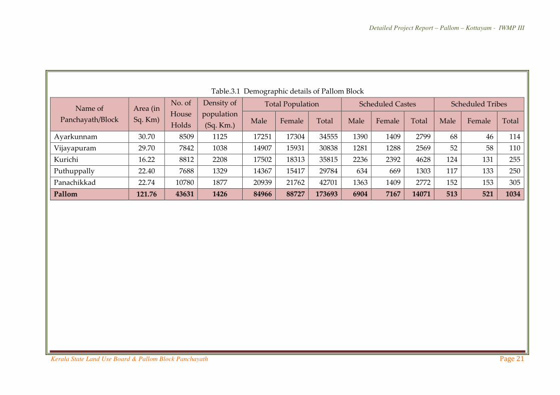
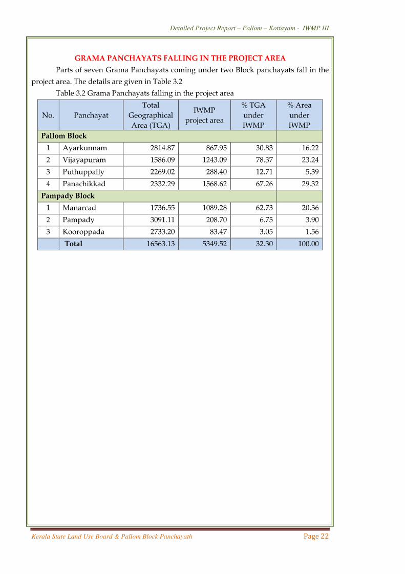


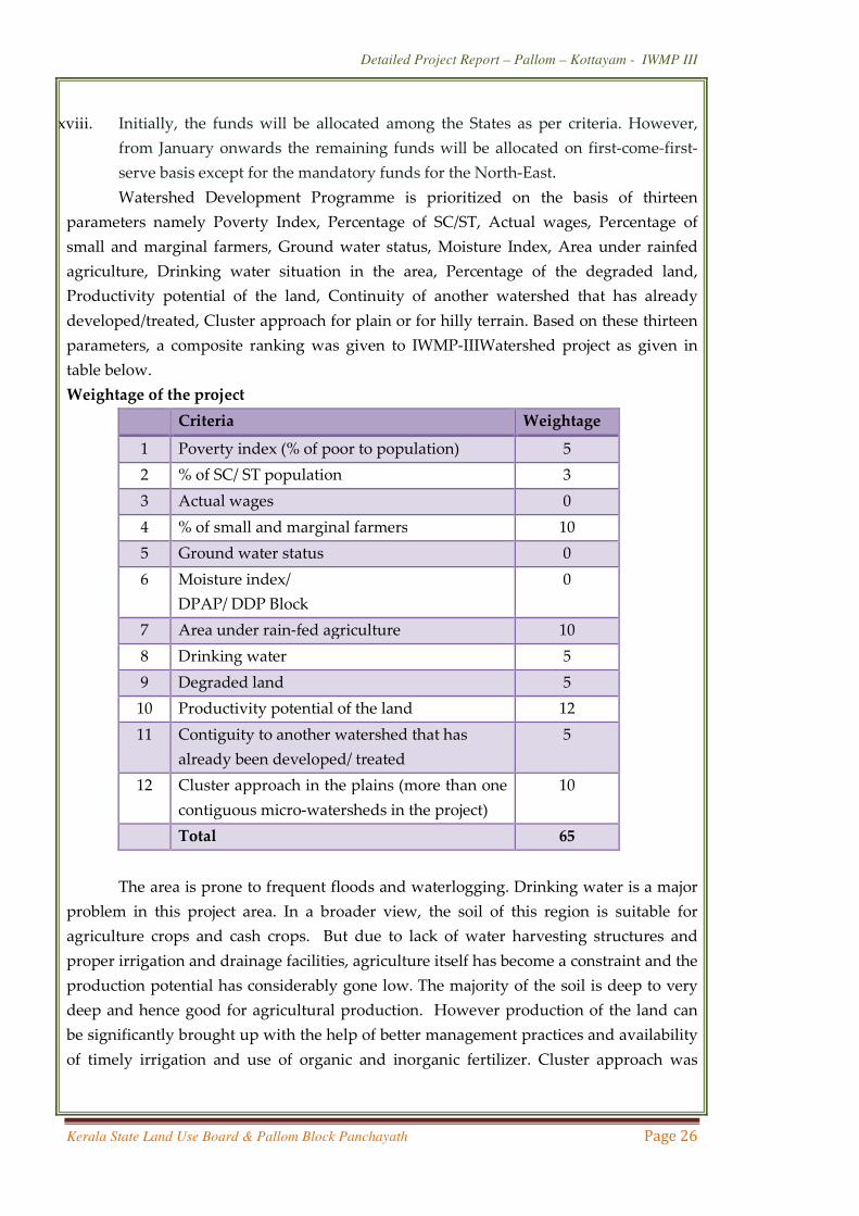


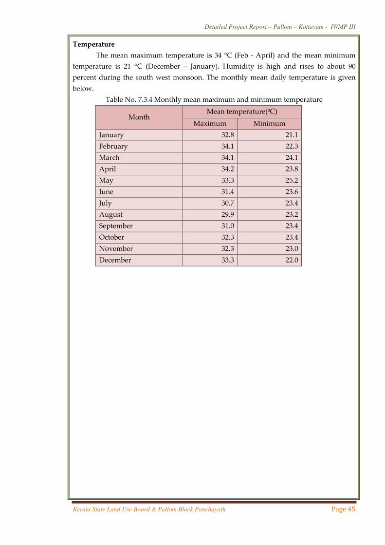
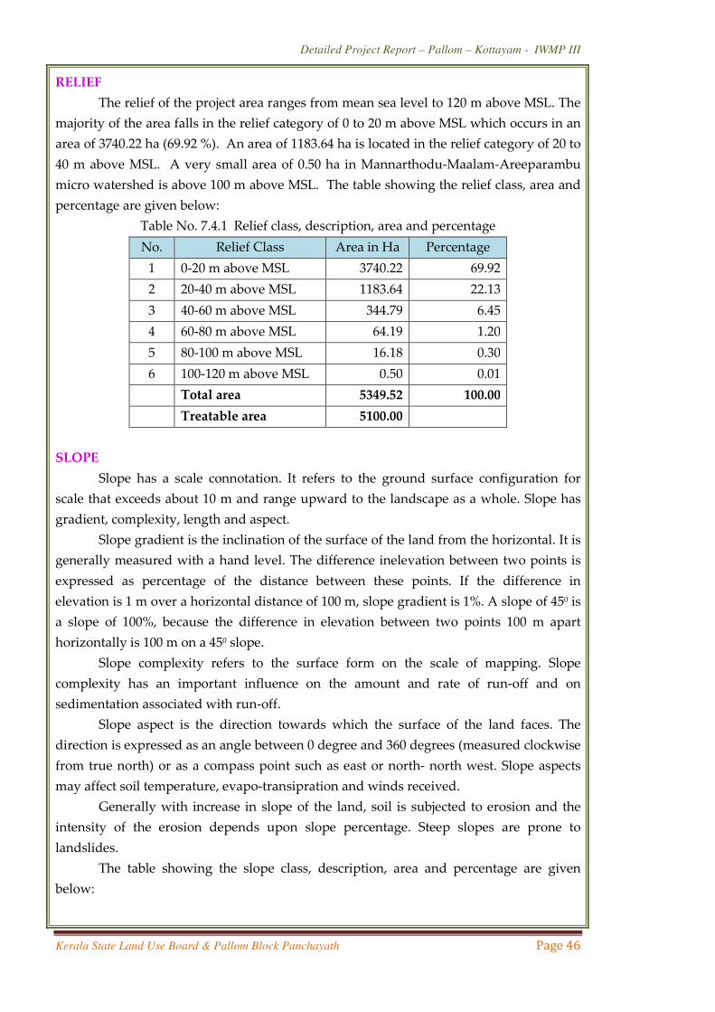


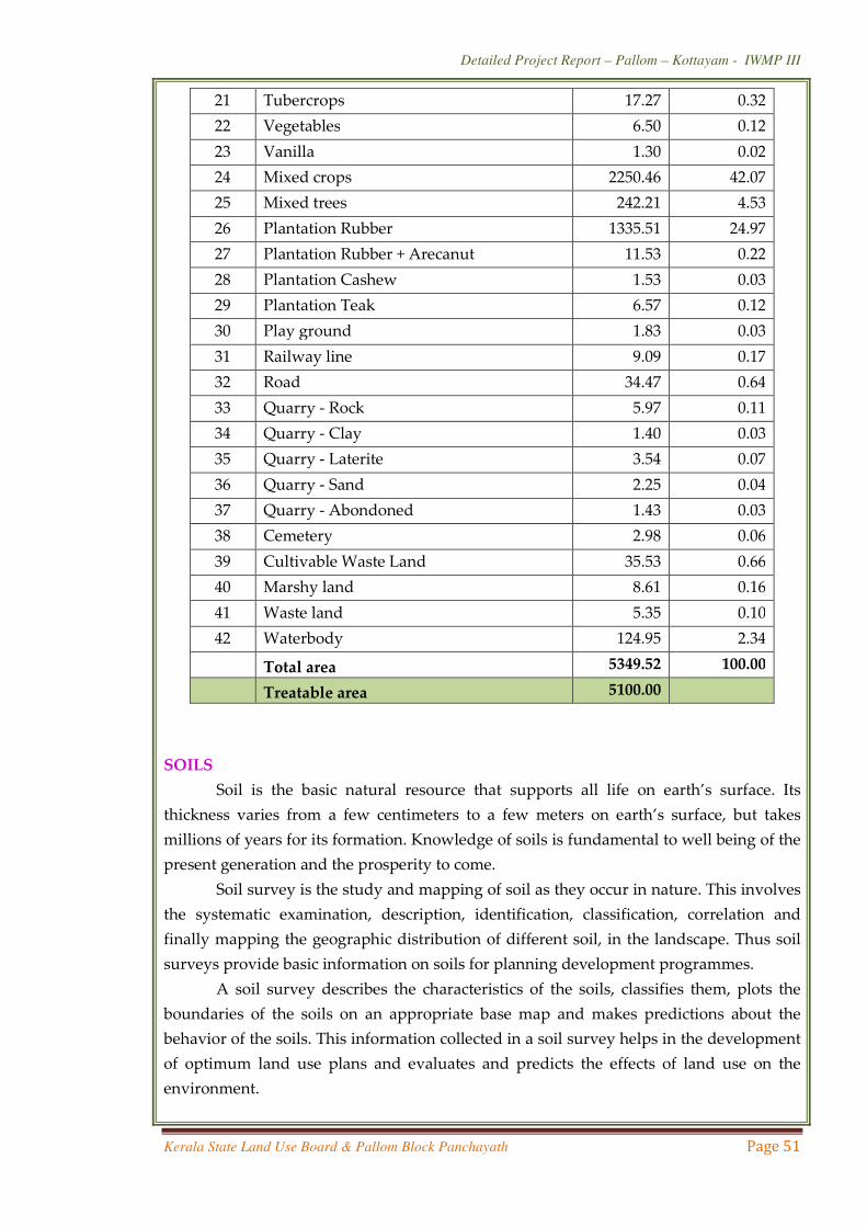

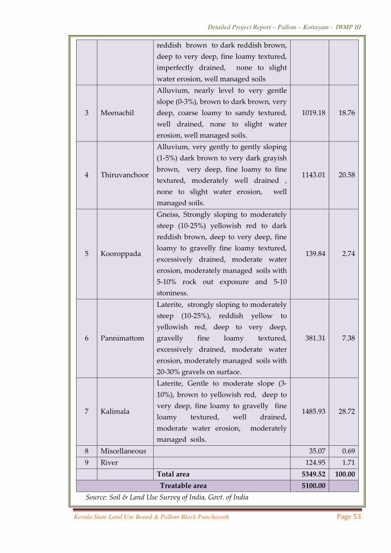
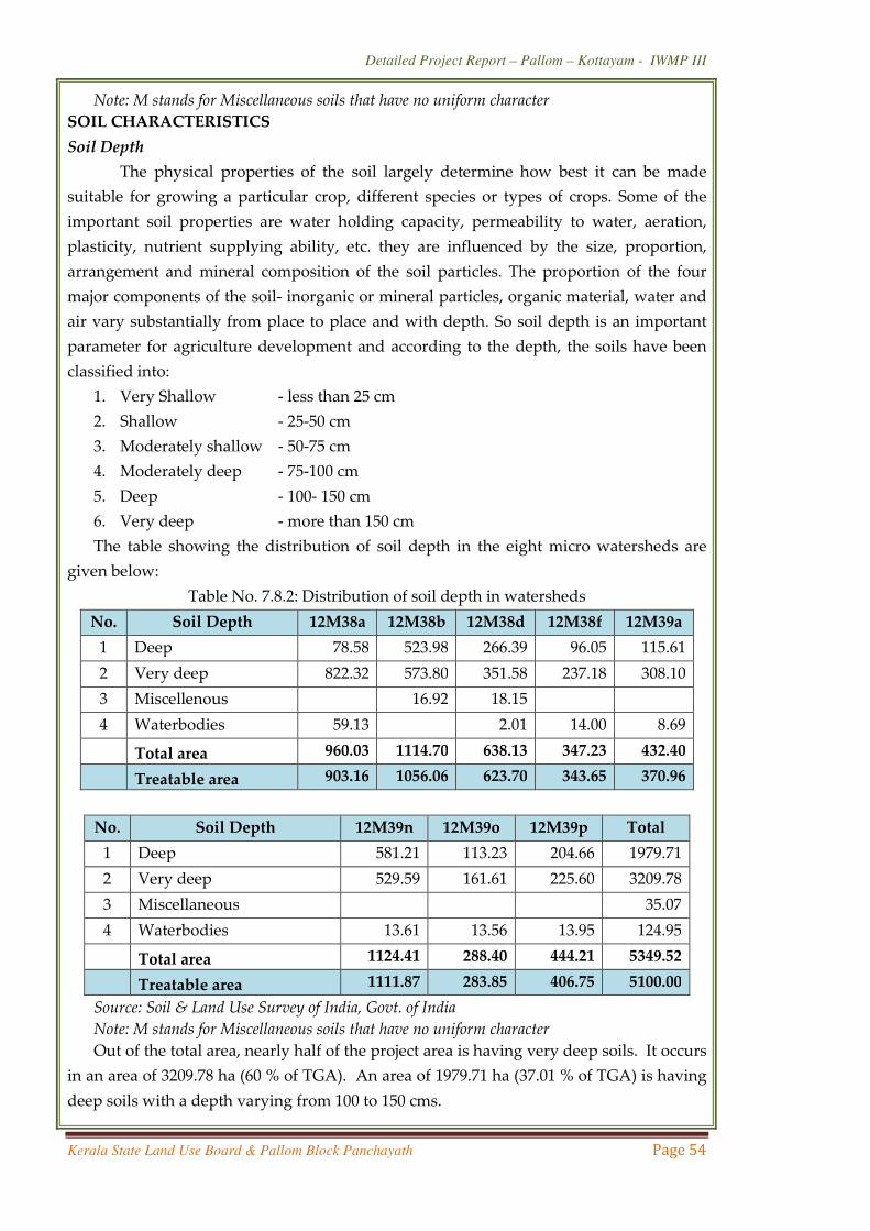
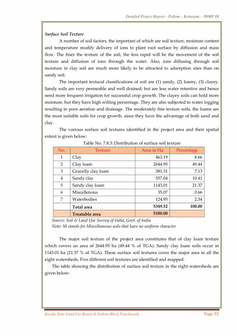
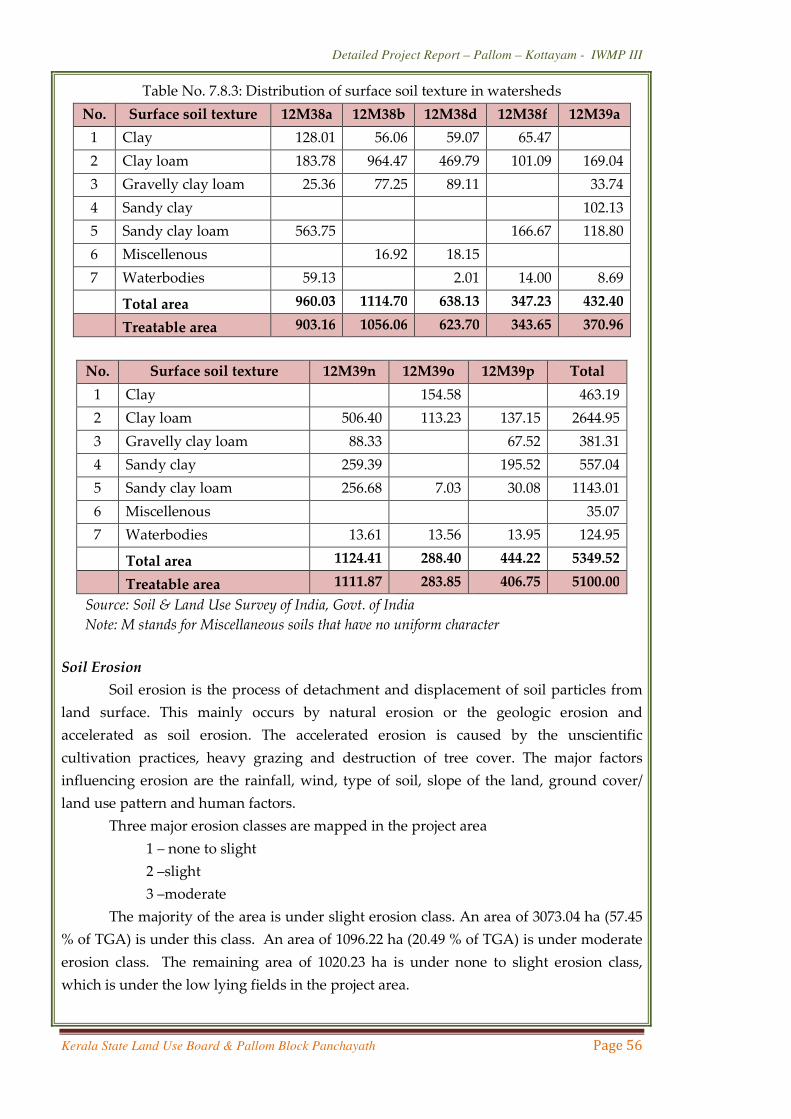


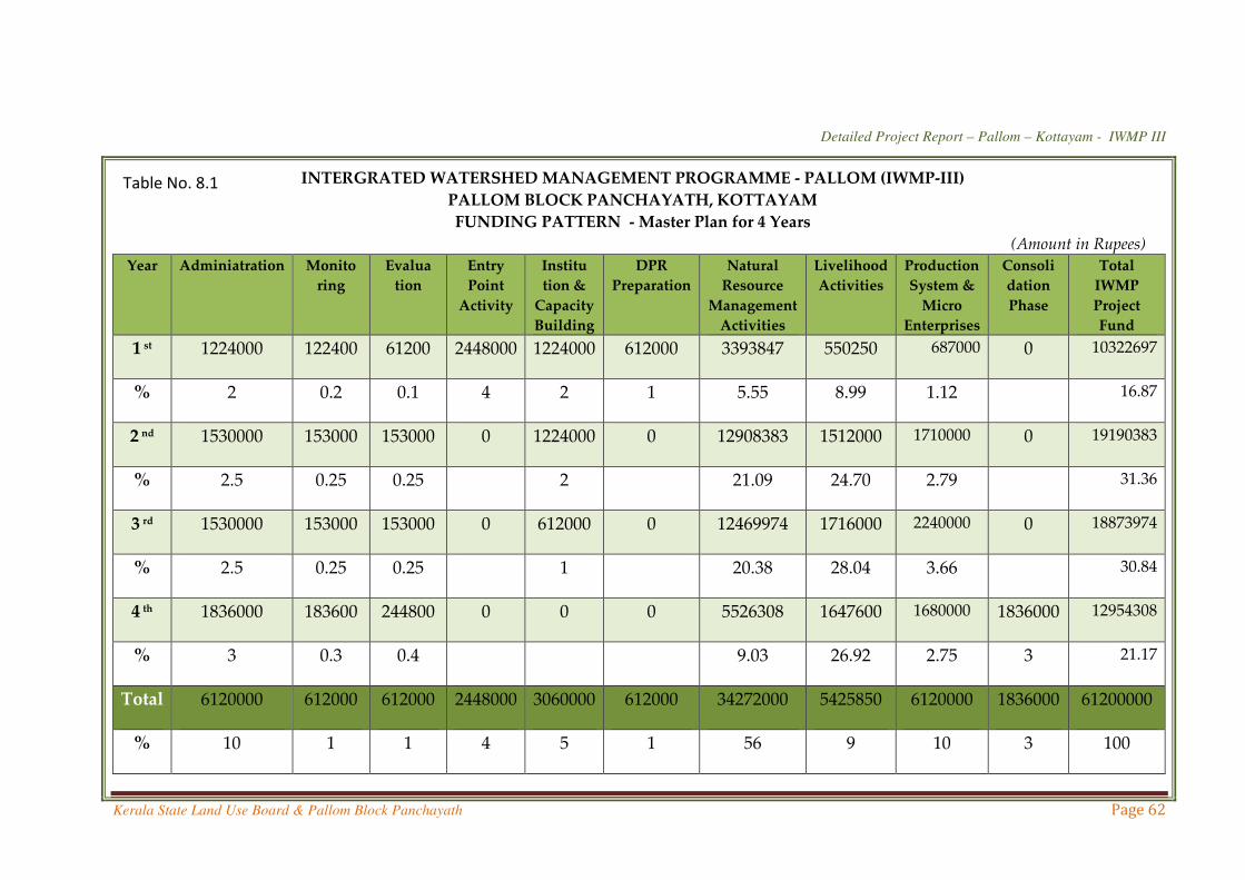


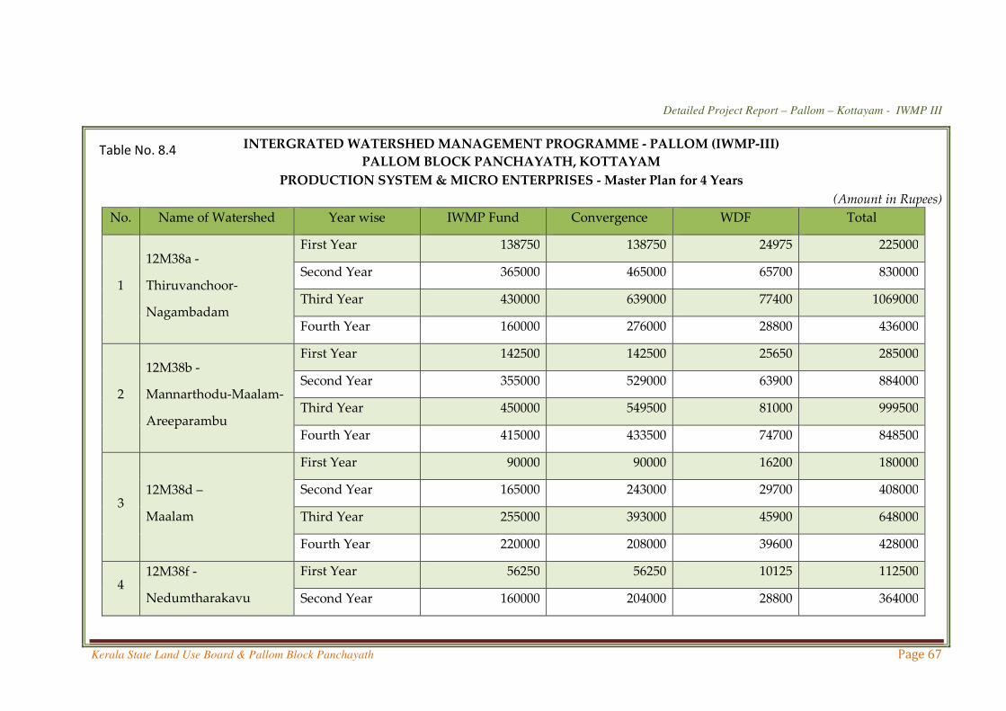


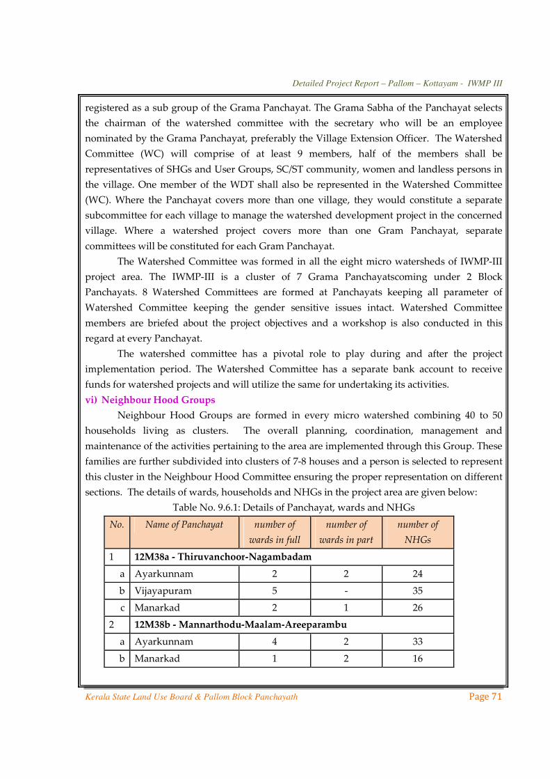


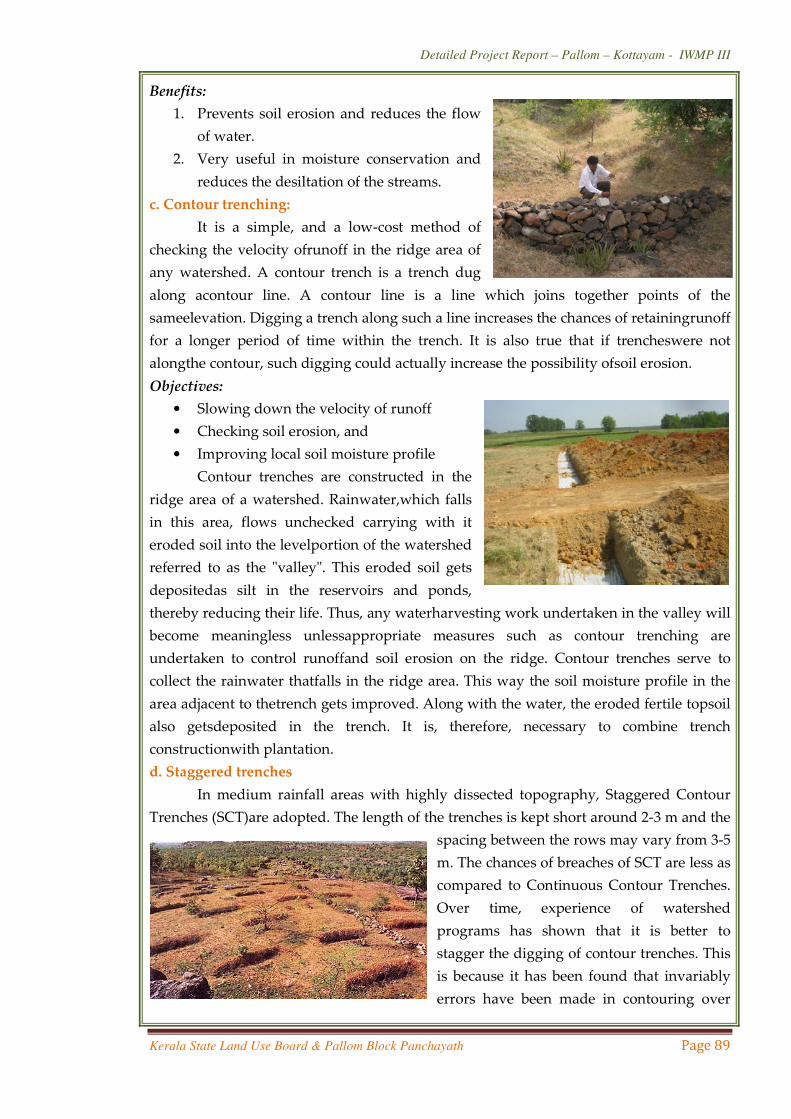
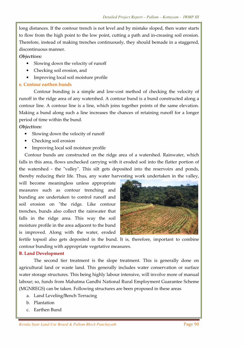
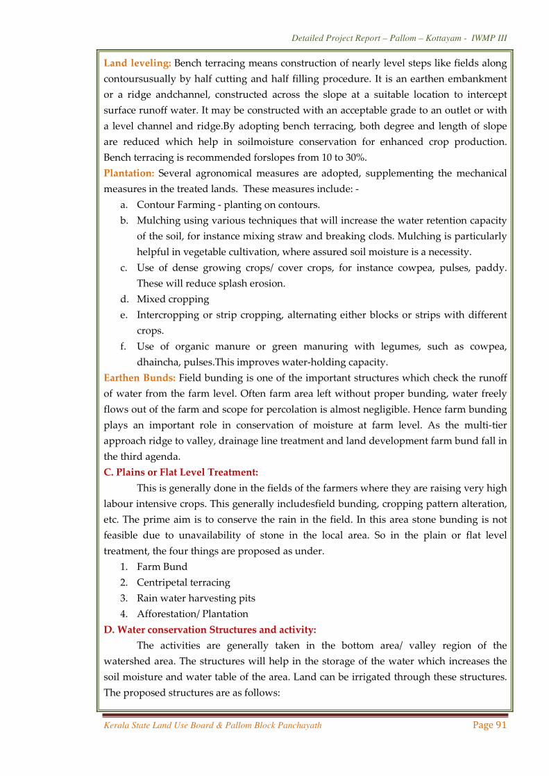
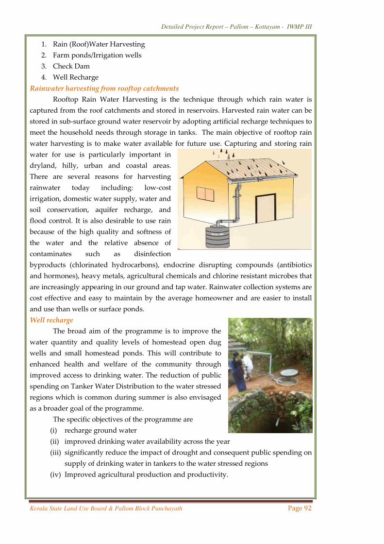
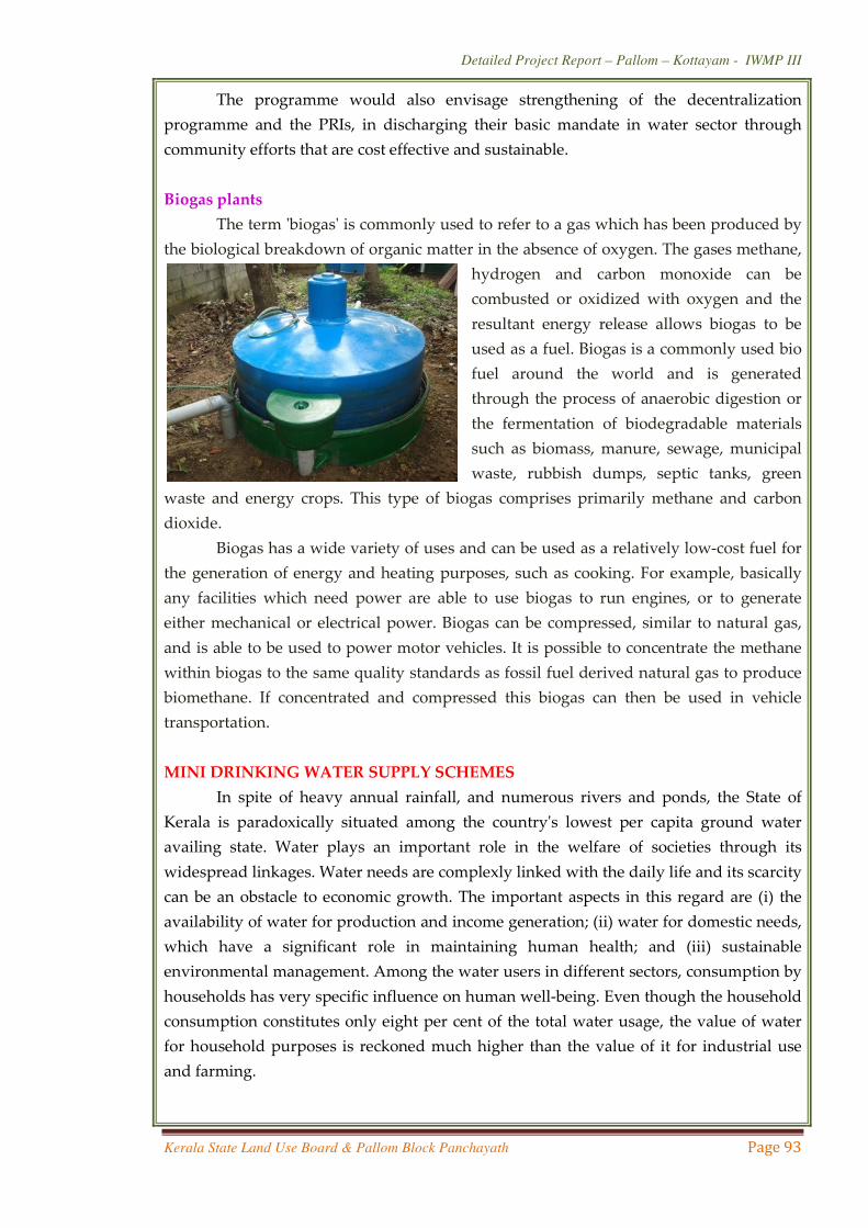

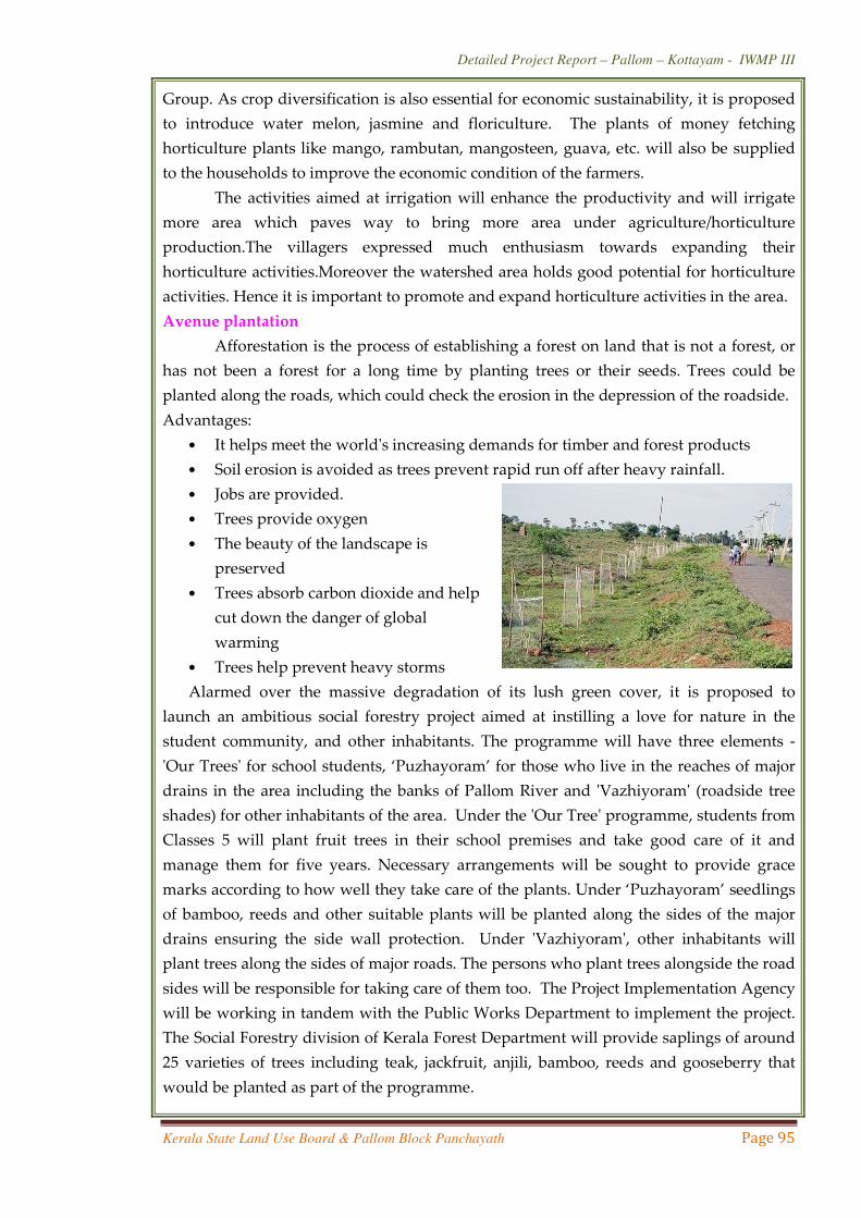
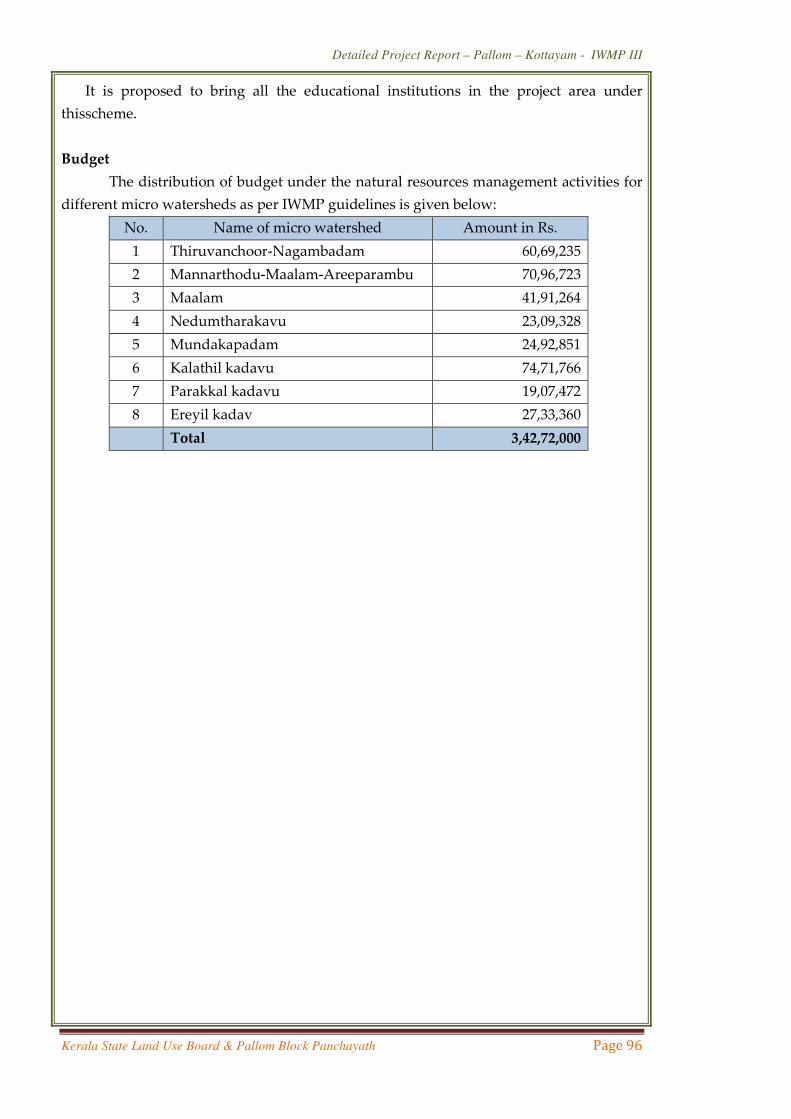


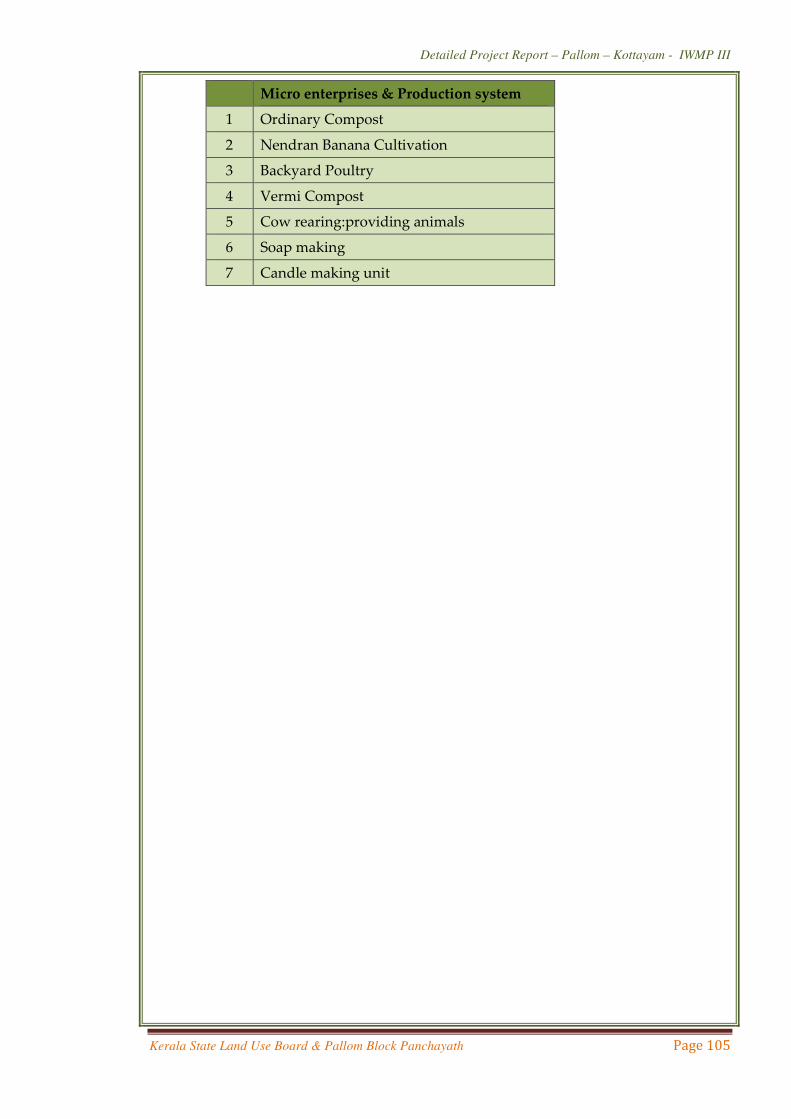


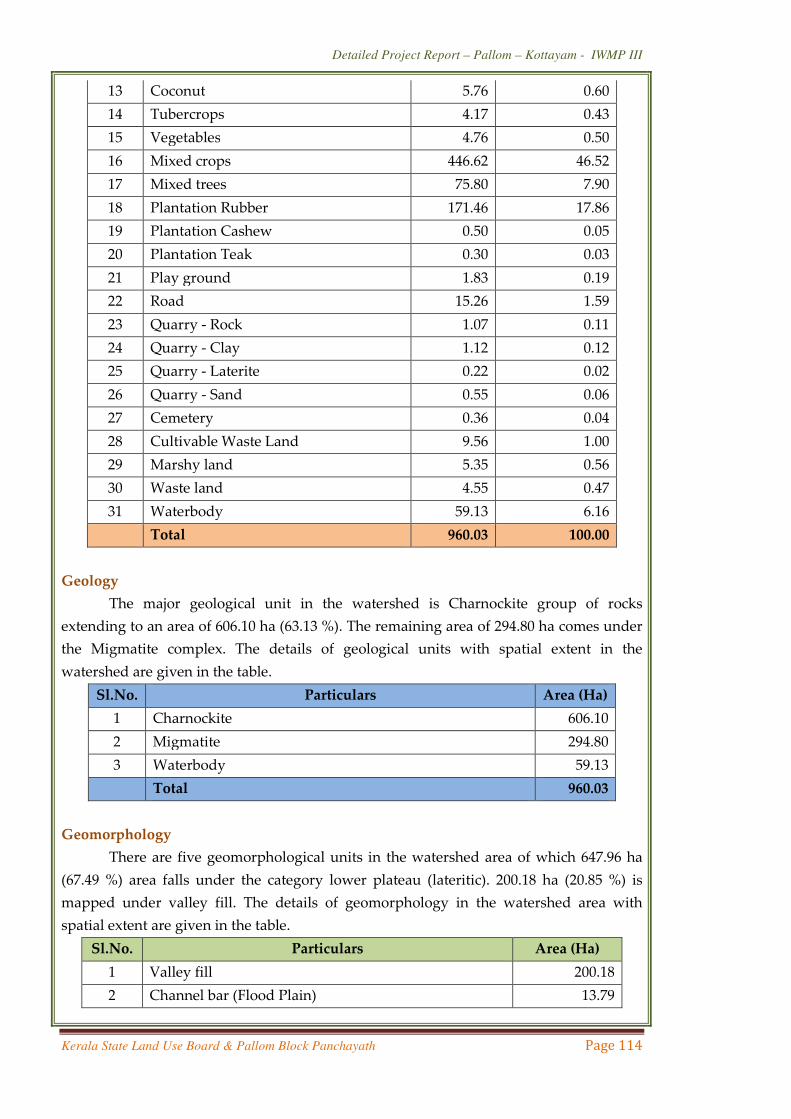


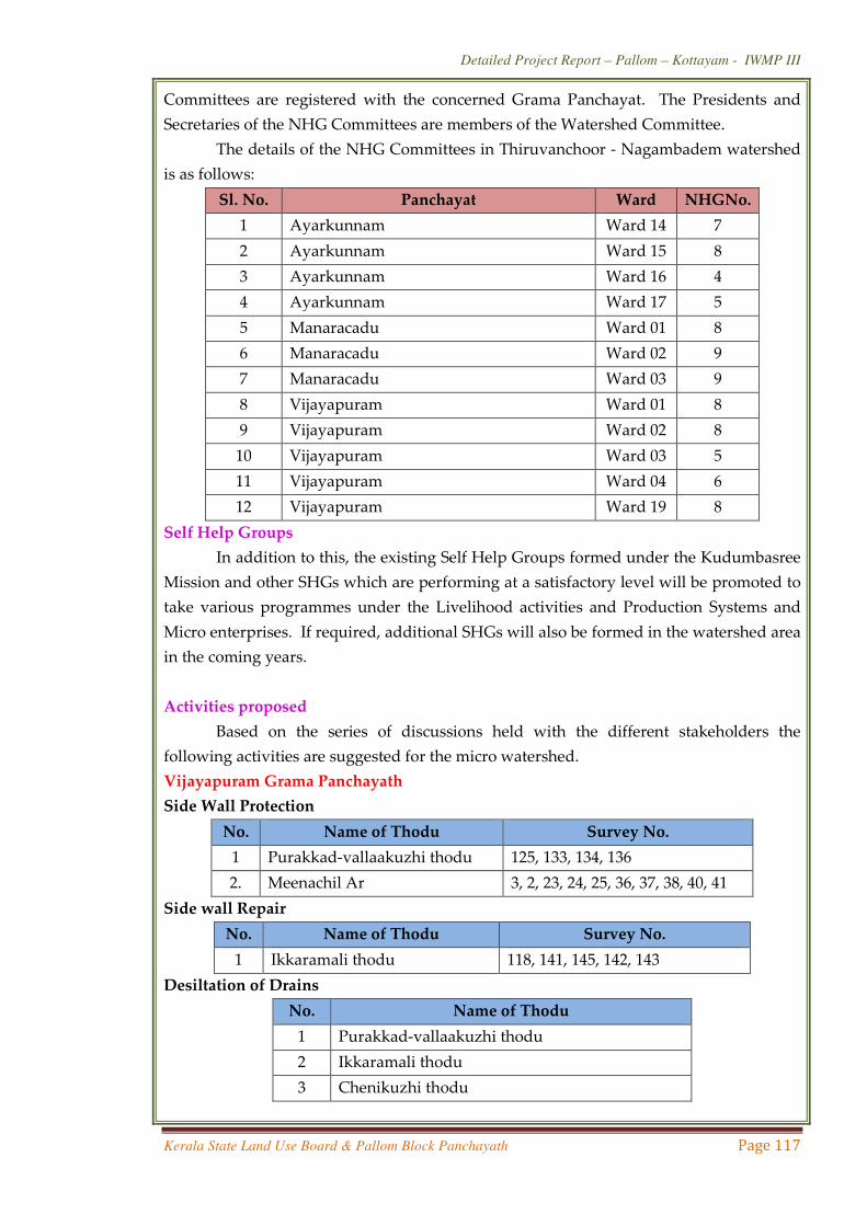


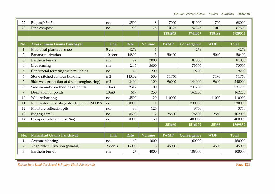


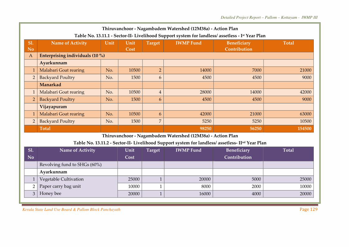
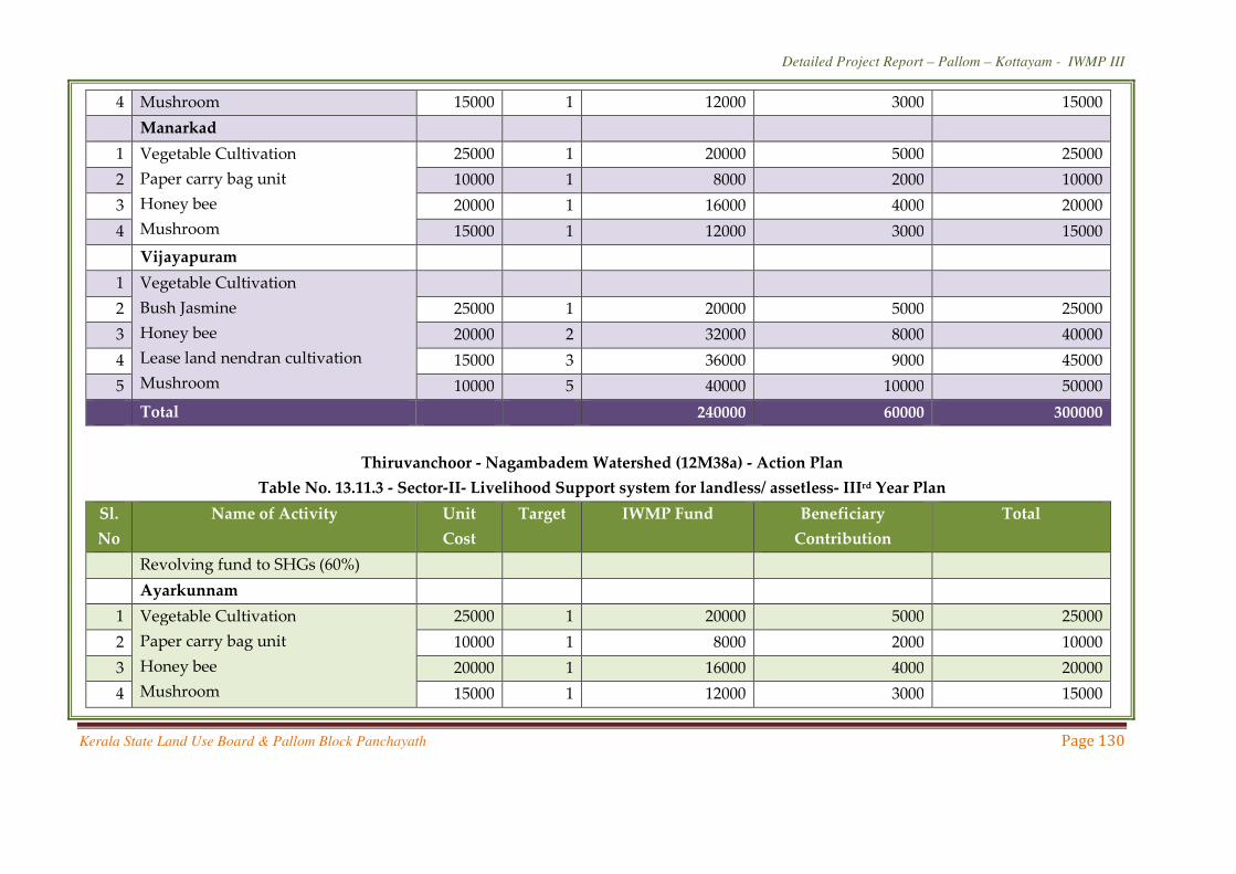


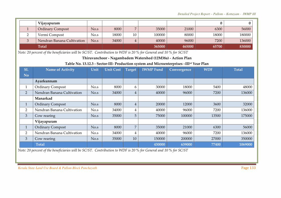
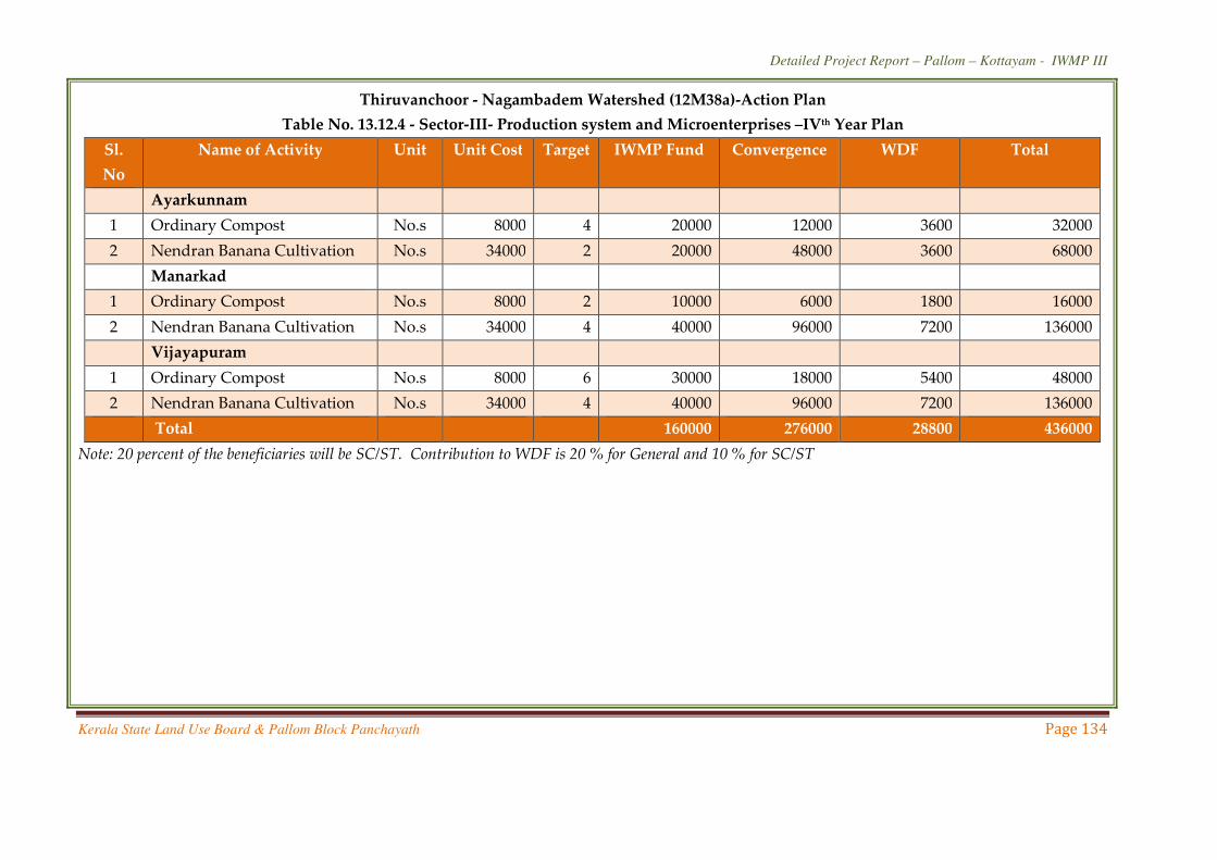


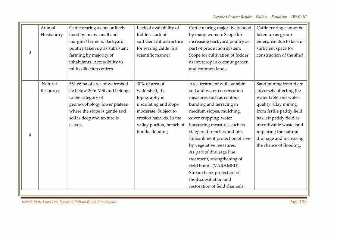


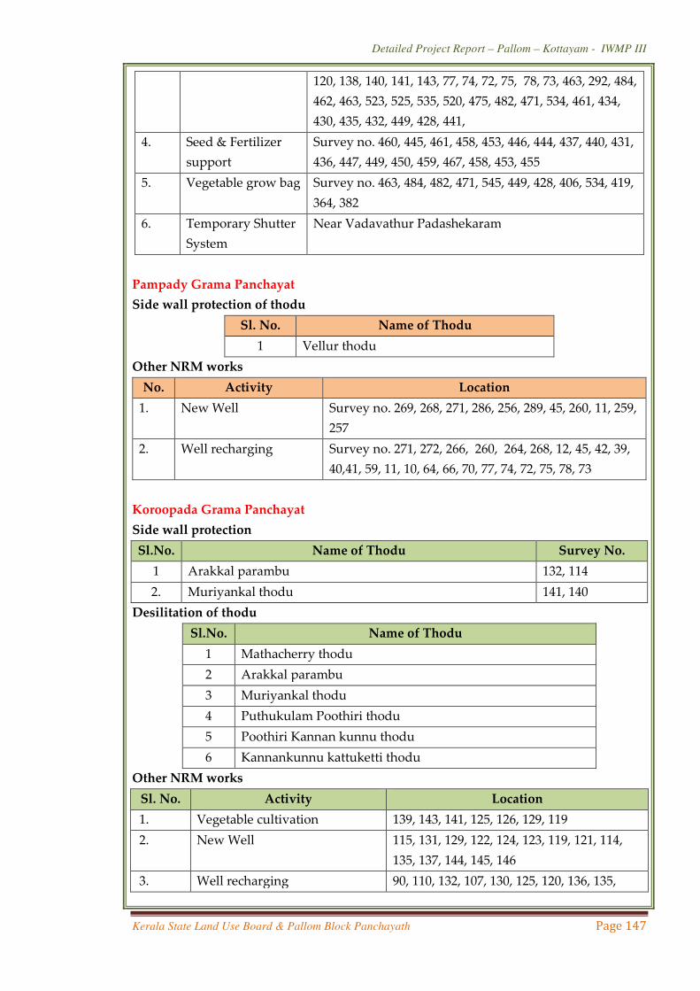


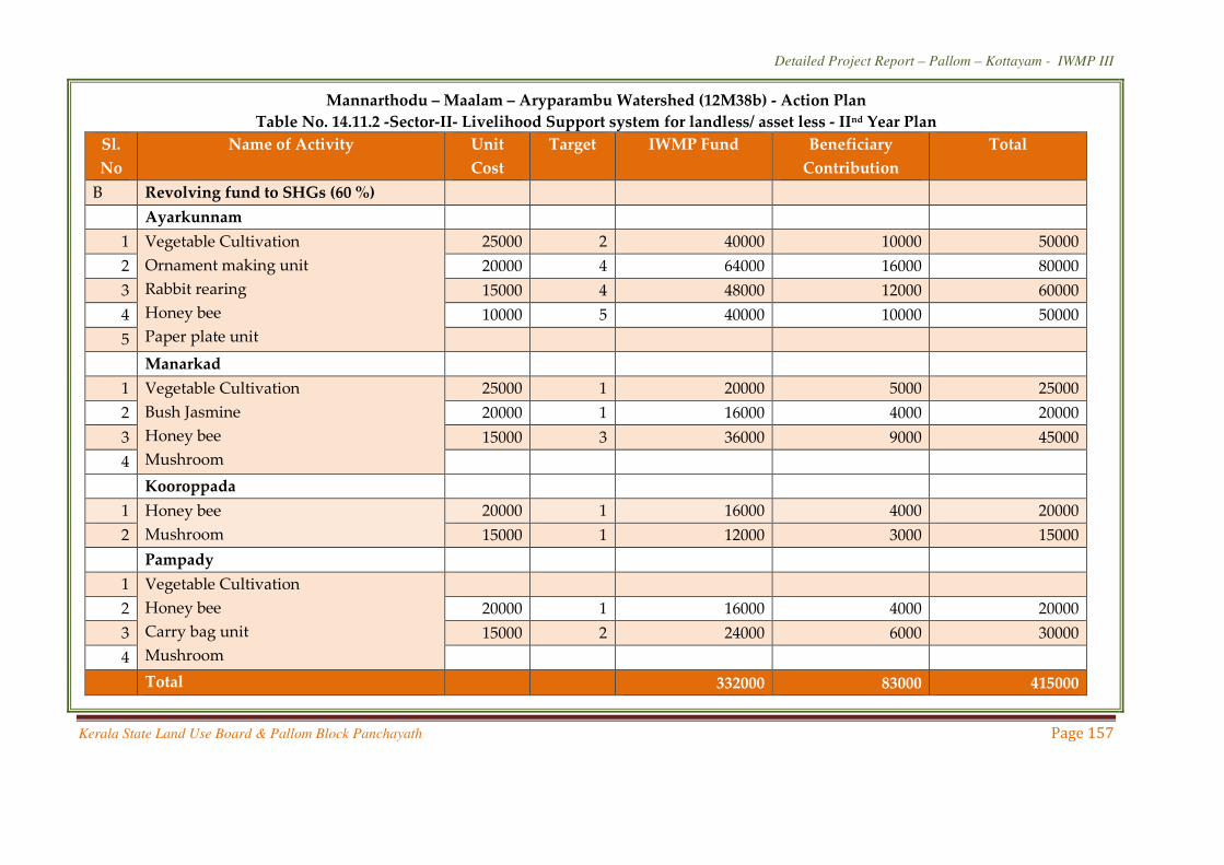


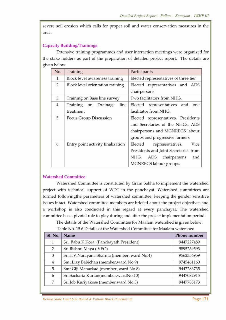


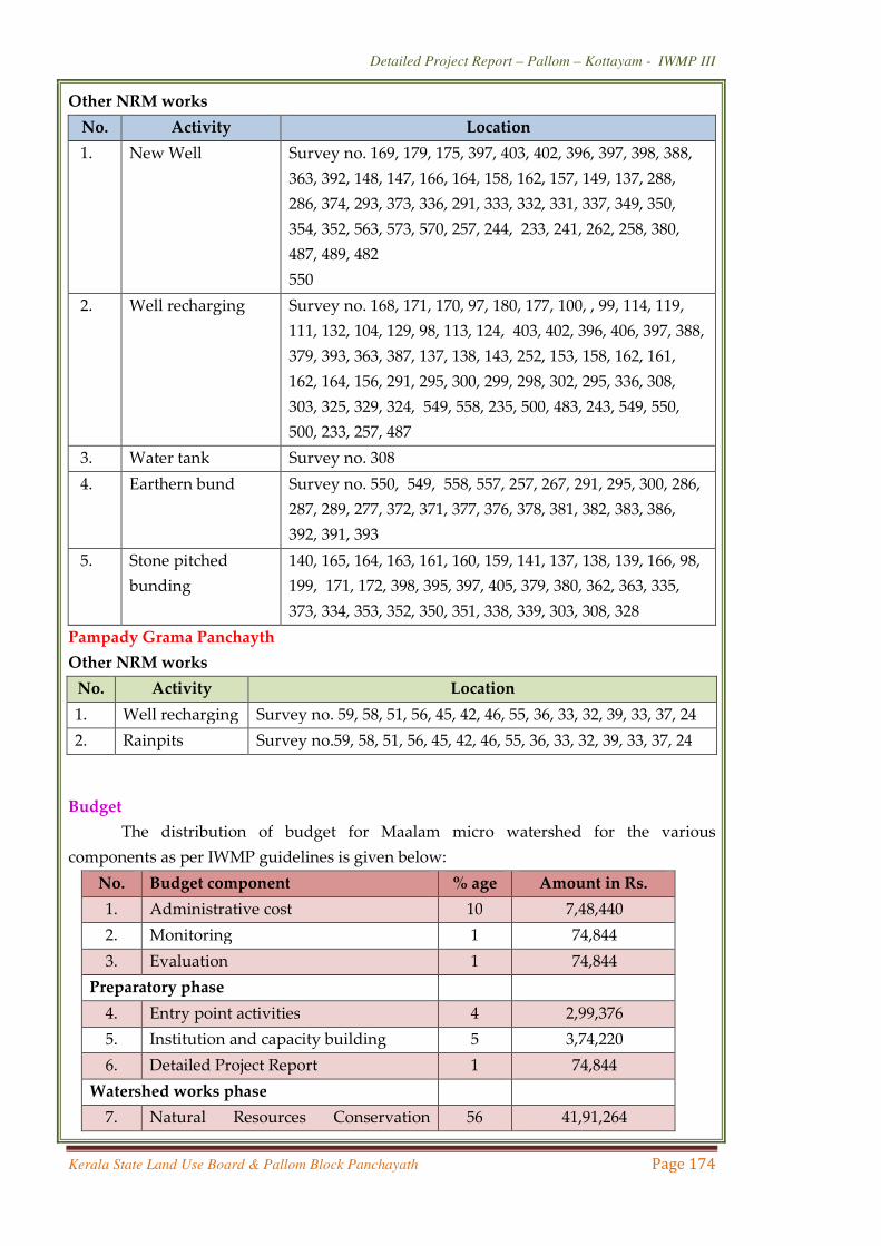


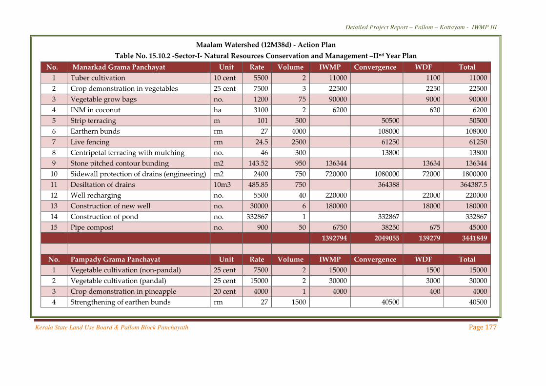
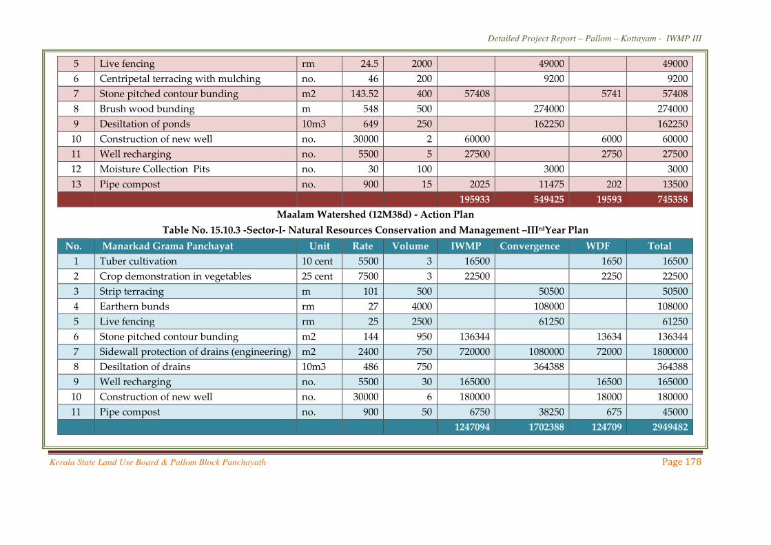


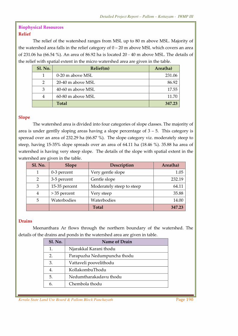


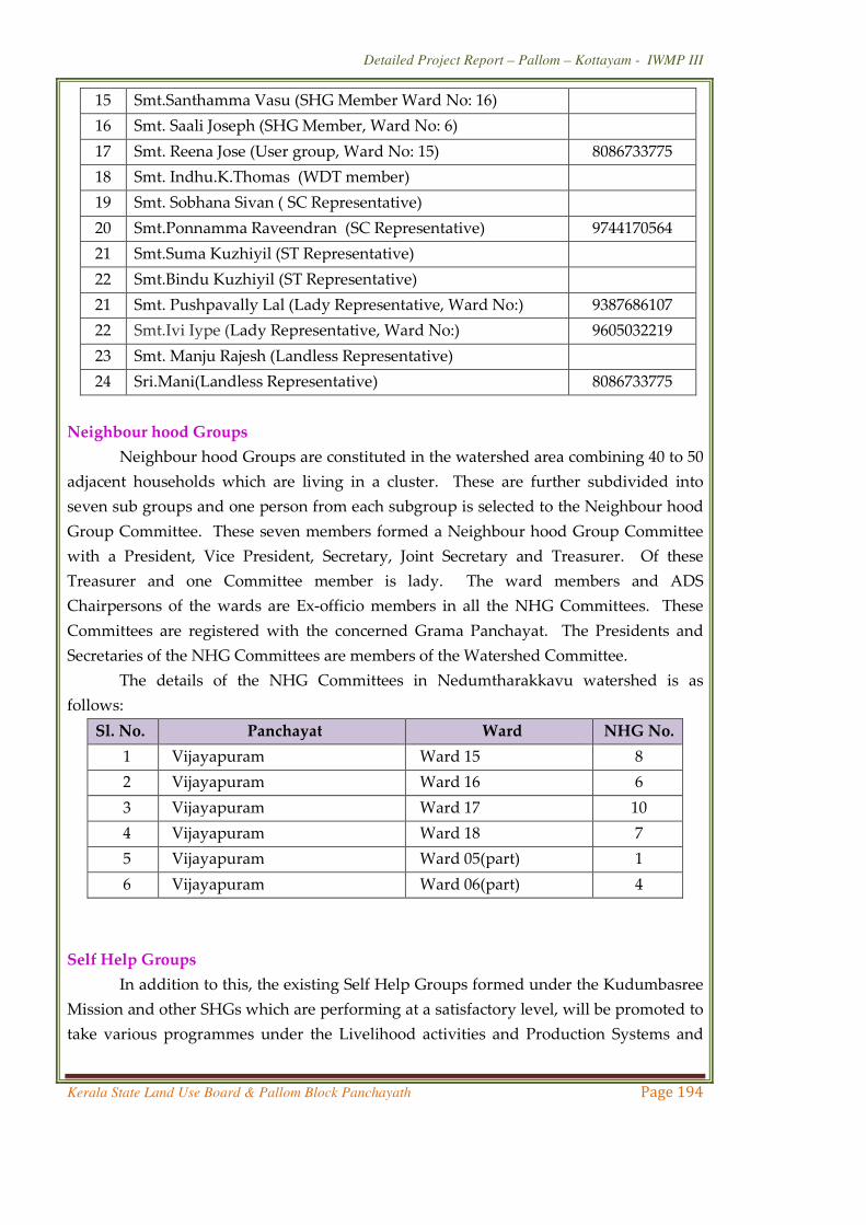

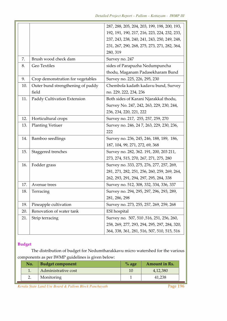
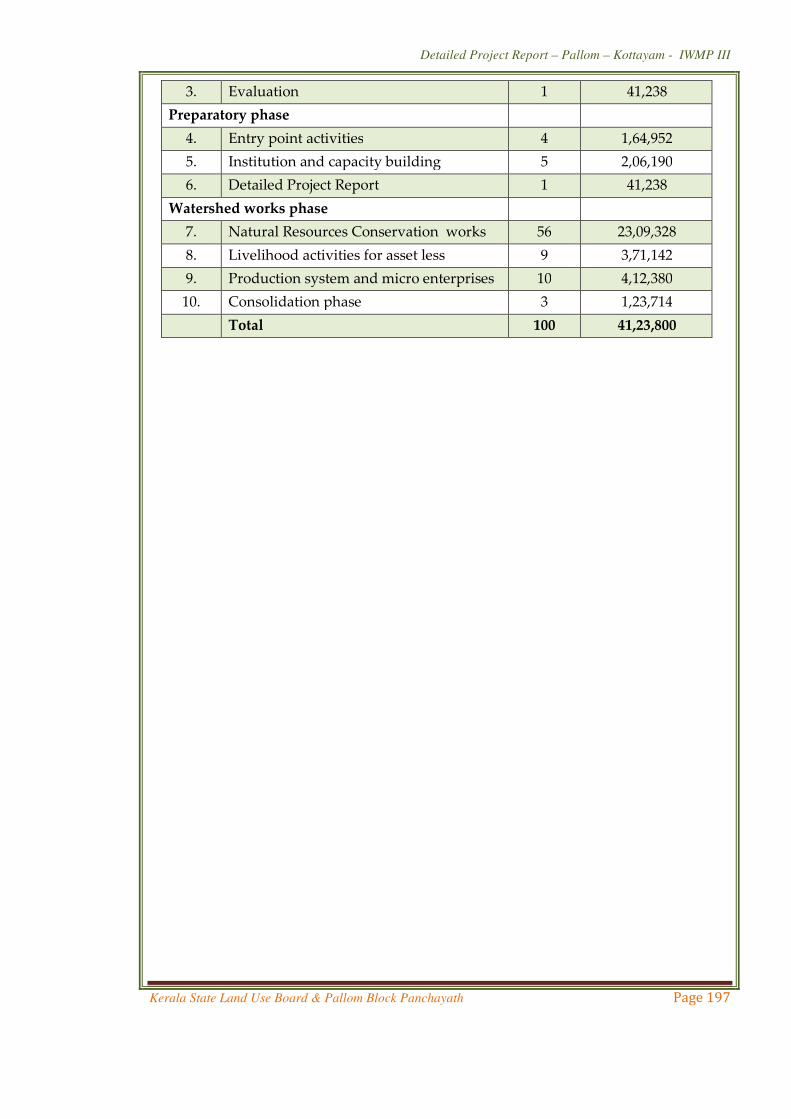


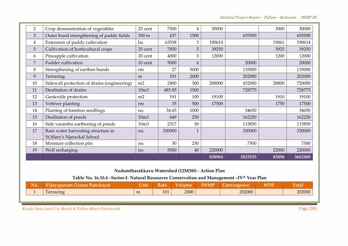

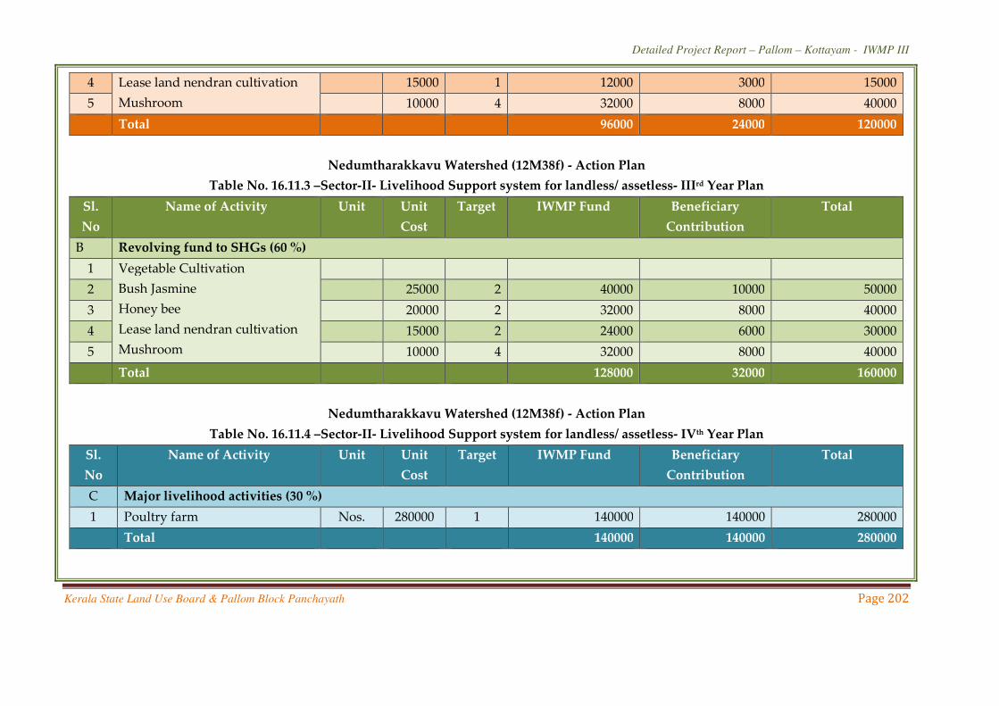
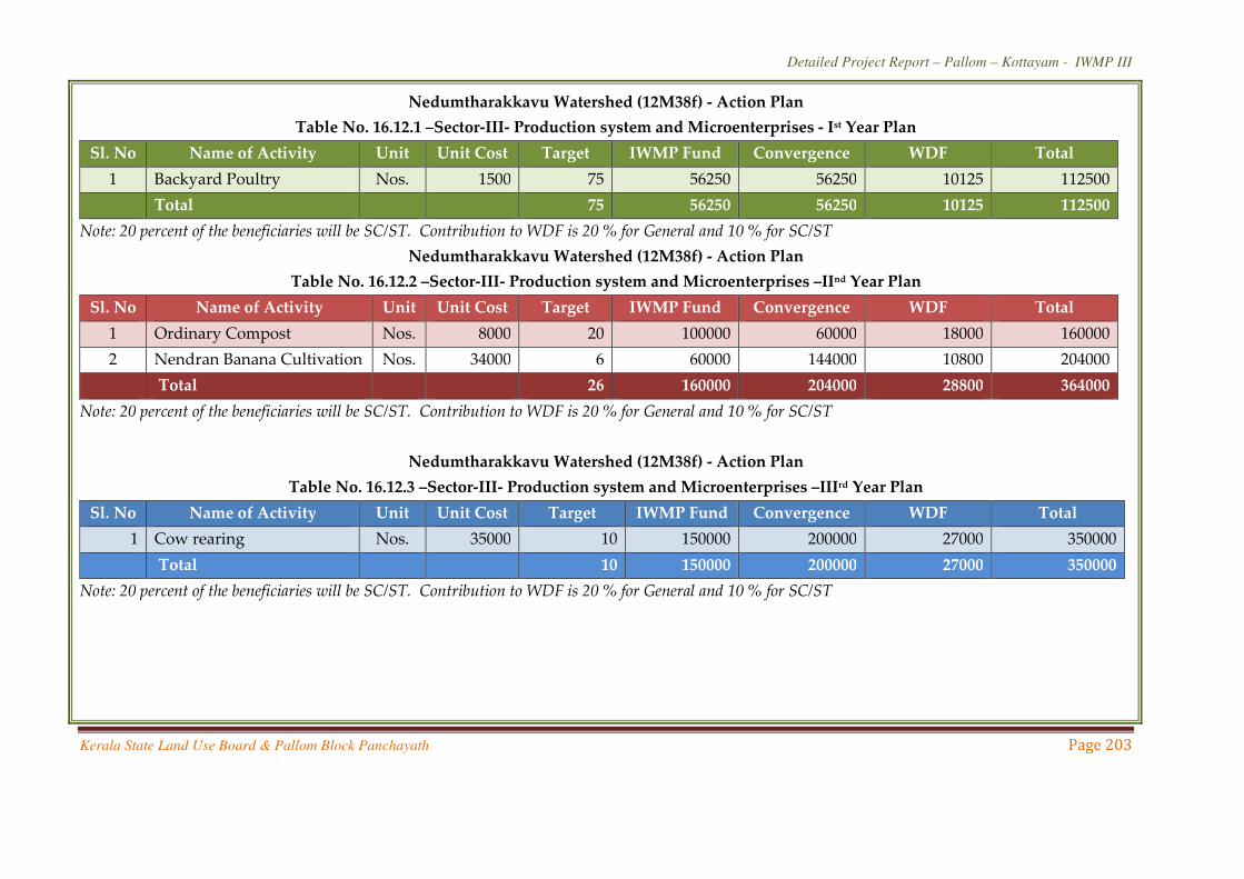


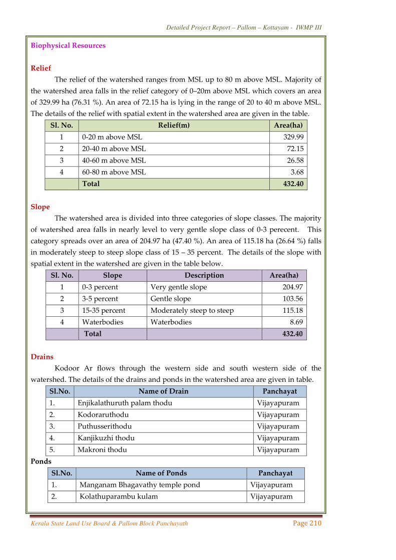

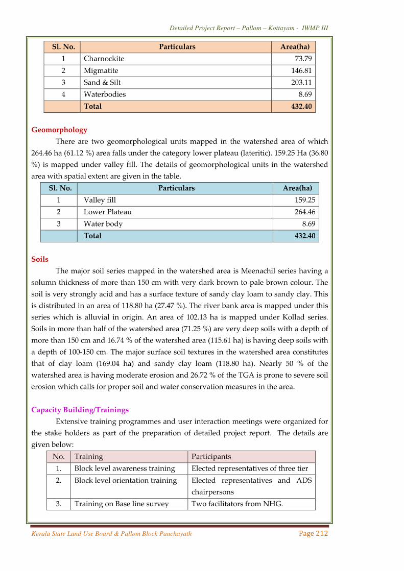

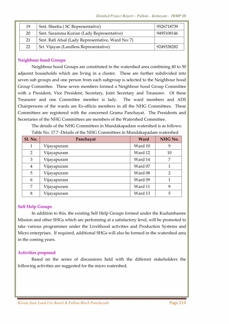

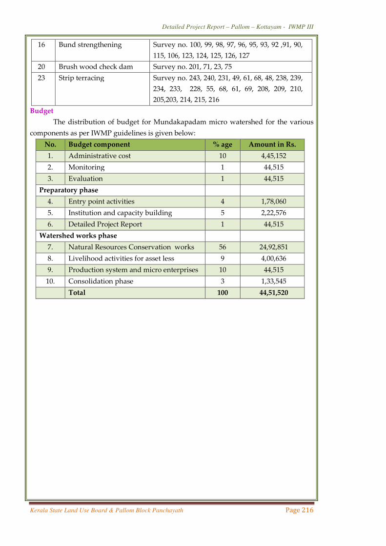
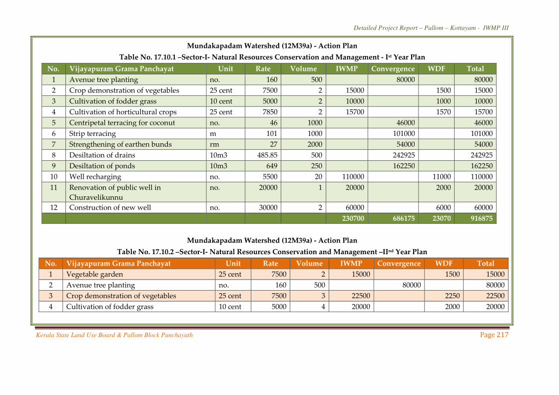
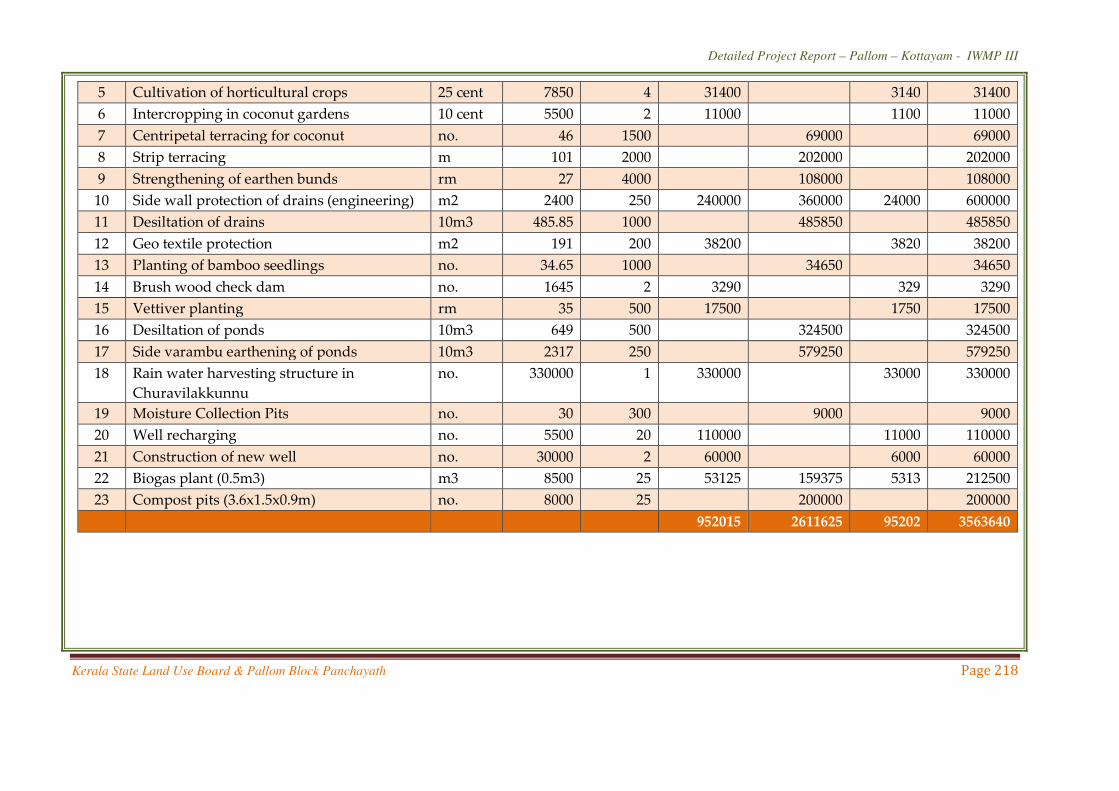
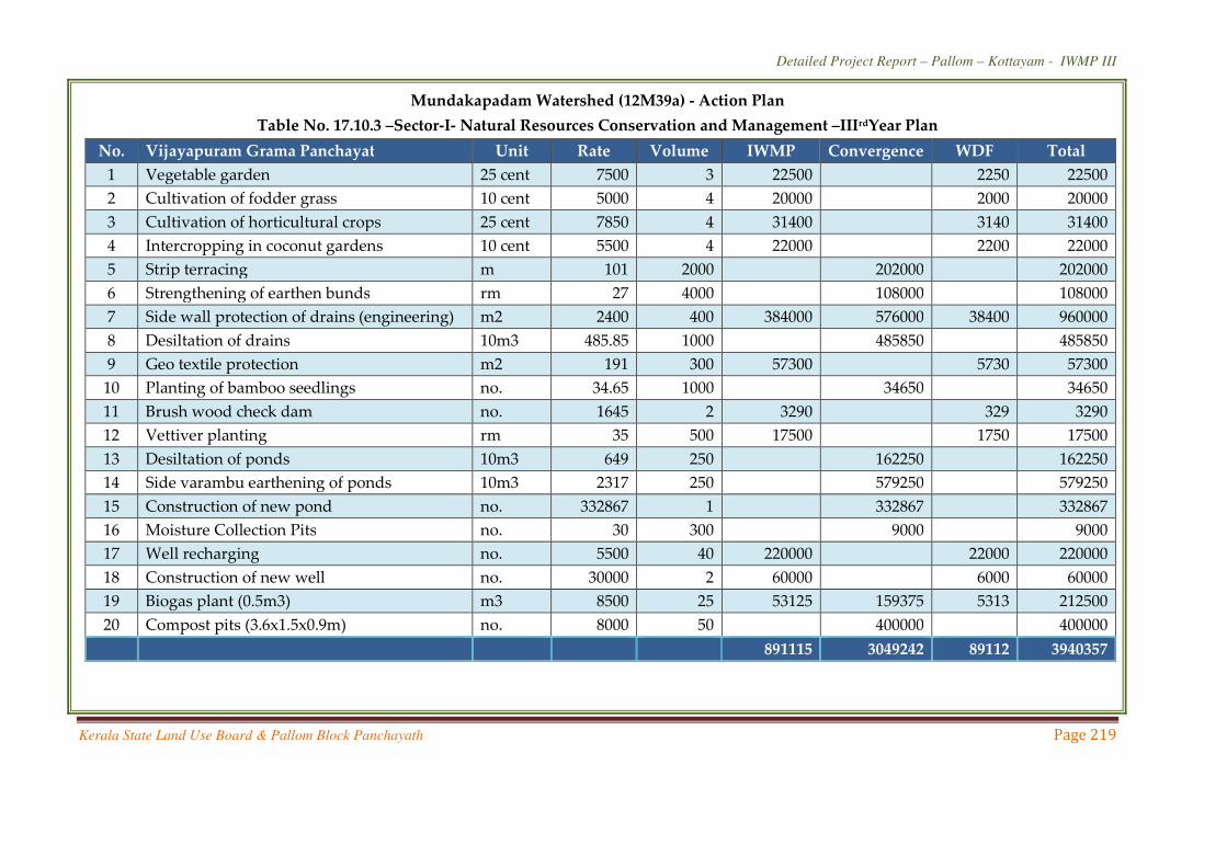

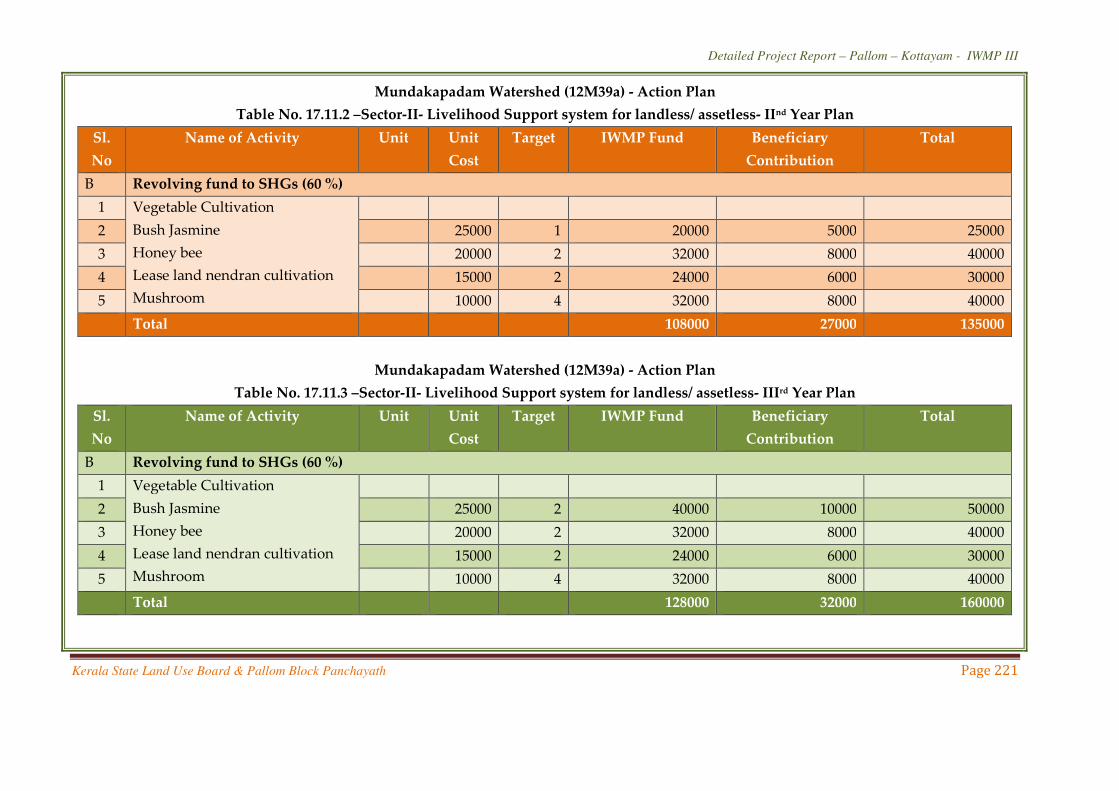

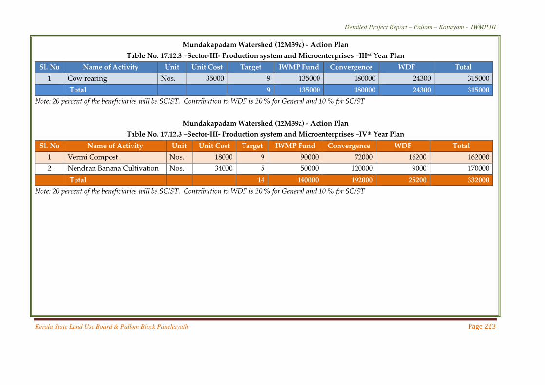


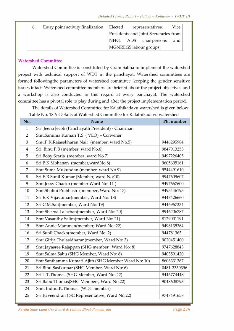

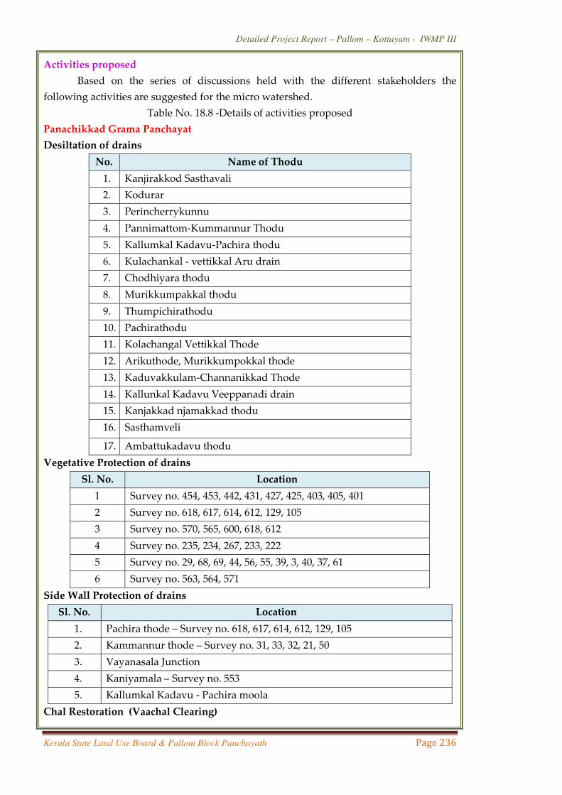
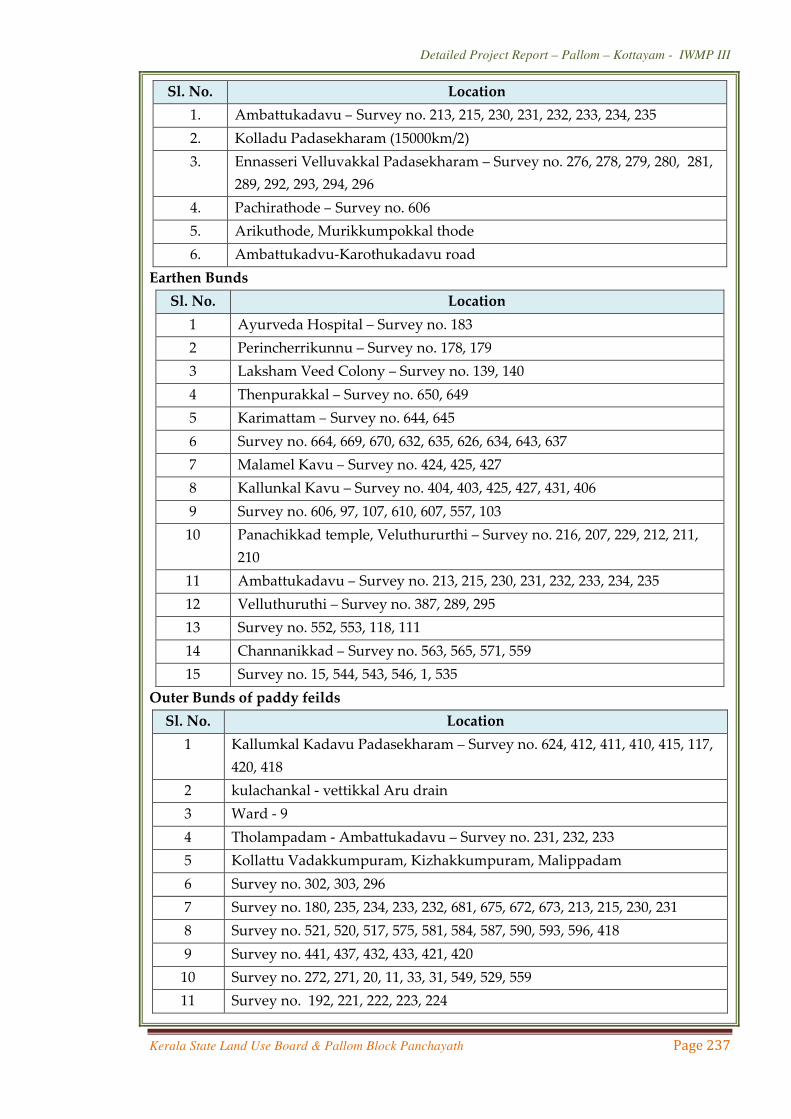


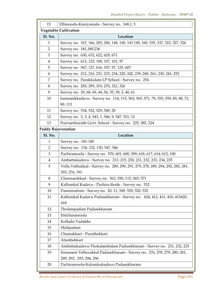


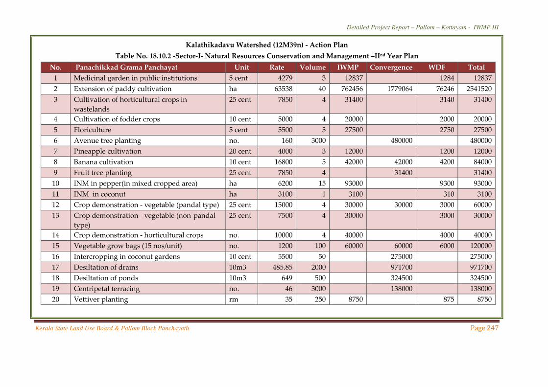


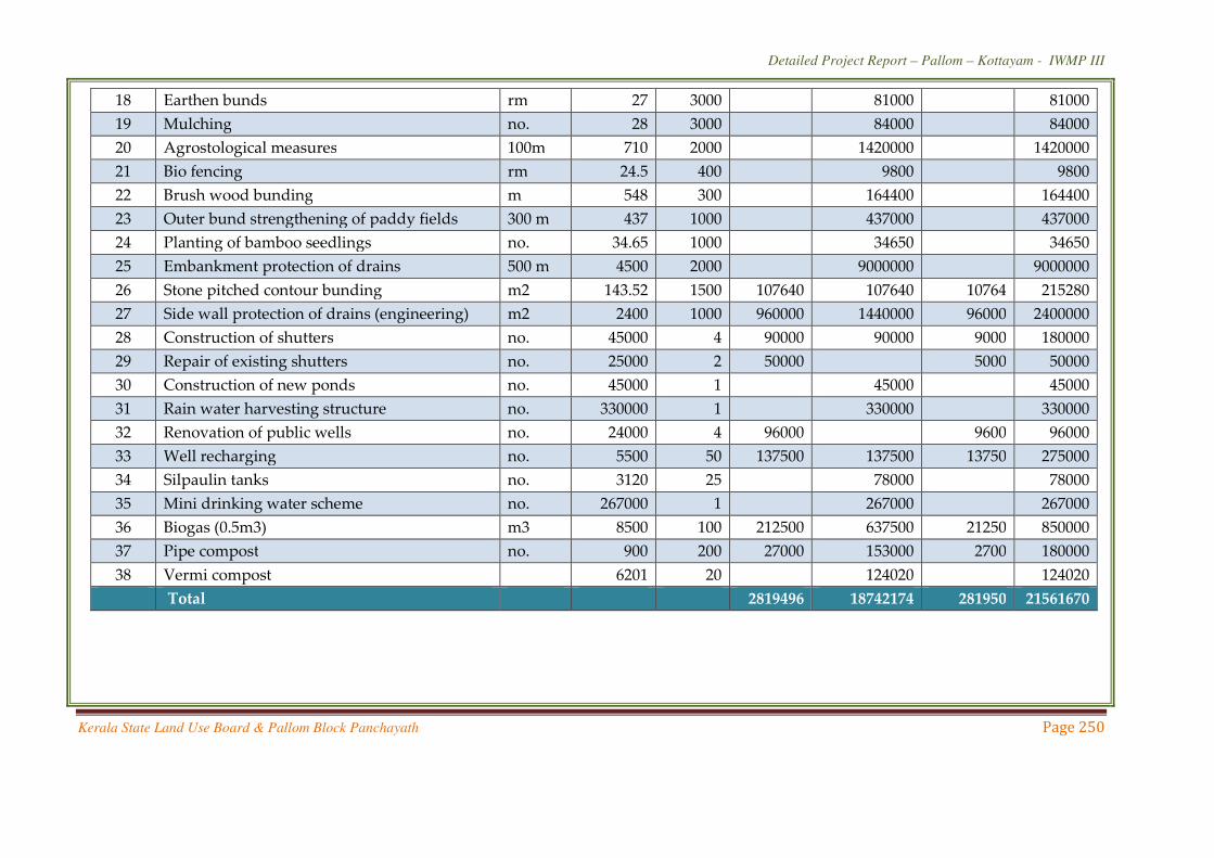


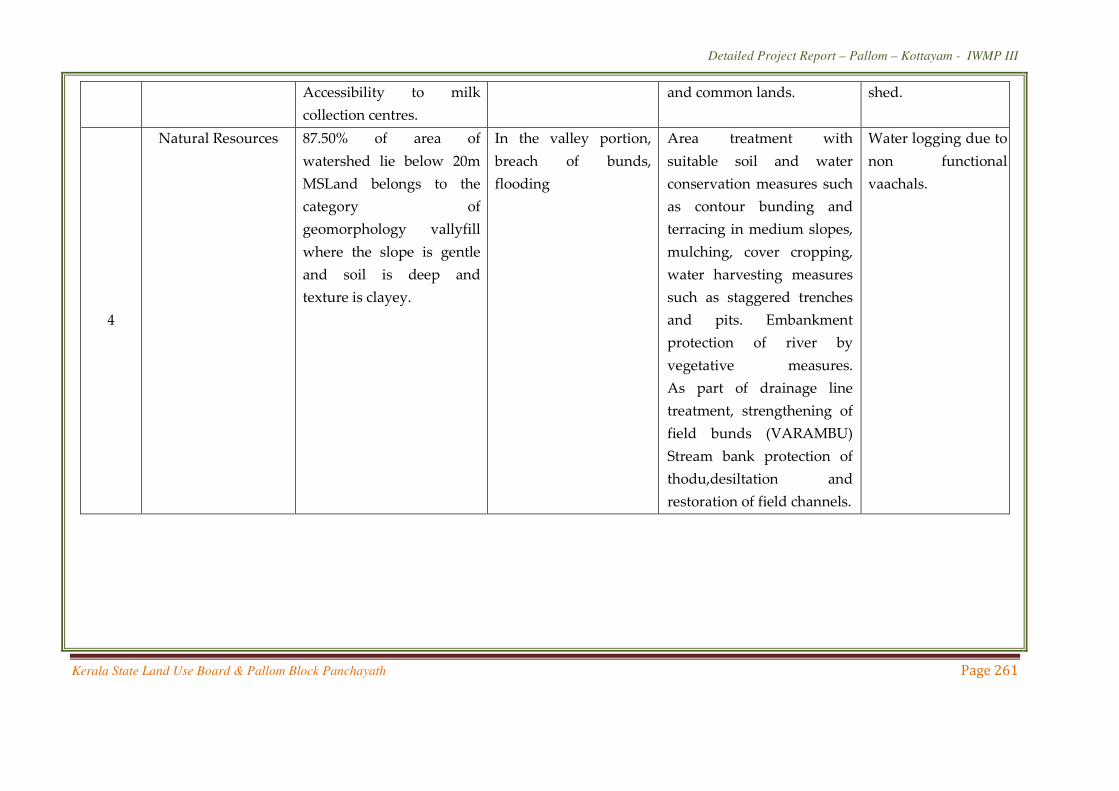


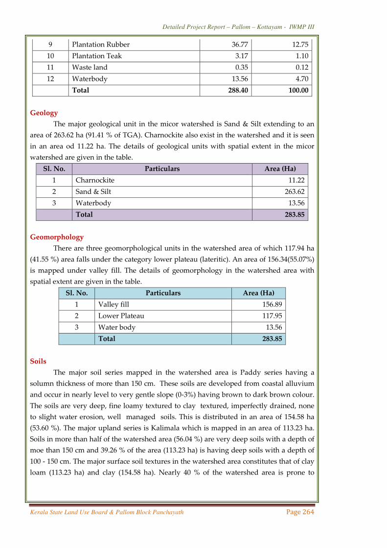
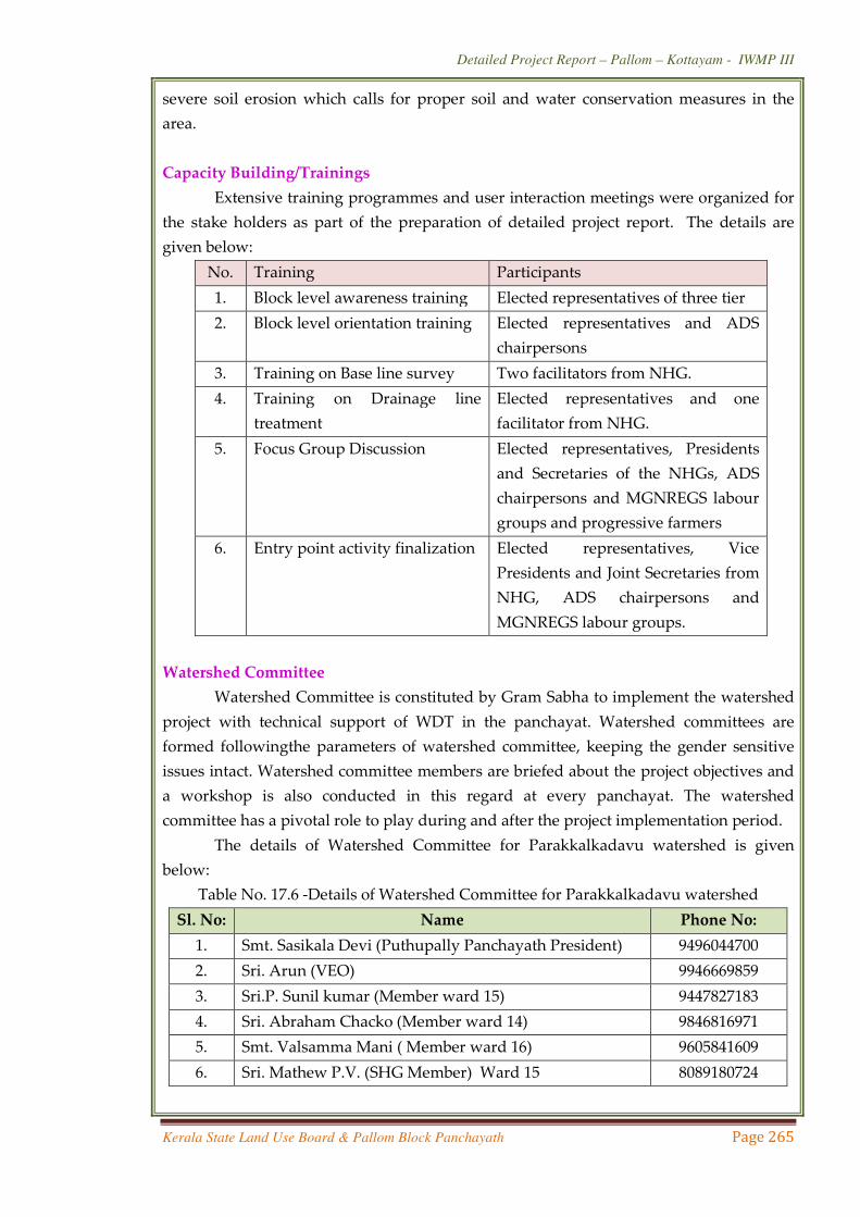


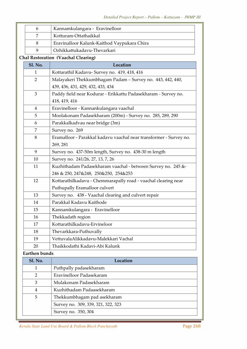
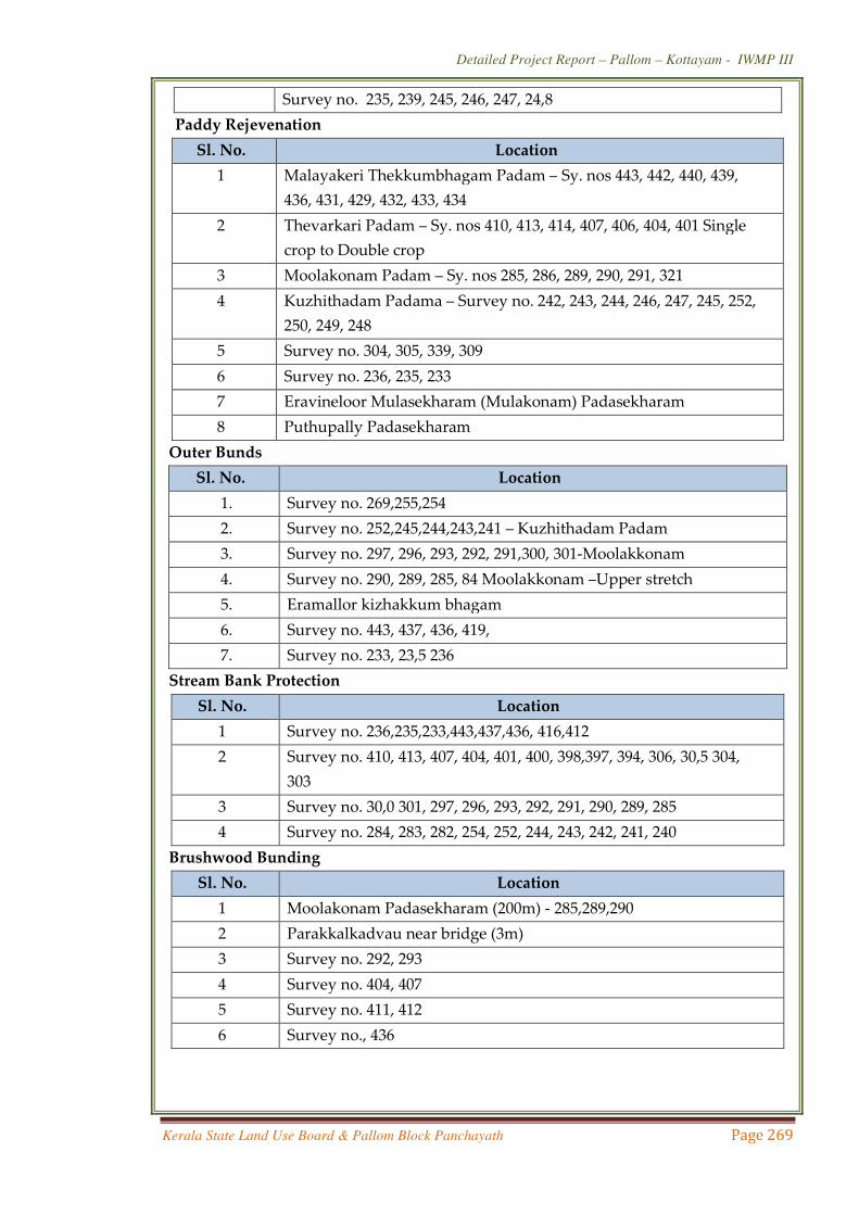


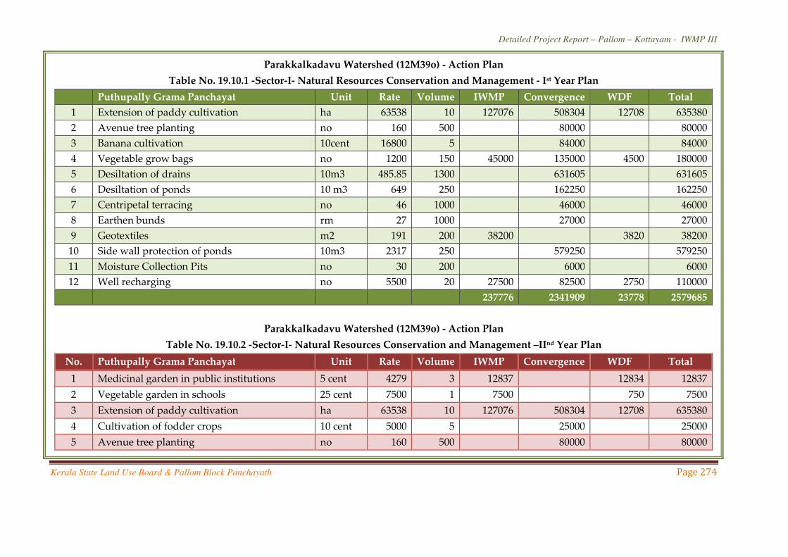


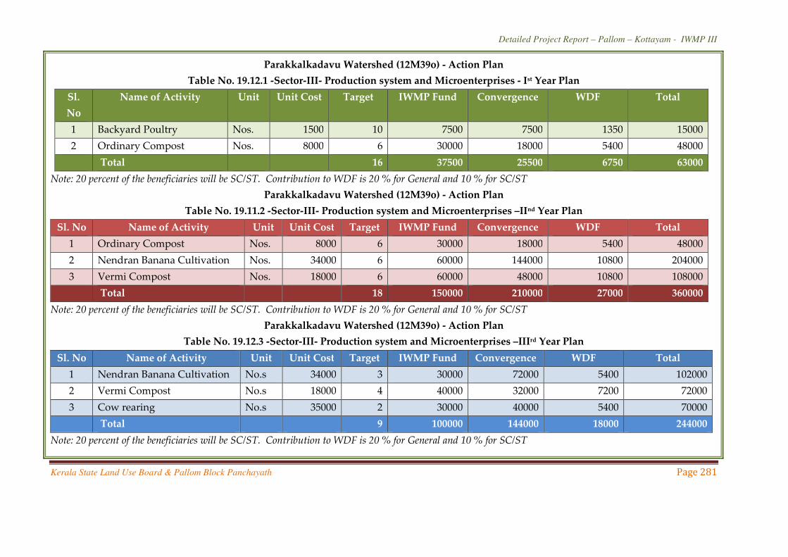


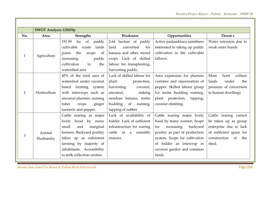

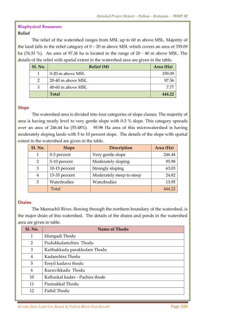

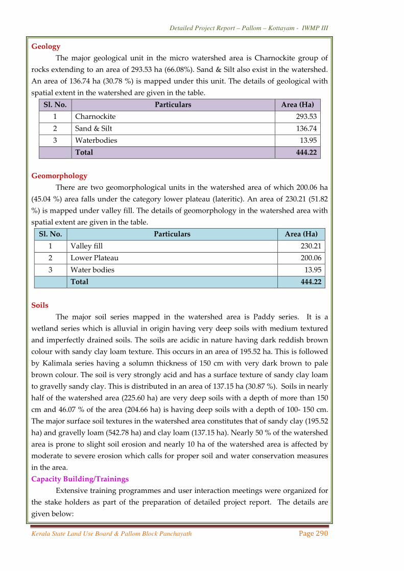

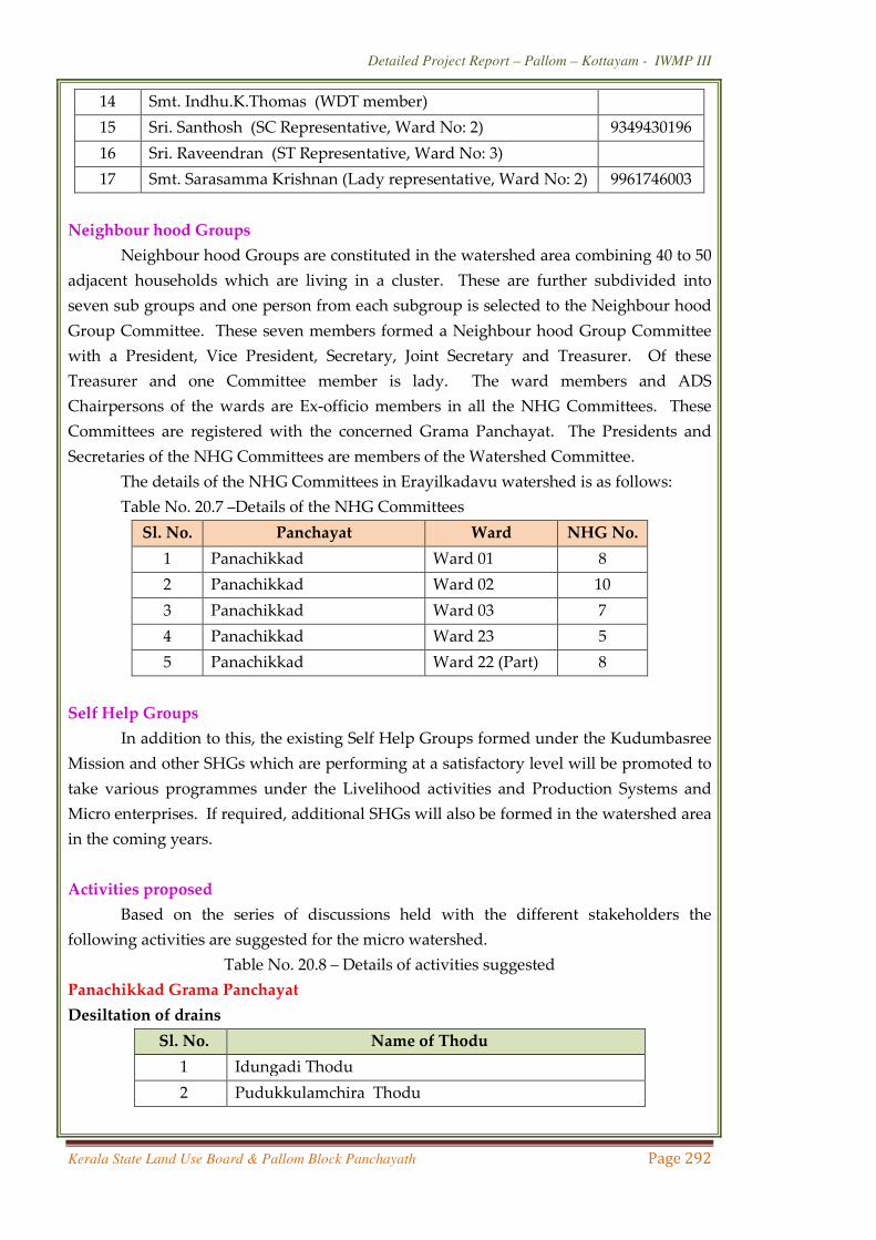

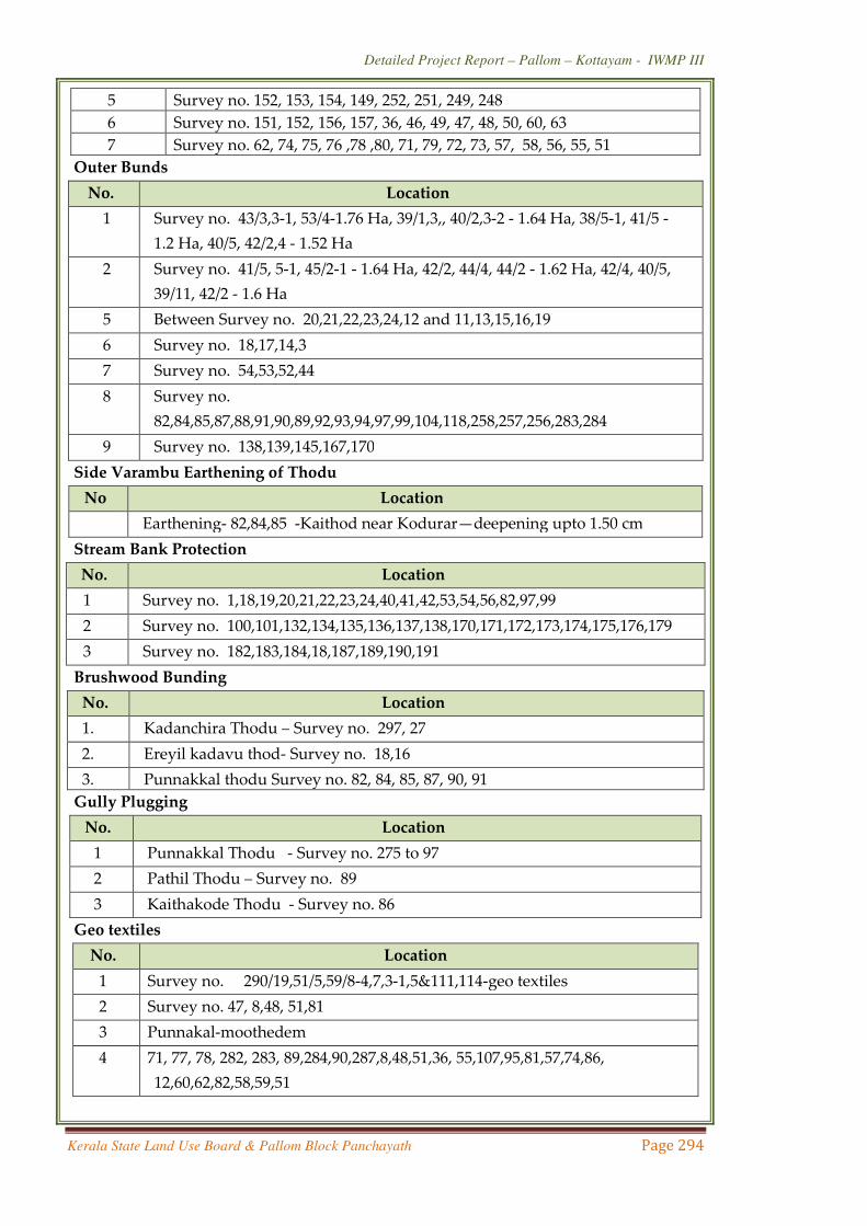

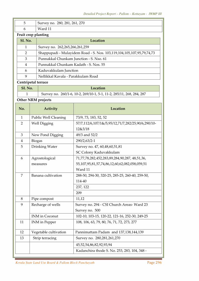


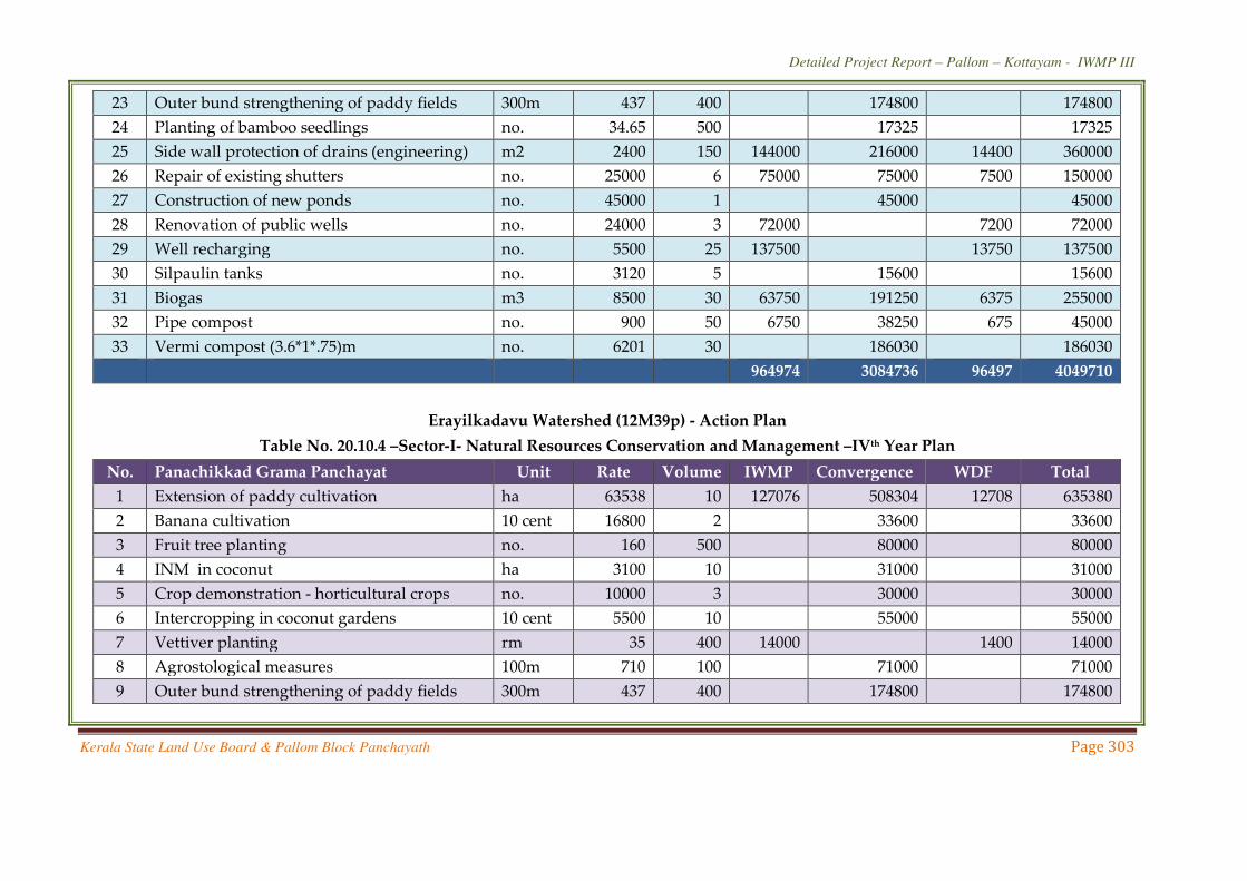


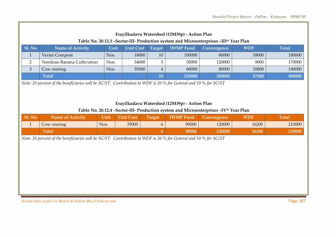


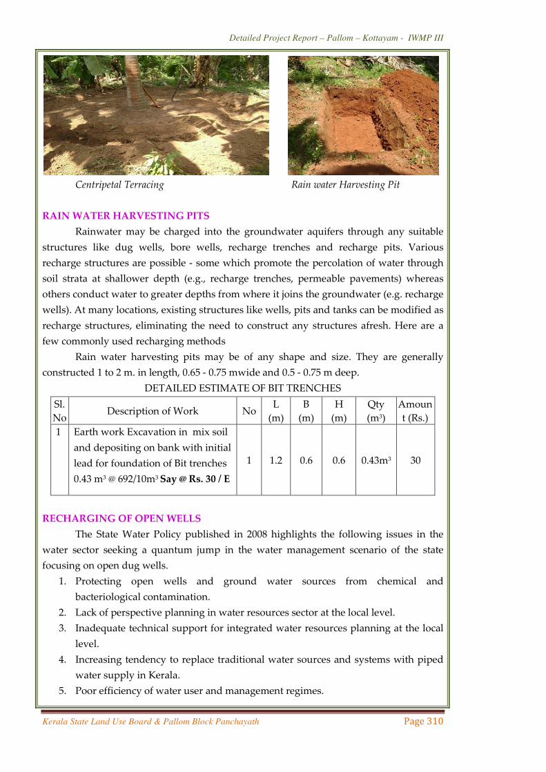


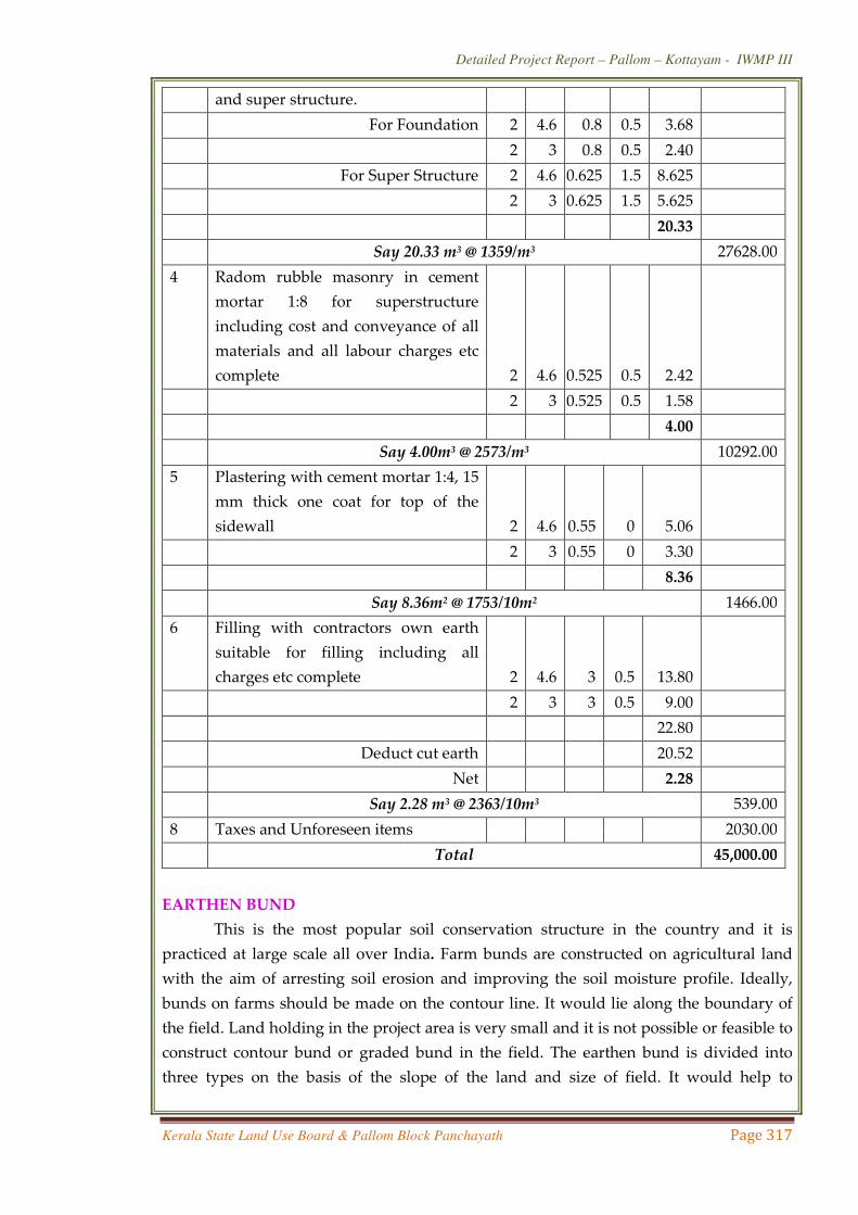


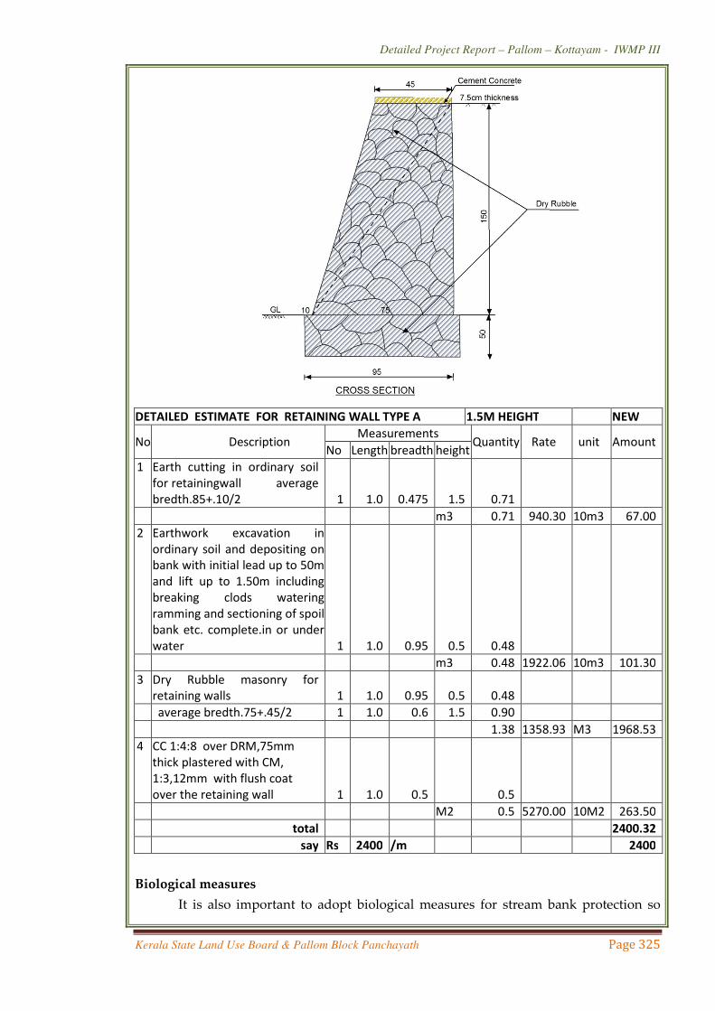


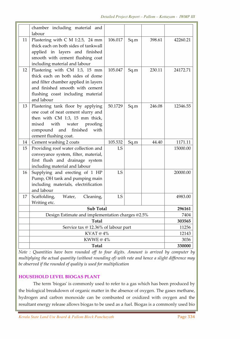


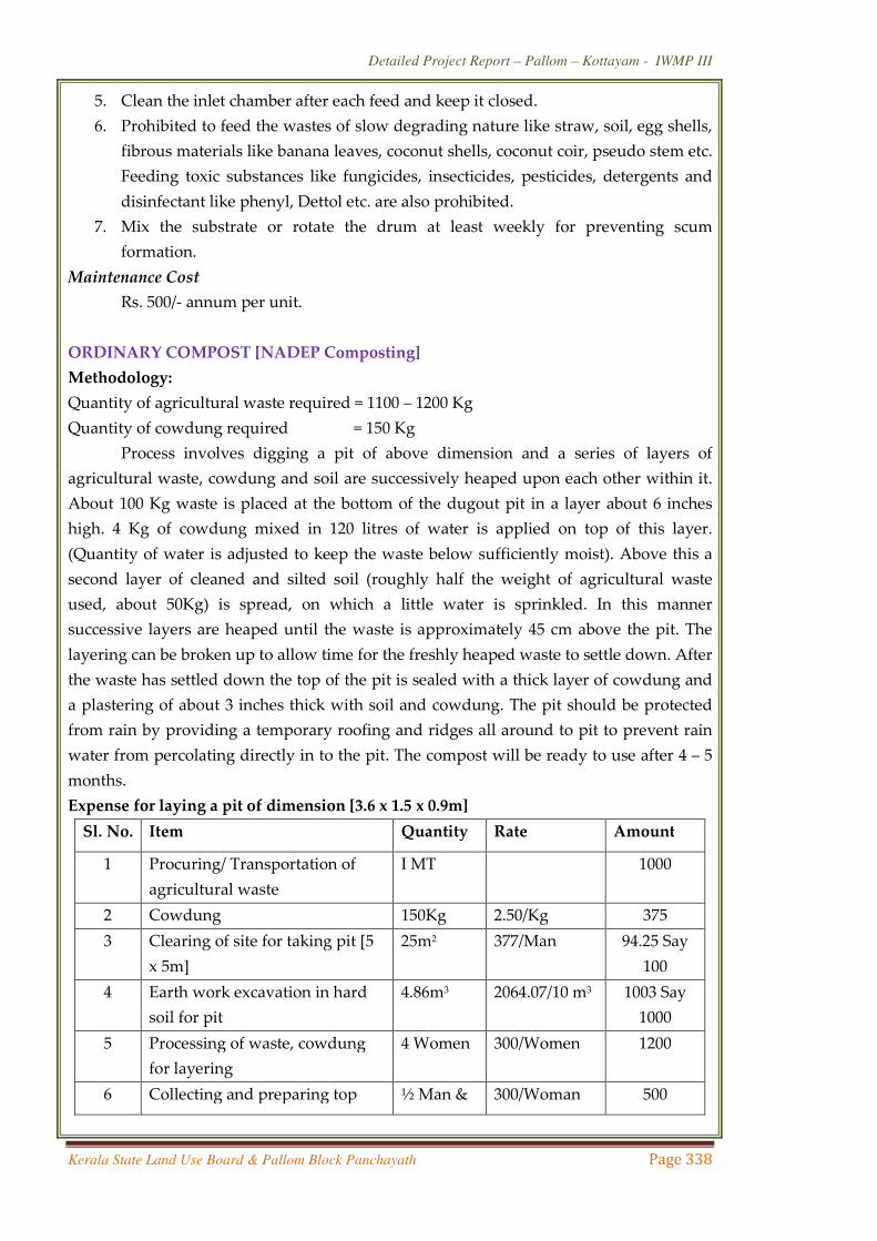


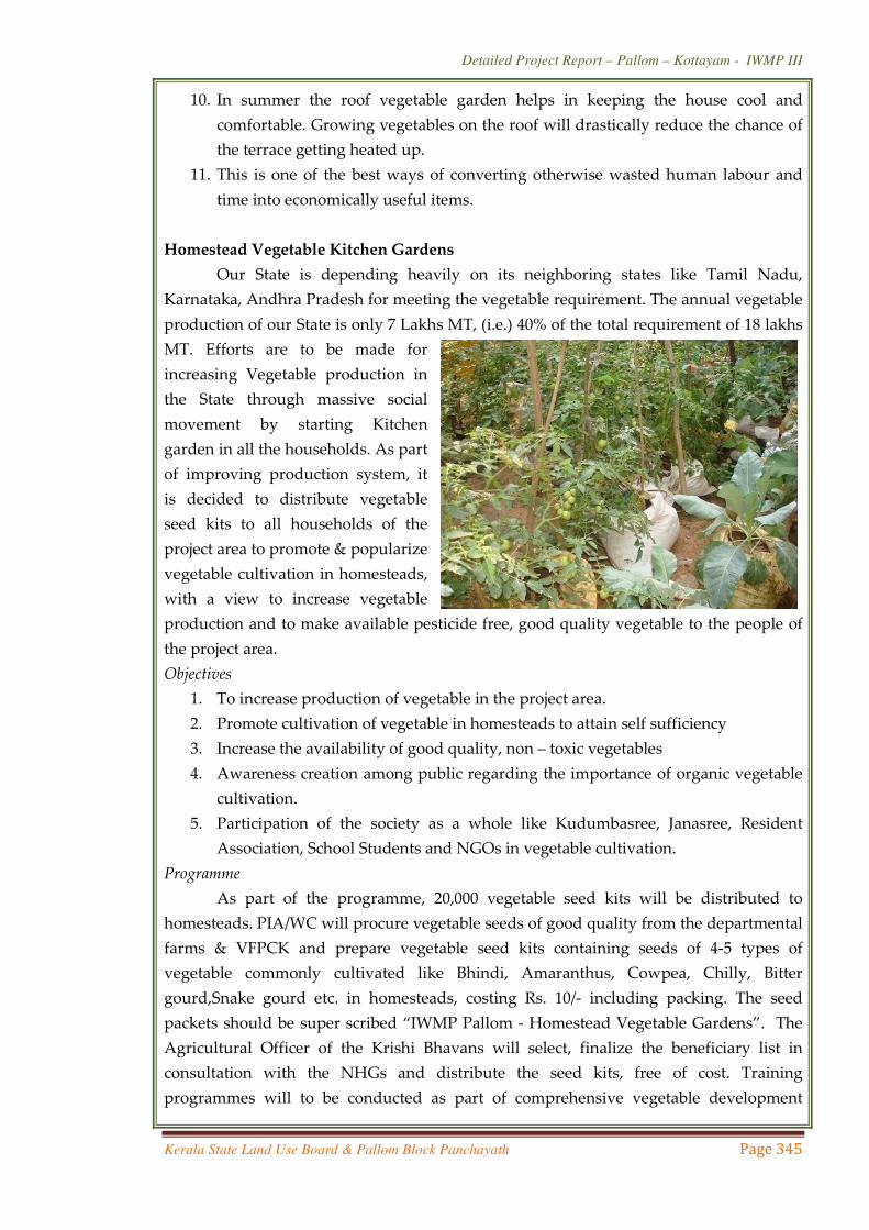


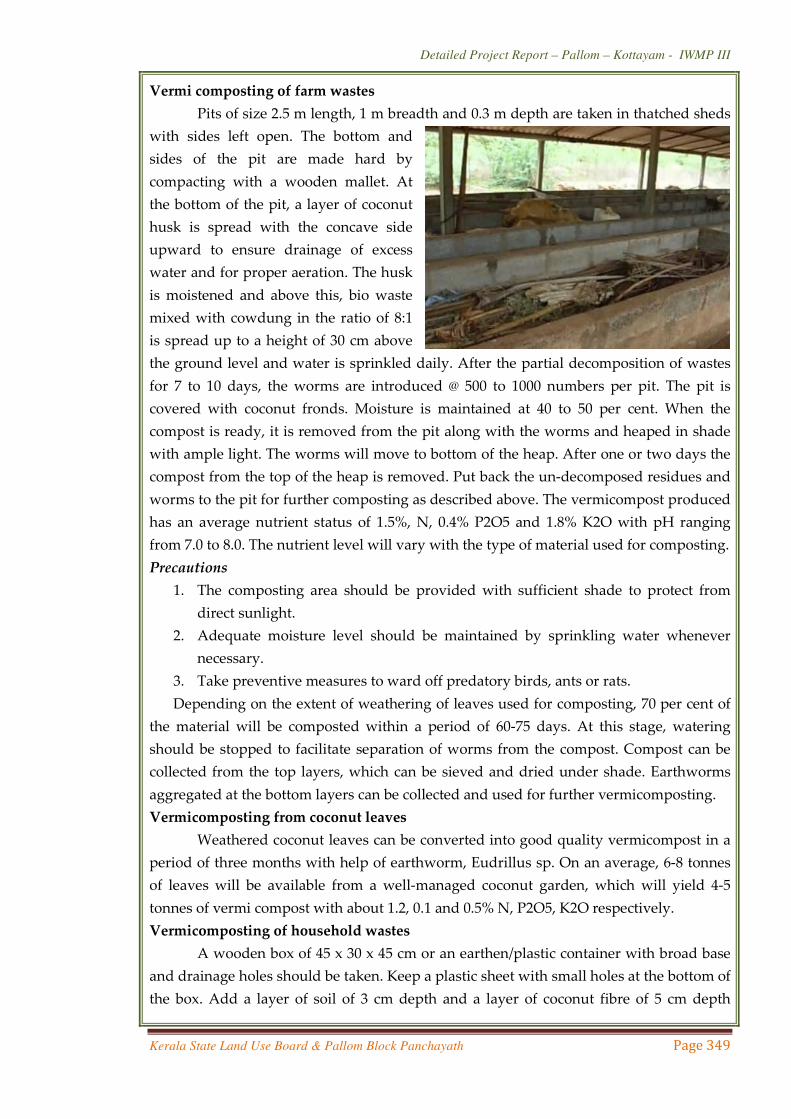


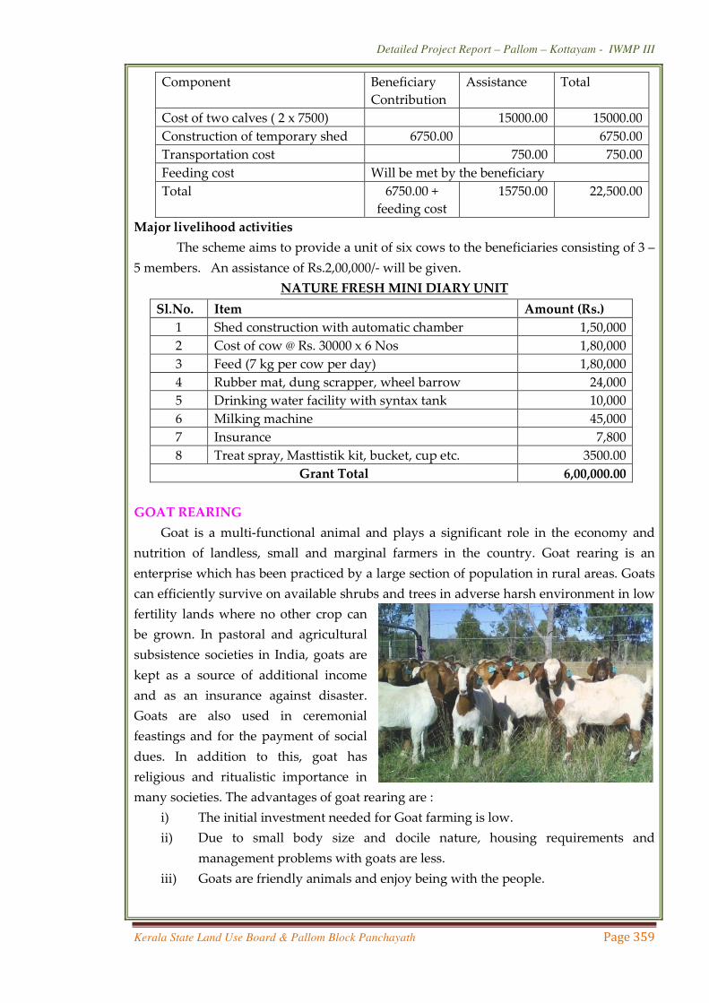

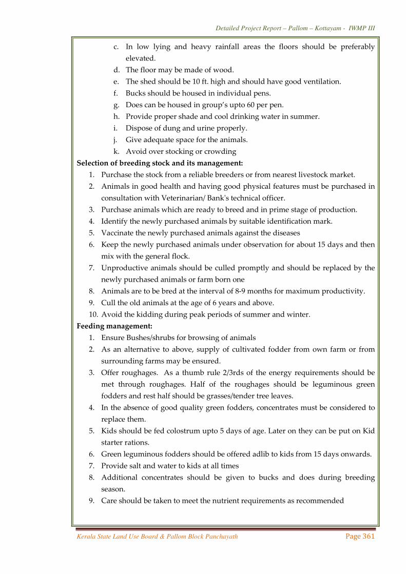

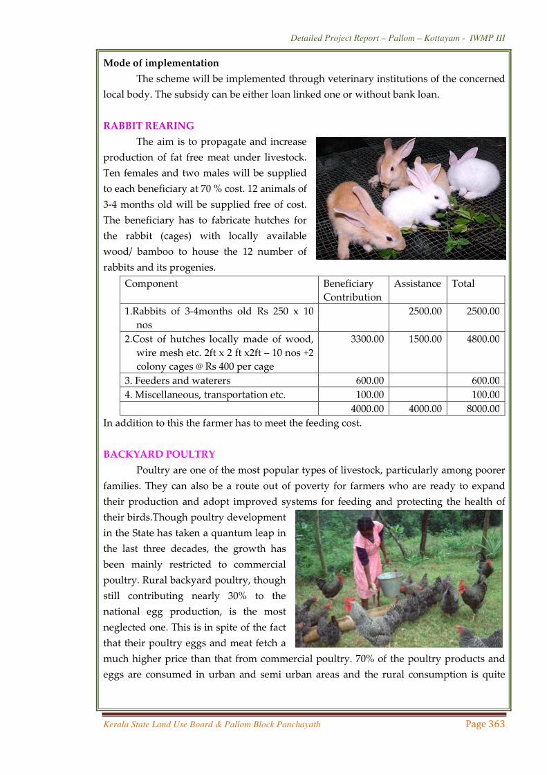
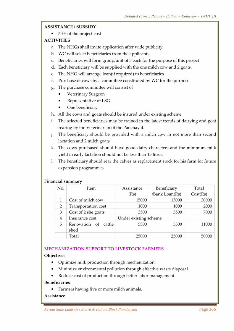


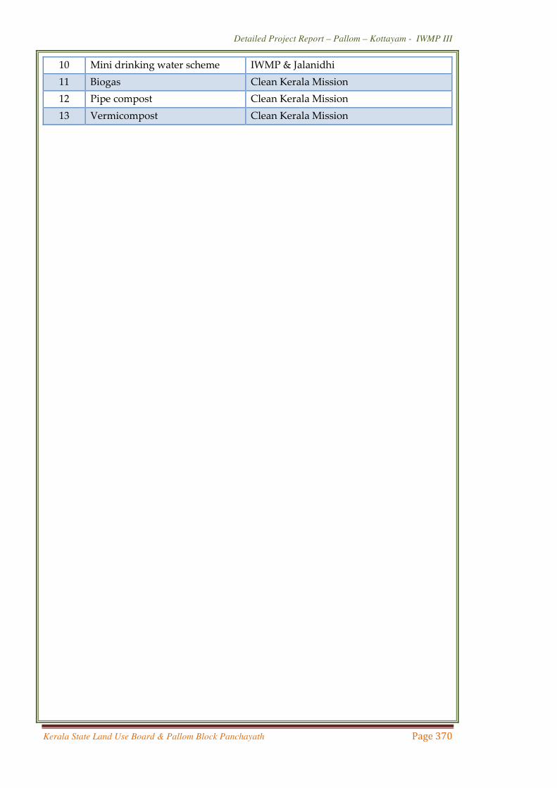

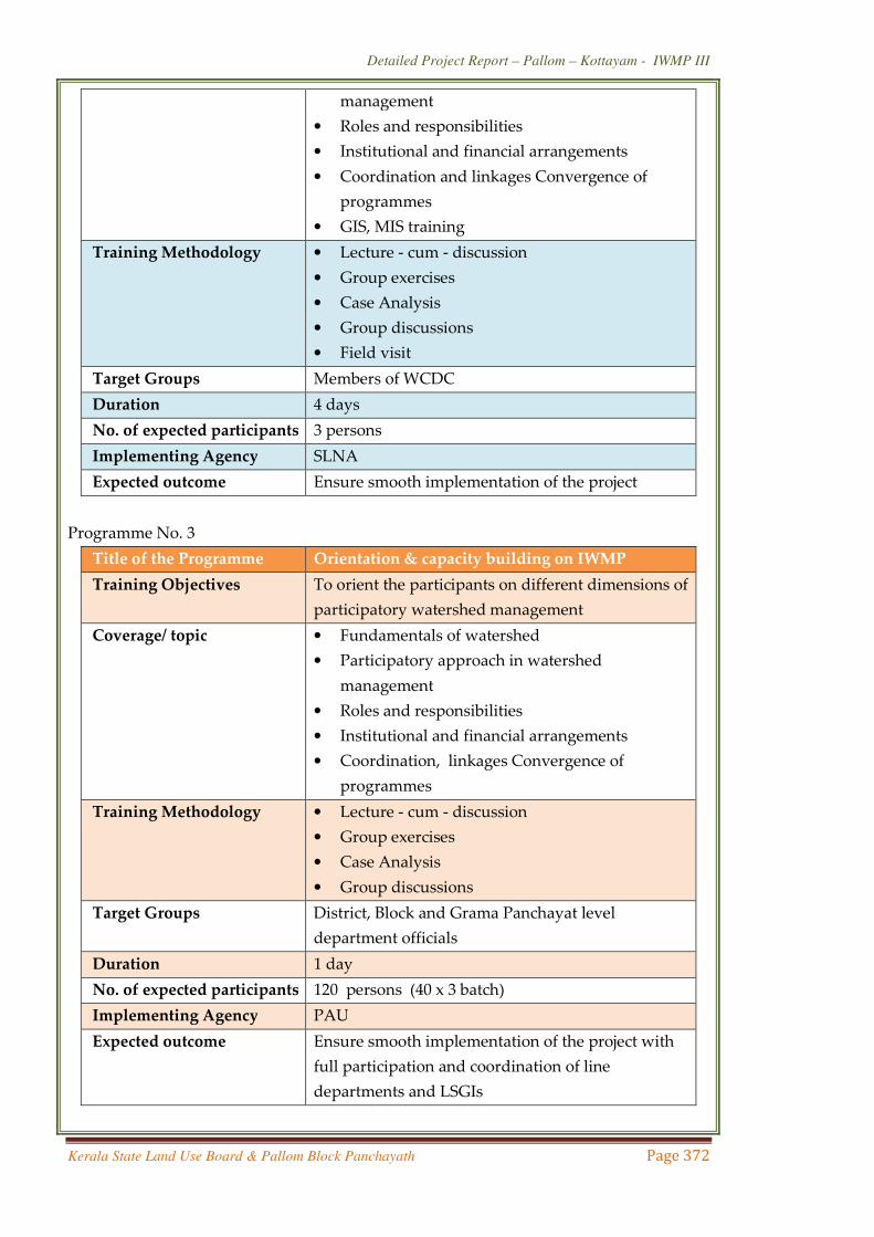


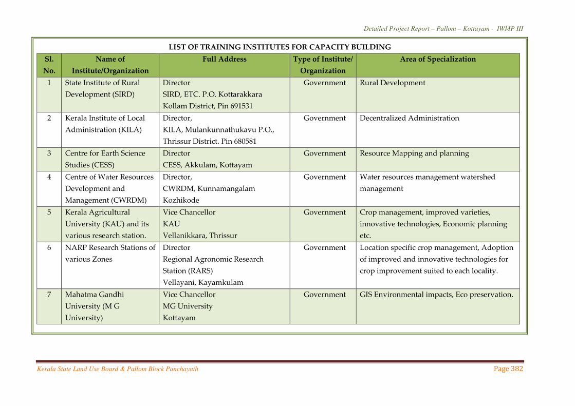
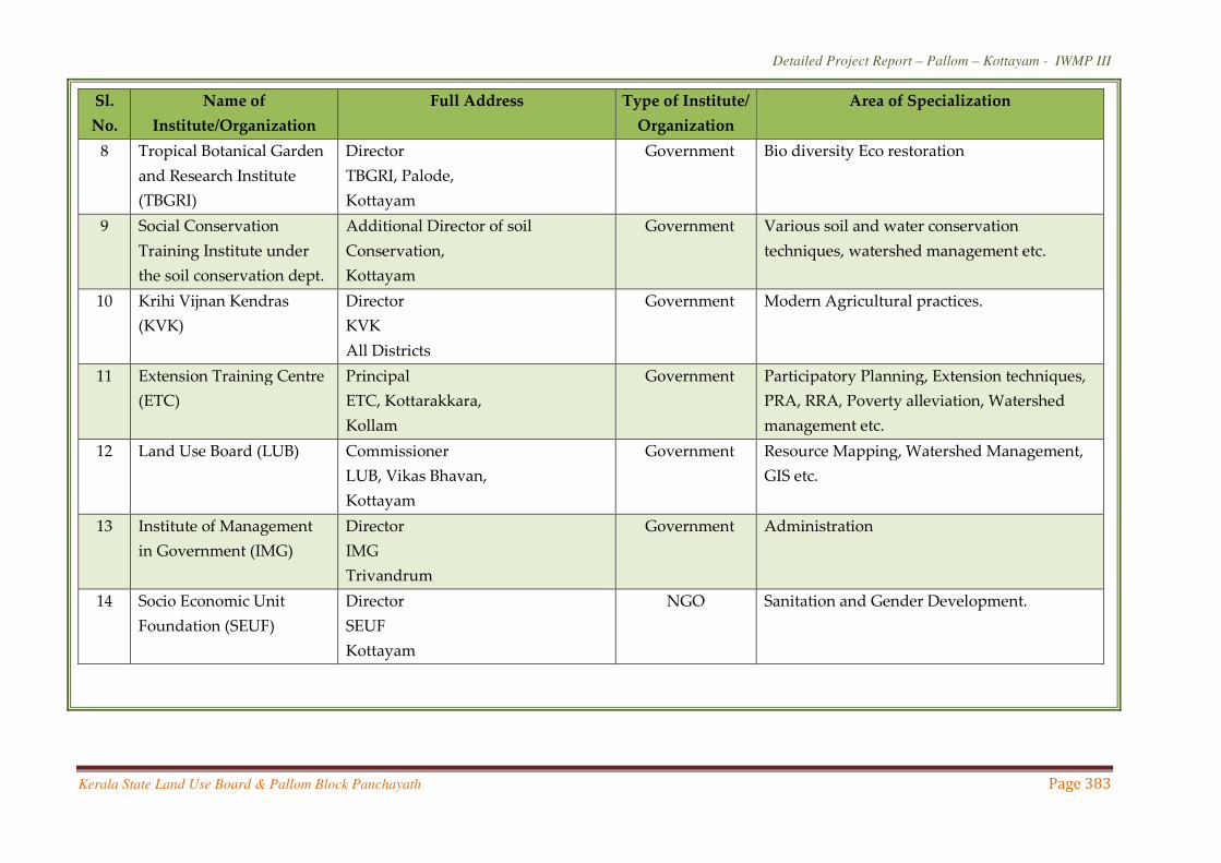

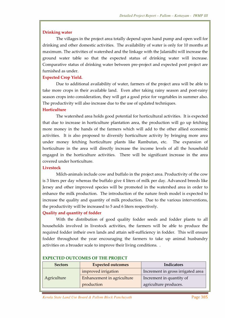
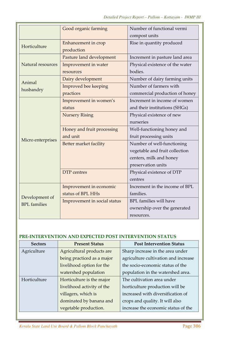
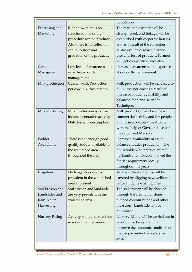


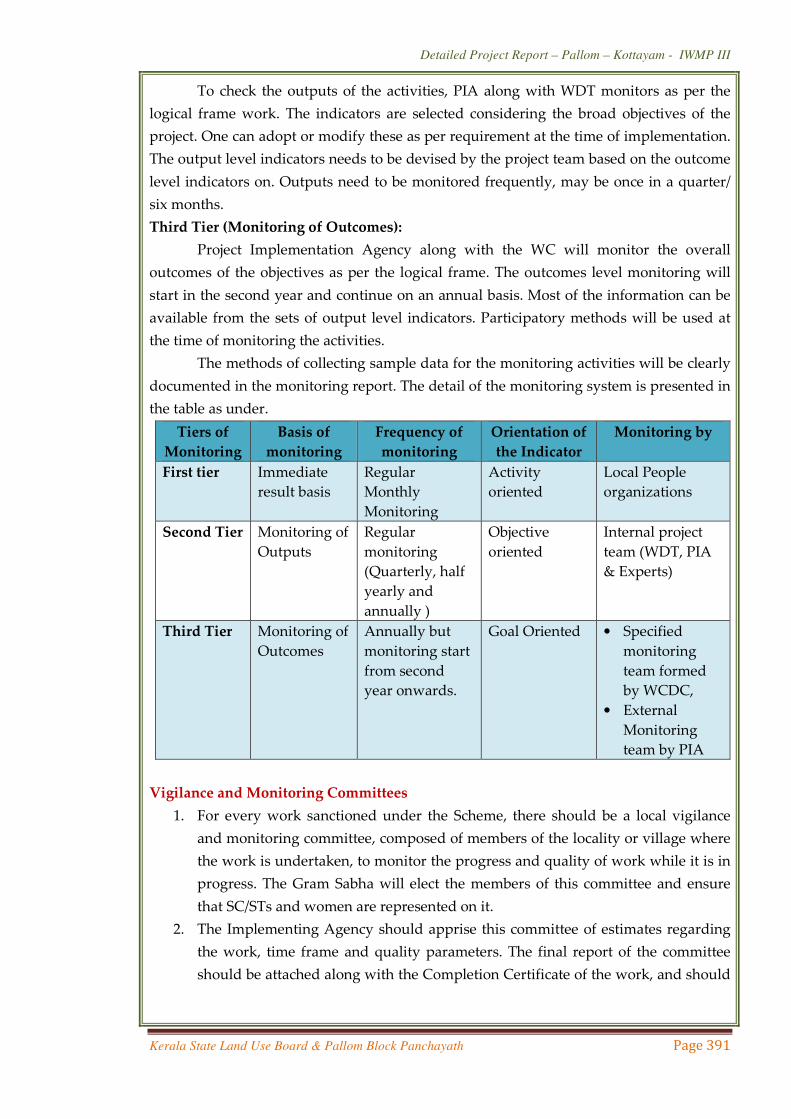

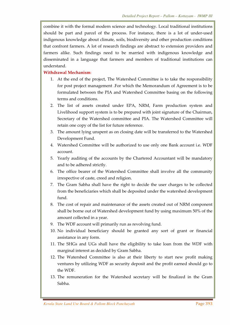


![IWMP-XIII-Rampur, Shimla, Himachal Pradesh 2011-12hprural.nic.in/IWMP_XIII_Rampur_Shimla.pdfIWMP -XIII (2011-12) Rampur[Page-1] DETAILED PROJECT REPORT IWMP-XIII-Rampur, Shimla, Himachal](https://static.documents.pub/doc/80x56/5b39fb357f8b9a5a178f0088/iwmp-xiii-rampur-shimla-himachal-pradesh-2011-xiii-2011-12-rampurpage-1.jpg)

