Diversion into the Maurepas Swamps A Complex Project under the Coastal Wetlands Planning, Protection, and Restoration Act Prepared for: U.S. Environmental Protection Agency, Region 6 Dallas, Texas Contract No. 68-06-0067 WA #5-02 Prepared by: Lee Wilson & Associates, Inc. Santa Fe, NM with: Drs. Gary Shaffer and Mark Hester Southeastern Louisiana University Hammond, LA and Dr. Paul Kemp, Hassan Mashriqui, Dr. John Day, and Robert Lane Louisiana State University Baton Rouge, Louisiana June 2001
Transcript
Diversion into the Maurepas Swamps
A Complex Project under the
Coastal Wetlands Planning, Protection, and Restoration Act
Prepared for:
U.S. Environmental Protection Agency, Region 6 Dallas, Texas
Contract No. 68-06-0067
WA #5-02
Prepared by:
Lee Wilson & Associates, Inc. Santa Fe, NM
with:
Drs. Gary Shaffer and Mark Hester Southeastern Louisiana University
Hammond, LA and
Dr. Paul Kemp, Hassan Mashriqui, Dr. John Day, and Robert Lane Louisiana State University Baton Rouge, Louisiana
June 2001
REPORT ON MAUREPAS RESTORATION PROJECT EXECUTUVE SUMMARY
ES-1 CWP:599:Report:Maur_Tech_Comm_Summary.Doc
EXECUTIVE SUMMARY
The Study. This report addresses wetlands south of Lake Maurepas, a large water body located near and northwest of New Orleans, Louisiana. Recent federal and state restoration initiatives, especially the Coastal Wetlands Planning, Protection and Restoration Act (CWPPRA), have identified the south Maurepas as an area where wetlands vegetation (especially the cypress-tupelo swamp) is stressed and dying, and in need of restoration.
A major cause of swamp deterioration is that flood control on the Mississippi River has eliminated the natural inputs of freshwater, nutrients, and sediment that historically built and maintained the wetlands. River diversions into the South Maurepas swamps are a recognized restoration strategy, with the purpose of reversing existing conditions of cypress-tupelo stress and loss by addressing the problems of subsidence, permanent flooding, and sediment and nutrient starvation.
The concept to divert Mississippi River water into the region of degraded swamp south of Lake Maurepas was nominated for consideration on Priority List 9 of the CWPPRA program, and was defined as a complex project. The Maurepas Phase 0 complex project study is a reconnaissance-level effort to develop and compare project alternatives, and select the most appropriate project to be recommended for further evaluation. Activities within the scope of this study have include: 1) preliminary site reviews, 2) hydrologic modeling of existing conditions and basic diversion scenarios, 3) baseline ecological field studies, and 4) surveying of elevations and cross-sections.
Project Site. Four potential diversion sites were identified for consideration, based mainly on availability of information from prior studies (including the Mississippi River Sediment, Nutrient, and Freshwater Redistribution Study (MRSNFR)) and inputs from local governments and other interested persons. The four locations reviewed were Reserve Relief Canal, Hope Canal, Convent, and Romeville.
The approach was to examine major factors that are either important to imparting benefits to the swamp or to avoiding unacceptable human conflicts or excessive costs, and to consider any potentially irresolvable conflicts that could represent “fatal flaws” to project implementation.
Diversion sites in the upper part of the Maurepas basin, including the Romeville or Convent sites, would deliver water directly to the headwaters of the Blind River, which has a relatively large channel capacity. As a result, most diverted water would be delivered directly to Lake Maurepas, resulting in minimal benefit to the swamps and maximum nutrient loading and turbidity in Lake Maurepas. Engineering needed to address this significant outfall management problem would add substantial expense and complexity to a project, and associated structures could interfere with navigation in the river. The Blind River also has development along its banks, and addition of diverted water would lead to stage increases that could add to flooding concerns.
Diversion structures at Reserve Relief Canal would be in a heavily populated and developed area, and would require a relatively large number of relocations of people and residences. Significant delays in project implementation would be expected due to the time required for negotiated relocations, with associated high costs. Potential drainage and flooding issues could
REPORT ON MAUREPAS RESTORATION PROJECT EXECUTUVE SUMMARY
ES-2 CWP:599:Report:Maur_Tech_Comm_Summary.Doc
be aggravated by the fact that the immediate vicinity of the diversion is already developed, and because there could be conflicts with the planned hurricane protection levee. These problems are generally present throughout the lowermost part of the study area, and suggest that the diversion needs to be substantially upstream of the developed areas that occur in and near Laplace and Reserve.
The Hope Canal site between Garyville and Gramercy is far enough downstream that water diverted there has the potential to flow directly into the swamps where benefits are needed, and far enough upstream to minimize conflicts with existing development and the Hurricane Protection Levee. There is largely undeveloped land that extends from the river to Airline Highway to accommodate a conveyance channel to Hope Canal. The existing Hope Canal channel from Airline Highway to I-10 would require improvements, creating potential benefits in providing capacity for relief of local drainage problems. The small size of the channel north of I-10 is a benefit, as it facilitates outfall management and maximizes the amount of diverted water that would be introduced into sheet- flow through the swamp. As the most promising site, Hope Canal was the location used to conduct further hydrologic modeling scenarios of diversions.
Project Size . Diversion size was provisionally set based on the assumption that cost and logistical factors would make it important to fit a diversion project into the existing channel beneath I-10. The limiting discharge capacity through the I-10 bridge was found to be between 1,500 and 2,000 cfs; the more conservative value of 1,500 cfs was used for modeling the project, to limit water velocities within the channel at the I-10 bridge.
Project Features. To estimate potential costs and benefits of a diversion project, a conceptual project in the Hope Canal area was defined to include the following features.
• A diversion at the Mississippi River, using box culverts. These would give the greatest flexibility in diversion operations, would allow diversion of water throughout most of the year, would allow the most flexibility in operations and control over volume discharged, and would provide the greatest potential sediment benefits. Two 10’ x 10’ box culverts would be capable of achieving the target flow of 1,500 to 2,000 cfs. Invert would be set to assure capability of essentially year-round diversion. A 100’ x 100’ (bottom dimension) receiving pond at the outfall of the box culverts would be used to slow water velocities and cause coarser sediments to drop out for ease of maintenance.
• A new channel from the diversion structure to a point just north of Airline Highway, where the constructed channel would intersect the Hope Canal. The channel, located just east of the Kaiser tailings ponds, would be used to convey water safely across agricultural/industrial lands and developed infrastructure to the existing Hope Canal. Relocations and structures needed to cross River Road, the railroad, the intervening pipelines, and Airline Highway are included in project costs.
• An improved channel along the existing Hope Canal from just north of Airline Highway to Interstate-10. The improvements, including guide levees, would expand the carrying capacity of Hope Canal from the existing 100 to 150 cfs up to 2,000 cfs (conveyance channels were sized for cost estimates at 2,000 cfs to assure sufficient capacity for diverted plus existing flow). The guide levees would retain water within the channel until it is released north of I-10. Without guide levees, most flow entering Hope Canal north of Airline Highway would be distributed into the swamps south of I-10, which are
REPORT ON MAUREPAS RESTORATION PROJECT EXECUTUVE SUMMARY
ES-3 CWP:599:Report:Maur_Tech_Comm_Summary.Doc
not the main target for this project. Guide levees along this portion of Hope Canal also would prevent impacts to water levels in the swamps that adjoin the developed areas south of Airline Highway. Use of the comparatively large conveyance capacity of the improved channel could be coordinated with Parish drainage plans to provide substantial benefits to local drainage and flood control needs.
• The existing Hope Canal channel, with outfall management structures, between I-10 and Lake Maurepas. The existing small conveyance capacity of the canal (100 to 150 cfs) and numerous existing breaks in the canal banks in combination with outfall management will minimize the amount of diverted water that would remain in the channel and flow directly to Lake Maurepas without first flowing through the swamp. Outfall management would include additional gaps in a remnant railroad bed that parallels the west side of Hope Canal, and channel constrictions in the canal.
Hydraulic Capacity of the Receiving Area. UNET modeling results show that, with a navigable channel constriction in place, essentially all diverted flow would enter the swamp system north of I-10. Diverted water would be broadly distributed within the swamp system between I-10 and the south shore of Lake Maurepas. The receiving area can absorb 1,500 cfs of flow without unacceptable water level increases, indicating that this size of diversion is not too large. At fully developed flow (i.e., after the model is run for a one-month period and water level stages have reached equilibrium), water levels at the Airline Highway crossing are about 4.3 feet in a low-tide scenario (lake water level at 1 foot), and 4.5 feet in a high- tide scenario (lake level at 2 feet). Clearly, lake level does not have a substantial impact on backwater levels in the upper part of the Hope Canal system.
Similarly, a 1,500 cfs diversion run continuously to equilibrium does not have a substantial effect on stages near the lake, another indication that such a diversion in not too large for the receiving system. At fully developed flow under a high tide scenario, water level at the end of Hope Canal is only about 0.25 feet above lake level; and water level in Dutch Bayou is the same as the lake level. The greatest increase in water leve l over that of the lake is predicted to be 0.3 to 0.5 feet for the reach from I-10 to the power line, about two-thirds of the way from I-10 to the end of Hope Canal. See the subsequent section on water quality for a discussion of the nutrient assimilation capacity of the receiving area.
Project Costs. The cost estimate prepared as part of this Phase 0 evaluation is an approximation made to estimate a benefit-cost relationship for the prospective project. This cost estimate has been prepared based largely on estimates made for comparable projects during the MRSNFR study, updated as needed to year 2001 dollars, and adjusted as appropriate for the specifics of the Hope Canal area.
The largest component of the project budget is relocations, which is a broad term that includes all costs associated with crossing River Road, Airline Highway, two main railroads, and numerous pipelines. These costs are relatively insensitive to the size of the diversion, and are probably typical of any major diversion project that might benefit the Lake Maurepas swamps. As a practical matter, costs of this magnitude are unavoidable if Louisiana’s coastal restoration process is to include a project with major benefits to the Lake Maurepas area.
Using conventional CWPPRA procedures, the estimated total cost of ¢$50,908,114 is equivalent to an annualized cost of about ¢$5,492,451. Note that this cost reflects amortization over a 20-
REPORT ON MAUREPAS RESTORATION PROJECT EXECUTUVE SUMMARY
ES-4 CWP:599:Report:Maur_Tech_Comm_Summary.Doc
year period whereas project benefits (see next section), though estimated for a 20-year period, will continue over a much longer time.
General Project Benefits. Long- lived species regenerate slowly and must do so effectively. Large mortalities can’t be tolerated, as they can among short- lived species. To preserve swamps in the long term, conditions must be re-established that both allow survival of existing cypress and tupelo trees, and allow at least periodic reproduction and recruitment of seedlings. Non-stagnant water, accretion and freshening are all needed to achieve these goals. From the perspective of sustainable ecosystem management, it is believed that implementation of a diversion of appropriate size into the swamps south of Lake Maurepas is the essential and singular approach that can move the swamps back toward environmental sustainability.
Implementation of the proposed diversion will greatly increase flow through the project area, which will provide constant renewal of oxygen- and nutrient-rich waters to the swamps. Benefits will include measurable increases in productivity, which will help build swamp substrate and balance subsidence, as well as increases in growth of trees, reduced mortality, and an increase in soil bulk density. As accretion improves, there also is expected to be an increase in recruitment of new cypress and tupelo, required for long-term sustainability of the swamp.
Anticipated sediment benefits to the swamp include direct contribution to accretion, as well as contribution to biological productivity through the introduction of sediment-associated nutrients, which also contributes to production of substrate. A conservative estimate of sediment loading to the target swamps from a Maurepas diversion would represent a loading per area of >1000 g/m2 /yr, or about twice the quantity estimated as needed to keep up with subsidence.
Results of this Phase 0 study show the Maurepas swamps are almost certainly nutrient limited. Other studies provide the expectation that the addition of nutrients with diverted water would at least double growth rates of the dominant swamp trees. An important adjunct to this is that it is estimated that nutrients added with diverted river water would be essentially completely taken up within the swamp (i.e., prior to discharge to Lake Maurepas). The addition of nutrients and associated increase in production will contribute substantially to the buildup of swamp substrates (accretion) through organic contribution, which will help counterbalance subsidence. So, nutrient additions will directly improve the health of the trees and conditions of the swamp, and in the long run also will help generate a condition more conducive to sprouting and recruitment of cypress and tupelo seedlings.
This study also shows the impacts of saltwater intrusion on the cypress-tupelo swamps, including significant mortalities of tupelo, red maple and ash, and suppression of tree productivity in the areas of highest salinity. Saltwater intrusion in the Maurepas swamps is impacting swamp vegetation already stressed by excessive flooding. The proposed diversion is expected to directly ameliorate increasing salinities in the swamps south of Lake Maurepas, as well as in the lake itself. This is expected to largely prevent the high mortalities previously observed in the project area. More persistently freshwater conditions are also expected to help increase tree and herbaceous productivity, which along with the flow-through of oxygen-, sediment- and nutrient rich waters, will contribute to stronger (higher bulk density) substrates and increased accretion.
Beyond direct benefits to the swamps, it is expected that Lake Maurepas would experience significant freshening as a benefit, which could have a positive impact on fisheries as well as other ecosystem components. Rivers and bayous entering the lake, such as Blind River, also
REPORT ON MAUREPAS RESTORATION PROJECT EXECUTUVE SUMMARY
ES-5 CWP:599:Report:Maur_Tech_Comm_Summary.Doc
have been impacted by increasing salinities, as well as by stagnant water conditions, and will garner freshwater benefits from the proposed diversion.
The Gulf of Mexico continental shelf off Louisiana currently experiences widespread hypoxia (low dissolved oxygen conditions) during the summer, attributed to direct introduction of nutrient-rich water from the Mississippi River. It has been recommended that wetlands and shallow water bodies be used to process river water before it enters the gulf, to reduce the magnitude of this hypoxic zone as well as help restore the wetlands. Since this study indicates that about 94% to 99% of the nutrients introduced in diverted water will be processed and retained by the swamps, it can be assumed that contribution of this diversion toward amelioration of Gulf hypoxia would be proportional to the magnitude of flow of the diversion compared to that of the Mississippi River. Because the volume of the proposed Maurepas diversion is small compared to average flows in the river, by itself this diversion would not have a measurable impact on the size of the hypoxic zone. But the proposed diversion should be viewed as a functional component of a potentially larger system of diversions that together can ameliorate nutrient delivery to the Gulf.
WVA Benefits. The procedure for evaluating the benefits of CWPPRA projects to swamp habitats, the Wetland Value Assessment (WVA) swamp model, uses a series of variables that are intended to capture the most important conditions and functional values of a swamp. Values for these variables are estimated for existing conditions, for conditions projected into the future if no restoration efforts are applied, and for conditions projected into the future if the proposed diversion project is implemented, providing an index of “quality” of the swamp for the given time period. The quality index is combined with the acres of swamp to get a number that is referred to as “habitat units”. Expected project benefits are estimated as the difference in habitat units between the futures with and without the project. To allow comparison of WVA benefits to costs for overall project evaluation according to CWPPRA requirements, total benefits are averaged over a 20-year period, with the result reported as Average Annual Habitat Units (AAHUs).
The institutional constraint of considering project benefits only over 20 years is widely understood to underestimate benefits in a swamp because cypress and tupelo trees are very long-lived, and their response (positively or negatively) to environmental change may take many decades to be realized. In particular, a diversion now could prevent catastrophic loss of swamp areas 30 or 40 years in the future. Thus, the merits of a diversion into the Maurepas swamp have probably been underestimated. The total WVA benefits estimated for the project are 8,486 AAHUs.
Drainage Issues. The increased channel capacity in Hope Canal should provide greater ability to remove storm water from the existing Garyville drainage system, and the operation plan for the diversion would be developed to accommodate such a use. Prior to anticipated rainfall events, the diversion structure would be closed. Hydrologic modeling indicates that following closure, water levels in the channel return to near ambient level within about 4 hours, at which point substantial capacity for forced drainage of local runoff would be available. Without question, the potential drainage capacity of the improved Hope canal would be much larger (up to an order of magnitude) than is now available. Other features compatible with the improved conveyance channel could be developed to enhance local drainage. These could include lateral drainage canals built parallel to the railroad grades (and/or possibly to the Airline Highway
REPORT ON MAUREPAS RESTORATION PROJECT EXECUTUVE SUMMARY
ES-6 CWP:599:Report:Maur_Tech_Comm_Summary.Doc
embankment) and tied into the diversion conveyance channel, which would collect impounded rainfall and discharge it into the diversion channel, bypassing existing drainage constrictions. Consideration also could be given to integrating the improved conveyance channel and any associated drainage features, with any new drainage features that would be developed as part of the Lake Pontchartrain West Shore Hurricane Protection Study, to further benefit drainage in the Garyville area.
Any and all future efforts associated with the proposed Maurepas diversion will be coordinated to ensure the appropriate linkage with local drainage plans and needs, including the Master Drainage Plan being developed by St. John the Baptist Parish, as well as with hurricane protection features.
Water Quality Issues. One of the main concerns with regard to any diversion into the upper Pontchartrain Basin is the possibility of excess nutrient loading to Lake Maurepas or Pontchartrain, either by direct flow of diverted water to the lakes or by nutrient loading in excess of wetland uptake capacity. The nutrient of primary concern is nitrogen, which in excess quantities could lead to algal blooms in the lakes. Thus, other major goals of the proposed diversion project are to minimize direct flow of nutrients to the lakes, and to assess the capacity of the swamps receiving diverted water to process and assimilate the associated nutrients.
Project attributes including the very limited conveyance capacity of Hope Canal north of I-10 and outfall management together strongly limit the direct flow of diverted water through Hope Canal to Lake Maurepas, and minimize nutrient loading to the lake from water remaining in channel flow. The vast majority (greater than 90%) of diverted water rapidly leaves the Hope Canal channel north of I-10 and enters sheet flow through the swamps. The ability of the swamps to assimilate the quantity of nutrients associated with this diverted water was estimated by focusing on nitrate. Both loading and uptake of nitrate was estimated using results of the UNET hydrologic model to define the pattern and quantity of flow of diverted water as it moves sequentially through sections of the receiving swamp, average concentrations of nitrate in river water, and estimates of uptake rates in relation to loading rates based on literature studies.
Sections of the swamp adjacent to Hope Canal and thus directly receiving river water (termed primary receiving cells) have the highest nitrate loading rates, and thus are expected to have uptake rates of 40% to70%. While this level of nitrate removal is not high, it results in water flowing to the next sections of swamp (termed secondary receiving cells because they receive water mainly from primary cells) with much lower nitrate concentrations. The resulting secondary loading rates are associated with removal efficiencies of 90% to 95%. Thus, the minimal reduction in nitrate along the shortest flow pathway, from Hope Canal to Blind River, would be about 94% to 99% reduction in concentration. This brings the original river concentrations down to levels that are in the high end of the range of nitrate concentrations currently measured in the Maurepas swamp channels. These calculations suggest that little Mississippi River-derived nitrate will reach Lake Maurepas, even if a 1,500 cfs diversion were operated continuously at full capacity.
Other water quality issues include salinity, turbidity, and toxicity. The south Maurepas swamps are at lower elevation than is “natural”, and in addition, freshwater inputs to the region are limited mainly to the Tickfaw River, the Amite Diversion Canal, the Blind River, and rainfall/drainage. The region therefore is and will continue to be susceptible to saltwater intrusion whenever the limited freshwater inputs are diminished. It is expected that the
REPORT ON MAUREPAS RESTORATION PROJECT EXECUTUVE SUMMARY
ES-7 CWP:599:Report:Maur_Tech_Comm_Summary.Doc
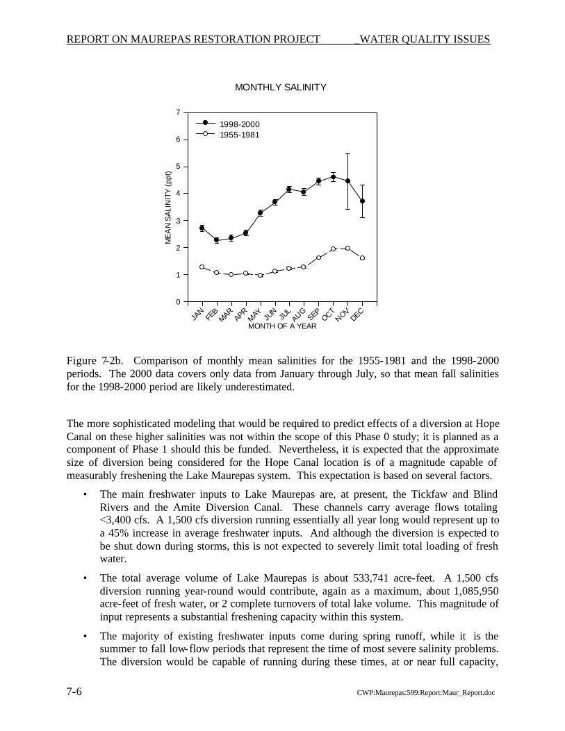
approximate size of diversion being considered for the Hope Canal location is capable of measurably freshening the Lake Maurepas system. This expectation is based on the magnitude of existing freshwater inputs from the main tributaries (<3,400 cfs) compared to the magnitude of the proposed diversion (about 1,500 cfs), representing almost a 45% increase in freshwater input, or almost two complete turn-overs of the volume of Lake Maurepas over a year. In addition, the diversion would be capable of running during the summer to fall low-flow periods that represent the time of most severe salinity problems, while the majority of existing freshwater inputs come during spring runoff. Turbidity is not expected to be a problem in Lake Maurepas from a diversion at Hope Canal, because virtually all of the diverted water is expected to flow through wetlands before reaching the lake, and most suspended sediments carried in river water would be retained within the swamps.
The issue often is raised of whether Mississippi River water is “clean enough” to introduce it into wetlands for restoration. This question was addressed in the Mississippi River Sediment, Nutrient, and Freshwater Redistribution Study (MRSNR; USACE, 2000). The conclusion from the MRSNFR study was that there were no issues of water or sediment quality that would preclude consideration of diversion of river water (and sediment) for restoration purposes. Only a few compounds, mainly mercury and some organochlorine pesticides that have been banned from use for well over a decade, were found to occasionally exceed water or sediment standards. However, the absence of significant observed bioaccumulation of these compounds was taken as evidence for no overall problems. The study recommended that when specific diversions are evaluated, site-specific studies should be considered if there is evidence of elevated concentrations of these compounds in the receiving area.
Status of Work on this Project. The Maurepas Phase 0 studies are considered complete, and are summarized in this report. Findings and recommendations of the Phase 0 study will be presented to the CWPPRA Technical Committee, and ultimately to the Task Force dur ing their July/August 2001 meeting. These findings, including the WVA benefits analysis and the project cost estimates, will form the basis for determining whether the Maurepas Diversion project should be moved forward and funded for Phase 1 Engineering and Design. A portion of the scientific studies that were initiated under Phase 0 and are planned to be continued as a component of Phase 1, covering the period from April through July 2001, has been funded, assuring the integrity of these studies, which involve time-sequenced sampling and require uninterrupted execution of the sampling program to be fully effective.
i CWP:599:Report:Maur_Tech_Comm_Summary.Doc
Table of Contents Executive Summary ES-1 1. Introduction 1-1
1.1 Problems That Led to Consideration of a Restoration Project 1-1 1.2 Project Development Plan 1-4 1.3 Project Concept 1-4 1.4 Phase 0 Study 1-7
2. Site Selection 2-1 2.1 Candidate Sites 2-1 2.2 Scope of site selection work in the Phase 0 study 2-1 2.3 Comparison Among Sites 2-4
3. Alignment, Sizing and Project Features 3-1 3.1 Alignment 3-1 3.2 Hydrologic Constraints on Size 3-2 3.3 Project features 3-3 3.4 Sizing evaluation in the receiving area 3-5
4. Project Costs 4-1 4.1 Costs to design and construct a 2,000 cfs diversion project in the Hope Canal area 4-1 4.2 Costs for Phase 1 engineering and design 4-2
5. Restoration Benefits 5-1 5.1 Nature of benefits to the Lake Maurepas swamps 5-1 5.2 Nature of other restoration benefits 5-4 5.3 Quantification of benefits through Wetlands Valuation Assessment 5-5
6. Consideration of Drainage Issues 6-1 6.1 Relationship of Project to General Drainage Conditions 6-1 6.2 Compatibility with Other Features 6-1 6.3 Safety Issues 6-2
7. Consideration of Lake Water Quality Issues 7-1 7.1 Nutrient Loading and uptake through Receiving Area 7-1 7.2 Salinity 7-5 7.3 Turbidity and Other Water Quality Issues 7-7
8. Potential Phase 1 Work 8-1 9. References 9-1
ii CWP:599:Report:Maur_Tech_Comm_Summary.Doc
List of Figures
Figure 1-1a and b. Examples of deteriorated cypress-tupelo swamp in the region south of Lake Maurepas, taken along Potato Run in the vicinity of sampling site 6 (north of Tent Bayou, south of Alligator Island, west of Dutch Bayou; see Figure 1-2).
Figure 1-1c and d. c) Example of deteriorated cypress-tupelo swamp in the region south of Lake Maurepas, taken along Potato Run in the vicinity of sampling site 6 (north of Tent Bayou, south of Alligator Island, west of Dutch Bayou; see Figure 1-2). d) Example of somewhat healthier swamp taken at Blind River near the Amite Diversion Canal.
Figure 1-2. Patterns of land loss in the Coast 2050 Region 1 for 1956-1990. From map produced by USGS National Wetlands Research Center.
Figure 1-3. Composite aerial photographic map of the southern Lake Maurepas study area, showing sampling and measurement locations for various study components, as well as the four candidate diversion locations reviewed.
Figure 1-4. Composite aerial photographic map of the southern Lake Maurepas study area, showing the network of channels included in the UNET model developed for this study, and the boundary of the study area incorporated in the model.
Figure 3-1. Map showing tentative alignment for a diversion at Hope Canal into the South Maurepas Swamps.
Figure 3-2. The I-10 bridge at Hope Canal.
Figure 3-3. UNET model results for a run at 1,500 cfs simulating one day of discharge, with no channel improvements north of Airline Highway, and no channel constrictions.
Figure 3-4. UNET model results for a run at 1,500 cfs, with channel improvements north of Airline Highway, and with one channel constriction in Tent Bayou.
Figure 3-5. Effect of lake level on stage in the Hope Canal System, based on a UNET model run for a 1,500 cfs diversion, with lake water levels set at 1 ft and 2 ft.
Figure 5-1. WVA project area for Maurepas Diversion project, including subareas.
Figure 7-1. Daily nitrate loading rate versus removal efficiency for various river diversions and wetland wastewater treatment systems.
Figure 7-2. a) Mean annual salinity at Pass Manchac for 1951-2000. Note that data for 2000 only covers January through August. b) Comparison of monthly mean salinities for the 1955-1981 period and the 1998-2000 period. Again, the 2000 data covers only the January through July period, so that mean fall salinities for the 1998-2000 period are likely underestimated.
Figure 8-1. Estimated schedule for performance of Phase 1 activities for a diversion into the south Maurepas swamp.
iii CWP:599:Report:Maur_Tech_Comm_Summary.Doc
List of Tables
Table 2-1. Matrix summarizing comparison of factors among four candidate diversion locations into the south Maurepas swamps.
Table 4-1. Summary of estimated project costs for a diversion from the Mississippi River at Hope Canal into the swamps south of Lake Maurepas.
Table 4-2. Summary of estimated Phase 1 costs associated with the proposed project to divert Mississippi River water at Hope Canal into the swamps south of Lake Maurepas.
Table 7-1. Flow distribution, nitrate concentration, loading, and removal from primary, secondary, and tertiary receiving swamp cells for a diversion into Maurepas swamp.
Attachments
Attachment A. Project Development Plan (PDP) for the Study of a Diversion into the Maurepas Swamp, dated 6 January 2000.
Attachment B. Site location information for each of the four candidate diversion locations considered.
Attachment C. Hydrologic modeling of the Maurepas diversion.
Attachment D. Maurepas diversion project cost estimates.
Attachment E. Characterization of ecosystem health of the Maurepas swamp, Lake Pontchartrain Basin, Louisiana: Feasibility and projected benefits of a freshwater diversion.
Attachment F. Water quality analysis of a Mississippi River diversion into the Maurepas swamp.
Attachment G. Wetland Value Assessment project information sheet.
REPORT ON MAUREPAS RESTORATION PROJECT INTRODUCTION
1-1 CWP:Maurepas:599:Report:Maur_Report.doc
1. INTRODUCTION
1.1 PROBLEMS THAT LED TO CONSIDERATION OF A RESTORATION PROJECT
This report addresses wetlands south of Lake Maurepas, a large water body located near and northwest of New Orleans, Louisiana. As with all of the rapidly disappearing coastal wetlands in Louisiana, the south Maurepas area has been subject to extensive consideration in recent years pursuant to federal and state restoration initiatives, especially the Coastal Wetlands Planning, Protection and Restoration Act (CWPPRA). Three particularly important reports are listed below.
• The Louisiana Coastal Restoration Plan (1993), which identified many potential projects for wetlands restoration along Louisiana’s coast. The south Maurepas swamps were included within the Pontchartrain Basin.
• The Louisiana Coast 2050 report (1998), which provided a more strategic and participation-based approach to restoration. The south Maurepas swamps are part of the Amite/Blind Rivers mapping unit of Region 1, as defined in the Coast 2050 report.
• The Mississippi River Sediment, Nutrient and Freshwater Diversion study (1999), which looked specifically at projects for restoration by means of diverting Mississippi River water into wetlands, including the south Maurepas swamps.
All these studies have identified the south Maurepas as an area where wetlands vegetation (especially the cypress-tupelo swamp) is stressed and dying, and in need of restoration. Figure 1-1 illustrates the typical existing conditions in the swamps south of Lake Maurepas. The Coast 2050 report is perhaps the most comprehensive evaluation.
• The Coast 2050 team relied upon evaluations of existing information, local expertise and research, and site-specific surveys, to define the main causes of problems in the Maurepas swamps.
• The Coast 2050 report concluded that subsidence, permanent flooding, and sediment and nutrient starvation are significant factors contributing to the stress and predicted loss of the south Maurepas swamps. More recent work has shown that increased salinity is also a significant cause of tree mortality in the swamps.
• The primary regional strategy recommended by Coast 2050 was consideration of relatively small (about 2,000 cfs) Mississippi River diversions at Convent (into the Blind River) and Reserve Relief Canal (directly into the swamps). Subsequently, it was determined that there were other potential diversion sites, as discussed later in this report.
In summary, river diversions into the South Maurepas swamps are a recognized restoration strategy. Their purpose is to reverse existing conditions of cypress-tupelo stress and loss by addressing problems of subsidence, permanent flooding, and sediment and nutrient starvation.
REPORT ON MAUREPAS RESTORATION PROJECT INTRODUCTION
1-2 CWP:Maurepas:599:Report:Maur_Report.doc
Figure 1-1a and b. Examples of deteriorated cypress-tupelo swamp in the region south of Lake Maurepas, taken along Potato Run in the vicinity of sampling site 6 (north of Tent Bayou, south of Alligator Island, west of Dutch Bayou; see Figure 1-2).
REPORT ON MAUREPAS RESTORATION PROJECT INTRODUCTION
1-3 CWP:Maurepas:599:Report:Maur_Report.doc
Figure 1-1c and d. c) Example of deteriorated cypress-tupelo swamp in the region south of Lake Maurepas, taken along Potato Run in the vicinity of sampling site 6 (north of Tent Bayou, south of Alligator Island, west of Dutch Bayou; see Figure 1-2). d) Example of somewhat healthier swamp taken at Blind River near the Amite Diversion Canal.
REPORT ON MAUREPAS RESTORATION PROJECT INTRODUCTION
1-4 CWP:Maurepas:599:Report:Maur_Report.doc
1.2 PROJECT DEVELOPMENT PLAN
The CWPPRA Task Force has recognized that many projects that were recommended in the Coast 2050 Plan are large and/or conceptual in scope, and that there are substantial uncertainties about the details of the problem to be solved, and how a project should be implemented. Certain Coast 2050 proposals were therefore identified as needing study to develop a sufficient basis for accepting, rejecting or modifying the project. Projects of this type are termed “Complex Projects” and the initial reconnaissance level studies are “Phas
The concept to divert Mississippi River water into the region of degraded swamp south of Lake Maurepas was nominated for consideration on Priority List 9 of the CWPPRA program, and was defined as just such a complex project. As the sponsoring agency, the Environmental Protection Agency (EPA) prepared a Project Development Plan (PDP) describing a proposed scope of work for the Maurepas Phase 0 study. The process by which EPA developed the PDP spanned several months at the end of 1999, and included inputs from a “brainstorming” meeting held at the Turtle Cove Research Station of Southeastern Louisiana University, where input was received from a broad spectrum of university, agency and other scientists. The final revised version of the Maurepas PDP is dated January 6, 2000 and is provided as Attachment A to this report; it was approved for funding through CWPPRA in March 2000.
1.3 PROJECT CONCEPT
The goal of the south Maurepas diversion concept is to restore and protect the health and productivity of the swamps south of Lake Maurepas, through re- introduction of Mississippi River water with its sediments and nutrients. As set forth in the PDP, the specific objectives of the project concept are to:
1. retain (i.e., minimize loss of) existing areas of swamp vegetation; 2. retain and preferably increase overstory cover; 3. decrease the morbidity rate of tupelo trees; 4. increase the density of the dominant tree species; 5. increase the primary productivity of trees; 6. increase accretion of substrate in the swamp; 7. restore and maintain characteristics of natural swamp hydrology (e.g., flooding regime,
drainage patterns, through-flow); 8. reduce salinity levels in the swamp; 9. increase sediment loading to the swamp; 10. increase nutrient loading to the swamp; 11. increase dissolved oxygen concentrations in swamp water; 12. maximize nutrient removal from river water diverted to the swamp;
REPORT ON MAUREPAS RESTORATION PROJECT INTRODUCTION
1-5 CWP:Maurepas:599:Report:Maur_Report.doc
13. ensure that diversion of river water does not result in increased nuisance algal blooms in Lake Maurepas; and
14. reduce nutrient loading from the Mississippi River to the Gulf of Mexico.
The following discussion is provided for those who are interested in a more detailed understanding of the technical basis for a south Maurepas diversion project.
Since the construction of the Mississippi River flood control levees, the Maurepas swamps have been virtually cut off from any freshwater or sediment and nutrient input. Thus, the only soil building has come from organic production within the wetlands; and preliminary evaluations suggest that productivity in the stressed Maurepas swamps may be substantially depressed compared to normal conditions. Subsidence in this area is classified as intermediate, at about 1.1 to 2.0 feet/century. With minimal soil building and moderately high subsidence, there has been a net lowering of ground surface elevation, leading to a doubling in flood frequency over the last four decades (Thomson, 2000), so that now the swamps are persistently flooded.
With minimal ability to drain and persistent flooding, the typical seasonal drying of the swamp does not usually occur. Cypress and tupelo trees are able to grow in flooded conditions. However, neither cypress nor tupelo seeds can germinate when flooded. Seeds of both species remain viable when submerged in water and can germinate readily when floodwaters recede (Kozlowski, 1984). The potential for re-establishment seems to be hindered by the relatively low numbers of viable seeds observed in swamp seed banks and by herbivory, as well as by flooding (Conner et al., 1986).
Apparently, tupelo trees are more competitive in permanently flooded conditions (Conner et al., 1981; Dicke and Tolliver, 1990), a condition that may explain the recent dominance of tupelo in the south Maurepas swamps. However, a high mortality of tupelo trees also has occurred in the last few years within the Maurepas study area.
In addition, the existing trees are highly stressed, which appears to decrease productivity, increase mortality, and increase susceptibility to herbivory and parasites. Saltwater intrusion has increased, at least in part due to a progressive combination of net subsidence and the lack of riverine freshwater inputs. Persistent saltwater intrusion events observed in 1999 and 2000 caused >97% mortality of tens of thousands of cypress seedlings planted as part of ongoing SLU research (Dr. Gary Shaffer) in the northwestern portion of Maurepas swamps. In a South Carolina swamp, Conner (1993) observed 66% mortality of trees after one year of exposure to 2 ppt salinity trapped in the swamp after Hurricane Hugo; another portion of the swamp exposed only to a pulse of salinity after the hurricane experienced 41% tree mortality. Salinity of 3 ppt can reduce growth of both cypress and tupelo saplings (Pezeshki, 1990); and when combined with flooding stress, can substantially reduce growth in cypress. In contrast, Myers et al. (1995) observed high survival of cypress in 3 ppt salinity if the trees were protected from grazing and overgrowth by vines. Clearly salinity can be a significant factor contributing to swamp deterioration, especially combined with other stressors (e.g., flooding, herbivory).
Herbivory appears to be a potentially important stressor in the south Maurepas swamps. Tupelo trees are susceptible to grazing by tent caterpillars and cypress by leaf rollers, which can result in almost total defoliation in the spring. Caterpillar grazing can reduce production of litter by about 13.5% (Conner and Day, 1976). Cypress and tupelo are both very susceptible to grazing by nutria, deer, and crawfish (Conner et al., 1986; Shaffer et al., 2000).
REPORT ON MAUREPAS RESTORATION PROJECT INTRODUCTION
1-6 CWP:Maurepas:599:Report:Maur_Report.doc
The potential benefits of a river diversion are evident in an area of swamp affected by sediments and nutrients delivered via the Amite River Diversion Canal. This includes the area immediately south of the Blind River between the confluence of the Blind and the diversion canal, and the mouth of the river where it discharges to the west end of the lake. The area is maintained in somewhat better condition than the remaining tract of south Maurepas swamps, and also presents an exception to the pattern observed of no regeneration. Several cohorts of cypress seedlings have colonized and established in this area, demonstrating on a small scale the positive impacts that are expected from a proposed diversion of Mississippi River water into the south Maurepas swamps.
A question significant to the evaluation of this area is what happens if and when the swamp dies? From observations made during field visits to this area that were part of the MRSNFR study (as well as field observations made in this study and discussed later in the report), it appears that many areas of interior swamp that have substantially opened and stressed or dying overstory vegetation also have bulltongue as understory vegetation (see Figure 1-1a and b). There are also some areas of stable fresh marsh within larger regions of swamp that can be identified as long-term features of the region. However, it is clear that not all or even most areas of dying swamp are converting to stable and healthy fresh marsh. Rather, it is expected that the vast majority of swamp in south Maurepas will convert to open water (see Figure 1-1c). In many areas of south Maurepas bulltongue marsh has already converted to fragile spikerush floatant. Factors contributing to this, as mentioned above, include the much greater tolerance of cypress and tupelo trees compared to herbaceous understory vegetation for deeper flooding of longer duration; and the increasingly unconsolidated nature of the substrate in these swamps that is almost certainly due to the demise of below-ground productivity.
It is expected that without restoration, the factors and processes that are contributing to stress and deterioration of the south Maurepas swamps will continue and result in loss of the swamp, with succession to open water. The species composition of these remaining swamps currently range from about 80% tupelo trees and 20% cypress trees near the Amite and Blind Rivers and interior areas of swamp to 20% tupelo and 80% cypress near the southern shore of Lake Maurepas, where recent mortality of tupelo has been high. As of 1990, wetlands within the Amite/Blind Rivers mapping unit included about 138,900 acres of swamp and 3,440 acres of fresh marsh. The wetland loss rates for the Amite/Blind Rivers mapping unit for 1974-90 were estimated by USACE to be 0.83% per year for the swamps, and 0.02% per year for fresh marsh. Based on these rates, about 50% or 69,450 acres of swamp, and 1.2% or about 40 acres of fresh marsh will be lost in 60 years.
REPORT ON MAUREPAS RESTORATION PROJECT INTRODUCTION
1-7 CWP:Maurepas:599:Report:Maur_Report.doc
Figure 1-2. Patterns of land loss in the Coast 2050 Region 1 for 1956-1990. From map produced by USGS National Wetlands Research Center.
The south Maurepas swamps are a major coastal wetland -- one of the largest remaining tracts of coastal freshwater swamp in Louisiana. For a combination of reasons, including lack of certainty about how swamps might respond to restoration efforts classically applied to marshes, and lack of clear-cut opportunities to implement large-scale swamp restoration, very few swamp restoration projects have been considered (and none implemented) within CWPPRA. The proximity of the south Maurepas swamps to the river represents a unique opportunity for useful redistribution of river resources to initiate restoration of the south Maurepas swamps, as recommended in the Coast 2050 plan. Few, if any, other major tracts of coastal swamp offer a similar opportunity for large-scale restoration and associated evaluation of success.
1.4 PHASE 0 STUDY
The Maurepas Phase 0 study is a reconnaissance- level effort to develop and compare project alternatives, and select the most appropriate project to be recommended for further evaluation. The main goals of the study have been to identify and evaluate the following.
• Siting alternatives for the candidate diversion, incorporating real estate, utility relocations, drainage, and flooding considerations.
• Sizing alternatives for the candidate diversion, including preliminary, site-specific estimates of how much water, sediments, and nutrients the swamp needs for significant enhancement of productivity and accretion, and how much water and nutrients it can assimilate, while avoiding flooding and drainage problems, and without causing algal blooms in the adjacent lake.
• Benefits of a diversion. This project concept is generally widely endorsed, because anticipated benefits of a diversion include enhanced productivity, enhanced accretion, reduced swamp loss, increased regeneration and associated self-maintenance, a relatively high nutrient assimilation capacity, and improved water quality (e.g., periodic freshening,
REPORT ON MAUREPAS RESTORATION PROJECT INTRODUCTION
1-8 CWP:Maurepas:599:Report:Maur_Report.doc
improved dissolved oxygen concentrations). However, high natural variability and differences among wetland types that have previously been studied makes it imperative that decisions about such a large-scale project be based on site-specific information.
Activities within the scope of this study have included the following.
• Preliminary site reviews, including real estate estimates, which contributed to preliminary comparisons among possible diversion locations.
• Hydrologic modeling of existing conditions and basic diversion scenarios, which focused on assessing how much water could be put into the swamps and defining where it would go.
• Baseline ecological field studies, which are providing preliminary information to examine nutrient assimilation and swamp productivity, and help estimate expected benefits from a diversion.
• Surveying of elevations and cross-sections, using a Geographic Positioning System (GPS) network established throughout the study area, to support hydrologic modeling efforts as well as some aspects of the ecological studies.
The general methodologies applied in the ecological components of the Maurepas Phase 0 study are as follows.
• Sampling stations were set at locations in a gradient away from the existing influence of the Amite Diversion Canal; in locations in the swamps south of Lake Maurepas between the river and the lake; and at locations to serve as controls (Figure 1-3).
• Sampling for most of the ecological components of the study was on a bimonthly (once every two months) basis, to assure that seasonal and possibly some periodic variations (such as frontal passage, strong storms, floods) could be measured, and that temporally dynamic processes (e.g., productivity instead of just biomass; nutrient assimilation instead of just concentration) as well as seasonal patterns could be estimated.
• Measurements of nutrients were made in soil waters, canals and bayous in the swamp, the river (using existing data), and the lake to assess spatial patterns potentially related to a diversion, support forecast of the No Action alternative, and predict effects of the diversion. Input and assimilation of nutrients from the Amite Diversion Canal were considered especially important in providing estimates of nutrient assimilation capacity. In addition, 80 of the 160 herbaceous plots were fertilized to demonstrate potential benefits of a diversion.
• Measurements of litterfall, stem growth, changes in tree band circumference, and clip plots were made periodically over time to estimate baseline overstory and understory productivity in the swamp. Stem growth measurements had to commence during the dormant season so that annual woody growth could be calculated.
REPORT ON MAUREPAS RESTORATION PROJECT INTRODUCTION
1-9 CWP:Maurepas:599:Report:Maur_Report.doc
[page for Figure 1-3]
REPORT ON MAUREPAS RESTORATION PROJECT INTRODUCTION
1-10 CWP:Maurepas:599:Report:Maur_Report.doc
The general methodologies applied in the hydrologic modeling component of the Maurepas Phase 0 study are as follows.
• A UNET model was developed to simulate existing conditions in the study area, and to simulate hydrologic effects on this area of a proposed river diversion.
• The study area included in the model was bounded on the north by Lake Maurepas, on the south Airline Highway, on the west by the Blind River, and on the east by Interstate 55 (Figure 1-4).
• Channels, reaches, and storage areas to be included in the model were identified and digitized from quarter quads using digitizing software. Numerous field surveys, including GPS, were used to obtain elevations, channel cross-sections, bank heights, locations of breaks in banks, and openings to the swamps. Staff gages were installed in the lake and in channels throughout the study area to provide snap shot water level data. Estimates of tree densities and other obstructions to flow were also incorporated in the model.
• Initial directions of flow of almost all of the channels were assumed to be north or east, eventually toward Lake Maurepas; these initial flow directions were defined as positive in the model.
• The Maurepas swamp was divided into small storage areas based on their proximity to the channel as well as elevation of the swamp. Swamp elevations were determined based on the USGS Digital Elevation Model (DEM) data and field observations. When LIDAR data becomes available, these will be incorporated in the model.
The Phase 0 study was modestly funded, and was not intended to answer all questions that are legitimately a part of project development and final design. For example, an operational model, which would be needed to support engineering and design, including more specific evaluations of flooding potential and project responses to these, was not part of this Phase 0 study. It was considered that such an effort belongs in the Phase 1 (design) portion of a project. Flooding issues, which are a particular concern, are addressed at the Phase 0 level by more basic design and operational considerations. In addition, the Phase 0 scope include several ecological study components that were envisioned as multi-year efforts, but were only funded for a single year with no commitment for additional funding.
REPORT ON MAUREPAS RESTORATION PROJECT INTRODUCTION
1-11 CWP:Maurepas:599:Report:Maur_Report.doc
[page for Figure 1-4]
REPORT ON MAUREPAS RESTORATION PROJECT SITE SELECTION
2-1 CWP:Maurepas:599:Report:Maur_Report.doc
2. SITE SELECTION
2.1 CANDIDATE SITES
Prior studies identified a number of potential sites for diverting Mississippi River water into the south Maurepas area. As part of the Phase 0 study, four of these previously identified locations were evaluated. The sites were selected for consideration based on: 1) the availability of information from the prior studies; 2) recommendations made by local governments and other persons interested in the project; and 3) the absence of immediately identifiable fatal flaws. The four locations are:
• Reserve Relief Canal, previously evaluated in the MRSNFR study;
• Hope Canal, suggested by many persons involved in this study;
• Convent, previously evaluated in the MRSNFR study; and
• Romeville, previously evaluated in a study of alternatives to the Bonnet Carre diversion.
The sites are shown on the location map previously provided as Figure 1-3. Table 2-1 compares the locations, based on evaluations described more fully below. Site location information is provided in Attachment B. Comparative information on each site, including relocations, channel lengths, and other factors that affect cost, can be found in Attachment D.
It is important to recognize that these four locations are not the only sites where a diversion might be placed, and their inclusion here does not represent a decision to short- list sites. It is believed that the sites provide a good representation of the choices available.
2.2 SCOPE OF SITE SELECTION WORK IN THE PHASE 0 STUDY
The scope of this Phase 0 study was not intended to involve a comprehensive reconnaissance evaluation of each site. Rather at this stage of project evaluation, the approach was to examine major factors that are either important to imparting benefits to the swamp or to avoiding unacceptable human conflicts or excessive costs. Siting evaluations emphasized identification of any potentially irresolvable conflicts that could represent “fatal flaws” to project implementation. The following factors were considered in comparing the four potential diversion locations.
• Will the diverted water reach areas of swamp most in need of restoration?
• Will the diverted water be distributed through the swamps in ways that are likely to benefit vegetation?
• What is the risk that diverted water may be channeled directly to the lake where nutrient overloading problems might occur?
• What are the potential real estate and relocation costs at each location, and in particular could there be a need to move members of the residential population?
REPORT ON MAUREPAS RESTORATION PROJECT SITE SELECTION
2-2 CWP:Maurepas:599:Report:Maur_Report.doc
Table 2-1. Matrix summarizing comparison of factors among four candidate diversion locations into the south Maurepas swamps. Sites are in order from upstream to downstream.
Sites
Issue Romeville Convent Hope Canal Reserve Relief Canal Distribution of Diverted Water Through Swamp
Water diverted to headwaters of Blind River; most expected to move in channel flow directly to Lake Maurepas, with minimal overland flow in swamps. Would require discharge 2-3 times larger in magnitude and/or additional structures to introduce water into the desired area of the swamp. This would add cost, interference with boat traffic.
Water diverted to headwaters of Blind River; most expected to move in channel flow directly to Lake Maurepas, with minimal overland flow in swamps. Would require discharge 2-3 times larger in magnitude and/or additional structures to introduce water into the desired area of the swamp. This would add cost, interference with boat traffic.
Easiest to manage for complete overland flow of diverted water, good network of channels for distribution through swamp. Require the least amount of outfall structures, thus less cost and interference with boat traffic.
Easier to get water out of canal than Blind River, but still expect primarily channel flow directly to lake; lesser network of channels for distribution than Hope Canal. Would require additional channel construction to direct water back to desired area of the swamp. This would add cost, interference with boat traffic.
Character of Target Swamps and Relative Benefits to Swamp Areas
Receiving swamp is stressed, but not as severely as the swamps closer to and south/southwest of Lake Maurepas. Unless extensive channel structures are built, there would be minimal benefits, because diverted water delivered to Blind River headwaters, remains in channel with minimal overland flow through swamps.
Receiving swamp is stressed, but not as severely as the swamps closer to and south/southwest of Lake Maurepas. Unless extensive channel structures are built, there would be minimal benefits, because diverted water delivered to Blind River headwaters, remains in channel with minimal overland flow through swamps.
Receiving swamp is stressed; some areas of moderately stressed swamps adjacent to Hope Canal at I-10, but large areas of highly stressed swamps near Tent and Mississippi Bayous. Greatest benefits, due to maximum distribution of diverted water through greatest area of needy swamp.
Relatively high level of stress in receiving swamps. Moderate benefits - not as easy to distribute diverted water as Hope Canal, slightly smaller area of target swamps.
REPORT ON MAUREPAS RESTORATION PROJECT SITE SELECTION
2-3 CWP:Maurepas:599:Report:Maur_Report.doc
Table 2-1 (con’t) Sites
Issue Romeville Convent Hope Canal Reserve Relief Canal Relation to Local Drainage Problems
Diversion channel would cross and therefore flow into parish drainage canal system; beneficial for distributing diverted water through area, but may also make response to turning off diversion slower. Would need very precise operations plan to manage for rainfall events.
Diversion channel would cross and therefore flow into parish drainage canal system; beneficial for distributing diverted water through area, but may also make response to turning off diversion slower. Would need very precise operations plan to manage for rainfall events.
Channel improvements to Hope Canal between Airline Highway and I-10 needed; will keep diverted flow in channel south of I-10 and thus eliminate direct water level increases in adjacent swamps and associated backwater effect; also will provide greatly improved drainage conveyance capacity when diversion is turned off.
Reserve Relief Canal more efficient than Hope Canal; improvement to achieve conveyance capacity would be lesser benefit to drainage, compared to existing conditions.
Relocation Costs*
$14,605,348 $14,605,348 $20,349,030 $19,211,303
Real Estate Costs*
$2,249,000 $1,495,000 $5,114,000 $8,102,000
Channel Length and Cost of Channel Work*
15,350’; $1,542,900
22,100’; $1,993,190
27,500’; $1,909,755
11,750’; $1,262,800
* Other construction costs, including the diversion structure and receiving basin, would be comparable among sites. Outfall management, including structures and channel work, could differ substantially among sites. However, outfall management was not evaluated in detail as part of the Phase 0 study, and so is compared qualitatively (see “Distribution of Diverted Water Through Swamp” above).
REPORT ON MAUREPAS RESTORATION PROJECT SITE SELECTION
2-4 CWP:Maurepas:599:Report:Maur_Report.doc
• Would a diversion at the site be beneficial or potentially adverse to local drainage problems?
• Is the site consistent with plans for extension of the Pontchartrain Hurricane Protection Levee?
• Reflecting issues such as the above, what is known about the potential local support for or opposition to a location?
• Does the site limit the size or operation of the diversion?
• What are the construction costs at each location?
2.3 COMPARISON AMONG SITES
The initial evaluation identified a significant problem with the two upstream sites and, by extension, any diversion into the upper part of the Maurepas basin. Specifically, a diversion at either the Romeville or Convent sites would deliver water directly to the headwaters of the Blind River. Information compiled during this study determined that channel capacity of the Blind River is relatively large, so that most diverted water would be delivered directly to Lake Maurepas. Avoiding this problem, if possible at all, would require complex and expensive engineering structures that would interfere with navigation in the river. Consequently, diversions in these locations would have minimal benefit to the swamps, and deliver the maximum nutrient load and turbidity to Lake Maurepas. In addition, the Blind River has development along the rivers banks, and addition of diverted water would lead to stage increases that could add to flooding concerns.
Note that the limitations on swamp benefits from a diversion into the Blind River drainage would not preclude a diversion intended to have other types of benefits, such as increased fisheries productivity in the Blind River and Lake Maurepas. Consideration of a project for such a purpose is outside the scope of this study. However, one possible alternative, a “mini-siphon” at Convent to divert about 200 cfs into Blind River, was evaluated as part of the MRSNFR study (USACE, 1999).
One of the remaining two locations, at Reserve Relief Canal, also poses significant problems. This site would require construction of the diversion structures in a heavily populated and developed area. There would be a consequent need to relocate a relatively large number of people and residences, which in turn would add to project costs and conflicts. Project implementation would be difficult, and likely delayed by the time required for negotiated relocations. Potential drainage and flooding issues could be aggravated by the fact that the immediate vicinity of the diversion is already developed, and because there could be conflicts with the planned hurricane protection levee. These problems are generally present throughout the lowermost part of the study area, and suggest that the diversion needs to be substantially upstream of the developed areas that occur in and near Laplace and Reserve.
At the level of investigation of the Phase 0 study, the information available indicates that the one remaining location does not appear to pose the severe problems of the other sites. Specifically, the site conceptually located at Hope Canal between Garyville and Gramercy is far enough
REPORT ON MAUREPAS RESTORATION PROJECT SITE SELECTION
2-5 CWP:Maurepas:599:Report:Maur_Report.doc
downstream that water diverted there has the potential to flow directly into the swamps where benefits are needed, and far enough upstream to minimize conflicts with existing development and the Hurricane Protection Levee.
In this location, land that is largely undeveloped extends from the river to Airline Highway. A small channel (Hope Canal) extends from the highway to I-10, and beyond to Lake Maurepas. The small size of the channel would require improvements south of I-10, which would create potential benefits in providing capacity for relief of local drainage problems. North of I-10, this small size is a benefit as it facilitates outfall management and the potential that diverted water can be introduced into a large acreage of swamp. As the most promising location, Hope Canal was the location used to conduct further hydrologic modeling scenarios of diversions.
REPORT ON MAUREPAS RESTORATION PROJECT ALIGNMENT, SIZING
3-1 CWP:Maurepas:599:Report:Maur_Report.doc
3. ALIGNMENT, SIZING AND PROJECT FEATURES
3.1 ALIGNMENT
In order to estimate potential costs and benefits of a diversion project, it was necessary to make assumptions about possible project features. For this purpose, the evaluation identified a conceptual project in the Hope Canal area. Figure 3-1 illustrates the hypothetical alignment that was used for evaluation purposes. The project can be thought of as having three main segments:
• a diversion works (box culverts were assumed) at the Mississippi River, and a new channel that conveys water safely across agricultural/industrial lands and developed infrastructure to the existing Hope Canal;
• an improved channel along the existing Hope Canal from north of Airline Highway up to Interstate-10;
• the existing Hope Canal channel, improved with outfall management structures, between I-10 and Lake Maurepas.
Figure 3.1 Map showing tentative alignment for a diversion at Hope Canal into the south Maurepas Swamp.
Maurepas Diversion Tentative Hope Canal Alignment
US 61
I-10
Garyville
REPORT ON MAUREPAS RESTORATION PROJECT ALIGNMENT, SIZING
3-2 CWP:Maurepas:599:Report:Maur_Report.doc
3.2 HYDROLOGIC CONSTRAINTS ON SIZE
The assumption was made that cost and logistical factors would make it important to fit a diversion project into the existing channel that passes beneath I-10 (Figure 3-2), if at all possible.1
Figure 3-2. The I-10 bridge at Hope Canal.
Preliminary estimates of the capacity of the I-10 bridge were based on the following information and assumptions. Supporting information is provided in the hydrologic component report, included as Attachment C.
• Four cross-sections of the channel measured at the I-10 bridge.
• Preliminary estimates of the extent of channel improvements that could be accommodated within the constraints of the existing bridge and bank configuration.
• Maintenance of flow velocities in the channel no greater than between 2.5 and 3 fps. Due to the low gradient, velocities are typically closer to 1 fps.
• An assumed channel depth of about -10 ft below ground level, and channel side slopes with a vertical to horizontal distance ratio of about 1 to 3.
1 Airline Highway does not pose a similar constraint for the reason that ANY diversion project
of whatever size will require major construction activity to cross this highway.
REPORT ON MAUREPAS RESTORATION PROJECT ALIGNMENT, SIZING
3-3 CWP:Maurepas:599:Report:Maur_Report.doc
The resulting preliminary estimate of discharge capacity through the I-10 bridge section is a maximum of about 1,500 to 2,000 cfs. It was decided to use 1,500 cfs for purposes of preliminary modeling of a diversion project. This maintained water velocities within the channel near or below preliminary maximum target levels of 3 fps. In addition, there were initial concerns about backwater stage elevations at the culverts under Airline Highway, although further project assessments led to the decision to use a bridge span at the point where the new channel would pass under Airline Highway, making that backwater concern mute.
To the extent that the results might indicate that a larger project is highly effective, it will be possible to revisit the question of whether it might be justified to modify the I-10 bridge, and incorporate channel reinforcements, if needed, to accommodate potentially higher flows. To the extent that the results might indicate that 1,500 cfs is too large a diversion, a smaller project could be readily modeled and evaluated. Thus, a flow of 1,500 cfs was the primary quantity considered in model runs, engineering cost estimates, and nutrient loading and assimilation calculations for a proposed diversion at Hope Canal.
3.3 PROJECT FEATURES
Diversion works. A diversion into the Maurepas swamps would be accomplished using box culverts, since these would give the greatest flexibility in diversion operations, would allow diversion of water throughout most of the year, would allow the most flexibility in operations and control over volume discharged, and would provide the greatest potential sediment benefits. Based on comparative evaluation of box culverts designed for a diversion at Myrtle Grove under the MRSNFR study, the Maurepas diversion could be accomplished at the target size of 1,500 to 2,000 cfs using two 10’ x 10’ box culverts. Invert would be set using criteria similar to that applied at Myrtle Grove and Davis Pond, to assure capability of essentially year-round diversion. A receiving pond, with 100’ x 100’ bottom dimensions, and reinforced with 20” of riprap, would be constructed at the outfall of the box culverts, to slow water velocities and cause coarser sediments to drop out for ease of maintenance.
First channel segment: river to Hope Canal north of Airline Highway. To convey Mississippi River water from a diversion at Hope Canal to the target swamps, a channel would be constructed from the diversion structure to a point just north of Airline Highway, where the constructed channel would intersect Hope Canal (see Figure 3-1). Note that substantial structures would be needed to cross River Road, the railroad, the intervening pipelines, and Airline Highway, and these are accounted for in project costs. This as well as the subsequent segment of the channel would be constructed with levees to confined flow within the channel until the release point at I-10.
Second channel segment: Hope Canal from north of Airline Highway to I-10. Hope Canal as now configured can convey about 150 cfs of flow. Thus it would need to be substantially enlarged to carry 1,500 cfs. Moreover, UNET model results indicate that if the height of the channel’s overflow banks were not increased, then most flow entering the canal north of Airline Highway would be distributed into the swamps south of I-10. This is illustrated in Figure 3-3 for a model run at 1,500 cfs of diverted flow, simulating one day of diversion, with no channel improvements north of Airline Highway, and no constrictions for outfall management.
I-10I-10
REPORT ON MAUREPAS RESTORATION PROJECT ALIGNMENT, SIZING
3-4 CWP:Maurepas:599:Report:Maur_Report.doc
Figure 3-3. UNET model results for a run at 1,500 cfs simulating one day of discharge, with no channel improvements north of Airline Highway, and no channel constrictions.
These swamps are not the main target of the diversion project; thus the enlarged Hope Canal channel also needs high banks to contain the diverted water and convey it to I-10. Within the scope of the Phase 0 study, it was assumed that all of the diverted water would be contained in the improved channel and conveyed to I-10. Note that for preliminary design and cost estimates, the conveyance channel was sized to carry 2,000 cfs. These and all other UNET results cited here are provided in Attachment C.
The possibility exists to convey most of the water to I-10, but distribute some relatively small proportion of diverted water just south of I-10 to benefit those swamps. Evaluation of this alternative will require specific modeling to determine the fate of such water, and any potential impacts on drainage in developed areas closer to Airline Highway. As a result, this modification of the main alternative will be evaluated as part of Phase 1A efforts (see Chapters 4 and 8).
The plan for improvement of the Hope Canal diversion channel has the additional objective of preventing any impacts to water levels in the swamps that adjoin the developed areas south of Airline Highway. The comparatively large conveyance capacity that the improved channel would represent could provide substantial benefits to local drainage needs, including the opportunity for coordination with Parish drainage plans that could have a positive impact on local drainage and flood control (see Chapter 6 for more detail).
REPORT ON MAUREPAS RESTORATION PROJECT ALIGNMENT, SIZING
3-5 CWP:Maurepas:599:Report:Maur_Report.doc
Third channel segment: Hope Canal north of I-10. The combination of hydrologic surveys and preliminary UNET modeling showed that the conveyance capacity of the existing Hope Canal channel north of I-10 is about 100-150 cfs. UNET model runs also showed that at essentially all diversion flows tested, approximately this volume of the water discharged at I-10 flows all the way to Lake Maurepas, without entering the swamps (Figure 3-3). Even a small increase in flow directly from the river to the lake is considered potentially undesirable because of concerns about nitrogen loading that might result in algal blooms.
Thus, outfall management is considered an appropriate project feature. For evaluation purposes, management was assumed to require construction of a navigable channel constriction (e.g., reducing channel cross-section with rock) toward the northern end of the natural channel. For modeling purposes, a location was selected in Tent Bayou just before (i.e., southwest of) its confluence with Dutch and Mississippi Bayous (see Figure 1-4). For cost purposes, two such channel constrictions were included to have flexibility in optimizing conditions for sheet flow through the swamps. In addition, costs were included to add additional gaps in an abandoned railroad embankment that runs just west of and parallel to Hope Canal from I-10 north.
3.4 SIZING EVALUATION IN THE RECEIVING AREA
The UNET model was run with 1,500 cfs conveyed in a channel to I-10, with a navigable channel constriction in the downstream end of the Hope Canal system. This scenario was run under alternative tidal conditions. The objective was to confirm that with outfall management, it would be possible for the adjoining swamps to absorb most of the diverted water with minimal through-flow to the lake; and that the resulting flows would have a meaningful effect on the swamps. Although no formal evaluation criteria were used, the results were interpreted through professional judgment as an indication of whether 1,500 cfs might be too large or too small a diversion quantity.
The results show that diverted water is broadly distributed within the swamp system between I-10 and the south shore of Lake Maurepas under all scenarios. With a channel constriction in place, essentially all diverted flow enters the swamp system north of I-10 (Figure 3-4).
REPORT ON MAUREPAS RESTORATION PROJECT ALIGNMENT, SIZING
3-6 CWP:Maurepas:599:Report:Maur_Report.doc
Figure 3-4. UNET modeling results for a run at 1,500 cfs, with channel improvements north of Airline Highway to I-10, and with one channel constriction in Tent Bayou.
The model was run with the lake water level at 1.0 foot, which represents an average low lake level based on a frequency analysis of almost half a century of lake water level data from Pass Manchac (Attachment C). Only about 17% of observations were lower than 1 foot; the median water level was about 1.5 feet. This was assumed to simulate low tidal conditions and/or strong north or northwest winds that would decrease lake water levels.
The model also was run with the lake water level at 2.0 feet, simulating high tidal conditions and/or strong east or southeastern, or even southern winds that would increase lake water levels. The frequency analysis (Attachment C) showed that lake water levels were greater than 2 feet only about 24% of the time.
UNET modeling results show that the receiving area can absorb 1,500 cfs of flow without unacceptable water level increases, indicating that this size of diversion is not too large. For example, at fully developed flow (i.e., after the model is run for a one-month period and water level stages have reached equilibrium), water levels at the Airline Highway crossing are about 4.3 feet in the low-tide scenario (i.e., with lake water level at 1 foot), and 4.5 feet in the high-tide scenario (i.e., with the lake level at 2 feet) (Figure 3-5). Clearly, lake level does not have a substantial impact on backwater levels in the upper 5 miles of the Hope Canal system (the conveyance channel up to I-10).
REPORT ON MAUREPAS RESTORATION PROJECT ALIGNMENT, SIZING
3-7 CWP:Maurepas:599:Report:Maur_Report.doc
Figure 3-5. Effect of lake level on stage in the Hope Canal system, based on UNET model run for a 1,500 cfs diversion, with lake levels set at 1 ft and 2 ft.
Similarly, a 1,500 cfs diversion run continuously to equilibrium does not have a substantial effect on stages near the lake, another indication that such a diversion in not too large for the receiving system. After a 30-day model run under the high tide scenario (the lake at 2 feet), water level at the end of Hope Canal (about 6 miles from the lake, at the beginning of Bayou Tent) is about 2.25 feet, only about 0.25 feet above lake level (Figure 3-5); and no increase in water level over that of the lake is predicted for Dutch Bayou. The greatest increase in water level over that of the lake is predicted to be 0.3 to 0.5 feet for the reach from I-10 to the power line, about two-thirds of the way from I-10 to the end of Hope Canal.
The modeling evaluation of the proposed Maurepas Diversion in Phase 0 has been conservative, with diversion flows of only 1,500 cfs. To consider whether a larger diversion might be possible would require the more detailed, two-dimensional modeling planned for Phase 1.
Effect of Lake Level on Stage in Hope Canal System for 1,500 cfs Diversion
0.0
0.5
1.0
1.5
2.0
2.5
3.0
3.5
4.0
4.5
0.0 2.0 4.0 6.0 8.0 10.0 12.0 14.0 16.0
Miles North of Mississippi River
Sta
ge (f
t, N
AD
83)
Day 7, 1.0
Day 30, 1.0
Day 7, 2.0
Day 30, 2.0
REPORT ON MAUREPAS RESTORATION PROJECT PROJECT COSTS
4-1 CWP:Maurepas:599:Report:Maur_Report.doc
4. PROJECT COSTS
4.1 COSTS TO DESIGN AND CONSTRUCT A 2,000 CFS DIVERSION PROJECT IN THE HOPE CANAL AREA
The cost estimate that is appropriate to a Phase 0 evaluation is an approximation that is made in order to estimate a benefit-cost relationship for the prospective project. For the Maurepas diversion, such a cost estimate has been prepared based largely on estimates made for comparable projects during the MRSNFR study; those costs have been updated as needed to year 2001 dollars, and adjusted as appropriate for the specifics of the Hope Canal area. The cost estimate is summarized in Table 4-1. More detailed documentation of the cost estimate is provided in Attachment D. As indicated in the attachment, the cost includes all currently identified project features (e.g. real estate acquisition, regulatory compliance, engineering design, construction, and 20 years of operation).
Table 4-1. Summary of estimated project costs for a diversion from the Mississippi River at Hope Canal into the swamps south of Lake Maurepas (see Attachment D for details).
Diversion structure $4,858,000
Sediment basin, channel work, culverts, and outfall management
$4,818,000
Relocations $20,349,000
Total Construction $30,025,000
25% contingency on construction $7,506,000
Phase 1 Engineering and Design1 $5,199,000
Supervision and inspection $960,000
Federal Supervision and Administration $750,500
State Supervision and Administration $750,500
Easements and Land Rights $2,530,000
Total Phase 2 Cost $47,721,000
1 - from Table 4-2.
REPORT ON MAUREPAS RESTORATION PROJECT PROJECT COSTS
4-2 CWP:Maurepas:599:Report:Maur_Report.doc
Structure costs were estimated for construction of box culverts. This type of structure would allow the most flexibility for operations in all seasons, would allow the greatest control over volume of discharge, and would provide the greatest potential sediment benefits. In addition, a comparison of structure costs for constructing siphons and box culverts was made, assuming a design capacity of 2,000 cfs. Structure costs were quite comparable, with construction of box culverts less than 15% more expensive. Operation and maintenance of box culverts is somewhat more expensive than for siphons, and this also is reflected in the estimated project costs. Should the more detailed engineering and design evaluations of Phase 1 suggest that installation of siphons would be adequate to meet project objectives, that option could be selected without negative impacts to current evaluations of project cost efficiency.
By far the largest component of the project budget is relocations, which is a broad term that includes all costs associated with crossing River Road, Airline Highway, two main railroads, and numerous pipelines. These and many other costs shown in the table are relatively insensitive to the size of the diversion, and are probably typical of any major diversion project that might benefit the Lake Maurepas swamps. As a practical matter, costs of this magnitude are unavoidable if Louisiana’s coastal restoration process is to include a project with major benefits to the Lake Maurepas area.
Using conventional CWPPRA procedures, the estimated total cost of $47,721,000 is equivalent to an annualized cost of about $4,885,855. Note that this cost reflects amortization over a 20-year period whereas project benefits (see next section), though estimated for a 20-year period, will continue over a much longer time.
4.2 COSTS FOR PHASE 1 ENGINEERING AND DESIGN
If a project of the type described here is considered to be cost-effective, the next step in the conventional CWPPRA process is to fund and complete a Phase 1 Engineering and Design study. Phase 1 generally represents the engineering and design phase of construction and results in plans and specifications that can be used to secure a construction bid. Phase 1 costs are summarized in Table 4-2.
For the case of a Hope Canal project, the following elements would be components of Phase 1 engineering and design that should be initiated early in Phase 1.
• Development and application of an operations model, e.g. TABS, for the project. Such a model could influence final design of the diversion structure and would be an important consideration in confirming that project features provide a net benefit to Parish drainage needs. The model would substantially expand upon the existing UNET model by incorporating two-dimensional elements and quantification of water-quality effects (e.g. salinity); there also would be additional field surveys to provide critical model inputs.
• Right-of way evaluations along the proposed alignment, including geotechnical studies, environmental surveys, and real estate studies, to assure are no fatal flaws with the proposed alignment well before beginning development of final plans and specifications.
REPORT ON MAUREPAS RESTORATION PROJECT PROJECT COSTS
4-3 CWP:Maurepas:599:Report:Maur_Report.doc
Table 4-2. Summary of estimated Phase 1 costs associated with the proposed project to divert Mississippi River water at Hope Canal into the swamps south of Lake Maurepas.
Engineering and Design $3,442,000
Engineering $1,300,000
Geotechnical Investigation $380,000
Surveys $300,000
Hydrologic Modeling $712,000
Ecological Modeling $150,000
Data Collection $360,000
Cultural Resources $40,000
Permitting $50,000
NEPA Compliance $150,000
Federal Supervision and Administration $750,500
State Supervision and Administration $750,500
Easements and Land Rights Studies $210,000
Monitoring $46,281
Monitoring Plan Development $12,943
Monitoring Protocol Cost $33,338
TOTAL PHASE 1 COST $5,199,000
• Continuation of scientific studies in the receiving waters, as necessary to confirm and refine estimates of project benefits. Most of the ecological and hydrological studies that were initiated dur ing Phase 0 were designed based on the principle that multi-year data would be acquired. This was because it was recognized that data from multiple years would greatly improve the reliability of data interpretations. In particular, the issues framed in Section 1 of this report about swamp productivity, accretion, responses to nutrient inputs, and nutrient assimilation, as well as evaluation of salinity patterns and associated responses, require multiple years of data to acquire a reasonable understanding of natural variability. The studies were initiated based on commitment of a single year of funds and with the understanding that additional funding was not assured. If the decision is made that a Lake Maurepas diversion project should proceed to Phase 1, then the scientific studies need to be continued for at least one more year. Note that these studies form a baseline for subsequent monitoring should the project ultimately be funded.
• Preparation of an environmental assessment and initiation of project permitting activities. This would provide public input to the decision about whether the project should go forward, and help ensure that there are no institutional fatal flaws.
REPORT ON MAUREPAS RESTORATION PROJECT PROJECT BENEFITS
5-1 CWP:Maurepas:599:Report:Maur_Report.doc
5. RESTORATION BENEFITS
5.1 NATURE OF BENEFITS TO THE LAKE MAUREPAS SWAMPS
The ultimate reason for diverting river water into the swamps south of Lake Maurepas is to re-establish the swamp to a healthy, self-sustainable condition. Part of the problem in the existing swamp is that the trees are excessively flooded. It is therefore not intuitive that putting more water into the swamp will do good. The discussion that follows explains the ecological principles that are the basis for believing that diversions benefit swamps. The ecological studies that support the discussion are provided in Attachments E and F. The application of the principles to the quantification of project benefits is discussed subsequently.
Hydrologic changes. Flooding has doubled in the Manchac Wildlife Management Area adjacent to the Maurepas swamp since 1955 (Thomson, 2000). This trend has also occurred in the Maurepas swamps and is expected to be even greater because the elevations of the various swamp areas are lower (Shaffer, unpubl. data). Currently the Maurepas swamps are often lower in elevation than the Lake, rendering flooding semi-permanent. Just as importantly, the flow and exchange of water through the swamp (“through-put”) is very low, due both to the low elevation of the swamp and to partial impoundment resulting from flood control levees, canal spoil banks, and abandoned railroad track embankments. This condition of semi-permanent flooding means that the swamps are inundated with stagnant and therefore oxygen-poor, nutrient-poor water. The flow-through of water and input of nutrients are found to be related in most swamp systems (Mitsch and Gosselink, 2000; Megonigal et al., 1997; Messina and Conner, 1998), and both low input of nutrients and stagnant, standing water and associated low dissolved oxygen conditions have been shown to decrease productivity in cypress swamps (Brown, 1981; Conner and Day, 1976; Pezeshki, 1990; Conner and Day, 1992). Based on results of this Phase 0 study, Shaffer et al. (2001, Attachment E) conclude that stagnant water conditions and lack of nutrients have substantially limited the productivity and health of the Maurepas swamps.
Implementation of the proposed diversion will greatly increase flow through the project area swamps. This, in combination with outfall management to optimize sheet flow through the swamps, will create conditions that will provide constant renewal of oxygen- and nutrient-rich waters to the swamps. Benefits will include measurable increases in productivity, which will help build swamp substrate and balance subsidence, as well as increases in growth of trees, reduced mortality, and an increase in soil bulk density. As accretion improves, there also is expected to be an increase in recruitment of new cypress and tupelo. Without recruitment in the long term, the swamps would be lost all together, as older and/or stressed trees die with no replacements (DeLaune et al., 1987; Conner and Day, 1988).
Sediment. The addition of sediments to wetlands is beneficial because sediments contribute directly to accretion, and also bring sediment-associated nutrients, particularly phosphate, which along with dissolved nitrates and other nutrients stimulate productivity (Brown, 1981). This biological productivity also contributes to production of substrate. It is known that freshwater marshes have highly organic soils compared to salt marshes, and that conversely, fresh marshes need lesser inputs of mineral sediments than salt marshes to maintain the combined organic and
REPORT ON MAUREPAS RESTORATION PROJECT PROJECT BENEFITS
5-2 CWP:Maurepas:599:Report:Maur_Report.doc
inorganic accretion at a level sufficient to balance subsidence (see for instance Nyman and DeLaune, 1991). Less is known about the specific mineral sediment needs of a swamp to balance accretion and subsidence rates, although Templet and Meyer-Arendt (1988) estimated the inorganic sediment deficit for a Louisiana swamp to be about 508 g/m2/yr, based on a substrate bulk density of 0.29 g/cm3 (Brown, 1981) and a substrate organic matter content of 83% (Ho and Schneider, 1976). This is comparable to the sediment levels needed in fresh marshes (Templet and Meyer-Arendt, 1988). Results of this Phase 0 study confirm that the Maurepas swamp substrates are highly organic, and that bulk densities are low, ranging from an average of 0.074 to 0.125 g/cm3 in all areas but the small proportion of swamp affected by the Amite Diversion Canal, where bulk densities were still fairly low at about 0.231 g/cm3 (Shaffer et al., 2001, Attachment E).
One estimate of potential sediment loading from the proposed diversion is presented in Attachment F. A more comprehensive review is presented here. For an average river suspended sediment concentration of about 200 mg/l (Day et al., 2001, Appendix F) and a diversion rate of 1,500 cfs, the Maurepas diversion could deliver up to about 2.68 x 10⁸ kg/yr of sediments if the diversion operated at full flow all year long. This is a maximum estimate, since the diversion would not operate 365 days per year, given accommodation for drainage needs during major storms. In addition, sedimentation of the coarser, heavier sediment particles will occur in the sediment basin, which will be constructed near the river at the outflow of the box culverts. Thus, it only is expected that the conveyance channel will transport lighter silts and clays to the swamps north of I-10. For an evaluation of potential sediment loading at Bayou Lafourche, Mashriqui and Kemp (1996) reported the mean sediment load of the Mississippi River at Tarbert’s Landing to be 226 mg/l, of which about 26% was sand, with silts and clays each contributing between 30% and 40%. Thus, even if only clays are conveyed by the channel to the swamps north of I-10, about 30% of the river load could be expected to reach the swamps.
Once there is an estimate of sediment loading to the swamp, there has to be consideration of how much of the suspended sediment is deposited within the swamp, compared to how much remains in suspension and is transported through. There are no direct estimates of capture efficiency in a swamp, though it is expected to be high. Aust et al. (1991) studied natural and logged cypress-tupelo swamps in southwestern Alabama, and generally reported that areas with more herbaceous cover, as well as with more fallen logs and slash, trapped more sediments than areas with less ground cover. Most of the Maurepas project area swamps have good herbaceous cover, since degradation of the swamp trees leads to reduced canopy cover and more light penetration. Studies at the Caernarvon diversion show that suspended solids from river water are rapidly deposited in the receiving marsh, so that total suspended sediments concentrations (TSS) of the water return to background levels by the first sampling station, which was approximately 10 km from the point of diversion (Lane et al., 1999). Although the Caernarvon receiving area is a marsh rather than a swamp, and the study results do not provide an estimate of distance over which sediments were deposited, they support an expectation of relatively high sediment capture efficiency in wetlands.
In addition, for the purposes of estimating project benefits through the CWPPRA Wetland Valuation Assessment (WVA) process (see Section 5.3 below, and Attachment G), it was assumed that only the subareas of swamp that first receive diverted water would actually get sediment benefits. This comprises an area of about 6,032 acres (called subarea 1 in the WVA evaluation, Attachment G). So if only 30% of the potential sediment load is delivered to the
REPORT ON MAUREPAS RESTORATION PROJECT PROJECT BENEFITS
5-3 CWP:Maurepas:599:Report:Maur_Report.doc
primary swamp receiving area, and an exceedingly low capture efficiency by the swamp of only one-third is assumed, it will represent a loading per area of about 1098 g/m2 /yr, or about twice the quantity needed as estimated by Templet and Meyer-Arendt (1988).
Thus, it is anticipated that sediments introduced with diverted water will increase accretion rates, likely holding or increasing existing swamp elevations against subsidence, at least for the subarea of swamp the will first receive diverted water. Sediments also will increase soil bulk densities. As has been discussed previously, higher elevations and soil bulk densities will increase tree health, survival, and productivity, and will increase the potential for tree regeneration.
Nutrients. As mentioned above, results of this Phase 0 study show the Maurepas swamps are almost certainly nutrient limited (Shaffer et al., 2001, Attachment E). Even though the 2000 study year was a period of significant drought with very high salinities, experimental nutrient enrichment significantly increased biomass production (by about one-third, see Shaffer et al., 2001, Attachment E). And other studies provide the expectation that the addition of nutrients with diverted water would at least double growth rates of the dominant swamp trees (see Attachment E for references). An important adjunct to this is that it is estimated that nutrients added with diverted river water would be essentially completely taken up within the swamp (i.e., prior to discharge to Lake Maurepas; see Attachment F).
As discussed under Hydrologic Changes above, the addition of nutrients and associated increase in production will contribute substantially to the buildup of swamp substrates (accretion) through organic contribution, which will help counterbalance the existing subsidence. So in the long run, nutrient additions will not only directly improve the health of the trees and conditions of the swamp, but also will help generate a condition more conducive to sprouting and recruitment of cypress and tupelo seedlings.
Freshening. Increasing salinities can effect tree health and physiology, decreasing growth, leaf and/or woody production, and increasing susceptibility to herbivory and disease. Cypress trees are considered moderately tolerant to salt (for a freshwater species) (Allen et al., 1996). When exposed to salinity with no other stresses (e.g., flooding), Pezeshki (1990) found 100% survival of cypress seedlings; however, both cypress and tupelo seedlings were sensitive to salt, which inhibited growth and photosynthesis. Myers et al. (1995) found high survival of cypress transplanted to an area with 3 ppt salinity when the cypress were protected from other stresses (e.g., grazing and overgrowth by vines). On the other hand, substantial mortalities (41% to 66%) of adult cypress as well as tupelo have been observed following inundation of a swamp with 2 ppt saltwater due to a hurricane (Conner, 1993). In addition, multiple stresses, such as increased salinity in combination with excess flooding, have been found to inhibit growth and production and increase mortalities more than either stress by itself (e.g., Pezeshki, 1990).
Results of this Phase 0 study show strong evidence of the impacts of saltwater intrusion on the cypress-tupelo swamps (Shaffer et al., 2001, Attachment E). Two of the most dramatic effects were significant mortalities of tupelo, as well as of red maple and ash, in the areas of highest salinity, and suppression of tree productivity with increasing salinity. It should be noted that saltwater intrusion into the Maurepas swamps is impacting swamp vegetation already stressed by excessive flooding.
The proposed diversion is expected to directly ameliorate increasing salinities in the swamps south of Lake Maurepas, as well as in the lake itself. This is expected to largely prevent the high
REPORT ON MAUREPAS RESTORATION PROJECT PROJECT BENEFITS
5-4 CWP:Maurepas:599:Report:Maur_Report.doc
mortalities previously observed in the project area. Survival of existing trees is requisite to future regeneration through recruitment of young cypress and tupelo. More persistently freshwater conditions are also expected to help increase tree and herbaceous productivity, which along with the flow-through of oxygen-, sediment- and nutrient rich waters, will contribute to stronger (higher bulk density) substrates and increased accretion.
Overall effect on regeneration. Long- lived species regenerate slowly and must do so effectively. Large mortalities can’t be tolerated, as they can among short- lived species. To preserve swamps in the long term, conditions must be re-established that both allow survival of existing cypress and tupelo trees, and allow at least periodic reproduction and recruitment of seedlings. Non-stagnant water, accretion and freshening are all needed to achieve these goals through the mechanisms discussed in the preceding subsections. While improvements expected from long-term operation of the diversion, including stronger substrates, higher elevations, and less frequent flooding, will gradually move the swamp toward conditions more conducive to seed germination and recruitment of young cypress and tupelo, it was recognized in Phase 0 discussions that it may be beneficial to consider periodic modification of diversion operations, to allow drier conditions to develop that would be conducive to cypress and tupelo seed germination. Further evaluation of such operational plans will be part of Phase 1 studies, should Phase 1 be approved for funding.
Overall effect on sustainability. The natural swamp system thrived based on self-maintenance (Templet and Meyer-Arendt, 1988): the river introduced sediments, nutrients, and fresh water which produced growth and accretion, which in turn kept the trees “above water”. Flooding was normal, and is essential. In fact, sustainable ecosystem management requires that the major sources of materials, energy, and other major functions be maintained or re-established, which in a deltaic swamp means periodic river inputs (Day et al., 1997). From this perspective, it is proposed that implementation of a diversion of appropriate size into the swamps south of Lake Maurepas is the essential and singular approach that can move the swamps back toward environmental sustainability.
5.2 NATURE OF OTHER RESTORATION BENEFITS
The benefits of a Lake Maurepas diversion project would not be limited to the directly impacted swamps. Most of the additional benefits are not quantified and will not be recognized in a WVA. They are discussed qualitatively below.
Fresher lake water. The proposed diversion at a flow of 1,500 cfs would have the capacity to significantly freshen Lake Maurepas. Compared to the existing average freshwater inflow to Lake Maurepas of <3,400 cfs, a 1,500 cfs diversion capable of running year-round represents up to a 45% increase in average freshwater input to the lake (see Attachment G for more details). From another perspective, the volume of water that would be delivered by a 1,500 cfs diversion running most of the year would be the equivalent of two complete replacements of lake volume per year. In addition, the diversion design would be capable of, on the average, operating at full flow even during the late summer and fall low-flow period, when high salinities and saltwater intrusion are the biggest threat. Thus, it is expected that Lake Maurepas would experience significant freshening as a benefit beyond direct benefits to the swamps. Such freshening could have a positive impact on fisheries as well as other ecosystem components.
REPORT ON MAUREPAS RESTORATION PROJECT PROJECT BENEFITS
5-5 CWP:Maurepas:599:Report:Maur_Report.doc
Fisheries benefits. The fisheries of Lake Maurepas as well as of rivers and bayous entering the lake such as Blind River, have been impacted by increasing salinities, as well as by stagnant water conditions in the rivers and bayous. Both of these subsystems (i.e., tributary rivers and bayous as well as the lake itself) will garner freshwater benefits from the proposed diversion. Hydrologic modeling results presented in Attachment C show that about 40% of the diverted water (about 600 cfs of a 1,500 cfs diversion) will move west through the target swamps and be collected by the Blind River, through which it will flow to the lake. So, Blind River will see a substantial addition of flowing fresh water relative to its present freshwater inputs, which will provide a substantial benefit to its fisheries. A similar benefit will occur in the Hope Canal/Tent Bayou/Dutch Bayou system, which receives direct inputs of diverted water, but which ultimately recollects about ha lf (about 800 cfs of a 1,500 cfs diversion) of diverted flow after passage through the swamps and conveys it to the lake. Mississippi Bayou and Reserve Relief Canal also collect waters flowing through the swamps.
Gulf hypoxia benefits. The Gulf of Mexico continental shelf off Louisiana currently experiences widespread hypoxia (low dissolved oxygen conditions) during the summer, attributed to direct introduction of nutrient-rich water from the Mississippi River (Turner and Rabalais, 1994), and resulting in fish kills and other deleterious effects (Turner and Rabalais, 1991). Wetlands, including swamps, are effective in removing or “capturing” nutrients through a variety of processes described in Attachment F. Because of this, Boesch et al. (1994) recommended that wetlands and shallow water bodies be used to process river water before it enters the gulf, to reduce the magnitude of this hypoxic zone as well as help restore the wetlands. Nutrient studies conducted as part of this Phase 0 work show that 94%-99% of nutrients in diverted river water will be removed within the Maurepas swamps. Therefore, it can be assumed that the proposed diversion will buffer the impact of nitrates and other nutrients on the Louisiana coastal shelf zone and contribute to amelioration of Gulf hypoxia in proportion to the magnitude of flow of the diversion compared to the flow of the Mississippi River. The volume of the proposed Maurepas diversion is small compared to average river flow, so that by itself, this diversion would not have a measurable impact on the size of the hypoxic zone. But the proposed diversion should be viewed as a functional component of a potentially larger system of diversions that together can ameliorate nutrient delivery to the Gulf, as well as restore the respective wetlands.
5.3 QUANTIFICATION OF BENEFITS THROUGH WETLANDS VALUATION ASSESSMENT
The procedure for evaluating the benefits of CWPPRA projects to swamp habitats, the Wetland Value Assessment (WVA) swamp model, uses a series of variables that are intended to capture the most important conditions and functional values of a swamp. Values for these variables are estimated for existing conditions, for conditions projected into the future if no restoration efforts are applied, and for conditions projected into the future if the proposed diversion project is implemented. Each of these provides an index of “quality” of the swamp for the given time period. This quality index is multiplied by the acres of swamp, to get a number that is a combination of both quality and quantity of swamp, and so is referred to as “habitat units”. The degree of benefits expected from the proposed project is then estimated as the difference in number of habitat units between the futures with and without the project. To allow comparison
REPORT ON MAUREPAS RESTORATION PROJECT PROJECT BENEFITS
5-6 CWP:Maurepas:599:Report:Maur_Report.doc
of WVA benefits to costs for overall project evaluation, the total benefits are “annualized” by averaging over a 20-year period, with the result reported as Average Annual Habitat Units (AAHUs).
The WVA swamp model was revised by the CWPPRA Environmental Workgroup during the winter and spring of 2001, to improve the way the component variables reflect the quality of swamp conditions. The revised swamp model was applied to evaluation of the Maurepas diversion project by the Environmental Workgroup; results are presented in Attachment G and are summarized below.
However, the conventional WVA approach to swamp benefits considers only effects that occur within 20 years, and this was not altered with the revised model. This reflects institutional constraints of the CWPPRA project review process, which for all other project types reviews and compares costs and benefits on a 20-year basis. A 20-year time frame is widely understood to underestimate benefits in a swamp because cypress and tupelo trees are very long- lived, and their response (positively or negatively) to environmental change may take many decades to be realized. In particular, a diversion now could prevent catastrophic loss of swamp areas 30 or 40 years in the future. Thus, the merits of a diversion into the Maurepas swamp have probably been underestimated.
The revised WVA swamp model includes four variables, as follows.
Stand structure (V1) – this estimates the distribution and abundance (as percent cover) of overstory trees, midstory trees and shrubs, and herbaceous (e.g., ground cover) plants within the swamp. It is viewed as a measure of the quality of habitat available to wildlife for resting, foraging, breeding, nesting, and nursery habitat and food production. In a highly stressed and degrading swamp like that south of Lake Maurepas, the percentage of canopy cover of the dominant overstory trees (cypress and tupelo) is greatly reduced due to reduced woody growth as well as to impaired production of leaves. In the most stressed conditions and/or as degradation of the swamp progresses, mortality of trees also reduces canopy cover. For example, the swamps close to the southern shore of Lake Maurepas or to major canals that are direct conduits to the lake are the most susceptible to saltwater intrusion, and have experienced the highest mortality of tupelo trees, so that canopy cover by large trees is only about 10% (see Attachments E and G). Midstory trees in good swamp conditions are expected to include the younger recruits of the dominant tree species (cypress and tupelo) as well as subdominant trees such as maple and ash. In the Maurepas swamps, many subdominant species have been eliminated due to excessive flooding and saltwater intrusion. For the majority of the Maurepas swamp, recruitment of the dominant trees also has been virtually eliminated due to the excessive flooding regime. Herbaceous cover can increase in partially degraded conditions, because the decrease in canopy cover by overstory trees permits more sunlight to reach the swamp floor. But ultimately, excessive flooding will reduce the abundance of herbaceous species.
Stand Maturity (V2) – the age and size of trees in Louisiana swamps have been limited by historic conversion of swamps (e.g., to agricultural uses), timber harvesting, loss of swamp due to saltwater intrusion, and reduced tree growth due to subsidence. Stands with large mature trees are unique, but considered valuable. The Maurepas swamps were harvested in about the 1920s. It is estimated that most of the trees are 30-50 years
REPORT ON MAUREPAS RESTORATION PROJECT PROJECT BENEFITS
5-7 CWP:Maurepas:599:Report:Maur_Report.doc
old (a study of the age composition of trees in the Maurepas swamp was conducted at SLU, with results expected to be available soon). Growth of the dominant tree species was measured as part of the Phase 0 study, and is low compared to that expected in a healthier condition (Attachment E). Thus, benefits of the proposed diversion project will be reflected in increased growth rates, leading to larger and healthier trees in the future.
Water Regime (V3) – this variable combines two of the major hydrologic characteristics of the swamp that impact health and condition of the vegetation – the duration of flooding, and the amount of water flow through the swamp. Optimal conditions are assumed to be seasonal flooding, with abundant and consistent river input and water flow-through. Seasonal flooding with periodic drying cycles allows recruitment of dominant overstory trees, increases vertical structural complexity of the swamp by allowing growth of vegetation on the swamp floor, and increases nutrient cycling through oxidation and decomposition of accumulated debris. It has already been pointed out that a major indicator of the degraded condition of the Maurepas swamp is the extended, semi-permanent flooding regime. In addition, the lack of freshwater input from the Mississippi River due to the flood control levees, the very low swamp elevations, and the partially impounded conditions that result from the several canals and embankments in the area, make the flow of water through the area very low. Stagnant water conditions lead to low oxygen levels, low exchange of nutrients, and build-up of toxins, all of which inhibit biological growth and productivity, and make the trees and other vegetation more susceptible to disease, herbivores, and other stressors. A diversion into the Maurepas swamps would provide substantial benefits by dramatically increasing flow-through, thereby improving all of these conditions through the mechanisms discussed in Section 5.2.
Mean High Salinity during the Growing Season (V4) - swamps are fundamentally freshwater ecosystems; however, cypress and tupelo can survive salinities up to about 3 ppt if protected from other stresses such as grazing and overgrowth by vines (Myers et al., 1995). Another study has shown relatively high mortalities (41%-66%) of canopy trees after exposure to only 2 ppt salinity intrusion due to a hurricane (Conner, 1993). Results of this study show a clear pattern of greater stress, lower canopy cover, and higher tree mortality in portions of the swamp with the greatest exposure to saltwater intrusion events, e.g., along the lake rim and in the vicinity of larger canals and bayous with direct connection to the lake (the “Lake” and “Average” station groups, see Attachments E and G). The proposed Maurepas diversion would provide sufficient freshwater on a year-round basis to help control saltwater intrusion and maintain optimal salinities within the swamps.
The project area for which WVA benefits were assessed, defined as the area of swamp that would be expected to gain measurable benefits from the diversion, is shown in Figure 5-1. The rationale for selecting this project area is presented in detail in Attachment G. The WVA model was applied by separating the project area into 7 subareas, representing a combination of differences in existing conditions, and differences in expected degree of influence of the diversion. A breakdown in the benefits estimated for each subarea also can be found in Attachment G. The total WVA benefits estimated for the project are 8,486 AAHUs.
REPORT ON MAUREPAS RESTORATION PROJECT PROJECT BENEFITS
5-8 CWP:Maurepas:599:Report:Maur_Report.doc
REPORT ON MAUREPAS RESTORATION PROJECT DRAINAGE ISSUES
6-1 CWP:Maurepas:599:Report:Maur_Report.doc
6. CONSIDERATION OF DRAINAGE ISSUES
6.1 RELATIONSHIP OF PROJECT TO GENERAL DRAINAGE CONDITIONS
Project features are being included that should ameliorate existing drainage conditions in developed areas within or close to the project site. As discussed in Chapter 3 above, the relatively small size of the existing Hope Canal channel will require that the project include channel improvements to Hope Canal from Airline Highway to I-10. The improvements will be needed to convey diverted water, and to retain the diverted water in the channel until it is delivered north of I-10. As a result, there should be no significant direct increase in stage in the swamps south of I-10. Preliminary modeling results suggest that backwater effects through culverts under I-10 should be negligible. However, the question of possible backwater effects under I-10 will be investigated in more detail through the two dimensional modeling planned for Phase 1, should Phase 1 be approved for funding.
In addition, there should be a substantial positive impact on drainage and flood control for developed areas adjacent to the proposed project site. The increased channel capacity in Hope Canal should provide an enhancement in the ability to remove storm water from the existing Garyville drainage system. Hydrologic modeling indicates that the proposed diversion channel improvement can contain flows of 1,500 to 2,000 cfs to I-10, beyond which the flows are rapidly dispersed into the surrounding swamp. This represents a much greater capacity for conveying flow than the existing channel. It will be capable of conveying water away from developed areas without increasing water levels in the adjacent swamps. The diversion operation plan will be developed to accommodate the use of the diversion channel to carry storm water runoff. Prior to anticipated rainfall events, the diversion structure would be closed, allowing diverted flows to drain from the channel and freeing capacity for local runoff. Hydrologic modeling runs indicate that following closure of the diversion structure, water levels in the channel return to near ambient normal level within about 4 hours (Kemp et al., 2001, Attachment C), at which point substantial capacity for forced drainage of local runoff would be available for drainage from south of Airline Highway, if such capacity is desired by the Parish. Without question, the potential drainage capacity of the improved Hope canal would be much larger (up to an order of magnitude) than is now available.
6.2 COMPATIBILITY WITH OTHER FEATURES
The construction of the diversion channel could provide an opportunity for improving local drainage. The major impediments to drainage flow for the developed area between the Mississippi River and Hope Canal at Airline Highway are the two railroad grades and Airline Highway itself. The most significant drainage problems appear to be in the areas closest to the river or south of the southern-most railroad grade. One or more lateral drainage canals could be built parallel to the railroad grades (and/or possibly to the Airline Highway embankment) and
REPORT ON MAUREPAS RESTORATION PROJECT DRAINAGE ISSUES
6-2 CWP:Maurepas:599:Report:Maur_Report.doc
tied into the diversion conveyance channel, which would collect impounded rainfall and discharge it into the diversion channel, bypassing the existing drainage constrictions. Check gates, flap-gated culverts, or possibly pumps could be used to move water from the drainage laterals to the diversion channel and prevent back flow of water during diversion operation. The diversion would, again, be operated to accommodate local drainage needs, shutting down the diversion in anticipation of storm events to provide capacity for draining local runoff.
In addition, the preferred alternative being considered in the ongoing Lake Pontchartrain West Shore Hurricane Protection Study is an alignment of protection that would extend to a point at Airline Highway approximately 0.25 mile east of Hope Canal. The area south of this hurricane protection levee would be put under a combination of gravity and forced drainage. Additional lateral drainage canals could be constructed to link the local drainage with the hurricane protection drainage features. The nearest pump station being considered in the proposed hurricane protection plan would be several miles away from the Hope Canal, and would provide little assistance to the drainage of the Garyville area. However, a new borrow canal on the protected side of the levee would be constructed to help convey storm water runoff to the pump station. In addition, a number of gravity drainage structures are also proposed in the hurricane protection levee at various locations along the alignment. The combination of the borrow canal and these structures could prove beneficial to the Garyville drainage if the two networks were tied together.
St. John the Baptist Parish has been working on a Master Drainage Plan, which should be published within about 6 months. All future efforts, in particular during Phase 1 Engineering and Design, will be coordinated to ensure the appropriate linkage of any planned diversion with local drainage plans and needs, as well as with hurricane protection features. The next phase of this study, if funded, will investigate in more detail the operational aspects of the diversion associated with managing operations to aid local drainage. The options presented above would be analyzed as part of these efforts.
6.3 SAFETY ISSUES
If there are any public safety concerns regarding the presence of the diversion structure and/or channel, a feature to fence the right-of-way could be incorporated in the project. Interactions with the project steering committee, composed of local government officials and members of the public, will be maintained to make sure such concerns are incorporated in project planning.
REPORT ON MAUREPAS RESTORATION PROJECT WATER QUALITY ISSUES
7-1 CWP:Maurepas:599:Report:Maur_Report.doc
7. CONSIDERATION OF LAKE WATER QUALITY ISSUES
7.1 NUTRIENT LOADING AND UPTAKE THROUGH RECEIVING AREA
One of the major benefits of a diversion of Mississippi River water into the swamps south of Lake Maurepas is the delivery of nutrients to the swamps to stimulate biological productivity, and in the long term move toward sustainability of the swamp ecosystem through the processes that are linked to productivity, such as substrate accretion. On the other hand, one of the main concerns with regard to any diversion into the upper Pontchartrain Basin is the possibility of excess nutrient loading to the lake, either by direct flow of diverted water to the lake or by nutrient loading in excess of wetland uptake capacity. The nutrient of primary concern is nitrogen, which in excess quantities could lead to algal blooms in the lake. Thus, other major goals of the proposed diversion project are to minimize direct flow of nutrients to the lake, and to assess the capacity of the swamps receiving diverted water to process and assimilate the associated nutrients.
Results of hydrologic modeling discussed in Chapter 3 and Attachment C show the naturally limited conveyance capacity of the existing Hope Canal channel north of I-10. In addition, outfall management approaches will be applied, in the form of channel constrictions as well as providing additional gaps in existing embankments. Together these will strongly limit the direct flow of diverted water through Hope Canal to Lake Maurepas. It is estimated that less than 100 cfs of diverted water would remain in the Hope Canal channel and reach the lake with no flow through the swamps. In addition, some of the main processes that contribute to nitrogen removal from water also are expected to occur within the channel (P. Kemp, personal communication). Since the Hope Canal is more than 7 miles long from I-10 to Lake Maurepas, there should be sufficient retention time within the channel to process much of the nitrate contained in such a small volume, and minimize nutrient loading to the lake even from water remaining in channel flow.
Hydrologic modeling shows, conversely, that the vast majority (greater than 90%) of diverted water rapidly (i.e., within about 1 mile) leaves the Hope Canal channel north of I-10 and enters sheet flow through the swamps. The ability of the swamps to assimilate the quantity of nutrients associated with this diverted water was estimated by focusing on nitrate. This is the nutrient of greatest concern because algae in coastal wetlands are more likely to be nitrogen- limited, so that the addition of nitrate can have the potential to stimulate algal growth. In addition, nitrate is in high concentrations in river water relative to background concentrations in the swamp or lake. The reduction in nitrate concentrations can be largely due to denitrification, a sediment-associated process carried out by anaerobic bacteria that results in the release of elemental nitrogen to the atmosphere (Attachment F). Because denitrification can occur rapidly, loading calculations were made on a daily basis.
The area of swamp that would first receive the flow of diverted water was identified based on results of hydrologic surveys and modeling used to describe the major flow pathways of diverted
REPORT ON MAUREPAS RESTORATION PROJECT WATER QUALITY ISSUES
7-2 CWP:Maurepas:599:Report:Maur_Report.doc
water through the swamp (Kemp et al., 2001, Attachment C). The model breaks the swamp into numbered cells according to hydrologic characteristics such as proximity to channels, significant hydrologic barriers, and flow patterns. The model also was used to estimate the flow through each of these cells for a 1,500 cfs diversion. A total of 4 cells adjacent to and both east and west of Hope Canal were identified as primary receiving cells (i.e., the swamp cells that receive diverted water directly from Hope Canal and the river). Flow of diverted water then cascades from the primary receiving cells to adjacent cells. Five cells were identified as secondary receiving cells that receive water flow mainly from primary cells. Only one tertiary swamp cell was selected for loading and uptake calculations as an example. Table 7.1, reproduced from Day et al. (2001, Attachment F), shows these cells by category, and summarizes information on the size of and flow through each cell, and on calculations on nitrate loading, uptake, and concentration of nitrate remaining.
The daily loading of nitrate to each cell in the primary receiving area was estimated from average river concentrations of nitrate (Attachment F) and the volume of water that would be added from model-estimated flow rates. Loading to secondary cells was estimated from nutrient concentrations remaining in the water after processing through the primary cells, plus estimates of flow through each secondary cell, and so on through the cascade. Evaluation of flow paths show that the minimum distance water would have to travel through the swamp to reach another water body is the path from Hope Canal to Blind River over a distance of at least 3 miles. Thus, retention time of water within the swamp is high, with sufficient time and distance over which denitrification and other assimilation processes can occur.
The rate of nitrogen removal in the swamp is high for low loading rates, and is inversely related to loading rate. Studies of the relationship between loading rate and removal efficiency are summarized in Attachment F. Removal rates are generally high (>75%) for daily loading rates up to about 0.1 g/m2 /day (Figure 7-1). From the loading rates estimated for each primary, secondary, etc. receiving cell in the Maurepas swamp, a removal efficient is estimated from the graph in Figure 7-1.
Figure 7-1. Daily nitrate loading rate versus removal efficiency for various river diversions and wetland wastewater treatment systems (references for the listed stud ies can be found in Attachment F).
REPORT ON MAUREPAS RESTORATION PROJECT WATER QUALITY ISSUES
7-3 CWP:Maurepas:599:Report:Maur_Report.doc
Table 7-1 summarizes results of the estimates of nitrate loading and uptake from diverted water as it flows through the cascade of primary, secondary, and tertiary receiving swamp cells. Loadings to the primary swamp cells adjacent to Hope Canal are relatively high (0.09 to 0.24 g/m2 /day), which will ensure significant benefits to the swamp. The associated removal efficiencies are relatively low (40% to 70%), and so loadings to the next (secondary) cells range from 0.032 to 0.065 g/m2/day. These secondary loading rates are associated with removal efficiencies of 90% to 95%. Thus, the minimal reduction in nitrate along the shortest flow pathway, from Hope Canal to Blind River, would be about 94% to 99% reduction in concentration. This brings the original river concentrations down to levels that are in the high end of the range of nitrate concentrations currently measured in the Maurepas swamp channels (Day et al., 2001, Attachment F). However, dilution effects have not been considered in these calculations. In addition, nitrate reductions along longer paths of water flow would, of course, be greater. The effects of rainfall, mixing, and other dilution factors will be assessed during Phase 1 studies, should these be funded, when two-dimensional modeling is planned. These preliminary calculations suggest that little Mississippi River-derived nitrate will reach Lake Maurepas, even if a 1,500 cfs diversion were operated continuously at full capacity.
Other nutrients of interest include ammonium, organic nitrogen, and phosphorus. Since ammonium concentrations in river water are less than one-tenth of nitrate, loading of ammonium from a diversion of river water is not a great concern. Ammonium also can be regenerated within the wetlands from decomposition of organic matter. This generally leads to an increase in ammonium concentrations downstream from a point of diversion; this has been observed at Caernarvon and at wetland treatment systems (Day et al., 2001; Attachment F). But in all these cases, ammonium concentration increased and then decreased again with distance from the point of diversion, and this is the pattern that would be expected at a diversion into Maurepas. Total organic nitrogen is expected to follow a similar pattern, with concentrations higher in the upper portion of the wetlands, close to the diversion, and with concentrations decreasing with distance from the diversion.
Phosphate concentrations are similar in the river and the Maurepas swamps. Phosphate dynamics in wetlands can be complex. Phosphate is readily adsorbed to clay and detrital particles at high concentrations, but also is released to the water at low concentrations. It also is affected by aerobic/anaerobic conditions in the upper layer of sediment. Overall, phosphate concentrations are not expected to change much in association with diversion of river water (Day et al., 2001; Attachment F).
REPORT ON MAUREPAS RESTORATION PROJECT WATER QUALITY ISSUES
7-4 CWP:Maurepas:599:Report:Maur_Report.doc
Cell Category Cell No. Area (acres) Area (m2) Discharge (cfs)
Table 7-1. Flow distribution, nitrate concentration, loading, and removal from primary, secondary, and tertiary receiving swamp cells for a diversion into Maurepas swamp.
REPORT ON MAUREPAS RESTORATION PROJECT _WATER QUALITY ISSUES
7-5 CWP:Maurepas:599:Report:Maur_Report.doc
7.2 SALINITY
There is evidence of a problem of increasing salinities in the swamps south of Lake Maurepas as well as in the lake. Figure 7-2a presents a 49-year salinity record for the USACE station at Pass Manchac. During the recent drought (last two to three years), salinities were higher than in previous years. Figure 7-2b illustrates this further by comparing long-term (1955-81) average monthly salinities to the monthly averages for the last three years (1998-2000). The average monthly increases are substantial, about 2-3 ppt. For reasons elaborated above (Chapter 1), the south Maurepas swamps are at lower elevation than is “natural”, and in addition, freshwater inputs to the region are limited mainly to the Tickfaw River, the Amite Diversion Canal, the Blind River, and rainfall/drainage. The region therefore is and will continue to be susceptible to saltwater intrusion whenever the limited freshwater inputs are diminished.
Figure 7-2a. Mean annual salinity at Pass Manchac for 1951-2000. Note that data for 2000 only covers January through August.
PASS MANCHAC SALINITY (1951-2000)
YEAR
1940 1950 1960 1970 1980 1990 2000 2010
MEA
N S
ALI
NIT
Y (p
pt)
0
1
2
3
4
5
6
7
REPORT ON MAUREPAS RESTORATION PROJECT _WATER QUALITY ISSUES
7-6 CWP:Maurepas:599:Report:Maur_Report.doc
Figure 7-2b. Comparison of monthly mean salinities for the 1955-1981 and the 1998-2000 periods. The 2000 data covers only data from January through July, so that mean fall salinities for the 1998-2000 period are likely underestimated.
The more sophisticated modeling that would be required to predict effects of a diversion at Hope Canal on these higher salinities was not within the scope of this Phase 0 study; it is planned as a component of Phase 1 should this be funded. Nevertheless, it is expected that the approximate size of diversion being considered for the Hope Canal location is of a magnitude capable of measurably freshening the Lake Maurepas system. This expectation is based on several factors.
• The main freshwater inputs to Lake Maurepas are, at present, the Tickfaw and Blind Rivers and the Amite Diversion Canal. These channels carry average flows totaling <3,400 cfs. A 1,500 cfs diversion running essentially all year long would represent up to a 45% increase in average freshwater inputs. And although the diversion is expected to be shut down during storms, this is not expected to severely limit total loading of fresh water.
• The total average volume of Lake Maurepas is about 533,741 acre-feet. A 1,500 cfs diversion running year-round would contribute, again as a maximum, about 1,085,950 acre-feet of fresh water, or 2 complete turnovers of total lake volume. This magnitude of input represents a substantial freshening capacity within this system.
• The majority of existing freshwater inputs come during spring runoff, while it is the summer to fall low-flow periods that represent the time of most severe salinity problems. The diversion would be capable of running during these times, at or near full capacity,
MONTHLY SALINITY
MONTH OF A YEARJA
NFE
BMAR
APRMAY
JUN
JUL
AUGSEP
OCTNOV
DEC
MEA
N SA
LIN
ITY
(ppt
)
0
1
2
3
4
5
6
7
1955-19811998-2000
REPORT ON MAUREPAS RESTORATION PROJECT _WATER QUALITY ISSUES
7-7 CWP:Maurepas:599:Report:Maur_Report.doc
based on comparison to the rating curve developed for Davis Pond (Attachment D). Flow during the summer and fall low flow period would contribute proportionately more freshwater inflows to the lake, and would thus have significant freshening capabilities.
It is possible that Lake Maurepas is not fully mixed, even though it is relatively shallow. But based on observations of sediment plumes out of the Amite Diversion Canal, it is probably that water diverted into the southern part of the system would tend to hug the south shore as is moves toward the passes, and so freshen these areas in a proportion greater than would be expected from nominal mixing.
7.3 TURBIDITY AND OTHER WATER QUALITY ISSUES
It appears from aerial photography that the Amite Diversion Canal delivers suspended sediments to the southwestern quadrant of Lake Maurepas (see Figure 1-3). However, flow through the diversion canal is largely contained within the channel. In contrast, turbidity is not expected to be a problem in Lake Maurepas from a diversion at Hope Canal. This is because virtually all of the diverted water is expected to flow through wetlands before reaching the lake, and most suspended sediments carried in river water will be retained within the swamps (Day et al., 2001; Attachment F). Much of the coarser-grained sediments will drop out in the sediment basin near the end of the discharge pipe, where initial reductions in water velocity will occur. Transport and deposition of finer sediments in overland flow through the swamp is expected, with a high rate of retention within the swamp. Studies at the Caernarvon diversion show that suspended solids from river water are rapidly deposited in the receiving marsh. Total suspended sediments concentrations (TSS) of the water return to background levels by the first sampling station, which was approximately 10 km from the point of diversion (Lane et al., 1999). Although the Caernarvon receiving area is a marsh rather than a swamp and the study results do not provide an estimate of distance over which sediments were deposited, they support an expectation of relatively high sediment capture efficiency in wetlands. More detailed evaluation of where and how much sediment will be retained will require the two-dimensional modeling planned for Phase 1, should this be funded.
In fact, deposition of sediments within the swamps from a diversion is anticipated as an important benefit of the proposed diversion. A preliminary estimate of sediment loading to the area of swamp that would first receive diverted water is about 1 kg/m2/year (see Section 5.1). This is about twice the estimated need of a swamp for mineral sediments enough to keep up with subsidence (Templet and Meyer-Arendt, 1988).
The issue often is raised of whether Mississippi River water is “clean enough” to introduce it into wetlands for restoration. This question was addressed in the Mississippi River Sediment, Nutrient, and Freshwater Redistribution Study (MRSNR; USACE, 2000). The conclusion from the MRSNFR study was that there were no issues of water or sediment quality that would preclude consideration of diversion of river water (and sediment) for restoration purposes. Only a few compounds, mainly some organochlorine pesticides that have been banned from use for well over a decade and mercury, were found to occasionally exceed water or sediment standards. However, the absence of significant observed bioaccumulation of these compounds was taken as evidence for no overall problems. The study recommended that when specific diversions are
REPORT ON MAUREPAS RESTORATION PROJECT _WATER QUALITY ISSUES
7-8 CWP:Maurepas:599:Report:Maur_Report.doc
evaluated, site-specific studies should be considered if there is evidence of elevated concentrations of these compounds in the receiving area.
REPORT ON MAUREPAS RESTORATION PROJECT PHASE 1 WORK
8-1 CWP:Maurepas:599:Report:Maur_Report.doc
8. POTENTIAL PHASE 1 WORK
Disposition of Phase 0 Results
Phase 0 studies are considered complete, and are summarized in this report. The scientific studies that were initiated under Phase 0 are planned to be continued as a component of Phase 1. A portion of these studies, covering the period from April through July 2001, has been funded, assuring the integrity of these studies, which involve time-sequenced sampling and require uninterrupted execution of the sampling program to be fully effective.
Findings and recommendations of the Maurepas Phase 0 study will be presented to the CWPPRA Technical Committee, and ultimately to the Task Force during their July/August meeting. These findings, including the WVA benefits analysis and the project cost estimates, will form the basis for determining whether the Maurepas Diversion project should be moved forward and funded for Phase 1 Engineering and Design.
Schedule for Proposed Phase 1
As discussed in Chapter 4 above, a diversion into the swamps south of Lake Maurepas would be a large, complex and potentially expensive project. Therefore, Phase 1 efforts were divided into two groups -- components of engineering and design work that contribute to final decisions on project feasibility as well as to project design -- and development of plans and specifications. Efforts in the first group have been referred to as “Phase 1A” for purposes of this report. Phase 1A is planned as a one-year effort. Figure 8-1 gives an estimated timeline of associated efforts.
REPORT ON MAUREPAS RESTORATION PROJECT PHASE 1 WORK
8-2 CWP:Maurepas:599:Report:Maur_Report.doc
Figure 8-1. Estimated schedule for performance of Phase 1 activities for a diversion into the south Maurepas swamps.
Task A M J J A S O N D J F M A M J J A S O N D J F M A M J J
Right of Way Evaluations Geotechnical studies Real estate studies Miscellaneous
Preliminary Design*
NEPA Enviornmental, cultural, water quality studies Environmental assessment report Permitting and coordination
Final E&D, Plans and Specifications
* - includes development of operations plan
20032001 2002
REPORT ON MAUREPAS RESTORATION PROJECT REFERENCES
9-1 CWP:Maurepas:599:Report:Maur_Report.doc
9. REFERENCES
Allen, J.A., S.R. Pezeshk i, and J.L. Chambers. 1996. Interaction of flooding and salinity stress on baldcypress (Taxodium distichum). Tree Physiology 16:307-313.
Aust, W.M., R. Lea, and J.D. Gregory. 1991. Removal of floodwater sediments by a clearcut tupelo-cypress wetland. Water Resources Bulletin 27(1):111-116.
Boesch, D. F., M. N. Josselyn, et al. 1994. Scientific assessment of coastal wetland loss, restoration and management. Journal of Coastal Research Special Issue No. 20.
Brown, S. L. 1981. A Comparison of the Structure, Primary Productivity, and Transpiration of Cypress Ecosystems in Florida. Ecological Monographs 51(4):403-427.
Conner, W.H. 1993. Artificial regeneration of baldcypress in three South Carolina forested wetland areas after Hurricane Hugo. In Proceedings of the Seventh Biennial Southern Silviculture Research Conference, Mobile, Alabama. USDA Southern Forest Experiment Station, New Orleans, General Technical Report SO-93.
Conner, W. H., and J. W. Day, Jr. 1976. Productivity and Composition of a Bald Cypress-Water Tupelo Site and a Bottomland Hardwood Site in a Louisiana Swamp. American Journal of Botany 63:1354-1364.
Conner, W. H., and J. W. Day, Jr. 1988. Rising water levels in coastal Louisiana: Implications for two coastal forested wetland areas in Louisiana. Journal of Coastal Research 4(4):589-596.
Conner, W. H. and J. W. Day, Jr. 1992. Water level variability and litterfall productivity of forested freshwater wetlands in Louisiana. The American Midland Naturalist 128:237-245.
Conner, W.H., J.G. Gosselink, and RT. Parrondo. 1981. Comparison of the vegetation of three Louisiana swamp sites with different flooding regimes. Amer.J.Bot. 68(3):320-331.
Conner, W.H., J.R. Toliver, and F.H. Sklar. 1986. Natural regeneration of baldcypress (Taxodium distichum (L.) Rich.) in a Louisiana swamp. Forest Ecology and Management 14:305-317.
Day, J.W., J.F. Martin, L. Cardoch, and P.H. Templet. 1997. System functioning as a basis for sustainable management of deltaic ecosystems. Coastal Management 25:115-153.
DeLaune, R.D., W.H. Patrick, and S.R. Pezeshki. 1987. Foreseeable flooding and death of coastal wetland forests. Environmental Conservation 14(2):129-133.
Dicke, S.G. and J.R. Toliver. 1990. Growth and development of baldcypress-water tupelo stands under continuous versus seasonal flooding. Forest Ecology and Management 33.34:523-530.
Ho, C.L. and S. Schneider. 1976. Water and sediment chemistry. Appendix VI, Section 1 in J.G. Gosselink, R.P. Miller, M.A. Hood, and L.M. Dehr (eds.), Louisiana offshore oil port environmental baseline study. LOOP, New Orleans, LA.
Kozlowski, TT. 1984. Plant responses to flooding of soil. BioScience 34:162-167.
REPORT ON MAUREPAS RESTORATION PROJECT REFERENCES
9-2 CWP:Maurepas:599:Report:Maur_Report.doc
Lane, R. R., J. W. Day, and B. Thibodeaux. 1999. Water Quality Analysis of a Freshwater Diversion at Caernarvon, Louisiana. Estuaries 22:327-336.
Mashriqui, H.S. and G.P. Kemp. 1996. Restoring the capacity of Bayou Lafourche to convey increased discharges from the Mississippi River. Natural Systems Management and Engineering Group, Center for Coastal, Energy and Environmental Resources, Louisiana State University, Baton Rouge, LA.
Megonigal, J. P., W. H. Conner, S. Kroeger, and R. R. Sharitz. 1997. Aboveground production in southeastern floodplain forests: A test of the subsidy-stress hypothesis. Ecology 78(2):370-384.
Messina, M. G. and W. H. Conner (eds.). 1998. Southern Forested Wetlands: Ecology and Management. Lewis Publishers, New York, NY, USA.
Mitsch, W. J, and J. G. Gosselink. 2000. Wetlands, 3rd Edition. Wiley, New York, NY, USA.
Myers R. S., G. P. Shaffer, and D. W. Llewellyn. 1995. Baldcypress (Taxodium distichum (L.) Rich.) restoration in southeast Louisiana: Relative effects of herbivory, flooding, competition, and macronutrients. Wetlands 15:141-148.
Nyman, J.A. and R.D. DeLaune. 1991. Mineral and organic matter accumulation rates in deltaic coastal marshes and their importance to landscape stability. GCSSEPM Foundation Twelfth Annual Research Conference Program and Abstracts, December 5, 1991.
Pezeshki, S.R. 1990. A comparative study of the response of Taxodium distichum and Nyssa aquatica seedlings to soil anaerobiosis and salinity. Forest Ecology and Management 33/34:531-541.
Shaffer, G.P., R.F. Souther, and S.L. Beville. 2000. Efficacy of diverting freshwater from the Mississippi River to swamps of southeastern Louisiana. Final Report to U.S. Forest Service, Grant No. 19-94-046.
Templet, P.H. and K.J. Meyer-Arendt. 1988. Louisiana wetland loss: A regional water management approach to the problem. Environmental Management 12(2):181-192.
Thomson, D. A. 2000. The influence of hydrological alterations upon wetland hydrodynamics and plant growth on the Manchac Landbridge, Southeastern Louisiana, USA. Master's Thesis, Southeastern Louisiana University, Hammond, LA. 90 pp.
Turner, R. E. and N. N. Rabalais. 1991. Changes in Mississippi River water quality this century. BioScience 41(3):140-147.
Turner, R. E. and N. N. Rabalais. 1994. Coastal eutrophication near the Mississippi river delta. Nature 368:619-621.
CWP:599:Report:Maur_Tech_Comm_Summary.Doc
Attachment A
Project Development Plan (PDP) For the Study of a Diversion into the
Maurepas Swamp, dated 6 January 2000
CWP:599:Report:Maur_Tech_Comm_Summary.Doc
Attachment B
Site Location Information for each of the Four Candidate Diversion Locations
Considered
CWP:599:Report:Maur_Tech_Comm_Summary.Doc
Attachment C
Hydrologic Modeling of the Maurepas Diversion
CWP:599:Report:Maur_Tech_Comm_Summary.Doc
Attachment D
Maurepas Diversion Project Cost Estimates
CWP:599:Report:Maur_Tech_Comm_Summary.Doc
Attachment E
Characterization of Ecosystem Health Of the Maurepas Swamp,
Lake Pontchartrain Basin, Louisiana: Feasibility and Projected Benefits of a
Freshwater Diversion
CWP:599:Report:Maur_Tech_Comm_Summary.Doc
Attachment F
Water Quality Analysis of a Mississippi River Diversion into
the Maurepas Swamp
CWP:599:Report:Maur_Tech_Comm_Summary.Doc
Attachment G
Wetland Value Assessment Project Information Sheet