Page 1
www.3D-Aerodromes.euState-of-the-art Technology Presentation
Marc Bonazountas | Joerg Schaller | Anestis Trypitsidis [email protected] | [email protected]
Monemvasias 27, 15125 Marousi, GreeceT: +30 210 6898615 F: +30 210 6821220 www.epsilon.gr
Page 2
Outline
Part 1: Introduction
Part 2: Steps of production
Part 3: Flight Tests
1(c) Epsilon Int. SA & Aviontek GmbH | EAE Presentation | [email protected] /05/2014
Page 3
2
Part 1: Introduction
(c) Epsilon Int. SA & Aviontek GmbH | EAE Presentation | [email protected] /05/2014
Page 4
(c) Epsilon Int. SA & Aviontek GmbH | EAE Presentation | [email protected]
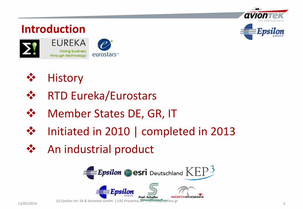
Introduction
History
RTD Eureka/Eurostars
Member States DE, GR, IT
Initiated in 2010 | completed in 2013
An industrial product
13/05/2014 3
Page 5
(c) Epsilon Int. SA & Aviontek GmbH | EAE Presentation | [email protected] 4
Part 2: Steps of production
13/05/2014
Page 6
Levels of Production: L1, L2, L3
5
Level-3: 3D-Fully Real
Level-2: 3D-Semi Real
Level-1: 3D Synthetic
EU 2500+
DE 450
IT 130
DE 50/GR47/IT30
(c) Epsilon Int. SA & Aviontek GmbH | EAE Presentation | [email protected] /05/2014
Page 7
Data & Software Integration |Skiathos
6
3-DVisualisation
andRenderingsoftware
EGNOSPrecisePosition
data
CockpitInterface Display
Hardware Unit
FlightPath
Predictor andtunnel Software
3-D GIS
High
precision
Airport
Data
3-D GIS
Approach
tunnel
Data
2-D GIS
Navigation
Approach
Data
3-D GIS
Airport
Vicinity
Data
Pilot
Switch
button
(c) Epsilon Int. SA & Aviontek GmbH | EAE Presentation | [email protected] /05/2014
Page 8
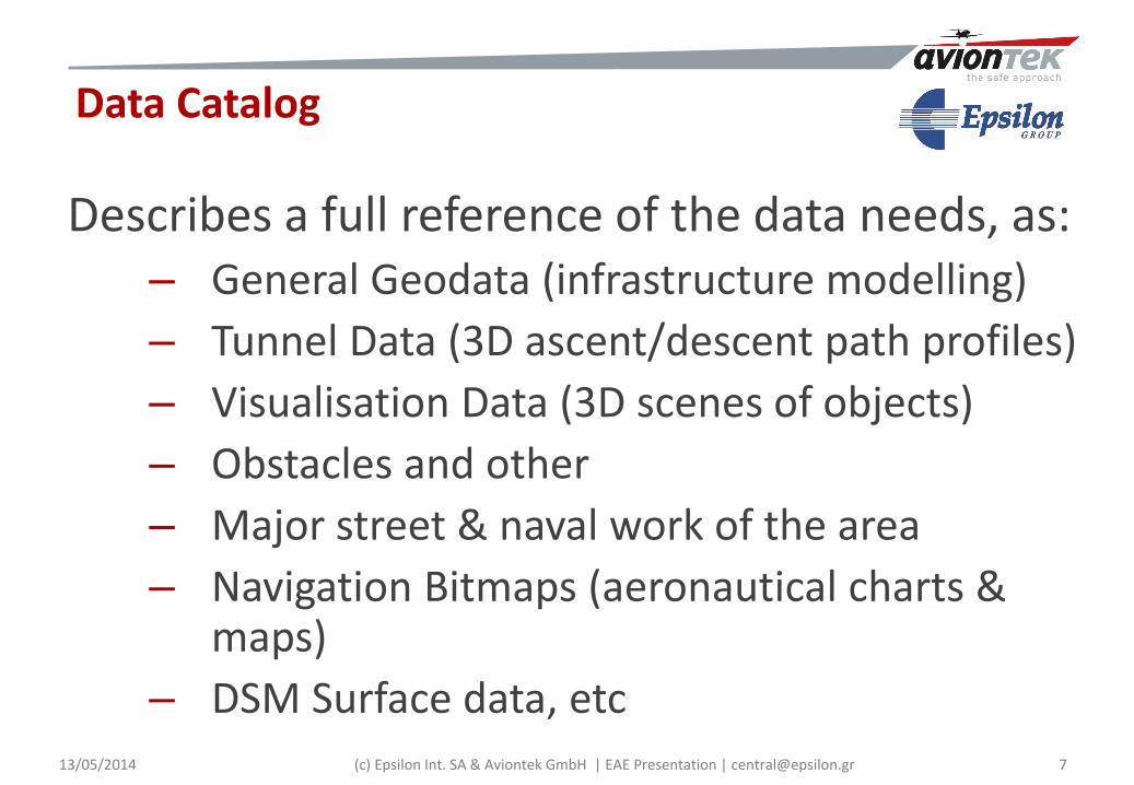
Data Catalog
Describes a full reference of the data needs, as:– General Geodata (infrastructure modelling)
– Tunnel Data (3D ascent/descent path profiles)
– Visualisation Data (3D scenes of objects)
– Obstacles and other
– Major street & naval work of the area
– Navigation Bitmaps (aeronautical charts & maps)
– DSM Surface data, etc7(c) Epsilon Int. SA & Aviontek GmbH | EAE Presentation | [email protected] /05/2014
Page 9
Step 1: ARINC SQLite Interface
8
Automated Extraction of Airport Runway
(c) Epsilon Int. SA & Aviontek GmbH | EAE Presentation | [email protected] /05/2014
Page 10
9
3D Visualization Data sources: Airborne Radar, LIDAR (High Res) SRTM TerraSAR-X, TanDEM-X (coming) DSM & DTM
Source: IntermapSource: LIDAR, EU Landing
Step 2: Geospatial Data - Elevation
(c) Epsilon Int. SA & Aviontek GmbH | EAE Presentation | [email protected] /05/2014
Page 11
10
Step 2: 3D terrain geodatabase
(c) Epsilon Int. SA & Aviontek GmbH | EAE Presentation | [email protected] /05/2014
Page 12
11
Source: ESRI Base map Source: Ikonos
Step 3: Orthophoto of the airport
(c) Epsilon Int. SA & Aviontek GmbH | EAE Presentation | [email protected] /05/2014
Page 13
12
CAD to GIS Conversion and Data Transformation
Using FME Extension for Esri ArcGIS
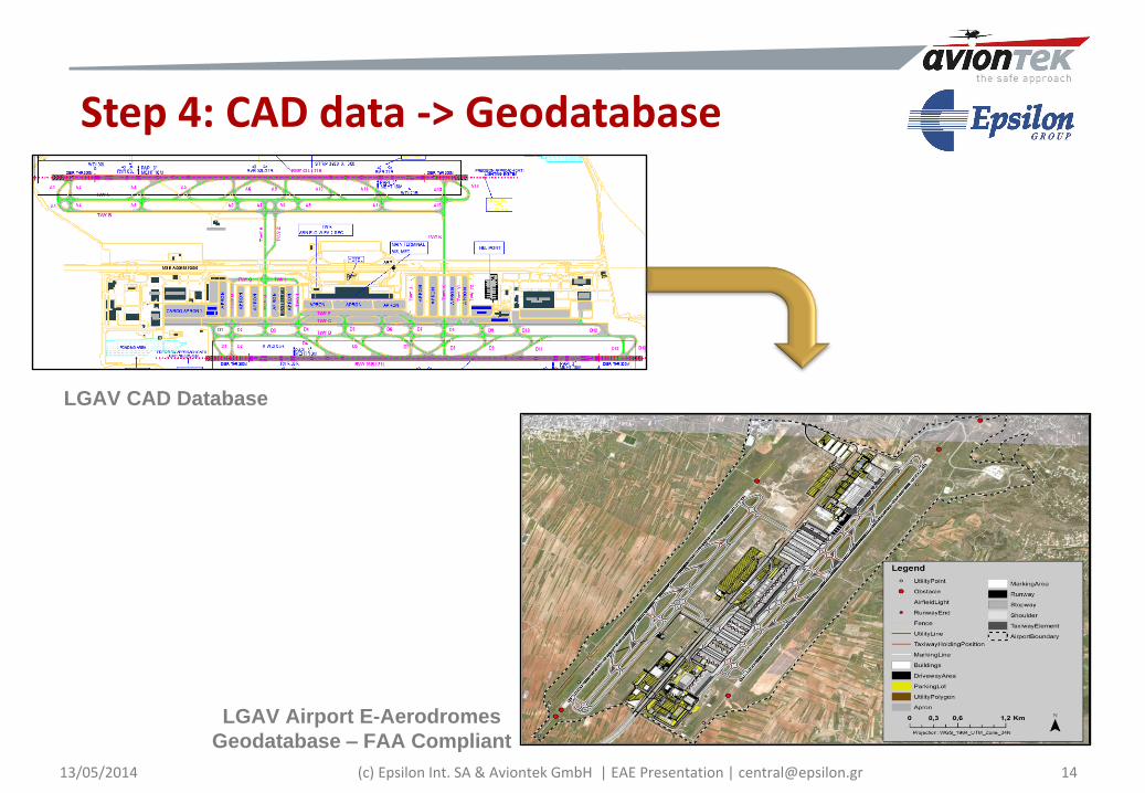
Step 4: CAD data -> Geodatabase
(c) Epsilon Int. SA & Aviontek GmbH | EAE Presentation | [email protected] /05/2014
Page 14
13
LGAV CAD Data
LGAV Airport ESRI Geodatabase – FAA Compliant
Step 4: CAD data -> Geodatabase
(c) Epsilon Int. SA & Aviontek GmbH | EAE Presentation | [email protected] /05/2014
Page 15
(c) Epsilon Int. SA & Aviontek GmbH | EAE Presentation | [email protected] 14
LGAV CAD Database
LGAV Airport E-Aerodromes
Geodatabase – FAA Compliant
Step 4: CAD data -> Geodatabase
13/05/2014
Page 16
15
Step 5: Approach Tunnel VFR
IFR Approach
VFR Approaches LOWZ
LGSK
LGSK
According to Jeppesen Bottlang Approach Maps
(c) Epsilon Int. SA & Aviontek GmbH | EAE Presentation | [email protected] /05/2014
Page 17
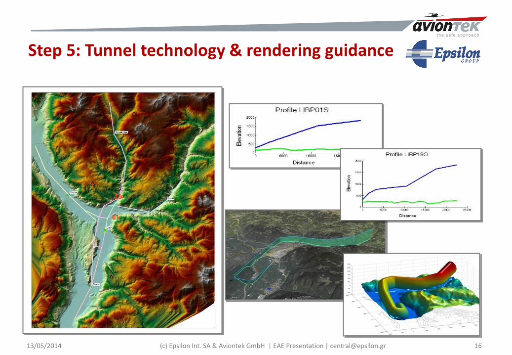
16
19
01
Step 5: Tunnel technology & rendering guidance
(c) Epsilon Int. SA & Aviontek GmbH | EAE Presentation | [email protected] /05/2014
Page 18
17
3D-Aerodromes geomatics imaging
LGAV Airport – El. Venizelos (Athens)
(c) Epsilon Int. SA & Aviontek GmbH | EAE Presentation | [email protected] /05/2014
Page 19
18
LGTS Airport – Macedonia
3D-Aerodromes geomatics imaging
(c) Epsilon Int. SA & Aviontek GmbH | EAE Presentation | [email protected] /05/2014
Page 20
19
LGKR Airport –Kerkira
LGSK Airport – Skiathos
LGRP Airport – Rodos
LGSR Airport – Santorini
LGSA – Chania
LGMK Airport - Mykonos
3D-Aerodromes geomatics imaging
(c) Epsilon Int. SA & Aviontek GmbH | EAE Presentation | [email protected] /05/2014
Page 21
(c) Epsilon Int. SA & Aviontek GmbH | EAE Presentation | [email protected]
• 3D-View (Detail in Esri‘s CityEngine)
• Athens International Airport
ESRI City Engine
13/05/2014 20
Page 22
(c) Epsilon Int. SA & Aviontek GmbH | EAE Presentation | [email protected]
3D Webscene with ArcGIS Online and CityEngine Web Viewer
13/05/2014 21
Page 23
Seaplanes 2D/3D charts
13/05/2014 (c) Epsilon Int. SA & Aviontek GmbH | EAE Presentation | [email protected] 22
Page 24
23
Part 3: Flight Tests
(c) Epsilon Int. SA & Aviontek GmbH | EAE Presentation | [email protected] /05/2014
Page 25
Standard
Tablet
3D-Pilot Products
13/05/2014 24(c) Epsilon Int. SA & Aviontek GmbH | EAE Presentation | [email protected]
Page 26
• The European Geo-stationary Navigation Overlay Service (EGNOS) offers improved position accuracy and integrity, based on GPS and in future also Galileo.
• EGNOS provides positions in the ITRF2000 (its tracking stations, the Ranging and Integrity Monitoring Stations (RIMS) all across Europe, and the satellite position corrections pertain to ITRF2000).
• Hence, 3D-Pilot also uses the WGS84 -ITRF2000 as reference frame to express three-dimensional receiver position coordinates (XYZ) on, or above the Earth.
Georreferencing Stations in Europe
25
EGNOS Positioning (Galileo, WAAS, GLONAS)
13/05/2014 (c) Epsilon Int. SA & Aviontek GmbH | EAE Presentation | [email protected]
Page 27
LGSK Skiathos (GR) Jeppesen Charts
26(c) Epsilon Int. SA & Aviontek GmbH | EAE Presentation | [email protected] /05/2014
Page 28
3D Skiathos digital airport (Ikonos)
27(c) Epsilon Int. SA & Aviontek GmbH | EAE Presentation | [email protected] /05/2014
Page 29
3D Skiathos imaging
28(c) Epsilon Int. SA & Aviontek GmbH | EAE Presentation | [email protected] /05/2014
Page 30
Demo flight
29(c) Epsilon Int. SA & Aviontek GmbH | EAE Presentation | [email protected] /05/2014
Page 31
30(c) Epsilon Int. SA & Aviontek GmbH | EAE Presentation | [email protected] /05/2014
Page 32
31
Test Flight | Skiathos 2012
(c) Epsilon Int. SA & Aviontek GmbH | EAE Presentation | [email protected] /05/2014
Page 33
32
Test Flight Skiathos | Visibility close to „0“
(c) Epsilon Int. SA & Aviontek GmbH | EAE Presentation | [email protected] /05/2014
Page 34
33(c) Epsilon Int. SA & Aviontek GmbH | EAE Presentation | [email protected] /05/2014