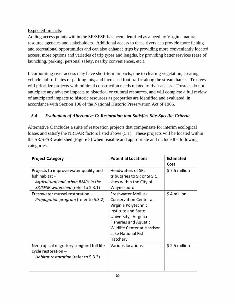
DuPont Waynesboro - South River/South Fork Shenandoah River/Shenandoah River Natural Resource Damage Assessment and Restoration Restoration Plan/Environmental Assessment Draft – October 2016 prepared by: Natural Resource Trustees: U.S. Fish and Wildlife Service Commonwealth of Virginia
Transcript
DuPont Waynesboro - South River/South Fork Shenandoah River/Shenandoah River Natural Resource Damage Assessment and Restoration Restoration Plan/Environmental Assessment Draft – October 2016
prepared by: Natural Resource Trustees:
U.S. Fish and Wildlife Service
Commonwealth of Virginia
ii
TABLE OF CONTENTS List of Figures ............................................................................................................................... v
List of Tables ............................................................................................................................... v
List of Acronyms .......................................................................................................................... vi
4.3.3 Neotropical Migratory Songbird Full Life Cycle Restoration. ............................... 36
4.3.4 Land protection, property acquisition, and recreational and wildlife enhancements. ......................................................................................................... 36
5.2 Evaluation of Alternative A: No Action/Natural Recovery ........................................... 42
5.3 Evaluation of Alternative B: Preferred Restoration Alternative .................................... 42
5.3.1 Projects to improve water quality and fish habitat - agricultural and urban BMPs in the SR/ SFSR watershed .......................................................................... 44
5.3.3 Neotropical Migratory Songbird Full Life Cycle Restoration – through Habitat Restoration .............................................................................................................. 51
5.3.5 Land protection, property acquisition, and recreational and wildlife enhancements – riparian habitat along the SR or SFSR ......................................... 58
5.3.6 Restoration of the VDGIF FRFH – Recreational Fishing Improvement Project .... 62
5.5 Compliance with NEPA and other potentially applicable laws ..................................... 67
Chapter 6 Selection of Preferred Alternative ...................................................................... 75
Literature Cited ............................................................................................................................ 78
Appendix A. Summary of stakeholder participation. ............................................ Appendix A-1
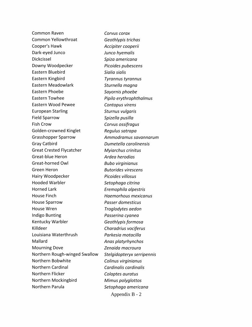
Appendix B. Birds observed during the 2011-2012 surveys in the SR/SFSR watershed. .......................................................................................... Appendix B-1
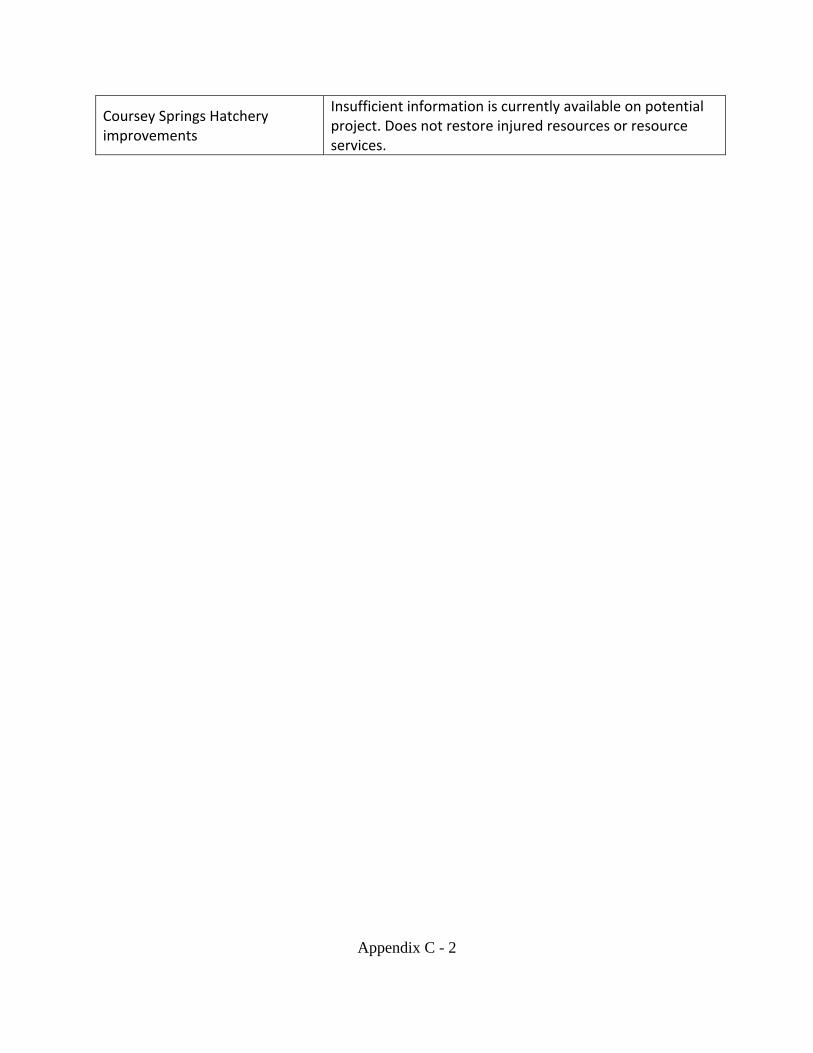
Appendix C. Projects That Do Not Satisfy Site-Specific Criteria .......................... Appendix C-1
v
LIST OF FIGURES
Figure 1. Location of DuPont Facility in Waynesboro, VA. ......................................................... 5
Figure 2. Assessment area and affected environment .................................................................. 10
Figure 3. Sinkhole pond areas in Augusta and Rockingham Counties. ....................................... 16
Figure 4. Diagram of pathways from Facility-mercury to biological endpoints ......................... 20
Figure 5. Map of major rivers and tributaries of SR/SFSR watershed ........................................ 44
Figure 6. Willets Tract addition and forest restoration and CWPNAP. ....................................... 53
LIST OF TABLES Table 1. River miles and acres of the assessment area. ............................................................... 12
Table 2. Major habitat types and resources within the assessment area. .................................... 23
Table 3. Mercury concentrations and service loss for fish .......................................................... 27
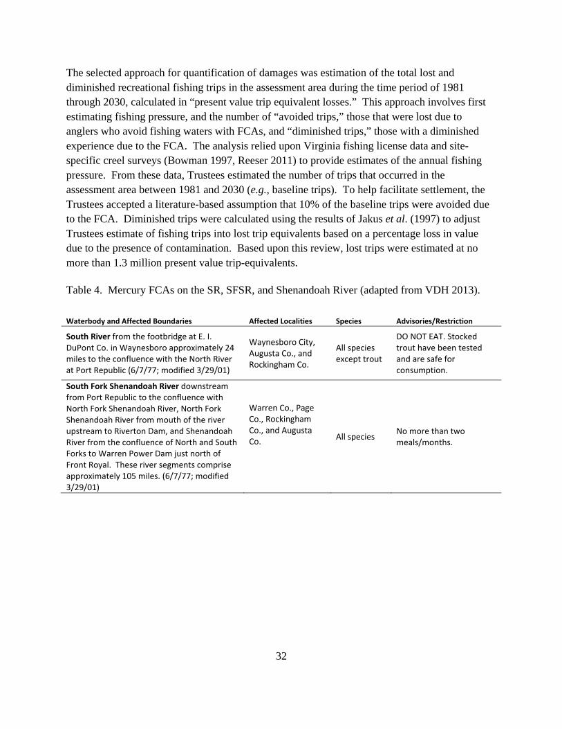
Table 4. Mercury FCAs on the SR, SFSR, and Shenandoah River. ............................................ 32
Table 5. Mussel species targeted for restoration . ........................................................................ 49
Table 6. Evaluation Criteria for CWPNAP restoration/addition. ................................................ 56
Table 7. Additional evaluation of CWPNAP restoration/addition, acquisition-specific. ............ 57
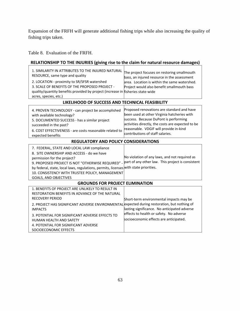
Table 8. Evaluation of the FRFH. ................................................................................................ 63
Table 9. Summary of injury and restoration categories. .............................................................. 76
vi
LIST OF ACRONYMS BMP Best Management Practice CD Consent Decree CERCLA Comprehensive Environmental Response, Compensation, and Liability Act CEQ Council on Environmental Quality C.F.R. Federal Code of Regulations COC Contaminant of Concern CWA Clean Water Act, or Federal Water Pollution Control Act CWPNAP Cowbane Wet Prairie State Natural Area Preserve DOI U.S. Department of the Interior DSAY Discounted Service Acre-Year EA Environmental Assessment EIS Environmental Impact Statement EPA U.S. Enviromental Protection Agency ESA Endangered Species Act FCA Fish Consumption Advisory FONSI Finding of No Significant Impact FRFH Front Royal Fish Hatchery FWS U.S. Fish and Wildlife Service HEA Habitat Equivalency Analysis MCI Madison Cave Isopod MOA Memorandum of Agreement NAAQS National Ambient Air Quality Standards NEPA National Environmental Policy Act NOAA National Oceanic and Atmospheric Administration NFSR North Fork Shenandoah River NMFS National Marine Fisheries Service NPL National Priorities List NRDAR Natural Resource Damage Assesment and Restoration NRCS Natural Resources Conservation Services NRDC Natural Resources Defense Council PRP Potentially Responsible Party PV Present Value RCRA Resource Conservation and Recovery Act REA Resource Equivalency Analysis RP/EA Restoration Plan/Environmental Assessment SR South River SFSR South Fork Shenandoah River
vii
SRST South River Science Team SWMU Solid Waste Management Units USACE U.S. Army Corps of Engineers U.S.C. U.S. Code VDCR Virginia Department of Conservation and Recreation VDEQ Virginia Department of Environmental Quality VDGIF Virginia Department of Game and Inland Fisheries VDH Virginia Department of Health
1
EXECUTIVE SUMMARY From 1929 to 1950, mercury was used in the manufacturing process at the former E.I. du Pont de Nemours and Company (DuPont) plant located in Waynesboro, VA. Mercury releases from the DuPont plant impacted soil and groundwater on-site, and storm sewers transported mercury to the South River, which continued downstream to the South Fork Shenandoah River and Shenandoah River. Natural resources (e.g., sediments, invertebrates, fish, amphibians, reptiles, birds, and mammals) have been exposed to and adversely affected by the mercury release. Remedial activities are ongoing under the direction of the U.S. Environmental Protection Agency (EPA) and the Virginia Department of Environmental Quality (VDEQ). Under federal law, through the Natural Resource Damage Assessment and Restoration (NRDAR) process, natural resource Trustees are authorized to assess and recover damages resulting from injuries to natural resources attributable to hazardous substance releases. The Trustees then utilize these recovered damages to plan and implement actions to restore, replace, rehabilitate, and/or acquire the equivalent of injured natural resources and the services they provide. Trustees in this case, the Commonwealth of Virginia, acting through VDEQ and the United States Department of the Interior acting through U.S. Fish and Wildlife Service, developed this Draft Restoration Plan and Environmental Assessment (Draft RP/EA) in accordance with 43 C.F.R. § 11.93 to inform the public as to the types and amount of restoration that are expected to compensate for injuries to natural resources and the services they provide associated with the mercury release from the former DuPont plant. Under the National Environmental Policy Act, federal agencies must identify and evaluate environmental impacts that may result from federal actions. In this Draft RP/EA, the Trustees describe the purpose and need for action, identify potential restoration alternatives, including a No Action alternative, summarize the affected environment, and describe the potential environmental consequences of proposed restoration activities. The Trustees are soliciting comments on this Draft RP/EA, and will address comments in preparing a final RP/EA wherein the Trustees will identify the Selected Restoration Alternative.
2
CHAPTER 1 INTRODUCTION AND SUMMARY
1.1 Purpose and Need for Restoration
This Draft RP/EA has been prepared by the Trustees to address natural resources injured and ecological services lost due to releases of mercury from the former DuPont plant located in Waynesboro, VA (the Facility). The purpose of this Draft RP/EA is to present the “Preferred Alternative” restoration project or projects that will accomplish the goal of restoring, rehabilitating, replacing and/or acquiring the equivalent of those natural resources, and the services those resources provide, that have been injured from the mercury release. For decades, mercury was released into the South River (SR), and transported downstream into the South Fork Shenandoah River (SFSR), Shenandoah River, and associated floodplain and upland habitat. A number of natural resources, including sediments, mussels, fish, amphibians, reptiles, birds, and mammals have been exposed to and adversely affected by mercury released from the Facility. The proposed remedial actions to reduce mercury in the system include stabilizing banks to prevent erosion and re-suspension of contaminated particles in the river (Anchor QEA et al. 2013). This strategy will be implemented in stages, likely over a period of more than 10 years. The effectiveness of this technique is unknown and will take many years of monitoring to determine whether there is a reduction in mercury is due to remedial activities. Impacts from mercury exposure are expected to continue into the future, as remedial efforts are not likely to remove all mercury from the system. The Trustees developed this Draft RP/EA in accordance with 43 C.F.R. § 11.93 to inform the public as to the types and scale of restoration to be undertaken towards compensating for injuries to natural resources. Consistent with the U.S. Department of the Interior (DOI) NRDAR regulations, this Draft RP/EA includes a reasonable number of restoration alternatives and identifies a preferred alternative. Public comments are being sought on this Draft RP/EA and will be considered and incorporated in the final RP/EA as appropriate.
1.2 Trustee Authority and Natural Resource Damage Assessment and Restoration Under federal law, the Trustees are authorized to act on behalf of the public to assess injuries to natural resources and services resulting from the release of hazardous substances into the environment. The NRDAR process, formalized in the DOI regulations (43 C.F.R. § 11), allows Trustees to pursue claims against responsible parties for monetary damages based on these injuries in order to compensate the public. The goal of this process is to plan and implement actions to restore, replace, or rehabilitate the natural resources that were injured or lost as a result of the release of a hazardous substance, or to acquire the equivalent resources or the services
3
they provide (Comprehensive Environmental Response, Compensation, and Liability Act (CERCLA), 42 U.S.C. § 9601 et seq.; 43 C.F.R. § 11). The following authorities authorize federal, state and tribal governments to act on behalf of the public as Trustees of natural resources:
CERCLA, as amended (42 U.S.C. § 9601 et seq.) Federal Water Pollution Control Act, 33 U.S.C. § 1251, et seq. (more commonly known
as the Clean Water Act or CWA) The Oil Pollution Act of 1990 (33 U.S.C. § 2701-2761 et seq.) Executive Order 12580 (52 Federal Register (FR) 2923 (January 23, 1987)), as amended
by Executive Order 12777 (56 FR 54757 (October 19, 1991) National Contingency Plan (40 C.F.R. §§ 300.600 et seq.)
As noted previously, the Trustees for the DuPont Waynesboro NRDAR are the Commonwealth of Virginia, represented by VDEQ, and DOI, represented by the U.S. Fish and Wildlife Service (FWS). A Trustee Memorandum of Agreement (MOA) was executed in June 2008, formalizing this collaborative process. The Trustee responsibilities outlined in the MOA include, but are not limited to: assessment of injury to natural resources, restoration planning, developing cost of restoration, replacement, rehabilitation, and/or acquisition of the equivalent, and coordination with response actions.
Under CERCLA, the parties responsible for releases of hazardous substances may be invited to participate in a cooperative NRDAR process (43 C.F.R. § 11.32(a)(2)). Although the final authority regarding determinations of injury and restoration rests solely with the Trustees, cooperative assessments can be beneficial to the public by reducing duplication of effort, expediting the assessment, and implementing restoration earlier than might otherwise be the case. Since 2005, DuPont has worked cooperatively with the Trustees to complete injury assessment studies, and a Cooperative Natural Resource Damage Assessment Funding Agreement (Cooperative Agreement) was signed by all parties in 2005 and 2010. Under the Cooperative Agreement, the parties conducted a series of site-specific studies assessing the exposure of natural resources, such as songbirds, amphibians, turtles, and bats, to mercury and potential effects resulting from that exposure. These studies are discussed in more detail in Chapter 3. DuPont’s active involvement in the damage assessment and restoration planning process also included/s the following:
Providing funding and assistance for assessment activities; Providing data and developing a database of contaminant concentration data; Participating in the development of injury assessments of ecological and human use
4
services, Identifying parcels for potential land conservation; and Identifying other potential restoration projects.
The Trustees completed a Damage Assessment Plan in 2011, summarizing existing information on natural resource injuries and describing proposed studies to evaluate past, current, and future impacts to natural resources and the services they provide (Industrial Economics, Inc. (IEc) 2011). In addition, the Damage Assessment Plan outlined how information gathered from the studies would be used to determine the types and scale of restoration needed to address these injuries.
1.3 Summary of Settlement Based on the results of the natural resource injury determination and other legal considerations associated with the Facility, the Trustees lodged a negotiated proposed consent decree with DuPont in the U.S. District Court for the Western District of Virginia on December 15, 2016 to implement various projects to effectuate restoration, replacement, rehabilitation and/or acquisition of the equivalent of the natural resources injured from mercury released from the Facility and/or the services those resources provide. The proposed Consent Decree (CD) will allocate the settlement as follows: DuPont, working with the Commonwealth, will complete at its expense certain recreational fishing projects; and DuPont will pay $42,069,916.78 into the DOI NRDAR Fund to be expended jointly by the state and federal Trustees to complete restoration projects meeting the requirements of this Draft RP/EA designed to address the injury.
1.4 Facility History and Remediation The Facility is located on approximately 177 acres on the eastern shore of the SR in Waynesboro, VA (Figure 1; U.S. Environmental Protection Agency (EPA) 2016). DuPont began operations at the Facility in 1929, manufacturing acetate flake and yarn, collectively referred to as acetate fibers. It discontinued production of acetate fibers in 1977. Other products historically manufactured on site included: Orlon®, Lycra®, Permasep®, and BCF Nylon; currently only Lycra is produced at the Facility, now owned and operated by INVISTA (EPA 2016). DuPont continues to own the real estate underlying the Facility.
5
Figure 1. Location of DuPont Facility, outlined in red, encompassing 177 acres adjacent to the SR, in Waynesboro, VA.
From 1929 to 1950, mercury was used in the manufacturing process, and waste sludge was conveyed to an on-site retort facility where the mercury was to be recovered. However, mercury releases occurred, impacting soil and groundwater locally on-site, and storm sewers transported mercury from the Facility to the SR. Mercury continues to be encountered during investigations at the Facility and mercury releases to the SR occur via storm water runoff (VDEQ 2009, URS 2012, Anchor QEA et al. 2013). Mercury is transported and re-circulated downstream via surface water, sediments, and floodplain soils to the SFSR and Shenandoah River, and a variety of natural resources have been exposed to Facility-related mercury. The mercury release was discovered in the 1970s, and a fish consumption ban, then advisory, was enacted in 1977 and 1979, respectively. As of 1999, fish tissue mercury levels had not declined since the early 1980s, as predicted, but instead concentrations remained steady or increased (URS 2012). DuPont and VDEQ discussed the need to assess mercury fate and transport in the SR and SFSR, and founded the South River Science Team (SRST) in 2001 to undertake this work. The SRST is a non-regulatory, collaborative group comprised of representatives from industry, state and federal governmental agencies, environmental groups, independent researchers, and other stakeholders. Since 2001, the SRST has met quarterly to coordinate efforts, identify data needs, collaborate, and share results and information concerning the assessment. Often the resulting studies have been used to support regulatory actions.
6
In 2005, DuPont entered into a consent decree with Natural Resources Defense Council (NRDC) and the Virginia Chapter of the Sierra Club as a result of lawsuit about the high mercury levels in fish and the associated threat to human health and the environment. It required that DuPont conduct a six-year ecosystem study of the SR watershed to delineate the threat and how to eliminate it, as well as fund abatement measures and propose a remedial plan. A revised consent decree was signed in 2014 that settled the matter with NRDC and Sierra Club. DuPont has also conducted numerous on-site investigations under the Resource Conservation and Recovery Act (RCRA) Corrective Action Permit (VAD003114832; issued in 1998 and renewed in 2009) managed by EPA and VDEQ. EPA has regulatory authority for the investigation and remediation of contamination on Facility property and VDEQ has the regulatory authority for investigation and remediation of contamination of the rivers and floodplain. A RCRA Facility Investigation was conducted in three phases to characterize solid waste management units (SWMUs) where hazardous substances may have impacted the environment; studies included soil and groundwater sampling at 20 identified SWMUs. DuPont is implementing interim measures (e.g., cleaning sewers) until the final remedy is selected. In 2014, VDEQ approved a Class 2 Permit Modification Request to incorporate the SR and parts of the SFSR (including the floodplain) into VAD003114832. Remedial activities for the rivers are ongoing. A remediation proposal was released in 2013 as required by the 2005 consent decree with NRDC/Sierra Club. The proposal found that a primary mechanism for the continued mercury loading to parts of the SR was through the slow erosion of legacy mercury deposits that currently reside in riverbank soils. Approximately 40 to 60% of the mercury that currently cycles through the food web into smallmouth bass tissue likely originates from eroding bank soils (Anchor QEA et al. 2013).
1.5 Relationship to Remedial Activities
NRDAR is a process that occurs in addition to the remedial process conducted by regulatory agencies like the EPA. These two processes have different goals. Remedial action objectives are risk-based, and are developed to protect human health and the environment from further unacceptable harm. The goal of NRDAR is the restoration of resources to their baseline condition, or what their condition would be absent the release of a hazardous substance. Losses resulting from natural resource exposure to released hazardous substances are estimated over time until the resource is restored. These losses can extend beyond the date of remedy completion if contaminants will be left in the environment at levels injurious to natural resources. There are components of NRDAR and remedial actions that overlap. For example, remedial decisions can include consideration of restoration objectives identified by the NRDAR process. Work to remedy a site may partially or completely restore injured natural resources, and
7
NRDAR estimates take this into account. In addition, remedial actions may cause “collateral injury” to habitat, and quantification and restoration of this remedy-induced injury is evaluated within the NRDAR process. For the DuPont Waynesboro NRDAR process, the Trustees have interacted and continue to interact with EPA and VDEQ as they evaluate, select, design, and implement remedies. This coordination provides an understanding of the remedial process and helped the Trustees evaluate how each of the remedial decisions affects estimates of natural resource damages.
1.6 Compliance with National Environmental Policy Act and Other Authorities
Restoration alternatives described in this document will be conducted in compliance with all applicable federal, state, and local regulations. Federal natural resource and environmental laws, orders, and regulations considered during the development of this Draft RP/EA include but are not limited to the: Endangered Species Act (ESA) of 1973; Farmland Protection Policy Act of 1981; Wild and Scenic Rivers Act of 1968; Migratory Bird Treaty Act of 1918; National Historic Preservation Act of 1966; Archeological and Historic Preservation Act of 1974; Fish and Wildlife Coordination Act of 1934; U.S. Fish and Wildlife Mitigation Policy of 1981; Information Quality Act of 2001; Executive Order 11990 on Wetlands of 1977; and Executive Order 11988 on Floodplains of 1977. Explanation of compliance with these and other federal authorities is found in Section 5.5. The major state environmental statutes and programs considered during the development of this Draft RP/EA include but are not limited to the: Virginia State Water Control Law, Va. Code § 62.1-44.5; Virginia Agricultural Best Management Practices Cost Share Program, Va. Code § 10.1-2128.1; Virginia Natural Area Preserves Act, Va. Code § 10.1-209 et seq.; and Virginia Cave Protection Act, Va. Code § 10.1-1000 et seq. Actions undertaken by the Trustees to restore natural resources or services under CERCLA and other federal laws are subject to the National Environmental Policy Act (NEPA) (42 U.S.C. § 4321 et seq.) and the regulations guiding its implementation at 40 C.F.R. Parts 1500 through 1517. These authorities outline the responsibilities of federal agencies for preparing environmental documentation. In general, federal agencies contemplating implementation of a major federal action must produce an environmental impact statement (EIS) if the action is expected to have significant impacts on the quality of the human environment. When it is uncertain whether a contemplated action is likely to have significant impacts, federal agencies prepare an environmental assessment (EA) to evaluate the need for an EIS. If the EA demonstrates that the proposed action will not significantly impact the quality of the human environment, the agency issues a Finding of No Significant Impact (FONSI), which satisfies the
8
requirements of NEPA, and no EIS is required. For a proposed RP, if a FONSI determination is made, the Trustees may then issue a final RP describing the selected restoration action(s). In accordance with NEPA and its implementing regulations, this Draft RP/EA summarizes the current environmental setting; describes the purpose and need for restoration actions; identifies alternative actions; assesses their applicability and potential impact on the quality of the physical, biological, and cultural environment; and outlines public participation in the decision-making process.
1.7 Public Participation
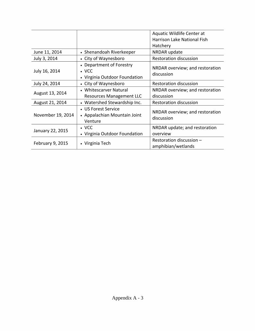
Public participation and review is an integral part of the restoration planning process, and is specifically required in the DOI NRDAR regulations (e.g., 43 C.F.R. §11.81(d)(2)). In addition, NEPA and its implementing regulations require that federal agencies fully consider the environmental impacts of their proposed decisions and that such information is made available to the public. To facilitate public involvement in the ecological and recreational restoration planning process, the Trustees have been meeting with interested stakeholders since 2008 (Appendix A). To continue the Trustees’ dedication to public involvement, this Draft RP/EA is available for public review and comment for a period of 45 days in accordance with 43 C.F.R. § 11.81(d)(2). The Trustees will address public comments and will document responses to those comments as part of the final RP/EA.
Comments may be submitted in writing and are due to the Trustees by January 30, 2017. To submit a comment, request a hard copy of the Draft RP/EA, or for additional information, please contact:
Anne Condon U.S. Fish and Wildlife Service 6669 Short Lane Gloucester, VA 23061 [email protected]
Copies of this document are available online at: https://www.fws.gov/northeast/virginiafield/news/news.html
As restoration progresses, the Trustees may amend the RP/EA if significant changes are made to the types, scope, or impact of the projects. In the event of a significant modification to the RP/EA, the Trustees will provide the public with an opportunity to comment on that particular amendment.
9
1.8 Administrative Record
An administrative record consisting of a catalog of all documents Trustees used to develop and make decisions related to the NRDAR process, including this Draft RP/EA, is maintained by FWS at the Virginia Ecological Services Office in Gloucester, VA.
1.9 Organization of the Draft RP/EA The remainder of this document is organized as follows:
Chapter 2 describes the affected environment.
Chapter 3 describes the injury assessment strategy and evaluation for ecological resources and human use / recreational fishing.
Chapter 4 describes restoration alternatives.
Chapter 5 evaluates the restoration alternatives, including the environmental impacts.
Chapter 6 describes the selection of the preferred alternative for ecological and recreational fishing restoration.
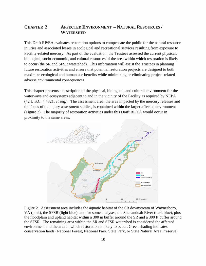
This Draft RP/EA evaluates restoration options to compensate the public for the natural resource injuries and associated losses in ecological and recreational services resulting from exposure to Facility-related mercury. As part of the evaluation, the Trustees assessed the current physical, biological, socio-economic, and cultural resources of the area within which restoration is likely to occur (the SR and SFSR watershed). This information will assist the Trustees in planning future restoration activities and ensure that potential restoration projects are designed to both maximize ecological and human use benefits while minimizing or eliminating project-related adverse environmental consequences. This chapter presents a description of the physical, biological, and cultural environment for the waterways and ecosystems adjacent to and in the vicinity of the Facility as required by NEPA (42 U.S.C. § 4321, et seq.). The assessment area, the area impacted by the mercury releases and the focus of the injury assessment studies, is contained within the larger affected environment (Figure 2). The majority of restoration activities under this Draft RP/EA would occur in proximity to the same areas.
Figure 2. Assessment area includes the aquatic habitat of the SR downstream of Waynesboro, VA (pink), the SFSR (light blue), and for some analyses, the Shenandoah River (dark blue), plus the floodplain and upland habitat within a 300 m buffer around the SR and a 300 ft buffer around the SFSR. The remaining area within the SR and SFSR watershed is considered the affected environment and the area in which restoration is likely to occur. Green shading indicates conservation lands (National Forest, National Park, State Park, or State Natural Area Preserve).
11
2.1 Watershed From its headwaters southwest of the City of Waynesboro, the SR flows in a northerly direction for approximately 50.8 miles to the town of Port Republic in Rockingham County. The drainage area of the SR is 235 square miles, with 89% in Augusta County, 6% in the City of Waynesboro, and 5% in Rockingham County (VDEQ 2009). As the SR approaches Waynesboro, large natural springs cool the water and increase flow.
In Port Republic, the SR merges with the North River to form the SFSR, which flows north through Rockingham, Page, and Warren Counties for approximately 100 miles. The SFSR drains approximately 1,700 square miles, and other major tributaries include the Middle River and Christians Creek (VDEQ 2009). There are 20 public access points along the SFSR offering recreational opportunities; the SFSR is a popular destination for canoeing and fishing, attracting thousands of users each year (VDGIF 2016). The majority of the land bordering the SFSR is private property, with the exception of the public access points, the Virginia-owned Andy Guest Shenandoah River State Park, and small sections of the George Washington National Forest on the west bank of the river.
At Front Royal, the SFSR merges with the North Fork Shenandoah River (NFSR) to form the Shenandoah River. This river continues to flow approximately 57 miles through Virginia and West Virginia, joining the Potomac River in Harper’s Ferry, WV, and ultimately draining into the Chesapeake Bay. The main stem Shenandoah River is one of the top smallmouth bass rivers in the eastern United States, and the section that runs through Clarke County, VA, is designated as a component of the Virginia Scenic River System (Va. Code § 10.1-417). Most of the land adjacent to the Shenandoah River is privately owned. Numerous anthropogenic and natural barriers exist between the headwaters of the Shenandoah drainage and the Chesapeake Bay; for example, the SFSR has three run-of-river hydropower dams and the Shenandoah River has one (VDGIF 2016a, b). The SFSR watershed (which contains the smaller SR watershed, hereafter collectively referred to as the SR/SFSR watershed) is within the Valley and Ridge physiographic region. To the southeast of the watershed are the Blue Ridge Mountains and to the west is Massanutten Mountain (Krstolic and Ramey 2012). The area surrounding the SR and the SFSR is mostly forested (55%) and agricultural (30% grass/pasture, 4% row-crop agriculture), interspersed with small urban populations (11%) including the City of Waynesboro and the towns of Grottoes and Elkton (Krstolic and Ramey 2012). The SFSR watershed receives many visitors annually to enjoy river-related activities.
12
The area enjoys significant natural heritage resources. For example, 17% of Augusta County contains natural heritage resources, such as habitat of rare, threatened, or endangered plant or animal species; unique natural communities; and significant geologic formations (Augusta County 2009). The SR/SFSR watershed supports numerous natural resources such as benthic organisms, fish, reptiles, amphibians, birds, and mammals, including state and federally listed species or species of concern. General descriptions of these resources are provided in Section 2.2 below.
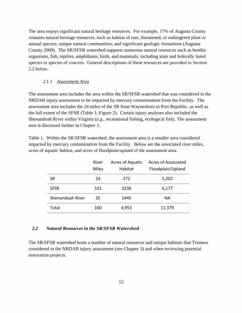
2.1.1 Assessment Area The assessment area includes the area within the SR/SFSR watershed that was considered in the NRDAR injury assessment to be impacted by mercury contamination from the Facility. The assessment area includes the 24 miles of the SR from Waynesboro to Port Republic, as well as the full extent of the SFSR (Table 1; Figure 2). Certain injury analyses also included the Shenandoah River within Virginia (e.g., recreational fishing, ecological fish). The assessment area is discussed further in Chapter 3. Table 1. Within the SR/SFSR watershed, the assessment area is a smaller area considered impacted by mercury contamination from the Facility. Below are the associated river miles, acres of aquatic habitat, and acres of floodplain/upland of the assessment area.
River
Miles
Acres of Aquatic
Habitat
Acres of Associated
Floodplain/Upland
SR 24 272 5,202
SFSR 101 3236 6,177
Shenandoah River 35 1445 NA
Total 160 4,953 11,379
2.2 Natural Resources in the SR/SFSR Watershed
The SR/SFSR watershed hosts a number of natural resources and unique habitats that Trustees considered in the NRDAR injury assessment (see Chapter 3) and when reviewing potential restoration projects.
13
Aquatic Resources
2.2.1 Mussels Several species of native freshwater mussels were historically present in the SR, SFSR, Shenandoah River, and tributaries. Mussel surveys of the upper Shenandoah River system, conducted from the early 1900s through the 1970s, recorded nine species (Ortmann 1919, Johnson 1970, Clark 1981, Chazal and Roble 2011). Species composition is quite similar among the forks of the upper Shenandoah River, and also to other major tributaries of the Potomac River basin, like the Cacapon River in West Virginia, and Broad Run near Manassas, VA (Garst et al. 2014), indicating that most mussel species are widely distributed throughout the Potomac River basin. However, mussel surveys of the SFSR and NFSR systems conducted in the 1990s, early 2000s, and from 2008-2009 by biologists from the Virginia Department of Conservation and Recreation (VDCR), documented only three live species (triangle floater (Alasmidonta undulata), Eastern elliptio (Elliptio complanata), and creeper (Strophitus undulatus)) and showed that mussel abundance was very low in both the SFSR and NFSR (Chazal and Roble 2011). Surveys conducted in 2013 in the SR identified these same three species at survey locations upstream of Waynesboro (Garst et al. 2014).
2.2.2 Fish The SR/SFSR watershed supports a diverse fishery. The fish assemblage in the Shenandoah drainage comprises 40 native species and subspecies and 18 introduced species (Jenkins and Burkhead 1994). Common taxa in the SR and SFSR rivers include smallmouth and largemouth bass (Micropterus dolomieu and M. salmoides), redbreast sunfish (Lepomis auritus), fallfish (Semotilus corporalis), shiners (Cyprinella spp. and Notropis spp.), dace (Rhinichthys spp.), white sucker (Catostomus commersoni), northern hogsucker (Hypentelium nigricans), darters (Etheostoma spp.), and sculpins (Cottus spp.). The American eel (Anguilla rostrata) migrates up the Potomac and Shenandoah Rivers from the Sargasso Sea and uses the SFSR and SR as elver and adult habitat.
As the SR approaches Waynesboro, several large springs enter the river providing an increase in flow and decrease in temperature. With the removal of the Rife-Loth Dam in 2010, this cold-water area now extends further downstream into the City of Waynesboro, creating suitable habitat for trout. Stocked species include: brook trout (Salvelinus fontinalis), rainbow trout (Oncorhynchus mykiss), and brown trout (Salmo trutta). A year-round trout fishery now exists several miles upstream of Waynesboro and downstream through most of Waynesboro City limits, creating a destination trout fishery for many anglers. As the SR warms downstream, habitat becomes more suitable for warm-water fish species; community composition varies
14
between upper and lower reaches of the SR reflecting the changes in habitat and water temperature (URS 2012).
2.2.3 Reptiles and Amphibians
Over 40 species of reptiles and amphibians occur in different areas within the SFSR watershed in wetland, riverine, and upland habitats. Some common reptile species along the SR include: snapping turtle (Chelydra serpentine), painted turtle (Chrysemys picta), stinkpot (Sternotherus odoratus), ratsnake (Pantherophis alleghaniensis), and northern watersnake (Nerodia sipedon). Common amphibians include: southern two-lined salamander (Eurycea bislineata), red-backed salamander (Plethodon cinereus), and American toad (Bufo americanus). Species of conservation concern found in the watershed include, but are not limited to: tiger salamander (Ambystoma tigrinum; state listed endangered), pine snake (Pituophis melanoleucus; state species of concern), and Big Levels salamander (Plethodon sherando), a woodland salamander endemic to the SR watershed, ranked as globally and state rare, and found in the Big Levels area within the George Washington National Forest/Blue Ridge Parkway.
Floodplain/Upland Resources
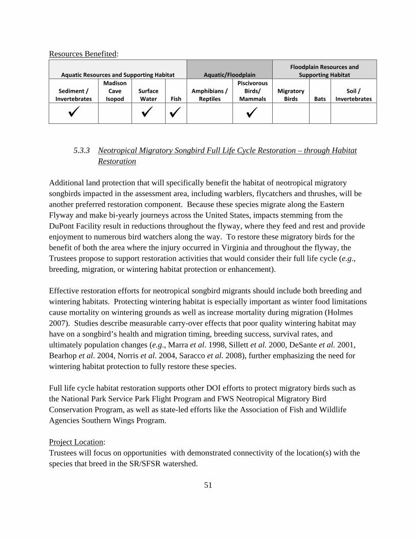
2.2.4 Birds Both resident and migratory birds utilize habitat within the SR/SFSR watershed for breeding, feeding, and roosting. These include waterfowl, waterbirds, raptors, and songbirds. Surveys conducted in 2011 and 2012 in the upper SFSR watershed identified 113 species in various habitat types and elevations (Cristol 2012, unpublished data). Many of these species are neotropical migratory birds, breeding in or migrating through the watershed and wintering in Central or South America or the Caribbean. See Appendix B. Species in the assessment area that are listed as species of greatest conservation concern (Tier I-IV) on the Virginia 2015 Wildlife Action Plan include, but are not limited to: belted kingfisher (Megaceryle alcyon), black and white warbler (Mniotilta varia), brown thrasher (Taxostaoma rufum), Canada warbler (Cardellina canadensis), chimney swift (Chaetura pelagica), eastern kingbird (Tyrannus tyrannus), eastern meadowlark (Sturnella magna), eastern towhee (Pipilo erythrophthalmus), eastern wood-pewee (Contopus virens), field sparrow (Spizella pusilla), gray catbird (Dumetella carolinensis), and wood thrush (Hylocichla mustelina).
2.2.5 Mammals Several species of mammals have been recorded in the SR/SFSR watersheds utilizing aquatic, floodplain, and terrestrial habitats. For example, muskrats (Ondatra zibethicus) forage on
15
shellfish in the river, and shrews (Sorex spp) prey on insects in the floodplain. Other species that use habitat in the watershed for feeding or breeding include river otters (Lontra canadensis) and mink (Neovison vison). Bats are also present in the watershed, foraging over the SR and SFSR, and roosting in caves, trees, and barns in the area. Bat species found in the watershed include big brown bat (Eptesicus fuscus), eastern red bat (Lasiurus borealis), and hoary bat (Lasiurus cinereus). Federally listed endangered Virginia big-eared bat (Corynorhinus townsendii virginianus) and Indiana bat (Myotis sodalis), federally and state listed threatened northern long-eared bat (Myotis septentrionalis), and state listed endangered little brown bat (Myotis lucifugus) and tri-colored bat (Perimyotis subflavus) may also be present in the watershed.
Unique Species and Features
2.2.6 Madison Cave Isopod The Madison Cave isopod (Antrolana lira; MCI) is a federally listed threatened, free-swimming, sightless, subterranean crustacean that lives in karst aquifers. It is endemic to the northern Shenandoah Valley, VA, and Jefferson County, WV, and to date has been found exclusively in Cambrian/Ordovician aged carbonate bedrock (Orndorff and Hobson 2007). Until 1990, this rare isopod was known from only Madison Saltpetre Cave and the adjacent Steger’s Fissure at the northeastern end of Cave Hill in Augusta County, VA. MCI abundance at Steger’s Fissure is the highest in the species’ range, estimated at 2,240-3,420 individuals (Fong 2007). As of 2010, the MCI was known from a total of 16 locations in the Shenandoah Valley from Leetown, WV, to Lexington, VA (FWS 2010).
2.2.7 Wetlands – Sinkhole Ponds Freshwater emergent, forested, and pond wetland habitat is present throughout the watershed. The SFSR watershed also contains a unique group of depression wetlands, known as the Shenandoah Valley sinkhole ponds (Fleming and Van Alstine 1999). These sinkhole ponds occur on deep alluvial fans in Augusta, Rockingham, and Page Counties that were deposited over carbonate rocks along the foot of the Blue Ridge Mountains during the Pleistocene (see Figure 3 for locations of some of these sinkhole ponds). Solution of the underlying rock and reworking of surficial material by streams resulted in the development of numerous natural ponds varying in size from less than 0.1 acre to more than 3.7 acres. Pollen profiles from bottom sediments in two Augusta County ponds demonstrate the continuous existence of wetlands over the past 15,000 years (Craig 1969). Most ponds in the Shenandoah Valley complex experience seasonally fluctuating water levels. The hydroperiods of many ponds are irregular and unpredictable, varying with the size and depth of the basin, degree of shading, and local groundwater conditions. Three rare and apparently endemic community types occur in the Shenandoah Valley ponds, and their flora is notable for its high percentage of rarities.
16
Figure 3. Sinkhole pond areas in Augusta and Rockingham Counties within the SR/SFSR watershed.
2.2.8 Limestone Cave Habitat The SFSR watershed contains a number of historically and geologically significant limestone caves, including Grand Caverns, a National Natural Landmark located along the SR. The karst terrain, a landscape of sinkholes, sinking streams, and caverns, was formed by groundwater dissolving the limestone and dolostone that underlie the Shenandoah Valley floor. Several of the caves in the SFSR watershed are designated as significant under the Virginia Cave Protection Act, and provide habitat for the MCI and bat species (VDCR 2015).
2.3 Cultural and Historic Resources
The area contains significant historical and cultural resources, including Civil War battlefields and related historic sites, many of which are protected through Shenandoah Valley Battlefields Foundation (SVBF) and other partners (SVBF 2015).
17
2.4 Ecological Stressors Ecological stressors in the SR/SFSR watershed include point source pollutants and industrial wastes, inadequately treated sewage, and agricultural and urban run-off and erosion from poor sedimentation control (FOSR 2013). The SFSR was listed as an impaired river in 1998 on Virginia’s Section 303(d) Total Maximum Daily Load (TMDL) Priority List and Report, and again in 2002, 2004, 2006 and 2008 (Engineering Concepts, Inc. 2009). The impairment was due to exceedances of fecal coliform and bacteria standards. The SR, SFSR and Shenandoah River are also on the 303(d) list because of the mercury contamination. Many other streams within the watershed are listed as impaired; thirty streams in Augusta County (553.38 miles) have water quality impairments based on TMDLs for pollutants such as fecal coliform, bacteria, pH, and other contaminants (Augusta County 2009). The SFSR watershed is home to dairy and beef cattle farms, with over 8,000 pairs of beef cattle and almost 3,000 dairy cattle as of 2009, and many have access to streams in the watershed (Engineering Concepts, Inc. 2009). The SFSR watershed also has chicken and turkey operations, and poultry litter is applied to cropland and pasture throughout the watershed. Augusta County, which contains most of the SR and its headwaters, is the second leading agricultural county in Virginia (Augusta County 2009). The county’s watersheds, including the SR watershed, are experiencing excessive levels of soil erosion from farmland which can have negative impacts on stream quality and long term agricultural productivity (Augusta County 2009), particularly tributaries to the Middle River such as Christians Creek. Areas within the watershed are experiencing increased human population growth and development in recent decades. In Augusta County, the growth rate for the decade 1990-2000 was 11.6%, the largest increase since 1960-1970 (Augusta County 2009). The population of Augusta and Rockingham Counties is expected to increase by 3% between 2015 and 2040 and more significant increases are predicted for cities and towns (e.g., 37% expected increase in Waynesboro) (VDEQ 2015). These stressors are important when evaluating restoration projects and areas – to help identify what projects to prioritize and what areas within the watershed to target – most in need of restoration, areas most at risk, where restoration will be most likely to succeed, etc. The existing stressors are also considered the evaluation of injury when establishing the baseline conditions of the area (see Chapter 3).
18
CHAPTER 3 INJURY ASSESSMENT The natural resources listed in Chapter 2 provide a variety of services. Services are “the physical and biological functions performed by the resource, including the human uses of those functions, [that result from the resource’s] physical, chemical, or biological quality” (43 C.F.R. § 11.14 (nn)). For example, ecological services provided by benthic invertebrates and mussels include foraging opportunities for fish and birds, nutrient cycling, and water filtration. Wetland soils provide services by supporting healthy vegetation and diverse plant communities that in turn provide animals with foraging opportunities, nesting or denning areas, and protective cover. Examples of human use services provided by natural resources include opportunities for fishing, boating, and wildlife viewing and appreciation. Injury has occurred when a resource’s viability or function is impaired such that the type and/or magnitude of services provided by that resource is reduced as a result of contamination (43 C.F.R. § 11.14 (v)). Determination of injury requires documentation that: (1) there is a viable pathway for the released hazardous substance from the point of release to a point at which natural resources are exposed to the released substance, and (2) injury of exposed resources (e.g., surface water, sediment, soil, groundwater, biota) has occurred as defined in 43 C.F.R. § 11.62. The first condition is satisfied based on clear documentation of direct historical discharge of mercury, the contaminant of concern, from the Facility into the SR, and ongoing releases from the banks of the SR (VDEQ 2009, Anchor QEA et al. 2013; See Section 3.2). The second condition is satisfied because measured concentrations of mercury in various resources within the assessment area displayed associated effects, or exceeded levels at which the literature reports adverse effects on endpoints such as reproduction, growth, and survival as well as the presence of a fish consumption advisory.
3.1 Contaminant of Concern The contaminant of concern (COC) in a NRDAR assessment area is a hazardous substance (as defined by Section 101(14) of CERCLA) to which trust resources have been exposed as a result of a release. Mercury is considered to be the primary COC for this assessment, listed in Table 302.4, the List of Hazardous Substances and Reportable Quantities under CERCLA, and as a toxic pollutant pursuant to 40 C.F.R. § 401.15, as amended. As mercury cycles through the environment, it can be present in several different forms. “Quicksilver,” or mercury-zero, is metallic, elemental mercury (such as the mercury released from the Facility), and is less toxic than other forms. Once released into the environment, elemental mercury is converted to methylmercury, the most common, and most toxic, organic mercury compound, mainly by microscopic organisms in water, soil, and sediment. Methylmercury is lipid soluble, allowing it to cross biological membranes and to enter the food
19
web, where it is bioaccumulated and biomagnified in upper trophic level organisms such as fish and birds. Mercury is primarily a neurotoxin, but can also cause biochemical, enzymatic, immunological, genetic, and reproductive effects on biota. For example, in adult mammals, methylmercury can cause ataxia difficulty in locomotion, impairment of hearing or vision, general weakness, and death (Eaton et al. 1980; Wren et al. 1987a,b). Symptoms of acute mercury poisoning in birds include, but are not limited to, reduced food intake leading to weight loss; progressive weakening in wings and legs; difficulty flying, walking and standing; and death (Wolfe et al. 1998). Reductions in egg laying and territorial fidelity are also associated with mercury exposure in birds (Barr 1986).
3.2 Pathway Pursuant to 43 C.F.R. § 11.14 (dd), a pathway is defined as:
The route or medium through which…a hazardous substance is or was transported from the source of the discharge or release to the injured resource.
Facility-related mercury has been identified in on-site storm water outfalls and continues to be discharged to the river via the outfalls (Anchor QEA et al. 2013). There are multiple pathways, historic and current, from the Facility to trust resources, including through surface runoff, groundwater, permitted point-source discharges, movement in surface water and abiotic and biotic pathways (Figure 4). Once mercury has been released to surface water and underlying sediments, it can be transported downstream via surface water flow. During periods of flooding, when heavy rains cause the SR and SFR to overtop their banks, mercury can be deposited on floodplain soils. Furthermore, contaminated floodplain soils in this study area can be transported back into the river via bank erosion processes (Eggleston 2009). Mercury in sediment and floodplain soils can be taken up by biota at the base of the food web and transported to higher trophic organisms via their diet (e.g., snapping turtles and screech owls; Bergeron et al. 2007, Cristol et al. 2008). As such, aquatic and terrestrial biota may also serve as pathways in addition to being endpoints.
20
Source
Initial Pathways
Abiotic Pathways and Endpoints
Biotic Pathways and Endpoints
Storm Water Runoff/Discharge
Facility‐Related Mercury
Infiltration to Groundwater
Floodplain Soils*
River Surface Water*
(Including transport to downstream
locations)
River Sediment*
Terrestrial Biota*
Aquatic Biota*
Flooding/Bank Erosion
Emerging Aquatic Invertebrates
* Indicates a Trust resource being assessed in the DuPont Waynesboro NRDAR process.
Figure 4. Diagram of pathways from Facility-mercury to biological endpoints (adopted from IEc 2011).
3.3 Injury Assessment Strategy
The goal of the injury assessment is to determine the nature and extent of injuries to natural resources and to quantify the resulting resource and service losses, providing a basis for evaluating the need for, type of, and scale of restoration actions. Injury to biological resources has resulted from the release of a hazardous substance if the concentration of that substance is sufficient to:
Cause the biological resource or its offspring to have undergone at least one of the following adverse changes in viability: death, disease, behavioral abnormalities, cancer, genetic
21
mutations, physiological malfunctions (including malfunctions in reproduction), or physical deformations (43 C.F.R. § 11.62 (f)(1)(i)).
or
Exceed levels for which an appropriate State health agency has issued directives to limit or ban consumption of such organism (43 C.F.R. § 11.62 (f)(1)(iii)).
As described in Chapter 1, this assessment process is guided by the NRDAR regulations under CERCLA. The injury assessment process occurs in two stages: 1) injury evaluation and 2) resource and service loss quantification. To evaluate potential injury to resources, the Trustees reviewed site-specific injury studies, as well as existing information, including remedial investigation data, ecological risk assessments, and scientific literature. Based on information from all these sources and with an understanding of the function of the terrestrial and aquatic ecosystems at and near the Facility, the Trustees evaluated injury to natural resources and determined the expected magnitude and severity of effects of mercury on trust resources. The Trustees considered several factors throughout injury assessment, including, but not limited to the:
• specific natural resource and ecological services of concern; • evidence indicating exposure, pathway and injury; • mechanism by which injury occurred; • type, degree, spatial and temporal extent of injury; and • types of restoration actions that are appropriate and feasible.
3.3.1 Geographic Scope
The assessment area is based on the geographic scope within which trust resources have been directly or indirectly affected by the releases of hazardous substances from the Facility (43 C.F.R. §11.14 (c)). For the purposes of this Draft RP/EA, Figure 2 depicts the geographic scope of the assessment area, which includes the:
SR from the Facility in Waynesboro downstream to Port Republic (24 river miles, 272 acres).
SFSR from Port Republic downstream to Front Royal (101 river miles, 3,237 acres).
Shenandoah River to the West Virginia border (35 river miles, 1,446 acres; only applicable for the fish analyses – ecological and recreational injuries).
Floodplain areas adjacent to the SR and SFSR (11,379 total acres, including 240 acres of wetlands).
22
3.3.2 Temporal Scope Within the assessment area, natural resource exposure to Facility-related hazardous substances has been documented at least since the 1970s and is expected to continue into the future. Damages are calculated beginning in 1981, in accordance with case law related to the promulgation of CERCLA, and are estimated into perpetuity, unless otherwise specified. Injury and corresponding damages with regard to recreational fishing losses were assumed to persist until 2030. Recovery scenarios may change with the implementation of additional remedial activities in the assessment area or with long-term environmental recycling of contaminants remaining after remedy implementation (e.g., through resuspension of contaminated sediments). Because remedial activities are ongoing, and because there is a high amount of uncertainty regarding effectiveness and success, Trustees assumed that the injury would remain unchanged for a long period of time.
3.4 Injury Evaluation / Resource and Service Losses Each of the resources impacted by the release of mercury, including surface water, sediment, and the organisms that utilize the riverine and associated wetland and floodplain or upland habitats (e.g., fish, birds, reptiles, amphibians, mammals), is a trust resource. Over the years, these resources have been exposed to mercury from the Facility and have suffered adverse effects. Below are the trust resources likely impacted/exposed to mercury contamination including both aquatic and floodplain resources:
• Surface Water and Sediment • Migratory Songbirds
• Soil • Piscivorous Birds/Mammals
• Mussels • Waterfowl
• Fish • Bats
• Reptiles/Amphibians • Madison Cave Isopod
• Human Use/Recreational Fishing
Injured trust resources within the assessment area sustained some loss in ecological services due to contamination. A reduction in the ability of a resource to provide these services, as compared to the baseline level of services or that which existed but for the contamination, is considered a service loss. The severity and magnitude of these potential losses are quantified, where possible, to establish a basis for scaling restoration (e.g., damages). In the sections below, the
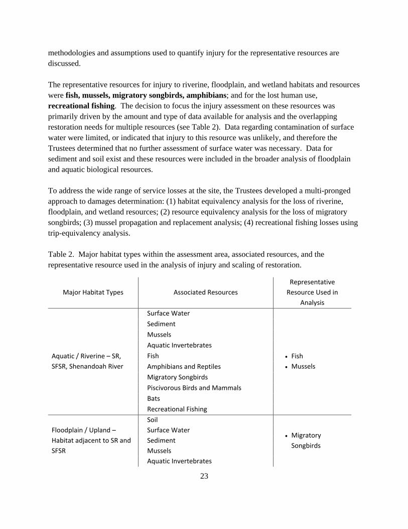
23
methodologies and assumptions used to quantify injury for the representative resources are discussed. The representative resources for injury to riverine, floodplain, and wetland habitats and resources were fish, mussels, migratory songbirds, amphibians; and for the lost human use, recreational fishing. The decision to focus the injury assessment on these resources was primarily driven by the amount and type of data available for analysis and the overlapping restoration needs for multiple resources (see Table 2). Data regarding contamination of surface water were limited, or indicated that injury to this resource was unlikely, and therefore the Trustees determined that no further assessment of surface water was necessary. Data for sediment and soil exist and these resources were included in the broader analysis of floodplain and aquatic biological resources. To address the wide range of service losses at the site, the Trustees developed a multi-pronged approach to damages determination: (1) habitat equivalency analysis for the loss of riverine, floodplain, and wetland resources; (2) resource equivalency analysis for the loss of migratory songbirds; (3) mussel propagation and replacement analysis; (4) recreational fishing losses using trip-equivalency analysis. Table 2. Major habitat types within the assessment area, associated resources, and the representative resource used in the analysis of injury and scaling of restoration.
Major Habitat Types Associated Resources
Representative
Resource Used in
Analysis
Aquatic / Riverine – SR,
SFSR, Shenandoah River
Surface Water
Fish
Mussels
Sediment
Mussels
Aquatic Invertebrates
Fish
Amphibians and Reptiles
Migratory Songbirds
Piscivorous Birds and Mammals
Bats
Recreational Fishing
Floodplain / Upland –
Habitat adjacent to SR and
SFSR
Soil
Migratory
Songbirds
Surface Water
Sediment
Mussels
Aquatic Invertebrates
24
Fish
Amphibians and Reptiles
Migratory Songbirds
Piscivorous Birds and Mammals
Bats
Recreational Fishing
Wetlands
Soil
Surface Water
Amphibians
Sediment
Mussels
Aquatic Invertebrates
Amphibians and Reptiles
Migratory Songbirds
Piscivorous Birds and Mammals
Bats
Recreational Fishing
Habitat Equivalency Analysis
Habitat Equivalency Analysis (HEA) is a service-to-service or resource-to-resource approach to natural resource valuation that can account for changes in baseline while estimating interim losses (Unsworth and Bishop 1994, Jones and Pease 1997). The fundamental concept is that compensation for lost ecological services can be provided by restoration projects that provide comparable services (compensatory restoration). HEA responds to the question “What, but for the release, would have happened to the injured area?” In this case, what services would the injured habitats have provided? With HEA, the replacement services are quantified in physical units of measure such as acre-years.1 The selected projects, or project types, are scaled so that the quantity of replacement services equals the quantity of lost services in present value terms. Potentially responsible parties (PRPs) implement or pay for restoration projects that are sufficient to cover the public’s interim losses. HEA involves three basic steps:
(1) Assess the present value of lost services (% service losses over time) relative to baseline. This “debit” is measured in discounted services acre-years (DSAYs).
(2) Select appropriate compensatory restoration projects (% restored services). The “relative productivity” of a proposed restoration project compared to what was injured is measured in the number of DSAYs restored for every acre included in the project.
1 An acre-year refers to all natural resource services provided by one acre for one year. This measure of natural resource services is specific to the type of land and its associated habitats since different habitats in varying locations provide different services.
25
(3) Identify the size of the project (scaling) that will equate the total discounted quantity of lost services to the total discounted quantity of replacement services to compensate the public’s losses. The “credit” is measured in acres owed or DSAYs restored by a proposed project of an identified size.
CERCLA (43 C.F.R. § 11.83) explicitly allows consideration of HEA as an economic tool to estimate damages in NRDAR cases. Following the process outline above, the Trustees determined the loss of riverine, floodplain, and wetland resources from mercury. To compensate for this loss, the amount of acquisition and enhancement needed was estimated using HEA. The assessment area is quite large with a variety of habitats. In collaboration with DuPont, Trustees identified the habitat types, reviewed the literature on natural resource injuries, and estimated service losses relative to baseline. Where restoration options were determined to provide multiple ecological services, the Trustees factored these additional service gains into the HEA crediting process.
Resource Equivalency Analysis
When there are injuries to non-marketed species, like migratory songbirds, their value can be difficult to quantify in economic terms. An alternative approach to economic valuation is resource equivalency analysis (REA) (variation of HEA based on Unsworth and Bishop 1994, and Jones and Pease 1997). A REA responds to the question, “What, but for the incident, would have happened to the injured species if it had not been killed by the oil spill or release of hazardous substances?” REA is a resource-to-resource approach that assumes services lost and restored are comparable. Specifically, the losses and replacement services are quantified in physical units of measure such as bird-years.2 Restoration projects are scaled so that the quantity of replacement services equals the quantity of lost services in present value (PV) terms.3 PRPs pay for or implement restoration projects sufficient to cover the public’s interim losses. Because the services provided by compensatory restoration projects are qualitatively equivalent to the services lost due to the spill or release, REA can avoid valuation altogether. When PRPs are
2 A bird-year refers to all services provided by 1 bird for 1 year. This measure of services is specific to the type of bird since different birds provide different services (the replacement services for 20 bird-years could be 20 birds for only one year, one bird over 20 years, or something in between). 3 Services provided in the future are discounted at an appropriate rate to reflect the social rate of time preference, the rate at which society is willing to substitute between present and future consumption of natural resources. The real rate of interest and the government borrowing rate are recommended in the economics literature as the best measures of the social rate of time preference. OMB Circular A-4 and empirical evidence supports a 3% discount rate (e.g., Freeman 1993; NOAA 1999). Federal rulemakings also support a 3% discount rate for lost natural resource use valuation (61 FR 453; 61 FR 20584). The annual discount factor may be calculated as (1+r)P-t, where r is the discount rate, P is the present time period, and t is the time period of lost services. In 2016, for example, the discount factor is 1.0, because any number raised to the zero power equals 1.0 (1.03(2016-2016= 0) = 1.0).
26
interested in providing a payment rather than performing an in-kind restoration project, the estimated project costs may be used to develop a final claim for damages. The first REA was developed as part of the North Cape oil spill settlement in 1999 (see Sperduto et al. 2003). CERCLA (43 C.F.R. § 11.83) explicitly allows consideration of REA as an economic tool to estimate damages in NRDAR cases. Following the process outline above, the Trustees determined the loss of songbird-years from mercury. To compensate for this loss, the amount of acquisition and enhancement needed was estimated using an understanding of songbird restoration that incorporates the full life-cycle of the bird (e.g., breeding, migration, or wintering habitat protection or enhancement).
3.4.1 Fish (Ecological or Eco-Fish) Though this analysis was focused specifically on eco-fish, it more broadly represents injury to the aquatic habitat and other resources that use that habitat such as piscivorous birds and mammals. The assessment area for the eco-fish injury analysis included a total of 4,954 acres of the SR (272 acres), SFSR (3,237 acres), and Shenandoah River (1,446 acres). To demonstrate injury due to mercury, site-specific toxicity information was reviewed and contaminant concentrations in fish tissue were compared to literature-based adverse effects thresholds. This analysis was a cooperative effort between the Trustees and DuPont and is summarized in this section. Fish species reviewed in the analysis include, among others, smallmouth bass, largemouth bass, black crappie (Pomoxis nigromaculatus), rock bass (Ambloplites rupestris), bluegill (Lepomis macrochirus), common carp (Cyprinus carpio), and channel catfish (Ictalurus punctatus). The final database included over 6,000 whole body fish mercury concentrations from 14 species of fish collected between 1981 and 2007. These species were classified as piscivores, omnivores, or invertivores. Peer-reviewed literature was evaluated, including, but not limited to, studies that examined the effect of mercury (not inorganic mercury); studies that described an effect on growth, reproduction, and/or survival (not short-term exposure); and studies focused on similar species to those found in the assessment area (e.g., studies on saltwater fish or arctic/rainforest species were excluded). Based on these studies, Trustees were able to determine service losses corresponding with a related mercury concentration. For example, at 0.5 parts per million (ppm) whole body mercury concentration, there was an associated 0% service loss, at 1 ppm, 27% service loss, at 2 ppm, 41% service loss and at 5 ppm, 62% service loss (Table 3).
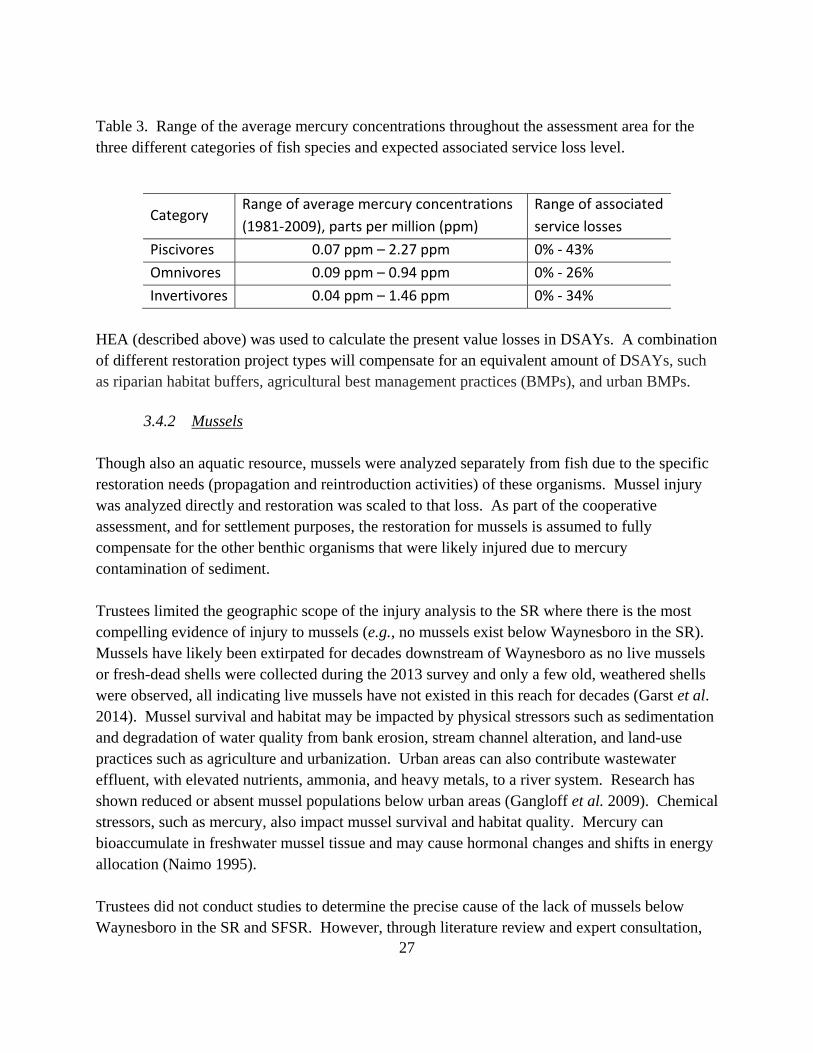
27
Table 3. Range of the average mercury concentrations throughout the assessment area for the three different categories of fish species and expected associated service loss level.
Category Range of average mercury concentrations
(1981‐2009), parts per million (ppm)
Range of associated
service losses
Piscivores 0.07 ppm – 2.27 ppm 0% ‐ 43%
Omnivores 0.09 ppm – 0.94 ppm 0% ‐ 26%
Invertivores 0.04 ppm – 1.46 ppm 0% ‐ 34%
HEA (described above) was used to calculate the present value losses in DSAYs. A combination of different restoration project types will compensate for an equivalent amount of DSAYs, such as riparian habitat buffers, agricultural best management practices (BMPs), and urban BMPs.
3.4.2 Mussels Though also an aquatic resource, mussels were analyzed separately from fish due to the specific restoration needs (propagation and reintroduction activities) of these organisms. Mussel injury was analyzed directly and restoration was scaled to that loss. As part of the cooperative assessment, and for settlement purposes, the restoration for mussels is assumed to fully compensate for the other benthic organisms that were likely injured due to mercury contamination of sediment. Trustees limited the geographic scope of the injury analysis to the SR where there is the most compelling evidence of injury to mussels (e.g., no mussels exist below Waynesboro in the SR). Mussels have likely been extirpated for decades downstream of Waynesboro as no live mussels or fresh-dead shells were collected during the 2013 survey and only a few old, weathered shells were observed, all indicating live mussels have not existed in this reach for decades (Garst et al. 2014). Mussel survival and habitat may be impacted by physical stressors such as sedimentation and degradation of water quality from bank erosion, stream channel alteration, and land-use practices such as agriculture and urbanization. Urban areas can also contribute wastewater effluent, with elevated nutrients, ammonia, and heavy metals, to a river system. Research has shown reduced or absent mussel populations below urban areas (Gangloff et al. 2009). Chemical stressors, such as mercury, also impact mussel survival and habitat quality. Mercury can bioaccumulate in freshwater mussel tissue and may cause hormonal changes and shifts in energy allocation (Naimo 1995). Trustees did not conduct studies to determine the precise cause of the lack of mussels below Waynesboro in the SR and SFSR. However, through literature review and expert consultation,
28
Trustees determined the likely proportion of injury expected from urban inputs (Waynesboro) and the proportion from mercury contamination (service loss attributable to mercury released from the Facility). In 2013, mean mussel density across sites sampled in the Cacapon River (WV), Broad Run (VA), and SR upstream of Waynesboro, was 2.26 mussel per square meter (m2) – a reasonable expected density for suitable habitat throughout the SR watershed, including downstream of Waynesboro. Trustees expected a lower density of 1.0 mussels/m2 below Waynesboro given the urban inputs and considering the mix of habitat types (e.g., unsuitable, such as bedrock, and suitable, such as cobble) that exist in the SR below Waynesboro. Using these density estimates, Trustees were able to parse the difference between the injury expected from urban inputs (56%) and the expected loss due to mercury (44%). Applying this estimated loss of density to the affected area resulted in a loss of up to 650,000 mussels. Therefore, the Trustees concluded a multi-year propagation program is necessary to restore the mussels lost from mercury contamination.
3.4.3 Migratory Songbirds The assessment area supports many species of songbirds and other migratory birds, including waterfowl, wading birds, and raptors. For the purposes of claim development, Trustees focused on migratory songbirds due to the extensive site-specific data on contaminant concentrations and effects. Trustees also used songbird data to inform the analysis for the floodplain injury (see Section 3.4.4). Because of the specific restoration needs of migratory songbirds throughout their full life cycle and within their migratory flyway, Trustees did a separate analysis to determine injury specifically to neotropical migratory songbirds. Of the 75 species evaluated, 44 species are considered medium- or long-distance migrants, 17 species are considered short-distance migrants or seasonal migrants, and 14 are considered resident species. In consultation with experts, the Trustees determined that the neotropical migratory subset consists of up to 68% of the representative species in the assessment area, a significant proportion of the injured bird population. Studies on exposure and effects of mercury on birds have been conducted in and around the assessment area and in the laboratory over a period of several years (e.g., Brasso and Cristol 2008; Cristol et al. 2008; Hallinger et al. 2010; Hallinger et al. 2011; Jackson et al. 2011a, b; Varian-Ramos et al. 2014). These studies examined mercury exposure in multiple species and life stages, contamination of prey items, and geographic extent of elevated mercury levels. Cristol et al. (2008) described mercury levels in several songbird species that were as high, or higher, than fish-eating species from the site – illustrating that mercury contamination of the aquatic environment had moved to the terrestrial system and food web. Prey items, specifically spiders, had mercury levels higher than fish prey species. Several site-specific and laboratory studies examined effects to survival, reproduction, immune/endocrine system function, and other sublethal effects, such as song learning (e.g., Brasso and Cristol 2008, Hawley et al. 2009, Wada
29
et al. 2009, Hallinger et al. 2010, Hallinger et al. 2011, Hallinger and Cristol 2011, Jackson et al. 2011a, Bouland et al. 2012, Carlson et al. 2014, Varian-Ramos et al. 2014, Henry et al. 2015). Key findings of these studies link mercury to adverse reproductive effects, most notably in Carolina wren (Thryothorus ludovicianus) and tree swallow (Tachycineta bicolor). Hallinger and Cristol (2011) showed that mercury levels in tree swallows within the SR assessment area (mean ± SE: 3.03 ± 0.15 ppm) were significantly elevated compared to swallows breeding on reference sites (mean ± SE: 0.16 ± 0.005 ppm), and that these high levels of mercury were associated with reduced hatching and fledgling success. Contaminated birds produced approximately 1 less fledgling than reference birds, translating to a 20% reduction in nest success. Jackson et al. (2011a) used an information-theoretic approach to analyze the Carolina wren reproductive data collected in the assessment area. This model showed that blood mercury concentration of the adult female was a strong predictor of nest success, and enabled Trustees to relate mercury level with a loss in reproduction. Average blood mercury levels were available for the 75 songbird species within the assessment area, ranging from 0.02 to 6.2 ppm on the SR and 0.01 to 1.5 ppm on the SFSR. Based on the model from Jackson et al. (2011a), these concentrations translated to a 0.06 – 99.9 % likelihood of nest failure on the SR and 0 – 24.2% on the SFSR, depending on the species. Because density estimates for each of the 75 species were available within the watershed, the Trustees were able to estimate the population (number of individuals) of songbirds within the 11,379-acre assessment area, and apply the appropriate loss estimates per species. These inputs were used in a REA to generate a number of lost bird-years and to estimate the number of wintering habitat acres necessary to compensate for the injury.
3.4.4 Non-wetland Floodplain (represented by songbirds) Trustees selected songbirds as a representative resource for the floodplain and upland habitat. Because of the comprehensive songbird studies that support a quantifiable reduction in services (in this case, reproduction), songbirds were elected as the “umbrella” resource to inform the analysis for the floodplain/upland resources. To quantify injuries, the baseline condition of the affected resources and associated services must be established. Baseline is “the condition or conditions that would have existed at the assessment area had the…release of a hazardous substance…not occurred” (43 C.F.R. § 11.14 (e)), taking into account natural processes and changes resulting from human activities. Baseline conditions include all environmental parameters, not only concentrations of COCs. For example, other impacts to water quality and physical changes to the habitat (the stressors discussed in Section 2.3) are incorporated into the determination of baseline conditions. As described in the
30
DOI regulations, establishing baseline requires either pre-release data or data from suitable reference locations. There are multiple landcover types within the assessment area (developed, row crop, pasture/hay, riparian forest, upland forest and early successional), each of which provide different baseline services for songbirds in the assessment area. Based on expert consultation and literature reviews, baseline services were determined for each landcover type (related to songbirds specifically), ranging from 15-100%, and achieving maximum services in the riparian forest landcover type. When determining the baseline levels for each landcover type, Trustees considered the level of urbanization, habitat fragmentation, agricultural practices, use of pesticides or other chemicals, diversity of vegetation type and structure, and other factors that may influence bird use and habitat quality. Trustees reviewed literature on mercury effects/exposure as weight-of-evidence, but focused on site-specific data to inform the injury quantification. At the time of assessment, the data generated from studies on this site provided more information than existed in the literature. Injury was determined by the reproductive loss expected for different regions of the assessment area such as riparian SR, upland SR, or riparian SFSR, which was determined using site specific studies and Trustee expertise. The maximum level of injury was 20% reproductive loss based on the site-specific studies (see above Section 3.4.3; Hallinger and Cristol 2011). A certain level of impairment was expected from the mercury contamination (5-20%), but some habitat types were already impaired for other reasons (agricultural activities, fragmentation, etc.). The total service loss was calculated by factoring the baseline services into the injury estimate, and service losses ranged from 0-20% for the various landcover types in the assessment area. HEA was used to calculate DSAYs owed for the injury to floodplain habitat (up to 69,000 DSAYs). Restoration projects that will compensate for this injury amount will include protecting or enhancing habitat in the watershed. The exact amount of acres depends on the type of land (e.g., agricultural, riparian, forested) and quality of habitat (whether, for example, it is contiguous, disturbed, fragmented), and how much active restoration may be required. This analysis was driven by bird data, but more broadly represents injury to floodplain resources, as the types of restoration that will restore floodplain and riparian habitat will have benefits to other resources as discussed in Section 4.3.4.
3.4.5 Wetland Floodplain (Amphibians) The assessment area supports a variety of amphibian and reptile species. For the purposes of claim development, Trustees focused on amphibians due to their specific habitat requirements of ephemeral ponds for breeding, and because the Trustees had a considerable amount of data on amphibians (toads). To demonstrate injury to amphibians/wetland habitat within the assessment
31
area, Trustees used site-specific toxicity and effects data, as well as population models developed from these data. Bergeron et al. (2010) collected adults from three amphibian species – red-backed salamander (Plethodon cinereus), northern two-lined salamander (Eurycea bislineata), and American toad (Anaxyrus americanus) – and larvae from the latter two species along a contamination gradient on the SR. Total mercury concentrations in the contaminated area were 3.5 to 22 times higher than in the reference area. Subsequent field and lab studies examined the effects of the elevated mercury levels on amphibian survival, reproduction, and behavior (e.g., Burke et al. 2010; Bergeron et al. 2011a, b; Todd et al. 2012; Willson et al. 2012). Multigenerational studies on the impacts of elevated mercury levels in American toad were conducted over several years, generating some of the key findings used in the injury analysis (Bergeron et al. 2011a, b; Willson et al. 2012; Willson and Hopkins 2013). These studies informed a landscape-scale population model, which showed that in a mercury-contaminated network of wetlands, annual American toad productivity is reduced 68% relative to an uncontaminated network (Willson and Hopkins 2013). These studies informed the HEA model used to estimate the amount of DSAYs owed for the acres of wetland habitat in the assessment area (up to 6,000 DSAYs). Restoration compensating for the wetland injury will include protecting or enhancing wetland habitat in the watershed, or creating new wetland habitat. The exact number of acres required depends on the quality and expected benefits of the project.
3.4.6 Recreational Fishing In addition to the ecological services, natural resources within the assessment area provide recreational services. For example, the aquatic habitat and fishery resources of the assessment area provide anglers with extensive opportunities for recreational fishing. The SR and SFSR support a regionally significant recreational fishery, with smallmouth bass being the most sought-after game fish. Though trout fishing occurs in some areas along the SR, trout are stocked and safe for consumption, so the trout fishing was not part of this injury analysis. This section describes the Trustees’ approach to quantifying the losses in recreational fishing resulting from contaminant-related Fish Consumption Advisories (FCAs) due to mercury. FCAs in the assessment area have been in place since 1977, and limit consumption of certain types of fish on the SR, SFSR, and the Shenandoah River (Virginia Department of Health (VDH) 2013). Advisories due to mercury range from “Eat no more than one meal per month – certain species” to “Eat none – all species.” Table 4 provides a summary of the FCAs within the assessment area from 1977 to the present.
32
The selected approach for quantification of damages was estimation of the total lost and diminished recreational fishing trips in the assessment area during the time period of 1981 through 2030, calculated in “present value trip equivalent losses.” This approach involves first estimating fishing pressure, and the number of “avoided trips,” those that were lost due to anglers who avoid fishing waters with FCAs, and “diminished trips,” those with a diminished experience due to the FCA. The analysis relied upon Virginia fishing license data and site- specific creel surveys (Bowman 1997, Reeser 2011) to provide estimates of the annual fishing pressure. From these data, Trustees estimated the number of trips that occurred in the assessment area between 1981 and 2030 (e.g., baseline trips). To help facilitate settlement, the Trustees accepted a literature-based assumption that 10% of the baseline trips were avoided due to the FCA. Diminished trips were calculated using the results of Jakus et al. (1997) to adjust Trustees estimate of fishing trips into lost trip equivalents based on a percentage loss in value due to the presence of contamination. Based upon this review, lost trips were estimated at no more than 1.3 million present value trip-equivalents. Table 4. Mercury FCAs on the SR, SFSR, and Shenandoah River (adapted from VDH 2013).
Waterbody and Affected Boundaries Affected Localities Species Advisories/Restriction
South River from the footbridge at E. I. DuPont Co. in Waynesboro approximately 24 miles to the confluence with the North River at Port Republic (6/7/77; modified 3/29/01)
Waynesboro City, Augusta Co., and Rockingham Co.
All species except trout
DO NOT EAT. Stocked trout have been tested and are safe for consumption.
South Fork Shenandoah River downstream from Port Republic to the confluence with North Fork Shenandoah River, North Fork Shenandoah River from mouth of the river upstream to Riverton Dam, and Shenandoah River from the confluence of North and South Forks to Warren Power Dam just north of Front Royal. These river segments comprise approximately 105 miles. (6/7/77; modified 3/29/01)
Warren Co., Page Co., Rockingham Co., and Augusta Co.
AND RECREATIONAL To compensate the public for injuries (e.g., service losses) to natural resources resulting from releases of mercury from the Facility, the Trustees are required to develop alternatives for the “restoration, rehabilitation, replacement, and/or acquisition of the equivalent of the natural resources and the services those resources provide” (42 C.F.R. §11.82 (a)). DuPont’s settlement with the Trustees for natural resource damages includes a cash payment of approximately $42 million to be utilized in funding these types of projects as well as renovation of the Front Royal Fish Hatchery (FRFH) to be performed directly by DuPont (as part of recreational fishing compensation). This chapter describes the Trustees’ restoration objectives and proposed restoration alternatives to compensate for the ecological and recreational injuries. Several restoration projects were proposed to the Trustees that are: 1) not expected to provide natural resource services similar to injured/lost services, or to provide services in a cost-effective way; 2) already required or funded in non-NRDAR contexts; and/or 3) lacks sufficient detail to permit analysis. These projects are summarized in Appendix C. Below, the Trustees outline the following restoration alternatives:
Alternative Description A No Action, no projects implemented
B
Projects to improve water quality and fish habitat
Mussel propagation Neotropical migratory songbird full life
cycle restoration Land protection, property acquisition, and
recreational and wildlife enhancements. Recreational fishing improvement projects
C All components of Alternative B, and Trout stocking and management
Trustees evaluated the alternatives to determine if they provide sufficient type, quality, and quantity of ecological services to compensate for those lost due to contamination in the context of both site-specific and regulatory evaluation criteria (43 C.F.R. §11.82 (d)) and compliance with potentially applicable laws. The Trustees may implement restoration projects that are not specifically identified in this Draft RP/EA, but are similar to those projects identified and consistent with restoration objectives. Any project not reviewed within the Draft RP/EA will be evaluated against the site specific and regulatory criteria, and if a project uses alternative techniques other
34
than described below, a project-specific NEPA determination will be made and public notice will be given to provide details on the new project proposal.
4.1 Restoration Objectives The Trustees’ overall ecological restoration objective is to compensate the public for past and expected future ecological losses due to Facility-related contamination in the assessment area. DuPont is currently designing and implementing remedial actions along the SR; however, the remedy is expected to take many years to complete and the effectiveness is yet unknown, so losses are expected to continue indefinitely into the future. The release of mercury has impacted the ability of trust resources to provide their baseline level of ecological services. Therefore, the Trustees focused on restoration projects that will compensate the public by providing additional (e.g., above and beyond baseline) ecological services in or near the assessment area. The Trustees’ overall recreational fishing restoration objective is to compensate the public for interim and expected future recreational fishing losses due to mercury contamination in the assessment area. Since 1977, a FCA has been issued for rivers in the assessment area due to mercury contamination, and is expected to continue well into the future. The FCA has impacted recreational anglers by reducing the quality of fishing opportunities in the assessment area. Therefore, the Trustees focused on restoration projects that will compensate recreational anglers by creating new or improving existing fishing opportunities in or near the assessment area. The following sections describe the no action alternative, as well as the characteristics and benefits of restoration alternatives evaluated as part of this process to compensate for both ecological and recreational fishing injuries.
4.2 Alternative A: No Action Alternative (Natural Recovery) As required under NEPA, the Trustees considered a restoration alternative of no action. Under this alternative, the Trustees would rely on natural recovery and would take no direct action to restore injured natural resources or compensate for interim lost natural resource services. This alternative would include the continuance of ongoing monitoring programs, such as those initiated by VDEQ for fish, but would not include additional activities aimed at reducing contamination, reducing potential exposure to contaminants, or enhancing ecosystem biota or processes. Under this alternative, no compensation would be provided for interim losses in resource services.
35
Under the no-action alternative, no habitats would be preserved, restored, or enhanced beyond what agencies and organizations are already doing in the area with limited existing resources. Aquatic and riparian habitats would continue to be degraded along the SR and SFSR and in adjacent habitats. Water quality would continue to be impaired. Neotropical migratory birds would continue to decline because of continued contamination and threats to wintering habitat. Fishing and boating recreational opportunities would continue to be limited by access points and impaired fishing stocks. Local citizens would not benefit from improved recreational opportunities and increased education and stewardship.
4.3 Alternative B: Preferred Restoration Alternative The Trustees considered a broad set of restoration alternatives that could potentially improve ecological services and recreational fishing services relevant to the assessment area. These restoration alternatives are expected to provide natural resource services similar to the services that the injured habitat would have provided but-for the mercury contamination. In addition to those proposed by Trustee agencies, alternatives were solicited from DuPont through cooperative discussion, and from stakeholders through meetings and discussions with local governments, conservation organizations, and academic researchers (see Appendix A). The broad categories of proposed restoration alternatives are listed below, and are expected to increase habitat quality and quantity, promote habitat connectivity, create new public use opportunities, and benefit trust resources within the SR/SFSR watershed.
4.3.1 Projects to improve water quality and fish habitat These projects would include agricultural BMPs that would improve 35-foot riparian zones along the SR, SFSR, and tributaries, and could include exclusion fencing, natural channel design projects, as well as urban BMPs such as stormwater pond improvements and impervious cover management. These projects would benefit small mammals, birds, amphibians, reptiles, and fish by providing habitat and improving water quality through reducing erosion and runoff.
4.3.2 Freshwater Mussel Restoration These projects would focus on improving the mussel community in the SR, SFSR, and tributaries. Projects would focus on mussel propagation and restocking efforts. Because of the depauperate mussel community in the SR and SFSR, propagation efforts are necessary to increase numbers and re-establish stable mussel populations of nine species, which would otherwise not be achieved through habitat improvements alone. Riparian habitat improvement will also benefit mussels, but by itself would not return populations to healthy numbers. Mussel restoration projects have ancillary benefits to fish and wildlife species by improving water
36
quality, stabilizing sediment, enhancing bottom structure, and increasing food abundance (Vaughn and Hakenkamp 2001, Vaughn et al. 2008).
4.3.3 Neotropical Migratory Songbird Full Life Cycle Restoration These projects would focus on habitat protection, enhancement, and/or restoration specific for migratory songbirds, and may include restoration activities located throughout their full life cycle (e.g., breeding, migration, or wintering habitat protection or enhancement). Because of the importance of wintering habitat on the health, migration, and breeding success of neotropical migrants (e.g., Marra et al. 1998, Bearhop et al. 2004, Norris et al. 2004), the Trustees will give specific consideration to projects that protect wintering habitat.
4.3.4 Land protection, property acquisition, and recreational and wildlife enhancements
This project category focuses on protection, enhancement, and/or restoration of riparian and floodplain habitat within the SR/SFSR watershed. Biologically and/or ecologically important land(s) would be purchased and held in perpetuity for public benefit. Such land(s) should benefit the same natural resources that were injured from Facility releases; reduce habitat fragmentation; directly support or benefit key biological resources, including wildlife and fish habitat, rare species occurrences, natural communities, wetland features, or other sensitive or unique attributes; and will be receive additional consideration if under threat of development, in close proximity to Virginia-owned lands or other protected lands, or of interest to environmental and international organizations. Enhancement activities on the subject parcels may include, but are not limited to: converting row crop and pasture/hay to forest (riparian or upland), invasive species control, wetland restoration and grassland creation (in certain areas). Actions related to habitat creation will maximize the use of low impact techniques as to not create additional disturbances. Currently, one specific parcel is known to be available for acquisition, Cowbane Wet Prairie State Natural Area Preserve (CWPNAP) – Willets Tract Addition and Forest Restoration. This parcel is evaluated as a potential restoration site in Section 5.3.4. Additional properties are not yet identified; opportunities for land acquisition and protection will be evaluated as they arise, prioritizing those that contain the following features and opportunities:
restoration of wetlands, with specific emphasis on ephemeral/sinkhole pond habitat of amphibians, that would provide benefits to a wide array of birds, amphibians, reptiles, mammals and fish and also serve as floodwater retention and groundwater recharge areas.
37
This could include planting buffers around existing wetlands or restoring hydrology to impacted wetlands, among other activities.
Amphibian and Reptile Habitat Enhancement and/or Restoration. Habitat protection, enhancement, and/or restoration with specific emphasis on turtle breeding habitat. This may include creating in-stream basking habitat, or planning restoration to include characteristics of desirable breeding habitat.
Bat Habitat Enhancement and/or Restoration. Habitat protection, enhancement, and/or restoration with specific emphasis on bat habitat, such as protecting hibernacula or known breeding habitat, and related activities such as surveys or outreach.
Waterfowl Habitat Enhancement and/or Restoration. Habitat protection, enhancement, and/or restoration with specific emphasis on waterfowl breeding habitat. This may include addition of nest boxes for wood ducks, or targeting properties with existing waterfowl habitat for protection or restoration.
Recreational Fishing Access. These projects include creating new and/or improving existing access to the river for recreational opportunities, specifically fishing.
MCI Habitat Protection/Restoration. These projects would focus on protecting/restoring habitat used by the federally listed threatened MCI.
4.3.5 Recreational Fishing Improvement Projects
Recreational fishing projects will be prioritized that accomplish the following:
Restore numbers of fishing trips Increase the value of individual trips Provide alternate fishing experiences with options for safe consumption Include outreach and mercury education efforts to inform public of actual risks and
provide improved river access and opportunities for high quality water-contact recreation
This category will include the modification and improvement of the Virginia Department of Game and Inland Fisheries (VDGIF) FRFH located in Shenandoah County, VA. The FRFH is currently used to produce a variety of cool-water and warm-water fish species; however, the FRFH is an older facility, and requires modifications and updates to improve its ability to produce warm-water fish such as smallmouth bass, a sport fish highly valued by the public in the SR/SFSR watershed. This category will also include creation of new or improvement of existing recreational fishing access points. The access point establishment may co-occur with land acquisition opportunities whenever possible, and greatest consideration will be given to those projects that provide significant enhancement of recreational fishing opportunities. However, there may be projects to
38
create or improve river access on the SR and SFSR that would effectively restore or increase the value of a fishing trip, but would not restore other resources, nor be compatible with the prioritization defined for land acquisition. The Trustees will also evaluate potential fishing access points separately from other land acquisition projects as opportunities are identified along the SR and SFSR.
4.4 Alternative C: Non-preferred Restoration Alternative Alternative C includes all components of Alternative B (see Section 4.3 for descriptions), as well as enhanced trout management or increased trout stocking in the SR. In this Alternative, funding for projects to improve water quality and fish habitat (e.g., agricultural and urban BMPs in the SR/SFSR watershed) would be reduced to allow funding for the trout management project.
4.4.1 Recreational Fishing Improvement Projects – trout stocking or management This project will focus on improving trout fishing opportunities in the SR that allow safe consumption, where allowed by regulation, of harvested fish. The SR has well-established seasonal trout fisheries in and around Waynesboro and Grottoes. A special-regulation, year-round trophy section exists on the SR upstream of Waynesboro. This project would aim to expand stocking in the SR, through purchase of more and/or larger fish, or through development and construction of a grow-out and holding facility. This project would provide narrow benefits to trout anglers, or possibly anglers with no preferred target fish, in certain sections of the SR.
39
CHAPTER 5 EVALUATION OF ALTERNATIVES
The Trustees’ primary goal in this chapter is to identify a preferred restoration alternative that compensates the public for natural resource injuries and associated losses resulting from the mercury releases within the assessment area. Trustees assess the environmental consequences of Alternative A: No Action/Natural Recovery, Alternative B: Preferred Restoration Alternative, and Alternative C: Non-preferred Restoration Alternative to determine whether implementation of either of these alternatives may significantly affect the quality of the human environment, particularly with respect to physical, biological, socio-economic, or cultural environments. This chapter also evaluates readily available information on environmental consequences of the preferred restoration alternatives and potential impacts on the quality of the physical, biological and cultural environment, and thus serves as a draft EA for the DuPont Waynesboro NRDAR Preferred Restoration Alternative. The following definitions will be used to characterize the nature of the various impacts evaluated in this Draft RP/EA:
Short-term or long-term impacts. In general, short-term impacts are those that would occur only with respect to a particular activity or for a finite period. Long-term impacts are those that are more likely to be persistent and chronic.
Direct or indirect impacts. A direct impact is caused by a proposed action and occurs
contemporaneously at or near the location of the action. An indirect impact is caused by a proposed action and might occur later in time or be farther removed in distance but still be a reasonably foreseeable outcome of the action.
Minor, moderate, or major impacts. These relative terms are used to characterize the
magnitude of an impact. Minor impacts are generally those that might be perceptible but, in their context, are not amenable to measurement because of their relatively inconsequential effect. Moderate impacts are those that are more perceptible and, typically, more amenable to quantification or measurement. Major impacts are those that, in their context and due to their intensity (severity), have the potential to meet the thresholds for significance set forth under NEPA (40 C.F.R. § 1508.27) and, thus, warrant heightened attention and examination for potential means for mitigation to fulfill the requirements of NEPA.
40
Adverse or beneficial impacts. An adverse impact is one having unfavorable or undesirable outcomes on the man-made or natural environment. A beneficial impact is one having positive outcomes on the man-made or natural environment. A single act might result in adverse impacts on one environmental resource and beneficial impacts on another resource.
Cumulative impacts. Cumulative impacts are defined as the “impacts on the environment which result from the incremental impact of the action when added to other past, present, and reasonably foreseeable future actions regardless of what agency (federal or non-federal) or person undertakes such other actions” (40 C.F.R. § 1508.7). Cumulative impacts can result from individually minor but collectively significant actions taking place over a period of time within a geographic area.
5.1 Evaluation Criteria To ensure the appropriateness and acceptability of restoration options addressing ecological losses, the Trustees evaluated each option against site-specific restoration requirements. These site-specific requirements were developed through discussions with natural resource managers at each of the Trustee agencies and with input from DuPont. Projects were also evaluated against the restoration criteria listed in the DOI damage assessment regulations (43 C.F.R. § 11.82). Below are the criteria used to evaluate potential restoration projects as part of the DuPont Waynesboro NRDAR process. The criteria were developed by the Trustees, and reflect the “factors to consider when selecting the alternative to pursue” (NRDAR factors) as described in 43 C.F.R. § 11.82(d)(1-10). Primary criteria:
Relationship to the injuries giving rise to the claim for natural resource damages • Similarity in attributes to the injured natural resource, e.g., same type and quality • Proximity to the SR/SFSR watershed • Scale of benefits (quantitative and qualitative) should be similar to the injured
natural resource (e.g., increase in acres/species/services)
Likelihood of success and technical feasibility • Can be accomplished with the available technology • Similar projects have succeeded in the past • Costs are reasonable related to expected benefits
41
Regulatory and policy considerations • Federal, state and local law compliance • Site ownership and access • Not otherwise required by federal, state, or local laws, regulations, permits, or
licenses • Consistency with Trustee policy, management goals and objectives, as well as
local, regional, and national restoration goals and initiatives
Elimination rationale • Benefits are unlikely to result in restoration benefits in advance of the natural
recovery period • Significant adverse environmental impacts, and such impacts are not adequately
mitigated • Potential for significant adverse effects to human health and safety, and such
effects are not adequately mitigated Secondary criteria:
Consistency with local, regional, and national restoration goals and initiatives Timeframe of potential benefits Self-sustainability Integration with existing management programs/leverage potential Habitat connectivity (e.g., result is larger individual habitat parcels rather than multiple,
smaller, disconnected parcels) Proximity to lands with protected status Benefits to protected species or sensitive or unique habitats Opportunities for education and outreach Provides measureable results – monitoring component
Additionally, actions undertaken to restore natural systems are expected to have long-term beneficial and sometimes short-term adverse impacts to the physical, biological, socio-economic, and cultural environments. In the analysis below, the Trustees examine the likely beneficial and adverse impacts of Alternatives A, B, and C on the quality of the human environment. If the Trustees conclude that the actions associated with the preferred alternative will not lead to significant adverse impacts, then the Trustees will issue a FONSI. If significant impacts are anticipated, the Trustees will proceed with an EIS to evaluate a reasonable range of restoration alternatives and the environmental consequences of those alternatives. The Trustees will continue to evaluate environmental impacts as specific projects are identified, designed and implemented. The following sections evaluate anticipated environmental consequences of the restoration alternatives in light of the NRDAR factors listed above.
42
5.2 Evaluation of Alternative A: No Action/Natural Recovery The No Action/Natural Recovery Alternative would not initiate any restoration action outside of the currently funded remedial program. Instead, the ecosystem would attenuate to background conditions based on natural processes only, with no assistance from active environmental restoration. The Trustees considered the changes in ecological services from natural recovery and found that the No Action/Natural Recover Alternative:
Does not restore injured resources to baseline. Remediation is expected to span many years and include years of monitoring after the bank stabilization actions are completed. Currently there is no guarantee that the remedial actions will reduce the continued inputs of mercury to the SR and SFSR from bank erosion. Lack of restoration beyond remedial actions will reduce the potential for resources to fully recover to baseline conditions.
Does not compensate the public for interim losses. Because remedial activity will not improve the site above baseline conditions, interim losses have and will continue to accrue from continued ecological and human use injury due to mercury.
While the No Action Alternative does not create additional adverse impacts to the environment, and is technically feasible and cost-effective, it does not provide the ecological, recreational, and socio-economic benefits described under Alternative B. Given the long time frame until natural attenuation of mercury in the system is achieved, under the No Action Alternative adverse environmental consequences from mercury (e.g., ecological and human use injuries) are expected to continue into the future and would not be mitigated through restoration actions. Otherwise stated, the No Action Alternative may result in adverse impacts to fish and wildlife, as well as reductions in the ecological and human use services, due to the lack of additional habitat functionality provided through restoration and/or preservation actions in the assessment area. Therefore, the No Action Alternative is not a favorable restoration alternative when evaluated against the NRDAR factors. This Alternative serves as a point of comparison to determine the context, duration, and magnitude of environmental consequences resulting from the implementation of Alternative B and C.
5.3 Evaluation of Alternative B: Preferred Restoration Alternative Alternative B includes a suite of restoration projects that compensate for interim ecological losses and satisfy the NRDAR factors listed above (5.1). These projects will be located within the SR/SFSR watershed (Figure 5) when feasible and appropriate and include the following:
Projects to improve water quality and fish habitat – Agricultural and urban BMPs in the SR/SFSR watershed (5.3.1)
Headwaters of SR, tributaries to SR or SFSR, sites within the City of Waynesboro
$ 10 million
Freshwater mussel restoration – Propagation program (5.3.2)
Freshwater Mollusk Conservation Center at Virginia Polytechnic Institute and State University; Virginia Fisheries and Aquatic Wildlife Center at Harrison Lake National Fish Hatchery
$ 4 million
Neotropical migratory songbird full life cycle restoration – Habitat restoration (5.3.3)
Various locations $ 2.5 million
Land protection, property acquisition, and recreational and wildlife enhancements – CWPNAP – Willets Tract addition and forest restoration (5.3.4)
Property adjacent to CWPNAP
$ 1.3 million
Land protection, property acquisition, and recreational and wildlife enhancements – Additional properties, prioritizing those adjacent to SR or SFSR, creating contiguous protected land corridors (5.3.5)
Locations upstream or within the City of Waynesboro, adjacent to the SR or tributaries to the SR or SFSR
$ 18.2 million
Recreational fishing improvement projects – Restoration of the VDGIF FRFH (5.3.6)
Locations on SR, SFSR, NFSR, or Shenandoah River, or tributaries
$ 2.5 million
Project attributes, resource benefits, potential environmental impacts, social consequences, and costs are provided in the sections below. These projects provide compensation for the ecological injuries, at a cost of approximately $38.5 million (the cash settlement for ecological damages). The remaining funds will be used for project restoration planning, oversight, and administration.
44
Restoration planning will include evaluation of these projects with input and feedback from the public as described in Chapter 1.
Figure 5. Map of major rivers and tributaries of SR/SFSR watershed (inset), and upstream of Waynesboro in the SR watershed (large map, shaded gray). Restoration may occur within the boundaries of these watersheds in riparian areas. Restoration activities in the headwater areas of the SR watershed (large map) will likely receive prioritization.
5.3.1 Projects to improve water quality and fish habitat - agricultural and urban BMPs in the SR/ SFSR watershed
Projects will be identified that improve water quality and habitat for native fish in the watershed through restoration actions such as planting riparian vegetation, stabilizing eroding banks, sedimentation control devices, improving in-stream habitat, installing alternative watering sources, excluding cattle from accessing the streams and other such agricultural BMPs. Other projects will be identified that improve water quality and habitat for native fish in the watershed through improvements to stormwater ponds and impervious cover management (e.g., urban BMPs).
45
Location: Candidate streams for agricultural BMP restoration activities will be those where riparian vegetation is degraded or absent, preferably in the headwaters of the SR (see VDCR 2010). Headwaters will be prioritized because restoration in those areas is likely to have the greatest positive impact on the overall stream and habitat quality. Other locations may include areas along tributaries to the SR or SFSR, including those within the City of Waynesboro. To maximize the effectiveness and coverage of implementing agricultural BMPs, Trustees may partner with existing programs to identify and prioritize locations and projects.
Possible locations for urban BMPs may include any of the towns and cities along the SR and SFSR, especially the City of Waynesboro. Waynesboro has identified potential restoration projects within the city limits, focusing on urban BMPs that are not already required by other laws or regulations. Project Description: Possible agricultural BMPs may include erecting livestock exclusion fencing, installing alternative watering sources, planting stream-side buffer vegetation, stabilizing eroding stream banks, sedimentation control structures, natural stream channel design, and/or implementing riparian zone conservation easements. Riparian habitat protection projects provide potential to restore riverine habitats and facilitate the recovery of aquatic fauna, like mussels, within impacted watersheds (Sweeney 1993). Implementation of the habitat protection and enhancement measures can restore the natural riparian structure and function, reduce nutrient and sediment input, provide organic debris as energy source, moderate and restore naturally occurring temperature regimes, and enhance natural recovery of biota (Horwitz et al. 2008, Sweeney and Newbold 2014). Projects will follow the Erosion and Sediment Control Handbook (VDEQ 1992) and the Natural Resources Conservation Services (NRCS) Field Office Technical Guidelines when appropriate. Urban BMP projects may include stormwater pond restoration or impervious cover management, such as bioswales, vegetative filter strips or constructed wetlands, or pervious paving techniques. Improving riparian buffer zones and working with local landowners on implementing agricultural BMPs within the SR/SFSR watershed will provide the benefit of improving water quality and the overall health of the aquatic ecosystem. Urban BMPs will improve water quality in the SR and SFSR as well as quality and quantity of stormwater runoff from urban areas into the rivers. Stormwater runoff may contain soil, sediment, suspended solids, or other contaminants if there is no effective erosion protection in place. Sediment and suspended solids may be detrimental to fish breeding habitat as increased turbidity reduces light penetration, increases water temperature and impacts the level of oxygen in the water. Taking action to improve stormwater runoff will improve water quality and aquatic habitat for fish and other organisms.
46
For this restoration category, there is flexibility to select from a variety of beneficial and appropriate restoration activities and several potential partners in the watershed to maximize the benefits and scope of these types of activities. Projects may involve establishing landowner agreements for the protection of a buffer area, or may involve easement or fee simple acquisition. The Trustees will prioritize projects with willing landowners who agree to protect the riparian buffer long-term. Estimated Cost: The Trustees will allocate approximately $10 million to implement and monitor agricultural and urban BMP projects. Expected Impacts: Intact riparian ecosystems provide many functions, including nutrient uptake, filtering runoff, capturing sediment, canopy and shade, regulation of stream water temperature, bank stability, and input for aquatic food webs. Mature riparian vegetation contributes woody material to the stream system through deadfall, which improves in-stream habitat, reduces stream velocities, and promotes bank and substrate stabilization (Sweeney and Newbold 2014). These functions are essential to maintaining water quality, flood mitigation, aquatic species survival, and biological productivity. Additionally, riparian buffers provide or improve habitat for aquatic and terrestrial species like songbirds and bats. Riparian buffer establishment and restoration is an efficient and cost-effective approach to protect and maintain water quality, and improve aquatic habitat for fish and other organisms. Cattle exclusion provides improvements in water quality through decreased nitrogen and sedimentation, even on a small scale. These activities will replace lost resources or provide additional natural resources and services by protecting and enhancing riparian areas in the upper SR/SFSR watershed, improving recreational fishing as a result. These types of projects have the additional benefit of potential removal from the CWA 303d list if a stream segment is impaired for nutrients and/or fecal coliform. Monitoring data post- project implementation can confirm that benefits are being provided by these activities.
Some restoration activities within this category may cause minor, short-term, direct or indirect impacts, however the long-term benefits listed above are expected to outweigh any of these impacts. For example, riparian planting may cause short-term, localized impacts as existing vegetation is trampled or removed prior to planting, and there may be a period of low ecological value of the area as plants grow to their full maturity. However, long-term impacts to water resources and riparian flora and fauna would occur due to the reduced erosion and increased shelter provided by these plants, and beneficial impacts would span a large geographic area downstream. Most of the riparian restoration activities (e.g., cattle fencing, planting, alternate water sources) are not expected to create potential for causing additional impacts to natural
47
resources, or human health and safety. Many activities within this category qualify as a categorical exclusion under NEPA (40 C.F.R. § 1508.4), and do not individually or cumulatively have a significant effect on the human environment (e.g., the installation of fences and the planting of seeds or seedlings and other minor re-vegetation actions). If more substantial stream bank stabilization or construction work is required, other short-term, moderate, localized impacts are expected from grading activities, equipment use, and temporary erosion into the river(s). For more substantial stabilization or other construction projects, Trustees would follow appropriate permitting processes and environmental review, and would not pursue a project that would have significant adverse environmental impacts. Another consequence is that any lands potentially protected by conservation easements will no longer be available for commercial, residential, or economic development (potentially affecting the market value of other properties in the area). Restoration activities and acquisition of property or establishment of conservation easements will be consistent with federal and state policies and laws promoting the conservation and protection of fish and wildlife resources.
Resources Benefited:
Aquatic Resources and Supporting Habitat Aquatic/Floodplain Floodplain Resources and
Supporting Habitat
Sediment/ Invertebrates
Madison Cave Isopod
Surface Water Fish
Amphibians / Reptiles
Piscivorous Birds /
Mammals Migratory
Birds Bats Soil /
Invertebrates
5.3.2 Freshwater Mussel Restoration
This restoration category focuses on restoring the mussel assemblage in the SR and SFSR. Mussel restoration has several expected ecological benefits: improving water quality through filter feeding activity; stabilizing river and stream bottoms and adding to the general biotic integrity and diversity of the river system; enhancing habitat heterogeneity; and providing important substrate and refuge for mussel host fish and sport fish eggs and providing habitat for prey items, such as insect larvae (Vaughn and Hakenkamp 2001, Vaughn et al. 2008). These benefits also extend to the sport fish in the river. The restored mussel assemblage will provide vital aquatic ecosystem functions such as nutrient cycling, conversion of food resources into forms readily assimilated by other organisms, and long-term storage and release of important elements such as calcium, phosphorous, and nitrogen (Nedeau et al. 2000). Project Location: Propagation activities will take place at the Freshwater Mollusk Conservation Center at Virginia Polytechnic Institute and State University as well as the Virginia Fisheries and Aquatic Wildlife
48
Center at Harrison Lake National Fish Hatchery. The Trustees will focus augmentation efforts within the SR and SFSR and their tributaries where habitat is suitable. Project Description: Because of the depauperate mussel community in the SR and SFSR, propagation is necessary to increase and establish mussel populations at multiple sites throughout the watershed. Between the two facilities, a plan will be developed to produce, release, and monitor target mussel species, and suitable sites will be identified in the SR and SFSR for introducing the propagated mussels into the rivers. Target species may include those listed in Table 5. The process for propagating listed and non-listed mussels has been developed and refined over the past two decades and is currently at a state where most mussel species can be propagated (O’Beirn et al. 1998, Henley et al. 2001, Jones et al. 2005, Barnhart 2006). Propagation and culture technology has greatly improved for mussels in the last 5 years, making population restoration at a large-scale possible (Carey et al. 2015). Each of the facilities can produce thousands of mussels per year for stocking. Propagation efforts will include collecting gravid females from the wild, artificially infecting host fish with mussel larvae in the laboratory, then collecting and holding transformed juvenile mussels. Mussels and host fish are held in the laboratory in recirculating systems for the majority of this process. Juvenile mussels are held in captivity for 1-3 years to improve the survival rate of the released cohort. In addition to propagation, adult mussels of several species may be translocated from other areas within the watershed to facilitate restoration of the mussel assemblage. Mussel translocation by itself is not considered to be a viable option for mussel population restoration as it does not produce a net gain in mussels in the river. However, translocation of some species could potentially enhance the rate at which mussel restoration is achieved by creating conditions that are supportive of a stable mussel assemblage. Several issues must be considered in a restoration plan before any mussel translocation could take place. Surveys would be required to identify appropriate source populations. These surveys must include baseline information such as size/age structure and sex ratios to assess possible impacts of removing adult mussels from donor sites (e.g., Cacapon River). Some work may be required to address concerns about the genetic relatedness, or lack thereof, of certain source populations and mussel populations within the SR/SFSR watershed. Mussel translocation projects have met with mixed success (Sheehan et al. 1989, Cope and Waller 1995, Carey et al. 2015), therefore, a translocation plan would have to be developed that includes protocols for yearly monitoring to determine success and detect potential problems and provide assurance that those issues would be rectified. It is likely that several years of translocation efforts would be necessary for each species that meets predetermined criteria for translocation.
49
Table 5. Mussel species targeted for restoration in the Shenandoah River system as part of the DuPont NRDAR, along with a short description of propagation difficulty and notes on distribution and conservation status.
Species Propagation Difficulty Notes
Eastern elliptio, Elliptio complanata
Difficult; host fish are poorly understood, especially for juvenile mussel production in a hatchery setting.
This is a keystone species due to its high abundance and filtering capacity.
Northern lance, Elliptio fisheriana
Moderately Difficult; host fish are known for this species, but utilization for juvenile mussel production in a hatchery will need to be improved.
Species is of conservation concern in Virginia, extremely rare in Shenandoah River system, but strong populations occur in other Potomac River tributary streams (e.g. Broad Run)
Triangle floater, Alasmidonta undulata
Moderately Difficult; host fish are known for this species, but culture techniques for juveniles in the Anodontine mussel group needs improvement.
Widely distributed species but generally locally uncommon. Obtaining gravid female mussels may be challenging.
Plain pocketbook, Lampsilis cardium
Easy; host fish are well known and juvenile production capacity is high.
Technically feasible.
Green floater, Lasmigona subviridis
Moderately Difficult; host fish are known, but their utilization for juvenile mussel production in a hatchery will need to be improved. Host fish may not be necessary since glochidia can transform to the juvenile stage directly in gills of the female mussel. However, culture of juveniles in the Anodontine mussel group needs improvement.
Species is of conservation concern in Virginia, extremely rare in Shenandoah River system, but strong populations occur in other Potomac River tributary streams (e.g. Cacapon River).
Brook floater, Alasmidonta varicosa
Moderately Difficult; host fish are known, but culture techniques for juveniles in the Anodontine mussel group needs improvement.
Species is of conservation concern in Virginia, extremely rare in Shenandoah River system, but strong populations occur in other Potomac River tributary streams (e.g., Cacapon River).
Creeper, Strophitus undulatus
Moderately Difficult; host fish are known, but their utilization for juvenile mussel production in a hatchery will need to be improved. Host fish may not be necessary since glochidia can transform to the juvenile stage directly in gills of the female mussel. However, culture of juveniles in the Anodontine mussel group needs to be improvement.
Widely distributed species but generally locally uncommon. Obtaining gravid female mussels may be challenging. However, a population occurs in the SR upstream of Waynesboro, VA.
Yellow lampmussel, Lampsilis cariosa
Moderately Difficult to Easy; host fish are well known and juvenile production capacity is high.
Species is of conservation concern in Virginia, extremely rare in Shenandoah River system, but populations occur outside the Potomac River system (e.g. lower Nottoway River, VA). Obtaining gravid female mussels may be challenging.
50
Eastern floater, Pyganodon cataracta
Moderately Difficult to Easy; host fish are well known and juvenile production capacity is high. However, culture of juveniles in the Anodontine mussel needs improvement.
Species is extremely rare in Shenandoah River system, but is widely distributed and common in the lower reaches of Atlantic Slope Rivers, including the Potomac and Rappahannock rivers.
All mussel restoration projects must be monitored during and beyond the propagation phase to document that the mussels reach sexual maturation and to document recruitment–an important indicator of a successful restoration. Monitoring is also needed to ensure that augmented individuals within a population reach ages similar to those found in the watershed. Mortality, recovery, and fitness indicators such as, growth and fecundity, may also be monitored for each species. Propagation of these species is technically possible; several of them have been propagated successfully at the facilities in Virginia. Expected challenges for those species that have not yet been propagated include locating broodstock, and other standard challenges with propagation. Due to the experience of staff at each of the facilities, there is a high probability of identifying and managing challenges associated with propagation of new species. Estimated Cost Anticipated cost is $4 million for a multi-year propagation program at two mussel facilities. Expected Impacts: The environmental consequences of propagating freshwater mussels to restore populations are positive. Augmentation activities provide several benefits in addition to reestablishing substantially extirpated populations. Propagation and release of mussels help to: 1) increase the re-colonization rates of species into suitable habitat, 2) increase the likelihood of recruitment into currently occupied habitat, 3) increase the chance of species’ continued existence in currently occupied river reaches, and 4) stabilize declining populations of non-listed species which in turn may preclude the need for future federal or state listing actions. The reintroduction of native, formerly native, or established species into suitable habitat within their historic or established range, where no or negligible environmental disturbances are anticipated is an activity that qualifies as a categorical exclusion under NEPA (40 C.F.R. § 1508.4), and does not individually or cumulatively have a significant effect on the human environment.
51
Resources Benefited:
Aquatic Resources and Supporting Habitat Aquatic/Floodplain Floodplain Resources and
Supporting Habitat
Sediment / Invertebrates
Madison Cave Isopod
Surface Water Fish
Amphibians / Reptiles
Piscivorous Birds/
Mammals Migratory
Birds Bats Soil /
Invertebrates
5.3.3 Neotropical Migratory Songbird Full Life Cycle Restoration – through Habitat Restoration
Additional land protection that will specifically benefit the habitat of neotropical migratory songbirds impacted in the assessment area, including warblers, flycatchers and thrushes, will be another preferred restoration component. Because these species migrate along the Eastern Flyway and make bi-yearly journeys across the United States, impacts stemming from the DuPont Facility result in reductions throughout the flyway, where they feed and rest and provide enjoyment to numerous bird watchers along the way. To restore these migratory birds for the benefit of both the area where the injury occurred in Virginia and throughout the flyway, the Trustees propose to support restoration activities that would consider their full life cycle (e.g., breeding, migration, or wintering habitat protection or enhancement). Effective restoration efforts for neotropical songbird migrants should include both breeding and wintering habitats. Protecting wintering habitat is especially important as winter food limitations cause mortality on wintering grounds as well as increase mortality during migration (Holmes 2007). Studies describe measurable carry-over effects that poor quality wintering habitat may have on a songbird’s health and migration timing, breeding success, survival rates, and ultimately population changes (e.g., Marra et al. 1998, Sillett et al. 2000, DeSante et al. 2001, Bearhop et al. 2004, Norris et al. 2004, Saracco et al. 2008), further emphasizing the need for wintering habitat protection to fully restore these species. Full life cycle habitat restoration supports other DOI efforts to protect migratory birds such as the National Park Service Park Flight Program and FWS Neotropical Migratory Bird Conservation Program, as well as state-led efforts like the Association of Fish and Wildlife Agencies Southern Wings Program. Project Location: Trustees will focus on opportunities with demonstrated connectivity of the location(s) with the species that breed in the SR/SFSR watershed.
52
Project Description: Projects would focus on protecting habitat for species found in the SR/SFSR watershed during the breeding season. Potential projects will likely include acquisition and long-term protection of existing habitat, with little active restoration needed. Trustees would target those properties with evidence of supporting shared migratory bird species that are adjacent to protected lands, and may be owned by an established organization that will provide oversight and monitoring. Other projects may include restoration and rehabilitation of degraded tropical forests to improve wintering habitat or working within farming communities to promote sustainable agriculture to provide wildlife habitat. These would involve encouraging agroforestry over intensive clearing and traditional agriculture which provide very limited habitat benefits to migratory birds and require significant quantities of pesticides and fungicides. Extensive monitoring has shown that the abundance, richness, and diversity of neotropical migrant species in agroforestry systems are significantly greater than in agricultural monocultures or pastoral areas (Perfecto et al. 1996, Estrada and Coates-Estrada 2005, Harvey and Gonzalez Villalobos 2007), and that agroforestry systems provide important refugia for resident and migrant birds.
Projects in this category will be evaluated with the following considerations:
• an associated U.S. non-profit or organization will manage/oversee transaction and manage/oversee in-country efforts
• property is adjacent to already protected land • there is high risk of development • acquisition is cost-effective • there is a high benefit to species, and documented overlap in species composition • long-term monitoring is possible
Estimated Cost: Trustees anticipate that this project will cost no more than $2.5 million. Expected Impacts: For projects that only involve acquisition and protection of existing habitat, beneficial impacts are expected. Land would be protected rather than converted to agriculture or developed, providing high quality wintering habitat for migratory songbirds. Enhancement activities are likely to include planting of forest (encouraging agroforestry) or invasive species management. These actions are expected to cause minor, short-term, localized impacts to existing resources and resource services, and result in moderate long-term benefits across a broad geographic scope.
53
Some restoration activities may, depending upon availability and suitability and life cycle needs of the species found in the SR/SFSR, occur outside of Virginia. Any activity will take in to account the nature of the linkage to related species adversely affected by the mercury contamination and potential positive impact to those populations. Bird injury was both a driver of the floodplain analysis, and a significant stand-alone injury requiring focused restoration activities,
5.3.4 CWPNAP - Willets Tract Addition and Forest Restoration
The primary goal of this restoration project is to protect and restore habitat along the SR that will benefit multiple resources and expand the area of already protected Virginia-owned lands. This project is evaluated separately from the category of “Land protection, property acquisition, and recreational and wildlife enhancements” because it is known to be available for acquisition at the time of preparing this Draft RP/EA. Project Location: Augusta County, VA, along the south bank of the SR and adjacent to CWPNAP (Figure 6)
Figure 6. Willets Tract addition and forest restoration outlined in white (Lot 1 and 2), and CWPNAP in green shading.
54
Project Description: CWPNAP is a 63-acre property along the north bank of the SR, owned and managed by the Virginia Department of Conservation and Recreation (VDCR) in Augusta County, VA. This property is part of a larger conservation site known as the “South River Wet Prairies” which has been assigned the highest possible biodiversity rank (“B1”) a site can receive in the Commonwealth. This rank stems from the presence of King Rail (Rallus elegans), an assemblage of documented rare plants (currently 17 taxa) and four distinct natural communities, including one of the last known examples of fire-maintained Shenandoah Valley natural grassland communities. At least 77 bird species have been recorded from the site (eBird 2016). At least one FWS Focal Species, the King Rail, and an additional bird species, the Grasshopper Sparrow (Ammodramus savannarum) considered to have “high regional threats” (Rosenburg 2003), are documented here. This area also overlaps with the potential ranges of federally listed endangered smooth coneflower (Echinacea laevigata) and Indiana bat, as well as federally listed threatened species such as swamp pink (Helonia bullata), Virginia sneezeweed (Helenium virginicum), MCI, and northern long-eared bat. The high quality prairie, wet meadows, and associated open habitats provide benefits for declining species which require such habitats, while wooded riparian forests provide benefits for other species which prefer these habitats.
Adjoining the VDCR owned and managed CWPNAP is an approximately 15 acre preserve managed jointly by VDCR and The Nature Conservancy. Prescribed fire is a critical management tool used across both ownerships to conserve the unique and outstanding biodiversity present. Continued use of prescribed fire at the site will require protecting adjacent parcels to serve as buffers from nearby smoke sensitive residential development. Moreover, a Virginia Conservation Vision Development Vulnerability model maps these adjacent parcels, and the entire perimeter of this conservation site, in the high degree of threat from development (Hazler et al. 2016). Thus, acquiring buffer parcels is a timely and critical need for maintaining habitat quality and supporting necessary management activities. Two tracts are under negotiation and are currently available for acquisition and addition to the CWPNAP. These comprise ~84 acres directly adjacent to the existing state Natural Area Preserve and share approximately ½ mile of common boundary. In addition to providing critical fire management buffers, these parcels would expand habitat connectivity across the SR creating contiguous riparian area protection for approximately 2,037 ft on both sides of the SR, as well as along approximately 2,095 ft of currently unprotected riparian area along both sides of the riparian area along Stony Run, a main tributary of the SR. The subject parcels have been zoned for residential development, and the current owner has proposed to use the parcels to expand a subdivision which has already been developed immediately to the west. Currently these tracts consist of a mix of active agricultural fields
55
(approximately 29%), mostly within the floodplain, fallow fields partially reverted to scattered trees/shrubs (approximately 28%), and existing, primarily upland forest (approximately 43%). If acquired, all existing forest would be maintained. Reverting fallow fields would be improved by reducing invasive species presence and all recently cropped fields (approximately 25 acres) would be restored to native hardwood forest. Restored and managed hardwood forests will provide water quality and retention benefits, as well as improved cover, foraging, and nesting habitat for many bird species throughout the year. Taken together, this project would expand opportunity for ecological restoration, increase riparian area protection, buffer the core Natural Area Preserve from external threats, and expand protection for at least one bird species of special concern as well as the other significant natural heritage resources present. Parcels to be acquired include Lot 1 and 2, identified on Figure 6 above. Estimated Cost: Cost for acquisition: $1,053,000 for Lot 1, Parcel ID 083C2 1 (34 acres) plus Lot 2, Parcel ID 083C2 1B (50 acres). Cost for restoration and monitoring activities: $265,779. These costs include acquisition of the parcel, plus purchase and establishment of oak and walnut seedlings and tree shelter, weed control activities prior to planting, and invasive plant monitoring and control. Expected Impacts: The acquisition of real property is an activity that qualifies as a categorical exclusion under NEPA (40 C.F.R. § 1508.4), and does not individually or cumulatively have a significant effect on the human environment. The restoration activities will result in direct and indirect, short-term, localized minor impacts on natural resources such as soil, sediment and vegetation. Impacts will be primarily related to weed control and elimination of agricultural crops prior to converting to forested habitat, e.g., a short period of limited or no vegetation cover, some impacts from machinery, and temporary soil erosion in construction areas. The potential adverse effects are outweighed by the potential long-term direct and indirect benefits of creating riparian forested habitat adjacent to CWPNAP as discussed above. In summary, restoring riparian habitat from fallow fields to forest will improve water quality and retention, provide habitat for many bird species throughout the year, and provide protection for a significant natural heritage site long-term. No cultural resources are expected to be impacted; no soil disturbing activities are planned for the CWPNAP addition. Table 6 and 7 contain additional analysis of the anticipated beneficial impacts of the proposed acquisition.
56
Resources Benefited:
Aquatic Resources and Supporting Habitat Aquatic/Floodplain Floodplain Resources and
Supporting Habitat
Sediment / Invertebrates
Madison Cave Isopod
Surface Water Fish
Amphibians / Reptiles
Piscivorous Birds/
Mammals Migratory
Birds Bats Soil /
Invertebrates
Table 6. Evaluation Criteria for CWPNAP restoration/addition. RELATIONSHIP TO THE INJURIES (giving rise to the claim for natural resource damages)
1. SIMILARITY IN ATTRIBUTES TO THE INJURED NATURAL RESOURCE, same type and quality
Similar, or more diverse, natural resources to those that were injured in the assessment area. Location within the same watershed, upstream on SR. Project would create an increase of acres of highly valued, protected area.
2. LOCATION ‐ proximity to SR/SFSR watershed
3. SCALE OF BENEFITS OF THE PROPOSED PROJECT ‐quality/quantity benefits provided by project (increase in acres, species, etc.)
LIKELIHOOD OF SUCCESS AND TECHNICAL FEASIBILITY
4. PROVEN TECHNOLOGY ‐ can project be accomplished with available technology?
No advanced technology required for restoration activities. Standard restoration methods would apply. Similar projects have been successful, e.g., regular restoration activities at CWPNAP. Cost effective, as VDCR will provide in‐kind contributions.
5. DOCUMENTED SUCCESS ‐ has a similar project succeeded in the past?
6. COST EFFECTIVENESS ‐ are costs reasonable related to expected benefits?
REGULATORY AND POLICY CONSIDERATIONS
7. FEDERAL, STATE AND LOCAL LAW COMPLIANCE
No violation of any laws, and not required as part of any other law. Site is for sale, “shovel‐ready”,
property owner has been cooperative.
8. SITE OWNERSHIP AND ACCESS ‐ do we have permission for the project?
9. PROPOSED PROJECT IS NOT “OTHERWISE REQUIRED” ‐ by federal, state, local laws, regulations, permits, licenses
10. CONSISTENCY WITH TRUSTEE POLICY, MANAGEMENT GOALS, AND OBJECTIVES
GROUNDS FOR PROJECT ELIMINATION 1. BENEFITS OF PROJECT ARE UNLIKELY TO RESULT IN RESTORATION BENEFITS IN ADVANCE OF THE NATURAL RECOVERY PERIOD
Benefits would not accrue if this land is not protected/restored, as this site would be developed otherwise. Short‐term environmental impacts may be expected during restoration, but nothing of lasting significance. No anticipated adverse effects to health or safety. No adverse
socioeconomic effects are anticipated.
2. PROJECT HAS SIGNIFICANT ADVERSE ENVIRONMENTAL IMPACTS
3. POTENTIAL FOR SIGNIFICANT ADVERSE EFFECTS TO HUMAN HEALTH AND SAFETY
4. POTENTIAL FOR SIGNIFICANT ADVERSE SOCIOECONOMIC EFFECTS
57
SECONDARY CRITERIA
1. CONSISTENCY WITH LOCAL, REGIONAL, AND NATIONAL RESTORATION GOALS AND INITIATIVES
This is consistent with state priorities (VDCR). The potential benefits are expected to start immediately for some of the restoration (protection of existing forest) and will increase over time for other (e.g., conversion of crop fields to forest), which otherwise would not happen. Because of the proximity to CWPNAP, this project will become part of that existing management program. This project will not only increase acreage of contiguous habitat, but will also provide a buffer between CWPNAP and neighboring residential areas, allowing for fire management to continue at the prairie without impacts. Education opportunities may be combined with existing programs using CWPNAP.
2. TIME FRAME OF POTENTIAL BENEFITS
3. SELF‐SUSTAINABILITY OF THE RESTORATION PROJECT
4. INTEGRATION WITH EXISTING MANAGEMENT PROGRAMS / LEVERAGE POTENTIAL
7. BENEFITS TO PROTECTED SPECIES / SENSITIVE OR UNIQUE HABITATS 8. EDUCATION AND OUTREACH OPPORTUNITIES
MONITORING
1. MONITORING ‐ will there be measurable results?
Monitoring/control of invasive species activities will be part of project, and will be undertaken by VDCR.
Table 7. Additional evaluation of CWPNAP restoration/addition, using acquisition-specific criteria.
SURROUNDING LAND USE AND LAND PROTECTION STATUS Does the parcel provide opportunity to avoid habitat fragmentation or protect a corridor? Does surrounding land use threaten the resource value of a parcel? Nature and likelihood of development threats
Acquisition of this parcel will increase the size and contiguous area of CWPNAP and provide critical buffer from development. If developed, opportunity for riparian forest restoration will be lost, existing mature forest will be converted, and habitat fragmentation will increase. In addition, development will threaten continued prescribed burning practices at CWNAP. Prescribed burning is a critical part of maintaining the unique habitat at CWPNAP, and implementation will be severely hampered by development of a residential area due to the smoke dispersal.
PRIORITY Has the parcel been identified as high priority for protection in existing local/regional land‐use planning docs?
Long‐standing VDCR priority due to rare species and natural communities, and designation as a high threat to development per the VDCR Conservation Vision Development Vulnerability model.
58
TYPES AND CONDITION OF NATURAL RESOURCES BENEFITED Is there evidence of rare species or habitat?
Tracts are part of a conservation site with outstanding (highest ranking) biodiversity significance, based on a large collection of rare plants, natural communities, and at least two bird species of conservation concern. Riparian buffer for more than 4,100 ft of the SR and a main tributary, Stony Run, will be protected.
Are there exemplary natural communities?
Does it protect warm‐water fisheries?
COST OF PROTECTION Would this be acquisition, land transfer?
Tracts will be acquired by VDCR at fair market value. The restoration costs will be leveraged with greater than 30% of the costs provided by VDCR matching funds. If successful acquisition is completed, it is likely that the owner of an adjacent ‘Phase 2’ high priority parcel will agree to work with VDCR as well.
Can the parcel be protected at a fair price for size and location?
Is there opportunity for leveraging additional resources
LONG‐TERM MAINTENANCE AND MANAGEMENT NEEDS Will public access be allowed? If so, is the management and degree of public access consistent with resource protection?
Public access will be allowed, and will be consistent with VDCR’s overall Natural Area Preserve guidelines seeking to balance public access and necessary management for the resources. Considering the management actions underway on existing protected lands, the VDCR and partners will maximize opportunities for efficient and expedited management activities. No cultural or archaeological resources are known on the site.
What is potential for future management problems and costs?
Are there on‐site resources that need to be preserved (cultural, archaeological)?
5.3.5 Land protection, property acquisition, and recreational and wildlife
enhancements – riparian habitat along the SR or SFSR
Additional land acquisition will be targeted adjacent to the SR, SFSR, Shenandoah River and their tributaries to restore, enhance, or create contiguous areas of high-quality habitat for the same types of natural resources that were injured. Parts of the watershed are experiencing development pressure and have high levels of agricultural use, resulting in decreased water quality and habitat fragmentation. The purchase of lands (or conservation easements) may be accompanied by restoration and/or enhancement actions that will improve or increase habitat for a diversity of wildlife, and improve water quality through buffering impacts on sedimentation and run-off. These lands will remain protected in perpetuity.
59
The Trustees intend to solicit agencies, nonprofit organizations, and private citizens for proposed parcels for acquisition, and will select parcels for acquisition funding based on the priority criteria they established for acquisition and funding limitations. Project sponsors would need to identify the agency or nonprofit organization that would hold the easement or acquire the land in fee title. The Trustees have already identified one candidate parcel, described above (5.3.4).
Project Location: Specific locations have not been determined, but potential acquisitions (with willing landowners) will be prioritized if they:
• are available for purchase within the desired timeline of the Trustees; • are adjacent to already protected land; • are at risk of development; • are not already contaminated; • provide habitat for state or federally protected species, or contain rare or unique habitat
features; • provide opportunities for wetland protection, enhancement, or restoration, that would
specifically benefit amphibians that use ephemeral pond complexes for breeding; • provide opportunities to protect or restore turtle breeding habitat, or in-stream basking
habitat; • provide opportunities to protect or restore bat habitat – hibernacula or breeding habitat; • provide opportunities to restore or enhance waterfowl habitat, such as installation of
wood duck box network; • provide opportunities to protect quality habitat of the federally listed threatened MCI
within its range in the northern Shenandoah Valley of Virginia and parts of West Virginia;
• increase public access for anglers or increase water-based recreation opportunities for the public; or
• provide opportunities to engage public in outreach activities.
Additional criteria are set forth in Table 7. Project Description: Examples of appropriate projects would include but not be limited to: restoring riparian forest habitat to benefit migratory birds, mammals, and amphibians/reptiles; converting hay/pasture/row crop to forest habitat; restoring or creating wetland habitat; restoring wet prairie habitat; or creating riparian buffer and stream stabilization. In some cases no additional enhancement work will be necessary. Property acquisition will be targeted to specifically benefit amphibians, reptiles, bats, waterfowl, MCI, and wetland habitat – if these resources do not benefit from a suggested property
60
acquisition, that property will not be considered. Parcels acquired through this settlement will benefit at least one or all of the listed resources. When possible, river access points may be included in the restoration of a property – either by creating new access or improving existing access. However, river access will also be pursued separately from the land acquisition restoration category to ensure compensation of recreational fishing losses and to allow flexibility to capture unique opportunities that may provide significant additional benefit to recreational fishing. A monitoring plan must be developed for selected projects to ensure long-term success. Because specific properties have not yet been identified, the evaluation criteria tables (see above Table 6 and 7) are not presented in this Draft RP/EA. Each project will be reviewed in detail as it is identified following these criteria. A general review of impacts/effects is presented below. Estimated Cost: Trustees anticipate that the land protection component will cost approximately $18.2 million. Expected Impacts: The acquisition of real property is an activity that qualifies as a categorical exclusion under NEPA (40 C.F.R. § 1508.4), and does not individually or cumulatively have a significant effect on the human environment. Some of the enhancement activities will result in direct and indirect, short-term, localized, or major impacts on natural resources such as soil, sediment, and vegetation. Existing habitat may in some cases be substantially modified to create the hydrology, grade, soil type, and vegetation necessary for the successful development of wetland habitats. This will likely involve the use of heavy machinery and construction equipment, which may result in soil compaction, emissions from heavy equipment, removal or crushing of understory vegetation, and increased soil erosion in the immediate area of construction operations. However, the long-term direct and indirect benefits expected from this type of restoration activity outweigh the potential adverse impacts. The creation of wetland habitat will provide significant benefit to amphibians and reptiles, and other species. For example, ephemeral ponds provide key breeding habitat for amphibians whose tadpoles and larvae are especially vulnerable to fish predation (fish cannot survive in ephemeral ponds). These ephemeral ponds also provide prey for species such as turtles, birds, small mammals, and predatory insects. Other potential restoration actions may include planting, revegetation of riparian or upland forest, invasive species control, bank restoration, and erosion reduction. These actions are expected to cause minor, short-term, localized impacts to existing resources and resource services, and result in moderate long-term benefits across a broad geographic scope. Wetland, riparian, and upland planting may cause short-term, localized impacts to existing vegetation at the restoration site (e.g., as existing vegetation is trampled or removed). During planting, which
61
may last for more than one year, the resource services provided by that area are likely to be reduced through physical disturbance over some time period, as the vegetation grows. However, long-term, moderate beneficial impacts to aquatic resources and associated flora and fauna are expected due to the reduced erosion and increased shelter provided by wetland and riparian plantings. Grassland restoration typically involves removal of existing vegetation through physical or mechanical means, replanting native grassland species, and conducting frequent maintenance (e.g., mowing or burning) to ensure the grassland does not convert to a more shrub-dominated or forested habitat type. The adverse impacts of these actions are expected to range from direct, short-term, localized, minor impacts to indirect, long-term, localized, minor impacts. For example, the short-term impacts associated with revegetation are similar to those described above. The long-term minor impacts are associated with the continued maintenance of the habitat such as emissions from equipment or noise from mowing. However, the long-term direct and indirect benefits of grassland restoration outweigh the potential adverse impacts. Grasslands are increasingly threatened by agriculture and development, yet are a crucial habitat for birds and other wildlife. For example, migratory songbirds rely on grassland habitat for foraging and nesting during the summer, and small mammals such as voles and mice make their homes in grassland areas, and are an important food source to many birds of prey.
Incorporating river access as part of these projects may have short-term impacts, due to clearing vegetation, creating vehicle pull-off sites or parking lots, or increased foot traffic along the stream banks. Trustees will prioritize projects with minimal construction needs related to river access. Trustees do not anticipate any adverse impacts to historical or cultural resources, and will complete a full review of anticipated impacts to historic resources as properties are identified and evaluated, in accordance with Section 106 of the National Historic Preservation Act of 1966. These projects would more likely benefit cultural or historical resources through the long-tern protection they will provide. Beneficial ecological impacts are expected for benthic invertebrates/mussels, fish, birds, mammals, amphibians and reptiles. Resources Benefited:
Aquatic Resources and Supporting Habitat Aquatic/Floodplain Floodplain Resources and
Supporting Habitat
Sediment / Invertebrates
Madison Cave Isopod
Surface Water Fish
Amphibians / Reptiles
Piscivorous Birds/
Mammals Migratory
Birds Bats Soil /
Invertebrates
62
5.3.6 Restoration of the VDGIF FRFH – Recreational Fishing Improvement Project The hatchery was built in the 1930s for the purpose of producing game fish for area rivers. The smallmouth bass is the most sought-after game fish in the Shenandoah River system and reproduces naturally in these waters. The restored hatchery would provide consistent production of smallmouth bass to supplement the river populations during years with poor natural reproduction. Restoration of the hatchery will generate increased numbers of higher quality fishing trips. A restored hatchery could also eventually produce other highly-desirable coolwater game fish for stocking, including walleye and muskellunge. Project Location: The FRFH is located near Front Royal, VA in Shenandoah County. Project Description: The renovated FRFH would improve consistency of year-class strength for smallmouth bass in area rivers through hatching, rearing, and stocking of fingerlings. A renovated facility could also provide facilities and opportunities for mercury-related environmental education for little additional cost. Effective outreach and education would help communicate potential risks associated with human exposure to mercury as well as safe activities available in the watershed These would address the stigma associated with mercury contamination, which decreases the appeal of these rivers in the minds of many users. In short, the renovated hatchery could “bring people back to the river” through stocking programs and education. The FRFH needs major reconstruction – including pond, raceway and building upgrades. Renovations are described in more detail in Appendix C to the proposed CD. Evaluation criteria for the FRFH are presented in Table 8. Estimated Cost: DuPont will perform all renovation directly. Initial costs of hatchery renovation have been estimated to be up to $10 million. Staffing and operation costs will be covered by VDGIF. Expected Impacts: This project will renovate existing structures and will not involve any expansion of construction activities to new areas, so the Trustees anticipate minimal adverse impacts. Some short-term, localized, direct and indirect impacts may occur from construction activities and use of heavy machinery, such as soil compaction, emissions from heavy machinery, and potential soil erosion. Trustees do not anticipate any adverse impacts to historical or cultural resources, and will complete a full review of anticipated impacts to historic resources as properties are identified and evaluated, in accordance with Section 106 of the National Historic Preservation Act of 1966.
63
Expansion of the FRFH will generate additional fishing trips while also increasing the quality of fishing trips taken.
Table 8. Evaluation of the FRFH.
RELATIONSHIP TO THE INJURIES (giving rise to the claim for natural resource damages)
1. SIMILARITY IN ATTRIBUTES TO THE INJURED NATURAL RESOURCE, same type and quality
The project focuses on restoring smallmouth bass, an injured resource in the assessment area. Location is within the same watershed. Project would also benefit smallmouth bass fisheries state‐wide
2. LOCATION ‐ proximity to SR/SFSR watershed
3. SCALE OF BENEFITS OF THE PROPOSED PROJECT ‐quality/quantity benefits provided by project (increase in acres, species, etc.)
LIKELIHOOD OF SUCCESS AND TECHNICAL FEASIBILITY
4. PROVEN TECHNOLOGY ‐ can project be accomplished with available technology?
Proposed renovations are standard and have been used at other Virginia hatcheries with success. Because DuPont is performing activities directly, the costs are expected to be reasonable. VDGIF will provide in‐kind contributions of staff salaries.
5. DOCUMENTED SUCCESS ‐ has a similar project succeeded in the past?
6. COST EFFECTIVENESS ‐ are costs reasonable related to expected benefits
REGULATORY AND POLICY CONSIDERATIONS
7. FEDERAL, STATE AND LOCAL LAW compliance
No violation of any laws, and not required as part of any other law. This project is consistent
with state priorities.
8. SITE OWNERSHIP AND ACCESS ‐ do we have permission for the project?
9. PROPOSED PROJECT IS NOT “OTHERWISE REQUIRED” ‐by federal, state, local laws, regulations, permits, licenses
10. CONSISTENCY WITH TRUSTEE POLICY, MANAGEMENT GOALS, AND OBJECTIVES
GROUNDS FOR PROJECT ELIMINATION 1. BENEFITS OF PROJECT ARE UNLIKELY TO RESULT IN RESTORATION BENEFITS IN ADVANCE OF THE NATURAL RECOVERY PERIOD Short‐term environmental impacts may be
expected during restoration, but nothing of lasting significance. No anticipated adverse effects to health or safety. No adverse
socioeconomic effects are anticipated.
2. PROJECT HAS SIGNIFICANT ADVERSE ENVIRONMENTAL IMPACTS
3. POTENTIAL FOR SIGNIFICANT ADVERSE EFFECTS TO HUMAN HEALTH AND SAFETY
4. POTENTIAL FOR SIGNIFICANT ADVERSE SOCIOECONOMIC EFFECTS
64
SECONDARY CRITERIA 1. CONSISTENCY WITH LOCAL, REGIONAL, AND NATIONAL RESTORATION GOALS AND INITIATIVES
This is consistent with state priorities. The potential benefits are expected to start immediately and will increase over time for other. VDGIF will continue to staff this hatchery.
2. TIME FRAME OF POTENTIAL BENEFITS
3. SELF‐SUSTAINABILITY OF THE RESTORATION PROJECT
4. INTEGRATION WITH EXISTING MANAGEMENT PROGRAMS / LEVERAGE POTENTIAL
This project would focus on identifying safe and convenient river access for anglers and recreational users within the SR/SFSR watershed. For river float trips, the goal is to have access at intervals of 5-7 miles. Areas that will provide bank fishing and wading access are also desirable. Project Location: Various locations along SR, SFSR, NFSR, North River, and Shenandoah River. VDGIF and VDEQ have identified some potential access point needs in the SR/SFSR watershed; however, exact project location(s) will depend upon property suitability and availability. Project Description: VDGIF and VDEQ have identified several opportunities to improve or add access within the watershed that would meet the goal of access points every 5-7 river miles, or would provide additional bank fishing or wading access. Estimated Cost: Trustees have allocated no more than $2.5 million to pursue access points either as component of property acquisition that will also benefit other resources, or separately. Costs will be highly variable between sites. Factors include whether ownership is public or private, size of tract, whether lease or purchase, local road access, topography, susceptibility to flooding, and degree of development proposed (canoe launch, boat ramp, walk-in access, etc.).
65
Expected Impacts: Adding access points within the SR/SFSR has been identified as a need by Virginia natural resource agencies and stakeholders. Additional access to these rivers can provide more fishing and recreational opportunities and can also enhance trips by providing more conveniently located access, more options and varieties of trip types and lengths, by providing better services (ease of launching, parking, personal safety, nearby conveniences, etc.).
Incorporating river access may have short-term impacts, due to clearing vegetation, creating vehicle pull-off sites or parking lots, and increased foot traffic along the stream banks. Trustees will prioritize projects with minimal construction needs related to river access. Trustees do not anticipate any adverse impacts to historical or cultural resources, and will complete a full review of anticipated impacts to historic resources as properties are identified and evaluated, in accordance with Section 106 of the National Historic Preservation Act of 1966.
5.4 Evaluation of Alternative C: Restoration that Satisfies Site-Specific Criteria Alternative C includes a suite of restoration projects that compensate for interim ecological losses and satisfy the NRDAR factors listed above (5.1). These projects will be located within the SR/SFSR watershed (Figure 5) when feasible and appropriate and include the following categories:
Projects to improve water quality and fish habitat – Agricultural and urban BMPs in the SR/SFSR watershed (refer to 5.3.1)
Headwaters of SR, tributaries to SR or SFSR, sites within the City of Waynesboro
$ 7.5 million
Freshwater mussel restoration – Propagation program (refer to 5.3.2)
Freshwater Mollusk Conservation Center at Virginia Polytechnic Institute and State University; Virginia Fisheries and Aquatic Wildlife Center at Harrison Lake National Fish Hatchery
$ 4 million
Neotropical migratory songbird full life cycle restoration – Habitat restoration (refer to 5.3.3)
Various locations $ 2.5 million
66
Land protection, property acquisition, and recreational and wildlife enhancements – CWPNAP – Willets Tract addition and forest restoration (refer to 5.3.4)
Property adjacent to CWPNAP
$ 1.3 million
Land protection, property acquisition, and recreational and wildlife enhancements – Additional properties, prioritizing those adjacent to SR or SFSR, creating contiguous protected land corridors (refer to 5.3.5)
Locations upstream or within the City of Waynesboro, adjacent to the SR or tributaries to the SR or SFSR
$ 18.2 million
Recreational fishing improvement projects – Restoration of the VDGIF FRFH (refer to 5.3.6)
Project attributes, resource benefits, potential environmental impacts, social consequences, and costs are provided in the sections above (5.3) and below (5.4.1).
5.4.1 Trout management project This project would focus on improving and increasing trout fishing opportunities on the SR to allow safe consumption of fish. Trout have been stocked at multiple locations along the SR starting in 1989 (Bugas 2011). Although trout were not an injured resource, and trout anglers were not impacted by the FCA or mercury contamination, stakeholders and state agencies identified this project for consideration due to angler interest in trout fishing on the SR and the opportunity to provide alternative fishing experiences with options for safe consumption. Project Location: Appropriate locations along SR, within the existing trout fishery in Waynesboro and Grottoes areas or in new areas with suitable habitat. Project Description: The goal of this project is to increase stocking frequency and size of fish and expand the area of trout stocking. Components of this project may include purchasing additional trout at larger
67
sizes for stocking, and/or constructing a grow-out facility to house trout, allowing them to reach desirable size. Estimated Cost: If this Alternative was selected, no more than $2.5 million would be redirected from “projects to improve water quality and fish habitat,” that may also have potential benefits to trout, in order to complete the trout stocking/management project. Expected Impacts: Expanded trout stocking and higher quality fish will attract a greater number of trout anglers to the SR, and will provide greater numbers of safe-to-consume fish for those anglers. Environmental impacts of trout stocking are primarily beneficial, and likely have minimal impact on native fish assemblages. Possible impacts may include some competition with local species and introduction of disease. If construction of a grow-out or holding facility becomes part of this project, there may be some short-term impacts from construction activities. Trustees do not anticipate any adverse impacts to historical or cultural resources, and will complete a full review of anticipated impacts to historic resources if a construction project is pursued, in accordance with Section 106 of the National Historic Preservation Act of 1966.
5.5 Compliance with NEPA and other potentially applicable laws
Upon completion of the public comment period, and if warranted, an Environmental Action Statement and a FONSI will be circulated for signature by the DOI Authorized Official upon publication of the notice of availability of the final RP/EA in the Federal Register. These documents will remain within the administrative record for this matter. Coordination and evaluation of required compliance with specific federal acts, executive orders, and other policies for the preferred restoration plan is achieved, in part, through the coordination of this document with appropriate agencies and the public. All ecological restoration projects will be in compliance with all applicable federal statutes, executive orders, and policies, including, but not limited to: NEPA, 42 U.S.C. § 4321 et seq.; ESA, 16 U.S.C. § 1531, et seq.; the National Historic Preservation Act of 1966, 16 U.S.C. § 470 et seq.; the Fish and Wildlife Coordination Act, 16 U.S.C. § 661 et seq.; the Rivers and Harbors Act of 1899, 33 U.S.C. § 403 et seq.; the Federal Water Pollution Control Act, 33 U.S.C. § 1251 et seq.; Executive Order 11990, Protection of Wetlands; and Executive Order 11988, Flood Plain Management. Compliance with the laws cited above, and any necessary permitting, will be undertaken during specific restoration project planning stages, and will completed early in the project planning
68
process. See below for descriptions of relevant laws, regulations and policies, and how the proposed restoration alternative is in compliance. State permits may be required to implement certain activities within the proposed restoration alternatives, depending upon the exact nature of proposed work. Proposed restoration activities in wetland and floodplain habitats would need to meet the requirements of the U.S. Army Corps of Engineers (USACE) Nationwide and/or General Permits. Any restoration work occurring within streambeds would require subaqueous bottom land permits from the Virginia Marine Resources Commission. Federal Trustees are also required under Executive Order Number 12898, 59 C.F.R. § 7629, to identify and address any policy or planning impacts that disproportionately affect the health and environment in low income and minority populations. Since the restoration alternatives will result in changes that benefit trust resources throughout the SR and SFSR watershed, including in and near Waynesboro, the federal Trustee has concluded that there would be no adverse impacts on low-income or minority communities due to implementation of the restoration alternatives. Anadromous Fish Conservation Act The Anadromous Fish Conservation Act (16 U.S.C. § 757a, et seq.) provides authority to conserve, develop, and enhance anadromous fishery resources. Compliance: The proposed restoration would conserve and enhance anadromous fishery resources. Clean Air Act The Clean Air Act (42 U.S.C. § 7401, et seq.) directs EPA to set limits on air emissions to ensure basic protection of health and the environment. The fundamental goal is the nationwide attainment and maintenance of the National Ambient Air Quality Standards (NAAQS). Primary NAAQS are designed to protect human health. Secondary NAAQS are designed to protect the public welfare (for example, to prevent damage to soils, crops, vegetation, water, visibility and property). Compliance: All construction activity would be conducted with conventional equipment in compliance with all local ordinances and NAAQS.
69
Clean Water Act (Federal Water Pollution Control Act) The Clean Water Act (33 U.S.C. § 1251, et seq.) is the principal law governing pollution control and water quality of the Nation’s waterways. Section 404 of the law authorizes a permit program for the beneficial uses of dredged or fill material in navigable waters. The USACE administers the program. Compliance: Coordination with the USACE would be completed pursuant to Section 404 of this Act before any site specific restoration action under this proposed plan could be undertaken. All joint federal/state permits would be obtained prior to the start of any site specific construction activities. All construction activity will be done in compliance with Section 404 of the law. Endangered Species Act The ESA (16 U.S.C. § 1531, et seq., 50 C.F.R. Parts 17, 222, 224) directs all federal agencies to work to conserve endangered and threatened species and to use their authorities to further the purposes of the ESA. Under the ESA, National Oceanic and Atmospheric Administration (NOAA) National Marine Fisheries Service (NMFS) and FWS publish lists of endangered and threatened species. Section 7 of the ESA, called “Interagency Cooperation,” is the mechanism by which federal agencies ensure the actions they take, including those they fund or authorize, do not jeopardize the existence of any listed species. Compliance: The Trustees would conduct necessary Section 7 consultations with NMFS and FWS prior to implementation of any future restoration project proposed under this plan. Such consultations would be initiated before selection of a specific project, but may be completed and/or updated during a project’s design phase. Farmland Protection Policy Act The Farmland Protection Policy Act of 1981 (7 U.S.C. § 4201 et seq.) aims to minimize the effect of federal programs on the unnecessary and irreversible conversion of farmland to nonagricultural use. Compliance: The Trustees would coordinate with NRCS to minimize impacts to farmland if applicable. Fish and Wildlife Conservation Act The Fish and Wildlife Conservation Act of 1980 (16 U.S.C. § 2901 and 50 C.F.R. § 83) provides for protection and management of non-game fish and wildlife and their habitats. Compliance: The intent of the NRDAR process is restore, replace, enhance, and/or acquire equivalent natural resources (fish, wildlife, and their supporting habitats) and resource services as were injured by releases of hazardous substances. The Trustees believe the restoration
70
activities described in the Draft RP/EA will enhance habitats and fish and wildlife, thereby benefiting natural resources. Fish and Wildlife Coordination Act The Fish and Wildlife Coordination Act (16 U.S.C. § 661, et seq.) states that wildlife conservation shall receive equal consideration with other features of water-resource development. This Act requires federal permitting and licensing agencies to consult with NOAA/NMFS, FWS, and state wildlife agencies before permitting any activity that in any way modifies any body of water to minimize the adverse impacts of such actions on fish and wildlife resources and habitat. Compliance: For restoration projects to be implemented under this plan, the Trustees would be consulting with agency regulatory staff in the future during the Clean Water Act Section 404 permitting process to minimize any potential impacts to fish and wildlife resources and habitat. Information Quality Guidelines issued pursuant to Public Law 106-554 Information disseminated by federal agencies to the public after October 1, 2002, is subject to information quality guidelines developed by each agency pursuant to Section 515 of Public Law 106-554 that are intended to ensure and maximize the quality of such information (e.g., the objectivity, utility and integrity of such information). Compliance: This Draft RP/EA is an information product covered by information quality guidelines established by NOAA and DOI for this purpose. The quality of the information contained herein is consistent with the applicable guidelines. Migratory Bird Treaty Act The Migratory Bird Treaty Act (16 U.S.C. § 715, et seq.) provides for the protection of migratory birds. This statute does not specifically protect the habitat of these birds but may be used to consider time-of-year restrictions for activities on restoration sites where it is likely migratory birds may be nesting and/or to stipulate maintenance schedules that would avoid the nesting seasons of migratory birds. Compliance: Consultation with the FWS constitutes compliance with this Act. If future restoration activities under this plan are deemed to adversely impact migratory birds, appropriate measures will be implemented to avoid impacts. National Environmental Policy Act Congress enacted the National Environmental Policy Act (NEPA; 42 U.S.C. § 4321 et seq.) in 1969 to establish a national policy for the protection of the environment. NEPA applies to federal agency actions that affect the human environment. Federal agencies are obligated to comply
71
with NEPA regulations adopted by the Council on Environmental Quality (CEQ). NEPA requires that an Environmental Assessment be prepared to determine whether the proposed restoration actions will have a significant effect on the quality of the human environment. If an impact is considered significant, then an Environmental Impact Statement (EIS) is prepared. If the impact is considered not significant, then a FONSI is issued. Compliance: The Trustees have integrated an analysis of the environmental consequences of the Preferred Alternative into this Draft RP/EA to comply with NEPA and CEQ processes and requirements. This integrated process allows the Trustees to meet the public involvement requirements of NEPA and CERCLA concurrently. Further NEPA analysis, tiered to the programmatic analysis herein, will occur when specific restoration activities are identified and proposed. Based on the analysis described in this document, the Trustees do not believe an EIS will be required for any projects within the scope of the Proposed Action. National Historic Preservation Act Section 106 of the National Historic Preservation Act of 1966 (16 U.S.C. § 470 et seq.) requires federal agencies to take into account the effects of its actions on historic properties by identifying historic properties, assessing adverse effects and resolving adverse effects. Compliance: In the area proposed restoration activities could occur, the Trustees do not expect any restoration project to have an interaction with historic sites, buildings, objects and antiquities of national significance. However, coordination with the Virginia Department of Historic Resources would occur in the future to ensure that specific restoration actions under this plan avoid impacting any such properties. Preservation of Historic and Archeological Data Act The purpose of the Preservation of Historic and Archeological Data Act of 1974, as amended, 16 U.S.C. § 469, et seq.) is to provide for the preservation of historic American sites, buildings, objects and antiquities of national significance, and for other purposes by specifically providing for the preservation of historical of archeological data which might otherwise be lost or destroyed. Compliance: In the area proposed restoration activities could occur, the Trustees do not expect any restoration project to have an interaction with historic sites, buildings, objects and antiquities of national significance. However, coordination with the Virginia Department of Historic Resources would occur in the future to ensure that specific restoration actions under this plan avoid impacting any such data.
72
Rivers and Harbors Act The federal Rivers and Harbors Act (RHA; 33 U.S.C. § 401, et seq.) regulates development and use of the Nation's navigable waterways. Section 10 of this Act prohibits unauthorized obstruction or alteration of navigable waters and vests the USACE with authority to regulate discharges of fill and other materials into such waters. Compliance: Coordination with the USACE would be completed pursuant to Section 10 of this Act before any site specific restoration action under this proposed plan could be undertaken. Future restoration actions under this plan that require Section 404 Clean Water Act permits are likely to meet the requirements of the USACE’s Nationwide and/or General Permits. All joint federal/state permits would be obtained prior to the start of any site-specific restoration activities, including for compliance with Section 10 of the law where applicable. Wild and Scenic Rivers Act The Wild and Scenic Rivers Act of 1968 (16 U.S.C. § 1271 et seq.) preserves certain rivers with outstanding natural, cultural, and recreational values in a free-flowing condition. Compliance: Trustees do not intend to include dam construction or other instream activities that would harm a river’s free-flowing condition, water quality or outstanding resource values, as part of the restoration activities. Executive Order 11514 Protection and Enhancement of Environmental Quality, as amended by Executive Order 11911 Relating to Protection and Enhancement of Environmental Quality Executive Orders 11514 and 11991 require that federal agencies monitor, evaluate and control their activities to protect and enhance the quality of the Nation's environment to sustain and enrich human life; inform the public about these activities; share data gathered on existing or potential environmental problems or control methods; and cooperate with other governmental agencies. Compliance: Releasing this Draft RP/EA, and any subsequent proposed site specific plans, for restoration for public review and comment is consistent with the intent of this Executive Order. Executive Order 11990 Protection of Wetlands Executive Order 11990 (40 C.F.R. § 6392 (a) and Appendix A) requires federal agencies to avoid the adverse impacts associated with the destruction or loss of wetlands, to avoid new construction in wetlands if alternatives exist, and to develop mitigative measures if adverse impacts are unavoidable. Compliance: The Preferred Alternative includes alternatives for restoration that will preserve and enhance existing wetlands and restore wetlands degraded by past logging, forestry,
73
agricultural, and fire exclusion activities and practices. No long-term, significant adverse impacts to wetlands are anticipated. Executive Order 11988 Floodplain Management Executive Order 11988 requires federal agencies to avoid to the extent possible the long- and short-term adverse impacts associated with the occupancy and modification of floodplains and to avoid direct and indirect support of floodplain development wherever there is a practicable alternative. Compliance: The Preferred Alternative includes alternatives for restoration that will preserve and enhance existing floodplains or restore floodplain habitat degraded by past agricultural activities and practices. No long-term, significant adverse impacts to floodplains are anticipated. Executive Order 12898 Federal Actions to Address Environmental Justice in Minority Populations and Low-Income Populations and Executive Order 12948 Amendment to Executive Order No. 12898 Executive Orders 12898 and 12948 require each federal agency to identify and address, as appropriate, disproportionately high and adverse human health or environmental effects of its programs, policies and activities on minority and low-income populations. Compliance: The Trustees have concluded that no low-income or ethnic minority communities would be adversely affected by any restoration activities that would occur under the Preferred Alternative. Executive Order 12962 Recreational Fisheries Executive Order 12962 requires that federal agencies, to the extent permitted by law and where practicable, and in cooperation with states and tribes, improve the quantity, function, sustainable productivity, and distribution of the Nation’s aquatic resources for increased recreational fishing opportunities. Compliance: The restoration activities that would occur under the Preferred Alternative will benefit fish populations in ways that could improve recreational fisheries. Executive Order 13112 Invasive Species The purpose of Executive Order 13112 is to prevent the introduction of invasive species and provide for their control, and to minimize the economic, ecological, and human health impacts that invasive species cause.
74
Compliance: The Preferred Alternative includes activities for management of invasive species. Surveys for invasive species and actions to control them, should they be present on acquired or state-owned restoration areas, would be performed. Executive Order 13653 Preparing the United States for the Impacts of Climate Change The purpose of Executive Order 13653 is to give federal agencies direction to support community-based preparedness and resilience efforts by establishing policies and prioritizing investments that promote preparedness, protect critical infrastructure and public resources, support science and research needed to prepare for climate impacts, and ensure that federal operations and facilities continue to protect and serve citizens in a changing climate. Specifically, Section 3 and 5 of Executive Order 13653 call for federal agencies to manage their lands and waters for climate preparedness and resilience and plan for climate change related risk. Compliance: Under the Preferred Alternative, the Trustees would consider regional climate information in planning and design of future habitat restoration projects that should allow for more resilient habitats in the face of changing climate.
75
CHAPTER 6 SELECTION OF PREFERRED ALTERNATIVE The Trustees evaluated three restoration alternatives. Of these, Alternative B best addresses natural resource injuries and service reductions resulting from the release of mercury within the assessment area, and includes the majority of the project categories originally suggested by stakeholders. Based on the Trustees’ evaluation of the environmental consequences of Alternatives A, B, and C, the NRDAR factors described in 43 C.F.R. § 11.82(d), and the potential for greater restoration project opportunities, the Trustees selected Alternative B as their Preferred Alternative. Alternative A provides no restoration options, and is therefore insufficient to compensate for natural resource injuries. Alternative C provides all of the opportunities for restoration contained in Alternative B, as well as a trout management component. The trout project was considered because it is supported by stakeholders, provides a safe-for-consumption fishing alternative, and benefits a certain portion of the SR angler population. However, the benefits are almost exclusively directed at trout anglers, a population that did not suffer a direct negative impact from the mercury contamination in the watershed. Redirection of funds to complete a trout-only project would decrease funds available for restoration projects to improve water quality and fish habitat that would benefit all resources impacted by mercury. Those projects, agricultural and urban BMPs in the upper SR, headwater streams, and within the City of Waynesboro, will improve riparian and aquatic habitat, benefitting multiple resources including fish. Alternative B would allow for more funding to be allocated to those types of projects. Because there are three differently managed stocked fisheries in the SR that are already popular destinations (Bugas 2011), the benefits of additional trout stocking and management are not sufficiently clear. Trout stocking impacts are too narrow, given the more broad benefits expected from the other restoration projects proposed in Alternative B, to devote substantial resources to the proposed trout project. Finally, the recreational fishing access improvement projects contained in Alternative B will provide substantial benefits to anglers of all fish species in the SR and SFSR, including trout anglers. The Trustees believe that the Preferred Alternative, Alternative B, represents cost-effective and beneficial means by which to restore or replace the injured natural resources and the services they provided. After this Draft RP/EA is finalized, the Trustees will begin to identify and evaluate additional specific project options based on the restoration alternative the Trustees
76
select in the final RP/EA. Compliance with the laws cited above, and any necessary permitting, will be undertaken during the planning stages of specific restoration projects. The Trustees may implement restoration project alternatives that are not specifically identified in the Draft RP/EA, but are consistent with our restoration objectives. Each project will be evaluated against the same restoration priorities and factors described above, and, if needed, a further review of environmental consequences will be conducted. Any selected projects that are expected to have non-negligible impacts will be subject to a project-specific NEPA analysis prior to implementation. In addition, Section 7 consultation (under the ESA) will be completed for restoration projects that may affect threatened or endangered species or their designated critical habitat and Section 106 of the National Historic Preservation Act will be followed for each restoration project that will be implemented. A summary of the injury categories and associated restoration and resource benefits is presented in Table 9. Table 9. Summary of injury and restoration categories.
Injury Category:
Representative
Resource:
Preferred Restoration
Categories:
Other Resources That
Benefit:
Fish (Aquatic) Fish
(Section 3.4.1)
Land protection, property
acquisition, and recreational
and wildlife enhancements –
riparian habitat along the SR
or SFSR
Agricultural and urban BMPS
Fish production (FRFH)
Mussel propagation
Sediment/Surface
Water
Soil
Mussels
Amphibians/Reptiles
Songbirds
Piscivorous Birds and
Mammals
Bats
Recreational Fishing
Mussels Mussels
(Section 3.4.2)
Mussel propagation
Sediment/Surface
Water
Fish
Piscivorous Birds and
Mammals
Recreational Fishing
77
Migratory Birds Songbirds
(Section 3.4.3)
Protection of songbird
habitat throughout life cycle Migratory Songbirds
Non‐Wetland
Floodplain
Songbirds
(Section 3.4.4)
Land protection, property
acquisition, and recreational
and wildlife enhancements –
riparian habitat along the SR
or SFSR
Sediment/Surface
Water
Soil
Fish
Mussels
Amphibians/Reptiles
Piscivorous Birds and
Mammals
Bats
Recreational Fishing
Wetland
Floodplain
Amphibians
(Section 3.4.5)
Land protection, property
acquisition, and recreational
and wildlife enhancements –
riparian habitat along the SR
or SFSR
Sediment/Surface
Water
Soil
Mussels
Amphibians/Reptiles
Songbirds
Piscivorous Birds and
Mammals
Bats
Recreational Fishing
Recreational
Fishing
Fishing Trips
(Section 3.4.6)
FRFH renovation and fish
production
Access point
creation/improvement
Agricultural and urban BMPs
Mussels
Piscivorous Birds and
Mammals
78
LITERATURE CITED Augusta County. 2009. Augusta County Comprehensive Plan Update 2007-2027 – Volume 2.
County of Augusta, VA. April 25, 2007, as amended January 28, 2009. Anchor QEA, URS Corporation, and E.I. du Pont de Nemours and Company (DuPont). 2013.
Remediation proposal - South River and a segment of the South Fork Shenandoah River, Virginia. October 2013.
Barnhart, M.C. 2006. Buckets of muckets: A compact system for rearing juvenile freshwater
mussels. Aquaculture 254:227–233. Barr, J.F. 1986. Population dynamics of the common loon (Gavia immer) associated with
mercury-contaminated waters in Northwestern Ontario. Occasional Paper 56. Canadian Wildlife Service, Ottawa, ON.
Bearhop S., G.M. Hilton, S.C. Votier, and S. Waldron. 2004. Stable isotope ratios indicate that
body condition in migrating passerines is influenced by winter habitat. Proceedings of the Royal Society of London B 271 (Suppl 4):S215–S218.
along a contamination gradient and nondestructive indices of exposure in amphibians. Environmental Toxicology and Chemistry 29(4):980-988.
Bergeron, C.M, J.F. Husak, J.M. Unrine, C.S. Romanek, and W.A. Hopkins. 2007. Influence of
feeding ecology on blood mercury concentrations in four species of turtles. Environmental Toxicology and Chemistry 26(8):1733-1741.
Bergeron, C.M., W.A. Hopkins, C.M. Bodinof, S.A. Budischak, H. Wada, and J.M. Unrine.
2011a. Counterbalancing effects of maternal mercury exposure during different stages of early ontogeny in American toads. Science of the Total Environment 409(22):4746-52.
effects of maternal and dietary mercury exposure have latent and lethal consequences for amphibian larvae. Environmental Science & Technology 45:3781-3787.
Female-biased offspring sex ratios in birds at a mercury-contaminated river. Journal of Avian Biology 43:244-251.
Bowman, D.W. 1997. Shenandoah River and South Fork of the Shenandoah River Angler Creel
Survey. Federal Aid in Sport Fish Restoration Project F-111- R-6. Virginia Department of Game and Inland Fisheries.
79
Brasso, R.L. and D.A. Cristol. 2008. Effects of mercury exposure on the reproductive success of tree swallows (Tachycineta bicolor). Ecotoxicology 17(2):133-141.
Burke J.N., C.M. Bergeron, B.D. Todd, and W.A. Hopkins. 2010. Effects of mercury on
behavior and performance of northern two-lined salamanders (Eurycea bislineata). Environmental Pollution 158(12):3546-3551.
Carey, C.S., J.W. Jones, B. Butler, and E. Hallerman. 2015. Restoring the endangered oyster
mussel (Epioblasma capsaeformis) to the Upper Clinch River, Virginia: an evaluation of population restoration techniques. Restoration Ecology 23:447-454
escape takeoff flight performance and increased molt rate in European starlings (Sturnus vulgaris). Ecotoxicology 23:1464–1473.
Chazal, A.C. and S.M. Roble. 2011. Decline of freshwater mussels of the North Fork and South
Fork Shenandoah Rivers, Virginia. Banisteria 38:38-59. Clarke, A.H. 1981. The tribe Alasmidontini (Unionidae: Anodontinae) Part I: Pegias,
Alasmidonta, and Arcidens. Smithsonian Contributions to Zoology 326:1-101. Cope, W.G. and D.L. Waller. 1995. Evaluation of freshwater mussel relocation as a
conservation and management strategy. Regulated Rivers: Research and Management 11:147-155.
Craig, A.J. 1969. Vegetational history of the Shenandoah Valley, Virginia. Geological Society
of America Special Papers 123: 283–296. Cristol, D.A. 2012. Bird surveys in South River/South Fork Shenandoah River Watershed 2011-
Monroe, and A.E. White. 2008. “The Movement of Aquatic Mercury through Terrestrial Food Webs.” Science 320:335.
DeSante, D. F., M. P. Nott, and D. R. O’Grady. 2001. Identifying the proximate demographic
cause(s) of population change by modelling spatial variation in productivity, survivorship, and population trends. Ardea 89 (special issue): 185-207.
Eaton R.D.P., D.C. Secord, and P. Hewit. 1980. An experimental assessment of the toxic
potential of mercury in ringed-seal liver for adult laboratory cats. Toxicology and Applied Pharmacology 55:514-521.
eBird. 2016. eBird: An online database of bird distribution and abundance [Internet]. Ithaca, NY
[Accessed: August 8, 2016]. Available from: http://ebird.org/ebird/hotspot/L597982.
80
Eggleston, J. 2009. Mercury loads in South River and simulation of mercury total maximum daily loads (TMDLs) for the South River, South Fork Shenandoah River, and Shenandoah River: Shenandoah Valley, Virginia. U.S. Geological Survey, Reston, VA. Scientific Investigations Report 2009-5076, 80 p., available online at http://pubs.usgs.gov/sir/2009/5076/.
Engineering Concepts, Inc. 2009. Bacteria TMDL development and benthic stressor analysis for South Fork Shenandoah River. Prepared for Virginia Department of Environmental Quality.
Estrada, A. and R. Coates-Estrada. 2005. Diversity of Neotropical migratory landbird species
assemblages in forest fragments and man-made vegetation in Los Tuxtlas, Mexico. Biodiversity and Conservation 14:1719–1734.
Fleming, G.P., and N.E. Van Alstine. 1999. Plant communities and floristic features of sinkhole ponds and seepage wetlands in southeastern Augusta County, Virginia. Banisteria 13: 67–94.
Fong, D. 2007. Mark-recapture Population Size Estimates of the Madison Cave Isopod,
Antrolana lira. Abstract. The Crustacean Society Meeting, October 14-17, 2007 Coquimbo, Chile.
Friends of the Shenandoah River (FOSR). 2013. The three major threats to the river. FOSR
[Internet]. Winchester, VA [cited August 31, 2016]. Available from: http://fosr.org/about-fosr/.
Gangloff, M.M., L. Siefferman, W. Seesock, and E.C. Webber. 2009. Influence of urban
freshwater mussel populations in a biologically diverse piedmont (USA) stream. Hydrobiologia 636:191-201.
Garst, D., A. Phipps, B. Watson, and J. Jones. 2014. Restoring freshwater mussels to the South
Fork Shenandoah River System, Phase I: assessment of reintroduction sites. Final Report to DuPont Corporate Remediation Group, Warwick, MD.
Hallinger, K.K. and D.A. Cristol. 2011. The role of weather in mediating the effect of mercury
exposure on reproductive success in tree swallows. Ecotoxicology 20(6):1368-1377. Hallinger, K.K., D.J. Zabransky, K.A. Kazmer, and D.A. Cristol. 2010. Birdsong differs
between mercury-polluted and reference sites. The Auk 127:156-161. Hallinger, K.K., K.L. Cornell, R.L. Brasso, and D.A. Cristol. 2011. Mercury exposure and
survival in free-living tree swallows (Tachycineta bicolor). Ecotoxicology 20(1):39-46.
81
Harvey, C.A. and J.A. Gonzalez Villalobos. 2007. Agroforestry systems conserve species-rich but modified assemblages of tropical birds and bats. Biodiversity and Conservation 16:2257–2292.
Hawley, D.M., K.K. Hallinger, and D.A. Cristol. 2009. Compromised immune competence in
free-living tree swallows exposed to mercury. Ecotoxicology 18(5): 499-503. Hazler, K.R., T. Tien, and R. Gilb. 2016. Virginia Conservation Vision: Development
Vulnerability Model, 2015 Interim Edition. Natural Heritage Technical Report 16-14. Virginia Department of Conservation and Recreation, Division of Natural Heritage, Richmond, VA.
Henley, W.F., L.L. Zimmerman, R.J. Neves, and M.R. Kidd. 2001. Design and evaluation of
recirculating water systems for maintenance and propagation of freshwater mussels. North American Journal of Aquiculture 63:144-155.
Henry K.A., D.A. Cristol, C.W. Varian-Ramos, and E.L. Bradley. 2015. Oxidative stress in
songbirds exposed to dietary methylmercury. Ecotoxicology 24(3):520-526. Holmes, R.T. 2007. Understanding population change in migratory songbirds: long-term and
experimental studies of Neotropical migrants in breeding and wintering areas. Ibis 149 (Suppl.2):2-13.
Horwitz, R.J., T.E. Johnson, P.F. Overbeck, T.K. O’Donnell, W.C. Hession, and B.W. Sweeney.
2008. Effects of riparian vegetation and watershed urbanization on fishes in streams of the MidAtlantic Piedmont (USA). Journal of the American Water Resources Association 44(3):724-741.
Industrial Economics, Inc. (IEc). 2011. South River and South Fork of the Shenandoah River
Natural Resource Damage Assessment: Damage Assessment Plan. Prepared for U.S. Fish and Wildlife Service and Virginia Department of Environmental Quality.
Jackson, A.K., D.C. Evers, M.A. Etterson, A.M. Condon, S.B. Folsom, J. Detweiler, J.
Schmerfeld, and D.A. Cristol. 2011a. Mercury exposure affects the reproductive success of a free-living terrestrial songbird, the Carolina wren (Thyrothorus ludovicianus). The Auk 128(4):759-769.
Jackson, A.K., D.C. Evers, S.B. Folsom, A.M. Condon, J. Diener, L.F. Goodrick, A.J. McGann,
J. Schmerfeld, and D.A. Cristol. 2011b. Mercury exposure in terrestrial birds far downstream of an historical point source. Environmental Pollution 159(12):3302–3308.
Jakus, P.M., M. Downing, M.S. Bevelhimer and J.M. Fly. 1997. Do sportfish consumption
advisories affect reservoir anglers’ site choice? Agricultural and Resource Economics Review 26(2):196-204.
82
Jenkins, R.E. and Burkhead, N.M. 1994. Freshwater fishes of Virginia. American Fisheries Society, Bethesda, MD.
Johnson, R.I. 1970. The systematics and zoogeography of the Unionidae (Mollusca: Bivalvia)
of the southern Atlantic slope region. Bulletin of the Museum of Comparative Zoology 140(6):263-449.
Jones, C.A. and K.A. Pease. 1997. Restoration-based compensation measures in natural
resource liability statutes. Contemporary Economic Policy 15:111-123. Jones, J.W., R.A. Mair, and R.J. Neves. 2005. Factors affecting survival and growth of juvenile
freshwater mussels (Bivalvia: Unionidae) cultured in recirculating aquaculture systems. Journal of North American Aquaculture 67:210-220.
Krstolic, J.L. and R.C. Ramey. 2012. South Fork Shenandoah River habitat-flow modeling to
determine ecological and recreational characteristics during low-flow periods. U.S. Geological Survey, Reston, VA. U.S. Geological Survey Scientific Investigations Report 2012-5081, available online at http://pubs.usgs.gov/sir/2012/5081/.
Marra, P.P., K.A. Hobson, and R.T. Holmes. 1998. Linking winter and summer events in a
migratory bird by using stable-carbon isotopes. Science 282:1884-1886. Naimo, T.J. 1995. A review of the effects of heavy metals on freshwater mussels.
Ecotoxicology 4:341-362. Nedeau, E.J., M.A. McCollough, and B.I. Swartz. 2000. The freshwater mussels of Maine.
Maine Department of Inland Fisheries and Wildlife, Augusta, ME. Norris, D.R., P.P. Marra, T.K. Kyser, T.W. Sherry, and L.M. Ratcliffe. 2004. Tropical winter
habitat limits reproductive success on the temperate breeding grounds in a migratory bird. Proceedings of the Royal Society of London B 271:59-64.
O’Beirn, F.X., R.J. Neves, and M.B. Steg. 1998. Survival and growth of juvenile freshwater
mussels (Unionidae) in a recirculating aquiculture system. American Malacological Bulletin 14(2):165-171.
Orndorff, W.D. and C.S. Hobson. 2007. Status survey for the Madison Cave isopod (Antrolana
lira) in Virginia, 2005-2007. Natural Heritage Technical Report 07-11. Virginia Department of Conservation and Recreation, Division of Natural Heritage, Richmond, VA.
Ortmann, A.E. 1919. A monograph on the naiads of Pennsylvania. Part III: systematic account
of the genera and species. Memoirs of the Carnegie Museum 8:1-384.
83
Perfecto, I., R.A. Rice, R. Greenberg, and M.E. van der Voort. 1996. Shade coffee: a disappearing refuge for biodiversity. BioScience 46:598-608.
Reeser, S.J. 2011. South Fork Shenandoah River Angler Creel Survey. Sport Fish Restoration.
Virginia Department of Game and Inland Fisheries. Rosenburg, K.V. 2003. Partners In Flight, Landbird Conservation Plan: Physiographic Area 12:
Mid-Atlantic Ridge and Valley Version 1.0. Partners In Flight. Saracco, J. F., D. F. DeSante, and D. R. Kaschube. 2008. Assessing landbird monitoring
programs and demographic causes of population trends. Journal of Wildlife Management 72: 1665-1673.
Sheehan, R.J., R.J. Neves, and H.E. Kitchel. 1989. Fate of freshwater mussels transplanted to
formerly polluted reaches of the Clinch and North Fork Holston Rivers, Virginia. Journal of Freshwater Ecology 5:139-149.
Shenandoah Valley Battlefields Foundation (SVBF). 2015. Preservation Success. SVBF
[Internet]. New Market, VA [modified April 20, 2015; cited August 31, 2016]. Available from: http://www.shenandoahatwar.org/success/.
Sperduto, M.B., S.P. Powers, and M. Donlan. 2003. Scaling restoration to achieve quantitative
enhancement of loon, seaduck, and other seabird populations. Marine Ecology Progress Series 264:221-232.
Sillett, T. S., R. T. Holmes, and T. W. Sherry. 2000. Impacts of a global climate cycle on
population dynamics of a migratory songbird. Science 288:2040-2042. Sweeney, B.W. 1993. Effects of streamside vegetation on macroinvertebrate communities of
White Clay Creek in Eastern North America. Proceedings of the Academy of Natural Sciences of Philadelphia 144:291-340.
Sweeney, B.W. and J.D. Newbold. 2014. Streamside forest buffer width needed to protect
stream water quality, habitat, and organisms: a literature review. Journal of the American Water Resources Association 50(3): 560-584.
Todd, B.D., J.D. Willson, C.M. Bergeron, and W.A. Hopkins. 2012. Do effects of mercury in
larval amphibians persist after metamorphosis? Ecotoxicology 21(1):87-95. Unsworth, R. and R. Bishop. 1994. Assessing natural resource damages using environmental
annuities. Ecological Economics 11:35-41. URS Corporation (URS). 2012. Final Report: Ecological study of the South River and a
segment of the South Fork Shenandoah River, Virginia. Final report prepared by URS. Fort Washington, PA.
84
U.S. Environmental Protection Agency (EPA). 2016. Mid-Atlantic Corrective Action Invista
Inc. (Formerly DuPont Waynesboro). EPA [Internet]. Region 3 The Mid-Atlantic States [modified March 4, 2016; cited August 31, 2016]. Available from: https://www3.epa.gov/reg3wcmd/ca/va/webpages/vad003114832.html.
U.S. Fish and Wildlife Service (FWS). 2010. Madison Cave isopod (Antrolana lira) 5-Year
Review: Summary and Evaluation. Gloucester, VA. Varian-Ramos, C.W., J.P. Swaddle, and D.A. Cristol. 2014. Mercury reduces avian
reproductive success and imposes selection: an experimental study with adult- or lifetime-exposure in zebra finch. PLoS ONE 9(4):e95674.
Vaughn, C.C. and C.C. Hakenkamp. 2001. The functional role of burrowing bivalves in
freshwater ecosystems. Freshwater Biology 46(11):1431-1446. Vaughn, C.C., S.J. Nichols, and D.E. Spooner. 2008. Community and foodweb ecology of
freshwater mussels. Journal of the North American Benthological Society 27(2): 409-423.
Virginia Department of Conservation and Recreation (VDCR). 2010. Water quality
improvement plan – South River and Christians Creek. Staunton, VA. VDCR. 2015. Virginia Cave Protection Act Code of Virginia. Virginia Department of
Conservation and Recreation [Internet], Richmond, VA [modified December 1, 2015; cited August 29, 2016]. Available from: http://www.dcr.virginia.gov/natural-heritage/vcbprotact
Virginia Department of Environmental Quality (VDEQ). 1992. Virginia Erosion and Sediment
Control Handbook, Third Edition. Richmond, VA. (Available online at http://www.deq.virginia.gov/Programs/Water/StormwaterManagement/Publications/ESCHandbook.aspx).
VDEQ. 2009. Total maximum daily load development for mercury in the South River, South
Fork Shenandoah River, and Shenandoah River, Virginia. Richmond and Harrisonburg, VA.
VDEQ. 2015. Commonwealth of Virginia State Water Resources Plan. Available from:
Virginia Department of Game and Inland Fisheries (VDGIF). 2016a. Shenandoah River – South
Fork. VDGIF [Internet]. Henrico, VA [cited August 31, 2016]. Available from: https://www.dgif.virginia.gov/waterbody/shenandoah-river-south-fork/.
85
Virginia Department of Game and Inland Fisheries (VDGIF). 2016b. Shenandoah River – Main Stem. VDGIF [Internet]. Henrico, VA [cited August 31, 2016]. Available from: https://www.dgif.virginia.gov/waterbody/shenandoah-river-main-stem/.
Virginia Department of Health (VDH). 2013. Fish consumption advisories – Shenandoah River
Basin. VDH [Internet]. Richmond, VA [modified March 29, 2013; cited August 31, 2016]. Available from: https://www.vdh.virginia.gov/epidemiology/DEE/PublicHealthToxicology/Advisories/ShenandoahRiver.htm.
responses and thyroid hormone levels in birds near a mercury contaminated river. Environmental Science and Technology 43(15):6031-6038.
Willson, J.D. and W.A. Hopkins. 2013. Evaluating the effects of anthropogenic stressors on
source-sink dynamics in pond-breeding amphibians. Conservation Biology 27(3):595-604.
Willson, J.D., W.A. Hopkins, C.M. Bergeron, and B.D. Todd. 2012. Making leaps in amphibian
ecotoxicology: translating individual-level effects of contaminants to population viability. Ecological Applications 22(6):1791-802.
Wolfe, M.F., S. Schwarzback, and R.A. Sulaiman. 1998. Effects of mercury on wildlife: A
comprehensive review. Environmental Toxicology and Chemistry 17:146-160. Wren, C.D., D.B. Hunter, J.J. Leatherland, and P.M. Stokes. 1987a. The effects of
polychlorinated biphenyls and methylmercury, singly and in combination on mink. I. Uptake and toxic responses. Archives of Environmental Contamination and Toxicology 16:441-447.
Wren, C.D., D.B. Hunter, J.J. Leatherland, and P.M. Stokes. 1987b. The effects of
polychlorinated biphenyls and methylmercury, singly and in combination on mink. II. Reproduction and kit development. Archives of Environmental Contamination and Toxicology 16:449-454.
Appendix A - 1
APPENDIX A. SUMMARY OF STAKEHOLDER PARTICIPATION.
From 2008 until the present, Trustees held multiple meetings or calls with federal and state natural resource agencies and other stakeholders to discuss the Natural Resource Damage Assessment and Restoration (NRDAR) process, injury assessment, and restoration ideas. Some of these meetings are listed below.
Date of meeting or call
Stakeholder groups (with Trustees)
Topics covered
September 25, 2008
South River Watershed Steering Committee (multiple groups represented)
NRDAR overview
April 21, 2009
DuPont Virginia Department of Conservation and Recreation (VDCR)
The Nature Conservancy (TNC)
Restoration discussion; site visit to Cowbane Wet Prairie State Natural Area Preserve
April 30, 2010 Virginia Department of Game and Inland Fisheries (VDGIF)
Restoration discussion
June 1, 2010 Trout Unlimited (TU) Restoration discussion
July 1, 2010 TNC VDCR VDGIF
Restoration discussion
August 8, 2011 VDCR VDGIF
Restoration discussion – bats, Madison cave isopod
APPENDIX C. PROJECTS THAT DO NOT SATISFY SITE-SPECIFIC
CRITERIA Trustees did not evaluate these projects, because the actions proposed will not address natural resources injuries in a specifically designed, cost-effective way.
Project Rationale for Unsuitability
Acquisition of properties located within other watersheds in Virginia
Insufficient information on the nexus to injured resources. Projects within SR/SFSR watershed will be prioritized, especially related to fish restoration. Restoration for migratory birds and other migratory species may occur outside the SR/SFSR watershed.
Acquisition of upland properties (no riparian connection)
Insufficient information on the nexus to injured resources. No nexus to riparian habitat. Projects with a riparian connection within SR/SFSR watershed will be prioritized.
Dam removal in SFSR watershed Insufficient information is currently available on potential projects and expected benefits. Projects may be considered for future restoration.
South River Greenway Construction
Does not directly restore injured resources or resource services. However, projects under Alternative B may coordinate well with Greenway construction and property acquisition that may include access for greenway construction and recreation.
Education and outreach programs, tools, and facilities
Does not directly restore injured resources or resource services. However, projects under Alternative B are expected to include educational components and outreach opportunities (e.g., signage, outreach programs related to migratory songbirds).
White‐nose syndrome research Does not restore injured resources or resource services.
Aquatic education center and staff
Does not restore injured resources or resource services. Projects under Alternative B are expected to have educational components and outreach opportunities such as signage at access points
Lake Shenandoah renovation (Rockingham County / Harrisonburg area)
Insufficient information currently available on potential projects and expected benefits.
Stocking catchable channel catfish in lower SR
Insufficient information currently available on potential projects and expected benefits.
Angler (creel) surveys – to evaluate long‐term success of stocking, fisheries management, and environmental education
Does not directly restore injured resources or resource services. May be incorporated as part of monitoring for options in Alternative B.
Appendix C - 2
Coursey Springs Hatchery improvements
Insufficient information is currently available on potential project. Does not restore injured resources or resource services.